planning proposal – pp050
TRANSCRIPT
PLANNING PROPOSAL – PP050 Shoalhaven Local Environmental Plan 2014
Former Anglican Church Site Lots 7 & 8, Section 3, DP 758530
Huskisson
Prepared by Planning, Environment & Development Group Shoalhaven City Council File: 62597E Version: Gateway request Date: February 2020
www.shoalhaven.nsw.gov.au

Planning Environment and Development Group, Shoalhaven City Council 2
Shoalhaven City Council PO Box 42
NOWRA NSW 2541 telephone (02) 4429 3111 facsimile (02) 4422 1816
e-mail [email protected] internet www.shoalhaven.nsw.gov.au
Disclaimer Every effort has been made to provide accurate and complete information.
However, Shoalhaven City Council assumes no responsibility for any direct, indirect, incidental, or consequential damages arising from the use of information in this document.
Copyright Notice No part of this publication may be reproduced in any form, or stored in a database or retrieval system, or transmitted or distributed in any form by any means, electronic, mechanical photocopying, recording, or otherwise without written permission from
Shoalhaven City Council. All rights reserved.
Copyright © 2020, Shoalhaven City Council

Planning Environment and Development Group, Shoalhaven City Council 3
Table of Contents Table of Contents ................................................................................................................ 3
1 Introduction ................................................................................................................... 5
1.1 Subject Land ........................................................................................................... 5
1.2 Background ............................................................................................................ 8
2 Part 1 –Intended Outcome .......................................................................................... 13
3 Part 2 – Explanation of Provisions .............................................................................. 14
4 Part 3 – Justification ................................................................................................... 16
4.1 Need for the Planning Proposal (Section A) ......................................................... 16
4.1.1 Is the Planning Proposal a result of any strategic study or report? ................ 16
4.1.2 Is the Planning Proposal the best means of achieving the objectives or intended outcomes, or is there a better way? ................................................. 20
4.2 Relationship to strategic planning framework (Section B) ..................................... 20
4.2.1 Is the Planning Proposal consistent with the objectives and actions contained within the applicable regional or sub-regional strategy (including the Sydney Metropolitan Strategy and exhibited draft strategies)? ................................... 20
4.2.2 Is the Planning Proposal consistent with the local council’s Community Strategic Plan, or other local strategic plan? .................................................. 21
4.2.3 Is the Planning Proposal consistent with applicable state environmental planning policies? ........................................................................................... 21
4.2.4 Is the Planning Proposal consistent with applicable Ministerial Directions (s.9.1 directions)? ........................................................................................... 22
4.3 Environmental, Social and Economic Impact (Section C) ..................................... 25
4.3.1 Is there any likelihood that critical habitat or threatened species, populations or ecological communities, or their habitats, will be adversely affected as a result of the proposal? .................................................................................... 25
4.3.2 Are there any other likely environmental effects as a result of the Planning Proposal and how are they proposed to be managed? .................................. 25
4.3.3 How has the Planning Proposal adequately addressed any social and economic effects? .......................................................................................... 26
4.4 State and Commonwealth Interests (Section D) ................................................... 28
4.4.1 Is there adequate public infrastructure for the Planning Proposal? ................ 28
4.4.2 What are the views of state and Commonwealth public authorities consulted in accordance with the Gateway determination? ................................................ 29
5 Part 4 – Mapping ........................................................................................................ 30
6 Part 5 - Community Consultation ................................................................................ 33
7 Part 6 – Project Timeline ............................................................................................ 33
Attachments ....................................................................................................................... 34

Draft Planning Proposal PP050 – Shoalhaven LEP 2014 – Former Anglican Church, Huskisson
Planning Environment and Development Group, Shoalhaven City Council 4
Tables Table 1 - Proponent’s PP documentation Hyperlinks ......................................................... 16 Table 2 - Summary of issues raised by community and how these will be addressed ....... 27 Table 3 - Indicative timeframe for completing tasks ........................................................... 33 Figures Figure 1 - Site location ......................................................................................................... 5 Figure 2 - Subject land ......................................................................................................... 6 Figure 3 - Current zoning of the broader locality .................................................................. 7 Figure 4 - Aerial photograph ................................................................................................ 8 Figure 5 - Current mapped maximum height of buildings .................................................. 18 Figure 6 - Incentive height of buildings .............................................................................. 19 Figure 7 - Key Design Move 3.5 (Source: Proponent’s Urban Design Strategy 7/11/19) ... 19 Figure 8 - Existing and proposed zoning............................................................................ 30 Figure 9 - Existing and proposed Maximum height of buildings ......................................... 31 Figure 10 - Existing and proposed Incentive height of buildings ........................................ 32

Draft Planning Proposal PP050 – Shoalhaven LEP 2014 – Former Anglican Church, Huskisson
Planning Environment and Development Group, Shoalhaven City Council 5
1 Introduction This Planning Proposal (PP) seeks to resolve and revise the planning controls that apply to the former Anglican Church site (Lots 7 and 8, Section 3, DP 758530 - 17 Hawke Street and 22 Currambene Street) at Huskisson. The site ceased to be used as a ‘place of public worship’ several years ago and as such the current SP2 zoning is no longer appropriate. An increase of 3 m to the ‘maximum height of buildings’ and the ‘incentive building height’ controls in Shoalhaven Local Environmental Plan (LEP) 2014 is also proposed in relation to Lot 7, Section 3, DP 758530 (No.17 Hawke Street) - to increase the ‘maximum height of buildings’ control to 13 m and the ‘incentive building height’ to 16 m.
1.1 Subject Land The subject land comprises Lots 7 and 8, Section 3, DP 758530 – No. 17 Hawke Street and No. 22 Currambene Street, Huskisson and also the adjacent section of Hawke Street (see Figures 1 and 2).
Figure 1 - Site location

Draft Planning Proposal PP050 – Shoalhaven LEP 2014 – Former Anglican Church, Huskisson
Planning Environment and Development Group, Shoalhaven City Council 6
Figure 2 - Subject land (includes adjacent road reserve)
The privately-owned component of the subject land (Lots 7 and 8) has frontages to Hawke Street (east), Bowen Street (south), Currambene Street (west), and an un-named laneway (north). The adjacent section of the Hawke Street road reserve is included in the subject land so that it continues to have the same zoning as Lots 7 and 8. A map showing the current zoning of the broader locality is provided in Figure 3 below.

Draft Planning Proposal PP050 – Shoalhaven LEP 2014 – Former Anglican Church, Huskisson
Planning Environment and Development Group, Shoalhaven City Council 7
Figure 3 - Current zoning of subject land and the broader locality
The history of the current zoning and building height controls in the LEP is discussed later in this PP.
The subject land has a total land area of approx. 8,437 m2 and is the site of the former Huskisson Anglican Church. The combined area of Lots 7 and 8 is approximately 6,070 m2. The former church building, brick rectory and some trees/vegetation currently remain on the land as shown in the recent aerial photo below (Figure 4).

Draft Planning Proposal PP050 – Shoalhaven LEP 2014 – Former Anglican Church, Huskisson
Planning Environment and Development Group, Shoalhaven City Council 8
Figure 4 – Aerial photograph
1.2 Background History
Lots 7 and 8 are understood to have been owned and occupied by the Anglican Church since c1878. A small church was erected c1905 and was replaced by the existing larger church in 1931. A number of modifications and additions were undertaken in the 1970s, including the erection of a brick rectory and external toilets, and the relocation of the original church within the site.
The Anglican Church ceased actively using the site as a church several years ago due to its small size and congregation changes. The Anglican Church is in the process of selling the land to the proponent and plan to use the proceeds from the sale to fund a new church/activity elsewhere in the Jervis Bay region.
A development application to demolish the church hall and a shed and relocate the church building was approved by Council in June 2019 (DA18/2102). Documentation regarding the development application is available via DA Tracking at:
http://www3.shoalhaven.nsw.gov.au/masterviewUI/modules/ApplicationMaster/Default.aspx
A report that was considered by Council on 4 June 2019 in relation to the above DA stated that:

Draft Planning Proposal PP050 – Shoalhaven LEP 2014 – Former Anglican Church, Huskisson
Planning Environment and Development Group, Shoalhaven City Council 9
The applicant has advised that the relocation of the church building will allow for further ground assessment under the church and to open the corner of the site up to allow for additional site planning associated with the planning for a future planning proposal.
Several trees were removed within Lots 7 and 8 in late 2019 using the ‘45 degree rule’ provision in Chapter G4 of Shoalhaven Development Control Plan (DCP) 2014.
Planning Proposal Application
A proponent initiated Planning Proposal (PP) application was submitted to Council on 9 October 2019 seeking to amend the LEP to enable a mixed-use development on Lots 7 and 8 comprising a residential apartment building, tourist and visitor accommodation (hotel and serviced apartments), and retail premises (including food and beverage).
The following specific amendments to the LEP were requested:
1. Rezone Lots 7 and 8 from SP2 Infrastructure (Place of Public Worship) to B4 – Mixed Use Business under the Shoalhaven LEP 2014.
2. Increase the ‘maximum height of buildings’ control in the LEP from 10 m to 13 m and the ‘incentive building height’ from 13 m to 16 m for Lot 7 for No. 17 Hawke Street. Lot 8 (No. 22 Currambene Street) would retain current ‘maximum height of buildings’ and ‘incentive building height’ of 10 m and 13 m respectively.
The PP application was reported to Council’s Development and Environment Committee for consideration on 20 January 2020. The report can be viewed here. The Committee resolved under delegation (MIN20.17) that Council:
1. Support ‘in principle’ the proposed rezoning of Lots 7 and 8, Section 3, DP 758530 - 17 Hawke Street and 22 Currambene Street, Huskisson from SP2 – Place of Public Worship to B4 – Mixed Use Business under the Shoalhaven LEP 2014, and also extend the proposed B4 zoning to include the adjacent section of Hawke Street that is currently zoned SP2 – Road.
2. Support ‘in principle’ the proponent’s proposed increase in the height controls to Lot 7 Section 3, DP 758530 (No. 17 Hawke Street).
3. Submit a Planning Proposal to the NSW Department of Planning, Industry and Environment (DPIE) for Gateway determination that is in accordance with parts 1 and 2.
4. Subject to a favourable Gateway determination, undertake the following assessments:
a. A new independent Ground Penetrating Radar (GPR) survey over the entire site by a grave detection specialist using best practice methodology.
b. Independent research into the graves and whether they are ‘relics’ under the NSW Heritage Act.
Draft Planning Proposal PP050 – Shoalhaven LEP 2014 – Former Anglican Church, Huskisson
Planning Environment and Development Group, Shoalhaven City Council 10
c. Consultation with Heritage NSW; the NSW Department of Planning, Industry and Environment; the Jerrinja Local Aboriginal Land Council; and Council’s Aboriginal Advisory Committee to seek clarification on the legal status of the graves with regard to the NSW Heritage act.
d. Continued consultation with the Jerrinja Local Aboriginal Land Council and Council’s Aboriginal Advisory Committee as required/appropriate.
e. Independent peer reviews of the proponent’s urban design strategy and feasibility assessment
5. Upon completion of the above assessments and considerations, report the findings to Council to confirm the details of Planning Proposal. Immediately upon gateway determination, subject to the completion of any reports required by the gateway determination, the Planning Proposal is to be placed on public exhibition
6. Amend Shoalhaven Development Control Plan 2014, Chapter N18 - Huskisson Town Centre, as required, in conjunction with the Planning Proposal process.
7. Note the required reviews/assessments are to be funded by the proponent in accordance with Council’s Planning Proposal Guidelines.
8. Advise the proponent, CCB and submitters of this decision.
Site Context
The subject land is a relatively large site in the context of Huskisson and is located on the southern edge of the existing commercial area which currently supports a mix of residential, commercial and retail, tourist accommodation and public open space. The land immediately surrounding the subject land is described below:
• North: development consent was recently granted for the demolition of the existing single storey building at No. 15 Hawke Street and the construction of shop top housing, consisting of 3 retail tenancies at ground floor, 8 apartments on the first and second floor and basement car parking (DA18/2040). Further north along Hawke Street (western side only) there is an existing mix of two and three storey commercial and tourist/visitor accommodation development. To the north along Currambene Street there are existing single storey buildings/dwellings and a commercial/shop top housing development that was recently completed at 12 Currambene Street. Further north along Currambene Street (toward Owen Street) there is a mix of commercial and retail developments.
• East: White Sands Park is located between Hawke and Bowen Streets and then Jervis Bay. Voyager Memorial Park is also located further to the north.
• West: predominately single and two storey dwelling houses are located on the western side of Currambene Street, with an older style residential flat building located on the corner of Currambene and Morton Street (No. 19 Currambene Street).

Draft Planning Proposal PP050 – Shoalhaven LEP 2014 – Former Anglican Church, Huskisson
Planning Environment and Development Group, Shoalhaven City Council 11
• South: existing residential developments are located directly to the south and south west of the subject land. There is a mix of two storey dwelling houses, multi-dwelling housing and tourist and visitor accommodation further south and south east. Relevant zonings are depicted in Figure 4 below.
Immediately adjoining to the south and west is No. 26 Currambene Street (Lot 9 Section 3, DP 758530) – this is an undeveloped lot owned by the Jerrinja Local Aboriginal Land Council (LALC). It was transferred to the LALC on 31 January 2017 following a successful Aboriginal Land Claim (Claim No.40448). It is currently zoned SP2 – Infrastructure (Car Park) under Shoalhaven LEP2014.
Heritage values
As discussed later in this section, the subject land is not heritage listed. Notwithstanding this, its heritage values still potentially include the following:
• Church building - erected in 1931 to replace a small and by then inadequate timber church that had been erected on the overall site in the 1880s. As noted above, a development application was approved allowing the church building to be relocated within the site and demolition of the other structures. Note: at the time of writing, the Church Building has not been relocated, but other buildings/structures have been removed.
• Graves – Thus far, between 6 and 8 grave sites have potentially been detected on the southern side of Lot 7 (No. 17 Hawke Street) through various Ground Penetrating Radar (GPR) Surveys. One grave straddles the boundary with the adjacent Lot 9 (No. 26 Currambene Street) where another two graves have also been detected. One of the graves on either Lot 7 or Lot 9 is possibly that of an Aboriginal leader named Jimmy Golding/King Bud Billy who died in 1905. A Heritage Assessment prepared for the proponent by GBA Heritage in December 2018 suggests that “…an unofficial graveyard almost certainly already existed “…on the land prior to it being granted to the church”. Further research is proposed to be undertaken into the history of the graves prior to public exhibition.
• Trees (predominantly spotted gums)/greenspace – as noted earlier various trees were removed from the eastern part of the site in late 2019.
Heritage status
As stated above, the subject land is not listed as a heritage item in the LEP. Council did consider this option on several occasions over the years and most recently as a result of community representations about the above-mentioned development application (DA18/2102). Ultimately, the Council resolved not to proceed to heritage list the site.
Similarly, the site is not listed in the NSW State Heritage Register although this option was considered by the NSW Government. The State Heritage Register (SHR) Committee resolved (February 2019) not to recommend to the NSW Minister for Heritage that an Interim Heritage Order (IHO) be placed over the site. The SHR Committee concluded that

Draft Planning Proposal PP050 – Shoalhaven LEP 2014 – Former Anglican Church, Huskisson
Planning Environment and Development Group, Shoalhaven City Council 12
this site was not likely to be of state heritage significance but is likely to be of local heritage significance. In his letter to Council in this regard (received 27 March 2019), the Chair of the NSW Heritage Council concluded by asking Council to revisit its decision to consider development of the site without further public consultation or investigation of the site’s potential cultural values. He went on to suggest that further consultation with the local Aboriginal people could go some way toward reuniting the planning requirements of a developing area with local community aspirations.
Following consideration of a report detailing the advice received in this regard Council resolved on 30 April 2019 to:
1. Re-affirm its previously resolved position in relation to the Former Huskisson Anglican Church site and building
2. Resolve to not support the inclusion of the site known as the former Huskisson Anglican Church and grounds, as a listed item, in either SLEP or the State Government Heritage register of Buildings of State Significance.
The report (DE19.40) considered by Council on 4 June 2019 in relation to DA18/2102 also provided a detailed account of Council’s deliberations regarding the heritage significance and can be viewed in the 4 June 2019 Development and Environment Committee Business Paper.
Notwithstanding the above, the graves are potentially ‘relics’ under the NSW Heritage Act. The Heritage Due Diligence report prepared in 2018 for the proponent by Archaeologist Sue Feary notes that:
“…proposed development on Jimmy Golding’s grave [if present] … would be dealt with under the NSW Heritage Act 1977. ‘Post-contact’ Aboriginal burials in locations where non-Aboriginal people are buried are not legally considered to be ‘objects’ under the National Parks and Wildlife Act 1974.”
The proponent has indicated that the area where graves are located will not be developed. Council has resolved to undertake a new overall GPR survey to get a more definitive map of their location, and further research and consultation to determine the status of the graves under the NSW Heritage Act. The outcomes of this further work can help inform the future planning for the site and will (as necessary) be incorporated into the Huskisson town centre chapter (Chapter N18) in the Shoalhaven Development Control Plan 2014, if necessary to ensure that the graves are protected and appropriately managed into the future.

Draft Planning Proposal PP050 – Shoalhaven LEP 2014 – Former Anglican Church, Huskisson
Planning Environment and Development Group, Shoalhaven City Council 13
2 Part 1 –Intended Outcome The intended outcome of the Planning Proposal is to ultimately enable:
• Mixed-use development comprising a residential apartment building, tourist and visitor accommodation (hotel and serviced apartments), and retail premises (including food and beverage) on Lots 7 and 8, Section 3, DP 758530 (No. 17 Hawke Street and No. 22 Currambene Street) Huskisson.
• Lot 7 Section 3, DP 758530 (No. 17 Hawke Street) to potentially be developed up to 16 m above the natural ground level.
Draft Planning Proposal PP050 – Shoalhaven LEP 2014 – Former Anglican Church, Huskisson
Planning Environment and Development Group, Shoalhaven City Council 14
3 Part 2 – Explanation of Provisions The proposed outcome will be achieved by amending Shoalhaven LEP 2014 to:
1. Rezone the subject land from SP2 Infrastructure (Place of Public Worship) to B4 Mixed Use.
2. Increase the mapped height of buildings controls for Lot 7 Section 3, DP 758530 (No. 17 Hawke Street) as follows:
a. ‘maximum height of buildings’ from 10 m to 13 m; and the
b. ‘incentive building height’ from 13 m to 16 m.
The current mapped height of buildings control is proposed to be retained over Lot 8 Section 3 DP 758530 (No. 22 Currambene Street).
The existing and proposed zoning is shown in Figure 8.
The objectives of the B4 zone are to:
• Provide a mixture of compatible land uses.
• Integrate suitable business, office, residential, retail and other development in accessible locations so as to maximise public transport patronage and encourage walking and cycling.
The following forms of development are permitted with consent in the B4 zone including:
Attached dwellings; Boarding houses; Building identification signs; Business identification signs; Centre-based child care facilities; Commercial premises; Community facilities; Educational establishments; Entertainment facilities; Function centres; Group homes; Hotel or motel accommodation; Information and education facilities; Medical centres; Multi dwelling housing; Oyster aquaculture; Passenger transport facilities; Recreation facilities (indoor); Registered clubs; Residential flat buildings; Respite day care centres; Restricted premises; Roads; Seniors housing; Shop top housing; Tank-based aquaculture; Tourist and visitor accommodation; Any other development not specified in item 2 (nil) or 4 (listed below)
The following forms of development are prohibited in the B4 zone:
Agriculture; Air transport facilities; Airstrips; Boat building and repair facilities; Boat launching ramps; Boat sheds; Camping grounds; Caravan parks; Cemeteries; Crematoria; Depots; Eco-tourist facilities; Electricity generating works; Environmental facilities; Exhibition homes; Exhibition villages; Extractive industries; Farm buildings; Farm stay accommodation; Forestry; Freight transport facilities; Heavy industrial storage establishments; Helipads; Highway service centres; Home occupations (sex services); Industrial retail outlets; Industrial training facilities; Industries; Jetties; Marinas; Mooring pens; Moorings; Mortuaries; Open cut mining; Pond-based aquaculture; Recreation facilities (outdoor); Research stations; Residential accommodation; Resource recovery facilities; Rural industries; Sex services premises; Signage; Storage premises; Transport depots; Truck depots;

Draft Planning Proposal PP050 – Shoalhaven LEP 2014 – Former Anglican Church, Huskisson
Planning Environment and Development Group, Shoalhaven City Council 15
Vehicle body repair workshops; Warehouse or distribution centres; Waste disposal facilities; Wharf or boating facilities
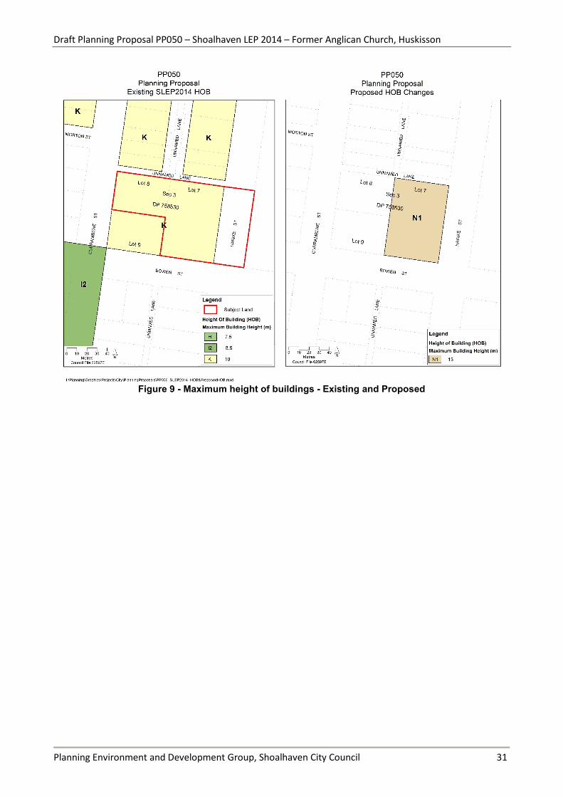
The existing and proposed ‘maximum height of buildings’ is shown in Figure 9.
The existing and proposed ‘incentive height of buildings’ is shown in Figure 10.
The existing Chapter N18 of the Shoalhaven Development Control Plan (DCP) 2014 contains additional objectives and planning controls for the Huskisson town centre, including land use and height provisions for Lots 7 and 8.
Council’s resolution to support the proponent’s PP application also included the following Part 6:
6. Amend Shoalhaven Development Control Plan 2014, Chapter N18 - Huskisson Town Centre, as required, in conjunction with the Planning Proposal process.
Draft Planning Proposal PP050 – Shoalhaven LEP 2014 – Former Anglican Church, Huskisson
Planning Environment and Development Group, Shoalhaven City Council 16
4 Part 3 – Justification
4.1 Need for the Planning Proposal (Section A)
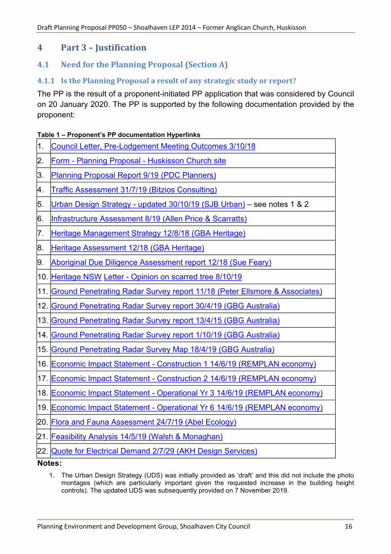
4.1.1 Is the Planning Proposal a result of any strategic study or report? The PP is the result of a proponent-initiated PP application that was considered by Council on 20 January 2020. The PP is supported by the following documentation provided by the proponent: Table 1 – Proponent’s PP documentation Hyperlinks
1. Council Letter, Pre-Lodgement Meeting Outcomes 3/10/18
2. Form - Planning Proposal - Huskisson Church site
3. Planning Proposal Report 9/19 (PDC Planners)
4. Traffic Assessment 31/7/19 (Bitzios Consulting)
5. Urban Design Strategy - updated 30/10/19 (SJB Urban) – see notes 1 & 2
6. Infrastructure Assessment 8/19 (Allen Price & Scarratts)
7. Heritage Management Strategy 12/8/18 (GBA Heritage)
8. Heritage Assessment 12/18 (GBA Heritage)
9. Aboriginal Due Diligence Assessment report 12/18 (Sue Feary)
10. Heritage NSW Letter - Opinion on scarred tree 8/10/19
11. Ground Penetrating Radar Survey report 11/18 (Peter Ellsmore & Associates)
12. Ground Penetrating Radar Survey report 30/4/19 (GBG Australia)
13. Ground Penetrating Radar Survey report 13/4/15 (GBG Australia)
14. Ground Penetrating Radar Survey report 1/10/19 (GBG Australia)
15. Ground Penetrating Radar Survey Map 18/4/19 (GBG Australia)
16. Economic Impact Statement - Construction 1 14/6/19 (REMPLAN economy)
17. Economic Impact Statement - Construction 2 14/6/19 (REMPLAN economy)
18. Economic Impact Statement - Operational Yr 3 14/6/19 (REMPLAN economy)
19. Economic Impact Statement - Operational Yr 6 14/6/19 (REMPLAN economy)
20. Flora and Fauna Assessment 24/7/19 (Abel Ecology)
21. Feasibility Analysis 14/5/19 (Walsh & Monaghan)
22. Quote for Electrical Demand 2/7/29 (AKH Design Services) Notes:
1. The Urban Design Strategy (UDS) was initially provided as ‘draft’ and this did not include the photo montages (which are particularly important given the requested increase in the building height controls). The updated UDS was subsequently provided on 7 November 2019.

Draft Planning Proposal PP050 – Shoalhaven LEP 2014 – Former Anglican Church, Huskisson
Planning Environment and Development Group, Shoalhaven City Council 17
2. Some of the visualisations/photo montages depict mature street trees on the western side of Hawke Street. However, trees at that location are located beneath overhead power lines and are pruned accordingly by Endeavour Energy. At the Council meeting on 20/1/20, the proponent gave a verbal undertaking that the overhead powerlines would be moved underground along the Hawke Street frontage. If this occurs, pruning of the trees will not be necessary.
A copy of Council’s resolution of 20th January 2020 to support the PP ‘in-principle’ is provided in section 1.2 of this PP.
Background: zoning of ‘places of public worship’ and use of the SP2 zone
Lots 7 and 8 were previously zoned Special Use 5(a)(Church) under the earlier Shoalhaven LEP 1985.
The Standard Instrument LEP (on which Shoalhaven LEP 2014 is based) mandates that ‘places of public worship’ are permissible in certain zones, including residential zones R1 and R3. Council also chose to make ‘places of public worship’ permissible in various other zones including business zones B1, B2, B3, B4 and B5.
One of the State Government’s principles in regard to special purpose (SP) zones is that they should generally not be used where the surrounding zone (e.g. is this case residential or business) permits the proposed use. This is to avoid the need for a ‘spot’ rezoning should a use cease or is downsized in the future.
Notwithstanding this, based on the ‘like for like’ transfer direction from the Council that underpinned the delivery of the new Shoalhaven LEP, Council ultimately chose during the construction of the Shoalhaven LEP 2014 to zone a number of existing longstanding ‘places of public worship’, including the subject land in Huskisson, to ‘SP2 - Place of Public Worship’ consistent with their previous Special Uses 5(a) Church under the LEP 1985.
Had Council not followed this approach in delivering the Shoalhaven LEP 2014, it is likely that the subject land would have been zoned either B2 or R3 at that point as these are the adjoining development zones (in which ‘places of public worship’ are permissible).
Background: current height controls
The current mapped building height controls in the LEP for Lots 7 and 8 and surrounds are shown in Figure 5 (‘maximum height of buildings’) and Figure 6 (‘incentive building height’).

Draft Planning Proposal PP050 – Shoalhaven LEP 2014 – Former Anglican Church, Huskisson
Planning Environment and Development Group, Shoalhaven City Council 18
Figure 5 – Current mapped maximum height of buildings
(N1 = 13 m, K = 10 m, I2 = 8.5 m, H = 7.5 m)
These height of building provisions were carried over into the LEP from the earlier DCP No.54 – Huskisson Town Centre that was in place prior to 2014 and showed Lots 7 and 8 mapped as ‘10 metres and 3 storeys’. The transference of the maximum height of buildings controls from the DCP to the LEP was also a requirement of the NSW Standard LEP Instrument process.
Lots 7 and 8 are also mapped as 13 m on the incentive height of buildings map (Figure 6) to which Clause 7.26 (Increased building height Huskisson Town Centre) of the LEP applies. This clause only applies if the site meets the following size requirements (paraphrased from subclause (3)(a)):
• if a single lot, the area is greater than 2,000 m2,
• or if more than one lot, each lot is greater than 1,200 m2
Lots 7 and 8 both comply with the above requirements (individually and combined). Hence, clause 7.26 allows up to 50% of the building to have a maximum height identified on the incentive height of buildings map, i.e. 13 m, subject to certain requirements:
(d) the basement of the building will contain car parking and will provide for 2 way traffic flow to access that car parking and will provide for the turning of vehicles, and
(e) the design and form of the building -
(i) follows good urban design practice, and
(ii) will improve the quality and amenity of the public domain, and
(iii) will minimise overshadowing of public places and residential premises.

Draft Planning Proposal PP050 – Shoalhaven LEP 2014 – Former Anglican Church, Huskisson
Planning Environment and Development Group, Shoalhaven City Council 19
Again, given that it dealt with potential maximum building height, the incentive height of building provision was also carried over into the LEP from the earlier DCP No. 54 – Huskisson Town Centre.
Figure 6– Incentive height of buildings
(N1 = 13 m, O = 16 m)
The justification provided by the proponent for increasing the proposed height controls on Lot 7, No. 17 Hawke Street, is based on the ‘Key Design Moves’ (KDM) outlined in the Urban Design Strategy (UDS) prepared by SJB Urban – refer to Figure 7.
Figure 7 - Key Design Move 3.5 (Source: Proponent’s Urban Design Strategy 7/11/19)

Draft Planning Proposal PP050 – Shoalhaven LEP 2014 – Former Anglican Church, Huskisson
Planning Environment and Development Group, Shoalhaven City Council 20
Figure 7 shows the transfer of some of the development potential (i.e. Gross Floor Area and building height) from the Currambene Street edge to the Hawke Street edge (from Lot 8 to Lot 7). This is the justification for the increased height controls on Lot 7. If this principal were applied equally across the subject land, the height controls would also be reduced on Lot 8. This however would result in variable height controls along Currambene Street, i.e. the LEP height controls would be lower on Lot 8 than the adjacent properties to the north and south. Council resolved to support the proponent’s proposed increase in height controls ‘in-principle’, subject to the completion of an independent review of the Urban Design Strategy. The findings of this review will be considered (along with a review of the feasibility assessment and further work in relation to the graves) before confirming the details of the PP and supporting DCP amendment prior to exhibition.
4.1.2 Is the Planning Proposal the best means of achieving the objectives or intended outcomes, or is there a better way?
The current SP2 Infrastructure (‘place of public worship’) zoning prohibits all other uses of the site except for roads, aquaculture or other uses that are ordinarily incidental or ancillary to a place of public worship. The land will need to be rezoned (i.e. via a Planning Proposal) to enable the intended outcome to be achieved.
4.2 Relationship to strategic planning framework (Section B)
4.2.1 Is the Planning Proposal consistent with the objectives and actions contained within the applicable regional or sub-regional strategy (including the Sydney Metropolitan Strategy and exhibited draft strategies)?
Direction 2.2 of the Illawarra-Shoalhaven Regional Plan (ISRP) is to: “Support housing opportunities close to existing services, jobs and infrastructure in the region’s centres”. It states that making more housing available in existing urban areas is a sustainable option because it takes advantage of existing job markets, infrastructure, commercial and retail opportunities, public transport, and facilities for pedestrians and cyclists.
Centres identified as the focus for increased housing activity include Huskisson.
The proposed B4 zone allows attached dwellings, residential flat buildings, seniors housing and shop top housing. The development proposed includes residential accommodation (residential flat building). As such the PP is considered to be consistent with Direction 2.2 of ISRP.

Draft Planning Proposal PP050 – Shoalhaven LEP 2014 – Former Anglican Church, Huskisson
Planning Environment and Development Group, Shoalhaven City Council 21
4.2.2 Is the Planning Proposal consistent with the local council’s Community Strategic Plan, or other local strategic plan?
Shoalhaven City Council’s Community Strategic Plan
The PP is considered to be broadly consistent with Council’s Community Strategic Plan, specifically Theme 2. Sustainable, liveable environments, and its Action 2.2 Plan and manage appropriate and sustainable development.
Shoalhaven Growth Management Strategy (GMS) V1
The GMS states that the strategic outcome for Huskisson is to:
“promote as the gateway to the Jervis Bay Region by providing a range of integrated housing opportunities for both tourist accommodation and permanent living, through a combination of urban consolidation and higher densities.”
The proposed B4 – Mixed Use zone allows a mix of uses that are generally consistent with this broader strategic outcome. The Growth considerations within the GMS for a number of settlements including Huskisson are:
• Development within settlement boundaries must be compatible with existing building forms and subdivision pattern.
• Outward expansion of settlements must protect and maintain landscape vistas for their visual and cultural heritage values
• Minimise adverse impacts in terms of hazards and environmental values
• Commercial development to enrich tourism potential
4.2.3 Is the Planning Proposal consistent with applicable state environmental planning policies?
A checklist of the State Environmental Planning Policies (SEPPs) is attached to this PP. The most relevant SEPPs are briefly discussed below.
• SEPP 55 – Remediation of land. A preliminary investigation report will be required prior to public exhibition of the PP.
• SEPP 65 – Design quality of residential apartment development. Provides design principles and objectives and design criteria in the NSW Apartment Design Guide for residential apartments, shop top housing developments. Is relevant given the outcome that the PP could facilitate.
• SEPP - Coastal management. Aims to promote an integrated and co-ordinated approach to land use planning in the coastal zone. The subject land is mapped as Coastal Environment Area and Coastal Use Area. Development within the Coastal Use Area must be designed to avoid or minimise impacts including overshadowing, loss of
Draft Planning Proposal PP050 – Shoalhaven LEP 2014 – Former Anglican Church, Huskisson
Planning Environment and Development Group, Shoalhaven City Council 22
views from public places to foreshores, Aboriginal cultural heritage, cultural and built environmental heritage etc.
Potential impacts resulting from the proposed increase in height controls, such as loss of views and overshadowing, will be further investigated as part of the proposed independent review of the proponent’s Urban Design Strategy prepared by SJB Urban. These issues are discussed elsewhere in this report.
An Aboriginal cultural heritage due diligence assessment prepared for the proponent by Sue Feary concluded that an Aboriginal cultural heritage assessment is not required. Further work will also be undertaken in relation to the graves, including to determine if they are ‘relics’ under the NSW Heritage Act or not.
4.2.4 Is the Planning Proposal consistent with applicable Ministerial Directions (s.9.1 directions)?
A checklist of the s.9.1 Ministerial directions is attached to this PP. The most relevant Ministerial Directions are discussed below.
Direction 1 - Employment and Resources
Applies when a relevant planning authority prepares a PP that will affect land within an existing or proposed business or industrial zone. The objectives of this Direction are to:
a) encourage employment growth in suitable locations,
b) protect employment land in business and industrial zones, and
c) support the viability of identified centres.
The proponent’s PP application was accompanied by a Feasibility Assessment prepared by Walsh and Monaghan and four ‘economic impact statements’ produced from the REMPLAN tool.
The relevant findings of the Feasibility Assessment include:
• Retail demand diminishes significantly away from the traditional strip centre and therefore any retail component in the subject land would need to be specialised to service accommodation guests.
• Impacts on the existing retail centre would be limited due to the relatively small retail component of the proposed development and the focus on tourist and visitor accommodation.
• The proposed food and beverage outlets may compete with those in the main centre.
• The proposed increase to the overall commercial zoning in Huskisson/Vincentia represents a total increase of 1.94% of the total B2 zone. Note: also equivalent to 9.4% of the core B2 area in Huskisson.
Draft Planning Proposal PP050 – Shoalhaven LEP 2014 – Former Anglican Church, Huskisson
Planning Environment and Development Group, Shoalhaven City Council 23
• The proposed increase in B4 zoned land equates to 8.6% of the total area of B4 zoned land in Huskisson.
• Rezoning the subject land to B4 could result in a medium to long term benefit for Huskisson and is most consistent with “highest and best use” principles.
The feasibility assessment broadly evaluates different zoning options for the subject land. It does not compare the feasibility of the development with or without the increase in height controls.
The economic impact statements produced from REMPLAN provide forecasted impacts on local output, employment, wages and salaries associated with the redevelopment of the site. The proponent’s PP report prepared by PDC Planners suggests that “The analysis provides details of positive economic impacts during both construction/ redevelopment phase and then ongoing operation of future development.” The assumptions on which the analysis is based have not been critically reviewed.
The importance of economic stimulation was one of the reasons that the Council resolved to support the PP ‘in principle’ on 20 January 2020. Council also resolved to undertake a peer review of the feasibility assessment to ensure that it is robust.
Unless the peer review indicates that the proposal could have a significant adverse impact on business in the existing commercial area of Huskisson, then the PP is considered broadly consistent with Ministerial Direction 1.
Direction 2.2 – Coastal Management
The subject land is within the Coastal Zone, but it is not affected by Sections (5) or (6) and is not otherwise inconsistent with this Direction.
Direction 2.3 - Heritage Conservation
The objective of this direction is to conserve items, areas, objects and places of environmental heritage significance and indigenous heritage significance. Section (4) of this Direction requires PPs to facilitate the conservation of:
a) items, places, buildings, works, relics, moveable objects or precincts of environmental heritage significance to an area, in relation to the historical, scientific, cultural, social, archaeological, architectural, natural or aesthetic value of the item, area, object or place, identified in a study of the environmental heritage of the area,
b) Aboriginal objects or Aboriginal places that are protected under the National Parks and Wildlife Act 1974, and
c) Aboriginal areas, Aboriginal objects, Aboriginal places or landscapes identified by an Aboriginal heritage survey prepared by or on behalf of an Aboriginal Land Council, Aboriginal body or public authority and provided to the relevant planning

Draft Planning Proposal PP050 – Shoalhaven LEP 2014 – Former Anglican Church, Huskisson
Planning Environment and Development Group, Shoalhaven City Council 24
authority, which identifies the area, object, place or landscape as being of heritage significance to Aboriginal culture and people.
As discussed earlier, while the subject land is not listed as a heritage item in the LEP or on the NSW Heritage Register, the graves (including any Aboriginal graves) could be ‘relics’ under the NSW Heritage Act. As such, it is imperative that any graves are identified and appropriately protected/conserved.
Concept plans included with the proponent’s PP application depict two ‘memorial gardens’ which encompass the currently known and suspected grave sites with a buffer of approximately 2 m.
It is however recommended that a new independent GPR survey be undertaken over Lots 7 and 8 to determine if any other potential graves are present, and to commission independent historical research and consultation to determine if an Aboriginal Cultural Heritage Assessment should be undertaken. These steps are considered necessary to satisfy this Direction, navigate the sensitive issues associated with the graves and potentially enable this aspect to be conclusively resolved.
Direction 3.4 Integrating Land Use and Transport
The objective of this direction is to ensure that urban structures, building forms, land use locations, development designs, subdivision and street layouts achieve the following planning objectives:
a) improving access to housing, jobs and services by walking, cycling and public transport, and
b) increasing the choice of available transport and reducing dependence on cars, and
c) reducing travel demand including the number of trips generated by development and the distances travelled, especially by car, and
d) supporting the efficient and viable operation of public transport services, and
e) providing for the efficient movement of freight.
The proponent’s PP report concludes that the it is not inconsistent with these objectives because:
• The site is located within Huskisson town centre which is serviced by way of pedestrian infrastructure and public transport.
• The site is within close proximity to a population base who then can travel less for employment.
• The PP aims to facilitate a form of development that, if approved, will increase the viability of public transport in the area.
Draft Planning Proposal PP050 – Shoalhaven LEP 2014 – Former Anglican Church, Huskisson
Planning Environment and Development Group, Shoalhaven City Council 25
Direction 4.4 Planning for Bushfire Protection
This Direction is triggered because the subject land is adjacent to, and marginally affected by, land currently mapped as ‘bushfire prone’. However, Lots 7 and 8 are separated from the main hazard by Hawke Street and White Sands Park, most of which is ‘managed’. Furthermore, the combined area of Lots 7 and 8 is directly accessible from Hawke Street, Bowen Street, Currambene Street and the un-named laneway.
As such, should the PP proceed, it will be referred to the NSW Rural Fire Service prior to public exhibition.
Direction 5.10 Implementation of Regional Plans
This Direction generally requires PP’s to be consistent with the Illawarra-Shoalhaven Regional Plan (ISRP). Refer to section 4.2.1.
4.3 Environmental, Social and Economic Impact (Section C)
4.3.1 Is there any likelihood that critical habitat or threatened species, populations or ecological communities, or their habitats, will be adversely affected as a result of the proposal?
The proponent’s PP request is accompanied by a flora and fauna assessment prepared by Abel Ecology P/L, which concludes: “The proposal activity is not likely to significantly affect any threatened species or Endangered or Critically Endangered Species or ecological community” and that the proposal would not trigger entry into the Biodiversity Offsetting Scheme. As such, no further work is considered necessary in relation to threatened biodiversity.
4.3.2 Are there any other likely environmental effects as a result of the Planning Proposal and how are they proposed to be managed?
The proponent’s Planning Proposal report prepared by PDC Planners includes the following information on other potential environmental impacts:
The site has redevelopment potential under current planning controls and in this regard, the potential exists for the entire site to be redeveloped for the purposes of a new place of worship – i.e. a large multi-storey modern church up to 13m in height.
The PP seeks to change the land use zone to B4 Mixed Use Business and, change the Height of Building Maps to 13m and the Incentive Height of Building Maps to 16m. It is considered that the development potential of the land. The alteration proposed to the land use zone involves only a change from one urban zone to another.

Draft Planning Proposal PP050 – Shoalhaven LEP 2014 – Former Anglican Church, Huskisson
Planning Environment and Development Group, Shoalhaven City Council 26
The additional 3m of building height and additional 3m of incentive building height has been assessed in detail by urban design experts SJB. The information prepared by SJB includes detailed assessments on existing and future desired character of Huskisson and the likely impacts of future redevelopment on the locality. The increases sought to the maximum allowable building height controls within the Shoalhaven LEP 2014 are considered to be acceptable.
As with any redevelopment project, particularly within established urban environments, there is the potential for adverse impacts on adjoining lands due to poor design of future buildings and / or inappropriate land uses. Ultimately, impacts on the surrounding built environment are assessed at development application stage. Further to this PP, it is recommended that the Shoalhaven City Council prepare an amendment to the Shoalhaven Development Control Plan 2014 Chapter N18 – Huskisson Town Centre. The amendment should incorporate specific development controls for the site in accordance with the urban design study completed by SJB.
With respect to other potential impacts on the natural environment, the site is relatively constraint free.
In this regard, the site is not one that is adversely affected by bushfire, flooding, acid sulfate soils, steep land, unstable land or site contamination.
In relation to the above comment concerning bushfire, a narrow strip of the eastern edge of the Lot 7 is mapped as ‘bushfire prone’. Hence, the NSW RFS will be consulted, in accordance with s.9.1 Ministerial direction 4.4 (Planning for Bushfire Protection).
As previously discussed, additional work is proposed to be undertaken in relation to the graves – this is to better understand their history, location and legal status. The intention is to ultimately protect them from disturbance and develop a plan for their long-term maintenance.
A preliminary land contamination assessment will be required to ensure consistency with State Environmental Planning Policy (SEPP) No. 55 – Remediation of Land.
4.3.3 How has the Planning Proposal adequately addressed any social and economic effects?
The proponent’s Planning Proposal report prepared by PDC Planners includes the following statement in relation to social and economic effects:
It is considered that the PP will have positive social and economic effects. The privately owned site is located within the Huskisson town centre and as such is regarded as being entirely suitable for redevelopment for the purposes of mixed use business and given that there is no demonstrated need to retain the special uses Church zone currently applicable to the site.

Draft Planning Proposal PP050 – Shoalhaven LEP 2014 – Former Anglican Church, Huskisson
Planning Environment and Development Group, Shoalhaven City Council 27
The locality and wider region present plenty of opportunities for the establishment of new places of worship with churches being a permissible land use within most land use zones. The loss of a site that is zoned Special Purposes – Church is a change that will not hinder the ability for new churches to be established within the locality.
The proposal to rezone land within the Huskisson commercial core will enable the transformation of an underutilised site which currently provides no jobs into a property that will have the potential to significantly increase total employment opportunities in the area. Supporting economic impact data submitted with this PP indicates that total employment including all direct, supply-chain and consumption effects is estimated to increase by up to 72 jobs upon redevelopment of the site in the manner foreshadowed.
The proponent’s documentation includes economic impact statements produced from REMPLAN. These provide forecasted impacts on local output, employment, wages and salaries associated with the redevelopment of the site. The proponent’s PP report states that “The analysis provides details of positive economic impacts during both construction/ redevelopment phase and then ongoing operation of future development.”
The Huskisson Church site has been the subject of considerable community interest since the development application to demolish the church hall was received by Council in 2018 (DA18/2102). Due to the high level of community interest in the subject land, a Get Involved page was created for the PP project when the proponent’s application was received to facilitate community advice and engagement (in accordance with Council’s Planning Proposal Guidelines). The Get Involved page will be maintained for the life of the PP process.
Approximately 136 submissions had been received and were considered when the matter was initially reported Council on 20 January 2020, and it was resolved to support the PP ‘in-principle’. The submissions covered a wide range of issues, some of which will be investigated further as part of the PP process. These issues are outlined below.
Table 2 - Summary of issues raised by community and how these will be considered/addressed
Broad issue How will this be assessed
Local Character Redevelopment of the site as proposed will change character of the locality to some extent. The existing height controls potentially already enable development up to 13 m high. Council has resolved to complete an independent review of the proponent’s Urban Design Strategy, and will consider the outcomes of this before confirming the details of the PP and undertaking formal community consultation. Council has also resolved to amend the DCP chapter for the Huskisson town centre

Draft Planning Proposal PP050 – Shoalhaven LEP 2014 – Former Anglican Church, Huskisson
Planning Environment and Development Group, Shoalhaven City Council 28
Aboriginal heritage The proponent’s Aboriginal cultural heritage due diligence assessment prepared by Sue Feary concluded that an Aboriginal Cultural Heritage Assessment is not required. Further work is proposed in respect of the graves including: a new overall Ground Penetrating Radar (GPR) survey; independent historical research; and consultation with the Jerrinja LALC and Council’s Aboriginal Advisory Committee to determine their legal status under the NSW Heritage Act.
European heritage The proponent’s documentation shows that the church building is proposed to be relocated onsite (subject to existing DA approval). The graves are proposed to be retained and protected subject to completing further work described above.
Building heights As noted above, the existing height controls in the LEP allow development up to 13 m above ground level. Increased heights are proposed, and an independent review of the proponent’s Urban Design Strategy will be completed.
Economic benefits / job creation
The proponent’s feasibility assessment and other relevant information will be independently reviewed.
4.4 State and Commonwealth Interests (Section D)
4.4.1 Is there adequate public infrastructure for the Planning Proposal?
The proponent’s Infrastructure Assessment prepared by APS concludes that:
“…all essential services (water, sewer, electricity) are on readily available to the site and will not be a constraint to the timing or delivery of development.”
As noted earlier, at the Council meeting on 20 January 2020, the proponent indicated that arrangements will be made to move the adjacent powerlines underground (if the proposal is ultimately approved). This is relevant because it would potentially enable the trees along Hawke Street (which currently are pruned by Endeavour Energy) to grow to the height depicted in the Urban Design Strategy prepared by SJB Urban.
Endeavour Energy provided preliminary advice to APS on behalf of the proponent in relation to the proposed development:
Endeavour Energy has completed a preliminary desk top assessment of the above address and have gathered the following advice:
1) As per the Maximum Demand submitted, 1 x 1000kVA padmount substation may be sufficient.

Draft Planning Proposal PP050 – Shoalhaven LEP 2014 – Former Anglican Church, Huskisson
Planning Environment and Development Group, Shoalhaven City Council 29
2) The padmount sub is not expected to be on a spur connection but rather in a ring main.
3) The padmount sub shall be designed as per endeavour energy standards MDI0028.
4) Easement requirements for installation of the padmount subs must comply with MDI0044.
5) Adjacent 11kV feeder HKD2 seems to have the capacity to cater for this load but requires HV Planning department’s confirmation (this will be done when a formal application of load is submitted).
6) Since this entire build is considered to be one development, it must be ensured that the two addresses/Lots are amalgamated since as per NSW Service Installation Rules, one lot is allowed only one supply. If the lots are not amalgamated, then each lot may require separate supplies.
Shoalhaven Water has advised APS that the existing water and sewerage infrastructure is capable of servicing the proposed development.
4.4.2 What are the views of state and Commonwealth public authorities consulted in accordance with the Gateway determination?
The following government agencies are proposed to be consulted prior to public exhibition:
• Heritage NSW (in relation to the legal status of the graves)
• NSW Department of Planning Industry and Environment (B&CD)
• NSW Rural Fire Service

Draft Planning Proposal PP050 – Shoalhaven LEP 2014 – Former Anglican Church, Huskisson
Planning Environment and Development Group, Shoalhaven City Council 30
5 Part 4 – Mapping
Figure 8 - Existing and proposed zoning
Draft Planning Proposal PP050 – Shoalhaven LEP 2014 – Former Anglican Church, Huskisson
Planning Environment and Development Group, Shoalhaven City Council 31
Figure 9 - Maximum height of buildings - Existing and Proposed

Draft Planning Proposal PP050 – Shoalhaven LEP 2014 – Former Anglican Church, Huskisson
Planning Environment and Development Group, Shoalhaven City Council 32
Figure 10 - Incentive height of buildings - Existing and Proposed

Draft Planning Proposal PP050 – Shoalhaven LEP 2014 – Former Anglican Church, Huskisson
Planning Environment and Development Group, Shoalhaven City Council 33
6 Part 5 - Community Consultation As discussed earlier in this PP, Council set up a Get Involved project page for the ‘Huskisson Church’ PP project to keep the community informed (and engaged at the appropriate stages) through the life of the project.
Council will exhibit the PP in accordance with the requirements of the Gateway determination. It is intended that an exhibition period of at least 28 days apply.
Public notification of the exhibition would include notification in the relevant local newspaper(s), and a notice on Council’s website (including the Get Involved project page). Hard copies of the planning proposal would be made available at Council’s Administrative Building in Nowra.
7 Part 6 – Project Timeline The anticipated timeline for the PP is outlined in Table 3 below.
Table 3 - Indicative timeframe for completing tasks Task Anticipated Timeframe Commencement date (date of Gateway determination) March 2020 Completion of Gateway determination requirements September 2020 Report outcomes of studies to Council to confirm details of the PP
October 2020
Public exhibition November 2020 Consideration of submissions December 2020 Post exhibition consideration of PP January 2021 Finalisation and notification of Plan March 2021

Draft Planning Proposal PP050 – Shoalhaven LEP 2014 – Former Anglican Church, Huskisson
Planning Environment and Development Group, Shoalhaven City Council 34
Attachments 1. Proponent’s PP document and any studies. 1. Council Letter, Pre-Lodgement Meeting Outcomes 3/10/18
2. Form - Planning Proposal - Huskisson Church site
3. Planning Proposal Report 9/19 (PDC Planners)
4. Traffic Assessment 31/7/19 (Bitzios Consulting)
5. Urban Design Strategy - updated 30/10/19 (SJB Urban) – see notes 1 & 2
6. Infrastructure Assessment 8/19 (Allen Price & Scarratts)
7. Heritage Management Strategy 12/8/18 (GBA Heritage)
8. Heritage Assessment 12/18 (GBA Heritage)
9. Aboriginal Due Diligence Assessment report 12/18 (Sue Feary)
10. Heritage NSW Letter - Opinion on scarred tree 8/10/19
11. Ground Penetrating Radar Survey report 11/18 (Peter Ellsmore & Associates)
12. Ground Penetrating Radar Survey report 30/4/19 (GBG Australia)
13. Ground Penetrating Radar Survey report 13/4/15 (GBG Australia)
14. Ground Penetrating Radar Survey report 1/10/19 (GBG Australia)
15. Ground Penetrating Radar Survey Map 18/4/19 (GBG Australia)
16. Economic Impact Statement - Construction 1 14/6/19 (REMPLAN economy)
17. Economic Impact Statement - Construction 2 14/6/19 (REMPLAN economy)
18. Economic Impact Statement - Operational Yr 3 14/6/19 (REMPLAN economy)
19. Economic Impact Statement - Operational Yr 6 14/6/19 (REMPLAN economy)
20. Flora and Fauna Assessment 24/7/19 (Abel Ecology)
21. Feasibility Analysis 14/5/19 (Walsh & Monaghan)
22. Quote for Electrical Demand 2/7/29 (AKH Design Services)

Draft Planning Proposal PP050 – Shoalhaven LEP 2014 – Former Anglican Church, Huskisson
Planning Environment and Development Group, Shoalhaven City Council 35
2. Council report and minute supporting the PP. Report to Council’s Development and Environment Committee, 20 January 2020
Minute:
RESOLVED (Clr Guile / Clr Gash) MIN20.17
That Council: 1. Support ‘in principle’ the proposed rezoning of Lots 7 and 8, Section 3, DP 758530 -
17 Hawke Street and 22 Currambene Street, Huskisson from SP2 – Place of Public Worship to B4 – Mixed Use Business under the Shoalhaven LEP 2014, and also extend the proposed B4 zoning to include the adjacent section of Hawke Street that is currently zoned SP2 – Road.
2. Support ‘in principle’ the proponent’s proposed increase in the height controls to Lot 7 Section 3, DP 758530 (No. 17 Hawke Street).
3. Submit a Planning Proposal to the NSW Department of Planning, Industry and Environment (DPIE) for Gateway determination that is in accordance with parts 1 and 2.
4. Subject to a favourable Gateway determination, undertake the following assessments:
a. A new independent Ground Penetrating Radar (GPR) survey over the entire site by a grave detection specialist using best practice methodology.
b. Independent research into the graves and whether they are ‘relics’ under the NSW Heritage Act.
c. Consultation with Heritage NSW; the NSW Department of Planning, Industry and Environment; the Jerrinja Local Aboriginal Land Council; and Council’s Aboriginal Advisory Committee to seek clarification on the legal status of the graves with regard to the NSW Heritage act.
d. Continued consultation with the Jerrinja Local Aboriginal Land Council and Council’s Aboriginal Advisory Committee as required/appropriate.
e. Independent peer reviews of the proponent’s urban design strategy and feasibility assessment
5. Upon completion of the above assessments and considerations, report the findings to Council to confirm the details of Planning Proposal. Immediately upon gateway determination, subject to the completion of any reports required by the gateway determination, the Planning Proposal is to be placed on public exhibition
6. Amend Shoalhaven Development Control Plan 2014, Chapter N18 - Huskisson Town Centre, as required, in conjunction with the Planning Proposal process.
7. Note the required reviews/assessments are to be funded by the proponent in accordance with Council’s Planning Proposal Guidelines.
8. Advise the proponent, CCB and submitters of this decision.
FOR: Clr Gash, Clr Wells, Clr White, Clr Guile, Clr Pakes, Clr Watson, Clr Kitchener and Stephen Dunshea
AGAINST: Clr Findley, Clr Gartner, Clr Digiglio, Clr Alldrick and Clr Proudfoot
CARRIED

Draft Planning Proposal PP050 – Shoalhaven LEP 2014 – Former Anglican Church, Huskisson
Planning Environment and Development Group, Shoalhaven City Council 36
3. SEPP Checklist. SEPP Date Name Applicable Not
inconsistent 19 10.12.08 Bushland in Urban Areas NA 21 24.04.92 Caravan parks NA 30 08.12.89 Intensive agriculture NA 33 13.03.92 Hazardous and Offensive development NA 36 16.07.93 Manufactured home estates NA 44 06.01.95 Koala habitat protection
47 17.11.95 Moore Park Showground NA 50 10.11.97 Canal estate development NA 55 28.08.98 Remediation of land
64 16.03.01 Advertising and signage NA 65 26.07.02 Design quality of residential flat development
70 31.05.02 Affordable Housing (Revised Schemes)
-- 6.02.19 State Environmental Planning Policy (Aboriginal Land) 2019 NA
-- 31.07.09 Affordable Rental Housing 2009
-- 25.06.04 Building Sustainability Index: BASIX 2004
-- 03.04.18 Coastal Management 2018
28.02.19 Concurrences and Consents 2018
-- 01.09.17 Educational Establishments and Child Care Facilities 2017
-- 27.02.09 Exempt and Complying Development Codes 2008
-- 31.03.04 Housing for Seniors or People with a Disability 2004
-- 01.01.08 Infrastructure 2007
-- 12.12.07 Kosciuszko National Park – Alpine Resorts 2007 NA -- 30.06.89 Kurnell Peninsula 1989 NA
-- 16.02.07 Mining, Petroleum Production and Extractive Industries 2007
-- 21.11.86 Penrith Lakes Scheme 1989 NA 28.02.19 Primary Production and Rural Development
-- 01.10.11 State and Regional Development 2011
-- 25.05.05 State Significant Precincts 2005
-- 01.03.11 Sydney Drinking Water Catchment 2011 NA -- 28.07.06 Sydney Region Growth Centres 2006 NA -- 31.05.13 Three Ports 2013 NA -- 15.12.10 Urban Renewal 2010 NA -- 25.08.17 Vegetation in Non-Rural Areas
-- 21.08.09 Western Sydney Employment Area 2009 NA -- 06.03.09 Western Sydney Parklands 2009 NA

Draft Planning Proposal PP050 – Shoalhaven LEP 2014 – Former Anglican Church, Huskisson
Planning Environment and Development Group, Shoalhaven City Council 37
4. S9.1 Checklist.
Direction Applicable Relevant Consistent 1 Employment and Resources
1.1 Business and Industrial Zones Broadly consistent. See note below.
1.2 Rural Zones NA
1.3 Mining, Petroleum Production and Extractive Industries NA
1.4 Oyster Aquaculture NA
1.5 Rural lands NA
2 Environment and Heritage
2.1 Environmental Protection Zones Subject land has not been identified for environment
protection purposes
2.2 Coastal Management Subject land is within a ‘Coastal
Use area’ and a ‘Coastal Environment Area’
2.3 Heritage Conservation Not inconsistent, subject to further
investigation in relation to the graves to determine their status
under the NSW Heritage Act.
2.4 Recreation Vehicle Area NA
2.5 Application of E2 and E3 Zones in Environmental Overlays in Far North Coast LEPs NA
3 Housing, Infrastructure and Urban Development
3.1 Residential Zones The PP will enable additional
housing opportunities within an existing, serviced centre.
3.2 Caravan Parks and Manufactured Home Estates NA
3.3 Home Occupations NA
3.4 Integrating Land Use and Transport
3.5 Development Near Regulated Airports and Defence Airfields
NA
3.6 Shooting Ranges NA
3.7 Reduction in non-hosted short term rental accommodation period
NA
4 Hazard and Risk 4.1 Acid Sulphate Soils NA
4.2 Mine Subsidence and Unstable Land NA
4.3 Flood Prone Land NA

Draft Planning Proposal PP050 – Shoalhaven LEP 2014 – Former Anglican Church, Huskisson
Planning Environment and Development Group, Shoalhaven City Council 38
Note: As stated in the report considered by Council on 20/1/20, based on initial review of the proponent’s documentation, the proposal is broadly consistent with Ministerial Direction 1.1 and Council has resolved to peer review the feasibility assessment prior to public exhibition to ensure that it is robust.
4.4 Planning for Bushfire Protection
5 Regional Planning 5.1 Implementation of Regional Strategies NA
5.2 Sydney Drinking Water Catchments NA
5.3 Farmland of State and Regional Significance on the NSW Far North Coast
NA
5.4 Commercial and Retail Development along the Pacific Highway, North Coast
NA
5.9 North West Rail Link Corridor Strategy NA
5.10 Implementation of Regional Plans PP is broadly consistent with the ISRP
5.11 Development of Aboriginal Land Council land
The subject land is not shown on the Land Application Map of State
Environmental Planning Policy (Aboriginal Land) 2019
6 Local Plan Making 6.1 Approval and Referral Requirements
6.2 Reserving Land for Public Purposes NA
6.3 Site Specific Provisions
7 Metropolitan Planning 7.1 Implementation of A Plan for Growing Sydney NA
7.2 Implementation of Greater Macarthur Land Release Investigation
NA
7.3 Parramatta Road Corridor Urban Transformation Strategy NA
7.4 Implementation of North West Priority Growth Area Land Use and Infrastructure Implementation Plan
NA
7.5 Implementation of Greater Parramatta Priority Growth Area Interim Land Use and Infrastructure Implementation Plan
NA
7.6 Implementation of Wilton Priority Growth Area Interim Land Use and Infrastructure Implementation Plan
NA
7.7 Implementation of Glenfield to Macarthur Urban Renewal Corridor
NA
7.8 Implementation of Western Sydney Aerotropolis Interim Land Use and Infrastructure Implementation Plan
NA
7.9 Implementation of Bayside West Precincts 2036 Plan NA
7.10 Implementation of Planning Principles for the Cooks Cove Precinct
NA

Draft Planning Proposal PP050 – Shoalhaven LEP 2014 – Former Anglican Church, Huskisson
Planning Environment and Development Group, Shoalhaven City Council 39
5. Evaluation Criteria for the Delegation of Plan Making Functions Checklist for the review of a request for delegation of plan making functions to Councils Local Government Area: Shoalhaven City Council Name of draft LEP: Shoalhaven Local Environmental Plan 2014 PP050 Address of Land (if applicable): The subject land is known as No. 17 Hawke Street and No. 22 Currambene Street, Huskisson and is legally described as Lots 7 and 8, Section 3, DP 758530. Intent of draft LEP: The Planning Proposal seeks to amend Shoalhaven LEP 2014 as follows:
1. Rezone the subject land from SP2 Infrastructure to B4 – Mixed Use Business. 2. Increase the:
a. ‘maximum height of buildings’ as mapped from 10 m to 13 m; and the b. ‘incentive building height’ as mapped from 13 m to 16 m for Lot 7, Section 3,
DP 758530 (No.17 Hawke Street).

Draft Planning Proposal PP050 – Shoalhaven LEP 2014 – Former Anglican Church, Huskisson
Planning Environment and Development Group, Shoalhaven City Council 40
Evaluation criteria for the issuing of an Authorisation (Note: where the matter is identified as relevant and the requirement has not been met, council is attach information to explain why the matter has not been addressed)
Council Response
Department Assessment
Y/N Not relevant
Agree Not agree
Is the Planning Proposal consistent with the Standard Instrument Order, 2006? Y
Does the Planning Proposal contain an adequate explanation of the intent, objectives, and intended outcome of the proposed amendment?
Y
Are appropriate maps included to identify the location of the site and the intent of the amendment? Y
Does the Planning Proposal contain details related to proposed consultation? Y
Is the Planning Proposal compatible with an endorsed regional or sub-regional strategy or local strategy endorsed by the Director-General?
Y
Does the Planning Proposal adequately address any consistency with all relevant S9.1 Planning Directions?
Y
Is the Planning Proposal consistent with all relevant State Environmental Planning Policies (SEPPs)? Y
Minor Mapping Error Amendments
Does the Planning Proposal seek to address a minor mapping error and contain all appropriate maps that clearly identify the error and the manner in which the error will be addressed?
NA
Heritage LEPs
Does the Planning Proposal seek to add or remove a local heritage item and is it supported by a strategy / study endorsed by the Heritage Officer?
NA
Does the Planning Proposal include another form of endorsement or support from the Heritage Office if there is no supporting strategy/study?
NA
Does the Planning Proposal potentially impact on item of State Heritage Significance and if so, have the views of the Heritage Office been obtained?
N

Draft Planning Proposal PP050 – Shoalhaven LEP 2014 – Former Anglican Church, Huskisson
Planning Environment and Development Group, Shoalhaven City Council 41
Reclassifications
Is there an associated spot rezoning with the reclassification? NA
If yes to the above, is the rezoning consistent with an endorsed Plan Of Management POM) or strategy? NA
Is the Planning Proposal proposed to rectify an anomaly in a classification? NA
Will the Planning Proposal be consistent with an adopted POM or other strategy related to the site? NA
Will the draft LEP discharge any interests in public land under Section 30 of the Local Government Act, 1993?
NA
If so, has council identified all interests; whether any rights or interests will be extinguished; any trusts and covenants relevant to the site; and, included a copy of the title with the Planning Proposal?
NA
Has the council identified that it will exhibit the Planning Proposal in accordance with the Department’s Practice Note (PN09-003) Classification and reclassification of public land through a local environmental plan and Best Practice Guidelines for LEPs and Council Land?
NA
Has council acknowledged in its Planning Proposal that a Public Hearing will be required and agree to hold one as part of its documentation?
NA
Spot Rezonings
Will the proposal result in a loss of development potential for the site (i.e. reduced FSR or building height) that is not supported by an endorsed strategy?
N
Is the rezoning intended to address an anomaly that has been identified following the conversion of a principal LEP into a Standard Instrument LEP format?
N
Will the Planning Proposal deal with a previously deferred matter in an existing LEP and if so, does it provide enough information to explain how the issue that lead to the deferral has been addressed?
N
If yes, does the Planning Proposal contain sufficient documented justification to enable the matter to proceed?
NA
Does the Planning Proposal create an exception to a mapped development standard? N

Draft Planning Proposal PP050 – Shoalhaven LEP 2014 – Former Anglican Church, Huskisson
Planning Environment and Development Group, Shoalhaven City Council 42
Section 3.22 matters
Does the proposed instrument: a. Correct an obvious error in the principal
instrument consisting of a misdescription, the inconsistent numbering of provisions, a wrong cross-reference, a spelling error, a grammatical mistake, the insertion of obviously missing words, the removal of obviously unnecessary works or a formatting error?;
b. Address matters in the principal instrument that are of a consequential, transitional, machinery or other minor nature?;
c. Deal with matters that do not warrant compliance with the conditions precedent for the making of the instrument because they will not have any significant adverse impact on the environment or adjoining land?
N
N
N