planning for sustainable pedestrian infrastructure … for sustainable pedestrian infrastructure...
TRANSCRIPT

64
Abstract Cities are for people but trends of development in transportation infrastructure withinthe city have prioritized vehicles over pedestrian. Even due to road tax policies vehiclesedge out pedestrian from road space. Here the paper support for developing pedestrianinfrastructure and providing safe, secure and convenient pedestrian infrastructure fortrue owners of city: ‘the people’. The parameters are identified to evaluate the walkabilityindex of Lucknow city. An attempt is also made towards providing design parameters toimprove walkability conditions general as well as in consideration to upcoming MRTS infill.The paper also considers policy level support to achieve the desired walkability conditions.
1. INTRODUCTIONWalkability is an important concept in sustainable urban design approach. It is ameasure of how friendly an area is for pedestrians. Walkability has many health,environmental, and economic benefits. Better walkability has shown many individualand community benefits, such as opportunities for increased social interaction,reduced crime, increased civic sense and responsibility. One of the most importantbenefits of walkability is the decrease of the automobile footprint from thecommunity. Thus ‘carbon emissions’ can be reduced if more people choose towalk. Increased walkability has also been found to have many economic benefitsboth to individuals and to the public with increased efficiency of land use includingaccessibility, increased liveability, transportation cost savings, economic benefitsfrom improved public health and catalyses economic growth.
In developing countries, like India, majority of the people have to walk or usepublic transportation. Many cities are indirectly encouraging use of public transportthrough introducing BRTS and/or MRTS projects thus increasing pedestrianmovement. On the contrary, we observe rapid growth of vehicles on road, newproposals for flyovers or widening of roads and encourage more vehicles and theprocess continues, sometimes even at the cost of footpaths and pedestrianconvenience and safety; thus discouraging pedestrian movement.
2. WHOSE CITY IS IT ANYWAY – PEOPLES’ OR VEHICLES’?Lucknow is soon going to adopt MRTS system. That is not only going to ease thetraffic movement on roads but also increase the pedestrian movement at MRTSnodes. Almost all commuters using the MRTS at a certain part of their trips wouldbehave as pedestrians. Therefore, we can expect mass increase in pedestrian flowat MRTS nodes. Efficiency of the MRTS is not only decided by individual performance
Dr. Jaydip Barman, Associate Professor, Department of Architecture and Regional Planning,Indian Institute of Technology Kharagpur. Email:Chintan Daftardar, Department of Architecture and Regional Planning, Indian Institute ofTechnology Kharagpur. Email:
Planning for Sustainable PedestrianInfrastructure with upcoming MRTS — AnAppraisal of Walkability Conditions in Lucknow
Dr. Jaydip Barman and Chintan Daftardar
Institute of Town Planners, India Journal 7 - 3, 64 - 76, July - September 2010
Dr. Jaydip Barman and Chintan Daftardar
65
but as a system for its user i.e. how users will approach the MRTS nodes and thencommuters’ behaviour when they walk out of the MRTS station. Thus at initial stagewe need to know pedestrian behaviour within Lucknow and that city has basicpedestrian infrastructure and walkability conditions.
Economically speaking land value is a function of walkability index; thus it has toplay a major role in developing urban economics. A commercial area with morewalkable character fetches higher sales. Since development of cities peoplepreferred living closer to city centers, work centers or activities of daily needs.Walkable streets have always been an essential part of vibrant urban space. Positivevalues are added to living within easy walking distance. But unfortunately walkingis unmeasured and/or neglected while traffic planning.
3. EVALUATING WALKABILITYEvaluating walkability is challenging as it requires consideration of many subjectivefactors. Basically Walkability Index comprises of three components: safety andsecurity, convenience, and degree of government policy support. Assessing andmeasuring walkability through the walking audit is most common method. Anestablished and widely used walking audit tool is Pedestrian Environment ReviewSystem (PERS) which has been used extensively in the UK. In case of Lucknowwalkability is studied through walking audit, a conventional method. Certainmodification in walkability audit criteria (filtration and addition of indicators orvariables) has been done with considerations to Lucknow city as shown in Table 1.
Dr. Jaydip Barman and Chintan Daftardar
Institute of Town Planners, India Journal 7 - 3, 64 - 76, July - September 2010
Table 1 Components, Indicators and Variables for evaluating ‘Walkability’
Component Indicator VariableSafety & 1 Pedestrian Fatalities 1 Proportion of road accidents that resulted inSecurity and Injuries pedestrian fatalities
2 Proportion of road accidents that resulted in pedestrianinjuries
2 Modal Conflict 3 5-minute interval count of pedestrians walking in streetamong other modes
4 Pedestrians who do not feel safe from road accidents3 Crossing Safety 5 Crossing safety (1-5 LOS)
6 *Buffer to moving vehicles with walkway4 Crossing Exposure 7 Average time waiting to cross
8 Judgement: sufficient time given (for healthy adult,small children, elderly & disabled) to cross
5 Traffic Management 9 Type (e.g., pedestrian - phase signal) as function ofat Crossings number of lanes and avg. traffic speed
6 Security 10 Perception of security from crime (1-5 LOS)11 Proportion of walkable roads with street lights
7 Safety Rules and 12 Existence of relevant pedestrian safety laws andLaws regulations
13 Enforcement of relevant pedestrian safety laws andregulations
66
Source: Global Walkability Index: Summary of Components, Indicators, and Variables (2005) ‘*’ filtration/addition of variables in context to study of Lucknow City (to above source).
Component Indicator Variable8 Pedestrian Safety 14 Presence of pedestrian safety education programme
Education9 Motorist Behaviour 15 Yielding to pedestrians Convenience and attractiveness10 Cleanliness 16 Cleanliness of walking paths (1-5 LOS)11 Quality and 17 Pedestrians inconvenienced by poor walking path
Maintenance of surface material (1-5 LOS)Walking Path Surface 18 Proportion of roads without sidewalks
12 Disability 19 Existence and quality of facilities for blind and disabledInfrastructure persons (1-5 LOS)
13 Obstructions 20 Permanent and temporary obstacles on walking paths(1-5 LOS)
21 *Level of (Permanent and temporary) Encroachmentfor private interest. i.e. Proportion of encroachmentfree pedestrian walkways.
14 Walking Path 22 Pedestrian congestion (1-5 LOS)Congestion 23 *Diversity of people
15 Pedestrian Amenities 24 Amenities (e.g., benches, public toilets) (1-5 LOS)25 Pedestrian way finding signage (1-5 LOS)
16 Trees 26 Average number of trees per km of road17 *Climatic Concerns 27 Proportion of walking paths with climate considerations
(e.g., covered by arcades & *flow of breeze)18 *Environment Quality 28 *Air & Odour Quality
29 *Acceptable Noise level for area19 Connectivity 30 Connectivity between residential and
employmentcentres (adjacent Landuse) (1-5 LOS)31 *Building Accessibility from walkway32 *Presence of Public Transportation System
20 *Parking Provision 33 *Availability of Parking Space21 *Scope of Expansion 34 *Land Availability for infrastructure development
/ improvement of 35 *Available Right of way (ROW) for increasing pedestrianInfrastructure facilities and amenities.
Policy 22 Planning for 36 Incorporation of pedestrian plans in transportationsupport Pedestrians plan details
37 Relative importance of pedestrians in cityplanning(agency self-rating)
38 Degree of centralization among bodies responsible fordifferent aspects of pedestrians planning
23 Relevant Design 39 Presence of relevant urban design guidelinesGuidelines 40 Presence of relevant building design guidelines
41 *Presence of billboard advertising rules24 Heritage 42 *To support socio-cultural heritage of city
Conservation Rule 43 *Implementation of ASI regulations to special area
Institute of Town Planners, India Journal 7 - 3, 64 - 76, July - September 2010
Dr. Jaydip Barman and Chintan Daftardar

67
Above mentioned indicators and variables are weighted on priority and availabilityto quantify and assess the walkability index. Walkability conditions in Lucknow arestudied only at subjective level due to time constraint and insufficient data.
3.1 Situation of Pedestrian infrastructure in Lucknow
Pedestrians are the victims of the present trends of vehicular centric infrastructuredevelopment. According to Dinesh Mohan accidents claim 80,000 lives every yearin India, almost 60 percent and 78 percent of those who are victims of accidentsare pedestrians, cyclist or sidewalk dwellers in Delhi and Mumbai respectively.Lucknow is also following similar traffic developments. Hence we need to prioritizefocus on developing traffic infrastructure for safe movement of actual possessorof city: the people or pedestrians and not the vehicles.
Lucknow city is growing fast and is expected to reach a population of 4.5 million by2021 (Master Plan 2021 projection). Already city’s roads are congested and still it isregistering large number of vehicles every year (see Table 2). To accommodatethese vehicles the city is developing vehicular centric infrastructure; introducingsequences of flyovers, canal road, Shaheed path (connecting road link for fiveregional highways), outer ring road and street widening programme, etc. Thisdevelopment process in traffic and transportation infrastructure has overshadowedthe pedestrian facilities.
Major pedestrian areas within Lucknow are business districts of Hazratganj,Aminabad, Chowk and Kaiserbagh; major transit hubs (Charbagh railway stationand Alambagh ISBT station); other sub city centres like Jawahar Bhawan, Lekhraj,Kapurthala, Nishatganj, Polytechnic, Vishal Khand, Patrakarpuram, Munshipuliya,etc; and tourist destination such as Hussainabad Complex. The survey was conducted
Source: RTO Lucknow
Table 2 Vehicular Growth in Lucknow in Last Ten Years
Year Two wheeler Car/jeep/taxi Bus Mini Bus Goods Vehicle Others Total1989-99 26891 4863 65 19 1072 708 336181999-00 31857 7801 267 42 941 826 417342000-01 34605 8699 153 65 694 761 449772001-02 36712 7725 183 26 863 638 461472002-03 48993 9128 152 60 1367 1026 607262003-04 52776 10432 93 89 1595 732 657172004-05 58635 10569 66 98 1890 600 718582005-06 62943 11081 54 225 1358 1390 770512006-07 60285 16532 122 98 2092 706 798352007-08 52482 13780 128 70 2557 993 700102008-09 54237 15766 174 117 2311 1790 74395Total 520416 116376 1457 909 16740 10170 666068
Institute of Town Planners, India Journal 7 - 3, 64 - 76, July - September 2010
Dr. Jaydip Barman and Chintan Daftardar
68
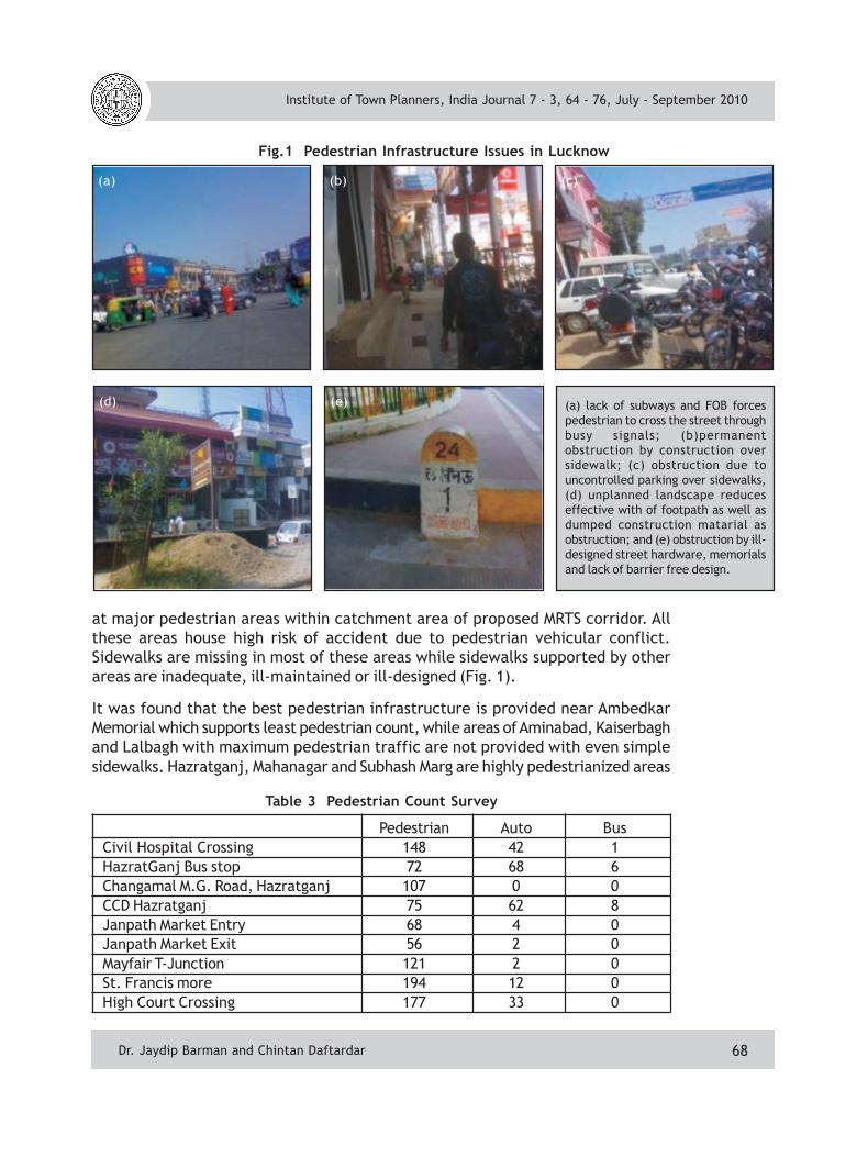
Fig.1 Pedestrian Infrastructure Issues in Lucknow
at major pedestrian areas within catchment area of proposed MRTS corridor. Allthese areas house high risk of accident due to pedestrian vehicular conflict.Sidewalks are missing in most of these areas while sidewalks supported by otherareas are inadequate, ill-maintained or ill-designed (Fig. 1).
It was found that the best pedestrian infrastructure is provided near AmbedkarMemorial which supports least pedestrian count, while areas of Aminabad, Kaiserbaghand Lalbagh with maximum pedestrian traffic are not provided with even simplesidewalks. Hazratganj, Mahanagar and Subhash Marg are highly pedestrianized areas
Table 3 Pedestrian Count Survey
Pedestrian Auto BusCivil Hospital Crossing 148 42 1HazratGanj Bus stop 72 68 6Changamal M.G. Road, Hazratganj 107 0 0CCD Hazratganj 75 62 8Janpath Market Entry 68 4 0Janpath Market Exit 56 2 0Mayfair T-Junction 121 2 0St. Francis more 194 12 0High Court Crossing 177 33 0
Institute of Town Planners, India Journal 7 - 3, 64 - 76, July - September 2010
Dr. Jaydip Barman and Chintan Daftardar
(a)
(a) lack of subways and FOB forcespedestrian to cross the street throughbusy signals; (b)permanentobstruction by construction oversidewalk; (c) obstruction due touncontrolled parking over sidewalks,(d) unplanned landscape reduceseffective with of footpath as well asdumped construction matarial asobstruction; and (e) obstruction by ill-designed street hardware, memorialsand lack of barrier free design.
(b) (c)
(d) (e)

69
and have sidewalks with commercialencroachments and obstructionsreducing effective width of walkways.Also due to insufficient infrastructureof parking vehicles are seen parked onfootpaths thus forcing public to walkon roads. Sidewalks at both the transithubs at Charbagh and Alambagh ISBTare encroached by street hawkers andvendors. Almost all the majorpedestrian areas are along traffic speedlanes while city lacks in subways or footover bridges for safe pedestrianmovement.
In some areas of Lucknow footpaths aredesigned at grade to road level toprovide flexibility of carriage widthduring peak hour but this has increasedaccident risk for the pedestrians. It hasbeen seen in case of Lucknow thatcontinuous mixed plots, largeinstitutional plots and walled townshipshave increased walking distance bymanifolds than the actual distance
between two destinations. Overall city’s traffic and pedestrian infrastructurediscourages pedestrian movement.
3.2 Design Considerations towards Walkable city
There are several ways to make a community more walkable. Preferably designconsiderations are to be observed from users’ perspective. In case of Lucknowwhere pedestrians are already high and would multiply with MRTS, pedestrianfacilities are needed to be designed considering pedestrian behaviour.
3.3 General pedestrian infrastructure design parametersSafety and Security: Pedestrian safety design must be the prime objective ofpedestrian infrastructure. The pedestrian-vehicular conflicts must be avoided.
• Place to walk are missing from major pedestrian zones. These areas should beprovided with sidewalks, and with minimum standard design considerations.The sidewalks should avoid any obstructions, barriers and too much of leveldifference to be provided for comfortable walking space.
• Barrier free pedestrian infrastructure design approach is needed for sidewalkdesign considering safety for disabled, elderly as well as children.
Fig. 2 Number of Pedestrian Intensity Around ProposedMRTS Interchange Hazratganj, Lucknow
Survey dated 26th Feb 2010
Institute of Town Planners, India Journal 7 - 3, 64 - 76, July - September 2010
Dr. Jaydip Barman and Chintan Daftardar

70
Fig. 3 Improving Walkability(Pedestrian Friendly Approach)
• Safe road crossing infrastructure isneeded especially for major workand commercial centres of city forsafe pedestrian movement.Therefore depending on number offootfalls crossing the streets skywalksand subways must be proposed toavoid pedestrian vehicular conflict.
• In case of zebra crossing the vehiclesare needed to be controlled beforestop line as tendency of theLucknowites have been to spill overzebra crossing during red signal.Hence traffic police control isequally important for safe crossings.
• Rescue islands must be an essentialpart of pedestrian safety ifpedestrians are made to walk acrossthe zebra crossing median.
• Controlling vehicles and blaming the drivers is not the only way as it has beennoticed that pedestrian themselves try to cross roads without signal, jumpingover or passing through the punctures in central verge. Hence public awarenessand commuters participation is also equally required. Also the punctures ifprovided must be designed at appropriate locations.
• Synchronised traffic signal must be provided at major junctions for vehicularas well as pedestrian movement along with timer that assures safe crossing forall including disabled, elderly and children.
• Street lights with adequate illumination along walkways ensure psychologicalsecurity to pedestrians.
• Since most of the pedestrian zones are close to commercial districts or workcentres, fire safety measures must also be taken under mandatory designconsiderations.
Convenience and Attractiveness: With upcoming MRTS, a majority of pedestrianswould be commuters or consumers. Therefore in public areas like work, commercialand recreational areas, pedestrian facilities and amenities would be required.
• Provision of basic street hardware and street furniture must be assured for theconvenience of pedestrians.
• Most of the walkways existing in Lucknow have hurdles and obstructions due toadvertisement hoardings or commercial encroachment which are needed to becontrolled.
Institute of Town Planners, India Journal 7 - 3, 64 - 76, July - September 2010
Dr. Jaydip Barman and Chintan Daftardar

71
• Regulation of street hawkers (theirnumber and location) will provideconvenience for pedestrians as wellas utilize existing pedestrianinfrastructure.
• Pedestrian friendly landscapingguidelines must be adopted toprovide natural shade andenvironment without causingobstruction for pedestrians andsufficient trees must be planted.Selection of trees must beconsidered to avoid any obstructiondue to low branching.
• Maintenance drive of walkwaysshould be regularly conducted. Thiswill not only ensure safe movementbut also provide time for commutersand consumers to appreciate urbanenvironment and have a glance oncommercial display thus increasingsales.
Fig. 4 Improving Walkability (Commuters & ConsumersZone for Sidewalks along Commercial Areas)
Institute of Town Planners, India Journal 7 - 3, 64 - 76, July - September 2010
• Urban Aesthetics and details are well appreciated in areas with walkableenvironment. Since most of the densely pedestrian areas within Lucknow arein heritage zone or old areas, pedestrian infrastructure design should alsoconsider urban design, architectural and cultural heritage features.
Policy Support: Success of any planning project essentially requires governmentpolicy support. Pedestrian planning guidelines under ‘IRC 103: guideline for inclusivepedestrian facilities (august 2009)’ has already been revised to improve pedestrianinfrastructure in Indian conditions by Transportation Research and Injury PreventionProgramme (TRIPP). Also National Urban Transport Policy (NUTP) has been requestedto formulate Unified Metropolitan Transport Authority for all major cities. Theseguidelines and policies must be adopted to achieve safe and sustainable transitplan. Hence, role of a transport planner thus becomes important especially inmetropolitan transport planning authorities.
• Setting a legal framework to protect right to walk for pedestrians must beconsidered to support social and equity concerns in mobility planning.
• Pedestrian movement plans should be made mandatory with traffic planning.
• Traffic regulations must be made strict with penalties to control vehicular aswell as pedestrian movement to ensure safety for both.
Dr. Jaydip Barman and Chintan Daftardar
72
• Introducing traffic calming techniques is required at design stage for Lucknowtraffic planning program, especially at major pedestrian nodes.
• Free left turns must have traffic control especially in high pedestrian zoneswith speed lanes. In Indian conditions usually left turn is always free. Thisincreases the risk for pedestrians if skywalks/subways are not provided as trafficfrom one direction is free movement, mostly a blind turns. Under such conditionsin major pedestrian areas fully pedestrian crossing time must be synchronizedwithin signal system.
• Involvement of public to be made in decision making and planning pedestrianinfrastructure.
• Safety audits and pedestrian safety education program must be conductedregularly.
• Policy planning for public mobility must also look into environment friendlyapproach.
• Devolution of responsibilities must be entitled to each chair of work.• Role of NGOs and public private participation, adoption of facilities or
development of infrastructure is also needed to be encouraged by cooperativeand corporate sectors.
• Various examples all over world like California as well as Delhi, etc have shownthat increasing land use dedicated to transport is not the solution for improvingtraffic conditions but smart traffic management, intelligent transportationssystem, mass transit system and traffic policies can play an appropriate role inresolving metropolitan traffic issues.
General Design Parameters towards Walkability at MRTS Nodes: With an upcomingMRTS proposal there is an expected increase in footfall at all the MRTS nodes.Therefore in addition to above mentioned considerations, walkability does notonly stick to pedestrian friendly approach but also consider commuters and consumerbehaviour.
• Promotion of transit oriented development (TOD) along with new urbanismplanning will improve walkability conditions and revitalise existing as well asnew urban centres.
• Compact and high density corridor development within MRTS catchment areawill help reduce walking distances as well as travel time.
• Appropriate zoning and building regulations (control setbacks, far, height,climatic concerns, etc;) can generate comfortable physical and visualenvironment for commuters.
• Connectivity of pedestrian infrastructure to major origin and destinationlocations must be seen with respect to exit locations of MRTS stations.
• Locations of exits in case of underground MRTS stations must be decided withefficient location specific planning by minimizing the maximum destinationdistances, thus reducing overall commuter walking.
Institute of Town Planners, India Journal 7 - 3, 64 - 76, July - September 2010
Dr. Jaydip Barman and Chintan Daftardar
73
• Urban illumination provides security to pedestrians as well as urban nightscape.
• Provision for secondary public transportation system also encourages pedestrianmovement.
• Strategic location of bus and public transit stoppages (e.g. with bus bays)
• Adequate shelter facility for secondary or feeder transit service users.
• Provision of para-transit stands
• Provision of commuter’s facilities and amenities including specific commercialoutlets, eat outs, post boxes, billing outlets as well as public toilets aroundMRTS station will also facilitate and encourage commuters.
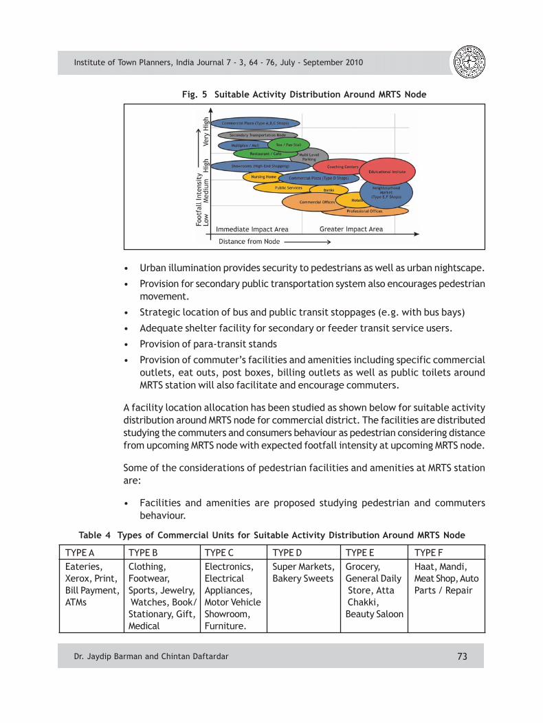
A facility location allocation has been studied as shown below for suitable activitydistribution around MRTS node for commercial district. The facilities are distributedstudying the commuters and consumers behaviour as pedestrian considering distancefrom upcoming MRTS node with expected footfall intensity at upcoming MRTS node.
Some of the considerations of pedestrian facilities and amenities at MRTS stationare:
• Facilities and amenities are proposed studying pedestrian and commutersbehaviour.
Table 4 Types of Commercial Units for Suitable Activity Distribution Around MRTS Node
TYPE A TYPE B TYPE C TYPE D TYPE E TYPE FEateries, Clothing, Electronics, Super Markets, Grocery, Haat, Mandi,Xerox, Print, Footwear, Electrical Bakery Sweets General Daily Meat Shop, AutoBill Payment, Sports, Jewelry, Appliances, Store, Atta Parts / RepairATMs Watches, Book/ Motor Vehicle Chakki,
Stationary, Gift, Showroom, Beauty SaloonMedical Furniture.
Institute of Town Planners, India Journal 7 - 3, 64 - 76, July - September 2010
Fig. 5 Suitable Activity Distribution Around MRTS Node
Dr. Jaydip Barman and Chintan Daftardar

74
• With facilities of ATM, Internet banking, credit and debit cards financial institutesand banks have reduced with number of footfalls.
• Most of the private commercial offices and professional offices deal with theirmajor clients through tele - conferencing or internet, thus reducing footfalls.
• Various types of commercial establishments are suggested with preferablelocation depending on (a) its catchment region, (b) recreational or generalconvenience, (c) probable footfalls, and (d) economic stability over landvalue(or land rent) distribution.
• Bill payment shops and ATMs at node will be best suited to busy schedule ofcommuters.
• Secondary transport service is proposed in between node and parking toencourage use of public or para-transit system even for commuters beyond GIAlinked by secondary transit system.
• Multi-level parking is adjusted at IIA and GIA interface to (a) reduce vehicular-pedestrian conflicts, (b) reduce congestion at nodes, and (c) will increasefootfall at high end commercial stretch between metro node and parkingincreasing economic returns.
• Urban open spaces must be considered along with designing above mentionedfacilities.
Special Design Features for Walkability within MRTS Catchment Area: Besidesgeneral pedestrian design parameters certain areas of old Lucknow and work centresneed special pedestrian infrastructure development approach.
• Fully pedestrianized lanes: Most of the activities in highly pedestrianized areasare governed by public sector. Hence public sector can share a responsibilitytowards pedestrian movement also. Most of the public and semi-public sectorcan play a major role by providing setbacks for creating ‘fully pedestrianizedlanes’. This will also resolve the issue of increased walking distance due togated communities and institutions. Requirement of such fully pedestrian laneis at Hazratganj, Ashok Marg, Lekhraj, Charbagh, Kanpur road (betweenCharbagh to Alambagh) and Moti Jheel mill area.
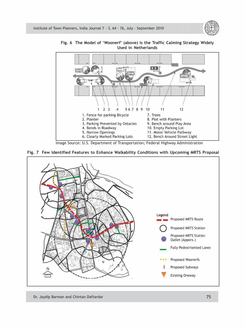
• Design of Woonerf: Old areas of Lucknow such as Aminabad, Kaiserbagh, Chowkand other areas with mix land use require some streets need to be legallyprioritized for pedestrians called as Woonerf. Prioritization of designing Woonerfmust be taken for selected streets in old areas of Lucknow which can be alsoplanned for new residential township as per requirement.
• Synchronizing traffic signals with MRTS scheduling: To adjust with bunchesof pedestrians outflow from MRTS station and disperse them accordingly overdemand in the region.
Institute of Town Planners, India Journal 7 - 3, 64 - 76, July - September 2010
Dr. Jaydip Barman and Chintan Daftardar
75
Fig. 6 The Model of ‘Woonerf’ (above) is the Traffic Calming Strategy WidelyUsed in Netherlands
Image Source: U.S. Department of Transportation; Federal Highway Administration
Fig. 7 Few Identified Features to Enhance Walkability Conditions with Upcoming MRTS Proposal
Institute of Town Planners, India Journal 7 - 3, 64 - 76, July - September 2010
Dr. Jaydip Barman and Chintan Daftardar

76
• Traffic police public interface units: This can be organised to assist tourist,pedestrians and emergency services. Such units should be developed near touristspots, recreational facilities, business and work centres.
• Car free Zones: This can be developed in old areas of Lucknow where peoplepark their private vehicle on road. This could be replaced by providing themwith centralized parking for the zone. Location of parking will be governed byavailability of space as well as consideration for minimizing the maximumdistance of the zone. Streets in these zones can also be developed as Woonerf.
• To identify strategic location for parking provision: Almost all stations mustpossess basic parking but major parking or multi-level parking should be providedat certain nodes which are close to major residential sectors within greaterimpact area. Location of major parking lots near residential areas must beclose to MRTS nodes (within 100 m from MRTS station) while at commercialnodes it can be within 250 m to 500 m encouraging walking around MRTS nodesthus providing opportunities for commercial establishments.
4. CONCLUSIONS
Improving walkability ensures easiest way for improving liveability concerns. Worldis walking towards urban sustainability. Walkability enhances urbanity, socialinteractions, community health and sustainable environment. It can also resolvesocial and equity concerns in mobility planning. Lucknow can also revive its Nawabiculture vibrancy by planning social walkable areas, and opting for optimal solutionfor the habitants of the city and its culture. The first step towards walkable Lucknowcity would be made by removing parking on sidewalks and utilising existinginfrastructure followed by providing basic pedestrian infrastructure and amenitiesto all other pedestrian areas. Thereafter, maintaining and upgrading pedestrianinfrastructure and encouraging pedestrians could be taken up. Also educationalprogrammes must be conducted to generate awareness of walkability. This shouldbe supported by structural reforms in legal framework to provide social equity topedestrians and right to walk for efficient system development. Various developmentorganizations need to work in coordination to achieve desired urban environmentfor pedestrians. Taking such steps at present would make safe, secure andconvenient rostrum for upcoming MRTS commuters.
Project for Public Spaces, a non-profit organization in New York City, has distilledthis idea into a slogan: ‘When you plan cities for cars and traffic, you get more carsand traffic. When you plan cities for people, you get more people’. Today urbanplanners in India need to rethink for whom they are planning. An urban module forIndian cities is needed to be developed to retain our socio-cultural vibrancy throughcontribution of pedestrian sustainable approaches.
Institute of Town Planners, India Journal 7 - 3, 64 - 76, July - September 2010
Dr. Jaydip Barman and Chintan Daftardar