planning model for rural roads - transportation research...
TRANSCRIPT
TRANSPORTA TJON RESEARCH RECORD 1291 171
Planning Model for Rural Roads
ASHOK KUMAR AND H. T. TILLOTSON
In tensive rural road development programs are under way in most of the developing countries but the task of implementing such programs is huge and complex, requiring comprehensive and coordinated planning of all the rural road development activities. The current planning practices are based mainly on ad hoc criteria that are not a good enough basis for planning major schemes. A planning model for systematically generating rural road networks is described. The model can be applied to any country that is planning a rural road network, even though the data used in developing the model belong to India. The model aims at generating a basic rural road network providing road connection from each village to a bigger center of activities for marketing, health, education, trade, social welfare, and so forth. For a rural area, several alternative networks can be generated; each of them will involve different construction costs, maintenance costs, travel costs, and social and economic benefits. The model selects the best alternative by minimizing the total cost or by aiming at tradeoffs between the given parameters. An iterative process has been developed for minimization of the total cost of a rural road network. The model is computer based to extend its utility and application, and its data requirements have been limited to what can be available from published census records, local government offices, and existing topographical maps.
In India, rural roads have been a matter of high political and development priority for many years. The government is committed to improving the quality of life in rural areas for which a basic rural road network is considered essential. All aspects of rural development including agriculture, health, education, dairy development, forestry, fisheries, small-scale industries, trade, commerce, and postal services depend on good communication. About 50 percent of the budget for road sector is spent on rural roads. There are about 600,000 villages in India. Intensive rural road development programs are underway to provide all-weather road connections to all these villages by the year 2001 as envisaged in the current plans (J).
Even though there is a political will for rural road development, the task of implementing such a rural road development program is huge and complex. Appropriate technologies, trained manpower, suitable organization, and other infrastructure facilities for implementing such a big task are yet to be developed. Apart from this, there are serious constraints on funds. Until now, only about 40 percent of the 600,000 villages are connected with all-weather roads. The remaining villages require about 1.3 million km of new road construction, involving an expenditure of about 400 billion rupees (J ,2). The requirement of maintenance funds is about 30 billion rupees per annum. Currently, only ·about 10 billion rupees per annum is allocated for new construction of rural
A. Kumar, Central Road Research Institute, New Delhi 110020, India. H. T. Tillotson, School of Civil Engineering, University of Birmingham, Birmingham, B 15, 2 TT, United Kingdom.
roads. Allocation for the maintenance is again only 20 to 30 percent of the actual requirements (3).
In addition to the mobilization of additional resources, concerted efforts need to be made for optimal use of the current resources. The first step in this direction is to plan all the rural road development activities in a corn'prehensive and coordinated manner, taking into consideration the long-range aspects of planning. The present practices of rural road planning leave plenty of scope for further improvements. Because of the absence of a scientific planning approach, several ad hoc approaches such as attaining a particular road density or bringing a village within a specified distance from a road or achieving road connection of a given proportion of villages within different population groups, are resorted to in the plans (1,4). One of the major guidelines that is now being followed is "to link with all-weather roads all villages with population of 1,500 and above and 50 percent of villages with population between 1,000 and 1,500 by the year 1990."
Although such guidelines appear specific, they in fact fail to offer any direction about the manner in which the targets should be achieved. The costs involved can vary enormously between alternative approaches to the same numerical targets. There is no guidance about which villages (among the targeted villages for road connection) should be connected first and where they should be connected. The design, construction, and maintenance standards are also not mentioned. Much is left to be interpreted locally, which provides scope for wide regional variation.
It is essential that the whole process of rural road development should be approached systematically. The first step in this direction is the preparation of master plans on a regional basis by adopting a scientifically based planning methodology. Only in this way can the funding procedure be streamlined and the expenditure be optimally used. The present study has been concerned with the planning of rural road networks. The aim has been to fill the long-felt need for a suitable methodology for preparing a master plan for rural roads (5 ,6).
THE PLANNING MODEL
Purpose
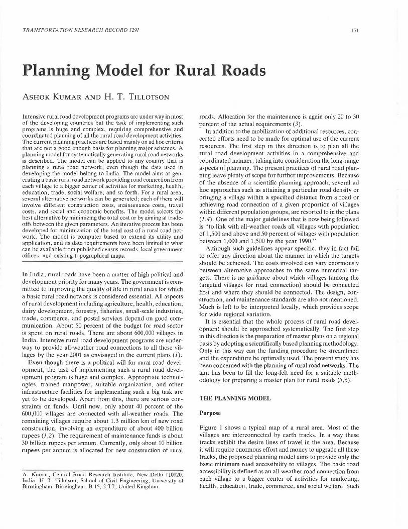
Figure 1 shows a typical map of a rural area. Most of the villages are interconnected by earth tracks. In a way these tracks exhibit the desire lines of travel in the area. Because it will require enormous effort and money to upgrade all these tracks, the proposed planning model aims to provide only the basic minimum road accessibility to villages. The basic road accessibility is defined as an all-weather road connection from each village to a bigger center of activities for marketing, health, education, trade, commerce, and social welfare. Such
172
· .. · ... .... .. ::{· . "!• ... . . ... ~ .. ~ : ..
. · · . . '-~ .. .,.o •. •• : . · ········ : . . ~. : ...
·. .· . . .. ~··~ ... ~:
TRANSPORTATION RESEARCH RECORD 1291
: · . :
.. . . .:.:-. . .! '
{ " :..., ·~· .· .;.··~ .· . · · ··· · 0\. : .. . · •:r .. ........ -.... 0..... . .. . . . ..... ... /'~~ : . . . . ..
· ... ~ .· ··. · , ·. •r . . · :.i, . . •.
,' •
::\~·-.... · .. [_ .. ··< .. ·: .t .· . . : . . '
,_r .· .· : .. .. ~ : .. ·· ·. •.. . . .· .
· .. ) ..
..... .. ';:.•, •.-.: : . ... .. : .. : ... :
..... . .. " .. . ... 7·~.;l:.~. . : ..f::t..'.'_'.:~~~ :'.:><: · .\ · ... , . • .... . . t. .
'· . ··:.:·· ·· : :· . ... ... .. :: ........ :.:"·;"· ... ~ .
.. ·. .. :-.~- .. : ,;.-~, •.. ... . 'P.- ·: · .. : . .
. . . .
TOWN
RIVER.
. .··. ··: ... . . .:·.
, . . .o'\ " . ,. .. oa., . .... ·:- :··· ·. . ... · ...... ...·
:
L E G
.0 EARTH TRACK ..
FIGURE 1 Typical map of a rural area.
centers are termed "market centers," which may be situated at the nearby towns, cities, or even at big villages.
It has to be recognized that even after providing all-weather road connections to the villages, the existing tracks interconnecting the villages will play a significant role in rural transportation. The journeys made between a village and farms, and between a village and other nearby villages, will mainly depend on these tracks.
The Optimization Problem
As road access is provided to the villages in a rural area, a large number of alternative networks need to be evaluated on the basis of parameters that include, among other factors, construction costs, maintenance costs, travel costs, and social and economic benefits. The best alternative will be that for
. ".!> : .. . . .... ·· :. : ... : . .. ····. . :·· ... '·· .. · .. .
E
· .. . · ... : ... .:· ..
..
N D
.. . · ··. : .· ' : .
VILLAGE .. ... to~~
MAIN ROAD .. _ -
which an objective function of these parameters has optimum value, i.e., a maximum or minimum.
Steenbrink (7) suggested a plausible and reasonable objective for a transportation network as the maximization of the positive difference between the benefits and costs to the society, called the "social surplus approach." The benefits of developing a rural road network include increased agricultural production; increased household income and assets; better access to administra tive centers like district and block headquarters; increa ed visits of government officials to rural areas, resulting in b tter administrative con.i.rol; availability of better qualified ta ff for schools, hospitals, and other services in rural areas; reduced sense of isolation among the rural people; increased industrial activities; and better opportunities for employment. On the cost side, there is (a) cost of constructing various rural road links including the cross-drainage works, (b) cost of maintaining the rural road links, (c) travel costs
Kumar and Tillotson
borne by the users, and (d) external costs such as environmental damage .
It is difficult to define, evaluate, and measure various social and economic benefits of rural roads in quantitative and monetary units. This task requires a good system of indicators for the well being of the rural community along with their relative weight, travel characteristics of different rural communities and the relationship of these characteristics with the type of road accessibility and spatial structure, and a future development plan for the region. Such information is generally not available for the rural areas in India. However, for the purposes of the present model it is the relative benefits of the alternative networks for an area that determine the optimum, rather than the absolute values of benefits. Therefore, several legitimate simplifications can be made to avoid the complex problem of evaluating the social and economic benefits of alternative optimum rural road networks for an area.
For a village, the basic travel demands for general marketing , sale of agricultural and dairy products , procurement of inputs for agriculture, visits to health and education facilities, etc., can be considered inelastic-at least for the alternative networks in the vicinity of an optimum network. Accordingly, little difference in trip patterns and the benefits provided by alternative networks in the vicinity of the optimum may be expected. Hence, the accessibility provided to the villages (or the opportunity provided for travel) can be considered as a whole to be the benefit of a rural road network. Achieving this benefit at the least cost becomes the objective in that case (7). Thus, the objective function for minimizing total cost can be expressed as
Min F = m • Z(X,C) + I(C) (1)
where
C = dimensions of the rural road links (such as length, design, and construction standards);
X = traffic flows on the rural road links; I( C) construction (plus maintenance) costs as a func-
tion of dimensions of the rural road links; Z(X,C) = travel costs as a function of traffic flow and
dimensions of the rural road links; and m = a factor that makes it possible to compare (and
add) travel costs and construction costs.
Minimization of investments for a given level of effectiveness (level of service) can also be used as an objective function for optimization of a rural road network as an alternative to minimization of total cost (6).
Estimation of Costs
For the present model , the costs have been divided into two types. One type has been called construction cost, which also includes maintenance cost suitably discounted over the life of the project. The model assumes construction cost for a link as proportional to its length, but with the provision of a weighting factor to reflect different construction standards and number and type of cross-drainage works of some links . This weighting factor can be estimated with a reasonable accuracy from the cost data on different type of road construction,
173
cross-drainage works, and labor and material rates available with local road construction agencies.
Another type of cost considered in the model is travel cost. For a rural road link, the travel cost will be the sum of the costs for each trip made over that link. Accordingly, the number of trips generated from each village and their respective costs needs to be known. The number of trips generated by a village will depend on the parameters including population, land use, occupation, income, vehicle ownership and socioeconomic development . The cost for a trip depends on its purpose, length, mode, riding quality of the road, and time involved in making that trip. In addition to conventional motorized vehicles, additional modes need to be taken into account such as bullock carts, bicycle, and pedestrian trips that either do not appear or are of less economic significance in conventional transportation planning followed in the West. Suitable data on trip generation rates from the rural areas in India and on operating costs of various nonmotorized vehicles are not yet available. This limitation has led the model to avoid dependence on the absolute value of travel cost; however, the results obtained by the model are demonstratively worthwhile. For the purpose of the present model, it is the relative costs of alternative road connections for a village, rather than the absolute costs of road connections, which determine the optimum. Therefore , several legitimate simplifications can be made (6).
Travel costs for a village can be considered as proportional to (a) the number of persons connected through that village and (b) the distance between that village and the destination of the traffic (the market center). It is therefore argued that whatever the travel costs may be, they will be proportional to a factor in units of person-kilometers, defined as the product of the population connected by a village and the distance between the village and the destination of the traffic. The model is aimed at relatively small uniform areas having similarity in terrain and environmental conditions, agriculture , income, occupation, and habitation patterns . The rural area for which an optimum network is to be generated can first be divided into such small uniform areas bounded by main roads or natural barriers, and the rural road network can be generated for each of these areas. This process restricts the data requirement of the model to the readily available data-like population of villages, coordinates of villages, linear distances between the villages-avoiding carefully any data that are difficult to obtain in rural areas.
The proxy for the construction cost is the length of the link and for the travel cost is the person-kilometer , which are not directly comparable units . Therefore, a conversion factor, RC, has been applied to the link lengths to convert them into equivalent person-kilometers. Hence,
Total Cost = Person-Kilometers
+ RC * Kilometers (2)
The value of RC determines the trade-off between construction and travel costs. A reduction in the number of person-kilometers is a benefit that has to be compared with the cost of extra link-length in kilometers. In the iterative process discussed previously, replacement of one link with another is worthwhile only if the benefits exceed the costs,

174
that is, if the change in person-kilometers exceeds RC times the change in kilometers.
The value of RC can be estimated by converting the construction, maintenance, and travel costs into equivalent annual costs or net present values. As discussed earlier, the construction and maintenance costs can be estimated easily , but the data required for the estimation of travel costs are not yet available. So the calc11lfltion proceeds as follows. The average costs of a trip per passenger per kilometer and goods movement per tonne per kilometer can be obtained from the local transport department or from the passenger and goods transporters. Through sample household surveys in selected villages, the average passenger trip generation rate and goods movement between the villages and market centers can be estimated. RC can then be estimated as follows :
RC = CA/(TP * CP + TG *CG) x 365 (3)
where
CA = equivalent annual cost for construction and maintenance of 1 km of a rural road,
TP average passenger trips per person per day between a village and a market center,
TG average goods movement per person per day (in tonnes) between a village and a market center,
107
TRANSPORTA TION RESEARCH RECORD 1291
CP average cost of a passenger trip per kilometer, and CG average cost of goods movement per tonne per kil
ometer .
As an alternative to determining the value of RC by Equation 3 (because of lack of data) , engineering judgment can be used in finding a trade-off between the construction and travel costs. This can be done by generating alternative optimum networks by adopting a set of RC values over a reasonable range. Each of these networks will be optimum for a specific value of RC. The road construction lengths and person-kilometers involved in each alternative optimum network are plotted. Figure 2 shows such a plot for the rural area shown in Figure 3. As is to be expected, when construction costs are at a minimum, small increases in these costs yield large savings in travel costs , but further increases in the construction costs are progressively less productive. The relative benefits of various levels of investments (in terms of road length required for construction of the network) in reducing the travel costs may be seen on the graph in Figure 2. The networks with excessive travel or construction costs, such as in the regions marked A and B, may be avoided . Engineering judgment will be swayed by the total construction cost if the budgets are constrained but in the knowledge of consequent changes in person-kilometers. It seems reasonable to adopt a network from the knee of the curve in Figure 2 in such
\ REGION 'A' 105
103
t 101
... ~ 99 )(
E .... 97 z ~ ffi 95 Q.
Ii; 93 0 u
iil 91
~ a: ..... 89
87
•
•
• • /IDENTIFIED OPTIMUM ~ NETWORK
• • • • • REGION 's' . ...
85 +-~-.-~~.----~-.-~--...--~-.-~---..~~-.-~----.. 76 80 84 88 92 96 100 104 108
CONSTRUCTION COST (Km) -
FIGURE 2 Relationship between pseudotravel and pseudoconstruction costs of alternative optimum networks for a typical rural area.
Kumar and Tillotson
VILLAGE NODES LINK OPTIONS
............ .... , I \
' ........ : I \ --------~ \ , ' I\ I \ / ', I ' / ,
' I \ I ... -..ff-., \_ I \ ---/I '-.. ' I ' I --- I ... \ '- ~-- I ', I ', I I ,• ........ ,, I ' ,, / ....
-- '~/ \ t ', I ------- , I , I * -----.... . \ , I --
1 / I ,/ I"',.._\/ I _,I
I ',./<' : /"' \ / --,-...... I ,,,,-' \
I _..-' f ...... ...,, f "" \ I .,,,...,,,,,..- I ''...k""' \ _.------"*: 1' ,,~------------A.---
1 ', ,/ I ', / '.,. I '-.. I ,/ I ' / ' I ', I " I ', / ', I .... , I /' I ' , '
I ',~, / I ',rt' ----~-' ~------ -r
------- .............. I ,,,"' '- ,' --- I .............. \ ,,"' ' _,I"
I \ I '-.. ~· ,,, \ /1
I \ I ' \ ' I \ I --- L'' I \ / / \ ------")/::----------
4 \ f / \ /I', \
I / \ / I ', ;' \ ,' I '
-- ------~--- ~I \ ,,/ I ', -- \ ,, I 'p-----\ I ; --- \ ,, I
'\ I ,,,,. ', ----...r<._ ' /" ' I ,,.,. \ /~.......... ' ,' \
/ ,,"' \ , \ ......... I ,; "" \ ,' \ ''jf' \ I ,,,, \ ,, \ ---------',/.,"' ,, \ I ---y-------------.J-< ' I
--- ,,""( \ I \ \ ,,..- ..- \ \ I \\ I ,,..- \ \ I I ,,..- \ I \ I ..-"' I \ I \ I ,,..- I \ I ~ *------- \ ).(_-----~---
,,.,..,,.,.,,, I --------c;:>---------".f I ', -
,,..-"' '1 I I : .... , ..-"' I I I ',
,' I I '
1 1 MARKET r.ENTRE
MAIN ROAD
ROOT NODES
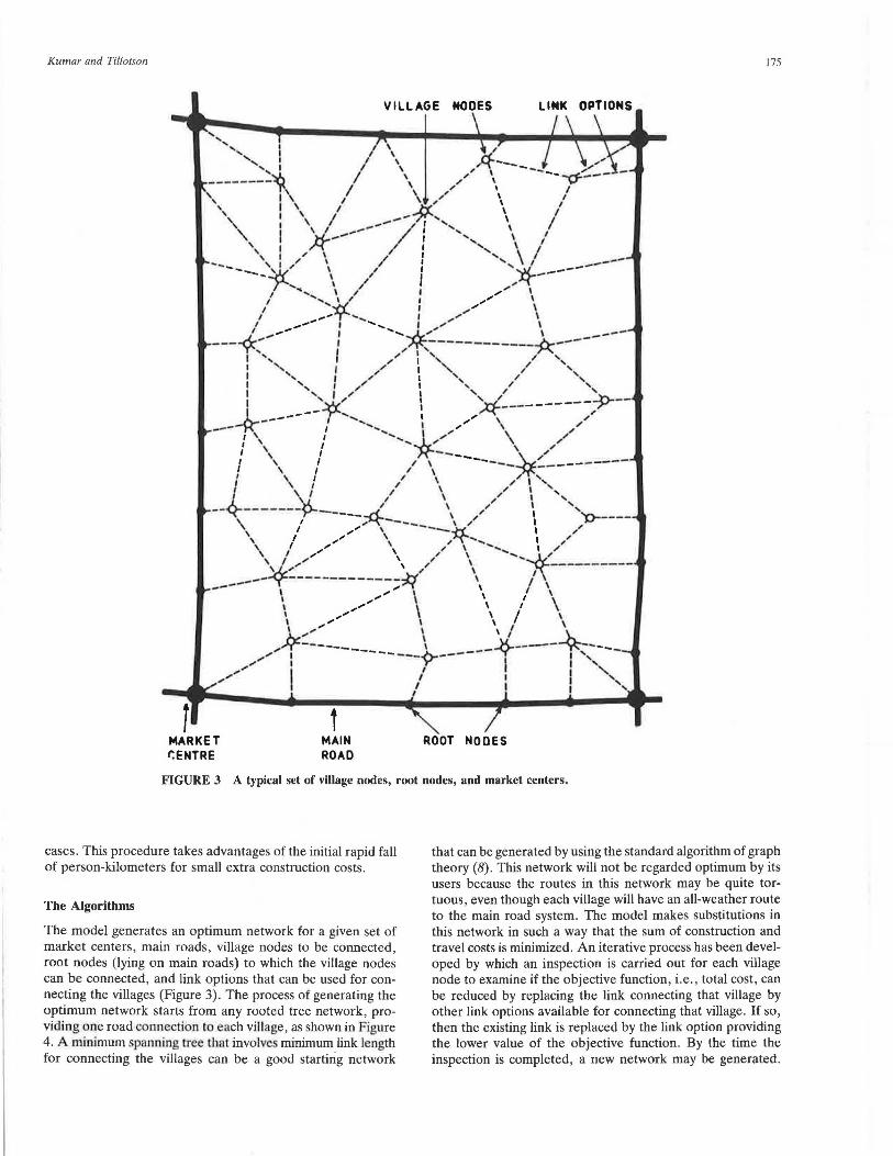
FIGURE 3 A typical set of village nodes, root nodes, and market centers.
175
cases. This procedure takes advantages of the initial rapid fall of person-kilometers for small extra construction costs.
that can be generated by using the standard algorithm of graph theory (8). This network will not be regarded optimum by its users because the routes in this network may be quite tortuous, even though each village will have an all-weather route to the main road system. The model makes substitutions in this network in such a way that the sum of construction and travel costs is minimized. An iterative process has been developed by which an inspection is carried out for each village node to examine if the objective function, i.e., total cost, can be reduced by replacing the link connecting that village by other link options available for connecting that village. If so, then the existing link is replaced by the link option providing the lower value of the objective function . By the time the inspection is completed, a new network may be generated.
The Algorithms
The model generates an optimum network for a given set of market centers, main roads, village nodes to be connected, root nodes (lying on main roads) to which the village nodes can be connected, and link options that can be used for connecting the villages (Figure 3). The process of generating the optimum network starts from any rooted tree network, providing one road connection to each village, as shown in Figure 4. A minimum spanning tree that involve minimum link length for connecting the villages can be a good starting network
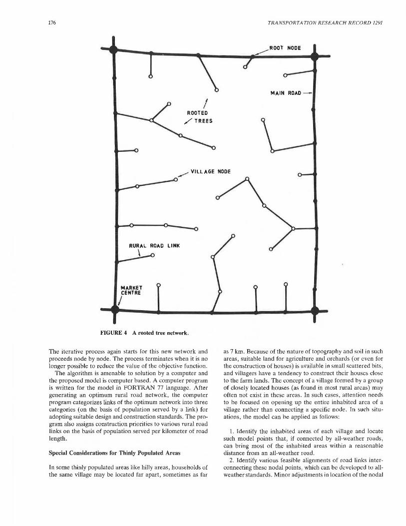
176 TRANSPORTATION RESEARCH RECORD 1291
_.....-- ROOT NODE
MAIN ROAD -
I ROOTED
/TREES
...,,...,,... VILLAGE NODE
MARKET CENTRE
I
ROAD LINK
FIGURE 4 A rooted tree network.
The iterative process again starts for this new network and proceeds node by node . The process terminates when it is no longer possible to reduce the value of the objective function.
The algorithm is amenable to solution by a computer and the proposed model is computer based. A computer program is written for the model in FORTRAN 77 language. After generating an optimum rural road network , the computer program categorizes links of the optimum network into three categories (on the basis of population served by a link) for adopting suitable design and construction standards. The program also assigns construction priorities to various rural road links on the basis of population served per kilometer of road length.
Special Considerations for Thinly Populated Areas
In some thinly populated areas like hilly areas, households of the same village may be located far apart, sometimes as far
as 7 km. Because of the nature of topography and soil in such areas, suitable land for agriculture and orchards (or even for the construction of houses) is available in small scattered bits, and villagers have a tendency to construct their houses close to the farm lands. The concept of a village formed by a group of closely located houses (as found in most rural areas) may often not exist in these areas . In such cases, attention needs to be focused on opening up the entire inhabited area of a village rather than connecting a specific node. In such situations, the model can be applied as follows:
1. Identify the inhabited areas of each village and locate such model points that , if connected by all-weather roads, can bring most of the inhabited areas within a reasonable distance from an all-weather road .
2. Identify various feasible alignments of road links interconnecting these nodal points, which can be developed to allweather standards. Minor adjustments in location of the nodal
Kumar and Tillotson
points, to suit engineering and geological requirements of these links may be necessary.
3. Through these steps, a set of nodes and link options can be arrived at, for which an optimum rural road network can be developed.
Incorporating Existing Rural Road Network in the Optimum Network
In most rural areas, some part of the rural road network may already be constructed, which would need to be considered during generation of an optimum network for that area. This could be done by making a suitable allowance in the construction cost of link options already constructed.
For the links already constructed, the construction cost may be treated as a part of the actual construction cost or just the cost of road maintenance alone. Alternatively, a rural road network can be generated without any regard to existing rural road network, in the first instance. Thereafter, the existing [Ural road network can be superimposed over the optimum network. This superimposition can then form the basis of any modification in the optimum network that can be justified because of the roads already constructed.
Different Applications of the Model
The model can be effectively used for preparing master plans for rural roads. The model can provide a uniform basis for rural road planning. Currently, planning practices differ widely from state to state and are swayed by local judgment.
177
Alternative combinations of market centers, main roads, and villages for an area can be evaluated by using the model. The model can also be applied for the identification of major bridge sites in rural areas . Even though major bridges are not anticipated on rural roads, the provision of a major bridge may emerge as the best alternative in some rural areas lying across a river or stream. In such situations, alternative rural road networks for the area can be generated with and without the provision of major bridges at feasible locations, and the alternative giving least cost can be adopted.
A direct estimate of the requirement for rural roads for each district and state and the country as a whole can be made by using the model. The task can be performed by obtaining the population of villages from census records and the coordinates of various villages and root nodes from the existing topographical maps. The coordinates can be directly measured from topographical maps and fed to a computer. Simultaneous with the requirement of rural roads, the need for establishing new market centers and developing main roads can also be assessed . The actual requirement for rural roads for a region or state, when compared to the existing rural roads in that region or state, can become a strong basis for allocating funds for rural road development among the various regions.
EXAMPLES
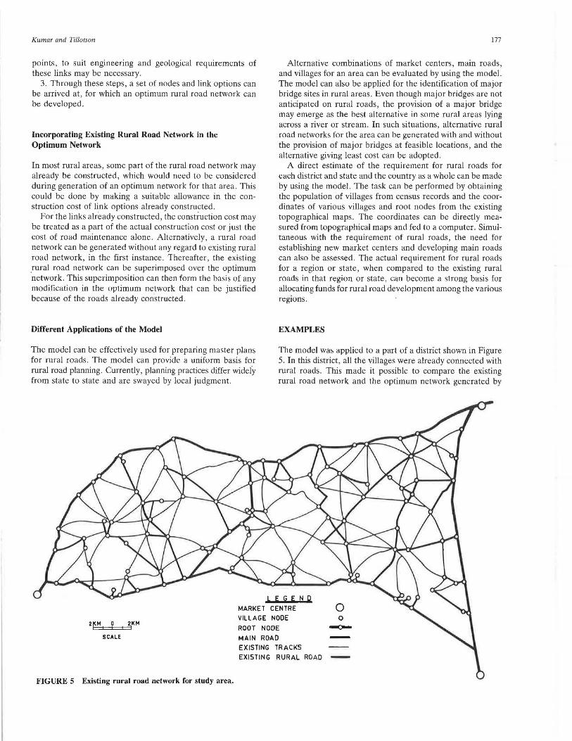
The model was applied to a part of a district shown in Figure 5. In this district, all the villages were already connected with rural roads . This made it possible to compare the existing rural road network and the optimum network generated by
LEGE Np MARKET CENTRE 0 VILLAGE NOOE 0
2fM 1 0 2KM
ROOT NOOE ~ I I I
SCALE MAIN ROAD EXISTING TRACKS EXISTING RURAL ROAD -
FIGURE 5 Existing rural road network for study area.
178
the proposed model. The optimum network was generated by aiming at a trade-off between travel costs and construction costs as explained previously. A set of 32 alternative optimum networks was generated by adopting different RC values ranging from 100 to 30,000. The pseudoconstruction and pscudotravel costs (road lengths and person-kilometers) of the alternative optimum networks are shown in Figure 6. Rapid fall in the travel costs with small increases in construction costs can be observed up to an RC value of 1,400. Accordingly, the network generated with an RC value of 1,400 was identified as the optimum, providing a reasonable trade-off between the construction and travel costs. The optimum network thus identified is shown in Figure 7. Table 1 presents a comparison between the existing and the optimum network.
1525 NET.
1040
1030
18000
1020
.t 1010
g 5!
TRANSPORTA T!ON RESEARCH RECORD 1291
The existing network is costlier to construct as well as costlier to the users. The existing network requires 157 .58 km of road length for providing one road connection to each village, whereas the optimum network requires only 144.2 km of road length to connect the villages. Pseudotravel cost for the existing network is 1 560 278 person-kilometers, whereas for the optimum network it is only 1 401 981 person-kilometers. The extra road length of the existing network does not show any benefit in terms of reduction in travel cost. On the contrary, the extra road length in the existing network makes the network less efficient. It is interesting to note that even with lower road length the optimum network provides far more efficient road connections to the villages. Efficiency for a village node in the optimum network was calculated as
llC 1000 VALUE E .x I
z 5t a: Ill Q.
.... 11'1 0 u ...I l&J > < a: ....
990
980
970
960
950
940 80
RC VALUE CORRESPONDING TO THE OPTIMUM NETWORK
84 88 92 96
7 MIN . TRAVEL COST NET.
100 104 10• CONSTRUCTION COST (km 1--
FIGURE 6 Pseudotravel and pseudoconstruction costs of alternative optimum networks.
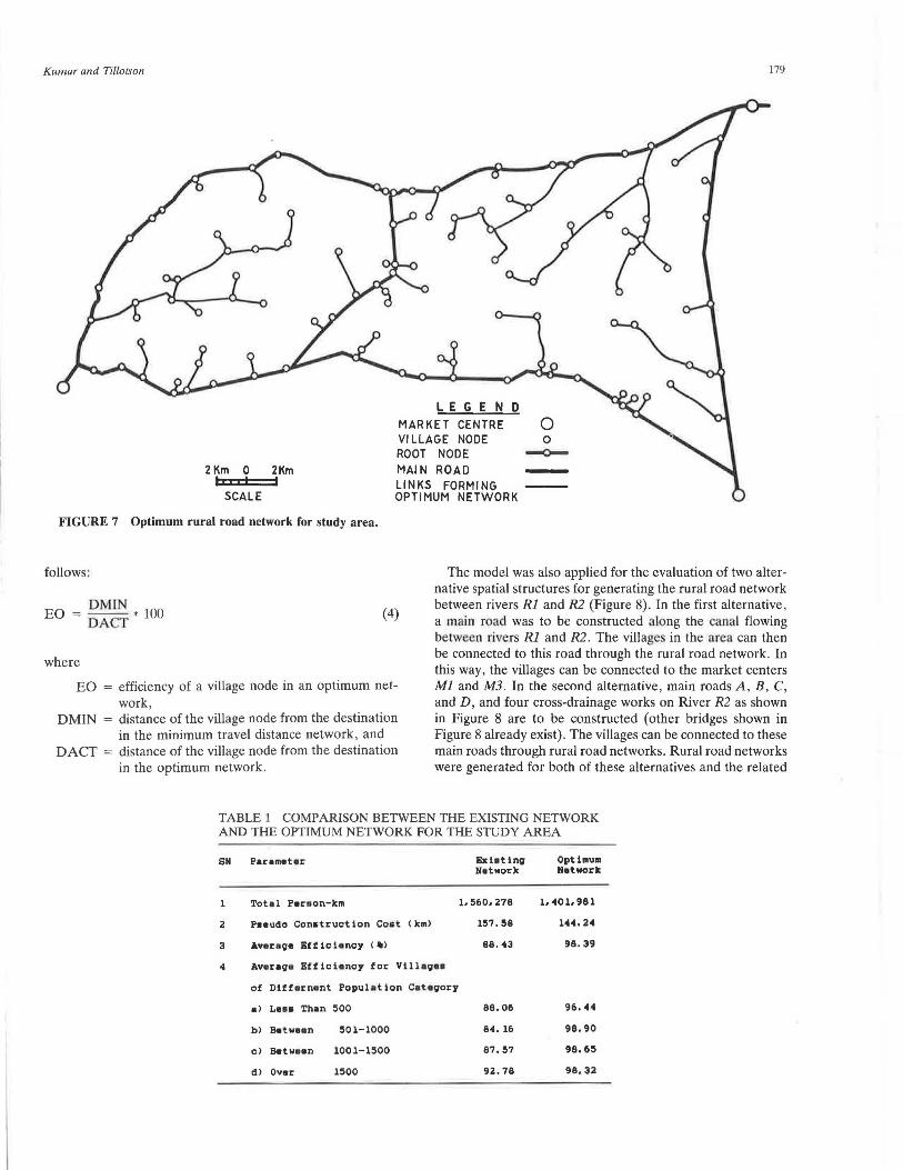
Kumar and Tillotson
2 Km 0 2Km I• I I I I
SCALE
LEGEND MARKET CENTRE 0 YI LLAGE NODE O ROOT NODE --0--
MAl N ROAD -LINKS FORMING OPTIMUM NETWORK
179
FIGURE 7 Optimum rural road network for study area.
follows:
EO = DMJN * 100 DACT
where
(4)
EO = efficiency of a village node in an optimum network ,
DMIN = distance of the village node from the destination in the minimum travel distance network , and
DACT = distance of the village node from the destination in the optimum network.
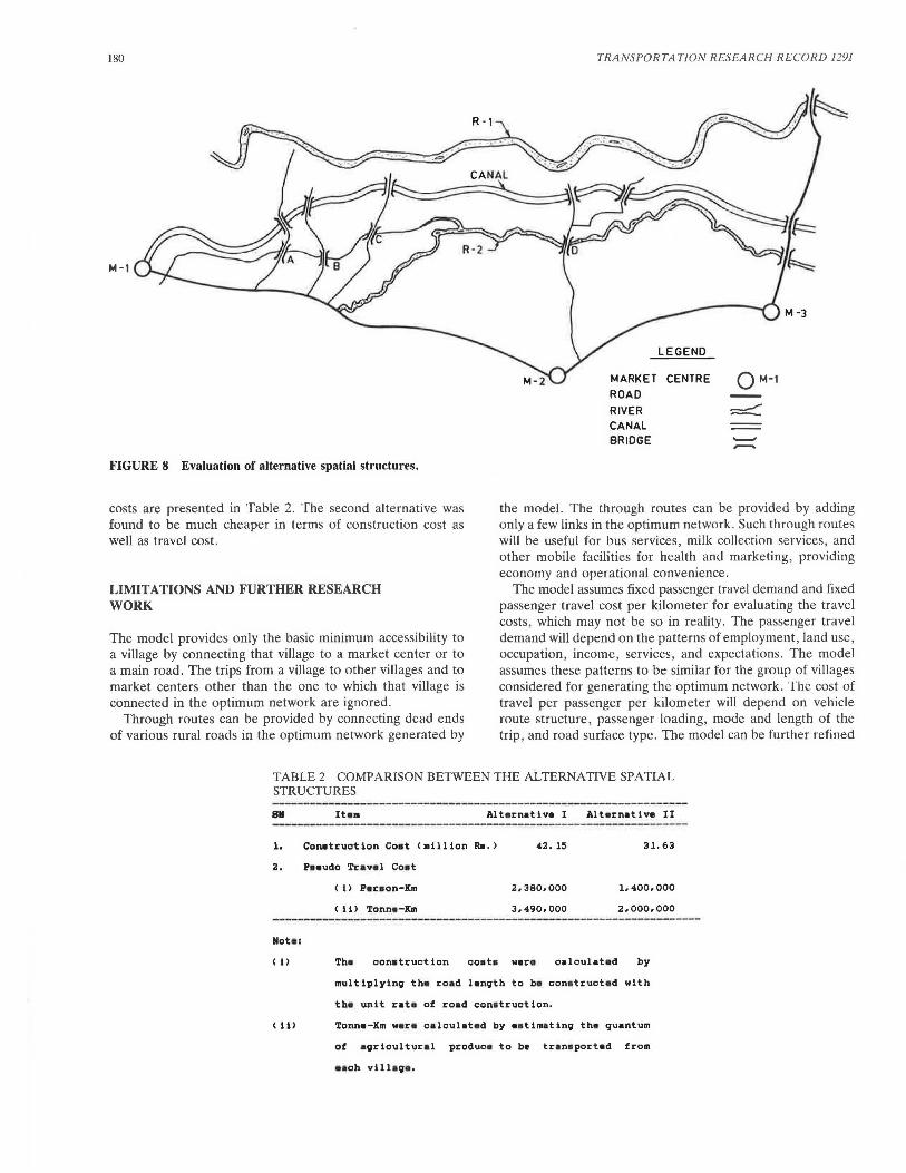
The model was also applied for the evaluation of two alternative spatial structures for generating the rural road network between rivers Rl and R2 (Figure 8). In the first alternative, a main road was to be constructed along the canal flowing between rivers Rl and R2. The village in the area can then be connected to this road through the rural road network. In this way , the villages can be connected to the market centers Ml and M3. In the second alternative, main roads A, B, C, and D, and four cross-drainage works on River R2 as shown in Figure 8 are to be constructed (other bridges shown in Figure 8 already exist). The villages can be connected to these main roads through rural road networks. Rural road networks were generated for both of these alternatives and the related
TABLE 1 COMPARISON BETWEEN THE EXISTING NETWORK AND THE OPTIMUM NETWORK FOR THE STUDY AREA
SN Parameter Bxllting Optimum Networll: Networll:
l Total Peraon-ll:m 1.560.278 1. 401. 981
2 Pseudo Conatruction Coat <kml 1S7. S8 144. 24
3 Average Efficiancy <-> 88.43 98.39
4 Average Efficiency for VilhgH
of Differnant Population Category
al Le•• Than 500 88.06 96. 44
bl Between SOl-1000 84. 16 98.90
cl Batwaan 1001-lSOO 87.S7 98.6S
dl Over 1500 92.78 98,32
180
M-1
FIGURE 8 Evaluation of alternative spatial structures.
costs are presented in Table 2. The second alternative was found to be much cheaper in terms of construction cost as well as travel cost.
LIMITATIONS AND FURTHER RESEARCH WORK
The model provides only the basic minimum accessibility to a village by connecting that village to a market center or to a main road. The trips from a village to other villages and to market centers other than the one to which that village is connected in the optimum network are ignored .
Through routes can be provided by connecting dead ends of various rural roads in the optimum network generated by
TRANSPORTATION RESEARCH RECORD 1291
LEGEND
MARKET CENTRE
ROAD
RIVER CANAL BRIDGE
QM-1
the model. The through routes can be provided by adding only a few links in the optimum network. Such through routes will be useful for bus services, milk collection services, and other mobile facilities for health and marketing, providing economy and operational convenience.
The model assumes fixed passenger travel demand and fixed passenger travel cost per kilometer for evaluating the travel costs, which may not be so in reality. The passenger travel demand will depend on the patterns of employment , land use, occupation, income, services, and expectations. The model assumes these patterns to be similar for the group of villages considered for generating the optimum network. The cost of travel per passenger per kilometer will depend on vehicle route structure, passenger loading, mode and length of the trip, and road surface type. The model can be further refined
TABLE 2 COMPARISON BETWEEN THE ALTERNATIVE SPATIAL STRUCTURES
-~------------------------
s• It•• Alt•rnativa I Alt•rnativa II
1. Con11truction Coat <million Ra.> 42. 15 31. 63
2. Paaudo Tra val Coat
< i> Paraon-Km 2,380.000 1.400,000
< ii> Tonne-Km 3,490.000 2.000.000 --------------------·------------------·---Rota :
< i) Th• conatruction coat• war• calculat • d by
multiplying th• roa d length to b• cona truct•d with
th• unit rat• of road cona truction.
(ii> Tonna-Km w•r• calculat•d by aatimating th• quantum
of agricultural produca to b~ trana portad from
aacb vilhg• .
Kumar and Tillotson
by taking into account the variation in passenger travel demand and passenger travel cost.
CONCLUDING REMARKS
A planning model has been developed that generates a basic rural road network providing access to each village to a larger center of activities for marketing, health, education, trade, commerce, and social welfare. The planning model will be useful to the planning authorities for preparing master plans for rural roads. The planning model can provide a systematic and uniform basis for planning of rural roads, apart from providing economy in the rural road development.
ACKNOWLEDGMENTS
The authors are grateful to D. V. Singh, Central Road Research Institute (CRRI), New Delhi, India, and to Y. R. Phull and A. V. S. R. Murty of CRRI for their suggestions and support for this work.
181
REFERENCES
1. Road Development Plan for India-1981-2001. Indian Roads Congress, New Delhi, 1984.
2. D. P. Gupta. Rural Roads for Achieving Integrated Rural Development. Indian Highways, Vol. 18, No. 5, Indian Roads Congress, New Delhi, 1990.
3. Growing Problem of the Maintenance of Roads-A Critical Study. Planning Commission (Transport Division), Government of India, New Delhi, 1987.
4. Seventh Five Year Plan. Planning Commission, Government of India, New Delhi, 1985.
5. C. G. Swaminathan, N. B. Lal, and A. Kumar. A Systems Approach to Rural Road Development. Journal of Indian Roads Congress, Vol. 42-IV, New Delhi, 1981.
6. A. Kumar. Planning of Rural Roads in India. Ph.D. dissertation, School of Civil Engineering, University of Birmingham, Birmingham, U.K., 1990.
7. P. A. Steenbrink. Optimization of Transport Networks, John Wiley, London, U.K., 1974.
8. N. Deo. Graph Theory with Applications to Engineering and Computer Science. Prentice Hall of India, New Delhi, 1980.