polymet aera errata and response to comments
TRANSCRIPT

2016 AERA Response to Comments Submittal, Including Errata
Poly Met Mining, Inc. NorthMet Project
December 19, 2016
The following provides responses to comments received from Kristie Ellickson of the MPCA via an e-mail dated December 5, 2016 regarding the NorthMet AERA reports submitted on August 24, 2016. The numbers below correspond to the numbered comments in the referenced e-mail. The MPCA comment is provided verbatim followed by the PolyMet/Barr response. To the extent corrections or clarifications to the AERA report text are needed to address the comments they are provided below. Corrections to the August 24, 2016 submittals are included in the errata table.
MPCA Comment:
1. I am proposing that Polymet/Barr fill out the forms that are on the AERA website and that is used asthe documentation of the AERA in the air permit. https://www.pca.state.mn.us/air/aera-forms-and-tools. This is more straightforward and brief documentation of the technical portions of the AERA forthe permit TSD.
a. These have been submitted and are complete
PolyMet/Barr response:
As noted by MPCA, this item has been addressed.
MPCA Comment:
2. Not all sources in the non-deposition input file have both a deposition and non-depositioncounterpart. Example: Dunka Road and WWTR. There are PM2.5 emissions in the emission inventoryfor these two pollutants, and my understanding was that PM2.5 sources would not include adeposition algorithm.
a. This question has been answered and my misunderstanding has been resolved. There is norecommended change.
PolyMet/Barr response:
As noted by MPCA, there was no recommended change.
MPCA Comment:
3. This is stated in the opposite (Mine Site AERA report): “USEPA stopped regulating particles less than10 micrometers in diameter (PM10) in the form of ambient air quality standards in 1987 becausepotential health risks from larger particles which enter the head area of the respiratory tract (e.g.,
aq5-35h
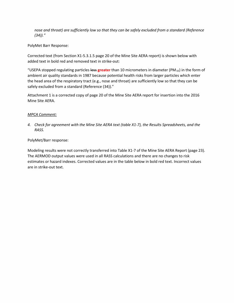
nose and throat) are sufficiently low so that they can be safely excluded from a standard (Reference (34)).”
PolyMet Barr Response: Corrected text (from Section X1-5.3.1.5 page 20 of the Mine Site AERA report) is shown below with added text in bold red and removed text in strike-out:
“USEPA stopped regulating particles less greater than 10 micrometers in diameter (PM10) in the form of ambient air quality standards in 1987 because potential health risks from larger particles which enter the head area of the respiratory tract (e.g., nose and throat) are sufficiently low so that they can be safely excluded from a standard (Reference (34)).”
Attachment 1 is a corrected copy of page 20 of the Mine Site AERA report for insertion into the 2016 Mine Site AERA.
MPCA Comment: 4. Check for agreement with the Mine Site AERA text (table X1-7), the Results Spreadsheets, and the
RASS. PolyMet/Barr response: Modeling results were not correctly transferred into Table X1-7 of the Mine Site AERA Report (page 23). The AERMOD output values were used in all RASS calculations and there are no changes to risk estimates or hazard indexes. Corrected values are in the table below in bold red text. Incorrect values are in strike-out text.

Table X1-7 Maximum modeled air concentrations evaluated in the 2016 AERA conducted for the proposed Mine Site - Corrected
PolyMet Mine Site Ownership Boundary Maximum Modeled Air Concentrations
(µg/m3)
Mineral Mining/Industrial District Boundary
Maximum Modeled Air Conc. (µg/m3)
Chemical Name 1-Hour
Mine Year 8
1-Hour Mine Year
13 Annual
Mine Year 8
Annual Mine Year
13 Annual
Mine Year 8 Annual
Mine Year 13
Acetaldehyde 0 0 0 0 0 0
Arsenic 0.006 0.007 0.00011 0.00010 0.00003 0.00002
0.00002
Cobalt NA NA 0.00046 0.00037 0.0001 0.00007
0.00008
Copper 0.119 0.231 NA NA NA NA
Crystalline Silica NA NA 0.074 0.056 0.018 0.011
0.012
Dibenzo(a,h)anthracene NA NA 2.6E-08 2.4E-08 6.4E-09 4.8E-09
4.9E-09
Diesel Particulate Matter NA NA 0.081 0.079 0.011 0.010
0.009
Dioxins/Furans (as 2,3,7,8-TCDD TEQ)
NA NA 2.5E-10 2.3E-10 5.7E-11 4.4E-11
4.3E-11
Indeno(1,2,3-cd)pyrene NA NA 1.5E-07 1.4E-07 3.7E-08 2.8E-08
2.9E-08
Manganese NA NA 0.011 0.009 0.003 0.002
0.002
Nickel 0.116 0.111 0.003 0.003 0.0007 0.0005
0.0005
Nitrogen Oxides (NOx)(1) 144.7 179.4 NA NA NA NA
Sulfur dioxide (SO2) 1.489 0.934 0.964
NA NA NA NA
Sulfuric acid (H2SO4/SO3) 0 0 0 0 0 0
(1) The USEPA factor of 80% for the conversion of NOX to NO2 was applied to the maximum modeled one-hour NOX air concentration. Value shown in table is NOX not NO2 estimate.
Additionally, Attachment 2 is a clean version of the corrected Table X1-7 (page 23 of the Mine Site AERA report) for insertion into the 2016 Mine Site AERA.
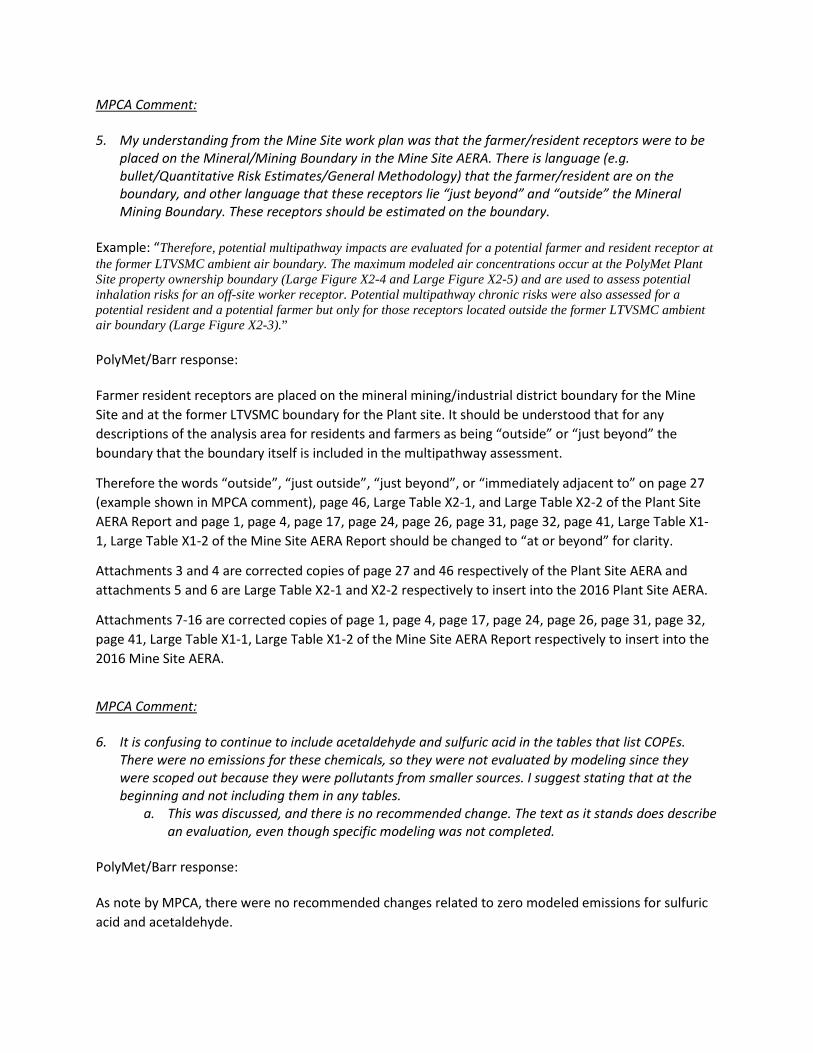
MPCA Comment: 5. My understanding from the Mine Site work plan was that the farmer/resident receptors were to be
placed on the Mineral/Mining Boundary in the Mine Site AERA. There is language (e.g. bullet/Quantitative Risk Estimates/General Methodology) that the farmer/resident are on the boundary, and other language that these receptors lie “just beyond” and “outside” the Mineral Mining Boundary. These receptors should be estimated on the boundary.
Example: “Therefore, potential multipathway impacts are evaluated for a potential farmer and resident receptor at the former LTVSMC ambient air boundary. The maximum modeled air concentrations occur at the PolyMet Plant Site property ownership boundary (Large Figure X2-4 and Large Figure X2-5) and are used to assess potential inhalation risks for an off-site worker receptor. Potential multipathway chronic risks were also assessed for a potential resident and a potential farmer but only for those receptors located outside the former LTVSMC ambient air boundary (Large Figure X2-3).” PolyMet/Barr response: Farmer resident receptors are placed on the mineral mining/industrial district boundary for the Mine Site and at the former LTVSMC boundary for the Plant site. It should be understood that for any descriptions of the analysis area for residents and farmers as being “outside” or “just beyond” the boundary that the boundary itself is included in the multipathway assessment.
Therefore the words “outside”, “just outside”, “just beyond”, or “immediately adjacent to” on page 27 (example shown in MPCA comment), page 46, Large Table X2-1, and Large Table X2-2 of the Plant Site AERA Report and page 1, page 4, page 17, page 24, page 26, page 31, page 32, page 41, Large Table X1-1, Large Table X1-2 of the Mine Site AERA Report should be changed to “at or beyond” for clarity.
Attachments 3 and 4 are corrected copies of page 27 and 46 respectively of the Plant Site AERA and attachments 5 and 6 are Large Table X2-1 and X2-2 respectively to insert into the 2016 Plant Site AERA.
Attachments 7-16 are corrected copies of page 1, page 4, page 17, page 24, page 26, page 31, page 32, page 41, Large Table X1-1, Large Table X1-2 of the Mine Site AERA Report respectively to insert into the 2016 Mine Site AERA.
MPCA Comment: 6. It is confusing to continue to include acetaldehyde and sulfuric acid in the tables that list COPEs.
There were no emissions for these chemicals, so they were not evaluated by modeling since they were scoped out because they were pollutants from smaller sources. I suggest stating that at the beginning and not including them in any tables.
a. This was discussed, and there is no recommended change. The text as it stands does describe an evaluation, even though specific modeling was not completed.
PolyMet/Barr response: As note by MPCA, there were no recommended changes related to zero modeled emissions for sulfuric acid and acetaldehyde.
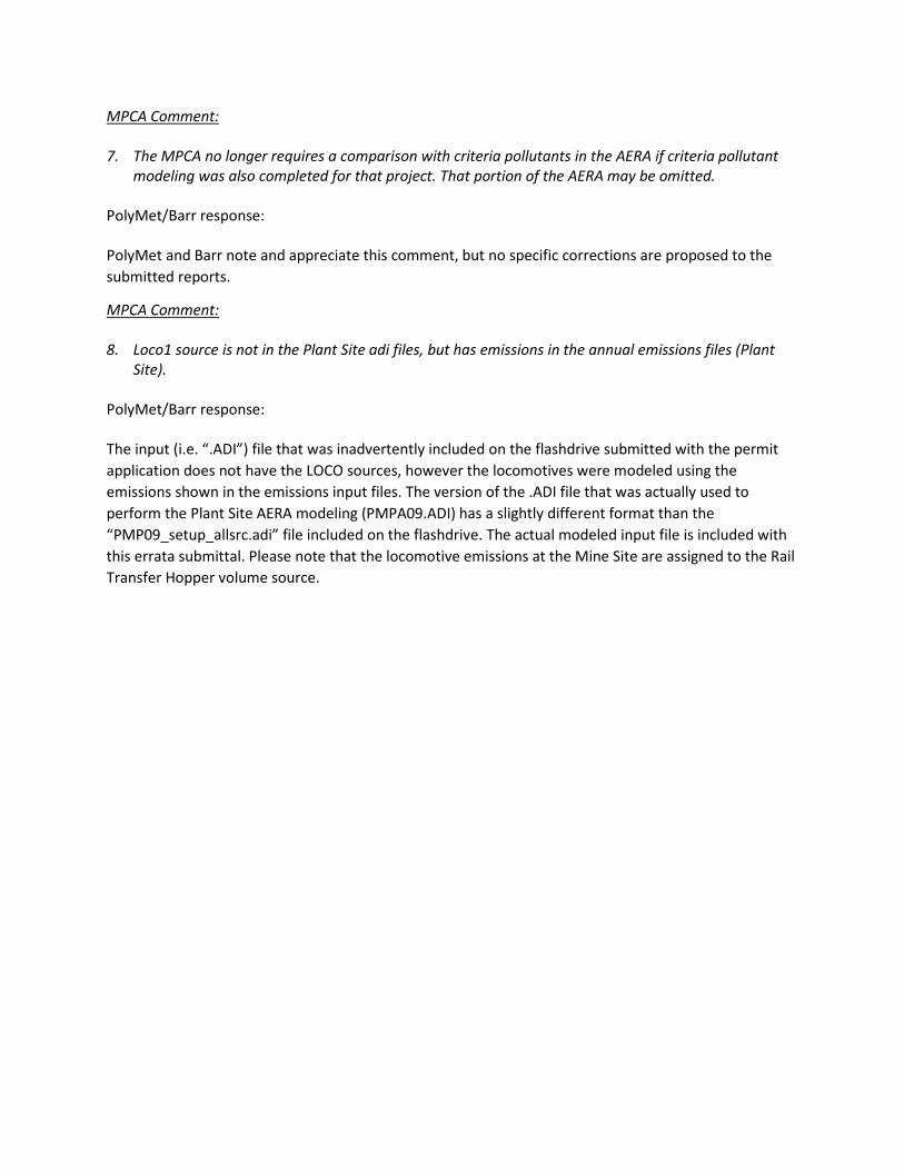
MPCA Comment: 7. The MPCA no longer requires a comparison with criteria pollutants in the AERA if criteria pollutant
modeling was also completed for that project. That portion of the AERA may be omitted. PolyMet/Barr response: PolyMet and Barr note and appreciate this comment, but no specific corrections are proposed to the submitted reports.
MPCA Comment: 8. Loco1 source is not in the Plant Site adi files, but has emissions in the annual emissions files (Plant
Site). PolyMet/Barr response: The input (i.e. “.ADI”) file that was inadvertently included on the flashdrive submitted with the permit application does not have the LOCO sources, however the locomotives were modeled using the emissions shown in the emissions input files. The version of the .ADI file that was actually used to perform the Plant Site AERA modeling (PMPA09.ADI) has a slightly different format than the “PMP09_setup_allsrc.adi” file included on the flashdrive. The actual modeled input file is included with this errata submittal. Please note that the locomotive emissions at the Mine Site are assigned to the Rail Transfer Hopper volume source.
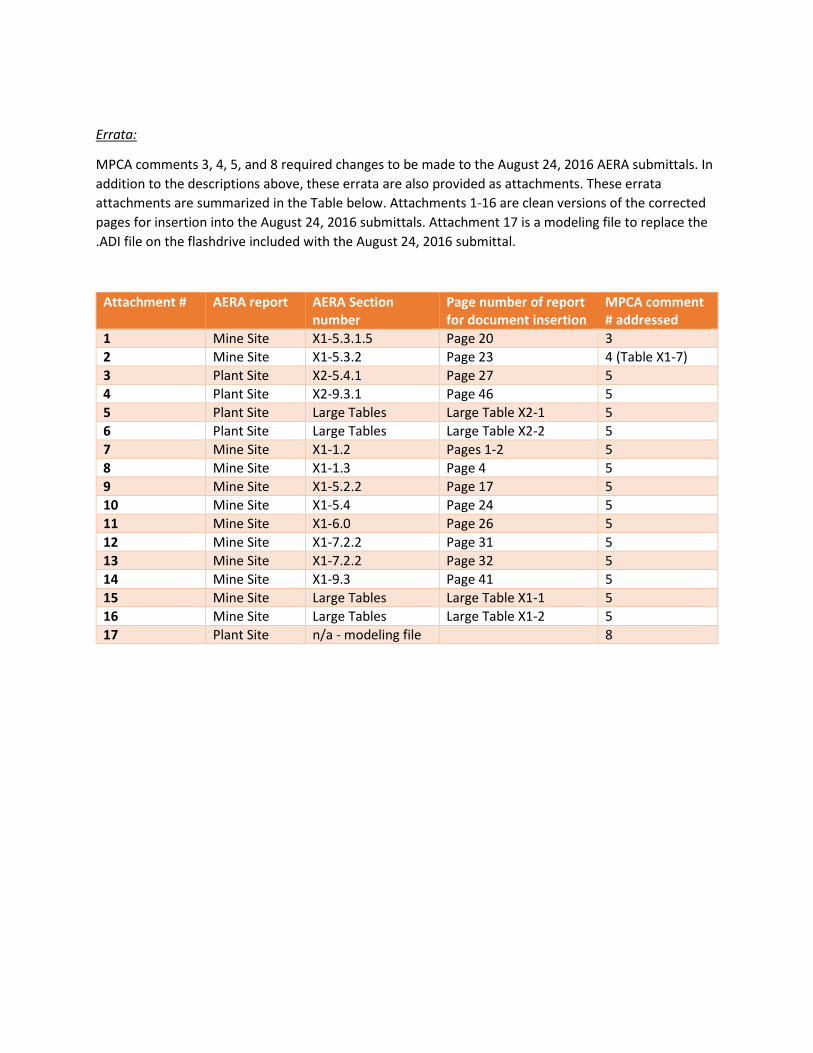
Errata:
MPCA comments 3, 4, 5, and 8 required changes to be made to the August 24, 2016 AERA submittals. In addition to the descriptions above, these errata are also provided as attachments. These errata attachments are summarized in the Table below. Attachments 1-16 are clean versions of the corrected pages for insertion into the August 24, 2016 submittals. Attachment 17 is a modeling file to replace the .ADI file on the flashdrive included with the August 24, 2016 submittal.
Attachment # AERA report AERA Section number
Page number of report for document insertion
MPCA comment # addressed
1 Mine Site X1-5.3.1.5 Page 20 3 2 Mine Site X1-5.3.2 Page 23 4 (Table X1-7) 3 Plant Site X2-5.4.1 Page 27 5 4 Plant Site X2-9.3.1 Page 46 5 5 Plant Site Large Tables Large Table X2-1 5 6 Plant Site Large Tables Large Table X2-2 5 7 Mine Site X1-1.2 Pages 1-2 5 8 Mine Site X1-1.3 Page 4 5 9 Mine Site X1-5.2.2 Page 17 5 10 Mine Site X1-5.4 Page 24 5 11 Mine Site X1-6.0 Page 26 5 12 Mine Site X1-7.2.2 Page 31 5 13 Mine Site X1-7.2.2 Page 32 5 14 Mine Site X1-9.3 Page 41 5 15 Mine Site Large Tables Large Table X1-1 5 16 Mine Site Large Tables Large Table X1-2 5 17 Plant Site n/a - modeling file 8

Attachment 1
20
Emission calculations for locomotives (diesel fuel combustion) include VOCs, speciated PAHs, TCDD TEQs, and metals. These emissions are based on the total fuel usage estimated for the locomotives and assigning half of the total emissions to the Mine Site (the remaining emissions are included in the Plant Site AERA). Locomotives have Tier 3 equivalent engines and use the emission factors appropriate for Tier 3 engines.
X1-5.3.1.3 Point Source Emissions The point sources at the Mine Site consist of three diesel tanks, a mobile generator used to temporarily power large electric mining vehicles, the backup generator at the Waste Water Treatment Facility (WWTF) and space heaters at the WWTF. Of these, only the space heaters at the WWTF are modeled for the AERA evaluation. The other point sources are discussed in Section X1-5.3.1.4.
X1-5.3.1.4 Small Sources Not Modeled A few small emission sources were not modeled for the AERA. One is the emergency diesel generator for the WWTF to be located at the Mine Site. This diesel powered backup generator will be used at the Mine Site to provide backup in case of a power failure at the WWTP. The major pollutant to be emitted from this generator is NOX. Some particulate metals may also be emitted. Due to the infrequent use, relatively short operating time expected for EU 332 and defined use as an emergency generator, potential emissions from this diesel generator were not modeled in the AERA following MPCA AERA guidance (Reference (13)).
Another small source of potential emissions are the diesel fuel tanks. The potential emissions from these tanks are VOCs. Due to the very small potential VOC emissions likely associated with these tanks they were eliminated from quantitative analysis according to the AERA guidance (Reference (13)).
A mobile diesel generator will be located at the Mine Site to provide temporary power to electric-powered large excavators and drill rigs used in the mine pits to move this equipment from one location to another. This generator is only sized to provide locomotion to the equipment, not to operate it for its primary function (drilling or loading haul trucks). This generator will be operated infrequently, and when it is operated, one of the large pieces of electrical mining equipment will be out of service, effectively limiting emissions from normal mining activities. Because this generator operates as a non-continuous source, it has been eliminated from quantitative analysis according to the AERA guidance (Reference (13)).
X1-5.3.1.5 Particulate Metal Emission Estimates Particulate metal emission estimates were based on total particles with a diameter of approximately 30 micrometers (approx. PM30). As such, the concentration of particulate metals estimated at modeled receptors includes particulate sizes up to PM30. USEPA stopped regulating particles greater than 10 micrometers in diameter (PM10) in the form of ambient air quality standards in 1987 because potential health risks from larger particles which enter the head area of the respiratory tract (e.g., nose and throat) are sufficiently low so that they can be safely excluded from a standard (Reference (34)).

Attachment 2
23
Table X1-7 Maximum modeled air concentrations evaluated in the 2016 AERA conducted for the proposed Mine Site
PolyMet Mine Site Ownership Boundary Maximum Modeled Air Concentrations
(µg/m3)
Mineral Mining/Industrial District Boundary
Maximum Modeled Air Conc.
(µg/m3)
Chemical Name 1-Hour
Mine Year 8
1-Hour Mine Year
13 Annual
Mine Year 8Annual
Mine Year 13Annual
Mine Year 8
Annual Mine Year
13
Acetaldehyde 0 0 0 0 0 0
Arsenic 0.006 0.007 0.00011 0.00010 0.00002 0.00002
Cobalt NA NA 0.00046 0.00037 0.00007 0.00008
Copper 0.119 0.231 NA NA NA NA
Crystalline Silica NA NA 0.074 0.056 0.011 0.012
Dibenzo(a,h)anthracene NA NA 2.6E-08 2.4E-08 4.8E-09 4.9E-09
Diesel Particulate Matter NA NA 0.081 0.079 0.010 0.009
Dioxins/Furans (as 2,3,7,8-TCDD TEQ)
NA NA 2.5E-10 2.3E-10 4.4E-11 4.3E-11
Indeno(1,2,3-cd)pyrene NA NA 1.5E-07 1.4E-07 2.8E-08 2.9E-08
Manganese NA NA 0.011 0.009 0.002 0.002
Nickel 0.116 0.111 0.003 0.003 0.0005 0.0005
Nitrogen Oxides (NOx)(1) 144.7 179.4 NA NA NA NA
Sulfur dioxide (SO2) 1.489 0.964 NA NA NA NA
Sulfuric acid (H2SO4/SO3) 0 0 0 0 0 0
(1) The USEPA factor of 80% for the conversion of NOX to NO2 was applied to the maximum modeled one-hour NOX air concentration. Value shown in table is NOX not NO2 estimate.
X1-5.4 Receptor Locations and Risk Concept Applications Reasonably expected future land use is a critical consideration for a risk assessment with regard to receptor locations and application of risk concepts. Resident and/or farmer receptors are assessed where residential and/or farming land use has the potential to occur in the future. When other future land use prohibits residential and/or farming land uses in specific areas, risks are typically not estimated for the farmer or resident receptor at those locations.
With regard to the Mine Site, PolyMet’s property ownership boundary (i.e., the Mine Site ambient air boundary, separating land to which the public has/does not have legal access) and the entire mine location are within the City of Babbitt Mineral Mining District and the St. Louis County Industrial District (Large Figure X1-2). The St Louis County Industrial District abuts the east side of the projected PolyMet

Attachment 3
27
air boundary (Large Figure X2-3). As a result of this past and current land use, there are currently no residential or farming developments and it is highly unlikely there will be future residential or farming developments within the former LTVSMC ambient air boundary. Therefore, potential multipathway impacts are evaluated for a potential farmer and resident receptor at the former LTVSMC ambient air boundary.
The maximum modeled air concentrations occur at the PolyMet Plant Site property ownership boundary (Large Figure X2-4 and Large Figure X2-5) and are used to assess potential inhalation risks for an off-site worker receptor. Potential multipathway chronic risks were also assessed for a potential resident and a potential farmer but only for those receptors located at or beyond the former LTVSMC ambient air boundary (Large Figure X2-3). Risk to a potential subsistence fisher from mercury emissions was evaluated for areas at several nearby lakes and in the 2013 Supplemental AERA (Reference (3)).
X2-5.4.1 Maximum Exposed Off-property Receptor Under the RME exposure concept used to assess the chronic off-site worker risk estimates, it was assumed that a hypothetical person is present at the location of maximum modeled concentrations regardless of whether or not conditions indicate that an off-site worker would be present for the concept duration and frequency. The Plant Site is located on a portion of the industrial lands formerly owned and used by LTVSMC. The past use and current ownership and conditions of this land indicate that there are no current residents and it is highly unlikely for there to be future residents on land within the former LTVSMC ambient air boundary. This area is primarily zoned as mining development or Industrial by St. Louis County and the City of Hoyt Lakes and residential or farming development in the future is highly unlikely. There is, however, potential for industrial or mining activities within the LTVSMC boundary that are not associated with the Project. For this reason, an off-site worker receptor with potential acute and chronic inhalation exposure was evaluated at the PolyMet boundary out to the former LTVSMC boundary. Potential acute (1-hour) exposure was assessed directly with no adjustment to the exposure time period. The chronic inhalation exposure time period was adjusted to a RME (8 hours/day, 250 days/year, for 25 years) for cancer and chronic noncancer risk.
Under the MEI exposure concept used to assess multipathway resident and farmer risk estimates, it was assumed that a hypothetical person is present at the locations of maximum modeled concentrations regardless of whether or not anyone lives, or has the ability to live at this location, or in the general area. There are currently no actual residents or farmers in the areas adjacent to either the Plant Site property ownership boundary or the former LTVSMC ambient air boundary and no individuals are expected to be residing in these areas in the foreseeable future during active mining and ore processing operations. In addition, soil, current forest vegetation, and climate indicate that any future farming development in this area is highly unlikely. Therefore, the assumption that a resident or farmer is present at the former LTVSMC ambient air boundary likely overestimates the potential risk to any “real” receptor.

Attachment 4
30
X2-6.0 Toxicity Assessment The objective of the toxicity assessment is to identify potentially toxic effects caused by chemicals of interest and to examine the dose-response relationship. There are toxicity values in the RASS for all CFEs assessed in the 2016 Plant Site AERA (version 2016-02). With the exception of assessing potential noncancer effects from nickel, these toxicity values were used in this AERA without modification.
The MPCA RASS version used for the 2013 AERA (Reference (3)) used a reference concentration (RfC) of 0.05 µg/m3 to assess potential chronic noncancer effects from inhalation of nickel. The current noncancer chronic toxicity value in the MPCA RASS (version 2016-02) for nickel is 0.014 µg/m3. This current toxicity value of 0.014 µg/m3 for nickel was derived by California Office of Environmental Health Hazard Assessment (OEHHA) using benchmark dose methodology, a dosimetric adjustment factor that accounts for the smaller lungs of infants and children, and an uncertainty factor to account for the potential increased sensitivity to continuous airborne exposure to nickel particles of infants and children versus adults (Reference (40)). However, infants and children will not be present within the former LTVSMC ambient air boundary. Only an off-site worker, who would be an adult, would have the potential for chronic exposure associated with the calculation of noncancer hazard quotients. Therefore, consistent with discussions with the MPCA and the MDH in November 2014 (Reference (45)), potential noncancer effects from chronic inhalation within the former LTVSMC ambient air boundary will be assessed using a toxicity value of 0.05 µg/m3. For areas at or beyond the former LTVSMC ambient air boundary, potential noncancer effects from chronic inhalation of nickel will be assessed using the current RASS value of 0.014 µg/m3, which will apply to the farmer and resident receptors.
Additional discussions of the toxicity values for the CFEs evaluated in this 2016 Mine Site AERA may be found in Attachment X2-E.
X2-6.1 Potential Health Effects Evaluated for the CFEs There were 15 CFEs carried forward for quantitative analysis in this AERA. The toxicity values used for analysis were those in the RASS, with the exception of the toxicity value for nickel to assess potential noncancer effects from chronic exposure at the PolyMet Plant Site boundary and within the former LTVSMC boundary. The CFEs and the potential health effects assessed in the RASS are listed in Table X2-8.

Attachment 5
Large Table X2-1 Exposure Parameters for the PolyMet Plant Site for Noncancer Effects
Exposure Information
Exposure Concentration Adjustments (note: if exposure is not adjusted the underlying assumptions in deriving the toxicity
values and/or multipathway screening factors (MPSFs) continue to apply)
MPCA- RASS Toxicity value or Multipathway screening
factor (MPSF) assumptions Classification of
assessed risk
Exposure Route Exposure Conc.
µg/m3 Receptor Location
Exp. Time (Hrs/day)
Exp. Freq. (days/year)
Exp. Duration (years)
Averaging time (years= exposure duration for
non-carcinogens) Assumptions and/or
adjustments MEI or RME
Inhalation only - 1 hour
Maximum modeled 1- hour concentration
Off-site worker at the Plant-Site Property Boundary
NA NA NA NA Toxicity values assume one hour of exposure
MEI
Inhalation only - 1 hour
Maximum modeled 1- hour concentration
Person at former LTVSMC ambient air boundary
NA NA NA NA Toxicity values assume one hour of exposure
MEI
Chronic inhalation
Adjusted maximum modeled air concentration
Off-site worker at the Plant-Site Property Boundary
8 hours/day 250 days/year 25 years 25 years None RME
Inhalation-for multipathway calculation
Maximum modeled annual concentration
Resident and farmer at or beyond the former LTVSMC mineral-mining boundary
None-see toxicity value assumptions
None-see toxicity value assumptions
None-see toxicity value assumptions
None-see toxicity value assumptions
Toxicity values are derived to assume exposure 24 hours/day, 365 days/year over a lifetime
MEI
Ingestion-for multipathway calculation
Maximum modeled annual concentration
Resident and farmer at or beyond the former LTVSMC mineral-mining boundary
None-see MPSF value assumptions
None-see MPSF value assumptions
None-see toxicity value assumptions
None-see toxicity value assumptions
MPSFs assume exposure duration equals averaging time
MEI
NA=not applicable- maximum modeled air concentrations are not adjusted for acute exposures.

Attachment 6
Large Table X2-2 Exposure Parameters for the PolyMet Plant Site for Cancer Effects
Exposure Information
Exposure Concentration Adjustments (note: if exposure is not adjusted the underlying assumptions in deriving the
toxicity values and/or multipathway screening factors (MPSFs) continue to apply)
MPCA- RASS Toxicity value or Multipathway screening factor
assumptions Classification of
assessed risk
Exposure Route Exposure Conc.
µg/m3 Receptor
Exposure Time (hours/day)
Exposure Frequency (days/year)
Exposure Duration(years)
Averaging time (always 70 years for
carcinogens) Other adjustments MEI or RME
Chronic inhalation
Maximum modeled annual concentration
Off-site worker at the Plant-Site Property Boundary
8 hours/day 250 days/year 25 years 70 years
Toxicity values are derived to assume exposure 24 hours/day, 365 days/year over a lifetime
RME
Inhalation-for multipathway calculation
Maximum modeled annual concentration
Resident and farmer at or beyond the former LTVSMC mineral-mining boundary
None-see toxicity value assumptions
None-see toxicity value assumptions
None-see toxicity value assumption
None-see toxicity value assumptions
Toxicity values are derived to assume exposure 24 hours/day, 365 days/year over a lifetime MPSFs do not apply to inhalation risk
MEI
Ingestion-for multipathway calculation
Maximum modeled annual concentration
Resident and farmer at or beyond the former LTVSMC mineral-mining boundary
None-see MPSF assumptions
None-see MPSF assumptions
None-see MPSF assumptions
None-see MPSF assumptions
The MPCA adjusts MPSFs in the RASS for exposure duration and averaging time -Exposure duration is 30 years for a resident and 40 years for a farmer -averaging time is 70 years
RME
NA=not applicable-acute exposures are not assessed for potential cancer effects nor are maximum modeled air concentrations adjusted for acute exposures.

Attachment 7
1
X1-1.0 Executive Summary The initial Mine Site Air Emission Risk Analysis (AERA) Report was submitted to the Minnesota Pollution Control Agency (MPCA) in January 2008 (Reference (1)) in support of the October 2009 Draft Environmental Impact Statement (DEIS) for the NorthMet Project (Project) (Reference (2)). In 2013, because of proposed changes to the Project, Poly Met Mining, Inc. (PolyMet) was requested to provide a supplemental AERA to reflect the proposed changes to the Project to support preparation of a Supplemental Draft Environmental Impact Statement (SDEIS). The Supplemental AERA was submitted in February 2013 (Reference (3)) and evaluated the Project and the associated changes in estimated emissions as per the MPCA-accepted November 2011 Work Plan (as amended in August 2012) (Reference (4)). PolyMet is now submitting their Application for Permit to Construct and Operate (Air Permit Application). The MPCA requested that the 2013 Supplemental AERA (Reference (3)) be updated to incorporate any changes in emission rate/source types or associated toxicity factors and to incorporate current model algorithms and meteorological inputs. This 2016 Mine Site AERA Permitting Update (2016 Mine Site AERA) was conducted to corroborate the findings of the 2013 Supplemental AERA.
X1-1.1 Chemicals for Evaluation Following the methodology described in the June 2016 Work Plan and subsequent July 2016 Addendum (Attachment X1-A), fourteen chemicals for evaluation (CFEs) were identified. These CFEs included a combination of chemicals identified using the Potency-Weighted Emissions Screening Method as described in the 2016 AERA Work Plan and the CFEs carried forward from the 2013 Supplemental AERA, at least some which may have also screened-in for analysis using the Potency-Weighted Emissions Screening Method.
The 14 CFEs assessed in this 2016 Mine Site AERA are as follows: acetaldehyde, arsenic, cobalt, copper, dibenzo(a,h)anthracene, diesel exhaust particulates, dioxins and furans (as 2,3,7,8-TCDD toxicity equivalent basis Toxicity Equivalent (TEQ)), indeno(1,2,3-cd)pyrene, manganese, nickel, nitrogen oxides (as NO2), silica-crystalline, sulfur dioxide (SO2) and sulfuric acid (H2SO4/SO3).
X1-1.2 Exposure Assessment Exposure assumptions for this 2016 Mine Site AERA are the same as those used in the previous AERA evaluations. Potential chronic (more than one year) and acute (one hour) exposures were evaluated for two Mine Site operating phases. These phases are represented by the Mine Year with the greatest emissions for that phase: Mine Year 8 represents the phase in which materials will be stockpiled in temporary or permanent stockpiles and Mine Year 13 represents the phase in which materials will be disposed of in mined-out pits and some stockpiled material transferred to the pits.
Potential health risks were assessed for two routes of exposure: direct via inhalation and indirect via food consumption. Multi-pathway exposure evaluates concurrent exposure to contaminants by both inhalation and food consumption. Potential inhalation health risks were estimated for a maximum exposed individual (24 hours/day, 365 days/year) at the Mine Site property ownership boundary (i.e., Mine Site ambient air boundary). Potential resident and farmer multipathway risks were estimated for receptor locations at or
2
beyond the mining/industrial district boundary because current zoning (Mineral Mining by the City of Babbitt or Industrial by St. Louis County) does not allow residential/farming development on the lands within the mining/industrial district nor are there existing residents in this area. See Large Table X1-1 and Large Table X1-2 for details regarding exposure, receptor location, toxicity, and type of exposure assumptions.
X1-1.2.1 Exposure Concentrations and Dispersion Modeling Exposure point concentrations were estimated from air dispersion modeling. For this analysis updated model and meteorological inputs were used. These updated inputs include the default Method 1 deposition algorithm for particulate in AERMOD model (version 15181 and other inputs as described in the Class II Modeling Protocol (Attachment Q1-A of Appendix Q-1) and the amended AERA Work Plan (Attachment X1-A).
X1-1.3 Estimated Potential Incremental Human Health Risks and Conclusions
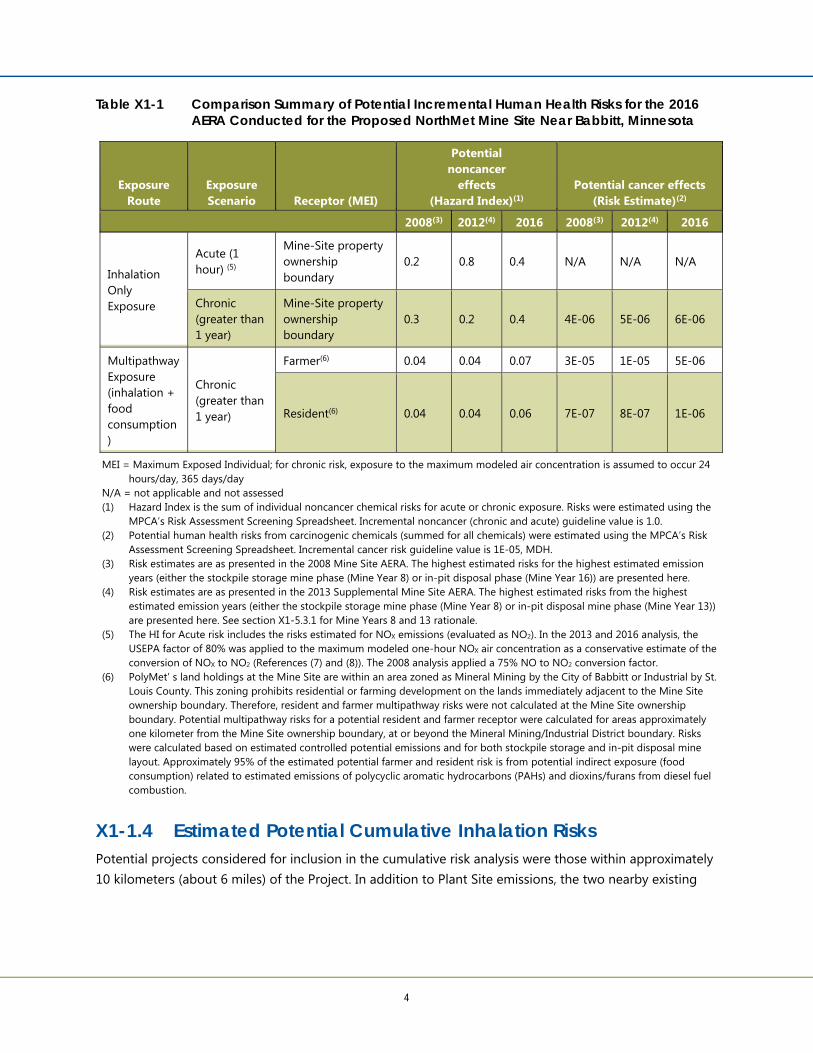
Maximum modeled air concentrations for the 14 CFEs were input to the MPCA’s Risk Assessment Screening Spreadsheet (RASS; version 2016-02). Table X1-1 shows that the summed potential health risks at the projected Mine Site ownership boundary and at the mineral mining zoning boundary from Mine Site air emissions were at or below the Minnesota Department of Health (MDH) guideline values of 1E-05 for carcinogens and 1.0 for noncancer chronic and acute endpoints (Minnesota Rules, part 4717.8050; Reference (5)). Risk driver chemicals (chemicals having potential noncancer risks of 0.1 or greater or carcinogenic risk of 1E-06 or greater) included the following:
Adult maximum exposed individual (inhalation only)
o NO2: potential noncancer acute HQ = 0.3
o Nickel: potential noncancer chronic HQ = 0.2
o Cobalt: potential carcinogenic risk = 4E-06
o Nickel: potential carcinogenic risk = 2E-06
farmer receptor (multipathway)
o Dioxins/furans (TEQ): indirect cancer risks = 4E-06
Table X1-1 provides a comparison of risks estimated for this 2016 Mine Site AERA to those previously estimated in the 2013 Supplemental AERA and the 2008 AERA. Overall, the estimated incremental health risks for this 2016 Mine Site AERA are considered to be similar (i.e., in the same range) to those estimated in the previous AERAs.
Uncertainty and variability are inherent in risk assessments from a variety of sources (Reference (6)). Uncertainty refers to our inability to definitively know something – often due to incomplete data.

Attachment 8
4
Table X1-1 Comparison Summary of Potential Incremental Human Health Risks for the 2016 AERA Conducted for the Proposed NorthMet Mine Site Near Babbitt, Minnesota
Exposure Route
Exposure Scenario Receptor (MEI)
Potential noncancer
effects (Hazard Index)(1)
Potential cancer effects (Risk Estimate)(2)
2008(3) 2012(4) 2016 2008(3) 2012(4) 2016
Inhalation Only Exposure
Acute (1 hour) (5)
Mine-Site property ownership boundary
0.2 0.8 0.4 N/A N/A N/A
Chronic (greater than 1 year)
Mine-Site property ownership boundary
0.3 0.2 0.4 4E-06 5E-06 6E-06
Multipathway Exposure (inhalation + food consumption)
Chronic (greater than 1 year)
Farmer(6) 0.04 0.04 0.07 3E-05 1E-05 5E-06
Resident(6) 0.04 0.04 0.06 7E-07 8E-07 1E-06
MEI = Maximum Exposed Individual; for chronic risk, exposure to the maximum modeled air concentration is assumed to occur 24 hours/day, 365 days/day
N/A = not applicable and not assessed (1) Hazard Index is the sum of individual noncancer chemical risks for acute or chronic exposure. Risks were estimated using the
MPCA’s Risk Assessment Screening Spreadsheet. Incremental noncancer (chronic and acute) guideline value is 1.0. (2) Potential human health risks from carcinogenic chemicals (summed for all chemicals) were estimated using the MPCA’s Risk
Assessment Screening Spreadsheet. Incremental cancer risk guideline value is 1E-05, MDH. (3) Risk estimates are as presented in the 2008 Mine Site AERA. The highest estimated risks for the highest estimated emission
years (either the stockpile storage mine phase (Mine Year 8) or in-pit disposal phase (Mine Year 16)) are presented here. (4) Risk estimates are as presented in the 2013 Supplemental Mine Site AERA. The highest estimated risks from the highest
estimated emission years (either the stockpile storage mine phase (Mine Year 8) or in-pit disposal mine phase (Mine Year 13)) are presented here. See section X1-5.3.1 for Mine Years 8 and 13 rationale.
(5) The HI for Acute risk includes the risks estimated for NOX emissions (evaluated as NO2). In the 2013 and 2016 analysis, the USEPA factor of 80% was applied to the maximum modeled one-hour NOX air concentration as a conservative estimate of the conversion of NOX to NO2 (References (7) and (8)). The 2008 analysis applied a 75% NO to NO2 conversion factor.
(6) PolyMet’ s land holdings at the Mine Site are within an area zoned as Mineral Mining by the City of Babbitt or Industrial by St. Louis County. This zoning prohibits residential or farming development on the lands immediately adjacent to the Mine Site ownership boundary. Therefore, resident and farmer multipathway risks were not calculated at the Mine Site ownership boundary. Potential multipathway risks for a potential resident and farmer receptor were calculated for areas approximately one kilometer from the Mine Site ownership boundary, at or beyond the Mineral Mining/Industrial District boundary. Risks were calculated based on estimated controlled potential emissions and for both stockpile storage and in-pit disposal mine layout. Approximately 95% of the estimated potential farmer and resident risk is from potential indirect exposure (food consumption) related to estimated emissions of polycyclic aromatic hydrocarbons (PAHs) and dioxins/furans from diesel fuel combustion.
X1-1.4 Estimated Potential Cumulative Inhalation Risks Potential projects considered for inclusion in the cumulative risk analysis were those within approximately 10 kilometers (about 6 miles) of the Project. In addition to Plant Site emissions, the two nearby existing

Attachment 9
17
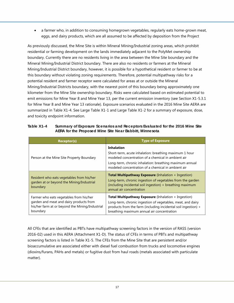
a farmer who, in addition to consuming homegrown vegetables, regularly eats home-grown meat, eggs, and dairy products, which are all assumed to be affected by deposition from the Project
As previously discussed, the Mine Site is within Mineral Mining/Industrial zoning areas, which prohibit residential or farming development on the lands immediately adjacent to the PolyMet ownership boundary. Currently there are no residents living in the area between the Mine Site boundary and the Mineral Mining/Industrial District boundary. There are also no residents or farmers at the Mineral Mining/Industrial District boundary, however, it is possible for a hypothetical resident or farmer to be at this boundary without violating zoning requirements. Therefore, potential multipathway risks for a potential resident and farmer receptor were calculated for areas at or outside the Mineral Mining/Industrial Districts boundary, with the nearest point of this boundary being approximately one kilometer from the Mine Site ownership boundary. Risks were calculated based on estimated potential to emit emissions for Mine Year 8 and Mine Year 13, per the current emission inventory (see Section X1-5.3.1 for Mine Year 8 and Mine Year 13 rationale). Exposure scenarios evaluated in the 2016 Mine Site AERA are summarized in Table X1-4. See Large Table X1-1 and Large Table X1-2 for a summary of exposure, dose, and toxicity endpoint information.
Table X1-4 Summary of Exposure Scenarios and Receptors Evaluated for the 2016 Mine Site AERA for the Proposed Mine Site Near Babbitt, Minnesota
Receptor(s) Type of Exposure
Person at the Mine Site Property Boundary
Inhalation Short-term, acute inhalation: breathing maximum 1 hour modeled concentration of a chemical in ambient air Long-term, chronic inhalation: breathing maximum annual modeled concentration of a chemical in ambient air
Resident who eats vegetables from his/her garden at or beyond the Mining/Industrial boundary
Total Multipathway Exposure (Inhalation + Ingestion) Long-term, chronic ingestion of vegetables from the garden (including incidental soil ingestion) + breathing maximum annual air concentration
Farmer who eats vegetables from his/her garden and meat and dairy products from his/her farm at or beyond the Mining/Industrial boundary
Total Multipathway Exposure (Inhalation + Ingestion) Long-term, chronic ingestion of vegetables, meat, and dairy products from the farm (including incidental soil ingestion) + breathing maximum annual air concentration
All CFEs that are identified as PBTs have multipathway screening factors in the version of RASS (version 2016-02) used in this AERA (Attachment X1-D). The status of CFEs in terms of PBTs and multipathway screening factors is listed in Table X1-5. The CFEs from the Mine Site that are persistent and/or bioaccumulative are associated either with diesel fuel combustion from trucks and locomotive engines (dioxins/furans, PAHs and metals) or fugitive dust from haul roads (metals associated with particulate matter).

Attachment 10

24
Mine Site property ownership boundary (Large Figure X1-2. Both of these zoned districts prohibit residential and farming operations. Due to the “Mineral Mining/Industrial District” zoning, residential and farming development are not a reasonably foreseeable land use in areas immediately adjacent to the projected PolyMet Mine Site property ownership boundary nor are there any residents in this area. Only areas at or beyond the Mineral Mining/Industrial District zoning areas are considered to have the potential to have residential or farming development as a reasonable future land use. Therefore, potential multipathway impacts are evaluated for a potential farmer and resident receptor at the more distant boundaries of these zoning areas (see receptor placement in Large Figure X1-4). The boundary of this area where residential and farming development is precluded is referred to as the “Mineral Mining/Industrial District Boundary” in this report or “at or beyond” the Mineral Mining/Industrial district boundary.
The maximum modeled air concentrations occur at the PolyMet Mine Site property ownership boundary (Large Figure X1-5 and Large Figure X1-6) and are used to assess potential inhalation risks (acute and chronic) for an individual. Potential multipathway chronic risks were also assessed for a potential resident and a potential farmer receptor, but only for those receptors located at or beyond the area zoned as Mineral Mining/Industrial District. The zoning boundaries are shown in Large Figure X1-2 and the specific receptors at or beyond these boundaries are identified in Large Figure X1-4.
X1-5.4.1 Maximum Exposed Off-property Receptor Under the MEI exposure concept, it was assumed that a hypothetical person or “receptor” lives at a specific location regardless of whether or not anyone lives, or has the ability to live, at this specific location, or in the general area. The receptor location to assess adult MEI inhalation risks (acute, chronic noncancer, and chronic cancer) was at the maximum modeled air concentration for each chemical at the Mine Site property ownership boundary. For multipathway exposure (includes inhalation), both the farmer/resident receptors were located at or beyond of the Mineral Mining/Industrial zoning boundaries (Large Figure X1-2). There are currently no actual residents or farmers in the areas adjacent to the Mine Site property ownership boundary or the Mineral Mining/Industrial District Boundary and no individuals are expected to be residing in these areas in the foreseeable future during active mining operations. In addition, soil, current forest vegetation, and climate indicate that any future farming development in this area is highly unlikely. Therefore, the assumption that a resident or farmer is present at the Mine Site property ownership boundary or the Mineral Mining/Industrial zoning boundary likely overestimates the potential risk to any “real” receptor.
X1-5.4.2 Indoor Air versus Outdoor Air For both receptors (maximum off-site receptor, farmer and resident) it was further assumed that the hypothetical individual is continuously exposed to outdoor air for a lifetime (24 hours/day, 365 days/day, over a 70-year period for inhalation, a 30-year period for resident ingestion and a 40-year period for farmer ingestion). In reality, people spend a considerable amount of time indoors, where concentrations of project related emissions are most likely lower. It has been estimated that U.S. residents spend only 6% of a day outdoors and 87% of a day indoors (Reference (38)).

Attachment 11
26
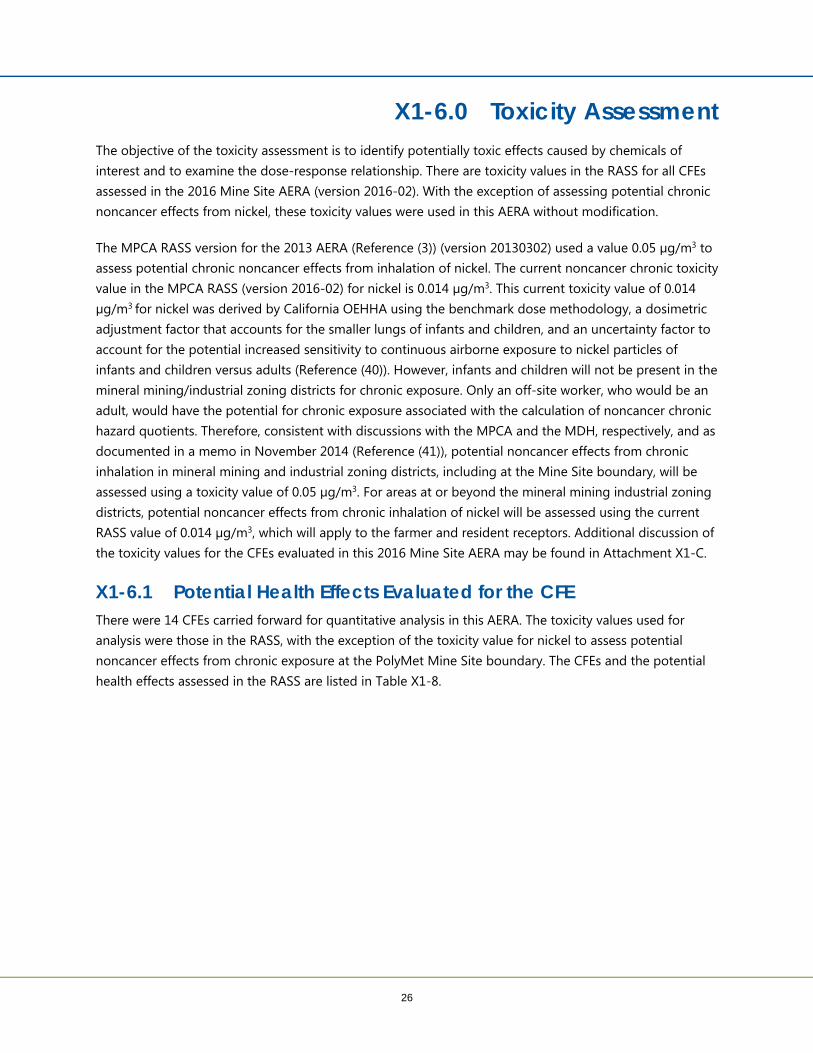
X1-6.0 Toxicity Assessment The objective of the toxicity assessment is to identify potentially toxic effects caused by chemicals of interest and to examine the dose-response relationship. There are toxicity values in the RASS for all CFEs assessed in the 2016 Mine Site AERA (version 2016-02). With the exception of assessing potential chronic noncancer effects from nickel, these toxicity values were used in this AERA without modification.
The MPCA RASS version for the 2013 AERA (Reference (3)) (version 20130302) used a value 0.05 µg/m3 to assess potential chronic noncancer effects from inhalation of nickel. The current noncancer chronic toxicity value in the MPCA RASS (version 2016-02) for nickel is 0.014 µg/m3. This current toxicity value of 0.014 µg/m3 for nickel was derived by California OEHHA using the benchmark dose methodology, a dosimetric adjustment factor that accounts for the smaller lungs of infants and children, and an uncertainty factor to account for the potential increased sensitivity to continuous airborne exposure to nickel particles of infants and children versus adults (Reference (40)). However, infants and children will not be present in the mineral mining/industrial zoning districts for chronic exposure. Only an off-site worker, who would be an adult, would have the potential for chronic exposure associated with the calculation of noncancer chronic hazard quotients. Therefore, consistent with discussions with the MPCA and the MDH, respectively, and as documented in a memo in November 2014 (Reference (41)), potential noncancer effects from chronic inhalation in mineral mining and industrial zoning districts, including at the Mine Site boundary, will be assessed using a toxicity value of 0.05 µg/m3. For areas at or beyond the mineral mining industrial zoning districts, potential noncancer effects from chronic inhalation of nickel will be assessed using the current RASS value of 0.014 µg/m3, which will apply to the farmer and resident receptors. Additional discussion of the toxicity values for the CFEs evaluated in this 2016 Mine Site AERA may be found in Attachment X1-C.
X1-6.1 Potential Health Effects Evaluated for the CFE There were 14 CFEs carried forward for quantitative analysis in this AERA. The toxicity values used for analysis were those in the RASS, with the exception of the toxicity value for nickel to assess potential noncancer effects from chronic exposure at the PolyMet Mine Site boundary. The CFEs and the potential health effects assessed in the RASS are listed in Table X1-8.

Attachment 12
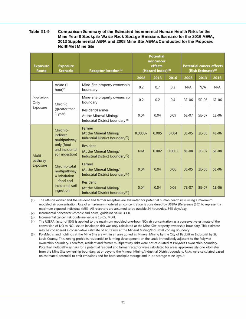
31
Table X1-9 Comparison Summary of the Estimated Incremental Human Health Risks for the Mine Year 8 Stockpile Waste Rock Storage Emissions Scenario for the 2016 AERA, 2013 Supplemental AERA and 2008 Mine Site AERAs Conducted for the Proposed NorthMet Mine Site
Exposure Route
Exposure Scenario Receptor location(1)
Potential noncancer
effects (Hazard Index)(2)
Potential cancer effects (Risk Estimate)(3)
2008 2013 2016 2008 2013 2016
Inhalation Only Exposure
Acute (1 hour)(4)
Mine-Site property ownership boundary
0.2 0.7 0.3 N/A N/A N/A
Chronic (greater than 1 year)
Mine-Site property ownership boundary
0.2 0.2 0.4 3E-06 5E-06 6E-06
Resident/Farmer At the Mineral Mining/ Industrial District boundary [5]
0.04 0.04 0.09 6E-07 5E-07 1E-06
Multi-pathway Exposure
Chronic-indirect multipathway only (food and incidental soil ingestion)
Farmer (At the Mineral Mining/ Industrial District boundary(5))
0.00007 0.005 0.004 3E-05 1E-05 4E-06
Resident (At the Mineral Mining/ Industrial District boundary(5))
N/A 0.002 0.0002 8E-08 2E-07 6E-08
Chronic-total multipathway = inhalation + food and incidental soil ingestion
Farmer (At the Mineral Mining/ Industrial District boundary(5))
0.04 0.04 0.06 3E-05 1E-05 5E-06
Resident (At the Mineral Mining/ Industrial District boundary(5))
0.04 0.04 0.06 7E-07 8E-07 1E-06
(1) The off-site worker and the resident and farmer receptors are evaluated for potential human health risks using a maximum modeled air concentration. Use of a maximum modeled air concentration is considered by USEPA (Reference (30)) to represent a maximum exposed individual (MEI). All receptors are assumed to be outside 24 hours/day, 365 days/day.
(2) Incremental noncancer (chronic and acute) guideline value is 1.0. (3) Incremental cancer risk guideline value is 1E-05, MDH. (4) The USEPA factor of 80% is applied to the maximum modeled one-hour NOX air concentration as a conservative estimate of the
conversion of NO to NO2. Acute inhalation risk was only calculated at the Mine Site property ownership boundary. This estimate may be considered a conservative estimate of acute risk at the Mineral Mining/Industrial Zoning Boundary.
(5) PolyMet’ s land holdings at the Mine Site are within an area zoned as Mineral Mining by the City of Babbitt or Industrial by St. Louis County. This zoning prohibits residential or farming development on the lands immediately adjacent to the PolyMet ownership boundary. Therefore, resident and farmer multipathway risks were not calculated at PolyMet’s ownership boundary. Potential multipathway risks for a potential resident and farmer receptor were calculated for areas approximately one kilometer from the Mine Site ownership boundary, at or beyond the Mineral Mining/Industrial District boundary. Risks were calculated based on estimated potential to emit emissions and for both stockpile storage and in-pit storage mine layout.

Attachment 13
32
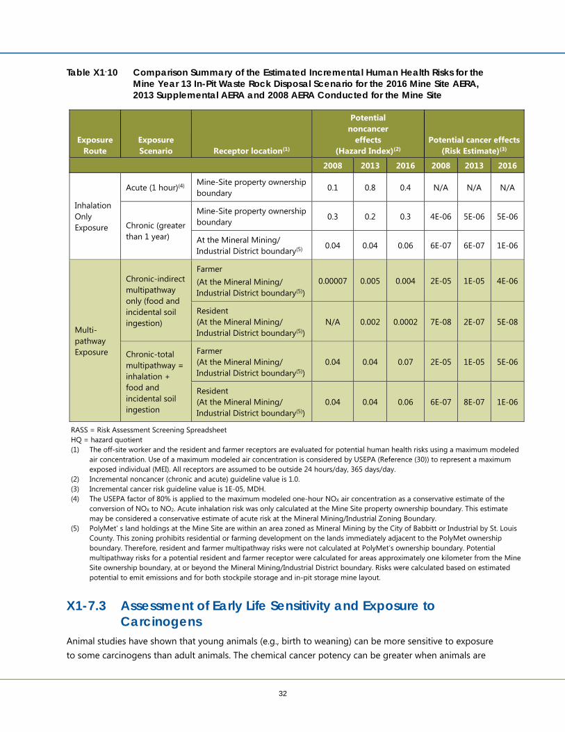
Table X1-10 Comparison Summary of the Estimated Incremental Human Health Risks for the Mine Year 13 In-Pit Waste Rock Disposal Scenario for the 2016 Mine Site AERA, 2013 Supplemental AERA and 2008 AERA Conducted for the Mine Site
Exposure Route
Exposure Scenario Receptor location(1)
Potential noncancer
effects (Hazard Index)(2)
Potential cancer effects (Risk Estimate)(3)
2008 2013 2016 2008 2013 2016
Inhalation Only Exposure
Acute (1 hour)(4) Mine-Site property ownership boundary
0.1 0.8 0.4 N/A N/A N/A
Chronic (greater than 1 year)
Mine-Site property ownership boundary
0.3 0.2 0.3 4E-06 5E-06 5E-06
At the Mineral Mining/ Industrial District boundary(5)
0.04 0.04 0.06 6E-07 6E-07 1E-06
Multi-pathway Exposure
Chronic-indirect multipathway only (food and incidental soil ingestion)
Farmer (At the Mineral Mining/ Industrial District boundary(5))
0.00007 0.005 0.004 2E-05 1E-05 4E-06
Resident (At the Mineral Mining/ Industrial District boundary(5))
N/A 0.002 0.0002 7E-08 2E-07 5E-08
Chronic-total multipathway = inhalation + food and incidental soil ingestion
Farmer (At the Mineral Mining/ Industrial District boundary(5))
0.04 0.04 0.07 2E-05 1E-05 5E-06
Resident (At the Mineral Mining/ Industrial District boundary(5))
0.04 0.04 0.06 6E-07 8E-07 1E-06
RASS = Risk Assessment Screening Spreadsheet HQ = hazard quotient (1) The off-site worker and the resident and farmer receptors are evaluated for potential human health risks using a maximum modeled
air concentration. Use of a maximum modeled air concentration is considered by USEPA (Reference (30)) to represent a maximum exposed individual (MEI). All receptors are assumed to be outside 24 hours/day, 365 days/day.
(2) Incremental noncancer (chronic and acute) guideline value is 1.0. (3) Incremental cancer risk guideline value is 1E-05, MDH. (4) The USEPA factor of 80% is applied to the maximum modeled one-hour NOX air concentration as a conservative estimate of the
conversion of NOX to NO2. Acute inhalation risk was only calculated at the Mine Site property ownership boundary. This estimate may be considered a conservative estimate of acute risk at the Mineral Mining/Industrial Zoning Boundary.
(5) PolyMet’ s land holdings at the Mine Site are within an area zoned as Mineral Mining by the City of Babbitt or Industrial by St. Louis County. This zoning prohibits residential or farming development on the lands immediately adjacent to the PolyMet ownership boundary. Therefore, resident and farmer multipathway risks were not calculated at PolyMet’s ownership boundary. Potential multipathway risks for a potential resident and farmer receptor were calculated for areas approximately one kilometer from the Mine Site ownership boundary, at or beyond the Mineral Mining/Industrial District boundary. Risks were calculated based on estimated potential to emit emissions and for both stockpile storage and in-pit storage mine layout.
X1-7.3 Assessment of Early Life Sensitivity and Exposure to Carcinogens
Animal studies have shown that young animals (e.g., birth to weaning) can be more sensitive to exposure to some carcinogens than adult animals. The chemical cancer potency can be greater when animals are

Attachment 14
41
X1-9.3 Multipathway Receptors Another type of “sensitive receptor” is the population surrounding a facility that could be exposed to the PBT pollutants emitted to air from a facility via the food pathway. The Mine Site operations are estimated to release only very small amounts of PBT chemicals; however MPCA AERA guidance indicates that PBTs may need some consideration beyond the indirect risks calculated in the RASS. Site information indicates that some agricultural lands are present within 10 kilometers (about 6 miles) of the facility, although agriculture is not a predominant land use (see Large Figure X1-7 that looks at land use). Water bodies (lakes, rivers) are also present within 10 kilometers (about 6 miles) of the Mine Site (Embarrass River, Partridge River, Mud Lake, Iron Lake, Argo Lake, Butterfly Lake). Therefore, multipathway receptors were evaluated for potential risks.
The RASS evaluated two generic receptors: (1) a farmer who only consumes homegrown vegetables, meat (beef, pork, and poultry) and dairy products, and (2) a nearby resident who consumes vegetables grown in his/her garden. Further discussion on potential risks to a generic farmer and a generic resident is provided in the next section. The multipathway exposure assessment also includes incidental ingestion of soil as a potential source of exposure.
X1-9.3.1 Farmers and Residents A review of land use and zoning within 10 kilometers (approximately six miles) of the proposed Mine Site identified small areas of agricultural lands (Large Figure X1-7 and Large Figure X1-8): small farms approximately 6.5 kilometers (about 4 miles) to the northwest of the proposed facility. This is also the closest area to the Mine Site with land identified as “agricultural.”
The nearest current residents to the proposed Mine Site are as follows:
approximately six miles north of the proposed Mine Site in the city of Babbitt
approximately five miles south of the proposed Mine Site toward the unincorporated village of Skibo
Chemicals assessed for multipathway risks include arsenic, PAHs, and dioxins/furans. The estimated total multipathway risks (Table X1-9 and Table X1-10), assuming the farmer receptor and resident receptor are at or beyond the Mineral Mining/Industrial District Boundary, are as follows: cancer = 5E-06 for the farmer receptor, 1E-06 for the resident; Noncancer chronic risks are 0.07 for the farmer and 0.06 for the resident. These risk estimates are within incremental risk guideline values of 1E-05 for cancer and 1.0 for noncancer. These risk results indicate that no adverse health effects to potential farmer or resident receptors would be expected to be associated with potential air emissions from Mine Site operations.
X1-9.3.2 Fishers Water bodies are located within 10 kilometers (about 6 miles) of the proposed facility (Embarrass River, Partridge River, Mud Lake, Iron Lake, Argo Lake, Butterfly Lake). The MPCA’s RASS does not assess chemical deposition to water bodies or accumulation in fish or humans consuming the fish because of the

Attachment 15
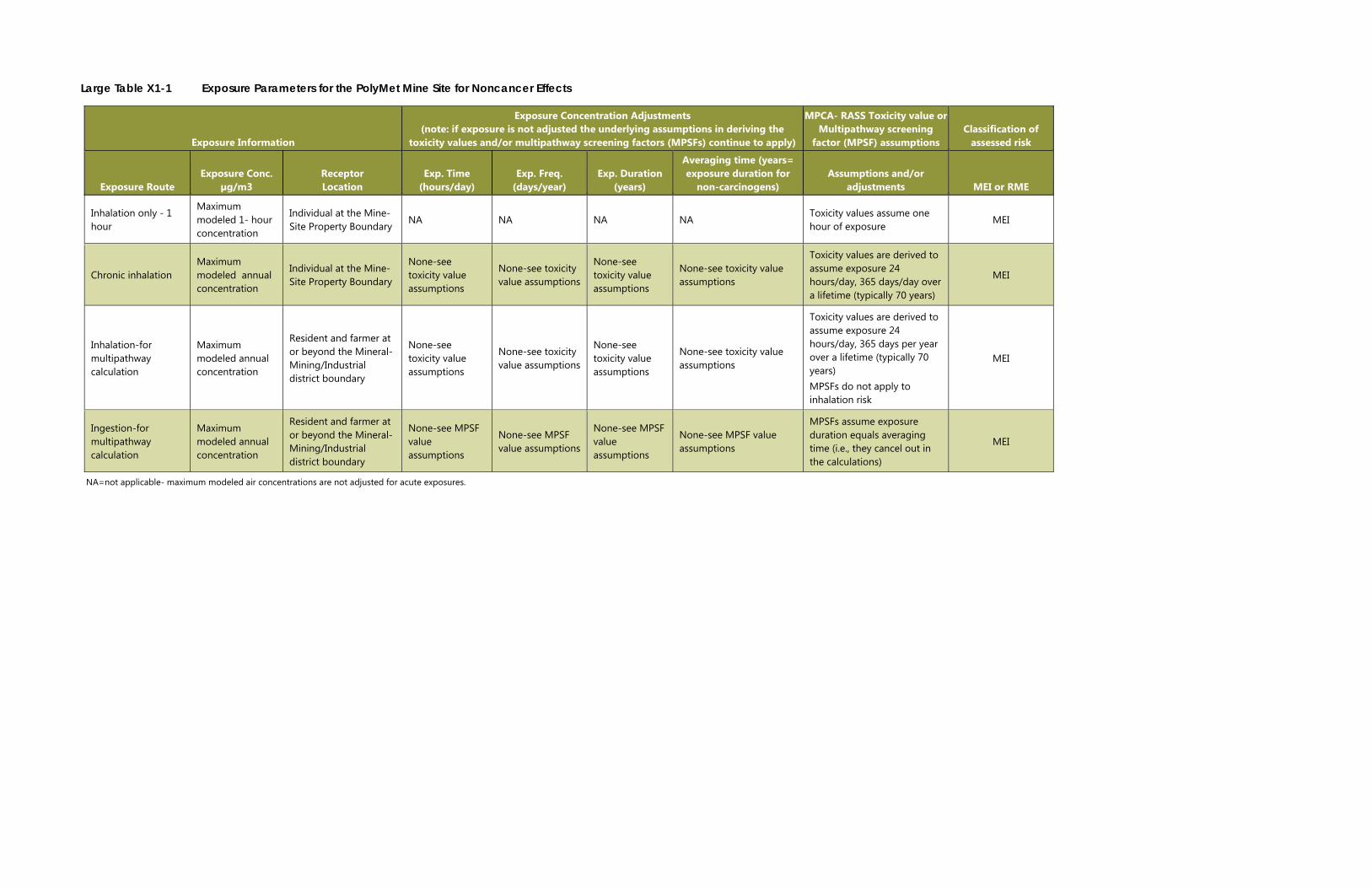
Large Table X1-1 Exposure Parameters for the PolyMet Mine Site for Noncancer Effects
Exposure Information
Exposure Concentration Adjustments (note: if exposure is not adjusted the underlying assumptions in deriving the
toxicity values and/or multipathway screening factors (MPSFs) continue to apply)
MPCA- RASS Toxicity value or Multipathway screening
factor (MPSF) assumptions Classification of
assessed risk
Exposure Route Exposure Conc.
µg/m3 Receptor Location
Exp. Time (hours/day)
Exp. Freq. (days/year)
Exp. Duration (years)
Averaging time (years= exposure duration for
non-carcinogens) Assumptions and/or
adjustments MEI or RME
Inhalation only - 1 hour
Maximum modeled 1- hour concentration
Individual at the Mine-Site Property Boundary
NA NA NA NA Toxicity values assume one hour of exposure
MEI
Chronic inhalation Maximum modeled annual concentration
Individual at the Mine-Site Property Boundary
None-see toxicity value assumptions
None-see toxicity value assumptions
None-see toxicity value assumptions
None-see toxicity value assumptions
Toxicity values are derived to assume exposure 24 hours/day, 365 days/day over a lifetime (typically 70 years)
MEI
Inhalation-for multipathway calculation
Maximum modeled annual concentration
Resident and farmer at or beyond the Mineral-Mining/Industrial district boundary
None-see toxicity value assumptions
None-see toxicity value assumptions
None-see toxicity value assumptions
None-see toxicity value assumptions
Toxicity values are derived to assume exposure 24 hours/day, 365 days per year over a lifetime (typically 70 years) MPSFs do not apply to inhalation risk
MEI
Ingestion-for multipathway calculation
Maximum modeled annual concentration
Resident and farmer at or beyond the Mineral-Mining/Industrial district boundary
None-see MPSF value assumptions
None-see MPSF value assumptions
None-see MPSF value assumptions
None-see MPSF value assumptions
MPSFs assume exposure duration equals averaging time (i.e., they cancel out in the calculations)
MEI
NA=not applicable- maximum modeled air concentrations are not adjusted for acute exposures.

Attachment 16
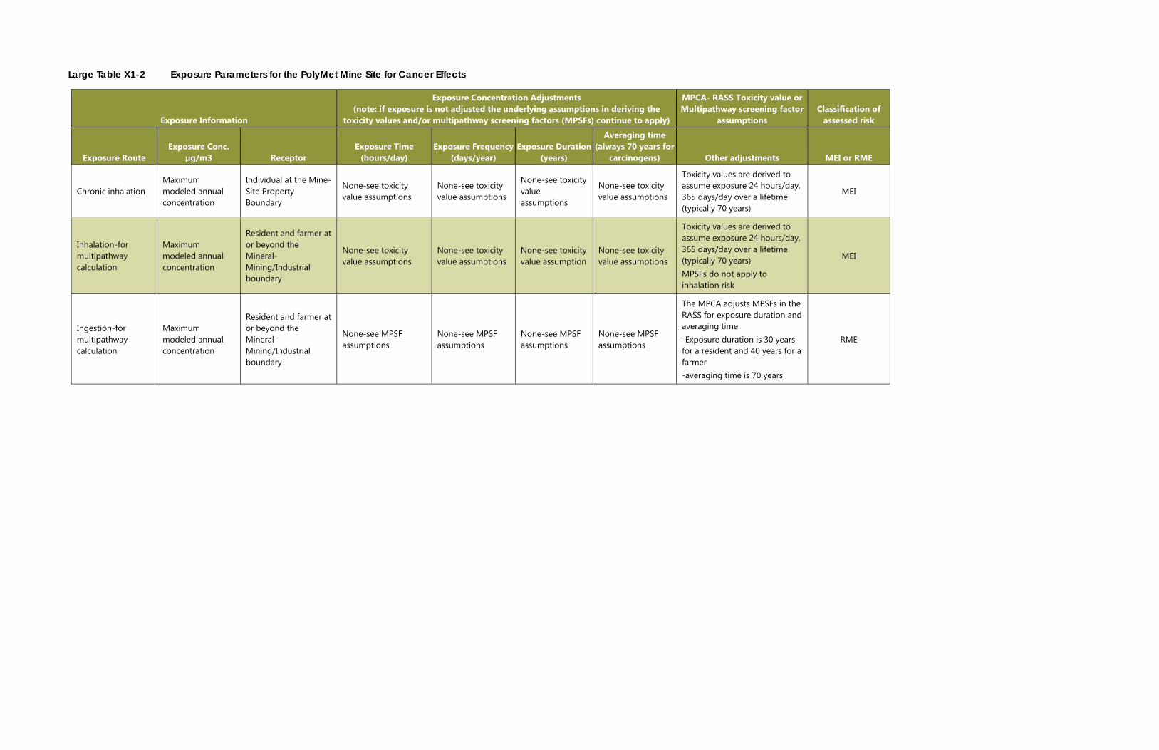
Large Table X1-2 Exposure Parameters for the PolyMet Mine Site for Cancer Effects
Exposure Information
Exposure Concentration Adjustments (note: if exposure is not adjusted the underlying assumptions in deriving the
toxicity values and/or multipathway screening factors (MPSFs) continue to apply)
MPCA- RASS Toxicity value or Multipathway screening factor
assumptions Classification of
assessed risk
Exposure Route Exposure Conc.
µg/m3 Receptor Exposure Time
(hours/day) Exposure Frequency
(days/year) Exposure Duration
(years)
Averaging time (always 70 years for
carcinogens) Other adjustments MEI or RME
Chronic inhalation Maximum modeled annual concentration
Individual at the Mine-Site Property Boundary
None-see toxicity value assumptions
None-see toxicity value assumptions
None-see toxicity value assumptions
None-see toxicity value assumptions
Toxicity values are derived to assume exposure 24 hours/day, 365 days/day over a lifetime (typically 70 years)
MEI
Inhalation-for multipathway calculation
Maximum modeled annual concentration
Resident and farmer at or beyond the Mineral-Mining/Industrial boundary
None-see toxicity value assumptions
None-see toxicity value assumptions
None-see toxicity value assumption
None-see toxicity value assumptions
Toxicity values are derived to assume exposure 24 hours/day, 365 days/day over a lifetime (typically 70 years) MPSFs do not apply to inhalation risk
MEI
Ingestion-for multipathway calculation
Maximum modeled annual concentration
Resident and farmer at or beyond the Mineral-Mining/Industrial boundary
None-see MPSF assumptions
None-see MPSF assumptions
None-see MPSF assumptions
None-see MPSF assumptions
The MPCA adjusts MPSFs in the RASS for exposure duration and averaging time -Exposure duration is 30 years for a resident and 40 years for a farmer -averaging time is 70 years
RME