projec ion map - georgia reports... · projec ncept repor rady t locat projec pi # 0 t- page 2 ion...
TRANSCRIPT
Project Co
County: G
PROJEC
oncept Repor
Grady
CT LOCAT
PROJEC
PI # 0
rt- Page 2
TION MAP
CT LOCATION
0012887
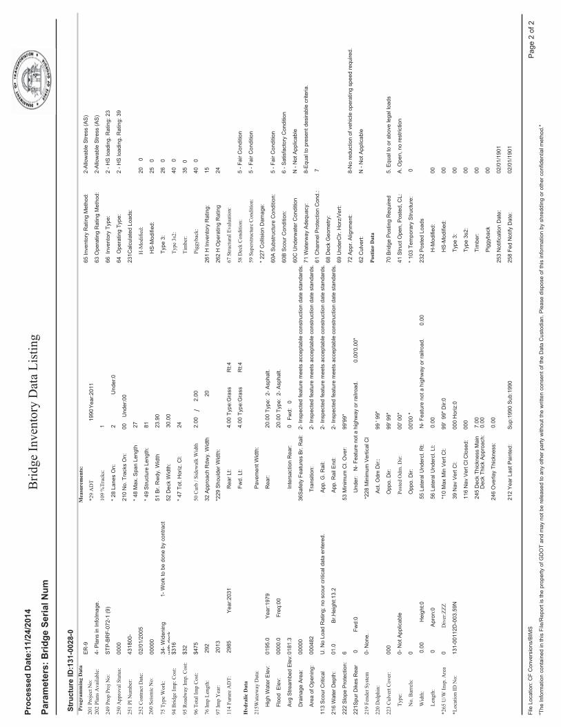
P.I. Number: 00012887
N
Project Concept Report- Page 3 P.I. Number: 0012887
County: Grady
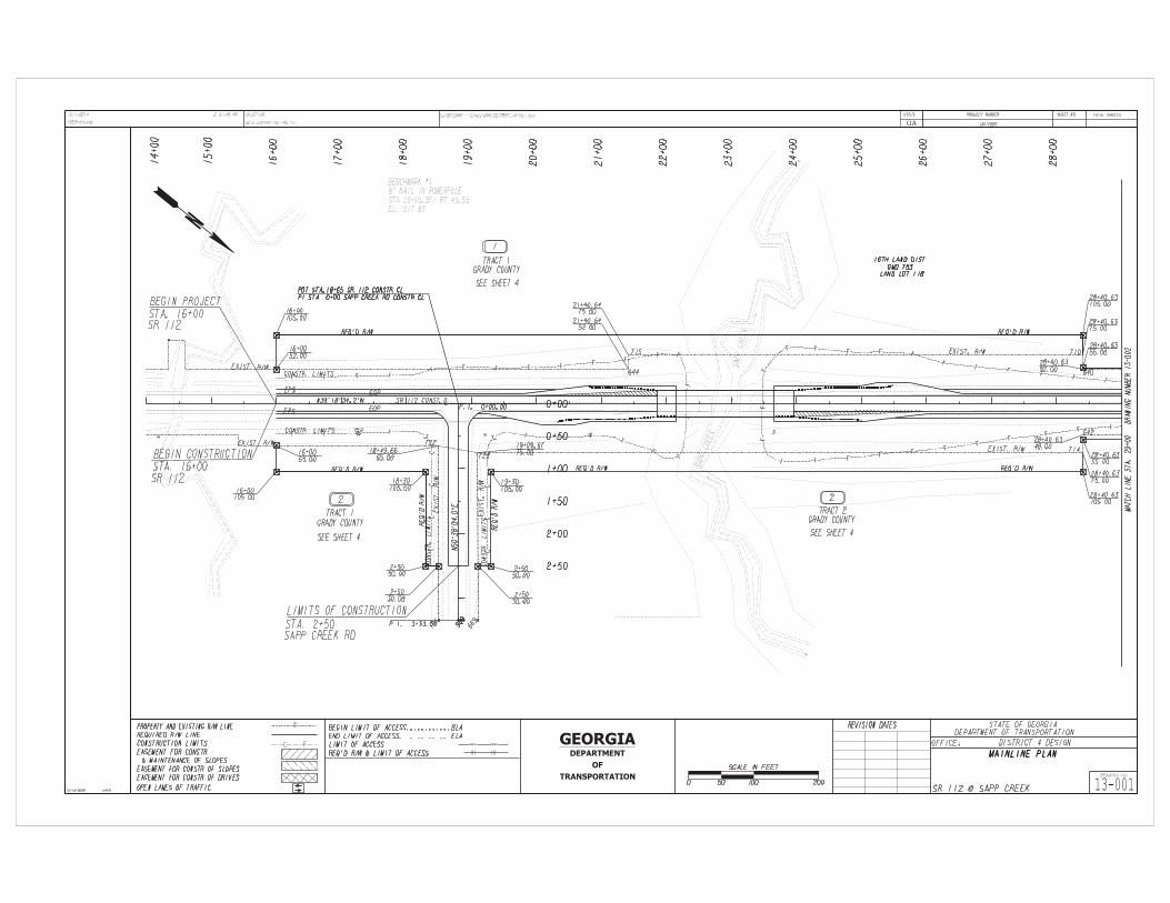
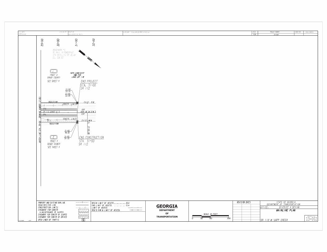
PLANNING AND BACKGROUND Project Justification Statement: This bridge is being replaced due to the construction of a lake by Grady County which will overtop the structure. The bridge on SR 112 over Sapp Creek, Structure ID 131-0028-0, was built in 1950. The bridge consists of three spans of steel beams on concrete caps and steel piles. This bridge was designed using an H-15 vehicle, which is below the current design standards. The overall condition of this bridge would be classified as fair. The deck is in fair condition with concrete cracking and efflorescence. The superstructure is in fair condition due to the deck separating from the beams during certain loading conditions. This separation will accelerate the deterioration of the deck. The substructure is in fair condition with some minor concrete cracking noted in the abutments. Existing conditions: This project is located approximately 5 miles northwest of Cairo, Georgia on SR 112 at Sapp Creek. The existing bridge is 81’ x 30’ with one 11’ travel lane in each direction. The approaches consist of one 11’ travel lane in each direction, 4’ grass shoulders and open ditches. Other projects in the area:
1. M004802; Resurface and Maintenance on SR 112 From SR 38 to Mitchell County Line. 2. Grady County’s “Tired Creek Recreational Lake”
MPO: N/A - Project not in MPO TIP #: if applicable TIA Regional Commission:Southwest Georgia RC RC Project ID (if TIA project) N/A Congressional District(s): 2 Federal Oversight: PoDI Exempt State Funded Other Projected Traffic: ADT or AADT Current Year (2013): 2550 Open Year (2018): 2750 Design Year (2038): 3700 Traffic Projections Performed by: GDOT Office of Planning Functional Classification (Mainline): Rural Minor Arterial Complete Streets - Bicycle, Pedestrian, and/or Transit Standard Warrants:
Warrants met: None Bicycle Pedestrian Transit Is this a 3R (Resurfacing, Restoration, & Rehabilitation) Project? No Yes Pavement Evaluation and Recommendations
Preliminary Pavement Evaluation Summary Report Required? No Yes Preliminary Pavement Type Selection Report Required? No Yes Feasible Pavement Alternatives: HMA PCC HMA & PCC
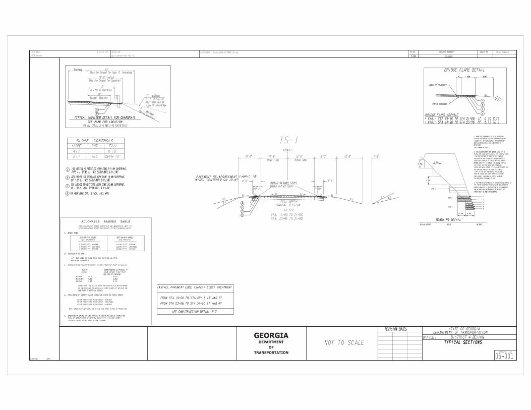
DESIGN AND STRUCTURAL Description of the proposed project: The project is the replacement of the existing bridge on SR 112 at Sapp Creek approximately 5 miles northwest of Cairo, GA. The current bridge will be replaced with a wider bridge at a higher elevation to meet the requirements of the proposed pool-elevation of Grady County’s Recreational Lake. The approaches will consist of two-12 ft. travel lanes, 10 ft. shoulders with 4
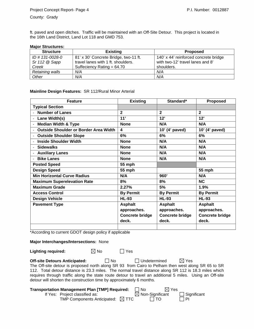
Project Concept Report- Page 4 P.I. Number: 0012887
County: Grady
ft. paved and open ditches. Traffic will be maintained with an Off-Site Detour. This project is located in the 16th Land District, Land Lot 118 and GMD 753. Major Structures:
Structure Existing Proposed ID # 131-0028-0 Sr 112 @ Sapp Creek
81’ x 30’ Concrete Bridge, two-11 ft. travel lanes with 1 ft. shoulders. Suffeciency Rating = 64.70
140’ x 44’ reinforced concrete bridge with two-12’ travel lanes and 8’ shoulders.
Retaining walls N/A N/A Other N/A N/A
Mainline Design Features: SR 112/Rural Minor Arterial
Feature Existing Standard* Proposed Typical Section ‐ Number of Lanes 2 2 2
‐ Lane Width(s) 11’ 12’ 12’
‐ Median Width & Type None N/A N/A
‐ Outside Shoulder or Border Area Width 4 10’ (4’ paved) 10’ (4’ paved)
‐ Outside Shoulder Slope 6% 6% 6%
‐ Inside Shoulder Width None N/A N/A
‐ Sidewalks None N/A N/A
‐ Auxiliary Lanes None N/A N/A
‐ Bike Lanes None N/A N/A Posted Speed 55 mph Design Speed 55 mph 55 mph Min Horizontal Curve Radius N/A 960’ N/A Maximum Superelevation Rate 8% 8% NC Maximum Grade 2.27% 5% 1.9% Access Control By Permit By Permit By Permit Design Vehicle HL-93 HL-93 HL-93 Pavement Type Asphalt
approaches. Concrete bridge deck.
Asphalt approaches. Concrete bridge deck.
Asphalt approaches. Concrete bridge deck.
*According to current GDOT design policy if applicable Major Interchanges/Intersections: None Lighting required: No Yes Off-site Detours Anticipated: No Undetermined Yes The Off-site detour is proposed north along SR 93 from Cairo to Pelham then west along SR 65 to SR 112. Total detour distance is 23.3 miles. The normal travel distance along SR 112 is 18.3 miles which requires through traffic along the state route detour to travel an additional 5 miles. Using an Off-site detour will shorten the construction time by approximately 6 months. Transportation Management Plan [TMP] Required: No Yes
If Yes: Project classified as: Non-Significant Significant TMP Components Anticipated: TTC TO PI
Project Concept Report- Page 5 P.I. Number: 0012887
County: Grady
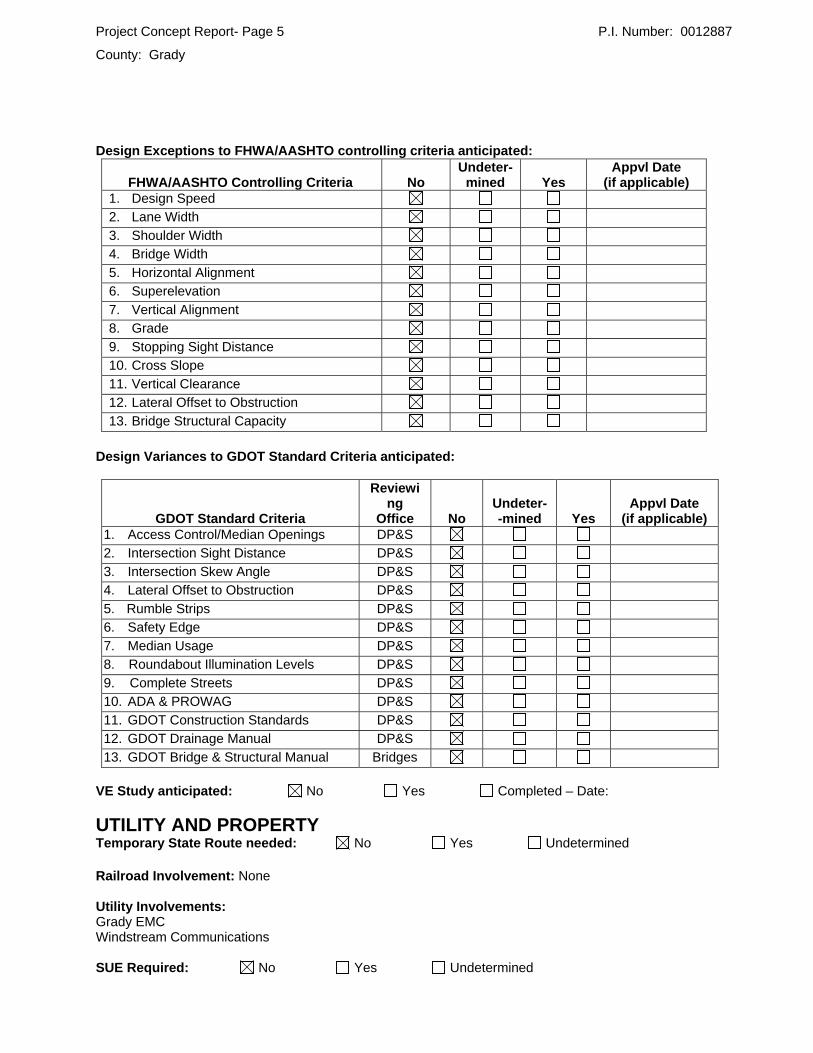
Design Exceptions to FHWA/AASHTO controlling criteria anticipated:
FHWA/AASHTO Controlling Criteria No Undeter-
mined Yes Appvl Date
(if applicable) 1. Design Speed 2. Lane Width
3. Shoulder Width 4. Bridge Width
5. Horizontal Alignment 6. Superelevation
7. Vertical Alignment 8. Grade
9. Stopping Sight Distance 10. Cross Slope
11. Vertical Clearance 12. Lateral Offset to Obstruction
13. Bridge Structural Capacity
Design Variances to GDOT Standard Criteria anticipated:
GDOT Standard Criteria
Reviewing
Office No Undeter- -mined Yes
Appvl Date (if applicable)
1. Access Control/Median Openings DP&S 2. Intersection Sight Distance DP&S
3. Intersection Skew Angle DP&S 4. Lateral Offset to Obstruction DP&S
5. Rumble Strips DP&S 6. Safety Edge DP&S
7. Median Usage DP&S 8. Roundabout Illumination Levels DP&S
9. Complete Streets DP&S 10. ADA & PROWAG DP&S
11. GDOT Construction Standards DP&S 12. GDOT Drainage Manual DP&S
13. GDOT Bridge & Structural Manual Bridges
VE Study anticipated: No Yes Completed – Date:
UTILITY AND PROPERTY Temporary State Route needed: No Yes Undetermined Railroad Involvement: None Utility Involvements: Grady EMC Windstream Communications SUE Required: No Yes Undetermined

Project Concept Report- Page 6 P.I. Number: 0012887
County: Grady
Public Interest Determination Policy and Procedure recommended? No Yes Right-of-Way (ROW): Existing width: 100 ft.-150 ft. Proposed width: 110 ft. - 210 ft. Required Right-of-Way anticipated: None Yes Undetermined Easements anticipated: None Temporary Permanent Utility Other
Anticipated total number of impacted parcels: 2 Displacements anticipated: Businesses: 0
Residences: 0 Other: 0
Total Displacements: 0 Location and Design approval: Not Required Required
CONTEXT SENSITIVE SOLUTIONS Issues of Concern: None Context Sensitive Solutions Proposed: None
ENVIRONMENTAL & PERMITS Anticipated Environmental Document: GEPA: NEPA: CE EA/FONSI EIS MS4 Permit Compliance – Is the project located in a MS4 area? No Yes Environmental Permits/Variances/Commitments/Coordination anticipated:
Permit/ Variance/ Commitment/ Coordination Anticipated No Yes Remarks
1. U.S. Coast Guard Permit xx
2. Forest Service/Corps Land xx 3. CWA Section 404 Permit xx
4. Tennessee Valley Authority Permit xx 5. Buffer Variance To be determined
6. Coastal Zone Management Coordination xx 7. NPDES xx
8. FEMA To be determined 9. Cemetery Permit xx
10. Other Permits xx 11. Other Commitments xx SP 107.23.G for Migratory Birds
12. Other Coordination To be determined
Is a PAR required? No Yes Completed – Date: Environmental Comments and Information:
NEPA/GEPA: • Expecting a CE, no Section 4(f) – except possibly de minimis. Aiming to have approved CE by mid March 2015. Local approval of the off site detour will be a consideration for this approval.
Ecology: • Seasonal survey for gopher tortoise/indigo snake may be required. Impact to waters and NW 404 permit and mitigation expect. Buffer variance unlikely but possible.
Project Concept Report- Page 7 P.I. Number: 0012887
County: Grady
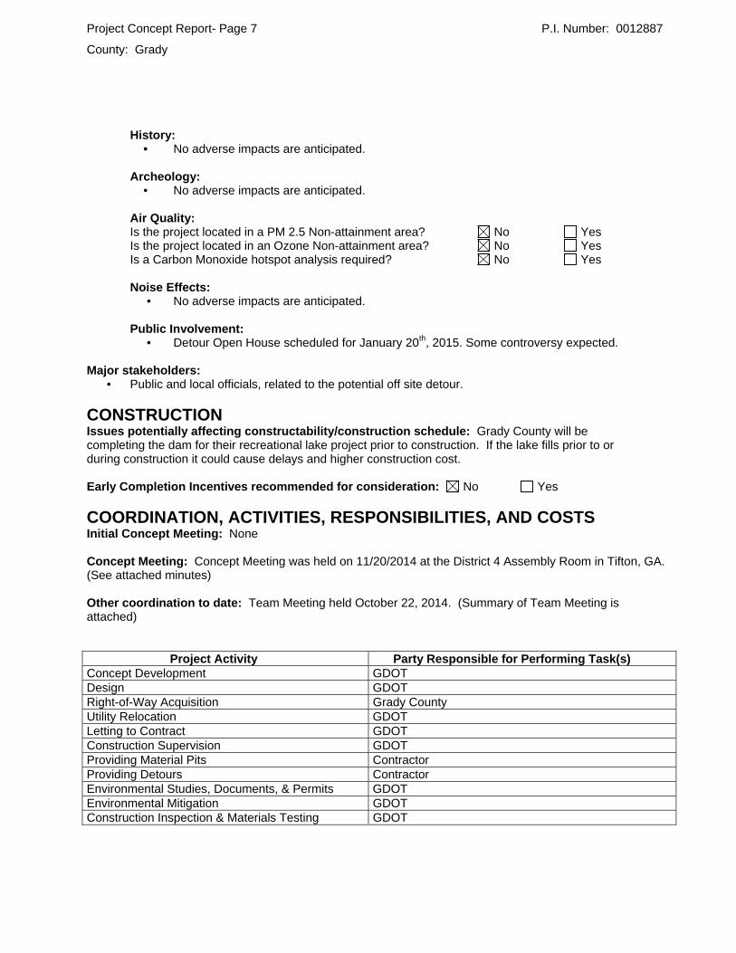
History: • No adverse impacts are anticipated. Archeology: • No adverse impacts are anticipated.
Air Quality: Is the project located in a PM 2.5 Non-attainment area? No Yes Is the project located in an Ozone Non-attainment area? No Yes Is a Carbon Monoxide hotspot analysis required? No Yes
Noise Effects: • No adverse impacts are anticipated.
Public Involvement: • Detour Open House scheduled for January 20th, 2015. Some controversy expected.
Major stakeholders: • Public and local officials, related to the potential off site detour.
CONSTRUCTION Issues potentially affecting constructability/construction schedule: Grady County will be completing the dam for their recreational lake project prior to construction. If the lake fills prior to or during construction it could cause delays and higher construction cost. Early Completion Incentives recommended for consideration: No Yes
COORDINATION, ACTIVITIES, RESPONSIBILITIES, AND COSTS Initial Concept Meeting: None Concept Meeting: Concept Meeting was held on 11/20/2014 at the District 4 Assembly Room in Tifton, GA. (See attached minutes) Other coordination to date: Team Meeting held October 22, 2014. (Summary of Team Meeting is attached)
Project Activity Party Responsible for Performing Task(s) Concept Development GDOT Design GDOT Right-of-Way Acquisition Grady County Utility Relocation GDOT Letting to Contract GDOT Construction Supervision GDOT Providing Material Pits Contractor Providing Detours Contractor Environmental Studies, Documents, & Permits GDOT Environmental Mitigation GDOT Construction Inspection & Materials Testing GDOT

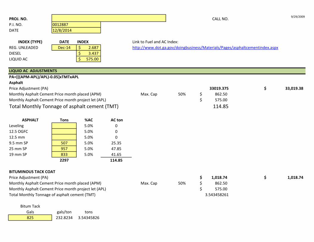
PROJ. NO. CALL NO. 9/29/2009
P.I. NO. DATE
INDEX (TYPE) DATE INDEX Link to Fuel and AC Index:REG. UNLEADED Dec-14 2.687$ DIESEL 3.437$ LIQUID AC 575.00$
LIQUID AC ADJUSTMENTSPA=[((APM-APL)/APL)-0.05]xTMTxAPLAsphaltPrice Adjustment (PA) 33019.375 33,019.38$ Monthly Asphalt Cement Price month placed (APM) Max. Cap 50% 862.50$ Monthly Asphalt Cement Price month project let (APL) 575.00$ Total Monthly Tonnage of asphalt cement (TMT) 114.85
ASPHALT Tons %AC AC tonLeveling 5.0% 012.5 OGFC 5.0% 012.5 mm 5.0% 09.5 mm SP 507 5.0% 25.3525 mm SP 957 5.0% 47.8519 mm SP 833 5.0% 41.65
2297 114.85
BITUMINOUS TACK COATPrice Adjustment (PA) 1,018.74$ 1,018.74$ Monthly Asphalt Cement Price month placed (APM) Max. Cap 50% 862.50$ Monthly Asphalt Cement Price month project let (APL) 575.00$ Total Monthly Tonnage of asphalt cement (TMT) 3.543458261
Bitum TackGals gals/ton tons825 232.8234 3.54345826
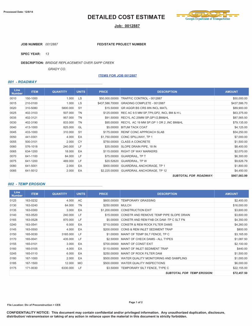
001288712/8/2014
http://www.dot.ga.gov/doingbusiness/Materials/Pages/asphaltcementindex.aspx
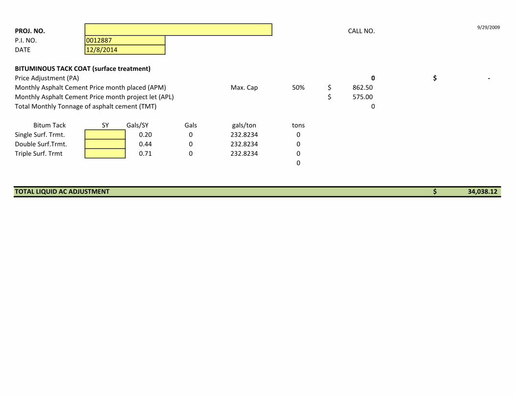
PROJ. NO. CALL NO. 9/29/2009
P.I. NO. DATE
001288712/8/2014
BITUMINOUS TACK COAT (surface treatment)Price Adjustment (PA) 0 -$ Monthly Asphalt Cement Price month placed (APM) Max. Cap 50% 862.50$ Monthly Asphalt Cement Price month project let (APL) 575.00$ Total Monthly Tonnage of asphalt cement (TMT) 0
Bitum Tack SY Gals/SY Gals gals/ton tonsSingle Surf. Trmt. 0.20 0 232.8234 0Double Surf.Trmt. 0.44 0 232.8234 0Triple Surf. Trmt 0.71 0 232.8234 0
0
TOTAL LIQUID AC ADJUSTMENT 34,038.12$
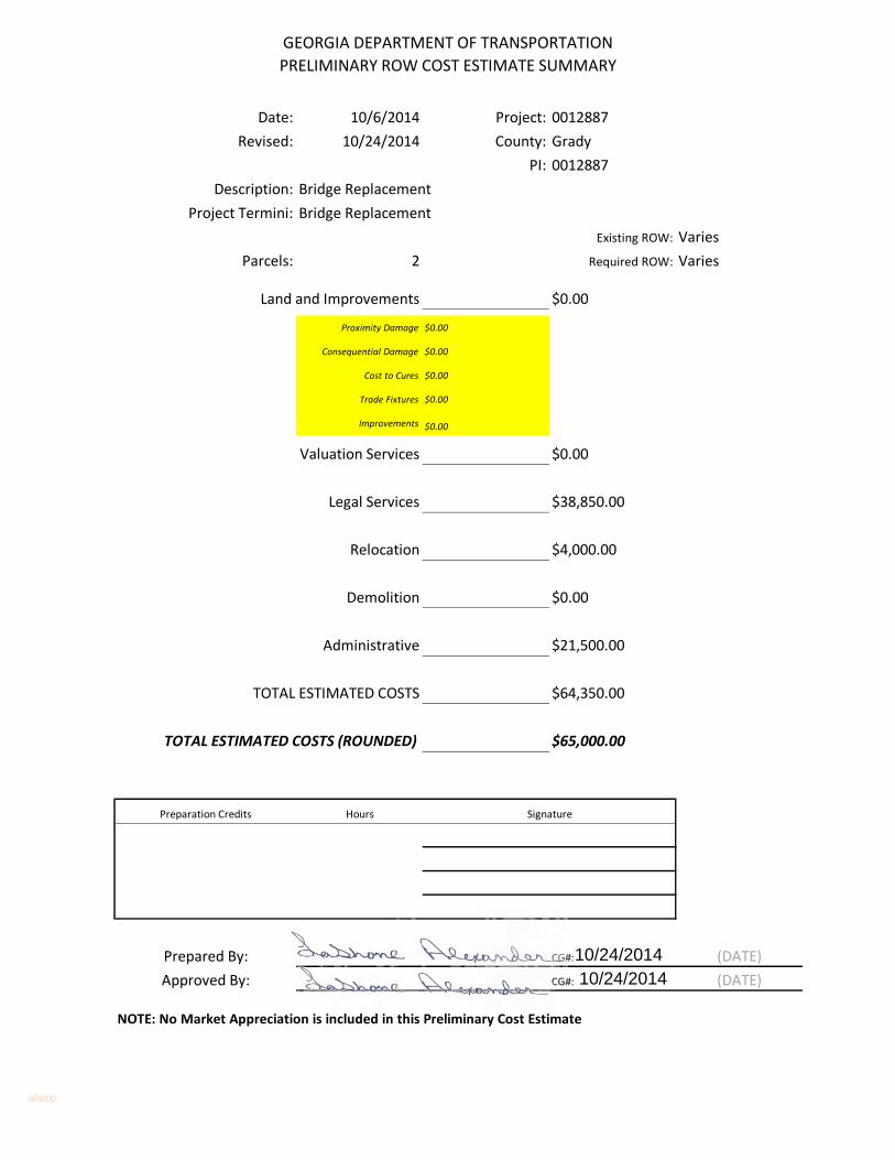
GEORGIA DEPARTMENT OF TRANSPORTATION
PRELIMINARY ROW COST ESTIMATE SUMMARY
Date: 10/6/2014 Project: 0012887
Revised: 10/24/2014 County: Grady
PI: 0012887
Description: Bridge Replacement
Project Termini: Bridge Replacement
Existing ROW: Varies
Parcels: 2 Required ROW: Varies
$0.00
Proximity Damage $0.00
Consequential Damage $0.00
Cost to Cures $0.00
Trade Fixtures $0.00
Improvements $0.00
$0.00
$38,850.00
$4,000.00
$0.00
$21,500.00
$64,350.00
$65,000.00
Preparation Credits Hours Signature
Prepared By: CG#: (DATE)
Approved By: CG#: (DATE)
NOTE: No Market Appreciation is included in this Preliminary Cost Estimate
Administrative
TOTAL ESTIMATED COSTS
TOTAL ESTIMATED COSTS (ROUNDED)
Land and Improvements
Valuation Services
Legal Services
Relocation
Demolition
allsop
10/24/201410/24/2014
STATE OF GEORGIA TRAFFIC CRASH REPORTGeorgia State PatrolGeorgia Department of Public SafetyP.O. Box 1456Atlanta, Georgia 30371-1456
Crash Number Reporting Agency Case NumberGSPG13CAD047798Reporting Agency CAD NumberReporting Agency
GEORGIA DEPARTMENT OF PUBLIC SAFETYC000197295-01
Source of Information
County of CrashGRADY
City or Place of Crash Crash Date/Time10/06/2013 08:00 AM
Reported Date/Time10/06/2013 08:01 AM
Dispatched Date/Time10/06/2013 08:02 AM
On Scene Date/Time10/06/2013 08:23 AM
Cleared Scene Date/Time10/06/2013 08:45 AM
Complete Date/Time10/07/2013 11:50 AM LAW ENFORCEMENT AGENCY
Reason (if Investigation Not Complete)
CRASH IDENTIFIERSCity Limits
Latitude LongitudeN 30 56 47.92 W 84 14 42.86
Roadway Cleared Date/Time10/06/2013 8:44:46 AM
Roadway
Roadway Description for Location of OccurrenceGA 112
Part of National Highway SystemNO
Roadway Functional Class TypeRURAL
Roadway Functional Class DetailMINOR ARTERIAL
Type of ShoulderUNPAVED
Roadway LightingNO LIGHTING
Roadway Bikeway FacilityNONE
Signed Bicycle RouteNOT APPLICABLE
Traffic Control Type at IntersectionNO CONTROL
Mainline Number of Lanes at Intersection Side Road Number of Lanes at Intersection
Blocked
ROADWAY INFORMATION
Intersecting Roadway Description for Location of Occurrence
Distance to City or Place of Crash
Distance / Direction from Crash Location
Light ConditionDAYLIGHT
Weather ConditionCLEAR
Roadway Surface ConditionDRY
First Harmful Event TypeCOLLISION WITH FIXED OBJECT
First Harmful Event DetailGUARDRAIL FACE
Crash Pictures Taken
CRASH INFORMATION
Contributing Circumstances: EnvironmentNONE
Contributing Circumstances: EnvironmentNONE
Contributing Circumstances: EnvironmentNONE
Contributing Circumstances: RoadNONE
Contributing Circumstances: RoadNONE
Contributing Circumstances: RoadNONE
School Bus RelatedNO
Work Zone RelatedNO
Crash Location in Work Zone
V01Motor Vehicle Type State
GAMOTOR VEHICLE IN TRANSPORTLicense NumberBGU4233
Registration Expires08/23/2014 Registration
VIN4T1BF28B94U373203
Permanent
Year2004
MakeTOYOTA
ModelAVALON U.S. XL
Style4S
ColorBLK
Body Type CategoryPASSENGER CAR
VEHICLE V01
Special Function of Motor Vehicle in TransportNO SPECIAL FUNCTION
Emergency Motor Vehicle UseNO
Type of Bus UseNOT A BUS
Owner First Name Owner Middle Name Owner Last Name Owner Suffix Owner Business (if not Person)TAMMY M CALHOUNAddress760 LIME SINK RD
Address Other CityWHIGHAM
StateGA
Zip Code39897-2403
Owner Phone Number Owner Phone Number (other) Insurance CompanyNATIONAL SECURITY GROUP
Insurance Policy Number974535
Vehicle RemovalTOWED DUE TO DISABLING DAMAGE
Vehicle Towed ByROYCES
Wrecker Selection MethodROTATION
Direction of Travel Before CrashNORTHBOUND 55
Roadway TypeUNDIVIDED HIGHWAY
Total Lanes2
Roadway Horizontal AlignmentSTRAIGHT
Roadway GradeLEVEL
Trafficway DescriptionTWO-WAY NOT DIVIDED
Traffic Control Device TypeNO CONTROLS
Working ProperlySpeed:
PostedEstimated
Roadway Description for Vehicle TravelGA 112Vehicle Maneuver Action (by this vehicle)MOVEMENTS ESSENTIALLY STRAIGHT AHEAD
Hit & Run (by this vehicle)NO DID NOT LEAVE SCENE
Damage Extent (for this vehicle)DISABLING DAMAGE
1st Sequence of Events Type (this vehicle)COLLISION WITH FIXED OBJECT
1st Sequence of Events Detail (this vehicle)GUARDRAIL FACE
2nd Sequence of Events Type (this vehicle)UNKNOWN
2nd Sequence of Events Detail (this vehicle)
3rd Sequence of Events Type (this vehicle)UNKNOWN
3rd Sequence of Events Detail (this vehicle)
4th Sequence of Events Type (this vehicle)UNKNOWN
4th Sequence of Events Detail (this vehicle)
Most Harmful Event Type (this vehicle)COLLISION WITH FIXED OBJECT
Most Harmful Event Detail (this vehicle)GUARDRAIL FACE
Contributing Circumstances 1 (this vehicle)NONE
Contributing Circumstances 2 (this vehicle)NONE
Occupant Type Person Name (First Middle Last Suffix) Injury StatusDRIVER TAMMY M CALHOUN NO INJURY(O)
Non Collision
TopUndercarriageUnknown
Area of Initial Impact
Non Collision
TopUndercarriageUnknown
Most Damaged Area
Person TypeDRIVER
Person Type Detail
First Name Middle Name Last Name SuffixTAMMY M CALHOUN
V01Vehicle#NM#
DRIVER V01
Date of Birth08/23/1960 53
Age SexF
First Harmful Event's Relation to JunctionNON-JUNCTION
Is First Harmful Event within Interchange AreaNO
Type of IntersectionNOT AT INTERSECTION
Total Counts Vehicles CMV Motorists Non-Motorists Injured Fatalities Witnesses Other Persons Businesses Violations1 0 1 0 0 0 0 0 0 1
Page 1 of 3 Version 9.9.9.9OFFICIAL COPY
Crash Number Reporting Agency Case NumberGSPG13CAD047798Reporting Agency CAD NumberReporting Agency
GEORGIA DEPARTMENT OF PUBLIC SAFETYC000197295-01
Driver License Number055288524
ClassC
Expires StateGA12/20/2013
Jurisdiction02
TypeNON-CDL DRIVER'S LICENSE
StatusVALID LICENSE
Drivers License Restrictions 1NONE
Drivers License Restrictions 2NONE
Drivers License Restrictions 3NONE
Driver Distracted ByNOT DISTRACTED
Driver Vision ObstructionsVISION NOT OBSCURED
Driver Actions at Time of Crash 1 (based on judgement of investigation officer)FAILED TO KEEP IN PROPER LANE
Driver Actions at Time of Crash 2 (based on judgement of investigation officer)NO CONTRIBUTING ACTION
Motor Vehicle Seating Position: RowFRONT Seating Position Unknown
Motor Vehicle Seating Position: SeatLEFT
Motor Vehicle Seating Position: OtherNOT APPLICABLE
Restraint SystemsSHOULDER AND LAP BELT USED
Helmet Use
Air Bag DeployedNOT DEPLOYED
EjectionNOT EJECTED
Injury Severity Level TypeNO INJURY(O)
Injury Severity Level Detail Primary or Most Obvious of Body Area Injured During Crash
Law Enforcement Suspected Alcohol UseNO
Alcohol Test Type Alcohol TestedTEST NOT GIVEN
Alcohol Test Result BAC
Law Enforcement Suspected Drug UseNO
Drug Test Type Drug TestedTEST NOT GIVEN
Drug Test Result
Violation Type Issued Number Violation DescriptionUNIFORM TRAFFIC CITATION E01334286 40-6-48 FAILURE TO MAINTAIN LANE
Trapped ExtricationNOT TRAPPED
Driver Actions at Time of Crash 3 (based on judgement of investigation officer)NO CONTRIBUTING ACTION
Driver Actions at Time of Crash 4 (based on judgement of investigation officer)NO CONTRIBUTING ACTION
Address760 LIME SINK RD
Address Other CityWHIGHAM
StateGA
Zip Code39897
Phone Number Phone Number (other) Condition at Time of CrashAPPARENTLY NORMAL
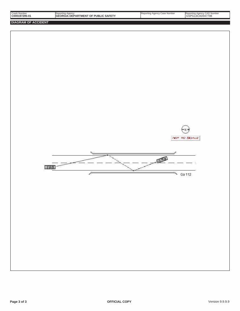
Vehicle 1 was northbound on Ga 112. The driver lost control of vehicle 1 and struck the west guardrail with its front. Vehicle 1 then traveled to the east side of the road, then struckthe east guardrail before coming to final rest in the southbound lane of Ga 112. Scene was recorded on DVD 599-019-2013.
NARRATIVE: C000197295
ID Number0599
REPORTING OFFICER
RankSERGEANT
Reporting Officer NameCULPEPPER, T.J.
Signature
G-12Org / Unit
ID Number0161
RankSFC
Approving Officer NamePEEPLES III, T. A.
Signature
G-12Org / Unit
APPROVING OFFICER (SUPERVISOR)
Page 2 of 3 Version 9.9.9.9OFFICIAL COPY
Crash Number Reporting Agency Case NumberGSPG13CAD047798Reporting Agency CAD NumberReporting Agency
GEORGIA DEPARTMENT OF PUBLIC SAFETYC000197295-01
DIAGRAM OF ACCIDENT
Page 3 of 3 Version 9.9.9.9OFFICIAL COPY
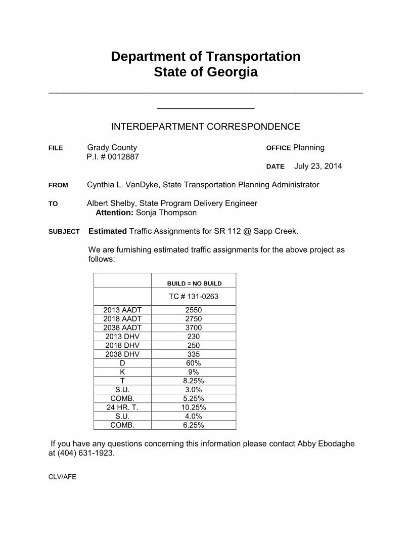
Department of Transportation State of Georgia
_______________________________________________________
INTERDEPARTMENT CORRESPONDENCE
FILE Grady County OFFICE Planning P.I. # 0012887 DATE July 23, 2014 FROM Cynthia L. VanDyke, State Transportation Planning Administrator TO Albert Shelby, State Program Delivery Engineer Attention: Sonja Thompson SUBJECT Estimated Traffic Assignments for SR 112 @ Sapp Creek.
We are furnishing estimated traffic assignments for the above project as follows:
BUILD = NO BUILD
TC # 131-0263
2013 AADT 2550 2018 AADT 2750 2038 AADT 3700 2013 DHV 230 2018 DHV 250 2038 DHV 335
D 60% K 9% T 8.25%
S.U. 3.0% COMB. 5.25%
24 HR. T. 10.25% S.U. 4.0%
COMB. 6.25%
If you have any questions concerning this information please contact Abby Ebodaghe at (404) 631-1923. CLV/AFE
Prepared: Abby Ebodaghe July 23, 2014
Traffic Projections/Forecasting Summary Sheet
P.I. # 0012887
Grady County
Year the counts were taken from 2013 coverage
Growth Factors
Growth for Build = No Build
Existing Year to Base Year 1.5%
Base Year to Design Year 1.5%
K = 9%
D = 60%
Assumptions
Computed a 15-year historical trend.
Prepared By
Recommended By
Approved By
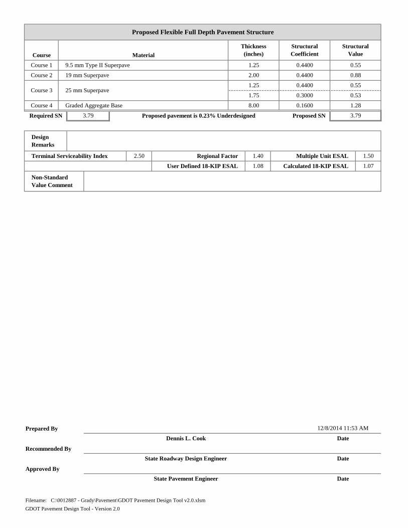
1.25 0.4400 0.55
1.75 0.3000 0.53
Course 4 Graded Aggregate Base 8.00 0.1600 1.28
State Pavement Engineer Date
Filename: C:\0012887 - Grady\Pavement\GDOT Pavement Design Tool v2.0.xlsm
GDOT Pavement Design Tool - Version 2.0
12/8/2014 11:53 AM
Dennis L. Cook Date
State Roadway Design Engineer Date
User Defined 18-KIP ESAL 1.08 Calculated 18-KIP ESAL 1.07
Non-Standard Value Comment
Terminal Serviceability Index 2.50 Regional Factor 1.40 Multiple Unit ESAL 1.50
Design Remarks
Required SN 3.79 Proposed pavement is 0.23% Underdesigned Proposed SN 3.79
Course 1 9.5 mm Type II Superpave 1.25 0.4400 0.55
Course 2 19 mm Superpave 2.00 0.4400 0.88
Course 3 25 mm Superpave
Proposed Flexible Full Depth Pavement Structure
Thickness (inches)
StructuralCoefficient
StructuralValueCourse Material
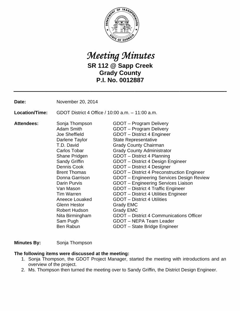
Date Loc Atte
Min The
1
2
e:
ation/Time
endees:
utes By:
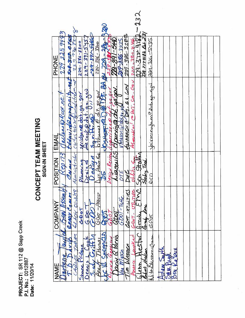
following 1. Sonja T
overview2. Ms. Tho
Nove
e: GDO
SonjaAdamJoe SDarleT.D. DCarloShanSandDennBrentDonnDarinVan MTim WAneeGlennRobeNita BSam Ben R Sonja
items werhompson,
w of the proompson the
MS
mber 20, 2
T District 4
a Thompsom Smith Sheffield ene Taylor David
os Tobar e Pridgen y Griffin
nis Cook t Thomas
na Garrison n Purvis Mason Warren ce Louakedn Hestor
ert Hudson BirminghamPugh
Rabun
a Thompso
re discussethe GDOT
oject. n turned th
MeetinSR 112 @
GradP.I. N
014
Office / 10
n
d
m
n
ed at the mProject Ma
e meeting o
ng Min@ Sapp dy Couno. 00128
0:00 a.m. –
GDOT – PGDOT – PGDOT – DState ReprGrady CouGrady CouGDOT – DGDOT – DGDOT – DGDOT – DGDOT – EGDOT – EGDOT – DGDOT – DGDOT – DGrady EMCGrady EMCGDOT – DGDOT – NGDOT – S
meeting: anager, sta
over to San
nutes Creek
nty 887
11:00 a.m.
Program DeProgram DeDistrict 4 Enresentativeunty Chairmunty AdminDistrict 4 PlaDistrict 4 DeDistrict 4 DeDistrict 4 PreEngineering Engineering District 4 TraDistrict 4 UtiDistrict 4 UtiC C
District 4 CoNEPA TeamState Bridge
arted the m
ndy Griffin,
elivery elivery ngineer
man istrator anning esign Enginesigner econstructio Services D Services Laffic Enginelities Enginlities
ommunicatiom Leader e Engineer
meeting with
the District
eer
on EngineeDesign RevLiaison eer neer
ons Officer
h introducti
t Design En
er view
r
ons and an
ngineer.
n
3. Mr. Griffin went through the draft Concept Report including the justification, existing conditions and proposed conditions.
4. Mr. Griffin discussed the proposed off-site detour with a total distance of 23.3 miles and the normal travel distance of 18.3 miles. The off-site detour would shorten the construction time by approximately six (6) months.
5. After the project overview, the Concept Report was reviewed for comments. 6. The following offices offered a discussion:
a. Planning – A question was raised if a temporary State Route would be needed for the County Road that ties into the project. It was determined that since the County owned the property on both sides of the road, a temporary State Route would not be needed for the project.
b. Environmental – History, Air & Noise and Archaeology are clear at this time. Ecology will require a Special Provision for the migratory birds but there are no other species at this time. Sam Pugh, NEPA Team Leader has scheduled the PIOH for 01/20/2015.
c. Utilities – Windstream has 200 pair underground. EMC is on the east side of the project located on poles. The 2nd submission Utility Plans were sent/given to the utility companies today. A green sheet will be needed for the utility companies prior to them submitting their location information back to the District.
d. Right of Way – After environmental approval, the right of way can be acquired. e. Traffic Operations – It was determined that the striping on the bridge needed to be skip
striping. f. Bridge – The hydrology report has been approved. Due to the type of bridge structure,
it was pointed out that there is no way to attach any utilities to the bridge if requested. g. Construction – No one from the construction office was available. The placement of the
work bridge will need to be determined to see if any environmental concerns need to be addressed.
Attachments: Concept Team Meeting Sign-in Sheet
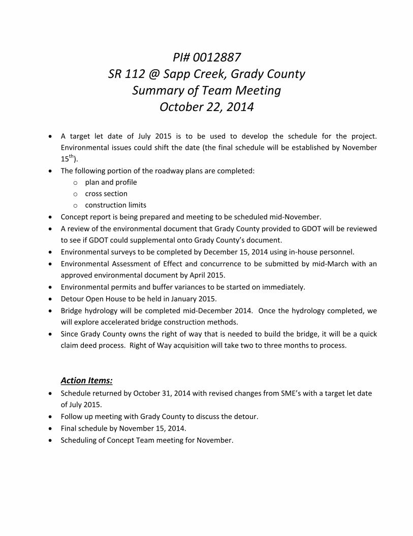
PI# 0012887 SR 112 @ Sapp Creek, Grady County
Summary of Team Meeting October 22, 2014
A target let date of July 2015 is to be used to develop the schedule for the project.
Environmental issues could shift the date (the final schedule will be established by November
15th).
The following portion of the roadway plans are completed:
o plan and profile
o cross section
o construction limits
Concept report is being prepared and meeting to be scheduled mid‐November.
A review of the environmental document that Grady County provided to GDOT will be reviewed
to see if GDOT could supplemental onto Grady County’s document.
Environmental surveys to be completed by December 15, 2014 using in‐house personnel.
Environmental Assessment of Effect and concurrence to be submitted by mid‐March with an
approved environmental document by April 2015.
Environmental permits and buffer variances to be started on immediately.
Detour Open House to be held in January 2015.
Bridge hydrology will be completed mid‐December 2014. Once the hydrology completed, we
will explore accelerated bridge construction methods.
Since Grady County owns the right of way that is needed to build the bridge, it will be a quick
claim deed process. Right of Way acquisition will take two to three months to process.
Action Items:
Schedule returned by October 31, 2014 with revised changes from SME’s with a target let date
of July 2015.
Follow up meeting with Grady County to discuss the detour.
Final schedule by November 15, 2014.
Scheduling of Concept Team meeting for November.
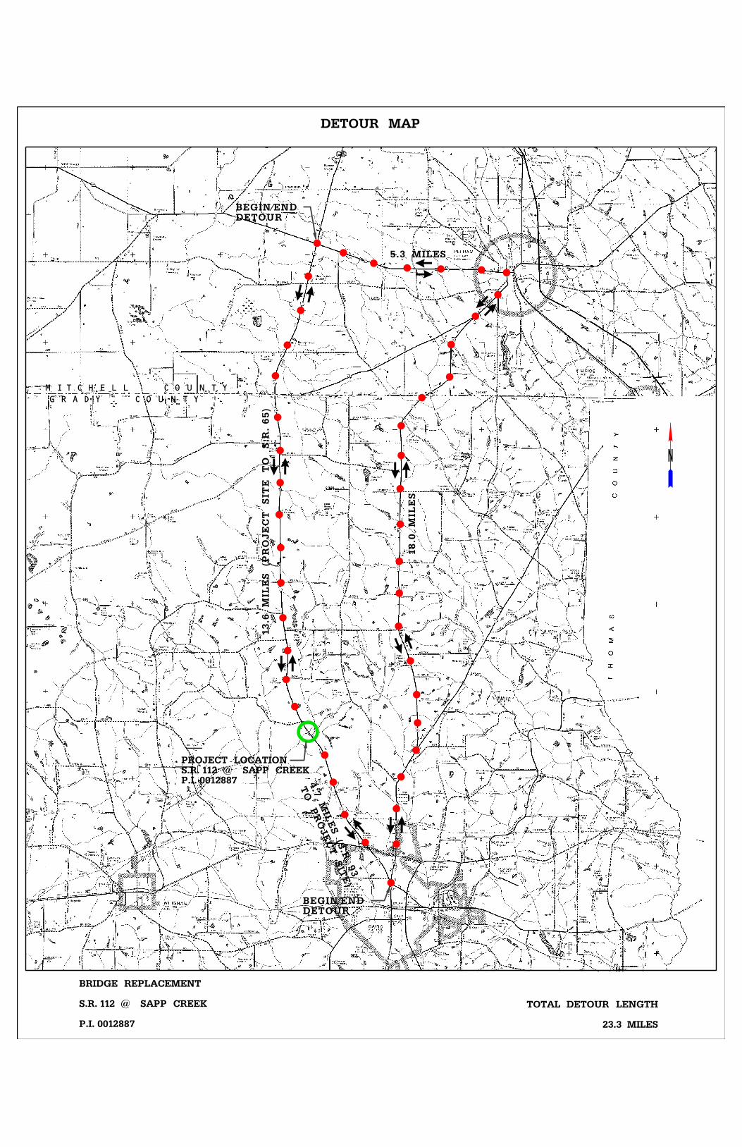
P.I. 0012887S.R. 112 @ SAPP CREEKPROJECT LOCATION
DETOUR MAP
P.I. 0012887
S.R. 112 @ SAPP CREEK
BRIDGE REPLACEMENT
DETOURBEGIN/END
DETOURBEGIN/END
5.3 MILES
18.0
MIL
ES
13.6
MIL
ES (P
ROJE
CT
SIT
E
TO
S.R. 65)
23.3 MILES
TOTAL DETOUR LENGTH
TO
PR
OJE
CT SIT
E)
4.7
MIL
ES (S.R. 9
3
M I T C H E L L C O U N T Y
G R A D Y C O U N T Y
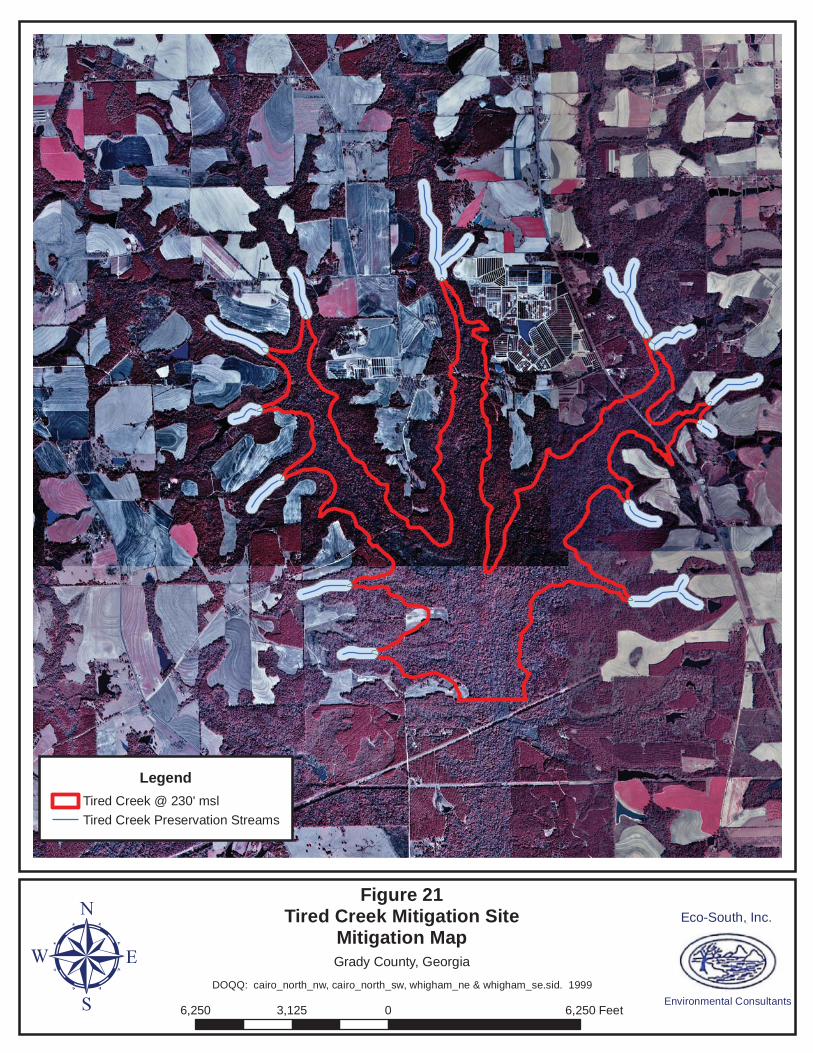
Legend
Tired Creek @ 230' msl
Tired Creek Preservation Streams
Figure 21Tired Creek Mitigation Site
Mitigation Map
6,250 0 6,2503,125 FeetμEco-South, Inc.
Environmental Consultants
Grady County, Georgia
DOQQ: cairo_north_nw, cairo_north_sw, whigham_ne & whigham_se.sid. 1999