pug list - raster analysis, 3d analysis, geoprocessing...e.g. spline 4, kriging 3, trend 3,...
TRANSCRIPT

PUG ListPUG ListRaster AnalysisRaster Analysis
3D Analysis3D AnalysisGeoprocessingGeoprocessing
Steve KoppSteve Kopp
Contour PolygonsContour Polygons
•• Spatial Analyst Spatial Analyst -- colorcolor--filled contours. Similar to thematic filled contours. Similar to thematic classification, where blue = classification, where blue = --1000 to zero, and red = 0 to +1000, 1000 to zero, and red = 0 to +1000, etc.etc.
•• Planned for 9.4. Planned for 9.4.

Contour LabelsContour Labels
•• Contour lines need more robust options for labeling as expected Contour lines need more robust options for labeling as expected in the industry. New Maplex labeling in v93 finally adresses thin the industry. New Maplex labeling in v93 finally adresses this is issue.issue.
•• 2009: new Maplex functionality released in v93, need to evaluate2009: new Maplex functionality released in v93, need to evaluateand monitor.and monitor. Would like some decent default settings for all Would like some decent default settings for all output from contour tools.output from contour tools. Have questions about saving maplex Have questions about saving maplex settings in layer file and other consumers using without maplex settings in layer file and other consumers using without maplex license.license.
•• We are adding support for We are adding support for ““readyready--onlyonly”” use of live use of live Maplex labeling at 9.4. Maplex labeling at 9.4. Users will be able to Users will be able to consume maps authored via Maplex without a consume maps authored via Maplex without a license.license.
•• At 9.4 there will be a new Contour Symbology tool At 9.4 there will be a new Contour Symbology tool that will create nicely labeled with masked that will create nicely labeled with masked annotation.annotation.

Blank inside polygonsBlank inside polygons
•• We need options to use "exclusive" polygons to blank areas of a We need options to use "exclusive" polygons to blank areas of a grid, in addition to thegrid, in addition to the current implementation of "Mask" which current implementation of "Mask" which treats polygons as "Inclusive" and blanks outside of the polygontreats polygons as "Inclusive" and blanks outside of the polygons.s.
•• Handling of nested polygons (internal holes and islands) makes Handling of nested polygons (internal holes and islands) makes this difficult to present a clear user experience. Therefore we this difficult to present a clear user experience. Therefore we suggest this is best handled as a geoprocessing workflow by a suggest this is best handled as a geoprocessing workflow by a user who knows their data and what they expect to happen.user who knows their data and what they expect to happen.
•• We can provide a ModelBuilder example tool to illustrate a We can provide a ModelBuilder example tool to illustrate a recommended use case that will work for simple polygons with no recommended use case that will work for simple polygons with no holes or islands.holes or islands.

Interpolation AlgorithmsInterpolation Algorithms
•• Would like some improvements in the options for "gridding" Would like some improvements in the options for "gridding" -- the the Spatial Analyst tools for Interpolation.Spatial Analyst tools for Interpolation. Specifically:Specifically:
–– AOI options to clip or blank either inside or outside of polygonAOI options to clip or blank either inside or outside of polygons.s.–– Similar to blanking inside contours, this should be handled as aSimilar to blanking inside contours, this should be handled as a
geoprocessing task where the user has full control and knows thegeoprocessing task where the user has full control and knows their ir data, not built into a tool.data, not built into a tool.
–– few points:few points: all, or at least one, of the algorithms work with a small all, or at least one, of the algorithms work with a small number (2, 1, or 0) input points.number (2, 1, or 0) input points.
–– Algorithms have minimum point requirements , otherwise youAlgorithms have minimum point requirements , otherwise you’’re re getting an answer other than Kriging, Spline, etc. getting an answer other than Kriging, Spline, etc. E.g. Spline 4,E.g. Spline 4, Kriging 3,Kriging 3, Trend 3, TopoToRaster 5, IDW 2Trend 3, TopoToRaster 5, IDW 2
–– IDW provide an optional "Nugget" parameter for weighting.IDW provide an optional "Nugget" parameter for weighting. I would I would like to be able to specify that all data pointslike to be able to specify that all data points that fall within a grid cell that fall within a grid cell
be weighted equally, regardless of whetherbe weighted equally, regardless of whether one is closer to the center one is closer to the center of the cell than another.of the cell than another.
–– This can be done using the MEAN option of the PointToRaster This can be done using the MEAN option of the PointToRaster function. function.

Raster LegendRaster Legend
•• Improvements to raster legend capabilitiesImprovements to raster legend capabilities–– Horizontal legendsHorizontal legends–– Additional labeling on raster legendsAdditional labeling on raster legends
•• This is planned for 9.4. It is not completed so if you have intThis is planned for 9.4. It is not completed so if you have interest erest in what you would like to see, please speak up.in what you would like to see, please speak up.

Raster PrecisionRaster Precision
•• All tools that create Raster grids should expose options for theAll tools that create Raster grids should expose options for thegrid precision (Binary, Integer, Long, Floating, Double) and Forgrid precision (Binary, Integer, Long, Floating, Double) and Format mat (ESRI Grid, TIFF, etc).(ESRI Grid, TIFF, etc).
•• The GRID format is internally always 32 bit. Some functions whicThe GRID format is internally always 32 bit. Some functions which h require table input require the raster to be of type Int.require table input require the raster to be of type Int.
•• At 9.4 Spatial Analyst tools will evaluate the type and depth ofAt 9.4 Spatial Analyst tools will evaluate the type and depth of the the input data and use the smallest possible output bit depth.input data and use the smallest possible output bit depth.
•• We do not believe it is appropriate to We do not believe it is appropriate to provide each function with an option to provide each function with an option to change the type or precision. This is easily change the type or precision. This is easily done with other tools such as Int, Float, and done with other tools such as Int, Float, and Copy Raster.Copy Raster.

Ignore NoDataIgnore NoData
•• The option to "Ignore NoData Values" on raster grids should be The option to "Ignore NoData Values" on raster grids should be exposed for all appropriate operations, perhaps even as an exposed for all appropriate operations, perhaps even as an environment setting which can be inherited from model or environment setting which can be inherited from model or document.document.
•• I want to find the depth to the deepest mapped horizon, when I want to find the depth to the deepest mapped horizon, when there are some null values.there are some null values. I should be able to use a simple I should be able to use a simple function:function: Max (A,B,C,D)Max (A,B,C,D)
•• We agree that some additional functions should have a NoData We agree that some additional functions should have a NoData option. In 9.4 the Cell Statistics tool, and other appropriate loption. In 9.4 the Cell Statistics tool, and other appropriate local ocal functions will have a NoData option.functions will have a NoData option.
–– Majority, Max, Mean, Med, Min, Minority, Std, Sum, Range, VarietMajority, Max, Mean, Med, Min, Minority, Std, Sum, Range, Varietyy

Performance improvementsPerformance improvements
•• Issues related to limitations of the GRID file format and shapefIssues related to limitations of the GRID file format and shapefiles.iles.•• Issues related to analysis against other raster formats, especiaIssues related to analysis against other raster formats, especially lly
geodatabase raster, and the creation of scratch filesgeodatabase raster, and the creation of scratch files
•• These issues are gone in 9.4.These issues are gone in 9.4.•• You are no longer limited to the GRID and shapefile format. You are no longer limited to the GRID and shapefile format. •• Direct analysis on all raster, vector and table formats without Direct analysis on all raster, vector and table formats without the the
creation of scratch files.creation of scratch files.•• Performance improvements for all formatsPerformance improvements for all formats
–– Significant improvements against subsets of large geodatabasesSignificant improvements against subsets of large geodatabases
Additional Raster Analysis Improvements in 9.4Additional Raster Analysis Improvements in 9.4
•• Map Algebra Integration with PythonMap Algebra Integration with Python–– Use Map Algebra with other GP tools, Python, and other Python Use Map Algebra with other GP tools, Python, and other Python
packages (NumPy, SciPy, etc).packages (NumPy, SciPy, etc).
•• New Fuzzy Logic tools for explorationNew Fuzzy Logic tools for exploration
•• New Image Classification UINew Image Classification UI

Geostatistical Analyst Improvements in 9.4Geostatistical Analyst Improvements in 9.4
•• Wizard Usability ImprovementsWizard Usability Improvements–– Resizable dialogResizable dialog–– Better default valuesBetter default values–– Parameter optimizationParameter optimization–– Mean svg valuesMean svg values
•• Native raster outputNative raster output•• Large input handlingLarge input handling•• New barrier interpolatorsNew barrier interpolators
–– Nonlinear searchNonlinear search–– Semitransparent barriersSemitransparent barriers
•• Geostatitistical simulation Geostatitistical simulation evaluation toolsevaluation tools

Metadata LineageMetadata Lineage•• MetaData needs to maintain an ancestry of Lineage. MetaData needs to maintain an ancestry of Lineage. All ESRI All ESRI
Operations (GeoProcessing, Export, Copy, etc) should produce Operations (GeoProcessing, Export, Copy, etc) should produce Lineage. ESRI has provided many tools to operate on data. And thLineage. ESRI has provided many tools to operate on data. And the e MetaData standard has a specific section for Lineage. To be trulMetaData standard has a specific section for Lineage. To be truly y useful, the lineage must be inherited from all Ancestors. Currenuseful, the lineage must be inherited from all Ancestors. Currently, tly, only the previous step is recorded in the lineage section of theonly the previous step is recorded in the lineage section of themetadata. metadata.
•• All Geoprocessing tools create metadata of the last process thatAll Geoprocessing tools create metadata of the last process that was was run and what datasets and parameters were used.run and what datasets and parameters were used.
•• We do not believe storage of full ancestry is a good solution.We do not believe storage of full ancestry is a good solution.•• A better solution is to use the information and hooks we alreadyA better solution is to use the information and hooks we already
provide and write a query tool that satisfies your needs.provide and write a query tool that satisfies your needs.–– Were any ancestors in a particular datum?Were any ancestors in a particular datum?–– What was the minimum cellsize of all ancestors? What was the minimum cellsize of all ancestors? –– Customized to your organizationCustomized to your organization
•• At 9.4 we will have a way to select which entries in the geoprocAt 9.4 we will have a way to select which entries in the geoprocessing essing history will go into standardized metadata documents. (Still jushistory will go into standardized metadata documents. (Still just the t the last processing step).last processing step).


3D Analysis3D Analysis
•• Progress was made in version 9.3 with the addition of 4 new Progress was made in version 9.3 with the addition of 4 new ArcObjects interfaces:ArcObjects interfaces: iRelationalOperator3d, iRelationalOperator3d, iProximityOperator3d, iCurve3d, and iPolyCurve3d.iProximityOperator3d, iCurve3d, and iPolyCurve3d. But this is But this is just the start, and needs to be beefed up.just the start, and needs to be beefed up. In the end, they In the end, they should be exposed as GeoProcessing tools.should be exposed as GeoProcessing tools.
•• Near 3DNear 3D•• Intersect 3D (Intersect 3D polylines with multipatches, return Intersect 3D (Intersect 3D polylines with multipatches, return
points)points)•• More to comeMore to come……

Creating 3D FeaturesCreating 3D Features
•• Operators & tools are needed to make points, lines or polygons Operators & tools are needed to make points, lines or polygons Zaware by getting values from a grid or tin.Zaware by getting values from a grid or tin. There is a tool to There is a tool to make attributes at points, but that is not quite the same as Zawmake attributes at points, but that is not quite the same as Zaware.are.
•• Interpolate Shape (9.3)Interpolate Shape (9.3)•• Layer 3D to Featureclass (9.3)Layer 3D to Featureclass (9.3)•• Feature to 3D by AttributeFeature to 3D by Attribute
•• 3D Editing3D Editing

3D Editing3D Editing
•• 3D Editing will be available in ArcScene and ArcGlobe 9.43D Editing will be available in ArcScene and ArcGlobe 9.4
–– Create, digitize, move 3D points, lines, polygonsCreate, digitize, move 3D points, lines, polygons
–– Move and scale multipatch (position editor)Move and scale multipatch (position editor)

3D I/O Transfer of Objects 3D I/O Transfer of Objects
•• Methods needed for import export transfer of true 3D objects. Methods needed for import export transfer of true 3D objects. Applications like GOCAD work in local coordinates and it is Applications like GOCAD work in local coordinates and it is difficult to integrate other data. difficult to integrate other data.
•• 2007 PUG This is a topic of ESRI research, but it covers a lot o2007 PUG This is a topic of ESRI research, but it covers a lot of f ground. ESRI would like to see some use cases and some realground. ESRI would like to see some use cases and some real--world data. world data.
•• This topic is still in search of a PUG champion.This topic is still in search of a PUG champion.•• ArcGIS supports conversion of 3D objects from ArcGIS supports conversion of 3D objects from
– 3D Studio– VRML and GeoVRML– OpenFlight– SketchUp
• IGeneralMultiPatchCreator– Write your own converter
•• Also direct read of CAD formats .dxf, .dwg, .dgnAlso direct read of CAD formats .dxf, .dwg, .dgn

3D Polylines3D Polylines
•• Need support for true vertical polylines and network tools to taNeed support for true vertical polylines and network tools to take ke advantage of them.advantage of them.
•• In 9.4 we will store true vertical polylines (well, pipes, etc) In 9.4 we will store true vertical polylines (well, pipes, etc) in the in the geodatabase.geodatabase.
•• Geometric NetworksGeometric Networks•• Network DatasetsNetwork Datasets•• Linear ReferencingLinear Referencing
•• Network Analyst tools will honor ZNetwork Analyst tools will honor Z
Looking for some additional data samples and use cases for testing

True 3D GISTrue 3D GIS
•• 2001 2001 -- Although we now have 2 1/2D, we still can't deal with true 3Although we now have 2 1/2D, we still can't deal with true 3--dimensional features like buried reservoirs or atmospheric dimensional features like buried reservoirs or atmospheric plumes. plumes.
•• The key piece remaining for 3D support is a data structure for The key piece remaining for 3D support is a data structure for storing continuous volumes (e.g. voxels). We are evaluating 3storing continuous volumes (e.g. voxels). We are evaluating 3rdrd
party libraries and continue to seek input from the PUG on use party libraries and continue to seek input from the PUG on use cases and real data.cases and real data.

ModelBuilder 9.4ModelBuilder 9.4
–– Undo / RedoUndo / Redo
–– Element tool tipsElement tool tips
–– Connect elements popupConnect elements popup
–– Model Only ToolsModel Only Tools
–– IteratorsIterators

Python and scripting improvements at 9.4Python and scripting improvements at 9.4
•• ArcPy ArcPy –– a Python site package for ArcGISa Python site package for ArcGIS•• Python Interactive WindowPython Interactive Window•• Automated mapping via PythonAutomated mapping via Python
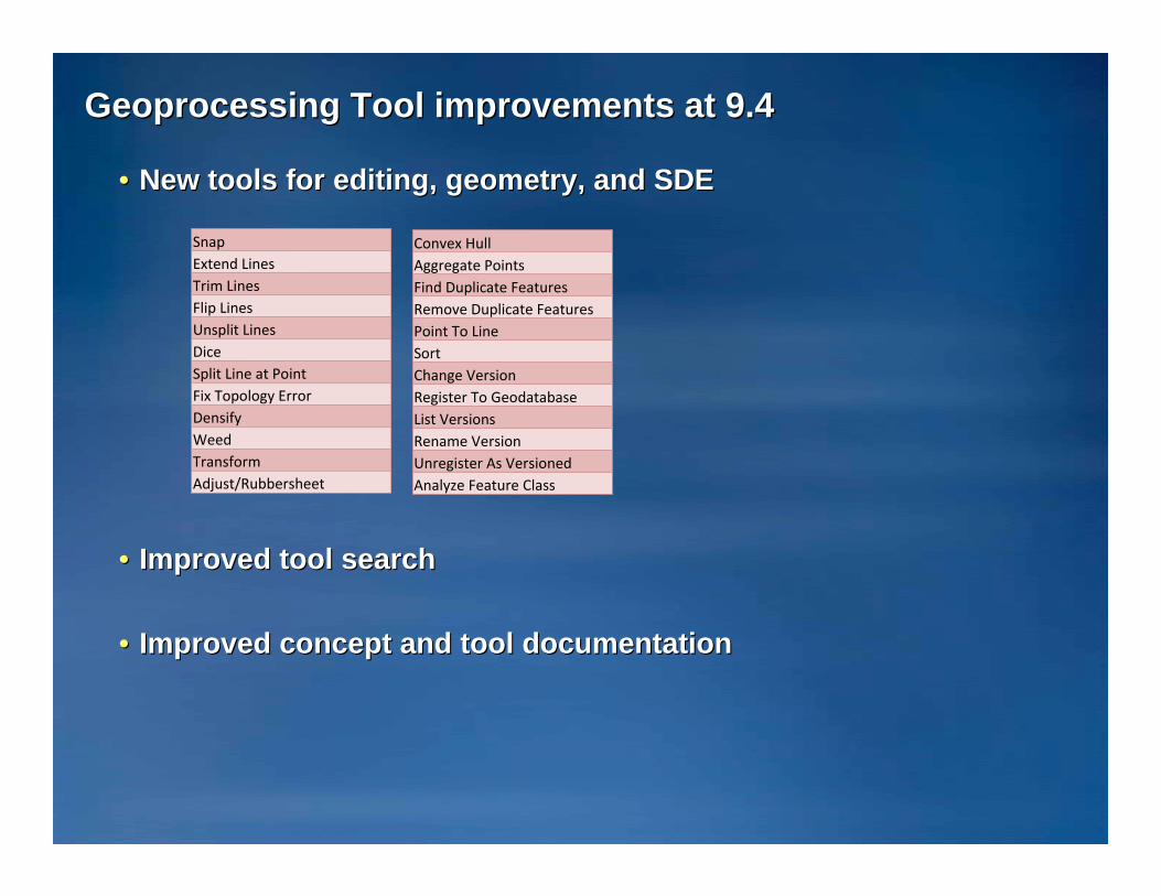
Geoprocessing Tool improvements at 9.4Geoprocessing Tool improvements at 9.4
•• New tools for editing, geometry, and SDENew tools for editing, geometry, and SDE
•• Improved tool searchImproved tool search
•• Improved concept and tool documentationImproved concept and tool documentation
SnapExtend LinesTrim LinesFlip LinesUnsplit LinesDiceSplit Line at PointFix Topology ErrorDensifyWeedTransformAdjust/Rubbersheet
Convex HullAggregate PointsFind Duplicate FeaturesRemove Duplicate FeaturesPoint To LineSortChange VersionRegister To GeodatabaseList VersionsRename VersionUnregister As VersionedAnalyze Feature Class

Geoprocessing Resource CenterGeoprocessing Resource Center
•• http://resources.esri.com/geoprocessing/http://resources.esri.com/geoprocessing/
•• Sample models and scripts, blog articles, discussion forumsSample models and scripts, blog articles, discussion forums

Thank youThank you……
Questions?Questions?
If you would like to become involved in the PUG Raster / 3D List please contact Rich Priem
For specific input on topics discussed in this session also cc Steve Kopp,