putnam county bus routes school reception centers€¦ · putnam county schools school reception...
TRANSCRIPT
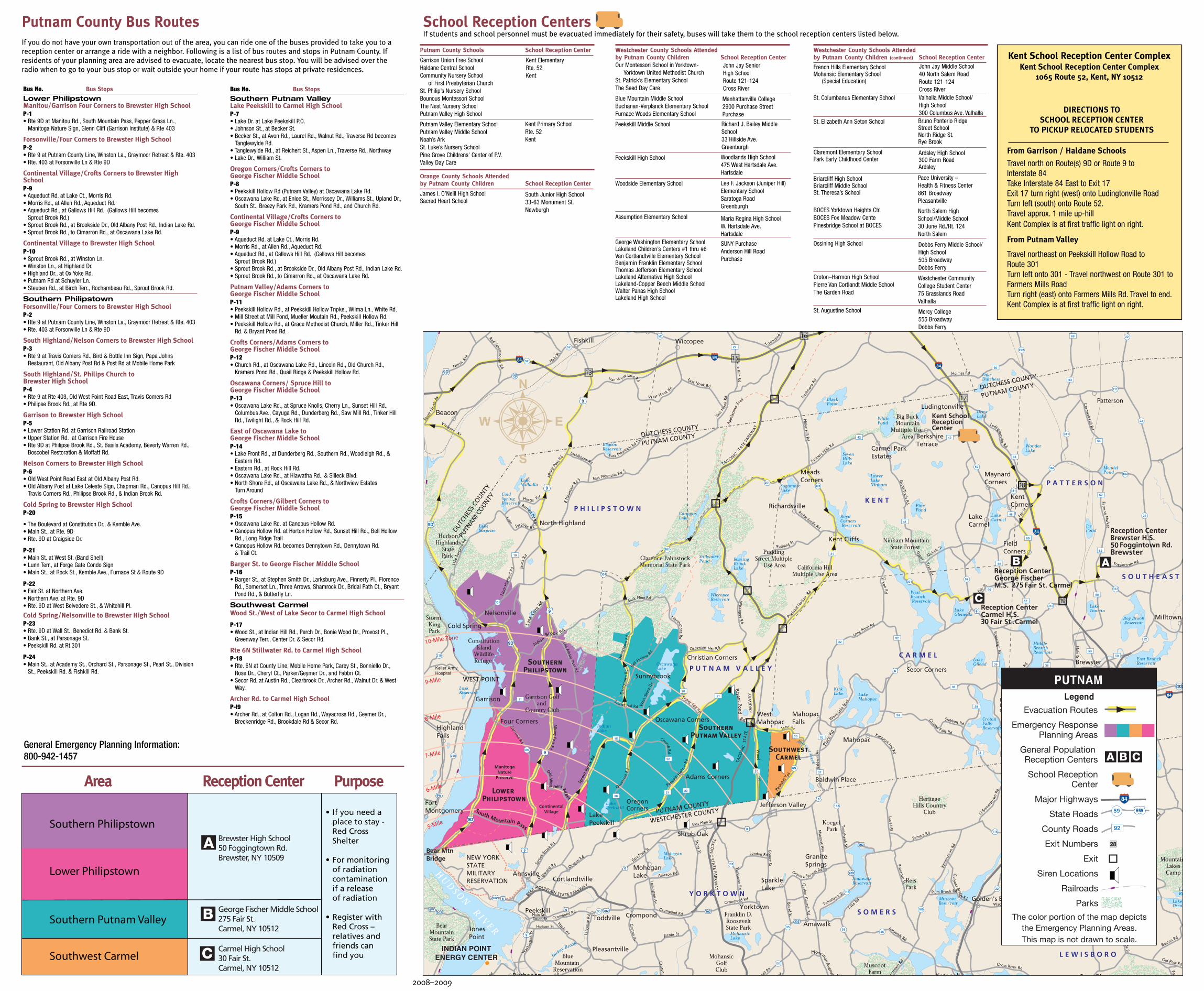
If students and school personnel must be evacuated immediately for their safety, buses will take them to the school reception centers listed below.School Reception Centers
Planning Area
BUS STOPS
18Lake Peekskill to Carmel High SchoolP-7• Lake Dr. at Lake Peekskill P.O.• Johnson St. Becker St.• Becker St., & Avon Rd., Laurel Rd., Walnut Rd., Tanglewylde Rd. &
Reichert St., Cross Rd., Traverse Rd. & Northway• Lake Dr. & William St.
Continental Village to Carmel High SchoolP-10• Sprout Brook Rd. at Winston Ln.• Winston Ln. at Highland Dr.• Putnam Rd. at Schuyler Ln.• Steuben Rd. at Birch Terr., Rochambeau Rd., Sprout Brook Rd.
18 & 19Oregon Corners/Crofts Corners to George Fischer Middle SchoolP-8• Oregon Corners (Putnam Valley) at Oscawana Lake Rd.• Oscawana Lake Rd. at Enloe St., Morrissey Dr., Williams St., Upland
Dr., South St., Breezy Park Rd., Kramers Pond Rd. & Church Rd.
If you do not have your own transportation out of the area, you can ride one of the buses provided to take you to areception center or arrange a ride with a neighbor. Following is a list of bus routes and stops in Putnam County. If residents of your planning area are advised to evacuate, locate the nearest bus stop. You will be advised over theradio when to go to your bus stop or wait outside your home if your route has stops at private residences.
Putnam County Bus Routes
10-Mile Zone
9-Mile
8-Mile
7-Mile
6-Mile
5-Mile
Baldwin Place
MuscootC
reek
Bog BrookReservoir
OregonCorners
INDIAN POINTENERGY CENTER
B
C
A
Kent SchoolReceptionCenter
17
16
15
18
19
20
21
Patterson
ContinentalVillage
ManitogaNature
Preserve
South Mountain Pass
OldW
est
Point RdEast
Moseman
Avenue M
Spro
ut
Broo
kRd
.
13
Lower Philipstown
SouthernPhilipstown
SouthernPutnam Valley
SouthwestCarmel
PUTNAMLegend
Evacuation Routes
Emergency ResponsePlanning Areas
General Population Reception Centers
School ReceptionCenter
Major Highways
State Roads
County Roads
Exit Numbers
Exit
Siren Locations
Railroads
Parks
The color portion of the map depictsthe Emergency Planning Areas.This map is not drawn to scale.
Brewster High School50 Foggingtown Rd.Brewster, NY 10509
George Fischer Middle School275 Fair St.Carmel, NY 10512
Carmel High School30 Fair St.Carmel, NY 10512
• If you need a place to stay -
Red CrossShelter
• For monitoring of radiation contamination if a release of radiation
• Register with Red Cross –
relatives and friends can find you
Southern Philipstown
Lower Philipstown
Southern Putnam Valley
Southwest Carmel
General Emergency Planning Information:800-942-1457
Area Reception Center Purpose
2008–2009
Putnam County Schools School Reception Center
Garrison Union Free SchoolHaldane Central SchoolCommunity Nursery School
of First Presbyterian ChurchSt. Philip’s Nursery SchoolBounous Montessori SchoolThe Nest Nursery SchoolPutnam Valley High School
Putnam Valley Elementary SchoolPutnam Valley Middle SchoolNoah’s ArkSt. Luke’s Nursery SchoolPine Grove Childrens’ Center of P.V.Valley Day Care
Orange County Schools Attended by Putnam County Children School Reception Center
James I. O’Neill High SchoolSacred Heart School
Westchester County Schools Attendedby Putnam County Children School Reception CenterOur Montessori School in Yorktown-
Yorktown United Methodist ChurchSt. Patrick’s Elementary SchoolThe Seed Day Care
Blue Mountain Middle SchoolBuchanan-Verplanck Elementary SchoolFurnace Woods Elementary School
Peekskill Middle School
Peekskill High School
Woodside Elementary School
Assumption Elementary School
George Washington Elementary SchoolLakeland Children’s Centers #1 thru #6Van Cortlandtville Elementary SchoolBenjamin Franklin Elementary SchoolThomas Jefferson Elementary SchoolLakeland Alternative High SchoolLakeland-Copper Beech Middle SchoolWalter Panas High SchoolLakeland High School
Westchester County Schools Attendedby Putnam County Children (continued) School Reception Center
French Hills Elementary SchoolMohansic Elementary School
(Special Education)
St. Columbanus Elementary School
St. Elizabeth Ann Seton School
Claremont Elementary SchoolPark Early Childhood Center
Briarcliff High SchoolBriarcliff Middle SchoolSt. Theresa’s School
BOCES Yorktown Heights Ctr.BOCES Fox Meadow CentePinesbridge School at BOCES
Ossining High School
Croton–Harmon High SchoolPierre Van Cortlandt Middle SchoolThe Garden Road
St. Augustine School
Kent ElementaryRte. 52Kent
Kent Primary SchoolRte. 52Kent
John Jay Senior High SchoolRoute 121-124Cross River
Westchester CommunityCollege Student Center75 Grasslands RoadValhalla
Manhattanville College2900 Purchase StreetPurchase
SUNY PurchaseAnderson Hill RoadPurchase
Valhalla Middle School/High School 300 Columbus Ave. ValhallaBruno Ponterio Ridge Street SchoolNorth Ridge St.Rye Brook
Dobbs Ferry Middle School/High School505 BroadwayDobbs Ferry
Mercy College555 BroadwayDobbs Ferry
Ardsley High School300 Farm RoadArdsley
Pace University – Health & Fitness Center861 BroadwayPleasantville
Maria Regina High SchoolW. Hartsdale Ave.Hartsdale
Lee F. Jackson (Juniper Hill)Elementary SchoolSaratoga RoadGreenburgh
Woodlands High School475 West Hartsdale Ave.Hartsdale
Richard J. Bailey MiddleSchool33 Hillside Ave.Greenburgh
North Salem HighSchool/Middle School30 June Rd./Rt. 124North Salem
John Jay Middle School40 North Salem RoadRoute 121-124Cross River
South Junior High School33-63 Monument St.Newburgh
From Garrison / Haldane Schools
Travel north on Route(s) 9D or Route 9 to Interstate 84Take Interstate 84 East to Exit 17Exit 17 turn right (west) onto Ludingtonville RoadTurn left (south) onto Route 52.Travel approx. 1 mile up-hillKent Complex is at first traffic light on right.
From Putnam Valley
Travel northeast on Peekskill Hollow Road to Route 301Turn left onto 301 - Travel northwest on Route 301 toFarmers Mills RoadTurn right (east) onto Farmers Mills Rd. Travel to end.Kent Complex is at first traffic light on right.
Kent School Reception Center ComplexKent School Reception Center Complex
1065 Route 52, Kent, NY 10512
DIRECTIONS TO SCHOOL RECEPTION CENTER
TO PICKUP RELOCATED STUDENTS
Bus No. Bus Stops
Lower PhilipstownManitou/Garrison Four Corners to Brewster High School P-1• Rte 9D at Manitou Rd., South Mountain Pass, Pepper Grass Ln.,
Manitoga Nature Sign, Glenn Cliff (Garrison Institute) & Rte 403
Forsonville/Four Corners to Brewster High School P-2• Rte 9 at Putnam County Line, Winston La., Graymoor Retreat & Rte. 403 • Rte. 403 at Forsonville Ln & Rte 9D
Continental Village/Crofts Corners to Brewster HighSchool P-9• Aqueduct Rd. at Lake Ct., Morris Rd.• Morris Rd., at Allen Rd., Aqueduct Rd.• Aqueduct Rd., at Gallows Hill Rd. (Gallows Hill becomes
Sprout Brook Rd.)• Sprout Brook Rd., at Brookside Dr., Old Albany Post Rd., Indian Lake Rd.• Sprout Brook Rd., to Cimarron Rd., at Oscawana Lake Rd.
Continental Village to Brewster High School P-10 • Sprout Brook Rd., at Winston Ln.• Winston Ln., at Highland Dr.• Highland Dr., at Ox Yoke Rd.• Putnam Rd at Schuyler Ln.• Steuben Rd., at Birch Terr., Rochambeau Rd., Sprout Brook Rd.
Southern PhilipstownForsonville/Four Corners to Brewster High School P-2• Rte 9 at Putnam County Line, Winston La., Graymoor Retreat & Rte. 403 • Rte. 403 at Forsonville Ln & Rte 9D
South Highland/Nelson Corners to Brewster High School P-3• Rte 9 at Travis Comers Rd., Bird & Bottle Inn Sign, Papa Johns
Restaurant, Old Albany Post Rd & Post Rd at Mobile Home Park
South Highland/St. Philips Church to Brewster High School P-4• Rte 9 at Rte 403, Old West Point Road East, Travis Comers Rd • Philipse Brook Rd., at Rte 9D.
Garrison to Brewster High School P-5• Lower Station Rd. at Garrison Railroad Station • Upper Station Rd. at Garrison Fire House • Rte 9D at Philipse Brook Rd., St. Basils Academy, Beverly Warren Rd.,
Boscobel Restoration & Moffatt Rd.
Nelson Corners to Brewster High School P-6• Old West Point Road East at Old Albany Post Rd.• Old Albany Post at Lake Celeste Sign, Chapman Rd., Canopus Hill Rd.,
Travis Corners Rd., Philipse Brook Rd., & Indian Brook Rd.
Cold Spring to Brewster High School P-20
• The Boulevard at Constitution Dr., & Kemble Ave.• Main St., at Rte. 9D • Rte. 9D at Craigside Dr.
P-21• Main St. at West St. (Band Shell) • Lunn Terr., at Forge Gate Condo Sign • Main St., at Rock St., Kemble Ave., Furnace St & Route 9D
P-22• Fair St. at Northern Ave.• Northern Ave. at Rte. 9D• Rte. 9D at West Belvedere St., & Whitehill Pl.
Cold Spring/Nelsonville to Brewster High School P-23 • Rte. 9D at Wall St., Benedict Rd. & Bank St.• Bank St., at Parsonage St.• Peekskill Rd. at Rt.301
P-24• Main St., at Academy St., Orchard St., Parsonage St., Pearl St., Division
St., Peekskill Rd. & Fishkill Rd.
Bus No. Bus Stops
Southern Putnam ValleyLake Peekskill to Carmel High School P-7• Lake Dr. at Lake Peekskill P.O.• Johnson St., at Becker St.• Becker St., at Avon Rd., Laurel Rd., Walnut Rd., Traverse Rd becomes
Tanglewylde Rd.• Tanglewylde Rd., at Reichert St., Aspen Ln., Traverse Rd., Northway• Lake Dr., William St.
Oregon Corners/Crofts Corners to George Fischer Middle School P-8 • Peekskill Hollow Rd (Putnam Valley) at Oscawana Lake Rd.• Oscawana Lake Rd, at Enloe St., Morrissey Dr., Williams St., Upland Dr.,
South St., Breezy Park Rd., Kramers Pond Rd., and Church Rd.
Continental Village/Crofts Corners to George Fischer Middle School P-9• Aqueduct Rd. at Lake Ct., Morris Rd.• Morris Rd., at Allen Rd., Aqueduct Rd.• Aqueduct Rd., at Gallows Hill Rd. (Gallows Hill becomes
Sprout Brook Rd.)• Sprout Brook Rd., at Brookside Dr., Old Albany Post Rd., Indian Lake Rd.• Sprout Brook Rd., to Cimarron Rd., at Oscawana Lake Rd.
Putnam Valley/Adams Corners to George Fischer Middle SchoolP-11• Peekskill Hollow Rd., at Peekskill Hollow Tnpke., Wilma Ln., White Rd.• Mill Street at Mill Pond, Mueller Moutain Rd., Peekskill Hollow Rd.• Peekskill Hollow Rd., at Grace Methodist Church, Miller Rd., Tinker Hill
Rd. & Bryant Pond Rd.
Crofts Corners/Adams Corners to George Fischer Middle School P-12• Church Rd., at Oscawana Lake Rd., Lincoln Rd., Old Church Rd.,
Kramers Pond Rd., Quail Ridge & Peekskill Hollow Rd.
Oscawana Corners/ Spruce Hill to George Fischer Middle School P-13• Oscawana Lake Rd., at Spruce Knolls, Cherry Ln., Sunset Hill Rd.,
Columbus Ave., Cayuga Rd., Dunderberg Rd., Saw Mill Rd., Tinker HillRd., Twilight Rd., & Rock Hill Rd.
East of Oscawana Lake to George Fischer Middle SchoolP-14• Lake Front Rd., at Dunderberg Rd., Southern Rd., Woodleigh Rd., &
Eastern Rd.• Eastern Rd., at Rock Hill Rd.• Oscawana Lake Rd., at Hiawatha Rd., & Silleck Blvd.• North Shore Rd., at Oscawana Lake Rd., & Northview Estates
Turn Around
Crofts Corners/Gilbert Corners to George Fischer Middle SchoolP-15• Oscawana Lake Rd. at Canopus Hollow Rd.• Canopus Hollow Rd. at Horton Hollow Rd., Sunset Hill Rd., Bell Hollow
Rd., Long Ridge Trail• Canopus Hollow Rd. becomes Dennytown Rd., Dennytown Rd.
& Trail Ct.
Barger St. to George Fischer Middle School P-16• Barger St., at Stephen Smith Dr., Larksburg Ave., Finnerty Pl., Florence
Rd., Somerset Ln., Three Arrows, Shamrock Dr., Bridal Path Ct., BryantPond Rd., & Butterfly Ln.
Southwest CarmelWood St./West of Lake Secor to Carmel High School
P-17• Wood St., at Indian Hill Rd., Perch Dr., Bonie Wood Dr., Provost Pl.,
Greenway Terr., Center Dr. & Secor Rd.
Rte 6N Stillwater Rd. to Carmel High SchoolP-18• Rte. 6N at County Line, Mobile Home Park, Carey St., Bonniello Dr.,
Rose Dr., Cheryl Ct., Parker/Geymer Dr., and Fabbri Ct.• Secor Rd. at Austin Rd., Clearbrook Dr., Archer Rd., Walnut Dr. & West
Way.
Archer Rd. to Carmel High School P-l9 • Archer Rd., at Colton Rd., Logan Rd., Wayacross Rd., Geymer Dr.,
Breckenridge Rd., Brookdale Rd & Secor Rd.
This map will help you:
• Locate your response Area
• Locate your General Population Reception Center
• Plan your evacuation route
• Find your emergency bus stop
• Locate your children’s School Relocation Centers
For non-emergency questions and general information concerningthe information on this map, please call the toll-free number belowduring business hours, Monday through Friday.
Putnam County Bureau of Emergency Services112 Old Route SixCarmel, NY 10512
1-800-942-1457
Emergency Planning Mapfor Putnam CountyWHAT IS 9-1-1?
9-1-1 is the universal emergency telephone numberdesigned to give citizens an easy to remembernumber when they need the assistance of thePolice, Fire, or Ambulance (EMS) Services in anemergency.
HOW DO I USE 9-1-1?When you have an emergency, remain calm anddial 9-1-1. When the call taker answers, tell themwhat your emergency is, location of theemergency, your name and call back phonenumber. Don’t hang up until the call taker tellsyou to.
WHEN SHOULD I DIAL 9-1-1?You should only dial 9-1-1 in an “Emergency.” Agood rule to remember is dial 9-1-1 to:
SAVE A LIFEPREVENT A CRIMEREPORT A FIRE
WHO DO I CALL FOR NON-EMERGENCIES?For non-emergencies, use your local policedepartment’s administrative line.
Carmel Police (845) 628-1300Cold Spring Police (845) 265-3407Kent Police (845) 225-4600NY State Police (845) 279-6161Sheriff’s Department (845) 225-4300
WHEN SHOULD I NOT CALL 9-1-1?9-1-1 is not to be used for snow plowing, weatherreports, traffic information, directions or similarnon-emergencies.
WHO ANSWERS MY 9-1-1 CALL?Your 9-1-1 call is answered by a trained dispatcherlocated at the County Communications Center.
WHAT IF I AM DISCONNECTED OR CANNOT SPEAKTO THE CALL TAKER?The 9-1-1 Center will call you back and if there isno answer, they will dispatch a police vehicle to
your location to make sure everything is okay.HOW DOES 9-1-1 KNOW WHERE I AM?Although there are multiple choices for telephoneservice in Putnam County, all telephone providersare required to provide a name, address andphone number for every active phone line. Inaddition, the 911 system displays the appropriatefire, EMS (ambulance) and police agency for youraddress. This information is provided to 9-1-1 forofficial use only and provides accurate data to thedispatcher in the event that you are unable totalk.
CAN I USE MY CELLULAR PHONE TO CALL 9-1-1?Yes. Calls made from cellular phone are also free.Calls originating within or around Putnam Countywill stay within our county and be directed to ourcounty 9-1-1 center. Although some phones arecapable of providing your exact location, not allphones provide this information. In fact, evenphones that are capable of transmitting thisinformation may not be able to do so. For thisreason, it is important that you remain on thephone line to assist the call taker in finding yourlocation.
WHAT IF I AM RENTING AND DO NOT KNOW MYCORRECT ADDRESS?You should contact the property owner orlandlord. They have been notified of your correctaddress.
CAN I CALL 9-1-1 FROM A PAY PHONE?Yes. When you c all 9-1-1 from a pay phone, thecall is “free”, no change is required. Simply pickup the phone and dial 9-1-1 and wait for the calltaker to answer your call. You must stay on theline to assist the call taker in responding to yourlocation.
CAN THE DEAF & HEARING OR SPEECH IMPAIREDUSE 9-1-1?Yes. The 9-1-1 Center is equipped with a“Telecommunications Device For The Deaf”(TDD/TTY). Simply dial 9-1-1 and then press the
TO REPORT A FIRE, PREVENT A CRIME OR SAVE A LIFE
DIAL 9-1-1TTY Announcement Key (space bar) to connect tothe system.
WHAT IF I CANNOT PRESS THE SPACEBAR?The 9-1-1 Center will attempt to connect to yourTTY and if they cannot, they will dispatch apolice vehicle to your location.
CAN I USE 9-1-1 IF I DO NOT SPEAK ENGLISH?Yes. The 9-1-1 Center (PSAP) has the ability touse an Interpreter Service. The only thing youneed to remember is dial 9-1-1 and tell the calltaker the language your desire.
CAN I DIAL 9-1-1 TO CHECK MY ADDRESS?No. Only dial 9-1-1 in an emergency. Contact theBureau of Emergency Services at (845) 808-4000if you have questions pertaining to your addressor the 9-1-1 system.
WHAT IF I MOVE OR HAVE AN ADDRESS CHANGE?You must contact Verizon or your local carrier
and give them your new address so that theymay correctly update the 9-1-1 address database.Also, contact your local Post Office and completethe necessary address change form.
WHAT CAN I DO TO ASSIST THE CALL TAKER?Remain calm, speak clearly, answer the calltaker’s questions, and follow directions.Remember: You may need to stay on the line toassist the call taker in responding to yourlocation.HOW CAN I ASSIST THE EMERGENCY SERVICES INFINDING MY ADDRESS?You can conspicuously post your house orbuilding address number on your front door andat the driveway entrance to your property.Numbers should be at least 3 inches high andposted on both sides of the mailbox, gatepost,or fence at the driveway entrance. Numbersshould be made of reflective material fornighttime visibility.
POST YOUR NUMBER, IT’S THE LAW!
FIRE
Fire is a fundamental force in nature. Without fire, life aswe know it today would not exist. Friendly fires heat ourhomes, cook our food and help to generate our energy,but fire also carries with it the potential for greatdestruction. Fire poses a potential threat to our lives,property and resources. It is important to have a plan.
WHAT SHOULD YOU DO?• Plan two escape routes out of each room.• Practice fire drills at least twice a year.• Teach family members to stay low to the ground when
escaping from a fire. Teach family members never to open doors that are hot. In a fire, feel the bottom of the door with the palm of your hand. If it is hot, do notopen the door. Find another way out.
• Install smoke detectors on every level of your home. Clean and test them at least once a month. Change batteries at least once a year.
• Keep a whistle in each bedroom to awaken your household in case of fire.
• Check electrical outlets. Do not overload outlets.• Purchase and learn how to use a fire extinguisher
(5 lb., A-B-C type).• Have a collapsible ladder on each upper floor of your
house.• Consider installing home sprinklers.
EMERGENCY MEDICAL SERVICESEach year, millions of Americans require immediatemedical attention for sudden illnesses and injuries.Responding to the needs of these Americans arethousands of members of the Nation’s EmergencyMedical Services (EMS) systems. Some of theseindividuals are paid while some volunteer their time, butall are highly trained, dedicated professionals whorespond to calls for help any time of the day or night.
WHAT SHOULD YOU DO:• “Phone First!” If you become aware of someone need
ing emergency medical assistance, immediately call 911. Do not waste valuable time trying to assist the patient before calling.
• After calling for help, assist the patient if you can. Do not move the patient unless they are in immediate danger. It is usually best to wait for trained help to arrive before moving injured patients from automo-
biles, stairwells, roadways and similar situations.• Keep a first aid kit in your home and automobile. The
kit, at a minimum, should contain such items as sterileadhesive bandages, sterile gauze pads, adhesive tape,scissors, sterile roller bandage, antiseptic, moist cleaning towelettes, triangular bandages, latex or plastic gloves and chemical ice packs.
• Always wear your seatbelt when riding in a car and a bicycle helmet when cycling. These two preventive measures save thousands of lives every year.
• Learn CPR (cardiopulmonary resuscitation). Thousands of victims of choking and medical emergen-cies have been saved by friends, family members and strangers through CPR. It works! Contact the Putnam County Bureau of Emergency Services at 845-808-4000.
THUNDERSTORMS
Thunderstorms can happen at any time. Severethunderstorms can bring heavy rains, hail, high winds,lightning and local flooding. When severe thunderstormsthreaten your area, listen to your local radio or TV stationfor updated information.
WHAT SHOULD YOU DO:• Get inside a home, large building or car
(not a convertible). A car offers some protection from lightning, but can be a dangerous place to be during a flash flood or tornado.
• Do not use the telephone, except for emergencies.• Do not use bathtubs, water faucets and sinks. Metal
pipes can conduct electricity.
If you are outside and there is no time to reach a safebuilding or car, follow these rules:• Do not stand under a tall tree in an open area, on a
hilltop, in an open field or on a beach.• Get away from open water.• Get away from tractors and other metal farm
equipment.• Get away from motorcycles, bicycles, golf carts and
scooters. Do not hold metal objects, such as golf clubs.
Thunderstorm TermsSevere Thunderstorm Watch: Conditions are right for asevere thunderstorm.Severe Thunderstorm Warning: A severe storm has beenobserved or has been detected by radar.
FLOODING
Floods are the most common and widespread of allnatural hazards. Some floods develop over a period ofdays, but flash floods can result in raging water in just afew minutes.
WHAT SHOULD YOU DO?• Listen to a radio or television station in your area for
updated information and instruction on what to do.• Keep a stock of food that requires no cooking or
refrigeration. Store drinking water in clean, closed containers.
• Keep a portable, battery-operated radio and flashlights in working order; stock extra batteries. Have first aid supplies and any medicines your family may need.
• Learn your community’s flood evacuation routes and where to find high ground.
• If instructed, turn off utilities at the main switches or valves. Disconnect electrical appliances, but do not touch any electrical equipment if you are wet or standing in water.
• If your car stalls in a flooded area, abandon it! You and your car could be swept away.
WHAT TO DO AFTER THE FLOOD!• Before entering a building, check for structural
damage.• Upon entering the building, use a battery-powered
flashlight.• Watch for electrical shorts and live wires before
making certain the main power switch is off. Report broken utility lines to police, fire and other appropriate agencies.
• Throw out any medicine or food that has had contact with flood water.
• DO NOT handle electrical equipment in wet areas.
Flooding Terms
Flood Forecasts can mean rainfall may be heavy enoughto cause rivers to overflow their banks, or melting snowmay be mixing with rainfall to produce similar effects.
Flood Warning or Forecasts of Impending Floodsdescribe the affected river, lake or tidewater, the severityof flooding (minor, moderate, or major) and when andwhere the flooding will begin.Flash Flood Watches mean heavy rains (that may causeflash flooding in specified areas) may occur. Understandthat a flash flood can occur without a visible sign ofrainfall in your area. Be alert to a possible emergencythat will require immediate action.Flash Flood Warnings mean flash flooding is occurringor imminent along certain streams and designated areas.Move to high ground immediately.
WINTER STORMS
WHAT SHOULD YOU DO?• Listen to a local radio or television station or NOAA
Weather Radio. They will provide updates on weatherconditions.
• Keep a battery-powered portable radio in working order; keep extra batteries.
• Have flashlights, battery powered lamps and extra batteries.
• Keep antifreeze in your car’s radiator.• Carry a winter car kit that includes the following:
flashlight, tow-chain, or rope, shovel, bag of sand or salt, extra mittens, gloves, hats, boots, windshield scraper, blanket, emergency flares
IF A BLIZZARD TRAPS YOU IN YOUR CAR:• Pull off the highway, stay calm and remain in your
vehicle.• Do not set out on foot. A building may seem close
but be too far to walk in a deep snow.• Set your hazard lights to “flashing” and hang a cloth
or distress flag from the window or radio antenna.• If you run your car engine to keep warm, open a
window slightly for ventilation. This will protect you from possible carbon monoxide poisoning. Keep snow cleared away from the exhaust pipe.
• Be careful not to use up battery power. Balance the use of radio, heat and lights.
• In extreme cold, use road maps, seat covers and floor mats for warmth. Use your coat as a blanket.
Winter Storm Terms
Winter Weather Advisory: Winter weather conditions,such as cold, ice or snow are expected to delay travel,cause major problems or create other types ofdangerous conditions.Winter Storm Watch: Usually issued 24 hours beforethe start of the event. Means potential exists for six-inch, accumulations or more of snow or ice.Winter Storm Warning: Usually issued within 12 hoursof the start of the event. Means the occurrence ofheavy snow, sleet or freezing rain is expected.Blizzard Warning: Heavy snow, high winds, anddangerously low temperatures are expected. Blizzardscan cause severe weather conditions, such as zerovisibility and life-threatening wind chill.
TORNADOS
A tornado is a violent storm with whirling winds of upto 300 miles per hour. A tornado spins like a top andmay sound like the roaring of an airliner or train.You will be alerted of a tornado by your local EASstation. Tune to a local station, which will provideupdated information and tell you what to do.
WHAT SHOULD YOU DO?• If you are at home – Go to a corner of your basement
and take cover under something sturdy. If your home has no basement, take cover in a small room (such as a closet or bathroom) or under sturdy furniture on the lowest floor in the center part of the house. Stay away from windows.
• Do not remain in a trailer or mobile home if a torna-do is approaching; take cover elsewhere in a nearby shelter or lie flat in the nearest ditch, ravine, or depression.
• If you are in a building – Go to an inside hallway on the lowest floor or to a designated area.
• If you are outside – Take cover and lie flat in the nearest ditch and cover your head with your arms.
Tornado TermsTornado Watch: A tornado may occur in or near yourarea.Tornado Warning: An actual tornado has been seen orhas been shown by radar. If a tornado warning is givenfor your area, take shelter immediately.
POWER OUTAGESA power outage can be caused by storm activity orequipment failures or when a tree, animal or otherobject comes into contact with an electrical line. Oncelocated, trouble spots can be isolated and repaired,enabling service to be restored.
WHAT SHOULD YOU DO?Here are some suggestions to make your situationeasier and safer to deal with while your powercompany is working to restore your service:• Check with your neighbors. If you are the only one
without power or only a few appliances won’t work, check to see if a fuse is blown or a circuit breaker is tripped.
• Contact your local utility company to report downed power lines, gas leaks or other dangerous conditions.
• Listen to newscasts on a battery-operated radio. During major power disruptions, announcers often will broadcast reports on the extent of the trouble and the approximate time electric service will be restored.
• Turn off major appliances that should not be in operation when the power comes back on. Do leave a light on so you’ll know when normal service has been restored. Do not use appliances if light is dim, indicating low voltage.
• Open refrigerators and freezers as little as possible. Food will keep for hours if door opening is kept to a minimum. If the outage is lengthy, contact a dry ice distributor.
• Stay away from downed lines and never touch them under any circumstances.
Emergency Preparedness Information
continued on right
2-1-1: A CRITICAL TOOL IN TIMES OFEMERGENCIES2-1-1 is an easy to remember telephone numberthat, where available, connects people withimportant community services and volunteeropportunities. The implementation of 2-1-1 isbeing spearheaded by United Way andcomprehensive and specialized information andreferral agencies in New York and the LowerHudson Valley Region.
2-1-1 offers access to the following types ofservices: • Basic Human Needs Resources • Physical and Mental Health Resources• Employment Supports • Support for Older Americans and Persons with
Disabilities• Support for Children, Youth and Families• Volunteer Opportunities and Donations.
FOR MORE INFORMATION GO TO www.211.org.
United Way • AIRS
Get Connected. Get Answers.TM