railway asset management system in turkey: a gis · pdf filets20 – sim applications...
TRANSCRIPT

TS20 – SIM Applications Hakan Guler, Murat Akad and Murat Ergun TS20.3 Railway Asset Management System in Turkey: A GIS Application
FIG Working Week 2004 Athens, Greece, May 22-27, 2004
1/11
Railway Asset Management System in Turkey: A GIS Application
Hakan GULER, Murat AKAD and Murat ERGUN, Turkey
Key words: Asset Management Systems, Information Systems, Geographic Information Systems (GIS). SUMMARY The associations working in the field of transportation use available data to define the goals and targets related with services or facilities’ purposes. The concept of Asset Management Systems is important in the field of transportation and it covers facilities, infrastructure and superstructure components of transportation systems. Due to the specific requirements of transportation applications and the rather late adaptation of Geographic Information Systems (GIS) technology in transportation, research has been directed towards enhancing existing GIS approaches to enable the full range of capabilities needed in transportation research and management. In this study, stations, segments, traffic accidents, maintenance and renewal works of Turkish State Railways were transferred into GIS environment; a data base was developed and an analysis was realised. OZET Ulaştırma alanında hizmet veren kuruluşlar, servisler veya tesislerle ilgili amaç veya hedeflerini belirlerken mevcut verilerden yararlanırlar. Ulaştırma alanında Fiziksel Yapı Yönetim Sistemi kavramı önemli olup ulaştırma sistemini oluşturan tesisleri, tüm altyapı ve üstyapı elemanlarını kapsamaktadır. Ulaştırma uygulamalarında ortaya çıkan özel ihtiyaçlardan ve Coğrafi Bilgi Sistemleri (CBS) teknolojisinin ulaştırma alanına oldukça geç girmesinden dolayı, araştırmalar mevcut CBS uygulamalarını zenginleştirerek ulaştırmayla ilgili araştırma ve yönetimlerdeki ihtiyaçları karşılamaya doğru yönlendirildi. Bu çalışmada TCDD şebekesinin; istasyonları, hat kesimleri, hatta meydana gelen trafik kazaları, bakım ve yenileme çalışmaları gibi bilgileri CBS ortamına aktarılarak bir veri tabanı oluşturulmuş ve analizler gerçekleştirilmi ştir.
TS20 – SIM Applications Hakan Guler, Murat Akad and Murat Ergun TS20.3 Railway Asset Management System in Turkey: A GIS Application
FIG Working Week 2004 Athens, Greece, May 22-27, 2004
2/11
Railway Asset Management System in Turkey: A GIS Application
Hakan GULER, Murat AKAD and Murat ERGUN, Turkey
1. INTRODUCTION Inventory and condition assessment is among the important elements of modern infrastructure asset management. Management of urban and transportation infrastructure assets can be very difficult. This task can be more manageable by the use of a geographical information system (GIS) for defining georeferenced locations, storing attribute data, and displaying data on maps. In the case of accidents or disasters, the assessment of damage and reconstruction can be costly and time consuming if the assets data are not simply available. Safe and efficient mobility of goods and people requires periodic monitoring and maintenance of all transportation infrastructure assets, which are rails, sleepers, ballast, pavements, bridges, tunnels, interchanges, roadside safety structures, and drainage structures. These data collection activities require time and labour-intensive efforts. In today’s environment, highway and railway data are collected using non-contact photography (remote sensing technology), video, laser, acoustic, radar, and infrared sensors. Thus, information will be available on a facility’s condition and performance, which can help managers to develop a plan schedule, and prepare short and long-range strategies with an Asset Management System (AMS) [1]. 2. CONCEPT OF ASSET MANAGEMENT SYSTEMS IN FIELD OF
TRANSPORTATION The assets that consist of railway track components and facilities must be managed by using appropriate management systems and tools. Thus, the term of asset management systems (AMS) began to be used for realising efficient railways. Although a number of definitions are used for asset management, asset management is the systematic process of maintaining, upgrading and operating physical assets cost-effectively. With this definition, asset management is a decision making tool that creates a framework for both long and short-term planning. Asset management systems should provide complete life cycle coverage, starting with planning and continuing until replacement or reconstruction. Through the automation of the maintenance process as an asset management tool, time can be saved and accurate information on railway track can be provided. This will help managers use good data to make objective judgements in selecting maintenance strategies [2]. It is difficult to gather and keep a huge amount of data of any transportation system, and virtually impossible to maintain an up to date value for those frequently changing resources without asset management systems. Information will be available for facilities’ condition and performance of transportation systems with asset management systems. The basic cycle of an asset management program can be formulated as follows:
TS20 – SIM Applications Hakan Guler, Murat Akad and Murat Ergun TS20.3 Railway Asset Management System in Turkey: A GIS Application
FIG Working Week 2004 Athens, Greece, May 22-27, 2004
3/11
− Inventory on assets − Conduct condition assessment standards − Develop and apply performance standards − Evaluate assets against standards − Analyse alternatives that might be followed to maintain or upgrade assets − Make decisions on allocation of resources − Implement investment plan − Develop and use performance measures to determine the performance of assets − Collect feedback information and make adjustments as needed 3. RAILWAY ASSET MANAGEMENT SYSTEMS Taking a look at the first phase of an AM development in respect to the railway infrastructure, it can be seen that the first important thing about providing detailed asset information is to find out what the assets are and where they are located. Although it sounds really basic, this has proven to be not an easy task on many railways, because asset documentation was usually paper based, rather old, not regularly updated, inconsistent, and consequently unreliable. The railway infrastructures on many of the railways in the world are more than hundred years old; and during these hundred years there have been numerous reconstructions and changes performed both in track layouts and track structures along with other infrastructure elements. Unfortunately, these changes, especially those performed further in the past, most often escaped being recorded or were poorly documented. Also, assets were usually referred to using mileposts, which were often proven to be wrong or imprecise. These things, along with the retiring of the most experienced engineers, who were perhaps the only ones left who knew something about those changes, necessitated the creation of a consistent and accurate infrastructure location and data collection system. This system had as its aim not only the establishment of the accurate infrastructure location but also the capturing of the existing knowledge and information present among the most experienced engineers while it was still available. Railway AMS should include and combine all kinds of specialised monitoring, data collection, and decision support systems. This should be the case for track, but also for all other railway infrastructure elements like bridges, switches and crossings, overhead lines, level crossings, tunnels, culverts, etc. AMS should also incorporate issues like environmental and hazard management and emergency response systems. Once integrated, an AMS should serve the needs of all the parties that are in anyway connected to the railway system, such as the infrastructure owners, railway contracting or traffic operating companies, or any other. They all should make use of the AMS, extract the data needed for their everyday or long-term strategic purposes, and also feed the appropriate data back to the system (Figure 1) [3].

TS20 – SIM Applications Hakan Guler, Murat Akad and Murat Ergun TS20.3 Railway Asset Management System in Turkey: A GIS Application
FIG Working Week 2004 Athens, Greece, May 22-27, 2004
4/11
Figure 1. GIS background layout of an AMS. 4. GEOGRAPHICAL INFORMATION SYSTEMS GISs are computer-based systems for the capture, storage, manipulation, display, and analysis of geographic information. The multiple functionality afforded by GIS distinguishes it from older technologies. The integration of multiple functionality within one rather seamless environment dispenses users from mastering a collection of disparate and specialised technologies. As it turns out, this aspect is often held by organisations as one of the decisive criteria in their decision to adopt GIS technology because of its efficiency benefits. The functional complexity of GIS is what makes it a system different from any other. Without geo-visualisation capability, the GIS are merely a database management engine endowed with some power to extract meaningful relationship between data entities. Without analytical capability, GIS would be reduced to an automated mapping application. Without database management features, GIS would be unable to capture spatial and topological relationships between geo-referenced entities if these relationships were not pre-defined. What sets GIS apart from other database management systems (DBMS) is not the nature of the information handled. Indeed GIS and DBMS may contain exactly the same information. The difference between the two systems is “under the hood”, namely in the way information is referenced. A DBMS references data by some unique index or combination of indexes. By contrast, information is all about a geographic description of the surface of the Earth in a GIS. Each data record is a geographic event in the sense that it is tied to a unique location defined in a given referencing framework (global, national or local datum). With the spatial referencing of objects, topology of the data can be defined, which in turn enables a host of spatial query operations of objects and set of objects [4, 5]. Components of GIS: GIS consists of some important components to carry out its fundamental functions properly. These components are as follows: − Hardware: The computer and the secondary devices attached to it, which enable GIS to
operate, are called as hardware.
TS20 – SIM Applications Hakan Guler, Murat Akad and Murat Ergun TS20.3 Railway Asset Management System in Turkey: A GIS Application
FIG Working Week 2004 Athens, Greece, May 22-27, 2004
5/11
− Software: Software is sum of algorithms written in high level programming languages in order to store, analyse, and display geographical data.
− Data: Data is the most important component of GIS. The complexity of data sources and huge amount of data having different structures require much more time and high costs.
− People: GIS technology has a wide application with human creativity. People manage the required systems to solve real world problems, and prepare long and short-term plans.
− Methods: GIS works properly only when plans and work principles are prepared precisely. These plans and principles are generally in the form of models and applications specific to each organisation.
5. GEOGRAPHICAL INFORMATION SYSTEMS IN RAILWAY ENGINEERING In the transportation industry geographic analysis is the key to making better decisions. Whether monitoring rail systems and road conditions, finding the best way to deliver goods and services, tracking fleet vehicles, or maintaining transportation networks, understanding these issues from a geographic perspective is crucial to deploying or spending resources wisely. Railways around the world find great utility in using geographical information systems (GIS) to manage key information for rail operations, maintenance, asset management, and decision support systems. The list below identifies the major functions or disciplines in which GIS has been successfully deployed in railway organisations [6]: − Real estate management − Facility management
− Track − Power − Communications and signalling
− Asset tracking − Commodity flow analysis − Emergency response management − Environmental and construction management − Intermodal management − Passenger information − Capacity planning − Marketing − Supply chain management − Site selection − Risk management
TS20 – SIM Applications Hakan Guler, Murat Akad and Murat Ergun TS20.3 Railway Asset Management System in Turkey: A GIS Application
FIG Working Week 2004 Athens, Greece, May 22-27, 2004
6/11
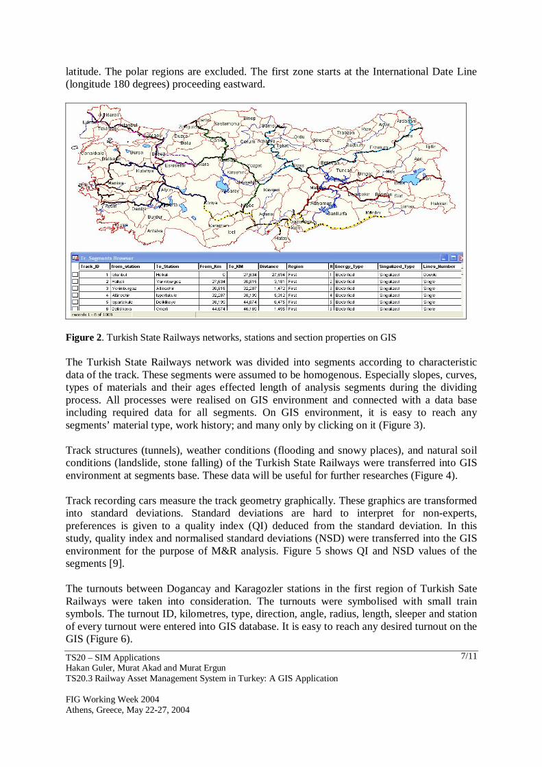
5.1 A Case Study for Turkish State Railways Generally, GIS network analysis is a suitable tool to model phenomena of the real world that are transported through a network. In this study it is used for infrastructure asset management system. For that purpose, a map containing the Turkish State Railways network was obtained from the Turkish State Railways Organisation (TCDD). Maps reflect the created databases. The map of the network was rectified and co-ordinated using the Mercator projection. The Mercator projection has straight meridians & parallels that intersect at right angles, as opposed to the Robinson projection. Mercator preserves area only at the equator and at two standard parallels equidistant from the equator. Datum is basically mathematical descriptions of the Earth’s size and shape. In this study, ED 50 (European Datum) and UTM 36 projection were used. Rasters and vectors data were used to represent the railway network, stations, switches and crossings. Raster data is represented by pixels with values. Raster allows certain types of operations, which is not possible with vector data. Map algebra is possible with multiple data layers – creating index maps. Vector data is stored as points, lines, and polygons. Vector uses less memory than raster format, and does not loose positional accuracy. MapInfo Professional was selected as the geographic analysis software. Raster, vector and table data were transferred into MapInfo Professional database for geographical analysis (Figure 2) [7]. The Turkish State Railways network was transferred into GIS environment in order to provide high quality decision support systems (DSS). It was an extremely complex system to transfer all the data related with the network. It requires a large amount of data to be available. Thus, a track section data contained in various databases and asset management systems (AMS) was transferred into the GIS database to be used for the track condition analysis and work planning purposes. This data contains general data, layout and operating data, general data on superstructure and infrastructure, geometry measurements, inspections and other measurements, work history and map data of the railway network on the analysis segment base [8]. The standard data encompass the following groups of data: − Administrative data (comprises information about the network and its administrative
organisation) − General data-layout and operating data (curves, loads, speeds, slopes) − General data on superstructure and infrastructure (ballast, sleepers, rails, structures) − Geometry measurements (alignment, vertical, twist, cross-level, gauge, quality indices,
other user-specific parameters) − Inspections and other measurements (general condition, ballast condition, fastening
condition, sleeper condition) − Work history (renewals, tamping work history, spot maintenance history) − Map data (data defining the map(s) of a railway network) The Universal Transverse Mercator Coordinate (UTM) system provides coordinates on a world wide flat grid for easy computation. UTM divides the World into 60 zones, each being 6 degrees longitude wide, and extending from 80 degrees south latitude to 84 degrees north
TS20 – SIM Applications Hakan Guler, Murat Akad and Murat Ergun TS20.3 Railway Asset Management System in Turkey: A GIS Application
FIG Working Week 2004 Athens, Greece, May 22-27, 2004
7/11
latitude. The polar regions are excluded. The first zone starts at the International Date Line (longitude 180 degrees) proceeding eastward.
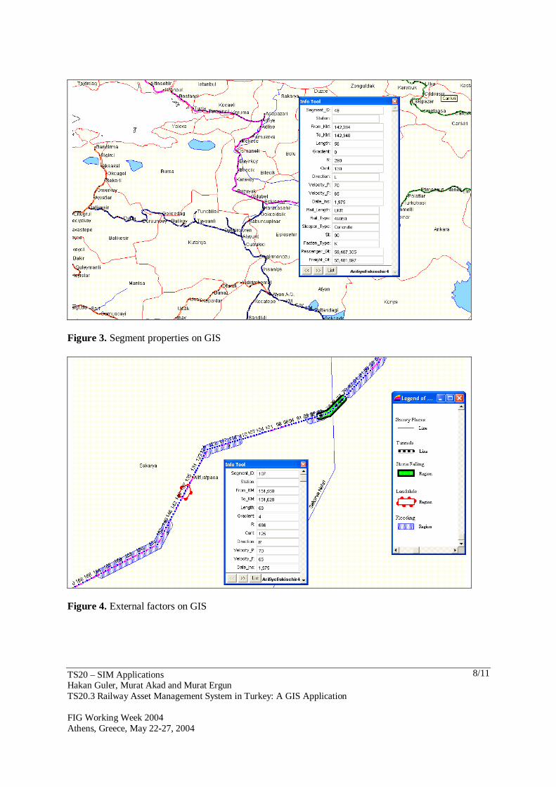
Figure 2. Turkish State Railways networks, stations and section properties on GIS The Turkish State Railways network was divided into segments according to characteristic data of the track. These segments were assumed to be homogenous. Especially slopes, curves, types of materials and their ages effected length of analysis segments during the dividing process. All processes were realised on GIS environment and connected with a data base including required data for all segments. On GIS environment, it is easy to reach any segments’ material type, work history; and many only by clicking on it (Figure 3). Track structures (tunnels), weather conditions (flooding and snowy places), and natural soil conditions (landslide, stone falling) of the Turkish State Railways were transferred into GIS environment at segments base. These data will be useful for further researches (Figure 4). Track recording cars measure the track geometry graphically. These graphics are transformed into standard deviations. Standard deviations are hard to interpret for non-experts, preferences is given to a quality index (QI) deduced from the standard deviation. In this study, quality index and normalised standard deviations (NSD) were transferred into the GIS environment for the purpose of M&R analysis. Figure 5 shows QI and NSD values of the segments [9]. The turnouts between Dogancay and Karagozler stations in the first region of Turkish Sate Railways were taken into consideration. The turnouts were symbolised with small train symbols. The turnout ID, kilometres, type, direction, angle, radius, length, sleeper and station of every turnout were entered into GIS database. It is easy to reach any desired turnout on the GIS (Figure 6).
TS20 – SIM Applications Hakan Guler, Murat Akad and Murat Ergun TS20.3 Railway Asset Management System in Turkey: A GIS Application
FIG Working Week 2004 Athens, Greece, May 22-27, 2004
8/11
Figure 3. Segment properties on GIS
Figure 4. External factors on GIS

TS20 – SIM Applications Hakan Guler, Murat Akad and Murat Ergun TS20.3 Railway Asset Management System in Turkey: A GIS Application
FIG Working Week 2004 Athens, Greece, May 22-27, 2004
9/11
Figure 5. Quality Index and normalised standard deviations of the segments on GIS
Figure 6. Properties of a turnout and carried out M&R work types on GIS 6. CONCLUSION Information will be available on a facilities condition and performance, which can help managers to develop a plan schedule, and prepare short and long-range strategies with an

TS20 – SIM Applications Hakan Guler, Murat Akad and Murat Ergun TS20.3 Railway Asset Management System in Turkey: A GIS Application
FIG Working Week 2004 Athens, Greece, May 22-27, 2004
10/11
AMS. GIS can be used to determine the location of an event or asset and its relationship or proximity to another event or asset, which may be the critical factor leading to a decision about design, construction, or maintenance. The aim of this paper was to demonstrate the capabilities of GIS in analysing the track assets and providing consequent decision support regarding them. REFERENCES Uddin, W., Al-Turk, E., Aug 10-14, 2001. Airborne LIDAR Digital Terrain Mapping for
Transportation Infrastructure Asset Management, 5TH International Conference on Managing Pavements, Seattle.
Wittwer, E., Bittner J., Switzer, A., 2002. The Fourth National Transportation Asset Management Workshop, International Journal of Transport Management, V.1, pp. 87-99.
J.R William, 1989, Fundamentals of geographic information systems, USA. Esveld, C., 2001. Modern Railway Track, Second Edition, The Netherlands. J.R William, 1989, Fundamentals of geographic information systems, USA. Yomralioglu, T., 2000. Geographical Information Systems, Secil Ofset, 1st Edition, Istanbul. http://www.esri.com/industries/transport/rail.html L. Daniel, P. Loree, A. Whitener, (2002) Mapinfo Profesional, 3 th Edition, Canada. Jovanovic, S., Korpanec, I., August 2000. Three Years of Experience with ECOTRACK
Implementation and Use, International Railway Journal (IRJ). Esveld, C., 1989, Modern Railway Track, Germany. BIOGRAPHICAL NOTES Hakan Guler graduated from the Istanbul Technical University, Turkey, as a Civil Engineer in 1995. After graduation, he started working as a project engineer between 1995 and 1996 in a company at the same time he started MSc in Istanbul Technical University. He began to work as a research assistant in 1996 in Sakarya University. He obtained his Master of Science Degree in Istanbul Technical University, Civil Engineering, in 1998 within the field of Analysis of Railway Track Structure Using Finite Element Methods. In 1998 he started working at Istanbul Technical University, Turkey, Faculty of Civil Engineering as a Ph.D. candidate and a research assistant within the Railway Engineering Group. His fields of special interest are Geographical Information Systems, Finite Element Methods and Decision Support Systems for track maintenance and renewal. He has thirteen national and international publications on GIS, FEM, Track M&R, OD analysis, analysis of railway accidents, airborne digital technology. Murat Akad, who obtained a BSc in Civil Engineering from Istanbul Technical University in 1991, got his MSc at the same institution on Transportation Engineering in 1994. His work was on capacity analysis of at-grade junctions. He has been working at the Department of Transportation of the same university since 1991. At the moment, he is working on his PhD on the area of Public Transportation. His areas of interest include public transportation, traffic management and transportation planning. He is a member of EURO Working Group on Transportation.
TS20 – SIM Applications Hakan Guler, Murat Akad and Murat Ergun TS20.3 Railway Asset Management System in Turkey: A GIS Application
FIG Working Week 2004 Athens, Greece, May 22-27, 2004
11/11
Murat Ergun, who obtained a BSc in Civil Engineering from Uludag University in 1986, got his MSc at the Istanbul Technical University on Transportation Engineering in 1989. His work was on using waste material on road pavement construction. He finished his PhD at the same institution in 1998, with a thesis on friction properties of pavements. He has been working at the Department of Transportation of the same university since 1987. His areas of interest include pavement management and infrastructure management. He is a founder and vice-president of International Society for Maintenance and Rehabilitation of Transport Infrastructures and he is also a member of EURO Working Group on Transportation. CONTACTS Hakan Guler Istanbul Technical University Civil Engineering Faculty, Transportation Engineering Department Istanbul TURKEY Tel. + 90 212 285 36 69 Fax + 90 212 285 34 20 Email: [email protected] Web site: http://atlas.cc.itu.edu.tr/~hguler Murat Akad Istanbul Technical University Civil Engineering Faculty, Transportation Engineering Department Istanbul TURKEY Tel. + 90 212 285 36 65 Fax + 90 212 285 34 20 Email: [email protected] Murat Ergun Istanbul Technical University Civil Engineering Faculty, Transportation Engineering Department Istanbul TURKEY Tel. + 90 212 285 65 36 Fax + 90 212 285 34 20 Email: [email protected]