raleigh survey update 2017 survey report of survey report with revisions as needed . raleigh survey...
TRANSCRIPT
RALEIGH SURVEY UPDATE 2017
SURVEY REPORT

Raleigh Survey Update 2017, p. 2
Table of Contents List of Maps ............................................................................................................. 3
Introduction ............................................................................................................. 5
Methodology ............................................................................................................. 7
Findings ..................................................................................................................... 9 Individual Properties ............................................................................................................................. 9
Brentwood ............................................................................................................................................... 23
Budleigh .................................................................................................................................................. 25
Caraleigh ................................................................................................................................................. 29
East Mordecai ......................................................................................................................................... 32
Fairway Acres ......................................................................................................................................... 36
Forty Acres .............................................................................................................................................. 38
Fuller Heights .......................................................................................................................................... 40
Gatewood ................................................................................................................................................ 44
Longview Park ........................................................................................................................................ 46
Lyon Park ................................................................................................................................................ 49
Oakdale ................................................................................................................................................... 52
Oxford Park ............................................................................................................................................. 55
Parkland and Hertford Village ............................................................................................................... 58
Ralina ...................................................................................................................................................... 62
Ridgewood .............................................................................................................................................. 65
Rollingwood ............................................................................................................................................ 68
Starmount ................................................................................................................................................ 70
Westover ................................................................................................................................................. 72
Windsor Park .......................................................................................................................................... 75
Woodcrest ............................................................................................................................................... 78
Summary ................................................................................................................. 81
Sources .................................................................................................................... 82

Raleigh Survey Update 2017, p. 3
LIST OF MAPS
MAP 1: Brentwood, roughly per plats ............................................................................................... 23
MAP 2: Boundary for proposed Brentwood Historic District ........................................................ 24
MAP 3: Budleigh, roughly per plats .................................................................................................. 26
MAP 4: Budleigh Area 1943 USGS topo map detail ..................................................................... 26
MAP 5: Budleigh Area 1968 USGS topo map detail ..................................................................... 27
MAP 6: Budleigh, buildings less than 50 years of age noted ......................................................... 27
MAP 7: Caraleigh Mills Property* .................................................................................................... 29
MAP 8: Caraleigh, roughly per plats ................................................................................................. 30
MAP 9: Boundary for proposed Caraleigh Historic District ......................................................... 31
MAP 10: East Mordecai, Meadowbrook and Lafayette noted ....................................................... 33
MAP 11: East Mordecai, buildings less than 50 years of age noted ............................................. 34
MAP 12: Boundary for proposed East Mordecai Historic District ............................................... 35
MAP 13: Fairway Acres plat** .......................................................................................................... 36
MAP 14: Boundary for proposed Fairway Acres Historic District ............................................... 37
MAP 15: Forty Acres, roughly per plats ........................................................................................... 38
MAP 16: Forty Acres, noncontributing buildings noted ................................................................. 39
MAP 17: Fuller Heights plat** .......................................................................................................... 40
MAP 18: Fuller Heights, roughly per plat ........................................................................................ 41
MAP 19: Fuller Heights, noncontributing buildings noted ............................................................ 42
MAP 20: Boundary for proposed Fuller Heights Historic District ................................................ 43
MAP 21: Gatewood, roughly per plats .............................................................................................. 44
MAP 22: Gatewood, noncontributing buildings noted.................................................................... 45
MAP 23: Longview Park, roughly per plats with several plats noted ........................................... 47
MAP 24: Longview Park, buildings less than 50 years of age noted ........................................... 48
MAP 25: Lyon Park plat** ................................................................................................................ 50
MAP 26: Lyon Park, roughly per plats.............................................................................................. 50
MAP 27: Lyon Park, noncontributing buildings noted ................................................................... 51
MAP 28: Oakdale plat * ...................................................................................................................... 53
MAP 29: Oakdale, roughly per plats ................................................................................................. 53

Raleigh Survey Update 2017, p. 4
MAP 30: Oakdale, noncontributing buildings and Oakwood boundary noted ............................ 54
MAP 31: Oxford Park, roughly per plat ............................................................................................ 56
MAP 32: Oxford Park, noncontributing buildings noted ................................................................ 57
MAP 33: Parkland plat** .................................................................................................................... 59
MAP 34: Parkland, roughly per plat with noncontributing buildings noted ................................ 60
MAP 35: Hertford Village, noncontributing buildings noted......................................................... 61
MAP 36: Ralina plat** ........................................................................................................................ 63
MAP 37: Ralina, roughly per plat with noncontributing buildings noted .................................... 64
MAP 38: Ridgewood, roughly per plat ............................................................................................. 66
MAP 39: Ridgewood, noncontributing buildings noted ................................................................. 67
MAP 40: Rollingwood, roughly per plats with dates noted ........................................................... 69
MAP 41: Starmount, roughly per plats .............................................................................................. 71
MAP 42: Westover, roughly per plats ............................................................................................... 73
MAP 43: Westover, noncontributing buildings noted ..................................................................... 75
MAP 45: Windsor Park plat** ........................................................................................................... 76
MAP 46: Windsor Park, noncontributing buildings noted ............................................................. 78
MAP 47: Woodcrest, roughly per plats ............................................................................................. 79
All maps by author except where noted
* maps courtesy Olivia Raney Local History Library
** maps courtesy Wake County Register of Deeds Office

Raleigh Survey Update 2017, p. 5
Introduction In November 2016, the Raleigh Historic Development Commission, Inc. (RHDC) and the City of Raleigh (City) issued a Request for Qualifications (RFQ) for an Architectural Survey Update. The project was funded by a federal Historic Preservation Fund grant from the National Park Service, United States Department of the Interior which was administered through the State Historic Preservation Office (NC HPO) of the North Carolina Office of Archives and History. This project was designed to update the architectural survey of Raleigh by recording properties within the city limits, with a focus on mid-20th-century neighborhoods and areas annexed since 2006, when the last update was completed. Neighborhoods were selected in part as a result of input from residents, including inquiries to the Raleigh planning staff and feedback from attendees of public meetings. The project was divided into six phases:
1. Initial Data Collection - Review of HPO and City files, receipt of shell database from HPO, and receipt of maps from City of Raleigh
2. Windshield Survey and Meeting- First public meeting; survey update of 11 properties,
and identification and survey of no more than 10 properties in the annexation areas. Deliverables: PowerPoint presentation prepared and delivered; photo proof sheets and disks for up to 21 properties; hard copy survey forms for up to 21 properties; maps for up to 21 properties; database for up to 21 properties
3. Survey Update of 5 Neighborhoods -Field work and updating of survey files for
Caraleigh, Ridgewood, Fairway Acres, Lyon Park, and Forty Acres--all areas placed on the North Carolina National Register Study List at the end of the Raleigh Modern Survey 1945-1965 in 2006. Deliverables: representative photos (disk and proof sheets); updated hard copy survey forms for the 5 neighborhoods; survey data base entries for the 5 neighborhoods; neighborhood maps with boundaries and photo keys
4. Survey Update of 11 Neighborhoods & Survey of 2 Neighborhoods -Field work and
updating of survey files for Brentwood, Budleigh, Fallon Park, Oakdale, Parkland/ Hertford Village, Ralina, Starmount, Westover/Mount Vernon, Woodcrest, Colinwood (now known as King Charles), and East Raleigh (comprising Gatewood, Rollingwood, and Windsor Park); and field work and creation of survey files for East Mordecai and Fuller Heights. Deliverables: representative photos (disk and proof sheets); updated hard copy survey forms for the 13 neighborhoods; survey data base entries for the 13 neighborhoods to include evaluation of NR eligibility; neighborhood maps with boundaries and photo keys
5. Survey Report and Revisions
Deliverables: Draft Survey Report; Final draft of all survey materials with revisions as needed

Raleigh Survey Update 2017, p. 6
6. Presentations and Revisions
Deliverables: Second Public Meeting; PowerPoint presentation and text for NRAC created (with commitment to deliver 3x: twice to HPO staff and once to NRAC); Final draft of survey report with revisions as needed

Raleigh Survey Update 2017, p. 7
Methodology The initial public meeting was held on Thursday, March 30, 2017, at 6:00 p.m.at the Five Points Center for Active Adults, 2000 Noble Road, Raleigh, NC 27608. The objectives of the meeting were to provide a formal "kick off," to describe the project scope, to entertain questions, and begin to gauge interest in communities for a second phase neighborhood survey. The City of Raleigh provided shape files for all tracts that had been annexed by the city since 2006, which constituted a total of 219 separate annexation areas scattered largely outside the beltline. The annexation areas varied in size from single parcels to entire subdivisions. The North Carolina Historic Preservation Office (HPO) provided files for the 11 previously surveyed individual properties within the annexed areas, and for 14 previously surveyed or documented neighborhoods, as well as some additional files for individual resources within target neighborhoods. The consultant team made site visits to the previously surveyed individual properties and as applicable took photographs and field notes. HPO survey database entries were created or updated for each. In most cases, previous survey data text was copied and added to the database. Comments on changes and relevant observations were added. Digital photographs were taken and labeled and hard copy photo proof sheets and maps were added to the files as applicable. The consultant team visited each of the 219 annexation areas to determine if extant resources that merited survey were present and to document the same, up to an agreed upon limit of ten total. Fieldwork was augmented by a review of historic aerial photographs to determine where resources might be on larger tracts that had been redeveloped and where an older resources could remain among new development. Ten new resources were surveyed. The properties selected were all resources over fifty years old and were selected based on a combination of perceived threat and/or architectural or historic merit. They were mapped, assigned survey site numbers, photographed and documented. For each resource, the consultant created and populated HPO survey database records, labeled the digital photographs, and created files with hard copy database entries, maps, and photo proof sheets. Raleigh tax data was used to determine date of construction. For neighborhoods, the consultant reviewed the existing HPO files and mapping data. Research at the Olivia Raney Local History Library and the Wake County Register of Deeds office provided information including historic plats used to determine the historic boundaries for each neighborhood, which were then mapped using the city's IMAPS on-line GIS program. Hard copies of both historic plats and the neighborhood per plats as delineated on a current base map were created. Using Raleigh real estate records, additional maps that showed new construction within the neighborhood boundaries were drawn and printed. In smaller neighborhoods, review of additional properties not deemed to be new construction, but which have been rehabilitated so as to be substantially new, were also mapped. These maps were used to produce maps with proposed revised district boundaries in Study-Listed neighborhoods where substantial change

Raleigh Survey Update 2017, p. 8
had occurred but where a district may remain. For others it was used to demonstrate that change and alteration was so pervasive that a district would not be eligible until many of the new buildings had reached 50 years of age and alterations were minimal. Maps for neighborhoods not on the Study List were also created. Historic plats were reproduced in hard copy and submitted with the newly created maps in the survey files. Fieldwork included photography and review of pre-existing neighborhood survey text for neighborhoods, as applicable. An individual database record was made for each neighborhood as well as a district record. Photographs and hard copy photo proof sheets and report forms printed from the database entries were created for each neighborhood file.

Raleigh Survey Update 2017, p. 9
Findings Individual Properties Thirteen properties were identified for survey update: WA1474 Wake Crossroads WA7877 House, 9600 Fonville Road WA7878 House, 9616 Fonville Road WA7879 House, 9625 Fonville Road WA1455 Mill Manager's House WA1921 Battle C. Jones House WA7630 House, 8320 Ebeneezer Church Road
WA6528 Raleigh Memorial Park Cemetery WA1301 Six Forks Baptist Church WA1456 Dr. Thompson House WA4329 House, 12804 Strickland Road WA7884 House, Old Falls of Neuse Road WA7885 Duplex, Old Falls of Neuse Road
Five properties have been demolished since they were last surveyed, (WA1456, WA4329, WA7884, WA7885 and WA7877). Additionally, the Battle C. Jones House (WA1921) is located in a parcel with heavy tree cover. The property is posted and the private lane gated. Many attempts to contact the registered agent for the owner were unsuccessful. WA1474 Wake Crossroads The 1990 Wake County survey describes this resource thus, "This crossroads community with 18th century roots has been greatly affected by development in recent years, but still retains its function as the commercial center of a predominantly rural community. ..."1 The H.B Jones Store, the frame bungalow on Mitchell Mill Road, and the garage service area noted on Lally's field map are all that remains of the resources surveyed. However a house at 3535 Forrestville Road, slightly south of Lally's map, might be considered part of the region.
WA1474 Wake Crossroads
1 Lally, Kelly. Wake Crossroads survey form, Wake County Survey 1990.

Raleigh Survey Update 2017, p. 10
New development, including a large church at the northwest corner of the intersection of Mitchell Mill and Forestville Roads, a convenience store complex at the southeast corner and a fire station just south of the southwest corner, plus road widening and nearby subdivisions have greatly altered the character of the area. The community lacks the integrity for National Register listing as a district. WA7878 House, 9616 Fonville Road This c. 1940, one-story, front-gable dwelling, with vinyl siding, replacement windows, and a front-gable porch supported by turned posts found ineligible in 2007 does not appear to have noticeably changed from the previous survey.
WA7878 House, 9616 Fonville Road
The building does not rise to a level of significance to merit National Register listing. WA7879 House, 9625 Fonville Road This one-story, side-gabled frame house with engaged front porch, projecting gabled bay at left edge of façade, vinyl siding, six-over-six double-hung sash windows, picture window with sidelights, and side addition with brick stack does not appear to have noticeably changed from the previous survey.

Raleigh Survey Update 2017, p. 11
WA7879 House, 9625 Fonville Road
The building does not rise to a level of significance to merit National Register listing. WA1455 Mill Manager's House, Fonville Road This house has been highly altered since the 1990 survey and photographs. Photos from the 2007 survey were not on file. The house is T-shaped. A cross-gabled wing and porch to the north has been removed. The façade porch to the south now has battered wooden piers on stone- faced bases. There is a one-story rear addition in the crook of the ell. Doors and windows have been replaced, the house is clad in vinyl siding with a composite shingle roof. The porch has a stone veneer up to the window sill level.
WA1455 Mill Manager's House, Fonville Road

Raleigh Survey Update 2017, p. 12
The building lacks the integrity needed for National Register listing. WA7630 House, 8320 Ebenezer Church Road Previously described in a 2014 North Carolina Department of Transportation (NCDOT) study Improve US 70 from SR 1876 to SR 1664 TIP # U-2823, WBS # 38984.1.1 as
One-and-one-half story Colonial eclectic cottage with stone veneer and stucco covering the exterior walls, featuring hipped dormer windows. The south portion of the façade has an accented clipped gable roof pierced by one-over-one window bay, and the gable ends on the north and south elevations have clipped gables. Window bays consist of two-over-two awning sash and all bays have brick header-course borders. The dormer windows are six-over-six sash replacements. A three-part "picture" window on the south portion of the facade consists of a single fixed pane flanked by two-over-two sash windows of narrow width. A small, gabled, freestanding hood/stoop shelters the single-leaf entrance. The stone veneer is laid in an irregular pattern with smoothed curved (convex) concrete joints. The north elevation is pierced by three bays on the first story (one double window, one entrance and one single window), and two six-over-six replacement sash bays on the second story sheltered by overhanging eaves of the clipped gable roof. A low wall containing a side patio matches the first story stone veneer treatment with a brick header course cap. The south elevation is pierced by two window bays on the first story. Exterior landscape features include mature trees, a small parking lot directly in front of the house, and a wooden fence encapsulating the back yard. Although the house has some interesting architectural elements, it does not retain integrity nor possess enough historical or architectural significance to be considered individually eligible for the NRHP.2
WA7630 House, 8320 Ebenezer Church Road
2 NCDOT Improve US 70 from SR 1876 to SR 1664 TIP # U-2823, WBS # 38984.1.1.

Raleigh Survey Update 2017, p. 13
The building does not appear to have noticeably changed from the previous survey. It does not rise to a level of significance to merit National Register listing. WA6528 Raleigh Memorial Park Cemetery, 7501 Glenwood Avenue Previously described in a 2014 North Carolina Department of Transportation (NCDOT) study Improve US 70 from SR 1876 to SR 1664 TIP # U-2823, WBS # 38984.1.1
Established in 1959, Raleigh Memorial Park Cemetery features spacious well-maintained grounds with two garden mausoleums, a giant marble statue of Christ, and rows of large oaks and evergreens in addition to the classical Chapel with mausoleum. The majority of the grounds hold orderly rows of graves and markers that are flush with the ground; however, the rear portion of the cemetery contains a large grouping of above-ground, traditional grave markers typical of styles popular in the last fifty years, as well as a memorial section for military internments. Raleigh Memorial Park sits upon one of the highest points in the city of Raleigh and encompasses over fifty acres, the only cemetery to be designated in North Carolina as a National Wildlife Habitat. It is divided into eight planned gardens with primarily flat bronze grave markers placed evenly along the landscape of trees and ornamental shrubs. Located at the front (east) of the property close to Glenwood Avenue, one of the large mausoleums is rectangular-shaped with marble and granite paneling. The second mausoleum is an octagonal-shaped seven-story structure with marble-paneled walls, with a flat roof extending well beyond the building’s walls to enclose a porch supported by fluted columns. The classical revival ca. 1960 marble veneer Chapel features a three-part façade including a central wing with large portico supported by fluted Doric columns. A large frieze is sheltered by the cornice and pediment with sculpted tympanum. The central wing features a three-bay façade with large double-leaf, oak, four-paneled entrance doors highlighted by marble surrounds and a stained-glass transom. The entrance is flanked by two tall oak window bays of two rows with five lights of stained glass each. Granite steps lead to the porch. The side wings are highlighted by marble arcading with each arch accented by a central keystone detail. Marble niches in the walls act as entombments holding cremated remains. The east elevation is pierced by two large window blocks with glass entrances. A substantial modern addition on the west elevation features a flat roof, oversized plain cornice and bands of windows. 3
In 2014 the cemetery was deemed ineligible for listing on the National Register and does not appear to have noticeably changed from the previous survey. The cemetery does not rise to a level of significance to merit National Register listing.
3 NCDOT Improve US 70 from SR 1876 to SR 1664 TIP # U-2823, WBS # 38984.1.1.

Raleigh Survey Update 2017, p. 14
WA6528 Raleigh Memorial Park Cemetery Chapel
WA6528 Raleigh Memorial Park Cemetery, View to Chapel
WA1301 Six Forks Baptist Church, Baileywick Road The 1990 Wake County survey described the resource thus:
This simple, country church was built in 1893 for the congregation of Six Forks Baptist Church. Although remodeled in recent years, this T-shaped church retains its overall original form and pointed-arched Gothic Revival windows and remains one of only a few surviving reminders of the rural past in this growing area of Wake County. The cemetery to the rear of the church contains graves dating from the early 1900s, marked mostly with manufactured stones. Many plots are covered with small pebbles. The church serves the congregation of Six Forks Baptist Church, established in the late nineteenth century. The

Raleigh Survey Update 2017, p. 15
church temporarily disbanded in 1940 due to World War II, but was reorganized in 1950.4
WA1301 Six Forks Baptist Church
The church seems to have been negligibly altered if at all since the 1990 survey. It now houses the Raleigh Korean Baptist Church. It merits further study of exterior changes and documentation of the interior to determine if it is eligible for National Register listing under Criterion C for architecture.
4 Lally, Kelly. Six Forks Baptist Church survey form, Wake County Survey 1990.
Raleigh Survey Update 2017, p. 16
The following ten properties were newly surveyed:
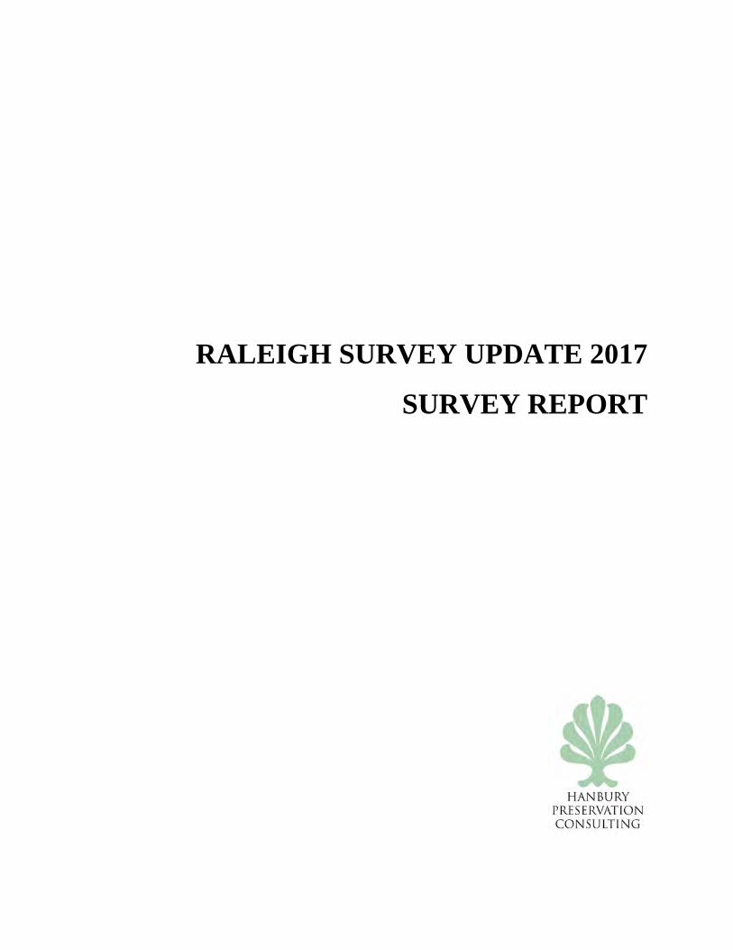
WA7936 House, 10200 Durant Road This one-story house, converted to office use, is constructed of concrete block. To the east and west are telescoping side-gabled wings, that are of frame construction with vinyl siding and which may have been porches, now enclosed. The central entrance is a single leaf, two-light door flanked by 6/6 wooden sash windows. The roof is composite shingle and has a central interior brick chimney set at a 45 degree angle to the roof ridge. On the north side of the house is an attached, partially enclosed car port with a gable roof. The house is now the office for a commercial mulch operation. The yard around the house retains mature trees.
WA7936 House, 10200 Durant Road
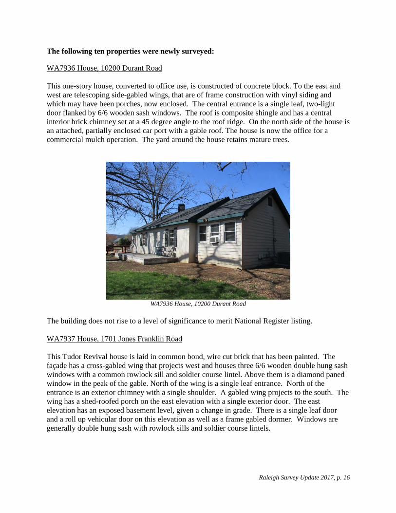
The building does not rise to a level of significance to merit National Register listing. WA7937 House, 1701 Jones Franklin Road This Tudor Revival house is laid in common bond, wire cut brick that has been painted. The façade has a cross-gabled wing that projects west and houses three 6/6 wooden double hung sash windows with a common rowlock sill and soldier course lintel. Above them is a diamond paned window in the peak of the gable. North of the wing is a single leaf entrance. North of the entrance is an exterior chimney with a single shoulder. A gabled wing projects to the south. The wing has a shed-roofed porch on the east elevation with a single exterior door. The east elevation has an exposed basement level, given a change in grade. There is a single leaf door and a roll up vehicular door on this elevation as well as a frame gabled dormer. Windows are generally double hung sash with rowlock sills and soldier course lintels.
Raleigh Survey Update 2017, p. 17
WA7937 House, 1701 Jones Franklin Road
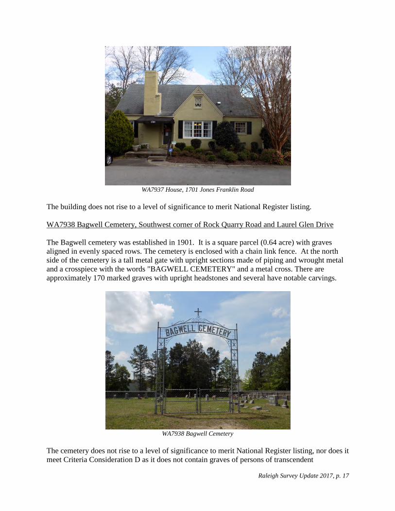
The building does not rise to a level of significance to merit National Register listing. WA7938 Bagwell Cemetery, Southwest corner of Rock Quarry Road and Laurel Glen Drive The Bagwell cemetery was established in 1901. It is a square parcel (0.64 acre) with graves aligned in evenly spaced rows. The cemetery is enclosed with a chain link fence. At the north side of the cemetery is a tall metal gate with upright sections made of piping and wrought metal and a crosspiece with the words "BAGWELL CEMETERY" and a metal cross. There are approximately 170 marked graves with upright headstones and several have notable carvings.
WA7938 Bagwell Cemetery
The cemetery does not rise to a level of significance to merit National Register listing, nor does it meet Criteria Consideration D as it does not contain graves of persons of transcendent
Raleigh Survey Update 2017, p. 18
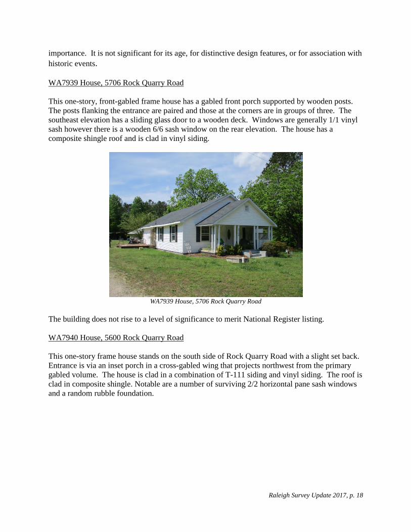
importance. It is not significant for its age, for distinctive design features, or for association with historic events. WA7939 House, 5706 Rock Quarry Road This one-story, front-gabled frame house has a gabled front porch supported by wooden posts. The posts flanking the entrance are paired and those at the corners are in groups of three. The southeast elevation has a sliding glass door to a wooden deck. Windows are generally 1/1 vinyl sash however there is a wooden 6/6 sash window on the rear elevation. The house has a composite shingle roof and is clad in vinyl siding.
WA7939 House, 5706 Rock Quarry Road
The building does not rise to a level of significance to merit National Register listing. WA7940 House, 5600 Rock Quarry Road This one-story frame house stands on the south side of Rock Quarry Road with a slight set back. Entrance is via an inset porch in a cross-gabled wing that projects northwest from the primary gabled volume. The house is clad in a combination of T-111 siding and vinyl siding. The roof is clad in composite shingle. Notable are a number of surviving 2/2 horizontal pane sash windows and a random rubble foundation.

Raleigh Survey Update 2017, p. 19
WA7940 House, 5600 Rock Quarry Road
The building does not rise to a level of significance to merit National Register listing. WA7941 House, 3900 Pearl Road
WA7941 House, 3900 Pearl Road
This one-story, side-gabled, brick veneer Ranch is not a true Split-Level house, however it is divided into two sections. The facade has on its western section a long rowlock sill above which is framing and two sets of paired 2/2 light windows. The eastern section is slightly set back and contains a single leaf entrance with three rectangular lights, set adjacent to the western section. To the east of the entrance are three 2/2 light windows, two of which are paired. The east and west gable ends have framing in the gables. The north gable end has two windows but the south

Raleigh Survey Update 2017, p. 20
has none. The rear elevation has a roll up vehicular door at grade on the east side. It also has a single leaf entrance with steps descending down to the north, and several 2/2 light windows. The building does not rise to a level of significance to merit National Register listing. WA7942 Silver Beach, Silver Beach Way Silver Beach on Robertsons Pond, north of Tryon Road, is the remnant of Silver Lake Waterpark. The beach retains a one story snack bar, clad in German siding with a porch and a service counter window. Also remaining are a covered picnic area, swing sets, a sand beach, a new dock and a dam. The remainder of the site was sold and redeveloped into a residential subdivision.
WA7942 Silver Beach
The site has been compromised and the loss of integrity precludes its listing on the National Register. WA7943 House, 4721 Old Poole Road This side-gabled house is laid in common bond with wire-cut bricks. The central single-leaf entrance is in a classical surround with fluted pilasters supporting an entablature on which is carved a branch or tree at its center. The entrance is flanked by metal casement windows with rowlock sills. The east elevation has an exterior end chimney and north of the chimney is a one-story, side-gabled bay that projects to the east and has an inset porch and exterior door on its north elevation. Windows are generally metal casement with rowlock sills. The house has a second brick chimney that is interior and north of the roof ridge.

Raleigh Survey Update 2017, p. 21
WA7943 House, 4721 Old Poole Road
The building does not rise to a level of significance to merit National Register listing. WA7944 House, 6616 Pleasant Pines Drive
WA7944 House, 6616 Pleasant Pines Drive
This imposing house sits on a lot of over 3 acres. It has a curving drive to a garage in a southern wing of the house leaving the front yard with a sweeping grassy area and several mature trees. The main, two-story section of the house has five bays. The central entrance bay has a two story, gabled projecting portico with paired square columns. The double leaf entrance has flanking sidelights and all are beneath an entablature with keystone. This central core has graduated fenestration with 8/12 windows on the first floor and 8/8 on the second. Most windows appear to be replacement vinyl windows. The house has one-story, side-gabled projecting wings to the north and south. The southern wing houses the garage. The east elevation has an exposed

Raleigh Survey Update 2017, p. 22
basement level due to a change in grade. A colonnade beginning with the breezeway to the garage, extends north where it is incorporated in an enclosed porch on the main level. East of the house is a landscaped terrace and mature plantings are set off by brick retaining walls and steps. The house does not appear to rise to a level of significance to merit National Register listing, however further research on the architect could prompt a re-assessment. WA7945 House, 2909 N. New Hope Road This one story brick Ranch house is laid in common bond wire cut brick. It has a single leaf entrance on the facade with three rectangular lights set on a diagonal. North of the entrance is a composite window with a large single pane flanked by 2/2 wooden sash windows with a common rowlock sill. South of the entrance are four hopper or awning windows set below the eaves. The house has a hip roofed frame wing to the north which is set back. It appears to have been a porch, later infilled. The rear of the house was screened by a privacy fence and was not observed.
WA7945House, 2909 N. New Hope Road
The building does not rise to a level of significance to merit National Register listing.

Raleigh Survey Update 2017, p. 23
NEIGHBORHOODS Brentwood Some may consider Brentwood to extend to an area bounded by Atlantic Avenue, New Hope Church Road, and roughly by Ingram, Arrowwood, and Huntleigh Drives to include the park and Beamon Lake. Brentwood was developed by the Sir Walter Building Company and later Brentwood Development Corporation and J.R Adams from 1956 to 1962. The area to the north was developed by J. R. Adams and developed as "Brentwood Estates." For the purposes of this survey, Brentwood is defined by the 7 plats filed at the Wake County Register of Deeds Office under the title "Brentwood." An aggregate map of all the historic plats overlaid on the city's current GIS data is shown below.
Brentwood, roughly per plats
The neighborhood appears to have had very little change since the previous survey. The predominant housing types are Ranches, Split-Level and Split-Foyers. There are many similar houses and they may have been built speculatively. Brentwood Road is the major arterial road through the community that connects to Capital Boulevard. Most of the smaller roads are curving and extend over a slightly rolling topography. The houses tend to have a similar setback. The neighborhood has a good collection of mature deciduous trees and conifers.

Raleigh Survey Update 2017, p. 24
Similar housing types and designs, uniform setbacks, and mature trees give the community visual cohesion. The neighborhood is a good intact example of a 1950s to 1960s suburban tract subdivision. The few noncontributing resources noted are generally those that are younger than 50 years of age. A proposed historic district boundary excludes only a few properties at the northeast corner of the district and along the eastern edge.
Boundary for Proposed Brentwood Historic District
The neighborhood is a largely intact example of a late 1950s and early 1960s speculative subdivision. The housing stock has minor alterations. The neighborhood is eligible for the National Register under Criterion A under the area of Community Planning and Development. It is associated with the Multiple Property Documentation Form, Post-World War II and Modern Architecture in Raleigh, North Carolina, 1945-1965, as a Tract Subdivision. It is a good example of a post-war subdivisions. Its curvilinear road pattern and tract houses "are representative of the post-World War II suburban landscape throughout the United States. The [subdivision], laid out in gently curving streets, with cul-de-sacs during the latter phase of the era, and occasionally with an adjacent strip shopping center or a neighborhood school, reflect (s) national trends."5 It is eligible for listing on the National Register under Criterion A for Community Planning and Development and C for Architecture. It was placed on the Study List on February 8, 2018.
5 Little, Ruth. Post-World War II and Modern Architecture in Raleigh, North Carolina, 1945-1965, National Register Multiple Property Documentation Form, 2009.

Raleigh Survey Update 2017, p. 25
Brentwood, 3100 Block of Ward Road
Brentwood, 3100 Block of Ward Road
Brentwood, 3208 Glenridge Drive
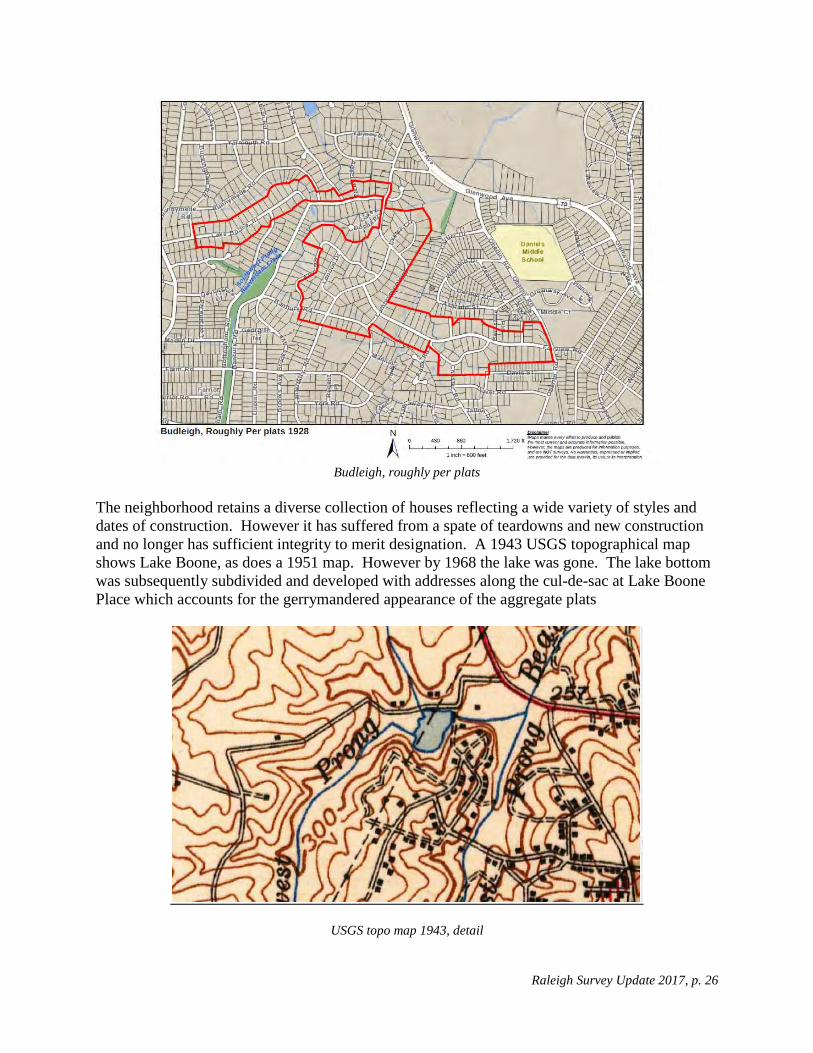
Budleigh Budleigh was originally platted in 1927 by the Atlantic Coast Realty Company. It was largely organized along Canterbury Road, southeast of Lake Boone. Subsequent plats with additions and revisions extended east along Fairview Road and west along the north shore of Lake Boone. An aggregate map of all the historic plats overlaid on the city's current GIS data is found below.
Raleigh Survey Update 2017, p. 26
Budleigh, roughly per plats
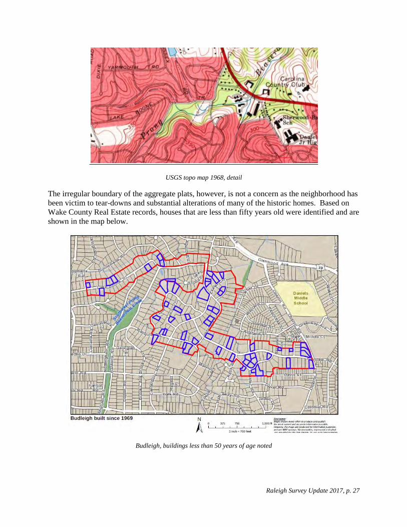
The neighborhood retains a diverse collection of houses reflecting a wide variety of styles and dates of construction. However it has suffered from a spate of teardowns and new construction and no longer has sufficient integrity to merit designation. A 1943 USGS topographical map shows Lake Boone, as does a 1951 map. However by 1968 the lake was gone. The lake bottom was subsequently subdivided and developed with addresses along the cul-de-sac at Lake Boone Place which accounts for the gerrymandered appearance of the aggregate plats
USGS topo map 1943, detail
Raleigh Survey Update 2017, p. 27
USGS topo map 1968, detail
The irregular boundary of the aggregate plats, however, is not a concern as the neighborhood has been victim to tear-downs and substantial alterations of many of the historic homes. Based on Wake County Real Estate records, houses that are less than fifty years old were identified and are shown in the map below.
Budleigh, buildings less than 50 years of age noted

Raleigh Survey Update 2017, p. 28
While numerous intact historic houses remain, including examples of the Colonial Revival and Modern styles, the district is not eligible for listing on the National Register due to the large number of non-historic houses and substantially altered houses built more than fifty years ago.
Budleigh, 2707 Cambridge Road
Budleigh, 1525 Canterbury Road
Budleigh, 600 Lake Boone Trail Budleigh, 1801 Banbury Road
While many now consider "Budleigh" to comprise a large area from Lewis Farm Road to the south, north to Lake Boone Trail, for the purposes of this survey, Budleigh as indicated on the map generated for this survey is only the area from three plats of 1928 entitled Budleigh, Budleigh Fairview Section, and Budleigh Lakeview Section, all property of the Highlands Corporation with sales by Atlantic Coast Realty. Later, post-war areas such as Lakeview (1941), Windemere (1945), Barber (1943), Barbers Lake (1947), and Budleigh Forest (1947), which are

Raleigh Survey Update 2017, p. 29
often considered "greater Budleigh," are not mapped or surveyed as Budleigh for the purposes of this survey. Caraleigh The Caraleigh neighborhood grew up around the Caraleigh Cotton Mills, established south of downtown Raleigh in 1891.
Map of Property of Caraleigh Mills Company A map from the collection at the Olivia Raney Local History Library shows the residential subdivision of the land near the mills stretching from what is now Lake Wheeler Road on the west to Fayetteville Street on the east (see map above, oriented with the south side at the top of the map). This map corresponds to a series of plats at the Wake County Register of Deeds office estimated to be from 1885. A map of the historic plat boundaries overlaid on the city's current GIS data is found below.

Raleigh Survey Update 2017, p. 30
Caraleigh, roughly per plats
The 1990 Raleigh survey described Caraleigh as Raleigh's last remaining intact mill village. It includes the Caraleigh Cotton Mills (WA3891) and company-built mill houses on Montrose and Thompson streets, as well as private dwellings that stretch east of the mills. Historic institutional buildings include the Caraleigh Baptist Church at the corner of Green Street and Summit Avenue and the former Caraleigh Grade School.
Caraleigh is not a typical mill village composed solely of a repeating series of standard design houses. The neighborhood includes both company-built housing and later private housing. Though there have been alterations to most buildings, a period of significance through 1968 could allow for a greater percentage of contributing resources. Remarkably many of the older housing stock remains in poor condition, including all of the specific examples cited in the 1990 Wake County survey. Growth pressures in Raleigh have precipitated new development, notably recent housing west of the mill along Maywood. The older and smaller houses are prime targets for demolition.
Proposed boundaries would include an area with the largest concentration of intact buildings from the company's original plat excluding the areas west of the mill extending to Lake Wheeler Road. South Saunders Street by its size and median creates a division between the east and west halves of the community but not to the extent that the district should be divided or terminated along this street.

Raleigh Survey Update 2017, p. 31
Industrial uses and new constriction, particularly toward the west end of the original platted area are largely without integrity. A proposed distinct boundary which excludes those areas is found below.
Boundary for proposed Caraleigh Historic District
Caraleigh neighborhood, new development west of the mills

Raleigh Survey Update 2017, p. 32
Although South Saunders Street has evolved into a major arterial road and does create a significant division, there is sufficient fabric on both its east and west sides to carry a district across the thoroughfare. A discontiguous district is also an option for National Register listing.
Caraleigh, 1600 Block of Thompson Street
Caraleigh, 1600 Block of Montrose Street
Caraleigh, 167 Gilbert Avenue
Caraleigh, 117 Gilbert Avenue
East Mordecai The East Mordecai neighborhood has been defined by a neighborhood association and is bounded by Glascock Street on the south, Wake Forest Road on the west and north, and Brookside Drive on the east and north. It incorporates two platted neighborhoods--Lafayette from 1938-39 and Meadowbrook from 1949-50.

Raleigh Survey Update 2017, p. 33
East Mordecai, Meadowbrook and Lafayette noted
According to the 1990 Raleigh survey, much of the area was "densely wooded tract of land owned by the Mordecai family. Known as Mordecai Grove, it was popular with picnic-goers in the late nineteenth century."6 It includes the 1898 Norburn Terrace (WA0051), designed by Adolph Gustavus Bauer, which is the study area's earliest house. On the southwest it includes Mary Elizabeth Hospital (WA3185) and a 1967 garden apartment complex.
Using city real estate data, a map with buildings less than fifty years of age was produced (see below).
6 Lally, Kelly. Oakdale survey form, Wake County Survey 1990

Raleigh Survey Update 2017, p. 34
East Mordecai, buildings less than 50 years of age noted
The area contains housing ranging from 1900 to the present with large concentrations in the 1940s and 1950s. Given the range of construction dates, the housing styles are an eclectic mix accordingly including Craftsman, Minimal Traditional, Ranch, and Tudor Revival. There are some dwellings that have been altered and enlarged and a few new construction and Modern-style units.
Though not a formal subdivision per se, the clearly defined area containing two subdivisions from the first half of the twentieth century, contains a distinct collection of largely single family housing with a range of architectural styles from Victorian to Ranch. The inclusion of Mary Elizabeth hospital in a largely residential neighborhood and the 1967 garden apartment complex, both noted in the map below, are decisions that should be made in a more detailed and nuanced survey and evaluation of the area.

Raleigh Survey Update 2017, p. 35
Boundary for East Mordecai Historic District, Garden Apartments and Mary Elizabeth Hospital noted
East Mordecai, 600 Block of Frank Street
East Mordecai, 500 Block of Frank Street
Raleigh Survey Update 2017, p. 36
East Mordecai, 1200 Block of Brookside Drive
East Mordecai, 1201 Watauga Street
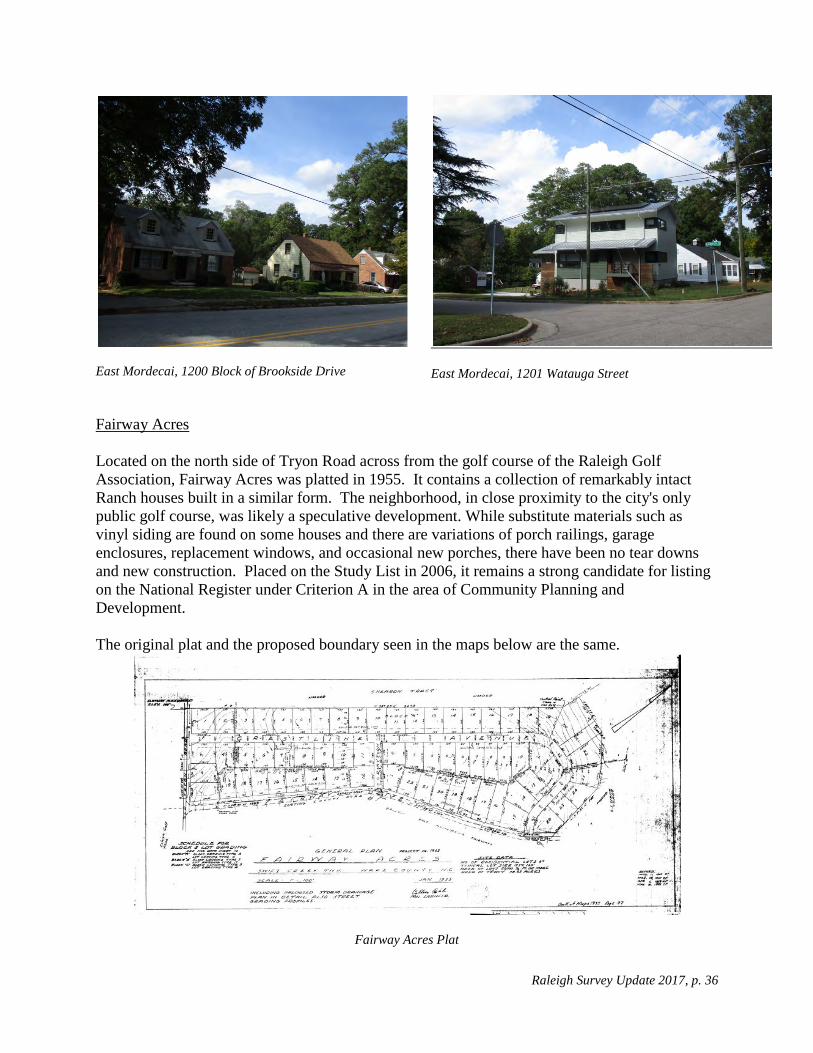
Fairway Acres Located on the north side of Tryon Road across from the golf course of the Raleigh Golf Association, Fairway Acres was platted in 1955. It contains a collection of remarkably intact Ranch houses built in a similar form. The neighborhood, in close proximity to the city's only public golf course, was likely a speculative development. While substitute materials such as vinyl siding are found on some houses and there are variations of porch railings, garage enclosures, replacement windows, and occasional new porches, there have been no tear downs and new construction. Placed on the Study List in 2006, it remains a strong candidate for listing on the National Register under Criterion A in the area of Community Planning and Development. The original plat and the proposed boundary seen in the maps below are the same.
Fairway Acres Plat

Raleigh Survey Update 2017, p. 37
Boundary for proposed Fairway Acres Historic District
Fairway Acres, 2900 Block of Crestline Avenue
Fairway Acres, 2700 Block of Fairway Avenue
Raleigh Survey Update 2017, p. 38
Fairway Acres, 2700 Block of Fairway Avenue
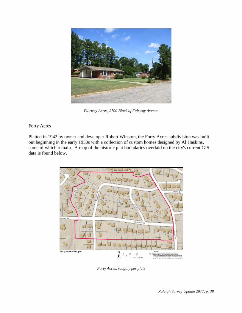
Forty Acres Platted in 1942 by owner and developer Robert Winston, the Forty Acres subdivision was built out beginning in the early 1950s with a collection of custom homes designed by Al Haskins, some of which remain. A map of the historic plat boundaries overlaid on the city's current GIS data is found below.
Forty Acres, roughly per plats

Raleigh Survey Update 2017, p. 39
The neighborhood has been substantially redeveloped. Of the 62 houses in the district, 31 are either new construction or houses rebuilt to the extent they bear little resemblance to their original appearance. Based on Wake County Real Estate records, houses that are less than fifty years old were identified. A windshield survey indentified substantially altered buildings. Both are shown in the map below.
Forty Acres, noncontributing buildings noted
Due to the high number of new and altered houses, Forty Acres is no longer eligible for listing on the National Register.
Forty Acres, 1409 Hathaway Road
Forty Acres, 2300 Block of Hathaway Road
Raleigh Survey Update 2017, p. 40
Forty Acres, 2300 Block of Churchill Road
Fuller Heights
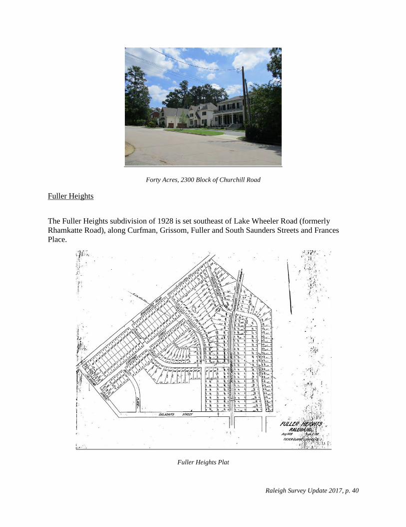
The Fuller Heights subdivision of 1928 is set southeast of Lake Wheeler Road (formerly Rhamkatte Road), along Curfman, Grissom, Fuller and South Saunders Streets and Frances Place.
Fuller Heights Plat

Raleigh Survey Update 2017, p. 41
A map of the historic plat boundaries overlaid on the city's current GIS data is found at below. The re-routing of South Dawson and South McDowell Streets to intersect with South Saunders effectively cuts a small eastern portion of the platted area away from the majority of the neighborhood. The proliferation of large commercial ventures along South Saunders and the re-combination of multiple narrow lots is out of character with the original development pattern of the subdivision.
Fuller Heights, roughly per plat
South and east of Grissom Street, there is recent development along cul-de-sacs. The rest of Fuller Heights is a collection of modest houses, mostly side-gabled and single story. Although one house was built as early as 1936, the vast majority were built in the early 1950s. They currently appear to be largely rental properties and some have had minor improvements and alterations. The overall feeling of the community with houses of a similar scale, age, size and setback gives it a cohesion and identity.
A map of Fuller Heights with noncontributing properties outlined in purple is shown below.

Raleigh Survey Update 2017, p. 42
Fuller Heights, noncontributing buildings noted
Fuller Heights is a good example of a post-World War II residential development. Within boundaries that exclude some commercial development, it has good integrity with many older houses that have not been substantially altered. Fuller Heights represents a post-war neighborhood of modest homes in contrast to many larger, more affluent communities built in Raleigh in that period. Though platted in 1928, most of the extant housing was built in the 1950s. The neighborhood reflects the growth in size and population of the city of Raleigh in the 1950s.
The proposed boundary runs from Lake Wheeler Road along the southwest side of Fuller Street to Grissom, excising the larger commercial lots. The proposed boundary continues west on the north side of Grissom until it turns to include houses on both sides of Curfman Street, excluding a cluster of late twentieth-century cul-de-sacs off the loop road of Talmadge Street.

Raleigh Survey Update 2017, p. 43
Boundaries for proposed Fuller Heights Historic District
Fuller Heights, 1400 Lake Wheeler Road
Fuller Heights, 1424 Curfman Street

Raleigh Survey Update 2017, p. 44
Fuller Heights, 1100 Block of Fuller Street
Gatewood Platted in 1963 by John Edwards for owner J. R. Adams, Gatewood abuts the Rollingwood neighborhood, also laid out by Edwards a few years earlier. The neighborhood is a collection of Ranch houses with later Split-Level and Split-Foyer houses typical of the 1960s and early 1970s. Though similar and in close proximity to Rollingwood, Gatewood is divided from Rollingwood by the campus of Powell Elementary School and new constriction in the cul-de-sacs of Kingsboro Road and Plymouth Court.
A map of the historic plat boundaries overlaid on the city's current GIS data is found below.
Map of Gatewood, roughly per plats

Raleigh Survey Update 2017, p. 45
Based on Wake County Real Estate records, houses that are less than fifty years old were identified and are shown in the map below, as are houses that per a windshield survey appear to have been substantially altered so as to be noncontributing to a potential district.
Gatewood, noncontributing buildings noted
The neighborhood is a good example of 1960s development patterns with a cul-de-sac and slightly curving roads, though not curved to the extent they would minimize the number of buildable lots. The houses are generally Ranches and Split-Levels. Of the 86 houses in the subdivision, 83 were built between 1961 and 1965. Most renovations have been modest and sympathetic resulting in a neighborhood that has very strong integrity. It is eligible for listing on the National Register under Criterion A for Community Planning and Development and C for Architecture.
The neighborhood is eligible for the National Register under Criterion A under the area of Community Planning and Development. It is associated with the Multiple Property Documentation Form, Post-World War II and Modern Architecture in Raleigh, North Carolina, 1945-1965, as a Tract Subdivision. It is a good example of a post-war subdivisions. Its curvilinear road pattern and tract houses "are representative of the post-World War II suburban landscape throughout the United States. The [subdivision], laid out in gently curving streets, with cul-de-sacs during the latter phase of the era, and occasionally with an adjacent strip shopping center or a neighborhood school, reflect (s) national trends."7 The tract housing represents a good collection of Ranch and Split-Level houses.
7 Little, Ruth. Post-World War II and Modern Architecture in Raleigh, North Carolina, 1945-1965, National Register Multiple Property Documentation Form, 2009.

Raleigh Survey Update 2017, p. 46
It is eligible for listing on the National Register under Criterion A for Community Planning and Development and C for Architecture. It was placed on the Study List on February 8, 2018.
Gatewood, 1500 Block of Westchester Road
Gatewood, 1500 Block of Westchester Road
Gatewood, 1417 North King Charles Road
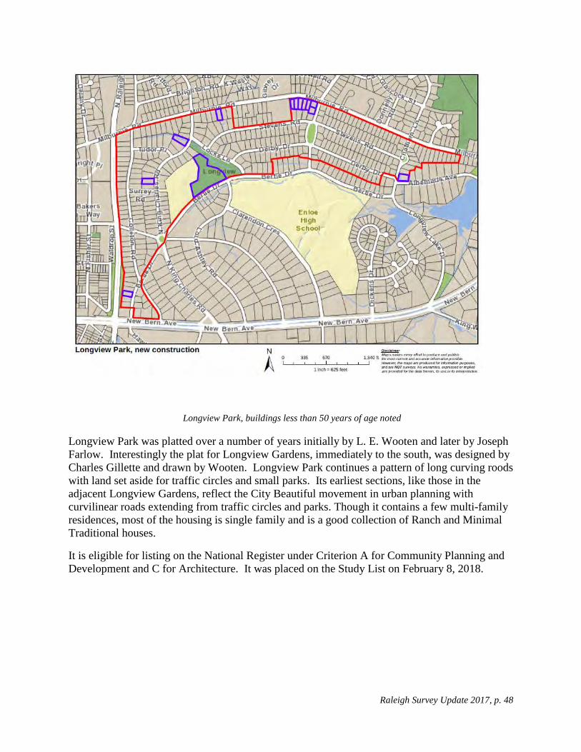
Longview Park There are a total of nine plats for Longwood Park dating from 1946 to 1959. They are shown in aggregate in the map below. They constitute a neighborhood roughly bounded by North Raleigh Boulevard, Milburnie Road, New Bern Avenue, Derby Drive, Colleton Road and Bertie Drive. Colleton and Bertie Drives and Enloe High School divide the neighborhood from Longview Gardens to the south. Milburnie Road is a fairly large road and an effective boundary between Longview Park, and Rollingwood and Windsor Park to the north.

Raleigh Survey Update 2017, p. 47
Longview Park roughly per plats, with several plats noted
The neighborhood is a assemblage of relatively small houses, almost all single story in brick or frame, mostly Ranch and Minimal Traditional. There is limited new construction in the area and rehabilitation efforts to date have largely protected the small scale and character of the neighborhood. A proposed boundary could exclude some new construction along Milburnie. The exclusion of Longview School and the adjacent park is reasonable though the dedication of land for a school and park should be reflected in the historic context even if excluded from the district due to integrity issues. Based on Wake County Real Estate records, buildings that are less than fifty years old were identified, and are shown in the map below.
Raleigh Survey Update 2017, p. 48
Longview Park, buildings less than 50 years of age noted
Longview Park was platted over a number of years initially by L. E. Wooten and later by Joseph Farlow. Interestingly the plat for Longview Gardens, immediately to the south, was designed by Charles Gillette and drawn by Wooten. Longview Park continues a pattern of long curving roods with land set aside for traffic circles and small parks. Its earliest sections, like those in the adjacent Longview Gardens, reflect the City Beautiful movement in urban planning with curvilinear roads extending from traffic circles and parks. Though it contains a few multi-family residences, most of the housing is single family and is a good collection of Ranch and Minimal Traditional houses.
It is eligible for listing on the National Register under Criterion A for Community Planning and Development and C for Architecture. It was placed on the Study List on February 8, 2018.

Raleigh Survey Update 2017, p. 49
Longview Park, 2400 Block of Stevens Road
Longview Park, 400 Block of North King Charles Road
Longview Park, 100 Block of Bertie Drive
Longview Park, 407 North King Charles Road
Lyon Park
Platted in 1953 by Jyles Coggins, Lyon Park was a speculative subdivision named for Coggins' wife Frances Lyon and with a road named after the builder, Paul Childers. The original houses were one-story Ranch houses clad variously in brick, weatherboard or board and batten, often with a carport. A few Split-Levels were built in the late 1950s.

Raleigh Survey Update 2017, p. 50
Lyon Park plat
Lyon Park, roughly per plats

Raleigh Survey Update 2017, p. 51
Since the neighborhood was last surveyed in 2006 when it was placed on the state's National Register Study List, nine of the forty-seven houses have been replaced or substantially altered. Most of the new construction differs significantly from the original houses in style, size, setback, and massing. Based on Wake County Real Estate records, houses that are less than fifty years old were identified, and are shown in the map below as are houses that per a windshield survey appear to have been substantially altered so as to be noncontributing to a potential district.
Lyon Park Neighborhood, noncontributing buildings noted
Due to the loss of integrity, the neighborhood is no longer a candidate for listing on the National Register.

Raleigh Survey Update 2017, p. 52
Lyon Park, 3123 Childers Street
Lyon Park, 3122 Ashel Street
Lyon Park, 3100 Block of Ashel Street
Lyon Park, 522 Vick Avenue
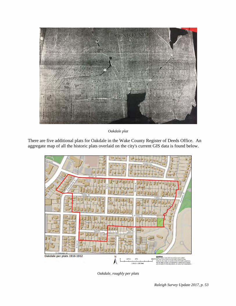
Oakdale Per plats dating from 1895 to 1911, the Oakdale subdivision is bounded by Sasser Street; Cemetery Branch; the southern boundary of properties on the south side of East Franklin and Pace Streets west to East Street; East Street; the south side of Franklin Street west to the rear property line of houses on the east side of Bloodworth north to the south side of Holden street; and extending west to include seven buildings on the west side of Bloodworth up to Sasser Street. A map from the Olivia Raney Local History Library (below) shows part of the neighborhood.
Raleigh Survey Update 2017, p. 53
Oakdale plat
There are five additional plats for Oakdale in the Wake County Register of Deeds Office. An aggregate map of all the historic plats overlaid on the city's current GIS data is found below.
Oakdale, roughly per plats

Raleigh Survey Update 2017, p. 54
Based on Wake County Real Estate records, houses that are less than fifty years old were identified and are shown in the map below as are houses that per a windshield survey appear to have been substantially altered so as to be noncontributing to a potential district. The map also shows the southern part of the Oakdale subdivision, largely along Franklin Street, which was added to the Oakwood (WA0223) National Register district in a northern expansion in the 1980s.
Oakdale, noncontributing buildings and Oakwood boundary noted
The houses along Franklin are some of the more architecturally significant and intact houses in the Oakdale subdivision. They date from 1898 to 2017, and two-thirds were built before 1928.
The remaining area (not subsumed by Oakwood) has a fair number of noncontributing buildings and could not be considered a candidate for National Register listing.
Raleigh Survey Update 2017, p. 55
Oakdale, 510 Sasser Street
Oakdale, 500 Block of Holden Street
Oakdale, 700 Block of Sasser Street
Oakdale, 516 Sasser Street
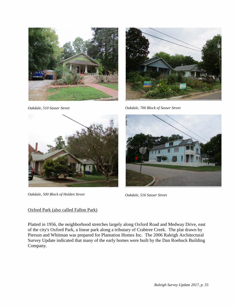
Oxford Park (also called Fallon Park)
Platted in 1956, the neighborhood stretches largely along Oxford Road and Medway Drive, east of the city's Oxford Park, a linear park along a tributary of Crabtree Creek. The plat drawn by Pierson and Whitman was prepared for Plantation Homes Inc. The 2006 Raleigh Architectural Survey Update indicated that many of the early homes were built by the Dan Roebuck Building Company.

Raleigh Survey Update 2017, p. 56
Oxford Park, roughly per plat
A few Ramblers and Ranch houses that were originally constructed in the neighborhood remain, but 24 of the 81 homes in the district boundaries have been either demolished or substantially altered. The neighborhood is not a viable historic district. Based on Wake County Real Estate records, houses that are less than fifty years old were identified and are shown in the map below, as are houses that per a windshield survey appear to have been substantially altered so as to be noncontributing to a potential district.

Raleigh Survey Update 2017, p. 57
Oxford Park, noncontributing buildings noted

Raleigh Survey Update 2017, p. 58
Oxford Park, 2432-2436 Oxford Road
Oxford Park, 2431Medway Drive
Oxford Park, 2357 Lowden Street
Oxford Park, 2112 Dunhill Drive
Parkland and Hertford Village The 2006 Raleigh Architectural Survey Update considered these two neighborhoods jointly and they were described thus:
Running along South Wilmington Street, Hertford Village and Parkland sit just north of Rush Road. Parkland, to the west, is a jumble of different styles of small minimal Ranches and Minimal Traditionals, mostly built around 1950.... Hertford Village.... is the product of a unified building campaign, with nearly identical houses running along slightly hilly terrain with green lawns and few trees. The small homes are somewhere in between the two styles of Ranch and Minimal Traditional, with a basic side-gabled Ranch form and the lack of decoration and tiny eaves of the Minimal Traditional.
Raleigh Survey Update 2017, p. 59
The two neighborhoods are divided by South Wilmington Street which at this point is a major arterial road. In the future they should be surveyed separately.
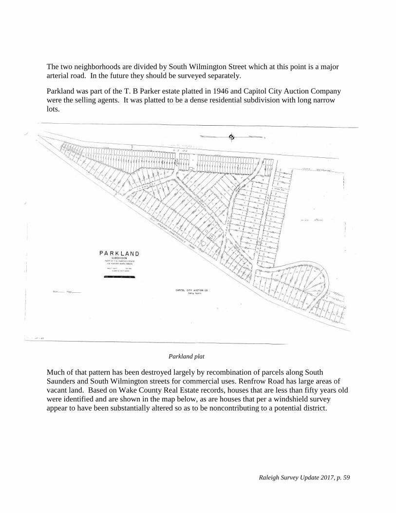
Parkland was part of the T. B Parker estate platted in 1946 and Capitol City Auction Company were the selling agents. It was platted to be a dense residential subdivision with long narrow lots.
Parkland plat
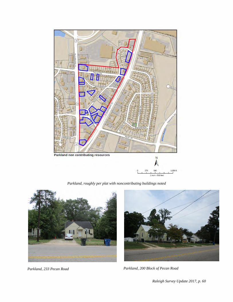
Much of that pattern has been destroyed largely by recombination of parcels along South Saunders and South Wilmington streets for commercial uses. Renfrow Road has large areas of vacant land. Based on Wake County Real Estate records, houses that are less than fifty years old were identified and are shown in the map below, as are houses that per a windshield survey appear to have been substantially altered so as to be noncontributing to a potential district.
Raleigh Survey Update 2017, p. 60
Parkland, roughly per plat with noncontributing buildings noted
Parkland, 233 Pecan Road
Parkland, 200 Block of Pecan Road
Raleigh Survey Update 2017, p. 61
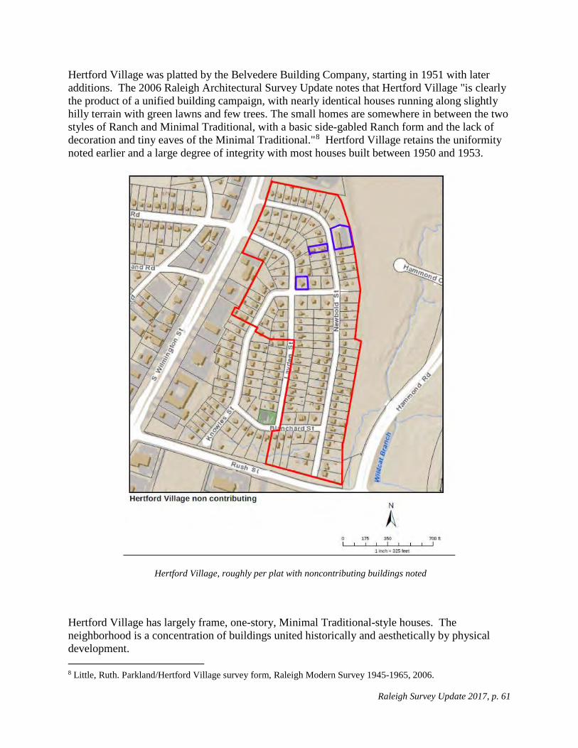
Hertford Village was platted by the Belvedere Building Company, starting in 1951 with later additions. The 2006 Raleigh Architectural Survey Update notes that Hertford Village "is clearly the product of a unified building campaign, with nearly identical houses running along slightly hilly terrain with green lawns and few trees. The small homes are somewhere in between the two styles of Ranch and Minimal Traditional, with a basic side-gabled Ranch form and the lack of decoration and tiny eaves of the Minimal Traditional."8 Hertford Village retains the uniformity noted earlier and a large degree of integrity with most houses built between 1950 and 1953.
Hertford Village, roughly per plat with noncontributing buildings noted
Hertford Village has largely frame, one-story, Minimal Traditional-style houses. The neighborhood is a concentration of buildings united historically and aesthetically by physical development. 8 Little, Ruth. Parkland/Hertford Village survey form, Raleigh Modern Survey 1945-1965, 2006.
Raleigh Survey Update 2017, p. 62
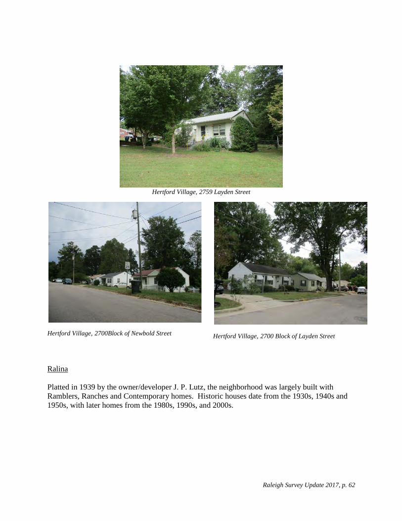
Hertford Village, 2759 Layden Street
Hertford Village, 2700Block of Newbold Street
Hertford Village, 2700 Block of Layden Street
Ralina Platted in 1939 by the owner/developer J. P. Lutz, the neighborhood was largely built with Ramblers, Ranches and Contemporary homes. Historic houses date from the 1930s, 1940s and 1950s, with later homes from the 1980s, 1990s, and 2000s.

Raleigh Survey Update 2017, p. 63
Ralina plat
The current survey has found that approximately 30% of the subdivision consists of noncontributing houses--either new construction or substantial alterations. As such the neighborhood is not a viable historic district.

Raleigh Survey Update 2017, p. 64
Ralina, roughly per plats with noncontributing buildings noted

Raleigh Survey Update 2017, p. 65
Ralina, 1514 Lutz Avenue
Ralina, 320 1Churchill Road
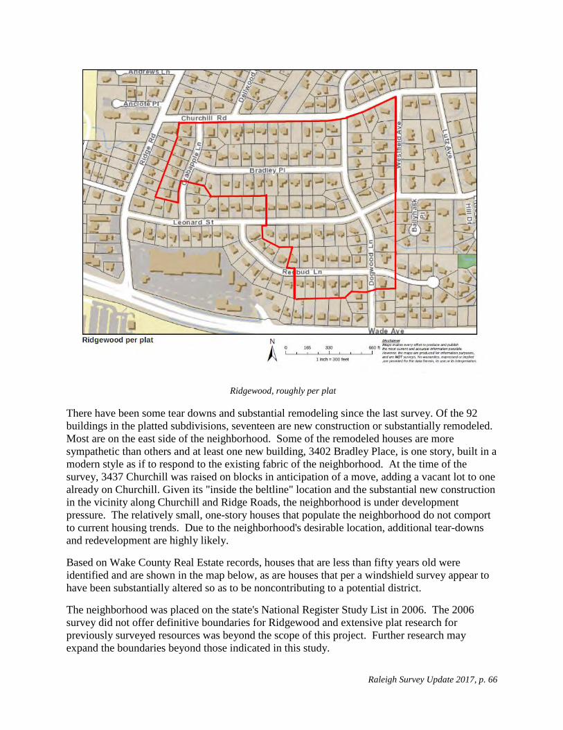
Ridgewood
The 2006 Raleigh Architectural Survey Update described Ridegewood thus:
The 1953 plat of the Ridgewood subdivision, prepared by Joseph N. Farlow, engineer, for developers Ed Richards and Willie York, consists of lots along Crabapple, Bradley, Dogwood, Leonard, and Redbud streets. Ed Richards was the owner of Cameron-Brown Realty and one of the three largest developers in Raleigh in the 1950s and 1960s. ...All houses were built from five different plans of minimal archetypal Ranches and Split-Levels, all containing three bedrooms and two bathrooms. The plans were so distinctive that they were known as the "Ed Richards plan." One of the most popular features of the Ridgewood houses was the use of antique (reclaimed) brick, a slightly more costly feature than the new brick of the standard houses. Houses generally cost about $18,000....The Ridgewood houses, whether Ranches or Split-Levels, share such common features as walls of a mixture of brick, flagstone, or wood siding; low-gabled or hipped roofs; carports; and screened porches. Building forms consist of the asymmetrical front-gable, the hip-roof rectangular, the side-gable rectangle, the gable-and-wing, the front-gable, and the cross-gable. A number have been gently remodeled, usually by converting the carport and screen porch into finished rooms. 9
9 Little, Ruth. Ridgewood survey form, Raleigh Modern Survey 1945-1965, 2006.
Raleigh Survey Update 2017, p. 66
Ridgewood, roughly per plat
There have been some tear downs and substantial remodeling since the last survey. Of the 92 buildings in the platted subdivisions, seventeen are new construction or substantially remodeled. Most are on the east side of the neighborhood. Some of the remodeled houses are more sympathetic than others and at least one new building, 3402 Bradley Place, is one story, built in a modern style as if to respond to the existing fabric of the neighborhood. At the time of the survey, 3437 Churchill was raised on blocks in anticipation of a move, adding a vacant lot to one already on Churchill. Given its "inside the beltline" location and the substantial new construction in the vicinity along Churchill and Ridge Roads, the neighborhood is under development pressure. The relatively small, one-story houses that populate the neighborhood do not comport to current housing trends. Due to the neighborhood's desirable location, additional tear-downs and redevelopment are highly likely.
Based on Wake County Real Estate records, houses that are less than fifty years old were identified and are shown in the map below, as are houses that per a windshield survey appear to have been substantially altered so as to be noncontributing to a potential district.
The neighborhood was placed on the state's National Register Study List in 2006. The 2006 survey did not offer definitive boundaries for Ridgewood and extensive plat research for previously surveyed resources was beyond the scope of this project. Further research may expand the boundaries beyond those indicated in this study.

Raleigh Survey Update 2017, p. 67
Ridgewood, noncontributing buildings noted
Ridgewood, 3412 Bradley Place
Ridgewood, 3402Bradley Place
Raleigh Survey Update 2017, p. 68
Ridgewood, 3449 Bradley Place
Ridgewood, 3438 Bradley Place
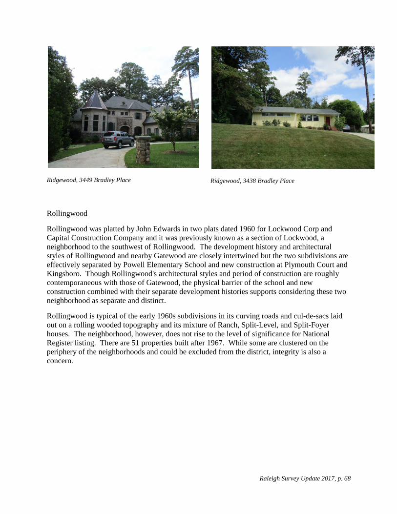
Rollingwood
Rollingwood was platted by John Edwards in two plats dated 1960 for Lockwood Corp and Capital Construction Company and it was previously known as a section of Lockwood, a neighborhood to the southwest of Rollingwood. The development history and architectural styles of Rollingwood and nearby Gatewood are closely intertwined but the two subdivisions are effectively separated by Powell Elementary School and new construction at Plymouth Court and Kingsboro. Though Rollingwood's architectural styles and period of construction are roughly contemporaneous with those of Gatewood, the physical barrier of the school and new construction combined with their separate development histories supports considering these two neighborhood as separate and distinct.
Rollingwood is typical of the early 1960s subdivisions in its curving roads and cul-de-sacs laid out on a rolling wooded topography and its mixture of Ranch, Split-Level, and Split-Foyer houses. The neighborhood, however, does not rise to the level of significance for National Register listing. There are 51 properties built after 1967. While some are clustered on the periphery of the neighborhoods and could be excluded from the district, integrity is also a concern.

Raleigh Survey Update 2017, p. 69
Rollingwood, roughly per plats with dates noted, (showing a portion of Longview Park, south of Milburnie Road)

Raleigh Survey Update 2017, p. 70
Rollingwood, 2400 Block of Kennington Road
Rollingwood, 2400 Block of Remington Road
Rollingwood, 2500 Block of Remington Road
Starmount The 2006 Raleigh Architectural Survey Update describes the neighborhood:
Developer J. T. Hobby Jr. platted the Starmount subdivision east of U. S. 1, between Trawick and Buffalo roads, in 1956. Some of the streets have celestial names: Mars, Venus, Jupiter, and Mercury. On its large lots, Ranches and Split-Levels were constructed from about 1957 to 1965. In general these are moderate-sized archetypal rambler Ranches with picture windows and carports that occasionally have decorative block or basketweave wood privacy screens. There is less colonial detail in the Ranches in this subdivision than in north and west Raleigh subdivisions of the period.10
Five plats dating from 1956 to 1960 show Starmount as oriented largely along Baugh Street and Starmount Drive. Later subdivisions known as Starmount Extended or Starmount Hills that are 10 Little, Ruth. Starmount survey form, Raleigh Modern Survey 1945-1965, 2006.

Raleigh Survey Update 2017, p. 71
partially described in the quotation above could be surveyed and added to this potential district. The integrity of Starmount is high as there have been very few alterations to houses built before 1968 and there are only two houses that are less than 50 years old, built in the 1990s on Baugh Street.
The neighborhood largely comprises houses that are Ranches, Minimal Traditional, Split-Levels with a few Contemporaries. The layout of the neighborhood is typical of the period with gently curving streets that diverge from an orthogonal grid yet do not curve so much as to limit greatly the number of lots within the subdivision as a whole. The minimum lot size is about one-half acre. Perhaps the location of the neighborhood, far from the downtown where the land values were lower, allowed for larger lots though still with relatively small houses.
The neighborhood is a good example of a small-scale, post-war development responding to population growth, annexation and expanded transportation near the beltline.
It is eligible for listing on the National Register under Criterion A for Community Planning and Development and C for Architecture. It was placed on the Study List on February 8, 2018.
Starmount, roughly per plats

Raleigh Survey Update 2017, p. 72
Starmount, 3500 Block of Baugh Street
Starmount, 3500 Baugh Street
Starmount, 3400Block of Baugh Street
Westover The 2006 Raleigh Architectural Survey Update describes the neighborhood:
Located west of Blue Ridge Road and immediately to the north of Hillsborough Street, Westover was constructed gradually over many decades. Much of it was platted in 1920 by a Dr. S.E. Douglass and close to Hillsborough, the houses are Bungalows, small Tudor Revivals, and Front Gables from the 1920s. Heading north along the three main streets, the house types change to Minimal Traditionals and Ranches, all modest in scale and decoration. Gary Street, the western-most street, was platted in 1956 by the Residential

Raleigh Survey Update 2017, p. 73
Building Company as Mount Vernon Park, an extension of the existing neighborhood and was built up entirely from 1959 through 1961 with small Ranches in a few basic forms.11
The previous survey included the Gary Street area within Westover. However the Gary Street area was subdivided and platted 40 years later than the Westover subdivision. The age and style of the housing, the curvilinear street pattern, and irregular lots that on average are 1.6 times as large as the Westover lots, all distinguish this adjacent area from Westover. Further research about land ownership or intent could support including the Mt. Vernon subdivision in the Westover area, but that falls beyond the scope of this study.
Westover, roughly per plats
11 11 Little, Ruth. Westover survey form, Raleigh Modern Survey 1945-1965, 2006.

Raleigh Survey Update 2017, p. 74
The original platted area of Westover has remarkable integrity considering current growth pressures in Raleigh. Houses are modest in size, there are no curbs or gutters and many houses have gravel drives, giving the neighborhood a rural feel.
The neighborhood is a good example of a rural community later annexed by the City of Raleigh with many examples of a variety of housing styles and types including Craftsman, Ranch, Minimal Traditional, and vernacular. The neighborhood contains some construction that is less than 50 years old and some homes with substantial alterations as seen in the map below. Tax records suggest that some extant resources pre-date the subdivision plat. A proposed district should follow the subdivision plat boundaries.
Westover, 230 Grand Avenue
Westover, 223 Grand Avenue
Westover, 200 Block of Marsh Avenue
Westover, 225 Grand Avenue

Raleigh Survey Update 2017, p. 75
Westover, noncontributing buildings noted
Windsor Park
While the plat for Windsor Park (see map below) was drawn in 1943, it was not recorded until 1949. It was drawn by Fred Habel. Windsor Park is bounded on the south by Milburnie Road, on the west by the houses on the west side of Colleton Road, on the north by the houses on the north side of Sheffield Road and on the east by the houses on the east side of Brighton Road. It had two lots reserved for play areas; one on Hartford has been developed but the second, on Brighton, remains vacant. The parcels on the north side of Milburnie flanking Colleton Road were reserved for business.

Raleigh Survey Update 2017, p. 76
Windsor Park plat
Most of the houses were built in 1950, however the construction dates of extant houses range from 1947 to 2017. There is some new construction in the neighborhood, largely west of King Charles Road, and some houses have been substantially altered with porches and dormers (noted on map below), but most remain one-story houses, or with wood or brick veneer exteriors, gabled roofs and small building foot prints.
The neighborhood is a good example of a small scale, post-war subdivision and could be eligible for the National Register under Criterion A for Community Planning and Development.
It is a good example of a post-war subdivision. Its curvilinear road pattern and tract houses "are representative of the post-World War II suburban landscape throughout the United States. The [subdivision], laid out in gently curving streets, with cul-de-sacs during the latter phase of the era, and occasionally with an adjacent strip shopping center or a neighborhood school, reflect (s) national trends." 12
It is eligible for listing on the National Register under Criterion A for Community Planning and Development and C for Architecture. It was placed on the Study List on February 8, 2018.
12 Little, Ruth. Post-World War II and Modern Architecture in Raleigh, North Carolina, 1945-1965, National Register Multiple Property Documentation Form, 2009.

Raleigh Survey Update 2017, p. 77
Windsor Park, 2216 Sheffield Road
Windsor Park, 2200 Block of Sheffield Road
Windsor Park, 600 Block of Brighton Road

Raleigh Survey Update 2017, p. 78
Windsor Park, noncontributing buildings noted
Woodcrest The Woodcrest community was platted in four maps dated September 1955, November 1955, July 1956 and May 1958. The first three were platted by engineer Herndon Edgerton for Seabrook Hills, Inc. and the last by J. L. Castlebury for Georgetown Builders. The two companies appear to have similar ownership.

Raleigh Survey Update 2017, p. 79
Woodcrest, roughly per plats
The neighborhood was a speculative development largely of Ranch and Split-Level, single-family homes, many of which appear to be specific types, built with small distinguishing features or material. The neighborhood is a small-scale, post-war neighborhood developed in response to population growth, annexation and expanded transportation near the beltline.

Raleigh Survey Update 2017, p. 80
It is eligible for listing on the National Register under Criterion A for Community Planning and Development and C for Architecture. It was placed on the Study List on February 8, 2018.
Woodcrest, 2100 Block of Timber Drive
Woodcrest, 600 Block of Dennis Avenue
Woodcrest, 500 Block of Banks Street
Raleigh Survey Update 2017, p. 81
Summary
Twenty-three individual resources were surveyed or re-surveyed. Of those, five had been demolished since they were previously surveyed and one was inaccessible. Of the remainder only two merit further study, WA1301 Six Forks Baptist Church, which may be eligible for National Register listing under Criterion C for architecture; and WA7944 House, 6616 Pleasant Pines Drive, which does not appear to be eligible based on the work performed under the scope of the current study but which may be architect-designed and additional research may prompt a re-assessment.
Five neighborhoods that were previously placed on the National Register Study List were re-surveyed: Ridgewood, Forty Acres, Lyon Park, Fairway Acres and Caraleigh. Lyon Park and Forty Acres have had so many teardowns and substantial alterations to historic buildings that they no longer have sufficient integrity for National Register listing. Ridgewood, Fairway Acres and Caraleigh still appear to be eligible for the National Register. The boundary for Caraleigh should be extended east toward Summit Avenue, or it should be considered for a discontinuous district flanking the South Saunders Street corridor.
Of the remaining neighborhoods, Brentwood, Gatewood, Longview Park, Starmount, Windsor Park, and Woodcrest are considered eligible for listing on the National Register under Criterion A for Community Planning and Development and C for Architecture. They were placed on the Study List on February 8, 2018. Budleigh, East Mordecai, Fuller Heights, Hertford Village, Oakdale, Oxford Park, Parkland, Ralina, Rollingwood, and Westover are not recommended for placement on the Study List. Many of the neighborhoods studies were part of what is collectively known as "East Raleigh." The Lakewood and Lockwood neighborhoods which are in East Raleigh merit further study. A project to map historic plats for neighborhoods on the city's GIS system as a separate layer would benefit survey efforts in Raleigh by clarifying neighborhood boundaries.

Raleigh Survey Update 2017, p. 82
Sources City of Raleigh GIS Little, Ruth. Post-World War II and Modern Architecture in Raleigh, North Carolina, 1945-1965, National Register Multiple Property Documentation Form, 2009. Neighborhood Files, Elizabeth Reid Murray Collection, Wake County Public Library, Olivia Raney Branch North Carolina Historic Preservation Office Survey Files Wake County Map Books Wake County Real Estate Records