report on red lake mines limited in
TRANSCRIPT

SSQUKEMaSBI PENASSI LAKE GIO
REPORT
ON
RED LAKE MINES LIMITED
IN
STURGEON LAKE AREA
PATRICIA MINING DIVISION
ONTARIO
by L. J. Cunningham, B.Sc., P.Eng.,Mining Engineer
dated at Kirkland Lake, Ontario28th December, 1971
i .
tl :te
saGMNE08B9 saouNEeeasei PENASSI LAKE
INDEX
SUMMARY
INTRODUCTION
LOCATION 4 DESCRIPTION
HISTORY
GENiSRAL GEOLOGY
GEOLOGY OF THE PROPERTY
GEOPHYSICS
CONCLUSIONS ft RECOMMENDATIONS
CERTIFICATE
™ f.
010C
Page
34 A
eLocation Map
Geology of Sturgeon Lake Area
., JUL1:2UNN.,,
r-*

Ai-es Dec. 1971*
S U K K A R Y
1. The property consists of 20 contiguous '^.patented mining claims in the
Sturgeon L?-.ke Area, Patricia Kinin^ Division, Ontario. Assessment work is due
in November, 1972.
2. Located 40 miles north of the Town of Ignace on Highway l?, the property is
crossed by Highway 59y.
3. The area had a minor production of gold in the 1930's but since 1969 tv:o
major base metal deposits have been found and two additional, possible orebodies
have been drill indicated.
. The Sturgeon Lake Area is a portion of an extensive belt of early Precambri"jr\
rocks. The oldest and most important economically are a series of mafic and
felsic volcanic flows and pyroclastics.
5. The sulphide deposits appear related to certain stratigraphic horizons within
the sequence of volcanic flows and these horizons are believed to be the result
of broad scale change in the volcanic activity. They may represent a time of
acquiescence between two periods of extensive volcanic eruption or more
specifically as indicated by geological information, a dormant period between two
periods of volcanic formation, one mafic and one felsic,
6. The property is underlain predominantly by mafic volcanics both fine and
coarse grained. They occur within a synclinal structure which strikes northeast
erly across the property. A lense of felsic rocks occurs along the axis of the ,
syncline immediately east of the property. For lack of outcrop information it is j
interpreted as terminating near the Lewis Red Lake property boundary. It may, i
however, extend westward on to the property under the overburden. Because the
syncline plunges westerly the important felsic rock may occur at depth beneath
the mafic rocks exposed on surface.
Minor granitic dikes have beer, found in the southwest corner of the property
near a fault which extends westerly across the property from alcng the axis of
two large granitic intrusive bodies lying irvuediately to the east.
7. Geophysical surveys in 1970 nave revealed six conductors, 5 of which occur
within the syncline. The 6th appears related to faulting along the south boundary
8. In 1971 an examination of outcrop ar.d topographical features in the vicinity
of the conductors was made by F. P. Tagliamonte, P, Eng. but did not give an
explanation for any of the conductors.
9. A drill test of five of the conductors is reconmended, the 6th conductor
warrants further ground investigation before drilling.
10. The estimated cost of the program^ls S20,000.00. ^

: REPORTON
LEWIS 1C-3J LAKE KINKS LIMITEDIN
STURGEON LAKt, ARKA PATKJCIA KINIKG DIVISION-
ONTARIO
INTRODUCTION
The property is a base metal prospect in the Sturgeon Lake Area where
recent activity has resulted in the discovery of two orebodies, the Mattabi and
the Sturgeon Lake Mines, which lie 8 and 12 miles respectively to the southeast
of this property.
The following sources of information were utilized in the preparation
of this report:
1. O.D.M. Maps P.353, P.588-89-90-91 and P.670
2. O.D.M. Geological Report No. 24, Metionga Lake Area
3. Report on Geological Reconnaissance Work - Frank P. Tagliamonte, P.Eng.dated 11 November, 1971
4. Report on Geological and Geophysical Surveys - W. G. Wahl Limited, dated26 March, 1970
LOCATION fe DESCRIPTION
The property comprises 20 contiguous, unpatented mining claims of about
40 acres each in the Sturgeon Lake Area, Patricia Mining Division of Ontario.
They are numbered as follows:
P.A. 203247 - 203266 inclusive
The claims are free of encumbrance, the title thereto being the usual
title to unpatented mining claims when held under miner's license. Assessment
work is due in November, 1972.
Located 40 miles north of the Town of Ignace, the property is crossed
by Highway 599 which extends in a northerly direction across the east part of the
property. Mountain Island Bay of Sturgeon Lake lies 1,000 feet to the east of the
group.
HISTORY
Prospecting dates back to the turn of the century. The first recorded
find of gold was in 1898. In 1936-7 Darkwater Mines operated, unsuccessfully, a
gold deposit located on Beidelman Bay on the south shore of Sturgeon Lake.
During the I960's a number of mining companies carried out prospecting
and geological, geophysical and geochemical surveying in selected parts of the
DSC. 1971- 2 -
In 1969 j following an aerial geophysical survey, Mattagarai Lake Mines
Limited drilled a number of conduc'.crs, one of which became the Mattabi Hine. In
1970, Falconbridge located a second orebody on ground optioned from New Brunswick j
Uranium Metals and Kining Limited. This orebody, now known as the Sturgeon Like j
Mines, extends into the property of Mattagami Lake Mines Limited. j
Since 1969, the area has been the centre of intense exploration for j
similar sulphide deposits containing copper, zinc and silver.
In the latest issue of the Northern Miner, dated 23rd Decf;ffiler, 1971*
Mattagami Lake Mines announced the results of 16 drill holes indicating a probablej
new orebody lying 4,000 feet northwest of Sturgeon lake Mines.
GKfflSttAL GEOLOGY
The Sturgeon Lake Area is a portion of an extensive but narrow belt of
early Precambrian rocks which extend for 50 miles to the north and over a hundred
miles to the west They are covered by glacial drift of varied nature, thickness
and extent.
The oldest rocks consist of a series of basic and acid volcanic rocks,
accompanied in the later stages of formation by contemporaneous sedimentation in
favourable basins. There followed a period of intrusion of minor amounts of basic,
rocks in the form of small dikes and stocks of diorite and gabbro. At a later j
period the large scale, regional emplacement of the granitic complex began. This !
resulted in the progressive development of lit par lit injection gneiss along the
contact zones to migmatite and hybrid gneiss, to finally core areas of massive,
coarse grained granite. A final intrusive stage consisted of syenitic rocks which
occur often as elliptically shaped bodies generally concordant with the regional
foliation.
The basic metal deposits of Mattabi and Sturgeon Lake Mines are
associated with the oldest rocks of the belt - that is, the volcanic flows and
pyroclastics.
The present stage of geological knowledge of the area indicates that
the felsic volcanic flows and pyroclastics constitute less than 20# of the total
volcanic rocks. By the very nature of their cyclic mode of deposition, i.e.
dependent on volcanic eruption, they would, under most conditions, tend to
accamulate as lensic bodies intercalated with the much more prevalent mafic flows,
and (as pointed out by Trowel, O.D.M. P.6Vo) considering the rapid facies change
within the pyroclastic units it is unlikely that any one formation would continue
very far along strike. Felsic units are therefore shown on existing geological
Doc. If?~ 3 -
sFT1 "''"-'m^ '
s&ir-/ maps as scattered lenses of various lengths and widths interstratified with the
predominant mafic volcanic units.
The sulphide deposits appear related to certain stratigraphic
horizons within the sequence of volcanic flows and these horizons are believed to
be the result of broad scale change in the volcanic activity. They may represent
a tiioe of acquiescence between two periods of extensive volcanic eruption or nore '
specifically, a dormant period between two stages of volcanic formation, one
mafic and one felsic.
The sulphide bodies form discrete masses along the stratigraphic
horizon and may have formed in structurally favourable areas.
"Although it has been speculated that Cu-Zn-Ag mineralization found by |
Falconbridge Nickel Mines Limited is localized along the same stratigraphic horizon
as the Mattagami Lake Mines Limited deposit, no part of the volcanic pile can be j
ignored until the exact stratigraphy of the volcanic rocks and the genesis of the t
mineralization are determined." (N. B. Trowel, O.D.M. Map P.670)
The gold mineralization found in the area is related to the period of
granitic intrusion which resulted in the deposition of gold with quartz in veins
and fractures.
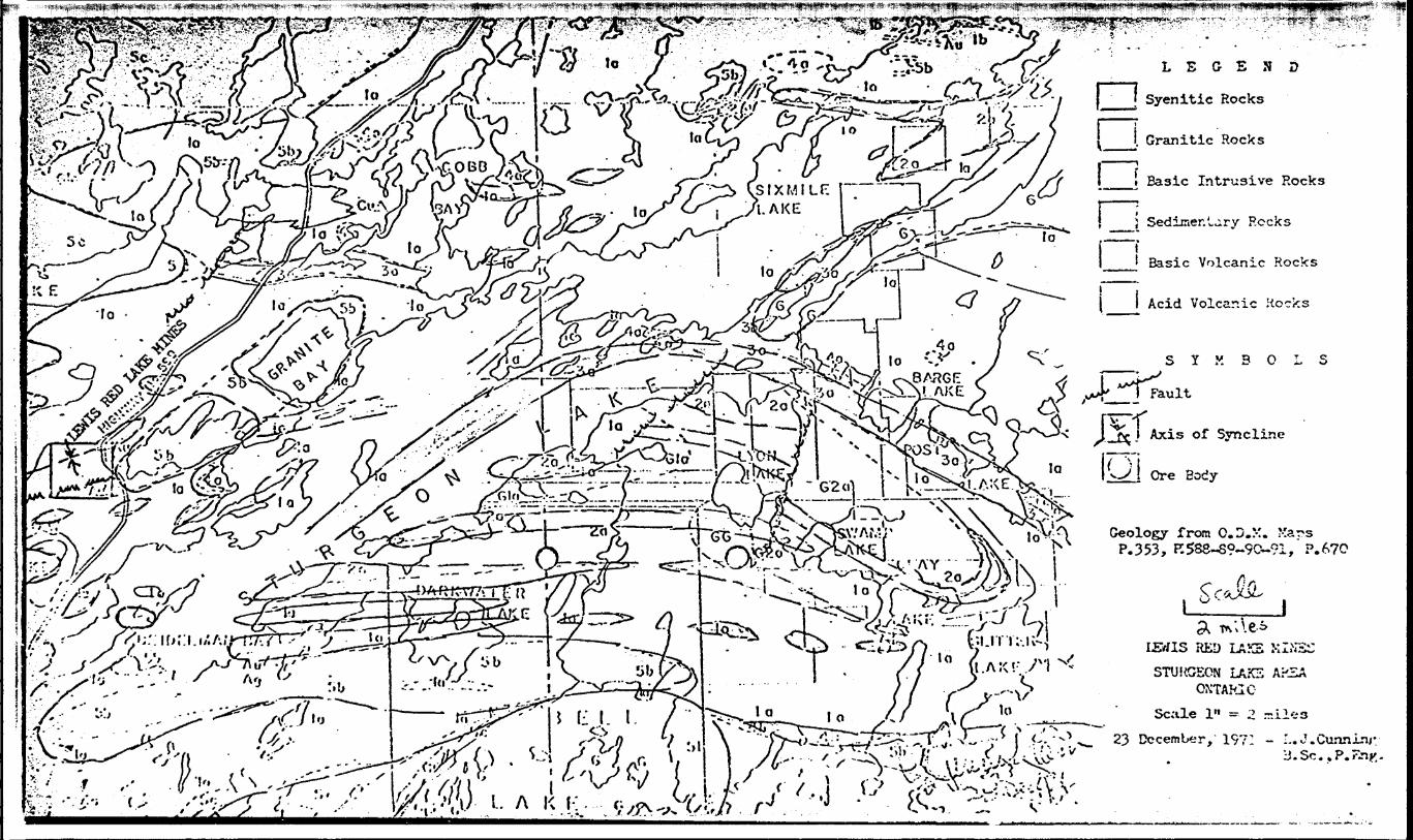
GEOLOGY OF THE PROPERTY- . iThe property was mapped by W. C. V/ahl Limited during 1970 and Frank T. j
Tagliamonte, P. Eng. examined outcrop in the vicinity of the electromagnetic j
conductors in 1971. O.D.M. Map P.588 by N. F. Trowel which was published in 1970
also shows the geology of the property.
All agree that the .property is underlain by predominantly basic
volcanics consisting of both fine and coarse grained flows which show pillow and
porphyritic structure and some flow breccia. Pyrite and pyrrhotite mineralization^
generally less than 2J&, occurs sparsely in these rocks.
A syncline has been interpreted striking slightly north of east across
the north-central part of the property.
A lensic body of felsic rocks consisting of rhyolite, lapillistone and
pyroclastic breccia occurs along the axis of the syncline immediately east of the
property. For lack of outcrop information, it is interpreted as terminating near
the Lewis Red Lake property boundary. It may, however, extend westward on to the
property under the overburden. Furthermore, because ths syncline plunges
westerly, it is possible that the felsic rocks exposeJ to the east along the
synclinal axis may occur at an unknown depth boaeath the exposed mafic units
Jscili'';*
.••*,.'j
on th- Lewis Hed Lake property.
A small occurrence of cngnetic iron formation and argillite confirm the
existence of sedimentary rocks of probable limited extent, associated with the
felsic unit in the northeast corner of the property.
Trowel shows 3 small occurrences of granite in the southwest corner of ,
the property,.which he describes as follows: "Associated dikes, the mobilized
equivalent of hornblende-biotite granite". They occur near a northeasterly fault
zone in the south part of the property which appears to be related to the large
granite intrusions immediately east of the property. The fault and the granite
intrusives have an apparent common axis.
GEOPHYSICS
During 1970 a magnetometer and VLF-electromagnetic survey were complete J
with readings at 50 foot stations on lines at AOO foot intervals by W. G. Wahl
Limited. Six anomalies were recommended for drilling - all were examined on the
ground by F. P. Tagliamonte, P. Eng.
Four of the conductors lie parallel to and in close proximity to the
synclinal axis in the northe-^t quarter of the property nearest to the known
felsic rocks;. Because a ground examination did not offer an obvious explanation
for these conductors, their investigation by drilling is recommended.
A fifth conductor lies near the synclinal axis but strikes obliquely
to the syncline and the regional trend of the formations. It may represent a
structural feature.such as a fold or shearing which may have economic significance.
Surface topography as shown by Tagliamonte indicates this conductor as conforming j
with low ground between two outcrop areas and as such is suspected as being caused
by conductive overburden. It warrants further investigation on the ground oefore
drilling.
The sixth conductor in the southwest corner of the property appears
related to the faulting extending westerly beyond the axis of the granitic
intrusions. Wahl interpreted the conductor as being a graphitic tuff with a low
tenor of pyrite. Tagliamonte noted easterly striking, chloritic shearing with
vertical dip at a point 200 feet to the north. It is worthy of drilling.
CONCLUSIONS fe RECOMMENDATIONS
There are diverging views on the wisdom of drilling VLF-EM conductors
without support by more sophisticate-1, geophysical techniques. Mattagami Lake
Mines, with a remarkable record of two proven and two possible economic sulphide
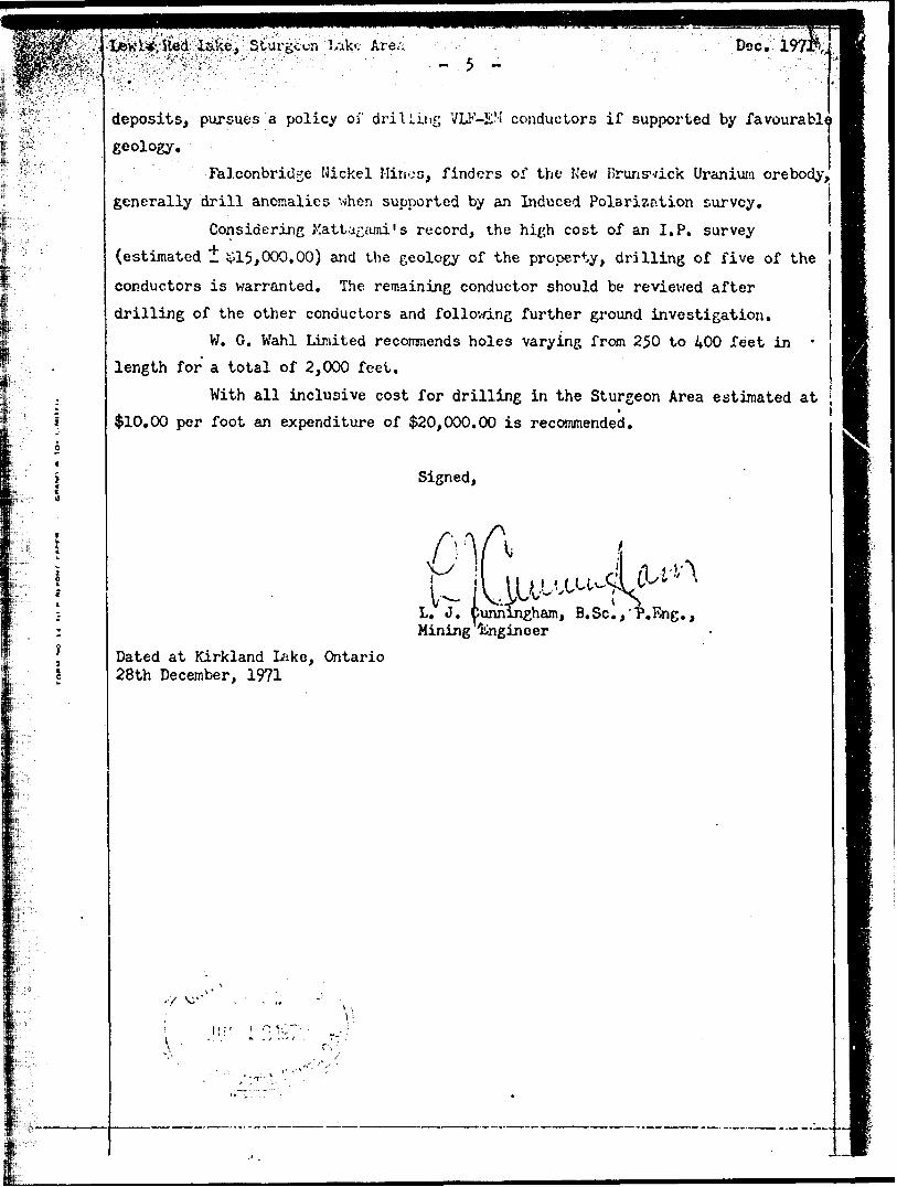
m :1St,u.rg*cn ' Are/ Dec.- 5 ^
deposits, pursues a policy of drilling VLF-EM conductors if supported by favourable
geology.
Falconbridge Nickel Mines, finders of the New Brunswick Uranium orebody,
generally drill anomalies when supported by an Induced Polarization survey.
Considering Mattagami's record, the high cost of an I.P. survey
(estimated l 15,000.00) and the geology of the property, drilling of five of the
conductors is warranted. The remaining conductor should be reviewed after
drilling of the other conductors and following further ground investigation.
W. G. Wahl Limited recommends holes varying from 250 to 400 feet in -
length for a total of 2,000 feet.
With all inclusive cost for drilling in the Sturgeon Area estimated att
$10,00 per foot an expenditure of $20,000,00 is recommended.
Signed,
YjlAL. J. Cunningham, B.Sc.,'"P.Eng., Mining Engineer
Dated at Kirkland Lake, Ontario 28th December, 1971
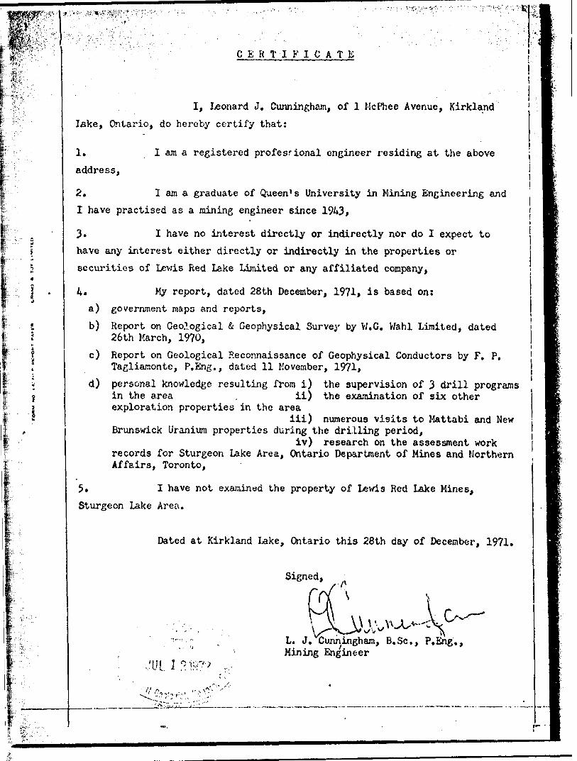
CERTIFICATE
I, Leonard J, Cunningham, of l McPhee Avenue, Kirkland
lake, Ontario, do hereby certify that;
l* I ara a registered professional engineer residing at the above
address,
2, I am a graduate of Queen's University in Mining Engineering and
I have practised as a mining engineer since 19/0*
3. I have no interest directly or indirectly nor do I expect to
have any interest either directly or indirectly in the properties or
securities of Lewis Red Lake Limited or any affiliated company,
4* My report, dated 28th December, 1971, is based on:
a) government maps and reports,
b) Report on Geological 4 Geophysical Survey by W.G. V/ahl Limited, dated 26th March, 1970,
c) Report on Geological Reconnaissance of Geophysical Conductors by F. P, Tagliamonte, P.Eng., dated 11 November, 1971,
d) personal knowledge resulting from i) the supervision of 3 drill programs in the area . ii) the examination of six other exploration properties in the area
iii) numerous visits to Mattabi and New Brunswick Uranium properties during the drilling period,
iv) research on the assessment workrecords for Sturgeon Lake Area, Ontario Department of Mines and Northern Affairs, Toronto,
5. I have not examined the property of Lewis Red Lake Mines,
Sturgeon Lake Area.
Dated at Kirkland Lake, Ontario this 28th day of December, 1971.
M.
Signed,
L. J. Cunningham, B.Se., P.Eng., Mining Engineer
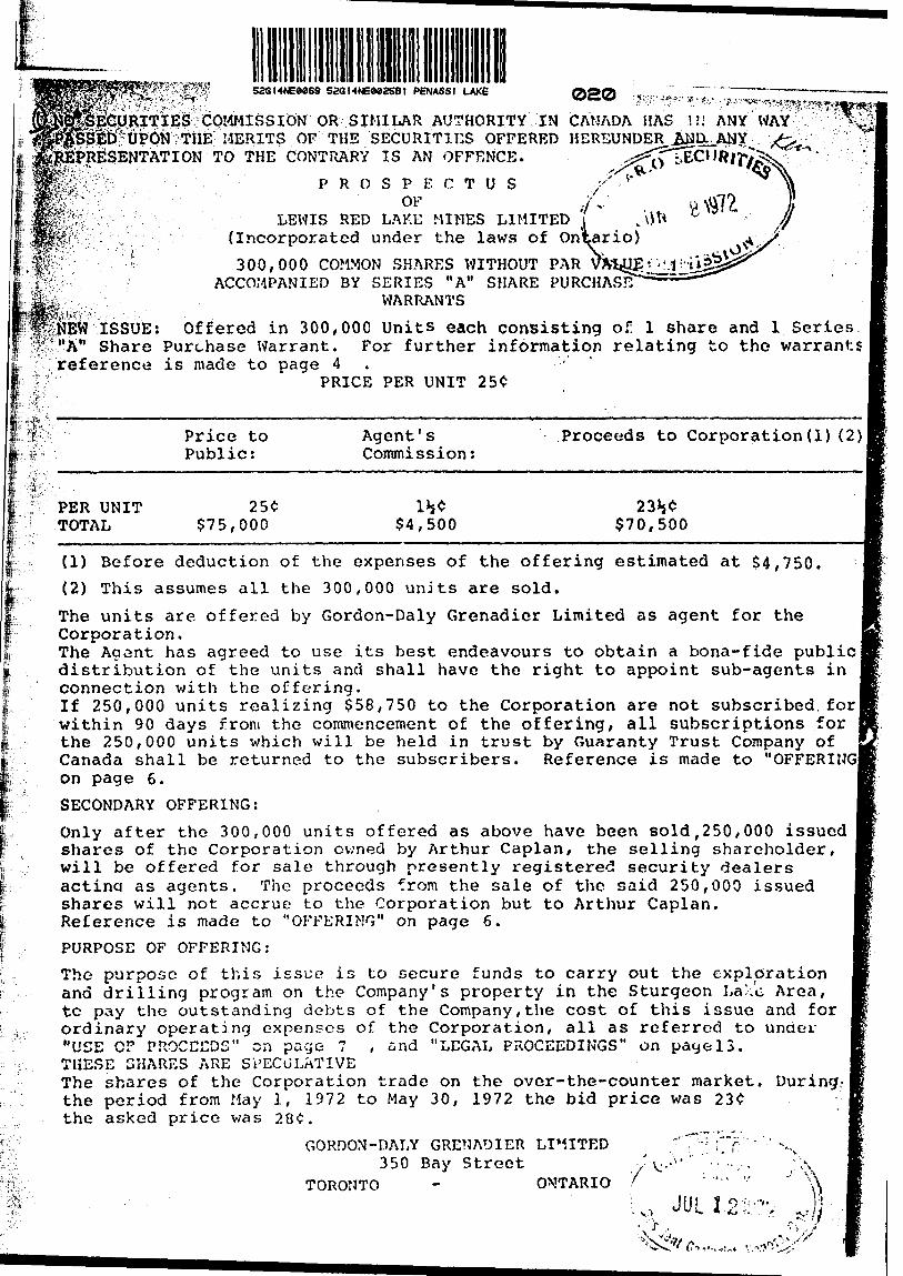
saGHNEoeasBt PENASSI LAKE 020COMMISSION OR SIMILAR AUTHORITY IN CANADA HAS
MERITS OF THE SECURITIES OFFERED HDREUNDERTO THE CONTRARY is AN OFFENCE.
. : :"it .' 1
'tt,.
ISSUE W Share reference
PROSPECTUS jOF yV
LEWIS RED LAKE MINES LIMITED 'i (Incorporated under the laws of Ontario)
300,000 COMMON SHARES WITHOUT PAR VA" ACCOMPANIED BY SERIES "A" SHARE PURCHASE
WARRANTS
Offered in 300,000 Units each consisting of l share and l Series Purchase Warrant. For further information relating to the warrants is made to page 4 ' -
PRICE PER UNIT 25*
PER UNIT TOTAL
Price to Public:
$75,000
Agent 1 s Commission:
w$4,500
Proceeds
23 $70,
to Corporation (1) (2)
W 500
(1) Before deduction of the expenses of the offering estimated at $4,750.(2) This assumes all the 300,000 units are sold.
The units are offered by Gordon-Daly Grenadier Limited as agent for theCorporation.The Agent has agreed to use its best endeavours to obtain a bona-fide public!distribution of the units and shall have the right to appoint sub-agents inconnection with the offering.If 250,000 units realizing $58,750 to the Corporation are not subscribed.for jwithin 90 days from the commencement of the offering, all subscriptions forthe 250,000 units which will be held in trust by Guaranty Trust Company ofCanada shall be returned to the subscribers. Reference is made to "OFFERINGlon page 6.
SECONDARY OFFERING:
Only after the 300,000 units offered as above have been sold,250,000 issued shares of the Corporation owned by Arthur Caplan, the selling shareholder, will be offered for sale through presently registered security dealers actina as agents. The proceeds from the sale of the said 250,000 issued shares will not accrue to the Corporation but to Arthur Caplan. Reference is made to "OFFERING" on page 6.
PURPOSE OF OFFERING:
The purpose of this issue is to secure funds to carry out the exploration and drilling program on the Company's property in the Sturgeon La/.'e Area, tc pay the outstanding debts of the Company,the cost of this issue and for ordinary operating expenses of the Corporation, all as referred to unaer "USE GF PROCEEDS" on page 7 , and "LEGAL PROCEEDINGS" on payel3. THESE SHARES ARE SPECULATIVEThe shares of the Corporation trade on the over-the-counter market. During,- the period from May l, 1972 to May 30, 1972 the bid price was 23* the asked price was 28*.
GORDON-DALY GRENADIER LIMITED "''"^f? - 'N.350 Bay Street
TORONTO ONTARIO 7V:-
JUL l•f .
-^ , '/,.,,.1'V. ' S. -
wT
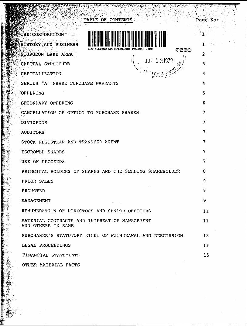
^^v,;,,: ,,-0 ,, :^.,,:;;s , ,^ y TABLES OF CONTENTS
HE CORPORATION
"::IISTORY AND BUSINESS52G14NE0869 SaGHNEeaaSB) PENASSI LAKE
J 013^ ,-" '
020C
, :vi
t :(T
TURGEON LAKE AREA
^CAPITAL STRUCTURE A-v
'CAPITALIZATION
SERIES "A" SHARE PURCHASE WARRANTS
OFFERING
SECONDARY OFFERING
CANCELLATION OF OPTION TO PURCHASE SHARES
DIVIDENDS
AUDITORS
STOCK REGISTRAR AND TRANSFER AGENT
ESCROWED SHARES
USE OF PROCEEDS
PRINCIPAL HOLDERS OF SHARES AND THE SELLING SHAREHOLDER
PRIOR SALES
PROMOTER
MANAGEMENT
REMUNERATION OF DIRECTORS AMD SENIOR OFFICERS
MATERIAL CONTRACTS AND INTEREST OF MANAGEMENT AND OTHERS IN SAME
PURCHASER'S STATUTORY RIGHT OF WITHDRAWAL AND RESCISSION
LEGAL PROCEEDINGS
FINANCIAL STATEMJ^NTS
OTHER MATERIAL FACTS
Page Nos
' -; IV
2
3
3
4
6
6
7
7
7
7
7
7
8
9
9
9
11
11
12
13
15
THE CORPORATION
RED LAKE MINES LIMITED (the "Corporation") is a corporation ^incorporated under the laws of the Province of Ontario by Articles
- Incorporation dated the 26th day of January, 1960. By Amendment its Articles of Incorporation dated the 3rd day of December,
^1971, the shares of the Corporation were changed from a par value of :.51.00 each to shares without par value. ;r." "'
*The Head Office and principal place of business of the Corporation Sis located at Suite 203, 350 Bay Street, Toronto, Ontario.
Corporation was incorporated to engage in the business of acquiring, exploring and developing mines, mineral lands and deposits.
l HISTORY AND BUSINESS
: Pursuant to an agreement dated February 8, 1960, the Corporation 'acquired from Joseph Lewis, 96 Dunvegan Road, Toronto, Ontario, six -patented mining claims situated -in the Township of Heyson and two "--patented mining claims situated in the Township of Dome, all located in the Red Lake Mining Division of the Province of Ontario, for and in consideration of the sum of 515,000 which was satisfied by the allotment and issue of 150,000 shares of the Corporation. The Corporation also acquired from Joseph Lewis and Larry F. Labow 541 Heathcote Avenue, Willowdale, Ontario, 12 unpatented mining claims situate in the Township of Harker, Larder Lake Mining Division, in the Province of Ontario, and 18 unpatented mining claims situated in the Township of Ewart in the Kenora Mining Division in the Province of Ontario in consideration of the sum of 360,000 which was satisfied by the allotment and issue of 350,000 shares of the Corporation to Larry F. Labow and 250,000 shares to Joseph Lewis; 90% of the said shares v/ere placed in escrow subject to the terms of the escrow set forth under the heading "ESCROWED SHARES".
The Corporation subsequently acquired by staking 2 mining claims in the Township of Dome, Province of Ontario, both claims being under the waters of Red Lake. Pursuant to an agreement dated November 9, 1960 and made between Howey Consolidated Mines Limited ("Howey") the Corporation and Larry F. Labow ("Labow") a working option to acquire the claims was given whereby Howey was obliged to pay $2,500 to the Corporation and Howey was required to carry out a magnetometer survey and to conduct 1,000 feet of diamond drilling on the two claims by September 30, 1961. The money was paid and the work was carried outbut the option was dropped. Previous management has indicated that 100,000 shares of the Corooration were allotted and issued to Labow (c T which 90,000 shares were subject to the terms of escrow as set forth und,; the heading "Escrowed Shares") in consideration of the time, expense and special skill and effort of Labow in acquiring the said claims and including the use by the Company of expensive equipment for underwater ^exploration.The two water claims were permitted to lapse in July, 1966. It was recommended that the Corporation drop the two patented claims in Dome -Township and the 6 patented claims in Heyson Township. At the request bf Joseph Lewis, the Vendor of the claims to the Corooration, and a former director of the Corporation the claims were transferred to
i Joseph Lewis for a nominal consideration of $2.00 rather than the Corporation abandoning same.

he: 12 jlaims in Harker Township wero allowed to lapse in February, , because of lack of development in the area and a decision of
l' l&the Corporation to devote the Corporation's efforts in the Red Lake ^'Area. No expenditures were made on these claims.
lpThe/18 claims in Ewart Township were allowed to lapse in December, |Kl961, because of lack of development in the area. Ho expenditures were ^/made on these claims. ' 'C--'. -' ". ' V1" 1 ' '
^According to previous management the Corporation spont $38,000 on the Red Lake claims. In addition said management estimated that Howey spent approximately 57,000.
j VSTURGEON LAKE AREA:
In 1969 the Corporation purchased 20 unpatented mining claims bearing numbers PA 203247 to PA 203266 inclusive located in the Sturgeon Lake Area for $5,000 cash. These claims were recorded in
; the name of Larry F. Labow on the 23rd day of December, 1964, and remained in his name until same were transferred into the name of the Corporation on the 25th day of October, 1971. The claims are in good standing until November 4, 1972. A program including geophysical surveys comprising a magnetometer and electromagnetic survey was carried out at a cost of 55,158. These claims were without a known ore body and the work proposed to be done on same is an exploratory search for ore. There is no surface or underground plant or equipment on the claims. 17 miles of line- cutting has been corrieted on a grid system having a baseline trending east-west with lines at 400 foot intervals trending north-south.
The following is a summary of the report of L. J. Cunningham, B. Se., P. Eng., dated December 28, 1971:-
The 20 mining claims of Lewis Red Lake Mines Limited are situated 40 miles north of the Town of Ignac-e in the Sturgeon Lake area of northwestern Ontario.
A sequence of volcanic rocks considered favourable for base metal exploration underly the property.
Geophysi.cal surveys carried out in 1970 have revealed 6 anomalies, 5 of which are considered worthy of diamond drill testing. Additional drilling will be done contingent on the results, obtained from the initial drilling programs.
The full report of L, J. Cunningham, B. Se., P. Eng., is available for inspection in the public files of the Ontario Securities Commission.
Out of the proceeds of the present offering, the Corporation intends to carry out the program of diamond drilling recommended by L. J. Cunningham, B. Se., P. Eng., at a total estimated cost of $20,000

CANCELLATION O)' OPTION TO PURCHASE SIHRES
^The outstanding option to purchase 100,000 shares granted by the lebrporation to Larry F. Labow at 15C per share good until March 24, ffi976, has been cancelled by virtue of Minutes of Settlement entered ^':into in the Ac' ion brought by the Corporation against Larry F. Labow
7 and Labow Mining Consultants Limited Reference is made to "LEGAL ^PROCEEDINGS" on page 13.
DIVIDENDS
No dividends have been paid uy the Corporation to date.
AUDITORS
The auditors for the Corporation are Laventhol, Krekstein, Horwath S. Horwath, 700-Richmond-Adelaide Centre, 120 Adelaide Street West, Toronto, Ontario.
STOCK REGISTRAR AND TRANSFER AGENT
Guaranty Trust Company of Canada, 88 Univers. t-y Avenue, Toronto, Ontario, is the Stock Registrar and Transfer Ac ant of the Corporation.
ESCROWED SHARES
There are 265,050 shares registered in the name of Arthur Caplan in escrow held by Guaranty Trust Company of Canada, 88 University Avenue, Toronto, Ontario, which shares are subject to release only upon the written consents of the Ontario Securities Commission and the Board of Directors of the Corporation, and subject to transfer, hypotl'ecation, assignment or any other form of alienation only upon the written consent of the Ontario Securities Commission. Reference is made to "HISTORY AND BUSINESS" on page l .Designation of No. of shares Percentage of class Security: held in escrow: based on the total
issued shares as of the date of the
___________ ______________ Prospectus;______
common shares 265,050 29.45*
T j SK rp
The net proceeds to be received from the sale of the 300,000 Units hereby offered amount to $70,500 less the cost of this issue estimated at $4,750, will be used to pay the ordinary operating expenses of the Corporation, the legal costs involved in the prosecution and settlement of the law suit in the Supreme Court of Ontario estimated at $3,800, the outstanding liabilities of the Corporation amounting to $ll,455 as at April 30, 1972, and to defray the cost of diamond drilling on the Corporation's Sturgeon Lake Claims estimated at $20,000. Any surplus remaining will be used for the operating expenses of the Corporation including additional diamond drilling on the Sturgeon Lake claims if warranted.
-9-
PRIOR SALKS
During the past two years the Corporation has not sold any shares other than the 121,050 shares which the previous directors and officers allotted and issued to Labow Mining Consultants Limited in settlement of a debt of $18,157.46 which debt and allotment and issuance of shares was the subject of the lav/suit referred to under the heading "LEGAL PROCEEDINGS" on page 13 , and which lawsuit has boon settled and the issuance of the 121,050 shares cancelled and set aside by Order of the Supreme Court of Ontario.
PROMOTER
Larry F. Labow who was the President and a director of the Corporation until July, 1971, and who was the owner directly and indirectly of a large block of shares of the Corporation may be considered the promoter of the Corporation until his retirement as President and a Director.
Arthur Caplan although not a director of the Corporation may be considered the present promoter of the Corporation because of his large shareholdings in the Corporation and because of his association with the Corporation during the past six months.
t?;-?
MANAGEMENT
The following are the particulars of present management of the Corporation including their principal occupations during the past five years:
Name and ' Address:
IAN ALBERT MacNAUGHTAN 242 Kings]ake Road, Willowdale, Ont.
Position:
President Director
and
Occupation;
Accountant and Corporation Secretar Previously office manager of G. D. Richmond Securities Limited, Toronto. Officer and/or Director of several mining companies includingNorlac Explorations Limited, Galway Brook Mines Inc. and Ardel Explorations Limited.

^^m?^
'''''Position:
IfrfXi^:;: ' ;'AARON PERRY
Iprive, Port Credit,
Vice-President and Director
#^-
Occupation:
Self-employed in ' Toronto for the last five years in the business of managing the affairs of associations such as Canadian Association of Exhibitions and Canadian Institution of Quantity Surveyors I.. addition he acts as an officer and/or director of several mining companies including Copper-Man Mines Limited, Great; Indian Explorations Limited and Arawak Mines Limited.
FRANK PETER TAGLIAMONTE 134 9 th Street, Noranda, Quebec.
Director Geological Engineer. Since February 1971 practising as a Consulting Geological Engineer, prior to that was retained by Newmont Mining Corporation of Canada Ltd. as a Consultant.
V TERRY SOKOLOFF749 Steeles Avenue, West,
i Unit 25, :Z Willowdale,
s Ont.
Secretary-Treasurer Accountant. Previously employed by Laventhol Krekstein Horwath 6 Horwath, Chartered Accountants, Toronto, Ontario. Presently employed by Shlesinger Corporate Services Limited, 350 Bay Street, Toronto, Ontario.
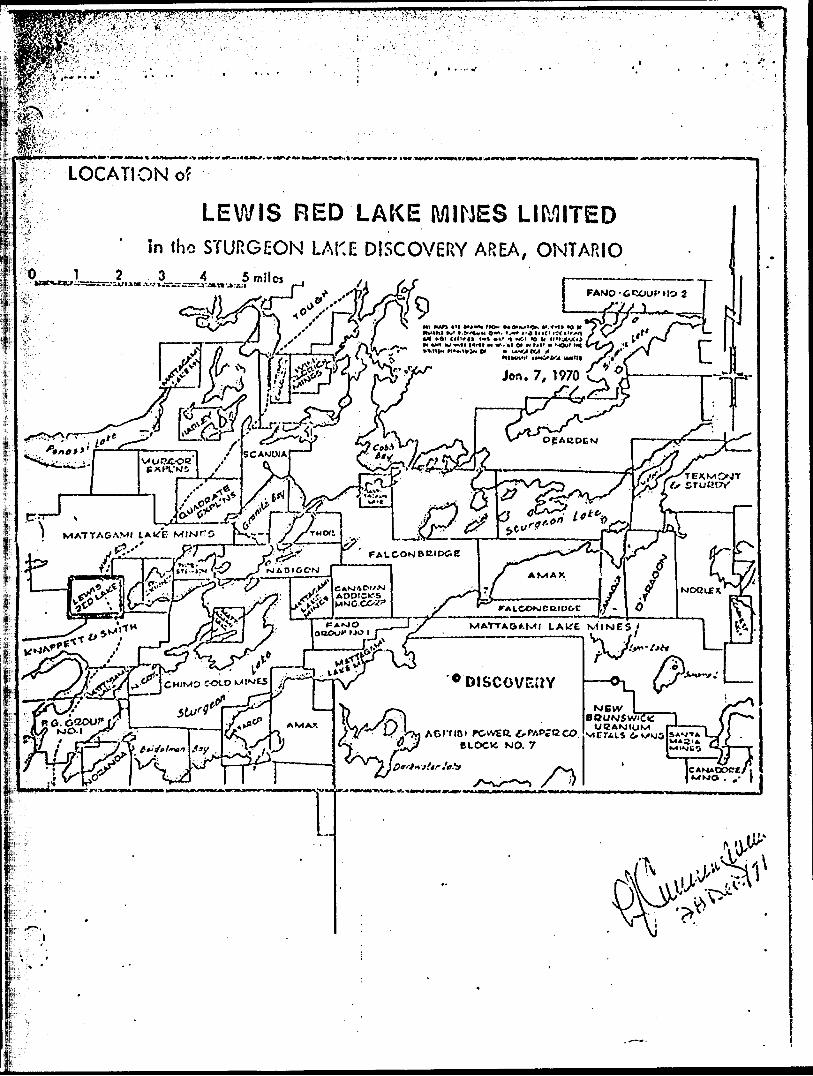
LOCATION of
LEWIS RED LAKE MINES LIMITEDIn Iho STURGEON LAKE DISCOVERY AREA, ONTARIO
fttro-lit* l——
MATTAGAMI LAkfE MINES
'•'Discovsav
yJpiyiif at,
,. — -^ /"tf.... ? ^ ,r 4o -2. .y -xtiK -^r-y
tTJt^i,,i!l.^|l|p:g^]jl^lB^-!^B^^
^sd^^fi^^i^!^i::^-:^^:^..•^HIIK.-,.^ -MjhMiHtJMHfM^IH^t
^^p^?is^pi^
S^ar l A^K.1** t - ^
S~^
J^ rr-\ L .T \J7 :-^ O S^ 7\4^oC4|Oj crX.T 7 ^ N .
visr ^^^J WN 1s^r,o7jKl\ l
7/ 10 6-AKI-^X/y A-^'^Jr^'' / f ^Ci^ - -\ ^^?^5Prr--~fe--r^ .rTi f \' o \ Tp-o^-r^.^ *\ *. -~ * \ . fr ,/^v^4^4^;../5 y r/.. ^ Vr^^.^:^^Vy
~7r :^ j*#**~~ ^T^'^ , ;/ rv^/iu ~"— ^3^^ ' 11- l /" ^4."-^ jo X/ J\rl':'..-^m- *.#}f. Y Y^SW;??./-- k-/^\*i^2^,s^ o g^
LEGEND
Rocks
i. Granitic Rocks
i i Basic Intrusive Rocks
n Sedimentary Recks
! Basic Volcanic Rocks
! ,j__l Acid Volcanic Hocks
SYMBO
J Axis of Syncline
l Ore Body
Geology from O. D. X. Mars P.353, F.588-89-9C-91, P.670
ISrfIS RED LAS MI^^CSTURGEON LAJG AH2A
OMARICScale l" ^ 2 niles
23 December, 1972 - I.. J.Cunnin/-