resource and reserve summary on the coal assets of …
TRANSCRIPT

RESOURCE AND RESERVE SUMMARY ON THE COAL
ASSETS OF WESCOAL HOLDINGS
LIMITED 2021
REPORT REPARED BY
L. Raaths
B. Tech (Mining), B.Sc. (Operations Research), MBL,
SACMA, SAIMM
Competent Person
K. Black
B.Sc. (Hons) Geol.
GDE (Chem. and Met. Engineering)
Pr. Sci. Nat., MGSSA
Competent Person
EFFECTIVE DATE 31 MARCH 2021

i
RESOURCE AND RESERVE SUMMARY ON THE COAL ASSETS OF WESCOAL HOLDINGS LIMITED
Wescoal Holdings
PO Box 1962
Edenvale, 1610
Gauteng
Tel: 011 570 5800
Fax: 011 570 5848
Wescoal Mining
Khanyisa Colliery, Forest Plots
Plot 6, Kendal
Mpumalanga
Tel: 086 111 6463
Fax: 086 557 3122
JSE 12.11(i) 5
Miptec (Pty) Ltd KJB GeoServices
19 Jan Frederick Street 60 Curvy Road
Witbank Randburg
1049 2194
South Africa South Africa
Tel: 082 419 5807 Tel: +27 11 326 3586
Email: [email protected] Email: [email protected]
JSE 12.9(a)
Effective Date of Report: 31 March 2021

ii
Contents
List of Figures ......................................................................................................................................................... ii
List of Tables ........................................................................................................................................................... iii
Purpose JSE12.10(d)(h)(i) [SR1.1(i)] ............................................................................................................... 1
Effective date JSE [12.10(a)] [SR9.1(iii)] ................................................................................................................. 1
Project outline [12.10(h)(ii)(iii)] [SR1.1(i), SR1.2(i)] ................................................................................................. 1
Ownership/Company Structure [12.10(h)(i)] [SR1.5(i)(ii)] ....................................................................................... 2
Licensing and Permitting JSE 12.10 (h)(iv), SR1.5 ................................................................................................. 4
Reporting Compliance [JSE 12.10(e] ...................................................................................................................... 5
Competent Persons (CP) JSE 12.10 (h) (xi), JSE 12.11 (i) 5, ............................................................................. 6
Personal Inspection [SR1.1(iii)] ............................................................................................................................... 7
Key Technical Persons [SR9.1(i)(ii)] ....................................................................................................................... 7
Work Conducted during FY 2021 [JSE 12.10(h)(vi)] [SR3.1, SR3.2(i)(v)] ........................................................... 8
Regional Geology [JSE 12.10(h)(v)] [SR2.1]........................................................................................................... 9
Coal Resource and Coal Reserves Summary [12.10(a)] [SR1.4(iii), SR4.1(iv), SR4.5(ii)(iv)(v)(vii), SR6.1(i),
SR6.3(vi)] .............................................................................................................................................................. 10
Coal Resource and Reserve Estimation Process JSE 12.11(iii)2 ........................................................................ 12
Elandspruit Complex ............................................................................................................................................. 19
Khanyisa Complex ................................................................................................................................................ 34
Vanggatfontein Colliery ......................................................................................................................................... 48
Moabsvelden ......................................................................................................................................................... 64
Sterkfontein ........................................................................................................................................................... 73
Leeuw Braakfontein Colliery ................................................................................................................................. 77
Arnot Colliery ........................................................................................................................................................ 82
CERTIFICATES OF COMPETENT PERSONS .................................................................................... 91
1.1 Certificate of Competent Person Leonardt Raaths and Consent ................................... 91
1.2 Certificate of Competent Person Katherine Black and Consent..................................... 92
List of Figures
Figure 1. Wescoal Holdings Limited company structure ......................................................................................... 2
Figure 2: Arnot OpCo Structure .............................................................................................................................. 3
Figure 3. Elandspruit Locality Map ........................................................................................................................ 19
Figure 4. Elandspruit plan indicating resource blocks utilised for the 31 March 2021 estimation. ........................ 23
Figure 5. Elandspruit plan detailing the remaining Reserves at 31 March 2021 ................................................... 28
iii
Figure 6. Khanyisa Complex locality map ............................................................................................................. 34
Figure 7. Khanyisa Colliery No 2 Seam Resource Areas ...................................................................................... 37
Figure 8. Khanyisa Colliery No 4 Seam Resource Areas. ..................................................................................... 38
Figure 9. Khanyisa Remaining Reserves plan as at 31 March 2021 .................................................................... 42
Figure 10. Vanggatfontein Colliery Locality Map ................................................................................................... 48
Figure 11. Vanggatfontein No. 5 Seam Resource Plan ........................................................................................ 52
Figure 12. Vanggatfontein No. 4 Seam Resource Plan ........................................................................................ 53
Figure 13. Vanggatfontein No. 2 Seam Resource Plan ........................................................................................ 53
Figure 14. Vanggatfontein Reserves Plan 31 March 2021 .................................................................................... 60
Figure 15. Moabsvelden Locality Map .................................................................................................................. 64
Figure 16. Moabsvelden Reserves as at 31 March 2021 ...................................................................................... 70
Figure 17. Sterkfontein Locality Map ..................................................................................................................... 73
Figure 18. LBC Locality Map ................................................................................................................................. 77
Figure 19. Arnot Colliery location Map .................................................................................................................. 82
Figure 20. Arnot S1 remaining resource areas after cut-off parameters applied (MSA CPR 2019) ...................... 85
Figure 21. Arnot S2L remaining resource areas after cut-off parameters applied (MSA CPR 2019). ................... 86
List of Tables
Table 1. Licencing and Permitting Summary .......................................................................................................... 4
Table 2. Table of Key Technical Persons ............................................................................................................... 8
Table 3. Summarised Resource and Reserve statement of all managed assets as at 31 March 2021 JSE 12.10 (h)
(ix), JSE 12.11 (iii) 6 .............................................................................................................................................. 11
Table 4. Asset resource category summary .......................................................................................................... 17
Table 5. Exploration expenditure FY21 ................................................................................................................. 18
Table 6. Planned Exploration expenditure FY22 ................................................................................................... 18
Table 7. Elandspruit Resource Estimation as at 31 March 2021 JSE 12.9 (h) (ix) ................................................ 24
Table 8. Elandspruit F1.8 Coal Qualities as at 31 March 2021 JSE 12.10 (h) (ix) ............................................... 25
Table 9. Elandspruit comparison of Resource Estimates 2020 and 2021 ............................................................. 26
Table 10. Elandspruit comparison of Resource Qualities 2020 and 2021 JSE 12.11 (iii) 4, JSE 12.11 (iii) 8 .... 27
Table 11. Elandspruit Production History .............................................................................................................. 28
Table 12. Elandspruit Reserve History .................................................................................................................. 28
Table 13. Elandspruit Reserve Estimate as at 31 March 2021 JSE 12.9 (h) (ix)1.18 ........................................ 29
Table 14. Elandspruit Coal Reserve reconciliation on ROM estimations [SR1.4(iv), SR4.5(vi), SR6.3(iv)] .......... 30
Table 15. Elandspruit Risks JSE 12.10 (h) (x), SE 12.11 (iii) 10 [SR5.7(i)] ...................................................... 33
Table 16. Khanyisa Resource Estimate Summary as at 31 March 2021 JSE 12.9 (h) (ix), JSE 12.11 (iii) 8 ..... 38

iv
Table 17. Khanyisa Colliery Resource reconciliation JSE 12.11 (iii) 8............................................................... 40
Table 18. Khanyisa Colliery Quality reconciliation JSE 12.11 (iii) 8 ................................................................... 40
Table 19. Khanyisa production history .................................................................................................................. 42
Table 20. Khanyisa Reserve History ..................................................................................................................... 43
Table 21. Khanyisa Reserves Estimate Summary as at 31 March 2021 JSE 12.9 (h) (ix) ................................ 43
Table 22. Khanyisa Reserves Reconciliation 31 March 2021 ............................................................................... 44
Table 23. Khanyisa Risks JSE 12.9 (h) (x), JSE 12.11 (iii) 10 ........................................................................... 46
Table 24. Vanggatfontein Resource Estimate as at 31 March 2021 ..................................................................... 54
Table 25. Vanggatfontein F1.8 Coal Qualities as at 31 March 2021 ..................................................................... 55
Table 26. Vanggatfontein Resource Reconciliation .............................................................................................. 56
Table 27. Vanggatfontein Quality Reconciliation................................................................................................... 56
Table 28. Vanggatfontein production history ......................................................................................................... 57
Table 29. Vanggatfontein Reserves estimates 31 March 2021 ............................................................................. 57
Table 30. Vanggatfontein Reserve History ........................................................................................................... 58
Table 31. Vanggatfontein ROM Reserve Reconciliation as at 31 March 2021 ..................................................... 58
Table 32. Updated Modifying Factors ................................................................................................................... 61
Table 33. Vanggatfontein Risks ............................................................................................................................ 63
Table 34. Moabsvelden Resource Estimate as at 31 March 2021 ........................................................................ 67
Table 35. Moabsvelden F1.8 Coal Quality Estimations as at 31 March 2021 ....................................................... 68
Table 36. Moabsvelden Resource Reconciliation [SR1.4(iii), SR4.5(vi)] ............................................................. 68
Table 37. Moabsvelden Reserve estimate 31 March 2021 ................................................................................... 69
Table 38. Moabsvelden Reserve Reconciliation ................................................................................................... 69
Table 39. Moabsvelden reserve History ................................................................................................................ 70
Table 40. Sterkfontein Project Resource Estimation as at 31 March 2020 (as per 2017 Venmyn CPR)) ............. 75
Table 41. LBC Resource estimate 31 March 2020 (No change from Venmyn 2017) ........................................... 81
Table 42. Arnot Seam 1 Opencast resources (Source MSA 2019 CPR) Wescoal 45% Attributable .................... 87
Table 43. Arnot Seam 2L Opencast resources (Source MSA 2019 CPR) Wescoal 45% Attributable .................. 87
Table 44. Arnot Seam 2L Underground resources (Source MSA 2019 CPR) Wescoal 45% Attributable ............. 88
Table 45. Arnot Opencast and Underground Indicative reserves, not included in the reserve estimation for Wescoal
.............................................................................................................................................................................. 89

Resource and Reserve Statement Wescoal Holdings Limited March 2021
1 | P a g e
Purpose JSE12.10(d)(h)(i) [SR1.1(i)]
Miptec (Pty) Ltd (“MIPTEC”) was commissioned by Wescoal Mining (Pty) Ltd, (“Wescoal”), a wholly owned
subsidiary of Wescoal Holdings Ltd, a coal mining and exploration company with thermal coal assets located in
the Mpumalanga and KwaZulu-Natal Provinces of South Africa, to produce an Coal Resource and Reserve update
statement for their operating assets, Elandspruit Colliery (“Elandspruit”), Khanyisa Colliery (“Khanyisa”),
Vanggatfontein Colliery (“Vanggatfontein”), Moabsvelden Colliery (“Moabsvelden”) as well as project areas
Sterkfontein Project (“Sterkfontein”), Leeuw Braakfontein Colliery Projects (“LBC”) and Arnot Colliery Project
(“Arnot”), in order to meet the JSE listing requirements, as agreed with their JSE sponsor, reflective of the 31
March 2021 Status.
Effective date JSE [12.10(a)] [SR9.1(iii)]
The effective date (“Effective Date”) of the Coal Resource and Coal Reserve Summary Report is the 31 March
2021.
Project outline [12.10(h)(ii)(iii)] [SR1.1(i), SR1.2(i)]
Wescoal’s operating coal assets are situated in the Witbank/ Highveld region and comprise:
• Elandspruit Colliery, which is an operational coal mine situated some 8 km west of the town of
Middelburg,
• the Khanyisa Complex situated approximately 14km west of the town of Ogies,
• Vanggatfontein Colliery situated 15 km east of the town of Delmas and
• Moabsvelden Colliery situated 5km north of Vanggatfontein and 14 km east of the Town of Delmas, all
in the Mpumalanga Province. Three coal projects, namely Sterkfontein, located approximately 5km
southwest of the town of Bethal, LBC, located approximately 10km east-southeast from the town of
Newcastle in the KwaZulu-Natal Province and Arnot located 16km east of the Town of Middelburg in
Mpumalanga.

Resource and Reserve Statement Wescoal Holdings Limited March 2021
2 | P a g e
Ownership/Company Structure [12.10(h)(i)] [SR1.5(i)(ii)]
Figure 1. Wescoal Holdings Limited company structure
Emphasis regarding the Coal Resource and Coal Reserve (“R&R”) estimates is placed on the realistic prospect for
eventual economic extraction. Resources were guided by reserves previously estimated, quality and strip ratio cut
offs. Reserves were backed by inhouse LOM schedules and financial models provided for scrutiny. The information
in this R&R statement is compiled on a group basis in appropriate detail, summarizing the current situation and
known changes at each operation. The Company structure, as depicted in Figure 1, was applied when reporting
attributable Coal Resources / Coal Reserves. The addition of Arnot, with Wescoal holding effectively 45% is based

Resource and Reserve Statement Wescoal Holdings Limited March 2021
3 | P a g e
on Arnot InvestCo (Pty) Ltd and Wescoal Mining (Pty) Ltd each owning 50% of Arnot HoldCo (Pty) Ltd which in
turn owns 90% of Arnot OpCo (Pty) Ltd. All other assets are 100% owned by Wescoal.
Figure 2: Arnot OpCo Structure

Resource and Reserve Statement Wescoal Holdings Limited March 2021
4 | P a g e
Licensing and Permitting JSE 12.10 (h)(iv), SR1.5
Table 1. Licencing and Permitting Summary
KHANYISA COLLIERY ELANDSPRUIT COLLIERY
VANGGATFONTEIN
COLLIERY MOABSVELDEN PROJECT BRAAKFONTEIN PROJECT STERKFONTEIN PROJECT ARNOT PROJECT
Right Holder Wescoal Mining (Pty) Ltd Wescoal Mining (Pty) LtdKeaton Mining (Pty)
Limited
Keaton Mining (Pty)
Limited
Keaton Mining (Pty)
Limited
Keaton Mining (Pty)
LimitedArnot OpCo (Pty) Limited
Type of Right MR MR MR MR MR PR MR
Colliery/Project Khanyisa Catwalk and Triangle Elandspruit Colliery Vanggatfontein Colliery Moabsvelden ProjectLeeuw Braakfontein
Colliery ProjectSterkfontein Project Arnot Colliery
Location Witbank / Delmas Middelburg Witbank / Delmas Witbank / Delmas Newcastle Bethal Rietkuil
DMR Ref. no. MP30/5/1/2/2/107MR MP 30/5/1/2/351 MR 309 MR 10025 MR 143 MR443PR, 444PR, 1827PR,
2053PR, 1720PRMP30/5/1/2/1/325MR
Area (ha) 303.9846 538.31 1,651.98 250.00 1,951.66 7,926.00 15,021.22
TenureAmended right expiry May
202528 Oct '10 - 27 Oct '26 23 Feb '10 - 22 Feb '30 16 Oct '13 - Oct '31 29 Aug '07 - 28 Aug '37
Expired Dec 2017,
Extension application
submitted timeously,
approval pending
06 Dec '12 - 05 Dec '38
Current status Operating Operating Operating Project Development Project Project Project (JV)
Notes to material
mineral rights
impediments
Section 102 application granted
variation to Khanyisa MR,
include Catwalk PR and
Triangle MR - May'17
None None None None
Two separate Mining Right
Applications lodged with
the DMR in Nov 2017 for
Keaton Mining and
Labohlano Trading. A
separate Section 102
Application
simultaneously lodged to
consolidate the two
Applications into one
Keaton Mining Right
Application. Awaiting
response from the DMR
1. Mining Right Coverage -
an incorrect plan was
seemingly used during the
Execution of the Right 3.
Section 11 MR Transfer
from Exxaro to AOC - still
in process 4.
Section 102 Transfers - Still
in progress
MPRDA EMPMP 30/5/1/2/3/2/1(107) EM - 10
Oct 2016
MP 30/5/1/2/3/2/1(351) EM - 28
Oct '10Unapproved
NEMA environmental
authorisation
17/2/3N-392, 30 November
2015
DWS WULWUL 03/B20F/AGJ/4627 - 13
May'16
WUL 04/B11J/ACGIJ/3057 - 28
Mar '15
Notes on permitting
and potential impact on
ongoing operations
None None None None None None None
Farms realted to
Guarantees
Heuwelfontein Ptn. 97,106, 107
and portions of 103
Elandspruit Ptn. 29, 30, 32, 33,
34, 36 & 40Moabsvelden 248IR, Ptn 8
Rem Ext. Drycut 8198HU,
Madadeni 15961HU and
Braakfontein 4278HU
Kaffirskraal 148IS, Blesbok
150IS, Sterkfontein 296IS,
Pieksdal 298IS,
Sterkfontein 299IS, Dikkop
Alias Verkorting 300IS,
Goedehoop 301IS,
Palmietfontein 307IS, and
Wildan577IS
Rem Ext. Drycut 8198HU,
Madadeni 15961HU and
Braakfontein 4278HU
Rehabilitation
guarantee Guarantee in place Guarantee in place Guarantee in place
Reg. right owner Wescoal Mining (Pty) Ltd Wescoal Mining (Pty) Ltd Keaton Mining (Pty) Ltd Neosho Trading 86 (Pty)
Ltd
Leeuw Braakfontein
Colliery (Pty) Ltd - 100%
owned by KEHL
Keaton Mining (Pty) Ltd
and Labohlano Trading 46
(Pty) Ltd
Arnot OpCo (Pty) Limited
Funding mechanism Lombard's Lombard's Centriq Centriq Centriq
Resource and Reserve Statement Wescoal Holdings Limited March 2021
5 | P a g e
Table 1 provides a summary of the licensing and permitting status for the operational and project assets under
review. As detailed in Table 1, all required licences, permits and agreements are in place to conduct mining
operations at the current operating assets.
For the Sterkfontein, two mining right applications were submitted in December 2017 together with a Section 102
application to consolidate the rights when granted. Wescoal awaits DMRE’s response in this regard.
LBC is currently undergoing a disposal process. Wescoal anticipates the process to be completed before the next
reporting cycle.
Arnot was added to the projects and relevant information sourced from the CPR completed By MSA for Arnot OpCo
with effective date 1 July 2019
Wescoal, on all operating assets, manages ongoing environmental monitoring, auditing and management process
to ensure that the requirements as set out in the approved environmental management programme are met, and
that any audit findings are addressed to ensure that no material aspects develop.
Reporting Compliance [JSE 12.10(e]
The reporting standard adopted for the reporting of the Coal Resources and Coal Reserves for the Wescoal
operating assets (Elandspruit, Khanyisa, Vanggatfontein and Moabsvelden), is the 2016 Edition of “The South
African Code for the Reporting of Exploration Results, Mineral Resources and Mineral Reserves” (the SAMREC
Code) as prepared by the South African Mineral Resource Committee Working Group under the auspices of the
Southern African Institute for Mining and Metallurgy (SAIMM) and the Geological Society of South Africa (GSSA).
The definitions of the relevant terms, methodologies and estimation processes employed and the reporting for
South African Securities Exchange purposes for the Coal Resources and Coal Reserves in this report are
according to those set out in the “The South African -guide to the systematic evaluation of coal exploration results,
coal resources and coal reserves” (SANS 10320:2020) published by Standards South Africa, a division of the
South African Bureau of Standards (SABS).
The respective Coal Resource and Coal Reserve Estimates are classified and signed off by suitably qualified CPs.
Each CP has sufficient, relevant experience in the style of mineralisation, type of deposit, mining method and
activity for which they have taken responsibility, to qualify as a CP as defined in section 9 of the SAMREC Code.
All CPs consent to the inclusion of information into this report in the form and context in which they appear. Each
CP is independent of the issuer and does not have a material interest capable of affecting their ability to give an

Resource and Reserve Statement Wescoal Holdings Limited March 2021
6 | P a g e
unbiased opinion on the projects for which they take responsibility, and have not received, and will not receive,
any pecuniary or other benefits in connection with the estimates presented, other than normal consulting fees.
Competent Persons (CP) JSE 12.10 (h) (xi), JSE 12.11 (i) 5,
The CP responsible for the Coal Resource Estimations on operating assets, Elandspruit, Khanyisa,
Vanggatfontein, Moabsvelden as contained in this report is Ms. Katherine Black (BSc. (Hons.), Pr. Sci. Nat. Ms
Black has 14 years’ experience in the mining industry as a coal geologist. Over the last 14 years, Katherine has
primarily been involved in the compilation and management of coal databases, the construction of geological
models, and the estimation of Coal Resources for various Greenfield operations in South Africa, Botswana and
Mozambique, as well as a number of operating coal mines in South Africa. Ms. Black is currently the owner of KJB
GeoServices (60 Curvy Road, Johannesburg, 2194) and an associate of Miptec. She is registered with the South
African Council for Natural Scientific Professions (SACNASP Reg. No. 400295/12) and is a member in good
standing with the Geological Society of South Africa.
The Coal Resources for Sterkfontein and LBC were added to this report as per the 31 January 2017 Venmyn
Deloitte Competent Person’s Report (“CPR”) and consent from Venmyn Deloitte was sourced in 2018. It has been
stated by Wescoal to the Competent Persons (“CP’s”), that no work subsequent to the issuing of the 2017 CPR
was conducted on these two projects to suggest a change in previously declared Coal Resources.
The Coal Resources for the remaining project, namely Arnot, were added to this report as per the 1st of July 2019
MSA Group CPR with consent sourced from the MSA Group in June 2021 to use the information from the CPR.
No work or mining activities subsequent to the issuing of the 2019 CPR have taken place, and therefore the coal
resource estimates have remained unchanged.
Dr E.A. Schneiderhan was responsible for the construction of the 2017 Sterkfontein and LBC geological models
and accompanying resource estimations, as well as the Arnot geological model and accompanying resource
estimations in 2019. Dr Schneiderhan has been modelling coal deposits for the past eleven years and has
experience with numerous projects in the Witbank, Highveld and Ermelo coalfields.
In accordance with the SAMREC Code, this report has been prepared under the direct supervision of a Lead
Competent Person, Mr. Leonardt Raaths, who assumes overall responsibility for this report. Mr. Raaths is
responsible for all the Coal Reserve Estimations. Mr Raaths holds a BTech Mining degree from UJ, a BSc. in
Operations Research from Unisa and an MBL from Unisa SBL. Mr Raaths is registered with the SAIMM
(registration number 702015). Mr Raaths has 30 years’ experience in coal mining, the largest portion of which was
on technical and project disciplines, where the determination of Coal Reserves was part of his responsibility. This

Resource and Reserve Statement Wescoal Holdings Limited March 2021
7 | P a g e
was largely for BHP’s South African collieries, Xstrata South Africa, CIC Energy and now as an independent
consultant at Miptec Consulting Proprietary Limited, 19 Jan Frederik Street Witbank, (PO Box 40084, Reyno Ridge,
1049).
As lead CP, it can be stated that this Coal Resource and Coal Reserve update report provides a true reflection of
the Resources and Reserves held by Wescoal.
Personal Inspection [SR1.1(iii)]
Miptec representatives, Leon Raaths and Katherine Black (Pr.Sci.Nat, CP Geology and Coal Resources )
conducted site visits to all of the Wescoal operations (Elandspruit, Khanyisa, Vanggatfontein and Moabsvelden
Collieries) during May 2021.
Dr PJ Hancox (Pr.Sci.Nat, CP Geology and Coal Resources) of CCIC Coal, on behalf of Venmyn, visited LBC and
Sterkfontein in September 2015. As no further work has been conducted on the area, and technical reliance is
placed upon the CPR signed off by Dr PJ Hancox (2017), no additional site visits have been undertaken.
MSA conducted independent site visits to the Arnot Project over the course of 2018. Dr PJ Hancox (Pr.Sci.Nat, CP
Geology and Coal Resources) and Mark Richard Mohring (CP Coal Reserves, Mining, and Processing) undertook
a site inspection on the 04 April 2018. As no further work has been conducted on the area, and technical reliance
is placed upon the CPR signed off by Dr PJ Hancox (2019), no additional site visits have been undertaken
Key Technical Persons [SR9.1(i)(ii)]
During the preparation of this update report, reliance was placed on the individuals detailed in Table 2 below.
Environmental practitioners are appointed by Wescoal and were consulted with regard the Coal Resources and
Coal Reserves. They are responsible for the compliance audits, monitoring, closure assessments and related
permitting/approvals as well as pending applications that could affect the reported Coal Resources and Coal
Reserves.

Resource and Reserve Statement Wescoal Holdings Limited March 2021
8 | P a g e
Table 2. Table of Key Technical Persons
Work Conducted during FY 2021 [JSE 12.10(h)(vi)] [SR3.1, SR3.2(i)(v)]
Exploration drilling was undertaken at Elandspruit, with no drilling at Vanggatfontein, Moabsvelden, Khanyisa or
any of the project areas. As such, only the Elandspruit geological model was updated with new information.
Estimations on the operating assets were based on the existing and updated models reflective of the surveyed
positions of the mined out faces as at 31 March 2021. The Coal Resources for these areas were updated by
Katherine Black (BSc. (Hons.), Pr. Sci. Nat, of KJB GeoServices (“KJB”) based on the 2018, 2020 and 2021
geological models respectively, nett of depletion. The Coal Reserves for these assets were estimated by Miptec in
the scheduling models nett of depletion as at 31 March 2021 based on the respective geological models and
relevant reconciliations, following the parameters as stipulated in the Reports. Mr. Leon Raaths, a full-time
employee of Miptec, is responsible for all the Coal Reserve estimations.
During the financial year 2021, nine fully cored holes were drilled at Elandspruit. The purpose of these boreholes
was to increase the geological knowledge over the area for both modelling and mine planning purposes. All
boreholes were wireline logged, sampled and analysed. The data obtained from the drilling program was verified
and incorporated into the geological model.
The Coal Resources for Sterkfontein and LBC were added to this report as per the 31 January 2017 Venmyn
Deloitte Competent Person’s Report (“CPR”) and consent from Venmyn Deloitte was sourced in 2018. It has been
stated, by Wescoal to the Competent Persons (“CP’s”), that no work was conducted on these two projects to

Resource and Reserve Statement Wescoal Holdings Limited March 2021
9 | P a g e
suggest a change in previously declared Coal Resources. A permitting change was initiated through the
submission of an application for two mining rights over the total Sterkfontein prospecting areas together with a
Section102 application to consolidate the mining right when executed. Sterkfontein can only resume further field
work once the Mining Right has been granted. At the time of this report the awarding of the Mining Rights was still
pending.
The Coal Resources for the remaining project, namely Arnot, was added to this report as per the 1st of July 2019
MSA Group CPR and consent was sourced from the MSA Group in Jun 2021 to use the information from the CPR.
Wescoal is not the operating partner on this project. Arnot OpCo has done more technical work on the project, that
was not considered for this report. Arnot OpCo has in their plans for the upcoming reporting period to update the
CPR and it align with the latest work in progress.
Regional Geology [JSE 12.10(h)(v)] [SR2.1]
Witbank Coalfield
The Elandspruit, Khanyisa, Vanggatfontein and Moabsvelden Collieries are located within the Witbank Coalfield
which extends approximately 90 km in an east- west direction from the town of Springs in the west, to Belfast in
the east, and 50 km in a north-south direction, from Middelburg in the north, to Rietspruit in the south. The northern
extent of the Coalfield is defined by the limit of coal-bearing sediments of the Vryheid Formation which abut against
pre-Karoo basement rocks of the Transvaal Sequence, the Waterberg Group and Bushveld Complex. The southern
limit of the central sector of the Coalfield is marked by a series of Bushveld Complex inliers known as the Smithfield
Ridge while in the east and west sectors, the boundary between the Witbank Coalfield and the Highveld Coalfield
to the south is somewhat arbitrary.
In the Witbank Coalfield, the Karoo Supergroup stratigraphic sequence is abbreviated with sediments of only the
Dwyka Group and Vryheid Formation of the Ecca Group present. The Dwyka Group is characterized by deposits
of glaciogenic origin, including tillites, diamictites and rhythmites, while the Vryheid Formation comprises a
predominantly arenaceous sequence of sandstones with sub-ordinate siltstones and mudstones arranged in a
series of upward coarsening sequences. Each genetic sequence represents a major cycle of deltaic outbuilding
and is usually capped by a coal seam. The only major disturbances to the strata are the minor dolerite dykes and
sills, which have displaced the coal seams and burnt and devolatilised the coal seam in certain areas.
The five major coal seams of the coalfield are contained within a stratigraphic interval averaging approximately
70m in thickness. The seams are numbered, from the base upwards and include the No. 1 Coal Seam, the No. 2
Coal Seam (split into the No. 2 Lower Coal Seam and No. 2 Upper Coal Seam), the No. 3 Coal Seam, the No. 4
Coal Seam (split into the No. 4 Lower Coal Seam and No. 4 Upper Coal Seam) and the uppermost No. 5 Coal
Seam.

Resource and Reserve Statement Wescoal Holdings Limited March 2021
10 | P a g e
Highveld Coalfield
Sterkfontein is located within the Highveld Coalfield. The coal deposits of the Highveld Coalfield are restricted to
rocks of the Vryheid Formation, which range in thickness from 70m to over 500m, being thickest in the northeast
and east of the preserved outcrop area, to the south-southwest of the town of Vryheid, where the basin was the
deepest. Five depositional sequences are recognised within the Vryheid Formation in the Highveld Coalfield, each
with the potential for coal seam development at the top. These are numbered from No.1 Seam at the base to No.5
Seam at the top. Of these, by far the most important economic seam of the Highveld Coalfield is the No.4 Seam.
Klip River Coalfield
LBC occurs in the north eastern part of the Klip River Coalfield, one of the most historically important coal producing
areas of South Africa. Large areas of the Klip River Coalfield are affected by Jurassic aged dolerite intrusions, and
these intrusives are probably the single most disruptive aspect of the coalfield. Displacements of up to 180m may
be associated with these intrusions. Coal within the Klip River Coalfield is hosted within the Vryheid Formation of
the Ecca Group, Karoo Supergroup. Five seams are known in the coalfield and various nomenclatures exist.
However, only two seams, known as the Top and Bottom Seams, are usually commercially exploited. The two
seams are considered to be the stratigraphic equivalents of the Alfred and Gus Seams in the Utrecht Coalfield,
and occur stratigraphically approximately 200m above the top of the Pietermaritzburg Formation and 120m below
the base of the Volksrust Formation. The Top Seam comprises mainly dull coal and is the uppermost economic
coal seam in the Klip River Coalfield. The seam attains its maximum thickness of 3.6m to the northeast of
Alcockspruit and Dannhauser and is also thicker in the northern reaches of the coalfield. Elsewhere it is usually
developed to a thickness of between 0.80m and 3.6m. The Bottom Seam comprises mainly bright coal. The thickest
development of the seam occurs in the east central parts of the coalfield, and thins towards the west and southwest,
thickening again to the far south in the vicinity of the town of Colenso. The two seams are separated by between
0.3m and 15m of predominantly coarse-grained to pebbly, cross-stratified sandstone, which fines upwards into
carbonaceous siltstone and mudstone. Apart from where locally tilted by dolerite intrusions, the seams (and strata)
are generally flat lying although gently undulating with a regional dip to the south of less than one degree.
Coal Resource and Coal Reserves Summary [12.10(a)] [SR1.4(iii), SR4.1(iv), SR4.5(ii)(iv)(v)(vii), SR6.1(i),
SR6.3(vi)]
As at the end of March 2021, Wescoal holds a total managed attributable Coal Resource of 305.42 million tonnes
(“Mt”) and an inclusive managed attributable Coal Reserve of 62.85 Mt nett of 7.82 Mt depleted for the reporting
period.
Coal Resource and Coal Reserve Estimates for the period ending 31 March 2021 are included below. The
Estimates for FY21 are compared to the FY20 Estimates and a reconciliation provided in each of the asset sections
below.

Resource and Reserve Statement Wescoal Holdings Limited March 2021
11 | P a g e
Table 3. Summarised Resource and Reserve statement of all managed assets as at 31 March 2021 JSE 12.10 (h) (ix), JSE
12.11 (iii) 6
The attributable Resources and Reserves were all based on a 100% basis ownership, except for Arnot which was
included on a 45% basis.
JSE 12.11 (iii) 11
Wescoal, on behalf of the directors, provided statements for Wescoal Holdings (Pty) Ltd, Wescoal Mining (Pty) Ltd,
Keaton Energy (Pty) Ltd and Neosho Trading 86 (Pty) Ltd, confirming that there are no legal proceedings or other

Resource and Reserve Statement Wescoal Holdings Limited March 2021
12 | P a g e
material conditions that may impact the company’s ability to continue mining or exploration activities for any of the
assets included in this Resource and Reserve update.
JSE 12.11 (iii) 10
It is important to note that Coal Resource Estimates are inclusive of Coal Reserves, nett of mining depletion and
are compliant with the SAMREC 2016 guidelines and the JSE Section 12.11. Estimations were rounded, and
therefore subsequent additions could result in minor discrepancies which are not considered material. The Coal
Resources and Coal Reserves will be affected by factors such as changes in coal pricing, currency fluctuations,
permitting, legislation and operating parameters.
Coal Resource and Reserve Estimation Process JSE 12.11(iii)2
Work conducted by Miptec is stated in the related section above and forms the focus of the descriptive sections
below.
Exploration and Data management
Drilling was only carried out on Elandspruit during the financial year ending 31 March 2021. Wescoal were
responsible for the design and management of the nine holes drilled across the Yoctolux North and East pits, as
well as the logging and sampling of the coal seams. Miptec verified the supplied data by checking the wireline logs
and lab certificates, prior to including the nine boreholes in the current geological model. The recently drilled
boreholes displayed the same seam characteristics as the boreholes already in the model, and therefore their
addition did not result in any material change in the coal resource estimate or seam statistics.
Laboratory Analysis
For the recent exploration program at Elandspruit, the borehole samples were analysed by Sibonisiwe Coal
Laboratory Services (“Sibonisiwe”), according to ISO standards. Sibonisiwe is an independent company
specializing in coal sampling and analysis and is South African National Accreditation Service (“SANAS”)
accredited. Miptec has not audited the laboratory and is not aware if they participate in any recognized “round
robin” quality control procedures.
Recent coal samples were analysed for both raw and wash proximate analyses: Ash Content (AS), Inherent
Moisture (IM) and Volatile Matter (VM), as well as for Calorific Value (CV) and Total Sulphur (TS). Density
measurements were taken on all samples. All the coal apparent relative densities (RD) were also determined by
the laboratories for each sample.
No bulk sampling work was done.

Resource and Reserve Statement Wescoal Holdings Limited March 2021
13 | P a g e
Geological Modelling
Geological models for Moabsvelden, Vanggatfontein, Elandspruit and Khanyisa were updated or maintained during
the 2021 financial year by Ms. K Black (Pri. Sci. Nat). Ms. Black is a registered member of SACNASP (Reg. no.
400295/12). All the geological models were created using Datamine’s MineScape™ Geological Modelling
Software.
Elandspruit was the only model updated with newly acquired drilling information, whereas the Vanggatfontein
model was updated by removing an erroneous borehole within in the VG4 Pit area (the borehole was determined
to be erroneously thick). All models for all of the collieries were updated with the surveyed mined out face positions
as at 31 March 2021, in order to update the Coal Resource Estimations.
The geological models for Sterkfontein, LBC and Arnot were created by Dr E A Schneiderhan of CCIC, using
Datamine’s Studio Modelling Software. No model updates have been conducted since the models were created in
2017 and 2019 respectively.
Model Process
The model process for Elandspruit, Khanyisa, Vanggatfontein and Moabsvelden are as per the description below.
The databases, on a per project basis, are validated and the necessary input files for the models created in MS
Excel format. These files, namely a collar and lithology file (including the seam picks and limit of weathering
(“LOW”)), along with the Topography file were uploaded directly into StratModel™. The modelling software includes
a user generated Schema, wherein the modelled units are listed in stratigraphic order (a form of model control).
Should the lithology file contain seams that are in the incorrected sequence stratigraphically, then upon upload,
the model will report an error (logged as an error report). This is the first level of data verification while modelling.
Besides lithological verification, the quality data was checked against the borehole intervals to ensure that there
were no missing or overlapping samples. Where it was found that partings within coal seams were not sampled,
then appropriate dummy values were assigned, in order to more correctly reflect the quality of the coal. Verification
routines regarding the import of quality data are also built into StratModel™. Should any undetected depth
correlations between the modelled lithology and imported qualities be detected, then these are also reported in an
error report file. The report file is then interrogated, and the listed errors corrected, and the newly edited files
reloaded.
Once the necessary physical and quality data was loaded into the models, and all reported errors corrected, the
data was gridded. The resultant grid model is interrogated by creating data posts, statistical reports, contour plots,
various grid arithmetic plots and posts and both 2D and 3D cross sections.

Resource and Reserve Statement Wescoal Holdings Limited March 2021
14 | P a g e
The model is set to truncate the coal seams on intersection with the Limit/Depth Of Weathering to ensure only
unweathered coal is reserved.
The following surfaces were modelled for each of the mineable coal seams:
• Topography;
• Level/Depth of weathering (LOW);
• Roof and Floor Elevations;
• Seam Thickness for all seams;
• Interburden Thicknesses; and
• Raw and Washed Air-Dried Qualities (RD, Ash, CV, VM, FC, IM and TS).
The Coal Resource boundaries are based on the sub-outcrops of the seams, cut-off seam thicknesses and
qualities, license boundaries and any existing surface and environmental features. The Coal Resources included
in the estimations are considered as having the potential for eventual economic extraction based on multiple factors
such as the fact that they form part of a Coal Resource that is currently being mined, the seam thicknesses and
qualities meet the current mining and marketing parameters.
The models are considered mature models, which are verified annually by comparison with actual surveyed
information from the various operations. During the current financial year, it was determined that there is a
discrepancy between the mined/surveyed coal tonnes at Vanggatfontein, and those estimated from the model. At
present, besides coal lost due to mining practices, the only other way to determine why the coal recoveries are
less than the model and current boreholes predict, is to drill additional boreholes at VG4. Due to the subsequent
lack of confidence in the data pertaining to VG4, a decision was made to downgrade the coal resource classification
of the No 5, No 4 and No 2 Seams from Measured to Indicated categories, until the additional drilling information
becomes available.
The model process for Sterkfontein, LBC and Arnot are as per the description below.
Modelling undertaken in Datamine and included the generation of wireframes, the level of weathering, slices and
sections of the major coal seams and dolerite intrusions. This was followed by geological interpretation, specifically
focused on the structure and the relationship between the dolerite intrusions and their effect on the coal seams. A
number of sections were generated to test the geological model and to gain a better understanding of the changes
in the floor elevation of the seams in order to see where faults potentially occur. Block models were then generated
of the coal seam depth and thickness and raw qualities. The seam wireframes were then converted into block
models with a 50m by 50m by seam height cell size.
Resource and Reserve Statement Wescoal Holdings Limited March 2021
15 | P a g e
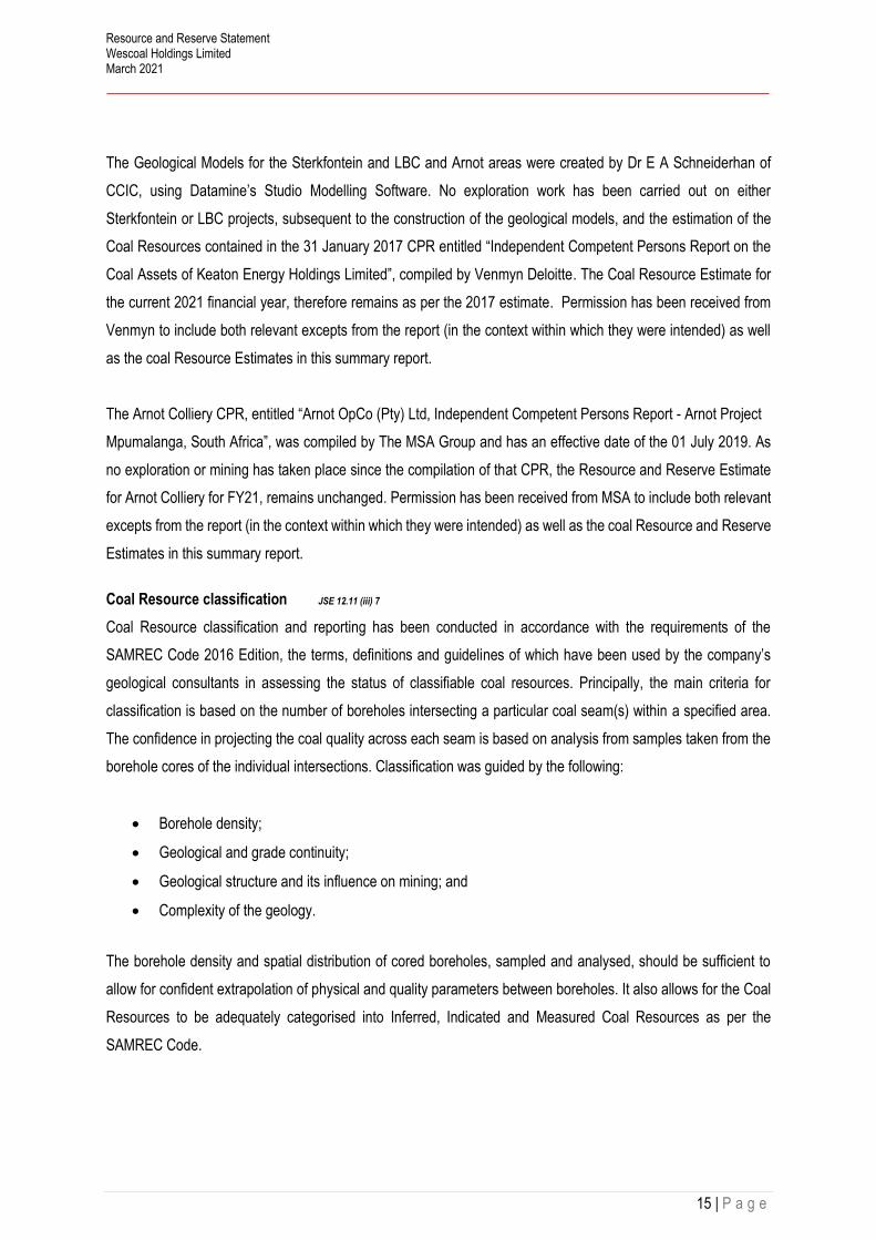
The Geological Models for the Sterkfontein and LBC and Arnot areas were created by Dr E A Schneiderhan of
CCIC, using Datamine’s Studio Modelling Software. No exploration work has been carried out on either
Sterkfontein or LBC projects, subsequent to the construction of the geological models, and the estimation of the
Coal Resources contained in the 31 January 2017 CPR entitled “Independent Competent Persons Report on the
Coal Assets of Keaton Energy Holdings Limited”, compiled by Venmyn Deloitte. The Coal Resource Estimate for
the current 2021 financial year, therefore remains as per the 2017 estimate. Permission has been received from
Venmyn to include both relevant excepts from the report (in the context within which they were intended) as well
as the coal Resource Estimates in this summary report.
The Arnot Colliery CPR, entitled “Arnot OpCo (Pty) Ltd, Independent Competent Persons Report - Arnot Project
Mpumalanga, South Africa”, was compiled by The MSA Group and has an effective date of the 01 July 2019. As
no exploration or mining has taken place since the compilation of that CPR, the Resource and Reserve Estimate
for Arnot Colliery for FY21, remains unchanged. Permission has been received from MSA to include both relevant
excepts from the report (in the context within which they were intended) as well as the coal Resource and Reserve
Estimates in this summary report.
Coal Resource classification JSE 12.11 (iii) 7
Coal Resource classification and reporting has been conducted in accordance with the requirements of the
SAMREC Code 2016 Edition, the terms, definitions and guidelines of which have been used by the company’s
geological consultants in assessing the status of classifiable coal resources. Principally, the main criteria for
classification is based on the number of boreholes intersecting a particular coal seam(s) within a specified area.
The confidence in projecting the coal quality across each seam is based on analysis from samples taken from the
borehole cores of the individual intersections. Classification was guided by the following:
• Borehole density;
• Geological and grade continuity;
• Geological structure and its influence on mining; and
• Complexity of the geology.
The borehole density and spatial distribution of cored boreholes, sampled and analysed, should be sufficient to
allow for confident extrapolation of physical and quality parameters between boreholes. It also allows for the Coal
Resources to be adequately categorised into Inferred, Indicated and Measured Coal Resources as per the
SAMREC Code.

Resource and Reserve Statement Wescoal Holdings Limited March 2021
16 | P a g e
Coal Resource classification based on core borehole density (points of observation supported by analytical data)
is as follows:
• Measured: 16 core boreholes per 100ha (350m x 350m grid),
• Indicated: four core boreholes per 100ha (500m x 500m grid spacing); and
• Inferred: one core borehole per 100ha (approximately 1km x 1km grid).
Geological losses varying between 5% and 20% are applied on a project by project basis.
Under the SAMREC Code, particular reference is made to the South African Guide to the Systematic Evaluation
of Coal Resources and Coal Reserves – South African National Standard (SANS 10320:2004). Reporting is also
in accordance with section 12.11 of the JSE Listings Requirements.
Coal Reserves JSE 12.11 (iii) 7
The Coal Reserve Estimates have been compiled by Mr. Leon Raaths of Miptec and the Coal Reserve estimation
methodology is described below.
It is important that the geological and mining modelling packages provide the primary order-of-magnitude cross-
checks of the in-situ volumes, relative densities and tonnages. Runge Pincock Minarco (RPM) Global’s Open Cut
and underground Coal XPac package as the pit design and scheduling software was used, which provides this
first GTIS reconciliation based on the primary exploration inputs, both structural and quality. With an excellent
correlation on GTIS estimates the XPac model is deemed an appropriate and reasonable representation of the
geological model. Wescoal utilise Deswick software to conduct LOM schedules, based on the same geological
models from Stratmodel. The Wescoal LOM reserves for the various assets compared favourably with that
replicated on the XPac modelling software by Miptec. Modifying factors applied in the reserving process are listed
in the respective sections of this report. In-pit seam losses and practical coal processing plant yields are the key
parameters which are constantly monitored and modified in the forward-looking models to inform realistic
expectations of future production.
Only Indicated and Measured Coal Resources are included for LOM scheduling model purposes. In the event that
an Indicated or Measured Coal Resource block is geographically isolated and cannot be accessed without
including Inferred Coal Resources into the schedule, that block is excluded. In this instance, additional drilling will
be recommended in order to upgrade the appropriate coal blocks to at least an Indicated Coal Resource
categorisation before the isolated block could be considered in LOM and Coal Reserve scheduling. In general
terms, resource blocks for which an Indicated Coal Resource categorisation has been applied qualify as a Probable

Resource and Reserve Statement Wescoal Holdings Limited March 2021
17 | P a g e
Coal Reserve, and blocks for which a Measured Coal Resource categorisation has been applied qualify as Proved
Coal Reserve.
It must be noted that although Miptec constructed LOM scheduling models, no LOM scheduling was conducted.
Wescoal commenced with a program to execute Budget and LOM scheduling and planning inhouse. The current
LOM information provided was compared on a total reserve basis, excluding quality and product information,
Miptec therefore reverted to the existing XPac LOM mining models for Coal Reserve Estimation purposes. It is
recommended that Wescoal follow due process to reconcile critical modifying factors, compare the mining model
to the geological model information to ensure correlation of information, to not only schedule the mining processes
but to also simulate the coal flow with the required product qualities and yields. It is also recommended that all cost
and revenue drivers are reported from the schedule for financial evaluation purposes.
Exploration activities and expenditure JSE 12.10 (e) (i – iii), JSE 12.10 (h) VI), JSE 12.11 (iii) 1
Of the total Coal Resources estimated at 410.1 Mt, approximately 33% is in the Measured category. Wescoal
manages an ongoing drilling program as part of their short-term technical control processes to validate the mining
and coal quality parameters on the operating assets.
Table 4. Asset resource category summary
ASSET RESOURCES IN
MEASURED
RESOURCES IN
INDICATED
RESOURCES IN
INFERRED
Elandspruit Colliery 100%
Khanyisa Colliery 100%
Vanggatfontein Colliery 71% 29%
Moabsvelden Colliery 93% 7%
Leeuw Braakfontein 100%
Sterkfontein 55% 45%
Arnot 39% 37% 24%
Table 4 provides a summary on the Coal Resource category distribution for each asset.
Table 5 indicates actual expenditure for the last reporting period whereas Table 6 details the planned exploration
budget for the ensuing periods.

Resource and Reserve Statement Wescoal Holdings Limited March 2021
18 | P a g e
Table 5. Exploration expenditure FY21
As per Table 5 above, the only expenditure was incurred at Elandspruit due to the drilling of nine infill boreholes.
Table 6 below details the planned expenditure in both VGF and Elandspruit.
Table 6. Planned Exploration expenditure FY22
MINE DESCRIPTION / PIT ZAR (M)
Vanggatfontein (ERB) 0.0
Vanggatfontein (WRB) 0.0
Moabsvelden Boxcut 0.0
Khanyisa Triangle 2 (North) 0.0
Elandspruit 0.79
TOTAL 0.79
MINE DESCRIPTION / PIT ZAR (M)
Vanggatfontein (ERB) VG4 & VG5 0.0
Vanggatfontein (WRB) UG VG6 & VG7 0.8
Moabsvelden No drilling planned 0.0
Elandspruit Graspan North and South 0.6
Khanyisa No drilling planned 0.0
Sterkfontein No drilling planned 0.0
LBC No drilling planned 0.0
TOTAL 1.4

Resource and Reserve Statement Wescoal Holdings Limited March 2021
19 | P a g e
Elandspruit Complex
The Elandspruit Complex comprises both opencast and underground operations and is 100% owned by Wescoal.
Figure 3 show the locality plan for Elandspruit, it is located approximately 8 km west of the town of Middelburg on
the farm Elandspruit 291 JS and encompasses an area of 538 hectares. Location 25.80982°S latitude and
29.38474°E longitude.
JSE 12.9 (h)(iii)
Figure 3. Elandspruit Locality Map
Wescoal holds the Mining Right that was granted in October 2010 for a period of 16 years. A Water Use Licence
(WUL) was granted in May 2015. Elandspruit produced first coal during 2015 from the most northern pit and
progressed southwards with operations. The underground started producing in 2016 with access from the Nungu
Colliery underground operation towards the south of the R555 district road.
The LOM plan for Elandspruit is in line with the current mining strategy regarding both opencast and underground
operations.

Resource and Reserve Statement Wescoal Holdings Limited March 2021
20 | P a g e
Project Geology [JSE 12.10(h)(v)] [SR2.1]
No. 1 Coal Seam
The No. 1 Coal Seam increases in thickness from less than 1 m along the eastern boundary where the seam
pinches out, to over 4m in the western sector. In the opencast area, the seam averages 4 m in thickness whereas
in the underground area in averages 2.9 m. The depth to roof of the No. 1 Coal Seam ranges from less than 10 m
along the eastern boundary, to around 72 m at its deepest along the southern boundary (underground area). The
gently dipping seam generally ranges in elevation from about 1 520mamsl to 1 540 mamsl.
No. 2 Lower Coal Seam
The No. 2 Lower Coal Seam ranges in thickness from less than 1m in the area of the washout, to up to 6.5m in the
particularly in the north. It is unknown whether the anomalously thick seam is due to actual thickening of the coal
seam, or due to correlation errors, where the No. 2 Lower and No. 2 Upper Coal Seams are situated contiguously.
Due to the fact that in those boreholes where the No. 2 Lower Seam is thicker than the surrounding holes, the No.
2 Upper Seam is thinner than expected, this means that the anomalies with regard to the seam thicknesses are
probably attributable to the correlation errors, as the average overall Seam 2 sequence thickness remains constant
between 6 – 7m.
The No. 2 Lower Coal Seam is usually separated from the underlying No. 1 Coal Seam by less than 1m of
sediments, but the interval thickness increases to over 11m in the southern-eastern corner of the property.
In the southeast of the property, the seam is absent along a north-south trending zone approximately 400 to 500m
in width. It is possible that the seam was washed-out by a syn- or post-depositional fluvial channel. On either side
of the wash-out, the seam is relatively thin and exhibits elevated ash contents.
The depth to seam roof ranges from 10-20m along the eastern boundary, to over 60m in the south. The floor
elevation is relatively constant, between 1530 and 1550 across the licence area, with the exception of the
southwestern corner where is drops below 1520 mamsl.
No. 2 Upper Coal Seam
The No. 2 Upper Coal Seam thickness averages around 2.0m across the licence area, however it does attain
thicknesses of over 4.0m in the north. It is unknown whether the anomalously thick seam is due to actual thickening
of the coal seam, or due to correlation errors, where the No. 2 Lower and No. 2 Upper Coal Seams are situated
contiguously. As mentioned above, the overall No. 2 Seam sequence remains at a constant thickness between 6
– 7m in these areas, which may mean that the anomalously thick or thin seams is due to correlation errors. These
errors are not surprising considering the seams are often contiguous and without wireline logs, it may prove difficult
to differentiate between the two seams.

Resource and Reserve Statement Wescoal Holdings Limited March 2021
21 | P a g e
The interval between the No. 2 Upper and No. 2 Lower Coal Seams ranges from non-existent in the north to over
11m in the south. The depth to roof of the No. 2 Upper Coal Seam ranges from less than 10m along the eastern
boundary to over 50m in the south. The seam floor elevation is relatively constant around 1546 mamsl, however
this does drop to less than 1530 mamsl in the southwestern corner of the licence area.
No. 3 Coal Seam
The presence of the No. 3 Coal Seam is dictated by its proximity to the limit of weathering, as it is eroded in areas
of lower topographic elevation. It is the thinnest of the 4 seams, averaging 0.4m across the entire licence area, and
never attaining thicknesses of greater than 0.6m. The interval between the No. 2 Upper and No. 3 Coal Seams is
consistent across the property ranging from 12.0 to 15.5 meters. The depth to seam roof ranges from 10 – 20m in
approaching the sub-crop to around 45m in the south.
The No. 3 Seam accounts for approximately 4% of the total opencast resources at Elandspruit.
No. 4 Lower Coal Seam
The No. 4 Lower Coal Seam is present only in areas of elevated topography; elsewhere it has been eroded. It
ranges in thickness from less than 1m as the seam approaches the sub-crop, up to 2 – 3m. The 4L Seam is on
average 6 – 7m above the No. 3 Coal Seam. The depth to roof ranges from less than 10m up to 35m in the
southwest. The floor elevation ranges from 1550 – 1580 mamsl, indicating a gentle dip towards the south-west.
The No 4 Lower Seam accounts for approximately 10% of the total opencast resources at Elandspruit.
Dolerite and Faulting
Examination of the geological model noted that there are no major structural disturbances such as dolerite
displacements or faults. The major structural irregularity present is noted in the underground sections and is the
area where the No. 2 Lower Coal Seam is absent, due to a suspected washout.
No dolerite or faulting has been encountered during mining, and it is not envisaged that it will affect mining
operations in the future either.
Coal Resource Classification [SR4.4(i)]
The coal seams at Elandspruit are of the multiple seam coal deposit-type, defined in SANS10320:2020 as
“characterised by a discrete number of coal seams, typically between 0.5 and 7.0 m in thickness, separated by
interburden units with a thickness that generally significantly exceeds the thickness of the individual coal seams”.
The resource classification is based on the geological knowledge of the deposit, including that gained from
mapping, remote sensing, geophysics and drilling.

Resource and Reserve Statement Wescoal Holdings Limited March 2021
22 | P a g e
Only valid Points of Observation (“PoO”) were used to determine the resource classification categories of the
various coal seams at Elandspruit. PoO are based on the number of cored drill holes that have appropriate quality
data. The following drill hole spacings apply:
• Inferred Coal Resource 1 000 m;
• Indicated Coal Resource 500 m; and
• Measured Coal resource 350 m
Based on the distribution of valid PoO’S at Elandspruit, all coal seams are assigned to the Measured Category.
Coal Resources JSE 12.10 (h)vii) [12.10(a)] [SR1.4(iii), SR4.1(iv), SR4.5(ii)(iv)(v)(vii), SR6.1(i), SR6.3(vi)]
Currently all seams present within the delineated opencast areas are scheduled for mining, namely the No. 4 Lower
Coal Seam, No. 3 Coal Seam, No. 2 Upper and Lower Coal Seams and the No. 1 Coal Seam. Within the
underground mining area, only the No. 1 Coal Seam is targeted for mining. As such, all other seams have been
excluded from the UG estimations. This decision was made based on the principal that all seams should have the
potential for economic extraction.
Cut-offs Applied: [SR4.1(vi), SR4.2(i)(ii)(vi)]
• Minimum Seam thickness cut-off of 0.5m for opencast (all seams) and 0.4m for opencast S3, and 1.2m
for underground;
• Raw Ash cut-off > 50% (adb);
• Raw Volatile Matter Content <18% (adb);
• Seam thickness is true thickness;
• Coal within mining license boundary only;
o A 9m buffer was excluded along the license boundary
o Coal included under the powerline, as Wescoal and Eskom are in advanced discussions to move
it.
o Coal Areas mined up to 31 March 2021 Excluded
• Coal Under the wetlands buffer excluded; and
• Geological losses are applied to cover unforeseen losses due to dolerites and faults.
o Measured: 10%
o Indicated:15%
o Inferred:20%
MTIS Modifying Factors
• Minimum mineable seam thickness of 0.5 m applied to the opencast areas; and

Resource and Reserve Statement Wescoal Holdings Limited March 2021
23 | P a g e
• Minimum mineable seam thickness of 1.2 m was applied to the underground areas and a theoretical
maximum mining height of 4.5 m was applied to the underground resource estimates.
Figure 4. Elandspruit plan indicating resource blocks utilised for the 31 March 2021 estimation.
The Coal Resource estimates were conducted in accordance with the South African Code for Reporting of Mineral
Resources and Mineral Reserves Code (SAMREC 2016), as well as the South African guide to the Systematic
Evaluation of Coal Resources and Coal Reserves (SANS10320:2004).
The Coal Resource estimate has been independently estimated and signed off by Ms. K. Black of KJB GeoServices
and is declared as at 31 March 2021. The Elandspruit opencast Coal Resource Estimate comprises 9.67 Mt (100%)
Measured Coal Resource Estimates, and the underground Coal Resource Estimate comprises 1.96 Mt (100%
Measured), for a Total Resource Estimate of 11.62 Mt (MTIS).

Resource and Reserve Statement Wescoal Holdings Limited March 2021
24 | P a g e
Table 7. Elandspruit Resource Estimation as at 31 March 2021 JSE 12.9 (h) (ix)
All Coal qualities quoted on an Air-Dry Basis (ADB)
MTIS – Mineable Tonnes In Situ
ARD – Apparent Relative Density
CV – Calorific Value MJ/kg; VM – Volatile Matter (%); TS – Total Sulphur (%); IM – Inherent Moisture (%); FC – Fixed Carbon (%)
Thickness – greater than 0.5m for opencast estimates (0.4m for S3), and 1.2m for underground estimates
Raw Ash content greater than 50% excluded
Raw Volatile content less than 18% excluded
10% Geological losses applied (measured coal classification)

Resource and Reserve Statement Wescoal Holdings Limited March 2021
25 | P a g e
Table 8. Elandspruit F1.8 Coal Qualities as at 31 March 2021 JSE 12.10 (h) (ix)
Reconciliation [SR1.4(iii), SR4.5(vi)]
Table 7 reflects the end of March 2021 Coal Resource Estimates, and Table 9 compares the 2020 to 2021
Estimates, as well as the actual surveyed ROM tonnes (AR). The total change in Coal Resource Estimates is
3.03 Mt, with 3.84 Mt surveyed as ROM coal mined. The overall coal gain is 0.81 Mt, predominantly the result of
mining outside of the predicted model extent, and in the areas in close to where the seam sub-crops against the
limit of weathering.

Resource and Reserve Statement Wescoal Holdings Limited March 2021
26 | P a g e
Table 9. Elandspruit comparison of Resource Estimates 2020 and 2021
The gains on the No. 2U Seam (0.47 Mt), can largely be attributed to mining the seam where the qualities drop
below the model cut-off (thickness greater than 0.5m and a raw volatile matter cut-off of less than 18%). Within the
Yoctolux North and Pit 2, the No. 2U Seam coal resource was considerably reduced by removing coal with a raw
volatile content of less than 18%. In practice these areas are mined, thereby resulting in a large coal gain. The
gains on the No 1 Seam are attributed to the poor quality floor of the seam being mined. This coaly mudstone can
be up to 1m thick, with a CV of less than 10 MJ/kg. During the modelling process this floor is not included in the
seam selection, however in practice, it is mined. There is an increase in the No 4L seam when compared to last
year. This is due to the addition of the recently drilled boreholes confirming a slightly larger seam extent.
The addition of nine boreholes to the model would have had a negligible effect on the coal tonnes, noticeable with
the 3% drop in the No. 1 Seam estimation.

Resource and Reserve Statement Wescoal Holdings Limited March 2021
27 | P a g e
Table 10. Elandspruit comparison of Resource Qualities 2020 and 2021 JSE 12.11 (iii) 4, JSE 12.11 (iii) 8
Table 10 contains a quality reconciliation between FY20 and FY21, indicating no obvious change in the coal
qualities.
Coal Reserves [12.10(h)(vii)(ix)] [SR4.2(ii), SR4.5(i)(iii), SR5.1(i)(ii), SR5.2(ix), SR5.6(v), SR6.1(i)(ii)(iii), SR6.2(i), SR6.3(i)(vi)]
Coal Reserves for Elandspruit are based on the current mining strategy with regards to both opencast and
underground operations. Opencast operations are based on the standard strip mining and roll over methodology,
with underground being based on standard bord and pillar methodology with no secondary extraction.
Elandspruit only generated ROM mined from opencast of 3.0 Mt for FY 2021. Mining on the underground is still on
hold pending the selection of underground mining contractors and a redesign in order to delay some low seam
mining areas.

Resource and Reserve Statement Wescoal Holdings Limited March 2021
28 | P a g e
Figure 5. Elandspruit plan detailing the remaining Reserves at 31 March 2021
Table 11. Elandspruit Production History
Table 11 shows the 3-year production history for Elandspruit from both the opencast and underground operations
with increased FY21 production.
Table 12. Elandspruit Reserve History
UG
Seam 4 Seam 3 Seam 2U Seam 2L Seam 1 Seam 1
FY19 0.24 0.05 0.14 1.11 1.03 0.10 2.67
FY20 0.23 0.07 0.42 0.89 1.07 2.68
FY21 0.14 0.04 0.34 0.90 1.57 3.00
ELANDSPRUIT PRODUCTION HISTORY
OPENCASTTOTAL
DATE /
PERIOD

Resource and Reserve Statement Wescoal Holdings Limited March 2021
29 | P a g e
Table 12 shows the reserve estimation ROM and quality history for the last three reporting periods as at 31 March
for each year. Each year did realise coal gains, with no change in the estimated average qualities.
Table 13. Elandspruit Reserve Estimate as at 31 March 2021 JSE 12.9 (h) (ix)1.18
Table 13 details the updated Coal Reserve Estimate for Elandspruit with Table 14 showing the Coal Reserve
reconciliation to that reported for the previous year.

Resource and Reserve Statement Wescoal Holdings Limited March 2021
30 | P a g e
The reconciliation on the opencast Coal Reserves is predominantly due to the mining depletion during FY21. The
Coal Resources located under the powerline are still included with work ongoing to move this powerline to access
the coal pillar of approximately 0.57 M Rom tonnes.
Mining operations recovered more reserves than estimated during the previous reporting period. A gain of 0.01 Mt
was realised on the No. 4 seam ROM, whereas the No. 3 seam showed a loss of 0.06 Mt ROM. The No. 2U and
2L Seams are mined either as separate units or together depending on the presence of an inter-seam parting.
During the modelling process, a substantial amount of No. 2U Seam was excluded from Coal Resources based
on quality cut-offs applied (a VM content < 18% was excluded). Mining has, however, extracted more No. 2U Seam
than indicated, as result of the difficulty in distinguishing between the No. 2U and No. 2L Seams, where there is
no inter-seam or intra-seam partings, as well as mining the coal excluded from the estimations based on the quality
cut-offs applies. As a combined unit the No. 2U and 2L Seams show a net gain of 0.21 Mt ROM. The No. 1 Seam
shows a gain of 0.32 Mt, predominantly due to the mining of the No 1L seam, which is located directly below the
No 1 Seam, but excluded from the reserve estimates based on the quality cut-offs applied (ash > 50% excluded).
There is a total nett gain of 0.47 Mt estimated as per the reconciliation in Table 14. The underground No 1 seam
Reserve Estimation remains the same as stated in the 31 March 2020 estimation.
Table 14. Elandspruit Coal Reserve reconciliation on ROM estimations [SR1.4(iv), SR4.5(vi), SR6.3(iv)]
ROM modifying factors – Opencast [12.10(h)(vii)] [SR5.1(i)(ii), SR6.1(iii), SR6.2(i)]
Cut-offs Applied:
• Minimum seam thickness for OC areas – 0.5m (all seams except for the No. 3 seam, 0.4m);
• Minimum volatile content – 18% (adb); and
• Maximum Ash Content - 50% (adb).

Resource and Reserve Statement Wescoal Holdings Limited March 2021
31 | P a g e
Layout losses
• Layout off set from wetland buffer zones and exclusion zones; and
• Layout off set from boundary pillars with regard to pit final void and end wall positions.
Loss and contamination
• A total of 14% losses inclusive of the 10% geological loss;
• 4% contamination; and
• 4% additional moisture. Inherent + 4% surface moisture represent total moisture.
Reserves boundaries/ identified infrastructure
• Mining Right area excluding the 9m legal boundary pillar;
• 11KV Powerlines on the eastern boundary;
• Previously mined out areas; and
• Wetlands and exclusion zones.
The following calculations defined:
• Model tons = reserved tons adjusted by seam cut offs within the economical reserve footprint;
• MTIS (AD) = Model tons – geological losses; and
• ROM (AR) = Model tons – total losses + contamination + surface moisture.
ROM modifying factors – Underground [12.10(h)(vii)] [SR5.1(i)(ii), SR6.1(iii), SR6.2(i)]
Seam cut-off
• Minimum 1.2m; and
• Minimum Volatiles 18%.
Losses, contamination, moisture
• 10% geological loss;
• Maximum mineable seam height – 4 m;
• Contamination – 0.1 m of roof/floor; and
• Surface moisture – 4%.
Layout losses
• Barrier pillar between underground and opencast;
• Barrier pillars between panels; and
• Areas under wetland and buffer.

Resource and Reserve Statement Wescoal Holdings Limited March 2021
32 | P a g e
Mining
• In panel extraction of 62%.
Marketing
Elandspruit has a processing facility some 18km east from the mine, with a monthly capacity of 210 000 feed tons.
ROM coal is trucked from the mine and processed at this processing facility from where the product is again trucked
to clients. Elandspruit is providing thermal coal to Eskom and to Inland clients.
Environmental management and closure funding JSE 12.10 (h) (viii), JSE 11.11 (iii) 13
The Elandspruit’s Environmental Liability was assessed by Jaco Kleynhans (Jaco-K Consulting) as at May 2021
based on the DMRE guidelines, it amounts to R110 M incl. VAT, an increase of R17.3 M on an equivalent base
from the 2020 assessment. Rehabilitation backlog is increasing year on year. Wescoal Processing, which mainly
process ROM from the Elandspruit operation has a closure liability of R20 M. An increase of R0.59 M. on an
equivalent basis from the 2020 assessment. The Elandspruit Colliery closure assessment quantum of R110 M. is
exclusive of the processing liability.
The volume-based assessment for Elandspruit as compared to the DMRE guideline assessment for Mar 2021
show an indicative shortfall of R231 M. and R11 M. on Wescoal processing.
Environmental guarantees from Lombard insurance are in place dated October 2020 for Elandspruit to the value
of ZAR 92.6 M.
The LOM indicated a remaining mine life of 4 years, although the financial model made provision for R315.7 M. on
a total Net Present Value basis, it is highly recommended that an actual funding mechanism is put in place for
closure.
Future work
• Regarding the UG section, an underground mining contractor was selected, and a concept redesign, with
the mining contractor, to delay the low seam mining areas has been completed. Final designs will be
completed with start-up planned for FY22.
• Work on moving the powerline is in progress to access the coal pillar left behind (approximately 0.57 Mt.)
• Robust LOM planning process to be put in place

Resource and Reserve Statement Wescoal Holdings Limited March 2021
33 | P a g e
Risks JSE 12.10 (h) (x), SE 12.11 (iii) 10 [SR5.7(i)]
Table 15. Elandspruit Risks JSE 12.10 (h) (x), SE 12.11 (iii) 10 [SR5.7(i)]
TYPE OF RISK RISK MITIGATION LEVEL OF RISK
Profitability Increase in strip ratio Mining to an average strip ratio Medium
Rehabilitation Increase in backlog, resulting in financial
risk, especially with the June 2021
expected legislation that will move the
assessment to a volume-based approach
Reduce backlog on rehabilitation High
Closure Provision Not meeting closure commitments Funding mechanisms to be put in
place to ensure enough funds will
be available at closure. The mine
should consider an aggressive
concurrent rehabilitation strategy to
reduce closure liability
High
LOM Process Impacting economic viability Conduct the LOM process in
advance of the annual R&R
update.
Medium

Resource and Reserve Statement Wescoal Holdings Limited March 2021
34 | P a g e
Khanyisa Complex
The Khanyisa Complex comprises the Triangle Resource Area and the Catwalk Resource Area, which Wescoal
effectively owns 100%.
Figure 6 show the location of Khanyisa complex, it is located some 10km west of the town of Ogies in Mpumalanga.
It comprises portions of the farm Heuvelfontein 215 IR. The location of the complex is 26.042950°S latitude and
28.973325°E longitude.
JSE 12.9 (h)(iii)
Figure 6. Khanyisa Complex locality map
A WUL for the total integrated mining area was awarded in May 2016. The consolidated Mining right was awarded
in March 2017.
Both Triangle and Catwalk Areas are mined via opencast truck and shovels methods, with the difference being
that Catwalk extracts the No. 2 Seam pillars and roof coal left by previous underground mining, whereas the coal
seams are insitu at both Triangle North and South.

Resource and Reserve Statement Wescoal Holdings Limited March 2021
35 | P a g e
Local Geology [12.10(h)(v)] [SR2.1]
Five principal seams are developed at Khanyisa, namely the No. 1, No. 2, No. 3 and the No. 4 Lower and No. 4
Upper Coal Seams. The No. 5 Coal Seam is not present at all. The No. 1 Coal Seam is not considered economic
as it is either very thin (~1m thick) or not developed. Similarly, the No. 3 Coal Seam is also not considered economic
as it is on average only around 0.3m in thickness.
No. 1 Coal Seam
The No. 1 Coal Seam occurs directly on top of the Dwyka Group sediments in both the Triangle and Catwalk
Project areas. Undulations in the paleo-topography at the time of peat accumulation resulted in zones where the
No. 1 Coal Seam did not develop. The coal is highly variable in nature, ranging from Shaley to dull-lustrous. Due
to the fact that the seam is thin with relatively poor qualities, it is not considered economic at this stage.
The depth of weathering across the Catwalk and Triangle Areas averages 17m. It has been modelled and
considered when estimating resources.
No. 2 Coal Seam
The No. 2 Coal Seam is the main economic target. It is present in the Triangle Area as in-situ coal, and in the
Catwalk area as pillar and roof coal, as well as a small portion of in-situ coal.
Triangle Project Area
The No. 2 Coal Seam is present as in-situ coal in the Triangle Project Area, and is on average 5.90m thick. The
average depth to the No. 2 Coal Seam roof is 40.9 m, ranging from 38 m to 43 m. The coal is dull to lustrous in
nature with an average CV of 20.90 MJ/kg.
The No 2 Seam is separated from the No. 4 Lower Seam above by a parting ranging in thickness from 9.92 m to
12.22 m (average 10.84m).
Catwalk Project Area
The No. 2 Coal Seam has been historically mined using underground board and pillar methods in the Catwalk area
and therefore the majority of the resource area comprises roof and pillar coal. The average pillar height is 2.7m,
while the remaining roof coal ranges in thickness from 1.5 to 2.3m. The depth to seam roof ranges from 21 to 27m.
The CV for both the roof and pillar coal is in the region of 22.5 MJ/kg.
No. 4 Lower Coal Seam
The No. 4 Lower Coal Seam occurs across the majority of the Triangle Area, with the exception of a few areas to
the South where it has been eroded. The No. 4 Lower Coal Seam is not present in either Catwalk North or South.

Resource and Reserve Statement Wescoal Holdings Limited March 2021
36 | P a g e
The No. 4 Lower Coal Seam lies on average 0.6m above the No. 3 Coal Seam, where it is separated by a
sandstone band. The seam thickness is relatively constant, ranging in thickness from 3.7 to 4 m, averaging 3.84m
in thickness. The average coal quality is good; raw ash content around 25% and a raw CV of 22.7 MJ//kg.
The seam is unaffected by either faulting or dolerite.
No. 4 Upper Coal Seam
The No. 4 Upper Coal Seam occurs over the majority of the Triangle Project Area, with the exception of a few
areas in the south, where the seam has been removed by erosion. The seam is on average 4.10m thick, and
occurs directly above the No. 4 Lower Coal Seam. The coal quality is considerably poorer than the No. 4 Lower
Coal Seam. The ash content is in the region of 39.70% and the CV is on average 17.20 MJ/kg.
Dolerite and Faulting
The majority of the holes in the Catwalk Project area intersected dolerite, which has affected both the quality and
distribution of the coal measures. However, during the historical mining, the area where the No. 2 Coal Seam was
mined out underground, was limited to those areas where the coal was unaffected by the dolerite. As the current
Catwalk Project is a roof and pillar reclamation project of the existing mined out areas, this remaining coal is
unaffected as well.
Within the Triangle Project area, only 2 boreholes in the south-western corner of the licence area intersected
dolerite, and this had no effect on the coal qualities in that area. The No. 4 Upper Coal Seam to the east is however
devolatilised and a large portion removed from resources. Within triangle North, the seams are totally unaffected.
No faulting or dolerite has been encountered in any of the boreholes, or during the mining process.
Coal Resource Classification [SR4.4(i)]
The coal seams at Khanyisa are of the multiple seam coal deposit-type, defined in SANS10320:2020 as
“characterised by a discrete number of coal seams, typically between 0.5 and 7.0 m in thickness, separated by
interburden units with a thickness that generally significantly exceeds the thickness of the individual coal seams”.
The resource classification is based on the geological knowledge of the deposit, including that gained from
mapping, remote sensing, geophysics and drilling.
Only valid Points of Observation (“PoO”) were used to determine the resource classification categories of the
various coal seams at Elandspruit. PoO are based on the number of cored drill holes that have appropriate quality
data. The following drill hole spacings apply:
• Inferred Coal Resource 1 000 m;
• Indicated Coal Resource 500 m; and

Resource and Reserve Statement Wescoal Holdings Limited March 2021
37 | P a g e
• Measured Coal resource 350 m
Based on the distribution of valid PoO at Elandspruit, the coal seams are classified as Measured Category.
Coal Resources JSE 12.10 (h)vii) [12.10(a)] [SR1.4(iii), SR4.1(iv), SR4.5(ii)(iv)(v)(vii), SR6.1(i), SR6.3(vi)]
Current mining in Triangle (Figure 7 and Figure 8), is taking place on the remainder of Triangle South as well as
Triangle North (No. 4 and No. 2 Seams).
The Catwalk area to the south of the Triangle Resource Area, has opencast Coal Resources comprising roof and
pillar coal in the previously underground mined out areas. As per the diagram below, current mining is only taking
place in Catwalk South, on the No. 2 Seam roof and pillars.
The coal seams within the Khanyisa Colliery area are defined as multiple seam type as per SANS 10320:2004.
Coal Resources are declared for the No.2 and No 4 Coal Seams.
Figure 7. Khanyisa Colliery No 2 Seam Resource Areas

Resource and Reserve Statement Wescoal Holdings Limited March 2021
38 | P a g e
Figure 8. Khanyisa Colliery No 4 Seam Resource Areas.
The Coal Resource estimates were conducted in accordance with the South African Code for Reporting of Mineral
Resources and Mineral Reserves Code (SAMREC 2016)1, as well as the South African guide to the Systematic
Evaluation of Coal Resources and Coal Reserves (SANS10320:2004).
The Coal Resource estimate has been independently estimated and signed off by Ms. K. Black of KJB
GeoServices, and is declared as at 31 March 2021. The Khanyisa opencast Coal Resource Estimate comprises
1.94 Mt (100%) Measured Coal Resource Estimates, and the underground Coal Resource Estimate comprises
0.17 Mt (100% Measured), for a Total Resource Estimate of 2.11 Mt (MTIS).
Table 16. Khanyisa Resource Estimate Summary as at 31 March 2021 JSE 12.9 (h) (ix), JSE 12.11 (iii) 8
All Coal qualities quoted on an Air-Dried Basis (ADB)
MTIS – Mineable Tonnes In Situ

Resource and Reserve Statement Wescoal Holdings Limited March 2021
39 | P a g e
CV – Calorific Value MJ/kg; VM – Volatile Matter (%); TS – Total Sulphur (%); FC – Fixed Carbon (%); IM – Inherent Moisture (%)
Thickness – greater than 0.5m for opencast estimates, and 1.2m for underground estimates
Raw Ash content greater than 50% excluded
Raw Volatile content less than 18% excluded
JSE 12.9 (h)vii),
MTIS Modifying Factors [SR4.1(vi), SR4.2(i)(ii)(vi)]
The following factors were applied in order to determine the MTIS resource estimations:
• Minimum Seam thickness cut-off 0.5m opencast,
• Raw Ash cut-off < 50% (adb);
• Raw Volatile Matter Content >18% (adb);
• Seam thickness is true thickness;
• Coal within mining licence boundary only;
• Coal under the pipeline excluded; and
• Face positions as at 31 March 2021.
Geological losses are applied to cover unforeseen losses due to dolerites and faults.
• Measured: 10%;
• Indicated 15%; and
• Inferred 20%
Opencast Coal Resources were delineated based on the proximity of the coal seams to surface and the favourable
strip ratio of less than 1:4 (bcm/ton) overburden to coal tonnes in the Triangle Area and 1:6 (bcm/ton) in the
previously mined areas within Catwalk. A minimum mineable seam thickness of 0.5 m was applied to the opencast
areas, and no maximum mining height was applied. Within the previously mined out areas in the Catwalk Coal
Resource area, Coal Resources from pillars were determined based on an estimated 65% underground extraction
at an estimated mining height of 2.8m. Roof coal was calculated at the remaining modelled seam height. Previous
opencast mining provided an indication of minimum safe distance between the public road and opencast
excavations hence a 50m zone was excluded on the western boundary from Coal Resources.
Reconciliation [SR1.4(iii), SR4.5(vi)]
Table 17 indicates a change in the Triangle Resource of 0.87 Mt (MTIS), which is less than the mined-out total of
0.63 Mt, indicating a gain of 0.22 Mt, which is predominantly due to a total gain on both the No 2 and No 4 Seams.

Resource and Reserve Statement Wescoal Holdings Limited March 2021
40 | P a g e
The No. 5 Coal seam was mined at Triangle North, although it was not included in the Coal Resource Estimates.
The boreholes drilled in Triangle North drilled though the No. 5 Seam with the Tricone bit (no core recovery) as it
is located close to surface (~10m deep), within the weathered horizon. As such, no No. 5 Coal Seam was recovered
during the drilling process, and therefore it was not included in the geological model. There was a gain of 0.04 Mt
on the No 4 Seam – potentially due to mining coal which was excluded from the Coal Resource estimate due to a
quality exclusion/cut-off. The gain on the No 2 Seam is due to the mining of the No 2 Upper Seam (located directly
above the No 2 Seam), which was previously omitted from the resource estimates. The fact that this portion of the
seam is currently being mined, resulted in its addition to the current Coal Resource estimate (this was excluded in
the previous year).
Within the Catwalk area, there is a mining gain of 0.11 Mt for the current financial year.
Table 17. Khanyisa Colliery Resource reconciliation JSE 12.11 (iii) 8
Table 18 below details the quality reconciliation between FY21 and FY20. The most noticeable difference is the
drop in qualities with the Catwalk resource area (3% increase in the raw ash content and 1.5 MJ/kg decrease in
the CV content).
The qualities pertaining to the Triangle resource area have remained constant.
Table 18. Khanyisa Colliery Quality reconciliation JSE 12.11 (iii) 8

Resource and Reserve Statement Wescoal Holdings Limited March 2021
41 | P a g e
Coal Reserves JSE 12.11 (iii) 3
Coal Reserves for the Khanyisa complex were based on the proven opencast strip and pillar mining strategies,
and operations were executed as such throughout FY21. Mining focused on the Triangle North Block, extracting
most of the No 4 Seam coal and commenced on the No 2 seam. Mining continued on the Catwalk South pillar
mining area.
Fixed infrastructure is utilised with all major mining activities contracted out, together with the crushing and
screening plants. Additional mining contractor infrastructure exists to provide for the full service.
Figure 9 below illustrates the remaining No 2 seam Coal Reserves for both the Triangle and Catwalk areas, as at
31 March 2021.
FY 2021 FY2020 FY 2021 FY2020 FY 2021 FY2020
Mt Mt CV (MJ/kg) CV (MJ/kg) ASH (%) ASH (%)
Khanyisa Colliery Total 2.11 2.98 20.56 20.47 30.33 30.81
Triangle Opencast 1.94 2.73 20.57 20.33 30.43 31.21
5 Seam - - - - - -
4U Seam 0.39 0.76 17.29 17.31 38.96 39.11
4L Seam 0.42 0.73 22.72 22.85 24.12 24.35
2 Seam 1.13 1.24 20.90 20.70 29.84 30.38
Triangle Underground - - - -
4 Seam - - - -
2 Seam - - - -
Catwalk Total 0.17 0.25 20.47 22.01 29.12 26.53
2 Seam 0.17 0.25 20.47 22.01 29.12 26.53
Khanyisa Quality Reconciliation

Resource and Reserve Statement Wescoal Holdings Limited March 2021
42 | P a g e
Figure 9. Khanyisa Remaining Reserves plan as at 31 March 2021
Table 19. Khanyisa production history
Table 19 details the 3-year production history for the Khanyisa Complex, covering both the Triangle and the
Catwalk pillar reserves.
DATE /
PERIOD SEAM 5 Seam 4 SEAM 2 TOTAL
FY19 - 0.69 0.30 0.99
FY20 0.02 0.34 0.76 1.12
FY21 0.01 0.72 0.29 1.02
KHANYISA PRODUCTION HISTORY

Resource and Reserve Statement Wescoal Holdings Limited March 2021
43 | P a g e
Table 20. Khanyisa Reserve History
Table 20 shows the reserve history for Khanyisa covering the last three estimations as at 31 March of the individual
years. Apart from depletion, no significant changes in estimated coal qualities.
Table 21. Khanyisa Reserves Estimate Summary as at 31 March 2021 JSE 12.9 (h) (ix)

Resource and Reserve Statement Wescoal Holdings Limited March 2021
44 | P a g e
Table 22. Khanyisa Reserves Reconciliation 31 March 2021
Triangle ROM Coal Reserves of 1.42 Mt opencast as at 31 March 2021, will be crushed, screened and blended to
achieve the average product quality of >19 MJ/kg and higher. The yield for raw products is conservatively based
on a 98% recovery as the mine only has crush and screening processing facilities.
A total of 0.91 Mt ROM was extracted from the Triangle sections during FY21, with a nett gain of 0.06 Mt realised.
The loss of 0.1 Mt on the No. 2 Seam can be attributed to coal recovery and writing off of the peripheral coal lost
in the mining off-sets on the end-walls and pillars which remained from the commencement of the Triangle mining.
The 0.15 Mt gain on the No. 4 Seam is due to the mining of the No. 4 Upper Seam, in those areas where it was
removed from the coal resource and reserve estimates based on it not meeting the quality cut-offs applied (VM
content < 18% removed). An additional 0.01 Mt gain on the No 5 seam was realised. No No. 5 seam was modelled
or planned for, as it was not recovered during drilling (the No 5 Seam is shallow and was tricone drilled as part of
the softs).
A total of 0.11 Mt ROM coal was extracted from Catwalk during FY21. The change in Coal Reserves as tabulated
in Table 22 is 0.13 Mt ROM, indicating a loss of 0.03 Mt. The loss is due to poor recovery on the roof coal as part
of the pillar mining methodology as well as the removal of the in-situ coal pillars on both end-walls which were not
mined.
It is imperative that coal extraction on the Triangle No 2 seam is monitored closely as the bulk of planned production
will be realised from the No 2 Seam within the Triangle area.
The remaining reserves indicate a remaining life of mine of less than 1.5 years.

Resource and Reserve Statement Wescoal Holdings Limited March 2021
45 | P a g e
Wescoal is currently in negotiation with Mzimkhulu mine management to jointly mine the boundary pillar to the
north of the northern Triangle. This would allow Wescoal to recover coal currently sterilised in safety benches and
highwall access roads in excess of 0.4 Mt.
ROM modifying factors – Opencast JSE 12.10 (h)vii),
Seam cut off:
• Minimum seam thickness – 0.5m; and
• Minimum volatiles (AD) – 18%.
Layout losses:
• OC - The national road and an additional 50m off set on the western boundary for both Catwalk and
Triangle. This is within the 100m road buffer and based on previous approvals and safe operations; and
• OC - Triangle northern boundary up to and inclusive of the 9m boundary pillar. The pillar will be mined
jointly with the Mwelase operations and is included in Coal Reserves.
Loss and contamination:
• OC - A total of 14% losses inclusive of the 10% geological loss;
• OC - 4% contamination; and
• 4% additional moisture. Inherent + 4% surface moisture represents total moisture.
Reserve boundaries/ identified infrastructure:
• Mining Right area excluding the 9m legal boundary pillar;
• Public road on the west;
• Transnet pipelines crossing Catwalk and the Triangle Areas;
• Previously mined out areas; and
• Maximum ROM strip ratio of 4:1 for the Triangle and 6:1 for Catwalk.
The following calculations defined:
• Model tonnes = reserved tonnes adjusted by seam cut-offs within the economical reserve footprint;
• MTIS (AD) = Model tonnes – geological losses, inclusive of minimum and maximum seam height cut offs;
and
• ROM (AR) = Model tonnes – total losses + contamination + surface moisture (for underground pillars are
excluded).

Resource and Reserve Statement Wescoal Holdings Limited March 2021
46 | P a g e
Marketing
Khanyisa has an existing contract in place with Eskom for the Triangle Coal and markets the Catwalk Coal through
coal traders to the export market.
Environmental management and closure funding JSE 12.10 (h) (viii), JSE 11.11 (iii) 13
An assessment update of the current Khanyisa rehabilitation liability based on the DMRE guidelines was made by
Jaco Kleynhans dated May 2021, it amounts to R 60.1 M including VAT, an increase of R5.4 M. on a comparative
basis from the 2020 assessment.
The volume-based assessment for Khanyisa as compared to the DMRE guideline assessment for Mar 2021 show
an indicative shortfall of R66.2 M.
The rehabilitation backlog is increasing with most of the No 4 seam being mined and the No 2 seam lagging behind.
It is possible for both Triangle South and Catwalk to be depleted during FY 2022.
Environmental guarantees from Lombard insurance are in place dated October 2020 to the value of ZAR 54.8 m.
The LOM indicated a remaining mine life of 2 years, although the financial model made provision for R100.8 M. on
a total Net Present Value basis, it is highly recommended that an actual funding mechanism is put in place for
closure.
Future work
• Rehabilitation of the mining voids
• Mining of the boundary pillar
• Moving of the Transnet Pipeline
Risk s[JSE 12.10 (h) (x), SE 12.11 (iii) 10 [SR5.7(i)]
Table 23. Khanyisa Risks JSE 12.9 (h) (x), JSE 12.11 (iii) 10
TYPE OF RISK RISK MITIGATION LEVEL OF RISK
Recovery Triangle 2 seam Financial risk, losses on the
No. 2 seam in the floor
resulting in Coal Reserves
reduction and increase strip
ratios
Mine to monitor extraction
of 2 seam and coal
recovery
High
Rehab backlog increasing
year on year Increased liability that could
have a major financial
impact once the new
Plan rehabilitation and
reduce the backlog High

Resource and Reserve Statement Wescoal Holdings Limited March 2021
47 | P a g e
legislation has been
promulgated (June 2021)
Closure Provision Not meeting closure
commitments Funding mechanisms to be
put in place to ensure
enough funds will be
available at closure.
High

Resource and Reserve Statement Wescoal Holdings Limited March 2021
48 | P a g e
Vanggatfontein Colliery
Vanggatfontein is an open cast coal mining operation, 100% owned by Wescoal, situated in the Witbank Coalfield
of South Africa that mines the No.5, No.4 and No.2 Coal Seams using truck and shovel rollover mining methods
at an average rate of 340,000tpm run of mine (ROM). The No.5 Seam is processed through a 100tph plant for
domestic metallurgical and boiler markets (No.5 Seam Plant), whilst the No.4 and No.2 Seams are processed
through a 480tph plant which produces thermal coal for Eskom.
Figure 10 show the locality plan for Vanggatfontein, the colliery is located approximately 16km east southeast of
the town of Delmas, in the Mpumalanga Province of South Africa. It is situated on the farm Vanggatfontein 251IR
and covers an area of 1651.98ha, Located at 26.173055 S, 28.83555E.
Figure 10. Vanggatfontein Colliery Locality Map
In June 2009, Prospecting Right MP/30/5/1/1/2/1/416PR was successfully converted into a 20-year Mining Right
(MP/30/5/1//2/2/309MR). The Mining Right was executed on 23 February 2010 and unless cancelled or suspended
in terms of clause 13 of the Mining Right, or section 47 of the MPRDA (Act 28 of 2002), will continue in force for a
period of 20 years, ending on 22 February 2030.

Resource and Reserve Statement Wescoal Holdings Limited March 2021
49 | P a g e
Local Geology [12.10(h)(v)] [SR2.1]
Locally, three coal seams are developed across the licence area – namely the No. 5 Seam, No. 4 Seam, and the
No. 2 Seam. Within the opencast resource areas, the No. 2 and No. 4 Seams are the primary economic targets,
with the addition of the No. 5 Seam where present.
No. 2 Seam
The No. 2 Seam is the bottom most economic coal seam. The No. 2 Seam sequence includes the succession from
the top of the Transvaal Supergroup basement to the top of the No. 2 coal seam. Rocks of the Dwyka group and
overlying No. 1 and No. 2 Coal seams are included as well.
The No. 2 Seam is well developed over the majority of the licence area, until it subcrops towards the east. The
seam comprises zones of alternating bright and dull coal, with occasional shaley coal bands in places. On average
the seam is 6.3m thick. The floor of the seam is variable, ranging from a mudstone, to a highly silty sandstone, and
in places to a medium grained sandstone. The roof of the seam is also variable, generally comprising a coarse-
grained sandstone to granulestone, however, in some areas it comprises a carbonaceous mudstone.
The average depth to the No. 2 Seam is 46m across the ERB.
The parting between the No.2 and No. 4 seam above varies greatly in thickness between VG4 in the north and
VG5 in the south. In VG4, the parting ranges between 4 – 8m, whereas in VG5 it ranges between 14 – 20m. The
parting material comprises a basal, highly carbonaceous siltstone, interbedded siltstone, and fine-grained
sandstone, which is frequently bioturbated that grades upwards into a medium to coarse-grained arkosic
sandstone. In many places this succession is truncated by an erosive based channel sandstone, which forms a
fining-upwards sequence to the base of the No.4 Seam.
The No 2 Seam is separated from the No 4 Seam above by a parting of approximately 11 m in thickness.
No. 4 Seam
The No. 4 Seam sequence comprises the predominantly sandstone succession from the immediate roof of the No.
2 Seam, to the top of the No. 4 coal seam. The seam comprises zones of dull coal with bands of shaley coal
increasing towards the top (washing the coal ensures the removal of the shale partings). The seam averages 6.8m
in thickness across the ERB area. It is, however, thickest (8.4m) in VG4 and thinnest in VG5 (5.9m). Within the
WRB resource area, the seam averages 6.2m thick, however for resource estimation purposes, it is limited to 4.8m.
The average depth to the No. 4 Seam roof is 28m within the ERB, and 44m within VG6. The No 4 Seam depths
range from less than 20m to over 100m in the WRB. The floor of the seam may be formed by a carbonaceous

Resource and Reserve Statement Wescoal Holdings Limited March 2021
50 | P a g e
siltstone, a bioturbated fine to medium grained sandstone, or a well-developed medium to coarse grained and gritty
sandstone.
The sequence between the No.4 Seam and the base of the No.5 Seam is formed by a thick succession of
interbedded sandstones and carbonaceous siltstones, culminating in the rocks that form the immediate floor to the
No.5 Seam. This parting is consistently between 16 – 20m thick.
No. 5 Seam
The No. 5 Seam is only present across VG4 and a small portion of VG3. It has been removed by erosion in VG5.
The seam averages 1.3 m in thickness, and comprises bright coal, interbedded with thin stringers of carbonaceous
siltstone.
The immediate roof of the No.5 seam is formed by a succession of interbedded siltstones and sandstone or coarse-
grained glauconitic sandstone, here informally referred to as the “Glauconite Marker”. This marker horizon is
important in opencast mining operations as it forms an easily recognizable unit immediately above the No.5 seam
coal.
Structure
In 2013, a high resolution low-level aeromagnetic and radiometric survey was flown over the Vanggatfontein
Project area by Xcalibur Airborne Geophysics. This work included flying 350 line kilometers over 16.3km2. Survey
commissioning, airborne data acquisition and processing quality control, plus final data interpretation were
managed by GAP Geophysics (Proprietary) Limited (GAP). GAP is a Johannesburg based independent
geophysical consultancy focusing on integrated data interpretation and survey programme management for the
mineral exploration and mining sectors. This work mapped the areal distribution of the various dolerite dykes and
sills with a fair degree of confidence and concluded that any loss-of-ground mining concerns appeared to be largely
constrained to the WRB.
Within the ERB there have been a number of borehole which have intersected dolerites, many having a notable
effect on the coal qualities. Within VG3 and VG4 there is a transgressive sill which has affected the coal seams.
The affected areas are reasonably well delineated and are for the most part, removed from the coal resources.
Within VG4, both dolerite and faulting have been encountered.
Coal Resource Classification [SR4.4(i)]
The coal seams at Vanggatfontein are of the multiple seam coal deposit-type, defined in SANS10320:2020 as
“characterised by a discrete number of coal seams, typically between 0.5 and 7.0 m in thickness, separated by
interburden units with a thickness that generally significantly exceeds the thickness of the individual coal seams”.

Resource and Reserve Statement Wescoal Holdings Limited March 2021
51 | P a g e
The resource classification is based on the geological knowledge of the deposit, including that gained from
mapping, remote sensing, geophysics and drilling.
Only valid Points of Observation (“PoO”) were used to determine the resource classification categories of the
various coal seams at Elandspruit. PoO are based on the number of cored drill holes that have appropriate quality
data. The following drill hole spacings apply:
• Inferred Coal Resource 1 000 m;
• Indicated Coal Resource 500 m; and
• Measured Coal resource 350 m
Based on the distribution of valid PoO at Vanggatfontein the coal seams are classified as Measured, Indicated and
Inferred.
Coal Resources JSE 12.10 (h)vii) [12.10(a)] [SR1.4(iii), SR4.1(iv), SR4.5(ii)(iv)(v)(vii), SR6.1(i), SR6.3(vi)]
As the ERB is delineated as an opencast area (strip ratio < 4 bcm waste: tonne coal), all coal seams are included
for mining, namely the No. 5 Coal Seam, No. 4 Coal Seam and No. 2 Seams. The WRB is designated as an
underground area, and as such, mining of the No 4 Seam has been planned in VG6 and the No. 2 Seam within Pit
VG7. Wescoal has applied to undermine the wetlands in VG6, the application was filed more than a year ago and
is currently awaiting approval. As such, the No 4 Seam coal resources previously excluded from the resource
estimate have been included (1.36 Mt).
During the current financial year, it was determined that there is a large discrepancy between the model estimation
and mined/surveyed coal tonnes at Vanggatfontein VG4 pit. At present, besides coal lost due to mining practices,
the only other way to determine why the coal recoveries are less than the model and current boreholes predict, is
to drill additional boreholes at VG4. Due to the lack of confidence in the data pertaining to VG4, a decision was
made to downgrade the coal resource classification of the No 5, No 4 and No 2 Seams from the measured to the
Indicated categories, until the additional drilling information becomes available.
The coal seams within the Vanggatfontein area are defined as multiple seam type as per SANS 10320:2004. Coal
Resources are declared for the No.2, No.4 and No.5 Seams.
JSE 12.9 (h)vii),
Cut-offs Applied: [SR4.1(vi), SR4.2(i)(ii)(vi)]
• Minimum Seam thickness cut-off of 0.5m (opencast), 1.8m underground;
• Raw Ash cut-off > 50% (adb);
• Cumulative Float 1.8g/cm3 Volatile Matter Content <16%;

Resource and Reserve Statement Wescoal Holdings Limited March 2021
52 | P a g e
• Seam thickness is true thickness;
• Coal within mining license boundary only;
o A 9m buffer was excluded along the license boundary
o Coal under the road excluded,
o Face positions as at 31 March 2021
• Coal Under the wetlands buffer excluded; and
• Geological losses are applied to cover unforeseen losses due to dolerites and faults.
o Measured: 10%,
o Indicated 15% and
o Inferred 20%
MTIS Modifying Factors:
• Minimum mineable seam thickness of 0.5 m applied to the opencast areas and 1.8m minimum mining
height to the underground areas; and
• A maximum mining height of 4.8m was applied to the underground Coal Resource estimations (VG6 and
VG7 Pits).
Figure 11. Vanggatfontein No. 5 Seam Resource Plan

Resource and Reserve Statement Wescoal Holdings Limited March 2021
53 | P a g e
Figure 12. Vanggatfontein No. 4 Seam Resource Plan
Figure 13. Vanggatfontein No. 2 Seam Resource Plan
The Coal Resource estimates were conducted in accordance with the South African Code for Reporting of Mineral
Resources and Mineral Reserves Code (SAMREC 2016)1, as well as the South African guide to the Systematic
Evaluation of Coal Resources and Coal Reserves (SANS10320:2004).

Resource and Reserve Statement Wescoal Holdings Limited March 2021
54 | P a g e
The coal resource estimate has been independently estimated and signed off by Ms. K. Black of KJB GeoServices,
and is declared as at 31 March 2021. The VGF ERB opencast Coal Resource Estimate comprises 10.66 Mt (60%)
Measured, 7.02 Mt (30%) Indicated, and 0.1 Mt (1%) Inferred Coal Resource Estimates, for a total opencast Coal
Resource estimate of 17.79 Mt. The VGF WRB underground estimate comprises 6.60 Mt (100%) measured Coal
Resource estimations. The total combined Coal Resource Estimate at VGF is 24.38 Mt (MTIS).
Table 24 details the VGF coal resource estimation.
Table 24. Vanggatfontein Resource Estimate as at 31 March 2021
All Coal qualities quoted on an Air-Dried Basis (ADB)
MTIS – Mineable Tonnes In Situ
ARD – Apparent Relative Density
CV – Calorific Value MJ/kg; VM – Volatile Matter (%); TS – Total Sulphur (%); IM – Inherent Moisture (%); FC – Fixed Carbon (%)
Thickness – greater than 0.5m for opencast estimates (0.4m for S3), and 1.2m for underground estimates
Raw Ash content greater than 50% excluded
Raw Volatile content less than 18% excluded

Resource and Reserve Statement Wescoal Holdings Limited March 2021
55 | P a g e
Table 25. Vanggatfontein F1.8 Coal Qualities as at 31 March 2021
Reconciliation [SR1.4(iii), SR4.5(vi)]
Table 26 below details the Resource reconciliation whereas Table 27 details the quality reconciliation.
The change in Coal Resource Estimates between FY20 (28.63 Mt) and FY21 (24.38 Mt), is predominantly due to
mining depletion. The WRB has in increase of 1.36 Mt due to the inclusion of the resources under the wetland
(permission to undermine the wetlands is imminent). In the ERB, the large losses on both the No 4 and No. 2
Seams are still largely unexplainable, and it is suggested that additional boreholes be drilled, particularly in VG4
where the largest losses occur. Year on Year, the mining practices, together with a model adjustment (removed
anomalously thick borehole in VG4), Vanggatfontein has realised a loss of almost 2.0 Mt of coal.
Regarding the quality comparisons, there are no noticeable changes between the qualities declared for FY20 and
FY21.

Resource and Reserve Statement Wescoal Holdings Limited March 2021
56 | P a g e
Table 26. Vanggatfontein Resource Reconciliation
Table 27. Vanggatfontein Quality Reconciliation
Marketing
Wescoal has an offtake agreement with Eskom to supply a minimum of 160,000tpm at 21.5 MJ/kg CV, 21 % VM
product delivered to a designated power stations, although the initial agreement has come to an end, Keaton
Mining provided documentation confirming a one year extension. The mine is in the process to exercise the option
to extend further and to also increase the offtake to accommodate coal from additional projects mainly focused on
the WRB. The metallurgical coal produced is sold on an ad-hoc basis to various domestic metallurgical customers.
Coal Reserves JSE 12.11 (iii) 3
Vanggatfontein is currently operated as an opencast mining operation based on contractor truck and shovel strip
mining and roll over methodology. Opencast mining at Vanggatfontein contributed to the 3.16 Mt ROM being
extracted during FY21. Boxcut operations are in progress at the VG5 pit, with initial No 4 Seam ROM extracted.

Resource and Reserve Statement Wescoal Holdings Limited March 2021
57 | P a g e
The current remaining Coal Reserves of 17.5 Mt ROM at the planned production rate provides for a 5-year Life on
the Vanggatfontein opencast operations.
The Vanggatfontein underground section construction phase on the WRB will commence with the construction of
the Coal Handling and Processing Plants, followed by the construction of the underground access.
Current projects are focused on increasing the ROM Coal Reserves by focusing on low quality thermal coal markets
and additional underground mining potential.
Table 28. Vanggatfontein production history
Table 28 shows the last 3 years annual production at Vanggatfontein Colliery.
Table 29. Vanggatfontein Reserves estimates 31 March 2021
DATE / PERIOD SEAM 5 SEAM 4 SEAM 2 TOTAL
FY19 0.10 1.52 1.07 2.68
FY20 0.12 1.27 0.80 2.19
FY21 0.20 2.06 1.35 3.61
VANGGATFONTEIN PRODUCTION HISTORY

Resource and Reserve Statement Wescoal Holdings Limited March 2021
58 | P a g e
Table 30. Vanggatfontein Reserve History
Table 30 shows the reserve history for Vanggatfontein Colliery for the last three estimations as at 31 March of each
year. The VG6 underground increase in reserves are based on the inclusion of 4 seam coal under the western
wetland. The environmental application was submitted more than a year back, actual approval is expected in due
course. This additional reserve was included in the offer to Eskom and form part of the off-take agreement that will
be finalised in the near future.
Table 31. Vanggatfontein ROM Reserve Reconciliation as at 31 March 2021
Table 31 details the results of the Coal Reserve reconciliation from the FY20 Estimate to the current FY21 Estimate.
A nett loss of 1.7 Mt ROM is indicated on the ERB. This loss is mainly due to significant recovery changes in VG4
as measured against the current geological model. Wescoal will be launching a drill campaign to twin selected

Resource and Reserve Statement Wescoal Holdings Limited March 2021
59 | P a g e
holes and to add additional holes to the current borehole database. In addition, a review of the current mining
practices will be undertaken in order to establish the exact cause and extent this will have on the remaining
reserves.
Figure 14 illustrates the Coal Reserves plan for the Vanggatfontein mining areas, indicating the remaining Coal
Reserve areas on the No.2 seam for opencast and the No. 4 seam for underground.
The WRB underground section is planned on the standard bord and pillar methodology with no secondary
extraction. The decision to change to an underground mine was based on recent drilling results as well as quality
requirements for new coal sales agreements. The results indicated that the extent of the No. 2 Seam
devolatilisation was greater than previously modelled, and as such, the majority of the No. 2 Seam did not meet
the minimum specifications as required by Eskom. The result of the removal of the devolatilised No. 2 Seam from
Coal Reserves, together with the fact that the road separating the VG4 and VG6 pits will not be diverted, meant
that the opencast option is not viable for most of the WRB.
Mining of the No. 4 Seam underground was analysed as alternative for the WRB. Information obtained from the
last two drill campaigns included geotechnical work and rock engineering work related to underground mining of
the No. 4 seam. The planned underground was based on a minimum height of 2 metres and maximum mining
height of 4.8 metres, targeting the No. 4 Seam Select only as a raw crush and screen ROM feed to Eskom. The
underground design was based on rock engineering designs provided by Associated Rock Mechanics Services
(ARMS).

Resource and Reserve Statement Wescoal Holdings Limited March 2021
60 | P a g e
Figure 14. Vanggatfontein Reserves Plan 31 March 2021
ROM modifying factors – Opencast JSE 12.10 (h)vii),
Cut-offs Applied:
• Minimum seam thickness for OC areas – 0.5m;
• Localised areas of poor-quality coal were included by reducing the raw quality cut off parameters
o It must be noted that the product to Eskom is a blended washed product that met the
specifications irrespective of the low-quality areas that were included in the actuals mined
o Raw Dry Ash Free volatile cut off on 20% per mining block, per coal seam as opposed to
averages where below 24% is not accepted by the client.
o Raw ASH of 50% on a localised basis as opposed to a maximum of 45% generally not accepted
by the client.
Layout losses
• Layout off set from wetland buffer zones and exclusion zones; and
• Layout off set from boundary pillars with regards to pit final void and end wall positions.
Loss and contamination
• Total losses applied inclusive of geological losses

Resource and Reserve Statement Wescoal Holdings Limited March 2021
61 | P a g e
• Recovery reconciliation on Vanggatfontein based on 9-months actual, indicated that VG4 required a
substantial adjustment for both the No 4 and No 2 seam. Comparison of actual mining thickness to
boreholes confirmed the lower recovery. Current investigations are focused on mining practice with
regard the top of both the No 4 and No 2 seam, possible re correlation of seam plies and the drilling of
additional boreholes to confirm current information as well as increasing borehole density. Table 32 below
indicates the updated modifying factors applied to the VGF reserves.
Table 32. Updated Modifying Factors
AREA/Seam VG3-S4 VG3-S2 VG4-S5 VG4-S4 VG4-S2 VG5-S4 VG5-S2
Total Loss 12% 18% 15% 25% 30% 12% 18%
Contamination 4% 4% 4% 4% 4% 4% 4%
Surface moisture 4% 4% 4% 4% 4% 4% 4%
Indicative Coal Recovery 95% 89% 92% 81% 76% 95% 89%
Reserve boundaries/ identified infrastructure
• Mining Right area excluding the 9m legal boundary pillar;
• Previously mined out areas; and
• Wetlands and exclusion zones.
The following calculations defined:
• Model tons = reserved tons adjusted by seam cut offs within the economical reserve footprint;
• MTIS(AD) = Model tons – geological losses; and
• ROM (AR) = Model tons – total losses + contamination + surface moisture.
ROM modifying factors - Underground
Seam cut-off
• Minimum 2m; and
• Minimum Volatiles 18%.
Losses, contamination, moisture
• 10% geological loss;
• Maximum mineable seam height – 4.8m;
• Surface moisture – 4%.
Layout losses

Resource and Reserve Statement Wescoal Holdings Limited March 2021
62 | P a g e
• Barrier pillar between underground and opencast;
• Barrier pillars between panels; and
Future work:
• Plan rehabilitation of VG3;
• Project work at VG7 for a small UG section, accessed from VG3 Highwall;
• Finalise VG6 Underground implementation plan;
• Additional drilling at VG4, review seam correlation, current mining practices impacting on coal recovery
and implement a monthly coal recovery reconciliation; and
• Update to the Geological and mining models with updated LOM and financial evaluation
Environmental management and closure funding JSE 12.10 (h)vii),
An assessment update of the current rehabilitation liability based on the DMRE guidelines was made by Jaco
Kleynhans dated Apr 2021, it amounts to R 225.2 M including VAT, an increase of R31.2 M. on a comparative
basis from the 2020 assessment.
The year on year increase in backlog is a concern, the commencement of operations in Pit VG5 has increased the
areas disturbed. With VG3 pit nearing completion, this will provide an opportunity to reduce the backlog
considerably.
The volume-based assessment for Vanggatfontein as compared to the DMRE guideline assessment for Mar 2021
show an indicative shortfall of R754.7 M.
Keaton Mining (Pty) Ltd has a financial guarantee in place to provide for the current closure liability quantum for
Vanggatfontein in the event of unscheduled closure. The guarantee is provided by Centriq Insurance Innovation
(Centriq) and is valued at R194 M as at end of July 2020.
The LOM indicated a remaining mine life of 6 years, although the financial model made provision for R825 M. on
a total Net Present Value basis, it is highly recommended that an actual funding mechanism is put in place for
closure.
Risks JSE 12.10 (h) (x), SE 12.11 (iii) 10 [SR5.7(i)]
Table 33 below details the identified at Vanggatfontein.

Resource and Reserve Statement Wescoal Holdings Limited March 2021
63 | P a g e
Table 33. Vanggatfontein Risks
TYPE OF RISK RISK MITIGATION LEVEL OF
RISK
Operational - safety Highwall failures The work in progress on VG4 pit was reduced
significantly resulting in single highwall from 2
seam to 5 seam hard overburden with almost no
safety benches. The mine will slow down on 4 and
2 seam mining to re-establish the off sets and
benches on 5-seam.
High
Reserves – coal
recovery Financial risk, reduced
reserves and increase in
strip ratio
Monitor recovery on a monthly and even shorter-
term basis with associated regular inspections.
The VG4 area is mostly impacted, additional
drilling and review of the mining processes will be
done together with aligning the modifying factors
to that reconciled
High
Increase in
rehabilitation
backlog
Financial, with the
increase backlog comes
increased liability and
cost of financial
guarantees. The
promulgation of the new
legislation moving to a
volume-based
assessment has
significant risk with large
amount of backlog.
Plan to reduce backlog as part of operational
execution High
Closure Provision Not meeting closure
commitments Funding mechanisms to be put in place to ensure
enough funds will be available at closure. The
mine should consider an aggressive concurrent
rehabilitation strategy to reduce closure liability
High
LOM Process Impacting economic
viability Conduct the LOM process in advance of the
annual R&R update. Medium

Resource and Reserve Statement Wescoal Holdings Limited March 2021
64 | P a g e
Moabsvelden
Moabsvelden is Wescoal’s most recent commissioned colliery situated in the Witbank Coalfield of South Africa. It
will leverage synergies with the neighbouring Vanggatfontein approximately 4km to the south along the district
road. Moabsvelden ROM will be processed through a dedicated coal handling and processing plant to be
constructed on the WRB. This processing facility will also process the planned future production from the
Vanggatfontein Extension. In the interim, Moabsvelden utilises spare plant capacity at Vanggatfontein to process
some of the low-quality seams to enable the mine to provide required specification coal to its Eskom clients.
Figure 15 show the locality map for Moabsvelden that is located approximately 55km southwest of Emalahleni and
approximately 77km east of Johannesburg. More specifically it is located approximately 15km east of the town of
Delmas in the Mpumalanga province of South Africa, located at 26.15166S, 28.81833E.
Figure 15. Moabsvelden Locality Map
On 23 April 2013, the Moabsvelden prospecting right (No. F 2008/07/14/006) was successfully converted into an
18-year mining right (No. 10025 MR) when it was issued in the name of Neosho Trading, 86 (Pty) Limited (Neosho)
(registration No. 2008/010470/07). The mining right covers an area of 249.4ha and was issued in terms of Section

Resource and Reserve Statement Wescoal Holdings Limited March 2021
65 | P a g e
23(1) of the Mineral and Petroleum Resources Development Act, 2002 (Act 28 of 2002) with an effective date of
16 October 2013, expiring on 15 October 2031.
Local Geology [12.10(h)(v)] [SR2.1]
Locally, three coal seams are developed across the licence area – namely the No. 5 Seam, No. 4 Seam and the
No. 2 Seam. The No. 2 and No. 4 Seams are the primary economic targets, with the addition of the No. 5 Seam
where the thickness, quality and continuity allow. The No. 3 Seam is not developed at all.
The No. 4 Seam is divided into the No. 4 Lower (4L) and No. 4 Upper (4U) Coal seams, based on the presence of
a mudstone parting, which is on average 0.4m thick. The 4U is the poorer portion of the seam and requires
beneficiation to produce an Eskom product. The 4L is the better quality, lower portion of the seam and is suitable
for crushing and screening to produce an Eskom product. The parting between the 4 Seam and the 2 Seam ranges
from less than 0.5m in the north to almost 10m in the south. It also changes in nature from a carbonaceous
mudstone in the north, to a predominantly sandstone horizon in the south.
As per the No. 4 Seam, the No. 2 Seam is also split into a No. 2 Upper (2U) and No. 2 Lower (2L) Seam when
there is the presence of a mudstone parting. The 2P parting which separates the 2U from the 2L is on average
0.4m thick. The 2U is the poorer quality top portion of the seam and requires washing in order to make an Eskom
product, whereas the 2L is the higher quality lower half of the seam and is suitable for crushing and screening to
produce an Eskom product. There is a palaeo-high identified in the south-west of the licence area, and this has
had a direct impact on the nature and quality of the coal seams. In close proximity to this basement high, both the
No. 4 and No. 2 Seams display thinner seams, with higher ash contents.
Structure
Structurally notable is the presence of a transgressive sill along the western and northern extents of the mining
footprint. The coal seams in these areas are uplifted by as much as 20m. At this point, it is difficult to determine
whether the uplift is a direct result from actual faulting, or as a result from the intrusion of another (un-intersected)
sill. The sill that is present is located above the coal seams and therefore cannot be responsible for the uplift. As
such, a proposed fault was modelled in this area, with the assumption that the sill may have intruded along zones
of weakness caused by the fault. Additional operational drilling will assist in further understanding the structure in
this area.
Coal Resource Classification [SR4.4(i)]
The coal seams at Moabsvelden are of the multiple seam coal deposit-type, defined in SANS10320:2020 as
“characterised by a discrete number of coal seams, typically between 0.5 and 7.0 m in thickness, separated by
interburden units with a thickness that generally significantly exceeds the thickness of the individual coal seams”.

Resource and Reserve Statement Wescoal Holdings Limited March 2021
66 | P a g e
The resource classification is based on the geological knowledge of the deposit, including that gained from
mapping, remote sensing, geophysics and drilling.
Only valid Points of Observation (“PoO”) were used to determine the resource classification categories of the
various coal seams at Elandspruit. PoO are based on the number of cored drill holes that have appropriate quality
data. The following drill hole spacings apply:
• Inferred Coal Resource 1 000 m;
• Indicated Coal Resource 500 m; and
• Measured Coal resource 350 m
Based on the distribution of valid PoO at Moabsvelden, the coal seams are classified as Measured and Indicated.
Coal Resources JSE 12.10 (h)vii) [12.10(a)] [SR1.4(iii), SR4.1(iv), SR4.5(ii)(iv)(v)(vii), SR6.1(i), SR6.3(vi)]
Currently all seams present within the delineated opencast areas (strip ratio < 4 bcm waste: tonne coal) are
included for mining, namely the No. 5 Coal Seam, No. 4 Coal Seam and No. 2 Seams. The coal seams within the
Moabsvelden area are defined as multiple seam type as per SANS10320:2004. Coal Resources are declared for
the No.2, No.4 and No.5 Seams.
JSE 12.9 (h)vii),
Cut-offs Applied: [SR4.1(vi), SR4.2(i)(ii)(vi)]
• Minimum Seam thickness cut-off of 0.5m (opencast);
• Raw Ash cut-off > 45% (adb) applied to the 4L and 2L Seams (crush and screen);
• DAF Volatile Content < 27.5% excluded;
• Seam thickness is true thickness;
• Coal within mining license boundary only (9m boundary pillars excluded);
• Coal Under the wetlands buffer excluded; and
• Geological losses are applied to cover unforeseen losses due to dolerites and faults.
o Measured: 10%,
o Indicated 15% and
o Inferred 20%
MTIS Modifying Factors:
• Minimum mineable seam thickness of 0.5 m applied to the opencast areas; and
• No maximum mining height applied for opencast resource estimates.

Resource and Reserve Statement Wescoal Holdings Limited March 2021
67 | P a g e
The Coal Resource Estimates were conducted in accordance with the South African Code for Reporting of Mineral
Resources and Mineral Reserves Code (SAMREC 2016), as well as the South African guide to the Systematic
Evaluation of Coal Resources and Coal Reserves (SANS10320:2004).
The Coal Resource Estimate has been independently estimated and signed off by Ms. K. Black of KJB
GeoServices and are declared as at 31 March 2021. The Moabsvelden Opencast Coal Resource Estimates
comprise 28.66 Mt (93%) Measured and 1.99 Mt (7%) Indicated Coal Resource Estimates, for a Total Resource
Estimate of 30.65 Mt (MTIS). As Moabsvelden is not yet in steady state, the coal resource estimates were
calculated by using the actual mining depletion for FY21. All of the coal qualities were re-estimated from the model,
based on the depleted polygons.
All Coal Resources are reported as at 31 March 2021 and are inclusive of the Coal Reserves.
Provision has been made for a geological loss factor (discount). Losses may occur mainly as a result of intersection
of dolerite dykes, small-scaled faulting and other unforeseen geological losses.
The geological discounts applied are:
• Measured Resource - 13%;
• Indicated Resource - 17%; and
• Inferred Resource - 20%.
Table 34. Moabsvelden Resource Estimate as at 31 March 2021
All Coal qualities quoted on an Air-Dried Basis (ADB)
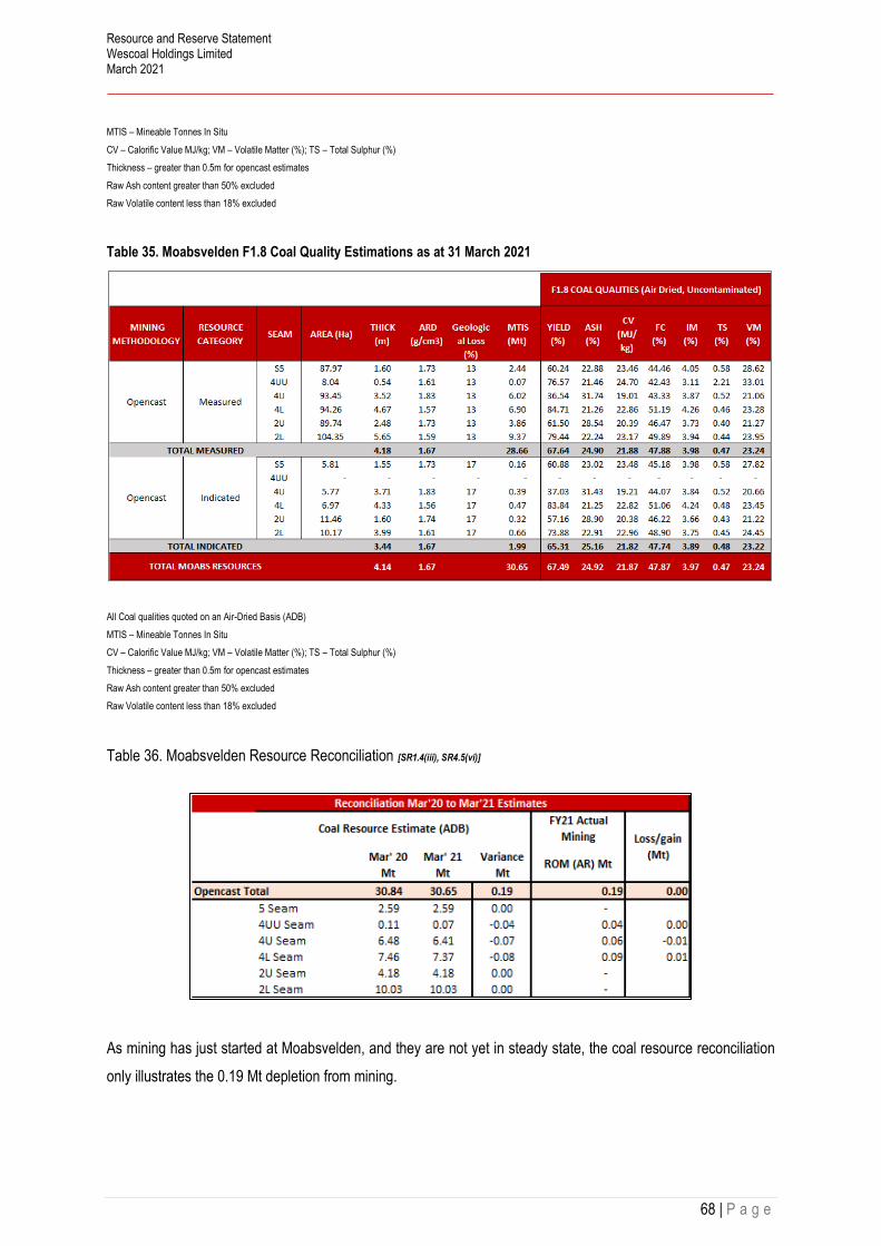
Resource and Reserve Statement Wescoal Holdings Limited March 2021
68 | P a g e
MTIS – Mineable Tonnes In Situ
CV – Calorific Value MJ/kg; VM – Volatile Matter (%); TS – Total Sulphur (%)
Thickness – greater than 0.5m for opencast estimates
Raw Ash content greater than 50% excluded
Raw Volatile content less than 18% excluded
Table 35. Moabsvelden F1.8 Coal Quality Estimations as at 31 March 2021
All Coal qualities quoted on an Air-Dried Basis (ADB)
MTIS – Mineable Tonnes In Situ
CV – Calorific Value MJ/kg; VM – Volatile Matter (%); TS – Total Sulphur (%)
Thickness – greater than 0.5m for opencast estimates
Raw Ash content greater than 50% excluded
Raw Volatile content less than 18% excluded
Table 36. Moabsvelden Resource Reconciliation [SR1.4(iii), SR4.5(vi)]
As mining has just started at Moabsvelden, and they are not yet in steady state, the coal resource reconciliation
only illustrates the 0.19 Mt depletion from mining.
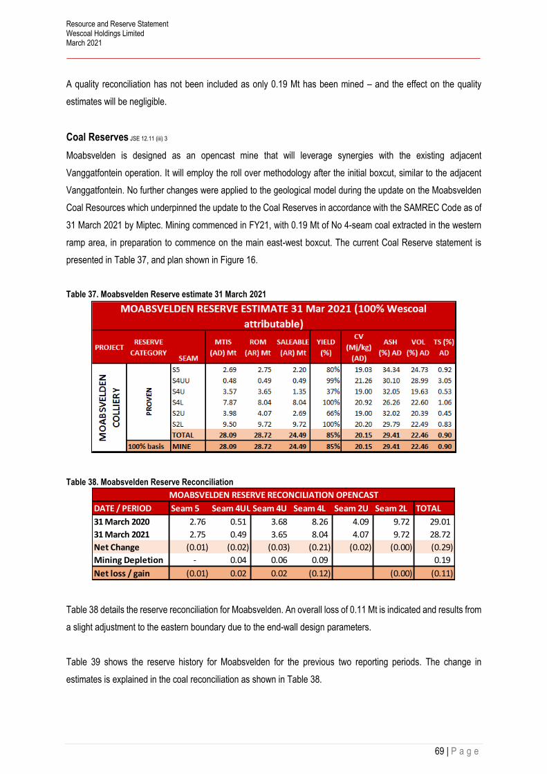
Resource and Reserve Statement Wescoal Holdings Limited March 2021
69 | P a g e
A quality reconciliation has not been included as only 0.19 Mt has been mined – and the effect on the quality
estimates will be negligible.
Coal Reserves JSE 12.11 (iii) 3
Moabsvelden is designed as an opencast mine that will leverage synergies with the existing adjacent
Vanggatfontein operation. It will employ the roll over methodology after the initial boxcut, similar to the adjacent
Vanggatfontein. No further changes were applied to the geological model during the update on the Moabsvelden
Coal Resources which underpinned the update to the Coal Reserves in accordance with the SAMREC Code as of
31 March 2021 by Miptec. Mining commenced in FY21, with 0.19 Mt of No 4-seam coal extracted in the western
ramp area, in preparation to commence on the main east-west boxcut. The current Coal Reserve statement is
presented in Table 37, and plan shown in Figure 16.
Table 37. Moabsvelden Reserve estimate 31 March 2021
Table 38. Moabsvelden Reserve Reconciliation
Table 38 details the reserve reconciliation for Moabsvelden. An overall loss of 0.11 Mt is indicated and results from
a slight adjustment to the eastern boundary due to the end-wall design parameters.
Table 39 shows the reserve history for Moabsvelden for the previous two reporting periods. The change in
estimates is explained in the coal reconciliation as shown in Table 38.
DATE / PERIOD Seam 5 Seam 4UUSeam 4U Seam 4L Seam 2U Seam 2L TOTAL
31 March 2020 2.76 0.51 3.68 8.26 4.09 9.72 29.01
31 March 2021 2.75 0.49 3.65 8.04 4.07 9.72 28.72
Net Change (0.01) (0.02) (0.03) (0.21) (0.02) (0.00) (0.29)
Mining Depletion - 0.04 0.06 0.09 0.19
Net loss / gain (0.01) 0.02 0.02 (0.12) (0.00) (0.11)
MOABSVELDEN RESERVE RECONCILIATION OPENCAST

Resource and Reserve Statement Wescoal Holdings Limited March 2021
70 | P a g e
Table 39. Moabsvelden reserve History
Figure 16. Moabsvelden Reserves as at 31 March 2021
Figure 16 shows a plan of the remaining reserves on the No 4 Seam where mining has commenced. All seams
are still unmined below the No 4 Seam.
Modifying Factors JSE 12.10 (h)vii),
The Mineable Coal Resources on Moabsvelden were limited largely by the extent of the buffer zone surrounding
the wetland in the north of the Moabsvelden licence area. Planning has been based on a 150m buffer between the
nearest workings and the wetland delineation, informed by the conditions set out in the WUL. Coal cut-offs of a
0.5m seam thickness, 24% DAFV except for 4U and 2U seams, which have a 20% DAFV cut-off applied as these
seams will be washed. Total losses of 15%, 3% contamination and 4% additional moisture for the As Received
calculation were applied.
DATE
MTIS
(AD) Mt
ROM
(AR) Mt
SALEABLE
(AR) MtYIELD (%)
CV
(Mj/kg)
(AD)
ASH (%)
AD
VOL (%)
ADTS (%) AD
FY2020 28.38 29.01 24.47 84% 20.18 29.32 22.47 0.90
FY2021 28.09 28.72 24.49 85% 20.15 29.41 22.46 0.90
MOABSVELDEN RESERVE HISTORY

Resource and Reserve Statement Wescoal Holdings Limited March 2021
71 | P a g e
Marketing
The integration of Moabsvelden into the Vanggatfontein complex has been designed to take advantage of existing
management and infrastructure, as well as to supply existing consumer segments. The No.5 Seam, No. 4U Seam
and No. 2U Seams will be selectively processed in a dense medium processing plant with the remainder of the
ROM only crushed and screened after which the two products will be blended and send to the client. ROM will be
processed at a planned new processing facility to be constructed on the WRB at Vanggatfontein.
Wescoal has an agreement to produce a low-quality Eskom product with an indicator calorific value of 18.8 MJ/kg,
a volatile matter content of 19% and an ash percentage not exceeding 35%. Eskom is currently engaging the mine
as part of a process to divert a portion of Moabsvelden product to Majuba PowerStation with an indicator value of
19.5 MJ/kg.
Future work:
• Plan and secure additional out of pit dumping space from neighbours; and
• Finalise processing plant designs and capacity - construction.
Environmental
Mining activities have commenced on the boxcut and infrastructure as at the date of this report. An assessment
update of the current Moabsvelden rehabilitation liability based on the DMRE guidelines was made by Jaco
Kleynhans dated May 2021, it amounts to R 41.7 M including VAT.
The volume-based assessment for Moabsvelden as compared to the DMRE guideline assessment for Mar 2021
show an indicative shortfall of R111.6 M.
Neosho Trading 86 (Pty) Ltd has a financial guarantee in place to provide for the current closure liability quantum
for Moabsvelden in the event of unscheduled closure. The guarantee is provided by Centriq Insurance Innovation
(Centriq) and is valued at R20m as at Sep 2016. Moabsvelden has an indicated life remaining of 10 years.
Risks [12.10(h)(x)] [SR5.7(i)]
TYPE OF RISK RISK MITIGATION LEVEL OF
RISK
Operational Waste Dump space Investigating use of neighbouring
surface area Medium
Dolerite Intrusions Although the sill has been extensively
surveyed (aeromag) and drilled, there
may be additional intrusive features that
Careful analysis and wireline
logging of the pre-split holes.
Regular sampling of the ROM coal.
Low

Resource and Reserve Statement Wescoal Holdings Limited March 2021
72 | P a g e
have not been identified. This may have
an impact on reserves, mining and coal
qualities.

Resource and Reserve Statement Wescoal Holdings Limited March 2021
73 | P a g e
Sterkfontein
The Sterkfontein Project is situated in the Highveld Coalfield of South Africa. It extends over portions of ten farms
and covers a footprint measuring approximately 16km in a north south direction, and approximately 9km in an east
west direction for a total area of 7,926ha. Exploration at Sterkfontein targets the No.4 Lower (No.4L) and No.4
Upper (No.4U) Seams of the Highveld Coalfield. It is planned for the Sterkfontein coal to be mined using an
underground bord and pillar method with the use of continuous miners. The coal is intended to be processed using
a double-stage circuit to produce a primary export thermal product and a middlings product for potential sale to
Eskom.
Figure 17 is a locality plan for Sterkfontein; the northern edge of Sterkfontein is located approximately 5km
southwest of the town of Bethal (Figure ES 22) in the Mpumalanga Province of South Africa, approximately 149km
east southeast of Johannesburg. The nearest main centre is the town of Ermelo, approximately 56km east of
Bethal, located at 26 degrees 31 minutes South, 29 degrees 24 Minutes East.
Figure 17. Sterkfontein Locality Map

Resource and Reserve Statement Wescoal Holdings Limited March 2021
74 | P a g e
Sterkfontein comprises five Prospecting Rights (PR) held in the names of Keaton Mining (Pty) Ltd (Keaton Mining)
and Labohlano Trading 46 (Pty) Limited (Labohlano). Most of these PR expired in 2017. Keaton timeously
submitted two mining right applications during December 2017 together with a section 102 application to
consolidate the rights when granted. Wescoal awaits DMRE’s response in this regard.
Historical Exploration
Prior to KEHL’s involvement, only four historical boreholes had been drilled on the Sterkfontein Project area. These
were drilled by AAC in 1969. Data for these boreholes were obtained from the CGS and, although they all
intersected coal, no information regarding the lithologies and coal qualities is currently available. Subsequent to
AAC relinquishing its rights, no additional boreholes were drilled on the property prior to the KEHL exploration
programmes.
No historical mining has taken place on any of the contributing properties associated with Sterkfontein.
Local Geology [12.10(h)(v)] [SR2.1]
The Sterkfontein Project area only hosts the No.5 and No.4 Seams with the No.2 Seam represented only by a
carbonaceous siltstone unit.
No 4 Seam
For exploration purposes the No.5 Seam forms a distinctive marker approximately 55m above the No.4 Upper
Seam. The No.5 Seam is thin, mostly being less than 40cm over the property. It occurs in most of the holes drilled
at a depth of between 130m and 175m.
No 4 Seam
The No.4 Seam is a composite seam which is often split by a sandstone or siltstone parting, creating a No.4 Upper
and No.4 Lower Seam. Typically, the quality of the No.4 Lower Seam is better than that of the No.4 Upper Seam
and is the main seam present on the project area. The No.4 Lower Seam ranges in thickness from a minimum of
0.18m to a maximum of 4.50m with an average of 1.64m. The overlying No.4 Upper Seam shows elevation
differences similar to those for the No.4 Lower Seam as would be expected. Based on statistical analysis of the
boreholes in the database the No.4 Upper Seam (where present) ranges in thickness from a minimum of 0.02m to
a maximum of 2.24m, averaging 0.74m
Two major dolerite sills have been identified on Sterkfontein which has an impact on the No.4 Seam structure on
the property.

Resource and Reserve Statement Wescoal Holdings Limited March 2021
75 | P a g e
Coal Resources JSE 12.10 (h)vii) [12.10(a)] [SR1.4(iii), SR4.1(iv), SR4.5(ii)(iv)(v)(vii), SR6.1(i), SR6.3(vi)]
The Coal Resource Estimates for Sterkfontein were most recently compiled by Dr EA Schneiderhan of CCIC Coal
and included in the 31 January 2017 CPR compiled by Venmyn Deloitte entitled “Independent Competent Persons
Report on the Coal Assets of Keaton Energy Holdings Limited”. As no recent work has been conducted on the
Sterkfontein, the Coal Resource Estimates contained in this report, are as per the 2017 Venmyn Deloitte CPR.
The coal seams within the Sterkfontein area are defined as multiple seam type as per SANS10320:2004. Whilst
both the No.5 and No.4 Seams of the Highveld Coalfield are present, the main economic target is however only
the No.4 (Upper and Lower) Seam.
For the Coal Resource Estimate, a minimum seam thickness of 1.4m has been used as a minimum practical mining
height of a Joy 14HM15 continuous miner and / or conventional drill and blast mining. No maximum mining height
was applied as the seam maximum thickness is 4.5m.
A minimum cut-off of 50% ash and 24% DAFV (to account for devolatilised coal as per the SANS10320:2004
guidelines) has been applied to all estimated Coal Resources. In order to convert GTIS to TTIS geological losses
of 10% and 15% have been applied to account for unexpected projected losses due to dolerite intrusions,
geological structure and geological complexity. No modelling error was applied. The application of a 1.4m mining
height was used to estimate the MTIS.
Table 40. Sterkfontein Project Resource Estimation as at 31 March 2020 (as per 2017 Venmyn CPR))
Coal Reserves
No Coal Reserves have been declared for Sterkfontein.

Resource and Reserve Statement Wescoal Holdings Limited March 2021
76 | P a g e
Coal market
Wescoal currently does not have an offtake agreement for saleable product at Sterkfontein but the coal quality
lends itself to a product for both the export and domestic thermal markets.

Resource and Reserve Statement Wescoal Holdings Limited March 2021
77 | P a g e
Leeuw Braakfontein Colliery
LBC is an advanced-stage exploration property situated within the Klip River Coalfield in South Africa. It extends
over portions of three farms and covers a total area of 1,951.66ha. LBC targets the Top and Bottom Seams of the
Klip River Coalfield. It is planned for the LBC coal to be mined using predominantly underground mining methods,
making use of the bord and pillar mining method, with the use of continuous miners. Shallow coal on the flanks of
the Coal Resource area have the potential to be extracted using open cast methods. The coal is planned to be
processed using a double-stage process targeting a primary export thermal product and a middlings product for
potential sale to Eskom.
Figure 18 shows the locality of LBC, which approximately 10km east-southeast of the town of Newcastle in the
KwaZulu-Natal province of South Africa. The project is situated approximately 30km southwest of Utrecht,
approximately 80km south of Volksrust, approximately 120km west of Vryheid and approximately 60km north of
the coal mining town of Dundee, located at 26.2047S, 28.8325E.
Figure 18. LBC Locality Map

Resource and Reserve Statement Wescoal Holdings Limited March 2021
78 | P a g e
LBC is 100% owned by Wescoal and comprises a single Mining Right (KZN 30/5/1/2/2/143 MR) issued to LBC.
Venmyn Deloitte has reviewed a copy of this Mining Right. The Mining Right was executed on 29 August 2007 and
unless cancelled or suspended in terms of clause 13 of the Mining Right, or section 47 of the MPRDA (Act 28 of
2002), will continue in force for a period of 30 years, ending on 28 August 2037.
LBC holds an approved EMP (dated 29 August 2007) and Mining Right (Ref No. KZN 30/5/1/2/2/143 MR), which
was awarded on 29 August 2007. This Mining Right will continue in force for a period of 30 years. However,
operations at LBC have not yet recommenced since the first box-cut excavation in 2008. An EMP amendment will
have to be conducted should Wescoal plan to proceed with activities.
Wescoal does not have an Environmental Authorisation at this stage. The EMP amendment process will have to
run concurrently with the NEMA EIA in line with the One Environmental System through the DMRE.
The current financial closure liability associated with LBC is ZAR4,1m.
Project History
Electronic data obtained from the CGS show that Braakfontein was historically explored with 1,486.33m drilled in
1951 and 1,254.86m drilled in 1956 on the contributing properties, respectively. CCIC Coal, which managed the
recent exploration on Braakfontein, compared the borehole collars in the CGS dataset against historic plan maps
obtained from Dave Thompson of DWT Consulting and confirmed their locations.
Details regarding drilling undertaken by Anglo Coal between 1989 and 1996 was obtained from the February 2001
Anglo Coal information memorandum. The information memorandum, which was used as part of the sale of the
Anglo Coal KwaZulu-Natal Holdings portfolio, included particulars about Braakfontein containing details about the
105 65.0mm size vertical diamond boreholes that were drilled in the so called then “Braakfontein Block”, most of
which is included in the current Braakfontein project area.
During the Anglo Coal exploration, boreholes logs were captured in the field by the relevant geologists and then
drafted into typed large format hard copy logs, which were signed off by the chief geologist of the day. All of the
Anglo Coal boreholes drilled during 1996 on Braakfontein document Mr K Chetty as the logger and sampler. The
Anglo Coal borehole logs contain data as to borehole lithological column, coal logs, recoveries and sample widths,
sample number and analysis as well as listing the drilling company, the drilled date, the core diameter, the logger
and sampler and coal laboratory. Samples were taken of coal seams only with a single sample for the Bottom
Seam and up to two samples for the Top Seam, split into an upper select and a lower non-select with parting.
During 1989 to 1990 Anglo Coal used Richlab for analysis. Notes on the Anglo Coal logs show that the 1996
boreholes were all analysed internally at the Anglo Coal Laboratories (ACCL)

Resource and Reserve Statement Wescoal Holdings Limited March 2021
79 | P a g e
No historical mining has taken place on any of the contributing properties associated with the Braakfontein Project.
Local Geology [12.10(h)(v)] [SR2.1]
Braakfontein hosts the complete succession of coal seams as previously documented for the northern Klip River
Coalfield, from the base up namely the Extra Bottom Seam, Bottom Seam, Top Seam, Marker Seam and the Fritz
Seam. The target coal at Braakfontein may therefore be defined as multiple seam type as per SANS: 10320 (2004).
Neither the Extra Bottom, nor Fritz and Marker seams, are considered economic, the Extra Bottom because of its
variable thickness and qualities, and the Marker Seam due to its thin nature, usually being less than 0.2m thick.
Top Seam sequence
The Top Seam is a composite seam that is composed of up to three individual units previously referred to as the
Top Lower Seam (0.45m to 0.95m thin banded, mixed, mainly bright coal), Top Seam Parting (0.6m to 1.3m
siltstone to sandstone parting) and Top Upper Seam (0.6m to 1.3m dull to dull lustrous coal). The full sequence
thickness ranges from a minimum of 0.10m to a maximum of 3.09m, averaging 2.18m. The Top Seam is thicker in
the centre of the resource, displaying a downthrown centre. Over most of the Coal Resource area the immediate
roof to the Top Seam is formed by a fine to medium grained sandstone with carbonaceous laminae, which forms
a poor roof. The depth to roof contours for the Top Seam show that mining depths will change from the sub-crop
and high wall in the west down to over 140m. The Top seam is deeper in the centre of the resource. For exploration
purposes the Marker Seam forms a distinctive seam approximately 12m above the Top Seam.
Bottom Seam sequence
The Bottom Seam is a composite seam, which often has at its base an inferior coal ply or carbonaceous mudstone
or siltstone. Based on statistical analysis of the drillholes in the database it may be shown to range in thickness
from a minimum of 0.14m to a maximum of 3.36m with an average of 1.32m. The Bottom Seam is thicker in the
centre of the Coal Resource. Coal lithologies also vary through the seam, but are mainly mixed, thinly banded coal.
At Braakfontein the floor to the Bottom Seam is composed of fine grained sandstone, which grades into
carbonaceous siltstone elsewhere. Overall this floor is more carbonaceous than that associated with the Top Seam
and is expected to be only moderately competent. The immediate roof to the Bottom Seam occurs at depths from
sub-crop to over 150m and is formed by a well-cemented coarse grained sandstone (previously referred to as the
Gus Sandstone in the Anglo Coal (2001) report) that should form a competent roof. The parting between the Top
and Bottom Seams at Braakfontein ranges between 7m and 14m, with an on average 12m thick. The parting
consists of white massive coarse- to medium-grained sandstone and siltstone.

Resource and Reserve Statement Wescoal Holdings Limited March 2021
80 | P a g e
Structure
The Braakfontein Coal Resource is structurally complex. The Coal Resource forms a syncline, with a north to south
trending central axis. The Top and Bottom Seams sub-outcrop on both the eastern and western flanks of the
resource. The syncline closes towards the north of the resource. The coal seams within the syncline dip at 5° to
9° towards the fringes. Two major dolerite sills have been identified on Braakfontein that have an impact on the
Coal Resources, these being the Ingogo and No.10 dolerite sills, which cause the deposit to be rather structurally
complex. The intrusions were intersected in a number of drillholes varying in thickness from 0.02m to 59.0m. The
presence of dominant north to south faults on Braakfontein has been confirmed with drilling. The faults have
resulted in a horst-graben structure that has downthrown the centre of the project area with displacement ranging
from approximately 10m to 45m. The faulting appears to be less steep towards the east of the project and gradients
range from approximately 7° to 11° away from the central down thrown fault block.
The depths of the Top and Bottom Seams vary across Braakfontein due to faulting, and the synclinal structure of
the coal seam stratigraphy, ranging from approximately 5m in the east and west to 200m in the centre. As well as
dominant north to south faulting, east to west faults have also been interpreted on the project. A secondary set of
fault traces may exist on Braakfontein but rather in a northeast to southwest orientation and additional drilling and
geotechnical work will verify this.
Coal Resources JSE 12.10 (h)vii) [12.10(a)] [SR1.4(iii), SR4.1(iv), SR4.5(ii)(iv)(v)(vii), SR6.1(i), SR6.3(vi)]
The Coal Resource Estimates for LBC were most recently compiled by Dr EA Schneiderhan of CCIC Coal and
included in the 31 January 2017 CPR compiled by Venmyn Deloitte entitled “Independent Competent Persons
Report on the Coal Assets of Keaton Energy Holdings Limited”. As no recent work has been conducted on the
LBC Project, the Coal Resource Estimates contained in this report, are as per the 2017 Venmyn Deloitte CPR.
Permission has been obtained from Venmyn to replicate the 2017 Resource Estimation in this report.

Resource and Reserve Statement Wescoal Holdings Limited March 2021
81 | P a g e
Table 41. LBC Resource estimate 31 March 2020 (No change from Venmyn 2017)
For the Coal Resource Estimate, a minimum seam thickness of 1.4m has been used as a minimum practical mining
height of a Joy 14HM15 continuous miner and / or conventional drill and blast mining. A minimum seam thickness
of > 0.5m was used for the opencast resources, and a strip ratio of < 6:1 was applied.
A minimum cut-off of 50% ash and 24% DAFV (to account for devolatilised coal as per the SANS10320:2004
guidelines) has been applied to all estimated Coal Resources. In order to convert GTIS to TTIS geological losses
of 20% have been applied to account for unexpected projected losses due to dolerite intrusions, geological
structure and geological complexity. No modelling error was applied. The application of a 1.4m mining height was
used to estimate the MTIS.
Coal Reserves
No Coal Reserves have been declared for LBC.
Coal market
Wescoal currently does not have an offtake agreement for saleable product at LBC but the coal quality lends itself
to a product for both the export and domestic thermal markets.

Resource and Reserve Statement Wescoal Holdings Limited March 2021
82 | P a g e
Arnot Colliery
The Arnot Project comprises the Arnot Coal Mining Right Area (“MRA”) which covers an area for approximately
16,400 Ha. And the Strathrae underground coal mine (a Section 102 application was submitted in the 1st quarter
of 2014), which covers an area approximately 1,400 Ha. The Arnot Colliery, as referred to in the CPR, refers to
that portion of the Arnot Project that was previously mined, and currently in the closure rehabilitation phase.
The mine is located as indicated in Figure 19 about 43km east of Middelburg along the N4 highway, 65km from
Caroline and approximately 25km from Hendrina and fall under the jurisdiction of the Steve Tshwete Municipality
under the Nkangala District Municipality. Location at roughly 2600’0” S, 29050’0” E
Figure 19. Arnot Colliery location Map
Wescoal Holdings Limited through Wescoal Mining (Pty) Ltd holds a 45% shareholding interest in Arnot OpCo
(Pty) Ltd.

Resource and Reserve Statement Wescoal Holdings Limited March 2021
83 | P a g e
The Mining Right (MP30/5/1/2/1/325MR) now under the name of AOC, was executed 6 December 2012 with expiry
on 5 December 2038 for a period of 26 years. The section 11 was indicated as still in progress with Section 102
MR for Strathrae also in process.
There is an unapproved 2013 consolidated EMPr. There is no valid EMPr for the Grootlaagte Opencast Reserve
area and a Mine closure Liability of R50 M of which an indicated R250 M is in Rehab trust funds.
The Arnot Colliery has been producing thermal coal for more than 40 years, using various mining methods including
(bord and pillar, opencasting and shortwalling (between 1995 and 2005). In the early years, the mine comprised a
much larger resource base. Several changes during the history of the mine have reduced the area to the current
Arnot mining right area (Sambo and van der Merwe, 2016)
Historical exploration and mining [SR2.1(iii), SR3.1]
The Arnot Colliery was a tied colliery to Eskom’s Arnot Power Station, construction of which started in 1968. The
generation unit went online in 1971 and the station was fully operational by 1975. Between 1992 and 1997 three
of its units were mothballed due to Eskom's surplus generating capacity, but they were brought back online in
January 1997, November 1997 and December 1998 respectively. Arnot Colliery began producing coal for Eskom
from the underground workings in May 1971, with the first surface opencast operations beginning in August of
1975.
At the time of the mine being put into care and maintenance, only underground areas were being exploited using
continuous miners (“CMs”). Future opencast operations on the farms Mooifontein (various portions) as well as
Grootlaagte were however being considered when the Arnot Colliery was place on care and maintenance at the
end of 2015.
Local Geology [12.10(h)(v)] [SR2.1]
No 1 Seam
The S1 is consistently developed in the western half of the Arnot Project area, whilst in the eastern portion it only
occurs as isolated patches. It is intersected at an average depth of more than 50 m in the underground extents,
rendering it not feasible for exploitation in these areas. It however occurs at shallower depths of at least 23 m in
the opencast areas and remains a good prospect in these resource areas. It is however patchily distributed. Where
present it is generally 1.2 m thick and consists of a hard, good quality mixed bright and dull banded coal, an average
in-situ Calorific Value (“CV”) of 25 MJ/kg on an air-dried basis (“adb”).
The inter-seam parting between the S1 and S2 consists of a grey micaceous mudstone unit that is usually between
0.7 m to 1.5 m in thickness, but which increases up to 5 m at the fringes of the S1 outcrop area.

Resource and Reserve Statement Wescoal Holdings Limited March 2021
84 | P a g e
No 2 Seam
The S2 is site-specifically subdivided into the Seam 2 Lower (“S2L”), Seam 2 Upper (“S2U”) and Seam 2A (“S2A”)
marked by two intra-seam partings, namely parting P2 and P3 respectively. The S2L constitutes the majority of the
coal resources in the Arnot area and consists of hard, dull to lustrous coal with several bright coal bands and
occasional stone partings. It has a CV of between 22.83 - 23.80 MJ/kg in the underground resource area and
between 24.06-24.46 MJ/kg in the opencast resource area.
The S2L is continuous across the Arnot Project. The depth to the top of the S2L depends largely on local surface
topography and reaches a maximum depth of 80 m along the eastern boundary of the Project area, pinching and
thinning out in the eastern parts of the mining section due to local, pre-Karoo basement palaeo-highs.
No 4 Seam
The S4 occurs erratically across the lease area with an average thickness of 0.7 m. The seam is often split by
internal clastic partings into Seam 4 Lower (“S4L”) and Seam 4 Upper (“S4U”). The No. 4 Seam is overlain by
interlaminated units of siltstone and shale with the S5 sporadically developed in areas. Neither the S4 nor S5 are
however included in the coal resource estimates
Structure and Intrusions
A well-developed dolerite sill is present some 15–20 m above the S2L in the topographically elevated areas in the
south-eastern portion of the Arnot Project area. This sill is between 5–40 m thick, with an average of ca. 11 m, and
has resulted in devolatilisation and minor resource loss where the volatile matter dropped below 18%. Feeder
dykes are expected to occur in the vicinity of the sill. A number of dolerite dykes are also known to have intruded
the Karoo Supergroup succession in the area, with six dykes having been intersected in the underground workings
to date. The dykes often lack magnetic signature and are not responsive to geophysical methods of detection.
Faults with displacement in excess of 2.5 m are rare and to date only six have been encountered in the
underground mine (Sambo and van der Merwe, 2015). A high density of compactional structures (i.e. slips and
faults) however occurs in zones adjacent to pre-Karoo palaeo-highs. Similar features are observed on the flanks
of relatively large floor rolls, scour and dome structures. The aforementioned geological structures have an adverse
effect on underground coal-mine roof and strata-stability as they manifest into roof and side falls, caving of the
roof, and more rarely in subsidence of the ground surface.
Coal Resources JSE 12.10 (h)vii) [12.10(a)] [SR1.4(iii), SR4.1(iv), SR4.5(ii)(iv)(v)(vii), SR6.1(i), SR6.3(vi)]
The Coal Resource Estimates for Arnot Colliery were most recently compiled by Dr EA Schneiderhan of CCIC
Coal, in association with The MSA Group, in a report entitled “Arnot OpCo (Pty) Ltd Independent Competent
Persons Report - Arnot Project Mpumalanga, South Africa”, and dated the 01 July 2019. As no recent work has

Resource and Reserve Statement Wescoal Holdings Limited March 2021
85 | P a g e
been carried out at Arnot, the Coal Resource Estimates contained in this report, are as per the 2019 MSA CPR.
Permission has been obtained from MSA to replicate the 2019 Resource Estimation in this report.
A new geological model was built from base principles by Dr E.A. Schneiderhan in 2019 using the Datamine Studio
RM modelling software. Dr Schneiderhan has been modelling coal deposits for the past eleven years and has
experience with numerous projects in the Witbank, Highveld and Ermelo coalfields. The data used for the
construction of the geological model derived from various drilling phases carried out between 1964 and 2015.
Where the seam interpretation was inconclusive and could not be confirmed through interrogation of the down-
hole geophysical trace or surveyed collar co-ordinates, the respective drill hole was excluded from the new
geological model. All drill hole collars were projected onto the surface DTM. This collar projection was done in
order to confirm the drill hole collar elevation. No drill holes were excluded due to collar issues. The structural
interpretation was carried out using all available structural data, as well as the previous model’s interpretation as
a guideline. The coal resource estimations were based on the model described above.
Figure 20 and Figure 21 illustrate the S1 and S2L resource areas, respectively.
Figure 20. Arnot S1 remaining resource areas after cut-off parameters applied (MSA CPR 2019)

Resource and Reserve Statement Wescoal Holdings Limited March 2021
86 | P a g e
Figure 21. Arnot S2L remaining resource areas after cut-off parameters applied (MSA CPR 2019).
Raw coal resources, which form the basis for the identification of reserves, are reported below for the S1 opencast
(Table 42) and S2L opencast (Table 43) and underground (Table 44) areas.
Geological cut-offs were based on:
• Environmental restrictions
• Limit of weathering
• Raw ash less than 50%; and
• Dry Ash Free Volatiles DAFV greater than 24%.
Mining cut offs used to determine the split between opencast and underground were as follows:
Seam thickness (> 0.5m for OC and > 1.8m for UG)
Depth to Seam Roof (<25m for OC and > 25m for UG)
It is stated that for the purposes to establish Reasonable Prospects for Eventual Economic Extraction, that seam
thickness, seam depth, potential mining method, surface infrastructure, natural man-made features and LOMP
were referred to.

Resource and Reserve Statement Wescoal Holdings Limited March 2021
87 | P a g e
Table 42. Arnot Seam 1 Opencast resources (Source MSA 2019 CPR) Wescoal 45% Attributable
Table 43. Arnot Seam 2L Opencast resources (Source MSA 2019 CPR) Wescoal 45% Attributable
ProjectOC/
UG
Resource
Block
Area
(ha)Seam
avg.
Seam
Thickne
ss (m)
avg.
Depth
to Roof
(m)
Volume
(Mm3)
GTIS
(Mt)
Resource
Category
Geol.
Loss (%)
TTIS
(Mt)RD
IM
(%)
Ash
(%)
VM
(%)
FC
(%)
CV
(MJ/kg)
TS
(%)
DAFV
OL (%)
ARNOT OC OC01 38.20 S1 0.97 19.30 0.35 0.52 Measured 5 % 0.49 1.50 3.9 19.9 30.4 45.9 25.35 0.86 39.89
ARNOT OC OC02 25.44 S1 0.70 18.69 0.16 0.23 Measured 5 % 0.22 1.42 3.4 14.4 30.1 52.2 27.02 1.09 36.66
ARNOT OC TOTAL 63.64 S1 0.86 19.05 0.51 0.75 Measured 5 % 0.72 1.47 3.7 18.1 30.3 47.9 25.88 0.93 38.85
ARNOT OC OC03 89.92 S1 1.06 20.17 0.38 0.54 Indicated 10 % 0.49 1.43 3.8 14.5 32.3 49.5 26.42 0.79 39.52
ARNOT OC OC05 20.52 S1 1.00 17.64 0.19 0.28 Indicated 10 % 0.25 1.46 3.9 16.9 31.0 48.3 26.04 1.11 39.20
ARNOT OC OC07 2.66 S1 0.54 22.28 0.01 0.02 Indicated 10 % 0.02 1.58 2.9 26.5 30.0 40.7 22.62 0.62 42.44
ARNOT OC OC08 34.73 S1 1.43 21.57 0.40 0.63 Indicated 10 % 0.57 1.57 3.0 26.6 29.4 41.0 22.66 1.21 41.92
ARNOT OC OC09 15.23 S1 0.90 20.72 0.12 0.19 Indicated 10 % 0.17 1.49 3.4 20.3 28.4 47.9 24.67 0.52 37.19
ARNOT OC OC10 12.39 S1 0.94 18.61 0.11 0.17 Indicated 10 % 0.15 1.54 3.0 23.1 26.7 47.1 23.76 0.88 36.19
ARNOT OC OC11 10.48 S1 0.65 22.00 0.07 0.10 Indicated 10 % 0.09 1.45 3.5 17.5 29.4 49.6 25.98 1.56 37.26
ARNOT OC TOTAL 185.93 S1 1.07 20.23 1.28 1.92 Indicated 10 % 1.73 1.50 3.4 20.2 30.2 46.2 24.72 0.99 39.64
ARNOT OC OC12 2.35 S1 0.57 21.67 0.01 0.02 Inferred 15 % 0.01 1.50 3.0 20.6 27.4 49.0 24.06 0.53 35.90
ARNOT OC OC13 3.57 S1 1.02 21.86 0.03 0.05 Inferred 15 % 0.04 1.52 3.0 21.6 27.4 48.0 24.18 0.89 36.35
ARNOT OC OC14 7.48 S1 0.61 22.72 0.04 0.06 Inferred 15 % 0.05 1.44 3.8 16.5 30.4 49.4 26.24 1.26 38.11
ARNOT OC OC15 23.88 S1 1.14 18.56 0.75 1.19 Inferred 15 % 1.01 1.59 2.9 29.1 27.4 40.7 21.68 1.71 40.42
ARNOT OC TOTAL 81.64 S1 1.07 17.50 0.84 1.33 Inferred 15 % 1.13 1.58 2.9 28.0 27.5 41.5 22.05 1.63 40.07
ARNOT OC TOTAL S1 2.63 4.00 3.57
Arnot S1 opencast tonnages and average raw qualities (01 July 2019)avg. raw Coal Qualities (air dried basis)
Project
OC/
UG
Resource
Block
Area
(ha) Seam
avg.
Seam
Thickness
(m)
avg.
Depth
to
Roof
Volume
(Mm3)
GTIS
(Mt)
Resource
Category
Geol.
Loss
(%)
TTIS
(Mt) RD
IM
(%)
Ash
(%)
VM
(%)
FC
(%)
CV
(MJ/kg)
TS
(%)
DAFVO
L (%)
avg.
Strip
Ratio
ARNOT OC OC01 51.30 S2L 2.74 15.48 1.33 2.03 Measured 5% 1.93 1.53 4.0 22.3 24.1 49.5 23.48 0.95 32.80 3.79ARNOT OC OC02a 178.80 S2L 2.51 17.58 4.00 5.90 Measured 5% 5.60 1.48 4.1 18.5 27.1 50.3 25.04 0.91 35.07 4.94ARNOT OC OC02b 50.17 S2L 1.71 16.39 0.79 1.13 Measured 5% 1.08 1.43 4.4 15.0 28.5 52.1 26.75 1.48 35.30 6.82ARNOT OC OC02c 70.37 S2L 1.90 15.32 1.23 1.78 Measured 5% 1.69 1.45 3.8 16.5 30.3 49.4 26.28 1.49 38.04 5.56ARNOT OC OC03 5.39 S2L 1.66 12.33 0.08 0.12 Measured 5% 0.12 1.61 4.4 29.3 21.2 45.1 20.60 1.26 31.95 4.91ARNOT OC OC04 6.64 S2L 1.50 17.20 0.09 0.14 Measured 5% 0.13 1.63 4.4 30.7 22.0 42.9 20.49 0.52 33.89 7.51ARNOT OC OC05 85.73 S2L 2.12 15.25 1.64 2.60 Measured 5% 2.47 1.58 4.0 26.8 22.3 46.9 21.89 0.77 32.23 4.55ARNOT OC TOTAL 448.40 S2L 2.25 16.34 9.16 13.71 Measure 5% 13.03 1.50 4.1 20.2 26.3 49.5 24.48 1.02 34.61 4.97ARNOT OC OC06 42.86 S2L 3.17 16.82 1.31 2.07 Indicated 10% 1.87 1.59 3.3 27.3 22.6 46.8 21.60 0.83 32.55 3.38ARNOT OC OC07 20.42 S2L 2.63 11.52 0.48 0.70 Indicated 10% 0.63 1.46 4.4 16.5 27.8 51.3 25.69 0.74 35.16 3.25ARNOT OC OC08 16.42 S2L 1.89 11.91 0.27 0.38 Indicated 10% 0.35 1.44 4.7 15.0 26.7 53.6 26.29 0.91 33.23 4.71ARNOT OC OC09 123.16 S2L 3.35 16.76 3.66 5.47 Indicated 10% 4.92 1.50 3.5 20.7 27.6 48.3 24.32 1.04 36.37 3.57ARNOT OC OC10 10.48 S2L 2.07 20.82 0.21 0.32 Indicated 10% 0.29 1.49 4.0 19.3 27.3 49.5 24.70 0.85 35.56 6.78ARNOT OC OC11 43.99 S2L 1.76 14.86 0.75 1.07 Indicated 10% 0.96 1.43 4.4 14.0 29.4 52.2 26.77 1.00 36.02 5.87ARNOT OC OC12 19.72 S2L 1.30 20.48 0.21 0.36 Indicated 10% 0.33 1.71 4.3 37.3 20.5 37.9 17.40 0.45 35.06 10.25ARNOT OC OC13 34.60 S2L 2.37 19.53 0.80 1.20 Indicated 10% 1.08 1.50 3.7 20.7 24.4 51.2 24.31 1.06 32.29 5.65ARNOT OC OC14 4.37 S2L 1.95 20.43 0.07 0.10 Indicated 10% 0.09 1.45 4.3 15.4 27.0 53.3 26.52 1.99 33.63 7.32ARNOT OC OC15 19.61 S2L 2.33 19.43 0.42 0.64 Indicated 10% 0.58 1.53 3.3 21.9 26.0 48.7 23.94 1.16 34.85 5.43ARNOT OC OC16 27.02 S2L 2.35 20.45 0.59 0.86 Indicated 10% 0.77 1.46 4.2 17.8 25.1 52.9 26.21 1.16 32.13 6.16ARNOT OC TOTAL 362.65 S2L 2.64 17.07 8.77 13.18 Indicated 10% 11.87 1.50 3.71 20.90 26.25 49.15 24.23 0.99 34.80 4.48ARNOT OC OC19 34.18 S2L 2.05 14.14 0.64 0.94 Inferred 15% 0.80 1.46 4.4 16.8 26.1 52.6 25.00 1.16 33.20 4.83ARNOT OC OC20 21.19 S2L 3.41 18.66 0.68 1.04 Inferred 15% 0.88 1.52 2.9 22.6 27.7 46.9 23.43 0.67 37.13 3.64ARNOT OC OC21 44.85 S2L 3.78 11.36 1.67 2.48 Inferred 15% 2.11 1.49 3.8 20.0 26.3 49.9 24.80 1.37 34.62 2.02ARNOT OC OC22 62.01 S2L 2.21 14.49 1.29 1.82 Inferred 15% 1.55 1.41 4.5 13.7 29.8 52.1 26.25 1.03 36.38 4.72ARNOT OC OC23 17.66 S2L 1.65 20.65 0.27 0.41 Inferred 15% 0.35 1.51 4.1 21.1 27.8 47.1 24.10 0.79 37.17 8.28
ARNOT OC OC24 3.33 S2L 2.26 22.40 0.07 0.11 Inferred 15% 0.09 1.49 4.0 19.0 26.9 50.1 24.68 0.88 34.90 6.66
ARNOT OC OC25 29.41 S2L 1.26 16.07 0.27 0.44 Inferred 15% 0.38 1.63 4.3 31.0 21.6 43.1 19.90 0.85 33.40 10.53
ARNOT OC OC26 8.26 S2L 2.28 22.15 0.19 0.28 Inferred 15% 0.24 1.51 3.8 21.3 24.4 50.5 24.00 0.98 32.58 6.51
ARNOT OC OC27 2.41 S2L 1.44 16.37 0.03 0.05 Inferred 15% 0.04 1.50 3.5 19.6 25.9 51.1 24.91 1.18 33.65 7.68
ARNOT OC OC28 7.03 S2L 1.49 17.10 0.10 0.15 Inferred 15% 0.13 1.51 3.8 19.3 26.5 50.5 24.93 1.60 34.38 8.20
ARNOT OC TOTAL 230.33 S2L 2.41 15.37 5.22 7.72 Inferred 15% 6.56 1.48 4.0 19.0 27.1 49.9 24.68 1.09 35.20 4.40
ARNOT OC TOTAL S2L 23.14 34.62 31.46
Arnot S2L opencast tonnages and average raw qualities (01 July 2019)
avg. raw Coal Qualities (air dried basis)
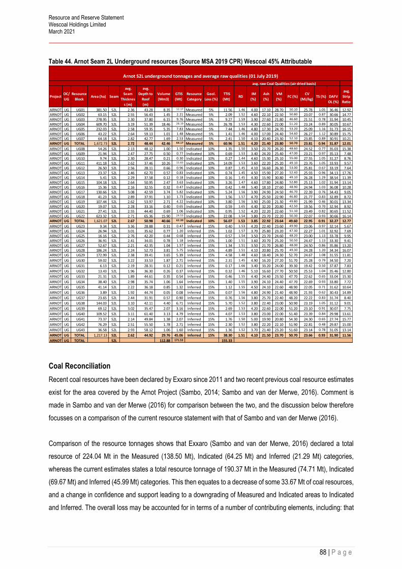
Resource and Reserve Statement Wescoal Holdings Limited March 2021
88 | P a g e
Table 44. Arnot Seam 2L Underground resources (Source MSA 2019 CPR) Wescoal 45% Attributable
Coal Reconciliation
Recent coal resources have been declared by Exxaro since 2011 and two recent previous coal resource estimates
exist for the area covered by the Arnot Project (Sambo, 2014; Sambo and van der Merwe, 2016). Comment is
made in Sambo and van der Merwe (2016) for comparison between the two, and the discussion below therefore
focusses on a comparison of the current resource statement with that of Sambo and van der Merwe (2016).
Comparison of the resource tonnages shows that Exxaro (Sambo and van der Merwe, 2016) declared a total
resource of 224.04 Mt in the Measured (138.50 Mt), Indicated (64.25 Mt) and Inferred (21.29 Mt) categories,
whereas the current estimates states a total resource tonnage of 190.37 Mt in the Measured (74.71 Mt), Indicated
(69.67 Mt) and Inferred (45.99 Mt) categories. This then equates to a decrease of some 33.67 Mt of coal resources,
and a change in confidence and support leading to a downgrading of Measured and Indicated areas to Indicated
and Inferred. The overall loss may be accounted for in terms of a number of contributing elements, including: that
ProjectOC/
UG
Resource
Block Area (ha) Seam
avg.
Seam
Thicknes
s (m)
avg.
Depth to
Roof
(m)
Volume
(Mm3)
GTIS
(Mt)
Resource
Category
Geol.
Loss (%)
TTIS
(Mt) RD
IM
(%)
Ash
(%)
VM
(%) FC (%)
CV
(MJ/kg) TS (%)
DAFV
OL (%)
avg.
Strip
Ratio
ARNOT UG UG01 381.50 S2L 2.36 43.28 8.35 12.17 Measured 5% 11.56 1.46 4.00 17.10 28.70 50.10 25.78 1.05 36.46 12.92 ARNOT UG UG02 63.15 S2L 2.55 56.43 1.45 2.21 Measured 5% 2.09 1.52 4.60 22.10 22.50 50.80 23.07 0.87 30.66 14.77 ARNOT UG UG03 278.95 S2L 2.30 37.80 6.15 9.76 Measured 5% 9.27 1.59 3.90 27.60 21.80 46.60 21.51 0.78 31.94 10.45 ARNOT UG UG04 609.70 S2L 3.19 51.39 18.46 28.19 Measured 5% 26.78 1.53 4.30 22.60 22.00 51.20 23.24 0.89 30.05 10.67 ARNOT UG UG05 232.03 S2L 2.58 59.35 5.35 7.83 Measured 5% 7.44 1.46 4.80 17.30 24.70 53.20 25.09 1.16 31.73 16.15 ARNOT UG UG06 43.22 S2L 2.64 59.13 1.01 1.48 Measured 5% 1.41 1.46 4.00 17.00 24.40 54.60 26.27 1.12 30.89 15.75 ARNOT UG UG07 64.18 S2L 2.82 42.77 1.69 2.53 Measured 5% 2.41 1.50 4.10 20.40 23.30 52.10 23.85 0.89 30.91 10.21 ARNOT UG TOTAL 1,672.73 S2L 2.72 48.44 42.46 64.17 Measured 5% 60.96 1.51 4.20 21.40 23.80 50.70 23.81 0.94 31.87 12.01
ARNOT UG UG08 54.26 S2L 2.13 48.12 1.00 1.50 Indicated 10% 1.35 1.50 3.50 21.70 26.20 48.60 24.52 0.77 35.03 15.38 ARNOT UG UG09 21.94 S2L 2.47 27.75 0.50 0.77 Indicated 10% 0.69 1.53 3.40 24.20 25.40 47.00 23.21 0.97 35.13 7.48 ARNOT UG UG10 9.74 S2L 2.30 28.47 0.21 0.30 Indicated 10% 0.27 1.44 4.60 15.30 25.10 55.00 27.55 1.05 31.27 8.76 ARNOT UG UG11 411.18 S2L 2.62 37.46 10.26 15.65 Indicated 10% 14.09 1.53 3.60 22.20 25.20 49.10 23.76 1.05 33.93 9.57 ARNOT UG UG12 26.50 S2L 2.56 28.11 0.66 0.96 Indicated 10% 0.87 1.45 4.10 16.60 26.30 53.00 25.81 0.67 33.19 7.64 ARNOT UG UG13 23.37 S2L 2.46 62.70 0.57 0.83 Indicated 10% 0.74 1.45 4.50 15.90 27.20 52.40 25.93 0.96 34.13 17.76 ARNOT UG UG14 5.41 S2L 2.29 37.58 0.12 0.18 Indicated 10% 0.16 1.45 4.30 15.90 30.80 49.10 26.28 1.29 38.54 11.39 ARNOT UG UG15 104.18 S2L 2.64 50.95 2.47 3.63 Indicated 10% 3.26 1.47 4.60 17.80 24.80 52.80 25.13 1.02 31.94 13.14 ARNOT UG UG16 15.36 S2L 2.16 32.55 0.32 0.47 Indicated 10% 0.42 1.48 5.40 18.10 27.60 48.90 24.94 1.03 36.08 10.28 ARNOT UG UG17 130.66 S2L 3.08 42.59 3.74 5.82 Indicated 10% 5.24 1.56 3.90 24.90 24.50 46.70 22.39 0.76 34.43 9.05 ARNOT UG UG18 41.23 S2L 2.89 37.91 1.10 1.73 Indicated 10% 1.56 1.57 4.70 25.50 22.90 46.80 21.77 0.83 32.89 8.72 ARNOT UG UG19 107.44 S2L 2.62 53.97 2.71 4.22 Indicated 10% 3.80 1.56 3.90 25.00 21.30 49.80 21.99 0.46 30.01 13.34 ARNOT UG UG20 19.07 S2L 2.28 33.16 0.40 0.65 Indicated 10% 0.59 1.65 4.40 32.20 20.80 42.50 19.56 0.70 32.94 8.92 ARNOT UG UG21 27.41 S2L 2.55 44.40 0.69 1.06 Indicated 10% 0.95 1.52 4.20 22.20 22.60 51.10 23.49 0.82 30.65 11.52 ARNOT UG UG22 623.32 S2L 2.71 65.36 15.90 24.53 Indicated 10% 22.08 1.54 3.80 23.70 22.20 50.30 22.07 0.93 30.66 16.14 ARNOT UG TOTAL 1,621.07 S2L 2.67 50.98 40.66 62.30 Indicated 10% 56.07 1.53 3.85 22.92 23.64 49.60 22.95 0.91 32.27 12.77
ARNOT UG UG23 9.34 S2L 3.36 28.88 0.31 0.47 Inferred 15% 0.40 1.53 4.20 22.40 23.60 49.90 23.06 0.97 32.14 5.67 ARNOT UG UG24 26.94 S2L 3.01 35.62 0.77 1.20 Inferred 15% 1.02 1.57 3.70 25.80 23.20 47.30 22.27 1.01 32.92 7.69 ARNOT UG UG25 16.16 S2L 2.76 42.20 0.44 0.68 Inferred 15% 0.57 1.54 3.50 23.70 24.60 48.20 23.00 1.13 33.78 9.95 ARNOT UG UG26 36.91 S2L 2.41 34.01 0.78 1.18 Inferred 15% 1.00 1.51 3.60 20.70 25.20 50.50 24.47 1.13 33.30 9.41 ARNOT UG UG27 52.67 S2L 2.21 42.35 1.04 1.57 Inferred 15% 1.34 1.51 3.50 21.70 26.80 48.00 24.50 0.86 35.86 13.20 ARNOT UG UG28 186.24 S2L 2.24 52.73 3.81 5.75 Inferred 15% 4.89 1.51 4.10 20.80 25.70 49.30 24.28 1.20 34.34 16.07 ARNOT UG UG29 172.99 S2L 2.38 39.41 3.65 5.39 Inferred 15% 4.58 1.48 4.60 18.40 24.30 52.70 24.67 1.08 31.55 11.81
ARNOT UG UG30 59.02 S2L 3.22 33.53 1.87 2.71 Inferred 15% 2.31 1.45 4.90 16.20 27.20 51.70 25.28 0.79 34.50 7.20
ARNOT UG UG31 6.13 S2L 2.19 28.31 0.12 0.21 Inferred 15% 0.17 1.66 3.40 33.20 24.00 39.30 19.42 0.50 37.87 7.83
ARNOT UG UG32 13.43 S2L 1.96 36.30 0.26 0.37 Inferred 15% 0.32 1.46 5.10 16.60 27.70 50.50 25.53 1.04 35.46 12.80
ARNOT UG UG33 21.31 S2L 1.89 44.61 0.35 0.54 Inferred 15% 0.46 1.55 4.40 24.40 23.50 47.70 22.62 0.65 33.04 15.30
ARNOT UG UG34 38.40 S2L 2.98 35.74 1.06 1.64 Inferred 15% 1.40 1.55 3.90 24.10 24.40 47.70 22.69 0.93 33.80 7.72
ARNOT UG UG35 41.14 S2L 2.22 36.18 0.85 1.32 Inferred 15% 1.12 1.55 4.50 24.10 22.60 48.90 22.05 0.71 31.62 10.64
ARNOT UG UG36 3.89 S2L 1.92 44.74 0.05 0.08 Inferred 15% 0.07 1.56 4.80 24.90 21.40 48.90 21.93 0.62 30.43 14.89
ARNOT UG UG37 23.65 S2L 2.44 31.91 0.57 0.90 Inferred 15% 0.76 1.56 3.80 25.70 22.40 48.20 22.22 0.83 31.74 8.40
ARNOT UG UG38 144.03 S2L 3.10 42.11 4.40 6.71 Inferred 15% 5.70 1.52 3.80 22.40 23.00 50.90 23.19 1.05 31.12 9.01
ARNOT UG UG39 69.12 S2L 3.02 35.47 2.07 3.16 Inferred 15% 2.69 1.53 4.20 22.60 22.00 51.20 23.10 0.91 30.07 7.75
ARNOT UG UG40 109.52 S2L 3.11 61.40 3.13 4.79 Inferred 15% 4.07 1.53 3.80 23.00 22.00 51.40 23.39 0.84 29.98 13.61
ARNOT UG UG41 73.37 S2L 2.14 49.84 1.38 2.07 Inferred 15% 1.76 1.50 5.00 19.90 20.80 54.30 24.30 0.65 27.74 15.77
ARNOT UG UG42 76.29 S2L 2.51 55.50 1.78 2.71 Inferred 15% 2.30 1.52 3.80 22.20 22.10 51.90 22.81 0.48 29.87 15.00
ARNOT UG UG43 36.58 S2L 2.93 58.12 1.06 1.60 Inferred 15% 1.36 1.52 3.70 21.40 23.20 51.60 23.14 0.78 31.05 13.14
ARNOT UG TOTAL 1,217.13 S2L 2.62 44.92 29.76 45.06 Inferred 15% 38.30 1.51 4.10 21.50 23.70 50.70 23.66 0.93 31.90 11.56
ARNOT UG TOTAL S2L 112.88 171.53 155.33
Arnot S2L underground tonnages and average raw qualities (01 July 2019)
avg. raw Coal Qualities (air dried basis)

Resource and Reserve Statement Wescoal Holdings Limited March 2021
89 | P a g e
the larger Inferred resource tonnages are discounted by 15 %, whereas Exxaro (Sambo and van der Merwe, 2016)
used a standard 10 %; that Exxaro made no exclusions for wetland and riverine areas; and that certain areas
included in the 2015 coal resource statement by Exxaro have been shown not to have coal present
Coal Reserves
Although the report does present reserves, and associated LOM plan, there were no evidence presented as to the
finalisation of markets, financial feasibility, closure on environmental permitting and finalisation as to the start-up
of operations.
The MSA CPR provided an indication that UG proven reserves could be 1.93 Mt, opencast probable reserves 5.7
Mt and UG probable of 5.77 Mt.
The mine indicated that they are currently in the process to secure an offtake agreement with Eskom for 20 Mt
saleable over a 10-year period.
Table 45. Arnot Opencast and Underground Indicative reserves, not included in the reserve estimation for Wescoal
MTIS (AD)ROM
(AR)IM CV (AD) TS (AD)
Mt Mt % MJ/kg %
5.77 3.35 23.31 0.79
2.79 4.00 25.37 0.732.75 3.07 24.16 0.89
11.31 3.45 24.03 0.80
1.93 4.49 24.76 0.87
1.93 4.49 24.76 0.871.93 4.49 24.76 0.87
13.24 3.60 24.14 0.81
Arnot Coal Reserve Statement as at 01 July 2019
Arnot Reserve Estimate 01 July 2019 Saleable Qualities
ProjectReserve
categorySeam
Reserve
block
Saleable
(ADC)Yield Ash (AD) Vol (AD)
Mt % % %
78 % 23.90 24.2811 Shaft10 Shaft 4.48
OC East 2.11 77 % 22.24 27.40OC West 2.21 79 % 21.04 26.46
Total 2L Seam 8.81 78 % 22.79 25.5724.03 22.79 25.57 0.80
Pro
ved
2L 10 Shaft
Total 11.31 8.81 78 % 3.45
11 Shaft 1.53 79 % 19.50 25.07
OC EastOC West
Total 2L Seam 1.53 79 % 19.50 25.0725.07
Total Arnot 10.33 78 % 22.30 25.50
Total Proved 1.53 79 % 19.50
Arn
ot
Pro
ject
Pro
bab
le
2L

Resource and Reserve Statement Wescoal Holdings Limited March 2021
90 | P a g e
Risks
TYPE OF RISK RISK MITIGATION LEVEL OF RISK
Geological Structural complexity - floor rolls, seam
thinning, intra-seam partings, dolerite
dykes and sills.
Additional Drilling low-medium
Mining Structural complexity could stop
production. Potential reduction in
reserve base.
Additional Drilling Medium
Market/coal
quality
Localised areas of poor coal quality. Resource management and
coal blending to achieve
required quality.
Medium
Geotechnical shallow mining conditions (<40mbs)
which may over time lead to surface
subsidence.
Surface and underground
subsidence monitoring
High
Environmental The proximity of wetlands to both open
cast and underground workings require
buffer zones or restricted zones for
mining. These zones need to be
depicted on operational plans and may
deplete resources and reserves
High
Capital Due to the age of the operations (>50
years in areas), primary and secondary
access infrastructure may require
refurbishment and maintenance for
extended life.
High

Resource and Reserve Statement Wescoal Holdings Limited March 2021
91 | P a g e
CERTIFICATES OF COMPETENT PERSONS
JSE 12.9 (c), JSE 12.9 (d), JSE 12.11 (i) (6), JSE 12.11 (i) 5, JSE 12.11 (i) 6,
1.1 Certificate of Competent Person Leonardt Raaths and Consent
1. My name is Leonardt Raaths I am a senior Mining Engineer and director for Miptec (Pty) Ltd, situated at 19
Jan Frederik street Witbank
2. Mining Engineer registered with SAIMM; membership number - 702015
3. B.Tech. in Mining Engineering, BSc. Operations research and MBL
4. More than 29 years’ experience in coal mining, with last positions as Technical Director, Mine Manager,
Technical Manager, Projects Manager and Group Mining Engineer for operations at BHP and Xstrata.
Currently senior Mining Engineer and director of Miptec (Pty) Ltd.
5. I am a “Competent person” as defined in the SAMREC and SAMVAL code.
6. I have undertaken to compile the combined Resource and Reserve update statement for Wescoal on their
current coal assets as the lead CP. I have the required experience and knowledge in mine planning, resource
and reserve estimation, mining projects, financial modelling and mining operations to estimate resources and
reserves and to oversee the compilation of the R&R update as lead CP.
7. I am responsible for the reserve estimations on Elandspruit, Khanyisa, Vanggatfontein and Moabsvelden as
well as being overall responsible for the update report as lead CP.
8. I am not aware of any material fact or material change with respect to the subject matter in the report that is
not reflected in the report, the omission of which would make the report misleading.
10. I declare that this report appropriately reflects the competent person’s/author’s view.
11. I am independent of Wescoal Mining and Wescoal Holdings.
12. I have read the SAMREC and SAMVAL code (2016) and the R&R update report has been prepared partially
in accordance with the guidelines of the SAMREC code with the restriction on the disclosure of business
intelligence and confidential information.
13. I do not have, nor do I expect to receive, a direct or indirect interest in Wescoal Holdings
14. At the effective date of the report, to the best of my knowledge, information and belief, the report contains
sufficient scientific and technical information that is required to be disclosed to not make the report misleading.
15. I hereby provide written approval for my contribution to this report to be issued into a Public Report in the form,
content and context in which it appears herein.
Signed at Witbank on this 12st day of June 2021
Leonardt Raaths

Resource and Reserve Statement Wescoal Holdings Limited March 2021
92 | P a g e
1.2 Certificate of Competent Person Katherine Black and Consent
As a contributing author to the report titled, Independent Competent Persons Report on the coal assets
of Wescoal Holdings Limited, I hereby state:
1. My name is Katherine Black and I am a Director of KJB GeoServices, located at 60 Curvy Road,
Randburg, South Africa.
2. I am registered as a Professional Natural Scientist (Geological Science) with the South African Council
for Natural Scientific Professions (SACNASP), registration No.400295/12. I am a Member of the
Geological Society of South Africa (GSSA).
3. I am a graduate of the University of Kwa Zulu Natal, with a B.Sc. Degree in Geology (2005), a B.Sc.
Honours Degree in Geology (2006) and that I have practiced my profession continuously since 2007.
4. I have been actively involved in the mining industry since 2007. I have worked on numerous, exploration,
geological due diligences, geological modelling and resource estimation and drafting of Competent
Persons Reports specialising in coal. I have contributed to compliant documents applicable to the
Canadian and South African stock exchanges.
5. I am a Competent Person as defined in the SAMREC Code.
6. I have compiled the Elandspruit, Khanyisa, Moabsvelden and Vanggatfontein Geological Sections of the
report. Geological sections for Braakfontein and Sterkfontein were extracted from the Venmyn Deloitte
2017 CPR with consent from Venmyn Deloitte.
7. I am responsible for the transparent and material reporting of coal assets in this report.
8. I am independent of Wescoal Holdings Limited.
9. As of the date of this certificate, to the best of my knowledge, information and belief, this report contains
sufficient technical information that is required to be disclosed to ensure that this report is not misleading;
10. I have read the SAMREC Code (2016) and the R&R update Report has been prepared partially in
accordance with the guidelines of the SAMREC Code.
11. I do not have nor do I expect to receive a direct or indirect interest in any of Wescoal Holdings assets
contained in the Report.
12. At the effective date of the Report, the best of my knowledge, information and belief, the report contains
all scientific and technical information that is required to be disclosed to make the report not misleading.
13. I hereby provide written approval for my contribution to this report to be issued into a Public Report in the
form, content and context in which it appears herein.
Signed at Randburg on this 12st day of June 2021
Katherine Black

Resource and Reserve Statement Wescoal Holdings Limited March 2021
93 | P a g e
Abbreviation and Glossary
ABBREVIATION EXPLANATION
% Percent
AD Air Dried
AR As Received
ARD Apparent Relative Density
ASH Ash Content
bcm Bank cubic metre
B. Sc Bachelor of Science
B. Tech Bachelor’s Degree in Technology
CSA Coal Supply Agreement
CCIC Caracle Creek International Consulting (Pty) Limited
CV Calorific Value
CP Competent Person
CPR Competent Person’s Report
DAFV Dry Ash Free Volatiles
DMRE Department of Mineral and Energy
DTM Digital Terrain Model
ERB East Resource Block
FY Financial Year
ha Hectare
HoldCo Holding Company
IM Inherent Moisture
I/WUL Integrated/Water Use Licence
JSE Johannesburg Stock Exchange
km Kilometre
LoM Life of Mine
LoW Limit of Weathering
Ltd Limited
m metre
mamsl Metres above mean sea level
MJ/kg MegaJoules per Kilogram
MPRDA Mineral and Petroleum Resources Development Act
MR Mining Right
Mt Million Tonnes
MTIS Million Tonnes In-Situ
OC Opencast
PR Prospecting Right
Pty Propriety
Pr. Sci. Nat. Professional Natural Scientist
R Rand
RD Relative Density
ROM Run of Mine
SACNASP South African Council for Natural Scientific Professions
SAMREC South African Mineral Reporting Code
SANAS South African National Accreditation System
tph Tonnes per hour

Resource and Reserve Statement Wescoal Holdings Limited March 2021
94 | P a g e
tpm Tonnes per month
TS Total Sulphur
UG Underground
VAT Value Added Tax
VG/F Vanggatfontein Colliery
VM Volatiles Matter
ZAR South African Rand