rivervale - credit-20160401121732...resources of bombay, india. reservoir safety flood assessments,...
TRANSCRIPT

Banksia Rd
Duckpond Rd
Boomerang Rd
394,000 396,0006,
428,
000
6,42
9,00
06,
430,
000
RPS Environment & Planning Pty Ltd
Proposed Sand Quarry
L120 Wetland
Railway Line
Drains
Geomorphic Wetland CategoryConservation
Resource Enhancement
Multiple Use
±
Job No. J5345
© COPYRIGHT JIM DAVIES & ASSOCIATES PTY. LTD. 2012
Data Source: DEC (2012) Geomorphic Wetland Dataset
0 200 400 600 800Metres
Scale:1:20,000 @A4 Oldbury Hydrology Study- Expert Review
Figure 1: Locality and Wetland Mapping
Rockingham
KW
INA
NA
FW
Y
CO
CK
BU
RN
RD
ARMADALE RD
THOMAS RD
Locality 1:300,000
I I
JDAi
D D -+--
D D D
0

!A
!A
!A
!AMundijong Rd
Kin
g R
d
Duckpond Rd
Sp1
Cps
C2
M4
Ms5
S10
Cps
S10
Cps
S10
Ms5
Cps
S10
Cs
S8
S10
Sc
M4
S8
Msc1
S10
Sp1
Sp1
S10
T300
T310
T260 (O)
T250 (O)
392,000 394,000 396,0006,
426,
000
6,42
8,00
06,
430,
000
RPS Environment & PLanning Pty Ltd
Proposed Sand Quarry
L120 Wetland
Drains
Railway Line
!A DoW Groundwater Monitoring Bores
Environmental GeologyC2 (Clay)
Cs (Sandy Clay)
M4 (Silt)
Msc1 (Clayey Sand Silt)
S10 (Sand)
S8 (Sand)
Sc (Clayey Sand)
Scg (Gravelly Clayey Sand)
Sp1 (Peaty Sand)
Spc (Clayey Peaty Sand)
±
Job No. J5345
© COPYRIGHT JIM DAVIES & ASSOCIATES PTY. LTD. 2012
0 200 400 600 800Metres
Scale:1:30,000 @A4 Oldbury Hydrology Study- Expert Review
Figure 2: Environmental Geology
Data Source: Jordan, J (1986) Rockingham and Serpentine sheet of Perth Metro Region Environmental Geology Series, GSWA
Cl D
-+-
----------I I
JDAi

APPENDIX A
Figure 8 of RPS Report

-
Figure 8: Surveying Relative levels
L09864, Rev 2, September 2012
Hydrology Assessment Lot 6 Banksia Road and Lots 300 and 301 Boomerang Road, Oldbury
Page 23

APPENDIX B
DoW Bore Hydrographs

10/4/12 Water Resources Data - Groundwater Sites
Water Resources Data - Groundwater Sites
Department of Water Period 38 Year Plot Start 00:00_01/01/1975
Interval 1 Month
-o- 61410131 Plot End 00:00_01/01/2013
T260 (0) 6268.00 Line/Point Waler Level AHD (m)
HYPLOT V 133 Output 04/10/2012
1975-13
GWL 17.5~-------- ~ i--- ----- -~---------~------~
16.5
15.5
14.5
13.5¼-------------+-----------+------ -----~~-------'--' 1975-84 1985-94 1995-04
kumina. water .wa.gov.au/waterinformation/wrdata/GW U614101 31/gwp.htm 1/1

10/4/12
10.9
10.4
9.9
9.4
8.9
8.4
7.9
Water Resources Data - Groundwater Sites
Water Resources Data - Groundwater Sites
Department of Water Plot Start 00:00_01/01/1975
Plot End 00:00_01/01/2013
Period 38 Year
lnteNal 1 Month
-o- 61410095 T250 (0) 6268.00 Line/Point Water Level AHO (m)
(
<) C ) •)
' (
C )
I ( )
'?, <) I<) )
' )
- , ) -C) ' c)
) C (
~ •> )
C )
~ ~
<) ) ) -
)
( ) ) '
I ' )
)
1975-84 I 1985-94 1995-04
kum ina .water. wa.gov.au/waterinformation/wrdata/GW U61410095/gwp.htm
HYPLOT V133 Output 04/10/2012
1975-13
GWL
)
)
' )
~ ()
I
1/1

10/4/12
6.3
5.8
5.3
4.8
4.3
3.8
3.3
Water Resources Data - Groundwater Sites
Water Resources Data - Groundwater Sites
Department of Water Plot Start 00:00_01/01/1975
Plot End 00:00_01 /01/2012
Period 37 Year
Interval 1 Month
-o- 61410094 T300 6268.00 Line/Point Water Level AHD (m)
I I
' ' C - I ' -)
1, ' ' I
) l I
I)
) - ' ~
) I
I) )
) ' I )
r I
) ·j
I 1975-84 I 1985-94 I 1995-04
kumina.water.wa.gov.au/waterinformation/wrdata/GWU61410094/gwp.htm
HYPLOT V133 Output 04/10/2012
1975-12
GWL
)
I
\ ~
'
I)
1/ 1

10/4/12 Water Resources Data - Groundwater Sites
Water Resources Data - Groundwater Sites
Department of Water Period 38 Year
Interval 1 Month -o- 61410130
Plot Start 00:00_01/01/1975
Plot End 00:00_01/01/2013
T310 6268.00 Line/Point Water Level AHO (m)
HYPlOT V 133 Outpu\ 04/1012012
1975-13
GWL 12.1~----------------------------------------~
' ' )
' ,) 11 .1 ' (
<) ) (
' <)
) ) <)
' ) )
) (
)
10.1 ) (
<) <)
'
·: i; ' ) 1
)
' <)
' )
) (
9.1 ' ' ) '
) ) )
)
8.1 2
7.1>-------~, -------+-------~ ,----~ 1975-84 1985-94 1995-04
kumina.water.wa.gov.au/waterinformation/wrdata/GWU61410130/gwp.htm 1/1
APPENDIX C
CV for Jim Davies and John Barnett

Curriculum Vitae Dr Jim Davies
1
Suite 1, 27 York Street
PO Box 117, Subiaco WA 6008 Tel (08) 9388 2436 Fax (08) 9381 9279
Email [email protected] www.jdahydro.com.au
Urban Stormwater Solutions
Water Resources Planning
& Assessment
Flood Management
Water Quality Studies
Groundwater
Mapping & Modelling
Environmental Hydrology
Infiltration Modelling
Water Sensitive
Urban Design
Licence Application &
Compliance Reporting
Catchment Modelling
Environmental Monitoring
Dr James (Jim) Reginald Davies Managing Director & Principal Hydrologist QUALIFICATIONS: B.Sc.(Hons) Civil Engineering, 1973 University of Leeds M.Sc. Engineering Hydrology, 1974 University of Newcastle upon Tyne PhD Coastal Hydraulics, 1980 Southampton University AFFILIATIONS: Chair of Stormwater Industry Association (SIA), Western Australia, 2010/12 Member Urban Development Institute of Australia (UDIA) Committee Member UDIA Urban Water Committee 2009/12 Fellow, Institution of Engineers, Australia (IE Aust). Chartered Professional Engineer, Australia. Member 1994 to 2000, National Committee on Water Engineering, IEAust Member and past Chairman, Hydrology and Water Resources Panel, IEAust, W.A. Member, Institute of Public Works Engineering Australia Fellow, International Association of Hydrogeologists. Member, Australian Water Association. Member and past Treasurer, Environmental Consultants Association, W.A. Past Member Advisory Board, Department of Environmental Engineering, UWA. External Supervisor Curtin University Engineering School Thesis “Separation criteria between finished lot levels and groundwater in Perth: Hydrological and geotechnical issues” by Aaron Godfrey 2010. EMPLOYMENT HISTORY: Dec 91 - present Managing Director, Jim Davies & Associates Pty Ltd, Perth
W.A. Mar 89 - Dec 91 Senior Engineer, GHD Pty Ltd, Perth, W.A. Jun 87 - Mar 89 Senior Engineer, Groundwater Resource Consultants, W.A. Mar 84 - Jun 87 Research Officer, Department of Agriculture, Perth, W.A. Feb 83 - Mar 84 Project Hydrologist, Binnie & Partners, Perth,W.A. Sep 78 - Jan 83 Hydrologist, Binnie & Partners, London, U.K. LANGUAGES: English, Conversational French, German and Bahasa Indonesia. EXPERTISE:
Leader in the application of Better Urban Water Management (BUWM) in Western Australia. Engineering hydrology and environmental hydrology including data collection, analysis and modelling. Experienced in both surface hydrology and groundwater hydrology. Particular experience in flood estimation, open channel hydraulics, computer modelling, urban and rural drainage design, nutrient and sediment studies, and groundwater investigation
JDAl

Curriculum Vitae Dr Jim Davies
2
Dec 1991 - present Managing Director & Principal Hydrologist JDA Consultant Hydrologists, Perth W.A.
Principal Hydrologist and Managing Director of JDA Consultant Hydrologists, specialist hydrology and water resources consultancy. Projects completed in all parts of Western Australia including rural and urban, groundwater and surface water, flooding, water resources and water supplies. Refer to Company Profile for comprehensive listing of projects.
Mar 1989 – Dec 1991 Senior Engineer Gutteridge, Haskins & Davey Pty Ltd, Perth, W.A.
Groundwater resource, water management studies and dewatering investigations and modelling using MODFLOW for the proposed ISK Mineral Sands mine at Dardanup. Developed a Master Plan for the drainage of 472 ha subdivision of coastal, agricultural land adjacent to the Preston River, Bunbury, W.A. Plan included water table control and a combination of compensating basins and sumps to handle design floods. Completed the hydrological investigation and design of earthworks for erosion control and regeneration of 10 km2 of scalded alluvial plain in the Gascoyne - Upper Ashburton River Basin, W.A. Environmental impact assessment of a proposed groundwater pumping scheme and a surface drainage scheme on Lake Toolibin, W.A., a significant inland, freshwater lake listed on the Ramsar Convention. Groundwater resource assessment for a bauxite mine in the Darling Range, W.A. Included supervision of test pumping of existing bores and estimation of reliable long term pumping rates. Review of estimates of the historic nutrient load to the eutrophic Peel-Harvey estuary, W.A. including assessment of previous modelling of river flows, using the SACRAMENTO model. Review of estimates of suspended sediment load and bed load at two gauging stations in the 46100 km2 catchment of the Ord River Dam, Kimberley, W.A. Review of a modelling study using the rainfall/runoff model FLOUT and the backwater model HEC-2 to estimate the effect of Ophthalmia Dam, Fortescue River, W.A. on riverine vegetation downstream. Waterway investigations of several rural road bridges in W.A. to determine the need for upgrading to pass design flood flows subject to serviceability criteria.
Completed an investigation of the causes of urban flooding adjacent to Woodlupine Brook, Kalamunda Shire, W.A. Work included hydraulic gradeline analysis of the piped stormwater drainage system, backwater analysis of the brook and design of a compensating basin.
Jun 1987 – Mar 1989 Senior Engineer Groundwater Resource Consultants, Perth, W.A.
Groundwater modelling studies of the Swan Coastal Plain aquifer, W.A., using MODFLOW model. Installation and calibration of three stream gauging stations on Lihir Island, Papua New Guinea. Water resource potential investigation, unconfined peat aquifer as a village water supply Sarawak, Malaysia Supervision of cable-tool & air-hammer drilling of groundwater production bores. Supervision of test pumping.
JDAl

Curriculum Vitae Dr Jim Davies
3
Surface hydrology modelling studies using the runoff/routing model RORB and the backwater model HEC-2. Design of extensions to the groundwater supply system for Pannawonica, Pilbara, W.A Monitoring of groundwater salinity profiles in bores associated with a seasand stockpile at Cockburn, W.A. Design and installation of surface water monitoring equipment, including capacitance water level probes, rising-stage samplers and peak stage indicators in a sand bed creek in the Great Sandy Desert, W.A.
Mar 1984 – Jun 1987 Research Officer Department of Agriculture, Perth, W.A.
Revised the design technique for roaded (improved) catchments and dams, involving saline land mapping. Revision of methods of estimation of surface runoff for the design of soil conservation earthworks. Contributed to a project to map the erosivity of rainfall in W.A. Research into methods of surface drainage to alleviate waterlogging and flooding.
Feb 1983 – Mar 1984 Project Hydrologist Binnie & Partners, Perth, W.A.
Responsible for flood plain mapping study of the Avon River, W.A.
Sep 1978 – Jan 1983 Hydrologist Binnie & Partners, London, U.K.
Development of a FORTRAN model to simulate the operation of surface water resources of Bombay, India. Reservoir safety flood assessments, including design flood estimation and spillway adequacy determination. Field work, feasibility study for proposed hydro-electric power scheme on the Mambilla Plateau, Nigeria.
Fieldwork for a run-of-river rice irrigation project in Aceh Province, Sumatra, Indonesia.
Oct 1974 – Sep 1978 Research Student Southampton University, U.K.
PhD thesis titled "Exceptionally High Sea Levels in the Solent".
Oct 1973 – Sep 1974 M.Sc. Student University of Newcastle upon Tyne, U.K.
Masters thesis titled "Water Level Oscillations of Lake Windermere, Lake District, U.K."
JDAl

Curriculum Vitae Dr Jim Davies
4
PUBLICATIONS
DAVIES, J.R. (2012) How Much Runoff Paper: A Comparison of Rational Method and Volumetric Coefficients. Institute of Public Works Engineering Australia (WA) State Conference March 2012.
DAVIES, J.R., ROGERS, A.R. AND SERAFINI, G (2012) Perched Water Table Mounding Between Subsoil Drains in Sand Fill over Guildford Formation. Institute of Public Works Engineering Australia (WA) State Conference March 2012.
DAVIES, J.R. & ROGERS, A. (2007) Infiltration Basins: Application to W.A. Basins of a French Procedure for Infiltration Assessment. Institute of Public Works Engineering Australia (WA) State Conference, Perth, March 2007.
DAVIES, J.R., RAHMAH, D., WILLS, S., (2005) Evaluation of Stormwater Pollutant Traps (SPT’s). Institute of Public Works Engineering Australia (WA) State Conference, March 2005.
DAVIES, J.R., O’DONNELL, M., ROGERS, A. (2005) On Site Stormwater Management for Infill Development, City of Stirling. Institute of Public Works Engineering Australia (WA) State Conference, March 2005.
MARTENS, S., DAVIES, J.R., O’DONNELL, M. (2005) Monitoring for Total Water Cycle Management: The WESROC Experience. Institute of Public Works Engineering Australia (WA) State Conference, March 2005.
DAVIES, J.R., WILLS, S., ROGERS, A. (2005) Wetland Management: Water Issues. WA Wetland Management Conference, World Wetlands Day, 2 February 2005. Cockburn Wetland Centre, Bibra Lake, Western Australia.
DAVIES, J.R., MARTENS, S., ROGERS A. (2004) Review of Water Table Elevation on the Swan Coastal Plain and the AAMGL Concept, 2004 Public Works Engineering State Conference March 2004, Institute of Public Works Engineering Australia (Western Australia Division) Incorporated.
DAVIES, J.R., YAN, M., MARTENS, S. (2003) Review of WA Design Rainfall for Flood Management. Institute of Public Works Engineering Australia (W.A.) State Conference March 2003.
MARTENS, S., DAVIES, J.R., O’DONNELL, M. (2002) Urban Water Management for WESROC -A Local Government Group in Western Australia. Institute of Public Works Engineering Australia (WA) State Conference, March 2002.
DAVIES, J.R. (2001) Source Control of Pollutants. Land Development in Areas of High Water Table Seminar, IEA, Perth, February 2001.
DAVIES, J.R., VUKOMANOVIC, S., YAN, M. (2000) Stormwater Quality in Perth, Western Australia, Hydro 2000 Symposium combining 26th National and 3rd International Hydrology and Water Resources Symposium of the Institution of Engineers Australia, Perth, November 2000.
MARTENS, S., DAVIES, J.R., YAN, M. (2000) Rainfall Runoff and Storm Surge Flooding at Exmouth, Western Australia in 1999, Hydro 2000 Symposium combining 26th National and 3rd International Hydrology and Water Resources Symposium of the Institution of Engineers Australia, Perth, November 2000.
DAVIES, J.R., TOWNLEY, L., WILLS, S., ROGERS, A., SCHOLZ, J. (2000) Hydrological Capture Zones of Wetlands, Hydro 2000 Symposium combining 26th National and 3rd International Hydrology and Water Resources Symposium of the Institution of Engineers Australia, Perth, November 2000.
SIVANATHAN, S., MARTENS, S., SIVAPALAN, M., DAVIES, J.R. (2000) Multi Stage Outlet Compensating Basins for Multi ARI Design, Hydro 2000 Symposium combining 26th National and 3rd International Hydrology and Water Resources Symposium of the Institution of Engineers Australia, Perth, November 2000.
JDAl

Curriculum Vitae Dr Jim Davies
5
DAVIES, J.R., PIERCE, D. (1999) Street Sweeping Revisited – Nutrients and metals in particle size fractions of road sediment from two major roads in Perth, Water 99 Joint Congress combining 25th Institution of Engineers Australia, Hydrology and Water Resources Symposium, and 2nd International Conference on Water Resources and Environment Research, Brisbane, July 1999.
DAVIES, J.R., PIERCE, D., SCHOLZ, J., YAN, M., STUBBERFIELD, D. (1999) Stormwater Pollution Source Control. (Poster Paper) IAWQ International Conference on Diffuse Pollution, Perth, May 1999.
DAVIES, J.R., MARTENS, A.S., ROGERS, A., HAUCK, E. (1999) Evaporation Basins for Management of Saline Groundwater Discharge (Poster Paper) IAWQ International Conference on Diffuse Pollution, Perth, May 1999.
NG, R., ROBINSON, J.S, DAVIES, J.R. & STEVENSON, J. (1999) Integrated Stormwater Management Strategy – Shire of Mundaring. IMEA 16th Annual State Municipal Engineering Conference, Perth, March 1999.
DAVIES, J.R., SCHOLZ, J. & PIERCE, D. (1998) Infiltration Opportunities. 3rd SIA Regional Conference on Stormwater Management, Stormwater – Keeping it Clean!, Perth, Oct 1998.
DAVIES, J.R., PIERCE, D. (1998) Street-sweeping to Reduce Stormwater Pollutant Loads to the Environment. Planning for Sustainable Futures National Conference, Mandurah, 21-23 Sept., 1998.
DAVIES, J.R., PIERCE, D. & GOLDSTONE, M. (1998) Sustainable stormwater management: Clean streets for the New Millennium. Hydra Storm ’98 combining 3rd International Symposium on Stormwater Management & 6th International Conference on Hydraulics in Civil Engineering, Adelaide, Sept 1998.
DAVIES, J.R. & VAN HALL, S. (1997) Design of stormwater infiltration basins with shallow water tables – Comparisons of models – MODRET and PCSUMP. Institution of Engineers Australia, Hydrology and Water Resources Symposium, New Zealand, Nov 1997, pp 379-383.
DAVIES, J.R., ROBINSON, J., & VAN HALL, S. (1997) An Examination of Retention Time and Circulation Patterns Using Field Measurements and 2-Dimensional Hydrodynamic Modelling (Poster Paper) Institution of Engineers Australia, Hydrology and Water Resources Symposium, New Zealand, Nov 1997, p 518.
DAVIES, J.R., & NG, R. (1997) Relationship between Rational Method Runoff Coefficient and Volumetric Runoff Coefficient (Poster Paper) Institution of Engineers Australia, Hydrology and Water Resources Symposium, New Zealand, Nov 1997, p 519.
DAVIES, J.R. & VAN HALL, S. (1996) Stormwater Runoff - Proceedings of two day course titled "Principles of Water Auditing for the Power, Mining and Mineral Processing Industries" held by Advanced Manufacturing Technology Centre, East Perth.
DAVIES, J.R. & RUPRECHT, J.K. (1996) Perth Rainfall IFD Revisited. Institution of Engineers, Australia, Hydrology and Water Resources Symp, Hobart May 1996, pp 269-272.
DAVIES, J.R. (1996) Water Sensitive Urban Design Progress in Perth. Institution of Engineers, Australia, Hydrology and Water Resources Symp, Hobart May 1996, pp 687-688.
DAVIES, J.R., DAVIES, P.K., ROBINSON, J.R., SIM, D. (1996) Design of infiltration basins, swales and trenches. 13th Annual State Municipal Engineering Conference, Perth , March 1996, pp 1-8.
DAVIES, J.R. (1992) Collection, treatment and disposal of nutrient enriched stormwater. 9th State Conference, WA Local Engineers Association Perth, Vol. 1.
JDAl

Curriculum Vitae Dr Jim Davies
6
DAVIES, J.R. (1991), HAUCK, E.J. & PAYNE, A.L. (1991) Design of waterponding banks for pastoral areas of Western Australia, Institution of Engineers Australia International Hydrology and Water Resources Symposium, Perth, pp. 639 – 641.
DAVIES, J.R. (1991) Unsteady open channel flow modelling. Association for Computer Aided Design (ACADS) Expo ’91 Conference, Perth.
DAVIES, J.R. (1990) Urban Drainage Design and Evaluation of Existing Systems. 7th State Conference, WA Local Government Engineers Association, Perth, Vol. 2.
DAVIES, J.R., McFARLANE, D.J., FERDOWSIAN, R. (1988) The effect of small earth structures and channel impovement on the flooding of agricultural land in south-western Australia. Western Australian Department of Agriculture, Division of Resource Management, Technical Report 77.
DAVIES, J.R. & DENBY, C.G. (1988) Hydrologic Aspects of Farm Dams with Improved Catchments, Hydrology and Water Resources Symposium 1988, ANU Canberra, 1 – 3 February 1988, pp. 192 – 196.
McFARLANE, D.J. & DAVIES, J.R. (1988) Soil factors affecting flood runoff on agricultural catchments in Western Australia. Western Australian Department of Agriculture, Division of Resource Management, Technical Report 18.
DAVIES, J.R. & McFARLANE, D.J. (1987) Estimation of runoff volumes and peaks from ungauged catchments. Western Australian Department of Agriculture, Division of Resource Management, Technical Report 43.
DAVIES, J.R. & McFARLANE, D.J. (1986) Estimation of runoff volumes in Western Australia. Institution of Engineers Australia Hydrology and Water Resources Symposium, Brisbane, pp. 209 – 213.
McFARLANE, D.J., DAVIES, J.R. & WESTCOTT, T. (1986) Rainfall erosivity in Western Australia. Institution of Engineers Australia Hydrology and Water Resources Symposium, Brisbane, pp. 350 – 354.
DAVIES, J.R., LAW, F.M. & STECKIS, R.A (1984) Mapping dryland salinity in Western Australia, Hydrology and Water Resources Symposium, Sydney, pp. 117 – 121.
HICK, P.T. DAVIES, J.R., STECKIS, R.A. (1984) Mapping dryland salinity in Western Australia using remotely sensed data. Proceedings 10th Anniversary International Conference Remote Sensing Society, Reading, UK, pp. 343 – 350.
DAVIES, J.R. & WEBBER, N.B. (1976) Research on exceptional sea levels in the Solent, The Dock & Harbour Authority, pp. 232, 233, 240.
JDAl

Curriculum Vitae John Barnett
1
Suite 1, 27 York Street
PO Box 117, Subiaco WA 6008 Tel (08) 9388 2436 Fax (08) 9381 9279
Email [email protected] www.jdahydro.com.au
Urban Stormwater Solutions
Water Resources Planning
& Assessment
Flood Management
Water Quality Studies
Groundwater
Mapping & Modelling
Environmental Hydrology
Infiltration Modelling
Water Sensitive
Urban Design
Licence Application &
Compliance Reporting
Catchment Modelling
Environmental Monitoring
John Barnett Principal Hydrogeologist QUALIFICATIONS: B.Sc., Geology, University of Nottingham AFFILIATIONS: Fellow, Geological Society (London) EMPLOYMENT HISTORY: 2006 - present Principal Hydrogeologist, Jim Davies & Associates Pty Ltd,
Perth W.A 1980 - 2006 Principal Hydrogeologist, URS Australia Pty Ltd, Perth W.A
(Incorporating Dames & Moore and Groundwater Resource Consultants)
1973 - 1980 Hydrogeologist, Geological Survey of WA, Perth W.A 1970 - 1973 Senior Hydrogeologist, Geotechnics (Aust) Pty Ltd, Perth W.A 1968 - 1970 Hydrogeologist, Geological Survey of WA, Perth W.A LANGUAGES: English, Fluent Norwegian, Amharic, French, Indonesian, Thai EXPERTISE:
Hydrogeology, environmental hydrogeology and groundwater development. Particular expertise in location and development of groundwater supplies, dewatering, assessment of environmental and land-use changes on groundwater levels and quality.

Curriculum Vitae John Barnett
2
Environmental Hydrogeology Hope Downs North (KBR/Rio Tinto). Investigation of hydrogeology and
hydrology of Weeli Wolli Springs, and potential effect of dewatering on spring flow (2006, 2007).
Hydrogeological assessment of Groundwater-Dependent Ecosystems in Blackwood River area, Reedia Swamps, St John Brook and Lake Quitjup, South West Yarragadee Investigation, for Water Corporation (2004, 2005).
Hydrogeological and hydrological investigations of salt lakes for potential disposal of dewatering discharge, Lake Carey and Lake Raeside (2003).
Dewatering study of railway underpass for Redcliffe-Bushmead Highway. Investigation of hydrogeological regime and impact of dewatering on nearby lakes, evaluation of upward leakage of confined groundwater.
Assessed groundwater resources, dewatering requirements and environmental aspects of uranium mining at Mulga Rock Prospect, Lake Minigwal, Western Australia.
Groundwater environmental investigation for quarry expansion, Voyager Quarry, The Lakes, for BGC (2004).
Study of potential effect of peat mining on surface and groundwater hydrology, Lake Muir, Western Australia.
Erosion Study, Millstream National Park, assessment of potential effects on river pool levels by erosion caused by cyclones.
Assessed potential groundwater contamination and associated liabilities for due diligence audit of power station and associated coal mine, Latrobe Valley, Victoria.
Dewatering
Hope Downs North, Stage 2 Dewatering (KBR/Rio Tinto). Contract preparation, supervision and reporting on drilling, construction and testing of large-diameter dewatering bores (2006, 2007).
Assessment of potential for reinjection of dewatering discharge into decommissioned saline groundwater production bores, Carosue Dam (2003).
Evaluation of dewatering and depressurising requirements, and conceptual dewatering system design for dry dock construction, Laem Chabang and Sattahip, Thailand.
Assessment of dewatering requirements and conceptual dewatering system, design and costing for construction of 52km long diversion channel for Indus River, Ghazi-Barotha Hydro Project, Pakistan.
Evaluation of groundwater regime and dewatering requirements for porphyry gold-copper deposit, Didipio Feasibility Study, Luzon, Phillippines.
Designed groundwater monitoring system and depressurising bore network for the Wagerup Refinery Site, Western Australia.
Design and supervision of dewatering and depressurising bore network for opencut coal-mine at Leigh Creek, South Australia.
Design of dewatering bore network for Chicken Creek opencut coal mine, Western Australia.
JDAi

Curriculum Vitae John Barnett
3
Groundwater Development
Hydrogeological studies, exploration and development of groundwater supplies for market gardens and orchards (Dongara, Guilderton, Kalbarri, Jindong and Margaret River); sports ovals (Albany Sporting Complex, Calingiri, Whim Creek); stock (Eneabba, Esperance, Mullewa, Toodyay and York, Drought Relief Drilling in Shires of Westonia, Burracoppin and South Yilgarn); pastoral stations (Bamboo Springs, Carmelia, Cowarna Downs, Credo, Dalgety Downs, Hillside and Yinnietharra); aboriginal settlements (Central Aboriginal Reserve, Blackstone, Giles, Jameson and Warburton) and road construction (Halls Creek to Fitzroy Crossing, Newman to Packsaddle, Nanutarra to Tom Price, Norseman to Esperance, Tom Price to Paraburdoo).
Hydrogeological studies, exploration and development of process and potable water supplies for mining from fractured rock and shallow alluvial aquifers throughout Western Australia, at Agnew, Bamboo Creek, Badgebup, Bardoc, Bellevue, Boddington, Cleo, Copperfield, Cosmos, Darlot, Deep South, Forrestania (Bounty Mine), Gabanintha, Granny Smith (Mt Weld Borefield, Wallaby Pit), Lawlers, Leinster, Lynas Find, Mount Fisher, Mount Gibson, Mount Keith, Nullagine, Ora Banda, Ramsgate, Robe River, St Ives (Thunderer and Bahamas Pits) Westonia, Wodgina and Yundamindera.
Groundwater assessment and test-pumping of production bore for soft- drinks factory, Sukabumi, Java, Indonesia.
Exploration and development of groundwater supply for petrochemical plant, West Java, Indonesia.
Exploration and development of groundwater supplies for coal mine and township in East Kalimantan, Indonesia (December 1990 – June 1991).
Technical Assistance Hydrogeologist in charge of Hydrogeology and Drilling Departments of Bahar Dar Regional Office, Ethiopian Water Works Construction Authority (October 1981 – July 1983). Responsible for training local staff in wide range of groundwater exploration and development methods.
Established irrigation water-supply for golf-course development, water-balance and nutrient management studies, Ravenswood Sanctuary, Western Australia.
Establishment of irrigation water-supply for golf-course resort, annual reviews of aquifer performance and nutrient management studies, The Vines Resort, Western Australia.
Hydrogeology
South West Water Audit: assessment of surface and groundwater resources, current water use and future water demand to 2025, for South West Development Commission (2005).
Hydrogeological studies for sewage treatment plants, Dongara and Kalbarri.
Assessed potential effects of canal development and urbanisation on groundwater regime for Environmental Review and Management Programme, Westport, Western Australia.
Assessed results of canal and residential development on groundwater regime, Waterside Mandurah, Western Australia.
JDAi

Curriculum Vitae John Barnett
4
Wellhead protection study and definition of capture zones for existing and future public water-supply wells on Gnangara and Jandakot Groundwater Mounds, for Water and Rivers Commission, Western Australia.
Conducted evaluation of pre-mining hydrogeology at Worsley Minesite, Western Australia. Designed monitoring programme to measure effects of future bauxite mining on surface and groundwater hydrology, and designed drainage and dewatering bore systems.
Performed hydrogeological investigation for Laporte Factory Effluent Disposal Scheme, for Public Works Department of Western Australia.
Assessment of groundwater and surface water resources and preparation of water resources management plan for Environmental Management Plan, Yampi, Western Australia for Department of Defence , Army Support Unit.
Project Manager (Hydrogeology): Pre-feasibility study for storage dams in Oman (November 1999 to February 2000).
National Well Inventory Project, Sultanate of Oman. National Technical Manager for project to survey about 160,000 wells and evaluate water use throughout Oman (January 1992-April 1994).
Assessment and investigation of potential groundwater supplies for resort developments, Antap and Bias Putih, Bali, Indonesia.
Master Plan Study of Rural Water Supply, Coastal Region of Sarawak, Malaysia. Investigated deep groundwater (100-150m depth), shallow sand (10-30m) and peat aquifers. (March – September 1986, February 1988 – July 1990).
Groundwater Remediation
Design and installation of Dual Pump Recovery System for remediation of groundwater contaminated by ammonium sulphate, including six recovery bores, monitoring bores and two recharge ponds at Baldivis, Western Australia.
Evaluation of contaminated groundwater plume beneath nickel refinery and design of remediation borefield, Kwinana, Western Australia.
Reviews of groundwater recovery system for saline groundwater plume beneath cement processing works, Kwinana, Western Australia.
Project Manager, Groundwater Assessment Project: Investigation and assessment of 80 onshore oil-well drilling locations for potential groundwater contamination, design and supervision of remediation system, Northern Thailand (September 1996 to July 1999).
JDAi

Curriculum Vitae John Barnett
5
PUBLICATIONS
Barnett, J. C. (1970). Hydrogeology of the Arrowsmith Area. Geol. Survey of WA, Record 1969/15.
Barnett, J.C., McInnes, D.B. & Waterton, C.A. (1984). Measurement of the Specific Yield of a Carbonate Aquifer. Hydrogeology of Karstic Terrains, Volume 1. UNESCO/IAH, International Contributions to Hydrogeology.
Barnett, J.C. & Commander D.P. (1985). Hydrogeology of the Western Fortescue Valley, Pilbara Region, Western Australia. Geol. Survey of WA Record 1986/88.
Whincup, P. & Barnett, J.C. (1988). Groundwater Prospecting in the Arid Regions of Western Australia. Second International Conference on Prospecting in Arid Terrain, Perth, Australia.
Barnett, J.C. (1991). Groundwater supply for the Pinang Coal Project, East Kalimantan. Fourth International Mining and Minerals Recovery Conference, Jakarta, Indonesia.
Barnett, J.C. & Smith, G.V. (1994). The National Well Inventory, Sultanate of Oman. International Conference on Groundwater: drought, pollution and management, Brighton, England.
Barnett, J.C., Munster, R., Lim, E., & Whincup, T. (1999). Natural Attenuation: Cheap and effective Groundwater Remediation. Water 99 Joint Congress, 25th Hydrology and Water Resources Symposium, 2nd International Conference on Water Resources and Environment Research, Brisbane, Australia.
JDAi

Suite 1, 27 York St, Subiaco WA 6008 PO Box 117, Subiaco WA 6904
Ph: +61 8 9388 2436 Fx: +61 8 9381 9279
www.jdahydro.com.au
JDAI

APPENDIX 7
Mattiske Vegetation Assessment
-

SUMMARY OF BOTANICALVALUES
FOR A POTENTIAL TUMULUS SPRING
(WETLAND L120), OLBURY
Prepared for
RPS Group Prepared by
Mattiske Consulting Pty Ltd
December 2012
RPS1203/89/2012
Mattiske ConsultlngPtyltd

Mattiske Consulting Pty Ltd
Disclaimer and Limitation
This report has been prepared on behalf of and for the exclusive use of the RPS Group, and is subject to and issued in accordance with the agreement between RPS Group and Mattiske Consulting Pty Ltd. Mattiske Consulting Pty Ltd accepts no liability or responsibility whatsoever for it in respect of any use of or reliance upon this report by any third party. This report is based on the scope of services defined by RPS Group, budgetary and time constraints imposed by RPS Group, the information supplied by RPS Group (and its agents), and the method consistent with the preceding. Copying of this report or parts of this report is not permitted without the authorisation of RPS Group or Mattiske Consulting Pty Ltd.

Mattiske Consulting Pty Ltd
TABLE OF CONTENTS
Page
1. SUMMARY ........................................................................................................................................ 1 2. INTRODUCTION ............................................................................................................................... 1 3. OBJECTIVES ..................................................................................................................................... 1 4. METHODS ........................................................................................................................................ 1
4.1 Field Survey .............................................................................................................................. 2 5. RESULTS .......................................................................................................................................... 2
5.1 Wetland L120 – Potential Tumulus Spring .................................................................................... 2 5.2 Rocla Wetland Area.................................................................................................................... 3
6. DISCUSSION AND CONCLUSIONS ........................................................................................................ 4 7. LIST OF PERSONNEL: ........................................................................................................................ 4
PHOTOGRAPHS
1: Wetland L120 – Potential Tumulus Spring
2: Rocla Wetland Area

1. ____________________________________________________________________________________________
Mattiske Consulting Pty Ltd
1. SUMMARY
Mattiske Consulting Pty Ltd was commissioned by the RPS Group to undertake a reconnaissance survey of a potential Tumulus Spring identified by the Department of Environment and Conservation (Wetland L120) and adjacent wetland area within the Rocla lease. Preliminary assessment and comparison of vegetation within Wetland L120 and the adjacent Rocla wetland suggests that these areas were once part of a larger contiguous wetland system. Wetland L120 and the Rocla wetland area both comprise typical Serpentine River Complex associations, with species and structure conforming to those detailed within Supergroup 2: Seasonal Wetlands (Bassendean landform types). Though direct access was not permitted to wetland L120, high resolution digital photography suggests Cyclosorus interruptus does not occur in this area and the species in question is most likely Histiopteris incisa. Information gathered in the preliminary field assessment of Wetland L120 and adjacent Rocla wetland area suggests that hydrological factors rather than botanical values should be used as the primary determinant for the presence/absence of a Tumulus Spring.
2. INTRODUCTION
Mattiske Consulting Pty Ltd was commissioned in November 2012 by the RPS Group to undertake a reconnaissance survey of a potential Tumulus Spring (Wetland L120) and adjacent wetland near Rocla’s Olbury operations, and subsequently to provide a brief interim summary detailing the botanical values associated with the survey area. The survey area is located east of Banksia Road, Olbury, in the Shire of Serpentine-Jarrahdale.
3. OBJECTIVES
Aim of current works was to undertake a reconnaissance survey of a potential Tumulus Spring (Wetland L120) and adjacent wetland area within the Rocla lease. Specifically to: • Undertake a qualitative survey of Wetland L120;
• Undertake a qualitative survey of wetland environments within the Rocla lease; and
• Prepare a brief interim summary detailing and comparing the botanical values present within both
areas.
4. METHODS
In accordance with the project scope, simple observations detailing species and vegetation communities present within the survey area were made. Direct access to Wetland L120 was not possible as the landowner did not approve access. As a result observations were made and photographs were taken from the boundary fence line.

2. ____________________________________________________________________________________________
Mattiske Consulting Pty Ltd
4.1 Field Survey
A reconnaissance survey of the area was undertaken by a senior botanist from Mattiske Consulting Pty Ltd on the 23rd
November 2012. The botanist held a valid collection licence to collect flora for scientific purposes, issued under the Wildlife Conservation Act 1950.
The flora and vegetation of Wetland L120 was assessed from the boundary fence line, and the Rocla wetland area was assessed using a 20 m grid pattern. Observations were made on the species and vegetation communities present, and where necessary relevant photographs were taken.
5. RESULTS
This section outlines simple observational data gathered from Wetland L120 and the Rocla wetland area. For clarity results have been separated as to the botanical values observed within Wetland L120 and those observed within the Rocla wetland.
5.1 Wetland L120 – Potential Tumulus Spring
Vegetation of Wetland L120 comprises typical Serpentine River Complex associations with species and structure conforming those detailed within Supergroup 2: Seasonal Wetlands (Bassendean landform types; Photograph 1). Over-storey comprises closed woodland to woodland of Melaleuca preissiana with emergent Eucalyptus rudis. Mid-storey comprises an open shrub layer of Gastrolobium ebracteolatum, Taxandria linearifolia, Astartea scoparia and Pteridium esculentum. Lower-storey comprises a sedgeland to closed sedgeland of Juncus pallidus, Juncus holoschoenus and Meeboldina scariosa. Ground layer comprises Centella asiatica, Cycnogeton lineare and Lobelia anceps. A number of exotic species were observed including Zantedeschia aethiopica, Arctotheca calendula, Hypochaeris glabra, Sonchus oleraceus, Solanum nigrum, Ehrharta longifolia and Carpobrotus sp. High resolution photographs (1.5 m away positioned on the fence line) of individuals thought to be Cyclosorus interruptus were taken. Based on frond shape and lobe dissection it is thought these individuals are most likely Histiopteris incisa (Dennstaedtiaceae) and not Cyclosorus interruptus (Thelypteridaceae; Bev Koch pers. comm., 28th
November 2012 – Principal Taxonomist).
Photograph 1: Wetland L120 – Potential Tumulus Spring

3. ____________________________________________________________________________________________
Mattiske Consulting Pty Ltd
5.2 Rocla Wetland Area
Vegetation of the Rocla wetland area, similarly to Wetland L120, comprises typical Serpentine River Complex associations with species and structure conforming those detailed within Supergroup 2: Seasonal Wetlands (Bassendean landform types; Photograph 2). The northern boundary of the wetland comprises an interface with FCT 21a Central Banksia attenuata – Eucalyptus marginata woodlands vegetation associations. To the west soils become increasingly saturated with open water on the western boundary. Over-storey comprises closed woodland to woodland of Melaleuca preissiana with emergent Eucalyptus rudis. Mid-storey comprises an open shrubland to shrubland of Taxandria linearifolia, Astartea scoparia, Pteridium esculentum, Kunzea glabrescens and Gastrolobium ebracteolatum. Lower storey comprises a sedgeland to open sedgland of Juncus pallidus, Juncus holoschoenus and Meeboldina scariosa. Ground layer comprises Lobelia anceps, Dampiera hederacea and Centella asiatica. A number of exotic species were observed including Zantedeschia aethiopica, Arctotheca calendula, Hypochaeris glabra, Sonchus oleraceus and Ehrharta longifolia.
Photograph 2: Rocla Wetland Area

4. ____________________________________________________________________________________________
Mattiske Consulting Pty Ltd
6. DISCUSSION AND CONCLUSIONS
Wetland L120 and the Rocla wetland area both comprise typical Serpentine River Complex associations, with species and structure conforming to those detailed within Supergroup 2: Seasonal Wetlands (Bassendean landform types). A qualitative comparison of species assemblage and structure suggests that Wetland L120 and the Rocla wetland area were once part of a larger contiguous wetland system. Extensive disturbance has more than likely isolated the L120 wetland and subsequently created a confluence with drainage and irrigation channels. Based on frond shape and lobe dissection, individuals thought to resemble Cyclosorus interruptus are more than likely Histiopteris incisa. There are 25 WAH records of this species, with disjunct population’s occurring in springs, drainage lines, swamps and rock outcrops from Albany to Bindoon. Stark similarity between the two areas makes defining the values of Wetland L120 in isolation i.e. as an atypical site solely defined by vegetation difficult. It is therefore recommended that hydrological factors rather than botanical factors be the primary determinant for assessing the presence/absence of a Tumulus Spring.
7. LIST OF PERSONNEL
The following Mattiske Consulting Pty Ltd personnel were involved in this project:
Name Position Project Involvement Flora Collection Permit
Dr E.M. Mattiske Managing Director & Principal Ecologist
Planning, Management & Reporting
n/a
Mr J Cargill Senior Ecologist Planning, fieldwork, and report preparation
SL009847
Mrs B. Koch Senior Botanist Plant identification N/A

APPENDIX 8
Risk Analysis: Groundwater
Dependent Vegetation
-

rpsgroup.com.au
RISK ANALYSIS: GROUNDWATER DEPENDENT VEGETATION L120 Wetland, Oldbury

DOC-TEM-004
RISK ANALYSIS: GROUNDWATER DEPENDENT VEGETATION L120 Wetland, Oldbury
Prepared by:
RPS
38 Station Street, SUBIACO WA 6008
PO Box 465, SUBIACO WA 6904
T: 618 9211 1111 F: 618 9211 1122
W: rpsgroup.com.au
Report No: L09864:2
Version/Date: Rev 0, December 2012
Prepared for:
ROCLA QUARRY PRODUCTS
130 Fauntleroy Avenue
REDCLIFFE WA 6104
RPS Environment and Planning Pty Ltd (ABN 45 108 680 977)

Risk Analysis: Groundwater Dependent Vegetation L120 Wetland, Oldbury
L09864:2, Rev 0, December 2012 DOCUMENT STATUS / DISCLAIMER
Document Status
Version Purpose of Document Orig Review Review Date
Format Review
RPS Release Approval
Issue Date
Draft A Draft for Client Review CarDav JohHal 05.12.12 DC 06.12.12
Rev 0 Final for Issue CarDav JohHal 14.12.12 DC 18.12.12 C. Davies 18.12.12
Disclaimer This document is and shall remain the property of RPS. The document may only be used for the purposes for which it was commissioned and in accordance with the Terms of Engagement for the commission. Unauthorised copying or use of this document in any form whatsoever is prohibited.

Risk Analysis: Groundwater Dependent Vegetation L120 Wetland, Oldbury
L09864:2, Rev 0, December 2012 Page i
TABLE OF CONTENTS Page
1.0 INTRODUCTION .................................................................................... 1
1.1 Background ................................................................................................................. 1
1.2 Objective of Risk Analysis......................................................................................... 1
2.0 VEGETATION SURVEY ......................................................................... 3
3.0 RISK ANALYSIS METHODOLOGY ....................................................... 5
3.1 Overview ..................................................................................................................... 5
3.2 Risk Analysis ............................................................................................................... 5
3.3 Potential Vegetation Impacts .................................................................................. 6
3.3.1 Overview .............................................................................................................................................. 6
3.3.2 Likelihood Categories........................................................................................................................ 6
3.3.3 Consequence Categories.................................................................................................................. 6
4.0 LIKELIHOOD CATEGORIES ................................................................. 7
4.1 Predicted Water Level Change at L120 Wetland ................................................ 7
4.1.1 Model Predictions ............................................................................................................................... 7
4.1.2 Ecological Water Requirements ..................................................................................................... 7
4.1.3 Likelihood Classification.................................................................................................................... 8
4.2 Vegetation Tolerance to Inundation ...................................................................... 9
4.3 Water Quality Impacts at L120 Wetland ............................................................ 13
4.3.1 Potential Impacts.............................................................................................................................. 13
4.3.2 Likelihood Classification................................................................................................................. 14
5.0 CONSEQUENCE CATEGORIES...........................................................15
5.1 Conservation Status of Vegetation ....................................................................... 15
5.1.1 DEC Classification System ............................................................................................................ 15
5.1.2 Consequence Classification .......................................................................................................... 17
5.2 Wetland Management Categories ........................................................................ 17
5.2.1 EPA Wetland Management Classification .................................................................................. 17
5.2.2 Consequence Classification .......................................................................................................... 18

Risk Analysis: Groundwater Dependent Vegetation L120 Wetland, Oldbury
L09864:2, Rev 0, December 2012 Page ii
5.3 L120 Wetland Relative Area .................................................................................. 18
5.3.1 Wetland Areas ................................................................................................................................. 18
5.3.2 Consequence Classification .......................................................................................................... 18
5.4 Relative Anthropogenic Impacts ........................................................................... 19
5.4.1 Existing Anthropogenic Impacts................................................................................................... 19
5.4.2 Consequence Classification .......................................................................................................... 20
6.0 RISK ANALYSIS RESULTS ....................................................................21
7.0 MANAGEMENT AND CONTINGENCY MEASURES .........................25
8.0 REFERENCES ..........................................................................................27

Risk Analysis: Groundwater Dependent Vegetation L120 Wetland, Oldbury
L09864:2, Rev 0, December 2012 Page iii
TABLES (contained within report text) Page
Table 1: Likelihood Ratings ............................................................................................................... 5
Table 2: Consequence Ratings ......................................................................................................... 6
Table 3: Risk Calculator .................................................................................................................... 6
Table 4: Water Level Change Likelihood Classification ............................................................ 9
Table 5: Inundation Tolerance Likelihood Classification ........................................................... 9
Table 6: Vegetation Species Characteristics .............................................................................. 10
Table 7: Water Quality Impact Likelihood Classification ....................................................... 14
Table 8: Vegetation Conservation Status Consequence Classification ............................... 17
Table 9: Wetland Management Consequence Classification ................................................. 18
Table 10: Relative Wetland Areas .................................................................................................. 18
Table 11: Area of Vegetation Risk Classification ........................................................................ 19
Table 12: Quarry Impact Relative to Existing Anthropogenic Factors .................................. 20
Table 13: Likelihood Rating .............................................................................................................. 21
Table 14: Consequence Rating ........................................................................................................ 21
Table 15: Risk Ranking Table ........................................................................................................... 22
Table 16: Risk Matrix Results .......................................................................................................... 23
GRAPHS (contained within report text) Page
Graph 1: Risk of Impact for Wetland Vegetation based on Magnitude of Groundwater Level Change ............................................................................................. 8

Risk Analysis: Groundwater Dependent Vegetation L120 Wetland, Oldbury
L09864:2, Rev 0, December 2012 Page iv
FIGURES (compiled at rear of report)
Figure 1: Site Location
Figure 2: L120 Wetland Location
Figure 3: Predicted Groundwater Elevation Increase After 10 Years
Figure 4: Geomorphic Wetlands
Figure 5: Existing Anthropogenic Hydrology Impacts

Risk Analysis: Groundwater Dependent Vegetation L120 Wetland, Oldbury
L09864:2, Rev 0, December 2012 Page 1
1.0 INTRODUCTION
1.1 Background
A hydrological assessment of a proposed sand quarry within Lot 6 Banksia Road and Lots 300 and 301 Boomerang Road, Oldbury (Figure 1) has been completed. The purpose of the hydrology assessment is to estimate the potential impacts of a proposed sand quarry on the hydrology of a Resource Enhancement wetland to the south. This wetland, herein referred to as the “Lot 120 Wetland” is alleged to have characteristics of Organic Mound (Tumulus) Springs. The location of the L120 Wetland is provided on Figure 2. Site investigations to date indicate the hydrology (JDA 2012, RPS 2012a) and vegetation (Mattiske Consulting 2012) is not consistent with a Tumulus Wetland classification. The investigations to date include: groundwater modelling to estimate the potential for water level changes in the
wetland associated with the sand quarry (RPS 2011) three field assessments (and reporting) to investigate site specific hydrology
(RPS 2012a) elevation surveying to assess the impact of anthropogenic features (open drains and
railway embankment) on the hydrology of the wetland (RS 2012a) an expert peer review of the hydrology assessments by JDA Consultant
Hydrologists (JDA 2012) flora Assessment by Mattiske Consulting (Mattiske Consulting 2012). The modelling predicts water levels at the L120 Wetland will increase slightly (0.15 m) due to the sand quarrying activities.
1.2 Objective of Risk Analysis
The objective of this risk analysis is to quantify the risk of sand quarrying activities (namely the predicted water level increase and water quality impacts) on vegetation species within the L120 Wetland.

Risk Analysis: Groundwater Dependent Vegetation L120 Wetland, Oldbury
L09864:2, Rev 0, December 2012 Page 2
This page is intentionally blank.

Risk Analysis: Groundwater Dependent Vegetation L120 Wetland, Oldbury
L09864:2, Rev 0, December 2012 Page 3
2.0 VEGETATION SURVEY
Mattiske Consulting (2012) assessed the vegetation type at the L120 Wetland and the wetland area to the north of the railway line. It should be noted that the survey at the L120 Wetland was based on visual observation outside the site boundary due to access issues at the site. The observed vegetation includes: Upperstorey – Closed woodland to woodland of Melaleuca preissiana with
emergent Eucalyptus rudis Endl.
Mid to lower storey – Taxandria linearifolia, Astartea fascicularis, Gastrolobium ebracteolatum and Pteridium esculentum.
Lower to ground storey – Juncus holoschoenus, Centella asiatica, Cycnogeton lineare and Cyclosorus interruptus1.
Exotics - Zantedeschia aethiopica, Ehrharta longifolia, Sonchus oleraceus, Arctotheca calendula, Solanum nigrum, Gomphocarpus fruticosus and Carpobrotus sp.
Mattiske indicated the vegetation species and structure in the L120 Wetland was consistent with that in the wetland to the north of the railway and consider that both areas were once part of a contiguous wetland system that has been disconnected by railway construction.
1Fern previously mapped as Cyclosorus interruptus is most likely Histiopteris incise (Mattiske Consulting 2012)

Risk Analysis: Groundwater Dependent Vegetation L120 Wetland, Oldbury
L09864:2, Rev 0, December 2012 Page 4
This page is intentionally blank.

Risk Analysis: Groundwater Dependent Vegetation L120 Wetland, Oldbury
L09864:2, Rev 0, December 2012 Page 5
3.0 RISK ANALYSIS METHODOLOGY
3.1 Overview
The sand quarrying activities have the potential to result in hydrological impacts at the L120 Wetland. The potential impacts are two-fold: impact of water level changes to vegetation impact of poor groundwater quality associated with the quarry.
3.2 Risk Analysis
The potential impact of the sand quarrying to L120 Wetland vegetation has been quantified using the likelihood/consequence model based on International Standard ISO 31000 Risk Management-Principles and Guidelines (ISO 2009) and Australian/New Zealand Standard AS/NZS 4360:2004. The risk analysis assesses the potential environmental impacts and ranks the risk of these impacts. The objective of the risk analysis is to produce a risk matrix using the following processes: identify risks, using the categories to follow
analyse each risk in terms of likelihood and consequences
select risk treatment strategies for each Extreme, High and Moderate risk.
The risk matrix was prepared using the parameters defined in Tables 1 to 3.
Table 1: Likelihood Ratings
Descriptor Definition
Almost Certain (A) Event expected to occur
Likely (L) Event will probably occur
Possible (P) Event could possibly occur
Unlikely (U) Event unlikely to occur
Rare (R) Event may occur only in exceptional circumstances

Risk Analysis: Groundwater Dependent Vegetation L120 Wetland, Oldbury
L09864:2, Rev 0, December 2012 Page 6
Table 2: Consequence Ratings
Descriptor Definition
Catastrophic (C ) Severe adverse impact on the environment
Major (Ma) Major adverse impact on the environment
Moderate (Mo) Moderate adverse impact on the environment
Minor (Mi) Minor adverse impact on the environment
Insignificant (I) Insignificant effects on the environment
Table 3: Risk Calculator
Likelihood Consequence
Insignificant Minor Moderate Major Catastrophic
Rare A A A A L
Unlikely A A L L M
Possible A L L M H
Likely A L M H E
Almost Certain L M H E E
E – Extreme Risk, H – High Risk, M – Moderate Risk, L – Low Risk, A – Acceptable Risk.
3.3 Potential Vegetation Impacts
3.3.1 Overview
There are seven categories related to wetland vegetation health that have been incorporated into the risk analysis. Three of these categories are associated with the likelihood of impact occurring, while four categories are associated with the consequences of impact.
3.3.2 Likelihood Categories
1. Change in water levels at L120 Wetland. 2. Vegetation tolerance to inundation. 3. Water quality impacts at L120 Wetland.
3.3.3 Consequence Categories
1. Conservation status of vegetation. 2. Wetland management categories. 3. L120 Wetland relative area. 4. Relative anthropogenic impacts. Details of these likelihood and consequence categories are provided in the following sections.

Risk Analysis: Groundwater Dependent Vegetation L120 Wetland, Oldbury
L09864:2, Rev 0, December 2012 Page 7
4.0 LIKELIHOOD CATEGORIES
4.1 Predicted Water Level Change at L120 Wetland
4.1.1 Model Predictions
Groundwater modelling predicts an average annual maximum increase in groundwater levels at the L120 wetland of about 0.15 m will occur after a 10 year period, which equates to about 1.5 cm per year. The average annual maximum predicted groundwater level increase is shown on Figure 3. After 10 years of excavation with revegetation, the groundwater level is predicted to decrease and result in no net change in levels at the wetland after another 10 years. As such, the water level changes are predicted to be temporary. This prediction is conservative as it does not include the controlling effects of drains in the area. Details of the groundwater modelling are provided in RPS (2011).
4.1.2 Ecological Water Requirements
A risk analysis of impacts associated with the predicted water level changes can be provided by comparison with generic Ecological Water Requirements (EWRs) established by the Department of Water (DoW) for the Swan Coastal Plain and Blackwood region (Hyde 2006). These generic EWRs relate to maximum drawdown limits and rate of change limits for wetlands and phreatophytic vegetation. The DoW document includes “risk of impact” categories for wetlands that were developed by Froend and Loomes (2004). As stated in Hyde (2006), the categories were developed based on the results of research into the response of vegetation to groundwater decline. The cumulative rate and magnitude of the predicted groundwater drawdown is defined and the possible ecological responses to the varying degrees of drawdown are described broadly as either low, moderate, high or severe in terms of probability of noticeable impact to groundwater change. The risk categories for wetlands are shown on Graph 1.

Risk Analysis: Groundwater Dependent Vegetation L120 Wetland, Oldbury
L09864:2, Rev 0, December 2012 Page 8
Froend and Loomes 2004
Graph 1: Risk of Impact for Wetland Vegetation based on Magnitude of Groundwater Level Change
This criterion indicates a maximum drawdown of 0.3 m at a rate of less than 0.1 m/yr is required to maintain wetland vegetation at a low level of risk. The predicted long-term maximum increase at the L120 Wetland (0.15 m) is less than the generic EWR “low impact” change provided by the DoW. In its hydrology study, RPS (2012a) noted that increases in wetland water levels are expected to be controlled by anthropogenic factors such as drains, and that any slight increases in levels may be beneficial. JDA (2012) confirmed this view, stating that the slight increase in water levels predicted by the computer model may be beneficial due to declining groundwater trends in the region, and that any increases in water levels are likely to be controlled by open drains in the immediate vicinity.
4.1.3 Likelihood Classification
The likelihood of impact associated with water level change has been classified according to the generic EWRs as follows (Table 4).
0.5
0.45
0.4 ,......_ '->, -- 0.35 E C 3
0.3 0
0.25 -0 3 ro '--0 0.2 ..... 0 Q) 0.15 -ro 0::
0.1
0.05
0
0
Severe
Moderate
0.1 0.2
I ~Lo~ w~ ====~ ====:~-o.5 !:: 0 5 0.6 0.7
0.3 0.4 . (m) f draw dow n Magnitude 0
0.8 0.9 1

Risk Analysis: Groundwater Dependent Vegetation L120 Wetland, Oldbury
L09864:2, Rev 0, December 2012 Page 9
Table 4: Water Level Change Likelihood Classification
Water Level Change (m) Likelihood Classification
< ± 0.3 1
> ± 0.3, ± < 0.5 2
> ± 0.5 < ± 0.8 3
> ± 0.8 4
4.2 Vegetation Tolerance to Inundation
The vegetation tolerance to inundation has been classified with reference to a species specific literature review as follows (Table 5).
Table 5: Inundation Tolerance Likelihood Classification
Tolerance to Water Level Change Classification
Likelihood Classification
High Inundation Tolerance (or weed) 1
Moderate Inundation Tolerance 2
Slight Inundation Tolerance 3
No Inundation Tolerance 4
Table 6 (overleaf) provides details of the vegetation species specific literature review.

Risk Analysis: Groundwater Dependent Vegetation L120 Wetland, Oldbury
L09864:2, Rev 0, December 2012 Page 10
Table 6: Vegetation Species Characteristics
Species Inundation Tolerance DEC Conservation Status13 Notes
Arctotheca calendula Not applicable (weed) Alien Commonly known as Cape Weed, originates in South Africa. Can be dominant in pasture9, cultivated land, waste places and roadsides13
Astartea fascicularis Drought tolerant10 Tolerates waterlogging11
Not rare, threatened or alien Part of Tea Tree Family. Will withstand frost, drought and wind10. Favours habitat that is wet in winter11
Carpobrotus sp. Drought tolerant13 Tolerates waterlogging13
Not rare, threatened or alien; and alien3
Commonly known as Pigface, Carpobrotus aequilaterus (Haw.) N.E.Br. is highly drought tolerant13, Carpobrotus edulis (L.) N.E.Br. habitat: white or grey sand, sandy clay. Coastal dunes and winter-wet depressions13. Priority 2 species found on Thevenard Is and Warren Region only13.
Centella asiatica Tolerates waterlogging11 Not rare, threatened or alien Grows in low, wet areas11, often in winter wet depressions13,
Cyclosorus interruptus1
High waterlogging tolerance12
Not rare, threatened or alien Will grow in full sun as long as it has wet feet, that is, with constantly wet or soggy soil conditions12. Habitat: black peaty sand or alluvial soil, near swamps, creeks, in vine thickets13, grows in areas of “almost permanent water”14
Cycnogeton lineare Tolerates waterlogging24 Not rare, threatened or alien Previously referred to as Triglochin linearis. Located in peaty sand, mud, clay, in rivers, creeks and swamps13. Triglochin sp. may have all or part of their roots constantly wet, or may be exposed to fluctuating wet and dry conditions24.
Ehrharta longifolia Not applicable (weed) Alien Weed with common name of Veld Grass, located in wetlands and waterways and invades sand dunes15. Habitat: white or grey sand, loam; sand dunes13.
Eucalyptus rudis Endl.
High waterlogging tolerance2, 19
Not rare, threatened or alien4 Located on sandy or loam soils in wetter parts of south-western WA, flats, hillsides13. Can tolerate several years of continuous inundation before tree death occurs, while extended periods of low water levels (for example as a result of drought) is also likely to lead to mortality19. Potential for remediation of areas affected by moderate levels of salinity and waterlogging20. Priority 4 species is Eucalyptus rudis subsp. Cratyantha only13.
Gastrolobium ebracteolatum
Tolerates waterlogging Not rare, threatened or alien Located on loam or sandy loam, riverine areas, swampy woodlands13,damp habitats16

Risk Analysis: Groundwater Dependent Vegetation L120 Wetland, Oldbury
L09864:2, Rev 0, December 2012 Page 11
Species Inundation Tolerance DEC Conservation Status13 Notes
Gomphocarpus fruticosus
Not applicable (weed)9 Not rare, threatened or alien; and alien5
Common name of Narrow-Leaf Cotton Bush. Native of Africa, Arabia and Mediterranean9. Located on disturbed sites13. Grows in a wide range of environments including warm temperate, sub-tropical, tropical and occasionally even semi-arid regions. It is a weed of roadsides, disturbed sites, waste areas, waterways, pastures, open woodlands and fallows9.
Histiopteris incise1 No data found26 Not rare, threatened or alien Located in forest margins or clearings, along streams, seepage zones or roadsides, exposed or in light shade. Native to Zimbabwe25. Found in wet rock face of a gorge13.
Juncus holoschoenus High waterlogging tolerance23, 24
Not rare, threatened or alien Located on sand, in swamps and creeks13, damp, sandy soils17, grassy wetlands and swamps18
Melaleuca preissiana High waterlogging tolerance19
Not rare, threatened or alien Located in sandy soils, swamps13, occurs mostly in areas that are seasonally wet11. Can tolerate several years of continuous inundation before tree death occurs, while extended periods of low water levels (for example as a result of drought) is also likely to lead to mortality19.
Pteridium esculentum Not applicable (weed) Not rare, threatened or alien Commonly known as Bracken Fern. Located in open forest, or on cleared land where it can form extensive colonies and be a troublesome weed that is difficult to eradicate17. Found on laterite gravel, white sand, red loam, brown clay, moist sandy soils, along creeks in eucalypt forest13 .
Solanum nigrum Not applicable (weed) Not rare, threatened or alien; and alien6
Commonly known as Black-berry Nightshade. Cosmopolitan weed, naturalised in all Australian States; most common in settled areas with winter rainfall but extending to arid and wet-tropical areas21. One of Australia's worst weeds of intensive agriculture9
Sonchus oleraceus Not applicable (weed) Not rare, threatened or alien; and alien7
Widespread and common, serious crop weed in some areas9. Found in a variety of soils, a weed of waste places and disturbed ground13.
Taxandria linearifolia Tolerates waterlogging Not rare, threatened or alien Known as Swamp Peppermint. Occurs in damp granite outcrops, swamps and along water courses22.
Zantedeschia aethiopica
Not applicable (weed) Not rare, threatened or alien; and alien8
Commonly known as Arum Lily. Naturalised on damp land and stream banks in temperate Australia. Thrives on sandy soil with a periodic high water table. A serious weed along creek lines and in wet areas of southwest Western Australia9.
1Fern previously mapped as Cyclosorus interruptus at the L120 Wetland is likely to be Histiopteris incise (Mattiske Consulting 2012) 2Marcar, Nico, Crawford D, Leppert P, Jovanovic T, Floyd R, Farrow R (2002) Trees for salt land; a guide to selecting native species for Australia. CSIRO Press, Melbourne Victoria, Australia. 3Carpobrotus aequilaterus and Carpobrotus edulis are classified as “alien”, Carpobrotus modestus, Carpobrotus rossii, Carpobrotus sp. and Carpobrotus virescens are classified as “Not rare, threatened or alien” and Carpobrotus pulcher and Carpobrotus sp. Thevenard Island are classified as “Priority 2: Poorly Known Taxa.” 4 Eucalyptus L'Her., Eucalyptus rudis Endl. and Eucalyptus rudis Endl. subsp. rudis are classified as “Not rare, threatened or alien” and Eucalyptus rudis subsp. Cratyantha is classified as “Priority 4: Rare, near

Risk Analysis: Groundwater Dependent Vegetation L120 Wetland, Oldbury
L09864:2, Rev 0, December 2012 Page 12
threatened or other taxa in need of monitoring.” 5 Gomphocarpus R.Br.is classified as “Not rare, threatened or alien” and Gomphocarpus fruticosus (L.) is classified as “Alien.” 6 Solanum L. is classified as “Not rare, threatened or alien” and Solanum nigrum L. is classified as “Alien.” 7 Sonchus L. is classified as “Not rare, threatened or alien” and Sonchus oleraceus L. is classified as “Alien.” 8 Zantedeschia Spreng. is classified as “Not rare, threatened or alien” and Zantedeschia aethiopica (L.) Spreng. is classified as “Alien.” 9Australian Weeds Committee website: http://www.weeds.org.au/ 10Australian National Botanic Gardens website: http://www.anbg.gov.au/ 11Wikipedia website: http://en.wikipedia.org/ 12Native Plants Hawaii website: http://nativeplants.hawaii.edu/plant/view/Cyclosorus_interruptus 13Florabase website: http://florabase.dec.wa.gov.au/ 14Tumbi wetlands website: http://www.tumbiwetlands.com.au/ 15Queensland Government Weeds of Australia website: http://keyserver.lucidcentral.org/weeds/data/ 16Roe Highway Extension Kwinana Freeway to Stock Road: Vegetation and Flora Assessment Phase 2. AECOM. Website: http://southmetroconnect.ice4.interactiveinvestor.com.au/SMC1101/Appendix%20Vol.%203/EN/pdf_pages/page_0043.pdf 17 NSW Government PlantNET website: http://plantnet.rbgsyd.nsw.gov.au/cgi-bin/NSWfl.pl?page=nswfl&lvl=sp&name=Juncus~holoschoenus 18 Victorian Flora website: http://www.victorianflora.wmcn.org.au/plantDetail.php?plantno=207.00000 19 Water and Rivers Commission Water Notes “Wetland Vegetation,” January 2000. Website: http://portal.environment.wa.gov.au/pls/portal/docs/PAGE/DOE_ADMIN/FACT_SHEET_REPOSITORY/TAB1144247/WRCWN03.PDF 20 Florabank website: http://www.florabank.org.au/lucid/key/species%20navigator/media/html/Eucalyptus_rudis.htm 21 Government of South Australia Flora website http://www.flora.sa.gov.au/ 22 Apace website: http://www.apacewa.org.au/ 23 Burkes Backyard website: http://www.burkesbackyard.com.au/factsheets/Flowering-Plants-and-Shrubs/Plants-for-Wet-and-Boggy-Areas/1325 24 ACS Distance Education website http://www.acs.edu.au/info/hobby/landscaping/wet-soil-plants.aspx 25 Flora of Zimbabwe website http://www.zimbabweflora.co.zw/speciesdata/species.php?species_id=101370 26 A likelihood category “3: Slight Inundation Tolerance” was applied.

Risk Analysis: Groundwater Dependent Vegetation L120 Wetland, Oldbury
L09864:2, Rev 0, December 2012 Page 13
4.3 Water Quality Impacts at L120 Wetland
4.3.1 Potential Impacts
Potential impacts to water quality of the L120 Wetland include: the contamination of surface / groundwater resources from “point sources” such as
fuel spills. The likelihood of water quality impacts are expected to be minor due to: Water infiltrating within the quarry will be direct rainfall run-off and is not expected
to contain any potential contaminants.
Vehicle refuelling will be conducted at the vehicle compound by hand. The fuel tank will be self-bunded and be lined to prevent any contamination in the unlikely event of a spill.
As a precaution, the refuelling station will be located towards the northern end of the excavation area which constitutes a 200 m separation distance away from the wetlands in the south-western area of the site, and > 200 m to the L120 Wetland.
In the unlikely event of a spill occurring during refuelling of either vehicles or the screening plant, impacted soil will be immediately excavated to prevent any contamination of the underlying groundwater.
Maintain the final land surface with a separation distance of 2 m to the highest known groundwater level. DoW’s policy position of a 2 m vertical separation distance from the water table was substantiated upon simulated diesel spill scenarios which modelled a range of situations from large and extensive spills to smaller release over a longer period of time. In considering the results of the study, the DoW considered that the 2 m vertical separation distance of undisturbed sand profile is appropriate. This buffer minimises the risk of contamination of groundwater and allows time for remediation / mitigation measures to take place.
Commence vegetation rehabilitation works at the completion of each mining stage.
Maintain all plant equipment in good condition.
Maintain all haul road and hardstand surfaces in good condition and with suitable grades.
Full details of water quality management associated with the proposed sand quarry are provided in the Extractive Industries License Application (RPS 2012b).

Risk Analysis: Groundwater Dependent Vegetation L120 Wetland, Oldbury
L09864:2, Rev 0, December 2012 Page 14
4.3.2 Likelihood Classification
The likelihood of water quality impacts associated with sand quarrying has been classified as follows (Table 7):
Table 7: Water Quality Impact Likelihood Classification
Water Quality Impact Classification Likelihood Classification
No likelihood of water quality impact 1
Slight likelihood of water quality impact 2
Moderate likelihood of water quality impact 3
High likelihood of water quality impact 4

Risk Analysis: Groundwater Dependent Vegetation L120 Wetland, Oldbury
L09864:2, Rev 0, December 2012 Page 15
5.0 CONSEQUENCE CATEGORIES
5.1 Conservation Status of Vegetation
5.1.1 DEC Classification System
Under the Wildlife Conservation Act (1950) the Minister for the Environment may declare species of flora to be protected if they are considered to be in danger of extinction, rare or otherwise in need of special protection. The following points provide flora classification as found in the DEC Florabase website (http://florabase.dec.wa.gov.au/conservationtaxa).
T: Threatened Flora (Declared Rare Flora — Extant). Taxa which have been
adequately searched for and are deemed to be in the wild either rare, in danger of extinction, or otherwise in need of special protection, and have been gazetted as such (Schedule 1 of the Wildlife Conservation (Rare Flora) Notice under the Wildlife Conservation Act 1950). Threatened Flora (Schedule 1) are further ranked by the Department according to their level of threat using IUCN Red List criteria:
– CR: Critically Endangered – considered to be facing an extremely high risk of
extinction in the wild – EN: Endangered – considered to be facing a very high risk of extinction in the
wild – VU: Vulnerable – considered to be facing a high risk of extinction in the wild.
X: Presumed Extinct Flora (Declared Rare Flora — Extinct). Taxa which
have been adequately searched for and there is no reasonable doubt that the last individual has died, and have been gazetted as such (Schedule 2 of the Wildlife Conservation (Rare Flora) Notice under the Wildlife Conservation Act 1950). Taxa that have not yet been adequately surveyed to be listed under Schedule 1 or 2 are added to the Priority Flora List under Priorities 1, 2 or 3. These three categories are ranked in order of priority for survey and evaluation of conservation status so that consideration can be given to their declaration as threatened flora or fauna. Taxa that are adequately known, are rare but not threatened, or meet criteria for Near Threatened, or that have been recently removed from the threatened list for other than taxonomic reasons, are placed in Priority 4. These species require regular monitoring. Conservation Dependent species are placed in Priority 5.
Priority One: Poorly-known taxa. Taxa that are known from one or a few collections or sight records (generally less than five), all on lands not managed for conservation, e.g. agricultural or pastoral lands, urban areas, Shire, Westrail and
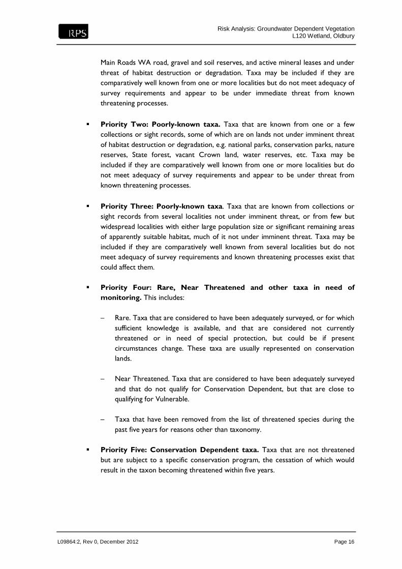
Risk Analysis: Groundwater Dependent Vegetation L120 Wetland, Oldbury
L09864:2, Rev 0, December 2012 Page 16
Main Roads WA road, gravel and soil reserves, and active mineral leases and under threat of habitat destruction or degradation. Taxa may be included if they are comparatively well known from one or more localities but do not meet adequacy of survey requirements and appear to be under immediate threat from known threatening processes.
Priority Two: Poorly-known taxa. Taxa that are known from one or a few collections or sight records, some of which are on lands not under imminent threat of habitat destruction or degradation, e.g. national parks, conservation parks, nature reserves, State forest, vacant Crown land, water reserves, etc. Taxa may be included if they are comparatively well known from one or more localities but do not meet adequacy of survey requirements and appear to be under threat from known threatening processes.
Priority Three: Poorly-known taxa. Taxa that are known from collections or sight records from several localities not under imminent threat, or from few but widespread localities with either large population size or significant remaining areas of apparently suitable habitat, much of it not under imminent threat. Taxa may be included if they are comparatively well known from several localities but do not meet adequacy of survey requirements and known threatening processes exist that could affect them.
Priority Four: Rare, Near Threatened and other taxa in need of monitoring. This includes:
– Rare. Taxa that are considered to have been adequately surveyed, or for which
sufficient knowledge is available, and that are considered not currently threatened or in need of special protection, but could be if present circumstances change. These taxa are usually represented on conservation lands.
– Near Threatened. Taxa that are considered to have been adequately surveyed
and that do not qualify for Conservation Dependent, but that are close to qualifying for Vulnerable.
– Taxa that have been removed from the list of threatened species during the
past five years for reasons other than taxonomy. Priority Five: Conservation Dependent taxa. Taxa that are not threatened
but are subject to a specific conservation program, the cessation of which would result in the taxon becoming threatened within five years.

Risk Analysis: Groundwater Dependent Vegetation L120 Wetland, Oldbury
L09864:2, Rev 0, December 2012 Page 17
5.1.2 Consequence Classification
The L120 Wetland has been assessed in relation to the DEC vegetation classification, with impact to higher priority vegetation having a greater consequence of impact compared to lower priority vegetation. This has been classified as follows (Table 8).
Table 8: Vegetation Conservation Status Consequence Classification
Conservation Status Classification Risk Classification
Alien and not rare, threatened or alien 1
Priority Four and Five- Rare, near threatened and other taxa in need of monitoring and Conservation Dependent Taxa
2
Priority One, Two and Three- Poorly Known 3
T - Threatened Flora (Declared Rare Flora- Extant). 4
Table 6 (previous) shows the DEC conservation status of all observed vegetation units within the L120 Wetland.
5.2 Wetland Management Categories
5.2.1 EPA Wetland Management Classification
The Environmental Protection Authority (EPA) has established three wetland management categorised depending on the quality of the wetland. The details of these wetland categories, as defined in EPA (1993) are: A Conservation Category Wetland (CCW) has a high degree of naturalness and the
management objective is to maintain and enhance natural attributes and function.
A Resource Enhancement Wetland (REW) has been modified and has a moderate degree of naturalness and human interest. The management objective is to maintain and enhance the existing ecological function. Opportunities may exist for commercial developments to enhance the conservation values of these wetlands.
A Multiple Use Wetland (MUW) is significantly degraded, possessing few natural attributes and limited human-use interest. The management objective should be in the context of the current wetland value and the potential value to the community if rehabilitated.
RPS considers the L120 Wetland is part of a larger wetland, consisting of REW and CCW that is believed to have been disconnected by construction of the railway line. The entire wetland, including CCW and REW areas is shown in Figure 4.

Risk Analysis: Groundwater Dependent Vegetation L120 Wetland, Oldbury
L09864:2, Rev 0, December 2012 Page 18
5.2.2 Consequence Classification
The L120 Wetland has been assessed in relation to the EPA Wetland Management Categories, with impact to higher category wetlands having a greater consequence of impact compared to lower category wetlands. This has been classified as follows (Table 9).
Table 9: Wetland Management Consequence Classification
Conservation Status Classification Consequence Classification
Not classified 1
Multiple Use 2
Resource Enhancement 3
Conservation Category 4
5.3 L120 Wetland Relative Area
5.3.1 Wetland Areas
The L120 Wetland forms a part of a 17.7 ha REW and CCW wetland, disconnected by construction of the railway line. The area of the L120 Wetland and adjacent REW and CCW wetland areas is outlined in Table 10 and shown in Figure 4.
Table 10: Relative Wetland Areas
Wetland Area Area (ha) % of Total CCW and REW Wetland Area
Total Area of REW and CCW 17.74 100
Total Area of REW 13.99 78.9
Total Area of REW North of Railway 12.32 69.4
Total Area of REW South of Railway 1.67 (0.7*) 9.4 (4*)
Total Area of CCW 3.75 21.1
Note: *Actual vegetated area of L120 Wetland is approximately 0.7 ha, or 4% of total mapped REW and CCW area.
5.3.2 Consequence Classification
A larger percentage of L120 Wetland area in relation to the total REW and CCW wetland area is considered to have a greater consequence of impact compared to a smaller relative percentage. This consequence has been classified as follows (Table 11).

Risk Analysis: Groundwater Dependent Vegetation L120 Wetland, Oldbury
L09864:2, Rev 0, December 2012 Page 19
Table 11: Area of Vegetation Risk Classification
% L120 Area Relative to CCW and REW Risk Classification
< 10 1
> 10 < 25 2
> 25 < 50 3
> 50 4
5.4 Relative Anthropogenic Impacts
5.4.1 Existing Anthropogenic Impacts
Field investigations indicate the hydrology in the area of the L120 wetland is significantly controlled by anthropogenic factors including the railway embankment and open drains. The lower elevations of the drains relative to the wetland was confirmed by surveying in September 2012, with non-flowing water connection between wetland water and drain water. Correspondence with Water Corporation confirms that water in the major drain to the south flows from west to east, finally terminating in the Peel Main Drain. Consequently any additional water in the drain in the vicinity of the L120 Wetland would flow away to the east. These factors are expected to minimise and control any groundwater level increases in the vicinity of the wetlands that are associated with the proposed excavation. This is particularly the case in the winter months when the drains remove water away from the system to the east and control groundwater levels. Specifically, existing anthropogenic impacts to the L120 Wetland water levels and quality include: groundwater drainage from the east – water levels and quality (algae in drain water) open drain from wetland to open drain further south – water levels open drain directly south and west – water levels railway embankment, tracks, paths and culvert – water levels non-native fauna (livestock and rabbits) – water quality. Groundwater modelling indicates the average annual maximum increase in groundwater levels at the L120 wetland due to the sand quarrying is up to approximately 0.15 m after a 10 year period. This prediction is conservative as it does not include the controlling effects of existing anthropogenic impacts to the natural hydrology in the area. Existing anthropogenic impacts are illustrated on Figure 5, with full detailed of existing impacts provided in RPS (2012a).
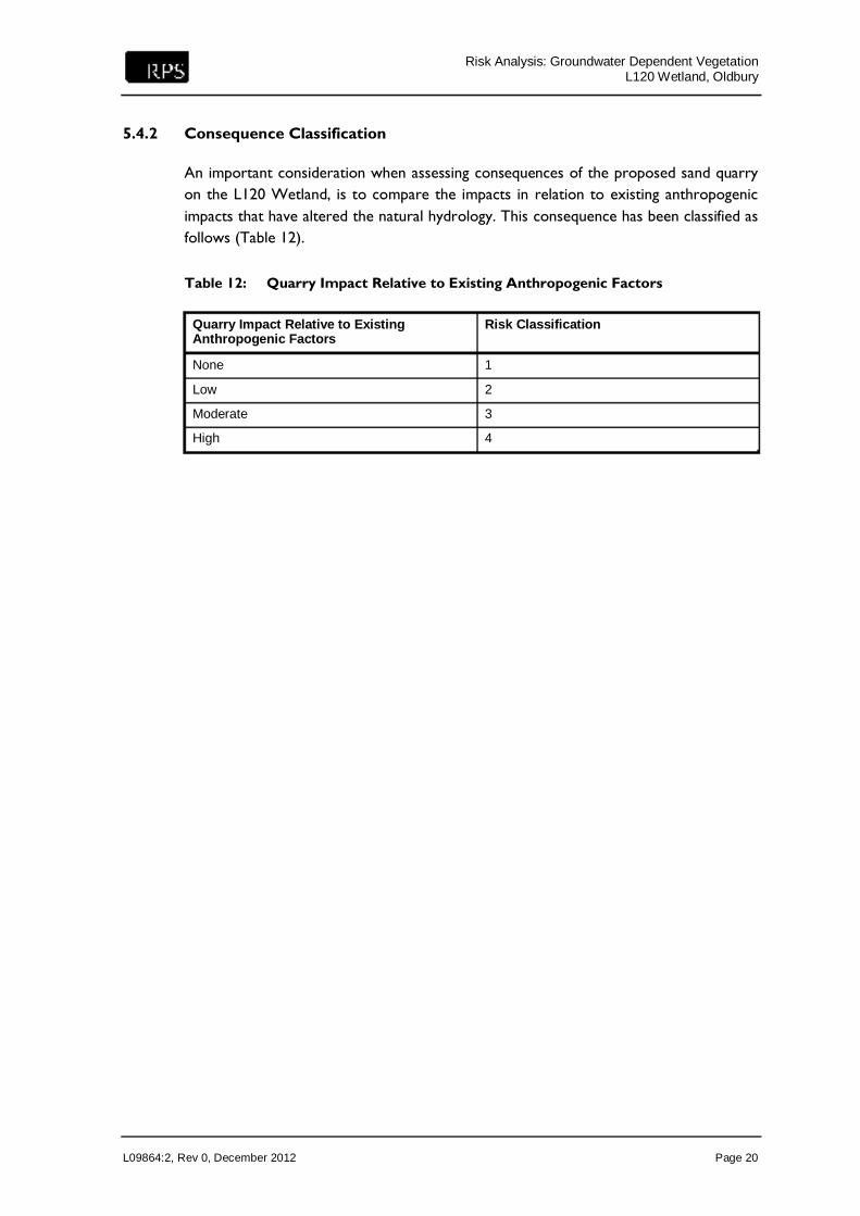
Risk Analysis: Groundwater Dependent Vegetation L120 Wetland, Oldbury
L09864:2, Rev 0, December 2012 Page 20
5.4.2 Consequence Classification
An important consideration when assessing consequences of the proposed sand quarry on the L120 Wetland, is to compare the impacts in relation to existing anthropogenic impacts that have altered the natural hydrology. This consequence has been classified as follows (Table 12).
Table 12: Quarry Impact Relative to Existing Anthropogenic Factors
Quarry Impact Relative to Existing Anthropogenic Factors
Risk Classification
None 1
Low 2
Moderate 3
High 4

Risk Analysis: Groundwater Dependent Vegetation L120 Wetland, Oldbury
L09864:2, Rev 0, December 2012 Page 21
6.0 RISK ANALYSIS RESULTS
The likelihood and consequence categories were used to quantify the risk of impact of sand quarrying activities to specific vegetation types at the L120 Wetland. Tables 13 and 14 provide the likelihood and consequence values used in the risk analysis.
Table 13: Likelihood Rating
Risk Value Likelihood of Impact
11-12 Almost Certain
9–10 Likely
7–8 Possible
5–6 Unlikely
3–4 Rare
Table 14: Consequence Rating
Risk Value Consequence of Impact
14-16 Catastrophic (C )
11–13 Major (Ma)
8–10 Moderate (Mo)
7–9 Minor (Mi)
4–6 Insignificant (I)
The above likelihood and consequence ratings were used to quantify and rank the risk of impact (Table 15). These quantities were in turn incorporated into a risk matrix to calculate the risk to each specific vegetation type with the L120 Wetland (Table 16).

Risk Analysis: Groundwater Dependent Vegetation L120 Wetland, Oldbury
L09864:2, Rev 0, December 2012 Page 22
Table 15: Risk Ranking Table
Vegetation Species Likelihood Categories Consequence Categories
Change in water level (m)
Vegetation tolerance to inundation
Water quality impacts at L120 Wetland
Conservation status of vegetation
Wetland management category
L120 wetland relative area
Impacts relative to existing anthropogenic factors
Arctotheca calendula 1 1 2 1 3 1 2
Astartea fascicularis 1 2 2 1 3 1 2
Carpobrotus sp. 1 2 2 1 3 1 2
Centella asiatica 1 2 2 1 3 1 2
Cyclosorus interruptus 1 1 2 1 3 1 2
Cycnogeton lineare 1 2 2 1 3 1 2
Ehrharta longifolia 1 1 2 1 3 1 2
Eucalyptus rudis 1 1 2 1 3 1 2
Gastrolobium ebracteolatum
1 2 2 1 3 1 2
Gomphocarpus fruticosus
1 1 2 1 3 1 2
Histiopteris incise 1 3 2 1 3 1 2
Juncus holoschoenus 1 1 2 1 3 1 2
Melaleuca preissiana 1 1 2 1 3 1 2
Pteridium esculentum 1 1 2 1 3 1 2
Solanum nigrum 1 1 2 1 3 1 2
Sonchus oleraceus 1 1 2 1 3 1 2
Taxandria linearifolia 1 2 2 1 3 1 2
Zantedeschia aethiopica
1 1 2 1 3 1 2

Risk Analysis: Groundwater Dependent Vegetation L120 Wetland, Oldbury
L09864:2, Rev 0, December 2012 Page 23
Table 16: Risk Matrix Results
Vegetation Species Likelihood Rating
Consequence Rating Risk Calculator
Arctotheca calendula Rare Minor Acceptable
Astartea fascicularis Unlikely Minor Acceptable
Carpobrotus sp. Unlikely Minor Acceptable
Centella asiatica Unlikely Minor Acceptable
Cyclosorus interruptus Rare Minor Acceptable
Cycnogeton lineare Unlikely Minor Acceptable
Ehrharta longifolia Rare Minor Acceptable
Eucalyptus rudis Rare Minor Acceptable
Gastrolobium ebracteolatum Unlikely Minor Acceptable
Gomphocarpus fruticosus Rare Minor Acceptable
Histiopteris incise Unlikely Minor Acceptable
Juncus holoschoenus Rare Minor Acceptable
Melaleuca preissiana Rare Minor Acceptable
Pteridium esculentum Rare Minor Acceptable
Solanum nigrum Rare Minor Acceptable
Sonchus oleraceus Rare Minor Acceptable
Taxandria linearifolia Unlikely Minor Acceptable
Zantedeschia aethiopica Rare Minor Acceptable
The results of the risk analysis indicate that the risk of sand quarrying activities constitutes an acceptable risk to vegetation of the L120 Wetland. This is the lowest of the five risk categories, namely: acceptable, low, moderate, high and extreme (Table 3). As specified in AS/NZS 4360:2004, treatment/strategies for risk categories less than a moderate risk of impact are not required to be implemented. Despite this, management and contingency measures are proposed for the sand quarrying activities. The next section provides a summary of the management and contingency measures proposed, with full details of management and contingency measures provided in the Extractive Industries License Application (RPS 2012b).

Risk Analysis: Groundwater Dependent Vegetation L120 Wetland, Oldbury
L09864:2, Rev 0, December 2012 Page 24
This page is intentionally blank.

Risk Analysis: Groundwater Dependent Vegetation L120 Wetland, Oldbury
L09864:2, Rev 0, December 2012 Page 25
7.0 MANAGEMENT AND CONTINGENCY MEASURES
Rocla will monitor groundwater levels at the southern edge of the site for the duration of the clearing program. Groundwater trigger levels have been determined (at 0.5 m above the model simulated groundwater increase of 0.2 m) and if exceeded for a period of more than two months consecutively, contingency strategies will be immediately implemented in consultation with the relevant authority. The contingency strategies include: accelerated planting of cleared stages where applicable
planting of phreatophytes (deep-rooted plants) along the southern boundary of the
site to increase water uptake
installation of groundwater abstraction bores along the southern site boundary to decrease groundwater levels if required. The water could be used in dust suppression or to accelerate plant growth in rehabilitated areas.

Risk Analysis: Groundwater Dependent Vegetation L120 Wetland, Oldbury
L09864:2, Rev 0, December 2012 Page 26
This page is intentionally blank.

Risk Analysis: Groundwater Dependent Vegetation L120 Wetland, Oldbury
L09864:2, Rev 0, December 2012 Page 27
8.0 REFERENCES
Environmental Protection Authority. 1993. A Guide to Wetland Management in the Perth and Near Perth Swan Coastal Plain Area. Bulletin 686. An update to EPA Bulletin 374.
Environmental Protection Authority. 2003. Native vegetation extent in the Swan Coastal
Plain Interim Bioregionalisation of Australia (IBRA) subregions south of the Moore River for vegetation complexes occurring within the Perth Metropolitan Region
ISO. 2009. International Standard ISO 31000: Risk Management-Principles and
Guidelines. Froend, R. and Loomes, R. 2004. Approach to determination of ecological water
requirements of groundwater dependent ecosystems in Western Australia – A report to the Department of Environment, Edith Cowan University, Perth.
Hyde, N.L. (2006). A summary of investigations into ecological water requirements of
groundwater-dependent ecosystems in the South West groundwater areas. JDA. 2012. Oldbury Hydrology Study- Expert Review. Mattiske Consulting. 2012. Summary of Botanical Values for a Potential Tumulus Spring
(Wetland L120), Oldbury. RPS. 2011. Groundwater Modelling Assessment. Lot 6 Banksia Road and Lots 300 and
301 Boomerang Road, Oldbury. Revision 1. RPS. 2012a. Hydrology Assessment. Lot 6 Banksia Road and Lots 300 and 301
Boomerang Road, Oldbury. Revision 3. RPS. 2012b. Extractive Industries License Assessment. Lot 6 Banksia Road and Lots 300
and 301 Boomerang Road, Oldbury. Revision 1. Standards Australia and Standards New Zealand. 2004. AS/NZS 4360:2004, Risk
Management, Sydney, NSW.

Risk Analysis: Groundwater Dependent Vegetation L120 Wetland, Oldbury
L09864:2, Rev 0, December 2012 Page 28
This page is intentionally blank.

FIGURES

38 Station Street Subiaco | T +61 8 92111111 | F +61 8 92111122 | www.rpsgroup.com.au
Job Number:L09864Date: 05.12.12Revision: 0Scale: 1:500000 Close up 1:50000 @ A4Drafted by: HTSource: Landgate, 2008
Figure 1
Site Location
SITE LOCATION
°
0 500 1,000 1,500 2,000250m
0 5 10 15 202.5km
---
00 -
o1 serpentine - Jarrahdale
Shire
(- C-_::o.
~\ . (
Rookmgh,m ~ \ , 0
r\~ C ;;i_,,_,-r\ ~, '-c___ /