route 3 contractors consortium · technical reviewer p kreuser p.1\a~ . ... route 3 contractors...
TRANSCRIPT

ROUTE 3 CONTRACTORS CONSORTIUM
~ . .
L 1: ],-', ~ . . ~
"
J~ - ~ , '
] - '
: ..
"' .. ~ --,,~ :t
G ~ 0:: C-j , ~,-.J
1- ,
, EI/1-oM,IIBe
ROUTE 3 TAl LAM TUNNEL & YUEN LONG APPROACH - SOUTHERN SECTION
FINAL DETAILED ENVIRONMENTAL IMPACT ASSESSMENT
Volume 1- The Main Line
August 1995
I CONSULTANTS IN
ENVIRONMENTAL
S CIENCES (ASIA) LTD
Room 1201, Tai Yau Building 181 Johnston Road, Wanchai, Hong Kong
Telephone : (852) 2893 1551" Facsimile: (852) 2891 0305

QUALITY ASSURANCE POLICY STATEMENT
Consultants in Environmental Sciences (Asia) Ltd is committed to satisfying the requirements of its Oients at the highest' standards of professional ethics,
It)s the Company's objective to provide services which meet the required specification and are produced on time in a cost-effective manner.
In pursuit of these objectives, the Directors have implemented Quality Systems based on ISO 9001 standard. All employees of the Company have a responsibility for quality.
The quality procedures are under continual review by senior Management to ensure that the changing needs of the Company's Oients are met.
L [
[
[ .. [ , .'
:.<~~,
"C' ' . . ,
'··.·0: :.. :
',<;.0· ~'~.~ .
"'0 . , :., ,[ '. ,
o '.0 o , ·0 "-'" '
.••... 01
,~~;' j
. ' 0,
o 'I' I "
,,~
'L· -. " '
." ,
L

-r' _J~J
In ';.;..J
j"'" ,
-.. ,
rT ; ~~-.. ~
, --1f.'.~
JU
TITLE
CLIENT
REPORT NO.
STATUS
I CONSULTANTS IN
ENVIRONMENTAL
, S CIENCES (ASIA) LTD
CES (ASIA) LTD DOCUMENT RELEASE FORM
Route 3 Tai Lam Tunnel & Yuen Long Approach ) - Southern Section Detailed EIA "
, (Volume 1- The Main Line)
:
Route 3 Contractors Consortium
668 PROJECT NO. 96530
Final DATE OF ISSUE 17 August 1995
QUALITY CONTROL NAME SIGNATURE DATE
CHECKED BY EChan €JJf!~ 16/8/95
TECHNICAL REVIEWER P Kreuser p.1\A~ . 16/8/95
APPROVED BY S Howard 0.fb~ 16/8//95
REMARKS : The information supplied and contained within this report is, to the best of our knowledge, correct at the time of printing. Where information has ·been supplied by third parties" such iriformation is reproduced here in good faith.
CES (Asia) Ltd accepts no responsibility for changes made to this report by third parties.

lr'~ >-).s4
[. ,
;
.-~~-~
[: 1 .~:~
C'i , '., ,(j
. , [ "
: ; ~ _·.1
[
' 1 , '
,
[0 [ ,
L.J
[".' .LJ
r
1
2
3
4
5
6
7
CONTENTS
INTRODUCTION 1,1 Background 12 Construction Requirements 1.3 Scope of Work 1.4 Project Area 15 Report Structure
PROJECT DESCRIPTION;· 21 Background .. , 2.2 Design . 23 Southern Section
EXISTING ENVIRONMENT 3,1 Sensitive Receivers 3.2 Cumulative Impacts 3.3· Noise 3.4 Air Quality 3.5 Water Quality 3,6 Ecology 3.7 Heritage
NOISE IMPACT 4.1 Legislation and Guidelines 4.2 Selected Sensitive Receivers 4.3 Methodology 4.4 Assumptions and Input Information 45 Predicted Impacts 4.6 Conclusions
AIR QUALI1Y 5.1 Legislation and Guidelines 5.2 Selected Sensitive Receivers 5.3 Methodology 5.4 Assumptions and Input Information 5.5 Predicted Impacts 5.6 Conclusions
WATER QUALI1Y 6.1 Legislation and Guidelines 6.2 Selected Sensitive Receivers 6.3 Assumptions and Input Information 6.4 Predicted Impacts 6.5 Conclusions
ECOLOGY 7.1 The Study Area 7.2 Relevant Hong Kong Regulations 7,3 Relevant International Conventions 7.4 Agriculture & Fisheries Department Fish Pond Categories
.. --.~ _._---
Page
1 1 2 3 4 4
6. 6 7 8
10 10 10 11 11 12 12 13
14 14 16 18 19 30 36
41 41 41 42 43 51 55
63 63 63 64 65 71
77 77 77 78 79

7.5 7.6 7.7 7.8 7.9 7.10 7.11
Vegetation Stream Ecology Stream Fauna Birds Reptiles and Amphibians Mammals Summary of Impact Avoidance and Habitat Loss Mitigation Measures
8 VISUAL AND LANDSCAPE IMPACT
9 VVASTEMANAGEMENT . 9.1 Legislation
9.2 VVaste Generation and Handling During Construction Phase 9.3 VVaste Arising During Operationai Phase 9.4 Mitigation Measures
10 CONCLUSIONS
List of Appendices
Appendix A Appendix B
Construction Requirements Dust Emission Calculations
79 86 87 88 98 99
100
110
113 113 114 116 117
120
·L
[
[
I T .
r [ .. T r [
,I [
[
T :.~':
[
.[
>1
1 I T
I. ...... _ ............ ,.. . .......... _ ....................... I

O:.,f,:j c-' '.
"- ~
l": ;,,~j
: L ' .' '; ~~,J
L"" i _: _ ~
-~
J
list of Tables
Table 1.1 Table 4.1 Table 4.2 Table 4.3 Table 4.4 Table 4.5 Table 4.6
Table 4.7 Table 4.8 Table 4.9 Table 4.10 Table 4.11 Table 4.12 Table 4.13 Table 4.14 Table 4.15 Table 4.16 Table 4.17 Table 4.18 Table 4.19 Table 4.20 Table 4.21
Table 4.22
Table 4.23
Table 4.24 Table 5.1 Table 5.2 Table 5.3 Table 5.4 Table 5.5 Table 5.6
Table 5.7
Table 5.8
Table 5.9
Table 7.1 Table 7.2
Table 7.3 Table 7.4
Table 7.5
Recommendations of ACE EIA Sub-Committee on the.PDS2EA Hong Kong Planning Standards and Guidelines: Road Traffic Noise Hong Kong Construction Noise Level Limits Construction Noise: Permitted Hours of Operation for Piling Representative Noise Sensitive Receivers: Operation Phase Impacts Selected Noise Sensitive Receivers: Construction Phase Impacts Worst Case PME Proposed by NCC GCL Concurrent PME - Worst Case Excavation at R46· (Ramp D) GeL Concurrent PME - Worst Case Concreting;at R46 (Ramp D) GqL PME - Worst Case Placement of Culvert Elements at R70, GCL PME - Worst Case Breaking Activities at R70 (Ramp C) GCL PME - Worst Case Filling Activities at R70 (Ramp C) DTP PME - Combined Earthwork Activities Affecting R70 NCC Worst Case for Hauling Route NCC Worst Case Activities at Tunnel Portal GCL Worst Case Earthworks - Filling of Chainage 5600 to 6100 GCL Worst Case Earthworks - Excavation of Chainage 6100 to 7300 GCL Worst Case Earthworks - link Road M GCL Worst Case Earthworks - Activities at Toll Plaza Stockpile GCL Worst Case Earthworks - Soil Nailing Activities Summary of Maximum Requirements for Construction Noise Mitigation 2011 Morning Peak Hour Traffic Flows Worst Case Cumulative Noise Impacts at NSRs to South of Tunnel -Incl~ding Mitigation Worst Case Facade Noise Levels (Construction) at Sensitive Receivers -Including Mitigation Worst Case Facade Noise Levels (Construction) in Immediate Vicinity of link Road M (Kam Sheung Access Road) Including Mitigation Facade Noise Levels (Operation) at Sensitive Receivers Hong Kong Air Quality Objectives Selected Representative Air Quality Sensitive Receivers ,Predicted Dust Emissions During the Construction Phase of the Project Vehicle Fleet Composition and Emission Factors for Year 2011 Tunnel Emission Rates for Year 2011 (AM Peak Hour) Predicted Maximum 1-hour, Maximum 24-hour and Annual Average TSP Concentrations at Selected Air Quality Sensitive Receivers Predicted Maximum 1-hour, Maximum 24-hour and Annual Average NO, Concentrations at Selected Air Quality Sensitive ,Receivers (2011) Predicted Changes in NO, Concentration in the Proximity of Tunnel Portals for Years 2002, 2004 and 2006 Compared to 2011 ' Predicted Maximum l-hour and Maximum 24-hour Average NO, Concentrations in the Vicinity of the Tunnel Portal (2011) AFD Categorization of Fish Ponds in Hong Kong Results of pOint-centred quarter survey of woodland at South Portal, Route 3 Project, March 1995 Estimated loss of habitats (ha) in South Study Area Native plants recorded on the study area during 1993-1995 surveys which provide forage sources for birds and which are recommended for use in revegetation. (After Corlett 1992) Birds recorded south of the tunnel during May 1993 and October 1994
- "--'- .•. _. ---, .... '" ... _. -. ---- "'. -_. __ . __ ... - .. -_ .. __ ._----- - "'-"~""--- -, --, .. - _ ... _------ " .. ------~ ........ -.. -- --, .. -
Page
2 14 16 16 17 18
2;1 2,1 21 22 22 24 24 25 25 25 26 26 26 27 28
31
32
33 34 41 42 47 49 50
52
54
55 79
82 84
86

Table 7.6
Table 7.7 Table 9.1 Table 9.2 Table 9.3
through January 1995 Birds recorded on the north study area during 26-27 May 1993 and October 1994 to April 1995 Ardeid Use Sites, Number of Days used out of Six Spoil Arisings from the Excavation Number of Employees and Refuse Arisings at Different Work Sites Lubrication Oil Consumption l)ate at Each Work Site
List of Figures
Figure 1.1 TLT & YLA (South Study Area) Figure 2.1 Desigrl Refinements . Figure 4.1 Representative Sensitive Receivers: North of Tai Lam Tunnel t Figure 4.2 Representative Sensitive Receivers : South of Tai Lam Tunnel Figure 4.3 Location of Concrete Profile Barriers Figure 5.1 Locations of Representative Air Quality Sensitive Receivers South of
South Portal Figure 5.2 Locations of Representative Air Quality Sensitive Receivers North of
South Portal Figure 5.3 Maximum 1-Hour Average N02 Concentration Contours South of South
Portal Figure 5.4 Maximum 24-Hour Average N02 Concentration Contours South of Solith
Portal Figure 5.5 Maximum 1-Hour Average N02 Concentration Contours North of South
Portal Figure 5.6 Maximum 24-Hour Average N02 Concentration Contours North of South
Portal Figure 6.1 Water Sensitive Receivers Figure 6.2 Affected Ponds & Surface Water Drainage for the Site Area of R3 North
Portal and Toll Plaza Figure 6.3 Surface Water Drainage for the Site Area of R3 South Portal & TKA Figure 6.4 Water Quality in Ponds to be Drained Figure 6.5 Sampling Location for Pond Water Testing Figure 7.1 Locations of the Transects in Woodland in the Vicinity of South Portal,
March 1995 Figure 7.2 Habitat Map, North of Tunnel Portal Figure 7.3 Locations of the Protected Species Arundina chinensis and the Mammal
Transects in the SOlith Area Figure 7.4 . Locations of the Eroded Hillsides Available for Compensatory Planting Figure 7.5 Ho Pui Egretry Figure 7.6 Heron and ,Egret Nest Sit~s, Spring 1995 _. Figure 7.7 Fish Ponds to be Lost Due to Route 3 Construction Figure 7;8 Diagram of Pond 2.to be Managed for Conservation Figure 8.1 Revised Extent of Cut Figure·9.1 Fill Management for Areas between Toll Plaza & North Portal
90
91 94
115 118 118
5 9
38 39 40
57
58
59
60
61
62 72
73 74 75 76
102 103
104 105 106
'107 108 109 111 119
-' '. -- -I
[
r [
'f ,[
[
i~[
-'t [
;:[
[
[
.[
[
[
{
.f 0[
.'-f
..... ---.--l

!
J
J
," !
:-1 ~jt.j
iT l~'-
I -{.~
I ' , , ~~..i
[

~~.:} \. ~
1'-" L," '
[' ',-"
[ , ' , ,
Lj
In Ij
l,','" .~ : \ ; ~~j
Route 3 Contractors Consortium R3 TLT & YLA (S) - Main Une DEIA Vl.5
1
1.1
INTRODUCTION
Background
The new Hong Kong International airport at Chek Lap Kok on the north coast of Lantau Island is scheduled to commence operations in 1997. To serve the new airport as well as the proposed container terminals 10 and 11 (also located on Lantau Island), extensive infr~structure and transport links fre required.
RoJte 3 Tal Lam Tunnel and Yueft Long Approach (R3 TLT & YLA) is an integral part of this supporting transport network, extending from Ting Kau to Au Tau, including the Northern link (Au Tau Interchange to Yuen Long) and the connection to the New Territories Circular Road (NTCR).
An Environmental Assessment (EA) study for the R3 TLT & YLA (including'the conveyor system under a separate cover) Preliminary Design Stage 2 (PDS2) was undertaken by Freeman Fox Maunsell for Highways Department according to a brief provided by the Environmental Protection Department (EPD). This study, hereafter referred to as the PDS2EA, was completed in March 1994, conditionally recommended for endorsement by the Advisory Council on the Environment (ACE) EIA Subcommittee on 5 July 1994 and was subsequently endorsed by the full ACE committee, subject to the conditions given in Table 1.1.
This project is now being undertaken by a franchisee, Route 3 (CPS) Company limited, that has delegated responsibilities for design and construction to Route 3 Contractors Consortium (R3CC). Aset of Construction Requirements are given in Appendix 5 part I of the Project Agreement, including various requirements for a Detailed Environmental Impact Assessment (DEIA) for aspects which were not covered' adequately by the PDS2EA or had considerable design changes. The environmental section of these
, Construction ReqUirements are included in Appendix A
This DEIA fulfils the requirements of the assessment for the Southern Section extending from the works boundary with Ting Kau Bridge up to and including the Karn Sheung Access Road, and the Conveyor System. The environmental impacts associated with the Northern Section of the project (from Kam Sheung Access Road north including the Au Tau Interchange) will be evaluated in the Northern Section DEIA to be submitted under separate cover.
Two documents have already been presented to ACE by R3CC. The first was an Information Paper on the environmental impacts of the preliminary works taking place in the first 6 months of the project. This was endorsed by the ACE. The second covered the environmental -impacts of the Conveyor System. , This was endorsed subject to the following conditions: '
a) all mitigation measures listed on page 14 of the Conveyor System Information Paper (April 1995) be adopted with the exception of enclOSing the discharge points and the stockpile;
. CES (Asia) Ltd 1 96530\reports\deia-s\r3sdeia.d12

Route 3 Contractors Consortium R3 TLT & YLA (S) - Main Line DEJA Vl.5
1.2
b) additional quietened equipment be deployed in construction activities and/or the use of noise barriers where necessary to ensure the daytime noise criterion of 75 dB(A) is met;
c) extremely loud equipment, such as rock drills, should not be used in the evening or night hours;
d) noise reduction measures for tugboats or strict controls on their use be applied; ':-' ~
e) litter and debris arisini from the project be cleared frequently and the jetty reinstated: as soon as possible; and
f) a summary of the habitat loss mitigation proposals for the project be included in the Southern Section DEJA to be submitted to ACE.
Table 1.1 Recommendations of ACE EJA Sub-Committee on the PDS2EA
Temporary access to avoid wetland R3CC will take note of this recommendation habitats and SSSI at Ho Pui. in proposing temporary access. Provision of wildlife corridors
Additional ecological survey before commencement of work.
Off-site compensatory planting at a ratio of no less than three to one.
The final EIA to be submitted to ACE for consultation.
Off-site restoration of wetland.
CO,nstruction Requirements
Supplementary surveys were carried out from late August, 1994 through January by . Highways Department. . R3CC will undertake the continuation of this survey and complete it in June 1995. Reports will be made at the end of the survey.
R3CC will undertake the compensatory planting in areas as indicated in Figure 7.7 of this Report.
R3CC will submit the Detailed EIA to ACE for consultation.
Highways believe that off-site restoration of wetland is not viable for this project. R3CC, however, will reinstate areas of ponds within the work site which are not required as part of construction, operation and maintenance of the permanent works.
These requirements are reproduced in Appendix A.
. CES (Asia) Ltd 2 96530\reports\deia-s\r3sdeia.d12
L [
[
[
T [
[
<[
T -[
[
[
[
J [
[
I [
l 1
... _J
[
--1
.j :.
c:
[ '" (i ",-.~J
[-' ,
-~J
[ '" -:~i
L"', : j
;: .. ~
r
Route 3 Contractors Consortium R3 TLT & YLA (S) - Main Une DEJA V1.5
1.2.1 Key Issues
Key issues which must be taken into account in monitoring and/or mitigating environmental impacts identified in clause 10.2 of the requirements are as follows:
• associated fixed noise sources of constructed facilities; • traffic noise; • eff~ct on air quality, particularly along Yuen Long Approach, at the portals and
ventilation exhaust points of Tai :Lam Tunnel and inside the tunnel; • visual impact, and landscaping and environmental reprovisioning; • ecological and heritage impact; • water quality impact; • disposal of soil, construction waste and unsuitable material; • traffic impact to existing roads during construction; • construction noise, dust and vibration.
These issues are covered by this DEJA with the exception of the impact of traffic flows on the local highway network, which is not an environmental issue and is being addressed by the traffic consultant, and air quality impacts in the tunnel, which is being addressed by the ventilation designers.
1.2.2 Ecology
Four main ecological issues are highlighted by the requirements, as follows:
• Clause 10.3.2 - determine the area, species and precise location of woodlands affected by the execution of the works;
• Clause 10.1.6 - complete the four seasons ecological survey already partially completed by Government and prepare a report identifying the need and measures to be taken to mitigate the impact of the constructed facilities on ecology;
• Clause 9.3.3 - for fish ponds affected by the temporary works, but not required in the long term, determine suitable enhancements to improve their ecological value.
1.2.3 Environmental Monitoring and Audit
Detailed requirements for environmental monitoring and audit (EM&A) are outlined in clauses 10.4-10.10.
1.3 Scope of Work
It has been agreed that EPD's standard scope of work will be employed for this project as far as is appropriate in relation to the evaluation of environmental impacts related to changes between the preliminary design and the final design. It should be noted that Clause 10.1.2 indicates that !'existing buildings and buildings'to be built in the future for which proposals have been submitted and agreed by the Government" are to be considered in the DEIA This report is prepared in accordance with these requirements.
The consultant has received from DPO Yuen Long a drawing prepared on 19 May 95 .
. CES (Asia) Ltd 3 96530lreportsldeia.slr3sdeia.d12

Route 3 Contractors Consortium R3 TLT & YLA (S) - Main line DEJA Vl.5
1.4
1.5
It shows recent planning application approvals in an area to the east of Ma On Kong (Figure 1.1). These new receivers will not be worst case receivers and were not selected for further assessment.
Project Area
For the purpose of addressing environmental matters associated with the R3 TLT & YLA, the project is divided into',a Southern Section and a Northern Section. The Southern, . Section comprises the Ting Kau Area, the Conveyor Systejl1, the Southern Portal, TLT &; YLA up to the Kam Sheurig Access Road. The remainingportion north of Kam Sheung' Access Road will be covered by the Northern Section DEIA
This DEJA is for the Southern Section of the Route 3 TLT & YLA up to and including the Kam Sheung Access Road and the Conveyor System. The area covered 9Y this report is shown in Figure 1.1.
Report Structure
This report is presented in 3 stand-alone volumes, as follows:
Volume 1 DEJA for Southern Section Main R3 Alignment Volume 2 DEJA for Conveyor System Volume 3 EM&A Manual for the Southern Section (including the Conveyor System)
Volume 1 consists of 10 sections, as follows:
1) Introduction; 2) Project D~scription; 3) Existing Environment (including Heritage); 4) Noise Impact; 5) Air Quality Impact; 6) Water Quality; 7) Ecology; 8) Visual Impact; 9) Waste Arisings and Disposal; and
.10) Conclusions.
CES (Asia) Ltd 4 96530\reports\deia-s\r3sdeia.d12
[
[
:',[ ,':
. ... [ ::/: '.;-~
.[
[
[
[
1 1 'I
r

0:
)
OP
r ~'.·"··. I• . . ,
I· , LJLJ
II ; LL)
[ , .
i-~ .,
r - .~
'.: Li~,-j
" .
: '\ "4 • . ~ •• \~.\._ . • J .;' ~ IJ~·. ~, ..... :.~ - \ :. . .. . .. \. :-.~.-..... ..
;::~ 1': r\. ~.~ 1 ... ,,' .:.:..... \ ~ .~~ •• '0 : ", /' •. :.~ .. .c: ........ .. ~ .... - '.. . .. ~ ... : . ',' ,.:' ," .... "t.· ,'r.'- ........ ~ .. . _ ·~.TL:;:~ '':>~~.::,<\:.
.;'--.::.:~ ........ . ."
. '.
. . '
. , .~
Legend
Study Area
Figure 1.1 TLT & YLA (South) Study Area
'''' .-_. ".:: ........ : ......... i
~ . ..... -.;:--::- :-;;.'
.~ -.... ....... . ,,' ~
~UA
"
\ Area of Approved .'Planning Applicaton
-, .... '. . ....
.,' .... :'Iou "~ : .- J_~' .• ' .
...,. \::~ '1'1~ .!. .... , .. ,. ~~.,. '. " . :1 -,' " I ..... " .... - ••
RAMal
'TSIN
C('")NStlLTAN'rs 11'1
ENVIRO:-lMU:-lTAL
SCII!NCBS (ASIA) LTD

1 LJ;
~~I:~·'·l .. ,- ~'.':;
'I"
[ I : ,. ;
~,:,,.)
rr' L..;u
11 L LJ
I .. " , ;' ;
l'. , ,,_.j
T' T' 1_,. ,
D" . : "
;. ": :,,:1
] '.n.' . . " ;
::-, j
rTl .--)~ .;
If~ l. ___ ,t:.:j
C,·· 'Lj
01: " "' I,~,j
[I.':'. i ,j l"-"1
l-··, :.' ! -.:.,J
Route 3 Contractors Consortium R3 TLT & YLA (S)- Main Line DEIA V1.5
2 PROJECT DESCRIPTION
2.1 Background
The R3 TLT & YLA comprises the northern section of Route 3 from Tuen Mun Road in the south to Au Tau near Yuen Long in the north, where it will connect with the New Territories Circular Road and the Yuen Long Southern Bypass. It will provide a direct link connecting the North West New Territories and the border crossing at Lok Ma Chau through to Tsuen; Wan, Kwai Chung:, Lantau, the West Kowloon Corridor and Hong Kong Island.
The R3 TLT & YLA provides a fully graded separated dual3-lane highway 12 km long . This includes the 6.3 km elevated stretches of Yuen Long Approach Road and the 3.8 kID Tai Lam Tunnel.
The Tai Lam Tunnel consists of two separate 3-lane road tunnels and central ventilation tunnels from the portals to the quarter points of the road tunnels. Ventilation plant buildings will be located at both portal areas.
There will be a 22-lane Toll Plaza and an Administration Building:, accommodating the Central MonitOring and (Traffic) Control System, situated 1.5 km north of the North Portal of the Tai Lam Tunnel. An additional satellite control station will be located in the South Portal area.
At the Toll Plaza, sliproads will be provided to connect the main roadway to Kam Sheung Road situated to the east. The approach roadworks at the south include the Ting Kau Interchange where R3 TLT&YLA connects to the northern end of the Ting Kau Bridge and Tuen Mun Road.
The preliminary design for the Tai Lam Tunnel identified the need to remove approximately 6 Mm3 of excavated spoil material from the area. A Conveyor System was deemed to be the most practical and environmentally acceptable method for transporting the material to a barge loading area. The amended design proposed by R3CC has reduced the spoil handling requirement to around 4.5 Mm3
• A Conveyor System will still be employed to move the spoil to the barge loading facility. This is assessed in Volume 2 ofthis DEIA .
A temporary 960 m long Conveyor System will be installed along the hillsides and coastal . area to transport away all excavated· material arising from t(\e construction of the Ting Kau Interchange and the Tai Lam Tunnel. Disposal of this material will be by barges
. which dock at a barge loading jetty; located at Gemini Beaches and linked .to the Conveyor System. .
Route 3 (CPS) Company Limited has been selected as the Franchisee for the Build Operate and Transfer (BOT) Contract for the R3 TLT & YLA. Acting on behalf of the Franchisee a JOint Venture of Dragages and Nishimatsu, the Route 3 Contractors Consortium (R3CC), will undertake design and construction of the R3 TLT & YLA.
CES (Asia) Ltd 6 96530\reports\deia -s\r3sdeia.d12
~ .-~.-.....-- .....-- ...................... _.

Route 3 Contractors Consortium R3 TLT & YLA (S) - Main Line DEIA V1.5
2.2
AJoint Venture of Maunsell Consultants Asia Ltd. and Scott Wilson Kirkpatrick, MSWJV, have been appointed by R3CC to undertake all aspects of design including the requirement for a Detailed Environmental Impact Assessment (DEJA).
Design
An implicit component of the DEJA is to establish the changes between the Franchisee's detailed designs compared with the preliminary design. These are broken down into the following subsections.
Environmental assumptions: No change to the environmental assumptions has been made.
Engineering assumptions: Figure 2.1 shows the refinements made to the design of the road. Briefly, these can be summarised as follows:
• The road alignment at the South Portal has been elevated by 18 m. This reduces the amount of material to be excavated from the southern cutting and tree loss. More fill material will be required to construct the embankment crossing the stream channel in the Southern Valley.
• Ramp C to the Tin Kau Interchange will be constructed with reinforced earth instead of the initial bridge design. This will require more fill for the embankment construction.
• There is a marginal difference in the tunnel alignment.
• The Ventilation Buildings at both the North and South Portals have been relocated and are now combined with the respective Portal Buildings. This will result in less cut and less land take.
• The Toll Plaza layout has been modified to move the toll booths slightly south. This will result in less fill.
• South of the Au Tau interchange, Link Road J has been reduced in length. This will result in more cut and less fill.
• At the Au Tau Interchange the alignment has been revised. This'will result in less land take and wetland loss. In addition roads on the edges of the interchange have been put onto 10weIl1bankments.
Traffic a~sumptions: The traffic load has been modified in ti1e detailed design. As' an 'indication of the magnitude of'differences, PDS2EA assumed a two-way tunnel traffic of 8,090 vehicles, of which 80% were heavy vehicles; the present design assumes a two-way tunnel flow of 7,820 vehicles and 64 % heavy vehicles. There are 3.3% reduction in total flow and 23% reduction in heavy vehicles.
, Identification of sensitive receivers: A detailed survey was conducted to identify the potential sensitive receivers for further detailed assessment of the air and noise impacts. Isolated
CES (Asia) Ltd 7 96530Ireportsldeia-sIr3sdeia.d12
L -~
i : l __ .:
f' . I c __ :
~,
I I
LJ
n
on --1! " , I I
. i, '
_[1 - , ...... ---'
.:0
.n
'-1 I ' .. _L. __

J:
\'
l '~'.-.;
--1-: .,
I,' " : 1
" ::, '; .J,j
1 [ , [ ..
-~::'J
U!'l I i
[ . ~ ~.J
[ '-
Route 3 Contractors Consortium R3 TLT & YLA (S)- Main Line DEIA V1.5
2.3
receivers, other than the village clusters identified during the PDS2EA, were located. These isolated receivers are nearer to the site and are adopted in this DEIA. This survey fulfils the requirements of the ACE EIA Subcommittee and the suggestions in the PDS2EA and which states:
"In order to obtain the precise number of NSRs affected, it would be necessary to conduct a very detailed site survey (including achieving access to all the properties to determine their natur;e and status) at the detailed desigJ:l stage taking into account the final alignment and, its land take requirements."
Southern Section
Three contractors will be working in: the Southern Section. The work split between them is as follows:
Nishimatsu Construction Co (NCC) • Civil works in northern half of tunnel, in:volvirtg mainly blasting and excavation; • Structural works associated with Portal structure and buildirtgs at the North Portal; • Site formation, drainage and landscaping works at North Portal.
Dragages et Travaux Publics (DTP) • Civil works in: southern half of tunnel, involvirtg mainly blasting and excavation; • . Earthworks for the main cut between Tin: Kau Interchange and South Portal; • Structunil works associated with Portal structure and buildirtgs at the South Portal; • Site formation, drainage and landscapin:g works at South Portal and the main cut.
Gammon Construction Ltd (GCL) , • Earthworks for batter and embankment formation between the North Portal and the
Toll Plaza; • Structural works for the culverts and all the bridges along the alignment as well as
buildin:gs ,in: the Toll Plaza area; • All roadworks.
CES (Asia) Ltd 8 96530\reports\deia-s\r3sdeia.d12

Jr Dr Ur Dr o[ Or Dr De OL Or I[ iDl I
Or D[
°L liD l iD [ !iDL iD[ I r,:' I~L I
r
NEW TOLL PLAZA LA YOUT LESS FILL
'/=".,--- TO K A H ROAD
VENTILA TlON BUILDING
NO DIFFERENCES COHBINED WI TH PORTAL BUILDING LESS LANDTAKE LESS CUT
.• ' HARGINAL DIFFERENCE IN " TUNNEL SEPARA TlON
-."
VENTILA TlON BUILDING
TAl LAH TUNNEL LEGEND:-
CURRENT PROPOSAL
----------- PREVIOUS PROPOSAL" (FOR PRELIHINARY DESIGN STAGE 2 - ElA)
9
NORTH PORTAL
;";.
SOUTH PORTAL
TAl LAH COUNTRY PARK
. TIL A TlON BUILDING COHBINED PORTAL BUILDING, LEVEL RAISED BY 18m
TAL, SIGNIFICANT LESS CUT, TL Y HORE FILL OVER STREAH
C BY REINFORCED EARTH, INS rEAD OF ON STRUCTURE HORE PLEASANT A ESTHETICALL Y
!
TO TlNG KAU BRIDGE
RAHP C
TlNG KAU IN TERCHA NGE
" ,i TUEN HUN OAD
DEIA SOUTHERH SECTION,
DESIGN REFINEMENTS FlQURE
FROM STAGE 2 EIA 2.1

-,..-,
J.
J
]'
-1'.'i ,~ ~
~Li
~-j- , 1.-- .
~I~~ .•. t
--) .. ~ ,
~J.,
C--: , ;
[
[
C}; <.- .'
I]\,j l~~~j
I". '.i". " ,
i; ,,:
[ '"
...i ~;'sj
[c ['
[. ", " ,
~,~;
[
'n, '," \
\' ':i S,:i
C'·'· .... :: )
",';
Route 3 Contractors Consortium R3 TLT & YLA (S) - Main Line DEIA Vl.S
3
3.1
3.2
EXISTING ENVIRONMENT
Sensitive Receivers
A comprehensive sensitive receiver survey was carried out to determine the locations of sensitive receivers within 300 m of the road alignment. This level of coverage ensured that the worst case sensitive receivers were identified. Survey results for the Southern Section are included in the EM&A Manual submitted as Volume 3 of this Report. No major additional cluster of sensitive receivers was located beyond those already identified in the PDS2EA. However, those isolated receivers in small houses, whose existence was noted in the PDS2EA, have now been clearly located and identified.
The site area between the North Portal and the Toll Plaza lies within the catchment area of Kam Tin River which drains into the inner Deep Bay. The site area of the South Portal and the Ting Kau Interchange area is located within the catchment of a,'small stream which drains the V-shaped valley north east of Sham Tseng. The rivers and streams within these catchments will be affected by the Route 3 project at both construction and operation stages. Sensitive receivers for water quality were identified in the PDS2EA and are adopted in this study.
In general, water sensitive receivers include the rivers, streams and coastal waters lying in the same catchment area and downstream of the construction site. Catchwaters and water tunnels within the Water Gathering Ground for Tai Lam Chung Reservoir are upstream of the site. It should also be noted that the South and North Portals of the tunnel are located close to, but outSide, the boundary of the Tai Lam Country Park. Specific sensitive receivers for the Southern Section as identified in the PDS2EA report are summarized as follows :
South Portal and Ting Kau Approach • The stream course in the V -shaped valley that runs southwesterly to Sham Tseng • The small stream that drains into Ting Kau Beach • The Water Supplies Department (WSD) catchwater located at the southern boundary
of the Country Park (this is upstream of the works and is unlikely to be affected) • Coastal beaches including Lido Beach and Gemini Beaches
North Portal, Toll Plaza to Kam Sheung Access Road • The Kam Tin River which drains much of the East Yuen Long area • The WSD catchwatet located at the northern boundary of the Country Park close to
the North Portal (this is upstream of the works and is unlikely to be affected) • Fish ponds in the low lying region of the Yuen Long flood plain
Cumulative Impacts
All the impact evaluations took account of other projects in the area, where information had been made available on the environmental impact of those projects in time for incorporation into this report. Known projects in the vicinity include:
• Ting Kau Bridge;
'CES (Asia) Ltd 10 96530\reports \deia ~s\r3sdeia.d12
f__ __ .,_ '
Route 3 Contractors Consortium R3 TLT & YLA (S) - Main Line DEIA Vl.S
3.3
3.4
• Tuen Mun Road Improvement; • Kam Tin Drainage Protection Works.
For the operational phase cumulative impact assessments for air and noise aspects have been achieved by modelling the larger road network taking account of predicted traffic growth. For the construction phase, cumulative impact assessment for dust impacts has been achieved by using a realistic background dust concentration. For construction noise impacts this was not done because the control is based on notional noise sources in the immediate vicinity of the sensitive receivers.
The Conveyor System and the R3 alignment are well separated beyond the immediate area of the South Portal by hilly steep terrain. There is therefore good spatial separation close to the sensitive receivers, which are well south of the South Portal. In addition, the peak activities for the construction of the conveyor are early in the programme during the preliminary works. This part of the programme is not the worst case for the work on the main line. Therefore the worst case impacts from these two aspects are not coincidental. Tl;le technique of incorporating appropriate levels of background environmental quality used in the assessments is considered adequate to cover cumulative impacts.
In terms of water quality, the focus for the Conveyor System assessment is on the impacts of the jetty. For both the main line and the conveyor, protection of fresh water courses is stressed. The areas impacted drain to separate catchments. It is considered that measures to protect fresh water will guard against cumulative impacts in the sea. This is because coastal dispersion is much greater and the Technical Memorandum standards were designed with this objective in mind.
Noise
A survey conducted for the PDS2EA - Conveyor System indicated that the ambient noise at the Pink & Golden Villas, situated to the South of the Tunnel Portal was dominated by traffic noise along Castle Peak Road (LlO ~ mm) = 75 dB(A), L,q~ mm) = 71 dB(A)).
A noise survey was conducted for the PDS2EA - Southern Section at five sensitive receivers. It was found that for the morning peak hour (0900) the L,o (' hom) varied from 58 dB (A) to 77 dB(A) depending on proximity to existing roads. The daytime L,q (' hom)
at the same locations varied from 51 dB (A) to 72 dB(A).
Air Quality -'
Indication of the 'existing conditions is not available from the monitoring program undertaken by E\PD because there is no N02 air quality mo~toring station located in the Southern Section. .
Both the Castle Peak Road and the Tuen Mun Road are running through the Ting Kau area, moderate pollutants levels in the proximity of the South Portal due to traffic emissions would be expected. There is currently no major road or industrial facillty in the proximity of the Northern Portal, the pollutant levels around the Northern Portal should currently be minimal.
. CES (Asia) Ltd 11 96530\reports\deia-s\r3sdeia,d12
--L
T [
[
I ::[ ~.<
{
3[ :;;~'.,
..:.[
[
[
[
[
T
[
.J

['
[
[,
I,,;; """"';;_,.1
"n I -," • i <,"',
~~,-:.;
[-' .. ' .• ,
~i....:J
C'
Route 3 Contractors Consortium R3 TLT & YLA (S) - Main Line DEIA Vl.5
Total suspended particulates (fSP) measured over a 24-hour period at the Riveria Apartments in September to October by Axis Consultants Ltd for Highways Department showed background TSP levels of around 80 pgm-3. However, measurements indicated that this level was rising due to a number of construction projects in the area. Baseline monitoring is being undertaken as part of the EM&A programme for this project.
3.5 Water Quality
3.5.1 Marine Waters
The gazetted bathing beaches in the Sham TsenglTing Kau area were ranked as poor with respect to bacteriological water quality. The seasonal geometric means of E. cali count for Gemini Beaches were 248 count per 100 ml in 1992, 254 count per 100 ml in 1993 and 246 count per 100 ml in 1994. The persistently high bacteria count in this area was, and is, due to livestock farms, the sewage and stormwater outfalls from' the squatters and unsewered development.
3.5.2 Inland Waters
Kam Tin River has one of the larger catchment areas in the Yuen Long locality and the river water quality is regularly monitored by the EPD. The relevant monitoring station for the area north of the North Portal to the Toll Plaza is station KTl which is further north and downstream of the study area. The river water quality of the Kam Tin River is ranked as "very bad", with measured average dissolved oxygen of 1.1 mg 1-1 and biochemical oxygen demand of 42 mg ]-1 in 1993. The suspended solids concentration and ammonia nitrogen content are also high.
In the south, the streams at Sham Tseng and Ting Kau are relatively small and the flows are usually small in winter. The stream in the V -shaped valley flows into two small
. reservoirs which once served the San Miguel brewery. It is understood that the collected water is no longer used by the brewery.
3.6 Ecology
Preliminary ecological surveys for the environmental impact assessment (EIA) of the Route 3 highway project were conducted from March to June 1993 (Freeman Fox Maunsell1993a, 1993b). A supplementary ecological survey to cover autumn and winter seasons was carried out from August 1994 through January 1995 (Freeman Fox Maunsell 1995) at the request of ACE. Impact assessments made subsequent to these surveys were
. based on preliminary alignments and designs provided by Highways Department in 1993. A final survey during spring 1995 was completed at the end of May 1995 and the results will be reported separately .. The ecology of the existing environment is described in Section 7 of this report.
The purpose of this DElA is to address contractor revisions of the preliminary Highway Department designs and describe potential impacts due to those revisions. Key ecological issues were identified in previous reports, and included:
. CES (~ia) Ltd 12 96530\reports \deia -s\r3sdeia.d12

Route 3 Contractors Consortium R3 TLT & YLA (S) - Main Line DEIA: Vl.5
./
r
3.7
• loss of woodlands and woodland restoration measures [ • loss of wetlands and possible wetland restoration measures;particularly for fish ponds
affected by temporary works . • indirect impacts on colonial nesting and roosting sites for egrets and herons [ • recommendations for ecological impact avoidance and mitigation
This report is based on the highway alignment, designs and information provided by T R3CC in February-May 1995.
Heritage
Heritage was addressed by consulting Antiquities and Monuments Office (AMO) of the .[ Recreation and Culture Branch on these issues. No item of historical interest was highlighted by AMO in the Southern Section of the R3 alignment.
The Conveyor System will pass close to two existing graves. One is directly adjacent to ::l Tuen Mun Road (north side). The other is about 100 m north of Tuen Mun Road. The contractor is aware of the grave locations and will take appropriate precautions through fencing and signage to ensure the graves are not adversely affected. [
[
[
[
.1
[
l l
. CES (Asia) Ltd 13 96530\reports\deia-s\r3sdeia.d12

i ---' '
J
l
i ~
r:
l_
:l '; . »
___ ~...s'

[
[.- "
, " .) }
[ '.'-:".' ;" :
"~- ;,
[ .. ': .. C"'. ,- "
..
r
Route 3 Contractors Consortium R3 TLT & YLA (S) - Main Line DEIA Vl.5
4 NOISE IMPACT
4.1 Legislation and Guidelines
4.1.1 Introduction
The Noise Control Ordinance (NCO) defines construction and fixed noise limits. Nonstatutory criteria, such as the Hong Kong Planning Standards and Guidelines (HKPSG) and the eligibility criteria relating to the ExCo directive, Equitable Redress for Persons Exposed to Increased Noise Resulting from the Use of New Roads, are relevant to the assessment of traffic noise impacts.
4.1.2 Noise Assessment (Operational Noise)
The HKPSG recommends that road traffic noise does not exceed the standards in Table 4.1:
Table 4.1 Hong Kong Planning Standards and Guidelines: Road Traffic Noise
Domestic premises 70
Offices 70
Educational institutions including kindergartens and nurseries 65
Hospitals, clinics, convalescences and homes for the aged 55
Notes: 0 The above standards apply to uses which rely on opened windows for ventilation. o Facade noise levels in tenns of LlO (peak hour) - ~
For new roads, direct noise mitigation must be provided to satisfy the noise limits contained in the HKPSG as far as practicable. In the case where an existing Noise Sensitive Receiver (NSR) is already subject to a prevailing noise level equal to or exceeding the HKPSG criteria, measures to avoid (as far as possible) deterioration of the existing situation are put forward. Indirect technical remedies can only be provided to tackle the residual noise impact after all direct technical remedies are exhausted, subject to meeting the ExCo directive for Equitable Redress for Persons Exposed to Increased Noise Resulting from the Use of New Roads, Criteria are:
• the predicted overall noise level from the new or improved road, together with other traffic noise in the vicinity, must not be less than the HKPSG criteria;
• the predicted noise level is at least 1.0 dB(A) more than the prevailing noise level, i.e., the total traffic noise level existing before the works to construct the road were commenced; and
. CES (Asia) Ltd 14 96530\reports\deia -s\r3sdei a.d12

Route 3 Contractors Consortium R3 TLT & YLA (S) - Main line DEIA Vl.5
• the contribution to the increase in the noise level from the new or improved road must be at least 1.0 dB(A).
It should be noted that the provision of indirect technical remedies for non-institutional buildings must be approved by ExCo.
4.1.3 Noise Assessment (Construction Noise)
The NCO provides for the control of construction noise. Assessment procedures and standards are set out in two Technical Memoranda (rM) associated with the Ordinance: the Technical Memorandum on Noisefrom Construction Work other than Percussive Piling and the Technical Memorandum on Noise from Percussive Piling.
Under the existing provisions, there is no legal restriction on noise generated by construction activities (other than percussive piling) between the hours of 07.00 and 19.00 on nonnal weekdays. However, EPD's Practice Note for Professional Persons PN 2/93 sets a non-statutory daytime noise limit of 75 dB(A) L"I (30 min) at the facades of dwellings, and 70 dB(A) at the facades of schools (65 dB(A) during examinations).
For activities outside the hours of 07.00 to 19.00, as well as for percussive piling, the NCO applies and contractors are required to obtain a Construction Noise Permit (CNP) from the Noise Control Authority. CNPs are issued at the discretion of the Noise Control Authority, and any conditions which may be attached to such CNPs should be strictly complied with. Applicable noise limits depend on the Area Sensitivity Rating (ASR) of the area in which the activity takes place. The ASR is itself a function of the type of area, and the degree to which it is influenced by noise sources such as major roads and industry. The areas under consideration in the present assessment can be characterised as:
• ASR" A": rural, village, or low denSity residential areas not affected by noise from major roads or industry;
• ASR" B": rural, village, or low density residential areas in which noise from major roads is noticeable, but is not a dominant feature;
• ASR "C": urban area.
The applicable acceptable noise limits for evening, night-time and holiday works are shown in Table 4.2.
In addition, the NCO requires that hand-held percussive breakers over 10 kg and air . compressors bear Noise Emission Labels, certifying that they comply with noise emission standards.
Percussive piling is subject to noise control in the daytime, and is prohibited between 19.00 and 07.00 on normal weekdays and all day on public holidays (including Sunday). Permitted hours of piling depend on the noise levels as received at the worst-affected NSRs. The Acceptable Noise Level (ANL)for piling at these NSRs is 85 dB(A), based on the assumption that the NSRs h,ave windows and no central ,air conditioning. The perinitted hours of piling are shown in Table 4.3. CNPs are required.
. ,
. CES (Asia) Ltd 15 96530\reports\deia -s\r3sdeia.cl12
t r [
[
l I [
[
[
J [
I :1 [
[
I

'\! L" .. l
[ '1 ,~, .. ~
[C~
: t,,;}
[ '.'.' , ,
""J
[-....• . . ,
L [
L . , ,
i -.
r
Route 3 Contractors Consortium R3 TLT & YLA (S) - Main Line DEIA V1.5
4.2
4.2.1
Table 4.2 Hong Kong Construction Noise Level Limits
All days during the evening (1900 to 2300 hours) and general holidays during the daytime and evening (0700 to 2300 hours)!
All days during the night-time (2300 to 0700 hours)!
Non-holiday daytime (0700 to 1900 hoursf
60
45
75
65 70
50 55
75 75
NOTES: 1 From the NCO Technical Memorandum on Noise from Construction Work other than Percussive Piling. 2 From EPD guidelines concerning daytime construction· noise levels. 3 Does not apply to noise from percussive piling.
Table 4.3 Construction Noise: Permitted Hours of Operation for Piling
More thaFI 10 dB(A)
1 to 10 dB(A)
No exceedance
Selected Sensitive Receivers
Existing Sensitive Receivers
08.00 - 09.00 and 12.30 - 13.30 and
17.00 - 18.00
08.00 - 09.30 and 12.00 - 14.00 and
16.30 - 18.00
07.00 - 19.00
A comprehensive survey was conducted to inventory sensitive receivers along the Route 3 alignment (Southern Section). Results of the survey are provided in the Environmental Monitoring and Audit Manual for the Southern Section (Volume 3). From the results of the survey, nOise sensitive receivers for this assessment were selected in accordance with the definitions given in the HKPSG,· which regards domestic premises, offices, educational institutions, and places of public worship as sensitive as long as they rely on opened windows for ventilation.
. CES (Asia) Ltd 16 96530\reports\deia -s\r3sdeia.d12

Route 3 Contractors Consortium R3 TLT & YLA (S) - Main Line DEIA Vl.5
4.2.2 Sensitive Receivers for Noise Assessment
Representative NSRs selected for operational noise assessment were ali residential and were based on their proximity to the alignment and their geographical spread along the route. Among these, those with a wide exposure to construction activities were selected for the construction noise impact assessment. Due to the construction noise impact methodology, which assumes concentrations of construction equipment at the nearest point on a linear alignment, these selected NSRs are by no means exhaustive. They have been chosen to give an indication of the construction phase impacts that can be expected at the more exposed sensitive receivers near the site. The rationale being that if mitigation measures are adequate for these NSRs, they should also be adequate for other receivers further away or less exposed.
,
"
Baseline noise measurements have been undertaken and will be provided in the Baseline Monitoring Report. '
Representative receivers are summarised below in Tables 4.4 and 4.5. Construction phase NSRs include those close to the alignment and the Karn Sheung Access Road. The locations of the representative receivers in relation to the alignment of the route are illustrated in Figures 4.1 and 4.2. .
Table 4.4 Representative Noise Sensitive Receivers: Operation Phase Impacts
R1660 1 concrete southwest Tin Sam Tsuen
Rl724 1 metal sheet and wood southeast Tin Sam Tsuen
R1750 2 concrete east Tin Sam Tsuen
R1794 1 metal sheet and wood south of Tm Sam Tsuen
R1843 2 concrete south of Tin Sam Tsuen
R1896 1 concrete north of Ma On
R1948 2 concrete MaOnKong
RZOOl 1 concrete west of Pui
R2013 1 metal sheet and concrete west of Ho Pui
R2285 2 c:oncrete west of Yuen Kong Tsuen
R2302 2 concrete nQrthern Yuen San Tsuen
R2 2 concrete Ting Kau
R46 2 concrete Ting Kau
R55 3 concrete TIng Kau
R70 2 concrete Ting Kau
.CES (Asia) Ltd 17 96530\reports\deia-s\r3sdeia.d12
L
T [
I
[
[
[
[
I j
_ r

,
i ~
"""';;-,-1 ; H) ---'W
["-,,, ',' ,- ,
~ .J
Oii, ~ : - , <""J
[ --, ,
';;~.>
['
Route 3 Contractors Consortium R3 TLT & YLA (S) - Main Line DEIA Vl.5
4.3'
4.3.1
Table 4.5 Selected Noise Sensitive Receivers: Construction Phase Impacts
RI717 1 14 north of M. On Kong
RI718 1 14 north of M. On Kong
RI719 1 15 north of M. On
RISSO 1 13 north of M. On Kong
R2291 1 14 north of M. On
R2292 1 11 north of M. On
RIS96 1 ISO north of M. On Kong
R1948 2 225 M. On Kong
R1959 3 263 'M.OnKong (pDS2EA NSR-l)
R2001 1 210 west of Ho Pui
R2013 1 90 west of Ho Pui
R46 2 25 K.u
R70 2 35 Ting K.u
Methodology
' Construction Impact
The methodology outlined in the TM on Noise from Construction Works other than Percussive Piling was used for the assessment of construction noise. The portions of the site closest to the representative NSRs were chosen as the notional source positions. All, items of powered mechanical equipment (PME) were assumed to be located at these notional source positions unless otherwise stated. Where the actual measured sound power levels (SWL) of PME to be employed was not available, they were taken from Table 3 of the TM. However, British Standard BS5228 was used as a source of SWL in place of the TM where more specific information was required, for example, in the cases of 24-tonne dump trucks, vibratory pokers and wheeled loaders ..
Construction noise levels were assessed at 13 representative NSRs along the length of the alignment, both to the north and south ofthe tunnel as well as along the Kam Sheung Access Road. One of these NSRs (R1959) was the receiver designated 'NSR l' in the PDS2EA and was included for comparative purposes. R1959 is a residential building located Ma On Kong village to the north of the tunnel. The remaining NSRs are described in Table 4.5 and are shown in Figures 4.1 and 4.2. NSRs R88B and R88C, which appear close to the Route 3 construction works in plan, are Single-storey
. CES (Asia) Ltd 18 96530\reports\deia -s\r3scleia.d12

Route 3 Contractors Consortium R3 TLT & YLA (5) - Main Line DEIA Vl.5
residences located about 25 m below an elevated section of Tuen Mun Road, and shielded from the construction works by the elevated road structure.
The noise impact assessment was undertaken for equipment considered to be in the line of sight of the NSRs: A facade correction of +3 dB(A) has been applied. Construction noise assessment was conducted on the basis that mitigation will be used where required to reduce worst case cumulative impacts to below the non-statutory daytime limit of 75 dB(A) at any given NSR.
4.3.2 Operational Impact
Traffic noise was predicted using the methodology provided in the UK DOT Calculation of Road Traffic Noise (CRTN), 1988, and was based on projected morning peak-hour flows in the year 2011. The methodology permits the contributions from individual road links to be modelled separately, so that the contribution from Route 3 and its slip roads can be separated from the contribution from existing roads, to permit application of the eligibility criteria relating to the ExCo directive mentioned above in section 4.1.2.
The operational noise impact does not include noise from the tunnel ventilation system. Noise from fixed sources (such as the tunnel ventilation system) and noise from road traffic are assessed using different parameters and under different assessment criteria. The noise from the ventilation system is regulated by the NCO under the Technical Memorandum for the Assessment of Noise from Places other than Domestic Premises, Public Places or Construction Sites. The ventilation system will be designed to ensure that statutory limits specified in the Technical Memorandum will be met. This issue will be addressed by the ventilation design team.
4.4 Assumptions and Input Information
4.4.1 Construction Phase
The worst case sound power level experienced at a given NSR was calculated as the cumulative result of worst case construction activities assigned to specific alignment sections or areas. For example, where temporally discreet activities are scheduled for the same alignment section, only the noisiest activity from each notional source affecting the same NSR was used as the contributory component to the final cumulative total noise at a given NSR. Consequently nOise impacts from activities such as the excavation works between alignment chainages 6100 to 7300 (to the north of the tunnel) were not included where soil nailing activities attributed to the same alignment section proved to exert a higher SWL. In this way a realistic worst case scenario is achieved. All construction· activities south of Kam Tin Road were included in the assessment in order to address cumulative nOise impacts at the specified NSRs. Construction activities to the north of Kam Tin Road were considered too distant to exert any influence on worst case cumulative construction noise impacts at NSRs in the southern section.
. CES (Asia) Ltd 19 96530\reports~deia-s\r3sdeia.d12
L T [
[
[
...• [. ; ~:,
,
[
[
I .[
:--,
.{
1 ···1 ...
I

l" [:
['
[H
L~·;'l .... >\: -i
[
C"
_J: .... :,
L-" 'C. , ' .. '~ "
G' Dr.'. rrr :;'-) .. ,
["'~
'. , .... "<.:.-..:
r
Route 3 Contractors Consortium R3 TLT & YLA (S) - Main Line DEJA V1.5
Mitigation Measures
Where required physical mitigation measures such as the use of acoustic screens at source will be employed. Temporary noise barriers or earth embankments may be used to screen specific receivers. Free-standing acoustic panels can be positioned to screen sensitive facades. These panels must be absorptive, having a noise reduction capability of up to 10 dB(A) and must have no gaps. Barrier material should have a mass per unit surface area 'in .excess of 7 kg/m2; alternatively, sandbags may be used to form a temporary screen. It should be noted that some sound will pass around the, ends of a short barrier. To minimise this occurrence, the length of the barrier should be' about five times its height, or the barrier should be curv~d around the noise source. The minimum height of the barrier should be such that no part of the noise source is visibl~ from the NSR (BS 5228: Part 1: '1984, Appendix D4 & Table 15). '
The daytime measurement of noise is conducted over a 30 minute period. Consequently a reduction in the operational time of an item of PME over this 30 minute measurement period will allow an attenuation in the sound power level to be made. For example, if an item of plant is operational for only 50% of the 30 minute measurement period, an attenuation in the SWL of 3 dB(A) is achievable (BS 5228: Part 1: 1984, Section A3.4., Figure 4). When physical mitigation measures such as mufflers and acoustic screens are either not possible or not practical, this method of restricting 'on-times' will be used to reduce noise levels to within the non-statutory day time limit of 75 dB(A).
Consideration was also given to all other current or proposed construction activities under way which may have caused further cumulative impacts. None was considered to contribute any additional impact at representative receivers to the north of the North Portal on the basis of available information. However, to the south of the tunnel additional cumulative impacts were predicted for R2 and R46 as a result of works from the construction of the Ting Kau Bridge.
, Construction Activities South of the Tunnel
To the south of the tunnel Dragageset Travaux Ltd (DTP) and Gammon Construction Ltd (GCL) will undertake construction works. GCL will be responsible for all road construction, whilst DTP will be responsible for both tunnelling at the South Portal, and earthworks south of the South Portal. Two NSRs, R46 and R70, will be affected to the south of the tunnel and the details of construction activities influencing cumulative noise impacts at these NSRs are provided in Tables 4.6 to 4.7 for R46, and Tables 4.8 to 4.11 for R70. The tables inclllde details of mitigation measures to be employed, where' these are required, to reduce noise at a given NSR to below 75 dB(A). PME lists for both GCL and DTP are included in these tables.
. CES (Asia) Ltd 20 96530\reports\deia-s\r3sdeia.ci12

Route 3 Contractors Consortium R3 TLT & YLA (5) - Main Line DEIA Vi.S
Table 4.6 Worst Case PME Proposed by NCC GCL Concurrent PME - Worst Case Excavation at R46 (Ramp D)
1 100 -10 100% 25 GJP 002
Handheld 1 111 -10 100% 25 R3CC, Breaker NEL'
Loader 1 112 ,0 20%,-7 25, GJP 081
Lorry 1 112 0 10%, -10 25 GJP141
Water 1 88 -10 100% 25 GJP 281 pump
'" noise emission label
Table 4.7 GCL Concurrent PME - Worst Case Concreting at R46 (Ramp D)
Mobile crane
Generator
Vibratory poker
1
1
1
112
100
98
o 20%, -7 25
-10 25
o 100% . 25
Note: concreting activities will not be concurrent with other activities at this NSR
GJP 048
GJP102
BS5228, table 9, item 40
. Table 4.8 GCL PME - Worst Case Placement of Culvert Elements at R70
Mobile crane
1 112 o 80%, -1
Note: culvert laying will not be concurrent with other activities at this NSR
. CES (Asia) Ltd 21 96530\reports\deia-s\r3sdeia.d12
40 GJP 048
[
[
[ .. {
... ,[ ..
[
. '[ .,'::.
[
[
1 l

L, '
'--J',. ;.'
en [.'."' •. ..
:', -'
['.' •• ' .. ... . "~,,
[
[
Route 3 Contractors Consortium R3 TLT & YLA (S) - Main Line DEIA V1.5
Table 4.9 GCL PME - Worst Case Breaking Activities at R70 (Ramp C)
Handheld Breaker
Dozer
1
1
1
100
111
115
-10 100%
-10 100%
o 100%
Note: breaking activities will not be concurrent with other activities at this NSR
96
96
96
CNP 002
R3CC, NEL
CNP 030
Table 4.10 GCL PME - Worst Case Filling Activities at R70 (Ramp ~)
Excavator
Vibratory roller
1
1
1
112 o
112 o
108 o
20%, :'7 35 CNP 141
40%, -4 85 CNP 081
100% 85 CNP 186
Note: each item. of PME is separated spatially along the alignment by 80 m, worst case occurs when excavator is in closest proximity to receiver, ie 35 m.
GCL PME listed in Table 4.10 will operate concurrently, but each activity will be separated spatiaily by 80 m from the activity in front or behind. PME will proceed in the order Lorry - Excavator - Roller. The lorry will be operational for only 20% of the 30 minute measurement period, ailowing an effective reduction in the SWL of 7 dB(A) for this item. Worst case cumulative impact is experienced when the excavator is at the minimum distance, 35 m, from the NSR, at which point the lorry and roller will be located 87 m from the NSR. Chart 1 demonstrates the variation in 'on-time' with respect to the excavator required to meet 75 dB(A) at R70.
From Chart 1 it can be seen that on-time increases with increasing distance of the excavator from R70 up to a distance of approximately 60 m. From approximately 60 to 95 m the required on-times fail once more. The reason for this is that compensation is required to balance the increasing contribution to the cumulative impact by the vibratory roller, following 80 m behind along the alignment.
CES (Asia) Ltd 22 96530\reports\deia-s\r3sdeia.d12

,.
Route 3 Contractors Consortium R3 TLT & YLA (5) - Main Line DEIA V1.5
Chart 1 Variation in On-time of Excavator During Ramp C Filling Activities Required to Meet 75 dB(A) at R70
Perc~ntage 'On Time' of Excavator Required Meet 75 dB(A) at R70
100
." 90
0 ." - 80
'" " 70 -6 - 60 ~."
~ ~ .. - 50 _ 0
:;;:g--'" 40 .~ 6 30
0
'" 20 '0 "if'. 10
0
30 40 50 60 70 so 90 100 110
Distance to Excavator from R70 (m)
. CE5 (Asia) Ltd 23 96530\reports\deia-s\r3sdeia.d12
L T [
T ·f
[ ..... [ ",',
.[
r r
..•........ [ ".;,
1
........ 1

--,-
'----,:
,.: i Lk:~;
n;J U" ;;
[:.,
, .:
"_.J
0', " .. ' L ,I
r u.
[
[ ..•. ' .. , .;- ~ \:. ~~
["" ' . .. . j
, , "_ J
Route 3 Contractors Consortium R3 TLT & YLA (S) - Main Line DEJA Vl.5
Table 4.11 DTP PME - Combined Earthwork Activities Affecting R70
1
1 117 0 90%, 250 CNP 067 -0.4
Bulldozer 1 115 0 90%1 250 CNP 030 -0.4
Loader 1 112 0' 90%, 250 CNP 081 -0.4
40 tonne 2 117 0 100% 450 CNP 067 Dump truck
Excavator 1 112 0 100% 450 CNP 081
Note: operations concurrent with Table 4.10
Construction Activities to the North of the Tunnel
To the north of the tunnel two contractors, GCL and Nishimatsu Construction Corporation (NCC), will be operating, All activities represented by PME listed below will run concurrently, unless otherwise stated,
NCC will concentrate on structural construction activities in the immediate vicinity of the North Portal. The haulage route serving this site will also act as a source of construction
,noise. Details of the PME NCC propose to use are as in Tables 4,12 and 4.13.
Table 4.12 NCC Worst Case for Hauling Route
Dtunp'truck (24 tonne)
Concrete lorry mixer
,CES (Asia) Ltd 96530\reports\deia-s\r3sdeia,d12
2
2
109 o
109 o
24
. --_.-.. -' ....
100%
100%
BS 5228, Table 12, avo items 127-137
eNP 044

Route 3 Contractors Consortium R3 TLT & YLA (S) - Main Line DEIA V1.5
Table 4.13 NCC Worst Case Activities at Tunnel Portal
Mobile crane 1 112· 0 100% CNP 048
Generator 2 100 0 100% CNP 102
1 112 0 100% CNP 141
2 88 0 100% CNP 281
1 115 0 100% CNP 165
Compressor 1 100 0 100% CNP 002
Ventilation fan 5 108 0 100% CNP 241
Concrete pump 1 109 0 100% CNP 046
GCL will operate on all areas of the alignment and will be respdnsible for both structural and earth works construction. PME will be distributed along the alignment to the north of the North Portal. Details of the type and locations of the PME to be used are provided in Tables 4.14 to 4.18.
Table 4.14 GCL Worst Case Earthworks - Filling of Chainage 5600 to 6100
Excavator 1 112 0 100% CNP 081
Loader 1 112 0 100% CNP 081
Vibratory roller 1 108 0 100% CNP 185
Dump truck (24 2 109 0 100% BS 5228, Table 12, tonne) avo items 118-143
Table 4.15 GCL Worst Case Earthworks - Excavation of Chainage 6100 to 7300
Excavator 2 112 o
Lorry 3 112 o
Of. only required within 100 m of R2013, otherwise 100%'acceptable Note,: excavation activities not concurrent with ,soil nailing activities
CES (Asia) Ltd 25 96530\reports\deia-s\r3sdeia.d12
100% CNP 081
80%, -1.0'" CNP 141
l [
[
[
[ '.--. •......•.... [
[
[
.[
[
'J , '[ /:
.,>.
[
[
1 [
j

L···· [:
[
Y'
k-:~
[ ...
;,' : ~,::.. J
[ '.' tJ
[
[
[
Route 3 Contractors Consortium R3 TLT & YLA (5) - Main Line DEIA Vl.5
Table 4.16 GCL Worst Case Earthworks - Link Road M
Water pump 3 88 0 100% CNP 281
Wheeled Loader 1 103.5 0 40%, -4* BS5228, Table 7 avo items 1-4
Vibratory roller 1 96 0 100% GCL
"" mitigation only required within 15 m of NSR
Table 4.17 GCL Worst Case Earthworks - Activities at Toll Plaza Stockpile
Table 4.18 GCL Worst Case Earthworks - Soil Nailing Activities
>I- mitigation only required at distances less than 225 m from R2013
Only concurrent activities were used to calculate the worst case cumulative impacts, hence structural works have not been included in the assessment as they will not be concurrent with earth works. Table 4.19 presents a summary of mitigation requirements.
. CE5 (Asia) Ltd 26 96530\reports\deia -s\r3sdeia.d12

·Route 3 Contractors Consortium R3 TLT & YLA (S) - Main Line DEIA V1.5
Table 4.19 -Summary of Maximum Requirements for Construction Noise Mitigation . .
Acoustic screening at source 10
Acoustic screening at source 10
1 On-time restricted to 20%
1 On-time restricted to 10% 10
GCL I. Concreting 1 Acoustic screening at source 10
1
Ramp C, South of Tunnel
GCL Breaking
GCL Filling
Vicinity oC Southern DTP F..':lrthworks Portal
o,ainages 6100-7300 GCL
GCL Earthworks Wheeled loader 1 ,On-time restricted to 40% 4
CES (Asia) Ltd 27 96530lreportsldeia-slr3sdeia.dI2
~ ~ (:. ~': ~. r- ~ r----i ,---, ,~ r--l r--1 r-; r--"I r--1' (.f·': ~ r-i' r-l r-l' r-l ,~i ;--

[
[ .....•
[i
, , - .~.-;
[n X:J
G.: [t]
["
~ ;
,,,, . .3
[: [1
L':", -: .: b
L'n Ll
Route 3 Contractors Consortium R3 TLT & YLA (S) - Main Line DEIA V1.5
4.4.2 Operational Phase
Existing Morning Peak Hour Traffic Flows
The existing nOise level was calculated based on existing (1994) morning peak hour traffic volumes obtained by counts. The assumed traffic flow along Tuen Mun Road was 4,840 vehicles (43 percent heavy) eastbound and 2,680 vehicles (57 percent heavy) westbound. Assumed traffic speed is 70 kmhr" along Tuen Mun Road.
Future Morning Peak Hour Traffic Flows
Future traffic noise levels were calculated based on predicted year 2011 morning peak hour traffic volumes, The flows, shown in Table 4.20, assumed a saturated condition in the Tai Lam Tunnel. A uniform assumption of64 percent heavy vehicles was used in the assessment.
Table 4.20 2011 Morning Peak Hour Traffic Flows
. Route 3 north of Nib 3910 Ramp C connecting E/b 1300 North Portal
Sib 3910 to Tuen Mun Road
Wlb 1300
Route 3 south of. Nib .3910 Tuen Mun Road E/b 5870 South Portal passing under and
Sib 3910 west of Route 3 Wlb 5360
Route 3 passing over Nib 2610 Tuen Mun Road E/b 4820 and north of Tuen passing underand
W/b Mun Road Sib 2540 east of Route 3 4240
Route 3 passing over Nib 1560 Tuen Mun Road east E/b 6120 and south of Tuen of Route 3 Mun Road Sib 1410 Wlb 5540
Nib North bound E/b East bound Sib South bound Wlb West bound
These flows are different from those that formed the basis of the PSD2EA traffic noise impact assessment. The PDS2 traffic assumptions can be found in the Table A1 of the Northern Link Supplementary Paper issued as part of thePDS2EA. As an indication of the magnitude of differences, the two-way tunnel traffic in the PDS2EA was assumed to be 8,090 vehicles, of which 80 percent were heavy vehicles; the assumptions on which the present predictions were based were a two-way tunnel flow of 7,820 vehicles and 64
'percent heavy vehicles.
. CES (Asia) Ltd 28 96530\reports\deia-s\r3sdeia.d12

Route 3 Contractors Consortium R3 TLT & YLA (S) - Main Une DEIA Vl.5
Traffic flow predictions for the Ting Kau Interchange assigned a significant flow to the future Sham Tseng Unle However,no alignment is available yet for this Unk. To proceed with the traffic noise assessment, Unk traffic was assigned to segments of Tuen Mun Road and Route 3. Thus, the above flows must be viewed with such limitations in mind, since a proportion of the total flow was assigned to links on which it is not actually expected to operate. This distortion of link flows around the Ting Kau Interchange is not expected to affect overall traffic noise predictions to a great extent, but can be expected to affect contributions from individual segments.
During the forecasting of the traffic flows on Route 3, the Kam Sheung Access Road was assumed to provide for movements between the Administration Building and Kam Sheung Road, and between the carpark for the Country Park and Kam Sheung Road. No direct access between Route 3 and the Access Road was assumed. In the event that direct access between Kam Sheung Access Road is permitted, a limited traffic flow of less than 100 cars per hour in year 2011 would be expected. The reason is that ,Kam Sheung Road is of poor geometric standard, and there is little surrounding development. The indigenous villages (such as Yuen Kong, Shek Wu Tong and Tin Sam Tsuen) are not expected to generate large volumes of traffic. The planning assumptions underlying the traffic forecasts did not have large scale development in this part of the Kam Tin Valley. If large scale development is to take place in the Kam Sheung Road area, then the local road network would need significant upgrading to cater for additional traffic. In this case, a review of the environmental impact of the increased traffic volumes on the Kam Sheung Access Road would need to be undertaken.
On the new roads, assumed speeds were identical to the design speeds of 100 kmhc' (main line) and 70 kmhr·' (ramps). A speed of 70 kmhr-1 was assumed on Tuen Mun Road. In accordance with recent informal discussion with Highways Department, who have indicated that Tuen Mun Road is paved with friction course, this paving material has been assumed along Tuen Mun Road.
The Route 3 main line will have two carriageways, each 11 m wide, with a 1 m marginal strip and a 3.3 m hard shoulder. The ramps will each be 7.3 m wide. Both the main line and ramps will be paved with friction course, as assumed previously in the PDS2EA assessment. Bridges and embankments over 5 m in height will have a 0.8 m concrete profile barrier beside the shoulder. Concrete profile barriers were therefore assumed at the following locations, shown in Figure 4.3:
• sides of Ramp C, from the southern limit of project to connection to Sham Tseng Unk;
• Route 3 median from southern. limit of project to close to main cut; • both sides of elevated portion of Ramp D, from junction with westbound Tuen Mun
Road to abutment north of eastbound Tuen Mun Road.
CES (Asia) Ltd 29 96530\reports\deia~s\r3sdeia.d12
·-L
T [
[
[
[
T [
[
[
... [ _.
[
[
l I J

L--[~
[
Dr! :~",J
en r!C) t_> ".;
ou [:
[:1 [ n.· .L~.:i
[ ' "".:..0>
DOl
L·· j : ; !....,J-
Route 3 Contractors Consortium R3 TLT & YLA (S) - Main Line DEIA V1.5
4.5 Predicted Impacts
4.5.1 Construction Phase
Based on the foregoing PME lists and recommended mitigation measures, facade noise levels experienced at selected receivers have been calculated and are presented in Table 4.21 for NSRs to the south of the tunnel, and in Tables 4.22 and 4.23 for NSRs to the north of the tunnel.
To the south of the tunnel none of the NSRs will be in the line of sight of rock crushing or concrete batching activities. To the north of the tunnel the nearest representative receiver to both the rock crusher and concrete batching plant is R1896. R1896 is situated 387 m from the batching plant and 485 m from the rock crusher. If these activities were to be undertaken concurrently with other worst case operations the cumulative noise level experienced at R1896 would increase by only O.3dB(A). Consequently impacts from rock crushing and concrete batching activities are considered insignificant.
Calculation of noise impacts resulting from blasting activities is not provided for in the Technical Memoranda issued under the Noise Control Ordnance and has therefore not been assessed.
The results indicate that with mitigation measures in place none of the NSRs would experience exceedance of the non-statutory daytime limit of 75 dB(A).
Cumulative impacts from the construction of Ting Kau Bridge at R2 and R46 were calculated. for the worst case three month period of the construction schedule of Route 3 Country Park .Section (December 1995-February 1996). R2 was found to· be entirely topographically screened from Route 3 works, consequently all noise impacts experienced at this receiver could be attributed to the construction of Ting Kau Bridge. During the critical period in question the construction of Ting Kau Bridge would cause an additional
. impact at R46 of 86.4 dB(A). The cumulative impact at this receiver including the Ting Kau Bridge works would therefore rise from 74.9 dB(A) to 89.6 dB(A). In can be seen that construction activities associated with the construction of Ting Kau bridge would cause the main noise impacts at this receiver.
. CES (Asia) Ltd 30 96530\reports\deia-s\r3sdeia.d12
[~---.. . .. __ ...... __ .- .

Route 3 Contractors Consortium R3 TLT & YLA (S) - Main Line DEIA Vl.S
Table 4.21 Worst Case Cumulative Noise Impacts at NSRs to South of Tunnel - Including Mitigation
DIP I Mounted breaker operation N/A N/A 300 63.0
Rock transportation, south N/A N/A 250 63.5 of DIP works area
Rock transportation, N/A N/A 450 59.6 vicinity of south portal
GCL I Breaking at Ramp C N/A N/A 96 73.3*
Placement of culvert N/A N/A 40 74.0* elements at Ramp C
Filling at Ramp C N/A N/A 35 I 70.2
Concreting at Ramp D 25 72.9* N/A N/A
Excavation at Ramp D 25 74.9* N/A N1A
Worst case cuIT\ulative impact, dB(A) 74.9 74.9 including +3 dB(A) facade correction
!'
N/A = Not Applicable, activity not in line of sight of NSR ~ Activity not concurrent with other activities and includes +3 dB(A) facade effect
CES (Asia) Ltd 31 965.30\reports\deia-s\r3sdeia,d12
i
~. ! ...
~. ~~: ,i:':",' h· r--'"i' ~ r--1 ,---, r---o' r---;' r---J r-; r---J' :---l r---J r---J r--I r--l' rJ!

1-: (" .. , .' .'.~. t~ ... _;;.,:,
IJ r-: r-J r-J lJ r-J ~ ~ .. ,' -- . f' " ,"~: " r" :"~ C::~~:~2 ~L;::">; t;..,",:.;.l.,;, h···· <.- ., ...... ' ~,
Route 3 Contractors Consortium
l.'J r=J c-l C"l t',:' . ; .. ~:~;L·.:_; ::.,- .-.!
~- .' ,.:, I.~.·,.·".,..'}!.
-;,,,,,,, r-J riJ:izj
r--J :~::/;':J L"i""l.,
"":;.~","",,.~!
[:-J r·N· .
[:-J r-J
R3 TLT & YLA (S) - Main Line DEJA V1.5
Table 4,22 Worst Case Facade Noise Levels (Construction) at Sensitive Receivers - Including Mitigation
Contractor
NCC I Portal 1557 48.4 1089 I ' 51.5 1068 51,7 654 55,9 480 I 58,6 entrance
Haul route 1290 45.9 810 50.0 810 50,0 375 56,7 210 61.7
Toll plaza 360 55.9 330 56.6 345 56,2 615 51.2 795 49,0 stockpile
GCL I Filling 360 58.2 390 57.5 465 56.0 780 51.5 870 50.5 Ch5600-6100
LinkM I 180 54,3 555 44,6 630 43.5 1005 39.5 1125 38.5
Toll plaza I 260 55,9 330 56,6 345 56.3 615 51.2 795 49,0 stockpile
Soil nailing 655 I 61.7 285 I 68,9 322 I 67,9 264 I 69.6 184 I 71.0'
Cumulative Impact, dB(A) 68.2 72.8 71.9 73.2 74,.8 including +3 dB(A) facade correction
*70% on-time only required within 225 m of R2013
CES (Asia) Ltd 32 96530\reports\deia~s\r3sdeia.d12
r-l. , .'- )

,: ~
· Route 3 Contractors Consortium R3 TLT & YLA (S) - Main Line DEJA V1.5
Table 4.23 Worst Case Facade Noise Levels (Construction) in Immediate Vicinity of Link Road M (Kam Sheung Access Road) Including
GCL
Nfitigation .
LinkM Construction
14 72.5 14 72.5 15
note: These NSRs too distant to be influenced by other construction activities along main aligrunent Results include +3 dB(A) facade correction
CES (Asia) Ltd 33 96530\reports\deia·s\r3sdeia.d12
71.9 13
f..-:;-: ~.. ,.:....-;..., ,.......-,. r---1 r---1' h c' r---1 r---1 M r---l ri: h
73.1 14 72.5 11 74.5
r--l :":-:;-:'. "-,,: i : r-1 r-1 [""j' ::-:;. C"""'J' ~

C'
F"j D,e)
[;
[~. ,
.' -,~-.~
[,
[ " .... .. ', __ .i
[.c.;
" -'
Ll
[".' . • ! 1 "J
Route 3 Contractors Consortium R3 TLT & YLA (S) - Maln Line DEIA V1.5
4.5.2 Operational Phase
Predicted noise levels at facades of representative sensitive receivers are provided in Table 4.24.
Table 4.24 Facade Noise Levels (Operation) at Sensitive Receivers
Rl724 N/A 64.3 84.3
R1750 N/A 59.2 59.2
R1794 N/A 63.2 63.2
R1843 N/A 62.5 62.5
R1896 N/A 68.2 68.2
R1948 N/A 69.3 69.3
R2001 N/A 66.1 66.1
R2013 N/A 64.0 64.0
R2285 N/A 63.0 63.0
R2302 N/A 63.9 63.9
R2 73.6 75.3 75.2 0.1
R46 66.1 69.5 68.5 1.0
R55 61.0 64.2 63.8 0.4
R70 76.2 80.4 78.2 2.2
NOTES: Noise levels shown in the table are based on assumption of friction course on Tuen Mun Road~ Route 3 mainline, and Route 3 ramps, and assume the presence of D.S-m solid concrete parapet walls on bridges and at embankments ove~ 5 m in height.
1 NSRs north of the North Portal (and within the Southern Section study area) are not currently affected by significant traffic noise. For these NSRs, this column is therefore not applicable ("N/A").
2 Significant in determining eligibility for compensation only if overall 2011 noise level exceeds the HKPSG recommended maximum of 70 dB(A) for domestic premises.
NSRs north of the North Portal (and within the Southern Section study area) are not currently exposed to the noise from any major roads. With the introduction of traffic on Route 3, traffic noise levels during the morning peak were predicted to comply with the
. CES (Asia) Ltd 34 96530\reports\deia-s\r3sdeia.d12

Route 3 Contractors Consortium R3 TLT & YLA (S) - Main Line DEIA V1.5
HKPSG maximum of 70 dB (A) if friction course is used on Route 3. The NSR survey conducted in March and April 1995 indicated that NSRs in the area are 1- to 3-storey structures on comparatively low-lying land, and thus remain lower in elevation than the road alignment. As indicated by the modelling topography will provide sufficient screening to keep traffic noise levels within the HKPSG limit.
As stated above in Section 4.4.2, year 2011 traffic on the Kam Sheung Access Road is expected to be less than 100 cars in the peak hour. At the closest sensitive facade, which is 10 m from the Access Road, this very limited flow would generate a facade noise level of 61 dB(A) (assuming no heavy vehicles) to 69 dB(A) (assuming heavy vehicles comprise half of the flow). Thus, traffic noise on Kam Sheung Access Road were predicted to comply with the 70 dB(A) HKPSG noise standard at nearby sensitive facades.
For NSRs south of the South Portal, noise from Tuen Mun Road generally dominates. NSRs R2 and R70 (overlooking Ramp q were predicted to experience morning peak hour facade noise levels exceeding the HKPSG criterion. At NSR R2, the shielding effect of Route 3 parapets, and the noise from Tuen Mun Road, limits the contribution from Route 3 to 0.1 dB(A).
At R70, a very high traffic noise level of about 80 dBCA) was predicted, due mostly to the traffic on Tuen Mun Road. Route 3 (particularly its associated Ramp q was predicted to contribute a maximum of about 2.2 dB(A) to the overall traffic noise level. Consequently, further mitigation at Route 3 (beyond the use of friction course and a 0.8 m high profile barrier) is required. Two practicable forms of mitigation are examined: direct technical remedies, such as roadside barriers and enclosures, and indirect technical remedies in the form of window insulation and air conditiOning.
Roadside Barrier and Enclosure (Ramp C): Further calculation indicated that a 3-m barrier extending along the northern side of Route 3 (starting where topographic barriers end at the Sham Tseng Link slip road connection, and ending at the entrance onto Tuen Mun Road) would not reduce the Route 3 contribution to the overall traffic noise level to below 1.0 dB(A) at any facade of R-70. A 4-m barrier of similar length would reduce the Route 3 contribution to the overali traffic noise level to below 1.0 dB(A) at only the bottom storey of one affected facade of R-70. Higher barriers or enclosures would therefore be required to protect ali levels and all facades at R-70, but are impractical for two reasons:
• Most importantly, the barrier has very limited effectiveness. The predicted contribution of Route 3 at R-70 is far less than that of Tuen Mun Road. The proposed barrier fails to reduce the noise contribution of Route 3 to an acceptable level at any facade (according to the criteria used in this assessment. outlined in Section 4.1.2 above), and fails to reduce the total facade noise level to within 10 dB(A) above the HKPSG criterion. Thus, the year 2011 predicted noise level at the worst-affected facade of R-70 is reduced from 8004 dB(A) to 79.9 dB (A), a reduction of only 0.5 dB(A), with the introduction of a 3-m barrier. Raising the barrier height to 4 m would reduce traffic noise at this facade only a further 004 dB (A) to 79.5 dB(A). Enclosing Ramp C and even the Route 3 main road would still have limited overall
CES (Asia) Ltd 35 96530\reports\deia.s\r3sdeia.d12
L I [
..... ·····-·······c
.r
r
.... [
[
J 1
f
['
c ["
[j
Cfl
[':l ~~'- .
C" ,-~j
l·· . ~j
['1 : .... '
L"'~
' .. ' ~ ~ ~.'
[T.i. : "
~.-}
Route 3 Contractors Consortium R3 TLT & YLA (S) - Main Line DEIA V1.5
noise reduction at R-70 which remains subject to excessive noise impacts from traffic on Tuen Mun Road with noise levels up to 78.2 dB(A) ..
• Due to potential wind loading at this open site, the barrier or enclosure foundations would require deep and extensive excavation and/or piling. On-going maintenance requirements to ensure the barrier's and enclosure's continued stability and safety would aiso be substantial. It is understood that cost is not a factor in considering the practicability of barriers and enclosures. However, it is a matter of concern that very high costs would be incurred for a very modest degree of noise mitigation at a single NSR.
Acoustic Insulation at the Receiver: Given the limited effectiveness of roadside barriers and enclosures, and the presence of only a single NSR, indirect technical remedies are considered as a last resort. R-70 fulfils the "eligibility criteria" detailed in Section 4.1.2 and is therefore recommended for consideration for the provision of wind0w insulation and air conditioning. This recommendation is in keeping with that of the PDS2EA
A comparison of the current findings with those of the PDS2EA shows that results are broadly similar. In both assessments, exceec:iances of the HKPSG standards were not anticipated north of the Tai Lam Tunnel. Similarly, both assessments found that a very limited number of NSRs are exposed to the road south of the TunneL Though input assumptions (particularly traffic flows and road alignments) differ between the two studies, their findings south of the tunnel are similar due to the very small number of potentially affected receivers.
4.6 Conclusions
4.6.1 Construction Phase
Based on the worst case scenario, the construction noise assessment indicated that mitigation measures will be required to reduce the noise during construction to within the non-statutory daytime limit. Mitigation to be used will include restrictions in operational on-times and the employment of mobile acoustic screens. Mitigation measures will therefore be used as indicated. For restricted hours activity, Construction Noise Permits are required. In the application for these permits, the contractor will demonstrate compliance with statutory limits. The following provides a list of impact mitigation measures in addition to those already outlined to be considered for adoption should monitOring detect any exceedance of acceptable noise levels.
(a) Noisy equipment and activities to be sited by the contractor as far from sensitive receivers as is practical.
(b) Noisy plant or processes to be replaced by quieter alternatives where possible. For example, pneumatic concrete breakers can be silenced with mufflers and bit dampers. If appropriate, a concrete cruncher (hydraulically-powered jaws) may be used; the cruncher emits a sound power level about 20 dB(A) lower than that of an electric breaker. Silenced diesel and gasoline generators and power units, as well as silencec:i
CES (Asia) Ltd 36 96530\reports\deia-s\r3sdeia.d12

Route 3 Contractors Consortium R3 TLT & YLA (S) - Main Line DElA VI.S
, and super-silenced air compressors, can be readily obtained. Manual operations are generally quietest, but may require long periods of time .. The power units of nonelectric stationary plant and earth-mOving plant can be quietened by vibration isolation and partial or full acoustic enclosures for individual noise-generating components.
(c) Intermittent noisy activities to be scheduled to minimise exposure of nearby NSRs to high levels of construction noise. For example, noisy activities can be scheduled at times COinciding with periods when dwellings are unoccupied. Prolonged operation of noisy equipment close to dwellings to be avoided.
(d) Idle eqUipment to be turned off or throttled down. Noisy equipment to be properly maintained and used no more often than is necessary.
(e) Construction activities can' be planned so that parallel operation of several sets of equipment close to a given receiver is avoided.
(f) If possible, reduce the numbers of operating items of PME.
(g) Construction plant to be properly maintained and operated. Construction equipment often has silencing measures built in or added on, e.g., bulldozer silencers, compressor panels, and mufflers. Silencing measures should be properly maintained and utilised.
4.6.2 Operational Phase
With the introduction of traffic along Route 3, traffic noise levels at NSRs north of the
L
I [
[
[
[
I T [
[ North Portal during the morning peak were predicted to remain below the HKPSG [ recommended maximum of 70 dE(A). An NSR survey indicated that NSRs in the area are low-rise structures on comparatively low-lying land, and thus remain lower in elevation than the road alignment. Consequently, topography is expected to provide [ sufficient screening to keep traffic noise levels within the HKPSG limit of 70 dE(A) during ' .. the morning peak hour.
For NSRs south 0df the South Portal, noise from Tueln MUI n Road generally dOminates"I
rendering the pre icted contribution from Route 3 re ative y minor. However, NSR R70, overlooking Ramp C, was predicted to experience a morning peak hour facade noise level of over 80 dE(A) in year 2011, with a maximum contribution of 2.2 dE(A) from Ramp C. [ Further mitigation beyond that already to be provided (friction course and 0.8-m profile ba~riers on bridge structures and mgh embankments) will be necessary. A 4-m high [ barrier along Ramp C could reduce the contribution of year 2011 Route 3 traffic at R-70 facades to less than 1.0 dE(A), but would have a very limited effect on overall traffic noise levels. Even with this barrier, R-70would be exposed to 79.5 dE(A) noise levels resulting mainly from traffic on Tuen Mun Road. Therefore, acoustic insulation is recommended . '[ at R-70, consisting of appropriate glazing (in accordance with Appendix 4.4 of the '. HKPSG) and air conditioning at affected sensitive facades.
1 CES (Asia) Ltd
. 96530\reports\deia-s\r3sdeia.d12 37
.J r

['
[;
C':;.'. ~, I
[;
CD
G~ [' ..•. " ..
,
0·, ,~ .:
, ,
[;
r -: --~-..;
TOLLPLAZA ---~
KAM SHEUNG ACCESS ROAD
01660 *
Rl8S0
R18'6 *
R1750 * Rl.719
R172< *" .iJJ?/ ~Rl718
R1717
* R179.
R2291
* R2302
+>,--- MAON KONG
*R2001
+/1'------ NORTH PORTAL
Figure 4,1 Representative Noise Sensitive Receivers: North of Tai Lam Tunnel I
CONSULTANTS IN
ENVIRONMBNTAL
S CIENCES (ASIA) LTD

MAIN ALIGNMENT
RAMPC
_.""I~~~ RAMP D-·~.... ~~
TING KAU BRIDGE----+\
L
I [
[
[
I [ ,[
'[
[
I [
J r [
[
L I
1------F-l.-g-U-fe-4-.2--R-ep-f-e-se-n-ta-tI~·v-e-N-o-is-e-s-e-n-s-itI-.v-e------r-l-c-O-N-s-u-L-T-A-N-T-s-,N-J.1 ENVIRONMENTAL
L _________ R_e_c_e_iv_e_f_s:_S_O_u_th_O_f_T_aI_·_L_am __ T_Ull_n_el ____ .L... __ S_C_'B_N_C_BS_"'_S_'A_'_L_T0----J J 19
.. .. .... ........... J

-f'l ,~: <~ ,~,;..:
]J
1
'll1 , __ }.:J
[Jl'i , , ;~~J
I .. -;;
R70
LEGEND
---- Location of O.8-m concrete profile barriers
Figure 4.3 Location of Concrete Profile Barriers .
40
I CONSULTANTS IN
ENVIRONMENTAL
S CIBNC'ES (ASIA) LTD
--,(
l '," , '
'-- ~ ,,:
;-1" !,
__ I ~,
r' , l~,,;
[ .•.. ; " ~.J
L· , , ' , .
:,~ .. :
l " ,
J~"j
.'

['
['
c·.··, · .: · , ,. .~ , . ". ~
01 ,-.. :
C·' .~ ... -"
[ ' (;.0,;
[, ~ ;"
[ ".
· .
[; "'-_,.l
f" j
LU
UJ r
Route 3 Contractors Consortium R3 TLT & YLA (S) - Main line DElA Vl.5
5
5.1
AIR QUALITY
Legislation and Guidelines
The Air Pollution Control Ordinance (Cap. 311, 1983) provides powers for controlling air pollutants from stationary and mobile sources, including fugitive dust emissions from construction sites. It encompasses a number of Air Quality Objectives (AQO). Currently AQOs stipulate concentrations for a variety of pollutants, of which carbon monoxide (CO), nitrogen dioxide (NO,) respirable suspended particulates (RSP) and total suspended . particulates (TSP) are relevant to this Study. The AQOs are listed in Table 5.1.
Table 5.1 Hong Kong Air Quality Objectives
CO 30000 10000
N02 300 150 80
RSP 180 55
TSP 5005 260 80
1 Measured at 298 K and 101.325 kPa. 2 Not to be exceeded more than three times per year. 3 Not to be exceeded more than once per year. 4 Arithmetic mean. S In addition to the above established legislative controls, it is generally accepted that an hourly average TSP
concentration of 500 pgm-3 should not be exceeded. Such a control limit is particularly relevant to construction work and has been imposed on a number of construction projects in Hong Kong in the fonn of contract clauses.
5.2 Selected Sensitive Receivers
From the results of the comprehensive sensitive receiver survey, ten representative air quality sensitive receivers were adopted for this assessment. They are existing buildings located along the Route 3 alignment and in the proximity of the South and North Portals. Their locations are shown in Figures 5.1 and 5.2 and listed in Table 5.2. The receiver height used for the analysis was 1.5 m above local ground level. This was selected as it is representative of the breathing zone.
Six receptor points at the fresh air intakes of both the southern and the northern ventilation buildings were also selected to assess the air quality in the vicinity of the fresh air intakes of the tunnel ventilation system. They are also shown in Figures 5.1 and 5.2. The height used for the assessment was 22 m (fresh air intake level) above local ground level.
l':ES (Asia) Ltd 41 96530\reports\deia-s\r3sdeia.d12

Route 3 Contractors Consortium R3 TLT & YLA (S) - Main Line DEIA VI.5
Table 5.2 Selected Representative Air Quality Sensitive Receivers
R2 South of South Portal, Ting Kau
R55 South of South Portal, Ting Kau
R46 South of South Portal, Ting Kau
R70 South of South Portal, Ting Kau
R20I3 . North of North Portal, west of Ho Pui
R200I North of North Portal, west of Ho Pui
RI948 North of North Portal, Ma On Kong
RI896 North of North Portal, north of Ma On Kong
RI843 North of North Portal, south of Tin Sam Tsuen
RI660 North of North Portal, southwest of Tin Sam Tsuen
5.3 Methodology
5.3.1 Construction Phase
The major pollutant of concern during the construction phase of the project is particulate matter (dust). Vehicle and plant exhaust emissions from the site should not constitute
. a considerable source of air pollutants based on previous experience. To assess potential dust impacts on the sensitive receivers, dust emissions from the construction sites and plant during the most work intensive period were modelled. .
The area north of the North Portal is rural and there is no available information on other major construction activities in the area. In view of its rural nature, a background dust level of 40 )lgm-3 was incorporated for cumulative dust impacts assessment. In addition,
. 24 hour working in this area for tunnelling related activities was assumed.
South of the South Portal, major sensitive receivers are located to the south of the construction site. The same receivers are located to the north of other major construction projects such as the TiI1g Kau Bridge and Castle Peak Road widening. Short term worst ·c<lse cumulative dust impacts at these sensitive receivers due to Route· 3 construction and other major construction projects at the same time are not possible because the worst case wind directions will be different and cannot come from the north and south simultaneously. By considering these and the local background dust levels described in Section 3.4, a background dust level of 80 )lg m·3 was incorporated in the assessment. This should adequately account for cumulative dust impacts.
. CES (Asia) Ltd 42 96530\reports\deia -s\r3sdeia.d12
--to
l [
[
.. [ .
[
I ..... [ :: ,
•. '[
[
.[
'.".
[
[
:[
[
[
L
l l
............ .1

[ '.-' , ! ,
[
[
C"·'· , LJ
[ '.".' " ... " ....
0'·'·" .; --, ! .. i
'-, , .. :
[.'." ""
' , ': ;,
".-,,~
[ .. ~\ '~,:J ~,,""
[ : u
Pi L,,-;;.~
[i
L'·"·· . ,
t....J
[ ".'.".'." ,
~iJ
L":l. ; , l_,.J
Route 3 Contractors Consortium R3 TLT & YLA (S) - Main Line DElA V1.5
5,3,2 Operational Phase
Air quality impact assessment during the operational phase consisted of three elements: (1) emissions from traffic, (2) alr quality near the fresh air intakes of the tunnel ventilation system, and (3) air quality near the tunnel ventilation buildings and b_1,lffer distance requirements from these buildings for future sensitive uses, For the assessment of air quality within the tunnel, a supplementary report to the tunnel ventilation AlP prepared by Parsons Brinckerhoff '. (Asia) Limited (PBA) will be submitted by R3CC to the Government for approval at a later date,
Impacts during the operational phase of the new road network may result from vehicle emissions arising from traffic, exhaust from the ventilation system of the Tai Tam Tunnel and the portal emissions from both the South and the North Portals, To assess the potential impacts of Route 3, year 2011 traffic flow and breakdown were adopted, Vehicle emissions from existing and future road networks in the study area were also included to incorporate the background pollutant concentrations in the area. Traffic flow on the Kam Sheung Access Road between the Toll Plaza and the existing Kam Sheung Road was estimated at no more than 100 vehicles per hour. Air emissions from such low flow were expected to comply with the AQOs.
Air quality in the vicinity of the fresh air intakes of the tunnel ventilation system was assessed. The predicted peak hour traffic flows for the northbound tube and the southbound tube of the tunnel are the same. Thus the traffic induced portal emissions at both the North and South Portals should be the same. Noting that the future road network in the proximity of the South Portal would be more complicated, open road emissions from the road network to the south of the South Portal would be more than that to the north of the North Portal. Hence, higher air quality impact in the proximity of the South Portal would be expected, as indicted in the PDS2EA.
All existing sensitive receivers in the proximity of the southern and the northern tunnel . ventilation buildings are low-rise structures. PDS2EA found that air pollutants exhausted from the ventilation shafts of the tunnel ventilation system would cause adverse impacts in the proximity of the tunnel ventilation buildings. This may constrain future landuse planning. Exclusion zone radii for future developments in the proximity of the South and North Portals were predicted based on the operational parameters ofthe Tai Lam Tunnel ventilation system.
5.4 Assumptions and Input Information
5.4.1 Construction Phase
Emissions Calculations
Sources of dust release during construction activities included the following:
• Drilling for blast charges • Blasting
'CES (Asia) Ltd 43 96530\reports \deia -s\r3sdeia.d12
Route 3 Contractors Consortium R3 TLT & YLA (S) - Main Line DEIA Vl.5
• Bulldozing blasted material and overburden • Grading of embankment • Loading and unloading of construction material • Plant vehicles travel on unpaved site roads • Rock crushing • Concrete batching • Wind erosion of stockpiles and open site
Dust errUssions were predicted based on typical values and emission factors from USEPA Compilation of Air Pollutant Emission Factors (AP-42). Silt content and moisture content for soft spoil were taken as 6.9 and 7.9 percent respectively, which are the geometric means for overburden in Western surface coal mining from AP-42. Unpaved site road surface material silt content was taken as 5.0 percent; this was based on the results of a particle size analysis of samples of typical site road surface material.
The material requiring blasting is mainly composed of granite. Since information on the silt content of granite material is not available, the silt content for blasted rock was taken as 1.6%, which is the geometric mean for crushed limestone in stone quarrying and processing from AP-42. It is likely that the actual silt content of the crushed granite will be lower. Site investigation undertaken by the contractor indicates that the majority of the rock has a moisture content of 3 - 4% and 3.5% was taken in this assessment for blasting and material handling operations. The blasting volume for the site north of the North Portal was taken as 7,500 m' per blast. For the site south of the South Portal, the blasting volume was taken as 80,000 m' per blast. In order to maintain sufficient rock production this is the most representative blast size.
Rainfall data were taken from the Royal Observatory weather records. Wind data from the Lau Fau Shan and the Shell Tsing Yi Installation meteorolOgical stations were used for the northern and southern parts of the study area respectively. These represent the closest stations to the respective site areas.
Committed Mitigaiion Measures
The following committed impact mitigation measures were taken into account in the modelling analysis:
Site Practices
• Mean vehicle speed of haulage trucks at 20 kmhr-l. • Twice daily watering of all open site areas (assumed 50% dust reduction as from AP-
42) .. • Wheel wash facilities. • Regular (every 1.5 hours) watering of all site roads and haulage roads where
necessary (assumed 70% dust reduction). • Suitable side and tailboards on haulage vehicles. • Watering of temporary stockpiles .
. CES (Asia) Ltd 44 96530\reports\dei<l-s \r3sdeia.d12
-L
T [
[
.
•.•.•.•.. [ .
" . "
.. [ ,": -
T .. [ ::<!
[
1 [
1

['
[
[0',
. :~.':' :1 ", . '~,-j
en. '. 'I . , " ,
D!.·.····: · , ., -,
["'j
· , &0';;
[ . '.' ;. , s.:,,",
[ '." ... · ~ .... ".
l ·.··' .' ·1
· , ,~_i
I'
Route 3 Contractors Consortium R3 TLT & YLA (S) - Main Line DEIA V1.5
Blasting
• Use of select aggregate and fines to stem the charge within drill holes and watering of blast face (assumed 30% dust reduction).
• Vacuum extraction drilling methods (assumed emission factor for wet quarry drilling from AP-42).
• Carefully sequenced blasting.
Concrete Batching ! Crushing
• Fabric filters installed within the concrete batching and crushing plant. • Water sprays on all crushers.
The committed measures to be incorporated into the blasting methodology are described in more detail as follows: '
• The blasting operations will be carried out with an "open face". This will have the effect of increasing the horizontal portion and decreasing the vertical portion of rock displacement. Subsequently the vertical emission of dust will be reduced. If the blast area is closed without an "open face", the fractured rock would be confined and forced to be displaced vertically.
• Vacuum filters on drill rigs will reduce dust associated with blasting preparation.
• Incombustible stemming will be used in the drill holes, where approximately 3 m of selected aggregates! granular material will be placed, which would confine the explosive and act as gas absorber.
• All the blast holes will be filled with emulsion and detonation will be sequential with a delay of approximately 25 ms between two holes. As the explosives detonate, fracture and move rock, dust is generated. The degree of interaction with adjacent blastholes will influence the velocity of movement of the shattered rock and will subsequently affect the quantity of dust generated. Closely spaced blastholes fired simultaneously will result in higher velocities of displacement and hence higher dust emission than a single blasthole. Through careful sequencing of the proposed detonator methodology, the velocity of the rock is reduced and dust emission minimized.
The calculations of the dust emission factors for different activities are tabulated in Table S_STH_E4.XLS,and S_NTH_E4.XLS respectively in Appendix B. The predicted dust generated from, different construction activities with the adoption of dust suppression measures were calculated and are listed in Table 5.3.
. CES (Asia) Ltd 45 96530\reports \deia * s\r3sdei n.d12

Route 3 Contractors Consortium R3 TLT & YLA (S) - Main Line DElA VI.5
Dispersion Modelling
The dispersion of TSP was modelled using the CES developed AAQuIRE (Ambient Air Quality in Regional Environments) system. AAQuIRE performs multiple runs of the USEPA approved Fugitive Dust Model (FDM) to assess potential impacts from construction activities. Modelling was undertaken to predict TSP concentrations at the sensitive receivers for I-hour, 24-hour and annual average time periods. Surface roughnesses cif the terrain in the proximity of the North and South Portals'were taken as 1 metre and 2.5 metres respectively in the FDM model. Two scenarios were modelled, namely dust due to construction activities with and without blasting operations.
CES (Asia) Ltd 46 96530\reports\deia ~s\r3sdeia.d12
1
T [
I . '[ :.;
:",":' . ... ".[
, ""'.[
[
.,,[ ,'! .'
'[ ,
.,[ . ..-.:
•. '1[
. --_ .. _. __ .. - --- .... -.-........ -..... -.. .... .... ..... ..J

['1
..
[: [~
[ ;-: .~ <;
;(~j
[[J
[ " •. ''''. !'>-J
J ~.-.-.;
C'· . ,~.J
C .i ~~
[
,n "- : ~- j
l ··'· '. ; -1 ,,-", . ..\
t"i , ~
'. 1 -'_.'
I ....
Route 3 Contractors Consortium R3 TLT & YLA (S) - Main Line DEIA Vl.5
Table 5.3 Predicted Dust Emissions During the Construction Phase of the Project
North of the North Portal
(unconfined)
Drilling
Loading and unloading of material
of overburden
Grading
Plant vehicles on unpaved site roads
Crushing
Concrete batching
General construction activities and wind erosion of stockpiles and open site
South of the South Portal
Blasting (unconfined)
Drilling
Loading and unloading of material
of overburden
Plant vehicles on unpaved site roads
Crushing.
Concrete batching
General construction activities and wind erosion of stockpiles and open site
39
8
5
19
59
553
20
17
256
468
85
9
22
402
256
51
131
Sequential hourly data for wind speed and direction from the Lau Fau Shan or the Shell Tsing Yi Installation meteorological stations were combined with surface observations from the Royal Observatory to obtain the best available hourly sequential data set for years 1990 to 1992. Dispersion modelling was undertaken for 120 predefined separate meteorological categories. At each receptor point the i-hour average concentration for TSP was predicted for each of the categories. The 120 meteorological categories were
. CES (Asia) Ltd 47 96530\reports\deia ~s\r3sdeia.d12
Route 3 Contractors Consortium R3 TLT & YLA (S) - Main Line DEJA Vl.5
then compared with each sequential hourly meteorological data set to produce timesequenced hourly pollutant concentrations. These sequential hourly concentrations allowed maximum I-hour, 24-hour and annual averages to be generated at each receiver based on real meteorological data, rather than relying on the simplistic 'worst-case' approach. This approach has been used successfully on many other projects, such as Lantau Port Development, Sha Tin Trunk Road T3 and Port Passenger Line Tuen Mun Extension.
>. 5.4.2 Operational Phase
Traffic Flow Predictions
The projected morning peak hour traffic flows for year 2011 provided by the traffic consultant were used in the assessment. The twenty four hour profile of vehicle flows was also required to calculate the daily vehicle emissions and hence the 240 hour average pollutant concentrations. The traffic flow profile for Screenline R_R (north end of Tsuen Wan and Sha Tin) taken from the Traffic Census was used as the best estimate. It was assumed that traffic would be free flowing with no queuing.
Emissions Calculations
The composition of the vehicle fleet during a.m. peak hour for year 2011 provided by the traffic consultant was used. Emission factors for CO, NOx and RSP were taken from the Fleet Average Emission Factors - EUR02 Model provided by EPD for year 2011. These are summarised in Table 5.4. No speed correction or other adjustment was made. 20% NOx to NOz conversion was assumed, as normally adopted for such assessments.
Petrol vehicles contribute more carbon monoxide, while diesel-powered vehicles (particularly the heavy goods vehicles) emit more nitrogen oxides and particulates. Current emission controls will mean that emissions from petrol vehicles will reduce as more vehicles will be fitted with catalytic convertors. In view of the lower composite emission rates of RSP and the high statutory limit of CO, the key air quality issue is NOz. The relative emission factors are shown in Table 5.4. The majority of air quality studies undertaken in Hong Kong, and the monitoring as undertaken by EPD, indicate this to be the case. For this reason, this assessment concentrated on potential future NOz concentrations arising from the proposed road network.
For the exhaust from the ventilation system of the Tai Lam Tunnel and the portal emissions from both the South and North Portals, pollutant generation rates were calculated based on the worst-case·scenario. The pollutant concentrations of the tunnel air exhausted from the tunnel ventilation system and the tunnel portals were taken as the tunnel air quality guideline levels of 1800 jlgm.3 NOz and 115000 Ilgm·3 CO. 10% NO,lNO, ratio was assumed for air exhausted from the tunnel. The emission factors for tunnel ventilation system were calculated and are tabulated in Table 5.5. 20% NO, to NOz conversion was assumed when considering air quality impacts at sensitive receivers, as normally adopted for such assessments. In the calculation of the pollutant concentrations at the fresh air intakes of the ventilation system, due to the short distance
. CES (Asia) Ltd 48 96530\rt:>port5\deia~s\r3sdeia.d12
L
[
[
[
f . .
if
[
I . T [
[
[
.[
.{
[
I [
J I j
. J -- ----

['" ,
i ,;
i ..
r, ['
en [
C'"
-.. ~" .. :.
Cr',
. } - ~ ~ ; '~'.l'
[.r."'. ,,: ,f
l:~ ;;
[. ,
.', , -,:...~
[ ' •• "'. ".! : ;
. . l"··· ' . LJ
l ,···j . , , i c~
[
Route 3 Contractors Consortium R3 TLT & YLA (5) - Main Line DEIA VI.S
of dispersion from the portals and the conservative assumptions of the tunnel emission factors, 10% NOx to NOz conversion was assumed for the pollutants exhausted from the portals.
Table 5.4 Vehicle Fleet Composition and Emission Factors for Year 2011 (AM Peak Hour)
PIE Motor Cycle 1.9 0.548 25.508 0.040
PIE Private Car 28.3 1.321 13.508 0.041
DIE Private Car 1.4 0.870 1.032 0.282
DIE Taxi 4,4 0.779 0.910 0.238
PIE PassengerlGoods Van 25.0 1.375 3.517 0.176 DIE PassengerlGoods Van PIE Goods (4 wheels) DIE Goods (4 wheels) PIE Light Goods (6 wheels &+) DIE Light Goods
DIE Medium Goods 15.1 4.594 8.407 0.566
DIE Goods 2.5 7.061 8,410 0.566
DIE 6 m Container 6.2 7.061 8,410 0.566
DIE 12 m Container 12.2 7.061 8.410 0.566
DIE Public Light Bus 0.6 3.524 3.492 0.417 DIE Non-franchised Bus
DIE One-decker Bus 0.2 8.578 9.017 0.894
DIE Double-decker Bus 0.2 8.578 9.017 0.894
DIE Double-decker Bus (3-axle) 2.0 8.578 9.017 0.894
Composite Emission Factor (g km·t vehicle',l) 3.171 8.506 0.299
'CE5 -(Asia) Ltd 49 96530\reports\deia -s\r3sdeia.d12

Route 3 Contractors Consortium R3 TLT & YLA (S) - Main Line DEIA V1.S
, "
Table 5.5 Tunnel Emission Rates for Year 2011 (AM Peak Hour)
Ventilation Shaft 950' 17.1 109 Southern
350' .., 6.3 40
Ventilation Shaft 850' 15.3 98 Northern
Portal 250' 4.5 29
1 700 m3s-1 is extracted from the southbound tube and 250 m3s-1 is extracted from the northbound lube. 2 All 350 m's" is exhausted from the southbound tube. 3 350 m3s-1 is extracted from the southbound tube and SpO m 3s· 1 is extracted from the northbound tube. 4 All 250 m3s-1 is exhausted from the northbound tube.
Dispersion Modelling
The dispersion of NOx was modelled using the CES developed AAQuIRE (Ambient Air Quality in Regional Environments) system. AAQulRE perfonns multiple runs of the USEPA approved CALINE4 and ISCST dispersion models. N02 concentrations at the sensitive receivers for the open road emissions were calculated using the CALINE4 modeL N02 emissions from the portals were predicted assuming the emissions behave as volume sources in accordance with the recommendations in the 1991 Permanent International Association of Road Congress Report (1991 PIARC Report). Dispersion of portal emissions and emissions from the exhaust stacks of the tunnel ventilation system were simulated using ISCST model. The N02 concentrations predicted by both t.he CALINE4 and the lSCST models at each receptor point were then summed to produce the cumulative concentrations.
For the area north of the North Portal, a wind direction standard deviation of 12° was used in the CALINE4 model to represent the rolling terrain in the area. For south'of the South Portal, a wind direction standard deviation of 25° to 30° was adopted, upon consultation' with EPD, to represent the topographic and coastal nature of the area. A wind direction standard deviation of 27.so was used in the model for this area.
Due to the inability of the CALINE4 model to model elevated roads higher than 10 m above local ground level, all elevated roads in the study area with elevation more than 10 m above local ground level were modelled with the maximum elevation of 10 m. Conservative results would be expected at sensitive receivers close to elevated roads.
Sequential hourly data for wind speed and direction from the Shell Tsing Yi Installation and Lau Fau Shan meteorological stations, which are the closest meteorological stations to the South and North Portals respectively, were combined with surface observations from the Royal Observatory to obtain the best available hourly sequential data set for years 1990-1992. Dispersion modelling was undertaken for 120 predefined separate meteorological categories. At each receiver location the 1-hour average concentration for
. CES (Asia) Ltd 50 96530\reports\deia -s\r3sdeia.d12
L ':,.[, . ,
[
:,,[, ' ..... .'
[
,[
" :[
[
[
'i[
.1 1
1 J[

[':.~'. .. , _,I
C·.·"· ' ;:C ';
~ ~
[J
'. -, [" ...• " ..
l' .. ~J
L··" i· 1 .' ;'
t~
l ;.·'·' ~ ~
:_~l
I
Route 3 Contractors Consortium R3 TLT & YLA (S) , Main Line DEIA Vl.5
5.5
N02 was predicted for each of the categories. The 120 meteorological categories were then compared with each sequential hourly meteorological data set to produce time, sequenced hourly pollutant concentrations. These sequential hourly concentrations allowed maximum 1,hour, 24,hour and annual averages to be generated at each receiver based on real meteorological data, rather than relying on the simple 'worst'case' approach. N02 concentrations were calculated at receiver heights of 1.5 metres above local ground level. This approach has been used successfully on many other projects, such as Lantau Port Development, Sh<i!Tin Trunk Road T3 and Port Passenger Line Tuen Mun Extension.
Predicted Impacts
5.5.1 Construction Phase
Predicted maximum 1,hour, maximum 24,hour'and annual average TSP concentrations at the selected sensitive receivers are tabulated in Table 5.6. Predicted TSP levels for scenarios with and without blasting operations were also tabulated.
It should be noted that the models used have limitations but no better alternative is available. Since the dispersion model does not take account of the topography and in this case the topography will limit dispersion to the receiver to some extent. These predictions are conservative. Site investigation undertaken by the R3CC indicated that the moisture content of the majority of the in,situ material was approximately 3 to 4%. Based on the predicted results for a moisture content of 3.5%, exceedance of the 1,hour TSP guideline level and the 24,hour and annual average TSP AQOs is not expected at any of the. sensitive receivers. Due to the possible variation and uncertainty in the moisture content of the blasted material, the prediction will be verified during the EM&A programme and, if necessary, appropriate mitigation measures will-be taken to reduce the impact of blasting operations. These will include refinement of the blasting procedures.
.CES (Asia) Ltd 51 96530\reports\deia-s\r3sdeia.d12

Route 3 Contractors Consortium R3 TLT & YLA (S) - Main Line DEIA V1.5
Table 5.6 Predicted Maximum 1-hour, Maximum 24-hour and Annual Average TSP Concentrations at Selected Air Quality Sensitive Receivers
South of the South Portal
R2 215 182 158 204 15 22
R55 183 172 144 173 4 5
R46 329 263 182 252 9 14
R70 485 288 190 227 10 16
North of the North Portal
R2013 82 418 242 249 42 44
R2001 75 195 114 117 18 19
R1948 76 225 116 123 17 19
R1896 51 168 107 107 11 12
Rl843 48 122 85 85 7 7
R1660 48 154 88 89 8 8
1 Predicted maximum values based on meteorological data for years 1990 to 1992.
5.5.2 Operational Phase
Predicted maximum 1-hour, maximum 24-hour and annual average N02 concentrations at the selected air quality sensitive receivers are tabulated in Table 5.7. The maximum 1-hour and maximum 24-hour average N02 concentration contours for the areas around the South and North Portals are presented in Figures 5.3 to 5.6. All the predicted results are based on meteorological data ~or years 1990 to 1992.
Results show that exceedance of the N02 AQOs at the sensitive receivers was not predicted. High N02 concentration at sensitive receivers R70 was mainly due to heavy traffic on the existing Tuen Mun Road and its close proximity to Ramp C of Route 3. The worst-case scenario for R70 is when the winds are blowing parallel to Tuen Mun Road and towards the receiver. Elevated N02 concentration at sensitive receiver R46 was also expected during worst-case meteorological conditions. From the predicted results, based on the forecasted traffic flow, air quality impact during the operational phase of Route 3
. CES (Asia) Ltd 52 96530\reports\deia-s\r3sdeia.d12
L
I [
[
{ ';'
...... [ O':i
,";
•... [ ,,[ .. ,
-'->~;
.[
[
:[
{
.,',:[ <[
J [
[
1 [ .....
l

[
[:
[" ric l_;:, "
D··' ' ..... ' " -j
I·' : ..
[J ["
[ '.-' .'j
[ T'.l -,' - ~
._.~.J
Lc-
Route 3 Contractors Consortium R3 TLT & YLA (S) - Main Line DEIA Vl.S
would be confined to the close proximity of the road network. Violation of the AQOs for N02 for year 2011 at all the sensitive receivers is not expected.
Based on the traffic flow prediction by the traffic consultant for other years after commissioning of the Tai Lam Tunnel and the corresponding vehicle emission factors taken the Fleet Average Emission Factors - EUR02 Model provided by EPD, the maximum percentage increase or decrease in NOx emissions and hence the N02 concentrations in the prpximity of the tunnel portals ,¥ould be as tabulated in Table"S.S. The prediction shows that N02 concentrations in the area would be higher in the year 2002 and then reduced gradually with the imposition of more stringent emission controls. Based on the modelling results for year 2011 and the maximum percentage increase in NOx emissions for year 2002, exceedance of the AQO for N02 would not be expected in the year 2002 ..
For air quality in the vicinity of the fresh air intakes of the tunnel ventilation, the predicted N02 concentrations at fresh air intake level of the receptor points at both the southern and northern ventilation buildings are tabulated in Table S.9 below. These results should only be indicative. Detailed assessment on air quality impacts from the ventilation buildings will be carried out by the ventilation engineer and will be submit.ted at a later date to EPD for approval. The predicted concentrations at receptor points PI to P6 indicate the range of maximum I-hour and maximum 24-hour average N02
concentration at the fresh air intakes of the tunnel ventilation buildings duringworst-case meteorological conditions. Highest N02 concentrations at the portal area were predicted when winds are blowing parallel to the tunnel approach roads and towards the portal. These worst-case meteorolOgical conditions occur less than 3% of the time based on the meteorolOgical data for years 1990-1992. Modelling results showed that there would be an exceedance of the I-hour average AQO for N02 at receptor point P3 at the Southern Portal. Nevertheless, after conSidering the mixing of the fresh air from the three receptor locations, PI to P3, before entering the funnel, the average N02 concentration, tabulated in Table S.9, indicates that an exceedance of the AQO for N02 would not be expected for the fresh air supply to the tunnel. It is considered that the calculations for the air
. quality in the vicinity of the fresh air intakes of the tunnel ventilation system are acceptable. The predicted air pollutant concentrations at the fresh air intakes have been provided to the ventilation designer for tunnel ventilation design. The ventilation system will be designed so as to meet the tunnel air quality guideline.
Dispersion modelling of NOx exhausted from the ventilation shafts of both the southern and the northern ventilation buildings was undertaken to predict the air. quality impacts in the proximity of both portals at higher level. Modelling results showed that the most extensive air quality impacts were predicted at SO metres and 60 metres above the exhaust level of the southern and the northern ventilation shafts respectively, that is, 162 mPD at the South Portal area and 129 mPD at the North Portal area. More extensive air quality impact was predicted at the North Portal area and the I-hour average N02 AQO would be exceeded over a limited area around the ventilation building. Future sensitive receivers should be located at least 3S0 m from the ventilation shaft of the northern ventilation building to prevent adverse air quality impact from the tunnel ventilation building. At the South Portal area, modelling results show that a 300 m buffer distance from the ventilation shaft of the southern ventilation building would be required for
. CES (Asia) Ltd . S3 96530\reports\deia-s\r3sdeia.d12
Route 3 Contractors Consortium R3 TLT & YLA (S) - Main Line DEIA Vl.5
future sensitive receivers.
.-. L.
·C [
Table 5.7 Predicted Maximum I-hour, Maximum 24-hour and Annual Average . ·C. N02 Concentrations at Selected Air Quality Sensitive Receivers (2011) .
R2 108 40
R55 135 43
R46 184 60
R70 224 76
R2013 114 32
R2001 58 17
R1948 44 13
R1896 39 9
R1843 25 6
R1660 38 9
1 Predicted maximum values based on meteorological data for years 1990 to 1992.
23
21
,29
27
6
4
3
2
1
2
.....•• [ , .
[
{
···r :[
:[
[ Table 5.8 Predicted Changes in N02 Concentration in the Proximity of Tunnel [
Portals for Years 2002, 2004 and 2006 Compared to 2011') .
2002 4590
2004 5170
2006 5400
2011 5400
. CES (Asia) Ltd 96530\reports\deia-s\r3sdeia.d12
5030
5400
5400
5400
54
110%
108%
104%
100%
[
I

n~l
[" ['
C:: },'.~
eLl ['
DB 1:;1 L;;:-~
[ :: jj
[ '" ,; ':
.",'
Route 3 Contractors Consortium R3 TLT & YLA (S) - Main Line DEIA V1.5
Table 5.9 Predicted Maximum 1-hour and Maximum 24-hour Average N02
Concentrations in the Vicinity of the Tunnel Portal (2011)
PI 200 52 Southern
P2 234 60
.P3 329 84
254 65
P4 196 46 Northern
P5 143 35
P6 121 29
Average 153 37
5.6 Conclusions
5.6.1 Construction Phase
The dust impacts predicted from non-blasting operations of R3 TLT & YLA were well within acceptable limits, assuming the stated mitigation measures and efficiencies.
For blasting impacts, the predicted results showed compliance with guideline and statutory limits. Higher dust levels are likely to occur at the sensitive receivers to the· south of the South Portal. It is recognised that the model for blasting is unable to take full account of the topography and the blasting procedures to be adopted. The results should therefore be treated with such limitations in mind.
Due to possible variation in the moisture content of the blasted material, blasting of materials with lower moisture content could result in higher dust levels at the sensitive receivers than those predicted. R3CC is confident that in practice the predicted levels will not be reached. To demonstrate this, R3CC is prepared to analyse trial blasts in order to calibrate the modelling predictions and to optimise the blasting process. Notwithstanding this, mOnitoring and control of the actual impacts due to blasting operations, especially to the south of the South Portal, will be undertaken by the on-site Environmental Manager and through a rigorous EM&A programme, as described in Volume 3 of this DEIA .
. CES (Asia) Ltd 55 96530\reports\deia -s\r3sdeia.d12
Route 3 Contractors Consortium R3 TLT & YLA (S) - Main Line DEIA V1.5
5.6.2 Operational Phase
The air quality impacts of Route 3 including the Tai Lam Tunnel would be confined to the area in close proximity of the proposed road alignment. Modelling results predicted no violation of the N02 AQOs at all the selected sensitive receivers in year 2011. Calculations show that the N02 emissions from the R3 TLT & YLA alignment could be 10% higher in 2002 and then reduced gradually with the imposition of more stringent erriission controls on motor vehicles. Based on the modelling res)llts for year 2011 and the maximum percentage increase in NO, emissions for year 2002, an exceedance of the, AQO for N02 would not be expected.
Sensitive receivers in the proximity of the North Portal are all at a distance away from the portal and the Route 3 alignment. Low pollutant concentrations Were predicted. Exceedance of the AQOs at other existing sensitive receivers in the proximity of both the South and the North Portals of the Tai Lam Tunnel is not expected.
Modelling results of the dispersion of the pollutant exhausted from the ventilation shafts of the Tai Lam Tunnel ventilation system indicates that there would be adverse air quality impacts at higher level in the proximity of the portal areas and the 1-hour average N02
AQO would be exceeded over a limited area around the ventilation buildings. Future sensitive receivers should be located at least 350 m and 300 m from the ventilation shaft of the northern and the southern ventilation buildings respectively to prevent adverse air quality impact from the tunnel ventilation buildings.
. CES (Asia) Ltd 56 96530\reports\deia ~5\r3sdeia.d12
"0··--- L [
[
[
[ ;j
. . {
T :.[
T [ ..
[
t [
.{
[
[
I [
J 1 r

[1
[
[ ,
Da D~i
[:
[ii
[ ' " , ~~J
lU ["",", -,',.'\
,- !
- L...>
x
~ ".-
,"
,-_ .... -~-' .;. . .;, /'-;., .. ---:: .~ .
. , /~.' . ... --. -:'
.. -~-{ .. .,-----SOUTH.poi:m~~" ' " f
q •
, '" ,
. '.: .f' _ . _: .
. '.' ./". ~.
.":,, .. ?(,'
"
..- ..
x
x
CONCRETE BATCHIN~ PLANT
>< . , .....
RAMPC .: . x . ' .. -
"
x
.:-.
x
RAMPD
.'
Figure 5.1
, 'K ' -' , l . ...:."
XR2 ..... --.
,:.~·nss ' _'0::,~~;; .. , ,:' . .;:.\' ':,
. ~ .. ' -
Locations of Representative Air Quality Sensitive Receivers South of South Portal
">7
~ ..
",'X :.-.. .....:..-.:.
:-;-"
. -~'. ,-;~) "
';/ -.,,:' /
.:{
':J ~, 'l_~
_~ .. x., '
" >.1.\.
I CONSULTANTS IN
ENVIRONMENTAL
SCIENces (ASIA) LTD

+
+
.+ CRUSHING PLANT
+
Figure 5.2
KAM SHEUNG ACCESS ROAD
+
+
MAON KONG
+
),{i:~t--NORTH PORTAL
+
Locations of Representative Air Quality Sensitive Receivers North of North Portal
58
+
+
I CONSULTANTS IN
ENVIRONMENTAL
SCIBNCES (ASIA) LTD·
L
r [
r r r [
{
T [
[
[
[
J [
[
[
l 1 [
I
L
['
[;
c.'·:·'· :\.' '~
.'- }
r:.'.·~.\ L,,;
L'l .~~
-- . -. - ~- :-:-. ._ 7..-_-
" -,0" .". .:, -
.~
y
...... .. - ... ", x
'.'. '.p",
,.,'
Figure 5.3' Maximum l-Hour Average NO, Concentration Contours South of South Portal
en
,- .. ~.
." .-~;
x
.... --.-. -- "
.-
I CONSULTANTS IN
ENVIRONMBNTAL
SCIBNCES (ASIA) LTD
'.
' .. ,,:;: .. -.. ;- .
. ',;
Figure 5.4
·=~~~~~·;'~t.~:~.·~;c:::7:'< - ;;'.-.: .'-.!.= .. ..~
.w·_~·=-"';:. __ ._,.. /'
--- - .. -' "- - . i
. :.-,:,-",~' ; .
. , .
:'- ... , :"7r· ~
"
. ',--..;,.-': ", '.~ :'.
Maximum 24-Hour Average N02 Concentration Contours South of South Portal
hn
x
I CONSULTANTS IN
ENVIRONMENTAL
SCIENces (ASIA) LTD
t [
. .... [ .
"[ ..
... [ '-',:
[
[
[
[
[
l

L~
[' ,
, ...J' ••
l, ,,'
[,' ,
" '
[", "
' ' , ,"",J
:. ~ [", , ~j
['.',", .: -::
.-.'
+ KAMSHEUNG ACCESS ROAD
Figure 5.5 Maximum I-Hour Average N02 Concentration Contours North of North Portal
61
----,--- -
I CONSULTANTS IN
ENVIRONMENTAL
SCIENces (ASIA) LiO

+ KAMSHEUNG
-ACCESS ROAD 1 .
L
T [
[
I {
[
'{
····C
[
,[
[
[
J [
[
[
_~lli=±±lli--J l FigureJi·r:,5~.6'@lli;:;:Maximum 24-Hour Average NO, Concentration I CON S U LTANT S 'N ·1
ENVI RONM ENTA L
Contours North of North Portal Se'ENCES (AS'A) LTD
<---------------'----------'I 62
J

J
II I '
Ii l:
I.' . l !
~r~
L',
[
L···'·· , .
(~
l ··.·· -, ,
~',-
[/., I • " ' '--'
[

C' .
~ .
[
eLl [11 D
'" ,,' >
;; ,-;
~: ,-,
l ;
.~ ;;..J
[U
[ .... 1 · . ,.J
C·' i:..;;
C·'·'· · . , J
L··· ' · , :....~
["." , , ." : ~;
! ', ..
Route 3 Contractors Consortium R3 TLT & YLA (S) - Main Line DEIA V1.5
6
6.1
6.2
WATER QUALITY
Legislation and Guidelines
The principallegislatibn against water pollution is the Water Pollution Control Ordinance [Cap. 358] (WPCO) which allows for gazettal of Water Control Zones (WCZs) within which discharge of liquid effluent and the deposit of matter into any water bodies and public sewers and drains are subjected to license control. The twoWCZs related to the R3 TLT & YLA are the Western Buffer WCZ and the Deep Bay WCZ. In principle, the WPCO controls water quality by controlling the quality and quantity of the effluent discharged into the environment. Even though the eXisting water quality in some areas may be poor, the effluent quality and quantity is still controlled under the supplementary TechnicalMemorandum (TM) - "Standards for Effluent Discharged into Drainage and Sewerage
. Systems, Inland and Coastal Waters" which sets the standard for effluent to be discharged into the WCZ, other than a discharge of domestic sewage into foul sewers.
For coastal waters, including inshore and marine waters, the TM specifies discharge standards for individual WCZ. For inland waters, the governing factor for effluent quality is beneficial use of the waters. The TM specifies four groups of beneficial use, namely Group A (abstraction for potable water supply), Group B (irrigation), Group C (pond fish culture) and Group D (general amenity and secondary contact recreation). Effluent standards for discharge into foul sewers and stormwater drains are also set in the TM.
In order to minimize construction impact on water quality, suggestions given in the Practice Note for Professional Persons PN 1/94 on "Construction Site Drainage" issued by the EPD will be followed as far as possible.
In this assessment it is assumed that the TM standards were written to safeguard both inland and coastal waters. Thus if a discharge meets TM standards for inland waters this
. is taken as having negligible effect on coastal waters. This is reasonable, because dispersion in marine waters is much greater than in inland waters.
Selected Sensitive Receivers
Among the various identified sensitive receivers shown in Figure 6.1, the streams and rivers in close proXimity to the site are most likely to be affected. Although the river quality further downstream of the Kam Tin River is very poor, care must· be exercised so that conditions will not deteriorate further due to works activities. The remaining fish ponds outside the works boundary should be. protected in terms of water quality as they provide important habitat for birds and amphibians. However, there will be no direct liquid discharges to these ponds, so this will be easily achieved. Construction activities are downstream of the WS D catchwaters, and the water quality in the catchwaters should not be affected. Impacts on the marine inshore water quality are indirect.
As stated in Section 3.1, marine sensitive receivers include coastal waters in general and gazetted beaches such as Gemini and Lido. The impact of the Conveyor System from the South Portal is presented in Volume 2 of this report.
. CES (Asia) pd 63 9 6530\reports\deia -s\r3sdeia.d12

Route 3 Contractors Consortium R3 TLT & YLA (S) - Main Line DEIA V1.5
6.3 Assumptions and Input Information
Water quality impacts during both operational and construction phase of the project were described in the PDS2EA report. In general, the discussions in the PDS2EA remain valid, but changes have been made in this detailed design resulting in reduction of cut and fill activities (refer t6 Section 2). This reduction of earthwork should lessen the impact on water quality during the construction phase. Further information on the operation and construction phases, where available, is included and disdussed in this assessment. '
[
6.3.1 Construction Phase [ Updated information regarding the site drainage and construction methods was provided by R3CC to facilitate this assessment. Information related to activities that may have potential water quality impacts is listed briefly in this section, and more details regarding mitigation measures are discussed in next sections where appropriate: Additional information obtained includes;
South Tunnel, South PQrtal and Ting Kau Approach
• Temporary facilities will be located on several platforms to the north of the alignment, constructed using conventional cut and fill method. These facilities include two numbers of 1 ton capacity magazine, an emulsion site depot, a smali batching plant for shotcrete works, offices, a canteen and a workshop and store. Water consumption for these facilities is about 0.14 m3 min" at peak.
• Crushing and screening plant will be established between the embankment and the Startrek pit area. The main stockpile will be in the Startrek pit with a capacity of 100,000 m3
, equivalent to one week's spoil from the main cut. • Maximum number of workers at peak is estimated to be approximately 350. • A canteen will be provided for up to 300 people. • Production water during tunnelling is estimated to be about 0.7 m3 per minute. • A steel pipe will be placed in the stream bed of the smali stream that drains towards
the San Miguel Brewery to aliow construction of the secondary road down to the valiey bottom.
North Tunnel, North Portal and Toll Plaza
. "" .... '.i ... [
{
I .J
• Temporary facilities in the vicinity of the North Portal include two numbers of 1 ton . capacity magazine, an emulsion site depot, site offices, a sub-station, a small batching { plant for shotcrete works and a small covered workshop. All these facilities will be' located on a platform to the northeast of the portal, to be filled up by the excavated •. [ material. Water consumption for these facilities is about 0.1 m' min" at peak. .
• Crushing and screening and batching plant will be established at the Toll Plaza area and the excavated rock would be stockpiled adjacent to the crushing facility.
• Maximum number of workers at peak is estimated to be approximately 350"l • Production water during tunnelling is estimated to be about 0.7 m' per minute. . .
. CES (Asia) Ltd 96530\reports\deia-s\r3sdein.d12
64 l l

[' [ .•
n c [>
l L,~
r
Route 3 Contractors Consortium R3 TLT & YLA (S) - Main Line DElA Vl.5
• Four culverts (pipe culverts or precast concrete culverts) will be installed at the stream crossing along the access main road alignment (Figure 6.2).
• Reinforcement works of the WSD catchwater channel near the North Portal will be carried out, subject to separate approval by WSD.
• Settlement basins will be constructed as required for pond dewatering. Water quality will be morutored to ensure that it complies with acceptable standards, normally the TM standards (Further details can be found in Section 6.4.2).
6.3.2 Operational Phase
For the operational phase, information was obtained from the construction proposal for the detailed design, which showed some minor changes in design and alignment from the PDS2EA. Additional information concerning the Administration Building has also been included in this report.
6.4 Predicted Impacts
6.4.1 Committed Mitigation Measures
The following mitigation measures will be implemented, for the operational phase, as specified in the construction proposal:
• Grease interceptors will be provided for the garage, workshop and kitchen in the Administration Building;
• Sedimentation will be controlled by silt traps in gully iniets and provision of sedimentation basins at appropriate locations along the highway.
• Silt traps will be cleaned and maintained regularly to ensure that they function properly.
• Oil interceptors will be provided for the tunnel and the Toll Plaza drainage systems.
For the construction phase, the following mitigation measures have been committed:
South Tunnel, South Portal and Ting Kau Approach
• A stilling pond will be provided downstream of the pipe culvert adjacent to the South Portal.
• Temporary drains and stilling ponds (Figure 6.3) will be installed prior to major cut and fill operation that exposes bare soil.
• Drains will be constructed along the alignment of the main and secondary access roads as well as around the temporary facilities. Diversion ditches will also be installed to collect run-off from areas of exposed soil. Water collected in drains and ditches will be diverted to temporary stilling ponds to allow for separation of sediment prior to discharge into the natural stream courses.
• Exposed slopes in soft material will be hydroseeded as soon as possible to reduce erosion potential and levels of sediment laden run-off.
• The stream below the South Portal will be diverted through a temporary drainage channel to maintain water flow and reduc.e ingress of contaminants. Water velocities
. CES (Asia) Ltd 65 96530\reports\deia-s\r3sdeia.d12

Rou te 3 Contractors Consortium R3 TLT & YLA (S) - Main Line DElA Vi.S
exiting the permanent culvert will be controlled by means of sumps and cascades where necessary.
• Oil interceptors will be installed for the workshop and storage areas. These will be emptied regularly and will have a by-pass to prevent flushing during periods of heavy rain.
• Office workshop and canteen facilities will be provided with appropriately sized septic tanks. Temporary chemical toilets will be provided when necessary.
• A sedimentation basin ,will be provided within the site 'area in the existing stream just, north of Tuen Mun Road draining into Lido Beach.
North Tunnel, North Portal and Toll plaza
• Temporary drains and stilling ponds will be installed prior to any major earthworks that expose bare soil.
• Drains will be constructed along the alignment of the access roads as well as around the temporary facilities and slope berms. Diversion ditches will also be installed to collect run-off from areas of exposed soil. Water collected in drains and ditches will be diverted to temporary stilling ponds to allow for separation of sediment prior to discharge into the natural stream courses (location of the stilling pits is shown in Figure 6.2).
• All exposed slopes will be hydroseeded as soon as possible to reduce erosion potential and levels of sediment laden run-off.
• The stream below the North Portal will be diverted through pipe culverts to maintain water flow and reduce ingress of contaminants. Water velocities exiting the culvert will be controlled by means of sumps and cascades where necessary.
• All run-off from stockpiles will be collected in temporary drains and directed to the stilling ponds. ' ,
• Oil interceptors will be installed for the workshop and storage areas in compliance with EPD regulations. These will be emptied regularly and will have a by-pass to prevent flushing during periods of h-Cavy rain.
'. Office workshop and canteen facilitie~.rwill be provided with approprioftely sized septic tanks. Sewage and wastewater will either be treated on site or will be removed offsite to Sewage Treatment Works using a licensed contractor.
• Surface pond water and run-off liquor from pond mud will be treated prior to' discharge where necessary. The surface water will be tested and if appropriate siphoned off and discharged into natural stream courses. The remaining pond slurry will be pumped into adjacent settlement basins. The mud and settled slurry in the ponds and settlement basins will be mixed with completely decomposed granite to convert it into a suitable material for reuse on site.
• All the tunnel production water will be directed to the stilling pit prior to discharge to the existing stream course or reused on site.
6.4.2 Construction Phase
Potential water quality impacts during the construction phase are summarized below. Adequacy of the committed mitigation measures are discussed and further recommendations are made where appropriate:
. CES (Asia) Ltd 66 96530\reports\deia-s\r3sdeia.d12
. . 'I.
f [
r <[ "
[
[
'C
"
[
[
[
'[
.'[
[
1 .. {

L'· ['
[ '" : !
, "
Route 3 Contractors Consortium R3 TLT & YLA (S) - Main Line DEIA V15
Contamination of surface runoff from the construction sites
One of the potential water quality impacts of construction activities is the increase of suspended solids, turbidity and sedimentation arising from the exposure of bare soil. Contamination of the surface run-off will be minimized by careful design of site drainage together with installation of stilling pit or sedimentation tank at appropriate locations.
In the portal areas, stormwater run-off from higher grounds are intercepted by the WSD catchwater channels and will not enter into the construction site. Ditches and dralns will be provided to collect the storm water run-off from the construction areas and all the collected water will be diverted to stilling ponds before discharge into natural streams. These ditches, channels and stilling pits will be maintalned and the deposited silt and grit removed regularly, at the onset of and after each rainstorm to ensure that they function properly.
If necessary stilling pits and ditches will be provided to minimise washing away of construction materials. Emulsion mixing will be carried out within the tunnel and surface run-off is unlikely to be affected.
Increase of erosion due to exposure of earth
During cut and fill, large areas of exposed soil may cause erosion during ralny seasons. This will increase the suspended solids content in the run-off and the eroded gullies are visually unpleasant. These exposed surfaces will be hydroseeded as soon as possible, as committed by the contractors, to minimize the duration of impact.
Sewage and other wastewater generated during construction
At peak rate, there will be about 350 workers working at the southern part of the tunnel ,and another 350 workers at the north. Toilets and septic tanks will be provided at , locations like offices and workshops. The septic tanks will be cleaned regularly. Since the workers Will be spread out on the site, chemical toilets will be provided, distributed over the site area if required,
Septic tanks will be provided for the wastewater generated from the canteens. Grease traps will be installed in addition to septic tanks to reduce the oil and grease content in the wastewater.
An oil interceptor will also be installed for the workshops and storage areas in compliance with EPD requirements.
Impact on the catchwaters
Construction activities will be carried out such that the collected run-off in the catchwaters is not contaminated. As they are upstream of the works, it is unlikely that the catchwaters will be affected by the construction works, However due to their close
'CES (Asia) Ltd 67 96530\reports\deia -s\r3sdeia.dl 2

Route 3 Contractors Consortium R3 TLT & YLA (S) - Main Line DEIA Vl.5
proximity to the access road and temporary facilities, the contractor will ensure that the workers do not dump any material into the catchwaters.
Contamination of surface waters during draining of fish ponds and excavation of pond mud
The construction of both the temporary access roads at the North Portal and Toll Plaza temporary facilities will involve dewatering of ponds and excavation of pond mud. The ponds affected by the works are shown in Figure 6.2. Settlement basins will be constructed adjacent to the ponds to be dewatered as shown in Figure 6.3.
Surface water samples were obtained from three ponds and the existing Kam Tin River Tributary in April 1995 to compare the water quality of the pond water, existing river water and the discharge guideline standards in the TM. Laboratory test results are shown in Figure 6.4 and detailed report is presented in Appendix C. The water sample from the existing river was obtained at a location near the Toll Plaza which is upstream of the site area for the Northern Section while three other samples were taken from the ponds to be dewatered (Figure 6.5). Figure 6.4 clearly shows that the pond water was much cleaner than the river water, although some parameters marginally exceeded the TM standards for discharges into Group D Inland Waters.
According to a survey carried out on 21 April 1995, the majority of the pond water had been discharged by the owner/operator of the ponds for the fish yield and there was still approximately 12,000 m3 of pond water to be discharged. Since the river water quality of the Kam Tin River is currently very poor and is unlikely to improve substantially in the near future, the relatively clean and clear surface-level water will be pumped from the ponds into the Kam Tin surface waters. Consent to discharge the pond water has been obtained from EPD Territory West Local Control Office for this type of one-off dewatering subjected to the following conditions:
• The discharge does not disturb the sediments both in the ponds and the receptive stream courses and subsequently raising suspended solids levels.
• The volume of water discharged would be controlled in order to avoid flooding of the stream courses.
• The discharge would not cause a discoloration to the water. in the stream courses. • Should there be any complaint from local residents downstream of the discharge
point, the methods of discharge would be revised where practical.
The bottom-level pond water and pond mud will form a slurry at the base of the dewatered pond. This slurry will be pumped into the adjacent settlement basin for settling. The quality of the supernatant water will be tested and further treated if required.
The remaining mud in the ponds and the settlement basins (approximately 22,000 m3)
will be allowed to dry out. The temporary stockpiling will be controlled to collect any run-off liquor. The run-off liquor will be tested for contamination and if necessary treated for discharge to the stream courses or sent to an approved disposal facility. The
. CES (Asia) Ltd 68 9 6530\reports\deia -s\r3sdeia.d12
··t r [
[
'[
.[
"1[
.[
[
,[
.[
.··1 [
J t

l [~. , '
~,
c [,
[ ,-: -:
C· '"
Route 3 Contractors Consortium R3 TLT & YLA (S) - Main Line DEIA VI.S
dried mud will be mixed with completely decomposed granite and/or rock spoil in order to convert it into a suitable material for use in the works. '
Where ponds are not required for permanent flood protection or not covered by the permanent works, they will be re-instated as per the Construction Requirements. These specify that the ponds will be returned to their original condition including water quality and where appropriate provision of suitable enhancement to improve ecological value, This aspect is discussed in detail in Section 7.0.
Pollution by production waters from tunnelling activities
Production water will be generated from the tunnelling process. At peak rate, more than 800 m3 per day of production water will be produced at the South Portal and 600 m3 per day at the North Portal. Experience obtained from other similar operations shows that direct discharge of the production water is likely to comply with the TM standards if all the production water passes through a sedimentation tank or stilling pit for suspended solids removal. An appropriately sized tank will be provided.
Water for dust suppression
Production water from the tunnelling operation will be recycled where possible and used for dust suppression. Seawater will only be used in the jetty area, where saline contamination is not an issue.
Q -:j 6.4.3 Operational Phase
[, .
- :~ .>
[
[
[ , ' [ ', ','
Cd
[' -
Potential impacts during the operational phase are summarized below,
Changing of catchment's characteristics
Introduction of Route 3 will inevitably change the characteristics of the catchment area, Fish ponds will be filled along the access road between the North Portal and the Toll Plaza, and the Kam Sheung Access Road, Streams crossing the route will be connected by box or pipe culverts,
Road and tunnel run-off
The major potential impact is pollution of rivers and streams by run-off and washwater from the road and its associated link-roads, that may have an elevated suspended solids loading. Contamination of the run· off can also arise from the loss of oil and petroleum, lead, zinc and cadmium from passing motor vehicles, accidental spillage and/or road traffic accidents. Contaminant levels in road and urban area run-off have been measured in several studies. The concentrations of certain pollutants with higher range of values have been reported from the 'first-flush' event. Pollutant concentrations typically decline rapidly during a rainstorm event. However, as concluded in the PDS2EA, elements found in the run-off from the road would not be expected to be any different to those found in any run-off derived from large scale vehicular transport infrastructure.
'CBS (Asia) Ltd 69 96530\reports\deia -s\r3sdeia.d12
Route 3 Contractors Consortium R3 TLT & YLA (S) - Main Line DEIA Vl.5
Several preventative measures can be taken to reduce tl:e concentration of trace contaminants in highway run-off. Provision of silt traps as committed will help to reduce the level of suspended solids in the run-off. Contaminants, for example, lead and zinc associated with the sediments will also be removed through the sedimentation process occurring in the silt' pond. These silt traps will be cleaned and maintained regularly to ensure that they function properly. R3CC is also committed to install oil interceptors at the Toll Plaza and at the outlet(s) of the tunnel drainage system, which will restrict the amount of petroleum 'entering the water regime. .
Regarding accidental spillages, leakage during traffic accident or run-off resulting from fire-fighting, installation of 'close-off' valve at strategic points within the road drainage systems was suggested in the PDS2EA. In the events of spillage or leakage of hazardous! toxic compounds, the valves would be closed so as to retain the material in the drainage for collection and proper disposal. This will be incorporated into the tu,nnel drainage design. Additional protection can also be gamed by the use of oil absorbent media to trap oil and grease during accidental spillage. The necessary procedures to minimize pollution arising from accidents will be explicitly specified in the operation manuals or procedures. The contractor has allowed for 'close-off' valves in the design and the location of which is not yet finalized. Operation manuals for the highway will be produced at a later stage of the project.
Quantities of run-off resulting from fire fighting, accidental spillages of oil, and traffic accidents are unpredictable. However, the frequency of their occurrence is considered to be very low.
Drainage of the main line was designed to prevent storrnwater from entering the tunnel. Therefore, run-off from the tunnel will mainly be wash-water generated during tunnel maintenance and cleaning operations. In addition to the contaminants contained in normal highway run-off, the tunnel run-off may also contain surfactants. As mentioned above, oil interceptors will be provided for the drainage system of the tunnel and this will help to reduce the amount of oil and grease entering fresh water streams. The effluent from the interceptors provided will be monitored to ensure that standards specified in the TM are met. Maintenance of the interceptors, including periodic condition checks and emptying of oil and sludge, is essential to maintain an adequate retention time. Special precautions for the correct disposal of all intercepted material will be required.
Sewage from the Administration Building
Foul water will be generated by the workforce. Assuming 280 people will be employed at the Administration Building site next to the Toll Plaza and using per -capita flow factors of 0.25 m3d-1 (for year 1996) from the Sewage Strategy Study, it was estimated that a total flow of 70 m3d-1 would be produced. There is no sewer connecting to the Administration Building to transport this sewage to the sewerage system. It is understood that the Sewerage Master Plan (SMP) for the area calls for sewerage to be provided by year 2005. In the interim, septic tanks with soakaways will be installed. However, it is important to ensure that the septic tanks do not overflow to a watercourse, since the effluent is
CES (Asia) Ltd 70 96530\reports\deia-s\r3sdeia.d12
-L [
[
.... [ .. !
..•....• ;;; .. [
.- " ::<:. ~
[
:i.·[ .
[
[ '_.i ':<.<
[
1 [
[
·1
, . l·', .'
ir I) .'
':;
~-IFl
~_JJ
'1'-'1 I ;
~_;"A
iV1 I ' ;
,_k.~'
, , !
• 1 ; ,
I ..
;:: , ___ '".J
[
[ . . ;
. .'
__ '';..,J
l.· 'j
:;, f .-;"_J
[
Route 3 Contractors Consortium R3 TLT & YLA (S) - Main Line DEIA V1.5
unlikely to meet the standards specified in the relevant TM under the WPCO. Septic tanks will be maintained effectively by regular desludging. .
There will be a canteen in the Administration Building to serve the workforce. A grease trap will be provided to reduce the oil and grease content of the wastewater being discharged. The grease tnip will be capable of providing at least 20 minutes of retention during peak flow, and will be properly cleaned and maintained regularly.
Cooling water
Discharge of the cooling water used for building ventilation must meet TM effluent standards. The parameter of most concern is temperature which will be limited to below 30°C assuming that the cooling water is discharged into "Group C inland waters" . As the air conditioning system proposed is a closed loop design, there should be no cooling water discharge. . '
6.5 Conclusions
6.5.1 Construction Phase
Construction impacts of the Route 3 Southern Section mainly relate to surface run-off from the site. Mitigation measures have been committed by the contractor to provide drains, ditches and stilling pits to minimize impacts on water quality. Oil interceptors will be provided where necessary .
Wastewater generated from the site will be diverted to septic tanks. Chemical toilets will be provided at remote areas. Grease traps will be installed to reduce the oil and grease content in the wastewater from the canteens.
. Consent from EPD Local Office has been obtained for pond dewatering.
Production water will be stored and reused for dust suppression on the site. The use of seawater will be minimized to avoid saline water entering the natural stream.
6.5.2 Operational Phase
Residual impacts of the Route 3 Southern Section were considered to be similar to those identified in the PDS2EA. Main residual impacts are related to the surface and tunnel run-off from the highway. The run-off is not expected to differ from that found in any urban run-off from large scale vehicular transport infrastructure. The impact will be reduced through installation of silt traps and oil interceptors at strategic locations and effective management in case of spillage or traffic accidents.
Sewage generated by the workforce in the Administration Building requires attention due to lack of sewerage system in the area. A septic tank will be installed, as recommended in the relevant Sewage Master Plan. It will not discharge to a water course.
. CES (Asia) Ltd 71 96530\reports\deia-s\r3sdeia.d12

[J'
[.
OF1:
Jtl
l·'·.··" ; , . ~
\ ..
[' .. ' , :1 , , . ,
-'.-_.J
[
Figure 6.1
LEGEND
• EPD'S MONITORING STATION KT1 '. RIVERS & STREAMS
_ ... ~~:~~:-:. - CATCHWATERS -'0, .....
... : .. .: .... ~':.. ... ", ~-.............. . .... '
. '.:-," ."
Water Sensitive Receivers
72
WATER TUNNEL. * 1-7 GAZETTED BEACHES
*1 ANGLER'S *5 UDO *2 GEMINI *6 TING KAU ~
*3 HOI MEl WAN *7 APPROACH *4 CASAM
.. :~
............ :; .. ;
'-·~-=i~~ . . .... \;--C .. :..
I CONSULTANTS IN
ENViRONMENTAL
S CIENCES (ASIA) LTD

... /
--1 W
,--,
" c._ l.. __
Figure 6.2
c w:: ~' , '"
Affected Ponds & Surface Water Drainage for the Site Area of R3 North Portal & Toll Plaza
rb. :'l/ //)"liWf:" \~-,: \J' r!- ( { ( ( \,_~ U'.~, \. ", __ .':;:'::'") d
'~ .. .. LEGEND , ;j
STILLING PIT ( ;
EXISTING STREAM ~' '-.;
~
I CONSULTANTS IN
ENVIRONMENTAL
S CIENCES (ASIA) LTD
~ ,

[' z ~ '"
(
'C "
' . ~
r,
~ < ~
~ ~ ~
~ z 3 z "' ~
< )\ s ~ z '" ~ 0 "' ~ ~ u ~ ~ z z > ~
-, z 0
5 ~ 0
Cl a: z CL
[ ' : ~ " !
~,.,.,
0 z u Ur:Q1Il
w CL (!j I cE W
...J ~ W CL CL
0:: 0::, IT'
ne "
:~ ::t J ',: ,) ~:
,." .f -
en ~~ j
['
['"
• <::~-~
[ .: : ;,~~-. i
74
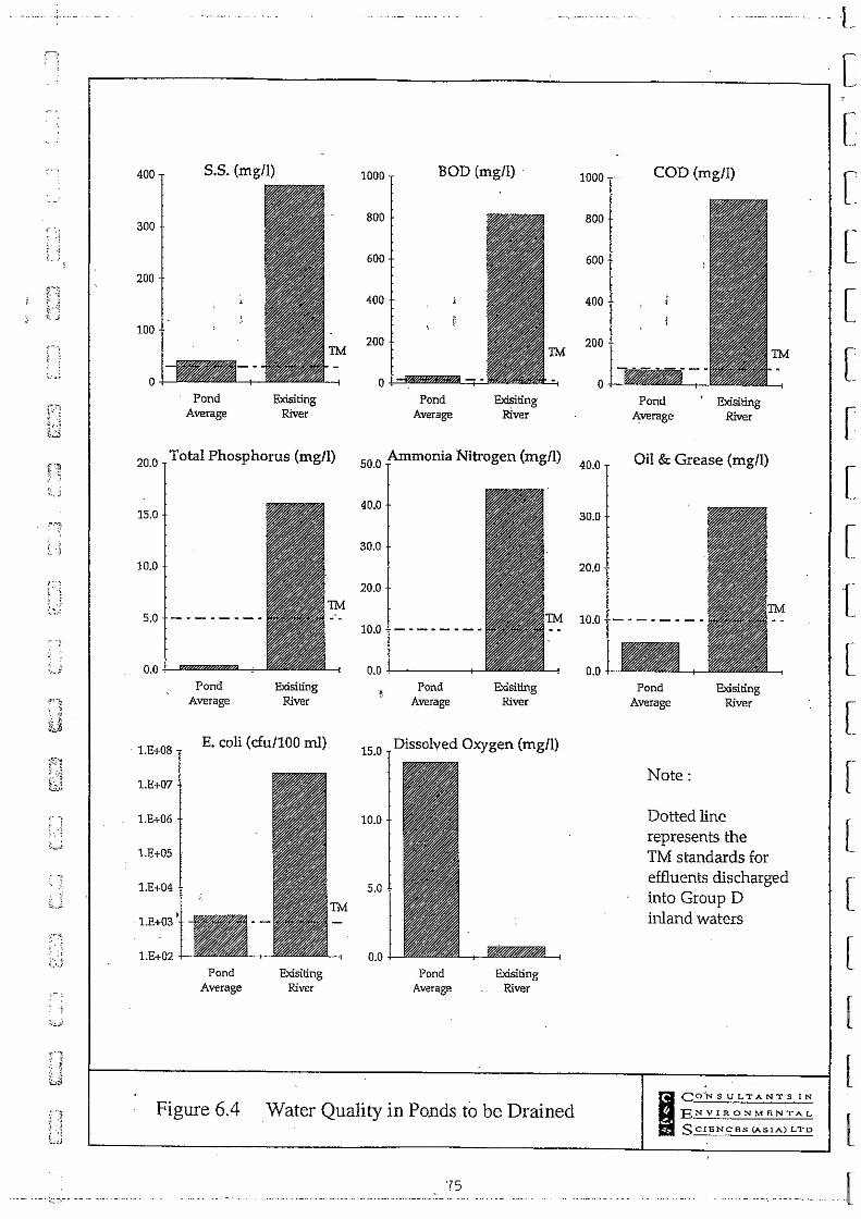
~!
,.':. . . ~
., .. ~ .. ,
400 5.5. (mg/l)
300
200
100
0
Pond Exisiting Average River
20.0 Total Phosphorus (mg/l)
15.0
10.0
5.0 - - - - - - - -
1.E+08
1.E+07
1.E+06
1.E+OS
1.E+03
l.E+02
Pond Average
Exisiting River
E. coli (cfu1100 ml)
Pond Average
Exisiting River
1000 BOD (mgll)
800
600
400
200
0
Pond Average
Exisiting River
50.0 Ammonia Nitrogen (mgll)
40.0
30.0
20.0
10.0 - ~ - • - - - ~
0.0 -I------~-
Pond Average
Exisiting River
Dissolved Oxygen (mg/l) 15.0
10.0
5.0
Pond Average
Exisiting River
Figure 6.4 Water Quality in Ponds to be Drained
'is
1000
400
200
o
40.0
COD (mg/l)
Pond .t\verage
Exisiting River
Oil & Grease (mg/l)
Pond Average
Note:
Exisiting River
Dotted line represents the TM standards for effluents discharged into Group D inland waters
I CO·~SULTANTS IN
ENVIRONMENTAL
SCIENces (ASIA) L""D
L
[
[
[
[
[
[
[
[
[
[
[
[
[
[
[
[
[
l [

r---'
..., '"
r.----; r.o'"
r; (r' - - ,- .
C,
r--- r-1 ~ , l " i"'- •
L " ." . ,~
Figure 6.5
r-1 r-1 r:J ~ c:::J ~ c:J l. ,~ __ , .. ,J r. C~~:~~-:] ~:(",.;':~:J
...... ~ " ?' "":":'1 f'fr':'.1'~"
l,..,. "v" " j '~; . :o~'"' ~':,.:~:::d
Sampling Location for Pond Water Testing
["-::-:J [----::J . . .... ~ "" ·t·~'··1 (., -~ :-;) ',.,'.'.:,: •. ,,':;J
["-::-:J ~ ' ~ rl, ~ 1"---"-' -. ~ , , ... , <,
~-.':"-':" "
rt-~ 1"':/ "\ . 'r; . I'~' ~ ~
'
, " . '.; \~-'" ,:,,j .(( ( ',,' ' •.. ~ •.. ) I,
• .. ...
LEGEND :j SAMPLING POINT (;
EXISTING STREAM ~ '...; ,
I CONSULTANTS IN
ENVIRONMENTAL
S CIENCES (ASIA) LTD
--,j
'-.--

[
[
[
[
[
[
[
[
[
[ , ,
[
;;' •• 3 [
[
[
[
[
l

L,
ei
[,
[
D;' I: \ .,
t_ .•
[--".
'. : !
-' ".~
L
Route 3 Contractors Consortium R3 TLT & YLA (S) - Main Line DEIA V1.5
7
7.1
7.2
ECOLOGY
The Study Area
The study area for ecological impact assessment on the southern section of R3 TLT & YLA was defined as all lands within the works boundary from Tuen Mun Road northward to the propose? Toll Plaza, including the Kam Sheung Access Road.
The portion of the st;udy area from Tuen Mun Road to the South Portal was sparsely settled, and supportep only three households. Agrisulture was limited to small pl9ts of vegetables and some fruit trees. Natural vegetation on the site was composed of dense shrub or tree cover. Topography was steep, and many short stream valleys dissected the hill slopes. Except for the few settlements the area was undisturbed and similar to the surrounding Tai Lam Country Park.
From the North Portal to the Toll Plaza the study area was densely populated and intensively developed for agriculture (poultry and swine prodUction, vegetable and ornamental plant farming) and light industry. All habitats were man-made or altered significantly by humans. Topography was mainly flat with an imperceptible northward slope on the gradient of the Kam Tin River.
Relevant Hong Kong Regulations
Hong Kong Government regulations relevant to this assessment include the following:
• the Forests and Countryside Ordinance (Cap. 96), which protects both natural and planted forests;
• the Forestry Regulations, which provide for protection of specified local wild plant species;
• the Wild Animals Protection Ordinance (Cap. 170), which provides for protection of listed species of wild animals (excluding fish and marine invertebrates) by prohibiting the disturbance, taking or removal of animals andlor their nests or eggs;
• the Animals and Plants (Protection of Endangered Species) Ordinance (Cap. 187), which controls the import, export and possession of specified endangered species; and
• the Country Parks Ordinance (Cap. 208), Part IV of which regulates development within country parks.
·CES (Asia) Ltd 7.7 9 6530\reports\deia-s\r3sdeia.dl 2
Route 3 Contractors Consortium R3 TLT & YLA (S) - Main Line DEJA Vl.5
7.3 Relevant International Conventions
Ramsar Convention
Through the United Kingdom, Hong Kong is a Party to the 1971 Ramsar Convention on Wetlands of International Importance Especially as Waterfowl Habitat (the Ramsar Convention). Contracting parties to the Ramsar Convention are required to designate at least one wetland for inclusion in a "List of Wetlands of International Importance". Within Hong Kong the Mai Po/Inner Deep Bay wetland is proposed to be listed as a Ramsar site. '
Article 1 of the Ramsar Convention defines wetlands as "areas of marsh, fen, peatland or water, whether natural or artificial, permanent' or temporary, with water that is static or flowing, fresh, brackish or salt, including areas of marine water the depth of which at low tide does not exceed six meters". All streams and man-made fish ponds in the study area qualify as wetlands under this definition.
Ramsar Convention Wise Use Concept
Article 3.1 of the Ramsar Convention calls upon the Contracting Parties to formulate and implement their planning to achieve the wise use of wetlands in their territory. At the 1987 Third Meeting of the Conference of the Contracting Parties to the Ramsar Convention in Regina, Canada, wise use of wetlands was defined as "their sustainable utilization for the benefit of mankind in a way compatible with the maintenance of the natural properties of the ecosystem" (Davis 1993).
Although some wetlands within the project area have been created or altered by mankind (fish ponds in particular), there are important natural properties of these ecosystems (Wilson 1995, Melville et al. 1994) which must be maintained to meet Hong Kong's requirements under the Ramsar Convention.
Bonn Convention
Also through the United Kingdom, Hong Kong is a Party to the convention on the Conservation of Migratory Species of Wild Animals (the Bonn Convention). The Bonn Convention has two major objectives:
• to prOvide stric't protection for species listed in Appendix I of the Convention (migratory species in danger of extinction throughout all or a significant portion of their range); and
• to encourage Range States to conclude agreements for the conservation and management of Appendix I (defined above) and/or Appendix II species (Inigratory species which have an unfavourable conservation status and require international agreements for their conservation, or which have a conservation status which would significantly benefit from international cooperation). At present no such agreement is relevant to Hong Kong.
CES (Asia) Ltd . 96530\reports\deia-s\r3sdeia.dl 2
78
L
T [
[
'-[ .--~ .. ~
[
:.[ .'
r [
" J[
I .J
T
[
[
[
-[ ,,'
il ---J

[
[
[;J
[n
[,~, " \ ,'.,-.'
DU en [
:"., :.~ .}
D:~) '~ ':'
[ ',:, ' ,
J '-~
[
C'>] ,'" :
C'" . )
-~.::.,;
[
[J
c,.
Route 3 Contractors Consortium R3 TLT & YLA (S) - Main Line DEIA Vi,S
7.4
The first objective above includes obligations to conserve and restore those habitats which are important in removing the species from danger of extinction; and to prevent, remove, compensate for or minimise the adverse effects of activities or obstacles that impede or prevent migration of the species. None of the species recorded in the study area is listed in Appendix I of the Bonn Convention.
Agriculture & Fisheries Department Fish Pond Categories
Hong Kong fish ponds were categorized by the Agriculture & Fisheries Department (AFD) into three grades depending on size of ponds, proximity to other ponds, qualitY of management, security'from development, and access'(AFD undated map). Although this system is not contained within any body of regulation relative to conservation or development, it is a useful guide for assessing the nature of fish ponds in specific areas within Hong Kong. Therefore, this classification scheme was used in this study. Table 7.1 lists the AFD categories of fish ponds. It should be noted that conservation of native flora and fauna was not a criterion for AFD fish pond classification. There is, however, a general relationship between the classification scheme and the potential for ponds to provide foraging areas for birds: the better managed, more secure ponds (Grade A ponds) would be expected to provide larger and more reliable foraging areas over a longer time period than would the Grade C ponds; which are susceptible to conversion for other uses and are not as well managed.
Table 7.1 AFD Categorization of Fish Ponds in Hong Kong
A
B
C
Well established pond fish culture areas with good potential for further development. Substantial amount of fish ponds is actively operated and well managed. Access to the site is good.
Established pond fish culture areas with small numbers of fish ponds most of which are actively operated and well managed. Further development is limited either the remoteness of the site, availability' of suitable land or vulnerability to Access to the site is
Areas with scattered small fish ponds and substantial amount of fish ponds are either idle or filled. They are subject to high development pressure due to proximity to developments.
7.5 Vegetation
7.5.1 , South Portal
The pristine forest in this area had been completely cleared many years prior to the current study. Habitats in the study area in early 1995 are shown on Figures 7.1 and 7.2. Remainingvegetation types were grassland, shrubland, and woodland. The grassland was
-CES (Asia) Ltd 79 96530\reports\deia-s\r3sdeia.d12

Route 3 Contractors Consortium R3 TLT & YLA (S) - Main Line DElA V1.5
L
[
widespread and dominated by Indocalamus sinicus, Lepidospem!Q chinensis, Arundinella [ setosa, Dicranopteris linearis, and Miscanthus sinensis. Scrubland was dominated by Rhaphiolepis indica, Baeckea frutescens, Litsea rotundifolia Var. oblongifolia, Melastoma .. [ sanguineum, and Eurya japonica. Woodland included natural forest and plantation. Young plantations of Acacia confusa, Lophostemon confertus and Melalel/cu quinquenervia were common on the ridges and hill tops. These areas had eroded due to historic deforestation, ...•.• [ and were replanted by Territory Development Department and are now being managed byAFD.
The point-centred quarter method was used to quantify the woodland in the! vicinity of the South .Porlal (Figure 7.1). Five transects were set to measure trees or shrubs with diameter at breast height (dbh) greater than 2 cm. Results of the surveys are summarised in Table 7.2.
Natural secondary forest was confined to the ravine area running towards' Sham Tseng, Sparse distribution of a few dying individuals and relict trunks of Pinus massoniana in situ indicated that most of the current vegetation developed from previous pine plantations under protection from fire and cutting (e,g, secondary forest),. or degraded from pine plantations due to fire (e,g, scrubland and grassland), Aerial photographs of this area were reviewed for the period before WWIl (between 1920 and 1945), The photographs showed that there was no woodland cover on the site prior to WWIl. Therefore, we concluded based on this evidence and on the evidence of field surveys that this area was planted to p, massoniana, Based on preliminary survey, the forest surveys concentrated on the ravines within the construction boundary of the Route 3 Project. Two line-transect surveys in site 1 (see Figure 7.1) and a focused survey (site 2, Figure 7,1) were conducted between 17 and 28 February 1995. These surveys showed, in accordance with the preliminary study, that the species diversity of total flora in this area was not high, Furthermore, dbh of individual trees did not exceed 15 cm, Most of the forest dominants were very common, light-demanding pioneer species of Hong Kong, These species probably dominated the current forest because of frequent disturbances, especially fire, However, a few patches of secondary forest on hill-slopes showed successful establishment of some pioneer species on degraded hill-lands under protection from fire, An example is Site 2 (see Figure 7,1), where there was a relatively large stand (about 10 m x 10 m in area) of Ternstroemia microphylla forest with a maximum size of about 14 cm dbh (Table 7,2),
Some patches of ravine forest along the Sham Tseng stream were of conservation value because of their diverse composition and special habitats, These forest stands have developed from relict trees as indicated by the presence of some narrowly-distributed species such as Lithocarpus corneus, Artocaipus hypargyrea and Engelhardtia roxbllrgiana, as well as some widespread pioneer species like Garcinia oblongifolia, Sapium discolor and Schefflera octophylla (Table 7.2),
Two species of the family Fagaceae were found within the South Portal area boundary: Lithocarpus comeus at sampling transect T4 (Figure 7.1) and Quercus myrsinaefolia on the hill-slope near sampling transect T1 (Figure 7,1), Species of the family Fagaceae were the major component of the original forest in Hong Kong, Although the above two species
CES (Asia) Ltd 80 . 96530\reports\deia-s\r3sdeia.d12
..
[
;{
T [
:[
[
. o[ ~:-.

[
[ [-'
['
[:
[, ....
Route 3 Contractors Consortium R3 TLT & YLA (S) - Main Line DEIA Vl.5
are not protected by the Forestry Regulations, their distribution is limited in Hong Kong (Zhuang 1993), Lack of suitable seed dispersal agents is considered to be one of the most important reasons for decline of all the Fagaceae species in Hong Kong (Dudgeon and Corlett 1994). An ecophysiological study of seedling growth showed that seedlings of Fagaceae species usually had low survival rates and very low growth rates in both open and forest conditions (Zhuang 1993). Therefore, poor competitive ability resulting from a slow natural growth rate is another limiting factor in the local distribution of Fagaceae. Today, most Fagaceae species existing in Hong Kong are confined to cliffs and ravines. Quite a few individuals grow from the sprouts of relict trees from previous forests. This is evidenced by a high percentage of multi-trunked trees bf other species like Engelhardtia roxburgiana. .:; ,
7.5.2 North Portal
The predominant habitat north of the North Portal was scrubland dornirtated by Rhus succedanea, Eurya japonica, and Rhodomyrtus tomentosa. No endangered or protected species was found in this area. Scrubland habitat of this type is common throughout the Territory. Loss of this habitat was therefore not considered to be a key issue for this report.'
7.5.3 Endangered/Protected Species
Two recorded species are protected by Hong Kong legislation. Enkianthus quinqueflorus (New Year Flower) was commonly found in shrub-grassland and shrub-woodiand on the slopes within and outside the works areas of the South Portal. This species is protected under the Forestry Regulations. Enkianthus is protected because of the historical extensive cutting of this species for Chinese New Year. Arundina chinensis (Bamboo orchid) was found in groups adjacent to the Tal Lam Country Park boundary near the South Portal on shady, rocky, and steep slopes by the stream channel near the catchwater. The family (Orchidaceae) to which this species belongs is protected under both the Forestry
. Regulations and the Animals and Plants (Protection of Endangered Species) Ordinance._.· Locations where A. chinensis was found are shown in Figure 7.3.
. CES (Asia) Ltd 81 96530\reports\deia-s\r3sdeia.d12

Route 3 Contractors Consortium R3 TLT & YLA (S) - Main Line DEIA V1.5
Table 7.2 Results of point-centred quarter survey of woodland at South Portal, Route 3 Project, March 1995
Transect 1
Sapium discolor , 25.02 28.27 0 27.27 80.57 1
Sinosideroxylqn wightianum 8.34 1.58 .• , 9.09 19.01 ~' 1
~. octophylla 8.34 7.49 9.09 24.92 1
Sterculia lanceolci.ta 8.34 0.79 9.09 18.22 1
25.02 46.99 18.18 90.19 1
Rhus succedanea 8.34 1.08 9.09 18.52 1
morrisiana 8.34 5.32 9.09 22.75 1
Garcinia oblongifolia 834 .7.98 9.09 25.41 1
Transect 2
Sterculia lanceolata 25.00 23.00 20.00 68.00 1
Zanthoxylum a'llicenne 8.00 1.00 10.00 19.00 1
Sapium discolor 17.00 21.00 20.00 57.00 1
Pinus massoniana 25.00 32.00 20.00 77.00 1
!tea chinensis 17.00 7.00 20.00 44.00 1
Garcinia 8.00 16.00 10.00 34.00 1
Transect 3
T ernstroemia 75.00 101.00 50.00 226.00 1.1
Litsea rotundifolia 20.00 16.00 38.00 73.00 2.3
Ilex memecylifolia 5.00 1.00 13.00 18.00 1
Transect 4
Carania oblongifolia 6.25 43.21 9.09 58.55 4.0
Itea chinensis 43.75 45.11 36.36 125.22 2.7
Litsea .c_ 25.00 4.71 27.27 56.98 . 1.5
Sinosideroxylon wigh tianum 6.25 5.34 9.09 20.68 3
Eurya Chinensis 12.50 0.83 9.09 22.42 1
Rhus succedanea 6.25 0.80 9.09 16.14 1
. CES (Asia) Ltd 82 96530\reports \deia-s\r3sdeia.d12
L ,[
I [
....... [
. ,,'
[ . ... [
[
[
.[ .
[

C·:-; i ..
[ [.
r. lj\",
er! .', : ['.: ..
DEl
O··n :; .:'-
OJ I'.
n· . ,," , ~-L-~;
[n · ..
' ~~.::;~
CEJ
C· '. · , . ~ .-~
[" , ,:i..-..
[': . .- •... ' ,
C· , · , ~~-~
[ ".; .: , ,J
r
Route 3 Contractors Consortium R3 TLT & YLA (S) - Main Line DEIA VI.S
Table 7.2 Results of point-centred quarter survey of woodland at South Portal, Route 3 Project, March 1995 (Cant' d) .
Transect 5
Acronychia pedunculala
Itea chinensis
Diospyros vaccinoides
Citrus sp.
Adina pilulifera
Enkianthus quinquejlorus
Litsea Totundifolia
. indica
Aporusa chinensis
7.5.4 Habitat Impacts
46.43
3.57
3.57
3.57
3.57
7.14
3.57
3.57
62.89
5.61
16.16
2.55
0.53
0.46
2.52
3.70
3.57
2.40
33.33 142.65 1.3
11.11 27.43 1
16.67 47.11 1
5.56 11.68 1
5.56 9.65 1
5.56 9.59 1
5.56 11.64 2
5.56 16.40 2.5
5.56 12.70 1
5.56 11.53 1
The habitat loss due to the Route 3 project in the southern section is estimated in Table 7.3. The calculation was based on the worst-case assumptions that all vegetation within the construction boundary (which was delineated only on the finalized design) will be removed.
Overall, there was an apparent increase in habitat loss with the final design of the alignment. However, it must be noted that this increase may not reflect real differences as much as greater detail and refinement of construction boundaries. The primary cause of the apparent increase is that works boundaries were not specified in all cases in the preliminary designs. In contrast, they are specified in detail in the final designs. This permitted a more detailed assessment of acreage to be lost, which resulted in calculations of greater surface areas. In some cases construction works boundaries were not drawn on the preliminary design and therefore habitat losses were not determined .
.CES (Asia) Ltd 83 96530\reports\deia~s\r3sdeia.d12
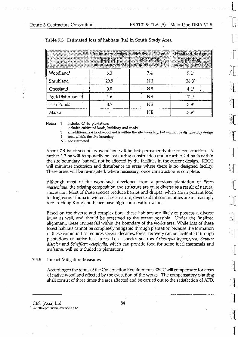
.:
Route 3 Contractors Consortium R3 TLT & YLA (S) - Main Line DEIA V1.S
Table 7.3 Estimated loss of habitats (ha) in South Study Area
Woodland' 6.3 7.4 9.13
Shrubland 20.9 NE 28.34
Grassland 0.8 NE 4.14
4.6 NE 7.44
Fish Ponds 3.7 NE 3.94
Marsh NE ,3.94
Notes: 1 .includes 0.1 ha plantations 2 includes cultivated lands, buildings and roads 3 an additional 2.4 ha of woodland is within the site boundary, but will not be disturbed by design 4 total within the site boundary NE not estimated
About 7.4 ha of secondary woodland will be lost permanently due to construction. A further 1.7 ha will temporarily be lost during construction and a further 2.4 ha is within the sIte boundary, but will not be affected by the facilities in the current design. R3CC will minimise incursion and disturbance in areas where there is no designed facility. These areas will be re-instated, where necessary, once construction is complete.
Although most of the woodlands developed from a previous plantation of Pinus massoniana, the existing composition and structure are quite diverse as a result of natural succession. Most of these species produce berries and drupes, which are important food for frugivorous fauna in winter. These mature, diverse plant communities are increasingly rare in Hong Kong and hence have high conservation value ..
Based on the diverse and complex flora, these habitats are likely to possess a diverse fauna as well, and should be preserved to the extent possible. Under the finalized alignment, these ravines fall within the boundary of the works area. While loss of these forest habitats cannot be completely mitigated through plantation because the formation of these communities requires several decades, forest recovery can be facilitated through plantations of native local trees. Local species such as Artocarpus hypargyrea, Sapium discolor and ScheffIera octophylla, which can provide food for some local mammals and avifauna, will be included in plantations.
7.5.5 Impact Mitigation Measures
According to the terms of the Construction Requirements R3CC will compensate for areas of native woodland affected by the execution of the works. The compensatory planting shall consist of three times the area affected and be carried out to the satisfaction of AFD.
CES (Asia) Ltd 84 96530\reports\deia -s\r3sdeia,d12
t r~ tJ
[
I ::f C[
[
l[ ",.:1 : •• 1
[
:[
.{
.. .•... [

r'· ~
C'
[
[ ' .. ': .. ' .. ,
[ CO . .
O· [;
C··:
~ ~:;s
[D [:
co
ij
Ci
C· UJ
Route 3 Contractors Consortium R3 TLT & YLA (S) - Main Line DEIA V1.5
The proposed off-site compensation and on-site reinstatement planting will not only aid in restoration of habitats lost due to construction of the highway, it will potentially enhance some existing habitats along the boundaries of the Tai Lam Country Park.
One potential location for such planting is the hill north of Sham Tseng along the west side of the conveyor alignment (28.5 ha). A second potential location is the hill slope west of Ma On Kong (52 ha) between the Route 3 alignment and the boundary of the Tai Lam Country Park. These are shown on Figure 7.4 and are both eroded hill slopes bordering on the alignment of Route 3. Together with the fill areas and cut slopes, the ACE request for woodland habitat restoration in a 3:1 ratio (recplanted:lost) may be met. The permanent loss of woodlahd in the southern section would be 7.4 ha. Re-planting in a 3:1 ratio would require 22.2 ha of the 80.5 ha available off-site total: It is anticipated that the re-planting requirement for the northern section (north of the Kam Sheung Access Road) will not, when combined with that required for the southern section, exceed the total area available for replanting on and off-site.
Revegetation on these areas will enhance vegetation establishment and succession. As specified in the PDS2EA (Freeman Fox MaunseII1993a), plant species indigenous to the site which provide cover and forage value for wildlife should be selected for use in revegetation. A list of such species which occurred on the site prior to disturbance is given in Table 7.4. These and other species will be used in revegetation based on availability of stock .
Because habitat preservation through adjustment of the highway alignment is not possible, it will be important to contain construction works to the minimum possible land area to avoid unnecessary habitat destruction. Riparian habitats are particularly sensitive and will be avoided.
As indicated in Section 7.8.5, bamboo will be included in the revegetation plan, particularly in association with the restored fish pond. Bamboo is a preferred nesting substrate for herons and egrets in the study of area. The purpose of including bamboo in the habitat restoration programme is to provide suitable nesting habitat for these species.
.CES (Asia) Ltd 85 9 6530\repor!s\deia -s\r3sdeia.d12

Route 3 Contractors Consortium R3 TLT & YLA (S) - Main Line DEIA V1.5
Table 7.4 Native plants recorded on the study area during 1993-1995 surveys which provide forage sources for birds and whi~h are recommended for use in revegetation. (After Corlett 1992)
Bridelia tomentosa small tree 4 XJO( Dec-Mar Celtis sinensis tree 2 XJO( Jun-Aug Cinnamomum camphora large tree 5 XJO( Nov-Jan Diospyros morrisiana tre.e 2 xx Dec-Jan; Ficus superba ;! tree 3 xx irregular) Litsea rotundifolia shrub 8 XJO( Oct-Dec Macaranga tanarius tree 5 XJO( Jun-Jul Machi/us breviflora tree 1 x Oct-Jan Mallotus paniculata small tree 3 XJO( Bec-Jan Rhaphiolepis indica shrub 6 XJO( Dec-Jan Rhodomyrtus tomen/osa shrub 8 XJO( Aug-Nov Rhus chinensis small tree 12 x Nov-Dec Sapium discolor tree 3 xxxx Oct-Dec Sapium sebiferum tree 7 xx Nov-Jan Schefflera octophylla tree 4 xxxx Jan-Mar Sterculia lanceolata tree xxxx Jul-Sep
Note BIRDS = number of bird species known to eat the fruit ATTRACT = relative attractiveness to birds PERIOD = main fruiting period
7.6 Stream Ecology
7.6.1 . Characterisation of Streams
The approach to the South Portal of the Tai Lam Tunnel crosses a valley containing a small stream (named Sham Tseng Stream for the purposes of this report). At the head of the valley much of the natural drainage into the stream is intercepted by a WSD catchwater and the water is diverted to the Sham Tseng Settlement Basin. Consequently, the stream is now of a seasonal nature, although low levels of water flow persist throughout the year.
In the lower stream reaches there is a series of weirs, a pipeline below Tuen Mun Road and finally a nullah flOwing through Sham Tseng to the sea. The upper stretches of the stream bed have been severely impacted in the past by rock-slips follOwing storms, spoil generated by construction of the road and catchwater, and damage to the catchwater by severe rainstorms. The upper reach of the stream was filled with rock and sediment rubble which resulted from previous construction projects and natural erosion in the area. Much of the larger rock rubble resulted from construction of the catchwater during the
CES (Asia) Ltd 86 . 96530\reports\deia-s\r3sdeia,d12
L [
r L
[
.[
[ .... [
:{ .[
[ .[
.' .'
[
[
I [
[
[
·f [
r

c C· L, Cfj
GJ DEj
en C'
C" " ;,~ ~ c.';
r
Route 3 Contractors Consortium R3 TLT & YLA (S) - Main Line DEIA V1.5
7.7
late 1950s, and more recent construction of a metal covering over portions of the catchwater which are subject to periodic landslips.
A 1994-5 construction project modified the catchwater overflow structure for Sham Tseng Stream and reinforced the channel and banks downstream from the catchwater. The result was that the stream has been eliminated for the first 150 m downstream from the catchwater. In place of the stream is an overflow channel lined with rock rip-rap. Downstream from the overflow channel the stream bed is buried under boulders in many places, with only isolated pools remaining. The area affected by deposition of rock rubble extends from the catchwater downstream to a point immediately below the proposed south portal. Downstream of the South Portal the middle section of the stream has been unaffected by construction works and is in better condition, with some large, deep pools connected by waterfalls.
The construction projects referred to above have affected the stream in two ways. First, deposition of crushed rock in the stream has buried the native stream bed and created a coarse rock filter through which the stream flows during the dry season. This has eliminated the stream as a surface feature during much of the year. Second, water diversion due to construction of the catchwater forTai Lam Reservoir has reduced normal stream flows. This has exaggerated the impact of the deposited rock rubble, resulting in dewatering of the stream to an even greater extent. An additional impact of these projects is that riparian and aquatic vegetation have been either removed or buried.
Of interest relative to the impacts of these construction projects is that the stream above the catchwater is considered to be excellent habitat for a wide variety of dragonflies (K. Wilson, Fisheries Officer, AFD). This testifies to the unpolluted quality of the water and the ecological utility of the native stream bed.
North of the North Portal the streams leading to Kam Tin River are generally of poorer quality due to the discharge of livestock waste.
Stream Fauna
The stream fauna in the reach of the Sham Tseng Stream to be culverted was surveyed during February 1995 using handnets, wire-mesh fish-traps, a minnow net and direct observation. Sampling was conducted throughout the reach of the Sham Tseng Stream which would be culverted beneath the earthen fill proposed for the South Portal apron.
As found in previous surveys, the fish population almost totally dominated by the minnow, Parazacco spilurus, with many adults and juveniles present in the remaining pools where the stream emerged from beneath the rocks and boulders. This species is widespread in Hong Kong, occurring in most unpolluted hill streams and the upper courses of rivers (Chong and Dudgeon 1992). Also recorded were small numbers of
. gobies (Ctenogobius duospilus.). These fish are also common, and are distributed widely in the New Territories. In the pools associated with the weirs at the lower end of the valley were numbers of guppies (Lebistes reticulatus). This is an exotic species, introduced for mosquito control and through the aquarium trade .
. CES (Asia) Ltd 87 96530\reports\deia-s\r3sdeia.d12

·--.-----.-"--" .... -.-.. --"--~-·-=l
Route 3 Contractors Consortium R3 TLT & YLA (S) - Main Line DEIA Vl.5 T The prosobranch snail, Brotia hainallensis, was recorded in some of the pools; this is the [ only species of freshwater snail that is common in stony hill streams and the upper courses of rivers in Hong Kong (Dudgeon and Corlett 1994). Large numbers of Atyid "C" ""
shrimp (Neocaridina serrata and Caridina lanceifrons) were present, as well as Macrobrachium hainanense.
7.8 Birds
7.8.1 General Species Surveys
'.j Birds were recorded visually and audially on the site between October 1994 and January ~, 1995. The objective of bird surveys was to document occurrence of birds on the site during autumn and winter seasons. Because quantification of bird abundance was not an objective, non-systematic surveys were conducted. Taxonomy and common nomenclature follow Viney et al. (1994).
7.8.2 Egretry Studies
Egretries (colonial nest sites of birds of the family Ardeidae, including herons and egrets) at Ho Pui and Ko Po Tsuen were studied during this project simultaneously with studies for the Main Drainage Channel Project (ERM 1995). Egretry sites are shown in Figure 7.5. The purpose of the studies was to determine the nature and magnitude of the potential impacts of the Route 3 project on ardeids which breed and/or winter in the vicinity of the two egretries.
Ho Pui egretry is proposed by AFD for designation as a Site of Special Scientific Interest (SSS1). Review of this proposal was in process at the time of this writing.
The Ko Po Tsuen egretry was first discovered in summer 1994 (K.W. Cheung, Conservation Division, AFD) and therefore was not described in earlier reports. The Ko Po Tsuen egretry is located in the northern study area of the Route 3 project and will be addressed in the DEIA for the northern section rather than in this report. In addition, the Ko Po Tsuen egretry was not used as a roost by wintering ardeids, and no observation of birds was made there.
The Ho Pui egretry was studied by observation from remote positions 50-80 m above the egretry along the catchwater road at the boundary of the Tai Lam Country Park. Birds were observed with lOx binoculars and a 2S-60x spotting scope. At 15 minute intervals on 8 days between 20 October 1994 and 31 January 1995 all ardeid locations were plotted on 1:1000 or 1:5000 scale topographic maps. Observations were made over 44 15-minute intervals spanning 11 hours. Data recorded for each location included bird identification, the number of individuals, and the activities of individual birds. Ninety-two groups (containing one or more individuals) of birds were recorded in total. During January 1995 bird movements were recorded without regard to time, with the objective of documenting bird movements in the vicinity of the egretries. Results were used to plot sites of bird use in relation to the boundaries of the egretries.
CES (Asia) Ltd 88 . 96530\reports\deia-s\r3sdeia.d12
C
C [
T [
[
.{
[
[
[
I {
r

['
c [
[;
['VI lj;:::~
[:
[,.
GJ [
.•.. ]
-'-'-->
r-
Route 3 Contractors Consortium R3 TLT & YLA (S) - Main Line DElA V1.5
7.8.3 Results of Bird Surveys - South of the Tunnel
Birds seen during prior surveys plus those seen on the current surveys in the south study area are listed in Table 7.5. A total of 40 species representing 22 families was recorded.
The Crested Goshawk, recorded both during summer and autumn/winter, is perhaps the least common of the species recorded in the south study area. The Grey-backed Thrush was also noteworthy because it is a Palearctic migrant whose numbers in Hong Kong were unusually large during winter 1994-5. All other recorded species are widespread or locally common in Hong Kong. ' ., The woodlands and shrublands near the South Portal were most important as bird habitats. Shrublands on upland sites were also important bird habitats, particularly the . wooded valleys which contained more mature shrubs and trees.
7.8.4 Results of Bird Surveys - North of the Tunnel
Birds recorded between the North Portal and the Toll Plaza during May 1993 and October 1994 through April 1995 are shown in Table 7.6. A total of 57 species was recorded, representing 26 families.
Although some species seen in the northern study area were uncommon in Hong Kong, most are common and widespread residents or seasonal visitors to the Territory. The Collared Scops Owl and Crested Goshawk were probably the least common species recorded. Both were recorded in or soaring above (Crested Goshawk) the Ho Pui egretry. Habitats of greatest importance to birds were riparian wetlands and upland woodlands. Agricultural habitats were of little utility to birds other than bulbuls and habitat generalists such as the Tree Sparrow. Wetlands in the upper Kam Tin valley supported smaller numbers of water birds than did the larger and more secluded ponds in the lower reaches of the drainage. Upland habitats near the Tai Lam Country Park supported large
. numbers of birds with diverse species representation. The wetland and wooded areas west of the proposed Toll Plaza supported abundant bird life. Pied Kingfishers were recorded repeatedly on the fish ponds in this area together with Chinese Pond Herons and Little Egrets, which foraged on ponds and along Kam Tin River.
7.8.5 Egretry Study Results
Ho Pui egretry was studied to answer the follOwing questions:
1. To what extent do ardeids use .the egretry during autumn and winter months? 2. Where do ardeids forage in relation to the egretry during autumn and winter? 3. What habitats are used near the egretry by wintering ardeids? 4. To what extent will the Route 3 project impinge upon habitats used by wintering
ardeids?
. CES (Asia) Ltd 89 96530\reports\deia-s\r3sdeia.d12

--------------_ ..
L Route 3 Contractors Consortium R3 TLT & YLA (S) - Main Line DEIA V1.5 C
Table 7.5 Birds recorded south of the tunnel during May 1993 and October 1994 C through January 1995
Night Heron (Nycticorax nycticorax) Reef Egret (Egretta sacra) Black-eared Kite (Milvus lineatus) Crested Goshawk (Accipiter trivirgatus) Chinese Francolin (Francolifzus pintadeanus)
.;, Spotted Dove (Streptopelia i:hinensis) Rufous Turtle Dove (Streptopelia orientalis) Collared Scops Owl (Otus bakkamoena) Red-winged Crested Cuckoo (Clamator coromandus) Large Hawk Cuckoo (Cuculus sparoerioides) Indian Cuckoo (Cuculus micropterus) Koel (Eudynamis scolopacea) Greater Coucal (Centropus sinensis) Lesser Coucal (Centropus bengalensis) Common Kingfisher (A/cedo atthis) White Breasted Kingfisher (Halcyon smymensis) House Swift (Apus nipalensis) Bam Swallow (Hirundo rustica) Grey Wagtail (Motacilla cinerea) White Wagtail (Motacilla alba) Crested Bulbul (Pycnonotus jocosus) Chinese Bulbul (Pycnonotus sinensis) Red-vented Bulbul (Pycnonotus aurigaster) Magpie Robin (Copsychus saularis) Violet Whistling Thrush (Myiophoneus caeruleus) Grey-backed Thrush (Turdus hortulorum) Yellow-bellied Prima (Prinia flaviventris) Plain Prinia (Prinia inomata) Common Tailor Bird (Orthotomus sutorius) Black-faced Laughing-thrush (Garrulax perspicillatus) Hwamei (Garrulax canorus) Great Tit (Parus major) Japanese White-eye (Zosterops japonica) Magpie (Pica pica) Blue Magpie (Urocissa erythrorhyncha) Jungle Crow (Corvus macrorhynchus) Crested Myna (Acridotheres cristatellus) Masked Bunting (Emberiza spodocfPhala) Little Bunting (Emberiza pusilla) Chestnut Muma (Lonchura malacca)
Key to symbols: R = resident PM = passage migrant . SV = summer visitor WV = winter visitor
CES (Asia) Ltd 90 . 96530\reports\deia-s\r3sdeia.d12
R R R R R R
PM/WV R
SV SV SV R R R R R R
SV WV WV
R R R R R
WV R R R R R R R R R R R
WV PM/WV
SV
[
T ::[
1[
'[ .... [
~- ,
[
..[
[ .. '[
[
T .,[
r

~~~~~~~~~'-~~~~~~~-, "-----~---,-----,-,-,-, ~~---,-~---
[-'" ',: j ;
. ,
[
[
r-{<C';
L'" -' .-.
or1 on
III L~, .1
nl L·..'::J
[
.c ; , , ,
,--".j
[1
[ ',",'
·1 ,'-'
Route 3 Contractors Consortium R3 TLT & YLA (S) - Main Une DEIA V1.5
Table 7.6 Birds recorded on the north study area during 26-27 May 1993 and October 1994 to April 1995
Grey Heron (Ardea cinerea) R Chinese Pond Heron (Ardeola bacchus) R Little Egret (Egretta ganetta) R Cattle Egret (Bubulciis jbis) R Night Heron (Nycticorax nycticorax) R BlaCk-eared Kite (Milvus llneatus) R Bonelli's Eagle (Hieraaetus fasciatus) R Crested Serpent Ea.gle (Spilornis cheela) ,R Crested Goshawk (.Accip,ter trioirgatus) R Northern Sparrowhawk (Accipiter nisus) WV Black Baza (Aviceda leuphotes) SV Chinese Francolin (Francolinus pintadeanus) R White-breasted Waterhen (Amaurornis phoenicurus) R Spotted Dove (Slreptopelia chinensis) ' R RUfous Turtle Dove (Slreptopelia orientalis) PMlWV Feral Pigeon (Columba lima) I ' Indian Cuckoo (Cuculus micropterus) SV Large Hawk-cuckoo (Cuculus sparoerivides) SV Plaintive Cuckoo (Cacomantis merulinus) SV Koel (Eudynamis scolopacea) R Greater Coucal (Centrorus. sinensis) R Lesser Coucal (Centropus bengalensis) R Eurasian Wryneck (Jynx torquil/a) WV Pied Kingfisher (C~e rndis) R Conunon lGng£sher cMo atthis) R White-breastei:l Kin her (Halcyon smyrnensis) R House Swift (Arus niralensis) R Barn Swallow (Hirunao rustica) SV Tree Sparrow (Passer montanus) R Richara's Pipit (Antllus richard,,) R, M, WV Olive-backed Pipit (Antllus lIodgsotll') WV Grey Wagtail (Motacilla cinerea) WV Wh,te Wagtail (Motacilla alba) R Crested BUlbul ~cnonotus jocosus) , R Chinese Bulbul cn0110tus sinensis) R Red-vented Bulb (PYCllonotus aurigaster) R Magpie Robin (Cops!Lchus saularis) R Siberian Stonechat (Saxicola maura) WV Grey Bushchat (Saxicola ferrea) WV Grey-backed Thrush (Turiius hortulorum) WV BlaCkbird (Turdus merula) WV Yellow-bellied Prinia (Prinia jlaviventris) R Plain Prinia (Prinia inomata) R Common Tailorbird (Orthotomus sutorius) R Black-faced Laughing-thrush (Garrulax perspici/latus) R Great Tit (Parus major) R Fork-tailed Sunbird (Aethopyga christinae) R Japanese White-eye (Zosterops japonica) R Rufous-backed Shrike (Lanius schach) R Black Drongo (Dicrurus macropterus) SV Magpie (Pica pica) R Jungle Crow (Corvus macrorhynchus) R White-cheeked Starling (ShlmJlS cineraceus) WV Black-necked Starling (Stumus nigrico/lis) • R Crested Myna (Acridotheres cristatellus) R Common Myna (Acridotheres tristis) I Masked Bunting (Emberiza spodocepllala) , WV Spotted Munia (Lollchura pUnctuJata) R
Key to symbols: R = resident WV = winter visitor SV = summer visitor
PM ~ passage migrant I = introduced
Note: Species in boldface plint may have been recorded north of the proposed toll plaza.
,CES (Asia) Ltd 91 96530\reports\deia -s\r3sdeia.d12

Route 3 Contractors Consortium R3 TLT & YLA (S) - Main Line DEIA Vl.5
Ardeid Use of Ho Pui Egretnj During Autumn 1994 and Winter 1994-5
Ardeids used the Ho Pui egretry during winter 1994-5 as a roosting and foraging site. Species observed included Cattle Egrets, Little Egrets, Grey Herons and Chinese Pond Herons. Night Herons were also recorded in the area, but they were not seen using the egretry, probably because they were inactive during daylight hours. Grey Herons were least abundant, appearing at the egretry only during October as single individuals. They were seen in greater numbers north of Kam Tin Road on wetlands closer to Deep Bay. Cattle Egrets were the most abundant of the ardeids in the Ho Pui area during winter. They were often observed in flocks of 15 birds or more feedin'g on exposed agricultural areas, often in the company of grazing cattle. Chinese Pond Herons were observed in smaller groups than Cattle Egrets, and typically in association with aquatic habitats if not roosting in trees.
Census of ardeids near Ho Pui was only possible when birds were disturbed from roost sites. When roosted in dense tree canopies birds were not usually visible. This survey has the limitation of negatively biased counts and estimates of bird use of dense woodland habitats. At 1330 hr on 24 October 1994 birds were disturbed from the egretry and surrounding woodlands by humans and dogs. An estimated 78 birds were flushed from their roosts. This compares to total counts of 31 and 28 roosting birds between 0830 and 0900 that same day, suggesting that approximately 30-40 percent of roosting birds at the egretry were visible to the observer.
Of the 78 birds seen following disturbance of the egretry, 55 flew from the dense fung shui woodland of the egretry itself. Morning counts of birds roosting or feeding at the egretry were 9 and 4 at 0830 and 0900 hrs, respectively. This suggests that while 30-40 percent of birds in the general area may have been visible to the observer, only 7-16 percent of birds at the egretry were visible. Maximum counts of undisturbed ardeids were 40 birds on 23 October and 22 December 1994. Assuming this total represents 30-40 percent of the birds in the area, the total number of wintering birds at the egretry could be estimated at 100-133. This compares with a breeding population estimated in 1991 at 83 birds (Young 1991). A winter influx of migratory ardeids is typical in the Deep Bay area (Young 1993), so it would not be unexpected for the winter population to exceed the breeding season population at Ho Pui.
Ardeid Spatial Distribution Near Ho Pui Egretry during Autumn 1994 and Winter 1994-5
Sites used by ardeids were numbered on 1:5000 topographic maps as shown on Figure 7.5. Site number 6 is the area typically used for nesting during spring and summer. Over the autumn and winter seasons ardeids showed fidelity to some of the numbered sites. Thirteen of the sites were identified during October 1994, and were used through January 1995 by at least some birds. In January 1995 sites 14 and 15 were added.
Because dense woodland vegetation at roost and foraging sites precluded accurate census of birds, the recorded numbers of individuals at each of the identified sites are not meaningful. However, the frequency with which birds were seen at sites provides an indication of the spatial distribution and preferences of the birds within the Ho Pui area.
CES (Asik) Ltd 92 96530\reports\deia ~s\r3sdei~.d12
l [
[
[
.. :[. >: .
·c : .. ::., •.•. :. "
., •...•... [ : .. , -
. ""
.~
[ .... [ .. '
T :[ })
[
[
[
[ ..... [ ..
[
r

fT o [ ,
~.
c.·······i
.
'- ., '--'
[" :-.:.:
r" : '---I'~c. j
[ :i ~.j
[':.: . . , <-J
Route 3 Contractors Consortium R3 TLT & YLA (S) - Main Line DEJA Vl.5
Table 7.7 ranks the numbered use sites according to the average frequency with which they were occupied by ardeids over the course of 36 sampling intervals over 6 days spanning 23 October 1994 to 31 January 1995.
Ardeid use of site 6 averaged 79 percent over 36 sample periods. As discussed above for census results, this estimate of frequency of use at the egretry location underestimates actual use because of the density of vegetation at the site and the difficulty of observing birds. Actual use is estimated to be 100 percent during winter months except during periods of prolonged disturbance by humans. Site 6 was the only site to be used on all six sample days. .
Other sites supported more open vegetation, therefore birds were more visible. Estimated frequency of use at these sites is probably a more accurate reflection of actual use patterns.
Ardeid Habitat Use Near Ho Pui Egretry During Spring 1995
Ardeids were first observed building nests at egretry locations in Kam Tin valley on 9 April 1995. Near Ho Pui nest building occurred in several species of trees as well as in stands of bamboo. Sites used for nesting are shown on Figure 7.6.
The two northern nesting sites were located in stands of bamboo in an area surrounded by village housing. Nesting at these sites has not been previously recorded. Both sites are outside the proposed project works areas.
At the traditional egretry at Ho Pui Chinese Pond Herons and Cattle Egrets were observed in pairs building nests. Little Egrets were also present, but were not seen
. building nests. All three species are known to nest at the Ho Pui Site (Young 1991).
Detailed habitat and nest tree use data will be collected during the completion of the four . seasons ecological survey which is currently underway. At the time of this writing nest
trees used by herons and egrets included Ficus microcarpa, Dimocarpus longan, Celtis sinensis, and bamboo. Bamboo appeared to be the preferred nesting substrate, although quantification will only be possible following completion of nests and the onset of egg incubation.
Because bamboo was selected as a nesting substrate when located either near fish ponds (Ho Pui traditional egretry) or distant from fish ponds (two new egretry sites) this report includes a recommendation that bamboo be included in the habitat restoration plan. The objective is to provide long-term tlesting habitat availability in areas within the works limit that are secure from encroachment or continued urbanisation. The concern for security arises from the fact that both the traditional egretry at Ho Pui and the two new sites are located on or surrounded by private property which is subject to development pressure. New housing construction was occurring at the perimeter and within the Ho Pui egretry at the time of the surveys.
. CES (Asia) Ltd 93 9 6530\reports\dei a -"s\r3sdeia.d12

Route 3 Contractors Consortium R3 TLT & YLA (S) - Main Line DEIA V1.5
Table 7.7 Ardeid Use Sites, Number of Days used out of Six
6 1 8 11 12 3 7 5 10 13 2 9 14 15
6 5 5 1 2 5 3 6 1 1 2 1 1 1
79% 66% 55% 50% 45% 29% 29% 25% 25% 20% 17% 17% 17% 17%
L '[
[
[
'[
c .[
7.8.6 Impact of Route 3 Highway Project on Ardeids Using Ho Pui Egretry During Autumn '. [ 1994 and Winter 1994-5
The most important conclusion from the spatial distribution and frequency of use data is that winter ardeid use of the Ho Pui area was concentrated on the flood plain along ,: [ the major tributaries of Kam Tin River and centred on the egretry. As illustrated in Figure .. : 7.5, no ardeid use area was more than 100 m from it perennial stream. These results indicate that the selected Route 3 alignment at the foot of the hills to the west of the [ floodplain will minimise disturbance to areas used by ardeids with the exception of sites .
. 3 and 9.
Sites 3 and 9 were located at fish ponds southwest of Ho Pui. These ponds are to be filled, resulting in a loss of approximately 0.73 ha of pond surface area or approximately 655 m of pond edge (the portion of the pond typically used by feeding ardeids). The surface area of ponds to be lost constitutes 0.73 of 4.8 total pond hectares (15%) within the boundary of the area defined as the winter use area' for ardeids at Ho Pui.
As shown in Table 7.7 above, site 3 was occupied by ardeids on 29 percent of sampling intervals over 5 of 6 sampling days.,Numbers of birds seen at site 3 ranged from 1 to 4. Because the site was visible from the observation paint and vegetation at the site was sparse, the numbers of birds recorded using the site probably accurately reflects actual use levels. Therefore, the number of birds using site 3 constitutes a small proportion of the total winter population near Ho Pui (less than 5 percent).
Site 9 was occupied on only one of 6 sampling days at one sampling interval. Use of this site may not be important during winter ..
CES (Asia) Ltd 94 . 96530\reports\deiaw s\r3sdeia.d12
[
[
1 1 .[
1 r
-,.irl ~ ~J
I
1 ), .
J '" '- ,
....J : .. ~'
I;; 1&.\J
-: r~~1 . ~J
... ~
~.
r I
l ...
Route 3 Contractors Consortium R3 TLT & YLA (S) - Main Line DEJA Vl.5
The above analysis indicates that the primary winter use area for ardeids near Ho Pui will not be directly affected by the Route 3 alignment. Use areas to be lost due to highway construction were of importance to less than 5 percent of the wintering population approximately 29 percent of the time and less than one percent of the population 17 percent of the time. .
However, nesting season ardeid numbers and spatial distribution may differ from winter patterns. Loss of 15 percent of the local availability of fish pond area may have a significant impact on nesting ardeids, particularly on Pond Herons which dominate the nesting community (52 of 83 nesting birds, Young 1991), an'd which rely more heavily than other ardeids on forage obtained from fish ponds (Young 1993). The use of these pond areas by nesting ardeids will be quantified during the spring survey and proposed ongoing monitoring of the egretry vegetation and pond reinstatement plans to be developed in accordance with the construction requirements will be prepared in consultation with a specialist ecologist to ensure that, if the egretry is negatively affected, the area is restored to encourage reutilisation following completion of construction.
7.8.7 Wetland Habitats
Predicted loss of wetland habitats (fish ponds) due to construction of the southern section of the Route 3 Highway is 3.9 ha. Ten ponds will be filled between the North Portal and Kam Sheung Access Road, as shown on Figure 7.7. Loss of these ponds is important ecologically because of the habitat provided by the ponds to water birds which feed in the ponds, and other species which explOit associated habitats such as pond bunds and nullahs.
AFD classified 1,760 ha of actively managed fish ponds in Hong Kong in 1992 (AFD unpublished data), based on the criteria set forth in Table 7.1. Of these, 1,330 ha (75.6%) were assigned to Grade A 185 ha (10.5) to Grade B, and 245 ha (13.9%) to Grade C (See Table 7.1). Chu (1993) cited AFDs 1994 annual report (AFD 1994) which tallied 1,620
. ha of active ponds and 270 ha of abandoned ponds in 1992. The currently estimated Hong Kong total is closer to 1,200 ha (K. Wilson, Fisheries Officer, AFD, pers. comm.).
All fish ponds to be lost due to Route 3 construction are located north of the North PortaL Those ponds to be lost between the north portal and Shek Wu Tong village are Grade B ponds.
The Route 3 project would result in loss of 3.9 ha of Grade B fish ponds on the southern study area. This may represent up to 0.33% of the remaining total fish pond area in the Territory, and 3.1 % of the remaining Grade B fish ponds, assuming the area of Grade B ponds remained a constant proportion of the totaL
From a cumulative perspective, the loss of 3.9 ha of fish ponds will be added to the loss of 122.3 ha from the Main Drainage Channel project and 11 ha from the Shenzhen River Training project for a total loss due to infrastructure projects of 137.2 ha. The Nam Sang Wai development would eliminate an additional 98.8 ha of fish ponds, increaSing the total to 236 ha. If 1,200 ha of fish ponds remain in the Territory, the above listed projects
. CES (Asia) Ltd 95 96530\reports\deia.s\r3sdeia,d12

Route 3 Contractors Consortium R3 TLT & YLA (S) - Main Line DEIA V1.5 [
would destroy 20 percent of the total. It is inevitable that this degree of loss of wetland [ habitat would result in losses of wildlife in Hong Kong on s~asonal and annual basis.
7.8.8 Potential Impacts to Birds [
Ho Pui Egretry
None of the nesting sites. at either egretry will be directly affected by the alignment. However, ardeid use sites 3 and 9 at the Ho Pui egretry will be filled. Within the defined boundary of the ardeid use areas 0.34 ha of fish ponds will be lost. It is probable that the ardeid use sites nearest the Route 3 works boundary will be disturbed during construction.
The short distance between roads, paths, houses and the usage sites indicates that the ardeids in this area are not affected by human disturbance. Village homes have been constructed at the periphery of the egretry, and in one case, near the centre of the egretry without causing birds to abandon the site. During autumn 1994, winter 1994-5, and spring 1995 housing was under construction on the northern and eastern peripheries of the egretrywith no obvious direct or indirect impacts on ardeids using the site. However, the nests were not counted during the 1994 breeding season, nor were impacts of housing construction monitored in detail.
Highway construction works near Ho Pui will certainly overlap at least one breeding season, and possibly 2 based on the 38 month programme for the project. Works in the vicinity of the egretry, especially during breeding season (March to September), may have a negative impact on the egretry.
Fasola and Alieri (1992) documented a significant difference between disturbance index values at egretries versus unoccupied but apparently suitable sites in Italy. Their disturbance index was based on the presence and utilization of roads and paths and on the presence of tracks within the [egretry] sites. They also documented a significant difference between building indices at occupied versus unoccupied sites. Their building index was based on the extent of roads, buildings and other man-made structures within 700 m of the centre of each egretry (or patch of vegetation at unoccupied sites). In both cases occupied sites had significantly lower levels of human disturbance than did unoccupied sites.
These results suggest that there is a threshold of human activity beyond which birds will not occupy an egretry. A test case for this hypothesis may be available at the Ko Po Tsuen egretry where nesting occun:ed in 1994. The surrounding area is highly disturbed by human activity, and birds did not use the area during winter 1994-5. Preliminary results from April 1995 survey show that the birds are now starting to nest in the area.
The overseas research and available data for both the Ko Po Tsuen and the Ho Pui egretries do not provide a clear indication of the relationship between human disturbance and ardeid distribution patterns. As described in Volume 3 (EM&A Manual), the ardeid use of the Ho Pui egretry will be monitored during the construction period. Vegetation
CES (Asia) Ltd 96 . 96530\repor.ts\deia-s\r3sdeia,d12
[
r i[
," , :[
[
:::.: .. {
[
'[ ... i[
.[
1 [
.I ...... ----------------- --_ .. _--

r'·"·'· ' \
-'
c CC
0;'] OK! r')'l L:-,
L~
C~ C) [c;
OJ ("\.) . , , -' -,' _.J
Route 3 Contractors Consortium R3 TLT & YLA (S) - Main Line DEIA VL5
and pond reinstatement plans to be developed in accordance with the Construction Requirements will be developed in consultation with a specialist. ecologist to ensure that, if the use of the egretry is negatively affected; the area is restored to encourage reutilisation following completion of construction.
7.8.9 Impact Avoidance and Mitigation Measures
Upland Birds
Revegetation following proposals submitted in the PDS2EA will partially address requirements of upland birds. As recommended in Section 7.5.5 of this report, off-site enhancement of shrub-woodland habitats between the completed Route 3 alignment and
. the Tai Lam Country Park would be beneficial for upland birds. Use of tree and shrub species as suggested in Table 7.4 would ensure prOvision of long-term forage sources for birds as well as some mammals.
Wetland Birds
Commercially operated fish ponds are the man-made wetland habitat of greatest conservation concern in the northwest New Territories (NWNI). This is due to the rapid rate of conversion of fish ponds to other land uses such as residences or light industry, Government infrastructure projects and private developments in NWNT currently pose a threat to approximately 20 percent of the remaining fish ponds in the area (see Section 7.8.7). For all of these projects mitigation of impacts caused by wetland habitat losses will be constrained by the lack of wetlands which are available for enhancement or lack of suitable areas for creation of wetland habitat.
Within the Route 3 southern section works boundaries virtually all lands would be occupied by permanent project works. Only those wetlands (or fish ponds) which are temporarily occupied by construction works and later to be restored are useful for consideration as potential mitigation sites. Constructed wetlands on such ponds could provide abundant foraging habitats for ardeids and other water birds.
The mitigation strategy specified in the Construction Requirements (Clauses 9.3.2 and 9.3.3) requires R3CC to restore all ponds required temporarily for construction but not part of the permanent works to be reinstated to their original condition including proviSion of suitable enhancements to improve their ecolOgical value. Ponds that fall within the works limits but are not required for construction must be returned to their original condition.
This requirement involves:
• Definition of "ecological value"
• Identification of measures which would enhance ecological value but not compromise fish production potential, thereby discouraging prospective pond operators from taking up leases.
. CES (Asia) Ltd 97 96530\reports\deia-s\r3sdeia.d12

Route 3 Contractors Consortium R3 TLT & YLA (S) - Main Line DEIA Vl.5
Recommended conservation clauses for post-construction operation of this pond should be based on results of the Planning Department study of thj2 ecological value of fish ponds which was commissioned in early 1995. Characteristics of fish ponds which support the greatest abundance and diversity of flora and fauna should be incorporated into fish pond lease contracts as performance criteria for construction (by the Route 3 contractor) and operation (by the fish pond lessee) of the pond. Performance under the
, "conservation lease" should be monitored by the Environmental Monitoring and Audit , contractor upon completion of. construction and annually thereafter by AFD to determine compliance.
The pond shown in Figure 7.8 would be suitable for imposition of conservation clauses following completion of Route 3 construction. In principle, pond banks could be contoured to slopes of 1:10 (vertical to horizontal) or less (Kentula et al. 1992). This would facilitate establishment of bank vegetation over a broad zone, and encourage use by water birds. Slightly steeper slopes would be acceptable at the outset because natural sedimentation would tend to reduce pond depth over time. Outside embankments could be planted with a mixture of wetland shrubs and bamboo. As noted in Section 7.8.5, bamboo is a preferred nest substrate of ardeids in the Ho Pui area.
This pond was not intensively used by water birds during 1994 or 1995, at which time no conservation management measures were being implemented. Implementation of conservation measures following completion of road construction could improve the conservation potential of the site.
The pond discussed as suitable for conservation management would be very small (0.06 hal in proportion to the total area of wetland habitat available to water birds using the Ho Pui egretries. The pond would not form part of a network of ponds managed for conservation. Because of its isolation it is unlikely that the pond would attract birds from any location other than Ho Pui or Toll Plaza. Based on observations of birds near Ho Pui in 1994 and 1995, it is estimated that a very small proportion of the local ardeid
. population would be partially supported by the recommended conservation plan. Because of the small size of the pond and the fact that its primary function would be commercial fish production, it is unlikely that conservation measures for species other than water . birds could be successfully implemented.
The pond recommended to conservation management is located on private land. Either R3CC would need to restrict reinstatement plans to outside the private land ownership or Government would need to resolve long term management of ecological enhancements on private land.
7.9 Reptiles and Amphibians
No reptile or amphibian was recorded in either study area which was not recorded during earlier surveys. Reptiles and amphibians are not active during winter months, and would not be expected to be seen or heard during winter surveys. Impact avoidance and mitigation measures proposed in the PDS2EA (Freeman Fox Maunsell 1993a) and listed below are considered adequate to address potential impacts to reptiles and amphibians:
CES (Asia) Ltd 98 • 96530\reports\~eia.s\r3sdeia.d12
L [
[
[
[
{ ....• [. -..
[ '['. o
[
.[
L[
[
[
{
[
---. [.
J

o CC
D, O
r: :L.~
GJ
D;~.l iLl
[
r
Route 3 Contractors Consortium R3 TLT & YLA (S) - Main Line DEIA V1.5
• Prompt revegetation of cut and fill slopes immediately follOwing completion of construction
• Provision of box culverts for the stream channel to enable wildlife movements
• Prevention of stream sedimentation during construction through use of erosion control matting and rapid riparian revegetation.
7.10 Mammals
7.10.1 Survey Methods
Small mammal occurrence and relative abundance was documented by mark-recapture sampling using H.B. Sherrnan® live traps. Traps were baited with a mixture of rolled oats, fruits and peanut butter, provided with shredded paper for bedding material, and set for 3 consecutive nights in representative habitats. Traps were constructed of aluminium sheet and measui:ed 3 x 3 x 10 (length). Traps were placed in linear transects at 10 pace intervals. Transect locations are shown in Figure 7.3. Traps were placed on the ground in all cases. Where grasses or other ground vegetation cover was particularly dense, a space was cleared to ensure placement of the trap firriUy on the ground.
Large mammals were surveyed non-systematically by searching for signs of burrows, droppings, scrapes, or tralls. Taxonomy follows Wilson and Reeder (1993).
7.10.2 Results
A total of 300 trap nights was sampled in shrub-woodland, woodland, shrub-grassland, and agriculture-disturbance habitats. Disturbances at the time of sampling included site clearance for engineering surveys and presence of survey crews. One village house near the sampling area was occupied at the time of sampling, but there was no occupant
. interference with the sampling program.
Two individuals were captured in 300 trap nights on the south study area. On the first night of sampling an eastern spiny-haired rat (Niviventer fulvescens Gray 1847) was captured in shrub-woodland habitat on the north facing slope of the ridge at the northern end of the proposed conveyor alignment. It was an adult male rat in non-breeding condition. Body weight was 70 g. This is a common hillside rat in Hong Kong (Hill & Phillipps 1981). It was ear-tagged and released.
On the third trapping night a field house mouse (Mus musculus homourus Hodgson 1845) was captured in agriculture-disturbance habitat along the water catchment road. It was a sub-adult male in non-breeding conditiOl). Body weight was 25 g. Although the distribution of this subspecies of house mouse is not well known in Hong Kong, it is probably common and widespread.
Large mammals recorded include the porcupine (Hystrix brachyura Unnaeus 1758) and the civet (probably the small Indian civet Viverricula indica Desmarest 1804). Both of these
CES (Asia) Ltd . 96530\reports \deia -s\r3sdeia.d12
99
Route 3 Contractors Consortium R3 TLT & YLA (5) - Main Line DEIA V1.5
species were recorded during earlier surveys on the south study area. Scats of civets (again, probably the small Indian civet) were seen on grave sites and trails in many areas north of the proposed north portal. It is possible that civets occur in good numbers in this area near Tai Lam Country Park due to the relative seclusion of the site and the abundance of forage. sources (fruit-bearing shrubs).
The barking deer (Muntiacus reevesi Ogilby 1839) was heard during summer 1993 surveys, and its faeces were recorded on the study area during winter 1994-5. Barking deer may also occur in good numbers near the Tai Lam Country Park. No evidence of deer snares or traps was seen.; .
Active burrows were located near the crest of the cut slopes along the west side of Tuen Mun Road. These were presumably constructed by the ferret badger (Me/oga/e moschata Gray 1831). The burrows were located beneath a dense canopy of shrub cover, making them impossible to see from a distance. Because' of the difficulty of locating ferret badger burrows under dense cover it is possible that additional active burrow sites on the study area were not detected.
7.10.3 Potential Impacts to Mammals
Based on trapping results discussed above, small mammal species are not expected to occur in large numbers or to be of particular conservation Significance on the project areas. Mitigation measures proposed in the PDS2EA (Freeman Fox Maunsell1993a) and listed below would be adequate to address potential impacts to mammal communities in general.
• Prompt revegetation of cut and fill slopes immediately following completion of construction
• Provision of box culverts for the stream channel to enable wildlife movements
• Use of native plant species in revegetation which produce fruits useful to local wildlife
• Erosion control through prompt revegetation
Burrowing mammals such as the civets and the ferret badger could be destroyed during earth moving operations. Therefore, any burrow systems encountered should be excavated by hand, and any captured animals should be released unharmed in areas secure from disturbance. Preferred release sites would be near the Tai Lam Country Park.
7.11 Summary of Impact Avoidance and Habitat Loss Mitigation Measures
The impacts of the Route 3 southern section on the surrounding ecology will be mitigated by:
• Sedimentation and erosion control measures to prevent adverse impacts on the stream and riparian vegetation, including hydroseeding of temporary works cut and
CES (Asia) Ltd 100 , 96530\reports\deia-s\r3sdeia.d12
L
C· .. j
[
I ::'[
T [
[
'.[
-.[ -'~-:~ -
[
[
I [
.J .• :[ ::. ,
_ ... J

[}'
[ .•.. ~ .'
C-'
C ,: -.,,-, ... ,'
r'c" l~
DEl
,::; j~ j
I
l\"~ : - ~
, ~~J •. J
. ,
I'
L~"
I'
1'<'·' !' t -.~ ::..-;
r ,
Route 3 Contractors Consortium R3 TLT & YLA (S) - Main Line DEJA Vl.5
fill slopes, use of earthen berms to control overland flow and other measures, as described in Section 6.0.
• Compensation planting of native woodlands permanently lost by the works through off-site planting three times the area affected with the same species of woodland to the satisfaction of the Directors Representative in consultation with the AgricultUre and Fisheries Department (as specified in the Construction Requirements and described in further detail in section 7.5.5).
• Reinstatement of vegetation on the temporary construction areas within the Works Boundary according to a comprehensive reinstatement plan to be developed in consultation with the government authorities; and specialist terrestrial ecologist.
• Where practicable transplantation of seedlings of protected species of E. quinqueJIorus and A. chinensis.
• Minimize incursion into areas within the Works Limits that are not directly required for either temporary or permanent work.
• Establishment of conservation management regimes in a pond partially lost to the highway project.
• Additional ponds to be restored to commercial fish production, thereby restoring the pre-disturbance function.
• Monitoring the egretry and restoration of the areas within the works limits and adjacent to the egretry, to encourage utilization, following construction.
• Where practical, excavate by hand, any burrow systems encountered during construction and release captured animals unharmed in areas secure from disturbance. The practicality of the commitment including the effect of translocating animals will be discussed with AFD and methods developed to carry out hand excavation and relocation of captured animals occurs where possible .
. CES (Asia) Ltd 101 96530\reports\deia-s\r3sdeia.d12

Legend
'
approximate • boundary of
, pennanent work area
non-woodland •. habitat ".
··---l
Figure 7.1 Locations of the Transects (T1-T5) in Woodland Habitat near the South Portal, March 1995
102
I CONSULTANTS IN
ENVIRONMENTAL
SCIENCES (ASIA) LTD
l [
[
[
[
[
[ .{
{
[
T .':.: ........ i.[
[
[
1 [
[

c
U'H L ... ~
[yr; 1.' .• j';;.j
[ .5 ';~J
[".' ... '.' , - ~
'~ .. ~
[
'C'l ';".: ... ;
_'-.J
I I I I ~ • I I
il~® m ~~
I
I I I ~. I~~ "
z ~ Q ~ < ~
'" ~ ~
~ z <' z '" '" < ;:g :S ~ z '" ~ 0 ~ ::> ~ u
'" ~ Z Z ~ ~
~
0 Z u Uo:l(/) I!I~III
103

Figure 7.3 Locations of the Protected Species Arundina chinensis and the Mammal Transects in the South Area
104
l ;[-,
c [
.[
:[
[
·::T
T [
'[
[
I ::[' ".
',:.'
I [
I [
I ~::::~:::::~: .[ SCIENCES (ASIA) LTD
,·1 r

---(
~--- ..
lrl Ui
. , ,--_."
[ '~'
U
Uri , ' :-...•
[ , " . " . ,
,~;...",:
Figure 7.4 Locations of the Eroded Hillsides Available for Compensatory Planting
105
I CONSULTANTS IN
ENVIRONMENTAL
S CIENCES (ASIA) LTD

--, ,
, , i'
D ~'._N ,,~,_,
o
'"
rJ c::::::::_:~ G c
Figure 7.5
rJ :"i
.... , .. ,' rl f:-' "
<eN""""'"
l"J c_~_~_:_-:
l"J ?">~':.:"'-"'1 ",.".",., ... L)
l " ...... .J kL',~,~~:;
c:J (' ,., ~,.,..-
r=::J , .. -:. .... c:-.:J ." -,.':\ ' ••• ____ J "- .. -.-,,/;
c::=::J fit ·:;~.',r,',\
""~"; . .;--.. "."" L __ .. J C~,';JS~' (,.,,,:".+; \:,~:j.tJ
Ho Pui Egretry - Boundary Drawn by Joining Circles with 200M Radius from the Centre of Each Site (Marked by Numbered Circles) Utilized by Birds
C-:J ", .. ~ ..... , ~:-:,;.~',->.
c=J, ,r--) '-.," • .1 C:-l,
I CONSULTANTS IN
ENVIRONMENTAL
S CIENCES (ASIA) L".I"D
•• ;..1

Figure 7.6 Heron and Egret Nest Sites, Spring 1995
t [
[
[
.........::c..-,-"" { tF.';#'D'i~~
~ "JJ;.;...\l ;[
'[ , '[ .. i
[
[
[ I
CONSULTANTS IN
ENVI RONM BNTA L
'-___________________________ --'---~_S_C'_E_N_C_ES_(A_S_"_A'_L_T_D-J ... t 107

r· U'
C· . ~ .. ~
Cc·, ,:!
./' .. -
C·'··; ;; ..
f ! 0·· .. ·.··
[j
Co C
··· j, .. :.
[~
C··\ ,;:J
[
I
.Figure 7.7 Fish Ponds to be Lost Due to Route 3 Construction (from North Portal to Kam Sheung Road)
108
I CONSULTANTS IN
ENVIRONMENTAL
S CIENCES (ASIA) LTD

L T [
[
I I '[
if
[
. [
[
[
I ',I [
[
{
.J [
[
. . .. .......... ... ......... ... ...... ............ ..... .. ................... .. ... . ... r

I'
.J
... --""--'-'
~~-"'"
I I , , ,_ J' .
r >~"1 '" ;,
l_)::j~
L' ,'1 "
'l' J __ ~.3
./ • / tr/
/ I I
" ,
I
/ I . I , ......... / ....... -_ ... -.,
( .- .. -,.' . , , .,.- ~ ..
'1 ,"
i I I
i •
/ .. ) , ,\, \ .
~- --- .. --' .. -/
"
1 "-
,. l
\
"0 - ----."-~-.----- -----..,
• t : \ \ ___ \..
:"- '" - ; --:, --' ---.... -- - : ; .......... ---' .... "'. .... --_. - _ ... - -~ \ ........ . ---- ... . '
- -.-~ .. ~-.......... ........ --'-'" ..•.
"
-'. ..... ........... __ ........ ~ .. :,:: -
'''-- \ '\ . \ ) \ C.
" " -'. --, ---\-
\. • 0" \
, \ :
- \:
--
I I
I ""ft~,:~j I I
I /
I I
~/ I
J I
I /
./ I
I
. '
I L.
~~~i~~-~-'-·o-o.- 't> ,-.. -'=-~'<' - - ' ...... ,-~ ---'--::~ -"-.. -
- ...... Stream - " .. " channel
. -- Initial pond ~ .. bank , , .
" \ ~ Final pond ,
,/ bank ,.,
'.
F\gure 7.8 Diagram of Pond 2 to be Managed for Conservation I CONSULTANTS IN
ENV1RONMBNTAL
SCIENCES (ASIA) LTD
109
I I
LJ
o
~ __ '
j'
I "
[ : J' ;;
( ,
U
L' :' I :
'.:.~)
lJ
~:
--;' "
~Jj
, ......... c··, l . ~ l'-'
J .. :
l ·','··' ,' .. , . :. .,
l ' , . '
~~: .. ~
L···' . :. , ;,
~J
L ' , : \ , ,
_I....,J
r
Rotite 3 Contractors Consortium R3 TLT & YLA (S) - Main Line DEIA V1.5
8 VISUAL AND LANDSCAPE IMPACT
Detailed assessment of visual and landscape impacts was carried out for the PDS2EA This work remains val,id, since the visual impacts of the design revisions during construction and operation will be minimal. Detailed discussion of the design refinements has been provided in Section 2.2. In particular the volume of the main cut south of the South Portal is slightly smaller due to the raising of the road level. This is shown on Figures 8.1 and 8.2. Other refinements that will reduce the landscape impact include: location of the ventilation buildings within, the portals, not up the valley, as previously proposed; and realignment of the Au Tau Interchange to reduce land-take.
Mitigation measures recommended in the PDS2EA for both the construction and operation phases remain valid for the current design. For ease of reference, the recommendations for construction are reproduced below. These measur!'!s will be implemented as far as possible. Implementation of the mitigation measures for the operational stage is the subject of the landscape AlP paper and is not covered in this DEIA.
Construction Phase
• restrict volume of construction traffic on local road network; • restrict the construction working areas to a minimum, siting them if possible in
visually isolated positions • enclose the working areas with hoardings to define boundary edge and screen low
level construction activities (e.g. car/truck movement) from surrounding receivers; • resh;ict heights of storage materials, stock piles and spoil heaps to low levels; and • minimise night-time working and lighting.
Advanced planting and ground modelling in designated landscape areas should be adopted where potential damage from construction activity can be avoided. This will enable the landscape to be established prior to the route becoming operational and make its screening qualities effective in a shorter length of operational time.
CES (Asia) Ltd 110 96530Ireportsldeia-sIr3sdeia.d12

Jr or or or or '0 [' .0 r ,
;'0 [ 1 -
10 l
0·[
o [ 1:0 l I
'0 r \0 [ ,0 l I,
10 l 1
,,0 [ ,
10 l ,
10 I ,
:0 ( Il I
,.
"
", !
'. 1
.. , , \
'.
LEGEND:
j TTl
-H/S
Nfl
Figure 8.1
ROCK cu, $~:lI'(
SOil. (ur 5LcP(
FII.l SLCPe
IIORXS stU LlHlr
l'J.fUilNAt SntlP
!tARD STRIP
Revised Extent of Cut
RO<.ITE 3 (CPS) co. LTD.
nNG KAU INTERCHANGE LAYOUT PLAN FOR EIA

112
NOTES: I
I :::~ ~~~I: ~~;~:o~~~~~ /'1 rOHlVNCTION I
Figure 8.2 Revised Extent of Cut Cont'd
ROUTE 3 (CPS) co. LTD.
ROOTE 3 COUNTRY PAAK SEC'TlON
TING KAU INTEROlANGE LAYOUT PLAN FOR EJA
I
I !

[:'-
DO]
~" d~J
'L"".' ; ~ ,. ,
01 ' I' .
I, j 0,.,
I· " ,:.. . .1
c,
[ C.' ,' .. i ._J
[,
D:'. · .
[
C-,.'·i · i .:- ~
0:.':. '1 .. -, · ,
c···· · ,
l;-J
[ .... , ' .. ;'.-.,:;
["'. .,
--: '
[ .'" [1
b.-""
['.
Route 3 Contractors Consortium R3 TLT & YLA (5) - Main Line DElA V1.5
9
9.1
WASTE MANAGEMENT
Construction Phase
Construction work Will be carried out at two major locations: the south and north of the tunnel portais. At the South Portal, construction work Will involve' the installation of access roads, construction of temporary structures (including offices, and stores), setting up and commissioning of crusher and batching facilities and site formation for the South Portal area. At the North Portal, similar work Will be carried out and in addition, dewatering ponds and construction of a Toll Plaza will be undertaken.
In the PDS2EA, waste arisings in terms of types, their environmental impacts, mitigation measures and disposal options have been described in detail. To avoid repetition of the previous work, the following sections Will focus on the qualification of waste generations and waste handling/minimisation procedures proposed by the contractor, which were not addressed due to lack of confirmed construction details at the preliminary design stage.
Operational Phase
In the PDS2EA, the waste issue was not addressed. Thus the follOwing sections Will focus on identification of wastes, handling and mitigation measures.
Legislation
The principal legislation controlling waste materials in Hong Kong is the Waste Disposal Ordinance [Cap.354] (WOO). Enacted in 1980, this ordinance generally encompasses all stages of the complex waste management chain from the place of arising to the final disposal point.
There are provisions under the WOO for dealing with certain types of waste. They include the Waste Disposal (Chemical Waste) (General) Regulation, which is relevant to this project. Enacted in 1992, it controls all aspects of chemical waste disposal including storage, collection, transport, treatment and final disposal.
Another existing ordinance pertaining to hazardous materials is the Dangerous Goods Ordinance [Cap 259](DGO). This ordinance provides for the definition of dangerous goods by category and control of their storage and transport.
Guidelines which provide additional information on regulatory compliance include:
• Waste Disposal Plan for Hong Kong' (December 1989), Planning, Environment and Lands Branch Government Secretariat.
• Environmental Guidelines for Planning in Hong Kong (1990), Hong Kong Planning and Standards Guidelines, Hong Kong Government.
. CES (Asia) Ltd 113 96530\reports\deia-s\r3sdeia.d12

Route 3 Contractors Consortium R3 TLT & YLA (S) - Main Line DEIA Vl.5
9.2 Waste Generation and Handling During Construction Phase D As described in the PDS2EA, construction activities will result in the generation of various . C, •
types of wastes including:
• Rock and soft spoil derived from site clearance and excavation for foundation works .[ (tunnel portals) and tunnel:,
• Construction waste from construction materials and processes
• Genenil. refuse from workforce
• Plant and equipment maintenance
.....•.. [ " '-.":
9.2.1 Waste from Site Clearance and Excavation
South Portal
Spoil will be produced from the excavation of cuttings and foundations. This includes the cutting for the interchange and the approach to the South Portal and excavation of the south tunnel. All vegetation within the site area will be progressively cleared ahead of the major excavation works. Suitable topsoil will be stockpiled for final landscaping activities, if possible.
The rock excavation, processing and handling will generally be carried out in the follOwing sequences:
[
[ ".- ,
'~~NEt [ • Blasted rock will be transported to rock crusher location and tipped into the crusher
feeder system • The crushed rock will be fed onto the Conveyor System for transporting to the [
temporary jetty for loading onto barges and disposal off Site.,.
Tunnel spoil removed via, the South Portal will be processed. After processing, the ;r;~~~~ will either be stoQ<piled for use on site or transported off site via the Conveyor ',I An estimated 500,000 m3 of spoil will be generated through the tunnelling activity and .... '[ 4 Mm3 from the main cut. Approximately 5% of the crushed rock will be used as aggregate. The rest of approximately 4.5 Mm3 will require off-site disposal via the Conveyor System. Re-use of such spoil is currently under investigation. [
North Portal
At the North Portal, the existing hill will be cut back to provide the necessary platfonn for the main tunnel and ventilation adit excavation activities. Table 9.1 is a summary of spoil arising from the excavation.
CES (Asia) Ltd 114 96530\reports\deia Ms\r3~deia.d] 2
T [
[
I [

[
lf~ L~ .
L
r.: .. ' L' "---:
[ ~.:.\J
[ ,
.- .'
[ ~...J
[: ~,~;;'
[ .' ,
Route 3 Contractors Consortium R3 TLT & YLA (S) - Main Line DElA V1.5
Table 9.1 Spoil Arisings from the Excavation
North Tunnel 25,000 535,500 o North Portal/Toll Plaza 657,000 100,000 22,000
Throughout the construction, fill material will be required from time to time at various locations for the formation of roads, road embankments, working platforms, and portals etc. All the excavated material from the Toll Plaza/North Portal together with a portion from the north tunnel will be re-used for the construction of the North Portal to Toll Plaza Section. Spoil re-use and generation for the North Portal/Toll Plaza area are presented in Figure 9.1. All the pond mud generated will be reused on-site.
Excavated Spoil Quality
Excavated material from construction activities will comprise rock, gravel, sand, day, soil and hard surface material. Thus it is unlikely that the spoil will be contaminated, except may be the pond mud.
The ponds in dose proximity to the Toll Plaza will be affected by the Preliminary Works. The contractor currently proposes to dewater the ponds and let the mud dry out. The dried pond mud will then be mixed with completely decomposed granite and/or rock spoil in order to convert it into a suitable state for use' as fill material.
9.2.2 Waste from Construction Material and Process
Waste will arise from different activities carried out by the contractor during construction*,-", and maintenance. These may include: '
• Wood from formwork • Waterproofing and curing materials • Bitumen • Cement and grout from on site concreting activities
It was estimated by the contractor that major construction waste such as concrete, debris and used timber materials would be generated at an average rate of around 8 m3 per month in the areas for bridge construction in the southern section and 20 tonnes per
. month from earthworks mainly from CH5600-CH6100 in the northern section. Such waste will be collected by commercial waste disposal companies'to be disposed off to a designated sites (eg, WENT or Pillar Point).
. CES (Asia) Ltd 115 96530\reports \deia -s\r3sdeia.d12

Route 3 Contractors Consortium R3 TLT & YLA (S) - Main Une DElA V1.5
9.2.3 Workforce Waste
Throughout construction, the workforce will generate general refuse, comprising food scraps, paper, empty containers etc. With reference to a public-collected waste load factor of 0.9 kg/cd stated in the Waste Disposal Plan (1989) and considering the fact that the workforce will be present on site for one shift only, a load factor of 0.3 kg/ cd was used in predicting refuse generation. Table 9.2 is a list of workers employed at different locations and estimated waste generation rates for each day. Such waste will be collected by private contractors and disposed of at a suitable landfill (eg, WENT or Pillar Point)
In addition to this refuse, human waste will be generated on the construction sites by the workforce. Such waste will be discharged to septic tanks provided by the contractor and removed regularly by hygiene services companies and then taken to a suitable landfill (eg. WENT or Pillar Point).
9.2.4 Maintenance Waste
[
[
..... [
Construction plant and equipment will require regular maintenance and servicing which will generate waste. Substances generated are likely to include some chemical wastes .••.. [ such as cleaning fluids, solvents, lubrication oil, and fueL
9.3
Based on the contractor's estimates, consumption rates for lubrication oil at each site are presented in Table 9.3. Such waste will be temporally stored in tanks on site and removed to a Government approved disposal facility by authorised contractors. The chemical wastes will be delivered to Ysing Yi Chemical Waste Treatment Facility or codisposed at an appropriate landfill ..
Waste Arising During Operational Phase
9.3.1 Refuse
[
[
[
General refuse, comprising food scraps, paper and empty containers etc will be generated [ by the workforce. Most of the refuse will be generated by the 280 employees at the ,,:; Administration Building. Assuming 0.3 kg/cd, the total refuse arising would be 84 kgd·1•
Such waste will be collecteq by privated contractors and di$posed of at a suitable landfill .... ~[ (eg, WENT or Pillar Point) .. , :'.
9.3.2 Chemical Waste
Oil, grease, lubricants, cleaning solvents, batteries and other chemical wastes may be stored on site. These shall be stored and disposed of in accordance with the Chemical Waste (General) Regulation and DGO. Chemical waste stores will be designed in accordance with EPD's Code of Practice on the Packaging, Labelling and Storage of Chemical Wastes. The general requirements are:
• the storage area will be used for chemical waste only;
. CES (Asia) Ltd 116 9 6530\reports\deia -s\r3sdeia.d12
[
[
[
[
[
[
-I
Lr:~ , ,
[
r, " l: ': ';,.:;
[\>; : t
~.' -" "',,;;
[, i
, ,
Route 3 Contractors Consortium R3 TLT & YLA (S) - Main Line DEIA V1.5
• the storage area will be enclosed on at least 3 sides; • adequate passive ventilation will be provided; • adequate space will be provided for workers to handle the waste containers; • the storage area will be secured; • the store will have a roof and be kept clean and dry; • the store will have an impermeable floor and will be designed to retain the contents
of the largest liquid container or 20% of the liquid storage volume capacity, whichever is greater; and
• incompatible wastes will be stored separately.
9.3.3 Sludge
9.4
Sludge will be generated from septic tanks on site. Due to the small size of the inflow, only a small quantity of sludge is expected to be produced. This will be disposed of by a qualified contractor to a government approved disposal facility (eg. WENT and/or Pillar Point).
Mitigation Measures
Different types of wastes will be segregated, stored, transported and disposed of separately in accordance with EPD's required procedures.
As only a small amount of sludge will be produced on site requiring periodic disposal, temporary on-site storage facilities may be required. Sludge/waste will be stored in enclosed containers to prevent odour emission.
The contractor will ensure that hazardous materials, chemical wastes and fuel are packed or stored in containers or vessels of suitable design and construction to prevent leakage, spillage or escape.
, The contractor and operator will prevent the uncontrolled disposal of hazardous materials and chemical waste to the air, soil, surface waters, groundwaters and coastal: waters.
Dangerous materials including fuel, oil and lubricants as defined under the DGO will be stored in specially designed areas and properly labelled on site. If leak, spill or discharge occurs, it can be contained more effectively in these specially built areas.
Refuse containers such as open skips will be provided at every work site for use by the workforce.
The contractor will re-use excavated spoil as much as possible to minimise off site disposal of spoil. In particular all excavated pond mud will be re-used on site. In addition, theContractor will make a reuse of of waste maters. Examples are:
• R3CC are currently discussing the possibility of disposing used oil to private recycling contractors
• Wooden material will be stored separately from other wastes and reused (eg for
·CES (Asia) Ltd 117 96530\reports\deia-s\r3sdeia.d12

Route 3 Contractors Consortium R3 TLT & YLA (S) - Main Line DEIA V1.5
formwork) where possible) • Where slope protection works are carried out in stages, the bamboo can be reused
on site. Fatigued bamboo will, however, be disposed of at a landfill.
The Contractor shoUld ensure that improper disposai of wooden waste by on-site burning will not occur as this can cause excessive emissions and fire hazards.
The Contractor should also ensure that wastes arising from construction will be sorted and disposed in such a way to comply with the New Disposal Arrangement for Construction Waste (EPD 1991). Materials such as wood, glass, plastic, steel and other metals can be disposed of at a strategic landfill (e.g WENT). Wastes such as concrete and rubble, if not reused on site, however, should only be disposed of at a public dump.
Table 9.2 Number of Employees and Refuse Arisings at Different "York Sites
Northern North Tunnel 350 105 Section
Tunnel Portal/Toll Plaza 350 105
Southern South Tunnel 180 54 Section
Ting Kau Interchange 350 105
Table 9.3 Lubrication Oil Consumption Rate at Each Work Site
1,200
Kau Interchange from Structure Work 200
Ting Kau Interchange from Earth Work 200
CES (Asia) Ltd 118 96530\reports\deia-s\r3sdeia.d12
L C C [
, ".[
[
'.'.[ :'
- .. " -
. .[
[
.. C'.'.' .. [
,
[
[
[
1 r
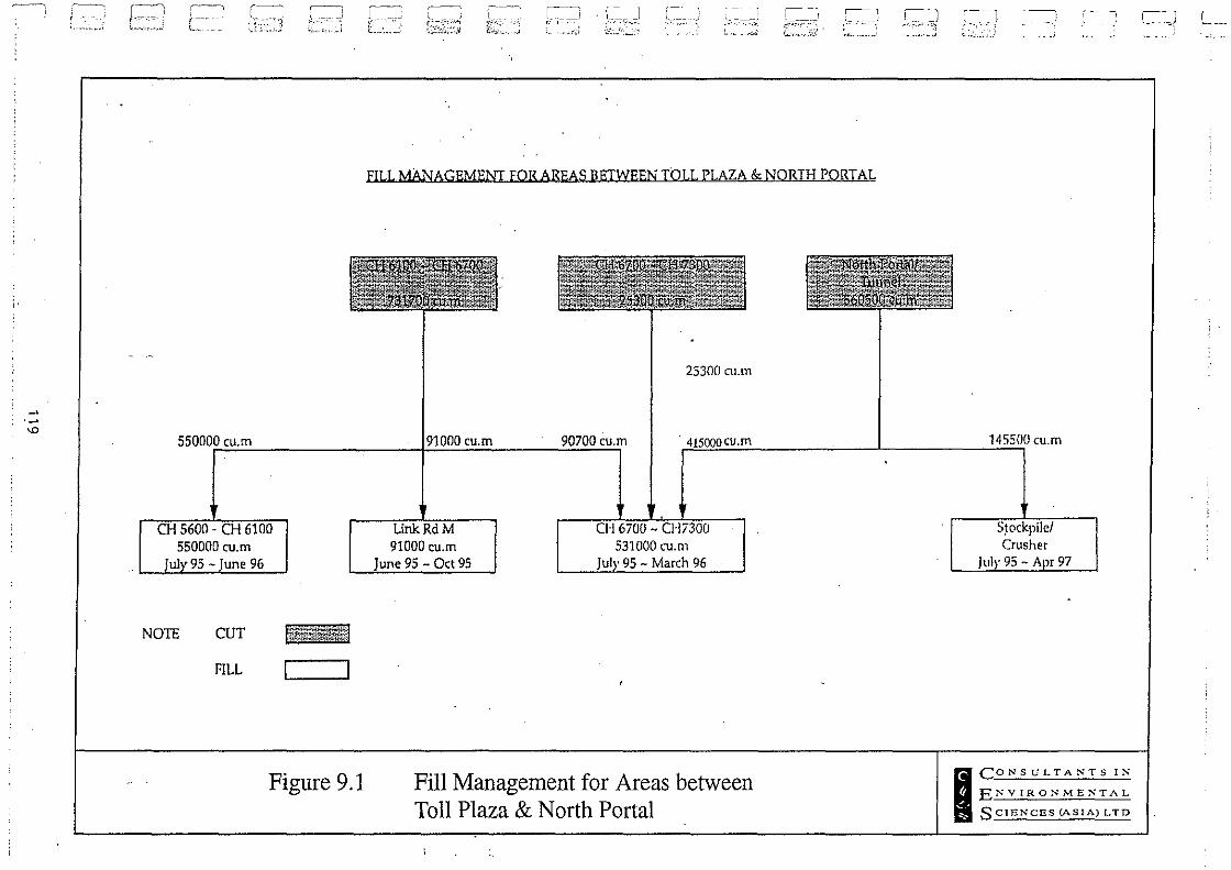
~
!
;,
'"
J~ ~~"",~,,;
,----, ! L ~L·.~:J
550000 cu.m r--
550000 (U,m 96
~, , , ,~. _;J
i; .• 'h .• i
NOTE CUT
FILL c=--,
Figure 9.1
r-= [-.. ~.'.~::
~
G~~;;j '---,
"
l ____ j L ____ _ ,. --'~
_,._>t,.
~_J ---<
\. ~ . ~:,) _ ____ -.l
r'- ",';-", L: .... _.,;~.! .
,---- 1
.-....
FILL MANAGEMENT FOR AREAS BETWEEN TOLL PLAZA & NORTH PORTAL
25300 cU.m
(007
) -l ---:l ~
'. "'-"'"~ .· .• i
90700 cU,m 'HJWV'-U,l>1 145500 cU.m
91000 (u.m 95 - Oct 95
531000 (u.m 95 - March 96
Fill Management for Areas between Toll Plaza & North Portal
97
I CONSULTASTS IS
ENVIRONMENTAL
SCIENCES (ASIA) LTD
CJ L ___ _

0' fJ
[ ' ..... , '
:, ~ :
I' I '
I,',
-''-
--. '--'

, ' C"
[
c·····'· ," 1 !..,.;
[
C.". .,\ .'. --.~
C-'·'·'··"· >_.,'
{ .•.. ::,
[lCC" :V:~,~ '~~d
[,,"1
.hl
[ ,; j,J
[:.'. '.'" "
-'~'_J
C'. 'i. ' ,
C· , , "
.:.-J
[ "., ': ,< , , ~j
[':,, :--:
-~ .. ~j
Route 3 Contractors Consortium R3 TLT & YLA (S) - Main Line DEIA V1.5
10 CONCLUSIONS
The findings of this report are broadly similar to those of the PDS2EA. One difference is that blasting was not previously included in the PDS2EA, but has now been addressed in detail. As is the normal practice in Hong Kong, construction impacts have been predicted on the basis of conservative worst case modelling. Representative worst case receivers that are closest to the construction sites were selected for assessment, since impacts at more distant receivers will be lower. R3CC has committed to meeting statutory environmental requirements and will endeavour to meet guideline limits wherever practicable. Commitments have also been made to a number of impact mitigation measures and these were used as a basis for modelling. However, since the modelling is based on worst case, and in reality impacts are likely to be lower than those predicted, the need for additional mitigation will be based on the results of the Environmental Monitoring and Audit (EM&A) programme. In addition, an on-site Environmental Manager from R3CC is included on the project team to eitsure that the necessary mitigation measures are carried out.
With the implementation of committed mitigation measures, residual environmental impacts during construction and operation of the R3 TLT & YLA southern section should be acceptable. Air quality impacts (TSP and NO,) were predicted to comply with all guideline and statutory limits during construction and operation. Future sensitive uses should be sited at least 350 m and 300 m from the northern and southern ventilation bUildings respectively. Construction noise was predicted to meet the non-statutory daytime limit of 75 dB(A}. Operational noise was predicted to meet the HKPSG guideline limit of 70 dB (A) at all selected receivers except R2 and R70. The contribution of traffic noise from Route 3 to R2 was predicted to be 0.1 dB(A}, with most of the noise coming from Tuen Mun Road. For R70, direct technical remedies were found to be ineffective agrun due to traffic noise from Tuen Mun Road. Indirect remedies (glazing and air conditiOning) were therefore recommended for this receiver. Residual impacts on water quality, ecology, visual and landscape, and solid waste were predicted to be acceptable with the implementation of the mitigation measures. Committed mitigation measures are summarised below.
Noise
• Acoustic screening is provided for stationary plant items. • During filling activities by GCL near NSR R70, each PME item is separated spatially
along the alignment by 80 m. • During combined earthwork activities by DTP south of the tunnel, the mounted
breaker is located at least 300·m from NSR R70 and operated for only 70% of the time during each 3D-minute period.
• During earthworks at Link Road M (Kam Sheung Access Road) by GCL, the wheeled loader is operated for 40% of the time during each 3D-minute period when it is within 15 m of an NSR.
• During earthworks within Chainage 6100 to 7300 by GCL, lorries are operated for only 80% of the time during each 3D-minute period when they are within 100 m of NSR 2013
. CES (Asia) Ltd 120 9 6530\reports\deia ·s\r3sdeia.d12

Route 3 Contractors Consortium R3 TLT & YLA (S) - Main Line DEIA V1.5
• During soil nailing north of the tunnel by GCL, the crawler drill is operated for only 70% of the time during each 30-minute period when it is within 225 m of NSR R2013.
Air Quality
Site Practices
• Mean vehicle speed of haulage trucks at 20 kmhr-'. • Twice daily watering of all open site areas (assumed 50% dust reduction as from AP-
42). • Wheel wash facilities. • Regular (every 1.5 hours) watering of all site roads and haulage roads where
necessary (assumed 70% dust reduction). • Suitable side and tailboards on haulage vehicles. • Watering of temporary stockpiles.
Blasting
• Use of select aggregate and fines to stem the charge within drill holes and watering of blast face (assumed 30% dust reduction).
• Vacuum extraction drilling methods (assumed emission factor for wet quarry drilling from AP-42).
• Carefully sequenced blasting. • The blasting operations will be carried out with an "open face". This will have the
effect of increasing the horizontal portion and decreasing the vertical portion of rock displacement. Subsequently the vertical emission of dust will be reduced. If the blast area is closed without an "open face", the fractured rock would be confined and forced to be displaced vertically.
• Vacuum filters on drill rigs will reduce dust associated with blasting preparation. • Incombustible stemming will be used in the drill holes, where approximately 3 m of
selected aggregates! granular material will be placed, which would confine the explosive and act as gas absorber.
• All the blast holes will be filled with emulsion and detonation will be sequential with a delay of approximately 25 ms between two holes. As the explosives detonate, fracture and move rock, dust is generated. The'degree of interaction with adjacent blastholes will influence the velocity of movement of the shattered rock and will subsequently affect the quantity of dust generated. Closely spaced blastholes fired simultaneously will result in higher velocities of displacement and hence higher dust emission than a single blasthele. Through careful sequencing of the proposed detonator methodology, the velocity of the rock is reduced and dust emission minimized.
Concrete Batching/Crushing
• Fabric filters installed within the concrete batching and crushing plant. • Water sprays on all crushers.
. CES (Asia) Ltd 121 96530\reports\deia-s\r3sdeia.d12
--·L
T [
I I [
[
-[ i'~': ,;:
I [
[
[
I [
[
[
[
[
I
[ •• -'.'. ' . ,
c [
[ '.: i._'
[l ,'.'1
[,
C,·, ("": I,.l
[i
. '
~ .;
1'; L~:. -"
LlJ
D;! ['::
J~.:j
C, [:
["
J;"',')
[ '; , ~~J
[>.;
-. ~
~;.--j
Route 3 Contractors Consortium R3 TLT & YLA (S) - Main Line DEIA Vl.S
Water Quality
Construction of South Tunnel. South Portal and Ting Kau Approach
• A stilling pond will be provided downstream of the pipe culvert adjacent to the South Portal.
• Temporary drains and stilling ponds (Figure 6.3) will be installed prior to major cut and fill operation that exposes bare soil.
• Drains will be constructed along the alignment of the main and secondary access roads as well as around the temporary facilities. Diversion ditches will also be installed to collect run-off from areas of exposed soil. Water collected in drains and ditches will be diverted to temporary stilling ponds to allow for separation of sediment prior to discharge into the natural stream courses. .
• Exposed slopes in soft material will be hydroseeded as soon as possible to reduce erosion potential and levels of sediment laden run-off.
• The stream below the South Portal will be diverted through a temporary drainage channel to maintain water flow and reduce ingress of contaminants. Water velocities exiting the permanent culvert will be controlled by means of sumps and cascades where necessary.
• Oil interceptors will be installed for the workshop and storage areas. These will be emptied regularly and will have a by-pass to prevent flushing during periods of heavy rain .
• Office workshop and canteen facilities will be provided with appropriately sized septic tanks. Temporary chemical toilets will be provided when necessary.
Construction of North Tunnel. North Portal and Toll Plaza
• Temporary drains and stilling ponds will be installed prior to any major earthworks that expose bare soil.
• Drains will be constructed along the alignment of the access roads as well as around the temporary facilities and slope berms. DiverSion ditches will also be installed to collect run-off from areas of exposed soil. Water collected in drains and ditches will be diverted to temporary stilling ponds to allow for separation of sediment prior tp discharge into the natural stream courses (location of the stilling pits is shown in Figure 6.2). .
• All exposed slopes will be hydroseeded as soon as possible to reduce erosion potential and levels of sediment laden run-off.
• The stream below the North Portal will be diverted through pipe culverts to maintain water flow and reduce ingress of contaminants. Water velocities exiting the culvert will be controlled by means ot sumps and cascades where necessary.
• All run-off from stockpiles will be collected in temporary drains and directed to the stilling ponds.
• Oil interceptors will be installed for the workshop and storage areas in compliance with EPD regulations. These will be emptied regularly and will have a by-pass to prevent flushing during periods of heavy rain.
• Office workshop and canteen facilities will be provided with appropriately sized septic tanks. Sewage and wastewater will either be treated on site or will be removed off-
CES (Asia) Ltd 122 9653 O\repor ts \deia -5 \r3sdeia. d12

Route 3 Contractors Consortium R3 TLT & YLA (S) - Main Une DEJA Vl.S
site to Sewage Treatment Works using a licensed contractor. • Surface pond water and run-off liquor from pond mud. will be treated prior to
discharge where necessary. The surface water will be tested and if appropriate siphoned off and discharged into natural stream courses. The remaining pond slurry will be pumped into adjacent settlement basins. The mud and settled slurry in the ponds and settlement basins will be mixed with completely decomposed granite to convert it into a suitable material for reuse on site.
• All the tunnel production water will be directed to the stilling pit prior to discharge to the existing stream course or reused on site.
Operational Phase
• Grease interceptors will be provided for the garage, workshop and kitchen in the Administration Building;
• Sedimentation will be controlled by silt· traps in gully iniets and· provision of sedimentation basins at appropriate locations along the highway.
• Silt traps will be cleaned and maintained regularly to ensure that they function properly.
• Oil interceptors will be provided for the tunnel and the Toll Plaza drainage systems.
Ecology
• Sedimentation and erosion control measures to prevent adverse impacts on the stream and riparian vegetation, including hydroseeding of temporary works Fut and fill slopes, use of earthen berms to control overland flow and other measures.
• Compensation planting of native woodiands permanently lost by the works through off-site planting three times the area affected with the same species of woodland to the satisfaction of the Directors Representative in consultation with the Agriculture and Fisheries Department (as specified in the Construction Requirements and described in further detail in section 7.5.5).
• Reinstatement of vegetation on the temporary construction areas within the Works Boundary' according to a comprehensive reinstatement plan to be developed in consultation with the government authorities; and specialist terrestrial ecologist.
• Where practicable transplantation of seedllngs of protected species of E. quinqueflorus and A. chinensis. •
• Minimize incursion into areas. within the Works L,irnits that are not directly required for either temporary or permanent work. .
• Establishment of conservation management regimes in a pond partially lost to the highway project.
• Additional ponds to be restored to commercial fish production, thereby restoring the pre-disturbance function.
• Monitoring the egretry and restoration of the areas within the works limits and adjacent to the egretry, to encourage utilization, following construction.
• Where practical, excavate by hand, any burrow systems encountered during construction and release captured animals unharmed in areas secure from disturbance. The practicality of the commitment including the effect of translocating animals will be discussed with AFD and methods developed to carry out hand
. CES (Asia) Ltd 123 96530lreportsldeia-slr3sdeia.d12
L
[
[
[
[
{
[ .:[ , .~
:.:;--
l [
[
[
,[
{
[
[
[
[
J

0···
·-'·' : : , '
[
., .. I
-, ,
;; .. ,.)
JtJ "
l '·' '; ,i
\ . ,~ .
"
-, :;'"';) j ~. .\
~ t~~
.. , "1 ~ ':j
--J ,.:]
Route 3 Contractors Consortium R3 TLT & YLA (S) - Main Line DEIA V1.5
excavation and relocation of captured animals occurs wher~ possible.
Visual and Landscape during Construction
• restrict volume of construction traffic on local road network; • restrict the construction working areas to a minimum, siting them if possible in
visually isolated positions • enclose the working areas with hoardings to define boundary edge and screen low
level construction activities (e.g. car/truck movement) from surrounding receivers; • restrict heights of storage materials, stock piles and spoil heaps to low levels; and • minimise night-time working and lighting.
Waste Management
• Different types of wastes will be segregated, stored, transported and' disposed of separately in accordance with EPD's required procedures.
• As only a small amount of sludge will be produced on sites requiring periodic disposal, temporary on-site storage facilities may be required. Sludge/waste will be stored in enclosed containers to prevent odour emission.
• The contractor will ensure that hazardous materials, chemical wastes and fuel are packed or stored in containers or vessels of suitable design and construction to prevent leakage, spillage or escape.
• The contractor and operator will prevent the uncontrolled disposal of hazardous materials and chemical waste to the air, soil, surface waters, groundwaters and coastal waters.
• Dangerous materials including fuel, oil and lubricants as defined under the DGO will be stored in specially designed areas and properly labelled on site. If leak, spill or discharge occurs, it can be contained more effectively in these specially built areas.
• Refuse containers such as open skips will be provided at every work site for use by the workforce.
• The contractor will re-use excavated spoil as much as possible to minimise off site disposal of spoil. In particuiar all excavated pond mud will be re-used on site .
'CES (Asia) Ltd 124 96530\reports\deia-s\r3sdeia.d12

Route 3 Contractors Consortium R3 TLT & YLA (S) - Main line DEIA V1.5
REFERENCES
AFD. 1994. Agriculture and Fisheries Annual Departmental Report 1992-1993, Hong Kong Government, Hong Kong.
Chong, D-h. and Dudgeon, D. 1992. Hong Kong Stream Fishes: An annotated checklist with remarks on conservation status. Mem. H.K. Nat. Hist. Soc. 19:79-111.
Chu, K. 1993. An evaluation of the ecological importance of fish ponds in the inner Deep Bay wetland system. World Wide Fund for Nature Hong Kong, unpublished report.
Corlett, R.T. 1992. Plants attractive to frugivorous birds in Hong Kong. Mem. H.K. Nat. Hist. Soc. 19:115-116.
Davis, T.J. 1993. The Ramsar Convention Manual: A Guide to the Convention on Wetlands of International Importance Especially as Waterfowl Habitat. Ramsar Convention Bureau, Gland.
Dudgeon, D. and Corlett, R. 1994. Hills and Streams. An Ecology of Hong Kong. Hong Kong University Press, Hong Kong.
ERM. 1995. Yuen Long-Kam Tin-Ngau Tam Mei Main Drainage Channel Environmental Impact Assessment.
Fasola, M. and R. Alieri. 1992. Conservation of heronry Ardeidae sites in North Italian agricultural landscapes. Biological Conserv. 62:219-228.
Freeman Fox Maunsell. 1993a. Route 3 Country Park Section and Ting Kau Bridge, Preliminary Design Stage 2, Country Park Section - Ting Kau Bridge. Volumes 3A &3B, Environmental Assessment - Technical Report and Appendices.
Freeman Fox Maunsell. 1993b. Route 3 Country Park Section and Ting Kau Bridge, Preliminary Design Stage 2, Country' Park Section - Ting Kau Bridge, Environmental Assessment - Supplementary Paper, Haul Road.
"
i; Freeman Fox Maunsell. 1993c. Route 3 Country Park Section and Ting Kau Bridge, Preliminary Design Stage 2, Country Park Section - Ting Kau Bridge, Environmental Assessment - Supplementary Paper, Conveyor System.
Hill, D. S. & K. Phillipps. 1981. Hong Kong Animals. Government Printer, Hong Kong.
Kentula, M.E., R.P. Brooks, S.E. Gwin, e.e. Holland, A.D. Sherman, and J.e. Sifneos. 1992. An Approach to Improving Decision Making in Wetland Restoration and Creation. Edited by A.J. Hairston. U.S. Environmental Protection Agency, Environmental Research Laboratory, Corvallis, Oregon, USA. 151pp.
CES (Asia) Ltd 125 96530\reports\deia-s\r3sdeia.d12
-L
T [
[
T :[
T
[
. .. 1 ,j[
'.[
[
. :[ .. 0:
··r
-j ~--J
_r
l
'-, I
. i :~: j ---! : ~j
i ; __ J ;.; .. ;
·.it] . i :
I •
I .-)
Route 3 Contractors Consortium R3 TLT & YLA (S) - Main Line DEIA Vl.5
Melville, D. S., L. Young, and P. J. Leader. 1994. Fish ponds around Deep Bay: Their importance to wildlife, especially waterbirds. World Wide Fund For Nature Hong Kong, unpublished report.
Viney, c., K. Phillipps, and yc. Lam. 1994. Birds of Hong Kong and South China. Government Printer, Hong Kong. 244 pp.
Wilson, D. E. & D. M. Reeder. 1993. Mammal Species of the World: A Taxonomic and Geographic Reference. Smithsonian Institution Press, Washington, D.C., USA, 1206 pp.
Wilson, K. 1995. Dragonflies, diversity and fish ponds. Porcupine 12:6-7.
Young, L. 1991. Conservation of wildlife in the Deep Bay area: with particular reference to heron species. In Boxall, J. (ed.) 1991. Polmet.91: Pollution in the Metropolitan and Urban Environment. Hong Kong Inst. Engineers, Hong Kong. .
Young, L. 1993. The Ecology of Hong Kong Ardeidae. Ph.D. thesis, Univ. Hong Kong, Faculty of Science.
Zhuang, x.Y. 1993. Forest Succession in Hong Kong. Ph.D. thesis, Department of Botany, University of Hong Kong .
GES (Asia) Ltd 126 96530\reports\deia-s\r3sdeia.d12

n
; . , ,
I '
I·
" i
LJ.:
L' : .;;'.J
r " t. _:~-~~
r I': ~ ['.;
\ ....

c
[]
C,', :.:. '.:
C"" r.1
C',,·'. ,
J
O· .
! ..
'".'
0' ! ---":~'.:'j
["" :i: ~
i .~: I J\"-' ,
C' '~ . .l
[;
[':' ;
-.: .f -,-,,-.:
[ .. .. '. ' , . i
-'-'
8.6.5
8.6.6
8.6.7
v) Steps shall be taken by the Franchisee to ensure that dust created by the operation of the conveyor system shall not interface with the keeping of an
efficient lookout from the Marine Department VTS Control Station and shall
not have an adverse effect on the radar antenna.
The Franchisee shall remove all installations relating to the conveyor system and
temporary pier and carry out reinstatement with landscaping works to the areas affected within 6 months of completion of the conveying activities and not later than February 1998. The construction, operation, removal and reinstatement of and utilities associated with the conveyor system shall be at the Franchisee's cost. The Franchisee shall also carry out improvement works, and construct a new beach building with furniture and equipment to replace the existing building. Details of the said reinstatement,
improvement and construction work are contained at Annex 2.
Prior to commencement of works relating to the conveyor system, the Franchisee shall at his own cost:-
(a) include as part of the Detailed Environmental Assessment Report an assessment. of the environmental impacts of the construction and operation of such system. The scope of and procedure and methodology for such assessment shall be agreed with and to the satisfaction of the Director's Representative in conjunction with Environmental Protection Department and the Franchisee shall carry out as part of the Worlcs any mitigation measures agreed or determined by the Director's Representative to be necessary, inter alia, to ameliorate
impacts to acceptable standards defmed in the Hong Kong Planning Srandards
and Guidelines; and
(b) conduct an assessment of the impact of the barge loading point ,'n marine traffic and submit the same to the Marine Department. In the e\ em rhat the impact on marine traffic is unacceptable to the Marine DepJ!1Inent, the Franchisee shall not be entitled to use or operate the barge 1"JJtng point without the express agreement and approval from the Marine Ilcrartment.
Any conditions imposed by the Marine Department upon the 'J IJ approval . shall be met by the Franchisee at his own cost prior to the barge I· 'JJtng point
being used or operated.
The Franchisee shall make its own arrangements to dispose of the surplu\ excavated materials to location(s) within Hong Kong to be agreed by the Director's Rerr~sentative. Disposal of surplus excavated materials in d'esignated public dumping sites. ,uch as the Tseung Kwan 0 Public Dump, and gazetted marine dumping areas shall not k allowed. Tentative peU mell requirements in 1995-96 for both government and pri\ Jte projects, taken from the Fill Management Committee database are listed in Anne< 12 for the Franchisee's reference and information. The Franchisee shall obtain prior agreement with the respective project offices and contractors for the proposed disposal lIr excavated materials to their sites. Rock may be required to be trimmed down to 250 lrun before
A-l

9.3 Ponds
9.3.1
9.3.2
9.3.3
The Franchisee shall be responsible for maintaining duril!g the Construction Period those
ponds within the Works Sites as shown on Drawing Nos. 92393/01l106C, 109C and
116C in Appendix 4 of the Project Agreement and other ponds identified in the Detailed
Drainage Impact Assessment, which are not required for construction of the permanent
work but are required to perform as temporary flood deiention ponds. The Franchisee
shall continue to maintain these detention ponds after the Construction Period until such
time as the Yuen Long Main Drainage Channel improvement works in the area have been
completed by Drainage Services Department, at which time they shall be handed back to
Government in a condition to be agreed with the Director's Representative;
The Franchisee shall be responsible for maintaining during the Construction Period those
portions of ponds which form part of the Works Area and are, not required for
construction of the Works. Government is to hand these portions of ponds back to their
former owners on completion of the Construction Period and the Franchisee is required
to return the ponds to their original condition including the quality of the water;
The Franchisee shall be responsible for maintaining during the Construction Period all , other ponds within the Works Sites which are not required for the Works. Ponds
required temporarily during construction of the Works but not required for the on-going
maintenance and operation of the Constructed Facilities shall be reinstated to their original
conditions including provision of suitable enhancements to improve their ecological value
as determined by the Detailed Environmentai Impact Assessment. As part of his .
L
T [
[
[
[
[
[
.[ Construction Proposals the Franchisee shall also design and re-provide permanent access [-equivalent to that in existence at the date of the execution of the Project Agreement, to
9.4
9.4.1
9.4.2
9.4.3
these ponds at his own cost.
Conditions of Land Availability
Those areas of land which may be made available to the Franchisee for Works Areas
during all or any part of the Construction Period shall be made available subject to
compliance with the standard engineering conditions for temporary land allocation for
Government projects as amended in respect of ~y particular area of land:
Any areas of Government land which are not subject to any lease or licence and which
the Franchisee requires as additional Works Areas may be made available to the
Franchisee subject to payment of a full market rental and to terms and conditions to be
assessed by Government;
Pursuant to Section 10.3, the land to be made available to the Franchisee for
compensatory planting will be allocated to the Franchisee by the Lands Department and
shall become part of his Works Sites for the purpose of the Project at no cost to the
Franchisee;
1\-2
.[ ,'.,;:
.... [
[
I
[
I r

c······: ".">
_c,
Dr: .. ) l .. j :~J
C· . -~ .. ~
[
9.4.5
Franchisee will not be entitled to any extension of the Consrruction Period oor the Franchise perio<! due to the time taken to acquire such land under these circumstances. Government will not provide land required by the Franchisee for carrying Out site investigation works.
Government shall use its re:l.Sonable endeavours to hand over Area H on 30th JUDe 19%. Such re:l.Sonable endeavours shall include without limitation, issuing such instructions as are re:l.Sonably necessary to the relevant contractors to widen the haul road from Castll! Peale Road in the vicinity of Area H by up to a maximum of 4 metres, to divert that haul road so that it does not encroach on Area H and to ensure that any traffic shall use the haul road as diverted. Government will obtain a price from others for carrying out such work for agreement with the Franchisee. If agreement is reached, the Franchisee shall pay the agreed price to Government within 30 days of demand. If the Franchisee does not consider such price to be reasonable, the Franchisee may itself carry out such works and, in these circumstances, Government shall secure such access as may be reasonably necessary for such purpose. Any work =ied out by the Franchisee under this Section 9.4.5 shall form part of the Temporary Works. '
SECTION 10 E1'fVIRONMENTAL PROTECTION
10.1
10.1.1
10.1.2
Environmental Impact Assessments
The Preliminary Environmental Impact Assessment Report makes initial recommendations for mitigation measures to reduce the environmental impacts arising from the construction and operation of the Constructed Facilities. The Franchisee shall carry out a Detailed Environmental Impact Assessment Report based on his Construction Proposals to verify the findings of the Preliminary Environmental Impact Assessment Report and assess in detail the environmental impacts of the Construction Proposals. Mitigation measures are to be adopted by the Franchisee, at its own cost, in order to ameliorate air, noise, water quality, visual and ecological impacts associated with the Constructect Facilities to the satisfaction of the Director'S Representative. The Franchisee's attention is drawn to the Planning, Environment and Lands Branch General Circular Nos. 2/92 and 2/94 / Works Branch Technical Circular No. 14/92 at Annex IS, for the preparation of the Detailed Environmental Impact Assessment.
Mitigation measures to be adopted to reduce environmental impacts arising from the operariQ't.shall include, entirely without limitation, noise mitigation measures to reduce the effect of traffic noise levels on existing buildings and buildings to be built in the future (for which proposals have been submitted to and agreed by Governmeot prior to the date of execution of the Project Agreement), which are adjacent to the Constructed Facilities SO as not to exceed the levels contained in the Hoog Kong Planning Standards and Guidelines. These measures will consist of either direct technical reme.:Jies such as no ise barriers to be installed alon"side the road or indirect remedies such as installation
. b
of air-conditioners, double glazing at the noise receives (or any combination thereof), and where necessary the upgrading of electricity supply to and within the premises. Direct and indirect remedies will be carried out by the Franchisee at his own cost. As the detailed proposal for installing indirect remedies to premises are required to be approved by EcCo, the Franchisee sh3JI allow for this procedure in the Construction Programme.
1\.-3

10.1.3
10.lA
10.1.5
10.1.6
10.1.1
10.2
10.2.1
As indic:lted in the Prelimin3.I)' Environment:J.l Impact Assessment Report, there are several outstanding issues relating to re:J.Ssurance and refinement of the reco=eoded mitigation measures, thar need to be addressed during the deniled design of the Works. The Franchisee shall carry out the Det:liled Environmental Impact Assessment to address these outstanding issues. The scope of and procedure and methodology for the Det:1iled Environmental Impact Assessment sb.all be agreed with and to the"satisfaction of the Director's Represent:ltion in consultation with EPD, and the Franchisee shall carry out as part of the Works any mitigation measures agreed or determined by the Director's Represent:ltive in consultation with the Environment:J.l Protection Departme.nt to be necess3.I)' .
In relation to any Change, the environment:J.l impact of that Change must, unless otherwise agreed by the Director's Representative, be assessed by the Franchisee and appropriate measures implemented as part of the Works (in the case of a Change proposed by the Franchisee at the Franchisee's cost) so as to ameliorate any environmental impact. The scope of and procedure and methodology for such assessment shall be agreed with and to the satisfaction of the Director's Representative and the measures to be implemented shall be as agreed with or determined by the Director's Representative. For the avoidance of doubt, the cost of an assessment required as a result of a Government Change shall be borne by Governinent. All such proposals shall take account of the Hong Kong Planning Standards and Guidelines, Environmental Protection Ordinances and Environmental Impact Assessment findings/reco=endatiooS.
Section 8.6.6 contains requirements for a detailed environmental impact assessment to be carried out in relation to the conveyor system referred to therein and Section 10.3 details certain environmental reprovisioning works to be carried out by the Franchisee.
The Advisory Council on the Environment (ACE) requires a four seasons ecological survey of the Site to be undertaken and mitigation measures proposed. Government has commenced the survey in September 1994 and from the date of the execution of the Project Agreement, the Franchisee shall, as part of his Detailed Environmental Impact Assessment continue and complete the said survey, until the completion of the four seasons cycle or the commencement of construction works in the relevant area. A report shall be prepared to identify the need and measures to be taken to mitigate the impact of the Constructed Facilities on the ecology.
The Franchisee shall not commence construction of any part of the Works, except in accordance with Clause 24 of the Project Agreement, prior to obtaining the agreement of the Dir.e,rtor's Representative in consultation with EPD and the ACE as to the implementation ofmidgation-:i:il"e:asures for th'at part of the Works. In this respect the Franchisee will be permitted to submit his Detailed Environmental Impact Assessment Report in phases consistent with his intended construction programme and sufficieot time must be allowed in the programme for the Director's Representative to obuin the necess3.I)' approvals of relevant authorities, including the endorsement of the findings by the ACE. Any phasing of the Detailed Environmental Impact Assessment Report sb.aIl be agreed in writing, in advance, by the Director's Representative.
Key Issues
Key issues which must be tak~n into account by the Franchisee in monitoring and/or mitigating the impact of che construction and operation of Constructed Facilities upon the environment include:- ' ,
A-4
L
1 [
I ....• 01 , -, . ;': .... - .. :
<,c
· .. ii·.:.[ .<--! ';.'
, ';, .... [
[ ,[
. I ::'-.:
,'[ '. -,: :.;j
[
1 •• I I -I

[
[
pr) U'
D'·; :- -.:'
1:_ ,
C"· ; < " ~:,- .;
['.C" .. .. .
;, ~ ;
[ ' .... " " ,
J~3
, , [ ....• }
10.3
10.3.1
10.3.2
10.4
10.4.1
10.4.2
(a)
(b)
(c)
(d)
(e)
(f)
associated fixed noise SDurces of Constructed Facil ities' ,
traffic no ise;
the effect upon air quality, particularly along Yuen LDng Approach Road, at the portals and ventilation exhaust points of Tai Lam Tunnel and inside the tunnel;
visual impact, and landscaping and environmental reprovisioning;
ecological and heritage impact;
water quality impact;
(g) disposal of soil, construction waste and unsuitable materi?l;
(b) traffic impact to existing roads during construction;
(i) construction Daise, dust and vibration.
Environmental Reprovisioning Works
The Franchisee shall carry out off-site compensatory planting of native woodlands affected by the execution of the Works, on land to be provided by Gove=ent reasonably adjacent to the Site, irrespective of landscape proposals carried out within the Site as described in Section 12. Two possible areas have been identified for such planting and are shown in Annex 14. If necessary, other areas r=nably adjacent to the Site will be detemuned and allocated by the Director's Representative in consultation with the Agriculture and Fisheries Department and Lands Department.
The area, species and precise location of woodland affected by the execution of the Works shall be determined in the Detailed Enviromnental Impact Assessment Report and the compensatory planting .shall consist of planting three times the area affected with the same species of woodland to the satisfaction of the Director's Representative in consultation with the Agriculture and Fisheries Department.
MonitQrirg- and Mitigation During Construction ,,- -: .
The Detailed Envirorunental impact Assessment Re'port shall ma.l::e reco=endarions for the mOnitoring and mitigation of construction nuisance in respect of air qualiry, noise, water and ecological impacts. These reco=endatioDS shall be adopted by the' Franchisee at its own cost, to the satisfaction of the Director's Representative.
In order to achieve an acceptable construction environment, the Franchisee shall ta.l::e into account the following matters and implement appropriate measures:-
(a) cle:m1iness of site; ,
(b) requirement to abide by the Noise Control Ordinance, Air Pollution Ordinance and any other relevant waste disposal ordinances;
11-5

10.4.3
10.4.4
10.4.5
(c)
(d)
(e)
([)
(g)
(h)
compliance with est4blished noise criteria / guidelines;
maintenance of all roads, footways, acc~s roads, streams, drains etc.;
discharge or disposal of all water and waste products;
. construction; maintenance, removal and reiost4tement of temporary drains;
dust suppression measures;
operation of concrete batching plant and rock crushing plant;
L
T [
[
.. :.[
(i) procedures for the avoidance of pollution during transporting and dumping of excavated spoil material; {
0) spoil handling and transport;
(k) protection of 'bathing water quality;
(I) supply of water quality monitoring equipment and assistance for the Works •. [ Checker to monitor and check any readings by the environmental team; .
(m) protection of water quality at water intakes; and
[ (n) construction and working methods tc ensure compliance with relevant standards
and the conditions of land within the site. . .
The Franchisee shall set up an environmental team to monitor and audit the environmental .{ impact of the Execution of the Works. The environmental team should consist of members with suitable experience and expertise in relevant fields and be approved by the [ Director of Environmental Protection (DEP). The environmental team shall provide approved equipment necessary for carrying out the environmental quarity measurements. Sufficient. equipment, spare parts and any other necessary materials should be available .[ to ensure that the schedule of measurement is achieved at all specified times. All, measurements shall be =ied out by suitably experienced staff.
The morutcring and audit works shall be =ied out at regular intervals. The environmental team shall submit tc the Works Checker (We) and DEP, and copy to the Directj:}f:.s,'·Representative if requested, the monitcring and audit schedules specifying frequenCy, locations and trigger/action/target limits and event/action plans for approval at the co=encement of the Works. Any revisions or supplements tc the above may be required to be carried out during the Construction Period.
For the purpose of environmental monitoring and audit, the trigger/action/target \f/Arf) limits are defined as:-
(a) Trigger limits -
(h) Action limits -
The levels beyond which there is an indication of a deteriorating ambient environmental quality for which a typical response could be more frequent monitoring.
The levels beyond which appropriate remedial actions may be necessary tc prevent the environmental quality
I
I .{
A-6 [
.. -....J

['
[
len :; t
L-J .. _.;
L., ;
i-Xl l~·,,_~
[ "" U " :1
;'~--'.:
[:
[' '
;- , "".;
from going beyond the target limits, which would be unacceptable.
(c) Target limits - The statutory I imits stipulated in relevant pollution control ordinances, environmental qualiry objectives or Hong Kong Plarining Standards and Guidelines beyond which the works should not proceed without appropriate remedial action, including a critical review of plant and wor\:: methods. .
10.4.6 A suggested T/Arr level action plan for dust is shown below at Table 10.4.6 for guidance. The ultimate sanction for persistent breach of the target limit should be to stop work until revised worl::ing practice has been agreed with the Director's Representative ..
Table 10.4.6 Suggested TI Arr Level Action Plan for Dust
Event Action
Ell 'Tironm e:a b.l T e:a.m Contr:lctoC'
Trigger level L:s exceeded for One Repc1t mQ.1urcment u .soon a.s po$lible. sample -Trigger level U exco::ded for Repc:tt mea.suremenU. more thrut One consecutive $Ample Notify the Works Checker. -
No.tify Contr.Lctor. ,
Action level u exceeded for one Rcpes.t mea..=mrcment 1$ .sooo u possible. :sample Notify the Works Checker. -
Notify Contractor.
Action level is cxcocded (or morc Inc~ frequency of monitoring to daily. ReVieW pJ.s..nc and methods. tha.n one consecutive .sample Notify the Works Checker. Submit proPOMU for reducing
Notify Contractor. d~t to cnvironmcnul ta..m. Require Contractor to make propJ.u.1.s to lrnpl~c::nt remedial actioru. rcducedwt.
Target level jj' cxceCd.cd for onc Rcpc::Lt mQ..:Surcmem a..s soon .u po •• ible. Mmplc Notify the Works Cheeker. -
Notify Contractor. ','
Target level U excec:Xl'Cd-ror more InC{"C3.3c frequency of monitoring to ~ !Cl,jt RevieW plant and mcthod..5. ..... -. than one ~ple daily. . Implement mC3..1urcs to reduce
Notify Conmctor. dU3t immediAtely.
Notify the Works Checker. Notify the WC, DE? ""d the Notify DE? environmental tc1m of action Notify Director', Rcp~wive. t3.l::cn.
Require Contr:1ctor to implement immcdi.w: ,tt;p4 to reduce dw.t.
10.5 Air Quality
10.5.1 The environmental tearn shall, prior to the co=encement of the constrUction works, carry out baseline' monitoring to detennlae the baseline (TSP) levels. The baseline
A-7

10.5.2
lO.S.3
10.6
10.6.1
10.6.2
10.6.3
10.7
10.7.1
monitoring shall be carried out for a period of at l=t rNa weeks, with measurement [ taken at design:lted locations and· to a schedule agreed witl! the WC and DEP. _
Checking of baseline dust (TSP) levels shall be carried out by the environmental team on at least four occasions during the y=, at not less than one ·monthly intervals, for each site. The checking shall be carried out when construction activities are not taking place.
Impact monitoring of 1 hour and 24 hour TSP levels should be carried out in accordance with the reco=endations given in Sections 4 and 27 of the Preliminary Environmental Impact Assessment Report and the Detailed Environmental Impact Assessment Report, using equipment specified in Table lO.5.3 below. The monitoring schedule should be determined by ,the environmental team depending on the Contractor's method of workin.,. , , D
but as a guide ~should be about 3 days per we<;lc.
Noise
The environmental team shall, prior to the co=encement of construction worlcs, carry out baseline monitoring to determine the ambient noise level. The monitoring shall be carried out for a· period of at least two weelcs, with measurements to be taken every day at designated sites, and to a schedule agreed by the Director's Representative in consultation with the WC and DEP. From these measurements baseline noise levels in L<q(30 min) shall be calculated.
Checking of baseline noise levels shall be carried out by the enviroomental team on at least four occasions during the year. The checlcing shall be =ied out when construction activities are not taking place. At each location, the interval between the monitoring shall not be. less than one month.
A schedule of proposed noise measurement times and sites shall be produced by the environmental team on a monthly basis and submitted to the WC and pEP for agreement
[
[
T [
[
[ at least two weelcs before the scheduled period. The measurement frequency shall be at [ least once per weelc. Construction noise levels shall be recor~ed as the averagce of three , ... consecutive Leq(30 min) measurements, at each of the agreed Sites. Where the ontractor. has been granted a permit to wor!:: during restricted houes, additional measurement in r" ' .• [
L<q(5 min) shall 'be taken during the restricted h·oues. . t :." ,
Water .. Qtpllity .,...-:
The enviroomental te:un snail, prior to the co=encement of the construction worlcs, carry out baseline monitoring to determine the baseline water parameters including turbidity, suspended solids, dissolved oxygen concentration (DO in mg/l) and dissolved oxygen saturation (DOS in %) at all the reco=ended monitoring stations, the locations of which are to be agreed with the Director'S Representative in consultation with the WC and DEP, and using equipment specified in Table 10.5.3 below. The baseline monitoring should be carried out on 4 days per weelc, at mid-flood and mid-cbb, for 4 consecutive weelcs. All measurements shall be taken in situ and at 3 water depths, namely, 1m below water surface, mid-water dep'th a.od 1m above sea bed unless water depth is less than Sm, in which C3Se the mid-water depth measurement i, not re<juired.
A-8
[
[ .[
, .. :
....... ..1

[
if; L~ ..
0"', -r::~ "-'".>
>;:.,:>
[,',n r :; -~ -;
11,',' L'
[
10.7.2
10.7.3
10.7.4
Checking of basel ine for various water qual ity parameters shall be curied out by the environmental te:JlIl on at I=t four occasioos during the year, at not less than one monthly intervals. via control statio os for tracking the movi~g baseline conditioos.
The interval between each series (mid-ebb and mid-flood) of sampling shall not be less than 36 hours. Two m=urements at each depth of each station shall be ta1::en. Where the difference in value between the first and second reading of each set is more than 25 % of the value of the first reading, the readings shall be discarded and further readings shall be taken. For the purpose of evaluating the water quality, all values shall be depth averaged.
The establishment of baseline monitoring shall tal::e into account the effects of seasonal differences in air and water qUality.
Table 10.5.3 List oC Approved Equipment for Environmental Monitoring and Audit
I Air Quality .
TSP level (.) US EPA-approved lUgh volume dtut .... mpler
(b) Dircc.t rca.d.ing dwt meter
The d'"'t ([SP) level> ,hall be m=ured by the "High Volume Method fot tot>.! ',",pcoded particulates" a3 described in Put 50 of Cr..'lpccr 1 of Tide 40 of the Code of Fedcr:il Rcgul.s.tion~ of the U'SA,
I Noj,jc , . ,
Noise. level The round level meteo u:scd ,hall comply with the Int.c::mational Elcctro"tcchnic.s.l Commiulon Public.tion.1 651: 1979 (type 1) 4Ild 804: 1985 (type 1) 'pecifiction., ., referred to in the Technical Memorandum to the Noi.><o Control Ordin4Il= (c..p. 4C()) . .
Water QlL:1licy-
A-9
, ,
I I

(\) Di:>,olved The m!ltrumcn[ "hall be.1 po rub Ie. wo.t.icrproof di..:uo[vcd oxygen mC1luring m3trumcn[ COrn 1 Oxygen vrilh c.:ilile. :scnJor, comprchcruivc opc;"'J.tion rrulIIU3U, l.lld be opcrililc from J. DC poWer lOU::;:,
It .lruU be Qpablc of mc.:uur.ng:-
(.) 3. dissolved ox.ygen level in the r:1!1gc of 0-20 mg/l a.nd a - 200% .s.atUr:ll.ion; and
(b) a. tc:npet"3.hlrc of Q...45 degree CeGitu.
It :shall have;!, mcmbrnnc dcct. ... od<:. wilh 1utoautiC tcmper:LtUre compcns.a..tion complete with'l. cab' • > of not [0.1 than 30m in lC1gth. Sufficient ltOCD of lpa.n: electrodes!U1d cile .:du.ll be rJUinuined : rephccment wbere neces.s.ary. (ySI model 58 mete .... YSI 5739 probe, YSI 5795A 3ubmcnlolc :s~ with reet and c:ililc or .similar approved)
(2) Turilidity . The instrument .!I~ll be.1 porublc, w~crproofturbidicy-mCl.3uring irutrument complete with cable, 3cruor s..nd;comprchcn:sivc oper:l.C.ion m.a.nll!l.U. The equipment :shall be operable Cram a DC
f power :source. It ~shall ha.ve.1. photoelectric lensor C3.pab,le of me:L:Suring turbidity between 0-1000 NTU and be complete with a C3.blc :It !C,jt 30m long. (p:l.rtcch Turbidimeter Model 7C()Q 3 RP Marl: 2. or 3imilir approved)
(3) W,"'r WatJ::.r sample:! .shall be w::en by 4. water .s.:lmpler consuting of!. 3-lit.re tnul:sparcnt PVC cylinder tlu... Sampler C-:Ul be effectively se:lled. with W:cx cups .S!. both ends. Tho: .sampler ,h.all ha.ve .J, po_itivc ~hing
:system to keep it open 3lld prevent prazuture e1o.sure until releccd by :l. mc:s.scngcr at: the ~Iec.tcd water depth {1<.l.hI3ico W3.CI!r Sampler No. 135WB203 or 3im..il.u' approved).
(4) SU3p<nded W3.tc.r .samples for swpcndcd solids me1.!urcmco.t. .dull be collected in high dcruity polyth<::oe bol:t.la, Solid pad::ed in icc (cooled to S'c without b¢ing frozen) md delivered to the Lthora..tary :U soon lU
pa33ible .dtcr collection. Upon .urivd.s..t the W>or.tlOry, ~plcs should be filtered (with .1 va.cuum of I",,. tJun 381 mm of Hg) through pro-weighed Millcpore ma.lChed pAir filter:! (for < 5 mg/1) or pre-weighed WIu.tm.w GF/C filtcN (for> 5 mg!l) immedis.tely. A MilIcpore hand-<lpcr.ucd filtntion 1U.l.CtT1bly (with !. v;t.Cuum of leu tlu.n 15 inches of Hg) sb.:t.ll be tuc:d to filter the W&.tcr
.sample:t. ~rticuLa.tc collected on the filter papers lhaU be 3!Orcd 3.!. SOc and be dried withln 48 houn: in 3. drying oven :1t lO:f'C until constant weight is fC1ched on two coruccutive weighings. Filter papcn: t!lJ:::en from the drying oven shall be cooled to room tempcr.W1rc.in 4. dc::licc:Uor prior to beinl: weighed. An accur.Ile electronic bahncc'shall be u.s.cd to give a prccilion level of 0.01 mg.
(5) Tcmpe:r:lrurc A lilior:L!Ory lundard ccr"..ilied mercury thennomc:tcr with :!ll ~un.cy of s.t lc.ut 0.5 degrcr; Cdsiu:s.
(6) W""'r Dcp<h A porublc ba.ttcry-<lpcf:ltcd Echo Sounder willeh = either be handled or 3ffu:ed lD the war\: beat if the same vc:.ss.cl b: to be used th.roughoUl the monitor.ng progr:ur.me. (5C1tarer 700 or si.ml1u .pproved) .
~.. i f\ ~ I,
MoU,itoring-instruments for water q~,ality shall be re-calibrated at bi~monthly intervals.
10.8 Rep<lrts
10.8.1 All mouitoring should be recorded 00 daily record sheets reCording, inter alia, the following:-
(i) (ii) (iii) (iv) (v)
sampling point; samp ling time; mooitored levels; equipmeQ[ used; weather cooditioos;
1\-10 "
[
.[
,[ ..
..
I [
[
.•.•. ' .. '[ ',",
[
[
[

r ...•. ·; L,·-,
[
'j .. ' j
j .... . J
n.'·l. L
0: , !:
[j
C.: f'
10.8.2
10.8.3
10.9
(vi) ac:ivities being c:lITied out on site.
Tne environmental t= shall submit to tbe WC and DEP, no later than the 10tb day of tbe montb following the reporting period, 5 copies of an Environmental Monitoring and Audit (EM&A) Report giving the dates and times of each series of measurements, The details of tbe EM&A Report shall be in accordance witb tbe specifications in Section 10,10. The actual measurements of each recording togetber witb comments on any discarded or repeated measurements shall also be provided. All data shall be in batb printed and magnetic media fortUS, to an l."areed format, and shall compare thi~ witb tbe comparable baseline environmental quality parameter level and established T/Arr limits. From tbis analysis, any necessary remedial measures are to be recommended by tbe environmental team for implementation by tbe Franchisee.
All correspondence between tbe WC or tbe environmental team and DEP shall be copied to the Director's Representative. .
Environmental Monitoring and Audit Manual
Six copies of a construction phase Environmental MOnitorlag and Audit Manual (EMAM) for each package of Works are required to be submitted to tbe WC and tbe DEP for approval 3 montbs prior to tbe co=encement of any construction works.
The environmental team and tbe Franchisee shall carry out tbe works required la tbe ENfAM which shall incorporate, but not necessarily be limited to, tbe followlag requirements:-
Purpose of the Nfanual Back"oround Inc1udlag: Site detail and project description; period and structure of project; EIA
Study; key issues studied in tbe EIA; mala study fladlags; land lease englaeerlag conditions; environmental protectio!l requirements in Contract documents; etc.
Project Organisation Inc1udlag: Management structure; liaison & communications flowchart (laternal
and external); etc.
Project Programme Inc1ud.ing~'· Sequence of project construction; location of Works Areas (on- and off-
.... -, ' Site); phasing.of Works; Temporary Works; summary of project data; etc.
Environmental Monitoring and Audit Requirements Including: , Air, noise and water quality - parameters; monitoring locations;
baseline monitorlag & audit; impact monitorlag & audit; T/Arr levels; TI Arr levels plans; reco=ended mitigation measures; compliance and post-project audit follow-up procedures; regular and special reporr procedures; etc.
Environmental Complaints Proce<lures
1\-11
Including:
Appendices Including:
t [
Summary of environmental inspections; remedial actions taken; status -, of the key environmental issues; statuS of environmental related licence _ I pennits obtainment; etc. C Appropriate chartS of monitoring results and environmental quility [ trends; appropriatedrawings/tables of monitoring locations; sensitive -receiver locations; EIA implementation status etc. -e
SECTION 11 DRAINAGE REQUIREMENTS
H.l
11.1.1
11.1.2
11.1.3
11.2
Drainage Impact Assessment
The Preliminary Dr~inage Impact Assessment identifies the effects of the Base Desil;n 0~;C the low lying areas and recommends -measures to eliminate the problems. Outstanding issues that need to be addressed in the future Detailed Drainage Impact Assessment are-,[ also described. The Franchisee shall conduct at its own cost a Detailed Drainage Impac(! Assessment in accordance with the requirements of Annex 3 and based on the Construction Proposals to verify the results of and to supplement the preliminarycDrainage Impact Assessment, prior to the start of construction works. ParticulaI -emphasis should be given to the effect of the construction of embankments upon existing flood storage areas. The _scope of and procedure and methodology for the Detailed Drainage Impact Assessment shall be agreed with and to the satisfaction of the DirectOr'l C Representative in con.sultation with the Drainage Services Department and the Franchisee shall carry out as part of the Works any temporary or permanent mitigation measure.<
_ agreed or determined by the Director's .Representative to be necessary. - if The Franchisee shall not commence construction of any part of the Works, except in _ accordance with Clause 24 of the Project Agreement, prior to obtaining the agreemen [ of the Director's Representative in consultation with Drainage Services Department as tl. the implementation of mitigation measures for that part of the Works. In this respect the Franchisee will be permitted to submit his Detailed Drainage Impact Assessment Repol _[in phases con.sistent with his intended con.struction programme and sufficient time mu~", be allowed in the, programme for the Director's Representative to obtain the necessary approvals of therelevant authorities. ~y p~~ing ~f the Detailed Drainage. Impa~[ Assessment Report shall be agreed ill wntmg, ill advance, by the DIrector::" Representative.
In relation to any Change, the Franchisee shall, unless otherwise agreed in writing wit [ the Director's Representative, assess the drainage impact of such a Change and implement appropriate measures as part of the Works to aIneliorate the drainage impact of th_
o
[
Change (in the case of a Change proposed by the Franchisee, at his own cost). The SCOI
of and procedure and methodology for such assessment shall be agreed with and to the satisfaction of the Director's Representative and the measures to be implemente:I shall r: __ [ as agreed with or determined by the DirectOr's Representative. For the aVOIdance - . doubt, the cost of an assessment required as a result of a Government Change shall 0' borne by Government.
Drainage Interfaces
1\-12

J
~J
!.:,-~
,j~; 3
~(' ,
LI
r , . Li
l~1
,~, ~
-'''''''
[r;
[,.;
[, r: l __ ,· ..
[". ". ' ,
,;:~.;
L-I:'
.' , "".:
[. .'

- is ,C 1.,_
r-: [. lJ Li
r' ,<"
c-J f' (
I,) '-_::.'.-;,.',-;
::--:=:J <':-"" " .. c:J L .. c J r=J .. , c:::J
····-1 le_.J C .. : ... ___ .. ~~ (r,~.,~.,
S_NTH_E4'xLS
1 965311 Route 3 C h of 1 portal
[!Olafbfasting area Total general sfte area Crushing
ohin lant
35506 -1569941
10125
ITotal haul road len to crushin lant 1775 17?8._ .. __
855"
1 -- ..
, rock blasted per day (cu:m) ,r of blast per day
IVolume rock per blast (cu.m) Deeth of drill hole (m) Area of blast face (sq.m) Moisture content (%) Mitigation efficiency (%) Mass dust per blast (kg) E
2 Drililn E (kg/Mg)
IE Iko/davl
I Site Area j from excavator to dump truck
particle size soft spoil silt content (%) rock sitt content (%)
ind speed (m/s) drop height (m) soft 5 oil moisture content (%)
rock moisture content (%) I shovel '
I from dump truck
1.40'
1 from 7500 from 12.5 from Engineer 600 1.5 from site. 30 estimated mitigation efficiency using, 39 calculated as in AP-42
f drillino. j as in AP-42
, from AP-42 5.9 from AP-42, Westem surface coal 1.6 from AP-42, stone quafT'/ing and J
3.45 from LFS 1990-1992 wind data 3 from
:':"-"A::=P~_4;o2C', "'Westem suitace coal mining. 3.51 from site
I from
B-1
j from material generation rate i as in AP-42
r=J , .C::] , .C:;-:-J ;--:-J r:-J q "-'0,' .''''' J
land
f stone
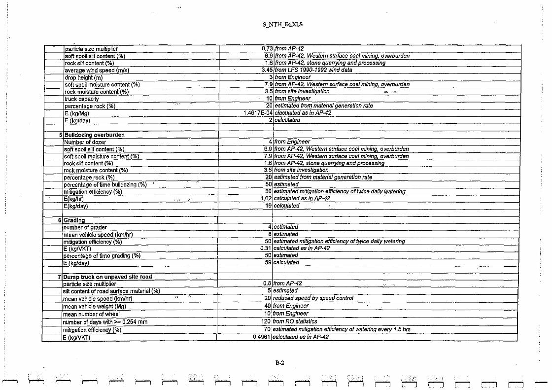
S_NTH_E4.XLS
I particle size multiplier 0.7 3 from AP-42 soft spoil si~ content (%) 6. 9 from AP-42, Westem surface coal mining, overburden rock si~ content (%) 1. 6 from AP-42, stone auarrying and processing average wind speed (m/s) 3.45 from LFS 1990-1992 wind data drop height (m) 3 from Engineer soft spoil moisture content (%) 7.9 from AP-42, Western surface coal mining. overburden rock moisture content (%) 3. 5 from site investigalion .""" <-'"-'-'
truck capacity , 10 from Engineer percentage rock (%) 20 estimated from material generation rate E (kg/Mg) 1.4617E-04 claculated as in AP-42 E (kg/day) 2 calculated
,
5 Bulldozing overburden Nuinber of dozer 4 from Engineer soft spoil silt content (%) 6.9 from AP-42, Westem surface coal mining, overburden soft spoil moisture content (%) 7.9 from AP-42, Westem surface coal minino, overburden rock si~ content (%) 1.6 from AP-42, stone quarrying and processing rock moisture content (%) 3.5 from site investigation percentage rock (%) 20 estimated from material generation rate percentage of time bulldozing (%1 •
.,
50 estimated mitigation efficiency (%) 50 estimated mlligalion effiCiency of twice dally watering E(kg/hr) ~ "
, 1.62 calculated as in AP-42 E(kg/day) 19 calculated
6 Grading number of grader 4 estimated mean vehicle speed (km/hr) 8 eslimated mitigation efficiency (%) 50 estimated mitiaation efficiencv of twice daliV watering E (kgNKT) 0.31 calCUlated as in AP-42 percentage of time grading (%) 50 estimated
E (kg/dayL 59 calculated
7 Dump truck on unpaved site road ,-particle size multiplier 0.8 from AP-42 ., '"
si~ content of road surface material (%) 5 estimated
mean vehicle speed (km/hr) 20 reduced speed by speed control
mean vehicle weight (Mg) 40 from Engineer . mean number of wheel 10 from Engineer
number of days with >- 0.254 mm 120 from RO stalistics
mitigation efficiency (%) 70 estimated mitigation efficiency of watering every 1.5 hrs
E(kgNKT) 0.4961 calculated as in AP-42
B-2
~ ~ 'r-- ',---, '~ 'r-1 r--"1 h ;~ 1'1 1'1 II rl r-··:)'I r----"J ['\ 'r-J r--J :::-1 ;
rj r-

--"l li rJ r--' r-:J c:J c-J c-J r::J c:J c:::J r-:J r ... :-'i r:"·:'··"· [ ( '.' .. ' (" ... ".,. f." r'"'--' '. ~
~_. ::L;:~ L~ ____ ... "': \:..,-"~,, .. ,", L .. __ ~." : 4 .•... _ .. ;--,-'.~-:~-) (;,;t;,_, .. ~ ...... .: c::::J [",_J
, "~,~~3 ~~:=:.~:~jJ r=:J r::J c::::J r' ..... ,\ ""-::-":,":'! ::-:_.,,,
.•• :t ",.-..;.1 '. "~,,,-,
,n n q . , r
5_ NTH _ E4.xLS
Average trip distance - to and fro (km) - 0, 5 estimated
No. of vehicle trip per day 50 o from Engineer
E (kg/day) 12 4 calculated
8 Site erosion sitt content (%) 6, 9 from AP-42, Western surface coal mining, overburden no, of day with >=0,25mm rainfall 12 o from RO statistics precentage time with > 5.4 mls wind speed (%) 14.75 from LFS 1990-1992 wind data percentage active operating area (%) 50 estimated
mitigation efficiency (%) 50 estimated mitigation efficiency of twice daily watering
E (kg/daylhectare) 2.2400 calculated as in AP-42
E (kg/day) 35 calculated
Crushing Plant ..
9 End-tipping from dump truck to crusher I stockpile
particle size multiplier 0,73 from AP-42
rock sitt content (%) 1.6 from AP-42, slone quarrying and processing
average wind speed (m/s) 3.45 from LFS 1990-1992 wind dala drop height (m) . 3 from Engineer rock moisture content (%) 3.5 from site investigation truck capactty 10 from Engineer
E (kg/Mg) 1,6664E-04 claculaled as in AP-42 E (kg/day) 1 calculaled
10 Primary crushing mitigation efficiency (%) 70 estimaled mitigation efficiency of collecting dust through fabric filler
E(kg/Mg) 2.7000E-03 from AP-42 production rate (Mg/day) 7420 from Engineer E (kg/day) 20 calculated
Batchlng Plant 11 Concrete balchlng
mitigation efficiency (%) 70 estimated mitigation efficiency of collecting dust Ihrough fabric filter
E (kg/Mg) 1.5000E-02 from AP-42
production rate (Mg/day) 1141 from Engineer
E (kg/day) 17 calculaled .
Haul Road from Northern Portal to Toll Plaza ..
121Haul truck on unpaved haul road Iparticle size multiplier - 0.8 from AP-42
B-3

It of road surface material (%) mean vehicle seed (kmlhrl mean vehicle wei ht Ml mean number of whe.
,r of dayS with >= 0.254 mm y(%
TE(kgIVKI '"';e-"tri+'p-d"ista=n-c"'-e--""to=--a::-n-:;d-;frC:O-o (km)
I No. of vehicle trip per day
13/Truck mixer on unoaved haul road e size
silt content of road surface material (%) mean vehicle speed (kmlhr mean vehicle weight (Mg: mean number of wheel
" of dayS with >= 0.254 mm '(%J
1[lkgNK -=-e""trt"" -:;d"'ista=nc::-:ec--""'to=-a=n:-:;d"'tr=o"(km)
No. of vehicle trip er day E (kg/day)
Site North 01 14
E
~ rOO
~ active ooeratino area (Ok] 1.1&
""
S_NTH_E4.XLS
cI speecl by speecl control 35 from 10 from
120 fromRO 70 estimatecl mitigation efficiency of
0.4518 calculalecl as in AP-42 3.55 2161from
0.8 from AP-42 estimatecl
2°lfrom 10 from
cI speecl
120 from RO s 70 estimated
0.3054 calculated as in AP-42 3.42 estimated
80 from 83
5( 50,
2.5866E-03 , 221 ,
B-4
j asinAP-4~
~twice
c--"\ 'r-"' '~ r--""\ i""""""'1 ,-, .. ,......., .. ~ f· I r--IM Ii '1'1 i:h
.
~ eve/y 1.5 hrs
a evel)ll.5 hrs
r--llJnri ,
d r-J r-
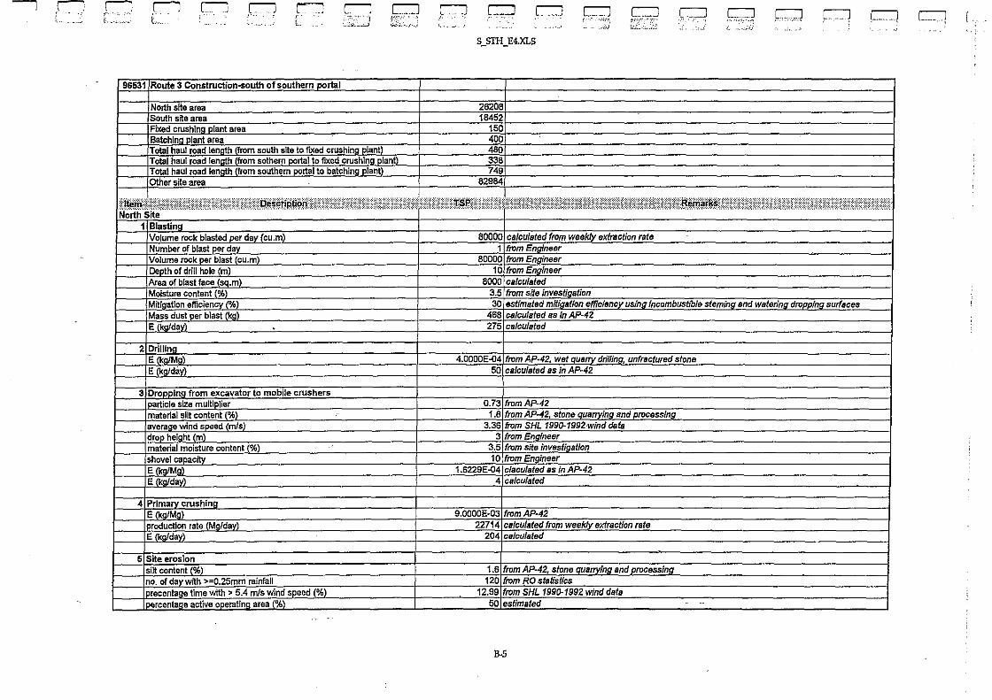
--""1 ,C ri t· ',' ",
C""""'"
[a6531
c--J C c< ...
r-J
ite area !hs~
Fixed crushing Batchlng plant area
c:-J I'··
r"'"J , ' L,
~
L'l :~~:::~.'.J
c:::J C'L:.:.,'.;
r otal haul road length (from south site to fIXed crushing plant' Total haul road length (from sothem portal to fixed crushing plant' Total haul road len h from southern rtal to batchin lant Oth,
~~!;~~~ Volume rock blasted er da cU.m Number of blast per day Volume rock per blast (cu,m) Depth of drill hole (m) ~ea'
'econtent~
-- - ~ ~ass dust per blast (kg)
E Iko/dav)
2 Drillina E (kg/Mg) E Ikafdav)
in9 from excavator to mobile article size multi Iier
material silt conten~ <d (mls)
I drop height (m) material moisture content (%) ihovel capacity
~ Primar EM'
roduction rate E k da
6 Site eros lor silt content % no. of day with ~ raLnfall
-
e active , :. 5.4 m/s wind speed (%)
. 9 area (%)
,rJ c::::J
S_srH_E4'xLS
262C 1845
338 749
82984
r:::J
80000 calculated from from
80000 from
2'
) from
from site, estimated miti
d as
[ __ .1 , . ''';'~I
.-'l
",s,C ?, wet quarry drilling,
d as in AP~42
0.73 from AP-42 1.6 from AP-42, stone
from SHL 199(}-19, from Engl
3.5 from site 10 from E
_4
9,0000E-03 22714
1201 from Ii nSHL
501,
B-5
~ as
'ifrom
c::::::::J t,":""":"--' i;;j: .• :,-~':'i.'
c::::J c::::J -""''--',,,\ k",) r:::::l C"l [,,-Hi
-",-Ii-
d stone
----

S_STH_E4.xLS
mitiaation efficienCY' (%) 50 estimated mitigation efficienCY' of twice dallv waterln!1 E (kQlday/hectare 0.4574 calculated as in AP-42 E (kg/day) 1 all/culsted
South SHe a Blasting
Volume rock blasted per day (cu.m) 80000 ca/culated from weekly extraction fate NUmber of blast per daY 1 from Engineer Volume rock per blast (cu.m) 80000 from Engineer Depth of drill hole (mL 10 from Engineer .
Area of blast face (sq,m 8000 ca/culated Moisture content (%) 3.5 from site investigation Mitiaation efficienCY' (%) ":C ,~-- 30 estimated millC1ation efficiencY us/no incombustible stemifJJl_snd watering dropping surfaces Mass dust per blast kg) 468 calculated as In AP-42 E (kg/day) 193 calculated
7 Drilling E (kQlMg) 4.0000E-04 from AP-44 wet QualTY drilling, unfractured stone E (kg/day) 35 calculated as in AP.42
8 Bulldozing_overburden Number of dozer 2 from Engineer material silt content (%)
. 1.6 from A~42, stone quarrying and processing
material moisture content %) 3.5 from site investiaatlon percentage o!time bulldozing (%) 50 estimated mit/cation efficiencY 1%) 50 estimated mitlaation efficiency of twice daily waterilJg E(kQlhr 0.90 ca/culated as In AP-42 . Elkofdav) 22 calcu/ated
~,
"
9 Load from excavator to haul truck article size multiplier 0.73 (rom Ap·42
material silt contenlL%t 1.6 from AP-42. stone QuafTVina ancf processing average wind speed m/s) 3.36 from SHL 1990-1992 wind data drop heighUm) 3 from EnDineer material moisture content % 3.5 from site investigation shovelcapac!ty 10 from Engineer E (kg/Mg) 1.6229E·04 e/aculated as in AP-42 E (kg/day) 2 calculated
10 Haul truck on unpaved site road I particle size multiplier 0.8 from AP.42 silt content of road surface material (%) 5 estimated mean vehicle speed (krnlhr) 20 reduced speed by speed control mean vehicle weight (Mg) ... ~ , 35 from Engineer mean number of wheel 10 from Engineer number of days with >= 0.254 mm 120 from RO statistics mitigation efficiency (%) 70 estimated mitigation efficiency of watering evelY 1.5 hrs
- ._- --_._- ...
B-6
- 1,--. , ,:,..
F-i r-1 r-1 .,....... r-1 r-1 'r"'"I r-i r--1 r-1 r-1 r-1 r-1 r-1 r-1 l"'l C"--:J i
C" ... i r-

( ( ) , ;(-" . t' t, ___ ".) ,. , .. , .. , r-J ~ C'""l r ' .
<c., •• '. -.
E (kgNKT) Average trip distance - to and fro (km) No. of vehicle trip per day E (kg/day
11 Site erosion silt content (%) no. of day with >=O.2Smm rainfall
I precentage time with> 5.4 m/s wind seed (%) 1 percentage active operating area (%) miti!1ation efficiencY (%) E (kg/day/hectare) E (koldavl
Fixed Crushing Plant 12 End-tipping from haul truck to crusher
article size multiplier rock silt content %l average wind speed m1s) drop heigh!1m material moisture content (%) truck capacity E :kalMol . E (kg/day)
13 Primary crushing mitigation efficiency (%)
E CkoIMal I production rate (Mo/day) E (kg/day)
Batching Plant 14 Concrete batchina
mitigation efficiency (% E (kaiMal roduction rate (Mgfday)
E (kaldavl
Haul Road from South Site to Fixed Crushing Plant 15 Haul truck on unpaved haul road
loarticle size multiplier silt content of road surface material (%) mean vehicle soeed CkmIhr mean vehicle weight (Mg) mean number of wheel number of days with >= 0.254 rnm mitigation efficiency (% E (kaNKn
.r:J ,,::-.. -.:}
r::::J ~i;::~',:,._"J
-
r=J ,c:::J Leu] c:::J c:::=:J C:'-_~~~j
c:::::::J '-.J
c::::::J CJ . ".:~ L.
,:" ",- ",; :,,,~-::~
S_S'fH_E4.xLS
0.451 8 calculated as In Ap·42 0.1 estimated 57 1 from Enaineer 26 calculated
1.6 from AP-42. stone Quarrying and I)fOcessina 12 o from RO statistics
12.9 9 from SHL 1990--1992 wind data 50 estimated 50 estimated mitiaation efficiencY of twice dallv waterin~
0.4574 cslculated as In AP-42 1 calculated
0.73 from AP-42 1.6 from AP-42, stone Quarrvino and Droaessina
3.36 from SHL 199().f992 wind dBtB 3 from Enaineer
3.5 from site investinatlon 10 from Enaineer
I.S229E'()4 claculated as In AP-42 3 calculated
70 estimated mit/oation efficiency of collectina dust fhrouah fabric fllter 2.7000E'()3 fromAP-42
19200 from Encineer 52 calculated
70 estimated mitiaation efficiencY of coJlecUna dust throuah fabric niter 1.5000E-02 from AP-42
3424 from Encineer 51 calculated
0.8 from AP-42 5 estimated
20 reduced speedbYsi'eed control . 35 from Engineer 10 from Enoineer
120 from RO statistics 70 estimated mitigation efficiency of waferina-eVeN 1.5 hrs
0.4518 calculated as in AP-42 - ---------
B-7
r:::J c::::::J l-.- ! I. .,
_ .. _-

Average trip distance - to and fro (km) '. of vehicle trip per day
E k da
Haul Road from Southern Portal to Fixed 1
16 Haul truck on unpaved haul road : particle size multjgl silt content of road surface material (%) mean vehicle speed (kmlhr) mean vehicle we! ht M mean number of wheal
I Plant
S_STH_E4.XLS
-S71Itrom, 248
~2ol reduced speed by speed control 35 10 (rom t;
120 'rom RO ., If days with >= 0.254 mm I mitigation a' 70 estimated mitil . 'l every.t5 hrs ,.. n._I\IKD __ _
I trio distance· to and frOCkm) No. of vehicle trip per day E (kg/day)
0.4518 calculated as in Ap..42 0.68 estim6 240 'rom-.E
7:
I Haul Road from Southern Portal to Batchina Plant Truck mixer on uncaved haul road I particle size multiplier slit content of road surface material (%) mean vehicle speed (kmlhr)
Itrom AP·42
r mean vehicle weloht Mol 2QJ I mean number of wheel ~ ¢ 10
number of days with >= 0.254 mm 12qJ!rom R0..J I'fl\) 701
I other ,
1 E (koNKTI I $I P • to and fro (km) No. of vehicle tri~~
__ .. 1.®. _ e active operating area (%)
~ (kgfday/sCl.m) , (kgJdavl
r::
---1.5C 12C
IE· l'
,
B-8
d as in Ap..42
d control
Y ofwlltering eve,y·'1.5 hrs
"of twice dailv watering
---, ;~ ',...--i .,........, r--; 'r--; 'r--; r--; '1'---1 r--; 'r--; r--1 r--1 ;1"'1 r-i rI ,
r--1 rJ r-1 r-1 r-