selmer i solar final ea - tva content/environment... · selmer north i solar project ii final ......
TRANSCRIPT
Document Type: EA-Administrative Record Index Field: Final EA Project Name: Selmer North I Solar Project Project Number: 2016-15
SELMER NORTH I SOLAR PROJECT
McNairy County, Tennessee
FINAL ENVIRONMENTAL ASSESSMENT
Prepared for: Tennessee Valley Authority
Knoxville, Tennessee
Submitted By:
Silicon Ranch Corporation
Prepared By: HDR, Inc.
October 2016
For Information, contact:
Charles P. Nicholson, PhD NEPA Compliance
Tennessee Valley Authority 400 West Summit Hill Drive, WT 11D
Knoxville, Tennessee 37902-1499 Phone: 865-632-3582
Email: [email protected]

Table of Contents
Final Environmental Assessment i
Table of Contents
1.0 INTRODUCTION ............................................................................................................. 1-1 1.1 PURPOSE AND NEED FOR ACTION ........................................................................ 1-1
1.2 SCOPE OF THIS ENVIRONMENTAL ASSESSMENT ............................................... 1-1
1.3 PUBLIC INVOLVEMENT ............................................................................................. 1-4
1.4 REQUIRED PERMITS AND LICENSES ..................................................................... 1-5
2.0 DESCRIPTION OF THE PROPOSED SOLAR PROJECT AND ALTERNATIVE .......... 2-1 2.1 NO ACTION ALTERNATIVE ....................................................................................... 2-1
2.2 PROPOSED ACTION ALTERNATIVE ........................................................................ 2-1
2.2.1 Project Description ............................................................................................... 2-1
2.2.2 Construction ......................................................................................................... 2-5
2.2.3 Electrical Interconnection ..................................................................................... 2-8
2.2.4 Project Operations .............................................................................................. 2-10
2.2.5 Decommissioning and Reclamation ................................................................... 2-10
2.3 ALTERNATIVES ELIMINATED FROM FURTHER CONSIDERATION .................... 2-10
2.4 COMPARISON OF ALTERNATIVES ........................................................................ 2-11
2.5 THE PREFERRED ALTERNATIVE ........................................................................... 2-14
3.0 AFFECTED ENVIRONMENT AND ENVIRONMENTAL CONSEQUENCES ................. 3-1 3.1 LAND USE ................................................................................................................... 3-1
3.1.1 Affected Environment ........................................................................................... 3-1
3.1.2 Environmental Consequences ............................................................................. 3-2
3.2 GEOLOGY, SOILS, AND PRIME FARMLAND ........................................................... 3-3
3.2.1 Affected Environment ........................................................................................... 3-3
3.2.2 Environmental Consequences ............................................................................. 3-7
3.3 WATER RESOURCES .............................................................................................. 3-10
3.3.1 Affected Environment ......................................................................................... 3-10
3.3.2 Environmental Consequences ........................................................................... 3-14
3.4 BIOLOGICAL RESOURCES ..................................................................................... 3-18
3.4.1 Affected Environment ......................................................................................... 3-19
3.4.2 Environmental Consequences ........................................................................... 3-25
3.5 VISUAL RESOURCES .............................................................................................. 3-28
3.5.1 Affected Environment ......................................................................................... 3-28
3.5.2 Environmental Consequences ........................................................................... 3-33
Selmer North I Solar Project
ii Final Environmental Assessment
3.6 NOISE ....................................................................................................................... 3-37
3.6.1 Affected Environment ......................................................................................... 3-37
3.6.2 Environmental Consequences ........................................................................... 3-38
3.7 AIR QUALITY AND GREENHOUSE GAS EMISSIONS............................................ 3-40
3.7.1 Affected Environment ......................................................................................... 3-40
3.7.2 Environmental Consequences ........................................................................... 3-42
3.8 CULTURAL RESOURCES ........................................................................................ 3-43
3.8.1 Affected Environment ......................................................................................... 3-43
3.8.2 Environmental Consequences ........................................................................... 3-52
3.9 UTILITIES .................................................................................................................. 3-52
3.9.1 Affected Environment ......................................................................................... 3-52
3.9.2 Environmental Consequences ........................................................................... 3-53
3.10 WASTE MANAGEMENT ........................................................................................... 3-54
3.10.1 Affected Environment ......................................................................................... 3-54
3.10.2 Environmental Consequences ........................................................................... 3-54
3.11 PUBLIC AND OCCUPATIONAL HEALTH AND SAFETY ......................................... 3-58
3.11.1 Affected Environment ......................................................................................... 3-58
3.11.2 Environmental Consequences ........................................................................... 3-59
3.12 TRANSPORTATION ................................................................................................. 3-60
3.12.1 Affected Environment ......................................................................................... 3-60
3.12.2 Environmental Consequences ........................................................................... 3-60
3.13 SOCIOECONOMICS ................................................................................................. 3-62
3.13.1 Affected Environment ......................................................................................... 3-62
3.13.2 Environmental Consequences ........................................................................... 3-65
3.14 ENVIRONMENTAL JUSTICE .................................................................................... 3-66
3.14.1 Affected Environment ......................................................................................... 3-66
3.14.2 Environmental Consequences ........................................................................... 3-68
4.0 CUMULATIVE IMPACTS ............................................................................................... 4-1 4.1 FEDERAL PROJECTS ................................................................................................ 4-1
4.2 STATE AND LOCAL PROJECTS ............................................................................... 4-2
5.0 LIST OF PREPARERS ................................................................................................... 5-1
6.0 REFERENCES ................................................................................................................ 6-1
Table of Contents
Final Environmental Assessment iii
List of Tables
Table 2.4-1. Comparisons of impacts by alternative. ............................................................... 2-12 Table 3.2-1. Soils on the project site. ......................................................................................... 3-6 Table 3.2-2. Farming statistics for McNairy County and Tennessee. ........................................ 3-6 Table 3.4-1. Migratory bird species of concern potentially occurring in the vicinity of the project area. ................................................................................................................................................. 3-20 Table 3.4-2. State-listed species potentially occurring in McNairy County, Tennessee. .......... 3-23 Table 3.7-1. Emissions of NAAQS pollutants in McNairy County for 2011. ............................. 3-41 Table 3.7-2. Emissions of GHGs in McNairy County for 2011. ................................................ 3-42 Table 3.8-1. Cultural resources recorded during survey of the direct effects APE. ................. 3-49 Table 3.8-2. Cultural resources recorded during survey of the indirect effects APE. ............. 3-52 Table 3.10-1. Summary of construction waste streams and management methods. .............. 3-57 Table 3.10-2. Summary of operation waste streams and management methods. ................... 3-58 Table 3.13-1. 1990–2030 Population data. .............................................................................. 3-64 Table 3.13-2. 2014 Employment data. .................................................................................... 3-64 Table 3.13-3. 2014 Per capita personal income data. ............................................................ 3-64 Table 3.14-1. 2010 Minority population data. .......................................................................... 3-67 Table 3.14-2. 2014 (Estimated) poverty level data. ................................................................ 3-67
List of Photos
Photo 3.5-1. View from the project site north towards TN 142, residences and Life Tabernacle Church. .................................................................................................................................... 3-29 Photo 3.5-2. View of agricultural fields on project site. ........................................................... 3-30 Photo 3.5-3. Early morning view looking west along Oxford Creek. ....................................... 3-31 Photo 3.5-4. Utility work by TVA located on southern portion of project site. ......................... 3-31 Photo 3.5-5. Life Tabernacle Church located on TN 142 adjacent to the northern boundary of the project site. ............................................................................................................................... 3-32 Photo 3.5-6. The closest residence to the site on TN-142, adjacent to the northern boundary of the project site. ............................................................................................................................... 3-33 Photo 3.5-7. Single-axis, tracking photovoltaic system with panels close to maximum tilt as viewed from the east or west. .............................................................................................................. 3-35 Photo 3.5-8. The back of the solar panels. ............................................................................. 3-36
List of Figures
Figure 1. Site location in McNairy County, Tennessee. ............................................................ 1-2 Figure 2. Aerial photograph showing Selmer I site boundary. .................................................. 2-2 Figure 3. Aerial photograph showing layout of solar facility components. ................................ 2-3 Figure 4. General energy flow diagram of PV solar system. ..................................................... 2-4 Figure 5. Diagram of single-axis tracking system. .................................................................... 2-4
Selmer North I Solar Project
iv Final Environmental Assessment
Figure 6. Location of electrical line connecting to the Pickwick Electric system. ...................... 2-9 Figure 7. Land cover on the solar facility site and adjacent area. ............................................. 3-2 Figure 8. Soils on the project site. ............................................................................................. 3-5 Figure 9. Soils classified as farmland on the project site. ......................................................... 3-7 Figure 10. Aerial photograph showing wetlands and streams. ............................................... 3-12 Figure 11. Topographic map showing wetlands and streams. ................................................ 3-13 Figure 12. Floodplains. ........................................................................................................... 3-14 Figure 13. Sensitive noise receptors in the vicinity of the project site. .................................... 3-38 Figure 14. 2010 US Census tracts in McNairy County. .......................................................... 3-63
Appendix
Consultation Correspondence and Comments on the Draft EA………………………………………A-1
Chapter 1 – Introduction
Final Environmental Assessment 1-1
CHAPTER 1
1.0 INTRODUCTION
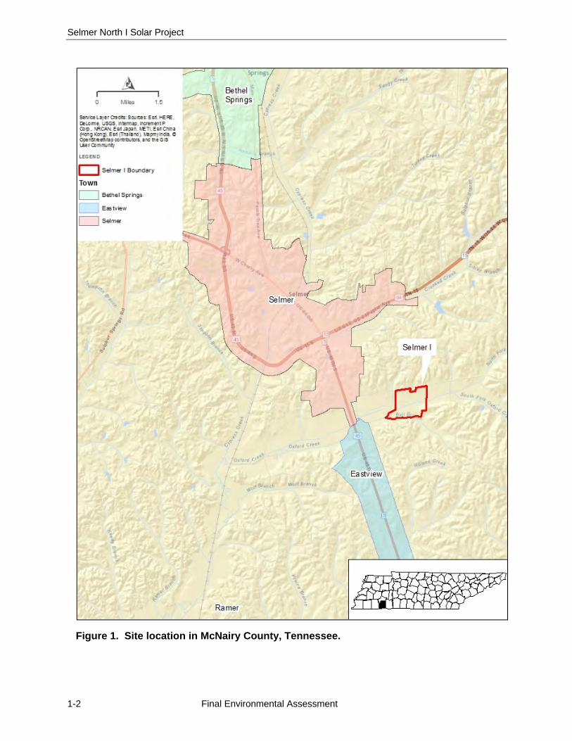
The Tennessee Valley Authority (TVA) proposes to enter into a power purchase agreement (PPA) with Selmer North I, LLC, the facility-specific entity affiliated with Silicon Ranch Corporation (SRC), to purchase the electric power generated by a proposed solar photovoltaic (PV) facility near Selmer, McNairy County, Tennessee. The proposed solar facility is Selmer North I, known as “Selmer I”, which would have direct current (DC) generating capacity of 20 megawatts (MW). The proposed solar facility known herein as the “Project” would be constructed and operated by SRC. The PPA would be executed through TVA’s Renewable Standard Offer (RSO) program, under which TVA agrees to purchase qualifying renewable energy at set prices for a 20-year period.
The proposed Selmer I solar facility would occupy approximately 99 acres of a 231-acre tract owned by SRC, approximately 1 mile southeast of Selmer (Figures 1, 2, and 3). The 231-acre tract is comprised of two parcels (one 13.7-acre parcel and one 217.4-acre parcel) and is known herein as the “project site.” The solar generating facility would consist of multiple parallel rows of PV panels on single-axis tracking structures, DC to alternating current (AC) inverters and transformers. The Selmer I facility would be connected to a distribution line owned/maintained by Pickwick Electric Cooperative (Pickwick Electric), which would transmit power to the TVA network.
1.1 PURPOSE AND NEED FOR ACTION
In its 2011 Integrated Resource Plan (IRP; TVA 2011) TVA established the goal of increasing its renewable energy generating capacity by 1,500 to 2,500 MW by 2020. TVA established the Renewable Standard Offer (RSO) program as one of the means of meeting this goal. Under the RSO program, TVA purchases energy at established terms and conditions (the “standard offer”) from operators of qualifying renewable energy-generating facilities. Qualifying facilities must be new, located within the TVA service area, and must generate electricity from specific technologies or fuels. Solar PV generation is one of the qualifying technologies. SRC and the Project have met the qualifications for the RSO program, and TVA must decide whether to execute the PPA.
TVA’s 2015 IRP (TVA 2015a) recommends the continued expansion of renewable energy generating capacity, including the addition of between 175 and 800 MW (AC) of solar capacity by 2023. The Proposed Action would help meet this need for additional solar capacity.
1.2 SCOPE OF THIS ENVIRONMENTAL ASSESSMENT
Pursuant to the National Environmental Policy Act of 1969 (NEPA) and the Act’s implementing regulations promulgated by the Council on Environmental Quality ([CEQ]; 40 Code of Federal Regulations [CFR] §§ 1500–1508), federal agencies are required to evaluate the potential environmental impacts of their proposed actions. This environmental assessment (EA) was prepared in accordance with NEPA and TVA’s procedures for implementing NEPA (TVA 1983) to assess the potential impacts of TVA’s Proposed Action (the purchase of power under the PPA) and the associated impacts of the construction and operation of the proposed solar facility.
Selmer North I Solar Project
1-2 Final Environmental Assessment
Figure 1. Site location in McNairy County, Tennessee.

Chapter 1 – Introduction
Final Environmental Assessment 1-3
TVA’s Proposed Action would result in the construction and operation of the proposed solar facility by SRC, as well as the construction and operation of the electrical interconnection by Pickwick Electric. The scope of this EA therefore focuses on impacts related to the construction and operation of the proposed solar facility and associated electrical interconnection.
This EA (1) describes the existing environment in the project area, (2) analyzes potential environmental impacts associated with the Proposed Action and the No Action Alternatives, and (3) identifies and characterizes cumulative impacts that could result from the proposed Project in relation to other ongoing or reasonably foreseeable proposed activities within the surrounding area of the project site. The “project area” is the potentially affected areas within and beyond the project site.
Under the PPA, TVA’s obligation to purchase renewable power is contingent upon the satisfactory conclusion of the environmental review and TVA’s determination that the Proposed Action will be “environmentally acceptable.” To determine acceptability, TVA must conclude that no significant impacts to the human environment would result from the location, operation, and/or maintenance of the proposed generating facility and that all project activities would be consistent with all applicable federal, state, and local environmental laws and regulations.
Based on internal scoping, identification of applicable laws, regulations, executive orders, and policies, TVA identified the following resource areas listed below as requiring analysis within this EA: Land Use; Geology, Soils, and Prime Farmland; Water Resources; Biological Resources; Visual Resources; Cultural Resources; Noise; Air Quality and Greenhouse Gases; Cultural Resources; Utilities; Waste Management; Public and Occupational Health and Safety; Transportation; Socioeconomics; and Environmental Justice.
This EA consists of six chapters discussing the Alternatives, resource areas potentially affected, and analyses of impacts. Additionally this document includes an appendix, which contains correspondence about the project. The structure of the EA is outlined below:
Chapter 1: Describes the purpose and need for the Project, the decision to be made, related environmental reviews and consultation requirements, necessary permits or licenses, and the EA overview.
Chapter 2: Describes the Proposed Action and No Action Alternatives, provides a comparison of the Alternatives, and discusses the Preferred Alternative.
Chapter 3: Discusses the affected environment and the potential direct and indirect impacts on these resource areas. Mitigation measures are also proposed, as appropriate.
Chapter 4: Discusses the cumulative impacts in relation to other ongoing or reasonably foreseeable proposed activities within the surrounding area of the project site.
Chapters 5 and 6: Contain the List of Preparers of this EA, and the References cited in preparation of this EA, respectively.
Appendix: Consultation correspondence and comments on the draft EA.

Selmer North I Solar Project
1-4 Final Environmental Assessment
1.3 PUBLIC INVOLVEMENT
A draft of this EA was issued for public review and comment for a 43-day period in July and August 2016. The draft EA was posted on the TVA website and notices of its availability and requests for comments were sent to government agencies, organizations, and individuals who indicated an interest in the Project. TVA also announced its availability and requested comments in a press release and in the local media.
TVA received a total of 11 comment letters and emails on the draft EA; nine were from individuals, one from the Tennessee Department of Environment and Conservation (TDEC) and one from the U.S. Fish and Wildlife Service (USFWS). Eight of the comments from individuals supported the Proposed Action for reasons that included the desirability of increased use of clean, non-polluting energy and the reduced reliance on fossil fuels, the abundant sunshine in the project area, and the local economic benefits. One individual commenter who lives adjacent to the proposed solar facility expressed concerns about their lack of previous awareness of the project and notification by the developer, the effect of the project on the value of their property, the ability of the solar facility to withstand tornadoes and other high winds, and the potential for higher risk of lightning strikes. SRC has subsequently met with this adjacent homeowner to discuss these concerns. The facility would meet applicable building codes and industry standards regarding potential damage from high winds. While solar facilities can be damaged by lightning strikes, there is little evidence that their presence increases the likelihood of nearby areas being struck by lightning.
TDEC stated that they do not anticipate adverse impacts to rare, threatened or endangered plant species. They noted that the endangered Hatchie burrowing crayfish had been collected 2.2 miles from the project site and potentially suitable habitat appeared to occur in the project area. Section 3.4 of this final EA has been revised to provide more information on the potential presence of the Hatchie burrowing crayfish. TDEC noted that the Class III landfill located in McNairy County is not in operation and requested a few edits to Section 3.10.2.2 related to the handling and disposal of wastes. Section 3.10.2.2 of the final EA has been edited in accordance with TDEC’s comments. TDEC recommended that open burning of debris from land clearing be conducted in a manner to encourage good smoke dispersion and in accordance with Tennessee open burning regulatory requirements. SRC and its construction contractor will comply with these measures. TDEC also recommended that Section 3.7.1 on air quality include a table listing the National Ambient Air Quality Standards pollutant emission standards. Because the Proposed Action will emit few air pollutants (Section 3.7.2), TVA believes this additional table would not contribute to understanding the impacts of the Proposed Action. As noted in Section 3.7.1, McNairy County is in compliance with the pollutant emission standards.
In its comments, TDEC also recommended the use of electric-powered lawn equipment due to quieter operation and reduced air emissions instead of traditional gas-operated lawn equipment. SRC has evaluated this and determined it is not feasible at this time due to the large area to be mowed and current limitations on electric-powered lawn equipment. TDEC noted the potential of the facility to provide an emergency source of electricity to serve critical infrastructure in the event of an energy emergency. This is not feasible due to the nature of the facility’s connection to the area electrical grid and the configuration of the grid. TDEC also noted potential stakeholder interest in
Chapter 1 – Introduction
Final Environmental Assessment 1-5
electromagnetic fields generated by PV facilities. Studies conducted to date show the strength of electromagnetic fields generated by PV facility components is very low and comparable to background field strengths at the site boundary.
The USFWS stated in their comments that they do not anticipate adverse impacts on federally listed endangered or threatened species. They noted the potential impacts to aquatic species and the need for stringent erosion control measures. This is addressed in EA Sections 2.2.2 and 3.3. The USFWS recommended that the site be revegetated with native vegetation and that mowing during the wildlife nesting season between April 1 and October 1 be avoided. As stated in Section 2.2.2, the site would be revegetated with native grass. Complete avoidance of mowing between April and October is not feasible as vegetation could grow tall enough to shade the PV panels during this period. SRC would, to the extent feasible, minimize mowing during the peak May and June wildlife nesting season. The USFWS also recommended that SRC not use pesticides, fertilizers, and other chemicals in wetlands or near streams. SRC does not plan to use these chemicals in wetlands or streams. With regards to migratory birds, USFWS noted that birds can collide with or be electrocuted by powerlines, particularly in the vicinity of streams and wetlands. None of the proposed above-ground electrical lines would be in the vicinity of streams or wetlands and, based on TVA experience, there would be minimal potential for bird collision or electrocution.
1.4 REQUIRED PERMITS AND LICENSES
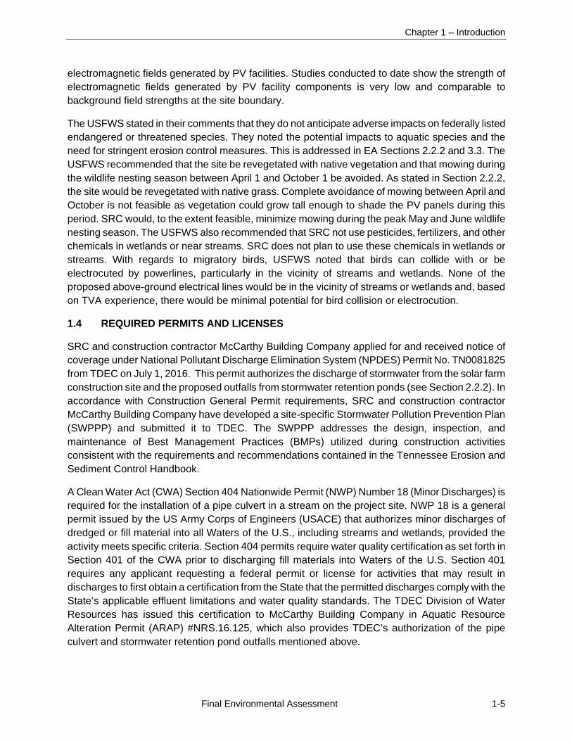
SRC and construction contractor McCarthy Building Company applied for and received notice of coverage under National Pollutant Discharge Elimination System (NPDES) Permit No. TN0081825 from TDEC on July 1, 2016. This permit authorizes the discharge of stormwater from the solar farm construction site and the proposed outfalls from stormwater retention ponds (see Section 2.2.2). In accordance with Construction General Permit requirements, SRC and construction contractor McCarthy Building Company have developed a site-specific Stormwater Pollution Prevention Plan (SWPPP) and submitted it to TDEC. The SWPPP addresses the design, inspection, and maintenance of Best Management Practices (BMPs) utilized during construction activities consistent with the requirements and recommendations contained in the Tennessee Erosion and Sediment Control Handbook.
A Clean Water Act (CWA) Section 404 Nationwide Permit (NWP) Number 18 (Minor Discharges) is required for the installation of a pipe culvert in a stream on the project site. NWP 18 is a general permit issued by the US Army Corps of Engineers (USACE) that authorizes minor discharges of dredged or fill material into all Waters of the U.S., including streams and wetlands, provided the activity meets specific criteria. Section 404 permits require water quality certification as set forth in Section 401 of the CWA prior to discharging fill materials into Waters of the U.S. Section 401 requires any applicant requesting a federal permit or license for activities that may result in discharges to first obtain a certification from the State that the permitted discharges comply with the State’s applicable effluent limitations and water quality standards. The TDEC Division of Water Resources has issued this certification to McCarthy Building Company in Aquatic Resource Alteration Permit (ARAP) #NRS.16.125, which also provides TDEC’s authorization of the pipe culvert and stormwater retention pond outfalls mentioned above.
Chapter 2 – Alternatives
Final Environmental Assessment 2-1
CHAPTER 2
2.0 DESCRIPTION OF THE PROPOSED SOLAR PROJECT AND ALTERNATIVE
This chapter explains the rationale for identifying the alternatives to be evaluated, describes each alternative, provides a comparison of alternatives with respect to their potential environmental impacts, and identifies the preferred alternative.
2.1 NO ACTION ALTERNATIVE
The No Action Alternative provides a baseline of conditions against which the impacts of the Proposed Action Alternative can be measured. Under the No Action Alternative, TVA would not purchase the power generated by the Project under the 20-year PPA with Selmer North I, LLC (i.e., TVA would not be involved with the Project) and the solar facility would not be constructed and operated by SRC. Existing conditions (land use, natural resources, visual resources, and socioeconomics) in the project area would remain unchanged. The property would remain as agricultural land and agricultural activities would likely continue on site. SRC would retain the property for future development. TVA would continue to rely on other sources of generation described in the 2015 IRP (TVA 2015a) to ensure an adequate energy supply and to meet its goals for increased renewable and low-greenhouse gas (GHG) emitting generation.
2.2 PROPOSED ACTION ALTERNATIVE
Under the Proposed Action Alternative, TVA would enter into the 20-year PPA with Selmer North I, LLC and SRC would construct and operate the 20-MW Selmer I single-axis tracking PV solar power facility in McNairy County, Tennessee. The proposed Selmer I facility would occupy approximately 99 acres of land in the northern portion of the site, which is comprised of two currently farmed tracts approximately 1 mile southeast of the town of Selmer. The proposed facility would connect to Pickwick Electric’s Forrest Hills Substation via a distribution line which would be rebuilt. This EA assesses the impact of TVA’s action to enter into the PPA and the associated impact of the construction and operation of the proposed solar facility by SRC and the electrical interconnection by Pickwick Electric.
2.2.1 Project Description
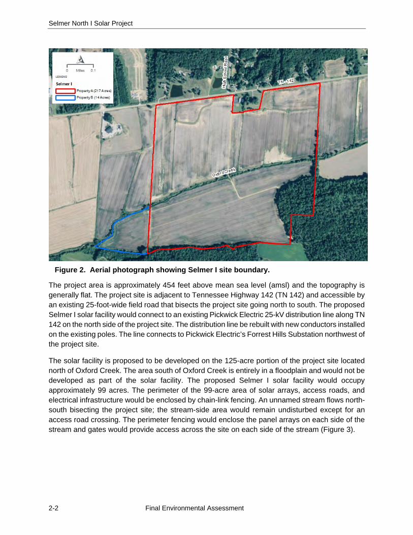
The solar facility would be constructed on a 231-acre, predominantly agricultural tract owned by SRC, approximately 1 mile southeast of Selmer town limits. This tract is comprised of two land parcels of 217.4 acres and 13.7 acres. The 13.7-acre parcel is entirely agricultural and the 217.4-acre parcel is predominantly agricultural with a small portion of undeveloped forest (Figure 2).
Selmer North I Solar Project
2-2 Final Environmental Assessment
Figure 2. Aerial photograph showing Selmer I site boundary.
The project area is approximately 454 feet above mean sea level (amsl) and the topography is generally flat. The project site is adjacent to Tennessee Highway 142 (TN 142) and accessible by an existing 25-foot-wide field road that bisects the project site going north to south. The proposed Selmer I solar facility would connect to an existing Pickwick Electric 25-kV distribution line along TN 142 on the north side of the project site. The distribution line be rebuilt with new conductors installed on the existing poles. The line connects to Pickwick Electric’s Forrest Hills Substation northwest of the project site.
The solar facility is proposed to be developed on the 125-acre portion of the project site located north of Oxford Creek. The area south of Oxford Creek is entirely in a floodplain and would not be developed as part of the solar facility. The proposed Selmer I solar facility would occupy approximately 99 acres. The perimeter of the 99-acre area of solar arrays, access roads, and electrical infrastructure would be enclosed by chain-link fencing. An unnamed stream flows north-south bisecting the project site; the stream-side area would remain undisturbed except for an access road crossing. The perimeter fencing would enclose the panel arrays on each side of the stream and gates would provide access across the site on each side of the stream (Figure 3).
Chapter 2 – Alternatives
Final Environmental Assessment 2-3
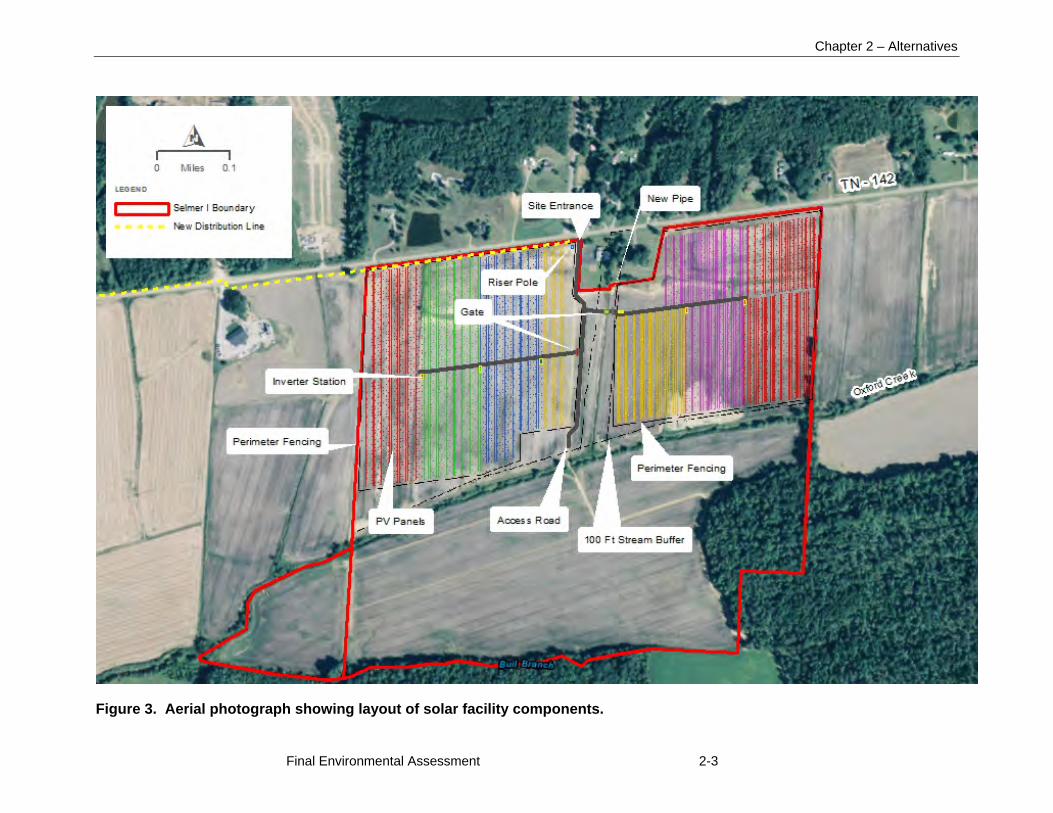
Figure 3. Aerial photograph showing layout of solar facility components.
Selmer North I Solar Project
2-4 Final Environmental Assessment
The remaining 26 acres of the 125-acre portion of the tract north of Oxford Creek and outside of the fenced-in area would be primarily undeveloped. Approximately 3 acres of the 26-acre area would be graded for the 25-foot-wide gravel access road parallel to the unnamed stream, and for temporary sedimentation basins and outfall ditches just north of Oxford Creek. The remaining areas around the basins and along the streams would remain undeveloped.
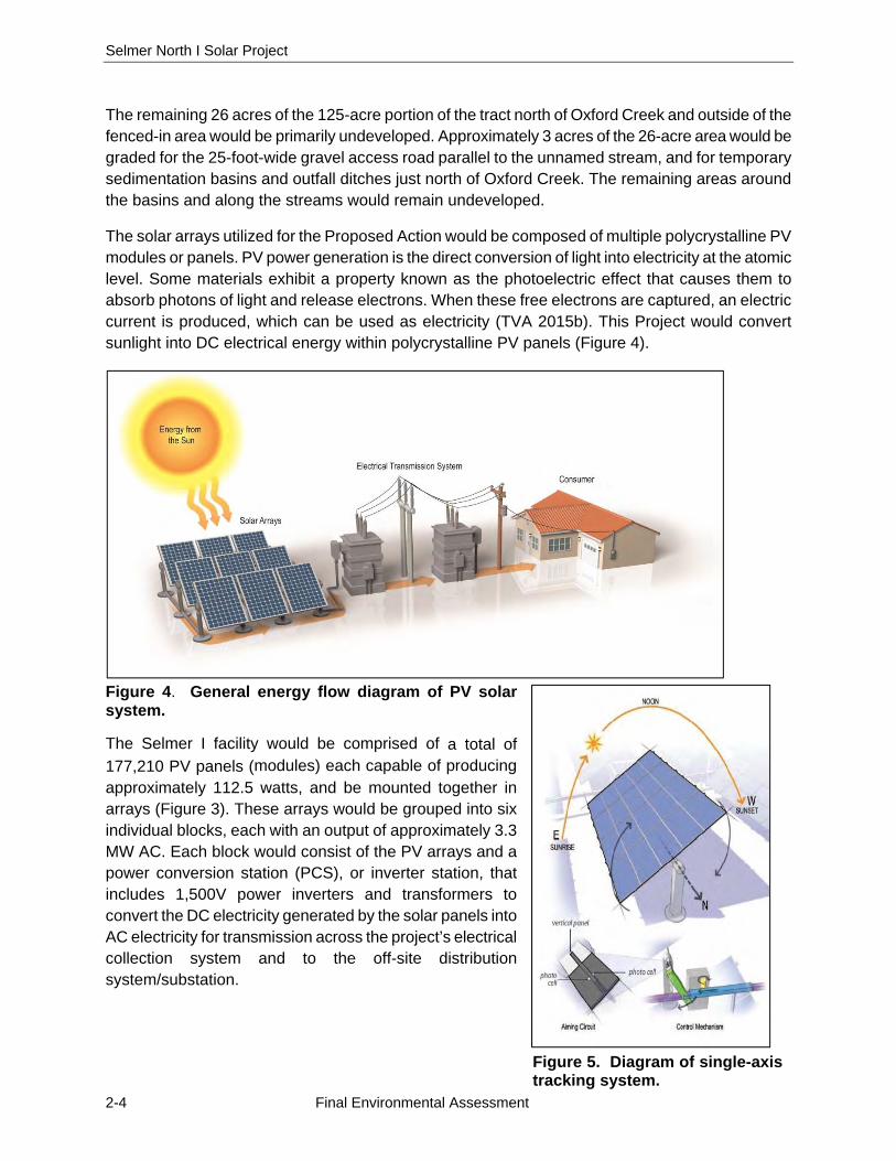
The solar arrays utilized for the Proposed Action would be composed of multiple polycrystalline PV modules or panels. PV power generation is the direct conversion of light into electricity at the atomic level. Some materials exhibit a property known as the photoelectric effect that causes them to absorb photons of light and release electrons. When these free electrons are captured, an electric current is produced, which can be used as electricity (TVA 2015b). This Project would convert sunlight into DC electrical energy within polycrystalline PV panels (Figure 4).
Figure 4. General energy flow diagram of PV solar system.
The Selmer I facility would be comprised of a total of 177,210 PV panels (modules) each capable of producing approximately 112.5 watts, and be mounted together in arrays (Figure 3). These arrays would be grouped into six individual blocks, each with an output of approximately 3.3 MW AC. Each block would consist of the PV arrays and a power conversion station (PCS), or inverter station, that includes 1,500V power inverters and transformers to convert the DC electricity generated by the solar panels into AC electricity for transmission across the project’s electrical collection system and to the off-site distribution system/substation.
Figure 5. Diagram of single-axis tracking system.

Chapter 2 – Alternatives
Final Environmental Assessment 2-5
The PV panels would be mounted on motor-operated axis tracker structures, commonly referred to as single-axis trackers. The axis trackers would be designed pivot the panels along their north-south axes to follow the path of the sun from the east to the west across the sky. The tracker assemblies would be constructed in parallel north-south rows using steel piles installed using either a vibratory pile driver or helical piles with a depth of 6 to 10 feet below grade (Figure 5).
The PV modules would be electrically connected in series (called a “string”) by wire harnesses that conduct DC electricity to combiner boxes. Each combiner box would collect power from several strings of modules and feed a PCS via cables placed in excavated trenches. The trenches would be approximately 3 feet deep and 1 to 4 feet wide. The bottom of each trench would be lined with clean fill to surround the DC cables, and the remainder of the trench would be backfilled with native soil and then appropriately compacted. Aboveground cables would be used to connect the modules to harnesses that lead wiring to combiner boxes.
The AC current from each individual PCS would be transformed into the AC collection voltage, typically 25 kV. The underground voltage collection circuits would deliver AC electricity from the transformers to the project’s on-site pole-mounted riser/switch in the central portion of the site adjacent to TN 142. These circuits would cross the unnamed stream underground by trenching.
The PV panels would be installed in parallel north to south rows and arranged to avoid streams on the project site. The six panel array blocks would each contain approximately 121 to 126 trackers of panels with an output of approximately 3.3 MW AC (Figures 3 and 4). Buried electrical cables would connect the rows of PV panels to 1,500V power inverters. The inverters would be connected by buried cables to six pad-mounted 25 kV transformers, which would connect to the Pickwick Electric Forrest Hills Substation approximately 2.7 miles from the project site via the new distribution line along the northern boundary of the project site. Buried electrical cables would run from each transformer to the point of interconnection adjacent to TN 142 in the north-central portion of the project site. Trenches for buried cables would be backfilled and the ground surface returned to its original grade. Additional details on the electrical interconnection with the Pickwick Electric system are given below in Section 2.2.3.
2.2.2 Construction
Construction of the solar power facility generally requires site preparation (surveying and staking, removal of tall vegetation/small trees, light grading/clearing, installation of a perimeter security fence, installation of sedimentation basins, and preparation of construction laydown areas) prior to solar array assembly and construction, which includes driving steel piles for the tracker support structures, installation of solar panels, and electrical connections and testing/verification.
SRC’s standard practice is to work with the existing landscape (e.g., slope, drainage, utilization of existing roads) where feasible to minimize or eliminate grading work to the extent possible. Any required grading activities would be performed with portable earthmoving equipment and would result in a consistent slope to the local land. Prior to grading, native topsoil would be removed from the area to be graded and stockpiled on site for redistribution over the disturbed area after the grading is completed. Silt fence, sedimentation basins, and other appropriate controls would be used (as needed) to minimize exposure of soil and to prevent eroded soil from leaving the work
Selmer North I Solar Project
2-6 Final Environmental Assessment
area. Disturbed areas would be seeded postconstruction using a mixture of certified weed-free, low-growing native grass seed obtained from a reputable seed dealer and in compliance with the requirements established by the local Natural Resource Conservation Service (NRCS). Erosion control measures would be inspected and maintained until vegetation in the disturbed areas has returned to the preconstruction conditions or the site is stable. Water would be used for soil compaction and dust control during construction.
Grading would consist of the excavation and compaction of earth to meet the final design requirements. Due to the existing topography of the site and the use of single-axis tracking, cut and fill grading activities would be required to achieve the final design and maximum slope criteria. Grading at the site is expected to result in a net zero balanced cut and fill quantity of earthwork to the extent practical and therefore not require any off-site or on-site hauling. Approximately 99 acres of the 231-acre project site would be cleared and graded for construction and placement of the solar panels, gravel access roads, and accompanying electrical components within the fenced-in area. Prior to clearing and grading activities, buffers (100 feet in width) would be established along streams as a conservative avoidance measure, and these areas would be avoided during construction to the extent possible, although minimal work could occur within the buffer zones (Figure 3).
Once sensitive areas are marked, construction areas would be cleared and mowed of vegetation and miscellaneous debris. Mowing would continue as needed to contain growth during construction.
To manage stormwater during construction, on-site sedimentation basins, berms, and ditches would be constructed within the 125-acre area north of Oxford Creek outside of the 99-acre fenced-in area of solar arrays. One of the three sedimentation basins would be located on the west side of the site just north of Oxford Creek and receive runoff from a drainage area of 40.2 acres. A second pond in the south-central portion of the 125-acre portion of the project site west of the proposed access road would have a drainage area of 13.8 acres, and the third pond in the southeastern corner of the 125-acre portion of the project site would have a 44-acre drainage area. The ponds would be constructed either by impoundment of a natural depression(s) or by excavating the existing soil. The floor and embankments of the basins would be allowed to naturally reestablish native vegetation after construction (or replanted as necessary) to provide natural stabilization, minimizing subsequent erosion. The basin would contain an emergency spillway, forebay area, nonporous baffles, and riprap with filter cloth. Water from the basins would be released into adjacent ditches along the perimeter of the site through specially designed outlets or discharge structures (18-inch diameter discharge pipes), which would allow increased flow volume as the water level in the basin increases. The breached basins would remain in place after construction. A 60-inch-diameter high-density polyethylene (HDPE) pipe with concrete headwalls would be installed in the unnamed stream to provide road access between the eastern and western portions of the solar facility while maintaining stream drainage during and after construction.
Construction would be sequenced to minimize the time that bare soil on the disturbed areas is exposed. Silt fence would surround the site perimeter, including the ditches. Other appropriate controls such as temporary cover would be used as needed to minimize exposure of soil and to prevent eroded soil from leaving the work area. Disturbed areas including but not limited to road
Chapter 2 – Alternatives
Final Environmental Assessment 2-7
shoulders, office/laydown areas, ditch areas, and other project-specific locations would be seeded postconstruction. If conditions require, soil would be stabilized by mulch or sprayable fiber mat. If the area seeded is a steep slope (6:1 or greater), hydroseeding may be employed as an alternative. Where hay mulch is required, it would be applied at 3 tons per acre and well-distributed over the area. Erosion control measures would be inspected and maintained until vegetation in the disturbed areas has returned to the preconstruction conditions or the site is stable. The SWPPP for the project area would be finalized with the final grading/civil design prior to construction.
A construction assembly area (laydown area) would be required for worker assembly, vehicle parking, and material storage during construction. This area would be on site for the duration of construction. Temporary construction trailers used for material storage and office space would be parked on site. Following completion of construction activities, all trailers, unused materials, and construction debris would be removed from the site. No operations and maintenance buildings or other permanent structures would be on site.
The design of the tracker support structures could vary depending on the final PV technology and vendor selected. Typical installations of this type are constructed using steel support piles. The driven steel pile foundation is typically galvanized and used where high load bearing capacities are required. The pile is driven with a hydraulic ram. Soil disturbance is restricted to the pile insertion location with temporary disturbance from the hydraulic ram machinery, which is about the size of a small tractor. Screw piles are another option for PV foundations which are driven into the ground with a truck-mounted auger. Screw piles create a similar soil disturbance footprint as driven piles.
Solar panels would be manufactured off-site and shipped to the site ready for installation. If concrete pads are required for the drive motors they would be precast and brought to the site via flatbed truck. Once the majority of the components are placed on their respective foundations and structures, electricians and other workers would run the electrical cabling throughout the solar field.
After the equipment is electrically connected, electrical service would be tested, and motors and their controllers checked. As the solar arrays are installed, the balance of the facility would continue to be constructed and installed and the instrumentation would be installed. Once all of the individual systems have been tested, integrated testing of the Project would occur.
The proposed Project would include a pole-mounted riser switch on site. Electrical system/ interconnection details are provided in Section 2.2.3 below.
The perimeter of the 99-acre solar facility would be securely fenced during construction and for the duration of the Project operation with 7-foot-high chain-link fencing with three strands of barbed wired on the top. One fence would surround the panel arrays and access roads to the west of the stream and one fence would surround the panel arrays and access roads to the east of the stream. Access between the two areas on site would be provided by a double-swing gate and access road across the stream. Construction activities would take approximately 4 to 6 months to complete using a crew that ranges from 100 to 150 workers at the peak of construction. Work would generally occur 7 days a week from 7 am to 6:30 pm. Additional hours could be necessary to make up schedule deficiencies or to complete critical construction activities.
Selmer North I Solar Project
2-8 Final Environmental Assessment
2.2.3 Electrical Interconnection
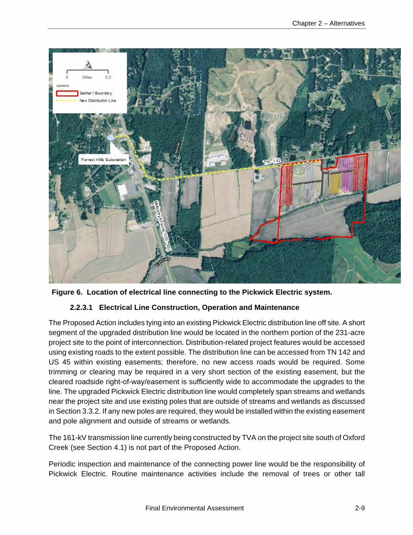
The proposed solar facility would be connected to the Pickwick Electric Forrest Hills Substation approximately 2 miles northwest of the project site via an upgraded Pickwick Electric distribution line along TN 142 and Tennessee Highway 5 (TN 5), commonly known as US Highway 45 (US 45). Pickwick Electric would utilize the existing 2.7-mile long overhead three-phase distribution line (express feeder) supported by wooden poles approximately 45 to 60 feet tall. Existing poles would be maintained and the existing conductors would be replaced to accommodate the additional load from the proposed solar facility. A short section of new poles and new conductors within the existing easement may be installed parallel to the existing line, depending on required electrical load. The upgraded 2.7-mile-long distribution line would run within the existing TN 142 roadway easement on the north side of the project site, continue west to Mulberry Avenue/US 45 and follow along US 45 until it turns west into the Pickwick Electric Forrest Hills Substation (Figure 6). The line would terminate at a spare breaker cubicle at the Forest Hills Substation. The last 0.1-mile section of the line connecting to the substation would be underground due to existing circuit issues at the substation that prevent connection from overhead. The underground section would not cross US 45; it would exit the substation and stop on the west side of US 45 and would then return to overhead and run south. The Forrest Hills Substation is connected to the TVA transmission system and a meter would be installed in the substation to measure the electricity generated by the solar facility.
SRC would install and maintain three-phase transformers at the solar facility that would convert the solar farm output to 25 kV. These would be connected to the on-site point of interconnection. Its exact location would be determined by Pickwick Electric, but would be near the existing church in the northern area of the project site by TN 142, west of the access road that runs south from TN 142. At the point of interconnection, Pickwick Electric would install a 25-kV collection system, including pole-mounted equipment that would hold metering, fused cutout switches and a recloser. The point of interconnection would be outside of the security fencing so it can be accessed without entering the solar facility site. No new distribution lines for the proposed solar facility are expected on site, except the small segment of the Pickwick Electric line at the point of interconnection. Pickwick Electric would obtain the required easement for the new line segment through the project site.
Chapter 2 – Alternatives
Final Environmental Assessment 2-9
Figure 6. Location of electrical line connecting to the Pickwick Electric system.
2.2.3.1 Electrical Line Construction, Operation and Maintenance
The Proposed Action includes tying into an existing Pickwick Electric distribution line off site. A short segment of the upgraded distribution line would be located in the northern portion of the 231-acre project site to the point of interconnection. Distribution-related project features would be accessed using existing roads to the extent possible. The distribution line can be accessed from TN 142 and US 45 within existing easements; therefore, no new access roads would be required. Some trimming or clearing may be required in a very short section of the existing easement, but the cleared roadside right-of-way/easement is sufficiently wide to accommodate the upgrades to the line. The upgraded Pickwick Electric distribution line would completely span streams and wetlands near the project site and use existing poles that are outside of streams and wetlands as discussed in Section 3.3.2. If any new poles are required, they would be installed within the existing easement and pole alignment and outside of streams or wetlands.
The 161-kV transmission line currently being constructed by TVA on the project site south of Oxford Creek (see Section 4.1) is not part of the Proposed Action.
Periodic inspection and maintenance of the connecting power line would be the responsibility of Pickwick Electric. Routine maintenance activities include the removal of trees or other tall
Selmer North I Solar Project
2-10 Final Environmental Assessment
vegetation that could interfere with the operation of the lines by using mechanical cutting or herbicides.
2.2.4 Project Operations
During operation of the solar facility, no major physical disturbance would occur. Moving parts of the solar field would be restricted to the east-to-west facing tracking motion of the solar modules, which amounts to a movement of less than a 1 degree angle every few minutes. This movement is barely perceptible. In the late afternoon, module rotation would start to backtrack west to east in a similar slow motion to minimize shading. At sunset the modules would track to a flat stow position. Otherwise, the PV modules would simply collect solar energy and transmit it to the TVA power grid. With the exception of fence repair, vegetation control, and periodic array inspection, repairs, and maintenance, the facility would require relatively little human activity during operation. No water or sewer service, or permanent lighting would be required on site during operations.
The project site would not be manned during operation; however, inspection and maintenance is required biannually and for equipment failures. Biannual inspections would include identifying any physical damage of panels, wiring, and interconnection equipment and drawing transformer oil samples. Vegetation on the site would be maintained to control growth and prevent overshadowing or shading of the PV panels. Traditional trimming and mowing would be performed on an interval basis (every 2 to 3 months), depending on growth rate to maintain the vegetation. During operations, selective use of spot herbicides may also be employed around structures to control any invasive weed outbreak. Precipitation in this region is adequate to remove dust and other debris from the PV panels while maintaining energy production; therefore manual panel washing is not anticipated unless a specific issue is identified.
The proposed project facility would be monitored remotely to identify any security or operational issues. If a problem is discovered during nonworking hours, a repair crew or law enforcement personnel would be contacted if an immediate response were warranted.
2.2.5 Decommissioning and Reclamation
The Project would operate and sell power under a PPA with TVA for the first 20 years of its life. At the end of the PPA, the Project staff and SRC would assess whether to cease operations at the project site or enter into a new power purchase contract or other arrangement. If TVA or another entity is willing to enter into such an agreement, the Project could continue operating. If no commercial arrangement is possible, then the facility would be decommissioned and dismantled and the site restored. In general, the majority of decommissioned equipment and materials would be recycled. Materials that cannot be recycled would be disposed of at an approved facility.
2.3 ALTERNATIVES ELIMINATED FROM FURTHER CONSIDERATION
In determining the suitability for development of a site within TVA’s service area that would meet the goals of expanding TVA’s renewable energy portfolio as expressed in the IRP, multiple factors were considered to screen potential locations and ultimately eliminate those sites that did not provide the needed attributes. This process of review and refinement ultimately led to the consideration of the current project site.
Chapter 2 – Alternatives
Final Environmental Assessment 2-11
The site screening process consisted of general solar resource screening within TVA’s service area including ensuring the availability of nearby electric infrastructure for interconnection. Additional screening consisted of suitable large-scale landscape features that would allow for utility scale solar development such as:
Generally flat landscape with minimal slope, with preference given to disturbed contiguous land with no on-site infrastructure or existing tall infrastructure in the immediate vicinity;
Land having sound geology for construction suitability, with minimal and/or avoidable floodplains or large forested or wetland areas;
Ability to avoid and/or minimize impacts to known sensitive biological, visual and cultural resources.
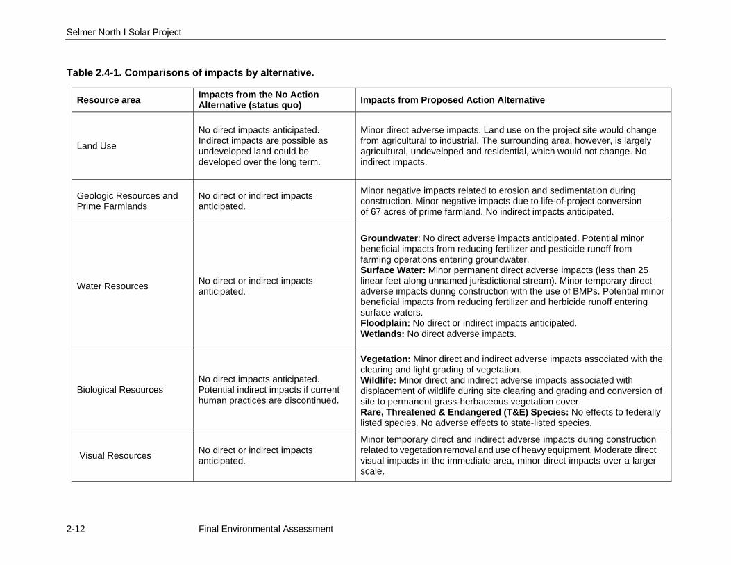
2.4 COMPARISON OF ALTERNATIVES
This EA evaluates the potential environmental effects that could result from implementing the No Action Alternative or the Proposed Action Alternative at the proposed solar site in McNairy County, Tennessee. The analysis of impacts in this EA is based on the current and potential future conditions on the properties and within the surrounding region. A comparison of the impacts of the alternatives is provided in Table 2.4-1.
Selmer North I Solar Project
2-12 Final Environmental Assessment
Table 2.4-1. Comparisons of impacts by alternative.
Resource area Impacts from the No Action Alternative (status quo) Impacts from Proposed Action Alternative
Land Use No direct impacts anticipated. Indirect impacts are possible as undeveloped land could be developed over the long term.
Minor direct adverse impacts. Land use on the project site would change from agricultural to industrial. The surrounding area, however, is largely agricultural, undeveloped and residential, which would not change. No indirect impacts.
Geologic Resources and Prime Farmlands
No direct or indirect impacts anticipated.
Minor negative impacts related to erosion and sedimentation during construction. Minor negative impacts due to life-of-project conversion of 67 acres of prime farmland. No indirect impacts anticipated.
Water Resources No direct or indirect impacts anticipated.
Groundwater: No direct adverse impacts anticipated. Potential minor beneficial impacts from reducing fertilizer and pesticide runoff from farming operations entering groundwater. Surface Water: Minor permanent direct adverse impacts (less than 25 linear feet along unnamed jurisdictional stream). Minor temporary direct adverse impacts during construction with the use of BMPs. Potential minor beneficial impacts from reducing fertilizer and herbicide runoff entering surface waters. Floodplain: No direct or indirect impacts anticipated. Wetlands: No direct adverse impacts.
Biological Resources No direct impacts anticipated. Potential indirect impacts if current human practices are discontinued.
Vegetation: Minor direct and indirect adverse impacts associated with the clearing and light grading of vegetation. Wildlife: Minor direct and indirect adverse impacts associated with displacement of wildlife during site clearing and grading and conversion of site to permanent grass-herbaceous vegetation cover. Rare, Threatened & Endangered (T&E) Species: No effects to federally listed species. No adverse effects to state-listed species.
Visual Resources No direct or indirect impacts anticipated.
Minor temporary direct and indirect adverse impacts during construction related to vegetation removal and use of heavy equipment. Moderate direct visual impacts in the immediate area, minor direct impacts over a larger scale.
Selmer North I Solar Project Chapter 2 – Alternatives
Final Environmental Assessment 2-13
Resource area Impacts from the No Action Alternative (status quo) Impacts from Proposed Action Alternative
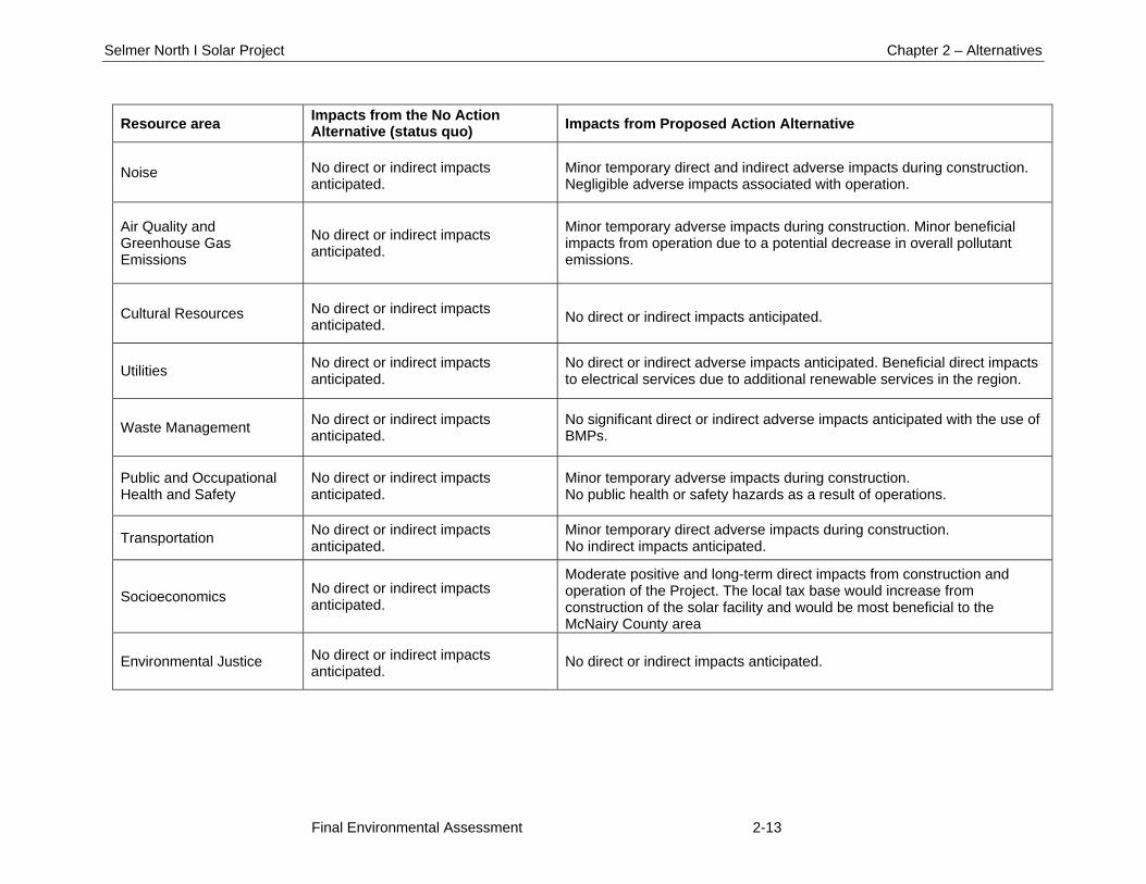
Noise No direct or indirect impacts anticipated.
Minor temporary direct and indirect adverse impacts during construction. Negligible adverse impacts associated with operation.
Air Quality and Greenhouse Gas Emissions
No direct or indirect impacts anticipated.
Minor temporary adverse impacts during construction. Minor beneficial impacts from operation due to a potential decrease in overall pollutant emissions.
Cultural Resources No direct or indirect impacts anticipated. No direct or indirect impacts anticipated.
Utilities No direct or indirect impacts anticipated.
No direct or indirect adverse impacts anticipated. Beneficial direct impacts to electrical services due to additional renewable services in the region.
Waste Management No direct or indirect impacts anticipated.
No significant direct or indirect adverse impacts anticipated with the use of BMPs.
Public and Occupational Health and Safety
No direct or indirect impacts anticipated.
Minor temporary adverse impacts during construction. No public health or safety hazards as a result of operations.
Transportation No direct or indirect impacts anticipated.
Minor temporary direct adverse impacts during construction. No indirect impacts anticipated.
Socioeconomics No direct or indirect impacts anticipated.
Moderate positive and long-term direct impacts from construction and operation of the Project. The local tax base would increase from construction of the solar facility and would be most beneficial to the McNairy County area
Environmental Justice No direct or indirect impacts anticipated. No direct or indirect impacts anticipated.
Selmer North I Solar Project
2-14 Final Environmental Assessment
2.5 THE PREFERRED ALTERNATIVE
The TVA-preferred alternative for fulfilling its purpose and need is the Proposed Action Alternative. Under this alternative, TVA would enter into the PPA with Selmer I North, LLC; SRC would then construct and operate the proposed 20-MW DC single-axis tracking PV solar power facility with the energy generated being sold to TVA under a 20-year PPA. The preferred alternative (Proposed Action Alternative) would produce renewable energy for TVA and its customers with only minor direct and indirect environmental impacts, would have certain environmental benefits, would help meet TVA’s renewable energy goals, and would help TVA meet future energy demands on the TVA system.
Chapter 3 – Affected Environment and Environmental Consequences
Final Environmental Assessment 3-1
CHAPTER 3
3.0 AFFECTED ENVIRONMENT AND ENVIRONMENTAL CONSEQUENCES
This chapter describes the existing environmental, social, and economic conditions of the proposed project and the surrounding areas that might be affected if the No Action or Proposed Action alternative is implemented. This chapter also describes the potential environmental effects that could result from implementing the No Action or Proposed Action alternative.
3.1 LAND USE
This section describes an overview of existing land use at and surrounding the project site and potential impacts to land use associated with the No Action and Proposed Action alternatives. The project site is located in McNairy County, Tennessee approximately 1 mile southeast of Selmer town limits (Figure 1).
3.1.1 Affected Environment
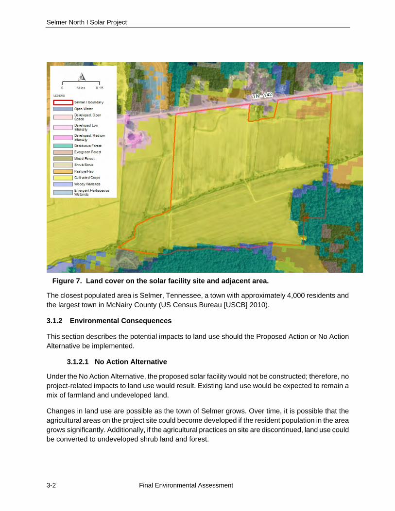
Land use is defined as the way people use and develop land, including leaving land undeveloped or using land for agricultural, residential, commercial, and industrial purposes. Many municipalities develop zoning ordinances and planning documents to control the direction of development and to keep similar land uses together. The project site is in an area with no zoning ordinances or other governmental regulations on development. Areas in McNairy County are advised by the West Tennessee Region Local Planning Assistance Office (Department of Economic and Community Development Local Planning Assistance Office 2011). The closest town that has zoning is the town of Selmer, located approximately 1 mile northwest of the project site. Land use on the project site is not officially governed by a municipality. Images generated with the National Land Cover mapping tool show the project site as agricultural land and forest (Figure 7).
The majority of the project site is agricultural land containing a gravel access road, several drainage channels, and two creeks. The site consists of flat terrain with a few scattered depressions and ranges in elevation from approximately 450 to 490 feet amsl. The majority of the site is comprised of actively farmed fields which were planted in cotton in 2015. Several small stands of shrubs and trees are present across the site, primarily along Oxford Creek which runs east to west across the project site. Topography is highest on the northern section of the project site, dropping down to Oxford Creek, and remaining primarily flat on the southern half of the site. The majority of the southern section of the site is located within a 100-year flood zone. No structures are present on the site.
Properties immediately adjacent to the western border of the site include an agricultural materials storage area. A church and a residence are on the northern central section of the site and bordered on three sides by the project site. Agricultural fields are located to the east and west and forested areas are adjacent to the south of the project site. TN 142 is the northern boundary of most of the site and ten residences with unobstructed views of the project site occur along the north side of TN 142. To the northwest of the site on the north side of TN 142 is a large Mulberry Solar Farm constructed in 2014 by Strata Solar and currently owned and operated by Dominion Resources, Inc.
Selmer North I Solar Project
3-2 Final Environmental Assessment
Figure 7. Land cover on the solar facility site and adjacent area.
The closest populated area is Selmer, Tennessee, a town with approximately 4,000 residents and the largest town in McNairy County (US Census Bureau [USCB] 2010).
3.1.2 Environmental Consequences
This section describes the potential impacts to land use should the Proposed Action or No Action Alternative be implemented.
3.1.2.1 No Action Alternative
Under the No Action Alternative, the proposed solar facility would not be constructed; therefore, no project-related impacts to land use would result. Existing land use would be expected to remain a mix of farmland and undeveloped land.
Changes in land use are possible as the town of Selmer grows. Over time, it is possible that the agricultural areas on the project site could become developed if the resident population in the area grows significantly. Additionally, if the agricultural practices on site are discontinued, land use could be converted to undeveloped shrub land and forest.
Chapter 3 – Affected Environment and Environmental Consequences
Final Environmental Assessment 3-3
3.1.2.2 Proposed Action Alternative
Under the Proposed Action, the construction and operation of the solar facility would change the land use of the 99-acre facility site from agricultural to industrial. This industrial land use would be similar to the area occupied by the Mulberry solar facility a short distance northwest of the project site. The surrounding area is largely agricultural, undeveloped and sparsely residential, which is not likely to change significantly over the next 20 years. As a relatively small portion of a very large land use category in the project vicinity would be lost, this adverse impact would be minor overall. Following decommissioning of the solar farm, a large portion of the site could return to agricultural use. The area of the project site owned by SRC, but not developed as a solar facility, is likely to remain agricultural and undeveloped in the southern portion due to the presence of the 100-year floodplain.
The activities associated with the Proposed Action would not have any indirect effects on land use.
3.2 GEOLOGY, SOILS, AND PRIME FARMLAND
This section describes the existing geological resources in the project area and the potential impacts on these geological resources that would be associated with the No Action and Proposed Action. Components of geological resources that are analyzed include geology, paleontology, geological hazards, soils, and prime farmland.
3.2.1 Affected Environment
3.2.1.1 Geology
The project site is located in McNairy County, Tennessee, in the Gulf Coastal Plain Province. This province extends from the Florida Panhandle to eastern Texas and from Kentucky to the Yucatan Peninsula in Mexico. The Project is in the East Gulf Coastal Plain section. The landscape varies greatly in topography from rolling hills near the Appalachian Mountains to the flat sandy coastal regions near the Gulf of Mexico (LandScope America 2016).
3.2.1.2 Paleontology
Western Tennessee was a shallow, tropical sea during the Cenozoic era. Significant paleontological resources are present in Middle and Eastern Tennessee regions near Nashville. McNairy County in Western Tennessee is part of the Coon Creek Formation which is a geologic formation created from sandy marl deposits in the Late Cretaceous period. The typical fossil finds in McNairy County are Foraminiferan fossils which are small and common shelled protozoa found often in limestone deposits, although few vertebrates and mollusks have also been found (Coon Creek Science Center 2007). It is unknown if fossils are present within the project boundary which has no exposed rock outcrops and deep soils (Section 3.2.1.4).
3.2.1.3 Geological Hazards
Geological hazards can include landslides, volcanoes, earthquakes/seismic activity, and subsidence/sinkholes. Conditions do not exist on the project site for a majority of these types of hazards. The project site is located on relatively stable ground and no significant slopes are present
Selmer North I Solar Project
3-4 Final Environmental Assessment
within several miles of the site; therefore, landslides are not a potential risk. There are no volcanoes within several hundred miles of the project site.
Seismic activity at the site could cause surface faulting, ground motion, ground deformation, and conditions including liquefaction and subsidence. The Modified Mercalli Scale is used within the United States to measure the intensity of an earthquake. The scale arbitrarily quantifies the effects of an earthquake based on the observed effects on people and the natural and built environment. Mercalli intensities are measured on a scale of I through XII, with I denoting the weakest intensity and XII denoting the strongest intensity. The lower degrees of the scale generally deal with the manner in which the earthquake is felt by people. The higher numbers of the scale are based on observed structural damage. This value is translated into a peak ground acceleration (PGA) value to measure the maximum force experienced. The PGA is the maximum acceleration experienced by a building or object at ground level during an earthquake on uniform, firm-rock site conditions. The PGA is measured in terms of percent of “g,” the acceleration due to gravity. The US Geological Survey (USGS) Earthquake Hazards Program publishes seismic hazard map data layers that display the PGA with 10 percent (1 in 500-year event) probability of exceedance in 50 years. The potential ground motion for the proposed project area is 0.20g, for a PGA with a 2 percent probability of exceedance within 50 years (USGS 2008).
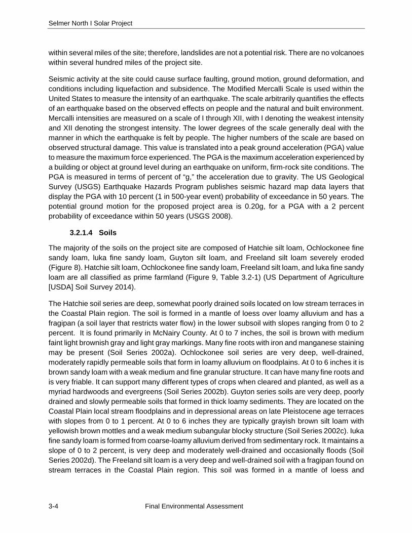
3.2.1.4 Soils
The majority of the soils on the project site are composed of Hatchie silt loam, Ochlockonee fine sandy loam, luka fine sandy loam, Guyton silt loam, and Freeland silt loam severely eroded (Figure 8). Hatchie silt loam, Ochlockonee fine sandy loam, Freeland silt loam, and luka fine sandy loam are all classified as prime farmland (Figure 9, Table 3.2-1) (US Department of Agriculture [USDA] Soil Survey 2014).
The Hatchie soil series are deep, somewhat poorly drained soils located on low stream terraces in the Coastal Plain region. The soil is formed in a mantle of loess over loamy alluvium and has a fragipan (a soil layer that restricts water flow) in the lower subsoil with slopes ranging from 0 to 2 percent. It is found primarily in McNairy County. At 0 to 7 inches, the soil is brown with medium faint light brownish gray and light gray markings. Many fine roots with iron and manganese staining may be present (Soil Series 2002a). Ochlockonee soil series are very deep, well-drained, moderately rapidly permeable soils that form in loamy alluvium on floodplains. At 0 to 6 inches it is brown sandy loam with a weak medium and fine granular structure. It can have many fine roots and is very friable. It can support many different types of crops when cleared and planted, as well as a myriad hardwoods and evergreens (Soil Series 2002b). Guyton series soils are very deep, poorly drained and slowly permeable soils that formed in thick loamy sediments. They are located on the Coastal Plain local stream floodplains and in depressional areas on late Pleistocene age terraces with slopes from 0 to 1 percent. At 0 to 6 inches they are typically grayish brown silt loam with yellowish brown mottles and a weak medium subangular blocky structure (Soil Series 2002c). Iuka fine sandy loam is formed from coarse-loamy alluvium derived from sedimentary rock. It maintains a slope of 0 to 2 percent, is very deep and moderately well-drained and occasionally floods (Soil Series 2002d). The Freeland silt loam is a very deep and well-drained soil with a fragipan found on stream terraces in the Coastal Plain region. This soil was formed in a mantle of loess and
Chapter 3 – Affected Environment and Environmental Consequences
Final Environmental Assessment 3-5
underlying loamy alluvium with slopes ranging from 0 to 12 percent. The first 0 to 13 inches is a brown silt loam with a fine granular structure, fine roots, and is very friable (Soil Series 2002e).
The Guyton silt loam and portions of the Iuka fine sandy loam are considered to be hydric soils. Hydric soils are soils that have been saturated with water or flooded long enough during the growing season to develop anaerobic (low oxygen) conditions. The presence of hydric soils is typically an indicator of a shallow water table, flooding, and/or ponding. The presence of hydric soils is also one of the criteria used in determining the presence of wetlands (see Section 3.3.1.4).
Figure 8. Soils on the project site.
3.2.1.5 Prime Farmland
Prime farmland is land that is the most suitable for economically producing sustained high yields of food, feed, fiber, forage, and oilseed crops. Prime farmlands have the best combination of soil type, growing season, and moisture supply and are available for agricultural use (i.e., not water or urban built-up land).
The Farmland Protection Policy Act ([FPPA]; 7 United States Code [U.S.C.] 4201 et seq.) requires federal agencies to take into account the adverse effects of their actions on prime or unique farmlands. The purpose of the Act is “to minimize the extent to which federal programs contribute to
Selmer North I Solar Project
3-6 Final Environmental Assessment
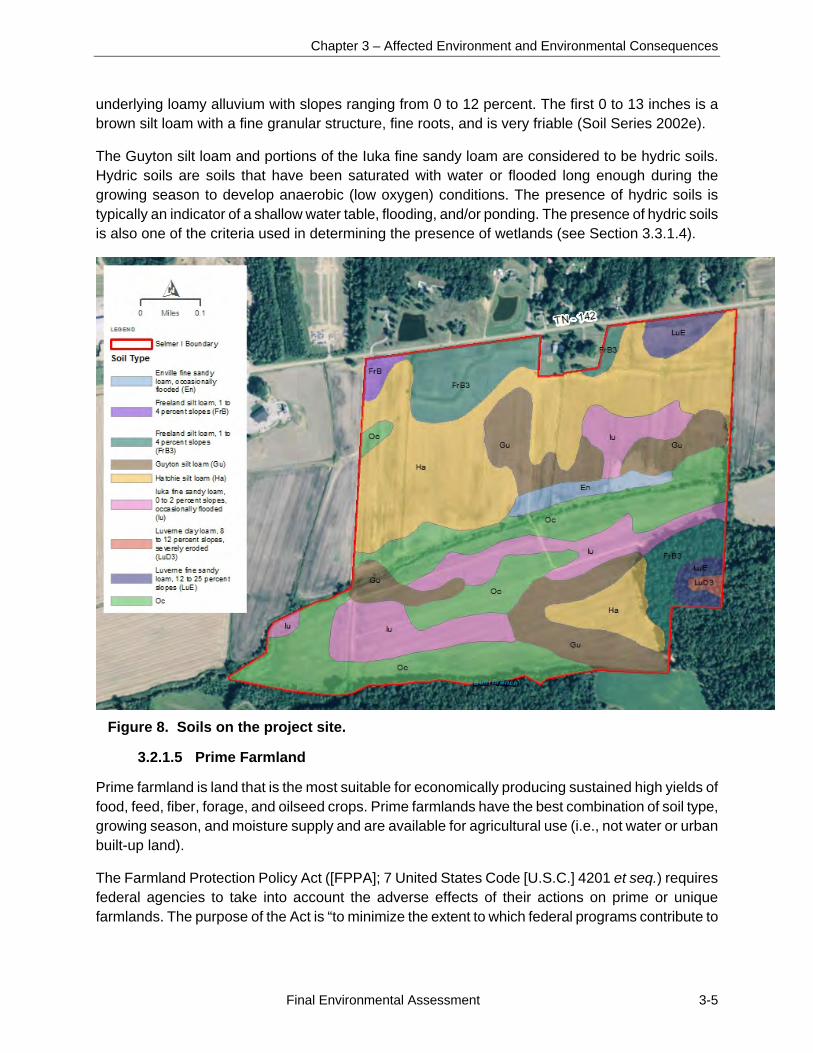
the unnecessary and irreversible conversion of farmland to nonagricultural uses.” The project site contains nine soil types, four of which are considered prime farmland soils (Table 3.2-1, Figure 9).
Based on information from the USDA NRCS, prime farmland soils occur on approximately 162 acres (70 percent) of the 231-acre project site. Within the 99 acres of the facility site, approximately 67 acres (67.6 percent of facility site) are considered to contain prime farmland soils. Table 3.2-2 provides farmland statistics for McNairy County and the state.
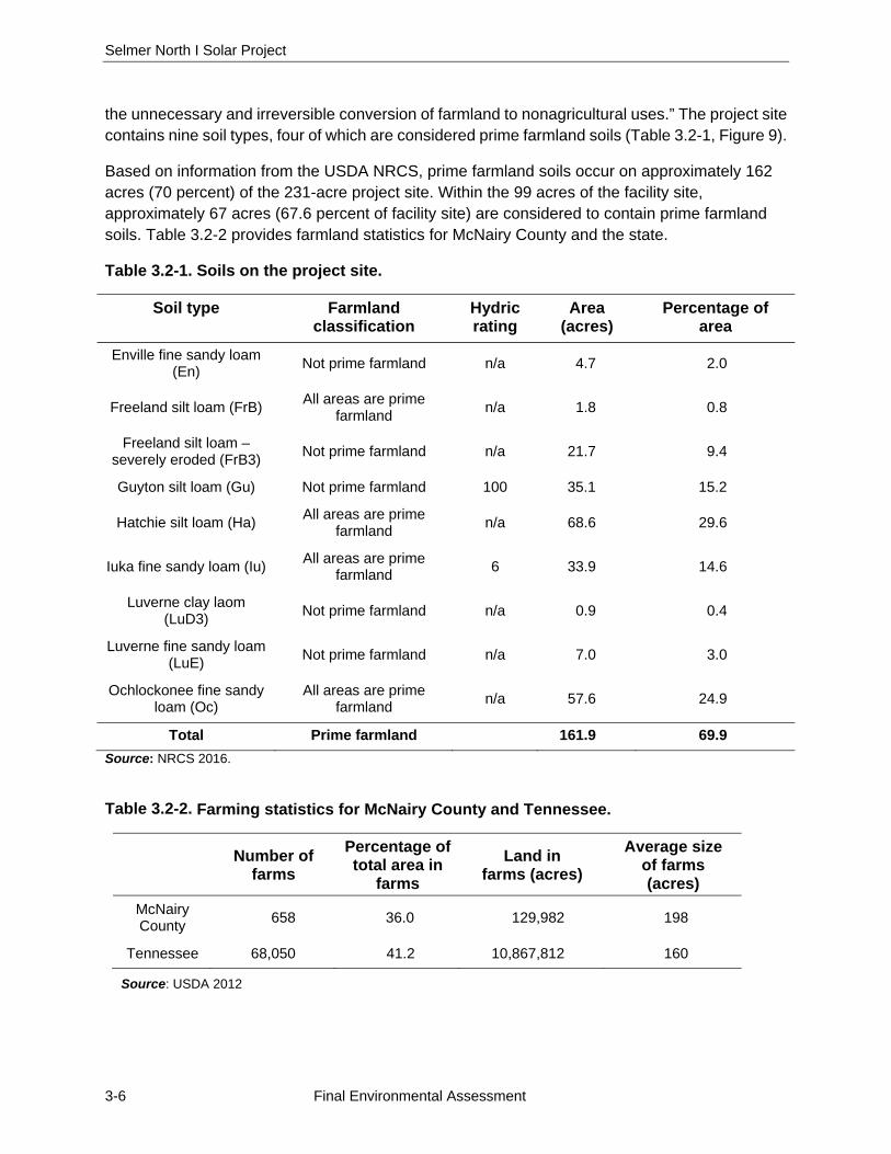
Table 3.2-1. Soils on the project site.
Soil type Farmland classification
Hydric rating
Area (acres)
Percentage of area
Enville fine sandy loam (En)
Not prime farmland n/a 4.7 2.0
Freeland silt loam (FrB) All areas are prime
farmland n/a 1.8 0.8
Freeland silt loam – severely eroded (FrB3)
Not prime farmland n/a 21.7 9.4
Guyton silt loam (Gu) Not prime farmland 100 35.1 15.2
Hatchie silt loam (Ha) All areas are prime
farmland n/a 68.6 29.6
Iuka fine sandy loam (Iu) All areas are prime
farmland 6 33.9 14.6
Luverne clay laom (LuD3)
Not prime farmland n/a 0.9 0.4
Luverne fine sandy loam (LuE)
Not prime farmland n/a 7.0 3.0
Ochlockonee fine sandy loam (Oc)
All areas are prime farmland
n/a 57.6 24.9
Total Prime farmland 161.9 69.9
Source: NRCS 2016.
Table 3.2-2. Farming statistics for McNairy County and Tennessee.
Number of farms
Percentage of total area in
farms
Land in farms (acres)
Average size of farms (acres)
McNairy County
658 36.0 129,982 198
Tennessee 68,050 41.2 10,867,812 160
Source: USDA 2012
Chapter 3 – Affected Environment and Environmental Consequences
Final Environmental Assessment 3-7
Figure 9. Soils classified as farmland on the project site.
3.2.2 Environmental Consequences
This section describes the potential impacts to geologic resources and prime farmlands should the Proposed Action or Action Alternative be implemented.
3.2.2.1 No Action Alternative
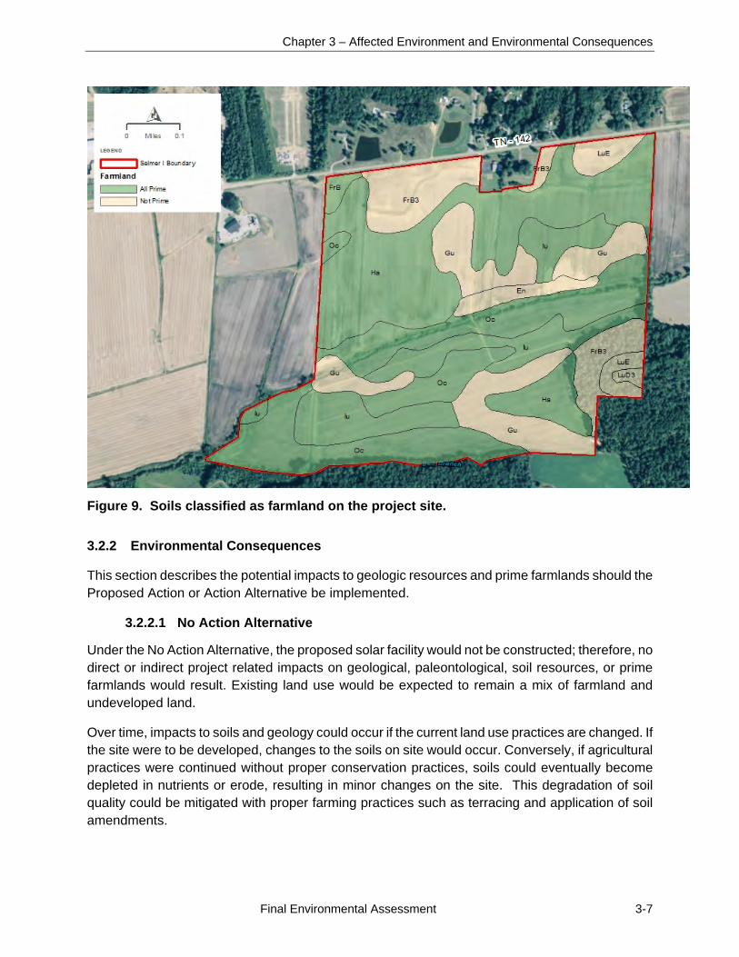
Under the No Action Alternative, the proposed solar facility would not be constructed; therefore, no direct or indirect project related impacts on geological, paleontological, soil resources, or prime farmlands would result. Existing land use would be expected to remain a mix of farmland and undeveloped land.
Over time, impacts to soils and geology could occur if the current land use practices are changed. If the site were to be developed, changes to the soils on site would occur. Conversely, if agricultural practices were continued without proper conservation practices, soils could eventually become depleted in nutrients or erode, resulting in minor changes on the site. This degradation of soil quality could be mitigated with proper farming practices such as terracing and application of soil amendments.
Selmer North I Solar Project
3-8 Final Environmental Assessment
3.2.2.2 Proposed Action Alternative
Under the Proposed Action, minor direct impacts to geology and soil resources would be anticipated as a result of construction and operation of the Project. Approximately 44 percent (102 acres) of land in the project site would be cleared and/or lightly graded for the solar facility with the exception of biologically sensitive areas such as those associated with jurisdictional streams and areas located within flood zones. The site grading and clearing for the solar facility would cause minor impacts to geology and soils including minor, localized increases in erosion and sedimentation.
Geology and Paleontology
Under the Proposed Action, minor impacts to geology and paleontology could occur. No geotechnical evaluation of the project site was completed.
The solar arrays would be supported by steel piles which would either be driven or screwed into the ground to a depth of 6 to 10 feet. On-site sedimentation basins would be shallow and, to the extent feasible, utilize the existing terrain without requiring extensive excavation. The PV panels would be connected with underground wiring placed in trenches about 3 feet deep. Additional minor excavations would be required for the medium voltage transformers associated with each PCS unit. Two or three power pole pads would be required to connect the arrays to the Pickwick Electric system. The poles would require some foundation work below the ground surface. Due to the small sizes of the subsurface disturbances, only minor direct impacts to potential subsurface geological and paleontological resources are anticipated.
As excavation would be limited, only minor direct impacts to geological and paleontological resources would be anticipated. Should paleontological resources be exposed during site construction (i.e., grading and foundation placement) or operation activities, a paleontological expert would be consulted to determine the nature of the paleontological resources, to recover these resources, to analyze the potential for additional impacts, and to develop and implement a recovery plan/mitigation strategy.
Geologic Hazards
Hazards resulting from geological conditions would be minor because the project site is in a relatively stable geologic setting. There is a moderate probability for small to moderate intensity seismic activity and an unknown potential for sinkholes. The facility would be designed to comply with applicable seismic standards. Either seismic activity or sinkholes would likely only cause minor impacts to the project site and equipment on the site. Geologic hazard impacts on the site would be unlikely to impact off-site resources.
Soils
As part of the site preparation and development process, approximately 102 acres of the project site would be developed. The project site could be temporarily affected during mowing and construction activities. Soils located in areas where only vegetation clearing is proposed would remain in place unless a circuit trench or foundation would be constructed.
Chapter 3 – Affected Environment and Environmental Consequences
Final Environmental Assessment 3-9
The layout plan was designed to minimize impacts to on-site streams. Although not anticipated, should borrow material be required, small amounts of sand and gravel aggregate may be obtained either from on-site activities within the 125-acre portion of the project site, or from local, off-site sources. The creation of new impervious surface, in the form of the access roads, panel footings and the foundations for the inverter stations, would result in a minor increase in stormwater runoff and potential increase in soil erosion. Use of BMPs such as soil erosion and sediment control measures would minimize the potential for increased soil erosion and runoff. Due to the Project disturbance area being at least 1 acre, a NPDES Permit for discharges of stormwater associated with construction activities would be required. Application for the permit would require submission of a SWPPP describing the management practices that would be utilized during construction to prevent erosion and runoff to reduce pollutants in stormwater discharges from the site. Following construction, implementation of soil stabilization and vegetation management measures would reduce the potential for erosion impacts during site operations.
During operation of the solar facility, very minor disturbance could occur to soils. Routine maintenance would include periodic motor replacement, inverter air filter replacement, fence repair, vegetation control, and periodic array inspection, repairs and maintenance. The Project may implement traditional mechanized landscaping using lawnmowers, weed eaters, etc. Traditional trimming and mowing would be performed periodically to maintain the vegetation at a height ranging from 6 inches to 2 feet. Selective spot applications of herbicides may be employed around structures to control weeds. Products used would be limited to post-emergent herbicides and would be applied by a professional contractor. These maintenance activities would not result in any adverse impacts to soils on the project site during operations.
Prime Farmland
Should the Proposed Action be implemented, approximately 44 percent (102 acres) of the 231-acre project site would be covered with panels, roads, sedimentation basins and project infrastructure and removed from potential farm use; this would include approximately 69 acres of prime farmland or approximately 43 percent of the total prime farmland soils at the project site.
The construction and operation of the solar facility would remove approximately 69 acres of prime farmland (and 32 acres of other farmland) from potential agricultural use and would result in conversion of the entire 99-acre fenced in area from farmland to a developed solar power facility. Of the remaining 26 acres of the 125-acre portion of the project site, approximately 3 acres north of Oxford Creek would be graded for a gravel access road, sedimentation basins, and ditches with the areas around the basins and the area along the streams remaining undeveloped. Appropriate erosion control measures would be used to control erosion and limit sediment/soil from leaving the project site. Due to the limited amount of grading and excavation on site, the majority of existing soils would remain in-situ. During grading, topsoil would be removed and stockpiled and, as grading is nearing completion, redistributed over the graded areas. None of the soils within the project area are classified as highly erosive or have other characteristics that would require special construction techniques or other nonroutine measures.
Selmer North I Solar Project
3-10 Final Environmental Assessment
Following the expiration of power purchase agreements, the solar facility would be decommissioned as described in Section 2.2.5. Once the facility components are removed and the site is stabilized, farming could resume with little long-term loss of soil fertility and potential agricultural production.
In accordance with FPPA evaluation procedures, a USDA Farmland Conversion Impact Rating Form (Form AD-1006) was completed for the site to quantify the potential impacts to prime farmland. The impact rating considers the acreage of prime farmland to be converted, the relative abundance of prime farmland in the surrounding county, and other criteria such as distance from urban environments, percentage of corridor currently being farmed, and compatibility with existing agricultural use. This form assigns a numerical rating between 0 and 260 based on the area of prime farmland to be disturbed, the total area of farmland in the affected county, and other criteria. Sites with a total score of at least 160 have the potential to adversely affect prime farmland. The impact rating score was 154 points for the project site. Projects with total impact rating scores below the threshold value of 160 do not require further consideration under the FPPA.
Based on the ratings for the project site, the impacts on soils, including prime farmland, from the construction and operation of the solar facility would be insignificant. Following the eventual decommissioning and removal of the solar facility, the site could be returned to agricultural use.
3.3 WATER RESOURCES
This section describes an overview of existing water resources in and surrounding the proposed project area in McNairy County, Tennessee and the potential impacts on these water resources that would be associated with the alternatives. Components of water resources that are analyzed include groundwater, surface water, and wetlands.
3.3.1 Affected Environment
3.3.1.1 Groundwater
Groundwater is water located beneath the ground surface, within soils and rock formations. Aquifers are rock units that have sufficient permeability to conduct groundwater and to allow economically significant quantities of water to be produced by man-made water wells and natural springs. To be productive, the aquifer must be permeable and porous and retain qualities that allow water to flow through it easily. Sandstones, conglomerates, and fractured rocks can often be productive aquifers. The aquifer underlying the project site in McNairy County is the McNairy-Nacatoch aquifer, part of the Mississippi embayment aquifer system in the Coastal Plain Physiographic province. The Mississippi embayment aquifer system is in Alabama, Arkansas, Florida, Illinois, Kentucky, Louisiana, Mississippi, Missouri, and Tennessee (USGS 1995).
Aquifers in the Coastal Plain Physiographic Province consist of unconsolidated to semiconsolidated sediments that range from the Late Cretaceous through late Eocene period. The McNairy-Nacatoch aquifer consists of sediments of Cretaceous age and is generally fine sand. Precipitation falling directly on surface outcrops of the aquifer units provides the primary water recharge for the McNairy-Nacatoch aquifer with a small recharge from upward leaking due to underlying aquifers. Most of this precipitation becomes surface water streams, but some percolates through the soil and runs into cracks and fissures in the bedrock. Groundwater flow in this aquifer system primarily flows
Chapter 3 – Affected Environment and Environmental Consequences
Final Environmental Assessment 3-11
in the general direction of the Mississippi River to the southwest along the axis of the Mississippi Embayment (USGS 1995).
The water quality in the Mississippi embayment aquifer system is generally suitable for most uses. It ranges from soft to moderately hard, calcium bicarbonate near the edges with sodium bicarbonate towards the deeper sections of the aquifer. Iron, fluoride, and sulfate concentrations are low throughout the aquifer system. Dissolved solids are usually less than 250 milligrams per liter for most of the Mississippi embayment aquifer, though deeper sections of the aquifer can see dissolved solid levels spike to over 1,000 milligrams per liter. The project area is in the shallower area of the aquifer and has the lowest concentrations (USGS 1995).
In 1985, fresh groundwater withdrawals from the Mississippi embayment aquifer system in Kentucky and Tennessee were estimated to be 311 million gallons per day (mgd), mostly from Tertiary rocks in Tennessee. The Memphis, Tennessee area is supplied totally by groundwater and accounts for 196 million gallons of withdrawal per day. Public supply, industrial, commercial, and thermoelectric power accounted for more than 90 percent of the groundwater withdrawn from the aquifers in Kentucky and Tennessee, with public supply withdrawals accounting for 65 to 70 percent in Mississippi (USGS 1995).
3.3.1.2 Surface Water
Surface water is any water that flows above ground and includes, but is not limited, to creeks, streams, ditches, ponds, lakes, and wetlands. Surface waters with certain physical and hydrologic characteristics are considered Waters of the US (or jurisdictional waters) and are under the regulatory jurisdiction of the U.S. Army Corps of Engineers (USACE). The CWA is the primary federal statute that governs the discharge of pollutants and fill materials into Waters of the US under Sections 402, 404 and 401. The limits of Waters of the US are defined through a jurisdictional determination accepted by the USACE. TDEC has jurisdiction over water quality in Tennessee.
The proposed project site is located in the Lower Mississippi Watershed. The Lower Mississippi River begins at the junction of the Ohio River and Upper Mississippi River at Cairo, Illinois, and runs to the Gulf of Mexico. No dams are located on the Lower Mississippi River and with a length of nearly 1,000 miles, the Lower Mississippi is the most traveled section of the Mississippi River.
Within the Lower Mississippi Watershed, the project area is located within the Upper Hatchie Region, which primarily occupies Tennessee with parts of Kentucky and Mississippi and runs along the border with Missouri and Arkansas. The Upper Hatchie Watershed is largely made up of large tributaries that feed into the Mississippi River. Within the Upper Hatchie Watershed, there are 71 recognized waterbodies. All 71 waterbodies making up the watershed are rivers, of which 8 are considered to be impaired (USEPA 2012).
The project site contains two on-site perennial waterbodies: Oxford Creek, which flows from east to west through the center of the property and an unnamed stream (Stream 1) flowing north to south through the center of the site into Oxford Creek (Figures 10 and 11). Oxford Creek is a 9-mile-long waterbody that flows from its headwaters approximately 3 miles to the northeast of the project site to Cypress Creek Ditch, approximately 4 miles downstream (west) of the project site. Bull
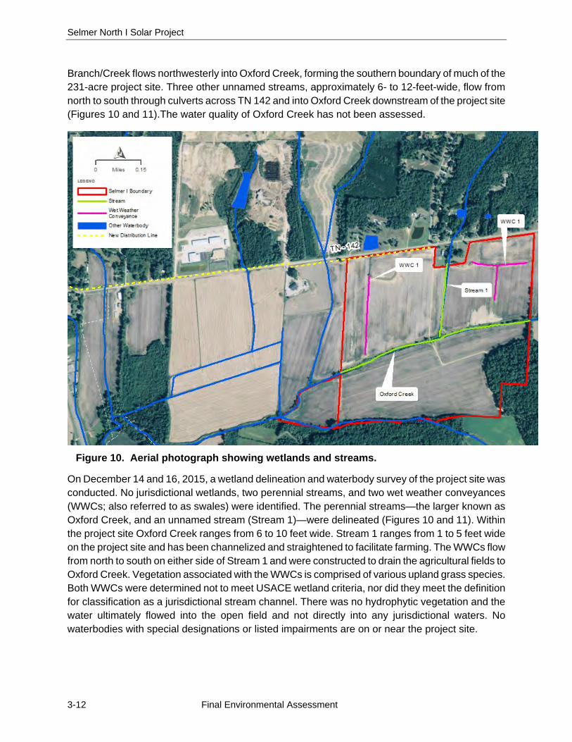
Selmer North I Solar Project
3-12 Final Environmental Assessment
Branch/Creek flows northwesterly into Oxford Creek, forming the southern boundary of much of the 231-acre project site. Three other unnamed streams, approximately 6- to 12-feet-wide, flow from north to south through culverts across TN 142 and into Oxford Creek downstream of the project site (Figures 10 and 11).The water quality of Oxford Creek has not been assessed.
Figure 10. Aerial photograph showing wetlands and streams.
On December 14 and 16, 2015, a wetland delineation and waterbody survey of the project site was conducted. No jurisdictional wetlands, two perennial streams, and two wet weather conveyances (WWCs; also referred to as swales) were identified. The perennial streams—the larger known as Oxford Creek, and an unnamed stream (Stream 1)—were delineated (Figures 10 and 11). Within the project site Oxford Creek ranges from 6 to 10 feet wide. Stream 1 ranges from 1 to 5 feet wide on the project site and has been channelized and straightened to facilitate farming. The WWCs flow from north to south on either side of Stream 1 and were constructed to drain the agricultural fields to Oxford Creek. Vegetation associated with the WWCs is comprised of various upland grass species. Both WWCs were determined not to meet USACE wetland criteria, nor did they meet the definition for classification as a jurisdictional stream channel. There was no hydrophytic vegetation and the water ultimately flowed into the open field and not directly into any jurisdictional waters. No waterbodies with special designations or listed impairments are on or near the project site.
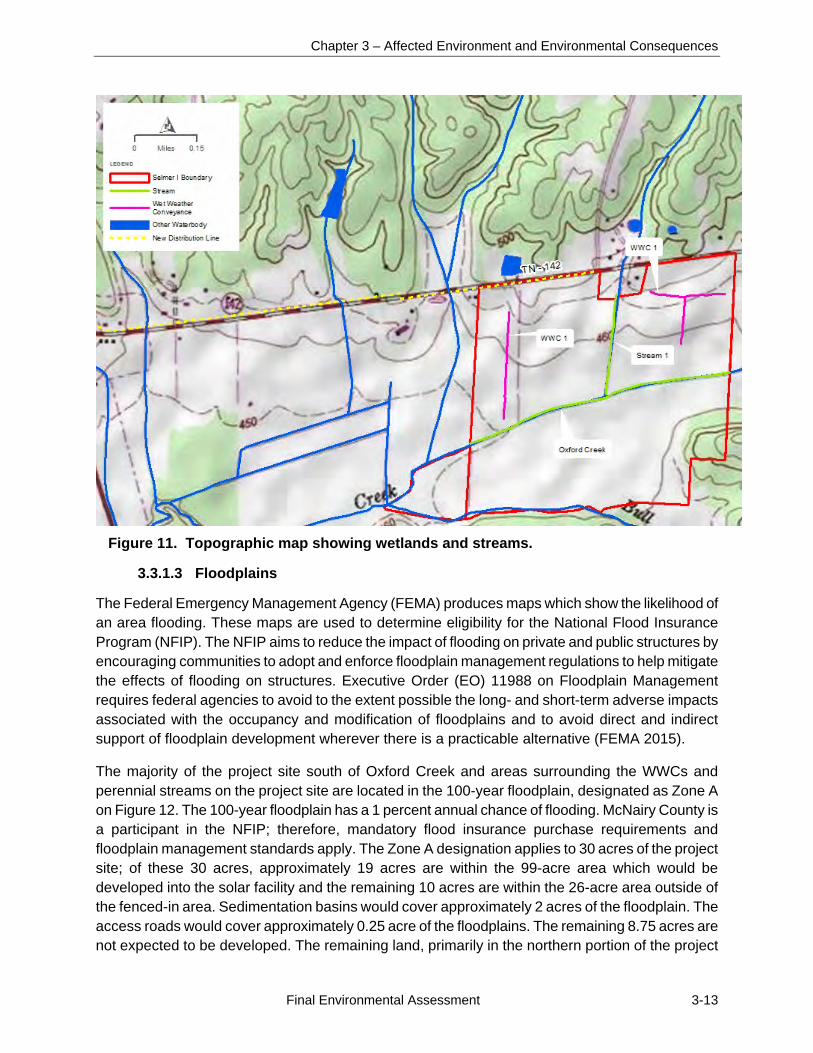
Chapter 3 – Affected Environment and Environmental Consequences
Final Environmental Assessment 3-13
Figure 11. Topographic map showing wetlands and streams.
3.3.1.3 Floodplains
The Federal Emergency Management Agency (FEMA) produces maps which show the likelihood of an area flooding. These maps are used to determine eligibility for the National Flood Insurance Program (NFIP). The NFIP aims to reduce the impact of flooding on private and public structures by encouraging communities to adopt and enforce floodplain management regulations to help mitigate the effects of flooding on structures. Executive Order (EO) 11988 on Floodplain Management requires federal agencies to avoid to the extent possible the long- and short-term adverse impacts associated with the occupancy and modification of floodplains and to avoid direct and indirect support of floodplain development wherever there is a practicable alternative (FEMA 2015).
The majority of the project site south of Oxford Creek and areas surrounding the WWCs and perennial streams on the project site are located in the 100-year floodplain, designated as Zone A on Figure 12. The 100-year floodplain has a 1 percent annual chance of flooding. McNairy County is a participant in the NFIP; therefore, mandatory flood insurance purchase requirements and floodplain management standards apply. The Zone A designation applies to 30 acres of the project site; of these 30 acres, approximately 19 acres are within the 99-acre area which would be developed into the solar facility and the remaining 10 acres are within the 26-acre area outside of the fenced-in area. Sedimentation basins would cover approximately 2 acres of the floodplain. The access roads would cover approximately 0.25 acre of the floodplains. The remaining 8.75 acres are not expected to be developed. The remaining land, primarily in the northern portion of the project
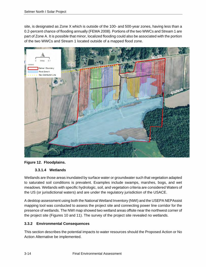
Selmer North I Solar Project
3-14 Final Environmental Assessment
site, is designated as Zone X which is outside of the 100- and 500-year zones, having less than a 0.2-percent chance of flooding annually (FEMA 2008). Portions of the two WWCs and Stream 1 are part of Zone A. It is possible that minor, localized flooding could also be associated with the portion of the two WWCs and Stream 1 located outside of a mapped flood zone.
Figure 12. Floodplains.
3.3.1.4 Wetlands
Wetlands are those areas inundated by surface water or groundwater such that vegetation adapted to saturated soil conditions is prevalent. Examples include swamps, marshes, bogs, and wet meadows. Wetlands with specific hydrologic, soil, and vegetation criteria are considered Waters of the US (or jurisdictional waters) and are under the regulatory jurisdiction of the USACE.
A desktop assessment using both the National Wetland Inventory (NWI) and the USEPA NEPAssist mapping tool was conducted to assess the project site and connecting power line corridor for the presence of wetlands. The NWI map showed two wetland areas offsite near the northwest corner of the project site (Figures 10 and 11). The survey of the project site revealed no wetlands.
3.3.2 Environmental Consequences
This section describes the potential impacts to water resources should the Proposed Action or No Action Alternative be implemented.
Chapter 3 – Affected Environment and Environmental Consequences
Final Environmental Assessment 3-15
3.3.2.1 No Action Alternative
Under the No Action Alternative, the proposed Project would not be constructed; therefore, no project related impacts to water resources would be expected to occur. Existing land use would remain a mix of agricultural and undeveloped, privately-owned land and water resources would remain as they are at the present time. Indirect impacts to water resources could result from the continuing use of the project site as agricultural land. Increases in erosion and sediment runoff could occur if farming practices were not maintained using BMPs. Erosion and sedimentation on site could alter runoff patterns on the project site and impact downstream surface water quality. In addition, if chemical fertilizers and pesticides are continually used, impacts to groundwater may occur if the local aquifers are recharged from surface water runoff.
3.3.2.2 Proposed Action Alternative
Groundwater
No adverse impacts to groundwater would be anticipated as a result of the Proposed Action. Once installed, the solar facility would occupy 99 acres and the total surface area of PV panels would be 34.1 acres of the project site. The elevated, tilted panels would cover roughly 15 percent of the project site; however, they would have relatively little effect on groundwater infiltration and surface water runoff because the panels would not include a runoff collection system. Rainwater would drain off the panels to the adjacent vegetated ground. Hazardous materials that could potentially contaminate groundwater would be stored on site during construction. The use of petroleum fuels, lubricants and hydraulic fluids during construction and by maintenance vehicles would result in the potential for small on-site spills. The use of BMPs to properly maintain vehicles to avoid leaks and spills and procedures to immediately address any spills that did occur, would minimize the potential for adverse impacts to groundwater.
Construction-related Water Needs
No water service is currently available at the proposed project site and no potable water would be available on site after construction. Construction-related water use would support site preparation (including dust control) and grading activities. During earthwork for the grading of access roads, foundations, equipment pads, and other components, the primary use of water would be for compaction and dust control. Smaller quantities would be required for preparation of the equipment pads and other minor uses. Water used during construction would be delivered by truck and would not adversely affect groundwater resources.
Operation and Maintenance-related Water Needs
The primary use of water during operation and maintenance-related activities would be for possible dust control (the proposed PV technology requires no water for the generation of electricity). The internal access roads would not be heavily traveled during normal operations and consequently water use for dust control is not expected.
The precipitation in the area is adequate to minimize the buildup of dust and other matter on the PV panels that would reduce energy production; therefore no regular panel washing is anticipated. The
Selmer North I Solar Project
3-16 Final Environmental Assessment
panels would be cleaned if a specific issue is identified and depending on the frequency of rainfall, proximity of arrays to sources of airborne particulates and other factors. This water would be brought on site in trucks for the specific purpose of panel cleaning and should not impact groundwater resources.
Decommissioning and Site Reclamation-related Water and Wastewater Needs
Because conditions can change during the course of the project life, a final Decommissioning and Closure Plan would be submitted to TVA for review and approval based on conditions as found at the time of facility closure.
The Project would comply with the requirements of the NPDES through preparation and implementation of a SWPPP and filing of a NOI to comply with the General Construction Stormwater NPDES Permit. The plan includes procedures to be followed during construction to prevent erosion and sedimentation, nonstormwater discharges, and contact between stormwater and potentially polluting substances. The NPDES permit was issued by TDEC on July 1, 2016.
Decommissioning and site reclamation would likely be staged in phases, allowing for a minimal amount of disturbance and requiring minimal dust control and water usage. It is anticipated that water usage during decommissioning and site reclamation would not exceed operational water usage.
Due to the lack of groundwater use anticipated for the Project in comparison with the overall withdrawal rate for West Tennessee of 244 Mgal/d (USGS 2000), impacts to the local aquifer and groundwater in general are not anticipated. The use of BMPs and a SWPPP would reduce the possibility of any on-site hazardous materials reaching the groundwater during operations or maintenance. Overall, impacts to groundwater are not anticipated to be significant.
Indirect beneficial impacts to groundwater could occur if panel placement and/or the use of buffer zones leads to fewer pollutants and erosion products entering groundwater. Currently most of the on-site land use is agricultural and undeveloped, which provides for the possibility of fertilizer and pesticide runoff entering groundwater. The construction and operation of the Proposed Action could eliminate the source of these damaging impacts, resulting in a beneficial, though minor, indirect impact to groundwater.
Surface Water
During the facility design process, care was taken to avoid streams. Complete avoidance was not feasible and the construction and operation of the Project would directly affect one stream on the project site. Impacts to Stream 1 would result from the construction of an access road across the stream, which would result in the placement of a new 60-inch-diameter plastic pipe with concrete headwalls at the stream crossing (Figure 3). This would be the subject of the Section 404 and TDEC ARAP permits described in Section 1.4. Stream 1 at the site of the proposed road crossing is approximately 5 feet wide and 2 feet deep. The pipe crossing would be approximately 35 feet long and would result in less than 10 cubic yards of fill in the stream. The existing Pickwick Electric distribution line along TN 142 would be replaced with a new line utilizing the existing poles or

Chapter 3 – Affected Environment and Environmental Consequences
Final Environmental Assessment 3-17
replacement poles in the same alignment as the existing poles and outside of any streams; the new line would completely span streams.
During construction, runoff of sediment and pollutants could reduce surface water quality in Oxford Creek and its onsite Stream 1 and WWC tributaries. The potential impacts to surface water would be minimized through the use of BMPs for controlling soil erosion and runoff, such as the use of a 100-foot buffer zone along Stream 1 and the installation of silt fences and stormwater retention ponds. Additionally, construction of on-site stormwater detention ponds would allow sediments to settle out prior to release from the pond. Therefore, through the use of BMPs and avoidance measures, impacts to surface water during construction would be minor. The operation and maintenance of the solar facility would have little impact on surface water and BMPs would be used during any maintenance activities with the potential to cause runoff of sediment and pollutants. The upgrading of the connecting transmission line would have little potential to affect surface water and BMPs would be implemented as necessary.
As described above for groundwater, minor beneficial, indirect impacts to surface water could result from the change in land use and the reduction in the amount of fertilizer and pesticide runoff to surface water resources, the reduced likelihood of erosion and sedimentation, and the reduction of the disturbance regime on the project site.
Floodplains
A portion of the project site lies within a 100-year floodplain associated with Oxford Creek; however most of the floodplain would be avoided by construction (Figure 12). All development on the project site would take place north of Oxford Creek and no project-related construction would occur in the floodplain south of Oxford Creek.
The proposed solar facility would occupy approximately 19 acres of floodplains associated with Oxford Creek and Stream 1. The Proposed Action was evaluated for floodplain impacts in accordance with the requirements of EO 11988. The project site was selected with the assistance of local economic development and public officials in McNairy County, Tennessee. The site was also prescreened with the assistance of engineers from Pickwick Electric and is in a good location to be a highly visible clean energy demonstration that is in proximity to the local Pickwick Electric offices. The site also offered a feasible electrical interconnection due to the presence of the adjacent 25-kV power line and the nearby substation. It is also one of the only sites in the area where a single parcel offered sufficient flat acreage to host a 20-MW, single-axis tilt solar array with minimal grading required. TVA has reviewed these site selection factors and determined that there is no feasible alternative to siting a portion of the facility in the floodplain.
Vulnerable electrical components located in the floodplain would be raised at least 1 foot above the 100-year floodplain elevation. One requirement of the NFIP is to submit a floodplain development permit (Tennessee Department of Economic & Community Development 2010). SRC has initiated coordination with McNairy County, the town of Selmer, and FEMA and submitted a Conditional Letter of Map Revision (CLOMR-F) application (FEMA form 086-0-26A, FEB 11) to FEMA for the 217-acre parcel of the project site. The results of a floodplain analysis show that drainage patterns should not be sufficiently altered by the installation of solar panels and other facility components to
Selmer North I Solar Project
3-18 Final Environmental Assessment
change the flood classification of the property, especially with the avoidance of jurisdictional streams. Additionally, the amount of potential fill required to grade the site is negligible and should not impact any adjacent properties with respect to flooding frequency or intensity. Although minimal grading and fill would be necessary to construct the Project, no direct or indirect impacts to the floodplain are anticipated under the Proposed Action. Therefore, impacts to floodplains associated with construction and operation of the Proposed Action is not anticipated. The Proposed Action is consistent with the requirements of E.O. 11988 on Floodplain Management.
Wetlands
No wetlands are present on site; therefore, under the Proposed Action, impacts to wetlands would be avoided. The action is consistent with the requirements of E.O. 11990, Protection of Wetlands.
3.4 BIOLOGICAL RESOURCES
This section describes an overview of existing biological resources within the project area and the potential impacts to biological resources that would be associated with the Proposed Action and No Action alternatives. The following components of biological resources are analyzed below: vegetation, wildlife, and rare, threatened, and endangered species.
The Project is located within the Upper Hatchie River watershed. This area lies within the Southeastern Plains Level III Ecoregion and contains five Level IV subecoregions. The Project is located within the Southeastern Plains and Hills subecoregion. The Southeastern Plains are characterized by a mosaic of cropland, pasture, woodland, and oak-hickory-pine forest. The subecoregion contains several north-south trending bands of sand and clay formations. This area contains rolling topography and more relief than the Mississippi Valley floodplains to the west. Streams in this area have generally sandy substrates. The natural vegetation type is oak-hickory forest, transitioning into oak-hickory-pine to the southern portion of the subecoregion near the Project (Griffith et al. 1998). The temperature in the Southeastern Plains during January ranges between 26 and 47 degrees Fahrenheit; during July temperatures range between 67 and 90 degrees Fahrenheit (Griffith 1998). The area experiences an average of 50 inches of precipitation per year (Griffith 1998).
A desktop survey was performed prior to field investigations of the proposed project area. Wildlife, vegetation, and threatened and endangered (T&E) species were researched during the desktop survey and verified through the field investigations in December 2015. Results of desktop investigations and field evaluations are described in this section.
Biological resources are regulated by a number of federal laws. The laws relevant to the Proposed Action include:
The National Environmental Policy Act (42 U.S.C. §§ 4321-4347);
The Endangered Species Act (ESA) (16 U.S.C. §§ 1531-1544);
The Migratory Bird Treaty Act (MBTA) (16 U.S.C. §§ 703-712); and
The Bald and Golden Eagle Protection Act.
Chapter 3 – Affected Environment and Environmental Consequences
Final Environmental Assessment 3-19
Desktop research with the Tennessee Wildlife Resources Agency (TWRA) and the US Fish and Wildlife Service (USFWS) Information for Planning and Conservation (IPaC) was conducted to obtain the current county list and a preliminary list of known occurrences of T&E species in McNairy County. USFWS must be consulted during the planning stages of a project with a federal nexus and the potential to affect T&E species. Depending on the nature of potential impacts to listed species, consultation may be informal or formal. Formal consultation is required if the Proposed Action has the potential to adversely affect listed species or their critical habitat. Based on the findings below, formal consultation would not be required for the Proposed Action.
3.4.1 Affected Environment
The existing biological resources in the project site include vegetation and wildlife, as well as potential for rare, threatened, or endangered species.
3.4.1.1 Vegetation
The southern portion of the Southeastern Plains and Hills subecoregion is typically characterized by oak-hickory-pine forests. These forests are characterized by a broad diversity of trees, including Northern red oak (Quercus rubra), pignut hickory (Carya glabra), white oak (Quercus alba), and mockernut hickory (Carya tomentosa). Vegetation on the project site has been altered from this typical forest community. The project site has been cleared for farming and cotton was grown on the site in 2015.
The predominant species in the project area is Mexican cotton (Gossypium hirsutum) which had been recently harvested leaving only the bare stalks. River birch (Betula nigra) and American sweetgum (Liquidambar styraciflua) were found near Oxford Creek. Other vegetation included blackberry thickets (Rubus sp.) which grew up to 6 feet tall.
3.4.1.2 Wildlife
Oak-hickory forests typically found in the Southeastern Plains and Hills support a variety of mammals, including gray squirrel (Sciurus carolinensis), fox squirrel (Sciurus niger), and eastern chipmunk (Tamias striatus) (USFWS 1995). Other common mammals that may occur within the ecoregion include white-tailed deer (Odocoileus virginianus), eastern cottontail (Sylvilagus floridanus) and raccoons (Procyon lotor). Game birds in the region include the wild turkey (Meleagris gallopavo). Common songbirds are the rose-breasted grosbeak (Pheucticus ludovicianus) during migratory periods, red-eyed vireo (Vireo olivaceous), common yellowthroat (Geothlypis trichas), blue jay (Cyanocitta cristata), and summer tanager (Piranga rubra) (USFS 1995).
Many of these species are likely to be found in the forested areas near the southern boundary of the project site; however, as the majority of the project site is actively farmed, overall species diversity is low and most species that were present during the field visit, such as white-tailed deer and wild turkey are widespread and relatively common in the area.

Selmer North I Solar Project
3-20 Final Environmental Assessment
Migratory Birds
The USFWS IPaC report identified 19 species of migratory birds of concern (i.e., birds of conservation concern, which are species not already federally listed that represent the Service’s highest conservation priorities) that have the potential to occur in the vicinity of the proposed project site. These species are listed in Table 3.4-1. Most of these required forested or extensive brushy or grassland habitats which are not present on the site, which is primarily cultivated cropland. The few that could occur include the American kestrel, dickcissel, and loggerhead shrike. No large bodies of water are present in the project area and therefore it is unlikely that the bald eagle would be found in or around the project site. Other migratory birds not on the USFWS list of species of concern likely present on the site include the blackbirds, eastern meadowlark, field sparrow, savannah sparrow (in winter), and indigo bunting (in summer).
Table 3.4-1. Migratory bird species of concern potentially occurring in the vicinity of the project area.
Species Seasonal occurrence in project area American kestrel (Falco sparverius paulus) Year-round
Bachman’s sparrow (Aimophila aestivalis) Breeding
Bald eagle (Haliaeetus leucocephalus) Year-round
Cerulean warbler (Dendroica cerulea) Breeding
Chuck-will's-widow (Caprimulgus carolinensis) Breeding
Dickcissel (Spiza americana) Breeding
Fox sparrow (Passerella iliaca) Wintering
Kentucky warbler (Oporornis formosus) Breeding
Least bittern (Ixobrychus exilis) Breeding
Loggerhead shrike (Lanius ludovicianus) Year-round
Prairie warbler (Dendroica discolor) Breeding
Prothonotary warbler (Protonotaria citrea) Breeding
Red-headed woodpecker (Melanerpes erythrocephalus) Year-round Rusty blackbird (Euphagus carolinus) Wintering
Sedge wren (Cistothorus platensis) Migrating
Short-eared owl (Asio flammeus) Wintering
Swainson's warbler (Limnothlypis swainsonii) Breeding
Wood thrush (Hylocichla mustelina) Breeding
Worm eating warbler (Helmitheros vermivorum) Breeding
Source: USFWS 2014a.
3.4.1.3 Rare, Threatened, and Endangered Species
Rare, threatened and endangered species are regulated by both the federal and state governments (see Section 3.4 above). Desktop research with the TWRA and USFWS revealed two federally
Chapter 3 – Affected Environment and Environmental Consequences
Final Environmental Assessment 3-21
listed endangered species and one federally listed threatened species in McNairy County, Tennessee. Several more species of plants and animals reported from McNairy County are listed by the State of Tennessee as endangered, threatened, in need of management, or of special concern (Table 3.4-2). It is unlawful to take, capture or kill any of these species (TWRA 2015).
Federally Listed Species
A desktop database search and aerial/street-view photograph review was conducted to identify the types of habitats present on the proposed project site, including habitats that potentially could support listed species. A survey of biological resources on the project site was conducted on December 14 and December 16, 2015. The survey focused on the general characteristics of the land cover, vegetation communities, and wildlife habitats currently present within and adjacent to the site and, in particular, to support a preliminary evaluation of the potential for special status species to occur on the site. This section summarizes the evaluation of those biological resources that potentially may constrain development of the proposed Project.
The federally listed species that were identified as having the potential to occur in the area are the whorled sunflower (Helianthus verticillatus), Indiana bat (Myotis sodalis), and the northern long-eared bat (Myotis septentrionalis). No designated critical habitats are present in the project area (USFWS 2015a).
Indiana bat
The endangered Indiana bat hibernates in caves and mines in winter and migrates to summer habitats in wooded areas. The large winter colonies disperse in spring, and reproductive females form smaller maternity colonies in wooded areas. Males and nonreproductive females roost in trees but typically do not roost in colonies. The range of the Indiana bat extends from the northeast through the east-central United States (USFWS 2015b). The Indiana bat typically forages in partially open forested habitats and forest edges as well as riparian areas along river and lake shorelines (NatureServe Explorer 2016). Suitable summer roosting habitat requires dead, dying, or living trees over 5 inches in diameter with sufficient exfoliating bark; multiple roost sites are generally used. Primary summer roosts are typically behind the bark of large, dead trees, particularly those that are in gaps in the forest canopy or along forest edges so that they receive sufficient sun exposure (USFWS 2015b). Caves which would provide wintering roosts are not present in the project site and the few trees in the developable project area are either too small or do not have exfoliating bark to provide suitable summer roosts. Therefore this species is not expected to occur on the project site.
Northern long-eared bat
The range of the northern long-eared bat includes 39 states across much of the eastern and north-central United States. Its recent listing as federally threatened is based on the impacts from white-nose syndrome on a large proportion of the population, particularly in the northeastern United States. The northern long-eared bat spends the winter hibernating in caves. In summer, it roosts singly or in colonies in live or dead trees over 5 inches in diameter beneath bark, in cavities, or in crevices (USFWS 2015c). It also has been found, though rarely, roosting in barns, sheds, or other structures. The northern long-eared bat forages for flying insects by flying through the understory of
Selmer North I Solar Project
3-22 Final Environmental Assessment
forested hillsides and ridges. Caves which would provide wintering roosts are not present in the project site and trees in the developable project area are either too small or do not have exfoliating bark to provide suitable summer roosts. Therefore this species is not expected to occur on the project site.
Whorled Sunflower
The whorled sunflower is known only in four counties in the United States. It is a 1- to 2-meter-tall perennial, herbaceous sunflower which inhabits remnant wet prairie areas and calcareous barrens, in moist, prairie-like openings in woodlands and along adjacent creeks. The whorled sunflower habitat also includes mature fields or grasslands (UFWS 2015d). None of these habitats occur on the project site.
State Listed Species
State-listed animal species in Tennessee are assigned a legal listing status of state protected. The species in McNairy County that have a state status are shown in Table 3.4-2. These species include only one of the federally listed species discussed above and three birds, two crustaceans, and nine plants. In addition, there are 19 plant and animal species in the county that have a special concern or need of management status.
The project area does not contain suitable habitat for the majority of the state-listed species. The listed terrestrial species that could occur in the habitat types present on the site include one mammal, the southeastern shrew. The project area provides a limited amount of potential suitable habitat for the lark sparrow in the unmowed grassy areas along the edges of the field. Lark sparrow habitat is typically a zeric mix of bare ground, patchy herbaceous cover, and scattered saplings. Project development would occur in areas which have been previously harvested for cotton. Potential suitable habitat for the lark sparrow exists outside the project area.
The Hatchie burrowing crayfish has potential to inhabit the streams on the project site. An unidentified crayfish was spotted at the northernmost section of Stream 1, which flows from north to south and intersects with Oxford Creek. The turbidity of the water and quickness of the crustacean made accurate identification difficult. The Hatchie burrowing crayfish uses saturated or seasonally saturated soils associated with perennial bodies of water, such as in the project area. The species has a small geographic range which includes the project area and is known to occur within a tributary of Cypress Creek, a tributary of the Hatchie River (International Union for Conservation of Nature 2010). The first identified population of the Hatchie burrowing crayfish was found in 1970 in a tributary of Cypress Creek near State Road 57 in McNairy County, 7.3 miles southwest of the project site (Native Fish Lab 1970). Oxford Creek and Stream 1 are both perennial tributaries of Cypress Creek, which is approximately 2.7 miles west of the project site.
In its comments on the draft of this EA, TDEC noted that the Hatchie burrowing crayfish had been collected from the Crooked Creek, a tributary to Cypress Creek upstream of Oxford Creek, as recently as 2009. TDEC also noted that, based on the soils description in EA Section 3.2.1.4, the Guyton and Iuka soils on the solar facility site, portions of which are classified as hydric soils, may provide suitable habitat for the crayfish.
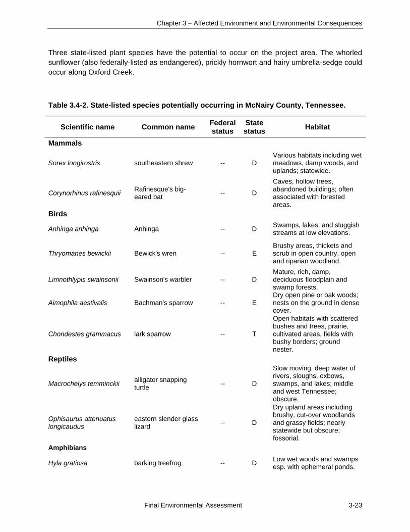
Chapter 3 – Affected Environment and Environmental Consequences
Final Environmental Assessment 3-23
Three state-listed plant species have the potential to occur on the project area. The whorled sunflower (also federally-listed as endangered), prickly hornwort and hairy umbrella-sedge could occur along Oxford Creek.
Table 3.4-2. State-listed species potentially occurring in McNairy County, Tennessee.
Scientific name Common name Federal status
State status
Habitat
Mammals
Sorex longirostris southeastern shrew -- D Various habitats including wet meadows, damp woods, and uplands; statewide.
Corynorhinus rafinesquii Rafinesque's big-eared bat
-- D
Caves, hollow trees, abandoned buildings; often associated with forested areas.
Birds
Anhinga anhinga Anhinga -- D Swamps, lakes, and sluggish streams at low elevations.
Thryomanes bewickii Bewick's wren -- E Brushy areas, thickets and scrub in open country, open and riparian woodland.
Limnothlypis swainsonii Swainson's warbler -- D Mature, rich, damp, deciduous floodplain and swamp forests.
Aimophila aestivalis Bachman's sparrow -- E Dry open pine or oak woods; nests on the ground in dense cover.
Chondestes grammacus lark sparrow -- T
Open habitats with scattered bushes and trees, prairie, cultivated areas, fields with bushy borders; ground nester.
Reptiles
Macrochelys temminckii alligator snapping turtle
-- D
Slow moving, deep water of rivers, sloughs, oxbows, swamps, and lakes; middle and west Tennessee; obscure.
Ophisaurus attenuatus longicaudus
eastern slender glass lizard
-- D
Dry upland areas including brushy, cut-over woodlands and grassy fields; nearly statewide but obscure; fossorial.
Amphibians
Hyla gratiosa barking treefrog -- D Low wet woods and swamps esp. with ephemeral ponds.
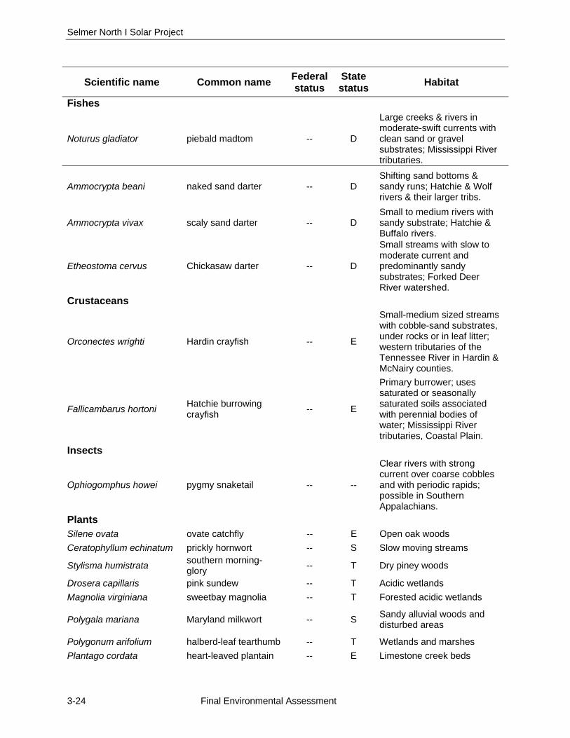
Selmer North I Solar Project
3-24 Final Environmental Assessment
Scientific name Common name Federal status
State status
Habitat
Fishes
Noturus gladiator piebald madtom -- D
Large creeks & rivers in moderate-swift currents with clean sand or gravel substrates; Mississippi River tributaries.
Ammocrypta beani naked sand darter -- D Shifting sand bottoms & sandy runs; Hatchie & Wolf rivers & their larger tribs.
Ammocrypta vivax scaly sand darter -- D Small to medium rivers with sandy substrate; Hatchie & Buffalo rivers.
Etheostoma cervus Chickasaw darter -- D
Small streams with slow to moderate current and predominantly sandy substrates; Forked Deer River watershed.
Crustaceans
Orconectes wrighti Hardin crayfish -- E
Small-medium sized streams with cobble-sand substrates, under rocks or in leaf litter; western tributaries of the Tennessee River in Hardin & McNairy counties.
Fallicambarus hortoni Hatchie burrowing crayfish
-- E
Primary burrower; uses saturated or seasonally saturated soils associated with perennial bodies of water; Mississippi River tributaries, Coastal Plain.
Insects
Ophiogomphus howei pygmy snaketail -- --
Clear rivers with strong current over coarse cobbles and with periodic rapids; possible in Southern Appalachians.
Plants Silene ovata ovate catchfly -- E Open oak woods
Ceratophyllum echinatum prickly hornwort -- S Slow moving streams
Stylisma humistrata southern morning-glory
-- T Dry piney woods
Drosera capillaris pink sundew -- T Acidic wetlands
Magnolia virginiana sweetbay magnolia -- T Forested acidic wetlands
Polygala mariana Maryland milkwort -- S Sandy alluvial woods and disturbed areas
Polygonum arifolium halberd-leaf tearthumb -- T Wetlands and marshes
Plantago cordata heart-leaved plantain -- E Limestone creek beds
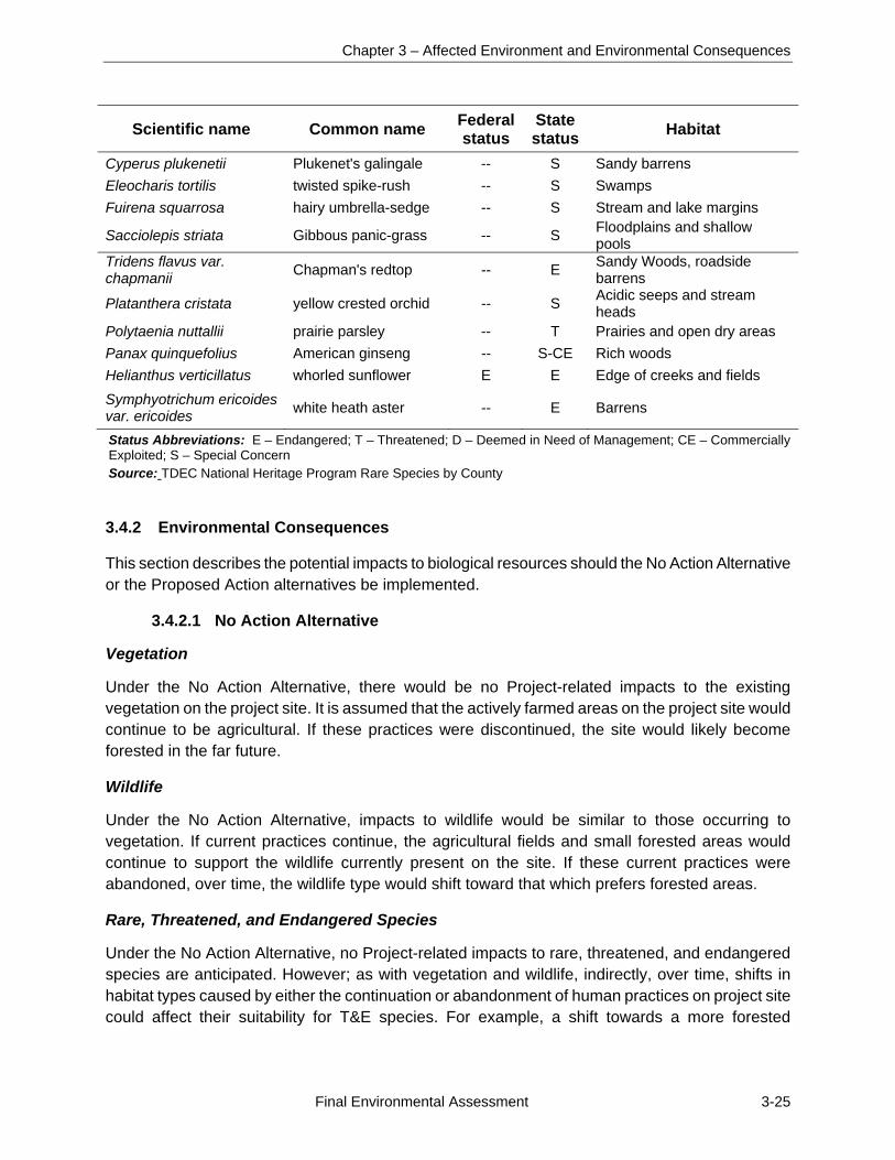
Chapter 3 – Affected Environment and Environmental Consequences
Final Environmental Assessment 3-25
Scientific name Common name Federal status
State status
Habitat
Cyperus plukenetii Plukenet's galingale -- S Sandy barrens
Eleocharis tortilis twisted spike-rush -- S Swamps
Fuirena squarrosa hairy umbrella-sedge -- S Stream and lake margins
Sacciolepis striata Gibbous panic-grass -- S Floodplains and shallow pools
Tridens flavus var. chapmanii
Chapman's redtop -- E Sandy Woods, roadside barrens
Platanthera cristata yellow crested orchid -- S Acidic seeps and stream heads
Polytaenia nuttallii prairie parsley -- T Prairies and open dry areas
Panax quinquefolius American ginseng -- S-CE Rich woods
Helianthus verticillatus whorled sunflower E E Edge of creeks and fields
Symphyotrichum ericoides var. ericoides
white heath aster -- E Barrens
Status Abbreviations: E – Endangered; T – Threatened; D – Deemed in Need of Management; CE – Commercially Exploited; S – Special Concern Source: TDEC National Heritage Program Rare Species by County 3.4.2 Environmental Consequences
This section describes the potential impacts to biological resources should the No Action Alternative or the Proposed Action alternatives be implemented.
3.4.2.1 No Action Alternative
Vegetation
Under the No Action Alternative, there would be no Project-related impacts to the existing vegetation on the project site. It is assumed that the actively farmed areas on the project site would continue to be agricultural. If these practices were discontinued, the site would likely become forested in the far future.
Wildlife
Under the No Action Alternative, impacts to wildlife would be similar to those occurring to vegetation. If current practices continue, the agricultural fields and small forested areas would continue to support the wildlife currently present on the site. If these current practices were abandoned, over time, the wildlife type would shift toward that which prefers forested areas.
Rare, Threatened, and Endangered Species
Under the No Action Alternative, no Project-related impacts to rare, threatened, and endangered species are anticipated. However; as with vegetation and wildlife, indirectly, over time, shifts in habitat types caused by either the continuation or abandonment of human practices on project site could affect their suitability for T&E species. For example, a shift towards a more forested
Selmer North I Solar Project
3-26 Final Environmental Assessment
vegetative cover would make it more habitable for forest-dwelling species, such as bats, but whether these species would be found there in the future is unknown.
3.4.2.2 Proposed Action Alternative
Vegetation
Under the Proposed Action, the proposed solar facility would be constructed on the project site with direct impacts to vegetation. Tall vegetation would be removed from the approximately 99 acres of agricultural land within the fenced-in area for the PV arrays, electrical components, and access roads. Following construction, the graded area within the fencing, as well as areas excavated to install underground wiring and for other purposes, will be seeded with various grasses and the solar farm would be maintained as described in Section 2.2.4 to prevent vegetation from growing taller than about 2 feet. This would result in the long-term conversion of most of the project site from seasonal row crops to a mix of grass and herbaceous vegetation. This vegetation would provide foraging habitat for animals such as the eastern cottontail.
Direct impacts to forested areas would be minimal under the Proposed Action as the trees along Oxford Creek would be maintained within the 100-foot streamside buffer. No trees outside the buffer area would be cleared.
Taking into consideration the large amount of similar habitats in the area regionally and locally, the clearing and light grading of the existing vegetation of either site would be considered a minor impact. Most of the project site is agricultural and used for growing annual crops. The surrounding area consists of very similar vegetative habitats and the effects of the conversion of 99 acres of early successional vegetation in this context would be relatively small.
Indirect impacts are possible if the existing vegetation is part of a larger system which relies on these particular plant communities for regional propagation and genetic diversity. Due to the large amount of similar habitat and plant communities surrounding the project area this impact is unlikely or at least would be very minor. Overall, although much of the existing vegetation on the two properties would be destroyed and converted to a new type of community, it would only constitute a minor impact due to the prevalence of similar habitats and ecosystems in the surrounding region.
Wildlife
Direct impacts to wildlife are also anticipated under the Proposed Action. Much of the wildlife living on the project site in areas which would be mowed and graded and converted to solar arrays would be displaced by construction activities. Following the completion of construction and site revegetation, some species adapted to grass and herbaceous fields such as field mice, common yellowthroat, and red-winged blackbird would likely reoccupy parts of the site. Minor shifts in species composition may occur due to the presence of the PV arrays, change in disturbance regime, and shift to periodically mowed grass and herbaceous fields.
Overall, direct impacts to wildlife would be long-term and adverse but, given the prevalence of the affected habitat types in the project area, insignificant to regional populations.
Chapter 3 – Affected Environment and Environmental Consequences
Final Environmental Assessment 3-27
Rare, Threatened and Endangered Species
Under the Proposed Action, no effects to threatened or endangered species are anticipated. Although suitable habitat for the northern long-eared bat, Indiana bat, and whorled sunflower were identified on areas adjacent to the project site, no protected species were identified on the project site during field surveys. Other listed species are not known or likely to occur on the property.
The project site is almost entirely agricultural land; no known caves are on or in the vicinity of the site for use in winter. No dead, dying, or living trees over 5 inches in diameter with sufficient exfoliating bark are located within the area of the proposed solar facility and along the connecting power line route. A few large trees occur in small wooded tracts along Oxford Creek, but there are no large tracts of forest or riparian areas to provide suitable foraging or roosting areas for the Indiana bat or northern long-eared bat. The trees along Oxford Creek are within the area that would be maintained as a buffer and would not be disturbed. No suitable foraging or roosting habitat would be affected by the construction and operation of the proposed solar facility and electrical interconnection.
The project site is regularly cleared/plowed for agricultural purposes; therefore, it is unlikely that the whorled sunflower would be present on the site. If present, they would likely be located near the perennial creeks. The proposed Project would not impact potential habitat, there are no records of recent observations of the species within the proposed project site, and no individuals were observed during the survey. The closest known population is approximately 5½ miles to the southwest of the project site (Federal Register 2014). Therefore, the Proposed Action would have no effect on this species.
Due to the connectivity of Cypress Creek to the streams in the project site and the estimated species extent, the Hatchie burrowing crayfish may occur in the project area. Very little is known about the Hatchie burrowing crayfish, including its population, migration capabilities, or lifespan. The hydric Guyton and Iuka soils on the solar farm site (Figure 8) may provide suitable habitat for this crayfish. These two soils occur on about 24 acres of the approximately 102 acres north of Oxford Creek that would be occupied by the solar facility, access roads, and sediment ponds. An undisturbed buffer would be maintained along Oxford Creek and the north-south flowing Stream 1 that bisects the site. This buffer area includes about 2 acres of Guyton silt loam. The remaining approximately 21 acres of Guyton and Iuka soils would be graded. On much of the western and central portion of the area of Guyton and Iuka soils to be graded, the finished ground surface would be within one foot of the pre-grading surface, which would reduce impacts to any crayfish that may be present. The larger areas of Guyton and Iuka soils on the project site south of Oxford Creek would remain undisturbed. While the Proposed Action may adversely affect any Hatchie burrowing crayfish on the solar facility site, the effects would be localized and long-term effects on species’ regional population would be insignificant. No impacts to other rare, threatened, or endangered species are anticipated due to the Proposed Action.

Selmer North I Solar Project
3-28 Final Environmental Assessment
3.5 VISUAL RESOURCES
This section describes an overview of the visual resources in and surrounding the project area and the potential impacts on these visual resources that would be associated with the Proposed Action and No Action Alternative.
3.5.1 Affected Environment
Visual resources are the visual characteristics of a place and include both natural and man-made attributes. Visual resources can determine how an observer experiences a particular location. For example, an agricultural setting would illicit very different feelings in an observer than a manufacturing plant or an industrial area. Visual resources are very important to people living in the area, people going through an area and in the context of historical and culturally significant settings. The experience of a historically significant building can be severely altered if the surrounding visual character is changed. A viewshed is defined as the environment that can be seen from a certain vantage point, a viewpoint is the vantage point from where the visual character is seen.
The proposed Project is near the town of Selmer. The regional character is mostly rural, with agricultural and pasture fields, rolling hills, forested areas, and generally small towns and communities. Attributes associated with the town of Selmer include many single-family homes with yards and trees, central roads with small shops and businesses, churches with grounds and social or athletic areas, and small single-lane roads leading into the more spread out residential areas and then on to the rural areas. The town is surrounded by rolling hills, farmland, and forests. Red soil gives way to green and brown fields.
The project site is mostly agricultural land, with actively farmed and small shrubby and forested areas present along Oxford Creek. The viewsheds constitute an almost completely agricultural setting, with few man-made attributes. Man-made features include several homes, a church, and storage facilities on adjoining properties as seen in Photo 3.5-1. A solar farm was recently constructed to the northwest of the site on the north side of TN 142.
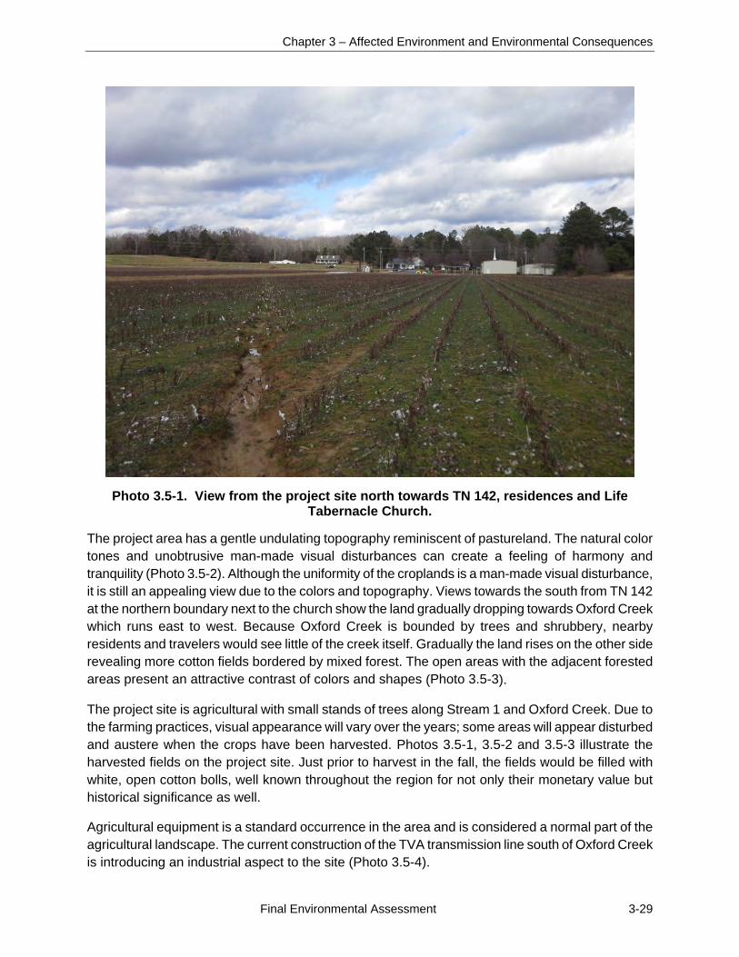
Chapter 3 – Affected Environment and Environmental Consequences
Final Environmental Assessment 3-29
Photo 3.5-1. View from the project site north towards TN 142, residences and Life Tabernacle Church.
The project area has a gentle undulating topography reminiscent of pastureland. The natural color tones and unobtrusive man-made visual disturbances can create a feeling of harmony and tranquility (Photo 3.5-2). Although the uniformity of the croplands is a man-made visual disturbance, it is still an appealing view due to the colors and topography. Views towards the south from TN 142 at the northern boundary next to the church show the land gradually dropping towards Oxford Creek which runs east to west. Because Oxford Creek is bounded by trees and shrubbery, nearby residents and travelers would see little of the creek itself. Gradually the land rises on the other side revealing more cotton fields bordered by mixed forest. The open areas with the adjacent forested areas present an attractive contrast of colors and shapes (Photo 3.5-3).
The project site is agricultural with small stands of trees along Stream 1 and Oxford Creek. Due to the farming practices, visual appearance will vary over the years; some areas will appear disturbed and austere when the crops have been harvested. Photos 3.5-1, 3.5-2 and 3.5-3 illustrate the harvested fields on the project site. Just prior to harvest in the fall, the fields would be filled with white, open cotton bolls, well known throughout the region for not only their monetary value but historical significance as well.
Agricultural equipment is a standard occurrence in the area and is considered a normal part of the agricultural landscape. The current construction of the TVA transmission line south of Oxford Creek is introducing an industrial aspect to the site (Photo 3.5-4).
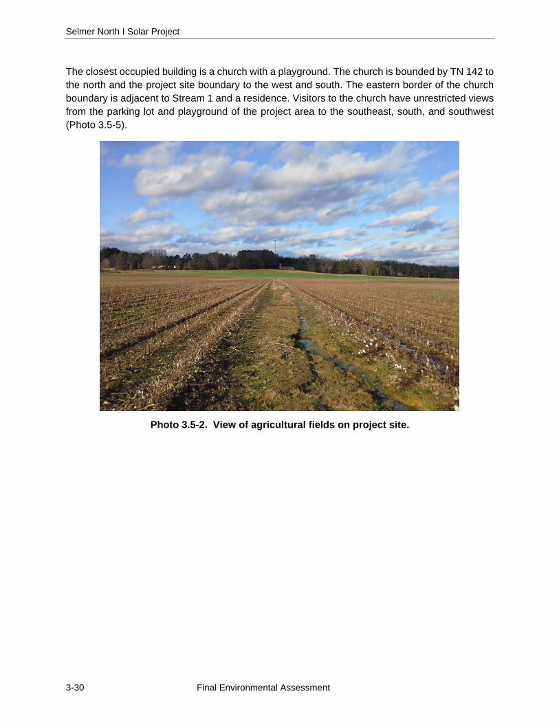
Selmer North I Solar Project
3-30 Final Environmental Assessment
The closest occupied building is a church with a playground. The church is bounded by TN 142 to the north and the project site boundary to the west and south. The eastern border of the church boundary is adjacent to Stream 1 and a residence. Visitors to the church have unrestricted views from the parking lot and playground of the project area to the southeast, south, and southwest (Photo 3.5-5).
Photo 3.5-2. View of agricultural fields on project site.
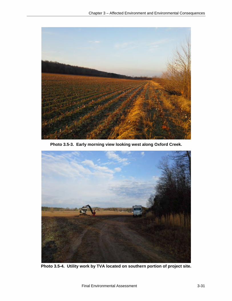
Chapter 3 – Affected Environment and Environmental Consequences
Final Environmental Assessment 3-31
Photo 3.5-3. Early morning view looking west along Oxford Creek.
Photo 3.5-4. Utility work by TVA located on southern portion of project site.
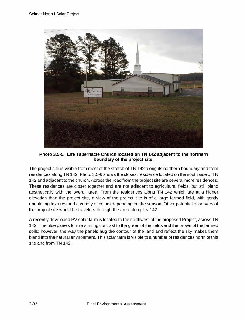
Selmer North I Solar Project
3-32 Final Environmental Assessment
Photo 3.5-5. Life Tabernacle Church located on TN 142 adjacent to the northern boundary of the project site.
The project site is visible from most of the stretch of TN 142 along its northern boundary and from residences along TN 142. Photo 3.5-6 shows the closest residence located on the south side of TN 142 and adjacent to the church. Across the road from the project site are several more residences. These residences are closer together and are not adjacent to agricultural fields, but still blend aesthetically with the overall area. From the residences along TN 142 which are at a higher elevation than the project site, a view of the project site is of a large farmed field, with gently undulating textures and a variety of colors depending on the season. Other potential observers of the project site would be travelers through the area along TN 142.
A recently developed PV solar farm is located to the northwest of the proposed Project, across TN 142. The blue panels form a striking contrast to the green of the fields and the brown of the farmed soils; however, the way the panels hug the contour of the land and reflect the sky makes them blend into the natural environment. This solar farm is visible to a number of residences north of this site and from TN 142.
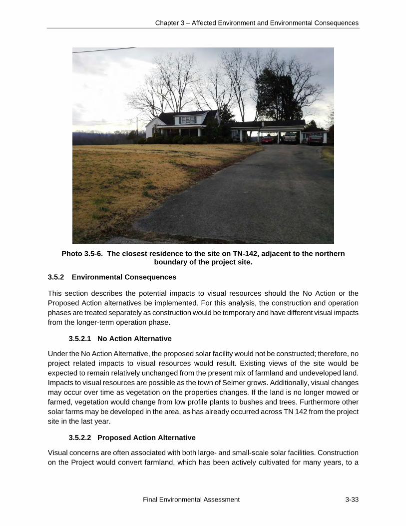
Chapter 3 – Affected Environment and Environmental Consequences
Final Environmental Assessment 3-33
Photo 3.5-6. The closest residence to the site on TN-142, adjacent to the northern boundary of the project site.
3.5.2 Environmental Consequences
This section describes the potential impacts to visual resources should the No Action or the Proposed Action alternatives be implemented. For this analysis, the construction and operation phases are treated separately as construction would be temporary and have different visual impacts from the longer-term operation phase.
3.5.2.1 No Action Alternative
Under the No Action Alternative, the proposed solar facility would not be constructed; therefore, no project related impacts to visual resources would result. Existing views of the site would be expected to remain relatively unchanged from the present mix of farmland and undeveloped land. Impacts to visual resources are possible as the town of Selmer grows. Additionally, visual changes may occur over time as vegetation on the properties changes. If the land is no longer mowed or farmed, vegetation would change from low profile plants to bushes and trees. Furthermore other solar farms may be developed in the area, as has already occurred across TN 142 from the project site in the last year.
3.5.2.2 Proposed Action Alternative
Visual concerns are often associated with both large- and small-scale solar facilities. Construction on the Project would convert farmland, which has been actively cultivated for many years, to a
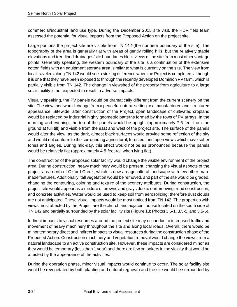
Selmer North I Solar Project
3-34 Final Environmental Assessment
commercial/industrial land use type. During the December 2015 site visit, the HDR field team assessed the potential for visual impacts from the Proposed Action on the project site.
Large portions the project site are visible from TN 142 (the northern boundary of the site). The topography of the area is generally flat with areas of gently rolling hills, but the relatively stable elevations and tree-lined drainages/site boundaries block views of the site from most other vantage points. Generally speaking, the western boundary of the site is a continuation of the extensive cotton fields with an equipment storage area, similar to what is currently on the site. The view from local travelers along TN 142 would see a striking difference when the Project is completed, although it is one that they have been exposed to through the recently developed Dominion PV farm, which is partially visible from TN 142. The change in viewshed of the property from agriculture to a large solar facility is not expected to result in adverse impacts.
Visually speaking, the PV panels would be dramatically different from the current scenery on the site. The viewshed would change from a peaceful natural setting to a manufactured and structured appearance. Sitewide, after construction of the Project, open landscape of cultivated cropland would be replaced by industrial highly geometric patterns formed by the rows of PV arrays. In the morning and evening, the top of the panels would be upright (approximately 7.6 feet from the ground at full tilt) and visible from the east and west of the project site. The surface of the panels would alter the view, as the dark, almost black surfaces would provide some reflection of the sky and would not conform to the surrounding agricultural, forested, and open views which have softer tones and angles. During mid-day, this effect would not be as pronounced because the panels would be relatively flat (approximately 4.5-feet-tall when lying flat).
The construction of the proposed solar facility would change the visible environment of the project area. During construction, heavy machinery would be present, changing the visual aspects of the project area north of Oxford Creek, which is now an agricultural landscape with few other man-made features. Additionally, tall vegetation would be removed, and part of the site would be graded, changing the contouring, coloring and texture of the scenery attributes. During construction, the project site would appear as a mixture of browns and grays due to earthmoving, road construction, and concrete activities. Water would be used to keep soil from aerosolizing; therefore dust clouds are not anticipated. These visual impacts would be most noticed from TN 142. The properties with views most affected by the Project are the church and adjacent house located on the south side of TN 142 and partially surrounded by the solar facility site (Figure 13; Photos 3.5-1, 3.5-5, and 3.5-6).
Indirect impacts to visual resources around the project site may occur due to increased traffic and movement of heavy machinery throughout the site and along local roads. Overall, there would be minor temporary direct and indirect impacts to visual resources during the construction phase of the Proposed Action. Construction machinery and vegetation removal would change the views from a natural landscape to an active construction site. However, these impacts are considered minor as they would be temporary (less than 1 year) and there are few onlookers in the vicinity that would be affected by the appearance of the activities.
During the operation phase, minor visual impacts would continue to occur. The solar facility site would be revegetated by both planting and natural regrowth and the site would be surrounded by
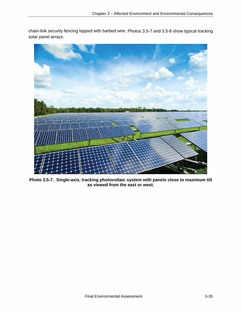
Chapter 3 – Affected Environment and Environmental Consequences
Final Environmental Assessment 3-35
chain-link security fencing topped with barbed wire. Photos 3.5-7 and 3.5-8 show typical tracking solar panel arrays.
Photo 3.5-7. Single-axis, tracking photovoltaic system with panels close to maximum tilt as viewed from the east or west.
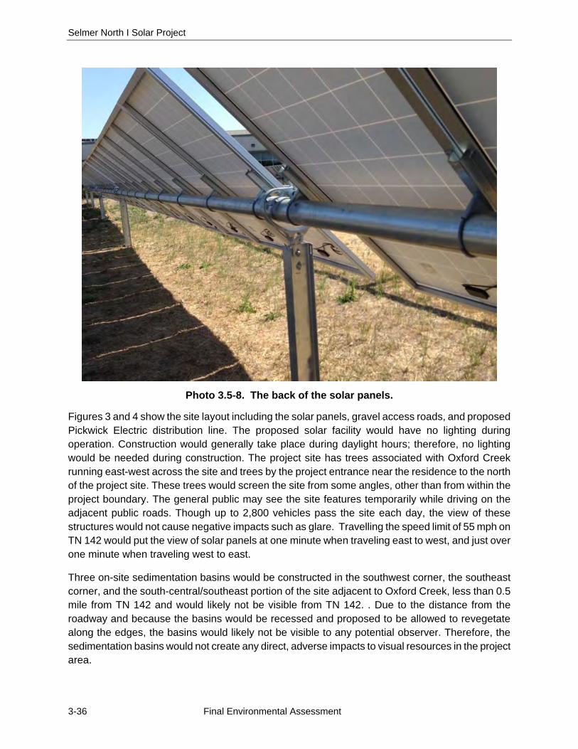
Selmer North I Solar Project
3-36 Final Environmental Assessment
Photo 3.5-8. The back of the solar panels.
Figures 3 and 4 show the site layout including the solar panels, gravel access roads, and proposed Pickwick Electric distribution line. The proposed solar facility would have no lighting during operation. Construction would generally take place during daylight hours; therefore, no lighting would be needed during construction. The project site has trees associated with Oxford Creek running east-west across the site and trees by the project entrance near the residence to the north of the project site. These trees would screen the site from some angles, other than from within the project boundary. The general public may see the site features temporarily while driving on the adjacent public roads. Though up to 2,800 vehicles pass the site each day, the view of these structures would not cause negative impacts such as glare. Travelling the speed limit of 55 mph on TN 142 would put the view of solar panels at one minute when traveling east to west, and just over one minute when traveling west to east.
Three on-site sedimentation basins would be constructed in the southwest corner, the southeast corner, and the south-central/southeast portion of the site adjacent to Oxford Creek, less than 0.5 mile from TN 142 and would likely not be visible from TN 142. . Due to the distance from the roadway and because the basins would be recessed and proposed to be allowed to revegetate along the edges, the basins would likely not be visible to any potential observer. Therefore, the sedimentation basins would not create any direct, adverse impacts to visual resources in the project area.
Chapter 3 – Affected Environment and Environmental Consequences
Final Environmental Assessment 3-37
Overall, visual impacts during the operation phase of the Project would be moderate in the immediate vicinity, but minimal on a larger scale, due to a combination of changes to the visual attributes of the area, the visibility from up to 1 mile away and the existing general local character. These impacts would be minimized, however, due to the sparsely populated immediate area.
3.6 NOISE
This section provides an overview of the existing ambient sound environment in the project area, and the potential impacts to the ambient sound environment that would be associated with the Proposed Action and No Action Alternative.
3.6.1 Affected Environment
Noise is generally described as unwanted sound, which can be based either on objective effects (hearing loss, damage to structures, etc.) or subjective judgments (such as community annoyance). Sound is usually represented on a logarithmic scale with a unit called the decibel (dB). Sound on the decibel scale is referred to as sound level. The threshold of human hearing is approximately 0 dB, and the threshold of discomfort or pain is around 120 dB.
Noise levels are computed over a 24-hour period and adjusted for nighttime annoyances to produce the day-night average sound level (DNL). DNL is the community noise metric recommended by the USEPA and has been adopted by most Federal agencies (USEPA 1974). A DNL of 65 A-weighted decibels (dBA) is the level most commonly used for noise planning purposes and represents a compromise between community impact and the need for activities like construction. The A-weighted sound level, used extensively in this country for the measurement of community and transportation noise, represents the approximate frequency response characteristic of the average young human ear. Areas exposed to a DNL above 65 dBA are generally not considered suitable for residential use. A DNL of 55 dBA was identified by USEPA as a level below which there is no adverse impact (USEPA 1974). For point of reference, approximate noise levels (measured in dBA) of common activities/events are provided below.
0 - the softest sound a person can hear with normal hearing 10 - normal breathing 20 - whispering at 5 feet 30 - soft whisper 50 - rainfall 60 - normal conversation 110 - shouting in ear 120 - thunder
Noises occurring at night generally produce a greater annoyance than do noises of the same levels occurring during the day. It is generally agreed that people perceive intrusive noise at night as being 10 dBA louder than the same level of noise during the day. This perception is largely because background environmental sound levels at night in most areas are about 10 dBA lower than those during the day (USEPA 1974).Ambient noise at the project area consists mainly of agricultural,
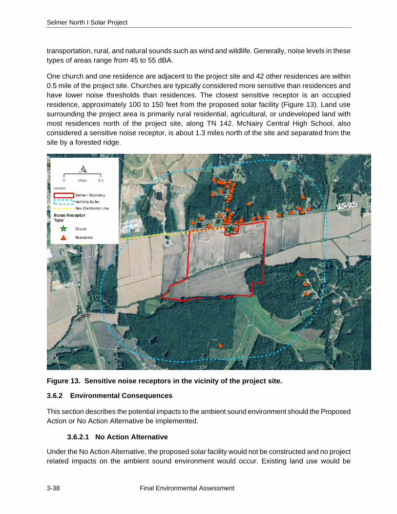
Selmer North I Solar Project
3-38 Final Environmental Assessment
transportation, rural, and natural sounds such as wind and wildlife. Generally, noise levels in these types of areas range from 45 to 55 dBA.
One church and one residence are adjacent to the project site and 42 other residences are within 0.5 mile of the project site. Churches are typically considered more sensitive than residences and have lower noise thresholds than residences. The closest sensitive receptor is an occupied residence, approximately 100 to 150 feet from the proposed solar facility (Figure 13). Land use surrounding the project area is primarily rural residential, agricultural, or undeveloped land with most residences north of the project site, along TN 142. McNairy Central High School, also considered a sensitive noise receptor, is about 1.3 miles north of the site and separated from the site by a forested ridge.
Figure 13. Sensitive noise receptors in the vicinity of the project site.
3.6.2 Environmental Consequences
This section describes the potential impacts to the ambient sound environment should the Proposed Action or No Action Alternative be implemented.
3.6.2.1 No Action Alternative
Under the No Action Alternative, the proposed solar facility would not be constructed and no project related impacts on the ambient sound environment would occur. Existing land use would be
Chapter 3 – Affected Environment and Environmental Consequences
Final Environmental Assessment 3-39
expected to remain a mix of agricultural land and undeveloped land; therefore, the ambient sound environment would be expected to remain as it is at present.
3.6.2.2 Proposed Action Alternative
Direct and indirect noise impacts associated with implementation of the Proposed Action would primarily occur during construction. Construction equipment produces a range of sounds while operational. The noisiest construction equipment, such as delivery trucks, dump trucks, water trucks, service trucks, bulldozers, chain saws, bush hogs, or other large mowers for tree clearing produce maximum noise levels at 50 feet of approximately 84 to 85 dBA. This type of equipment may be used for approximately 6 months in the project area.
Construction noise would cause temporary and short-term adverse impacts to the ambient sound environment around the project area. The closest sensitive receptor, an occupied residence on the south side of TN 142, is adjacent to the northern boundary of the project site, approximately 140 feet from the proposed solar arrays. The Life Tabernacle Church on the south side of TN 142 is also adjacent to the northern boundary of the project site, approximately 200 feet from the proposed solar arrays and approximately 125 feet from the main site access road. The adjacent residences and church would temporarily experience heightened noise during construction, primarily from the pile driving activities. Construction would only occur during daylight hours, so the Project would not affect ambient noise levels at night. Most of the proposed equipment would not be operating on site for the entire construction period, but would be phased in and out according to the progress of the Project. The equipment most likely to make the most noise would be the pile driving activities during the construction of the array foundations, which would be completed in 3 to 5 weeks. Standard construction pile drivers are estimated to produce between 90 to 95 dBA (calculated at a distance of 50 feet) at close range (USDOT 2011). The specialty pile drivers proposed to be used for solar panel installation produce less noise and the piles supporting solar panels would be driven into soil with little to no rock drilling anticipated. Construction workers would wear appropriate hearing protection in accordance with Occupational Safety and Health Act (OSHA) regulations. Regular coordination would be made with church administration to plan construction activities around the church services and other scheduled events, and noise producing activities (specifically the drilling) will be limited or avoided during these times.
Existing ambient noise periodically includes tractors, other farm equipment, and highway traffic. As construction would occur during the day, presumably when farm activities and more traffic would occur, there would not be a significant difference in noise levels other than during pile driving.
Following completion of construction activities, the ambient sound environment would be expected to return to existing levels or below by eliminating more frequent use of farm and agricultural equipment. The moving parts would be electric-powered and produce little noise. Consequently, the Proposed Action would have minimal effects on noise levels as a result of normal continuous operation. The periodic mowing of the site to manage the height of vegetation would produce sound levels comparable to those of agricultural operations in the surrounding area although at less frequent intervals.
Selmer North I Solar Project
3-40 Final Environmental Assessment
Overall, implementation of the Proposed Action would result in minor, temporary adverse impacts to the ambient noise environment for those residents living near the project area during construction. Noise impacts during operation and maintenance of the solar farm would be negligible and less than those of the previous farming operations.
3.7 AIR QUALITY AND GREENHOUSE GAS EMISSIONS
This section describes an overview of existing air quality and GHG emissions in the project area and the potential impacts on air quality and GHG emissions that would be associated with the Proposed Action and No Action Alternative.
3.7.1 Affected Environment
Ambient air quality is determined by the type and amount (concentration) of pollutants emitted into the atmosphere, the size and topography of the air basin in question, and the prevailing meteorological conditions in that air basin. Through its passage of the Clean Air Act of 1970 (CAA) and its amendments, Congress has mandated the protection and enhancement of our nation’s air quality. The USEPA has established the National Ambient Air Quality Standards (NAAQS) for the following criteria pollutants to protect the public health and welfare: sulfur dioxide (SO2), ozone (O3), nitrogen dioxide (NO2), particulate matter whose particles are less than or equal to 10 micrometers (PM10), particulate matter whose particles are less than or equal to 2.5 micrometers (PM2.5), carbon monoxide (CO), and lead (Pb).
The primary NAAQS were promulgated to protect public health, and the secondary NAAQS were promulgated to protect public welfare (e.g., visibility, crops, forests, soils and materials) from any known or anticipated adverse effects of air pollutants. Areas in compliance with the NAAQS are designated “attainment” areas. Areas in violation of the NAAQS are designated as “nonattainment” areas, and new sources being located in or near these areas may be subject to more stringent air permitting requirements. Nonattainment areas are usually defined by county. National standards, other than annual standards, are not to be exceeded more than once per year (except where noted). Areas that cannot be classified on the basis of available information for a particular pollutant are designated as “unclassifiable” and are treated as attainment areas unless proven otherwise (USEPA 2016).
3.7.1.1 Regional Air Quality
McNairy County, Tennessee is in attainment for NAAQS pollutants by the USEPA as of January 2016 (USEPA 2015). The National Emissions Inventory (NEI) is a comprehensive and detailed estimate of air emissions of both Criteria and Hazardous air pollutants from all air emissions sources. The NEI is prepared every 3 years by the USEPA based on emission estimates and emission model inputs provided by state, local, and tribal air agencies for sources in their jurisdictions, and supplemented by data developed by the USEPA. The emissions in the county for 2011 are presented in Table 3.7-1. These emissions are from the fuel combustion, industrial, fuel combustion other, petroleum and related industries, other industrial processes, waste disposal and recycling, highway vehicles, off highway, solvent utilization, storage and transport, and miscellaneous sectors (USEPA 2011a).
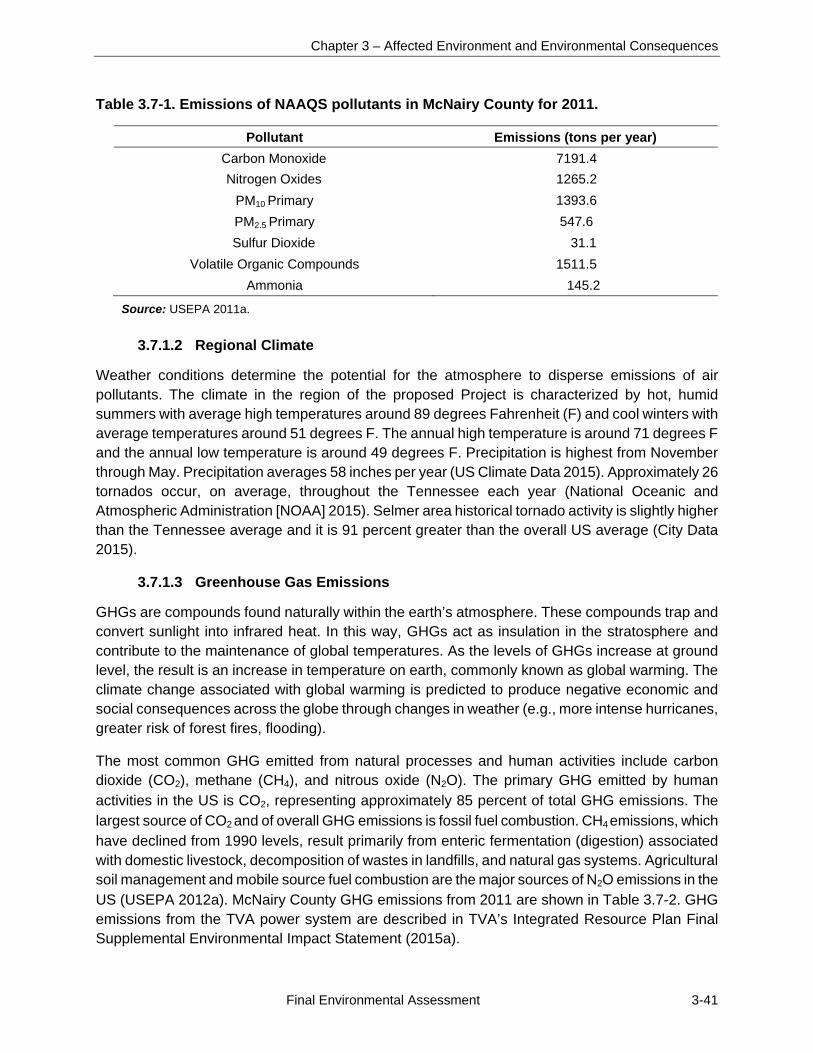
Chapter 3 – Affected Environment and Environmental Consequences
Final Environmental Assessment 3-41
Table 3.7-1. Emissions of NAAQS pollutants in McNairy County for 2011.
Pollutant Emissions (tons per year) Carbon Monoxide 7191.4 Nitrogen Oxides 1265.2
PM10 Primary 1393.6 PM2.5 Primary 547.6 Sulfur Dioxide 31.1
Volatile Organic Compounds 1511.5 Ammonia 145.2
Source: USEPA 2011a.
3.7.1.2 Regional Climate
Weather conditions determine the potential for the atmosphere to disperse emissions of air pollutants. The climate in the region of the proposed Project is characterized by hot, humid summers with average high temperatures around 89 degrees Fahrenheit (F) and cool winters with average temperatures around 51 degrees F. The annual high temperature is around 71 degrees F and the annual low temperature is around 49 degrees F. Precipitation is highest from November through May. Precipitation averages 58 inches per year (US Climate Data 2015). Approximately 26 tornados occur, on average, throughout the Tennessee each year (National Oceanic and Atmospheric Administration [NOAA] 2015). Selmer area historical tornado activity is slightly higher than the Tennessee average and it is 91 percent greater than the overall US average (City Data 2015).
3.7.1.3 Greenhouse Gas Emissions
GHGs are compounds found naturally within the earth’s atmosphere. These compounds trap and convert sunlight into infrared heat. In this way, GHGs act as insulation in the stratosphere and contribute to the maintenance of global temperatures. As the levels of GHGs increase at ground level, the result is an increase in temperature on earth, commonly known as global warming. The climate change associated with global warming is predicted to produce negative economic and social consequences across the globe through changes in weather (e.g., more intense hurricanes, greater risk of forest fires, flooding).
The most common GHG emitted from natural processes and human activities include carbon dioxide (CO2), methane (CH4), and nitrous oxide (N2O). The primary GHG emitted by human activities in the US is CO2, representing approximately 85 percent of total GHG emissions. The largest source of CO2 and of overall GHG emissions is fossil fuel combustion. CH4 emissions, which have declined from 1990 levels, result primarily from enteric fermentation (digestion) associated with domestic livestock, decomposition of wastes in landfills, and natural gas systems. Agricultural soil management and mobile source fuel combustion are the major sources of N2O emissions in the US (USEPA 2012a). McNairy County GHG emissions from 2011 are shown in Table 3.7-2. GHG emissions from the TVA power system are described in TVA’s Integrated Resource Plan Final Supplemental Environmental Impact Statement (2015a).
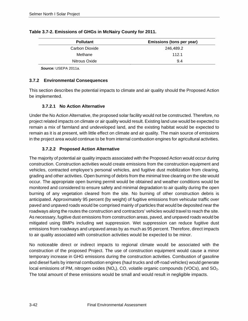
Selmer North I Solar Project
3-42 Final Environmental Assessment
Table 3.7-2. Emissions of GHGs in McNairy County for 2011.
Pollutant Emissions (tons per year) Carbon Dioxide 246,489.2
Methane 112.1 Nitrous Oxide 9.4
Source: USEPA 2011a.
3.7.2 Environmental Consequences
This section describes the potential impacts to climate and air quality should the Proposed Action be implemented.
3.7.2.1 No Action Alternative
Under the No Action Alternative, the proposed solar facility would not be constructed. Therefore, no project related impacts on climate or air quality would result. Existing land use would be expected to remain a mix of farmland and undeveloped land, and the existing habitat would be expected to remain as it is at present, with little effect on climate and air quality. The main source of emissions in the project area would continue to be from internal combustion engines for agricultural activities.
3.7.2.2 Proposed Action Alternative
The majority of potential air quality impacts associated with the Proposed Action would occur during construction. Construction activities would create emissions from the construction equipment and vehicles, contracted employee’s personal vehicles, and fugitive dust mobilization from clearing, grading and other activities. Open burning of debris from the minimal tree clearing on the site would occur. The appropriate open burning permit would be obtained and weather conditions would be monitored and considered to ensure safety and minimal degradation to air quality during the open burning of any vegetation cleared from the site. No burning of other construction debris is anticipated. Approximately 95 percent (by weight) of fugitive emissions from vehicular traffic over paved and unpaved roads would be comprised mainly of particles that would be deposited near the roadways along the routes the construction and contractors’ vehicles would travel to reach the site. As necessary, fugitive dust emissions from construction areas, paved, and unpaved roads would be mitigated using BMPs including wet suppression. Wet suppression can reduce fugitive dust emissions from roadways and unpaved areas by as much as 95 percent. Therefore, direct impacts to air quality associated with construction activities would be expected to be minor.
No noticeable direct or indirect impacts to regional climate would be associated with the construction of the proposed Project. The use of construction equipment would cause a minor temporary increase in GHG emissions during the construction activities. Combustion of gasoline and diesel fuels by internal combustion engines (haul trucks and off-road vehicles) would generate local emissions of PM, nitrogen oxides (NOx), CO, volatile organic compounds (VOCs), and SO2. The total amount of these emissions would be small and would result in negligible impacts.
Chapter 3 – Affected Environment and Environmental Consequences
Final Environmental Assessment 3-43
The conversion of the site from the existing row agriculture fields to permanent grassland would likely result in a small overall increase in soil carbon sequestration.
The operation of the proposed solar facility is not anticipated to have any negative impacts to air quality or GHG emissions. No emissions would be produced by the operation of the solar facility. Minor emissions would occur during maintenance activities, including facility inspections and periodic mowing.
Conversely, overall emissions of air pollutants from the TVA power system would decrease during operations as the emissions-free power generated by the solar facility would offset power that would otherwise be generated, at least in part, by the combustion of fossil fuels. The reduction in GHG emissions resulting from the operation of the solar facility would have little noticeable effect at regional or larger scales. It would, however, be a component of the larger planned system-wide reduction in GHG emissions by the TVA power system. The adverse impacts of GHG emissions and the beneficial impacts of TVA’s reduction in GHG emissions are described in more detail in TVA (2015a).
3.8 CULTURAL RESOURCES
This section describes an overview of existing cultural resources within the project area vicinity and the potential impacts on these cultural resources that would be associated with the Proposed Action and No Action Alternative. Components of cultural resources that are analyzed include archaeological and architectural resources.
3.8.1 Affected Environment
3.8.1.1 Regulatory Background
Cultural resources are properties and places that illustrate aspects of prehistory or history or have long-standing cultural associations with established communities and/or social groups. Cultural resources may include archaeological sites, unmodified landscapes and discrete natural features, modified landscapes, human-made objects, structures such as bridges, buildings, and groups of any of these resources, sometimes referred to as districts.
Section 106 of the National Historic Preservation Act of 1966 (NHPA), as amended (54 U.S.C. § 300101 et seq.) is specifically designed to address the effects of federal and/or federally funded projects on tangible cultural resources—that is, physically concrete properties—of historic value. The NHPA provided for a national program to support both public and private efforts to identify, evaluate, and protect the nation’s important cultural resources. Once identified, these resources are evaluated for inclusion in the National Register of Historic Places (NRHP) maintained by the National Park Service. Tangible cultural resources may qualify for inclusion in the NRHP if they are 50 years of age or older (unless in exceptional cases) and if found to embody one or more of four different types of values, or criteria, in accordance with 36 CFR § 60.4:
Criterion A: association with events that have made a significant contribution to the broad patterns of our history. Such events may include a specific occurrence or pattern of occurrences, cultural traditions, or historic trends important at a local, regional, or national

Selmer North I Solar Project
3-44 Final Environmental Assessment
level. To be considered in association with a cultural resource, events must be important within the particular context being assessed.
Criterion B: association with the lives of persons significant in our past. People considered may be important locally, regionally, or nationally, and the cultural resources considered are limited to properties illustrating a person’s achievements rather than commemorating them.
Criterion C: embodiment of the distinctive characteristics of a type, period, or method of construction; representative of the work of a master; possessing high artistic values; or representative of a significant and distinguishable entity whose components may lack individual distinction. Cultural resources considered generally include architectural resources such as buildings, objects, districts, and designed landscapes.
Criterion D: cultural resources that have yielded, or may be likely to yield, information important in prehistory or history. Considered cultural resources typically include archaeological sites but may also include buildings, structures, and objects if they are the principal source of important information not contained elsewhere.
Cultural resources that are listed or considered eligible for listing in the NRHP are called “historic properties.” Federal agencies are required by the NHPA to consider the possible effects of their undertakings on historic properties and take measures to avoid, minimize, or mitigate any adverse effects. NEPA requires federal agencies to consider how their undertakings may affect the quality of the human environment, including both cultural resources and those defined as historic properties, so that the nation may “preserve important historic, cultural, and natural aspects of our national heritage.” “Undertaking” includes any project, activity, or program that has the potential to have an effect on a historic property and that is under the direct or indirect jurisdiction of a federal agency or is licensed or assisted by a federal agency.
Considering an undertaking’s possible effects on historic properties is accomplished through a four-step review process outlined in Section 106 of the NHPA (36 CFR § 800). These steps are:
1. Initiation (defining the undertaking and the Area of Potential Effect [APE] and identifying the parties to be consulted in the process);
2. Identification (studies to determine whether cultural resources are present in the APE and whether they qualify as historic properties);
3. Assessment of adverse effects (determining whether the undertaking would affect the qualities that make the property eligible for the NRHP); and
4. Resolution of any adverse effects (by avoidance, minimization, or mitigation).
Throughout the process, the lead federal agency must consult with the appropriate State Historical Preservation Officer (SHPO), federally recognized American Indian tribes that have an interest in the undertaking, and any other party with a vested interest in the undertaking.
Through various regulations and guidelines, federal agencies are encouraged to coordinate Section 106 and NEPA review to improve efficiency and allow for more informed decisions. Under NEPA, impacts to cultural resources that are part of the affected human environment but not necessarily eligible for the NRHP must also be considered by federal agencies. Generally these considerations
Chapter 3 – Affected Environment and Environmental Consequences
Final Environmental Assessment 3-45
are accomplished through consultation with parties having a vested interest in the undertaking, as described above. The Tennessee Historical Commission specifically addresses NHPA and NEPA coordination and suggests agencies initiate Section 106 review early in the planning process.
3.8.1.2 Cultural Resources Identification Methods
As part of the evaluation process, an archaeological survey and a separate architectural survey were conducted in December 2015 and January 2016 to determine the presence of prehistoric and historic cultural resources that are listed or eligible for listing in the NRHP. The project area for cultural resources includes approximately 125 acres that may be affected by the Proposed Action. A direct effects APE and an indirect effects APE were also defined for the Proposed Action. The direct effects APE is defined as the area that would be directly affected by potential site construction, clearing, and operations. The direct effects APE overlaps with the project area and consists of the 125-acre project area north of Oxford Creek. The indirect effects APE is defined as an 0.5-mile radius surrounding the project area. The 125-acre project area and a 1-mile radius surrounding the project area were evaluated during background research. The cultural resources assessment for the direct and indirect effects APEs consisted of background research, field surveys, archaeological analysis, initial NRHP evaluations, and results summary (Franz and Reynolds 2016).
Background research was conducted to identify any previously recorded cultural resources and historic properties, to establish the cultural setting in the project area vicinity, and to develop an effective method to newly identify cultural resources in the direct and indirect effects APEs. Field surveys were conducted in December 2015 and January 2016 to newly identify buried and aboveground cultural resources in the direct and indirect effects APEs. The archaeological field survey consisted of systematic surface and subsurface investigation of the direct effects APE. Findings of three or more artifacts within a 30-meter area were delineated and recorded as archaeological sites and registered with the Tennessee Division of Archaeology. The architectural field survey consisted of documentation of each property 50 years of age or older, noting characteristics of design, construction, and other aspects of its architectural integrity needed to evaluate the property’s eligibility for listing in the NRHP. Each property was photographed to the extent feasible from publicly accessible right-of-ways and documented on Tennessee Historical and Architectural Resource forms.
Recovered artifacts were processed, cleaned, cataloged, and analyzed in a fully-equipped archaeological laboratory. Using information compiled during background research, survey, and analysis, identified cultural resources were evaluated based on the four NRHP criteria, discussed above.
3.8.1.3 Cultural Setting
Archaeological sites spanning the entire period of human occupation in the Southeast are present in the project area vicinity, in western Tennessee. Archaeologists have developed several broad developmental stages characterizing human occupation for the central portion of the Mississippi River valley spanning the last 12,000 years. Paleoindian (approximately 11,500 to 9,900 Before Present [BP]), Archaic (approximately 9,900 to 3,000 BP), Woodland (approximately 3,000 to 1,000
Selmer North I Solar Project
3-46 Final Environmental Assessment
BP), Mississippian (approximately 1,000 to 350 BP), and Historical (1542-ca. 1966 A.D.) comprise these stages, and sites from each of these have been identified in western Tennessee.
When compared with surrounding regions to the west, the loess hills of western Tennessee appear to have a greater density of diagnostic Paleoindian artifacts as well as plentiful good quality chert. Early Paleoindian people are believed to have had small band social units with seasonal migrations relating to the movement of their large game prey, evidence of which exists in western Tennessee (Breitburg and Broster 1995; Brister et al. 1981; Williams 1954). Given a marked change in climatic conditions, late Paleoindian people altered their subsistence strategies to primarily depend on small game animals and gathered plant material. Subsistence during the Archaic stage shows more emphasis on gathering plants than before, as well as a gradual increase in population. Western Tennessee’s data on the Archaic stage are sparse in comparison to surrounding areas, but a few sites have been identified that help characterize Archaic adaptions as focused on intensive exploitation of diverse ecological zones and the eventual demarcation of territorial boundaries (Anderson et al. 1987; Childress et al. 1993; Childress and Wharey 1996; Jennings 1989; Lewis and Lewis 1961; Mainfort 1985; Smith 1979 and 1991).
Several Woodland sites, including one mound, have been recorded in the project area vicinity. During this stage, the use of certain edible plants led to the semidomestication of some species, which progressed to full-scale agriculture by the end of the Woodland stage. The bow and arrow, introduced ca. 1,350 to 1,150 BP (Blitz 1988), replaced the spear and atlatl, perhaps as a result of intergroup warfare. The Mississippian stage is marked by the shift to a new and improved ceramic clay body mixture. Settlements consisted of large towns in the floodplains of major river valleys, where inhabitants practiced agriculture, especially the growing of corn. Human-made mounds indicating ceremonial significance and an elite hierarchy were common in large towns. Mound placement was based on basic geometric principles often in alignment with equinox and solstice points and other important markers.
The first European exploration of the Mid-South occurred when Hernando De Soto led a Spanish entrada through the region in 1542. Large uninhabited areas were noted between the towns of Late Mississippian peoples, supporting notions that Mississippian chiefdoms were separated by buffer zones. After contact, Mississippian populations are believed to have decreased by as much as 90 percent, probably due to the introduction of European diseases. During the early historical period, portions of Tennessee were included in French, Spanish, and, eventually, American land claims (Bauch 1972; Orneslas-Struve and Coulter 1982; Twyman 1850).
Early settlers of western Tennessee came mostly from middle and eastern Tennessee as well as parts of North Carolina, South Carolina, and Virginia. The earliest pioneers settled on land granted by the state of North Carolina (Sease et al. 1989). Tennessee officially separated from North Carolina and became a state in 1796. McNairy County, Tennessee, was established on 8 October 1823 (Wright 1882). The county was named for Judge John McNairy, who arrived in western Tennessee from Guilford County, North Carolina, after being appointed to the Superior Court of the Western District by President Washington. McNairy County was part of land ceded in 1818 in the Chickasaw Purchase. The first county seat was established at Purdy in the early 1820s. The first store in town was reliant upon Chickasaw customers, who traded fur and hides for various goods.
Chapter 3 – Affected Environment and Environmental Consequences
Final Environmental Assessment 3-47
The main crops produced in the county consisted of cotton, corn, oats, and wheat. In 1858, the Mobile and Ohio Railroad completed its line through McNairy County, running about 4 miles west of Purdy (Kennedy n.d.). Several new settlements emerged along the line as a result, including Falcon, Bethel Springs, Finger, Guys, and Ramer.
In August 1861, Tennessee ratified the Confederate Constitution and joined her sister states in the Civil War, a four-year struggle against the Union. Divided opinions on secession, however, led to the creation of both Confederate and Union companies in McNairy County (Whitten 2011). In February 1862, Ulysses Grant secured control of the Tennessee River from the Confederacy and opened up western Tennessee to federal occupation (McKenzie 2001). Key skirmishes and battles occurred in Adamsville on April 1, 1862, and at Pittsburg Landing, south of Adamsville, on April 6, 1862. The latter, known as the Battle of Shiloh, was the bloodiest encounter in American history to that point, with nearly 24,000 casualties. Although suffering from many of these casualties, the Union was ultimately victorious following the heated battle that took place over a two day period (Connelly 1979). Despite such losses, Confederate resistance in western Tennessee resulted in numerous guerilla-type engagements, including those of Nathan Bedford Forrest’s throughout the war and at some points near the project area (Henry 1991).
While Purdy had remained the McNairy County seat since its inception in the 1820s, its citizens endured decades of attempts to move the seat after the town was bypassed by the railroad (Kennedy n.d.). Arguments for moving the seat increased following the Civil War. The stately brick courthouse at Purdy burned in 1881, with some historians suggesting that the cause may have been nefarious, and while it was never rebuilt, the town remained the county seat for the next 10 years. In 1891, the town of New South, along the railroad at the geographic center of McNairy County, was selected to be the new county seat and eventually became known as Selmer.
By the late nineteenth century, McNairy County residents focused once again on agricultural production, and cotton farming became the primary focus in the area through the early twentieth century. In 1880, western Tennessee produced over 80 percent of the state’s cotton (Smith 1945). McNairy County has remained rural while enjoying fame as the home of Buford Pusser, the big-stick carrying sheriff immortalized in the 1973 film Walking Tall. McNairy County is now home to a number of industries, including United Stainless, Monogram Refrigeration, and a number of solar farms (Thomas 2014).
3.8.1.1 Background Research
Background research showed that no archaeological resources were previously recorded within the project area, and five archaeological sites (40MY40, 40MY41, 40MY42, 40MY149, 40MY151) were previously identified within 1 mile of the project area. No cultural resources listed or eligible for listing in the NRHP were identified within 1 mile of the project area.
Sites 40MY40, 40MY41, and 40MY42 are all prehistoric lithic scatters identified in an archaeological assessment of the Cypress Creek watershed within McNairy County by the Memphis State University Anthropological Research Center. Areas surrounding Oxford Creek east of US 45 were included in the survey area (Peterson 1975). Site 40MY40 is located on a terrace south of Oxford Creek and east of US 45. Peterson (1975) reported a moderately dense (20-by-40 meter) lithic
Selmer North I Solar Project
3-48 Final Environmental Assessment
scatter containing Paleoindian end-scrapers and Late Archaic stemmed projectile points. The site appeared to have been widely known to collectors. Site 40MY41 is located on a second terrace to the north of 40MY40, closer to Oxford Creek. This small scatter contained a Middle Woodland Copena biface. Site 40MY42 was identified within the flood plain of Bull Creek, flowing to the south of Oxford Creek. This small scatter had no culturally diagnostic material.
Sites 40MY149 and 40MY151 were identified during two different cultural resources assessments. Site 40MY149 is a late nineteenth to mid-twentieth century dump site located on a ridge nose above TN 142. The site was identified during a cultural resources assessment in advance of construction of the Mulberry solar farm, just northwest of the project site (Freeman 2013). Site 40MY151 is a small lithic scatter found in the floodplain of Bull Creek, south of the project site, identified during a cultural resources assessment for a TVA transmission line (Hunter and Mocas 2014). Both of these sites were recommended NRHP-ineligible.
Historical maps of McNairy County show that four structures were extant near or within the georeferenced boundaries of the project site in the 1910s (Purdue 1916). The same four structures were extant in 1936, at this point positioned along the south side of TN 142 (US Postal Service [USPS] 1936). One of these structures was located within the project area but may have been demolished or removed by 1949 (USGS 1949).
Based on background research, the direct effects APE was considered to have a relatively high probability for both prehistoric and historic resources. The direct effects APE was expected to minimally contain evidence of historical homesteads along TN 142 and possibly prehistoric resources on terraces of Oxford Creek. The indirect effects APE was expected to contain an inventory of mid-twentieth century architectural resources representative of residential housing development trends that occurred in McNairy County after WWII, when the county saw an increase in the local economy and development of rural areas beyond Selmer’s downtown area. Increased availability of automobiles and improved road conditions allowed residents to live farther from their places of work, encouraging widely spaced residential development in rural settings.
3.8.1.2 Survey Results
Three archaeological sites (40MY156, 40MY157, and 40MY158) and three isolated artifact occurrences were recorded during survey of the direct effects APE. None of these sites or isolated occurrences is recommended eligible for listing in the NRHP. More details on the survey results are provided below, and direct effects findings are summarized in Table 3.8-1.
In the direct effects APE, 563 shovel test pits (STPs) were initially excavated along 35 north-to-south transects. Three archaeological sites and three isolated artifact occurrences were identified, resulting in the excavation of additional STPs to establish site boundaries.
Largely confined to the surface, the historical finds (40MY156 and one historical isolated occurrence) originate from structures formerly on the property and possibly from trash dumping. Based on background research, the dwelling formerly at 40MY156 appears to have been built between 1916 and 1936 and demolished or removed prior to 1984 (Purdue 1916; USGS 1984; USPS 1936). Site materials appear to date to the twentieth century, but there is no indication of in
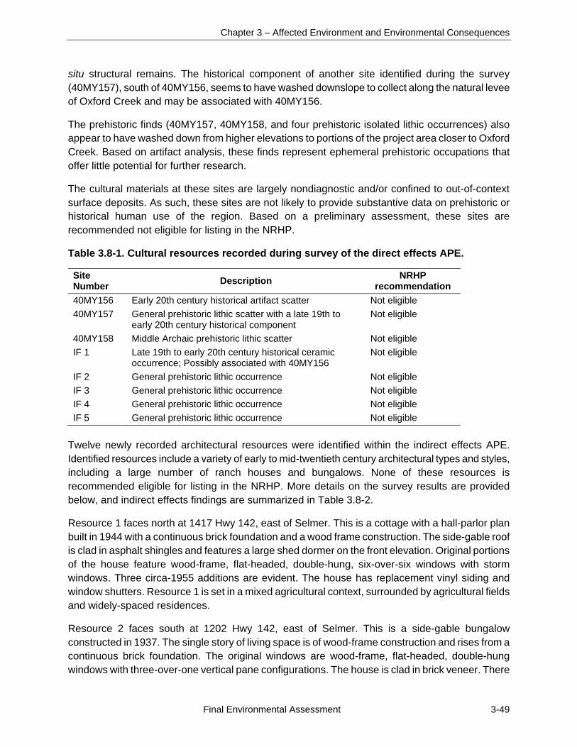
Chapter 3 – Affected Environment and Environmental Consequences
Final Environmental Assessment 3-49
situ structural remains. The historical component of another site identified during the survey (40MY157), south of 40MY156, seems to have washed downslope to collect along the natural levee of Oxford Creek and may be associated with 40MY156.
The prehistoric finds (40MY157, 40MY158, and four prehistoric isolated lithic occurrences) also appear to have washed down from higher elevations to portions of the project area closer to Oxford Creek. Based on artifact analysis, these finds represent ephemeral prehistoric occupations that offer little potential for further research.
The cultural materials at these sites are largely nondiagnostic and/or confined to out-of-context surface deposits. As such, these sites are not likely to provide substantive data on prehistoric or historical human use of the region. Based on a preliminary assessment, these sites are recommended not eligible for listing in the NRHP.
Table 3.8-1. Cultural resources recorded during survey of the direct effects APE.
Site Number
Description NRHP
recommendation
40MY156 Early 20th century historical artifact scatter Not eligible
40MY157 General prehistoric lithic scatter with a late 19th to early 20th century historical component
Not eligible
40MY158 Middle Archaic prehistoric lithic scatter Not eligible
IF 1 Late 19th to early 20th century historical ceramic occurrence; Possibly associated with 40MY156
Not eligible
IF 2 General prehistoric lithic occurrence Not eligible
IF 3 General prehistoric lithic occurrence Not eligible
IF 4 General prehistoric lithic occurrence Not eligible
IF 5 General prehistoric lithic occurrence Not eligible
Twelve newly recorded architectural resources were identified within the indirect effects APE. Identified resources include a variety of early to mid-twentieth century architectural types and styles, including a large number of ranch houses and bungalows. None of these resources is recommended eligible for listing in the NRHP. More details on the survey results are provided below, and indirect effects findings are summarized in Table 3.8-2.
Resource 1 faces north at 1417 Hwy 142, east of Selmer. This is a cottage with a hall-parlor plan built in 1944 with a continuous brick foundation and a wood frame construction. The side-gable roof is clad in asphalt shingles and features a large shed dormer on the front elevation. Original portions of the house feature wood-frame, flat-headed, double-hung, six-over-six windows with storm windows. Three circa-1955 additions are evident. The house has replacement vinyl siding and window shutters. Resource 1 is set in a mixed agricultural context, surrounded by agricultural fields and widely-spaced residences.
Resource 2 faces south at 1202 Hwy 142, east of Selmer. This is a side-gable bungalow constructed in 1937. The single story of living space is of wood-frame construction and rises from a continuous brick foundation. The original windows are wood-frame, flat-headed, double-hung windows with three-over-one vertical pane configurations. The house is clad in brick veneer. There
Selmer North I Solar Project
3-50 Final Environmental Assessment
is one addition, the front porch, evident. The dwelling is set in a mixed agricultural context, surrounded by agricultural fields and widely-spaced residences.
Resource 3 faces south at 1358 Hwy 142. This is a side-gable, wood-frame bungalow constructed in 1929. The single story of living space is constructed on a continuous concrete block foundation. The house has a symmetrical façade with a gable-roof front porch. One 1980 addition is evident, and the front door, windows, and siding have been replaced. Resource 3 is located in a small cluster of residential buildings, surrounded by agricultural fields.
Resource 4 faces southeast at 30 Amanda Way, east of Selmer. The resource is a 1930 clip-gable bungalow. The single story of living space is of wood-frame construction and rises from a brick pier foundation with brick infill. The house has a shed-roof front porch with a continuous brick foundation, a concrete slab floor, and wood posts supported with decorative brackets. The house has wood-frame, flat-headed, double-hung windows with three-over-one vertical pane configurations, most of which are covered with storm windows. The house is clad in a combination of original weatherboard siding and circa-1970 corrugated metal. One circa-1970 addition is evident, and the front door is a replacement. Resource 4 is located in a small cluster of residential buildings, surrounded by agricultural fields.
Resource 5 faces west at 57 Amanda Way, east of Selmer. The resource is a 1959 ranch home with a continuous concrete block foundation and wood-frame construction. The side-gable roof is clad in raised-seam metal and features a gable-roof projection with a shed-roof portico on the side (north) elevation. The house has board-and-batten siding in the roof gables. The front elevation windows are aluminum-framed with one-over-one configurations. One circa-1980 addition is evident, along with 1970s and 1980s replacement materials. The dwelling is located in a small cluster of residential buildings, surrounded by agricultural fields.
Resource 6 faces west at 27 Amanda Way. This 1963, wood-frame, side-gable ranch house sits on a continuous brick foundation. There is a gable-roof projection on the north end of the house. The house is clad in drop siding with vertical corner boards and has aluminum-frame, sliding windows. A shed-roof portico on the front elevation has a continuous brick foundation, a concrete slab floor, and decorative cast iron supports. The house has a circa-1980, raised panel, metal front door with a fan light. Resource 6 is located in a small cluster of residential buildings, surrounded by agricultural fields.
Resource 7 faces south at 87 Amanda Way, east of the town of Selmer. The foundation of the 1961, wood-frame, side-gable ranch house is of continuous concrete block. The house underwent major changes in circa 1985 which resulted in the installation of vinyl siding, replacement windows, and a large shed-roof addition and wooden deck on the front elevation. The dwelling is located in a small cluster of residential buildings, surrounded by agricultural fields.
Resource 8 faces south at 1458 Hwy 142, east of the town of Selmer. This wood-frame, side-gable, 1963 ranch house rests on a concrete slab foundation. There is a gable-roof projection on the side (east) elevation. Four of the windows on the front elevation are original aluminum-frame, double-hung windows with two-over-two, horizontal pane configurations. Circa-1995 modifications resulted
Chapter 3 – Affected Environment and Environmental Consequences
Final Environmental Assessment 3-51
in substantial changes to the house, including the front elevation. Resource 8 is located in a small cluster of residential buildings, surrounded by agricultural fields.
Resource 9 faces south at 1672 Hwy 142, east of the town of Selmer. This 1948, front-gable, wood-frame bungalow has a brick pier foundation with permastone infill. The asphalt shingle-clad roof features exposed rafter tails, as does the gable-roof front porch. On the side (west) elevation is a gable-roof room projection. Extensive work in circa 2000 resulted in replacement windows, siding, and front door. The dwelling sits directly north of Hwy 142, in a small cluster of residential buildings, surrounded by agricultural fields.
Resource 10 is a front-facing bungalow constructed of concrete block in 1955. The dwelling faces south at 1776 Hwy 142, east of the town of Selmer. The gable-roof front and rear porches have continuous concrete block foundations, concrete slab floors, and wood support posts. Extensive alterations to the dwelling in circa 1970 and 1995 resulted in replacement siding, windows, and front door. The dwelling is situated directly north of Hwy 142, in a small cluster of residential buildings, surrounded by agricultural fields.
Resource 11 is a circa-1900, Georgian Cottage located on a separate parcel immediately north of Resource 10. The house is abandoned but appears to have been remodeled into a barn at one time. The wood-frame, hip-roof house sits on its original concrete slab foundation. The windows and doors were at some point removed, and a large bay was cut at the likely location of the front door. On the rear elevation, two large bays were cut, and cattle stalls created. The two interior chimneys have collapsed into piles on the floor of the former house.
Resource 12 is a front-facing, circa-1938 bungalow, east of the town of Selmer. The house has a continuous brick foundation and a wooden frame. The front-gable, asphalt-shingle roof has an interior brick stove flue, and cement boards clad the front gable. The wrap-around, gable-roof front porch has a continuous brick foundation, a concrete slab floor, and brick column supports. There is a single wood front door. Modifications in the 1960s resulted in replacement windows and an addition. Resource 12 sits in a small cluster of residential buildings, immediately north of Hwy 142, and is surrounded by agricultural fields.
Archival research did not identify historical associations that would qualify any of these resources under Criteria A or B. Many had extensive alterations that compromised their historic integrity, including material and design alterations such as large-scale additions, the replacement of original doors and windows, and the addition of synthetic siding. Because of the moderate to low level of integrity, these resources do not qualify for inclusion under Criterion C, and there is no known potential for these resources to qualify under Criterion D. In addition, there is no potential for a historic district, as the resources range widely in their construction date, type, style, and planning. As such, none of these resources is recommended eligible for inclusion in the NRHP, either individually or as a district.

Selmer North I Solar Project
3-52 Final Environmental Assessment
Table 3.8-2. Cultural resources recorded during survey of the indirect effects APE.
ID Address Date Type or style NRHP
recommendation
1 1417 Hwy 142 1944 Hall-parlor cottage Not eligible
2 1202 Hwy 142 1937 Bungalow Not eligible
3 1358 Hwy 142 1929 Bungalow Not eligible
4 30 Amanda Way 1930 Bungalow Not eligible
5 57 Amanda Way 1959 Ranch Not eligible
6 27 Amanda Way 1963 Ranch Not eligible
7 87 Amanda Way 1961 Ranch Not eligible
8 1458 Hwy 142 1963 Ranch Not eligible
9 1672 Hwy 142 1948 Bungalow Not eligible
10 1776 Hwy 142 1955 Bungalow Not eligible
11 1864 Hwy 142 1900 Georgian cottage Not eligible
12 2074 Hwy 142 1938 Bungalow Not eligible
3.8.2 Environmental Consequences
No cultural resources listed or eligible for listing in the NRHP were identified during background research or during field survey of the direct or indirect effects APEs. Given the extensive survey completed within the direct and indirect effects APEs, the potential for additional, unidentified cultural resources to be located is considered very low. Any undiscovered archaeological resources that may exist in the direct effects APE would likely be highly-disturbed, low density artifact scatters also ineligible for listing in the NRHP. TVA concurs with the recommendation in the cultural resources survey report that no historic properties would be affected by the construction and operation of the proposed solar facility and connecting power line (Franz and Reynolds 2016). TVA has consulted with the Tennessee SHPO and federally recognized Indian tribes on this determination (Appendix). In a letter dated July 5, 2016, the Tennessee SHPO concurred with TVA’s determination that no historic properties would be affected (Appendix). No tribes have responded.
3.9 UTILITIES
This section describes an overview of existing utilities within the project area and the potential impacts on these utilities that would be associated with the Proposed Action and No Action Alternative. Specific utility components analyzed below include electrical service, natural gas, and water supply.
3.9.1 Affected Environment
The Town of Selmer is the county seat of McNairy County and the source for the majority of the public services provided to the Project and adjacent areas. Public services include sanitary water, sewer, utilities (including natural gas and electricity) services, and solid waste disposal services, although all of the utilities may not extend outside of the town boundaries where the site is located.
Chapter 3 – Affected Environment and Environmental Consequences
Final Environmental Assessment 3-53
3.9.1.1 Electrical Service
Electrical service is provided in the project area by Pickwick Electric through TVA. In addition, TVA is currently constructing a new high-voltage transmission line across the portion of the project site south of Oxford Creek.
3.9.1.2 Natural Gas
Natural gas in the area is provided by Selmer Utility Division. No natural gas lines were observed on the project site, though the church and residence which immediately border the northern section of the project site likely have gas service.
3.9.1.3 Water Supply
No water supply, wastewater treatment system, or connections to the town of Selmer sewer are present on the project site.
No occupied residences are located on site; therefore, there are currently no communication resources on the project site.
3.9.2 Environmental Consequences
This section describes the potential impacts to utilities should the Proposed Action or No Action Alternative be implemented.
3.9.2.1 No Action Alternative
Under the No Action Alternative, the proposed solar facility would not be constructed; therefore, there would be no project related impacts to utilities. Existing land use would be expected to remain a mix of farmland and undeveloped land, and existing on-site utilities would likely remain unchanged, with the exception of potential upgrades and maintenance.
3.9.2.2 Proposed Action Alternative
Under the Proposed Action, approximately 2.7 miles of 25-kV electrical line would be replaced from the solar facility to the Forrest Hills Substation west of the project area as discussed in Section 2.2.3. Electrical service would be provided by Pickwick Electric to the Selmer I facility. If pole replacement in some locations is required due to loading requirements, there may be interruption of service that would be coordinated by Pickwick Electric. Most of the construction can be done without interruption. Some customers along the route may experience a brief interruption (a few hours) while crews are moving transformers to new poles. Pickwick Electric would coordinate with the customers when outages are necessary. Therefore, no adverse impacts would be anticipated to electrical services with implementation of the Proposed Action. No other utility services would be required to construct and operate the Project and there would be no impacts to other utilities. Implementation of the Proposed Action would result in additional renewable energy resources in the region which would constitute a beneficial impact to electrical services in the region.
Selmer North I Solar Project
3-54 Final Environmental Assessment
3.10 WASTE MANAGEMENT
This section describes an overview of existing waste management within the project area and the potential impacts to waste management that would be associated with the Proposed Action and No Action Alternative. Components of waste management that are analyzed include solid and hazardous waste and materials.
3.10.1 Affected Environment
“Hazardous materials” and “hazardous waste” are substances, which because of their quantity, concentration, or characteristics (physical, chemical, or infectious), may present a significant danger to public health and/or the environment if released. These substances are defined by the Comprehensive Environmental Response, Compensation, and Liability Act (CERCLA; 42 U.S.C. § 9601 et seq.) and the Solid Waste Disposal Act, as amended by the Resource Conservation and Recovery Act ([RCRA]; 42 U.S.C. § 6901 et seq.). Regulated hazardous wastes under RCRA include any solid, liquid, contained gaseous, or semisolid waste or combination of wastes that exhibits one of more of the hazardous characteristics of ignitability, corrosivity, toxicity, or reactivity, or is listed as a hazardous waste under 40 CFR § 261. Storage and use of hazardous materials and wastes are regulated by local, state, and federal guidance including the Emergency Planning and Community Right-to-Know Act (42 U.S.C. § 116 et seq.) and RCRA.
In August 2015, as part of the property evaluation process, a Phase I Environmental Site Assessment (ESA) was conducted on the project area to establish the presence, former use or spillage of hazardous substances or petroleum products. Currently, land use in the project area is agricultural and undeveloped. The project area has been actively farmed since 1947; therefore, it is likely that the tract has been affected by current and historical use of herbicides and/or pesticides, which is a recognized environmental condition (Tioga Environmental Consultants [Tioga] 2015). HDR staff surveyed the project site in December 2015 and observed no waste-related environmental conditions, though there was evidence of heavy machinery in use in and around the project site, which could lead to petroleum and other hydrocarbon leaks and spillage.
The project area is located in unincorporated McNairy County. Solid waste in McNairy County is managed by the McNairy County Solid Waste Management Department through the McNairy County government offices. The McNairy County Landfill, located at 770 Airport Road, processes nonhousehold items only and accepts tires at an additional cost.
McNairy County has two recycling centers open one day a week and only accepting drop-offs. Recyclable items include cardboard, paper, plastic, tin, computers, and rechargeable batteries (McNairy County 2015).
3.10.2 Environmental Consequences
This section describes the potential impacts to waste management should the Proposed Action be implemented.
Chapter 3 – Affected Environment and Environmental Consequences
Final Environmental Assessment 3-55
3.10.2.1 No Action Alternative
Under the No Action Alternative, the proposed solar facility would not be constructed; therefore, no project related impacts to waste management resources would occur. Existing land use would be expected to remain a mix of farmland and undeveloped land, and existing waste management conditions would be expected to remain as they are at present.
3.10.2.2 Proposed Action Alternative
Construction of the Proposed Action would result in the generation of hazardous and nonhazardous solid and liquid waste in the form of construction debris, oils, packaging materials, and general construction waste. Under the Proposed Action it is anticipated that a total of approximately 55 gallons of hazardous waste would be generated for the duration of the construction. An additional 4,200 cubic yards of nonhazardous solid waste (105 loads, 40 cubic yards each) would be generated at the project site during construction. Nonhazardous wastes would include construction debris and general trash, including pallets and broken down cardboard module boxes.
Materials suitable for soil compaction activities such as gravel and soils would be brought to the project site as needed and off-loaded at the designated road or building location for immediate dispersion. Materials unsuitable for compaction, such as mowed debris, would be removed and loaded immediately for subsequent disposal at an acceptable off-site location. Contaminated grading and mowing materials are not anticipated; however, if any such materials are encountered during excavation, they would be disposed of at the nearest appropriate facility, the Northeast Mississippi Regional Landfill in Walnut, Mississippi, in accordance with applicable laws, ordinances, regulations, and standards.
Hazardous Materials Management
During construction, all hazardous materials would be stored on-site in storage tanks, vessels, or other appropriate containers specifically designed for the characteristics of the materials to be stored. Storage conex boxes and work trailers would be located on each project site. The storage facilities would include secondary containment in case of tank or vessel failure. Construction- and decommissioning-related hazardous materials would primarily be liquids such as used oil, hydraulic fluid and other lubricants associated with construction equipment. Material Safety Data Sheets for all applicable materials present on site would be made readily available to on-site personnel.
Fueling of some construction vehicles would occur in the construction area. Other mobile equipment would return to the on-site laydown area for refueling. Special procedures would be identified to minimize the potential for fuel spills, and spill control kits would be carried on all refueling vehicles for activities such as refueling, vehicle or equipment maintenance procedures, waste removal and tank clean-out. A fuel truck may be stored on site for a 3 to 4 week period during site grading of each project site. During the majority of the construction period, fuel would be stored on site in aboveground double-walled storage tanks with built-in containment. The total volume of on-site tanks would not exceed the 1,320 gallons, the threshold above which a Spill Prevention, Countermeasure and Control (SPCC) Plan may be required (40 CFR § 112).
Selmer North I Solar Project
3-56 Final Environmental Assessment
During operations, bulk chemicals would be stored in storage tanks; other chemicals would be stored in returnable delivery containers. Chemical storage and chemical feed areas would be designed to contain leaks and spills. The transport, storage, handling, and use of all chemicals would be conducted in accordance with applicable laws, ordinances, regulations, and standards. The six transformers would each contain 643 gallons of oil/hydraulics fluid; therefore, approximately 3,858 gallons of oil would be on site for equipment operation, which would exceed the 1,320 gallon threshold for an SPCC plan. The facility would fall under USEPA’s SPCC requirements of “oil-filled operational equipment” and a Tier I Qualified Facility; therefore, no double-walled protection would be required and the SPCC plan would not have to be certified by a Professional Engineer (USEPA 2006 and 2011b). The SPCC plan would be prepared by a SRC contractor prior to construction to prevent oil discharges during facility operations.
The quantities of hazardous materials stored on site would be evaluated to identify the required usage and to maintain sufficient inventories to meet use rates without stockpiling excess chemicals. Chemicals that could be present during construction, operation and maintenance of the Proposed Project include diesel fuel, lubricants, mineral and FR3 insulating oil, sodium hexafluoride, and welding gases.
SRC would develop and implement a variety of plans and programs to ensure safe handling, storage, and use of hazardous materials (e.g., Hazardous Material Business Plan). Facility personnel would be supplied with appropriate personal protective equipment (PPE) and would be properly trained in the use of PPE as well as the handling, use, and cleanup of hazardous materials used at the facility and the procedures to be followed in the event of a leak or spill. Adequate supplies of appropriate cleanup materials would be stored on site.
In addition to the chemicals listed above, small quantities (less than 55 gallons, 500 pounds or 200 cubic feet) of janitorial supplies, office supplies, laboratory supplies, paint, degreasers, herbicides, pesticides, air conditioning fluids (chlorofluorocarbons [CFC]), gasoline, hydraulic fluid, propane, and welding rods typical of those purchased from retail outlets may also be stored and used at the facility. Flammable materials (e.g., paints, solvents) would be stored in flammable material storage cabinet(s) with built-in containment sumps. Due to the small quantities involved and the controlled environment, a spill could be cleaned up without significant environmental consequences.
Hazardous Waste
Small quantities of hazardous wastes would be generated during construction, operation and maintenance and decommissioning. Hazardous wastes generated during the construction phase would include used oil, hydraulic fluid, and other lubricants associated with construction equipment. Hazardous solid and liquid waste streams that could be generated during operation of the proposed Project include substances such as used hydraulic fluids, used oils, greases, filters, etc., as well as spent cleaning solutions and spent batteries. Hazardous wastes generated and disposed of during decommissioning would include diesel fuel, hydraulic fuel and lubricating oil. To the extent possible, all hazardous wastes would be recycled. Liquid hazardous wastes would be removed to a professional disposal location after use. Waste collection and disposal would be conducted in accordance with applicable regulatory requirements to minimize health and safety effects.
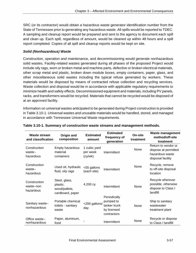
Chapter 3 – Affected Environment and Environmental Consequences
Final Environmental Assessment 3-57
SRC (or its contractor) would obtain a hazardous waste generator identification number from the State of Tennessee prior to generating any hazardous waste. All spills would be reported to TDEC. A sampling and cleanup report would be prepared and sent to the agency to document each spill and clean up. Each spill, regardless of amount, would be cleaned up within 48 hours and a spill report completed. Copies of all spill and cleanup reports would be kept on site.
Solid (Nonhazardous) Waste
Construction, operation and maintenance, and decommissioning would generate nonhazardous solid wastes. Facility-related wastes generated during all phases of the proposed Project would include oily rags, worn or broken metal and machine parts, defective or broken electrical materials, other scrap metal and plastic, broken down module boxes, empty containers, paper, glass, and other miscellaneous solid wastes including the typical refuse generated by workers. These materials would be disposed by means of contracted refuse collection and recycling services. Waste collection and disposal would be in accordance with applicable regulatory requirements to minimize health and safety effects. Decommissioned equipment and materials, including PV panels, racks, and transformers would be recycled. Materials that cannot be recycled would be disposed of at an approved facility.
Information on universal wastes anticipated to be generated during Project construction is provided in Table 3.10-1. Universal wastes and unusable materials would be handled, stored, and managed in accordance with Tennessee Universal Waste requirements.
Table 3.10-1. Summary of construction waste streams and management methods.
Waste stream and classification
Origin and composition
Estimated amount
Estimated frequency ofgeneration
On-site treatment
Waste managementmethod/off-site
treatment
Construction waste–hazardous
Empty hazardous material containers
1 cubic yard per week (cy/wk)
Intermittent None
Return to vendor or dispose at permitted hazardous waste disposal facility
Construction waste–hazardous
Used oil, hydraulic fluid, oily rags
<55 gallons (each site) Intermittent
None
Recycle, remove to off-site disposal location
Construction waste–non hazardous
Steel, glass, plastic, wood/pallets, cardboard, paper
4,200 cy Intermittent None
Recycle wherever possible, otherwise dispose to Class I landfill
Sanitary waste–nonhazardous
Portable chemical toilets - sanitary waste
<200 gallons/day
Periodically pumped to tanker truck by licensed contractors
None Ship to sanitary wastewater treatment plant
Office waste–nonhazardous
Paper, aluminum, food -
Intermittent None Recycle or dispose to Class I landfill
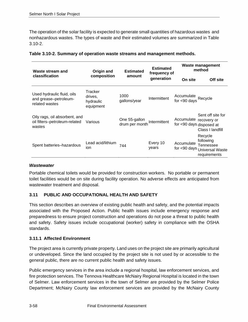
Selmer North I Solar Project
3-58 Final Environmental Assessment
The operation of the solar facility is expected to generate small quantities of hazardous wastes and nonhazardous wastes. The types of waste and their estimated volumes are summarized in Table 3.10-2.
Table 3.10-2. Summary of operation waste streams and management methods.
Waste stream and classification
Origin and composition
Estimated amount
Estimated frequency ofgeneration
Waste management method
On site Off site
Used hydraulic fluid, oils and grease–petroleum-related wastes
Tracker drives, hydraulic equipment
1000 gallons/year Intermittent Accumulate
for <90 days Recycle
Oily rags, oil absorbent, and oil filters–petroleum-related wastes
Various One 55-gallon drum per month
Intermittent Accumulate for <90 days
Sent off site for recovery or disposed at Class I landfill
Spent batteries–hazardous Lead acid/lithium ion 744 Every 10
years Accumulate for <90 days
Recycle following Tennessee Universal Waste requirements
Wastewater
Portable chemical toilets would be provided for construction workers. No portable or permanent toilet facilities would be on site during facility operation. No adverse effects are anticipated from wastewater treatment and disposal.
3.11 PUBLIC AND OCCUPATIONAL HEALTH AND SAFETY
This section describes an overview of existing public health and safety, and the potential impacts associated with the Proposed Action. Public health issues include emergency response and preparedness to ensure project construction and operations do not pose a threat to public health and safety. Safety issues include occupational (worker) safety in compliance with the OSHA standards.
3.11.1 Affected Environment
The project area is currently private property. Land uses on the project site are primarily agricultural or undeveloped. Since the land occupied by the project site is not used by or accessible to the general public, there are no current public health and safety issues.
Public emergency services in the area include a regional hospital, law enforcement services, and fire protection services. The Tennova Healthcare McNairy Regional Hospital is located in the town of Selmer. Law enforcement services in the town of Selmer are provided by the Selmer Police Department; McNairy County law enforcement services are provided by the McNairy County
Chapter 3 – Affected Environment and Environmental Consequences
Final Environmental Assessment 3-59
Sheriff’s Department. Both the police department headquarters and the Sheriff’s office are located in Selmer. Fire protection services are provided by the McNairy County Fire Department and the Selmer Fire Department. The nearest fire station to the project site is located in Selmer on Industrial Park Road, approximately 3.5 miles and 6 minutes from the project site. The Tennessee Emergency Management Agency has the responsibility and authority to coordinate with state and local agencies in the event of a release of hazardous materials in association with project activities.
3.11.2 Environmental Consequences
This section describes the potential impacts to public safety should the Proposed Action be implemented.
3.11.2.1 No Action Alternative
Under the No Action Alternative, the proposed solar facility would not be constructed; therefore, no project related impacts on public health and safety would result. Existing land use would be expected to remain a mix of farmland and unused land and existing public health and safety issues would be expected to remain as they are at present.
3.11.2.2 Proposed Action Alternative
Workers at the proposed solar facility would have an increased safety risk associated with the construction activities. However, because construction work has known hazards, standard practice is for contractors to establish and maintain health and safety plans in compliance with OSHA regulations. Such health and safety plans emphasize BMPs for site safety management to minimize potential risks to workers. Examples of best practices include employee safety orientations; establishment of work procedures and programs for site activities; use of equipment guards, emergency shutdown procedures, lockout procedures, site housekeeping, personal protective equipment; regular safety inspections; and plans and procedures to identify and resolve hazards.
Potential public health and safety hazards could result in association with the flow of construction traffic along the public roadways. Adjacent residences located along TN 142 near the project site, which would be used by construction traffic to access the project site would see increased commercial and industrial traffic. Awareness of these residences and establishment of traffic procedures to minimize potential safety concerns should be addressed in the health and safety plans established and followed by the construction team.
Minimal amounts of fuel for construction vehicles would be kept on site during construction of each solar facility. BMPs would be implemented to minimize the potential of a spill and to instruct on-site workers on how to contain and clean up any potential spills. The project site would be surrounded by security fencing during both construction and operational phases and access gates would normally remain locked. General public health and safety would not be at risk in the event of an accidental spill on site.
Emergency response for the project site would be provided by the local, regional, and state law enforcement, fire, and emergency responders described in Section 3.11.1.
Selmer North I Solar Project
3-60 Final Environmental Assessment
No public health or safety hazards would be anticipated as a result of operations. Overall, impacts to public health and safety in association with implementation of the Proposed Action would be considered temporary and minor.
3.12 TRANSPORTATION
This section describes an overview of existing transportation resources, and the potential impacts on these transportation resources that would be associated with the Proposed Action and No Action Alternative. Components of transportation resources that are analyzed include roads, traffic, railroads and airports.
3.12.1 Affected Environment
3.12.1.1 Roads
The project site is just over 1 mile from the intersection of TN 142 and US 45. TN 142 is a two-lane paved road that follows along most of the northern property boundary and terminates west at US 45 (Figures 2 and 6). From its intersection with TN 142, US 45 provides direct access into the town of Selmer. TN 142 provides access east to the town of Stantonville, approximately 7 miles east of the project site. No public roads are present within the project site; gravel and dirt roads on site provide vehicular access to the agricultural fields.
3.12.1.2 Traffic
Existing traffic volumes were determined using Average Annual Daily Traffic (AADT) counts measured at existing Tennessee Department of Transportation (TDOT) stations. The 2014 AADT for TN 142 approximately 1 mile west of the project site and a short distance east of US 45 was 2,810 vehicles measured at station 037. Approximately 7 miles east of the site and close to Stantonville, the 2014 AADT was 1,236 vehicles at station 075. (TDOT 2016). The county roads around the project site support levels of traffic relatively typical for rural Tennessee.
3.12.1.3 Rail and Air Traffic
No rail lines are operating within 3 miles of the project site.
The closest major airport is the Memphis International Airport, in Memphis, Tennessee, approximately 100 miles west of the project area. The closest regional airport is the Robert Sibley Airport located east of Selmer in McNairy County, approximately 5 miles northeast of the project site. The airport consists of two runways, running 165 degrees and 345 degrees North. Direct approaches should not lead planes over the project site (Robert Sibley Airport 2015).
3.12.2 Environmental Consequences
This section describes the potential impacts to transportation resources should the Proposed Action be implemented.
Chapter 3 – Affected Environment and Environmental Consequences
Final Environmental Assessment 3-61
3.12.2.1 No Action Alternative
Under the No Action Alternative, the proposed solar facility would not be constructed. Therefore, no project related impacts on transportation resources would result. Existing land use would be expected to remain a mix of farmland and unused land and the existing transportation network and traffic conditions would be expected to remain as they are at present.
3.12.2.2 Proposed Action Alternative
The construction and operation of the proposed solar facility would have no effect on operation of the airports in the region. The operation of the solar facility would not affect commercial air passenger or freight traffic in the region and would not adversely affect any crop dusters operating in the vicinity of the project area.
During construction of the proposed solar facility, an average crew of approximately 100 with a maximum of 150 workers would be present at the project site from approximately 7 am to 6:30 pm, 7 days a week, for approximately 4 to 6 months. A majority of these workers would likely come from the local or regional area. The other workers would come from outside the region and many would likely stay in local hotels in Selmer. Workers would either drive their own vehicles or carpool to the project site. Parking would be on site during the day. Some of the work teams would likely visit local restaurants and businesses during working hours. Additional traffic due to deliveries and waste removal would consist of a maximum of approximately 15 vehicles per day during construction.
Traffic flow around the work site would, therefore, be heaviest at the beginning of the work day, at lunch, and at the end of the work day. Deliveries and most workers would access the project site from the west on TN 142. No major industries are located along TN 142 and a limited number of residences are present alongside the road in the vicinity of the project site. Some traffic to McNairy Central High School likely travels TN 142 to High School Road, which intersects TN 142 near the main access road to the solar facility. The majority of traffic to the school is likely from US 64 north of the school. Should traffic flow be a problem, SRC would consider staggered work shifts to space out the flow of traffic to and from the project site. SRC would also consider posting a flag person during the heavy commute periods to manage traffic flow and to prioritize access for local residents. Use of such mitigation measures would minimize potential adverse impacts to traffic and transportation to less than significant levels.
Construction equipment and material delivery would require approximately 15 semitractor trailer trucks or other large vehicles visiting each project site per day during the construction periods. The project site can both be accessed via routes which do not have load restrictions. These vehicles should be easily accommodated by existing roadways; therefore, only minor impacts to transportation resources in the local area would be anticipated as a result of construction vehicle activity.
Several on-site maintenance access roads would be maintained on the project site. Following construction, the gravel roads would be maintained to allow periodic access for site inspection and maintenance. They would be closed to through traffic.
Selmer North I Solar Project
3-62 Final Environmental Assessment
Due to the project area’s proximity to the town of Selmer, possible minor traffic impacts along US 45 through the town of Selmer could occur as workers could potentially commute from Selmer. However, the proposed workforce would consist of a maximum of 150 employees for only part of the construction period, therefore, the addition of these vehicles to the existing traffic on TN 15 would be considered minor.
The solar facility is not manned during operation; however maintenance is required biannually and for equipment failures and would require minimal personnel. Therefore, the operation of the solar facility would not have a noticeable impact on the local roadways.
Overall, direct impacts to transportation resources associated with implementation of the Proposed Action would be anticipated to be minor and mitigated. The Proposed Action would not result in any indirect impacts to transportation.
3.13 SOCIOECONOMICS
This section describes an overview of existing socioeconomic conditions within the project area and the potential impacts that would be associated with the Proposed Action and No Action Alternative. Components of socioeconomic resources that are analyzed include population, employment, and income.
3.13.1 Affected Environment
The proposed project area is located in the central portion of McNairy County, Tennessee approximately 4 miles west and 3 miles southeast of the town of Selmer. The project area falls within Census Tracts (CT) 9305 and 9306 for socioeconomic resources (Figure 14).
3.13.1.1 Population
The population of McNairy County, as reported in the 2010 US Census of Population, is 26,075 and 4,396 of whom live in the town of Selmer (US Census Bureau [USCB] 2010). As projected by the State of Tennessee, the population of McNairy County would be about 27,412 by 2030 (USCB 2005). CT 9305, which contains the northern half of the project site and Selmer, has a population of 7,788. CT 9306 contains the southern half of the project site and has a population of 3,785 (USCB 2010). Population trends and projections are presented in Table 3.13-1.
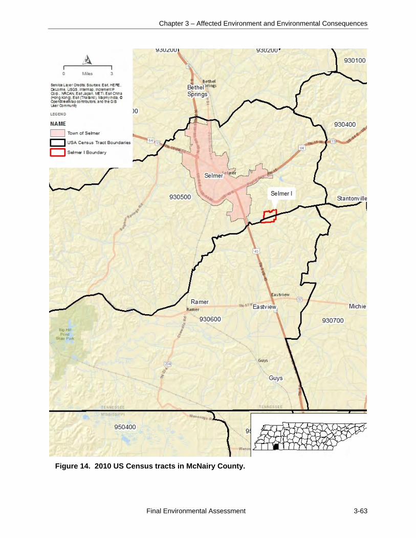
Chapter 3 – Affected Environment and Environmental Consequences
Final Environmental Assessment 3-63
Figure 14. 2010 US Census tracts in McNairy County.
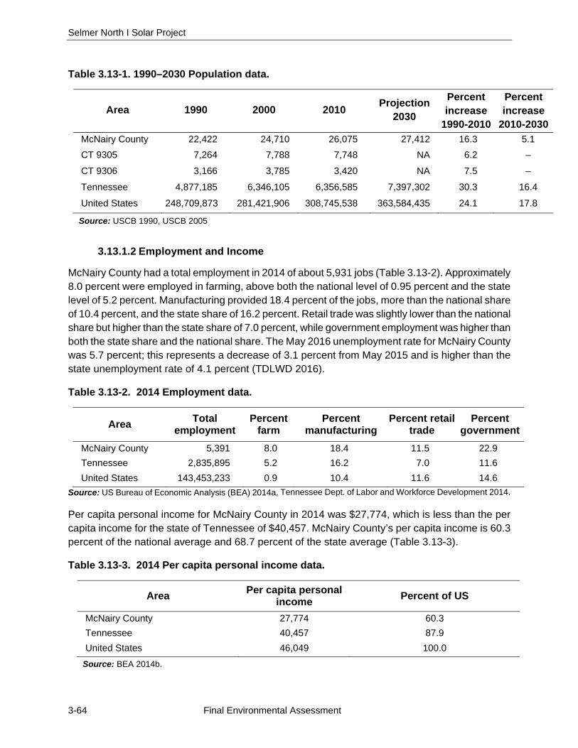
Selmer North I Solar Project
3-64 Final Environmental Assessment
Table 3.13-1. 1990–2030 Population data.
Area 1990 2000 2010 Projection
2030
Percent increase
1990-2010
Percent increase
2010-2030
McNairy County 22,422 24,710 26,075 27,412 16.3 5.1
CT 9305 7,264 7,788 7,748 NA 6.2 –
CT 9306 3,166 3,785 3,420 NA 7.5 –
Tennessee 4,877,185 6,346,105 6,356,585 7,397,302 30.3 16.4
United States 248,709,873 281,421,906 308,745,538 363,584,435 24.1 17.8
Source: USCB 1990, USCB 2005
3.13.1.2 Employment and Income
McNairy County had a total employment in 2014 of about 5,931 jobs (Table 3.13-2). Approximately 8.0 percent were employed in farming, above both the national level of 0.95 percent and the state level of 5.2 percent. Manufacturing provided 18.4 percent of the jobs, more than the national share of 10.4 percent, and the state share of 16.2 percent. Retail trade was slightly lower than the national share but higher than the state share of 7.0 percent, while government employment was higher than both the state share and the national share. The May 2016 unemployment rate for McNairy County was 5.7 percent; this represents a decrease of 3.1 percent from May 2015 and is higher than the state unemployment rate of 4.1 percent (TDLWD 2016).
Table 3.13-2. 2014 Employment data.
Area Total employment
Percent farm
Percent manufacturing
Percent retail trade
Percent government
McNairy County 5,391 8.0 18.4 11.5 22.9
Tennessee 2,835,895 5.2 16.2 7.0 11.6
United States 143,453,233 0.9 10.4 11.6 14.6
Source: US Bureau of Economic Analysis (BEA) 2014a, Tennessee Dept. of Labor and Workforce Development 2014.
Per capita personal income for McNairy County in 2014 was $27,774, which is less than the per capita income for the state of Tennessee of $40,457. McNairy County’s per capita income is 60.3 percent of the national average and 68.7 percent of the state average (Table 3.13-3).
Table 3.13-3. 2014 Per capita personal income data.
Area Per capita personal income Percent of US
McNairy County 27,774 60.3
Tennessee 40,457 87.9
United States 46,049 100.0
Source: BEA 2014b.

Chapter 3 – Affected Environment and Environmental Consequences
Final Environmental Assessment 3-65
3.13.2 Environmental Consequences
This section describes the potential impacts to socioeconomic resources should the Proposed Action or No Action Alternative be implemented. Social and economic issues considered for evaluation within the impact area include change to current and projected population levels, change in expenditures for goods and services, and short-term or long-term impacts on employment and income.
3.13.2.1 No Action Alternative
Under the No Action Alternative, the proposed solar facility would not be constructed; therefore, no short-term beneficial socioeconomic impacts from the proposed project would occur. Existing land use would be expected to remain a mix of farmland and unused land and existing socioeconomic conditions would be expected to remain as they are at present.
3.13.2.2 Proposed Action Alternative
Under the Proposed Action, a new solar facility would be built in the project area. Construction activities at the project site would take approximately 4 to 6 months to complete with an average crew of 100 to 150 workers at the site during the peak of construction. Workers would include a mix of general laborers, electrical technicians, and journeyman-level electricians. Work would generally occur 7 days a week from 7 am to 6:30 pm. Short-term beneficial economic impacts would result from construction activities associated with the project, including the purchase of materials, equipment, and services and a temporary increase in employment and income. This increase would be local or regional, depending on where the goods, services, and workers were obtained. It is likely some construction materials and services would be purchased locally in the McNairy County area, as well as in adjacent counties. Also, the majority of the construction workforce would likely be from local or regional sources. A small portion of the workforce would come from out-of-state. The direct impact to the economy associated with construction would be short-term and beneficial.
The majority of the indirect employment and income impacts would be from expenditure of the wages earned by the workforce involved in construction activities, as well as the local workforce used to provide materials and services. Construction of the proposed facility could have minor beneficial indirect impacts to population and short-term employment and income levels in McNairy County and the town of Selmer.
During operation of the solar facility, a temporary workforce of six to eight employees would be on site for mowing the site every 2 to 3 months. One to two people would also be on site during biannual inspections of the solar facility. Grounds maintenance and some other operation and maintenance activities would be conducted by local contractors. Therefore, operations of the solar facility would have a small positive impact on employment in McNairy County.
Overall, socioeconomic impacts for the operation of the proposed solar facility would be positive and long-term, although small relative to the total economy of the region. The local tax base would increase from construction of the solar facility and would be most beneficial to the McNairy County area. Additionally, the local governments (McNairy County and Town of Selmer) would not have to
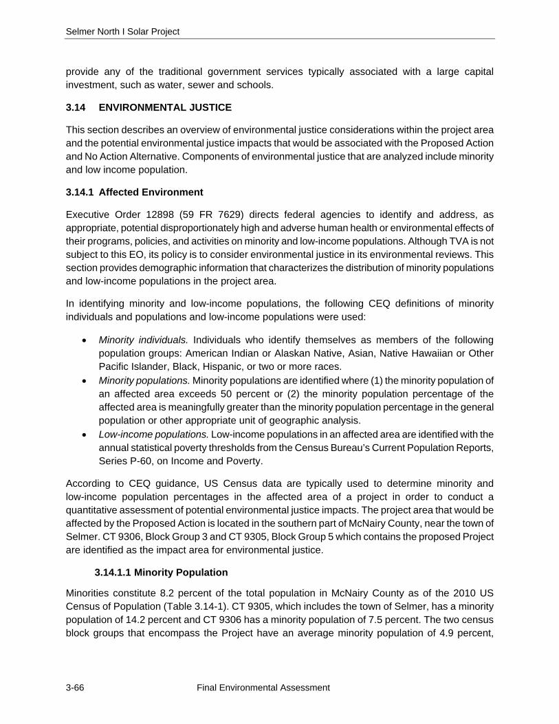
Selmer North I Solar Project
3-66 Final Environmental Assessment
provide any of the traditional government services typically associated with a large capital investment, such as water, sewer and schools.
3.14 ENVIRONMENTAL JUSTICE
This section describes an overview of environmental justice considerations within the project area and the potential environmental justice impacts that would be associated with the Proposed Action and No Action Alternative. Components of environmental justice that are analyzed include minority and low income population.
3.14.1 Affected Environment
Executive Order 12898 (59 FR 7629) directs federal agencies to identify and address, as appropriate, potential disproportionately high and adverse human health or environmental effects of their programs, policies, and activities on minority and low-income populations. Although TVA is not subject to this EO, its policy is to consider environmental justice in its environmental reviews. This section provides demographic information that characterizes the distribution of minority populations and low-income populations in the project area.
In identifying minority and low-income populations, the following CEQ definitions of minority individuals and populations and low-income populations were used:
Minority individuals. Individuals who identify themselves as members of the following population groups: American Indian or Alaskan Native, Asian, Native Hawaiian or Other Pacific Islander, Black, Hispanic, or two or more races.
Minority populations. Minority populations are identified where (1) the minority population of an affected area exceeds 50 percent or (2) the minority population percentage of the affected area is meaningfully greater than the minority population percentage in the general population or other appropriate unit of geographic analysis.
Low-income populations. Low-income populations in an affected area are identified with the annual statistical poverty thresholds from the Census Bureau’s Current Population Reports, Series P-60, on Income and Poverty.
According to CEQ guidance, US Census data are typically used to determine minority and low-income population percentages in the affected area of a project in order to conduct a quantitative assessment of potential environmental justice impacts. The project area that would be affected by the Proposed Action is located in the southern part of McNairy County, near the town of Selmer. CT 9306, Block Group 3 and CT 9305, Block Group 5 which contains the proposed Project are identified as the impact area for environmental justice.
3.14.1.1 Minority Population
Minorities constitute 8.2 percent of the total population in McNairy County as of the 2010 US Census of Population (Table 3.14-1). CT 9305, which includes the town of Selmer, has a minority population of 14.2 percent and CT 9306 has a minority population of 7.5 percent. The two census block groups that encompass the Project have an average minority population of 4.9 percent,
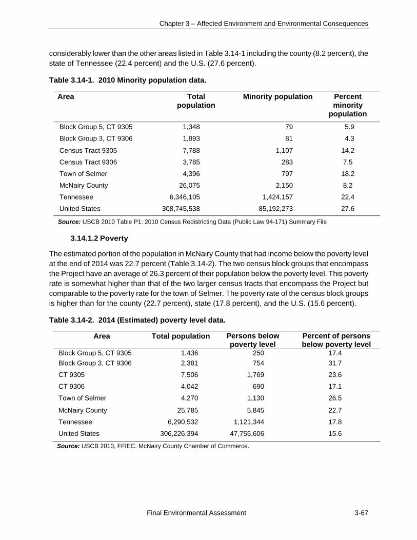
Chapter 3 – Affected Environment and Environmental Consequences
Final Environmental Assessment 3-67
considerably lower than the other areas listed in Table 3.14-1 including the county (8.2 percent), the state of Tennessee (22.4 percent) and the U.S. (27.6 percent).
Table 3.14-1. 2010 Minority population data.
Area Total population
Minority population Percent minority
population
Block Group 5, CT 9305 1,348 79 5.9
Block Group 3, CT 9306 1,893 81 4.3
Census Tract 9305 7,788 1,107 14.2
Census Tract 9306 3,785 283 7.5
Town of Selmer 4,396 797 18.2
McNairy County 26,075 2,150 8.2
Tennessee 6,346,105 1,424,157 22.4
United States 308,745,538 85,192,273 27.6
Source: USCB 2010 Table P1: 2010 Census Redistricting Data (Public Law 94-171) Summary File
3.14.1.2 Poverty
The estimated portion of the population in McNairy County that had income below the poverty level at the end of 2014 was 22.7 percent (Table 3.14-2). The two census block groups that encompass the Project have an average of 26.3 percent of their population below the poverty level. This poverty rate is somewhat higher than that of the two larger census tracts that encompass the Project but comparable to the poverty rate for the town of Selmer. The poverty rate of the census block groups is higher than for the county (22.7 percent), state (17.8 percent), and the U.S. (15.6 percent).
Table 3.14-2. 2014 (Estimated) poverty level data.
Area Total population Persons below poverty level
Percent of persons below poverty level
Block Group 5, CT 9305 1,436 250 17.4
Block Group 3, CT 9306 2,381 754 31.7
CT 9305 7,506 1,769 23.6
CT 9306 4,042 690 17.1
Town of Selmer 4,270 1,130 26.5
McNairy County 25,785 5,845 22.7
Tennessee 6,290,532 1,121,344 17.8
United States 306,226,394 47,755,606 15.6
Source: USCB 2010, FFIEC. McNairy County Chamber of Commerce.
Selmer North I Solar Project
3-68 Final Environmental Assessment
3.14.2 Environmental Consequences
This section describes the potential environmental justice impacts should the Proposed Action or No Action Alternative be implemented. Executive Order 12898 (59 FR 7629) directs federal agencies to identify and address, as appropriate, potential disproportionately high and adverse human health or environmental impacts on minority and low-income populations. According to the CEQ, adverse health effects to be evaluated within the context of environmental justice impacts may include bodily impairment, infirmity, illness, or death. Environmental effects may include ecological, cultural, human health, economic, or social impacts. Disproportionately high and adverse human health or environmental effects occur when the risk or rate of exposure to an environmental hazard or an impact or risk of an impact on the natural or physical environment for a minority or low-income population is high and appreciably exceeds the impact level for the general population or for another appropriate comparison group (CEQ 1997).
3.14.2.1 No Action Alternative
Under the No Action Alternative, there would be no changes to the project area attributable to the Proposed Action and therefore no disproportionately high and adverse direct or indirect impacts on minority or low-income populations.
3.14.2.2 Proposed Action Alternative
Based on the analysis presented in Section 3.14.1, residents of the census tracts containing the project site are not considered a minority population but can be considered a low-income community. Based on the analysis of impacts for all resource areas presented in this EA, it was determined that there would be no significant adverse health impacts on members of the public or significant adverse environmental impacts on the physical environment (water, air, aquatic, and terrestrial resources) and socioeconomic conditions. Therefore, there would be no disproportionately high or any adverse direct or indirect impacts on minority or low-income populations due to human health or environmental effects resulting from the Proposed Action.
Chapter 4 – Cumulative Impacts
Final Environmental Assessment 4-1
CHAPTER 4
4.0 CUMULATIVE IMPACTS
Cumulative impacts are defined as the effects of the Proposed Action when considered together with other past, present, and reasonably foreseeable future actions. Chapter 3, Affected Environment and Environmental Consequences, presents information about past and present environmental conditions, as well as future trends, where appropriate. This chapter addresses the cumulative impacts of the Project and any reasonably foreseeable action in the vicinity.
Desktop research of potential past, present, and future actions in the McNairy County, Tennessee area was conducted. Resources examined included:
Local and regional news sources;
Town of Selmer government website records, including planning commission meetings, city meeting minutes, and public notices; and
Chamber of Commerce websites and meeting minutes.
TDOT website
The proposed Project would result in minor direct impacts to land use, water resources, geological resources and farmlands, visual resources, noise, and air quality.
4.1 FEDERAL PROJECTS
This section addresses other projects with possible land use, water resources, visual, geological resources and farmlands, noise, and air quality impacts. Four federal projects are in the vicinity of the project area. The first is the US 64/State Route 15 project, which is part of the National Highway System. The TDOT roadway widening project stretches across ten southern Tennessee counties between Memphis and I-24, spanning over 260 miles and was separated into multiple projects. US 64 crosses through the town of Selmer and is approximately 1.5 miles north of the project site. The roadway improvements have been completed in four counties, including McNairy County near the project area (TDOT 2016).
The other three projects are solar farms. Two 20-MW solar farms are currently operating in the area: Selmer Solar Farm, located about 2 miles east of the project site and about 2 miles south of the town of Selmer, and Mulberry Solar Farm, located on the north side of TN 142, less than 0.5 mile from the entrance to the Selmer I project site and 1.7 miles southeast of the town of Selmer. Both facilities were constructed by Strata Solar and began operating in late 2014. Strata Solar subsequently sold the facilities to Dominion for operation. The Mulberry and Selmer solar farms produce 30,000 MW-hours of electricity a year which TVA purchases under the terms of a 20-year PPA. The potential environmental impacts of constructing and operating these two solar farms is the subject of the 2013 EA issued by TVA (TVA 2013).
SRC proposes to construct the 10-MW Selmer II Solar Project on a 117-acre site approximately 4.5 miles northwest of the Selmer I site and approximately 1.5 miles west of the town of Selmer. The
Selmer North I Solar Project
4-2 Final Environmental Assessment
proposed Selmer II facility would be developed on currently undeveloped land composed of mostly pine plantation. This PV solar facility would be very similar to the Selmer I facility. The potential environmental impacts of constructing and operating the proposed Selmer II facility is currently being evaluated and expected to be generally similar to those of the Selmer II facility. Construction of the Selmer II facility is scheduled to begin in 2016. TVA would purchase the electricity generated from the facility under the terms of a 20-year PPA.
In addition to these projects, a new 161-kV TVA transmission line and 161-kV substation are being constructed in the area. The new transmission line is located on the southern portion of the 231-acre Selmer I project site, south of Oxford Creek. The purpose and need for the new transmission line and substation are independent of the Selmer I Project and the transmission project was planned before TVA received the proposal to purchase power from the Selmer I Project. Construction of the transmission project began in fall 2015 and the transmission facilities are expected to be in service in 2016 (TVA 2015c). The transmission project consists of a new substation and 161-kV transmission line, including:
A new West Adamsville switching station that would be located east of the Pickwick Hydro Plant-South Jackson 161-kV Transmission Line.
A new 15-mile transmission line that would connect the existing Selmer 161-kV Substation to the proposed West Adamsville Switching Station.
Two proposed 161-kV lines that would also tie into the new switching station – the Henderson-West Adamsville transmission line and the West Adamsville-Pickwick 161-kV transmission line.
TVA considered several alternative routes from a network of 21 alternative transmission line segments. The line would be built on steel pole structures centered on a 100-foot-wide right-of-way, but some of the routes share right-of-way with existing lines. Three alternative locations were considered for the switching station, which would be located east of the Pickwick Hydro Plant-South Jackson 161-kV Transmission line near TN 64 (TVA 2015c).
Transmission line construction is affecting the Project area as some of the construction activities are occurring within the 231-acre Selmer I project site; however the impacts of transmission line construction are not expected to result in adverse cumulative impacts.
These current and proposed projects have the potential to contribute to cumulative impacts on land use in the area. The solar farms would change the land use in the area from agricultural, undeveloped, and pine plantation to industrial. The development of solar energy in McNairy County is bringing a new industry around the town of Selmer. Owners of cotton fields, pine plantations, and other agricultural areas are offered potentially new uses that can help offset losses due to falling crop prices. The construction and maintenance of the solar farms would bring jobs and business to the area.
4.2 STATE AND LOCAL PROJECTS
No state or locally funded projects are in the vicinity of the project area with the potential to contribute to cumulative impacts associated with the Proposed Action.
Chapter 5 – Preparers
Final Environmental Assessment 5-1
CHAPTER 5
5.0 LIST OF PREPARERS
Table 5-1 summarizes the expertise and contribution made to the EA by the Project Team.
Table 5-1. Environmental Assessment project team
Name/Education Experience Project role
TVA
Charles P. Nicholson Ph.D., Ecology and Evolutionary Biology; M.S., Wildlife Management; B.S., Wildlife and Fisheries Science
36 years in zoology, endangered species studies, and NEPA compliance
NEPA Compliance and Document Preparation
W. Richard Yarnell B.S., Environmental Health
40 years in cultural resource management
Section 106 cultural resource compliance
Stephen C. Cole Ph.D., Anthropology; M.A. Anthropology; B.A. Anthropology
14 years in cultural resource management, 4 years teaching anthropology at university
Cultural resources, NHPA Section 106 compliance
HDR
Renee Mulholland B.S., Marine Science; Masters of Earth and Environmental Resource Management (MEERM)
11 years in regulatory compliance, permitting, and NEPA documentation and project management
NEPA Project Manager, Document Preparation/Coordination and Document QA/QC
Benjamin Burdette, EIT M.S., Environmental Engineering
1 year in NEPA coordination and document preparation at the EIS level
Environmental Planner, Document Preparation, GIS mapping, field work
Jason McMaster, PWS B.S., Business Administration; M.S., Environmental Science; M.A., Biology
8 years in combined regulatory compliance, preparation of environmental review documents, and project management
Environmental Scientist, Document Preparation
Harriet Richardson Seacat M.A. Anthropology
15 years conducting anthropological research relating to NHPA and NEPA compliance
Senior Ethnographer, Document Preparation/Cultural Resources

Selmer North I Solar Project
5-2 Final Environmental Assessment
Name/Education Experience Project role Blair Goodman Wade, ENV SP B.S., M.E.M.
11 years in regulatory compliance, NEPA documentation, and mitigation planning
Sr. Environmental Planner, Document QA/QC
Chapter 6 – References
Final Environmental Assessment 6-1
CHAPTER 6
6.0 REFERENCES
Anderson, David G., John E. Foss, Patrick H. Garrow, and Keith McRae. 1987Archaeological Survey Along the Obion River. Garrow & Associates, Inc., Atlanta, Georgia. Report submitted to U.S. Army Corps of Engineers, Memphis District, Memphis, Tennessee.
Bauch, Linda M. 1972. Tennessee Historical Markers. Tennessee Historical Commission, Nashville, Tennessee.
Blitz, John H.1988. Adoption of the Bow in Prehistoric North America. North American Archaeologist 9: 123-145.
Breitburg, Emanuel, and John B. Broster. 1995. A Hunt For Big Game. The Tennessee Conservationist Vol. LXI, No. 4.
Brister, R.C., J. Armon, and D.H. Dye. 1981. American Mastodon Remains and Late Glacial Conditions at Nonconnah Creek, Memphis, Tennessee. Memphis State University Anthropological Research Center Occasional Paper No. 10.
Bureau of Economic Analysis (BEA). 2014a. Regional Data. U.S. Dept. of Commerce. Accessed on 01/19/16 at: http://www.bea.gov/iTable/iTable.cfm?reqid=70&step=1&isuri=1&acrdn=2#reqid=70&step=10&isuri=1&7003=200&7035=-1&7004=naics&7005=-1&7006=47000&7036=-1&7001=1200&7002=1&7090=70&7007=2014&7093=levels.
_____. 2014b. Local Area Personal Income. U.S. Dept. of Commerce. Accessed on 01/21/16 at: http://www.bea.gov/newsreleases/regional/lapi/2015/pdf/lapi1115.pdf.
Childress, Mitchell R. 1993. Archaeological Survey and Testing in Northwestern Tennessee: Crockett, Dyer, Gibson, Haywood, Lake, Lauderdale, and Weakley Counties. Garrow and Associates, Inc., Memphis, TN. Submitted to the U.S. Army Corps of Engineers, Memphis District, Memphis, TN.
Childress, Mitchell R., and Camille Wharey. 1996. Unit 4 Mound Excavations at the Chucalissa Site, 1960-1970. In Mounds, Embankments, and Ceremonialism in the Mid-South, edited by R.C. Mainfort and Rick Walling, pp. 64-77. Arkansas Archaeological Survey Research Series No. 46, Fayetteville.
City Data.com. 2015. Selmer, Tennessee (TN) profile. Accessed on 01/14/2016 at: http://www.city-data.com/city/Selmer-Tennessee.html
Connelly, Thomas L. 1979. Civil War Tennessee: Battles and Leaders. University of Tennessee Press, Knoxville, Tennessee.
Coon Creek Science Center. The Fossils of Coon Creek 2007. Accessed on 01/14/2016 at: http://www.memphismuseums.org/layout_files/uploads/files/Coon%20Creek%20book%201st%20Half%20draft%20final.pdf
Selmer North I Solar Project
6-2 Final Environmental Assessment
Council on Environmental Quality (CEQ). 1997. Environmental Justice Guidance Under the National Environmental Policy Act. Available at: http://www3.epa.gov/environmentaljustice/resources/policy/ej_guidance_nepa_ceq1297.pdf
Federal Financial Institutions Examination Council (FFIEC) Census Reports. 2016. Accessed on 01/19/2016 at: http://www.ffiec.gov/census/report.aspx?year=2000&state=47&msa=&county=109&tract=9906.00&report=population
Federal Register. 2014. Endangered and Threatened Wildlife and Plants; Designation of Critical Habitat for Physaria globosa (Short's bladderpod), Helianthus verticillatus (whorled sunflower), and Leavenworthia crassa (fleshy-fruit gladecress). Accessed on 01/12/2016 at: https://www.federalregister.gov/articles/2014/08/26/2014-19558/endangered-and-threatened-wildlife-and-plants-designation-of-critical-habitat-for-physaria-globosa
Federal Emergency Management Agency (FEMA). FEMA Flood Map Service Center. 2008. Accessed on 12/31/2015 at: https://msc.fema.gov/portal
_____. 2015. Executive Order 11988: Floodplain Management. Accessed on 01/21/2016 at: http://www.fema.gov/executive-order-11988-floodplain-management.
Franz, David M. and W. Michael Reynolds. 2016. Phase I Cultural Resources Survey of the Selmer I and Selmer II Solar Tracts McNairy County, Tennessee. Prepared by Brockington and Associates, Inc., Norcross, Georgia for HDR Engineering, Charlotte, North Carolina on behalf of Silicon Ranch Corporation Nashville, Tennessee.
Freeman, Kirk. 2013. A Phase I Cultural Resource Survey of 216.25 acres at the Mulberry Farm Site and 220 03 acres at the Selmer Farm site near Selmer. McNairy County, Tennessee. Prepared by AECOM, Greenville, South Carolina, for Strata Solar Power, LLC and Tennessee Valley Authority, Knoxville, Tennessee.
Griffith, G.E., J.M. Omernik, and S.H. Azevedo. 1998. Ecoregions of Tennessee. (2 sided color poster with map, descriptive text, summary tables, and photographs). U.S. Geological Survey, Reston, VA. Scale 1:940,000. http://archive.epa.gov/wed/ecoregions/web/html/tn_eco.html
Henry, Robert Selph. 1991. Forrest: First with the Most. Broadfoot Publishing Company, Wilmington, North Carolina.
Hunter, John A. Mocas, Stephen T. 2014. Phase I Archaeological Survey, West Adamsville Switching Station and Selmer – W. Adamsville Transmission Line, McNairy Count, Tennessee. Prepared by AMEC, Lexington, Kentucky, for Tennessee Valley Authority, Knoxville, Tennessee.
International Union for Conservation of Nature. 2010. Fallicambarus hortoni. Accessed on 01/04/2016 at: http://www.iucnredlist.org/details/8493/0
Chapter 6 – References
Final Environmental Assessment 6-3
Jennings, Jesse D. 1989. Prehistory of North America. Mayfield Publishing, Mountain View, California.
Kennedy, Nancy Wardlow. n.d. The Death Song of Purdy. Accessed on 01/12/2016 at: http://www.mcnairytnhistory.com/history.html
LandScope America. 2016. East Gulf Coastal Plain. Accessed on 01/14/2016 at: http://www.landscope.org/explore/natural_geographies/ecoregions/East%20Gulf%20Coastal%20Plain/
Lewis, Thomas, and Madeline K. Lewis. 1961. Eva: An Archaic Site. University of Tennessee Press, Knoxville, Tennessee.
Mainfort, Robert C., Jr. 1985. An Archaeological Survey of Selected Localities within the Obion-Forked Deer Drainage, West Tennessee. Tennessee Department of Conservation, Division of Archaeology, Nashville, TN. Submitted to the U.S. Army Corps of Engineers, Memphis District, Memphis, Tennessee.
McKenzie, Robert Tracy. 2001. Civil War and Socioeconomic Change in the Upper South: The Survival of Local Agricultural Elites in Tennessee, 1850-1870. In Tennessee History: The Land, the People, and the Culture, edited by Carroll Van West, second edition. University of Tennessee Press, Knoxville, Tennessee.
Native Fish Lab. A new crayfish of the genus Fallicambarus from Tennessee (Decapoda, Astacideae) 1970. Accessed 01/12/2016 at: http://www.nativefishlab.net/library/textpdf/20420.pdf4rf
NatureServe Explorer. 2016. Helianthus verticillatus. Accessed on 01/04/2016 at: http://explorer.natureserve.org/servlet/NatureServe?sourceTemplate=tabular_report.wmt&loadTemplate=species_RptComprehensive.wmt&selectedReport=RptComprehensive.wmt&summaryView=tabular_report.wmt&elKey=161308&paging=home&save=true&startIndex=1&nextStartIndex=1&reset=false&offPageSelectedElKey=161308&offPageSelectedElType=species&offPageYesNo=true&post_processes=&radiobutton=radiobutton&selectedIndexes=161308
Natural Resource Conservation Service (NRCS). 2016. Custom Soil Resource Report for McNairy County, Tennessee. Accessed on 01/08/2016 at: http://websoilsurvey.sc.egov.usda.gov/WssProduct/op434unqucgyjd4sogzabitp/GN_00000/20160115_10090710311_65_Soil_Report.pdf
Ornelas-Struve, Carole, and Frederick Lee Coulter. 1982. Memphis: 1800-1900, Vols. I-III. Nancy Powers & Company, New York, New York.
Peterson, Drexel A. 1975. Archaeological Evaluation of the Cypress Creek Watershed, McNairy County, Tennessee. Prepared by Memphis State University Anthropological Research Center for U.S. Department of Agriculture, Soil Conservation Service, Nashville, Tennessee.

Selmer North I Solar Project
6-4 Final Environmental Assessment
Purdue, A.H. 1916. State of Tennessee Geological Survey. Map available at the Tennessee State Library and Archives, Nashville, Tennessee.
Robert Sibley Airport. 2015.0Runway Information. Accessed on 01/05/2016 at: http://www.robertsibleyairport.com/runwayinfo.htm.
Sease, E.C., R.L. Flowers, W.C. Mangrum, and R.K. Moore. 1989. Soil Survey of Shelby County, Tennessee. U.S. Department of Agriculture, Soil Conservation Service, Washington D.C. (2nd printing).
Soil Series. 2002a. Hatchie Series. Accessed on 01/14/2016 at: https://soilseries.sc.egov.usda.gov/OSD_Docs/H/HATCHIE.html.
_____. 2002b. Ochlockonee Series. Accessed on 01/14/2016 at: https://soilseries.sc.egov.usda.gov/OSD_Docs/O/OCHLOCKONEE.html.
_____. 2002c. Guyton Series. Accessed on 01/14/2016 at: https://soilseries.sc.egov.usda.gov/OSD_Docs/G/GUYTON.html.
_____. 2002d. Iuka Series. Accessed on 01/15/2016 at: https://soilseries.sc.egov.usda.gov/OSD_Docs/I/IUKA.html.
_____. 2002e. Freeland Series. Accessed on 01/14/2016 at: https://soilseries.sc.egov.usda.gov/OSD_Docs/F/Freeland.html.
Smith, Gerald P. 1979. Archaeological Surveys in the Obion-Forked Deer and Reelfoot-Indian Creek Drainages: 1966 through early 1975. Anthropological Research Center Occasional Papers No. 9, Memphis State University, Memphis,TN.
Smith, Gerald P. 1991. The Archaic Period in the Mississippi Drainage of Western Tennessee. In The Archaic Period in the Mid South: Proceedings of the 1989 Mid-South Archaeological Conference, edited by Charles H. McNutt, pp.46-58. Mississippi Department of Archives and History Archaeological Report No. 24. Memphis State University, Anthropological Research Center Occasional Papers No. 16, Memphis, TN.
Smith, Sarah Frances. 1945. Post-Civil War Agriculture in West Tennessee. Unpublished Master’s thesis, Vanderbilt University, Nashville, TN.
Department of Economic and Community Development Local Planning Assistance Office. 2011. Status of Planning & Land Use Controls. Accessed on 12/22/2015 at: https://www.gnrc.org/wp-content/uploads/2011/12/status-complete-2011.pdf
Tennessee Department of Economic & Community Development. 2010. Floodplain Management in Tennessee. Accessed on 01/21/2016 at: https://www.tn.gov/assets/entities/ecd/attachments/NFIP_TN_Quick_Guide.pdf.
Chapter 6 – References
Final Environmental Assessment 6-5
Tennessee Department of Environment & Conservation (TDEC). Rare Species by County. Accessed on 01/03/2016 at: http://environment-online.state.tn.us:8080/pls/enf_reports/f?p=9014:3:0::NO
Tennessee Department of Labor and Workforce Development (TDLWD). 2014. Tennessee's Quarterly Census of Employment and Wages Annual Averages for 2014. (n.d.). Retrieved January 19, 2016, from https://www.jobs4tn.gov/admin/gsipub/htmlarea/uploads/QCEW2014.pdf
_____. 2016. May 2016 County Unemployment Rates. Accessed on 07/01/2016 at https://www.tn.gov/workforce/news/43314.
Tennessee Department of Transportation (TDOT). 2016. Traffic History. Accessed on 01/05/2016 at: https://www.tdot.tn.gov/APPLICATIONS/traffichistory
_____. 2016. US 64/State Route 15. Accessed on 01/14/2016 at: https://www.tn.gov/tdot/topic/us-64-sr-15
Thomas, David. 2014. Industry and Interest Growing in Selmer and Adamsville. Article published by the Jackson Sun Newspaper, Jackson, Tennessee, on 11 October, 2014.
Tioga Environmental Consultants. 2015. Phase I Environmental Site Assessment, Parcels 099 023.68 & 099 026.00, Selmer, McNairy County Tennessee, August 2015, Project No. 51625.00. Prepared for Pickering Firm, Inc.
Tennessee Valley Authority (TVA). 1983. Procedures for Compliance with the National Environmental Policy Act. Accessed on 02/23/2016 at: https://www.tva.gov/file_source/TVA/Site%20Content/Environment/Environmental%20Stewardship/Environmental%20Reviews/tvanepa_procedures.pdf.
_____. 2011. Integrated Resource Plan, TVA’s Environmental & Energy Future. Tennessee
Valley Authority, Chattanooga, Tennessee.
_____. 2013. Final Environmental Assessment: Strata Solar Farm Project, McNairy County, Tennessee. Tennessee Valley Authority, Knoxville, Tennessee.
_____. 2014. TVA Solar Photovoltaic Projects Final Programmatic Environmental Assessment: Alabama, Georgia, Kentucky, Mississippi, North Carolina, Tennessee, and Virginia. Available at: https://www.tva.com/Environment/Environmental-Stewardship/Environmental-Reviews/TVA-Solar-Photovoltaic-Projects.
_____. 2015a. Final 2015 Integrated Resource Plan and Final Supplemental Environmental Impact Statement. Available at: http://www.tva.com/environment/reports/irp/index.htm.
_____. 2015b. River Bend Solar Project, Lauderdale County, Alabama, Draft Environmental Assessment. Available at: https://www.tva.com/Environment/Environmental-Stewardship/Environmental-Reviews/River-Bend-Solar-Project.
Selmer North I Solar Project
6-6 Final Environmental Assessment
_____. 2015c. Transmission System Projects: Selmer, Tennessee. Accessed on 01/14/2016 at: https://www.tva.com/Energy/Transmission-System/Transmission-System-Projects/Selmer,-Tennessee.
Tennessee Wildlife Resources Agency (TWRA). 2015. Tennessee Wildlife Resources Commission Proclamation 00-15 Endangered or Threatened Species. Accessed 02/23/2016 at: http://tennessee.gov/assets/entities/twra/attachments/endangered.pdf.
Twyman, R.B. 1850. Twyman’s Memphis Directory and General Business Advertiser for 1850. R.B. Twyman, printer. Memphis, Tennessee.
US Census Bureau (USCB). 2010. American Factfinder. DP-1. Profile of General Population and Housing Characteristics: 2010. 2010 Demographic Profile Data. Accessed on 01/20/2016 at: http://factfinder.census.gov/faces/nav/jsf/pages/searchresults.xhtml?refresh=t
_____. 1990. Public Law 94-171 (1990 Census). Accessed on 01/19/16 at: http://censtats.census.gov/cgi-bin/pl94/pl94data.pl
_____. 2005. Population Division, Interim Projections of the Total Population for the United States and States: April 1, 2000 to July 1, 2030. Accessed on 01/19/2016 at: https://www.census.gov/population/projections/files/stateproj/SummaryTabA1.pdf
_____. 2014. American Fact Finder. Poverty Status of Individuals in the Past 12 Months by Living Arrangement. Accessed on 01/21/2016 at: http://factfinder.census.gov/faces/tableservices/jsf/pages/productview.xhtml?pid=ACS_14_5YR_B17021&prodType=table
_____. 2015. USA QuickFacts from the US Census Bureau. Accessed on 01/19/16, at: http://quickfacts.census.gov/qfd/states/00000.html
US Climate Data. 2016. Climate Selmer -Tennessee. Accessed on 01/14/2016 at: http://www.usclimatedata.com/climate/selmer/tennessee/united-states/ustn0452
US Department of Agriculture (USDA). 2002. Soil Survey. Accessed on 12/10/2015 at: http://websoilsurvey.sc.egov.usda.gov/App/HomePage.htm
_____. 2012. Census of Agriculture – County Data, Tennessee. USDA National Agricultural Statistics Service.
US Department of Transportation (USDOT). 2011. “Construction Noise Handbook.” Federal Highway Administration. Available at:
http://www.fhwa.dot.gov/environment/noise/construction_noise/handbook/handbook07.cf
US Environmental Protection Agency (USEPA). 1974. Information on Levels of Environmental Noise Requisite To Protect Public Health And Welfare With An Adequate Margin of Safety. March 1974. Prepared By the US Environmental Protection Agency Office Of Noise Abatement And Control.
Chapter 6 – References
Final Environmental Assessment 6-7
_____. 2006. Spill Prevention, Control, and Countermeasures (SPCC) Rule Amendment. Option for Qualified Oil-Filled Operational Equipment. EPA-550-F-06-008. http://www.epa.gov/emergencies.
_____. 2011a. The 2011 National Emissions Inventory. Accessed on 01/14/2016 at: https://www.epa.gov/air-emissions-inventories/2011-national-emissions-inventory-nei-data.
_____. 2011b. Spill Prevention, Control, and Countermeasures (SPCC) Rule. Streamlined Requirements for Tier I and II Qualified Facilities. http://www.epa.gov/emergencies.
_____. 2012. Assessment Summary for Reporting Year 2012 Tennessee, Upper Hatchie Watershed. Accessed on 01/21/2016 at: http://iaspub.epa.gov/tmdl_waters10/attains_watershed.control
_____. 2016. Tennessee Nonattainment/Maintenance Status for Each County by Year for All Criteria Pollutants. Accessed online at: http://www.epa.gov/airquality/greenbk/anayo_al.html
US Forest Service (USFS). 1995. Descriptions of Ecoregions in the US. Accessed on 01/03/2016 at: http://www.fs.fed.us/rm/ecoregions/descriptions/
US Geological Survey (USGS). 1949. Purdy, TN Quadrangle. 7.5 Minute Series Topographic Map.
_____. 1980. 1951 Rose Creek, TN Quadrangle, photorevised. 7.5 Minute Series Topographic Map.
_____. 1984. 1949 Rose Creek, TN Quadrangle, photorevised. 7.5 Minute Series Topographic Map.
_____. 1995. Ground Water Atlas of the United States. Accessed on 12/24/2015 at: http://pubs.usgs.gov/ha/730k/report.pdf
US Fish and Wildlife Service (USFWS). 2015a. IPaC – Information, Planning, and Conservation System. Trust Resources List for the Selmer I and Selmer II Proposed Project Sites. Accessed on 12/10/2015 at: http://ecos.fws.gov/ipac/
_____. 2015b. Species Profile for Indiana bat (Myotis sodalist). Environmental Conservation Online System. Accessed on 01/04/2016 at: https://ecos.fws.gov/tess_public/profile/speciesProfile.action?spcode=A000#crithab
_____. 2015c. Species Profile for Northern long-eared bat (Myotis septentrionalis). Environmental Conservation Online System. Accessed on 01/04/2016 at: https://ecos.fws.gov/speciesProfile/profile/speciesProfile.action?spcode=Q3HO
_____. 2015d. Species Profile for Whorled Sunflower (Helianthus verticillatus). Environmental Conservation Online System. Accessed on 01/04/2016 at: https://ecos.fws.gov/speciesProfile/profile/speciesProfile.action?spcode=A0JE
Selmer North I Solar Project
6-8 Final Environmental Assessment
US Postal Service (USPS).1936. Rural delivery routes, McNairy County, Tennessee. Map available from the Tennessee State Library and Archives, Nashville, Tennessee.
Whitten, Jeff. 2011. McNairy County’s Forgotten Role in Shiloh Battle. Article published in the Independent Appeal Newspaper, Jackson, Tennessee, 17 August, 2011.
Williams, Stephen. 1954.The Island 35 Mastodon. American Antiquity 22(2):359-372.
Wright, Marcus Joseph. 1882. Reminiscences of the Early Settlement and Early Settlers of McNairy County, Tennessee. Commercial Publishing Company, Washington, D.C.
Appendix
Final Environmental Assessment A-1
Appendix
Consultation Correspondence and Comments on the Draft EA
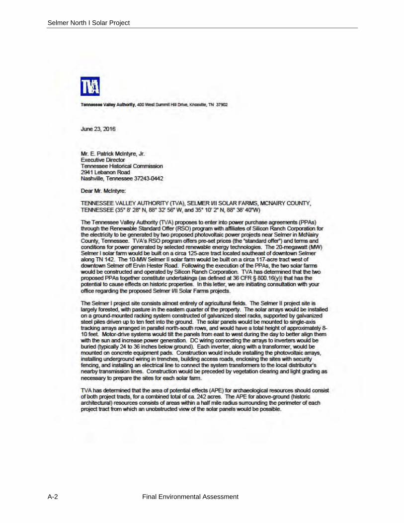
Selmer North I Solar Project
A-2 Final Environmental Assessment
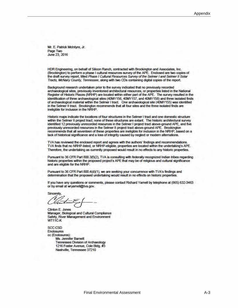
Appendix
Final Environmental Assessment A-3
Selmer North I Solar Project
A-4 Final Environmental Assessment

Appendix
Final Environmental Assessment A-5
Selmer North I Solar Project
A-6 Final Environmental Assessment
Appendix
Final Environmental Assessment A-7

Selmer North I Solar Project
A-8 Final Environmental Assessment
Appendix
Final Environmental Assessment A-9
Selmer North I Solar Project
A-10 Final Environmental Assessment
Appendix
Final Environmental Assessment A-11
Selmer North I Solar Project
A-12 Final Environmental Assessment
Appendix
Final Environmental Assessment A-13

Selmer North I Solar Project
A-14 Final Environmental Assessment
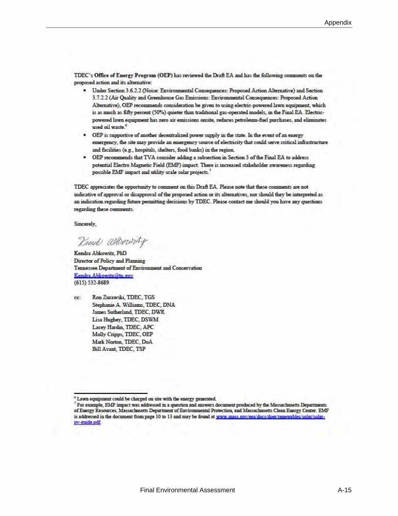
Appendix
Final Environmental Assessment A-15
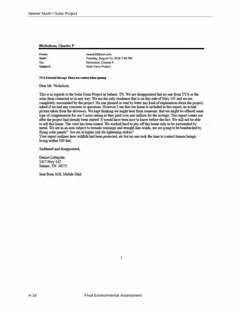
Selmer North I Solar Project
A-16 Final Environmental Assessment
Appendix
Final Environmental Assessment A-17
Selmer North I Solar Project
A-18 Final Environmental Assessment
Appendix
Final Environmental Assessment A-19
Selmer North I Solar Project
A-20 Final Environmental Assessment

Appendix
Final Environmental Assessment A-21

Selmer North I Solar Project
A-22 Final Environmental Assessment