shoreline restoration plan - ecology.wa.gov
TRANSCRIPT

for the Cities of Aberdeen, Cosmopolis, and Hoquiam
Shoreline Restoration Plan
Prepared for City of Hoquiam
November 5, 2015 Prepared by:
City of Hoquiam Planning DepartmentEcology Grant #G1400451Task 8
This report was funded in part through a grant from the Washington Department of Ecology

SHORELINE RESTORATION PLAN for the
Cities of Aberdeen, Cosmopolis, and Hoquiam
Prepared for City of Hoquiam 609 Eighth Street
Hoquiam, Washington 98532
Prepared by Herrera Environmental Consultants, Inc.
2200 Sixth Avenue, Suite 1100 Seattle, Washington 98121 Telephone: 206-441-9080
AHBL 1200 Sixth Avenue, Suite 1620
Seattle, Washington 98101
November 5, 2015

i sw 13-05681-000 shoreline restrtn plan_a-c-h.docx
CONTENTS Limitations ................................................................................................... v
Introduction ................................................................................................. 1
Purpose and Intent .................................................................................... 1 Shoreline Master Program ............................................................................ 1 Scope.................................................................................................... 2 Restoration Plan Objectives ......................................................................... 2 Restoration Policies ................................................................................... 3
Methods ...................................................................................................... 5
Inventory Data and Information Sources ........................................................... 5 Identification of Restoration Opportunities ....................................................... 5 Identification of Restoration Priorities............................................................. 6
Restoration Priorities ...................................................................................... 7
Restoration Projects by City .............................................................................. 9
Aberdeen ............................................................................................... 9 Overview ........................................................................................ 9 Restoration Priorities and Opportunities .................................................. 10 Habitat Benefits ............................................................................... 10
Cosmopolis ............................................................................................ 19 Overview ....................................................................................... 19 Restoration Priorities and Opportunities .................................................. 19 Habitat Benefits ............................................................................... 19
Hoquiam ............................................................................................... 19 Overview ....................................................................................... 19 Restoration Priorities and Opportunities .................................................. 20 Habitat Benefits ............................................................................... 21
Programmatic Restoration Opportunities .............................................................. 25
Removal of Abandoned Creosote-Treated Pilings ............................................... 25 Removal of Abandoned Homes ..................................................................... 25 Education of Small Stream Riparian Landowners ................................................ 26 Stormwater Retrofit Programs ..................................................................... 26 Invasive Species Inventories and Removal Plans ................................................. 26 Vegetate Shoreline Road Rights-of-Way with Native Vegetation .............................. 26 Monitor Restoration Projects ....................................................................... 27
Partners and Funding Resources for Restoration ..................................................... 29
Salmon Recovery Funding Board ................................................................... 29 Aquatic Lands Enhancement Account ............................................................. 29
ii sw 13-05681-000 shoreline restrtn plan_a-c-h.docx
Washington Wildlife and Recreation Program .................................................... 29 NOAA Fisheries ....................................................................................... 30
Coastal and Estuarine Land Conservation Program (CELCP) ............................ 30 Pacific Coastal Salmon Recovery Fund ..................................................... 30
US Fish and Wildlife Service ........................................................................ 31 Chehalis Fisheries Restoration Program ................................................... 31 National Fish Passage Program .............................................................. 31 North American Wetlands Conservation Act Small Grants .............................. 31 Western Native Trout Initiative ............................................................. 31
Aquatic Restoration Program ....................................................................... 32 Family Forest Fish Passage Program ............................................................... 32 Grays Harbor Conservation District ................................................................ 32 Wild Fish Conservancy ............................................................................... 33 The Nature Conservancy ............................................................................ 33 Chehalis Basin Fisheries Task Force ............................................................... 33 Chehalis River Basin Land Trust .................................................................... 33 Washington Coast Sustainable Salmon Partnership.............................................. 34 Grays Harbor Audubon Society ..................................................................... 34
Implementation and Monitoring ......................................................................... 35
Timelines and Benchmarks ......................................................................... 35 Funding ................................................................................................ 37 Monitoring Strategy .................................................................................. 37
Data Gaps ................................................................................................... 39
Monitoring Results ................................................................................... 39 Climate Change ....................................................................................... 39
Sea Level Rise ................................................................................. 39 Precipitation and Streamflow Changes .................................................... 40
References ................................................................................................. 41
iii sw 13-05681-000 shoreline restrtn plan_a-c-h.docx
TABLES Table 1. List of Projects Identified in the Preparation of This Plan. .............................. 9
Table 2. Charley Creek Auto Yards. ................................................................... 13
Table 3. Fry Creek Fish Passage Feasibility Study. .................................................. 14
Table 4. Stewart Creek Confluence Floodplain Feasibility Study. ................................ 15
Table 5. Wilson Creek Fish Passage Feasibility Study. ............................................. 16
Table 6. Fry Creek Levee Setback. .................................................................... 17
Table 7. Grays Harbor Derelict Fishing Gear Removal. ............................................. 18
Table 8. Mill Creek Riparian Improvement. .......................................................... 20
Table 9. Adams Street Shoreline Restoration. ....................................................... 22
Table 10. Moon Island Road. ............................................................................. 23
Table 11. Rennie Island Restoration. ................................................................... 24
FIGURES Figure 1. Map of Proposed Site-Specific Restoration Opportunities Within Aberdeen,
Cosmopolis, and Hoquiam. .................................................................. 11
Figure 2. Typical Abandoned Home in the Shoreline Jurisdiction of Aberdeen.................. 25

v sw 13-05681-000 shoreline restrtn plan_a-c-h.docx
LIMITATIONS As with any report, there are limitations (inherent or otherwise) that must be acknowledged. This report is limited to the subjects covered, materials reviewed, and data available at the time the report was prepared. The authors and reviewers have made a sincere attempt to provide accurate and thorough information using the most current and complete information available and their best professional judgment. Any questions regarding the content of this report should be referred to staff at the city of interest.

November 2015
Shoreline Restoration Plan for the Cities of Aberdeen, Cosmopolis, and Hoquiam 1
INTRODUCTION This restoration plan serves as a guide for the cities of Aberdeen, Cosmopolis, and Hoquiam (the Cities) to achieve improvements in ecological functions of degraded shoreline areas as required by WAC 173-26-201(2)(f). The plan identifies proposed restoration projects identified by others and new, site-specific, restoration project opportunities identified by Herrera through research and field visits.
The plan includes recommendations for the removal of fish barriers, anthropogenic debris, shoreline armoring, and invasive plant species. It recommends the implementation of beach nourishment, and riparian planting. In addition, the plan describes types of programmatic activities that would support shoreline restoration. Finally, this document describes partners and grant opportunities that could facilitate implementation of the restoration plan, and provides suggested implementation mechanisms for achieving restoration goals.
Purpose and Intent The purpose of this restoration plan is to identify, over time, degraded areas and impaired functions within shoreline jurisdiction of the Cities, and identify restoration projects that will, over time, restore shoreline ecological functions and processes. This plan will be accomplished through voluntary and incentive-based public and private programs to restore and enhance shoreline areas.
This plan serves as a guide for the Cities to support and develop projects that are planned to improve the ecological functions (physical, chemical, and biological) of degraded shoreline areas as required by WAC 173-26-201(2)(f). This plan:
• Identifies currently planned and new, site-specific restoration projects.
• Summarizes existing studies that prioritize where future restoration can be most effective and should have highest priority.
• Identifies programmatic restoration opportunities that could be applied to candidate shorelines within the Cities.
Shoreline Master Program Ecology’s Shoreline Management Plan Guidelines (Ecology 2011) require the development of a shoreline restoration plan as part of the Shoreline Management Program (SMP) update process. This plan supports the goals, policies, and regulations of the Cities’ SMP. Although the protective and mitigation provisions of the SMP are intended to achieve no net loss of ecological functions from new adverse impacts, this restoration plan will help ensure that the
November 2015
2 Shoreline Restoration Plan for the Cities of Aberdeen, Cosmopolis, and Hoquiam
shoreline ecosystem functions within the Cities achieve no net loss with potential for improvement over time. As such, this plan serves as a technical companion to the Cities’ SMP.
Scope The scope of this plan is to identify site-specific restoration and programmatic opportunities to improve shoreline ecological functions along the marine and freshwater shorelines of the Cities. The shoreline areas included in this plan are defined as the shoreline and all uplands within 200 feet from the ordinary high water mark (OHWM) of lakes greater than 20 acres, rivers or streams with mean annual flow exceeding 20 cubic feet per second, and marine shorelines and associated tidelands. All streams that are tidally influenced (such as Fry Creek), of which there are many in the Cities are also included.
This plan relies on multiple strategies that use physical restoration to improve shoreline functions and resources as well as programs that can be implemented by the Cities or interested organizations that will benefit shoreline and aquatic ecological functions. This plan’s success depends on the involvement of a number of government and nonprofit organizations that are actively stewarding and restoring land in the Cities.
The plan’s success also depends on private landowners, including industries, and cooperation with the Port of Grays Harbor. One of the largest stressors on the ecological health of the Cities is the past and current industrialization of their associated marine and estuarine shorelines. Historical activities spanned a much larger area than is currently needed for supporting and growing the Cities’ industrial base. Much could be accomplished by identifying unused, disturbed, and potentially polluted properties that have the potential to produce significant ecological lift if they were to be cleaned up and restored. Such restoration projects could help offset the impacts from ongoing industrial activities.
This plan recommends preservation of habitat and ecological functions where possible. For example, where riparian areas with intact native vegetative canopy can be preserved, they will help maintain shoreline habitat for salmon and other socially and economically important fish and wildlife species, provide a native plant seed source, and supply large woody debris—all functions that support the ecology of adjacent shorelines.
Restoration Plan Objectives • Identify restoration recommendations for improving shoreline ecosystem processes and
habitats required to support the life cycles of priority or locally important fish and wildlife species.
• Identify restoration projects that are consistent with and, where practicable, prioritized based on the biological recovery goals for species or populations for which a recovery plan is available.
• Identify potential restoration partners including local, state, and federal public agencies, tribes, nonprofit organizations, and landowners to restore shorelines with impaired ecological functions or processes.
November 2015
Shoreline Restoration Plan for the Cities of Aberdeen, Cosmopolis, and Hoquiam 3
• Identify funding sources for restoration, enhancements, easements, or acquisitions including federal, state, county, grant, or other funding sources.
• Identify timelines and benchmarks for implementing effective restoration.
Restoration Policies The following policies will guide the Cities’ restoration projects:
• Policy 1. Restoration and enhancement actions will improve shoreline ecological functions and processes and should be designed using principles of landscape and conservation ecology. The primary goal is to restore or enhance physical and biological ecosystem-wide processes that create and sustain shoreline habitat structure and functions.
• Policy 2. Encourage and facilitate cooperative shoreline restoration and enhancement programs between local, state, and federal agencies; tribes; nonprofit organizations; and landowners to address shorelines with impaired ecological functions.
• Policy 3. Target restoration and enhancement projects that will support the life cycles of priority species, such as Chinook and other anadromous fish; locally important plants, fish and wildlife; and other populations or habitats for which a prioritized restoration or recovery plan is available.
• Policy 4. Integrate restoration and enhancement with other natural resource management efforts such as the Grays Harbor Estuary Management Plan.
• Policy 5. Seek and support funding opportunities from state, federal, private, and other sources to implement restoration and enhancement projects.
• Policy 6. Encourage restoration and enhancement projects by developing project permitting and processing guidelines that will streamline their review.
• Policy 7. Avoid adverse impacts on critical areas, fish and wildlife habitat conservation areas, water quality, and water storage capacity in all shoreline restoration and enhancement projects.

November 2015
Shoreline Restoration Plan for the Cities of Aberdeen, Cosmopolis, and Hoquiam 5
METHODS Inventory Data and Information Sources A variety of information sources were examined and used to develop this plan. Most of the existing information on restoration projects relates to plans developed by others to assess the needs of wild fish and their prey. They include a series of publications produced by the Wild Fish Conservancy (Sandell et al. 2011, 2013, and 2014; Sandell and McAninch 2013). Unfortunately, only one proposed project mentioned in these documents (i.e., the Charley Creek Auto Yard Cleanup) is within the shoreline jurisdiction of the Cities.
Unlike many other areas in western Washington, there have been very few restoration projects undertaken in the Cities, and even fewer restoration projects are planned. Most restoration projects were completed either in response to an emergency (e.g., the catastrophic failure of Mill Creek dam) or as mitigation for a specific development project (e.g., the tributary channel and floodplain wetland at Bishop Athletic Complex).
Therefore, the primary source of information for specific projects, aside from interviews with local interest groups, was a 1-day field visit to the Cities to identify projects on the ground. The site visit was prefaced by an in-office meeting attended by a geomorphologist, a fisheries biologist, a restoration engineer, and a wetlands scientist, where the best available science described in the Aberdeen, Cosmopolis, and Hoquiam Shoreline Inventory and Characterization report (Herrera and AHBL 2014) and other related studies was discussed. The entire shoreline of each city was examined during this meeting, and potential targets for restoration were identified to be examined in greater detail on the site visit. The site visit occurred on October 17, 2014, which had a high tide of 8.45 feet above MLLW at 9:48 a.m. and a low tide of 4.48 feet above MLLW at 3:00 p.m., as observed at Westport, Washington (NOAA 2014). Locations in all three cities were visited, including Lake Aberdeen and the reach of the Wynoochee River within the city of Aberdeen.
Identification of Restoration Opportunities Restoration opportunities were identified for each city from the existing known planned or in-progress projects, along with projects identified on the site visit. New project selection focused on improving habitat limiting factors, such as improving and expanding juvenile salmonid rearing opportunities, identified in Sandell et al. (2011). In the case of the Cities, the majority of restoration projects proposed in this document target rearing habitat for variety of salmonid species, including Chinook, coho, chum, steelhead, and cutthroat trout. Rearing habitat has been shown to be a critical factor in salmonid population sustainability, but has been diminished by development throughout Grays Harbor (Sandell et al. 2011). Because of the large number of potential opportunities possible and the history of industrial development, projects that would also improve human health and safety were given special attention.
November 2015
6 Shoreline Restoration Plan for the Cities of Aberdeen, Cosmopolis, and Hoquiam
In particular, restoration activities were identified according to the following site characteristics found to indicate high value for restoration in the Cities’ Shoreline Inventory and Characterization Report (Herrera and AHBL 2014) in conjunction with conditions found on the field reconnaissance:
• The site is degraded with respect to key species’ habitats and presents an opportunity for restoration that will produce a net gain in shoreline ecological functions and habitat in the future.
• The site has unused or relict shoreline armoring and infrastructure, which if removed, would likely lead to gains in habitat or improvements in physical processes.
• The site has or is adjacent to areas having specific, high-value, biological features such as mature riparian forest or wetland habitats that support important fish species, birds, and other wildlife.
• The site would provide public access for water dependent and shoreline recreational use.
• The site is potentially contributing contamination to the surrounding landscape.
Identification of Restoration Priorities Priorities for restoration were largely drawn from local studies that generally prioritized projects that restore previously modified shorelines, improve salmon recovery, and increase intertidal area. These studies are:
• Several Wild Fish Conservancy studies on ways to improve wild salmonid populations in the harbor (Sandell et al. 2011, 2013, 2014; Sandell and McAninch 2013)
• The Chehalis Basin Salmon Habitat Restoration and Preservation Work Plan for WRIA 22 and 23 (CBPHWG 2008)
• Salmonid habitat limiting factor analysis (WSCC 2001)
These studies used field surveys and analytical methods to determine restoration priorities and make recommendations for sites that would provide the greatest gain towards improving critical habitats and shoreline ecological functions. Summaries of their findings are provided in this plan to inform users about already documented priorities for additional restoration and protection in the Cities. The information provided and the results of these studies can be effectively used as a basis for planning and prioritizing future projects.

November 2015
Shoreline Restoration Plan for the Cities of Aberdeen, Cosmopolis, and Hoquiam 7
RESTORATION PRIORITIES The protection and recovery of anadromous salmonid species is the primary focus for shoreline restoration projects in the Cities, given past development and disturbance of shoreline areas (Sandell et al. 2011). The Cities, resource agencies, tribes, nonprofit organizations, and private interests are already coordinating protection and management efforts for salmonid species. Existing habitat conditions, habitat limiting factors, and proposed protection measures for salmonids in the Cities have been presented in several completed management documents (Sandell et al. 2011; CBPHWG 2008; WSCC 2001). These documents were developed with the intent of identifying specific habitat issues throughout the Cities. The authors of these documents also propose protections and strategies for conserving anadromous salmonid populations. Protection measures and goals that have been identified as priorities for the Cities include:
• Restore access to low-gradient habitats blocked by culverts or other barriers focusing on those cases with high potential benefits (i.e., reconnecting large areas of intact, forested habitat) and reasonable project costs.
• Reduce shoreline armoring and fill, and remove deleterious shoreline debris, including creosote-treated pilings. Consider the use of clean sandy dredge spoils as shoreline sediment nourishment to improve intertidal habitat conditions, provide a buffer between developed areas and the harbor, and reduce maintenance of hardened shorelines and revetments.
Secondarily, the protection of shellfish resources is a focus for shoreline restoration projects in the Cities. Shellfish harvesting is an important economic driver in the Cities, as well as an important shoreline-dependent recreational activity for the Cities’ residents. Most of the risk to shellfish resources comes from development, primarily via stormwater contamination from runoff. By creating buffers along shorelines that reduce stormwater contaminant loading to receiving waters (mostly metals, but also PAHs and other man-made contaminants), there would be less risk to human health from shellfish consumption, and potentially an expansion of the areas available for shellfish harvest.

November 2015
Shoreline Restoration Plan for the Cities of Aberdeen, Cosmopolis, and Hoquiam 9
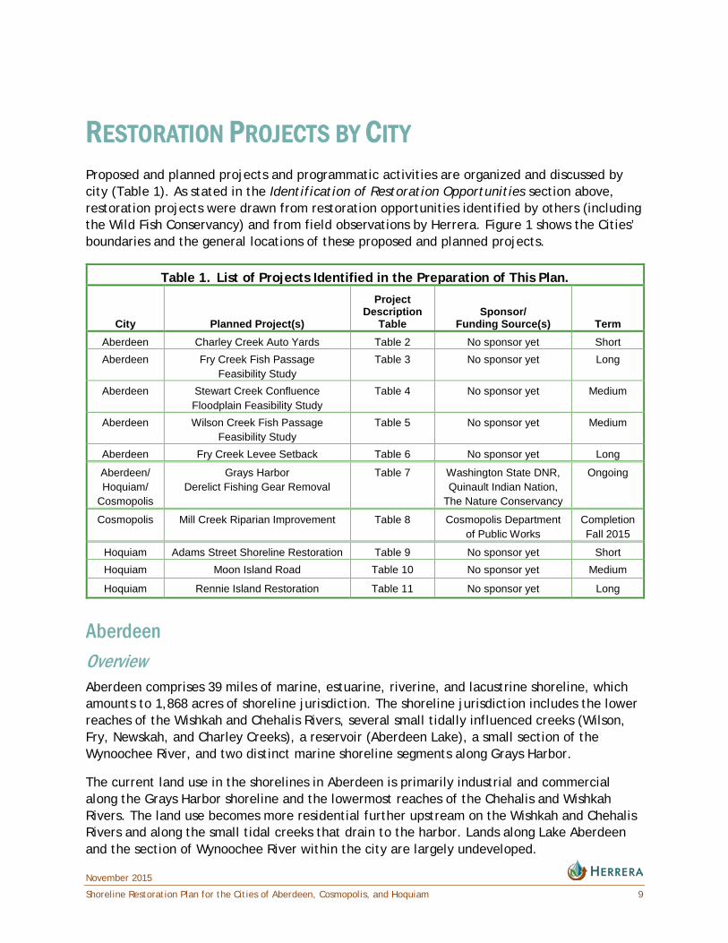
RESTORATION PROJECTS BY CITY Proposed and planned projects and programmatic activities are organized and discussed by city (Table 1). As stated in the Identification of Restoration Opportunities section above, restoration projects were drawn from restoration opportunities identified by others (including the Wild Fish Conservancy) and from field observations by Herrera. Figure 1 shows the Cities’ boundaries and the general locations of these proposed and planned projects.
Table 1. List of Projects Identified in the Preparation of This Plan.
City Planned Project(s)
Project Description
Table Sponsor/
Funding Source(s) Term Aberdeen Charley Creek Auto Yards Table 2 No sponsor yet Short Aberdeen Fry Creek Fish Passage
Feasibility Study Table 3 No sponsor yet Long
Aberdeen Stewart Creek Confluence Floodplain Feasibility Study
Table 4 No sponsor yet Medium
Aberdeen Wilson Creek Fish Passage Feasibility Study
Table 5 No sponsor yet Medium
Aberdeen Fry Creek Levee Setback Table 6 No sponsor yet Long
Aberdeen/ Hoquiam/
Cosmopolis
Grays Harbor Derelict Fishing Gear Removal
Table 7 Washington State DNR, Quinault Indian Nation,
The Nature Conservancy
Ongoing
Cosmopolis Mill Creek Riparian Improvement Table 8 Cosmopolis Department of Public Works
Completion Fall 2015
Hoquiam Adams Street Shoreline Restoration Table 9 No sponsor yet Short Hoquiam Moon Island Road Table 10 No sponsor yet Medium
Hoquiam Rennie Island Restoration Table 11 No sponsor yet Long
Aberdeen Overview Aberdeen comprises 39 miles of marine, estuarine, riverine, and lacustrine shoreline, which amounts to 1,868 acres of shoreline jurisdiction. The shoreline jurisdiction includes the lower reaches of the Wishkah and Chehalis Rivers, several small tidally influenced creeks (Wilson, Fry, Newskah, and Charley Creeks), a reservoir (Aberdeen Lake), a small section of the Wynoochee River, and two distinct marine shoreline segments along Grays Harbor.
The current land use in the shorelines in Aberdeen is primarily industrial and commercial along the Grays Harbor shoreline and the lowermost reaches of the Chehalis and Wishkah Rivers. The land use becomes more residential further upstream on the Wishkah and Chehalis Rivers and along the small tidal creeks that drain to the harbor. Lands along Lake Aberdeen and the section of Wynoochee River within the city are largely undeveloped.

November 2015
10 Shoreline Restoration Plan for the Cities of Aberdeen, Cosmopolis, and Hoquiam
Restoration Priorities and Opportunities Prior to development, Aberdeen was a high-value rearing area for the salmonids of the Chehalis River, but also for fish from the Humptulips, Hoquiam, and Wishkah Rivers (Sandell et al. 2011). The confluence of the Chehalis and Wishkah Rivers at the head of the harbor has many associated tributaries, both large and small. While the larger rivers have now been developed for industrial purposes, the smaller streams mainly drain stormwater runoff from residential development in their lower reaches, often with intact forests in their headwaters. Much of the infrastructure currently located in the streams (e.g., culverts, tide gates, bridges) in these residential areas is old and dilapidated. Several of these small streams are targets for restoration and include Charlie Creek, Frye Creek, Stewart Creek, and Wilson Creek (Tables 2 through 5). In some cases, this infrastructure is a fish barrier. Improvements to stream infrastructure could enable fish access to the intact basins upstream from developed parts of Aberdeen, as well as providing more reliable infrastructure for the community at large.
The harbor itself also presents some opportunities (Tables 6 and 7). Two projects are described that both target estuarine conditions and improve harbor conditions overall. These include the Frye Creek Levee Setback and Grays Harbor Derelict Fishing Gear Removal. However, while there are some abandoned properties and infrastructure, most of the industrial land along the harbor is actively used. Where it is not, some of these properties are close to the urban core of the city and well connected to other transportation (i.e., roads). The most feasible restoration action in these areas is removal of abandoned creosote-treated piles. It is probable that removal could be made in partnership with WDNR, since they have an established program in place to facilitate removal (WDNR 2014).
Habitat Benefits Fish barrier removal is an action that has both fish habitat and infrastructure improvement benefits. These actions would help to improve juvenile salmonid foraging habitat, and in some cases, expand spawning habitat in what are already intact upland streams. Allowing access to the forested riparian areas and streams outside of the city would put fish in contact with more ecologically beneficial conditions, as compared with the current condition that confines migrating adult salmonids and rearing juveniles to the more intensely disturbed industrial shorelines.
Removal of creosote-treated pilings is another key salmonid habitat benefit, as these contaminants can affect the survivability of both juvenile and adult salmonids. These pilings can also contribute to contamination of shellfish throughout the rest of the harbor. Given the businesses that depend on commercial shellfish collection and the number of citizens who recreationally collect shellfish, this is an important consideration for the city.

WilsonCreek FishPassage
Stewart CreekConfluenceFloodplain
Mill CreekRiparian
Improvement
Fry CreekFish Passage
CharleyCreek
Auto Yard
AdamsStreet
ShorelineRestoration
Grays HarborDerelict FishingGear Removal
Fry CreekLevee
Setback
Moon Island Road
CHEHALIS RIVER
AberdeenFRY CREEK
STEWART CREEK
W ILS ON CREEK
Rennie IslandRestoration
Hoquiam Aberdeen
Cosmopolis
UV109
UV105£¤101
£¤101
£¤101£¤101 £¤12
HOQUIAMR
ELLIOT SLOUGHHO
QUIAM
R,E FK
NEWSKAH CR
HOQUIAMR, W
F K
CHARLEY CR
WISHKAHR
Figure 1. Map of Proposed Site-SpecificRestoration Opportunities withinAberdeen, Cosmopolis and Hoquiam.
0 1 20.5Miles
Produced B y: GISProject: K:\Projects\Y2013\13-05681-000\Project\vi cinity_map_11x17.mxd (11/5/2015)
NAD 1983 HARNWashington State Plane South FIPS 4602 Feet
USDA, Aerial (2013)
LegendRestoration site
City limit
River or stream
Highway
^
P A C I F I CO C E A N
WASHINGTON
BRITISHCOLUMBIA
Index
Forks
TacomaShelton
Seattle
Everett
Longview
Chehalis
Cle Elum
Bremerton
Long Beach
Darrington
Bellingham
Castle Rock
Leavenworth
Ocean Shores
Port Angeles
Mount Vernon
Olympia


November 2015
Shoreline Restoration Plan for the Cities of Aberdeen, Cosmopolis, and Hoquiam 13
Table 2. Charley Creek Auto Yards.
Project Name Charley Creek Auto Yards
Location Aberdeen
Project Sponsor No sponsor yet
Project Status Conceptual
Target Habitat Salmonid spawning and rearing habitat
Current Ownership
Private
Zoning Commercial
Hydrogeomorphic Classification
Tributary stream
Project Size ~13.7 acres
Strategy Pollution prevention and contaminant removal
Existing Conditions
Two auto-wrecking junk yards are located at a low elevation in close proximity to the Charley Creek/Grays Harbor estuary. Concerns have been raised that stormwater leaving each of the junk yards may be transporting contaminants, including heavy metals and petroleum hydrocarbons, into Charley Creek. Soil contamination and seepage into Charley Creek is another concern. Charley Creek is utilized by a variety of salmonid species, including juvenile Chinook, coho, and chum salmon in addition to cutthroat trout.
Project Description
Both sites should be inspected to ensure they comply with Washington State stormwater requirements. If sources of contamination are identified, measures should be taken to prevent polluted runoff from entering Charley Creek. In addition, relocation of the junk yard(s) should be evaluated. Predicted sea level rise due to climate change indicates that the properties will likely be inundated in the future; therefore, relocation of the junk yards should be considered in the long term.
Future Threats
Continued contamination of what is otherwise a pristine estuarine tributary, sea level rise, and potential inundation causing further pollution.
Project Rationale
Stormwater and groundwater contamination can be lethal to both juvenile and adult salmonids. Salmonids are particularly sensitive to contaminants, such as, dissolved copper. The remaining Charley Creek watershed upstream of the junk yards is in excellent condition and a variety of juvenile salmonids has been documented utilizing the Charley Creek estuary.
Functions Restored
Improved water quality and juvenile salmonid rearing and spawning habitats.
November 2015
14 Shoreline Restoration Plan for the Cities of Aberdeen, Cosmopolis, and Hoquiam
Table 3. Fry Creek Fish Passage Feasibility Study.
Project Name Fry Creek Fish Passage Feasibility Study
Location Aberdeen
Project Sponsor No sponsor yet
Project Status Conceptual
Target Habitat Salmonid migration corridor and spawning and rearing habitat
Current Ownership
Private
Zoning Commercial
Hydrogeomorphic Classification
Tributary stream
Project Size One tide gate, several culverts
Strategy Fish passage/ barrier removal
Existing Conditions
There is quality salmon habitat located upstream from this project site. Fry Creek flows through a series of ditches in a residential neighborhood in Aberdeen before reaching a commercial property and parking lot between Sumner Avenue and Simpson Avenue. Fry Creek is then routed underground beneath the parking lot, emerging south of Simpson Avenue. The creek then flows through another series of ditches and culverts before reaching a tide gate on the north side of Port Industrial Road. Each of these features would be evaluated to ensure that fish passage is provided.
Project Description
A feasibility study is needed to evaluate daylighting Fry Creek between Sumner Avenue and Simpson Avenue. The tide gate on the north side of Port Industrial Road would be evaluated to ensure that fish passage is provided. All fish passage barriers would be evaluated and removed.
Future Threats
Continued development in the Fry Creek basin and poor adaptability to sea level rise and heightened precipitation due to global warming.
Project Rationale
Greater than 1 linear mile of quality tributary stream habitat upstream of the City of Aberdeen, with numerous acres of off-channel wetland habitat.
Functions Restored
Salmonid migration, spawning, and rearing habitat.

November 2015
Shoreline Restoration Plan for the Cities of Aberdeen, Cosmopolis, and Hoquiam 15
Table 4. Stewart Creek Confluence Floodplain Feasibility Study.
Project Name Stewart Creek Confluence Floodplain Feasibility Study
Location Aberdeen
Project Sponsor No sponsor yet
Project Status Conceptual
Target Habitat Freshwater tidal
Current Ownership
Private
Zoning Residential
Hydrogeomorphic Classification
Tidewater floodplain
Project Size Approximately 1 acre
Strategy Fish barrier removal
Existing Conditions
A tidally influenced wetland area is separated by an 18-inch-diameter culvert under North B Street west of the Stewart Creek and Wishkah River confluence. The culvert is likely a fish passage barrier periodically.
Project Description
This project would be a feasibility study to assess improving fish passage and access to the wetland on the west side of North B Street.
Future Threats
Poor adaptability to sea level rise and heightened precipitation from global warming, additional development in the Stewart Creek basin.
Project Rationale
Off-channel habitat is critical to the survival of many salmonid species (i.e., Chinook, coho, steelhead, etc.). Improving floodplain connectivity increases off-channel habitat.
Functions Restored
Floodplain connectivity, juvenile salmonid foraging and rearing habitats.

November 2015
16 Shoreline Restoration Plan for the Cities of Aberdeen, Cosmopolis, and Hoquiam
Table 5. Wilson Creek Fish Passage Feasibility Study.
Project Name Wilson Creek Fish Passage Feasibility Study
Location Aberdeen, Washington
Project Sponsor No sponsor yet
Project Status Conceptual
Target Habitat Salmonid spawning and rearing habitat
Current Ownership
City of Aberdeen
Zoning Residential
Hydrogeomorphic Classification
Tributary stream
Project Size One tide gate, several culverts
Strategy Fish passage/ barrier removal
Existing Conditions
Wilson Creek currently flows through a small residential neighborhood on the east side of Aberdeen before undercrossing US Route 12 and then passing through a tide gate where Wilson Creek enters Grays Harbor.
Project Description
The project would be to conduct a feasibility study to assess fish passage and barrier removal options in Wilson Creek.
Future Threats
Continued development in the Wilson Creek basin, poor adaptability to sea level rise, and heightened precipitation from global warming.
Project Rationale
Wilson Creek is largely undeveloped upstream of the small residential neighborhood and likely contains salmonid spawning and rearing habitat upstream.
Functions Restored
Salmonid migration, spawning, and rearing habitat.
November 2015
Shoreline Restoration Plan for the Cities of Aberdeen, Cosmopolis, and Hoquiam 17
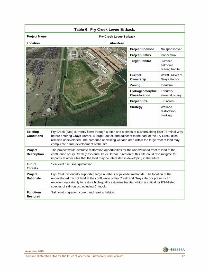
Table 6. Fry Creek Levee Setback.
Project Name Fry Creek Levee Setback
Location Aberdeen
Project Sponsor No sponsor yet
Project Status Conceptual
Target Habitat Juvenile salmonid rearing habitat
Current Ownership
WSDOT/Port of Grays Harbor
Zoning Industrial
Hydrogeomorphic Classification
Tributary stream/Estuary
Project Size ~ 8 acres
Strategy Wetland restoration/ banking
Existing Conditions
Fry Creek (east) currently flows through a ditch and a series of culverts along East Terminal Way before entering Grays Harbor. A large tract of land adjacent to the east of the Fry Creek ditch remains undeveloped. The presence of existing wetland area within the large tract of land may complicate future development of the site.
Project Description
The project would evaluate restoration opportunities for the undeveloped tract of land at the confluence of Fry Creek (east) and Grays Harbor. If restored, this site could also mitigate for impacts at other sites that the Port may be interested in developing in the future.
Future Threats
Sea level rise, soil liquefaction.
Project Rationale
Fry Creek historically supported large numbers of juvenile salmonids. The location of the undeveloped tract of land at the confluence of Fry Creek and Grays Harbor presents an excellent opportunity to restore high-quality estuarine habitat, which is critical for ESA-listed species of salmonids, including Chinook.
Functions Restored
Salmonid migration, cover, and rearing habitat.
November 2015
18 Shoreline Restoration Plan for the Cities of Aberdeen, Cosmopolis, and Hoquiam
Table 7. Grays Harbor Derelict Fishing Gear Removal.
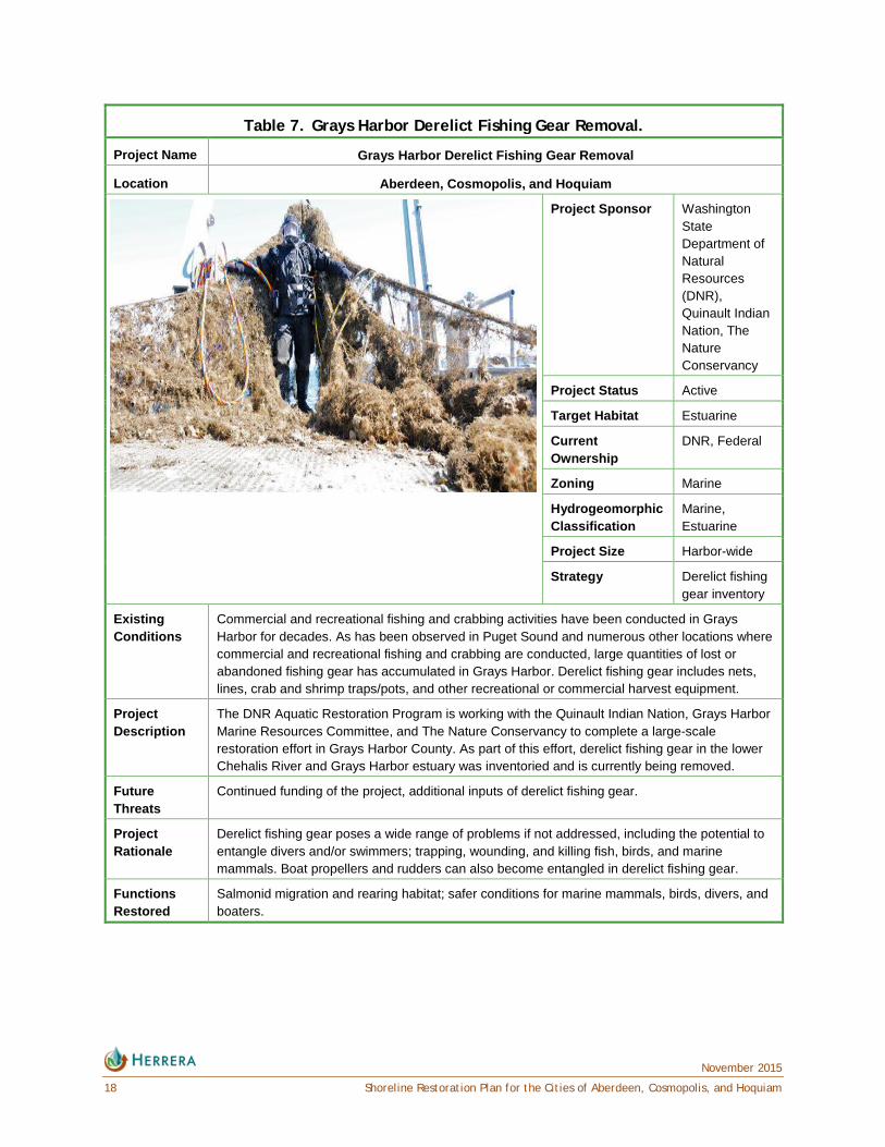
Project Name Grays Harbor Derelict Fishing Gear Removal
Location Aberdeen, Cosmopolis, and Hoquiam
Project Sponsor Washington State Department of Natural Resources (DNR), Quinault Indian Nation, The Nature Conservancy
Project Status Active
Target Habitat Estuarine
Current Ownership
DNR, Federal
Zoning Marine
Hydrogeomorphic Classification
Marine, Estuarine
Project Size Harbor-wide
Strategy Derelict fishing gear inventory
Existing Conditions
Commercial and recreational fishing and crabbing activities have been conducted in Grays Harbor for decades. As has been observed in Puget Sound and numerous other locations where commercial and recreational fishing and crabbing are conducted, large quantities of lost or abandoned fishing gear has accumulated in Grays Harbor. Derelict fishing gear includes nets, lines, crab and shrimp traps/pots, and other recreational or commercial harvest equipment.
Project Description
The DNR Aquatic Restoration Program is working with the Quinault Indian Nation, Grays Harbor Marine Resources Committee, and The Nature Conservancy to complete a large-scale restoration effort in Grays Harbor County. As part of this effort, derelict fishing gear in the lower Chehalis River and Grays Harbor estuary was inventoried and is currently being removed.
Future Threats
Continued funding of the project, additional inputs of derelict fishing gear.
Project Rationale
Derelict fishing gear poses a wide range of problems if not addressed, including the potential to entangle divers and/or swimmers; trapping, wounding, and killing fish, birds, and marine mammals. Boat propellers and rudders can also become entangled in derelict fishing gear.
Functions Restored
Salmonid migration and rearing habitat; safer conditions for marine mammals, birds, divers, and boaters.
November 2015
Shoreline Restoration Plan for the Cities of Aberdeen, Cosmopolis, and Hoquiam 19
Cosmopolis Overview The Cosmopolis shoreline jurisdiction comprises 303 acres of riverine shoreline. Most of this area is along the lower left bank (facing downstream) of the Chehalis River. A minor part of the shoreline jurisdiction includes low-lying areas around Mill Creek and other associated wetlands in the floodplain. Mill Creek is an important tributary to the lower Chehalis River, which confluences within the city limits and shoreline jurisdiction. It also serves as a recreational resource for the city and is the focus of one of the two parks in town.
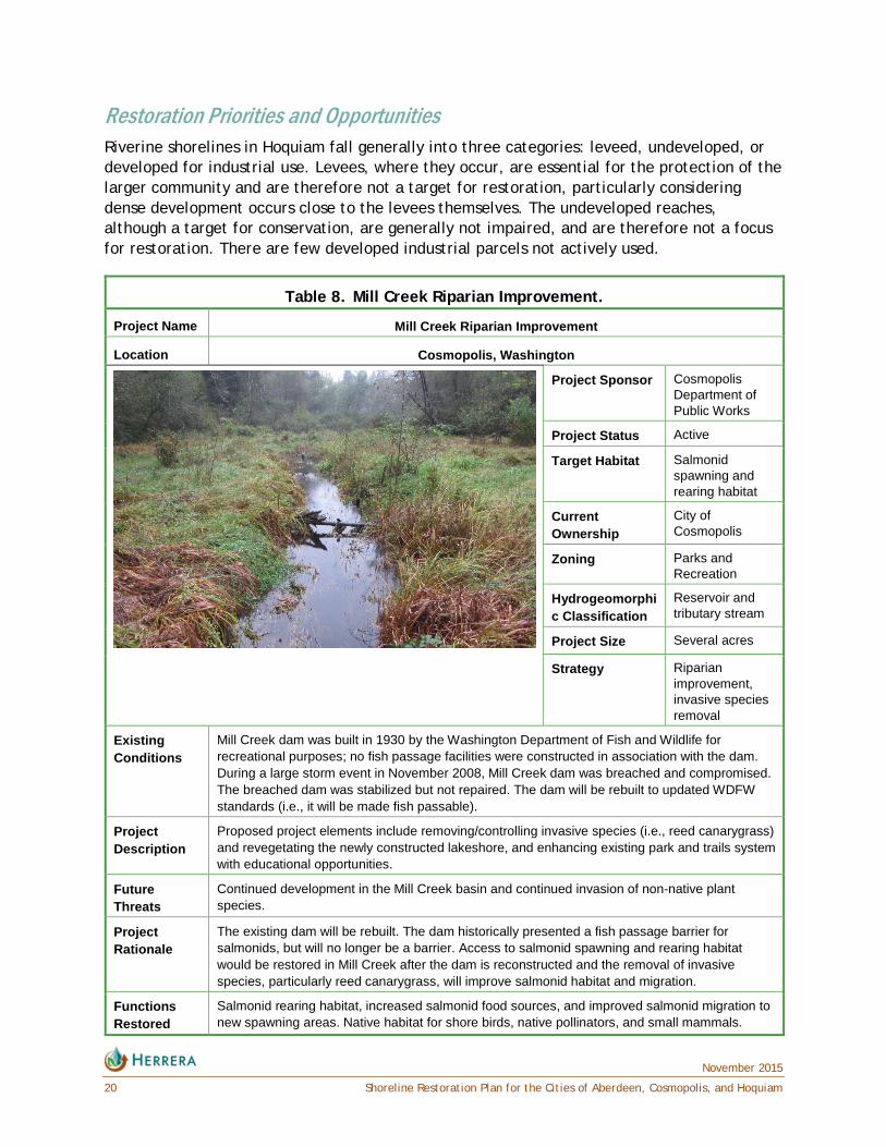
Restoration Priorities and Opportunities Mill Creek was dammed in the 1930s to provide a recreational freshwater pond for fishing. The dam failed in a large storm in 2008 and remains a barrier to all salmonids. The dam failure also drained Mill Creek pond, which has since been invaded by reed canarygrass (Phalaris arundinacea) and other invasive plant species. The dam will be rebuilt with construction scheduled for 2017. The reconstructed dam will be fish passable, either with a bypass channel or fish ladder. This would be an opportunity for Cosmopolis to enhance the riparian area of Mill Creek and the reconstructed pond (Table 8). Removal of reed canarygrass and other invasive species in these riparian areas and replanting with native species would significantly improve habitat for lacustrine species, salmonids, and provide a more aesthetically pleasing park environment.
Habitat Benefits Mill Creek is a low gradient stream that can be accessed by juvenile salmonids owing to the well-maintained and fish-passable tide gates in the Chehalis River levee. Above the dam, there is more than 1 mile of channel that is potential spawning habitat, and possibly rearing habitat, mostly located outside of the city and within industrial forest. Despite most of the basin having been logged recently, the Mill Creek riparian corridor upstream of the dam is intact and is not a limiting factor for salmonid migration. Removal of the reed canarygrass and other invasive species and replanting with native species would increase salmonid food sources and improve salmonid migration to new spawning areas. It would also provide higher quality habitat for shore birds, native pollinators, and small mammals.
Hoquiam Overview The Hoquiam shoreline jurisdiction comprises 491 acres of riverine shoreline and 4,805 acres of marine shoreline. A significant portion of the marine shoreline is already protected as part of the Grays Harbor National Wildlife Refuge, including some shoreline that was created when dredge spoils and fill were placed to make the Bowerman Airport. Outside of the refuge, the land use in Hoquiam is dominated by industrial and transportation uses along Grays Harbor and the lower reaches of its rivers and creeks. The upper portions of the Hoquiam River and its tributaries are primarily residential development land use, though commercial and industrial land uses are present on these water bodies as well.
November 2015
20 Shoreline Restoration Plan for the Cities of Aberdeen, Cosmopolis, and Hoquiam
Restoration Priorities and Opportunities Riverine shorelines in Hoquiam fall generally into three categories: leveed, undeveloped, or developed for industrial use. Levees, where they occur, are essential for the protection of the larger community and are therefore not a target for restoration, particularly considering dense development occurs close to the levees themselves. The undeveloped reaches, although a target for conservation, are generally not impaired, and are therefore not a focus for restoration. There are few developed industrial parcels not actively used.
Table 8. Mill Creek Riparian Improvement.
Project Name Mill Creek Riparian Improvement
Location Cosmopolis, Washington
Project Sponsor Cosmopolis Department of Public Works
Project Status Active
Target Habitat Salmonid spawning and rearing habitat
Current Ownership
City of Cosmopolis
Zoning Parks and Recreation
Hydrogeomorphic Classification
Reservoir and tributary stream
Project Size Several acres
Strategy Riparian improvement, invasive species removal
Existing Conditions
Mill Creek dam was built in 1930 by the Washington Department of Fish and Wildlife for recreational purposes; no fish passage facilities were constructed in association with the dam. During a large storm event in November 2008, Mill Creek dam was breached and compromised. The breached dam was stabilized but not repaired. The dam will be rebuilt to updated WDFW standards (i.e., it will be made fish passable).
Project Description
Proposed project elements include removing/controlling invasive species (i.e., reed canarygrass) and revegetating the newly constructed lakeshore, and enhancing existing park and trails system with educational opportunities.
Future Threats
Continued development in the Mill Creek basin and continued invasion of non-native plant species.
Project Rationale
The existing dam will be rebuilt. The dam historically presented a fish passage barrier for salmonids, but will no longer be a barrier. Access to salmonid spawning and rearing habitat would be restored in Mill Creek after the dam is reconstructed and the removal of invasive species, particularly reed canarygrass, will improve salmonid habitat and migration.
Functions Restored
Salmonid rearing habitat, increased salmonid food sources, and improved salmonid migration to new spawning areas. Native habitat for shore birds, native pollinators, and small mammals.
November 2015
Shoreline Restoration Plan for the Cities of Aberdeen, Cosmopolis, and Hoquiam 21
The restoration priority for the City of Hoquiam is to restore the Grays Harbor shoreline where several factors have discouraged development. Three projects were identified specifically to improve shoreline conditions. They include Adams Street Shoreline Restoration, Moon Island Road, and Rennie Island Restoration (Tables 9 through 11). These projects could be conducted in a way that also improves shoreline access and recreation opportunities, though recreation on Rennie Island is likely to be limited due to boat only access. The Grays Harbor shoreline is less developed because it was historically intertidal marshes. Many of these marsh areas were only filled to just above marine inundation, often with dredge spoils. Naturally low in elevation, even after filling, much of this shoreline remains at risk of marine flooding. More recently, the fill materials in the shoreline areas have begun to subside and revert to wetlands in some areas, which may need to be mitigated for if impacted by development.
The Grays Harbor shoreline of Hoquiam also represents a key habitat type (i.e., estuarine wetlands), which has been eliminated by development in Hoquiam and surrounding communities. This potentially high-quality habitat is why the western portion is already part of the Grays Harbor National Wildlife Refuge. In addition to the fisheries benefits, the expanded and improved intertidal areas would be used by shorebirds and valued commercial species such as Dungeness crab.
Habitat Benefits Site-specific shoreline restoration projects will help increase fish populations by increasing rearing success, and directly and indirectly help businesses in Hoquiam by increasing the ecological productivity of the greater harbor. As a natural locus of accumulating large woody debris in the harbor, restoration along the Hoquiam shoreline presents a unique opportunity to restore habitat functions to an area that has been historically disturbed, but still has some of the attributes of an intact salmon-bearing system.

November 2015
22 Shoreline Restoration Plan for the Cities of Aberdeen, Cosmopolis, and Hoquiam
Table 9. Adams Street Shoreline Restoration.
Project Name Adams Street Shoreline Restoration
Location Hoquiam
Project Sponsor No sponsor yet
Project Status Conceptual
Target Habitat Estuarine shoreline
Current Ownership
City of Hoquiam
Zoning Industrial, Right-of-Way
Hydrogeomorphic Classification
Estuarine
Project Size 500 feet of marine shoreline
Strategy Debris removal
Existing Conditions
The site is characterized by the footing of a historic building, which has been removed. Garbage has been illegally dumped throughout the site. The shoreline has also been hardened with riprap and waste rock/asphalt. Numerous derelict pilings are located in close proximity to the shoreline, some of which may be creosote treated.
Project Description
The former building footing and garbage would be removed and planted with native vegetation. Riprap and other shoreline hardening materials would be removed to provide improved juvenile salmonid rearing habitat. The derelict pilings would also be removed, particularly if they are creosote treated, which would improve local water quality.
Future Threats Continued sediment contamination, poor adaptability to sea level rise.
Project Rationale
The degraded nature of the site impedes natural shoreline functioning; and the derelict pilings present a potential chronic source of sediment contamination, including polycyclic aromatic hydrocarbons (PAHs). This site is easily accessible to the public and offers a good opportunity for a public amenity with a lookout and informative educational signs.
Functions Restored
Salmonid migration and rearing habitat, enhanced shorebird foraging habitat, longshore sediment transport, marine riparian vegetation.
November 2015
Shoreline Restoration Plan for the Cities of Aberdeen, Cosmopolis, and Hoquiam 23
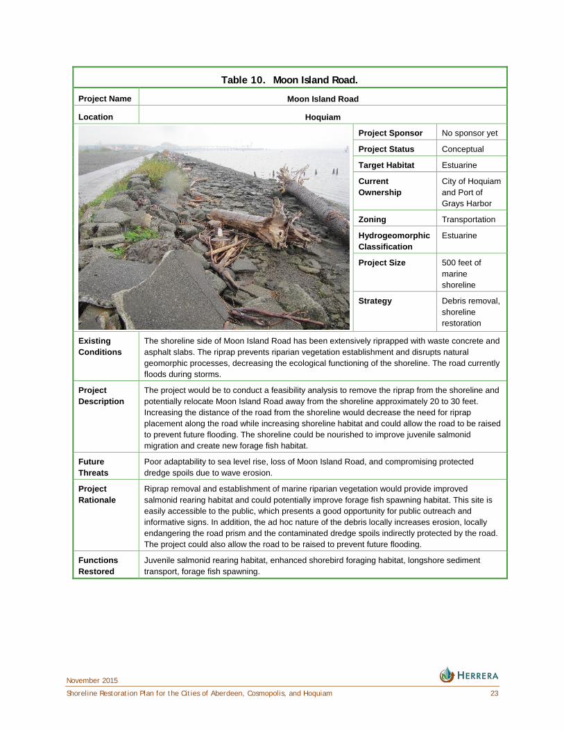
Table 10. Moon Island Road.
Project Name Moon Island Road
Location Hoquiam
Project Sponsor No sponsor yet
Project Status Conceptual
Target Habitat Estuarine
Current Ownership
City of Hoquiam and Port of Grays Harbor
Zoning Transportation
Hydrogeomorphic Classification
Estuarine
Project Size 500 feet of marine shoreline
Strategy Debris removal, shoreline restoration
Existing Conditions
The shoreline side of Moon Island Road has been extensively riprapped with waste concrete and asphalt slabs. The riprap prevents riparian vegetation establishment and disrupts natural geomorphic processes, decreasing the ecological functioning of the shoreline. The road currently floods during storms.
Project Description
The project would be to conduct a feasibility analysis to remove the riprap from the shoreline and potentially relocate Moon Island Road away from the shoreline approximately 20 to 30 feet. Increasing the distance of the road from the shoreline would decrease the need for riprap placement along the road while increasing shoreline habitat and could allow the road to be raised to prevent future flooding. The shoreline could be nourished to improve juvenile salmonid migration and create new forage fish habitat.
Future Threats
Poor adaptability to sea level rise, loss of Moon Island Road, and compromising protected dredge spoils due to wave erosion.
Project Rationale
Riprap removal and establishment of marine riparian vegetation would provide improved salmonid rearing habitat and could potentially improve forage fish spawning habitat. This site is easily accessible to the public, which presents a good opportunity for public outreach and informative signs. In addition, the ad hoc nature of the debris locally increases erosion, locally endangering the road prism and the contaminated dredge spoils indirectly protected by the road. The project could also allow the road to be raised to prevent future flooding.
Functions Restored
Juvenile salmonid rearing habitat, enhanced shorebird foraging habitat, longshore sediment transport, forage fish spawning.
November 2015
24 Shoreline Restoration Plan for the Cities of Aberdeen, Cosmopolis, and Hoquiam
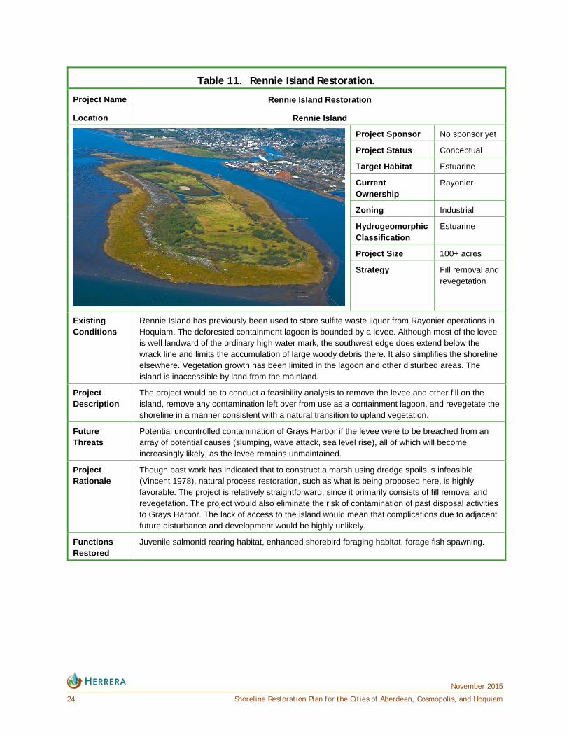
Table 11. Rennie Island Restoration.
Project Name Rennie Island Restoration
Location Rennie Island
Project Sponsor No sponsor yet
Project Status Conceptual
Target Habitat Estuarine
Current Ownership
Rayonier
Zoning Industrial
Hydrogeomorphic Classification
Estuarine
Project Size 100+ acres
Strategy Fill removal and revegetation
Existing Conditions
Rennie Island has previously been used to store sulfite waste liquor from Rayonier operations in Hoquiam. The deforested containment lagoon is bounded by a levee. Although most of the levee is well landward of the ordinary high water mark, the southwest edge does extend below the wrack line and limits the accumulation of large woody debris there. It also simplifies the shoreline elsewhere. Vegetation growth has been limited in the lagoon and other disturbed areas. The island is inaccessible by land from the mainland.
Project Description
The project would be to conduct a feasibility analysis to remove the levee and other fill on the island, remove any contamination left over from use as a containment lagoon, and revegetate the shoreline in a manner consistent with a natural transition to upland vegetation.
Future Threats
Potential uncontrolled contamination of Grays Harbor if the levee were to be breached from an array of potential causes (slumping, wave attack, sea level rise), all of which will become increasingly likely, as the levee remains unmaintained.
Project Rationale
Though past work has indicated that to construct a marsh using dredge spoils is infeasible (Vincent 1978), natural process restoration, such as what is being proposed here, is highly favorable. The project is relatively straightforward, since it primarily consists of fill removal and revegetation. The project would also eliminate the risk of contamination of past disposal activities to Grays Harbor. The lack of access to the island would mean that complications due to adjacent future disturbance and development would be highly unlikely.
Functions Restored
Juvenile salmonid rearing habitat, enhanced shorebird foraging habitat, forage fish spawning.

November 2015
Shoreline Restoration Plan for the Cities of Aberdeen, Cosmopolis, and Hoquiam 25
PROGRAMMATIC RESTORATION OPPORTUNITIES In addition to the planning area-specific actions mentioned and summarized in the previous sections, several broad-scale programs are being implemented, or are proposed here to assist with the Cities’ restoration efforts. These typically fall within the category of restoration strategies, rather than specific restoration projects. These strategies are described below.
Removal of Abandoned Creosote-Treated Pilings Recently WDNR completed a survey of abandoned creosote-treated pilings in Grays Harbor (WDNR 2014). Puget Sound has had a program to remove abandoned creosote-treated pilings since 2004. This program has removed more than 14,000 tons of creosote-treated timber from Puget Sound since its inception (WDNR 2014). Removal of these pilings not only has ecological benefits, but also can have human health benefits, particularly in Grays Harbor where recreational shellfish harvesting is a key shoreline activity. In particular, removal of numerous pilings in the Hoquiam and Little Hoquiam rivers would provide high ecological benefit, as both rivers are a key salmonid rearing and feeding area.
Removal of Abandoned Homes There are a number of abandoned homes within the shoreline jurisdiction (Figure 2). Cataloging these homes could be considered restoration or mitigation in itself, similar to the effort to catalog creosote-treated pilings (see previous opportunity). Eventual removal of these homes would benefit nearby streams through the reduction of impervious surface and reduction in contaminant loading. It would also benefit human health, as abandoned homes are a known vector for human diseases and vermin (Shane 2012). Abandoned homes can also attract illegal dumping, leading to contamination of nearby water bodies. This program could also improve property values and benefit public safety, because abandoned homes typically depress property values and increase local crime rates (Shane 2012). If properties with abandoned homes were acquired, revegetation of these sites would provide further habitat benefits, since most are immediately adjacent to water bodies that contain salmonids.
Figure 2. Typical Abandoned Home in the Shoreline Jurisdiction of Aberdeen.
November 2015
26 Shoreline Restoration Plan for the Cities of Aberdeen, Cosmopolis, and Hoquiam
Education of Small Stream Riparian Landowners There are many small streams throughout the Cities. Some of these are ecologically disconnected by tide gates or extremely long (thousands of feet) culverts or stormwater drains. However, many have quality habitat area located upstream and are fully connected with the harbor and could be actively used by salmonids. The riparian corridors along these streams in many locations are absent (i.e., lawns or paved areas extend to the streams). Invasive species (e.g., English ivy) are also common. A program to educate local landowners that live along these streams about ways to care for their riparian corridors would improve conditions for anadromous fish. The focus could easily be expanded to include stormwater education, which would help make residents aware that their storm drains contribute to the water used by aquatic species, similar to a program set up by the Puget Sound Partnership for Puget Sound (Puget Sound Starts Here 2014). Such education could also help minimize illicit discharges to these important water bodies.
Stormwater Retrofit Programs Stormwater infrastructure in the Cities is commonly outdated and in badly need of repair. Most storm drains accept water untreated from pollutant generating impervious surfaces into areas where fish and even salmonids may reside. In updating this infrastructure, the Cities should consider using low-impact development techniques, such as bioswales, rain gardens, or other stormwater treatment facilities that promote infiltration. In more developed parts of the Cities where space is limited, manufactured treatment devices with small footprints that can manage high flow rates with effective pollutant removal capacity such as a Filterra bioretention system, Linear Modular Wetland System, Urbangreen Biofilter, or Treepod Filter can be readily integrated into landscaped areas, parking lots, sidewalk strips, and highly developed sites.
Invasive Species Inventories and Removal Plans Invasive species, such as Japanese knotweed (Fallopia japonica), English ivy (Hedera helix) and even Spartina alterniflora, are present throughout the Cities. These species degrade habitat and impair ecological function. Despite their prevalence, there is little information available about their prevalence throughout the Cities. Identifying the extents of these species is the first step to removing them and improving shoreline ecological functions. Once inventories are prepared, plans can be put forward to removal these species in a methodical way, often using community resources, such volunteer events, and governmental and non-governmental (non-profit) funding. The Grays Harbor County Noxious Weed Control Board is available to provide assistance in noxious weed identification and removal recommendations.
Vegetate Shoreline Road Rights-of-Way with Native Vegetation Several roads are adjacent to shorelines throughout the Cities. In many cases, there is a small buffer of land (often a public right-of-way) between the roadway and the shoreline. These areas typically lack vegetation or are colonized by nonnative, invasive plant species.
Native riparian vegetation is essential to healthy riparian ecosystems, even those along marine shorelines. For locations in the Cities where the roadway buffer is large enough and
November 2015
Shoreline Restoration Plan for the Cities of Aberdeen, Cosmopolis, and Hoquiam 27
the ecological benefits of revegetation are significant enough, implementing removal of nonnative invasive plant species and revegetation with natives in the public rights-of-way could create an opportunity to engage the community and thereby encourage people to remove invasive plants, and plant native vegetation on their private properties.
Monitor Restoration Projects One of the primary means to ensure success of restoration projects in meeting the goal of restoring ecological functions is to monitor existing and future restoration projects to determine if they are performing as designed, and to evaluate the efficacy of different approaches. Monitoring also provides the basis for determining when adaptive management and corrective actions may need to be implemented to ensure the project success. Whenever possible, monitoring of future restoration projects should include baseline monitoring prior to project construction, as that is critical to understanding and demonstrating the effects of restoration.
Determining a physical and ecological baseline is crucial for documenting the ecological lift of restoration projects. As such, it is recommended that all proposed and potential restoration projects be monitored both prior to and following their construction and that such monitoring be included as part of the project implementation and funding.


November 2015
Shoreline Restoration Plan for the Cities of Aberdeen, Cosmopolis, and Hoquiam 29
PARTNERS AND FUNDING RESOURCES FOR RESTORATION The following programs, organizations, and agencies support the types of restoration projects described in this plan. There are public and nonprofit organizations that will fund restoration projects that meet their mission as well as local organizations described that could lead the work or serve as partners to accomplish restoration goals.
Salmon Recovery Funding Board In 1999, the Washington State legislature created the Salmon Recovery Funding Board (SRFB), which is now administered by the Puget Sound Partnership. The SRFB provides grants to protect or restore salmon habitat. Composed of five citizens appointed by the governor and five state agency directors, the SRFB brings together the experiences and viewpoints of citizens and the major state natural resource agencies.
Aquatic Lands Enhancement Account In 1984, the Washington State legislature created the Aquatic Lands Enhancement Account (ALEA) to ensure that money generated from aquatic lands was used to protect and enhance those lands. Aquatic lands are all tidelands, shore lands, harbor areas, and the beds of navigable waters. ALEA grants may be used for the acquisition, improvement, or protection of aquatic lands for public purposes. They also may be used to provide or improve public access to the waterfront. The ALEA program is targeted at re-establishing the natural, self-sustaining ecological functions of the waterfront, providing or restoring public access to the water, and increasing public awareness of aquatic lands as a finite natural resource and irreplaceable public heritage. It is administered by the Recreation and Conservation Office and is funded almost entirely by revenue generated by WDNR's management of state-owned aquatic lands (WSRCO 2014).
Washington Wildlife and Recreation Program The Washington Wildlife and Recreation Program (WWRP) provides funding for a variety of projects to protect habitat, restore habitat and species, and acquire properties with valuable natural resources. It is administered by the Washington State Recreation and Conservation Office and is funded by the legislature in the state's capital construction budget (WWRP 2014).
• The Critical Habitat Category fund program provides funding to protect habitat for wildlife including habitat for endangered, threatened, or sensitive species. Project sites may include high-quality habitat or degraded habitat that once restored will support the target species.
November 2015
30 Shoreline Restoration Plan for the Cities of Aberdeen, Cosmopolis, and Hoquiam
• The Natural Areas Category fund provides funding to protect high quality, representative native ecosystems or unique plant or animal communities; endangered, threatened, or sensitive species; rare geological features; or similar features of scientific or educational value. Project sites must have, to a major degree, retained their natural character and be managed primarily for resource preservation, protection, and study.
• The Riparian Protection Category fund provides funding to protect riparian areas. Projects may include a wide variety of site conditions on either fresh or saltwater riparian areas. Projects must include property acquisition. Projects to extend riparian protection for a minimum of 25 years on lands enrolled in the federal Conservation Enhancement Reserve Program are allowed.
• The Salmon Recovery fund provides funding to improve important habitat conditions or watershed processes to benefit salmon and bull trout. Projects must go through selection by local lead entities and must address goals and actions defined in regional recovery plans or lead entity strategies.
• The State Lands Restoration and Enhancement fund provides funding to two state agencies to repair damaged plant and animal habitat. Restoration projects must bring a site back to its original function through activities that will help the site be self-sustaining. Enhancement projects must improve the ecological functionality of a site.
• The Urban Wildlife Habitat Category fund provides funding to conserve wildlife habitat in cities. Projects must be within 5 miles or inside a city or town (or its adopted urban growth area boundary) with a population of at least 5,000, which would include the entire shoreline jurisdiction covered by this document.
NOAA Fisheries NOAA Fisheries funds land conservation and restoration projects through multiple programs. The particular goals of these programs and level of available funding can vary from year to year. Examples of these programs include the Coastal and Estuarine Land Conservation Program (CELCP) and the Pacific Coastal Salmon Recovery Fund.
Coastal and Estuarine Land Conservation Program (CELCP) CELCP provides matching funds to state and local governments to purchase threatened coastal and estuarine lands or obtain conservation easements. To be considered, the land must be important ecologically or possess other coastal conservation values, such as historic features, scenic views, or recreational opportunities.
Pacific Coastal Salmon Recovery Fund The Pacific Coastal Salmon Recovery Fund (PCSRF) was established by Congress in 2000 to reverse the declines of Pacific salmon and steelhead, supporting conservation efforts in California, Oregon, Washington, Idaho, and Alaska. The program, administered by NOAA, is essential to preventing the extinction of the 28 listed salmon and steelhead species on the West Coast and, in many cases, has stabilized the populations and contributed to their

November 2015
Shoreline Restoration Plan for the Cities of Aberdeen, Cosmopolis, and Hoquiam 31
recovery course (NOAA Fisheries West Coast Region 2014). The Pacific Coastal Salmon Recovery Fund has funded most of the work performed by the Wild Fish Conservancy described herein (Sandell et al. 2011, 2013, and 2014; Sandell and McAninch 2013).
US Fish and Wildlife Service The US Fish and Wildlife Service has grant programs that fund restoration-oriented projects. These programs are often tailored to particular goals of the agency and, as with NOAA, can vary from year to year. However, it is likely that there are programs that would apply to the restoration goals described herein, particularly projects that support protection of endangered species and critical habitats. A few of those programs are described in separate subsections below.
Chehalis Fisheries Restoration Program The Chehalis Fisheries Restoration Program provides funding for habitat restoration in the Chehalis River and Grays Harbor Basins (USFWS 2014). Private landowners; nonprofit organizations; and local, tribal, state, or federal agencies are eligible to apply for funding through this program. The Chehalis Fisheries Restoration Program funds a variety of projects, including fish passage barrier corrections, removal of invasive species, native plant revegetation, riparian and off-channel fish habitat restoration, agricultural wetland restoration for fish use, and monitoring of fish use of these habitats.
National Fish Passage Program The National Fish Passage Program provides funding to restore native fish and other aquatic species to self-sustaining levels by reconnecting habitat that has been fragmented by human-made barriers (USFWS 2014). Private landowners; nonprofit organizations; and local, tribal, state, or federal agencies are eligible to apply for funding through this program.
North American Wetlands Conservation Act Small Grants The North American Wetlands Conservation Act (NAWCA) Small Grants is a competitive, matching grants program created in 1996. Its goal is to promote public-private partnerships and encourage smaller-scale, long-term wetland conservation projects that may otherwise not be able to compete in the US Standard Grants Program. The US Standard Grants Program is a competitive, matching grants program that supports public-private partnerships carrying out projects in the United States that further the goals of the North American Wetlands Conservation Act (Act)(USFWS 2014). Projects must involve long-term protection, restoration, and/or enhancement of wetland and associated upland habitats for the benefit of all wetland-associated migratory birds. Grant requests may not exceed $75,000, and funding priority is given to new grantees or partners.
Western Native Trout Initiative The mission of the Western Native Trout Initiative is to serve as a catalyst for the implementation of conservation or management actions, through partnerships and cooperative efforts that result in improved trout species status, improved aquatic habitats, and improved recreational opportunities (WNTI 2007). The Western Native Trout Initiative
November 2015
32 Shoreline Restoration Plan for the Cities of Aberdeen, Cosmopolis, and Hoquiam
funds a variety of projects, including riparian restoration, invasive species removal, fish passage barrier correction, and wetland and estuary restoration. Private landowners; nonprofit organizations; and local, tribal, state, or federal agencies are eligible to apply for funding through this program (USFWS 2014).
Aquatic Restoration Program The Aquatic Restoration Program is administered by WDNR to establish partnerships with agencies and organizations to restore, enhance, create, and protect healthy ecological conditions in freshwater, saltwater, and estuarine aquatic systems (WSDNRARP 2014). Funds from this program must be matched one to one with the goal to leverage seed money to develop projects that maximize restoration benefits. Funding provided by the Aquatic Restoration Program is restricted to on-the-ground portions of restoration projects, including on-site preparation and implementation of restoration-related activities.
Family Forest Fish Passage Program The Family Forest Fish Passage Program (FFFPP) is administered by WDNR and was established by the Washington State legislature in 2003 as an incentive-based program that assists smaller private forestland owners in replacing fish barriers on their land (DNR 2013). Private forest landowners are eligible to use the FFFPP if less than 2 million board feet of timber is harvested each year from their land. Regulatory fish barriers that are eligible under the FFFPP include culverts, and other stream crossing structures that prevent salmonids and other fish species from reaching upstream habitat.
The FFFPP works with over 40 entities in Washington State, including salmon enhancement groups, conservation districts, local tribes, and the US Fish and Wildlife Service (DNR 2013). This program has assisted nearly 200 private landowners since its inception, resulting in the replacement of 244 barriers, and opening of more than 524 miles of stream habitat. The replacement of fish barriers has the added benefit of reducing maintenance concerns for smaller private forestland owners.
Grays Harbor Conservation District Grays Harbor Conservation District is a non-regulatory, not-for-profit, community-based, subdivision of state government, made up of local community members and staff with the goal of applying on-the-ground conservation measures in Grays Harbor County and the surrounding western Washington area, through education, outreach, technical assistance, and cost-sharing. Their mission is to protect, conserve, and enhance regional natural resources and to promote the implementation of environmental practices proven to meet these goals. They provide forestry assistance and are authorized to act as a sponsor for the Washington Department of Natural Resources FFFPP, which provides funding to small forest landowners to repair or remove fish passage barriers. In addition, they act as a sponsor for SRFB projects and will cost share for conservation practices projects eligible for their cost sharing programs, as funding is available.
November 2015
Shoreline Restoration Plan for the Cities of Aberdeen, Cosmopolis, and Hoquiam 33
Wild Fish Conservancy A nonprofit conservation organization headquartered in Duvall, Washington, Wild Fish Conservancy (WFC) is dedicated to the recovery and conservation of the region’s wild-fish ecosystems. Through science, education, and advocacy, WFC promotes technically and socially responsible habitat, hatchery, and harvest management to better sustain the region’s wild-fish heritage (Wild Fish Conservancy 2014). Wild Fish Conservancy has been active in supporting ecological restoration in Grays Harbor through a series of recent studies looking at the most effective ways of improving wild fish numbers in the estuary (Sandell et al. 2011, 2013; Sandell and McAninch 2013). WFC has concluded that juvenile rearing habitat, such as estuarine tidelands, has been the type of habitat most greatly affected or eliminated by development. Therefore, this type of habitat should be the highest priority for future restoration efforts.
The Nature Conservancy The mission of The Nature Conservancy is to conserve the lands and waters on which all life depends. The Nature Conservancy achieves this mission through the dedicated efforts of a diverse staff, including more than 600 scientists, located in all 50 US states and more than 35 countries, and with the help of many partners, from individuals and governments to local nonprofits and corporations (The Nature Conservancy 2014). The Nature Conservancy has most recently worked in Grays Harbor in collaboration with the Quinault Indian Nation and WDNR to remove derelict fishing gear from throughout the harbor (Pacific Marine and Estuarine Fish Habitat Partnership 2014).
Chehalis Basin Fisheries Task Force The Chehalis Basin Fisheries Task Force (CBFTF) is a private, nonprofit, tax-exempt corporation dedicated to increasing salmonid populations for citizens and communities in the Chehalis River Basin. Its mission is to produce salmon for sport and commercial fisheries through enhancement of steelhead and searun cutthroat trout resources by restoring, enhancing, and protecting stream habitat critical to these anadromous species. While the CBFTF functions in a variety of capacities, its primary focus is to act as a funding agency, coordinating technical resources, and providing public education. Since inception, the CBFTF has allocated over two million dollars to fisheries enhancement projects and over three million to habitat restoration efforts. In addition to fish production and restoration projects, the CBFTF constituency has initiated, educated, and supported a wide variety of issues.
Chehalis River Basin Land Trust The Chehalis River Basin Land Trust (CRBLT) promotes the protection of lands that provide habitat for wildlife and fish in the Chehalis Basin (CRBLT 2013). Created in 1995, the CRBLT is a nonprofit sponsor organization of the Land Trust Alliance that focuses on permanent conservation easements, riparian and wetland restoration projects, and land acquisition.
November 2015
34 Shoreline Restoration Plan for the Cities of Aberdeen, Cosmopolis, and Hoquiam
Washington Coast Sustainable Salmon Partnership The Washington Coast Sustainable Salmon Partnership is one of seven regional salmon recovery organizations in the state. The partnership was formed by the four coastal Lead Entities in 2007 and is organized under an interlocal agreement between counties, cities, tribes, and ports within the region. Although salmon and steelhead populations in the Washington Coast Region are seriously degraded from historical levels—experts suggest that the current abundance of coastal salmon runs is probably only about 10 percent of what it was a hundred years ago—they are considered healthier than elsewhere in the state. The Washington Coast Sustainable Salmon Partnership’s mission is to keep regional salmon populations healthy. They have a restoration initiative that seeks to restore forests, water quality, and fish and wildlife habitat by funding high priority projects in the region. Projects are selected that provide restoration jobs to local people and ensure sustainable natural resource jobs in the future. A coalition of partners developed a comprehensive database of restoration and sustainable job needs and seeks funding for prioritized projects for critical restoration work that also provides good-paying restoration and sustainable natural resource jobs.
Grays Harbor Audubon Society The mission of the Grays Harbor Audubon Society is to inspire diverse audiences to conserve natural ecosystems and build healthy communities for people, birds, and other wildlife. The Grays Harbor Audubon Society has a habitat protection program that is based on the idea that if you want to protect habitat, you purchase it. The Grays Harbor Audubon Society has currently protected over 3,050 acres in Grays Harbor, Pacific, and Jefferson counties.
November 2015
Shoreline Restoration Plan for the Cities of Aberdeen, Cosmopolis, and Hoquiam 35
IMPLEMENTATION AND MONITORING Effective implementation of restoration projects and programs may require both regulatory and non-regulatory approaches to be effective. In many cases, the restoration opportunities described herein require acquisition of or easements on private land, potential relocation of public infrastructure (predominantly roads), and extensive cooperation and coordination with citizens, private landowners, and other stakeholders. While technically feasible, many of the suggested restoration strategies are extremely challenging from a socio-political perspective and will require consensus on what needs to be accomplished and how.
Timelines and Benchmarks Many aspects of restoration can be highly opportunistic, for example, where one finds a willing landowner; or where an event, such as a road failure due to flood-induced erosion that requires immediate repair, creates an opportunity for a more ecologically beneficial solution. Establishing timelines is further complicated by the fact that shoreline restoration may largely depend on grant funding, which is unpredictable. That said it is important to set specific timelines and benchmarks to ensure progress. A suggested timeline for initiating implementation of this plan is as follows:
Within 0 to 7 years of adoption of this plan:
• Each City identify at least one site-specific shoreline project that provides a high level of ecological function. Establish a schedule for obtaining and assigning staff, applying for funding, and initiating steps toward implementation.
• Each City identify and complete design work on at least one stormwater quality treatment project that uses a bioswale, rain garden, manufactured treatment device, or other water quality treatment option to improve stormwater quality.
• Develop and implement at least one restoration directed program using public outreach and education or incentives to engage private landowners in restoration activities.
Within 7 to 10 years of adoption of this plan (assuming funding is available):
• Each City complete at least one other site-specific restoration project.
• Each City identify and complete one riparian enhancement/invasive vegetation removal project.
• Each City complete construction of at least two stormwater quality treatment projects that will improve water quality.
November 2015
36 Shoreline Restoration Plan for the Cities of Aberdeen, Cosmopolis, and Hoquiam
Every 10 years thereafter:
• Each City identify and complete at least one new site-specific shoreline restoration project that provides a high level of ecological function.
• Each City identify and complete at least one new riparian enhancement/invasive vegetation removal project.
• Each City identify and complete at least one stormwater quality treatment project that will improve water quality.
• Each City develop and implement at least one restoration directed program using public outreach and education or incentives to engage private landowners in restoration activities.
Over time, restoration efforts must be evaluated against a set of benchmarks to determine if adequate progress is being made. Progress can be tracked by reporting benchmarks such as the examples below:
• Acres of riparian enhancement
• Acres of reconnected floodplain
• Acres of wetland restored in the shoreline jurisdiction
• Acres of noxious weed removal and native vegetation planted
• Number of fish barriers removed or number of stream miles open to fish passage
• Number of exceedances of water quality criteria as measured in the state water quality assessment
• Number of restoration actions implemented in conjunction with other project partners
In the context of the SMP update, restoration planning is a long-term effort. The SMP guidelines include the general goal that local master programs “include planning elements that, when implemented, serve to improve the overall condition of habitat and resources within the shoreline area” (WAC 173-26-201(c)).
The legislature has provided an overall timeframe for future amendments to the SMP that can be used to evaluate restoration progress. A jurisdiction is required to review its SMP once every 8 years (beginning on or before June 30, 2022), and amend if necessary (RCW 90.58.080(4)). During this review period, the Cities should document progress toward achieving shoreline restoration goals. The review could include:
• Re-evaluating adopted restoration goals, objectives, and policies.
• Summarizing both planning efforts (including application for and securing grant funds) and on-the-ground actions undertaken in the interim to meet those goals.
• Revising the SMP restoration planning element to reflect changes in priorities or objectives.
November 2015
Shoreline Restoration Plan for the Cities of Aberdeen, Cosmopolis, and Hoquiam 37
Funding Funding sources for restoration projects and programs are identified in the report section Partners and Funding Resources for Restoration. In addition to those outside funding sources, the Cities could identify some projects as part of their capital facilities planning or develop a specific restoration fund to ensure that shoreline restoration is considered during the budget process. It is expected that restoration funding will be derived from a variety of sources selected for their appropriateness to the project or program goals.
Monitoring Strategy The Cities are required to monitor the effectiveness of the SMP, including this restoration plan, over time to assess whether net loss of ecological functions and processes is occurring. This will require tracking shoreline development activities to ensure permit compliance, and periodically reassessing the ecological health and status of shoreline resources. The latter should include identifying which restoration activities have occurred compared to the stated goals, objectives, and priorities of this plan. Should restoration projects fall short of being implemented within the general periods recommended in this plan (see Timelines and Benchmarks section), the City should take specific steps to remedy that situation in order to remain compliant with the SMP. An annual review of restoration efforts, including projects and programs, is recommended.

November 2015
Shoreline Restoration Plan for the Cities of Aberdeen, Cosmopolis, and Hoquiam 39
DATA GAPS Monitoring Results One of the largest data gaps found during the preparation of this plan was the lack of information on the effectiveness of past and current restoration activities in the Cities. Monitoring of sites has been limited. In particular, upcoming mitigation projects can produce “lessons learned” about conducting restoration projects in the greater Grays Harbor area. Such monitoring data should then be used to educate the public, gauge cost effectiveness, and determine the effectiveness of different restoration approaches.
Climate Change An analysis of climate change in Grays Harbor and the Lower Chehalis River was recently completed by the Wild Fish Conservancy for the specific purposes of identifying climate-adaptable restoration projects in the Grays Harbor estuary (Sandell and McAninch 2013). Their analysis reviewed recent climate-change literature relevant to the area and found that there will be increases in stream temperatures, particularly in the summertime (Mantua et al. 2010), compromised habitat restoration success (Battin et al. 2007), hydrologic change of stream basins (Elsner et al. 2010), and increased sea level (Canning 2005; Mote et al. 2008). Sea level rise, precipitation, and streamflow changes will impact restoration success and viability, and are discussed separately below.
Sea Level Rise Sandell and McAninch (2013) summarized sea level rise estimates in the estuary as being produced by the combined effects of global sea level rise and local factors, such as vertical land deformation (e.g., tectonic movements) and seasonal water surface elevation changes due to atmospheric circulation effects. Within the Cities, there is little if any tectonic motion (Verdonck 2006; Central Washington University 2014), so sea levels reflect eustatic (globally averaged) changes (Canning 2005; Mote et al. 2008). This explains the relatively modest sea level rise observed at Toke Point, the nearest sea level NOAA gauge, in the 20th century (1.60 mm per year) (NOAA 2014). With that said, recent (within the last 30 years) sea level rise has been suppressed by large-scale oceanographic processes, the reversal of which may trigger acceleration of sea level rise in the near future (Bromirski et al. 2011). It is also important to couch these predicted changes in known interannual sea level variability associated with El Niño. Mojfeld (1992) has shown that during El Niño years the average water level can be up to 1 foot higher than in ordinary winters, with deviations during storms of up to 3 feet.
Therefore it is expected that lower areas will convert from upland to marsh areas over the next 50 years (e.g., in recently filled areas, such as near the confluence of the Hoquiam River and Grays Harbor: Sandell and McAninch [2013]). This conversion will decrease the viability of these extremely low-lying lands to be anything other than intertidal marshes. However, it is unclear how these processes will interact, since they are dependent on the nature of the sea
November 2015
40 Shoreline Restoration Plan for the Cities of Aberdeen, Cosmopolis, and Hoquiam
level rise (i.e., episodic events versus gradual conversion to intertidal area) and future development. Even though the Sandell and McAninch (2013) model is capable of producing estimates of conversion time scales for different habitat types, the approximations inherent in the model likely limit its applicability at the site scale. Therefore, continued review of sea level rise research will be important to ensuring that restoration projects are designed and sited appropriately to be sustainable given expected sea level changes.
Precipitation and Streamflow Changes There has also been an extensive amount written about expected weather-related precipitation and hydrologic changes in western Washington due to climate change. However, there remains some uncertainty regarding the influence climate change will have on local precipitation patterns. The most likely change is a temperature-driven shift in precipitation form, with less snowfall and more rainfall. However, in general, climate change is also expected to lead to an increase in precipitation intensity during the largest storms, regardless of the form that precipitation takes. This increase occurs because of the increase in available moisture in the atmosphere when temperatures increase, and because storms in a warmer climate are likely to draw moisture from larger areas (Trenberth 2011). This intensification of the hydrologic cycle likely has already begun to occur, as evidenced by global sea-surface salinity measurements that are consistent with increased evaporation rates in areas of the ocean that supply moisture to western North America (Durack et al. 2012).
At national and global scales, data analysis of observed precipitation shows that storms appear to be getting more intense because of increased global temperatures (Min et al. 2011, Pall et al. 2011). However, global circulation models do not presently have the precision to model changes in atmospheric flow at the scale of individual Pacific Northwest watersheds. This problem can be addressed effectively in the Pacific Northwest by driving higher resolution regional-scale models with coarse-scale global circulation output (Dulière et al. 2011). In Washington, this approach shows increases in precipitation intensities and a shift from snow to rain during transitional seasons (Rosenberg et al. 2010; Elsner et al. 2010). Analysis of observed historical precipitation in the Pacific Northwest has shown increases in precipitation intensities for durations less than 24 hours in the Puget Sound area (Rosenberg et al. 2010) and for maximum 48-hour precipitation across much of western Washington (Mass et al. 2011). Continued review of climate-change research will be important to ensuring restoration projects are designed and sited appropriately to be sustainable given expected weather changes.
November 2015
Shoreline Restoration Plan for the Cities of Aberdeen, Cosmopolis, and Hoquiam 41
REFERENCES Battin, J., M.W. Wiley, M.H. Ruckelshaus, R.N. Palmer, E. Korb, K.K. Bartz, and H. Imaki. 2007. Projected impacts of climate change on salmon habitat restoration. Proceedings of the National Academies of Science 104:6720–6725.
Bridges, A. 2010. Prospectus for the City of Ocean Shores wetland mitigation bank: Weatherwax Property, Ocean Shores, Washington. Prepared for Interagency Review Team. February 23, 2010.
Bromirski, P.D., A.J. Miller, R.E. Flick and G. Auad. 2011. Dynamical suppression of sea level rise along the Pacific coast of North America: Indications for imminent acceleration. Journal of Geophysical Research 116:C07005, doi: 10.1029/2010JC006759.
Canning, D.J. 2005. Sea Level Rise and Coastal Hazards in Washington State. Washington State Department of Ecology. Presented at The Future Ain’t What it Used to Be: Planning for Climate Disruption, 2005 Regional Climate Change Conference, Seattle, Washington. October 27, 2005.
CBPHWG. 2008. The Chehalis Basin Salmon Habitat Restoration and Preservation Work Plan for WRIA 22 and 23. Prepared by the Chehalis Basin Partnership Habitat Work Group with Assistance by Lee Napier, Lead Entity Coordinator, Grays Harbor County; Chad Stussy, Washington Department of Fish and Wildlife; Brett Demond, Streamworks, LLP.; John Kliem, Creative Community Solutions. Updated September 2008.
CRBLT. 2015. Chehalis River Basin Land Trust. Accessed February 23, 2015: http://www.chehalislandtrust.org/.
Central Washington University. 2014. Pacific Northwest Geodetic Array (PANGA) website. Available at: http://www.panga.cwu.edu/demo_vms/velo_map.html.
Dulière, V., Zhang, Y., and E.P. Salathè. 2011. Extreme precipitation and temperature over the U.S. Pacific Northwest: A comparison between observations, reanalysis data, and regional models. Journal of Climate 24:1950–1964.
Durack, P.J., S.E. Wijffels, and R.J. Matear. 2012. Ocean salinities reveal strong global water cycle intensification during 1950 to 2000. Science 336:455–458.
Ecology. 2011. Shoreline Master Program Guidelines (Chapter 173-26 WAC, Part III). Available at: http://apps.leg.wa.gov/wac/default.aspx?cite=173-26.
Elsner, M.M., L. Cuo, N. Voisin, J.S. Deems, A.F. Hamlet, J.A. Vano, K.E.B. Mickelson, S. Lee, and D.P. Lettenmaier. 2010. Implications of 21st century climate change for the hydrology of Washington State. Climatic Change 102:225–260.
November 2015
42 Shoreline Restoration Plan for the Cities of Aberdeen, Cosmopolis, and Hoquiam
FHWA. 2014. In-Lieu Fee and Mitigation Banking FAQs website. Federal Highways Administration. Accessed December 10, 2014: https://www.fhwa.dot.gov/everydaycounts/pdfs/spd/banking_faq.pdf.
Herrera and AHBL. 2014. Shoreline Inventory and Characterization Report for the Cities of Aberdeen, Cosmopolis, and Hoquiam. Prepared for the City of Hoquiam Planning Department by Herrera Environmental Consultants, Inc., Seattle, Washington. October 2014.
King County. 2012. Wetland, River and Shoreline Mitigation in King County Factsheet (December 2012). Accessed December 10, 2014: http://www.govlink.org/watersheds/8/committees/1305/9_KC_in_lieu_fee_mitigation_factsheet.pdf.
Mantua, N.J., I. Tohver, and A.F. Hamlet. 2010. Climate change impacts on streamflow extremes and summertime stream temperature and their possible consequences for freshwater salmon habitat in Washington State. Climatic Change 102:187–223.
Mass, C., A. Skalenakis, and M. Warner. 2011. Extreme precipitation over the west coast of North America: Is there a trend? Journal of Hydrometeorology. 12:310–318.
Min, S., X. Zhang, F.W. Zwiers, and G.C. Hegerl. 2011. Human contribution to more-intense precipitation extremes. Nature 470:378–381.
Mojfeld, H.O. 1992. Subtidal sea level fluctuations in a large fjord system. Journal of Geophysical Research, 97(C12):20,191–20,199.
Mote, P., A. Petersen, S. Reeder, H. Shipman, and L.W. Binder. 2008. Sea Level Rise in the Coastal Waters of Washington State. UW Climate Impacts Group and Washington State Department of Ecology. January 2008.
NOAA. 2014. Toke Point, WA – Station ID: 9440910 webpage. National Oceanographic and Atmospheric Administration Accessed December 10, 2014: http://tidesandcurrents.noaa.gov/stationhome.html?id=9440910.
NOAA Fisheries West Coast Region. 2014. Pacific Coastal Salmon Recovery Fund website. National Oceanographic and Atmospheric Administration. Accessed December 9, 2014: http://www.westcoast.fisheries.noaa.gov/protected_species/salmon_steelhead/recovery_planning_and_implementation/pacific_coastal_salmon_recovery_fund.html.
Pacific Marine and Estuarine Fish Habitat Partnership. 2014. Grays Harbor County Derelict Gear Removal Project Annual Report. Accessed December 9, 2014: http://www.pacificfishhabitat.org/media/Grays_Harbor_Derelict_Gear_2013_Annual_Report_12_16_13.pdf .
Pall, P., T. Aina, D.A. Stone, P.A. Stott, T. Nozawa, A.G.J. Hilberts, D. Lohman, and M.R. Allen. 2011. Anthropogenic greenhouse gas contribution to flood risk in England and Wales in autumn 2000. Nature 470:382–385.
November 2015
Shoreline Restoration Plan for the Cities of Aberdeen, Cosmopolis, and Hoquiam 43
Puget Sound Starts Here. 2014. Puget Sound Starts Here website. Accessed December 10, 2014: http://www.pugetsoundstartshere.org/.
Rosenberg, E.A., P.W. Keys, D.B. Booth, D. Hartley, J. Burkey, A.C. Steinemann, and D.P. Lettenmaier. 2010. Precipitation extremes and the impacts of climate change on stormwater infrastructure in Washington State. Climatic Change 102:319–349.
Sandell, T. and A. McAninch. 2013. Climate Change in the Chehalis River and Grays Harbor Estuary. Wild Fish Conservancy. Prepared for Chehalis Basin Habitat Work Group. February 10, 2013.
Sandell, T., J. Fletcher, A. McAninch, and M. Wait. 2011. Grays Harbor Juvenile Fish Use Assessment, RCO #10-1412P: Literature Review, Habitat Inventory, and Study Plan. Prepared for: Chehalis Basin Habitat Work Group and the Salmon Recovery Funding Board Technical Review Panel. January 2011.
Sandell, T., J. Fletcher, A. McAninch, and M. Wait. 2013. Grays Harbor Juvenile Fish Use Assessment: 2012 Annual Report. Prepared for: Chehalis Basin Habitat Work Group and the Washington State Recreation and Conservation Office. Prepared by: Wild Fish Conservancy.
Sandell, T., J. Fletcher, A. McAninch, and M. Wait. 2014. Grays Harbor Juvenile Fish Use Assessment: 2013 Annual Report. Prepared for: Chehalis Basin Habitat Work Group and the Washington State Recreation and Conservation Office. Prepared by: Wild Fish Conservancy.
Shane, J.M. 2012. Abandoned Buildings and Lots. Center for Problem-Oriented Policing. US Department of Justice. Problem-Specific Guides Series No. 64.
The Nature Conservancy. 2014. The Nature Conservancy Vision and Mission website. Accessed December 10, 2014http://www.nature.org/about-us/vision-mission/index.htm.
Trenberth, K.E. 2011. Changes in precipitation with climate change. Climate Research 47:123 138.
USFWS. 2014. Washington Fish and Wildlife Office, Funding – Fisheries and Fish Passage. United States Fish and Wildlife Service. Accessed November 17, 2014 http://www.fws.gov/wafwo/funding_fisheries.html.
Verdonck, D. 2006. Contemporary vertical crustal deformation in Cascadia. Tectonophysics 417:221–230.
Vincent, M.K. 1978. Habitat Development Field Investigations, Rennie Island Marsh Development Site, Grays Harbor, Washington Summary Report. US Army Engineer Waterways Experiment Station. Technical Report D-78-11.
Wild Fish Conservancy. 2014. Wild Fish Conservancy Northwest: About Us website. Accessed December 9, 2014: http://wildfishconservancy.org/about.

November 2015
44 Shoreline Restoration Plan for the Cities of Aberdeen, Cosmopolis, and Hoquiam
WSRCO. 2014. Washington State Recreation and Conservation Office, Olympia, Washington – Aquatic Lands Enhancement Account. Accessed November 17, 2014: http://www.rco.wa.gov/grants/alea.shtml.
WNTI. 2007. Western Native Trout Initiative, A Plan for Strategic Actions. The Western Native Trout Initiative, Lakewood, Colorado. January 2007.
WSCC. 2001. Salmonid habitat limiting factory analysis. Chehalis Basin and nearby drainages: Water Resources Inventory Areas 22 and 23. Washington State Conservation Commission, Olympia, Washington.
WDNR. 2014. Removing creosote-treated materials from Puget Sound and its beaches factsheet. Washington Department of Natural Resources. Accessed December 10, 2014: http://www.dnr.wa.gov/Publications/em_fs07_210.pdf.
WSDNRARP. 2014. Washington State Department of Natural Resources, Aquatic Restoration Program, Olympia, Washington. Accessed November 17, 2014: http://www.dnr.wa.gov/ResearchScience/Topics/AquaticClean-UpRestoration/Pages/aqr_restoration_program.aspx.
WWRP. 2014. Washington State Recreation and Conservation Office, Washington Wildlife Recreation Program, Olympia, Washington. Accessed November 17, 2014: http://www.rco.wa.gov/grants/wwrp.shtml.