site characterisation of an uranium deposit by 3d … · mineral deposits are often hosted in deep...
TRANSCRIPT
Borehole Geophysics Workshop - Emphasis on 3D VSP
16-19 January 2011, Istanbul, Turkey
Introduction
Mineral deposits are often hosted in deep geological features with variable dimensions and shapes,
diverse orientations and complex physical properties. This combination of large depth and high
variability is a challenge for the structural characterization of these deposits and their surroundings,
especially when meter or sub-meter resolution is required. 3D seismic surveys are performed by
deploying overlapping rectangular grids of sources and receivers on the ground surface, their primary
goal being to image the horizontal and gently dipping bedding sequence beneath. Steep faults are
however only inferred indirectly by surface 3D. With VSP (Vertical Seismic Profiling) and MSP
(Moving Source Profiling) receivers are placed in boreholes and sources are deployed on surface. The
vertical receiver arrays permit steeply inclined targets to be imaged directly, while the resolution
increases because of the shorter distances from targets to receivers. Significantly more resolved -
albeit also more local - images are obtained by Side-Scan seismic surveys, with sources and receives
placed in the same borehole. These three techniques were applied jointly within a pre-feasibility study
for mine development of the Millennium uranium deposit (Figure 1). The zone of interest is located at
500-600 m depth in graphitic fault zones within the upper basement overlain by quartz-rich
sandstones. A novel 3D imaging technique, the IP-3D pre-stack migration, that can integrate uneven
combinations of surface and borehole seismic layouts has been used. Sharp 3D images of both
bedding and faults are obtained by this novel technique, which increases significantly the level of
detail and interpretability of the imaging exercise.
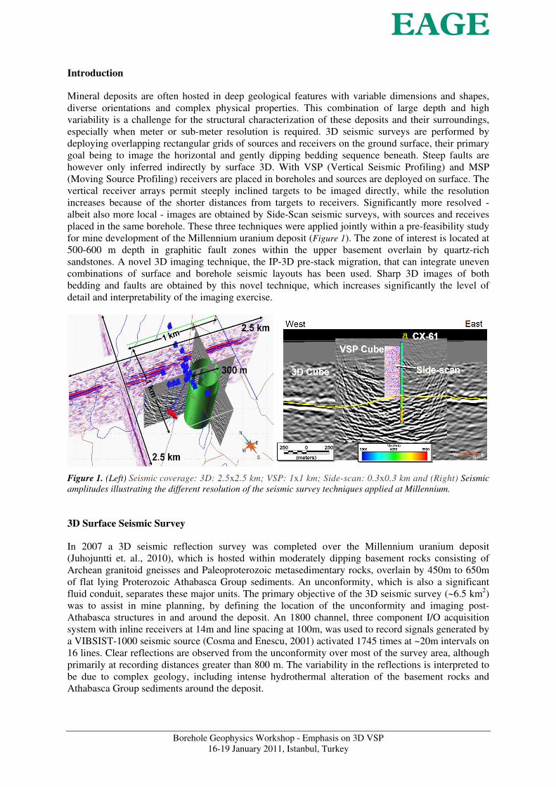
Figure 1. (Left) Seismic coverage: 3D: 2.5x2.5 km; VSP: 1x1 km; Side-scan: 0.3x0.3 km and (Right) Seismic
amplitudes illustrating the different resolution of the seismic survey techniques applied at Millennium.
3D Surface Seismic Survey
In 2007 a 3D seismic reflection survey was completed over the Millennium uranium deposit
(Juhojuntti et. al., 2010), which is hosted within moderately dipping basement rocks consisting of
Archean granitoid gneisses and Paleoproterozoic metasedimentary rocks, overlain by 450m to 650m
of flat lying Proterozoic Athabasca Group sediments. An unconformity, which is also a significant
fluid conduit, separates these major units. The primary objective of the 3D seismic survey (~6.5 km2)
was to assist in mine planning, by defining the location of the unconformity and imaging post-
Athabasca structures in and around the deposit. An 1800 channel, three component I/O acquisition
system with inline receivers at 14m and line spacing at 100m, was used to record signals generated by
a VIBSIST-1000 seismic source (Cosma and Enescu, 2001) activated 1745 times at ~20m intervals on
16 lines. Clear reflections are observed from the unconformity over most of the survey area, although
primarily at recording distances greater than 800 m. The variability in the reflections is interpreted to
be due to complex geology, including intense hydrothermal alteration of the basement rocks and
Athabasca Group sediments around the deposit.
Borehole Geophysics Workshop - Emphasis on 3D VSP
16-19 January 2011, Istanbul, Turkey
VSP, MSP and Side-Scan Borehole Seismic Surveys
VSP data were recorded in borehole CX-61 from 31 shots and 180 3-comp receivers at 5m intervals.
From the same borehole, MSP data were recorded by 8 3-comp receivers at 5m intervals, placed from
482.5 to 517.5m depth and Side-scan in boreholes CX-62 & CX-63 (~500 receivers @ 1m).
To aid the estimation of surface static corrections used for processing of all surface and borehole data,
the P wave velocity filed was derived by tomographic inversion of the VSP, MSP and a part of the 3D
data (Figure 2, left). A velocity model in depth, required for subsequent processing and migration,
was also derived by 3D tomographic inversion of all available borehole seismic data, including full
wave sonic (Figure 2, right).
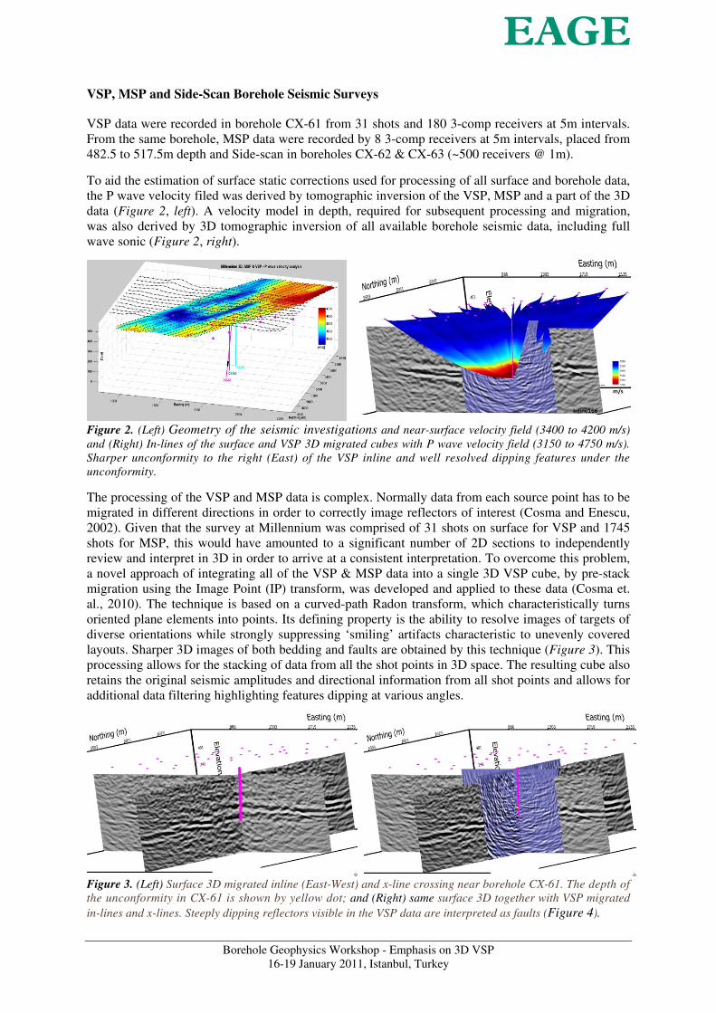
Figure 2. (Left) Geometry of the seismic investigations and near-surface velocity field (3400 to 4200 m/s)
and (Right) In-lines of the surface and VSP 3D migrated cubes with P wave velocity field (3150 to 4750 m/s).
Sharper unconformity to the right (East) of the VSP inline and well resolved dipping features under the
unconformity.
The processing of the VSP and MSP data is complex. Normally data from each source point has to be
migrated in different directions in order to correctly image reflectors of interest (Cosma and Enescu,
2002). Given that the survey at Millennium was comprised of 31 shots on surface for VSP and 1745
shots for MSP, this would have amounted to a significant number of 2D sections to independently
review and interpret in 3D in order to arrive at a consistent interpretation. To overcome this problem,
a novel approach of integrating all of the VSP & MSP data into a single 3D VSP cube, by pre-stack
migration using the Image Point (IP) transform, was developed and applied to these data (Cosma et.
al., 2010). The technique is based on a curved-path Radon transform, which characteristically turns
oriented plane elements into points. Its defining property is the ability to resolve images of targets of
diverse orientations while strongly suppressing ‘smiling’ artifacts characteristic to unevenly covered
layouts. Sharper 3D images of both bedding and faults are obtained by this technique (Figure 3). This
processing allows for the stacking of data from all the shot points in 3D space. The resulting cube also
retains the original seismic amplitudes and directional information from all shot points and allows for
additional data filtering highlighting features dipping at various angles.
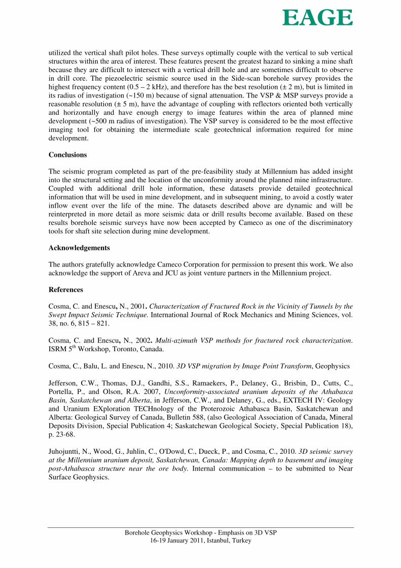
Figure 3. (Left) Surface 3D migrated inline (East-West) and x-line crossing near borehole CX-61. The depth of
the unconformity in CX-61 is shown by yellow dot; and (Right) same surface 3D together with VSP migrated
in-lines and x-lines. Steeply dipping reflectors visible in the VSP data are interpreted as faults (Figure 4).

Borehole Geophysics Workshop - Emphasis on 3D VSP
16-19 January 2011, Istanbul, Turkey
Integrated Site Model
The interpretation of the 3D VSP cube at Millennium has resulted in the definition of a complex
system of post-Athabasca faulting located in proximity of the deposit and the mine infrastructure. The
majority of this faulting parallels the strike of the drill defined basement stratigraphy, but conjugate
faults and numerous cross faults, trending at various azimuths and at different scales, have also been
interpreted from this data (Figure 4). The majority of the interpreted faults extend up into the
overlying sandstone units, an indication of post-Athabsca movement. Coupled with the existing drill
hole information and other seismic datasets, the 3D VSP cube has resulted in an improvement in the
understanding of the structural setting around the deposit (Figure 5).
Figure 4. Interpreted depth to unconformity (3D surface seismic cube) with interpreted post-
Athabasca structure (3D VSP cube).
Figure 5. The VSP 3D migrated cube shows an improvement in the amount of detail of sub-vertical structure.
The location of the mineralization (red) and the alteration zone (magenta) are shown, together with borehole
intersections of the unconformity (yellow spheres).
Discussion
The various seismic survey techniques used during the study provide different resolution with respect
to the targets of interest due to the different frequency content and coupling with the geology (Figure
1). The 3D surface survey provides the best areal extent and depth of investigation, but preferentially
couple with horizontal to sub-horizontal strata. The 3D surface survey has limited resolution
compared to the borehole seismic results because of the wider geophone spacing and lower frequency
content present in the recovered dataset. The borehole seismic techniques, VSP, MSP and Side-scan,
Borehole Geophysics Workshop - Emphasis on 3D VSP
16-19 January 2011, Istanbul, Turkey
utilized the vertical shaft pilot holes. These surveys optimally couple with the vertical to sub vertical
structures within the area of interest. These features present the greatest hazard to sinking a mine shaft
because they are difficult to intersect with a vertical drill hole and are sometimes difficult to observe
in drill core. The piezoelectric seismic source used in the Side-scan borehole survey provides the
highest frequency content (0.5 – 2 kHz), and therefore has the best resolution (± 2 m), but is limited in
its radius of investigation (~150 m) because of signal attenuation. The VSP & MSP surveys provide a
reasonable resolution (± 5 m), have the advantage of coupling with reflectors oriented both vertically
and horizontally and have enough energy to image features within the area of planned mine
development (~500 m radius of investigation). The VSP survey is considered to be the most effective
imaging tool for obtaining the intermediate scale geotechnical information required for mine
development.
Conclusions
The seismic program completed as part of the pre-feasibility study at Millennium has added insight
into the structural setting and the location of the unconformity around the planned mine infrastructure.
Coupled with additional drill hole information, these datasets provide detailed geotechnical
information that will be used in mine development, and in subsequent mining, to avoid a costly water
inflow event over the life of the mine. The datasets described above are dynamic and will be
reinterpreted in more detail as more seismic data or drill results become available. Based on these
results borehole seismic surveys have now been accepted by Cameco as one of the discriminatory
tools for shaft site selection during mine development.
Acknowledgements
The authors gratefully acknowledge Cameco Corporation for permission to present this work. We also
acknowledge the support of Areva and JCU as joint venture partners in the Millennium project.
References
Cosma, C. and Enescu, N., 2001. Characterization of Fractured Rock in the Vicinity of Tunnels by the
Swept Impact Seismic Technique. International Journal of Rock Mechanics and Mining Sciences, vol.
38, no. 6, 815 – 821.
Cosma, C. and Enescu, N., 2002. Multi-azimuth VSP methods for fractured rock characterization.
ISRM 5th Workshop, Toronto, Canada.
Cosma, C., Balu, L. and Enescu, N., 2010. 3D VSP migration by Image Point Transform, Geophysics
Jefferson, C.W., Thomas, D.J., Gandhi, S.S., Ramaekers, P., Delaney, G., Brisbin, D., Cutts, C.,
Portella, P., and Olson, R.A. 2007, Unconformity-associated uranium deposits of the Athabasca
Basin, Saskatchewan and Alberta, in Jefferson, C.W., and Delaney, G., eds., EXTECH IV: Geology
and Uranium EXploration TECHnology of the Proterozoic Athabasca Basin, Saskatchewan and
Alberta: Geological Survey of Canada, Bulletin 588, (also Geological Association of Canada, Mineral
Deposits Division, Special Publication 4; Saskatchewan Geological Society, Special Publication 18),
p. 23-68.
Juhojuntti, N., Wood, G., Juhlin, C., O'Dowd, C., Dueck, P., and Cosma, C., 2010. 3D seismic survey
at the Millennium uranium deposit, Saskatchewan, Canada: Mapping depth to basement and imaging
post-Athabasca structure near the ore body. Internal communication – to be submitted to Near
Surface Geophysics.