snh commissioned report 115: survey of herbivore impacts ... · pdf filethis report has...
TRANSCRIPT

C O M M I S S I O N E D R E P O R T
For further information on this report please contact:
Jenny BryceScottish Natural HeritageINVERNESSTelephone: 01463 706471E-mail: [email protected]
This report should be quoted as:
O’Hanrahan, B. (2005). Survey of herbivore impacts on upland, peatland and woodlanddesignated features in the Strathglass Complex Special Area of Conservation. Scottish Natural Heritage Commissioned Report No. 115 (ROAME No. F02AC202).
This report, or any part of it, should not be reproduced without the permission of Scottish Natural Heritage.This permission will not be withheld unreasonably. The views expressed by the author(s) of this report shouldnot be taken as the views and policies of Scottish Natural Heritage.
© Scottish Natural Heritage 2005.
Commissioned Report No. 115
Survey of herbivore impacts on upland,peatland and woodland designatedfeatures in the Strathglass Complex
Special Area of Conservation(ROAME No. F02AC202)


Background
This project investigated the current level of herbivore impacts on the Natura interests within the Strathglass Complex SACcovering the hills between Lochs Affric, Mullardoch and Monar (NN 477 753) in the East Highland SNH Area (HighlandCouncil local authority area, Inverness-shire). Where possible, evidence of trends in impact levels were also examined.
The aim of the survey was to establish current levels of impacts attributable to deer browsing and trampling and to considerwhether these are likely to lead to the deterioration of the Natura interests. The survey based on random sample points, wasstratified by nine upland management units, four of which also contained Caledonian Forest. Current impacts for the uplandhabitats were assessed against the small-scale field indicators in ‘A Guide to Upland Habitats’ (MacDonald et al. 1998) whilsta parallel method was devised for woodlands. The report documents various logistical difficulties with locating the correcthabitats at the random locations provided and on the usefulness/timing of application of some of the indicators. Deer were themain herbivores throughout the majority of the site. The results are presented here first by management unit and habitat typeand are then repeated in a summary for each habitat across the site as a whole. An overview of the prognosis is then describedfor each management unit.
Main findings
The results of the survey indicate that continuation of the current levels of impact on three main features type is likely to lead tothe deterioration of these habitats on a relatively widespread basis throughout the SAC, although impact levels do vary betweenmanagement units. These feature types are:
l Blanket bogs (H7130);
l North Atlantic wet heaths with Erica tetralix (H4010) and;
l Caledonian Forest (H91C0).
For blanket bog and wet heath the damaging impacts are most likely a consequence of trampling and for the woodland interestsfrom browsing. Localised concerns which could lead to deterioration of interests were also identified with respect to Alpine andboreal heaths (H4060), European dry heaths (H4030) and flushes. Furthermore it is suggested that Siliceous alpine and borealgrasslands (H6150), dry heath and alpine heath would benefit from reductions in impact levels more widely.
The results of this study will be used to inform discussions relating to local deer management.
Survey of herbivore impacts on upland, peatland and
woodland designated features in the Strathglass Complex SAC
Commissioned Report No. 115 (ROAME No. F02AC202)Contractor: Brendan O‘Hanrahan (Including the results of the survey of North Affric and ForestryCommission Scotland, Fasnakyle, management units carried out by Central Environmental Surveys).Year of publication: 2005
C O M M I S S I O N E D R E P O R T
Summary
For further information on this project contact:Jenny Bryce, Scottish Natural Heritage, Inverness.
Tel: 01463 706471
For further information on the SNH Research & Technical Support Programme contact:The Advisory Services Co-ordination Group, Scottish Natural Heritage, 2 Anderson Place, Edinburgh EH6 5NP.
Tel: 0131–446 2400 or [email protected]

Acknowledgements
The survey was carried out by two teams of surveyors, the northern management units by BrendanO’Hanrahan and his team, the southern management units by Alan Booth’s team from Central EnvironmentalSurveys (CES). This report has largely been compiled by Brendan O’Hanrahan. The project was managedinitially by Ro Scott (SNH, Deer Advisory Officer) and latterly by Jenny Bryce when she took over this role.
Additional input to the project was provided from Chris Wright (SNH, Area Officer) and Robbie Kernahan(DCS, Deer officer).
All estates are thanked for their assistance in facilitating access for this survey.
May 2005
Scottish Natural Heritage Commissioned Report No. 115 (ROAME No. F02AC202)

Contents
Summar y
Acknowledgements
1 INTRODUCTION 1
2 METHODS 3
2.1 Source of survey methods 3
2.1.1 Habitats surveyed 4
2.1.2 Habitat definitions for impact assessment (upland and 4
peatland)
2.1.3 Wet heath anomaly 5
2.2 Sampling and field procedure 5
2.2.1 Generation of waypoints 5
2.2.2 Field procedure 5
2.2.3 Less extensive habitats 6
2.3 Woodland methods 7
2.3.1 Waypoints, impact assessment and life-class recording 7
2.3.2 Notes and clarifications for woodland methods 7
2.4 Data presentation 8
2.5 Applicability of small-scale field indicators in this survey 8
2.6 Influence of survey timing 9
2.7 Boundaries of management units 10
2.8 Data analysis 10
2.9 Problems with features listed for waypoints 11
3 DETAILS OF SURVEY 12
3.1 Habitats surveyed 12
3.2 Surveyors 13
4 RESULTS 14
4.1 Pait (West Monar and Pait) 14
4.1.1 Siliceous alpine and boreal grasslands (H6150) 14
4.1.2 Alpine and boreal heaths (H4060) 15
4.1.3 European dry heaths (H4030) 15
4.1.4 North Atlantic wet heaths with Erica tetralix (H4010) 15
4.1.5 Blanket bogs (H7130) 16
4.1.6 Siliceous rocky slopes with chasmophytic vegetation 16
(H8220)
4.1.7 Siliceous scree of the montane to snow levels (H6230) 16
4.1.8 Flushes 16
Scottish Natural Heritage Commissioned Report No. 115 (ROAME No. F02AC202)

4.2 Braulen 174.2.1 Siliceous alpine and boreal grasslands (H6150) 174.2.2 Alpine and boreal heaths (H4060) 174.2.3 European dry heaths (H4030) 174.2.4 North Atlantic wet heaths with Erica tetralix (H4010) 184.2.5 Blanket bogs (H7130) 184.2.6 Siliceous scree of the montane to snow levels (H6230) 184.2.7 Hydrophilous tall herb fringe communities of plains and 18
of the montane to alpine levels (H6430)4.2.8 Sub-Arctic Salix spp. scrub (H4080) 194.2.9 Flushes 194.2.10 Woodland 19
4.3 East Benula 204.3.1 Siliceous alpine and boreal grasslands (H6150) 204.3.2 Alpine and boreal heaths (H4060) 204.3.3 European dry heaths (H4030) 204.3.4 North Atlantic wet heaths with Erica tetralix (H4010) 204.3.5 Blanket bogs (H7130) 204.3.6 Hydrophilous tall herb fringe communities of plains and 21
of the montane to alpine levels (H6430)4.3.7 Sub-Arctic Salix spp. scrub (H4080) 214.3.8 Flushes 21
4.4 Glencannich 214.4.1 Siliceous alpine and boreal grasslands (H6150) 214.4.2 Alpine and boreal heaths (H4060) 214.4.3 European dry heaths (H4030) 224.4.4 North Atlantic wet heaths with Erica tetralix (H4010) 234.4.5 Blanket bogs (H7130) 234.4.6 Siliceous rocky slopes with chasmophytic vegetation 24
(H8220)4.4.7 Siliceous scree of the montane to snow levels (H6230) 244.4.8 Hydrophilous tall herb fringe communities of plains and 24
of the montane to alpine levels (H6430)4.4.9 Sub-Arctic Salix spp. scrub (H4080) 244.4.10 Flushes 244.4.11 Woodland (Liatrie Burn SSSI) 24
4.5 West Benula 254.5.1 Siliceous alpine and boreal grasslands (H6150) 254.5.2 Alpine and boreal heaths (H4060) 254.5.3 European dry heaths (H4030) 264.5.4 North Atlantic wet heaths with Erica tetralix (H4010) 264.5.5 Blanket bogs (H7130) 264.5.6 Siliceous rocky slopes with chasmophytic vegetation 27
(H8220)4.5.7 Siliceous scree of the montane to snow levels (H6230) 274.5.8 Hydrophilous tall herb fringe communities of plains and 27
of the montane to alpine levels (H6430)4.5.9 Flushes 27
Scottish Natural Heritage Commissioned Report No. 115 (ROAME No. F02AC202)

4.6 Syndicate (East Benula South) (labelled Cozac in datasheets provided) 28
4.6.1 Siliceous alpine and boreal grasslands (H6150) 28
4.6.2 Alpine and boreal heaths (H4060) 28
4.6.3 European dry heaths (H4030) 28
4.6.4 North Atlantic wet heaths with Erica tetralix (H4010) 29
4.6.5 Blanket bogs (H7130) 29
4.6.6 Siliceous rocky slopes with chasmophytic vegetation 29
(H8220)
4.6.7 Siliceous scree of the montane to snow levels (H6230) 29
4.6.8 Hydrophilous tall herb fringe communities of plains and 29
of the montane to alpine levels (H6430)
4.6.9 Flushes 30
4.7 Mullardoch 30
4.7.1 Siliceous alpine and boreal grasslands (H6150) 30
4.7.2 Alpine and boreal heaths (H4060) 30
4.7.3 European dry heaths (H4030) 31
4.7.4 North Atlantic wet heaths with Erica tetralix (H4010) 31
4.7.5 Blanket bogs (H7130) 31
4.7.6 Siliceous rocky slopes with chasmophytic vegetation 32
(H8220)
4.7.7 Siliceous scree of the montane to snow levels (H6230) 32
4.7.8 Flushes 32
4.7.9 Woodland 32
4.8 North Affric 32
4.8.1 Siliceous alpine and boreal grasslands (H6150) 32
4.8.2 Alpine and boreal heaths (H4060) 33
4.8.3 European dry heaths (H4030) 33
4.8.4 North Atlantic wet heaths with Erica tetralix (H4010) 33
4.8.5 Blanket bogs (H7130) 34
4.8.6 Siliceous rocky slopes with chasmophytic vegetation
(H8220) 34
4.8.7 Siliceous scree of the montane to snow levels (H6230) 34
4.8.8 Flushes 34
4.8.9 Woodland 35
4.9 FCS (Fasnakyle) 35
4.9.1 Siliceous alpine and boreal grasslands (H6150) 35
4.9.2 Alpine and boreal heaths (H4060) 35
4.9.3 European dry heaths (H4030) 36
4.9.4 North Atlantic wet heaths with Erica tetralix (H4010) 36
4.9.5 Blanket bogs (H7130) 36
4.9.6 Flushes 37
4.9.7 Woodland 37
Scottish Natural Heritage Commissioned Report No. 115 (ROAME No. F02AC202)

5 OVERVIEW BY HABITAT, MANAGEMENT UNIT AND 38HERBIVORE SPECIES5.1 Habitats 38
5.1.1 Siliceous alpine and boreal grasslands (H6150) 385.1.2 Alpine and boreal heaths (H4060) 385.1.3 European dry heaths (H4030) 405.1.4 North Atlantic wet heaths with Erica tetralix (H4010) 415.1.5 Blanket bogs (H7130) 425.1.6 Calcareous rocky slopes with chasmophytic vegetation 42
(H8210)5.1.7 Siliceous rocky slopes with chasmophytic vegetation 43
(H8220)5.1.8 Siliceous scree of the montane to snow levels (H6230) 435.1.9 Hydrophilous tall herb fringe communities of plains and 44
of the montane to alpine levels (H6430)5.1.10 Sub-Arctic Salix spp. scrub (H4080) 445.1.11 Flushes 455.1.12 Upland assemblage 455.1.13 Caledonian Forest 46
5.2 Overview for each management unit 495.2.1 Pait 495.2.2 Braulen 495.2.3 East Benula 505.2.4 Glencannich 515.2.5 West Benula 515.2.6 Syndicate 525.2.7 Mullardoch 525.2.8 North Affric 535.2.9 Fasnakyle (FCS) 53
5.3 Individual herbivore species 535.3.1 Red Deer 535.3.2 Sheep 535.3.3 Cattle 535.3.4 Feral goats 535.3.5 Mountain hares 545.3.6 Heather beetle 54
References 55
Appendix 1 Herbivore impact assessment methods for woodland features 56
Appendix 2 Definitions of Caledonian Forest life-classes used from Clifford 58(unpublished, 2003)
Appendix 3 Individual browsing and trampling indicators for each 60–97habitat type
Scottish Natural Heritage Commissioned Report No. 115 (ROAME No. F02AC202)

List of f igures
Figures 1–5 Current impacts on woodland: numbers of sample points 44–46classified by life-class types
List of tablesTable 1 Number of sample points obtained per management unit 12Table 2 Siliceous alpine and boreal grasslands results – all management units 38Table 3 Alpine and boreal heaths results – all management units 39Table 4 European dry heaths results – all management units 40Table 5 Wet heaths results – all management units 41Table 6 Blanket bogs results – all management units 42Table 7 Siliceous rocky slopes results – all management units 43Table 8 Siliceous scree results – all management units 43Table 9 Tall herbs – results for all management units 44Table 10 Salix scrub results – all management units 44Table 11 Flushes results – all management units 45Table 12 Caledonian Forest results – all management units 46
NOTE:The data referred to as being supplied on an accompanying CD have not beenreproduced for each copy of the report. However these can be made available on request from SNH Headquarters Library or by contacting Jenny Bryce([email protected]).
Scottish Natural Heritage Commissioned Report No. 115 (ROAME No. F02AC202)


1 INTRODUCTION
Under the Deer (Scotland) Act of 1996, the Deer Commission for Scotland (DCS) is empowered to takeaction where deer are damaging the natural heritage. The statutory agencies’ approach to this issue is setout in the document “Deer (Scotland) Act & Damage by Wild Deer to Woodland and the Natural Heritage”,which is available on request from DCS. In this document, damage to the natural heritage is defined (on p.8) as occurring:
“…when natural and semi-natural habitats are prevented from regenerating to sustain their ground cover and the
diversity of plant species; or where local populations of important species (animal or plant) are in decline;
or where important earth science features are being eroded by deer.”
The Deer (Scotland) Act provides different measures which may be used depending on whether deer “havecaused, are causing or are likely to cause damage” and whether or not that damage is considered by theDeer Commission to be serious.
The objective of this survey was to inform SNH, DCS and the land owners of the nature and extent ofherbivore impacts within the Strathglass Complex SAC and did not assume that impacts were at damaginglevels. In particular the survey sought to:
i) assess the severity of current grazing and trampling impacts from deer (of any species) on the notifiedfeatures and the direction of any apparent trends in impact levels;
ii) determine whether current levels of impact can at present be considered damaging to any of thedesignated natural heritage features and/or whether trend indicators suggest that such impacts, if continued, are likely to become damaging in the future.
The Strathglass Complex Special Area of Conservation (SAC) is one of the largest SACs in Scotland at c.23,500ha, comprising the following SSSIs: Affric-Cannich Hills, Glen Affric, Liatrie Burn and Glen Strathfarrar. The landscape in the SAC is dominated by two parallel east-west ranges of mountains;the southernmost running between Lochs Affric and Mullardoch, while the northern range runs between Lochs Mullardoch and Monar. The southern range includes Carn Eige, the highest mountain north of theGreat Glen at 1,183m, while the northernmost of the two Sgurr na Lapaichs within the site is, at 1,150m,the highest peak in the northern half of the site. In the northeast, the site is bounded by Glen Strathfarrar,continuing on to the west as Gleann Innis an Loichel. The Allt Riabhachan and Coire nan Èach, followinground to Coire Lungard mark the site’s north-western boundaries. The southern boundary extends to the northshore of Loch Affric and the north side of the Allt Gleann Gniomhaidh. The eastern boundary between theeast ends of Loch Affric and Loch Mullardoch skirts east of Beinn Eun before descending to the north alongAllt Fraoch-choire. North of Loch Mullardoch the line keeps east of Creag Feusag before making a dog-legto link up with the Allt Innis a’ Mhuilt and thence to the southern edge of Glen Strathfarrar, much of whichis included almost as far as the junction with Strathglass. However, the Glen Strathfarrar National NatureReserve (NNR) was not included in this project, in contrast to the Site of Special Scientific Interest (SSSI) ofthe same name to the west, including Inchvuilt and Coille na Leitire Duibhe.
The site (grid reference NH 185 314) is within the SNH East Highland Area and Highland Council localauthority areas.
1
Scottish Natural Heritage Commissioned Report No. 115 (ROAME No. F02AC202)

This survey was organised according to management units – for upland and peatland features this comprisednine units: Braulen, Pait, Glencannich, East Benula, West Benula, Syndicate (East South Benula) andMullardoch, North Affric and Forestry Commission Scotland (FCS)-owned Fasnakyle Forest. The latter twowere surveyed by Central Environmental Surveys and the results of all the assessments are combined in thisreport. As the survey methods were not identical, the samples carried out by Central Environmental Surveysare identified in this report and maps by the notation (1), with (2) being those carried out by BrendanO’Hanrahan. Woodland was surveyed in five of the management units, namely North Affric, Fasnakyle(FCS), Mullardoch, Braulen and Glencannich (the latter consisting solely of the Liatrie Burn SSSI); all byBrendan O’Hanrahan’s team.
2
Scottish Natural Heritage Commissioned Report No. 115 (ROAME No. F02AC202)
Strathglass sur vey area and management units

2 METHODS
This survey assessed current levels of herbivore impacts on both woodland and upland/peatland habitats.
This focussed on Annex I (European Habitats Directive) features in addition to a generic habitat called
‘flushes’, which was included because it was thought to be likely to provide a good index of herbivore activity.
For the upland and peatland survey, parts of the Affric-Cannich Hills, Glen Affric and Glen Strathfarrar SSSIs
were surveyed. For the woodland survey, all of the Liatrie Burn SSSI and parts of Glen Affric, Affric-Cannich
Hills and Glen Strathfarrar SSSIs were included.
2.1 Source of sur vey methods
For upland and peatland habitats, a protocol amalgamating parts of two published methodologies was
drawn up by SNH in discussion with DCS and the land owners and managers. The vegetative condition
part of the survey, was taken from the Upland Common Standards Monitoring guidance document ( JNCC
2004) and is not detailed in this report. The methods for the habitat impact assessment, which formed the
main part of the study, examined the small-scale field indicators from MacDonald et al. (1998). The habitat
impact assessment consisted of looking at various indices of herbivore impact, some direct, such as trampling
and browsing of dwarf shrubs, others more indirect, eg, degree of flowering for cotton-grass species and
average vegetation height. It also incorporated a varying number of indicators designed to detect the trend
of impacts at each point ie, whether there was any evidence that the level of impact was increasing or
decreasing. The samples collected by Central Environmental surveys did not mirror this protocol, instead
recording the achievement or failure to achieve condition targets for all the indicators. Hence in the raw data
(supplied as a CD) these are described as ‘Y’ or ‘N’ rather than as impact classes. However, despite this
difference in recording methodology, many of the same browsing and trampling indicators were assessed,
hence the information can still be used to draw comparison with the habitat impact assessments carried out
for the upland features in the northerly management units.
For the impact assessment part of the survey the feature classes which were the subject of this project
corresponded as follows to the field guide habitat types from MacDonald et al. (1998).
This survey MacDonald et al. (1998)
Blanket bogs Blanket bog
European dry heaths Dwarf shrub heath
North Atlantic wet heaths with Erica tetralix Dwarf shrub heath/Blanket bog (see section 2.1.3)
Siliceous alpine and boreal grasslands Wind-clipped heath
Alpine and boreal heath Wind-clipped heath
Tall herb communities Tall herbs
Sub-Arctic Salix spp. scrub Scrub
Siliceous rocky slopes No equivalent – refer to JNCC (2004)
Calcareous rocky slopes No equivalent – refer to JNCC (2004)
Siliceous scree No equivalent – refer to JNCC (2004)
Flushes Flush
3
Scottish Natural Heritage Commissioned Report No. 115 (ROAME No. F02AC202)

For the woodlands, the only aspect of habitat condition assessed was a proxy for age-structure. This involvedrecording the proportion of trees in different life classes (after Clifford (2003), unpublished) for more or lesshomogeneous blocks of woodland. The assessment of current impacts was carried out at random waypointswithin woodland polygons using a method developed by SNH in parallel to the upland methodology. Thisincluded assessment of the level of damage, if any, to regeneration, the degree of browsing on the fieldlayer and the incidence of trampling and dunging. See Appendix 1 for more detailed methodology.
2.1.1 Habitats sur veyed
The following Annex I (from the EC Habitats Directive) habitats were the subject of this survey:
Upland and peatland
l Extensive habitats;
l Siliceous alpine and boreal grasslands (H6150);
l Alpine and boreal heaths (H4060);
l European dry heaths (H4030);
l North Atlantic wet heaths with Erica tetralix (H4010);
l Blanket bogs (H7130);
l Scarcer habitats;
l Siliceous rocky slopes with chasmophytic vegetation (H8220);
l Calcareous rocky slopes with chasmophytic vegetation (H8210);
l Siliceous scree of the montane to snow levels (H6230);
l Hydrophilous tall herb fringe communities of plains and of the montane to alpine levels (H6430);
l Sub-Arctic Salix spp. scrub (H4080).
Woodland
l Caledonian forest (H91C0);
l Bog woodland (H91D0).
In addition (for upland and peatland)
l Flushes.
2.1.2 Habitat definit ions for impact assessment (upland and peatland)
The habitat definitions in MacDonald et al. (1998) are broader than the Annex I habitats. Thus, the wind-clipped heath set of indicators was applicable to both the siliceous alpine and boreal grasslands and alpineheath features. In contrast, there is only one category of impact assessment in MacDonald et al. (1998) forflushes, which corresponds to three categories of flushes used in condition assessments: alpine flushes,alkaline fen and springheads, rills and flushes.
4
Scottish Natural Heritage Commissioned Report No. 115 (ROAME No. F02AC202)

Every feature type assessed during this survey had its own table of attributes and targets, although some ofthe targets were common to several habitats. Flushes were the exception which have been amalgamated forthe purposes of this report.
Sample survey forms with more complete texts for the individual targets and indicators are supplied on theCD which accompanies this report.
2.1.3 Wet heath anomaly
One peculiarity is that because the MacDonald et al. (1998) method is based on generic habitat classes,although one impact assessment habitat class could be used for a single feature in almost every case, therewas one exception – wet heath, which is covered by either dwarf-shrub heath or blanket bog dependingon the floristics of the stand. Thus, the NVC sub-community M15b was normally assessed using the blanketbog impact assessment indicator list (hereafter referred to as ‘boggy wet heath’), whereas M15d wasassessed against the dwarf-shrub heath indicators (referred to as ‘heathy wet heath). M15a and M15c weremore often assessed using the blanket bog indicators (being more normally on deep peat), but some drierexamples were assigned to ‘heathy wet heath’.
2.2 Sampling and field procedure
2.2.1 Generation of waypoints
Notified features were normally identified from data provided by previous SNH surveys. Annex I habitatswere derived from vegetation maps using standard conversions between vegetation codes and featuretypes. Thus prior to the field survey, a set of random points (or two if woodland was also present) wasgenerated for the five ‘widespread’ upland features within each of the nine management units. Randomsample locations were identified by a twelve-figure grid reference, with up to a maximum of 37 points beingselected for each feature type present within a management unit.
2.2.2 Field procedure
This survey involved visiting (where possible) each of the sample locations (waypoints), finding the ten-figuregrid reference with a hand-held Global Positioning System (GPS) receiver (Garmin etrex and Garmin 12 receivers were used, with accuracies of 5–12m being normal), and checking to see if the vegetation atthe point belonged to one of the appropriate vegetation types given for that particular waypoint. Thus, forexample, if it was a wet heath point then we would search for the Scirpus-Erica wet heath M15 NVCcommunity (Rodwell 1991). Many points were listed in the waypoint lists as being for potentially more thanone feature, eg, for both blanket bog and wet heath. If the feature (or features) was absent at the exactlocation, then it would be sought within a radius of 20m for the extensive upland features (dry heath, wetheath, blanket bog, alpine heath and siliceous and boreal grasslands) or 50m for woodland. A gridreference for this new location was then taken (highlighted in the results spreadsheets). If, however, none ofthe listed features could be found within this radius, but another of the widespread upland features waspresent, then this would be assessed instead. In the latter case, the waypoint number is highlighted in thespreadsheet to indicate that it is a ‘new recruit’ to this habitat. No more than one feature was assessed foreach waypoint (with the exception of four points on the Syndicate management unit which were eachassessed for two habitats because of a misunderstanding – their data have been retained because of thesmall sample sizes on this unit).
5
Scottish Natural Heritage Commissioned Report No. 115 (ROAME No. F02AC202)

Once the feature had been located, the surveyor would then proceed through the list of targets andindicators in the relevant table for that feature (other than those carried out by CES, in which condition targetswere also used to assess current browsing impacts). For the condition assessment part of the exercise if thetarget was met it was recorded as a ‘Y’, if not, as an ‘N’. There were two parts to the impact assessment:current field indicators and trend indicators. For the former, a point would normally be classed as havingeither a high, moderate or low level of impact, though sometimes the choice would be between,high/moderate and low. For the trend indicators, the objective was to establish if there were detectablechanges in the levels of impacts, perhaps demonstrated by indirect indices such as the relative vigour ofspecies such as Juncus squarrosus as compared with Sphagnums. Here the options are either decreasing orincreasing, with ‘chronic’ as a qualifier to indicate that this level of impact has probably been continuingover a long period. The scale of assessment for the extensive habitats was 4m2.
Although at least one point was found for each of the extensive habitats within each management unit, somehabitats were very poorly represented within particular areas, eg, only one wet heath location was foundwithin the Syndicate management unit and only one dry heath point on Pait ground. Two of the morerestricted habitats, tall herbs and Salix scrub, were only found in a minority of the nine management units.No locations for calcareous rocky slopes were encountered, probably because it is a very restricted habitatwhich is unlikely to be picked up at random.
Where reaching waypoints would have involved unacceptable risk to the surveyors the points were eithernot assessed or, where possible, assessed at a distance using binoculars. Where this was the case, it isnoted accordingly in the data spreadsheets.
The impact assessment indicator for dwarf shrub heath referring to Calluna and V. myrtillus browsing(European dry heaths and ‘heathy’ wet heath) has different thresholds depending on the vigour and growthrates of the dwarf shrubs. The threshold used in this survey for ‘High’ impacts on the seven northernmanagement units was 33%, as the dwarf shrubs concerned were judged to have relatively slow rates ofgrowth. However, it is possible that this assumption should have been questioned for some areas, especiallyMullardoch, where Calluna in particular is often quite vigorous.
2.2.3 Less extensive habitats
Habitats with more restricted distributions were treated in a different way. Those for which some accurate,but limited, survey information was available – Salix scrub and tall herbs – were sought at the grid referencesprovided and a subset of points was taken if the habitat was reasonably widespread – if not, each localitywas assessed as a single point. An opportunistic approach was also taken with these habitats, ie, if thefeature was encountered at additional locations during the course of surveying the extensive features, anassessment would be made at that location and the location recorded. For features where previous surveyinformation was lacking or inadequate – siliceous and calcareous rocky slopes, siliceous scree and flushes– an entirely opportunistic approach was taken, ie, the habitats were assessed whenever encountered up toa target of, eg, 12 points for flushes (fewer for the rocky habitats) per management unit.
For the purposes of this survey flushes were defined as follows: comprising the NVC communities M10,M11, M12, M31, M32, M33, M37, M38; also species-rich M15a, ie, with at least 3 Carex spp., or agood complement of “brown” mosses. ‘Heathy’ M15a, ie, where it occupies a broader area (rather than aclearly linear, narrow flush), has fewer Carex spp. and brown mosses, was assessed as wet heath; very
6
Scottish Natural Heritage Commissioned Report No. 115 (ROAME No. F02AC202)

species-poor, stony flushes which might be regarded as impoverished M15a (what the Averises (Averis &Averis 1998) called M15a(ii)) were not assessed at all (being so species-poor, they would have failed thecondition assessments almost every time).
Surveyors entered data in the field onto either standard paper or electronic (for PDA entry) recording forms.
2.3 Woodland methods
2.3.1 Waypoints, impact assessment and life-class recording
The woodland survey method was also based on randomly generated waypoints. In this case 30 pointswere generated for each management unit as it was assumed they would coincide with woodland blocksmapped as polygons in the Scottish Semi-natural Woodland Inventory (Caledonian Partnership 2001). Only those management units with significant areas of well-developed semi-natural woodland were includedin the woodland survey: Braulen, Glencannich (Liatrie Burn SSSI), Mullardoch, FCS’s Fasnakyle estate andNorth Affric. This survey was intended to assess the current herbivore impacts on the Annex I habitatsCaledonian forest and Bog woodland. In practice, no points were found which clearly qualified as Bogwoodland and thus all points were assessed using the indicators for Caledonian forest. Some sample areasdid however contain small areas which might have been considered as Bog woodland.
There were two parts to the woodland survey, the first involved mapping the proportion of trees in differentlife-classes (with Scots pine and broadleaved trees being recorded separately), eg, small seedlings, saplings,pole stage, senescent (definitions of different life-classes are given in Appendix 2) within relativelyhomogeneous woodland blocks. The Clifford life-class classification was simplified for this survey in thatalthough most of the eight main life-classes are further subdivided, only the ‘integers’ were used with theexception of class 1, seedlings, where 1.1 and 1.2 were distinguished. The mapping units were nearlyalways coterminous with the polygons identified by the Scottish Semi-natural Woodland Inventory(Caledonian Partnership 2001). Where blocks could clearly be separated into more than one mappable unit,usually due to the presence of a fence, then additional blocks were noted, although this was very unusual.
The second component of the woodland survey comprised the assessment of current impacts: browsing,trampling and dunging, the extent to which regenerating seedlings seemed to be ‘escaping’ from the fieldlayer and the presence or absence of damage to trees and seedlings. As for upland features these wereassessed and normally given scores of ‘H’, ‘M’ or ‘L’. For this assessment a sample area of 50m by 50mwas used. To attempt to assess the trend of these impacts, the presence of the three ‘youngest’ life-classes inthe sample area was noted as well as the extent to which grazing-sensitive herbs were confined toinaccessible areas. This latter indicator was, however, found difficult to use because the survey wasconducted so late in the year.
2.3.2 Notes and clarif ications for woodland methods
The indicators relating to seedlings and recording the presence/absence of life-classes were notquantitative, ie, even if there was only one seedling from a particular life-class, it was recorded as beingpresent. Then a recording was made of whether or not the seedling was above the field layer or damaged.If the sample size for seedlings was very low, this is normally (but not always) recorded in the notes sectionfor each waypoint.
7
Scottish Natural Heritage Commissioned Report No. 115 (ROAME No. F02AC202)

Where no regeneration was seen in the sample area, then for the ‘regeneration success’ indicator an ‘H’impact score was awarded. The impact assessment recording forms include a column for ‘overall assessmentof current impacts’. This is partly a summation of the other columns, but was not derived using the averagingprocess used for the upland features (see 2.9), and hence comprises a more subjective assessment.
Due to delays relating to progress with the upland fieldwork, amendments to the original assessmentmethodology and subsequently weather, fieldwork for the woodland survey did not start until December2004. It is therefore possible that there may have been some underestimation of the presence ofbroadleaved seedlings.
2.4 Data presentation
NOTE: The data referred to as being supplied on an accompanying CD have not been reproduced for eachcopy of the report. However these can be made available on request from SNH Headquarters Library orby contacting Jenny Bryce ([email protected]). The raw data are supplied electronically as Excelspreadsheets with one worksheet for each feature (on a CD accompanying this report). Each record consistsof the waypoint code, date, surveyor, 12-figure grid reference and short letter codes, eg, ‘Y’ or ‘H’ for eachtarget or indicator, followed by details of photographs, species of herbivores noted as being present in thearea (by signs or direct observation), NVC community and any appropriate notes. For presentationpurposes, the column headings for the targets are often severely abbreviated. For full details of the targetrequirements for the different attributes in the condition assessment, please refer to the Interagency - UplandHabitat Common Standards Monitoring guidance (JNCC, 2004). For full details of the small-scale indicatorsused for the impact assessment, please refer to MacDonald et al. (1998).
2.5 Applicabil i ty of small-scale field indicators in this sur vey
Several of the standard indicators proved not to be applicable or misleading during the course of the projectand consequently, were discarded at the analysis stage.
One of the indicators used in MacDonald et al. (1998) was omitted from the recording forms almost fromthe beginning, namely that referring to the presence of spiders’ webs (dry heaths and ‘heathy’ wet heath),as they were found to be rare, even in areas which were shown by all other indicators to have low deerimpacts, that their inclusion would have resulted in a misleading contribution to the overall impact score foreach waypoint.
The indicator for the firmness of the bog surface (blanket bog and ‘boggy’ wet heath), although recordedduring fieldwork, was discarded for the analysis as it was clear from the beginning that, virtually every singlepoint would have to be described as having a high impact level on this criterion. Hence this indicator wasnot regarded as providing an accurate reflection of impact levels.
The indicator based on the degree of browsing of Betula nana (blanket bog) was also omitted from theanalysis as the species was not seen during this survey.
Although the indicator referring to the degree of Eriophorum flowering (blanket bog and ‘boggy’ wet heath)was included in the analysis, it should probably have been given a lower weighting for waypoints surveyed
8
Scottish Natural Heritage Commissioned Report No. 115 (ROAME No. F02AC202)

later in the season. There was a clear seasonal bias to this indicator, with E. vaginatum fruiting headsbecoming very difficult to spot after June/July and those of E. angustifolium having largely disappeared bythe end of September. Eriophorum flowering may also be subject to other influences, as it often seemed tocorrelate poorly with other impact indicators.
Similarly, while the Rubus chamaemorus indicator (blanket bog and ‘boggy’ wet heath) was retained for thefinal analysis, this species rarely flowers this far north in Scotland (O’Hanrahan, pers. obs.). The approachtaken in the analysis had the effect of neutralising the indicator – following the comments in MacDonald et al. (1998). Where no evidence of browsing was noted (which was the case in all of the points surveyed)the point was noted as having neither a high nor a low impact level.
The dwarf-shrub heath indicator referring to the degree of uprooting in recently burnt patches was removedfrom the final analysis since no burning was noted on any of the management units during this study.
Calluna and V. myrtillus flowering was not found to be a very reliable indicator of impact levels in this survey.From observations elsewhere eg, Angus, the degree of flowering can often be much more closely linked tothe weather in spring and summer than herbivore impacts (O’Hanrahan, pers. obs.).
The trend indicator for blanket bog referring to the height and cover of dwarf shrubs relative to graminoidsis considered as a useful index of past grazing pressure. However, as implied in MacDonald et al. (1998),where Eriophorum is vigorous, particularly in Calluna-Eriophorum bog (M19), then this may result in a falsescore of chronic high impact.
The Carex panicea indicator for blanket bog is regarded as an indicator of long-term trampling and erosionon drier peat. It was considered that this indicator was not applicable to upland areas such as this one,where exposure is generally less extreme than for example in the Western or Northern Isles, north Sutherlandor parts of Wester Ross. Possibly because of the lack of wind-borne marine minerals, C. panicea hardly everbecomes common in such situations in the Strathglass area – Juncus squarrosus and Trichophorum seem tooccupy this niche almost exclusively.
2.6 Influence of sur vey timing
Because of the timing of the survey at least one of the indicators used: the level of browsing on Callunavulgaris, was not assessed at the optimal time of year and it is possible that this impact may therefore havebeen somewhat underestimated. Certainly, surveys on management units in October, such as on the‘Syndicate’ ground, seemed to pick up much more frequent evidence of heather browsing, although thisphenomenon is blurred by the fact that the areas with higher deer impacts (as shown by other indicators)tended to have been surveyed later.
The indicator for summer grazing (dry heaths and ‘heathy’ wet heath) was probably also inappropriate forassessment after September and should perhaps be removed from the analysis for points assessed after thatmonth. As is mentioned above, it also became very difficult to detect Eriophorum species flowers or fruitsafter early September.
Surveyors reported that it was difficult or impossible to assess grazing impacts (for the siliceous alpine andboreal grasslands and alpine heath features) on montane herbs such as Armeria maritima and Silene acaulis
9
Scottish Natural Heritage Commissioned Report No. 115 (ROAME No. F02AC202)

from October onwards. Similarly, fewer and fewer Carex fruiting spikelets remained after mid-October asthey had mostly naturally disintegrated. Thus grazing impacts could not be adequately assessed for thisindicator for the flushes towards the end of the survey period.
2.7 Boundaries of management units
The data relating to the small parcel of ground owned by Carl Lawaetz in the Mullach a’ Ghlas-thuill – Allt Taige area on the north side of Loch Mullardoch has for the moment been subsumed within the largerEast Benula management unit (of which it was, until recently, a part).
2.8 Data analysis
For the purposes of giving an impact score to each waypoint, where the possible field entries are ‘H’,‘H/M’, ‘M’, ‘M/L’ and ‘L’ (very occasionally ‘H/L’) they have been given weightings to arrive at a numerical‘sum’ for each point as follows: 3 for ‘H’; 2.5 for ‘H/M’; 2 for ‘M’; 1.5 for ‘M/L’ and 1 for ‘L’. The totalfor all of the indicators for each point which were considered applicable and given a ‘score’ was thencalculated and divided by the number of ‘scored’ indicators. The final impact level for the point was thendetermined by where this last ‘average’ figure fell within the following ranges: 0–1.501 for ‘Low’,1.502–2.501 for ‘Moderate’ and above 2.502 for ‘High’. The results of these analyses have beenpresented in the results section for each habitat and ownership unit, but the maps (Appendix 3) illustrate someof the individual browsing and trampling indicators.
As the management units surveyed by Central Environmental Surveys used condition targets for both thecondition and current grazing impact indicators, it has not been possible to aggregate them in the sameway. The derivation of a current impact class has had to be inferred by reading across from the conditionassessment to the appropriate small-scale field indicators in MacDonald et al. (1998). In many cases onlya subset of the equivalent small-scale field indicators were assessed and these were recorded as passing orfailing to meet the condition target. The main indicators used to produce an average impact for each samplecarried out by CES are as follows.
Alpine Heath l Where grazing on Arctic-alpine grasses, sedges and rushes is < or > 10%l Grazing on dwarf shrubs is < or > 33%l Extent of disturbed bare ground, locally and/or over the feature as a whole, is < or > 10%
Siliceous Alpine l Grazing on Arctic-alpine grasses, sedges and rushes is < or > 10%and Boreal l Grazing on sub-alpine grasses (eg Agrostis, Festuca, subalpine Poa spp.) is < or > 10%Grassland l Extent of disturbed bare ground, locally and/or over the feature as a whole, is < or >10%
European Dry Heaths l Levels of grazing on mature dwarf shrub is < or > 33%
North Atlantic l Presence of an intensely disturbed surface at < or > 10%Wet Heaths with l Presence of disturbed bare ground at < or > 10%Erica tetralix and l Drainage due to grazing or trampling < or > 10%Blanket bog l Disturbance to the Sphagnum layer < or > 10%
l Levels of grazing on dwarf shrub of any age class is sufficient to fail the sample; 33% for mature heather or 66% for pioneer heather
Alpine Flush l Levels of trampling and tracking sufficient to noticeably modify drainage patterns(Calcareous and l Disturbed bare ground accounts for < or > 25% of the coverAcidophilous l Disturbance to moss layer with pulling of bryophytes and other plants is < or >10%categories) l Presence/absence of at least one unbrowsed flowering shoot of each arctic alpine species
10
Scottish Natural Heritage Commissioned Report No. 115 (ROAME No. F02AC202)

For some impacts, primarily browsing of dwarf shrubs, there is not a direct read across between thecondition targets and the small-scale field indicators such that failure to meet the condition target couldequate to either moderate or high impact levels. These have been listed as ‘moderate or high’. Where thereare condition target failures in addition to exceeding dwarf shrub browsing targets, these have beenaveraged and are recorded as Moderate/High.
For the habitats assessed against the wind-clipped heath small-scale indicators for which assessments areeither ‘High’ or ‘Low’, the aggregate has a tendency to be flipped towards ‘High’ by the presence of anyadditional target failures – this effect is most pronounced in the alpine heath assessments for North Affric.
Photographs that were taken of sample points are supplied on the CD accompanying this report.
2.9 Problems with features l isted for waypoints
As can be seen from the low numbers of waypoints confirmed for some habitats in some management units,eg, alpine heath in East Benula and dry heath in West Benula, not all of the extensive habitats were commonacross the site. In some cases (eg, the alpine heath) this was expected due to the scarcity of the vegetationtypes concerned recorded in that management unit during the original survey by the Nature ConservancyCouncil Upland Survey team (NCC 1982, 1983 and 1987). In others, such as the large cluster of pointslabelled as being dry heath above Coire Moireach on the north side of Beinn Fhionnlaidh, it appears thatthe extent of the habitat has been misrepresented either in the original survey or through the conversionprocess to digital files.
Discrepancies between the habitats actually found on the ground and those listed for waypoints led to somehabitats being more frequently recorded and assessed, while others were significantly under-recorded. One of the clearest examples of this is on the West Benula management unit, where a large cluster of pointsin Coire Mhàim was intended to pick up alpine heath which was interpreted (by the digitisation of theUpland Survey results) as being present at about 5% cover in the corrie. However, this habitat probablyoccupied less than 1% of the area concerned and none of the very few patches present were close to anyof the waypoints provided. Consequently virtually all of the waypoints were assessed for the dominanthabitat in the corrie: blanket bog. Thus, many more than the target 28 points were assessed for blanket bogon this management unit, but only ten points (all but two on the south side of Loch Mullardoch) were assessedfor alpine heath.
Both the remote selection of sample points based on habitat survey and the inclusion of only sample pointsconsidered to represent qualifying habitats in the field, had the effect of excluding some areas of the SACfrom this survey. Hence this survey has not picked up impacts on non-qualifying habitats, some of which mayhave undergone the greatest historical changes as a result of herbivore grazing and trampling, for example,the south facing slopes of Mullach a Ghlas-thuill (East Benula) which are now species poor grassland.
11
Scottish Natural Heritage Commissioned Report No. 115 (ROAME No. F02AC202)

3 DETAILS OF SURVEY
3.1 Habitats sur veyed
Table 1 illustrates the numbers of waypoints surveyed for each habitat in each management unit.
N.B. Waypoints which were ‘discarded’ because none of the extensive habitats were present within 20m of them have not been included in the lists below.
Table 1 Number of sample points obtained per management unit
Ownership Pait Braulen East Glencannich West Syndicate Mullardoch North FCSBenula Benula (East Affric
BenulaSouth)
Siliceous alpine 45 15 10 15 21 14 5 17 22and boreal grasslands(H6150)
Alpine and 7 29 4 32 10 11 21 27 21boreal heaths (H4060)
European dry 32 15 10 20 1 26 37 17 24heaths (H4030)
North Atlantic 9 29 45 36 24 1 30 17 34wet heaths with Erica tetralix(H4010)
Blanket bogs 32 27 27 15 36 29 34 18 28(H7130)
Siliceous rocky 1 – – 10 1 7 2 1 –slopes with chasmophyticvegetation(H8220)
Siliceous scree 1 4 – 10 3 3 1 4 –of the montane to snow levels (H6230)
Hydrophilous – 3 1 1 2 1 – – –tall herb fringe communities of plains and of the montane to alpine levels (H6430)
Sub-Arctic – 5 2 1 – – – – –Salix spp. scrub (H4080)
Flushes 8 12 14 16 8 11 4 12 2
Caledonian – 27 – 26 – – 26 15 26Forest (H91C0)
12
Scottish Natural Heritage Commissioned Report No. 115 (ROAME No. F02AC202)

3.2 Sur veyors
This monitoring survey was carried out by Brendan O’Hanrahan, Phil James, Alistair Headley, Ruth Maierand Graeme Guy. David Gray, Fraser Milne, Stuart Smith and Pete Matthews carried out the field surveyfor Central Environmental Surveys.
13
Scottish Natural Heritage Commissioned Report No. 115 (ROAME No. F02AC202)

4 RESULTS
The results are presented here first by management unit and habitat type (results section 4) and are thenrepeated in a summary for each habitat across the site as a whole (Section 5.1) and lastly an overview ofthe prognosis is given for each management unit (Section 5.2).
Of the intended 1260 waypoints for the extensive upland habitats a total of 979 were assessed – roughly75%. There were occasionally high discard rates due to waypoints being provided in areas which lackedany of the appropriate habitats – often where grassier vegetation was dominant. Some points were alsodiscarded for health and safety considerations.
The impact classes discussed in the following sections reflect the amalgamation of the various small-scalefield indicators. The averaging process by its nature, tends to even out the ‘highs’ and ‘lows’ and hencerepresents an overall indication of impact levels. However, this amalgamation may disguise some of thedetail, for example, in differentiating between browsing and trampling impacts which may not becoincident. Some overall assessments of ‘low’ impacts may disguise the recording of individual indicatorsas ‘high’. Given that some indicators are more reliable than others and that some of these impacts may inthemselves have consequences for the habitats, the aggregated impact class may not always be sufficientto describe the significance of impacts. Hence the maps in Appendix 3 illustrate some of the individualbrowsing and trampling indicators. In each case, those indicators that are illustrated are those generallythought to be the most reliable indicators of browsing and trampling impacts for the relevant habitat type.
Unless otherwise noted, where deer are referred to below, the species concerned is red deer, Cervuselaphus.
4.1 Pait (West Monar and Pait)
This is the most north-westerly of the management units, dominated by the An Socach-An Riabhachan ridge.
4.1.1 Sil iceous alpine and boreal grasslands (H6150)
Most of the points for this habitat were found either in the large cluster of points in Coire Riabhachain witha few outliers near Fuaran Riabhachain and on the broad slope of Màm Ruisgte leading up towards An Socach. They were usually above 700m a.s.l. The main component of this habitat, namely the Nardus-Carex grass-heath (U7) National Vegetation Classification (NVC) community (Rodwell 1992), is widespreadon these broad, mainly north-facing slopes. Forty-five points were assessed for this habitat on the Paitmanagement unit – the highest number for the habitat on the entire study area.
No points were assigned to the overall ‘High’ impact level. Just over half of the points assessed wereconsidered to be at ‘Moderate’ levels of impact, mainly due to evidence of dwarf shrub browsing and highdensities of deer dung pellets. Deer were by far the commonest herbivore noted during the survey – hareswere not seen at all and their dung pellets were only rarely seen. Just below 45% of points were assigned tothe ‘Low’ impact level. The points to the west of Coire Riabhachain appeared to have lower impact levelsthan those in the corrie. This pattern may be expected as deer often seek shelter from the prevailing wind incorries or use them as through-routes. Corries also tend to have slightly lusher vegetation, often being well-irrigated by flushes, than the more exposed ridges. There was an unusually high level of disturbed bare groundrecorded, with 13 of the 45 points showing some evidence of this (see Map 4 in Appendix 3).
14
Scottish Natural Heritage Commissioned Report No. 115 (ROAME No. F02AC202)

Both trend indicators tended to be assessed as either chronic high or increasing. However, the indicatorbased on the cover of fine-leaved grasses is considered by this team of surveyors to be poorly, if at all, linkedto herbivore impact levels, especially when the main vegetation type concerned is the Nardus-Carex grass-heath, which is naturally grassy. The cover of broad-leaved grass species, which was sometimes recordedby surveyors as being greater than 10%, is probably a more reliable indicator of chronically high orincreasing impacts, but it was difficult to detect a pattern for this indicator from the results.
4.1.2 Alpine and boreal heaths (H4060)
The majority of the very few (seven) points confirmed and assessed for this feature were on the shelterednorthwest side of Coire Riabhachain, with two points on the north side of Meall Garbh in the north-easternpart of the management unit and one point on the broad northwest-facing shoulder just west of Coire GormBeag. All but one of the points were in vegetation of the Vaccinium myrtillus-Racomitrium lanuginosummontane heath (H20) NVC community.
Levels of impact were consistently low, with only one point being assigned to the ‘Moderate’ impact class.Trends were considered to be either of ‘decreasing’ impact or stable at a low level.
4.1.3 European dr y heaths (H4030)
The great majority of points for this habitat were on the lower northern slopes of An Riabhachan, straddlingFuaran Riabhachain, supplemented by a small group on the west-facing northeast side of CoireRiabhachain. With only one exception, all of the 32 points for this feature belonged to either the Alchemillaalpina-Carex pilulifera sub-community of the Vaccinium myrtillus-Deschampsia flexuosa NVC community(H18b) or to the Vaccinium sub-community of the Juncus squarrosus-Festuca ovina grassland (U6c), bothcharacteristic of the relatively even, moderately steep north-facing slopes of this SAC.
About 80% of the points had impact scores which resulted in their being described as having ‘Moderate’levels of herbivore impacts. A significant part of this assessment relates to the low frequency of Vacciniummyrtillus flowers and fruits. Hence this assessment may overstate the degree of impact as flowering ofVaccinium myrtillus can be a very patchy. Conversely, a high proportion of the points were considered tobe displaying evidence of chronic moderate impact. Just under 20% of the points were judged to have lowimpact levels. None received an overall ‘High’ impact level rating.
4.1.4 Nor th Atlantic wet heaths with Erica tetralix (H4010)
Of the small sample of wet heath points confirmed for this management unit (just nine) most were, as withthe dry heaths above, on the lower slopes of An Riabhachan, with a further three points at the north end of Coire Riabhachain. The points were either from the M15c or M15d sub-communities of the Scirpus-Erica wet heath. All of the points on the Pait management unit were assessed using the dwarf shrub heathindicator table.
All had impact scores which caused them to have aggregate impact scores of ‘Moderate’. This was mainly due to all but one of the points showing evidence of trampling, as well as varying levels of dwarfshrub browsing.
15
Scottish Natural Heritage Commissioned Report No. 115 (ROAME No. F02AC202)

4.1.5 Blanket bogs (H7130)
The distribution of blanket bog points forms a fringe along the northern edge of the Pait survey area,occupying a broad band on the south side of the Allt Riabhachain, with a couple of outliers at the mouthsof Coire Gorm Mòr and Coire Riabhachain and finally a few scattered on either side of FuaranRiabhachain. Most of the points were in Calluna-Eriophorum bog (M19), usually the drier Empetrum nigrumsub-community (M19b), with a few from the Typical sub-community of the Scirpus-Erica wet heath (M15b)and two from the Sphagnum sub-community of the Juncus-Festuca grassland (U6a).
Only one of the 32 blanket bog points on Pait was given an aggregate ‘High’ impact level, but just overthree-quarters were assessed as being of ‘Moderate’ impact levels. Nineteen percent were assigned to the‘Low’ impact class. Those suffering the least impact were in a loose group at the far northern end of theslope separating Coire Gorm Mòr from Coire Riabhachain.
The impacts recorded varied from trampling impacts around water tracks and gullies, conspicuous browsingon Calluna and occasionally mechanical disturbance to Sphagnum hummocks. There was obviously a lot of deer traffic along the Allt Riabhachain corridor, with gullying there being frequent and locally severe.Some vole signs were noticed at the western end of the Allt Riabhachain glen, but it is unlikely that they havea major impact on the bog habitat.
The trend indicators, as was generally the case on this site, did not deliver a very clear picture, but it seemedthat only about a quarter, at most, of points were showing signs of lessening herbivore pressure – based onthe vigour and competitiveness of Juncus squarrosus.
4.1.6 Sil iceous rocky slopes with chasmophytic vegetation (H8220)
Only one point for this feature was assessed: on the north side of the narrow ridge connecting An Socachwith the Bealach Bholla, but the habitat is extremely widespread, especially on the steep north-facing wallsof the two main corries on the management unit. The point assessed passed all of the targets in the conditionassessment.
4.1.7 Sil iceous scree of the montane to snow levels (H6230)
The single point assessed was on the steep slope descending from the summit of An Socach towards theBealach Bholla. It did not meet the target referring to disturbance, but this is not surprising as it was directlyon the main path. What other scree there was away from the path would certainly have passed. Nothingwas seen that would suggest that this habitat was suffering from high impacts from either humans or herbivores.
4.1.8 Flushes
All of the flushes assessed on the Pait estate were either Anthelia julacea (M31) or Philonoto-Saxifragetum(M32) springs, and were thus assessed using the springheads, rills and flushes attribute table for conditionassessment. The eight points checked were found either near Fuaran Riabhachain, in Coire Riabhachain oron the slopes of Màm Ruisgte in the northwest of the unit.
About two-thirds were found to have ‘Moderate’ impact levels, the remaining third had ‘Low’ levels. Few individual indicators were scored as being at a ‘High’ level, but equally, few flushes showed
16
Scottish Natural Heritage Commissioned Report No. 115 (ROAME No. F02AC202)

consistently ‘Low’ impact levels. The points near Fuaran Riabhachain may have had slightly higher herbivoreimpacts than those elsewhere. Impacts included grazing of Carex spikelets, disrupted bryophyte carpets andoccasional moderate poaching.
4.2 Braulen
This is the least compact of all the management units, stretching from the northeast side of Meall Garbh inthe west to Sgurr na Lapaich and then continuing as a narrower swathe into Glen Strathfarrar, ending at Loch Beannacharan in the east and including Creag Dhubh and the north side of Carn nan Gobhar. It also contains the most extensive areas of woodland of any of the management units north of Loch Mullardoch. The north-facing slopes in Glen Strathfarrar are some of the most sheltered on the entireStrathglass Complex SAC.
4.2.1 Sil iceous alpine and boreal grasslands (H6150)
Most of the points for this habitat are in the west on either Meall Garbh or Sgurr na Lapaich, with just oneoutlier on the north side of Carn nan Gobhar. All but two of the points were of the Nardus-Carex grass-heath (U7).
Of the 15 points approximately a quarter were at ‘Moderate’ impact levels, one point on the spur from MeallGarbh was considered to have an overall ‘High’ impact level and the rest were assessed as having ‘Low’impact levels. The principal impacts noted were dwarf shrub browsing, some disturbance of bare groundand relatively high densities of deer dung pellets.
4.2.2 Alpine and boreal heaths (H4060)
Alpine heath has a similar distribution to the montane grasslands above, but with the addition of severalpoints on Creag Dhubh in the east. Most of these are from the Vaccinium-Racomitrium montane heath (H20)and Calluna vulgaris-Racomitrium lanuginosum heath (H14), but four of the points on the southeast side ofCreag Dhubh are from the Calluna vulgaris-Arctostaphylos alpinus heath (H17). This reflects the localabundance of alpine bearberry on the western end of the Braulen estate within the Strathglass Complex SAC.
Four of the 29 points were considered to have an aggregate ‘Moderate’ herbivore impact level, theremainder were all recorded as having aggregate ‘Low’ impact levels.
4.2.3 European dr y heaths (H4030)
Only 15 points were confirmed for this feature on Braulen, perhaps because many of the points providedfor this habitat were actually on areas where wet heath was dominant. They were thinly scattered from westto east, with a small group on the lower slopes of Meall Garbh and single points in Coire Gnada, by CoireBuidhe Beag, at the mouth of Garbh-Choire, just above Coille na Lapaich and on Creag Dhubh.
None of the samples was noted as having ‘High’ impact overall and 40% were recorded as having ‘Low’impacts. All of those near the Allt Mheadhoin on the north side of Meall Garbh were assigned to the‘Moderate’ impact class, partly because of evidence of browsing on less palatable dwarf shrubs. Deer werethe only herbivores present.
17
Scottish Natural Heritage Commissioned Report No. 115 (ROAME No. F02AC202)

One indicator which may be contributing to a slightly spurious increase in the overall impact score recordedis that referring to flowers and fruits of Calluna and V. myrtillus which was often recorded as ‘High’, but wasnot considered to be the most reliable of characters.
4.2.4 Nor th Atlantic wet heaths with Erica tetralix (H4010)
Twenty-nine points were found for this habitat, roughly half from ‘heathier’ sub-communities – M15c andM15d, while the remainder were all from the ‘Typical’ M15b sub-community of the Scirpus-Erica wet heath.Most of the points were found on moderate slopes below 600m, e.g. below Meall Garbh, the upper slopesof Gleann Innis and Loichel and around Car Mòr and Carn nam Fiacal below Creag Dhubh.
Two of the points down near the River Farrar beside the eastern end of Inchvuilt wood were assessed ashaving aggregate ‘High’ impact levels. Just over half of the remainder had ‘Moderate’ impacts and theremainder (41%), were judged to have ‘Low’ impacts. The recording of higher levels of impact is consistentwith what was anecdotally observed during the survey, i.e., that there was much more evidence of deertraffic in the bottoms of the glens.
4.2.5 Blanket bogs (H7130)
Most of the 27 blanket bog sample locations were found close to the bottoms of the glens, with one or twoexceptions, such as a point high up beside Allt an Èas Bhàin Mhòir north of Loch Mòr, and another at thetop of the Fèith Bhàn, the latter at nearly 750m. Points surveyed were from a range of different vegetationtypes, including Calluna-Eriophorum bog (M19), Scirpus-Eriophorum bog (M17), the typical sub-communityof the Scirpus-Erica wet heath (M15b) and even three points from the Molinia-Potentilla erecta mire (M25).
Five of the points were regarded as being at an overall ‘High’ impact level, with three of these being justnorth of Inchvuilt wood near Loch Lòn an t-Samhraidh. Seventy percent of samples had ‘Moderate’ impactlevels and the rest had ‘Low’ impacts. Conspicuous browsing on Calluna and on less palatable dwarfshrubs, such as Erica tetralix, were the main impacts recorded. Evidence of trampling was widespread,though rarely severe.
4.2.6 Sil iceous scree of the montane to snow levels (H6230)
The points assessed for siliceous scree on Braulen were on the southeast side of Sgurr na Lapaich, on thesteep slopes overlooking Loch Tuill Bhearnach. Each of the four points had vegetation of the Cryptogrammacrispa-Athyrium distentifolium snowbed (U18). All passed their condition assessment targets.
4.2.7 Hydrophilous tall herb fringe communities of plains and of the montane to alpine
levels (H6430)
The three points for this habitat assessed were all on ledges on the steep slopes below Sgurr na Lapaichtowards Loch Mòr. Each was from a different NVC community, namely from the Luzula sylvatica-Vacciniummyrtillus community (U16), Luzula-Geum community (U17) and finally from the Thelypteris-Blechnumcommunity (U19).
None were noted as having any obvious herbivore impacts, all being more or less inaccessible.
18
Scottish Natural Heritage Commissioned Report No. 115 (ROAME No. F02AC202)

4.2.8 Sub-Arctic Salix spp. scrub (H4080)
Five points for this habitat were monitored during this survey, four of these being on the steep and rockywest-facing slopes of Sgurr na Lapaich while the fourth was on the crags just north of Creag Dhubh. All ofthese points were of the Salix lapponum scrub (W20) vegetation type.
Only the Creag Dhubh point was adjudged to have ‘Moderate’ impact levels, the others were all consideredto have ‘Low’ impacts. Although most showed some evidence of browsing, the other indicators weregenerally found to suggest relatively low impacts. However, none of the patches was very large and most‘failed’ the target for minimum viable stand area in the condition assessment.
4.2.9 Flushes
A wide variety of different flushes was found on Braulen, even though only twelve points were assessed.Thus Carex demissa-Saxifraga aizoides mire (M11), Carex saxatilis mire (M12), Pinguicula vulgaris-Carexdioica mire (M10), Philonotis-Saxifraga springs (M32) and Anthelia julacea springs (M31) were allexamined in at least one location.
No flushes were considered to have ‘High’ impact levels, 25% had ‘Moderate’ impact levels and theremainder were considered to be subject to only ‘Low’ levels of impact.
4.2.10 Woodland
Woodland on the Braulen management unit is distributed between four roughly discrete blocks on the southside of Glen Strathfarrar (extending into Gleann Innis an Loichel in the extreme west), from west to east:Coille na Lapaich (including Giubhas Allt na Lapaich and Giubhas nan Saighead), Inchvuilt wood, Coillena Leitire Duibhe and Coille na Paite. Inchvuilt wood is by far the largest, at around 250ha, while Coillena Leitire Duibhe is also relatively large c.100ha., but the remaining two occupy much narrower bandsalong the steeper north-facing slopes of the glen. The two latter also have in common that their western‘panhandles’ are largely broadleaved woodland from the typical sub-community of the Quercus petraea-Betula pubescens-Dicranum majus woodland (W17b). The remainder (and the great majority of the twolarger blocks) is dominated by Scots pine Pinus sylvestris, from the Sphagnum capillifolium/quinquefarium-Erica tetralix sub-community of the Pinus sylvestris-Hylocomium splendens woodland (W18d).
The random spread of waypoints resulted in a distribution which did not include any points in thewesternmost block – Coille na Lapaich. Twenty-seven points were assessed, while two points wereamalgamated and one was discarded. In the remaining woodland blocks, four points (#15, 7, 21 & 1)were recorded as having a ‘High’ impact score overall. These points were all found in Inchvuilt wood; #15 & 7 in a loose cluster at the eastern end and #21 & 1 close to each other near the middle of this pieceof woodland. Two other points had ‘Moderate/Heavy’ impacts; #29 also in Inchvuilt wood and #24 inCoille na Paite. None of the points mentioned was in a fenced area of woodland, though some of thoserecorded as displaying ‘Low’ impact levels were within exclosures. Not surprisingly, all of the pointsmentioned had no seedling regeneration, with the exception of #24, which only had regeneration oninaccessible rocky ground. In terms of life-classes, most of the points combined either just old trees or oldtrees with some seedlings and saplings. Only at four sample points were there young trees (class 3) whichcould be considered to have escaped browsing pressure and hence be contributing to the continuity of thewoodland structure. Nine sample points had some regeneration above 1.5m, although all but one of theseappeared to be within fences.
19
Scottish Natural Heritage Commissioned Report No. 115 (ROAME No. F02AC202)

4.3 East Benula
4.3.1 Sil iceous alpine and boreal grasslands (H6150)
Siliceous alpine and boreal grasslands points were confirmed from the southwest side of Sgurr na Lapaich,from the far eastern and western ends of the Riabhachan ridge, as well as on the Sròn na Frìthe spur. Of the ten points, three were from the Carex-Racomitrium moss-heath (U10), with the remainder coming fromthe Nardus-Carex grass-heath (U7).
Exactly half of the ten points were considered to be subject to ‘Moderate’ impact levels and half to ‘Low’levels.
4.3.2 Alpine and boreal heaths (H4060)
Only four points were located and confirmed for this habitat on the East Benula management unit. Three ofthese were on the west-facing side of Sròn na Frìthe, while the fourth was over to the east on the steep slopesabove An Glas-Tholl.
As with siliceous alpine and boreal grasslands above, half had ‘Moderate’ impact levels and half had ‘Low’levels.
4.3.3 European dr y heaths (H4030)
Although no dry heath points were provided, it transpired to be commoner than alpine heath, with ten pointsbeing found which complied with the definition of this habitat. The points were scattered thinly along thelower slopes of Coire Brogaichain, Toll na Feurstaig, Coire Socrach and the Garbh-Choire, going west toeast. As with Pait to the north, the great majority of the points were in vegetation of the H18 and U6c types.
Nine of the ten points had ‘Moderate’ aggregate impacts, although this may be partly due to all scoring‘High’ for the degree of Calluna flowering. Only one of the points was recorded as having heavy browsing,with another five points being recorded as moderate in this respect.
4.3.4 Nor th Atlantic wet heaths with Erica tetralix (H4010)
With 45 samples, this had the highest number of points of all the habitats on this management unit. The majority of these were from the Typical Scirpus-Erica wet heath sub-community (M15b).
Only one had an aggregate ‘High’ level of impact, just over half having ‘Moderate’ levels and the rest,‘Low’. The principal impacts were browsing on Calluna and Vaccinium. Trampling was most marked in theCoire Socrach-Garbh-choire areas, whereas along the ridge to Meall Bac a’ Chùl-dhoire and down to An Màm impacts were generally lower.
4.3.5 Blanket bogs (H7130)
Twenty-seven points were assessed for this habitat on East Benula. They were from a range of differentvegetation types, including several which were labelled as being intermediate between the Calluna-Eriophorum bog and the Scirpus-Eriophorum bog.
20
Scottish Natural Heritage Commissioned Report No. 115 (ROAME No. F02AC202)

No points were considered to be subject to overall ‘High’ impact levels. Nearly all (89%) had aggregateindicator scores which placed them in the ‘Moderate’ category, the remainder were considered to be ‘Low’.The main impacts noted included browsing on Calluna and Vaccinium myrtillus, as well as locallyconspicuous trampling on bare peat.
4.3.6 Hydrophilous tall herb fringe communities of plains and of the montane to alpinelevels (H6430)
The single point for this habitat was recorded on the crags between Coire Beag and An Glas-tholl. It wasof the Luzula-Geum (U17) tall herb ledge community. No obvious impacts were noted.
4.3.7 Sub-Arctic Salix spp. scrub (H4080)
Two points for this feature were noted and surveyed, both in roughly the same area as the tall herb pointdiscussed above. Again the vegetation type was the Salix lapponum scrub (W20). One was clearlysuffering under a severe insect infestation and this may have been the main reason why it attained a‘Moderate’ average impact score. The other point seemed not to be subject to any direct browsing impacts.
4.3.8 Flushes
A wide range of different flush types was sampled on the East Benula management unit (n=14), rangingfrom M37 and M38 (Cratoneuron commutatum springs) to M31, M32, M11 and M15a.
One was recorded as having a ‘High’ impact score average, but the majority (86%) had ‘Moderate’ impactlevels, and one had a ‘Low’ overall score. Moderate levels of poaching and disruption to the bryophyteswere the main problems experienced by the flushes monitored on this estate.
4.4 Glencannich
4.4.1 Sil iceous alpine and boreal grasslands (H6150)
This habitat was mainly confirmed from the broader exposed slopes above 5–700m, especially Carn nanGobhar, but also Leacan Riabhach, Creag Dhubh and the hill north of Creag Feusag. Five points on LeacanRiabhach and three at the top of Coire na Buidheig, which were listed for this feature, turned out to be alpineheath. Of the 15 confirmed locations, just under half were from the Carex-Racomitrium moss-heath (U10),with all of the remainder coming from the Nardus-Carex grass-heath (U7), except for a single point onLeacan Riabhach, which was in an area of the Juncus trifidus-Racomitrium lanuginosum rush-heath (U9).
All but two points, #102 and #110, both on the ridge north of Creag Feusag, were recorded as havingan overall ‘Low’ impact score. These two points, assessed as ’Moderate’, were the only points to showsignificant dwarf shrub browsing. The latter waypoint, just above the saddle with Mullach Tharsuinn, showedobvious trampling damage, perhaps because it lies on a transit route used by deer.
4.4.2 Alpine and boreal heaths (H4060)
Thirty-two points were found to have vegetation belonging to this Annex I habitat type; more than in anyother management unit during this survey. As mentioned above, eight of these were originally listed as being
21
Scottish Natural Heritage Commissioned Report No. 115 (ROAME No. F02AC202)

siliceous alpine and boreal grasslands. The habitat seems therefore to be widely distributed above 700m,with particular concentrations of points around the north end of Mullach na Maoile, on the Leacan Riabhachslope, in an arc around the higher parts of Coire na Buidheig as well as at the east end of the ridge northof Creag Feusag.
The geographical position of the Strathglass site is reflected in the range of alpine and boreal dwarf shrub
vegetation types encountered. Seven different heath types, with examples of both the northwest seaboard
and the ‘continental’ Cairngorms types were found just on this management unit. The commonest vegetation
type was the eastern/Central Highland biased Calluna-Cladonia heath (H13), which accounts for over a
third of the waypoints and was particularly frequent on the north and east sides of Coire na Buidheig and
north of Creag Feusag. The characteristically more western Calluna-Racomitrium heath (H14) was abundant
at eight recorded locations – all of them, as might be expected, on the exposed western sides of either
Carn nan Gobhar or the Leacan Riabhach slope. The often Vaccinium myrtillus-dominated NVC types
Vaccinium-Racomitrium heath (H20), Vaccinium-Rubus heath (H22) and Vaccinium-Cladonia heath (H19)
were each represented by three waypoints. Vaccinium-Deschampsia heath (H18) and Calluna-
Arctostaphylos alpinus heath (H17) were restricted to one location each.
All but four of the points assessed had overall ‘Low’ impact scores, the exceptions falling into the ‘Moderate’
impact class. There was no general pattern to the distribution of overall impact classes on this estate.
Three of the points assessed as ‘Moderate’ and one other point (#125) had ‘High’ levels of dwarf shrub
browsing. In the case of this indicator, there may have been a very slight pattern towards higher browsing
in the Coire na Buidheig and northeast Creag Feusag areas.
4.4.3 European dr y heaths (H4030)
Twenty points were confirmed for this Annex I habitat on Glencannich, although of these only 12 were
originally intended for this habitat. A high proportion of the originally dry heath points turned out to be on
wet heath, suggesting wet heath was underestimated in the original survey (or subsequent digitisation).
With the exception of two outlying points on, respectively, Creag Feusag and the Leacan Riabhach area,
all the other points for this habitat are either contained within or very close to the general catchment of the
Allt Mullardoch. Thirteen of these are on the eastern side of the glen. Just over half of the points were
attributed to the Calluna vulgaris-Erica cinerea heath (H10), with the remainder being mainly from the
Calluna vulgaris-Vaccinium myrtillus heath (H12); principally distributed on the higher steeper slopes of Coire
Dubh and Coire na Buidheig.
Eight of the confirmed locations for this habitat received an overall ‘Moderate’ impact score, with the rest
adjudged to be at a ‘Low’ level. Apart from the fact that three of the four points in the Mullach na Maoile
area reached the higher of the two impact classes, there was no discernible geographical pattern to the
distribution of impact scores. It was also difficult to extract any consistent pattern from the indicators which
contributed to the ‘Moderate’ scores. Two points had high levels of dwarf shrub browsing, one had extensive
trampled ground and one had a significant amount of stem breakage due to herbivores. Two points were
recorded as having Calluna growth-forms associated with chronically high levels of browsing – #23 and
#83, located respectively on Mullach na Maoile and Leacan Riabhach.
22
Scottish Natural Heritage Commissioned Report No. 115 (ROAME No. F02AC202)

4.4.4 Nor th Atlantic wet heaths with Erica tetralix (H4010)
There were eleven waypoints assessed under the dwarf shrub heath set of indicators, with the exception of twopoints on the southern slopes of Mullach na Maoile. All the ‘heathy’ wet heath points were located somedistance from Loch Mullardoch, e.g., in the Glas Toll between Carn nan Gobhar and the Leacan Riabhach slopeor in Coire Dubh. Most of these points were from the Cladonia sub-community (M15c). In contrast, the greatmajority of the 25 points assessed as ‘boggy’ wet heath were within a kilometre of the loch shore, especiallybelow Mullach na Maoile: these being mainly from the Typical sub-community (M15b). There was also a clusterof ‘boggy’ wet heath points in the Coire Eoghainn area between Creag Feusag and Mullach Tarsuinn.
Two points at opposite ends of the management unit – one right at the back of Coire Beag and the otherclose to Allt Coire Eoghainn achieved ‘High’ overall impact scores. Neither point had any ericoids present,although dead Calluna was noted at the Coire Eoghainn point (#30). It was not clear whether the heatherhad been killed by large herbivores or, perhaps, by heather beetle. In the case of #34 in Coire Beag, alltrampling-related indicators were recorded as having ‘High’ impact levels. A further four points (#24, 44,65 and 78) at the southern end of Mullach na Maoile showed relatively high overall impact scores. It wasalso noticeable that seven of the eleven ‘boggy’ wet heath points in the stretch between the Allt Taige andthe Allt Mullardoch had over 75% graminoid cover, principally Molinia, with Trichophorum locally prominent.In the case of three of these, there was little or no live Calluna present.
However, nine of the ‘boggy’ wet heath points had ‘Low’ aggregate impact scores; scattered apparently atrandom across the study area, apart from a group of four in the southwest corner towards the Allt Taige.Again, there was a slight westerly bias to the distribution of the four ‘heathy’ wet heath points with ‘Low’overall impact scores, with three of these being in the Mullach na Maoile-Allt Taige area.
4.4.5 Blanket bogs (H7130)
Most of the fifteen locations confirmed for blanket bog are west of the main line followed by the AlltMullardoch, with the greatest concentrations in the Coire an t-Sith and Glas Toll-Leacan Riabhach areas.There were also singleton points on Mullach na Maoile, Bealach an Tuill Ghaineamhaich, Coire Dubh andthe top of Coire Eoghainn. The two principal blanket bog vegetation types assessed were the Scirpus-Eriophorum bog (M17) and the more upland Calluna-Eriophorum bog (M19), with slightly more pointsbelonging to the former. There was also one point from the Sphagnum sub-community of the Juncus-Festucagrassland (U6a).
Over half of the waypoints originally generated for the blanket bog habitat turned out to be wet heath(though many were generated for both habitats).
The waypoints were split roughly equally between ‘Low’ and ‘Moderate’ overall impact scores. As with otherhabitats, the points east of the Allt Mullardoch showed some of the higher impact scores. However, the onlytwo points (#2 and 64) which were recorded as having high-to-moderate dwarf shrub browsing were westof the Allt Taige. No waypoints were noted as having more than moderate trampling impacts.
The trend indicators which provided meaningful results: the proportion of grass species, the ratio ofgraminoid to dwarf shrub height and the abundance and growth of Juncus squarrosus, all tended to eithershow chronically low impacts or decreasing impact tendencies.
23
Scottish Natural Heritage Commissioned Report No. 115 (ROAME No. F02AC202)

4.4.6 Sil iceous rocky slopes with chasmophytic vegetation (H8220)
Ten points were opportunistically sampled for this Annex I habitat. Five were on Creag Feusag, two on thesteep slopes southeast of Carn nan Gobhar and three along the northeast-facing slopes of Creag a’Chaorainn-Leacan Riabhach. None showed any signs of grazing or trampling pressure.
4.4.7 Sil iceous scree of the montane to snow levels (H6230)
There were also ten points for siliceous scree, seven of which were on Carn nan Gobhar, one below Creaga’ Chaorainn and two on Creag Dhubh. There were no signs of any herbivore impacts at any of the points.
4.4.8 Hydrophilous tall herb fringe communities of plains and of the montane to alpine
levels (H6430)
There was only one tall herb ledge found in this area during the survey – at the southeast corner of Creaga’ Chaorainn. The vegetation there was from the Luzula sylvatica-Vaccinium myrtillus tall herb community(U16). No herbivore impacts were noted.
4.4.9 Sub-Arctic Salix spp. scrub (H4080)
One stand of Salix lapponum scrub (W20) was found adjacent to the tall herb vegetation on Creag a’Chaorainn just mentioned. Apart from some minor evidence of browsing on the shrubs, there did not seemto be any significant impacts affecting this small stand.
4.4.10 Flushes
Sixteen flushes were found and assessed by surveyors while en route to supplied waypoints. Half of thesewere on or around Creag Feusag. Ten of these were from the Philonotis-Saxifraga spring (M32), two eachfrom the Carex panicea sub-community of the Scirpus-Erica wet heath (M15a) and Sphagnum fallax lawns(M2) and just one from the Anthelia julacea spring (M31). The M2 lawns do not, strictly speaking, comeunder the agreed definition of the flush ‘habitat’, but, are included here for information.
Slightly over half of the points were assessed overall as having ‘Moderate’ impact scores, the rest being‘Low’. Apart, perhaps, from #8 and #13, which showed some evidence of significant grazing pressure,and #9 which was heavily poached, none of the flush points seemed to be experiencing significant levelsof impacts.
The non-native willow herb Epilobium brunnescens was noted at two locations, both in the east near CreagFeusag.
4.4.11 Woodland (Liatrie Burn SSSI)
On the Glencannich management unit all of the woodland was contained within the Liatrie Burn SSSI. This area of woodland is dominated by Scots pine Pinus sylvestris, most of which belongs to the Sphagnumcapillifolium/quinquefarium-Erica tetralix sub-community of the Pinus sylvestris-Hylocomium splendenswoodland (W18d), with some areas of Betula pubescens woodland, mainly from the Typical sub-communityof the Quercus petraea-Betula pubescens-Dicranum majus woodland (W17b).
24
Scottish Natural Heritage Commissioned Report No. 115 (ROAME No. F02AC202)

Of the 30 points provided, 26 were assessed and four were discarded. Two points received an overall
‘High’ impact score, seven a ‘Moderate/High’ impact and a further five sample locations were judged to
be subject to ‘Moderate’ impact levels. The six points with the highest impact scores (#7, 10, 14, 20, 23
& 24) were all at the north end of the site; all outwith exclosures and all with no evidence of seedling
regeneration (Appendix 3). The northern part of the wood consists largely of life-classes four and older with
only a few samples recording any young trees. Young trees and regeneration were, however, evident in the
southern fenced part, where current herbivore impact levels were mostly recorded as ‘none’.
4.5 West Benula
4.5.1 Sil iceous alpine and boreal grasslands (H6150)
There were 21 points confirmed for this feature, with a relatively high level of discards due to either
inaccessibility (six) or because the feature was not present (ten). Most of the points discarded due to the
wrong habitat were on relatively planar slopes either above An Nead on the north side of Loch Mullardoch
or on the western side of the Stob Coire Lochan-Màm Sodhail ridge, where vegetation was generally
dominated by Juncus-Festuca grassland (U6) or the Racomitrium sub-community of the Nardus stricta-Galium
saxatile grassland (U5e). Eight extra points for this feature were picked up from the Coire Moireach area
on the north side of Beinn Fhionnlaidh; points originally generated for dry heath.
Apart from the Coire Moireach points, there were also locations for this feature in the Meall a’ Chaisg and
Beinn Fhionnlaidh-Stob Coire Lochan areas as well as the slopes and ridge southwest of Màm Sodhail.
The great majority of the points with this feature were from the Nardus-Carex grass-heath (U7) with a couple
of points each from the Carex-Racomitrium moss-heath (U10) and the Juncus-Racomitrium rush-heath (U9).
Seven of the 21 points had overall ‘Moderate’ impact scores, the rest having ‘Low’ impacts. Five of the
‘Moderate’ overall impact points were in the area between Coire Moireach and the Leapaichean Falaich
on the northwest side of Beinn Fhionnlaidh. The other two, were on Meall a’ Chaisg and in the high corrie
nestling below Meall a’ Chaisg and An Socach. Points #10 and #130 at Beinn Fhionnlaidh seemed to
have the highest levels of grazing, although all the points in this area were reported as having conspicuous
signs of trampling.
4.5.2 Alpine and boreal heaths (H4060)
The great majority of random points provided for this habitat turned out to be other habitats, especially those
in Coire Mhàim, which were largely blanket bog. Thus, only ten points were confirmed for this feature, eight
of which were south of Loch Mullardoch. All but one of the locations were of the Vaccinium-Racomitrium
heath (H20) NVC vegetation type, the exception being from the Vaccinium-Rubus heath (H22).
Eight of the points received ‘Low’ overall impact scores and the remaining two had a ‘Moderate’ average
score. Seven of the points showed ‘High’ scores for dwarf shrub browsing, including all of the points from
the Coire Moireach-Beinn Fhionnlaidh area. One point – #19 at the very south end of this part of the study
area was reported with a ‘High’ level of grazing on Carex bigelowii and/or fine-leaved grasses.
25
Scottish Natural Heritage Commissioned Report No. 115 (ROAME No. F02AC202)

4.5.3 European dr y heaths (H4030)
None of the points generated for this habitat were actually sampled for this feature. Nearly all of thegenerated points were in the Coire Moireach area on Beinn Fhionnlaidh, which had been recorded on theUpland Survey maps as having Vaccinium-Deschampsia heath (H18). On visiting this area, it transpired thatthe only Annex I habitats present were alpine heath and siliceous alpine and boreal grasslands.
The only point sampled was originally assigned to another habitat and was probably a rather borderlineexample of the feature, being an almost alpine version of Vaccinium-Deschampsia heath (H18) at the cornerbetween Coire Mhàim and An Nead on the north side of Loch Mullardoch. All except one of the indicators(the exception being the unreliable indicator based on the degree of flowering and fruiting of V. myrtillus)were recorded as being ‘Low’ or ‘Moderate/Low’.
With such a tiny sample size, it appears that this habitat is indeed very scarce on this management unit.
4.5.4 Nor th Atlantic wet heaths with Erica tetralix (H4010)
Sixteen ‘heathy’ wet heath and eight ‘boggy’ wet heath points were confirmed on this management unit.Five of the latter were around the Dorus a’ Choilich area on the northwest side of Beinn Fhionnlaidh, all therest of the points from both categories were on the north side of Loch Mullardoch. There was a large clusterof ‘heathy’ wet heath points in the intermediate step of Coire Mhàim and a smaller cluster of ‘boggy’ wetheath points at the foot of Leathad Choinneach at the loch shore. The ‘heathy’ wet heath points are mainlyM15d, with some M15c locations. The ‘boggy’ wet heath points are a mixture of these two sub-communities, joined by a few points of M15b.
All of the ‘boggy’ wet heath points had overall ‘Moderate’ impact scores. From the ‘heathy’ wet heath points,#97 and #92 below Meall a’ Chaisg both had ‘High’ overall impact scores due to almost uniformly highscores for both trampling and dwarf shrub browsing. The remainder of the heathy points had overall‘Moderate’ scores, with just under half showing ‘High’ scores for dwarf shrub browsing. Trampling appearedto be less of an issue than browsing, the reverse of the pattern more frequently encountered in the areagenerally. Three of the ‘boggy’ points between An Nead and Coire Lungard had high levels of dwarf shrubbrowsing. Point #8 by Creag na Ciste had significant trampling impacts.
4.5.5 Blanket bogs (H7130)
Blanket bog was very common and widely distributed on this management unit. There was an especiallylarge concentration of waypoints that were assigned to this habitat in Coire Mhàim (many of which hadbeen generated for alpine heath). Other groupings of points were along Gleann a’ Choilich, in a loose lineon the western side of Allt Coir’ an Lochan and also on the moderate slopes between Coire Lungard andAn Nead. In total there were 36 points for this feature, the highest number for any of the management units.On this management unit (and particularly in Coire Mhàim) about a third of the points were not consideredto currently support blanket bog vegetation, but almost certainly had done in the past and were consideredcapable of doing so again. The vegetation in such cases varied mainly between the Sphagnumsub-community of the Juncus-Festuca grassland (U6a) and the Vaccinium myrtillus sub-community of Scirpus-Erica wet heath (M15d). Most of the remainder of the points were from the Scirpus-Eriophorum bog (M17),the majority of these from the Juncus squarrosus-Rhytidiadelphus loreus sub-community (M17c). There were
26
Scottish Natural Heritage Commissioned Report No. 115 (ROAME No. F02AC202)

also three points from the Vaccinium vitis-idaea-Hylocomium splendens sub-community of the Calluna-Eriophorum bog (M19c), as well as several points where bare peat occupied most of the immediateassessment locations.
The overall impact scores were distributed as follows: five ‘High’, 29 ‘Moderate’ and two ‘Low’. Three ofthe points with ‘High’ overall scores were in the bottom of Coire Mhàim, one was on the next ‘intermediate’level and the last was beside Allt Coir’ an Lochan on the south side of the loch. Including all of these, 21 of the waypoints had evidence of heavy trampling near pools or water tracks. Calluna or V. myrtilluswere totally absent from five of the points and where they were present, high to moderate levels of browsingwere noted on 14 occasions. The only two points with ‘Low’ overall scores were not far from the mouth ofAbhainn a’ Choilich. Despite the frequency with which some evidence of trampling was noted, eleven pointshad good cover and depth of Sphagnum and/or Cladonia. Hence at least a third of the points could stillbe considered to be on intact bog.
The vigour of Juncus squarrosus was the only trend indicator to show a reliable pattern, particularly whereadjoining Sphagnum or other potential competitors. Nineteen of the points showed at least some evidencethat J. squarrosus was becoming overgrown by other plants indicating a decrease in impacts.
4.5.6 Sil iceous rocky slopes with chasmophytic vegetation (H8220)
One point on crags above Coire Lochan was assessed – there were no signs of herbivore access or impact.
4.5.7 Sil iceous scree of the montane to snow levels (H6230)
Three points were assessed on the flank of the top southwest of Màm Sodhail – there were no signs ofherbivore impacts.
4.5.8 Hydrophilous tall herb fringe communities of plains and of the montane to alpine
levels (H6430)
Two locations on the crags above Coire Lochan were assessed (with binoculars). Due to the distance andthe lateness of the season it was difficult to see a great deal, apart from the fact that both areas seemed tobe of Luzula-Vaccinium vegetation (U16), but were almost certainly inaccessible, so should have beenspared any attentions from deer or other herbivores.
4.5.9 Flushes
There were eight flush points picked up in total, of which seven were on the north side of Loch Mullardoch.The southern point was west of the top southwest of Màm Sodhail and was from the Philonotis-Saxifragaspring (M32). Two points were in the high corrie below Meall a’ Chaisg, two on the higher slopes of thesame mountain (but to the west) and the remaining three were in the Creag na Ciste-An Nead area. There were three other points from the M32 spring, one from the Anthelia julacea spring (M31) and thethree lowest points were from the Carex panicea sub-community of the Scirpus-Erica wet heath (M15a).
Two points had ‘Low’ overall impact scores while the rest had ‘Moderate’. Points #F3, #F4 and #F8 wereall at the high end of the scales for impacts, mainly due to severe poaching and disruption to the bryophyte
27
Scottish Natural Heritage Commissioned Report No. 115 (ROAME No. F02AC202)

carpet. However, one complicating factor may have been that there had been repeated bouts of heavy rainjust prior to survey and there was some evidence that there had been scouring of flushes due to heavy runoffwhich had swept away parts of Sphagnum cushions in several places. In general none of the points showedany significant signs of grazing.
4.6 Syndicate (East Benula South) ( label led Cozac in datasheets provided)
4.6.1 Sil iceous alpine and boreal grasslands (H6150)
There were 14 points confirmed for this feature, with a relatively high level of discards due to eitherinaccessibility (four) or because the feature was not present (three). With two exceptions, the points foundalong the Stob a’ Choire Dhomhain and Carn Eige ridge were all from the Carex-Racomitrium moss-heath(U10) or Juncus-Racomitrium rush-heath (U9). The remaining points, all in Coire Domhain, were from theNardus-Carex grass-heath (U7).
Only three points had an overall ‘Moderate’ impact score, the rest being ‘Low’. However, nearly half of thepoints had ‘High’ levels of dwarf shrub browsing. This should, however, be considered in conjunction withthe fact that none of the locations had ‘High’ scores for grazing on fine-leaved grasses and Carex bigelowii.Significant grazing impacts were noted on the slopes above #49, including locally intensive uprooting ofgrass tillers.
4.6.2 Alpine and boreal heaths (H4060)
Eleven points were confirmed for this habitat, all either in Coire Domhain or on the high, steep groundenclosing it to east and west. There were small clusters of points on the western side of Creag Dhubh andnear Bealach na h-Eige. Of these points, the majority were from the Calluna-Racomitrium heath (H14)(sometimes in a variant close to Calluna-Cladonia heath (H13)), with three being from the Racomitriumlanuginosum sub-community of the Calluna-Erica heath (H10b) and a single point from the Vaccinium-Racomitrium heath (H20).
Point #107 received a ‘High’ overall impact score, while four points had a ‘Moderate’ overall score. The remainder received an overall ‘Low’ score. There was perhaps a tendency for the points closest to theentrance to the corrie to be subject to higher impacts. Point #113 was reported as experiencing ‘High’ levelsof grazing on both dwarf shrubs and fine-leaved grasses, while another four and three points respectivelyalso had one of these indicators recorded as ‘High’. A conspicuous density of hoof prints was recorded formost of the points on the east side of the corrie and also towards the Creag na h-Eige.
4.6.3 European dr y heaths (H4030)
As with the alpine heath above, all of the points confirmed for this habitat were in the Coire Domhain area,though in this case closer to the main axis of the corrie and below the crags separating the upper from thelower half of the corrie. Just under half of the locations found here were of the Vaccinium-Rubus NVC heathtype (H22), with a similar number coming from the Calluna-Vaccinium heath (H12) and one or two pointseach from the Vaccinium-Deschampsia heath (H18) and the V. myrtillus sub-community of the Juncus-Festucagrassland (U6c).
28
Scottish Natural Heritage Commissioned Report No. 115 (ROAME No. F02AC202)

All but three of the 26 points had overall ‘Moderate’ impact scores, the rest being ‘Low’. Point #87 in thesoutheast of the area had a ‘High’ overall status, having ‘High’ scores for dwarf shrub browsing, the typeof shoots removed, trampling and the density of dung pellets. Twelve and six points recorded ‘High’ scoresfor trampling and browsing respectively suggesting trampling is generally more of an issue than browsing.This may indicate that the corrie is largely used for shelter or in transit to other areas.
4.6.4 Nor th Atlantic wet heaths with Erica tetralix (H4010)
No points were generated for this feature on the ‘Syndicate’ management unit, but one point was found nearAllt Coir’ an Lochan. It was from the Vaccinium myrtillus sub-community of Scirpus-Erica wet heath (M15d).Although it had an overall ‘Moderate’ impact score, both trampling and dwarf shrub browsing indicatorsshowed relatively high impact levels.
4.6.5 Blanket bogs (H7130)
The blanket bog points on this management unit (n=29) were mostly scattered in the northern half, with thegreatest proportion of them found on the western side of Allt a’ Choire Dhomhain, especially near or aboveCoire Buidhe. There was also a loose group on the gentle and often highly eroded slopes between Allt Coir’an Lochan and the base of the Stob a’ Choire Domhain-Creag na h-Eige ridge.
Most of the points were in vegetation belonging to either the Calluna-Eriophorum bog (M19) or the Scirpus-Eriophorum bog (M17), six of these being from the Drosera rotundifolia-Sphagnum sub-community (M17a).One other point was identified as being from the closely related Sphagnum magellanicum-Andromedapolifolia sub-community of the Erica tetralix-Sphagnum papillosum bog (M18a). Three points came from theoften secondary vegetation type U6a – the Sphagnum sub-community of the Juncus-Festuca grassland.
Seven points received a ‘Low’ overall impact score, 21 were calculated to be at a ‘Moderate’ overall impactlevel and a single point received an overall ‘High’ score. The latter was #34 at the very top of Coire Buidhe,where trampling and dwarf shrub browsing indicators were unanimously ‘High’. Eighteen points were recordedwith high to moderate levels of dwarf shrub browsing. Ten points had ‘High’ scores for the abundance of hoofprints in bare peat. Sphagnum or Cladonia were extensive and abundant at 13 of the point locations, whereasonly three points were reported as having absent or very patchy quantities of these groups.
4.6.6 Sil iceous rocky slopes with chasmophytic vegetation (H8220)
There were no signs of herbivore access or impacts at the seven points assessed. One point was on cragsjust east of Allt Coir’ an Lochan while the rest were on crags scattered through the Coire Domhain area.
4.6.7 Sil iceous scree of the montane to snow levels (H6230)
Three points on Bealach na h-Eige and just above it to the north were assessed. There were no signs ofherbivore impacts.
4.6.8 Hydrophilous tall herb fringe communities of plains and of the montane to alpinelevels (H6430)
One small patch on crags east of the waterfall on Allt Coir’ an Lochan was assessed with binoculars. Due to the distance and the lateness of the season, it was difficult to see a great deal, apart from the fact
29
Scottish Natural Heritage Commissioned Report No. 115 (ROAME No. F02AC202)

that the area was of the Luzula-Vaccinium vegetation (U16). However, the crag was more or lessinaccessible, so should have been spared any attentions from deer or other herbivores.
4.6.9 Flushes
Eleven points were found and assessed on this management unit. Nine of the points were from the Philonotis-Saxifraga spring (M32) and one each from M15a and from the Carex demissa – Saxifraga aizoides (M11).Apart from two points each in the East Allt Coir’ an Lochan and upper Coire Buidhe areas, the remainderof the points were scattered through the Coire Domhain area.
Two of the points at the outer end of Coire Domhain (one strictly speaking in Coire Buidhe) had ‘High’ overallimpact scores, mainly due to poaching and disruption to bryophytes, though the Coire Buidhe point wasalso heavily grazed. The points on the steep east side of Coire Domhain below Tom a’ Chòinich also hadrelatively high scores (though with a ‘Moderate’ average), but much of this was due to very few indicatorsbeing available to assess and the skewing effects of the vegetation height indicator, which is not consideredto be very reliable in November. Two points (both on the western side of the Creag na h-Eige ridge) hadoverall ‘Low’ impact scores, the other points were ‘Moderate’ overall. Apart from #F7, most of the otherpoints showed only moderate levels of poaching and generally low to insignificant levels of grazing.
4.7 Mullardoch
4.7.1 Sil iceous alpine and boreal grasslands (H6150)
Only five points were confirmed for this feature on the Mullardoch management unit, partly because most ofthe waypoints generated were for both alpine heath and this habitat, but only met the description of alpineheath. All of the points were either on Toll Creagach or the ridge extending to the west. Four of the pointswere attributable to the Juncus-Racomitrium rush-heath (U9), with the remaining point belonging to theNardus-Carex grass-heath (U7).
Rather surprisingly, considering the otherwise generally low level of impacts on this estate, two points (#77and #78) about a kilometre apart, had very clear signs of heavy grazing impacts and hence received ‘High’overall impact scores. This was also despite the fact that there were few signs of deer in the vicinity.Uniformly ‘Low’ scores were recorded for the other three points for all indicators.
4.7.2 Alpine and boreal heaths (H4060)
Twenty-one points were found and confirmed for this feature on the Mullardoch management unit. They werescattered quite widely across the higher ground of this area, with concentrations around Toll Creagach, the top of the eastern Creag Dhubh and towards the top of Toll na h-Imrich.
The diversity of alpine and boreal vegetation types noted here was almost as great as on the Glencannichmanagement unit, with only one fewer NVC community being recorded from this area. The commonestvegetation type was Vaccinium-Cladonia heath (H19) with six locations. The Calluna-Cladonia heath (H13)and Calluna-Racomitrium heath (H14) each had four points. Vaccinium-Racomitrium heath (H20), Vaccinium-Rubus heath (H22) and Calluna-Arctostaphylos alpinus heath (H17) were each represented by two or threewaypoints.
30
Scottish Natural Heritage Commissioned Report No. 115 (ROAME No. F02AC202)

The low degree of impact experienced by most of the habitat on the Mullardoch estate is probably bestillustrated by the fact that only one point had ‘High’ scores for browsing and grazing (#16), all of the othersbeing recorded with ‘Low’ levels for grazing impacts. There was some very local evidence of trampling,which contributed to three of the points attaining ‘Moderate’ overall impact scores (the rest being ‘Low’), andthis seems to be consistent with the Bealach between Toll Creagach and the crags by Doire Tana being animportant transit route for deer. Similar levels of trampling were recorded from the Fasnakyle ground on theother side of the march. In general, it would seem that alpine heath on this estate is not subject to levels ofherbivore impact which would endanger the integrity of the habitat.
4.7.3 European dr y heaths (H4030)
Dry heath was widely distributed below the 550m contour on this estate. Thirty seven points were confirmed,more than for any of the other management units. Twenty-five of these were from the Calluna-Sphagnum-Vaccinium heath (H21), with several other points attributable to the Vaccinium-Rubus heath (H22) and theCalluna-Vaccinium heath (H12). One point came from the Calluna-Erica heath (H10).
The level of impact here was uniformly low. Only one point had a ‘Moderate’ score for dwarf shrubbrowsing. Point #54 in the Fraoch-choire was recorded as having a ‘High’ degree of trampled ground, butall other points were assessed as having ‘Moderate/Low’ trampling impacts. The Calluna on thismanagement unit is very often over 60cm high which may deter herbivore browsing.
4.7.4 Nor th Atlantic wet heaths with Erica tetralix (H4010)
There were 20 points from the ‘heathy’ wet heath and 10 from the ‘boggy’ wet heath category. All but oneof the latter and most of the former were in the Allt Lùb nam Meann area. All of the ‘heathy’ wet heath pointswere from the Cladonia sub-community of Scirpus-Erica wet heath (M15c), as were half of the ‘boggy’ wetheath points. The remainder from the latter category were from the Typical sub-community (M15b).
A total of 12 points had a ‘Moderate’ overall impact score. The remainder were assessed at overall ‘Low’impact levels. Only two points had more than the minimum score for dwarf shrub browsing and some of the‘Moderate’ scores for ‘boggy’ wet heath seem to be largely due to the absence of Eriophorum fruiting heads.There was some conspicuous damage from heather beetle in the northeast of the Allt Lùb nam Meann cluster.
4.7.5 Blanket bogs (H7130)
There were 34 confirmed points for blanket bog on the Mullardoch management unit. With the exceptionof one point at the lower end of the Fraoch-choire, all the other points were either in the area stretching upfrom Allt Lùb nam Meann to Allt Toll na h-Imrich or between the western Creag Dhubh and the loch shore.About 20 were from the Calluna-Eriophorum bog, especially from the Empetrum nigrum nigrum sub-community (M19b) or the Vaccinium vitis-idaea-Hylocomium splendens sub-community (M19c). Eleven pointswere from the Scirpus-Eriophorum bog (M17), particularly the Juncus-Rhytidiadelphus sub-community (M17c).
Seven points had ‘Moderate’ overall impact scores, while the remainder had ‘Low’ overall scores. Althoughnot severe, both #106 and #128 showed evidence of some trampling. This aside, there did not appear tobe any signs of major herbivore impact on this habitat. No point received more than a ‘Low’ assessment fordwarf shrub browsing.
31
Scottish Natural Heritage Commissioned Report No. 115 (ROAME No. F02AC202)

4.7.6 Sil iceous rocky slopes with chasmophytic vegetation (H8220)
Two points were assessed, one on crags above the Fraoch-choire and one below Toll Creagach. There wereno signs of herbivore access or impact at either.
4.7.7 Sil iceous scree of the montane to snow levels (H6230)
Only one point on the northeast shoulder of Toll Creagach was assessed. There were no signs of herbivoreimpacts.
4.7.8 Flushes
Just four points were found and assessed on this management unit. One was just below Bealach Toll Easawhile the other three were on the north and northeast sides of Toll Creagach. Two of the points were fromthe Philonotis-Saxifraga spring (M32) and two from the Anthelia julacea spring (M31).
#F2 and #F3 both showed some signs of poaching, but only the former reached an overall ‘Moderate’impact score, the rest having ‘Low’ average impact scores. #F1 and #F4 showed virtually no signs ofherbivore impact.
4.7.9 Woodland
This area of woodland is dominated by Scots pine Pinus sylvestris, most of which belongs to the Pinussylvestris-Hylocomium splendens woodland (W18), with some areas of Betula pubescens woodland, mainlyfrom the Typical sub-community of the Quercus petraea-Betula pubescens-Dicranum majus woodland (W17b).
Twenty-six points from the original 30 were assessed – four were discarded because they overlapped withother points. No points received an overall ‘High’ impact score, 35% of the sample locations were judgedto be subject to ‘Moderate’ or ‘Moderate/Low’ impact levels, with the remainder (65%) having ‘Low’impacts. There was no clear pattern to the distribution of those points with higher scores for individual impactindicators. It is possible that the proportion of ‘Moderate’ scores may somewhat exaggerate the level ofimpact as the absence of seedlings in some areas may be due to the height of the Calluna canopy ratherthan to herbivore pressure.
The tall field layer of Calluna and lush carpet of mosses beneath, which is a widespread feature within theestate, may be reducing the potential for regeneration. Within the single exclosure, Scots pine regenerationoccurred beyond the boundaries of the existing stands, whilst broadleaf regeneration, mainly Rowan Sorbusaucuparia occurred beneath the canopy. In terms of life-classes, pine was either present only as class fourand older or in combination with class one (small saplings). Only one point recorded large saplings,however, most samples recorded the presence of pre-reproductive broadleaved regeneration, most of whichwas below heather height.
4.8 Nor th Affric
4.8.1 Sil iceous alpine and boreal grasslands (H6150)
The montane communities on the ridges are chiefly of the Carex-Racomitrium community (U10) and Juncus-Racomitrium community (U9). The Nardus-Carex snowbed (U7) community is somewhat fragmentary at lower
32
Scottish Natural Heritage Commissioned Report No. 115 (ROAME No. F02AC202)

altitudes in mosaics with alpine and boreal heaths, but becomes more continuous and extensive at higheraltitudes.
Twenty four percent of samples assessed for siliceous and alpine boreal grassland failed to meet the targetsfor current grazing on indicator species of grasses and sedges. Levels of grazing on certain grasses, ie,Festuca and Agrostis species were generally lower than that on the indicator species. Trampling impacts onthis habitat were generally light and overall impacts were assessed as ‘Low’ in 94% of samples.
4.8.2 Alpine and boreal heaths (H4060)
At the lowest limits of montane influence there are fragmentary stands of Calluna-Racomitrium (H14) andVaccinium-Racomitrium (H20) heaths. These are mostly confined to small knolls located between tracts ofblanket mire or wet heath. Some stands of Vaccinium-Deschampsia heath (H18c) rich in Vacciniumuliginosum may also be regarded as a form of alpine heath. These occur as fragmentary stands in this kindof location, which are found mostly higher in the floors of the corries. Further up and in more exposedlocations, there are frequent expanses of Calluna-Cladonia heath (H13) and Calluna-Arctostaphylos alpinusheath (H17) and more rarely Vaccinium myrtillus-Cladonia arbuscula heath (H19). In a few places there arelimited expanses of Calluna-Juniperus heath (H15) in more exposed locations.
There was no indication of poor condition of alpine and boreal heaths on the basis of the composition ofthe vegetation sampled. All plots passed on cover of dwarf shrubs, lichens, bryophytes and indicatorspecies. The principal indicator resulting in plots failing to meet condition targets was grazing. This was mostpronounced in relation to dwarf shrubs where 70% had more than a third of heather shoots browsed.However, there were also modest failure rates for grazing on grasses and sedges, both palatable speciesand those that are indicator species for the habitat. Disturbance from trampling appeared to be a much lesssignificant impact on alpine heath in this management unit than grazing.
4.8.3 European dr y heaths (H4030)
The dry heath is mostly Calluna-Erica heath (H10), again a western type, with small tracts of Calluna-Vaccinium-Sphagnum heath (H21) continuing the oceanic trend. On a few slopes some Vaccinium myrtillus-Rubus chamaemorus heath (H22) is found, chiefly around the margins of boulder fields and siliceous scree.
A significant proportion of the plots were in poor condition with a reduction in cover of key species,including dwarf shrubs. Thirty five percent of samples failed to meet the criteria for cover and diversity. The effects of browsing during the current season was visible on dwarf shrubs, resulting in 24% of plots beingclassed as having ‘Moderate’ impact levels. Grazing pressure on dry heath was highest in the corries, mostlynoticeable in Corrie Coulavie, but also in Corrie Leachavie and Gleann nam Fiadh.
4.8.4 Nor th Atlantic wet heaths with Erica tetralix (H4010)
North Affric management unit occupies moderate slopes overwhelmingly dominated by forms ofTrichophorum-Erica wet heath (M15), much of it Molinia-dominated or otherwise rich in Molinia.
The principal cause of failing to meet the condition criteria in the wet heath samples was the dominance ofMolinia, most often combined with loss or reduction of key species. Although there was no sign of recent to
33
Scottish Natural Heritage Commissioned Report No. 115 (ROAME No. F02AC202)

intermediate-term burning, the habitat structure gives the general appearance of a heath that has becomeMolinia-dominated through loss of heather following burning in the past. Extended winter grazing may,however, also have contributed to or been responsible for this in the past.
Current grazing appeared to be generally light in this habitat, possibly because in many samples, Erica tetralix is the dominant or only dwarf shrub with any significant cover. There was a single sample wherebrowsing of dwarf shrubs was >33%. Although affecting relatively few points, higher impacts occurredmainly on the lower slopes in the glens and corries. There was also a single point with significant disturbancedue to poaching and tracking by deer.
4.8.5 Blanket bogs (H7130)
The blanket bog is western-oceanic, with wetter tracts having a high cyperaceous cover typical ofTrichophorum-Eriophorum bog (M17), and drier peats giving way to the Calluna-Eriophorum bog (M19).Hag systems are common, and occur even on gently sloping ground.
All samples passed on the condition indicators. Eleven percent of samples were classed as an aggregate‘Moderate’ impact level largely due to grazing impacts. As for wet heath, browsing may have beenameliorated by the predominance of Erica tetralix. The distribution of grazing pressure was patchy, althoughthere was generally little evidence of grazing in the interior of extensive hag systems.
In some places, especially in the corries, erosion appeared to be exacerbated by tracking by deer. This influence was present in most areas of blanket mire, but only occasionally was it severe enough to failthe condition targets. In these locations trampling impacts have contributed to the classification of overallimpacts as ‘Moderate’.
4.8.6 Sil iceous rocky slopes with chasmophytic vegetation (H8220)
Only one sample was recorded for this habitat, which met all the condition targets.
4.8.7 Sil iceous scree of the montane to snow levels (H6230)
Four samples were recorded for this habitat, which is not sufficient to draw an accurate assessment of thefeature, however, there were no specific problems relating to any aspect of habitat condition raised by thiscurrent survey.
4.8.8 Flushes
Calcareous upland communities are very limited in extent and distribution on this management unit, but dooccur, often near outcrops of calcareous rocks or calcareous scree. Corrie Leachavie in particular has someopen swards of Festuca-Agrostis-Alchemilla grassland (CG11) and associated high-altitude Carex-Pinguiculamire (M10), as well as Saxifraga-Carex mire (M11). Carex saxatilis mire (M12) also occurs near MàmSodhail. The most frequent and varied of the upland flushes are the acidophilous types, of which the Carexcurta-Sphagnum russowii mire (M7) and Anthelia-Sphagnum mire (M31) are most often found.
The 12 samples assessed were in generally good condition as regards the non-specialist suites of indicatorspecies, but most of the calcareous flushes failed on the presence of specialist species. Only one sample
34
Scottish Natural Heritage Commissioned Report No. 115 (ROAME No. F02AC202)

had Tofieldia pusilla. About a quarter of plots showed current grazing levels high enough to fail the plot.This was noted exclusively in the acid flushes. Acid flushes exhibited predominantly ‘Moderate’ impacts, witha smaller number having no or ‘Low’ impacts, while the calcareous flushes were almost all ‘Low’ impactlocations. Almost half of the flushes displayed poaching and tracking on the bare surface, which probablyresults from deer using the drainage tracks as routes through the hills. As with grazing, most of those affectedwere acid flushes, contributing to the aggregate assessments as ‘Moderate’. One plot exhibited encroachmentof Agrostis stolonifera, which may indicate long-term decline of the habitat in that particular location.
4.8.9 Woodland
This area of woodland is dominated by Scots pine Pinus sylvestris, most of which belongs to the Pinussylvestris-Hylocomium splendens woodland (W18), with some areas of Betula pubescens woodland, mainlyfrom the Typical sub-community of the Quercus petraea-Betula pubescens-Dicranum majus woodland(W17b). Much of the woodland is rather open, forming a mosaic with bog, and both dry and wet heath,with just scattered older trees and variable amounts of regeneration.
Just under half of the 15 points assessed received an average ‘High/Moderate’ impact score, five pointswere adjudged to have a ‘High’ average impact score and the remaining points (20%) received a ‘Low’ or‘Moderate/Low’ overall impact score. All of the ‘High/Moderate’ points were unfenced and showed highimpact levels of damage to regeneration. There was also much local trampling. Not surprisingly, those pointsin the fragmentary woodland at the west end of Loch Affric showed relatively high levels of browsing andtwo of the points with ‘High’ overall impact scores were situated here.
4.9 FCS (Fasnakyle)
4.9.1 Sil iceous alpine and boreal grasslands (H6150)
Nardus-Carex snowbed (U7) is abundant at high altitude and occurs more patchily in sheltered locations onlower slopes, and the Carex-Racomitrium community (U10) and Juncus-Racomitrium community (U9) isabundant on the ridges.
Higher levels of Festuca spp. in some plots were sufficient to fail the condition samples and can sometimes beassociated with long-term grazing impacts. However, on the basis of observations in the Cairngorms and theTorridons this is not considered to be a reliable indicator (O’Hanrahan 2005, unpublished). The pattern ofcurrent grazing on indicator species of grasses and sedges was similar to that in North Affric along the topsof the ridges. Twenty three percent of plots failed the target relating to grazing of forbs and fine-leaved grasses.
4.9.2 Alpine and boreal heaths (H4060)
Alpine heaths in this unit comprise Calluna-Racomitrium heath (H14), Vaccinium-Racomitrium (H20) heath,Vaccinium-Deschampsia heath (H18c), often with Vaccinium uliginosum, Calluna vulgaris-Cladoniaarbuscula heath (H13) and Calluna-Arctostaphylos alpinus heath (H17).
There was no indication of poor condition on the basis of the composition of the vegetation sampled. The main current impact resulting in samples being recorded as ‘High’ impact (10%) was grazing. This wasmost pronounced in relation to dwarf shrub, although many of the samples showed similar failure rates for
35
Scottish Natural Heritage Commissioned Report No. 115 (ROAME No. F02AC202)

grazing on grasses and sedges, both palatable species and those that are indicator species for the habitat.A cluster of samples at the bealach to the east of Toll Creagach failed both browsing and trampling targets.The overall impact was, however, significantly less than on similar habitats in the North Affric Estate.
4.9.3 European dr y heaths (H4030)
Dry heath is of limited occurrence and is found mostly in small pockets of steeper sloping ground amonglarger tracts of wet heath around Ben Eun. Cover of dwarf shrubs is generally good, with only one plotfailing to meet the target of 75% cover. Species-rich types of dry heath were not recorded on thismanagement unit. Current grazing on dwarf shrub in the dry heath habitat was relatively slight with three samples failing to meet the targets. Trampling indicators were ‘light’ throughout.
4.9.4 Nor th Atlantic wet heaths with Erica tetralix (H4010)
The wet heath is a north-western oceanic type, principally forms of Trichophorum-Erica wet heath (M15),mainly Molinia-dominated. However, there are tracts of Calluna-Erica heath (H10) and Calluna vulgaris-Vaccinium myrtillus-Sphagnum capillifolium heath (H21).
In contrast to the adjacent North Affric Estate, failure of condition targets due to Molinia dominance wassignificantly less frequent, but did occur in four samples. However, wet heath did show significant levels ofcurrent grazing impacts, with 35% of samples (n=10) being assessed as having more than 33% of shootsbrowsed. This was most marked on the lower ground in Gleann nam Fiadh between Beinn Eun and Am Meallan. Higher altitude points on and around Am Meallan and the march with North Affric appearedto be experiencing much less grazing pressure. Possibly a higher proportion of the habitat on moderate tosteep slopes is derived by modification of stands of Sphagnum-rich dry heath (H21). Calluna cover istherefore quite high in some stands and hence grazing impacts are probably more marked than on grassierstands. There was a low condition failure (n=2) rate due to the ground being excessively disturbed bypoaching and tracking, most likely by deer. These trampling impacts made the principal contribution to theassessment of ‘Moderate’ impacts (6% of samples) on this management unit.
4.9.5 Blanket bogs (H7130)
The blanket mire is western-oceanic, with wetter tracts of Trichophorum-Eriophorum bog (M17), and Calluna-Eriophorum bog (M19) on drier ground. The blanket mire is patchy and is mostly found as small expansesof several hectares in mosaics with wet heath on gently sloping to level ground on the shoulders of hills andin corries. There are scattered hag systems on the lower slopes of Am Meallan, and a few hags elsewhere.The habitat is typically species-poor, which may be a result of longer-term impacts. Twelve percent (n=4) ofsamples failed the condition targets due to an insufficiently diverse representation of indicator species.
The most significant current impact on blanket bogs was grazing, which was high on this management unit.Unlike the North Affric Estate, this management unit has no very extensive areas of continuous blanket mire,therefore it may be that the existing stands are much more accessible to deer. Tracking was present in mostareas of blanket mire, but only occasionally was it severe enough to fail the condition targets. However,these impacts have been used to distinguish between aggregate ‘Moderate‘ (11%) and ‘Low’ impacts (89%).There is a significant cover of Calluna, much of which appeared to be severely affected by heather beetle,Lochmaea suturalis.
36
Scottish Natural Heritage Commissioned Report No. 115 (ROAME No. F02AC202)

4.9.6 Flushes
Only two samples of Philonotis fontana-Saxifraga stellaris spring (M32) were assessed. One sample passedon all criteria and the other failed on: the level of cover of indicator species, a high cover of disturbed bareground, both at the sample point and over the extent of the feature visible from the sample point and on thepresence of high levels of Agrostis stolonifera. The latter assessment tends to indicate that this is an area offlush that is in long-term decline.
4.9.7 Woodland
Twenty-six points were assessed, all on the north side of Loch Affric. This area of woodland is dominated byScots pine Pinus sylvestris, most of which belongs to the Pinus sylvestris-Hylocomium splendens woodland(W18), with some areas of Betula pubescens woodland, mainly from the Typical sub-community of theQuercus petraea-Betula pubescens-Dicranum majus woodland (W17b).
Thirteen of the points assessed received a ‘High’ overall impact score (50%), two were ‘Moderate’ and 11received a ‘Low’ or ‘Moderate/Low’ overall score. Only one sample lacked any form of regeneration fromeither broadleaves or pine. The browsing levels in the unfenced western half of the area are almost all‘High’. Only three points had regeneration above 1.5m.
37
Scottish Natural Heritage Commissioned Report No. 115 (ROAME No. F02AC202)

5 OVERVIEW BY HABITAT, MANAGEMENT UNIT AND HERBIVORE SPECIES
5.1 Habitats
5.1.1 Sil iceous alpine and boreal grasslands (H6150)
Table 2 Sil iceous alpine and boreal grasslands results – al l management units
Average n % of points with % of points with % of points with ‘HIGH’ impact levels ‘MODERATE’ impact levels ‘LOW’ impact levels
Pait 45 0 56 44
Braulen 15 7 27 67
E Benula 10 0 50 50
Glencannich 15 0 13 87
W Benula 21 0 33 67
Syndicate 14 0 21 79
Mullardoch 5 40 0 60
North Affric 17 0 6 94
FCS 22 0 18 82
This is the dominant habitat on most exposed ridges throughout the site, normally represented by the Nardus-Carex grass-heath (U7) and the Carex-Racomitrium moss-heath (U10), with the former being especiallyabundant over large areas of the Pait deer forest.
It was rarely subject to severe herbivore impacts, but occasionally ‘High’ impacts were recorded, such ason Braulen and Mullardoch. However, sample sizes for these units were quite small, so it may be prematureto conclude that these habitats are in danger. Trampling impacts on this habitat were most evident on thenorthern slopes of An Riabhachan in the Pait management unit. Grazing seemed to be most marked on ornear the Toll Creagach-Tom a’ Chòinich ridge, particularly on the Fasnakyle side.
One of the problems with interpreting the results for waypoints from this and the next feature is that thenumber of indicators (from the ‘wind-clipped heath’ set) actually producing results was often rather low – thealpine cushion-herb indicator could only be used about 20% of the time and terracing was relatively rare.The broad-leaved grass indicator was also inapplicable for over half of the points checked. This led to asituation where many points were assessed on the basis of only five indicators, two of which referred to dungpellet densities.
38
Scottish Natural Heritage Commissioned Report No. 115 (ROAME No. F02AC202)

5.1.2 Alpine and boreal heaths (H4060)
Table 3 Alpine and boreal heaths results – al l management units
Average n % of points with % of points with % of points with ‘HIGH’ impact levels ‘MODERATE’ impact levels ‘LOW’ impact levels
Pait 7 0 14 86
Braulen 29 0 14 86
E Benula 4 0 50 50
Glencannich 32 0 13 88
W Benula 10 0 20 80
Syndicate 11 9 36 55
Mullardoch 21 0 14 86
North Affric 27 7 63 30
FCS 21 10 33 57
This was the rarest of the extensive habitats across the site, with two of the management units having fewerthan ten points each.
It was also the habitat that was apparently subject to the least herbivore impact, with only one point beingrecorded as having a ‘High’ average impact score in the northern sites, and a clear majority in all but twocases with ‘Low’ impacts. The map for alpine heath in Map 5, Appendix 3 illustrating performance againstdwarf shrub browsing targets, highlights that all management units reported at least some higher impactsagainst this individual target. However, this was rare on Mullardoch and occurred at around 15% of pointsfor Braulen and Glencannich. Trampling impacts, on the other hand, were more localised – for example,around the bealach between Toll Creagach and Doire Tana (Mullardoch and FCS ground) and in CoireDomhain (Syndicate).
The higher levels of herbivore impacts in the southern sites is based on a smaller number of indicators,converted from the condition assessment system. It is probably slightly biased by the absence of the haredung indicator from the analysis of these data points, as this indicator was ‘Low’ for every single pointchecked on the northern management units during this survey (where hare dung pellets were present).
The generally low level of impacts probably reflects the fact that these vegetation types are often dominatedby species such as Empetrum nigrum which are of low palatability. They are also often found on veryexposed ridges or steep rocky slopes which would not be especially attractive to deer browsing.
39
Scottish Natural Heritage Commissioned Report No. 115 (ROAME No. F02AC202)

5.1.3 European dr y heaths (H4030)
Table 4 European dry heaths results – al l management units
Average n % of points with % of points with % of points with ‘HIGH’ impact levels ‘MODERATE’ impact levels ‘LOW’ impact levels
Pait 32 0 81 19
Braulen 15 0 60 40
E Benula 10 0 90 10
Glencannich 20 0 40 60
W Benula 1 0 0 100
Syndicate 26 0 88 12
Mullardoch 37 0 0 100
North Affric 17 0 24 76
FCS 24 0 13 87
Dry heath is a common habitat across the Strathglass Complex SAC, being especially frequent on the lower,steeper slopes on for example, the north side of An Riabhachan and the slopes on the Mullardochmanagement unit between the woodland and about 600m. Probably a slight majority of it is from theCalluna vulgaris-Erica cinerea (H10) community, but there are also large areas of the Vaccinium myrtillus-Deschampsia flexuosa heath (H18), especially in the northern half of the site. Calluna is often quite rare inthese drier areas. The more oceanic Calluna-Vaccinium-Sphagnum heath H21 is locally frequent, especiallyon Mullardoch estate and near burns.
Perhaps surprisingly, no points were recorded with aggregate ‘High’ impact scores, but several managementunits such as Pait, East Benula and the Syndicate ground were recorded with large majorities displaying‘Moderate’ impacts. The maps for dwarf shrub browsing in Appendix 3 (Map 7) illustrate the pattern ofmoderate and high levels for this indicator. Trampling indicators found evidence of high level impacts for thepresence of disturbed bare ground around Coire Domhain (Syndicate) and An Riabhachan (Pait).Mullardoch is clearly a separate case, with the Calluna-dominated dry heaths there apparently in very goodcondition and subject to little or no impact. This may partly be due to the height of many of the Callunastands, especially lower down, rendering them unattractive to browsers. Glencannich, with the exception ofsome localised browsing, also appeared to be relatively free of damaging impacts.
In the two southern management units, obvious browsing pressure seemed to be relatively unusual, with theexception of a small cluster of points at the base of the southern spur from Tom a’ Chòinich, and no pointsfailed the disturbance targets. Areas with apparently consistently high to moderate browsing levels in thenorth were the base of An Riabhachan and Coire Domhain, which corresponds well with the pattern fortrampling impacts.
40
Scottish Natural Heritage Commissioned Report No. 115 (ROAME No. F02AC202)

5.1.4 Nor th Atlantic wet heaths with Erica tetralix (H4010)
Table 5 Wet heaths results – al l management units
Average n % of points with % of points with % of points with ‘HIGH’ impact levels ‘MODERATE’ impact levels ‘LOW’ impact levels
Pait 9 0 100 0
Braulen 29 7 52 41
E Benula 45 2 58 40
Glencannich 36 6 58 36
W Benula 24 8 92 0
Syndicate 1 0 100 0
Mullardoch 30 0 40 60
North Affric 17 0 0 100
FCS 34 0 6 94
This habitat is very widespread across the site, particularly on gentle-moderate slopes below 600m. The habitat was especially dominant on much of the East Benula, North Affric, FCS and Braulenmanagement units. Yet it was virtually absent from Pait and the Syndicate ground.
Although relatively few points were considered to have clearly ‘High’ levels of impact, the majority in all butone of the management units (Mullardoch) was recorded as having an average impact ‘Moderate’ level.This may be partly related to a lot of the points being on softer peat and therefore more likely to be affectedby deer trampling if near any of the main thoroughfares. Notable clusters for browsing impacts are alongthe south facing slopes of Loch Mullardoch in Coire Lungard, An Garbh-choire and around Mullach naMaoile and on the FCS unit between Am Meallan and Beinn Eun. In addition, heavy trampling impacts onwet heath are evident on the northern edge of the Pait ground and again in the corries to the north of LochMullardoch.
It was noticeable that where the field layer was dominated by a high cover of graminoids, such as on EastBenula in the Meall Bac a’ Chùl-dhoire-An Màm area and in the lower part of Gleann nam Fiadh onFasnakyle, trampling was a relatively insignificant impact. This may reflect the ability of tough, resilientgrasses like Molinia to absorb a lot more mechanical damage than a comparable area of wet heath whereeg, Trichophorum and Calluna are dominant.
41
Scottish Natural Heritage Commissioned Report No. 115 (ROAME No. F02AC202)

5.1.5 Blanket bogs (H7130)
Table 6 Blanket bogs results – al l management units
Average n % of points with % of points with % of points with ‘HIGH’ impact levels ‘MODERATE’ impact levels ‘LOW’ impact levels
Pait 32 3 78 19
Braulen 27 19 70 11
E Benula 27 0 89 11
Glencannich 15 0 47 53
W Benula 36 14 81 6
Syndicate 29 3 72 24
Mullardoch 34 0 21 79
North Affric 18 0 11 89
FCS 28 0 11 89
The majority of blanket bog on the Strathglass Complex SAC is of either the Scirpus cespitosus-Eriophorumvaginatum (M17) or the Calluna vulgaris-Eriophorum vaginatum blanket mire (M19) NVC vegetation types(Rodwell 1991). Blanket bog is mainly located in the northern, western and south-western parts of the site,in addition to the larger corries such as Coire Domhain, Coire Riabhachain and Coire an Lochain.
Much of the greatest impact seems to be concentrated in the west, where there are several busy routes fordeer traffic such as Coire Lungard, along the Allt Riabhachain and through Gleann a’ Choilich. The largercorries also seem to suffer in some places, eg, on the Syndicate ground as well as Pait and East Benula.However, by the criteria used during this survey, relatively few points are described as having aggregate‘High’ impact levels. Indeed, the eastern estates or management units: Braulen, Glencannich andMullardoch, seem to have only localised areas with any significant impact.
The separate maps of browsing and trampling impacts, however, provide more detail on individualindicators. High to moderate levels of dwarf shrub browsing were widespread, being particularly markedin much of Pait, East Benula and the Syndicate management units, but also frequent on parts of Braulen,West Benula and Fasnakyle. North Affric, Glencannich and Mullardoch (in descending order) have few orno problems with dwarf shrub browsing. Some of the corries mentioned above recorded high tramplingimpacts on Sphagnum mosses (Map 12, Appendix 3) and generally such impacts are highest on EastBenula, West Benula and the Syndicate areas, with significant local concentrations on Braulen, Pait,Glencannich and even Mullardoch (Lùb nam Meann area). In contrast, the two southern management unitsseem to be subject to only the most localised trampling impacts.
5.1.6 Calcareous rocky slopes with chasmophytic vegetation (H8210)
No points were found for this feature.
42
Scottish Natural Heritage Commissioned Report No. 115 (ROAME No. F02AC202)

5.1.7 Sil iceous rocky slopes with chasmophytic vegetation (H8220)
Table 7 Sil iceous rocky slopes results – al l management units
Average n % of points meeting condition targets
Pait 1 100
Braulen 0 –
E Benula 0 –
Glencannich 10 100
W Benula 1 100
Syndicate 7 100
Mullardoch 2 100
North Affric 1 100
FCS 0 –
None of the points surveyed showed any signs of herbivore impact.
5.1.8 Sil iceous scree of the montane to snow levels (H6230)
Table 8 Sil iceous scree results – al l management units
Average n % of points meeting condition targets
Pait 1 86
Braulen 4 100
E Benula 0 –
Glencannich 10 100
W Benula 3 100
Syndicate 3 100
Mullardoch 1 100
North Affric 4 100
FCS 0 –
None of the points surveyed showed any signs of herbivore impact. The only target missed was for disturbedbare ground at a location coinciding with a path on narrow ridge.
43
Scottish Natural Heritage Commissioned Report No. 115 (ROAME No. F02AC202)

5.1.9 Hydrophilous tall herb fringe communities of plains and of the montane to alpinelevels (H6430)
Table 9 Tall herbs – results for al l management units
Average n % of points with % of points with % of points with ‘HIGH’ impact levels ‘MODERATE’ impact levels ‘LOW’ impact levels
Pait 0 – – –
Braulen 3 0 0 100
E Benula 1 0 0 100
Glencannich 1 0 0 100
W Benula 2 0 0 100
Syndicate 1 0 0 100
Mullardoch 0 – – –
North Affric 0 – – –
FCS 0 – – –
All of the tall herb ledges surveyed were recorded as having low impacts, perhaps because thesecommunities are largely confined to inaccessible locations.
5.1.10 Sub-Arctic Salix spp. scrub (H4080)
Table 10 Salix scrub results – al l management units
Average n % of points with % of points with % of points with ‘HIGH’ impact levels ‘MODERATE’ impact levels ‘LOW’ impact levels
Pait 0 – – –
Braulen 5 0 20 80
E Benula 2 0 50 50
Glencannich 1 0 0 100
W Benula 0 – – –
Syndicate 0 – – –
Mullardoch 0 – – –
North Affric 0 – – –
FCS 0 – – –
Although all of the Salix scrub patches were quite small, relatively little direct herbivore impact was noted(with the exception of the insect infestation recorded on the stand in East Benula and some evidence of slightbrowsing on Braulen).
44
Scottish Natural Heritage Commissioned Report No. 115 (ROAME No. F02AC202)
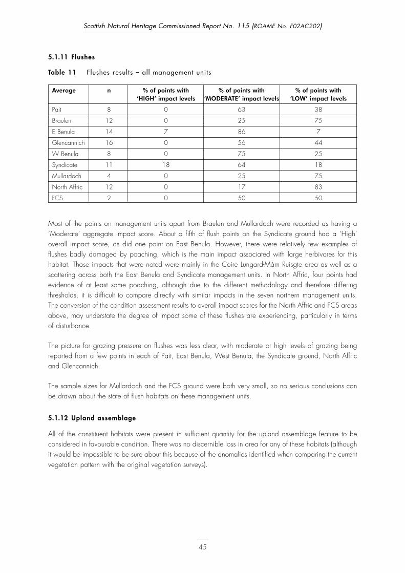
5.1.11 Flushes
Table 11 Flushes results – al l management units
Average n % of points with % of points with % of points with ‘HIGH’ impact levels ‘MODERATE’ impact levels ‘LOW’ impact levels
Pait 8 0 63 38
Braulen 12 0 25 75
E Benula 14 7 86 7
Glencannich 16 0 56 44
W Benula 8 0 75 25
Syndicate 11 18 64 18
Mullardoch 4 0 25 75
North Affric 12 0 17 83
FCS 2 0 50 50
Most of the points on management units apart from Braulen and Mullardoch were recorded as having a‘Moderate’ aggregate impact score. About a fifth of flush points on the Syndicate ground had a ‘High’overall impact score, as did one point on East Benula. However, there were relatively few examples offlushes badly damaged by poaching, which is the main impact associated with large herbivores for thishabitat. Those impacts that were noted were mainly in the Coire Lungard-Màm Ruisgte area as well as ascattering across both the East Benula and Syndicate management units. In North Affric, four points hadevidence of at least some poaching, although due to the different methodology and therefore differingthresholds, it is difficult to compare directly with similar impacts in the seven northern management units. The conversion of the condition assessment results to overall impact scores for the North Affric and FCS areasabove, may understate the degree of impact some of these flushes are experiencing, particularly in terms of disturbance.
The picture for grazing pressure on flushes was less clear, with moderate or high levels of grazing beingreported from a few points in each of Pait, East Benula, West Benula, the Syndicate ground, North Affricand Glencannich.
The sample sizes for Mullardoch and the FCS ground were both very small, so no serious conclusions canbe drawn about the state of flush habitats on these management units.
5.1.12 Upland assemblage
All of the constituent habitats were present in sufficient quantity for the upland assemblage feature to beconsidered in favourable condition. There was no discernible loss in area for any of these habitats (althoughit would be impossible to be sure about this because of the anomalies identified when comparing the currentvegetation pattern with the original vegetation surveys).
45
Scottish Natural Heritage Commissioned Report No. 115 (ROAME No. F02AC202)

5.1.13 Caledonian Forest
Table 12 Caledonian Forest results – al l management units
Average n % of points % of points % of points with % of points % of points with ‘HIGH’ with ‘HIGH’/ ‘MODERATE’ with ‘LOW’/ with ‘LOW’ impact levels ‘MODERATE’ impact levels ‘MODERATE’ impact levels
impact levels impact levels
Braulen 27 15 7 11 7 59
Glencannich 26 8 27 19 8 38
Mullardoch 26 0 0 15 19 65
North Affric 15 33 47 0 7 13
FCS 26 50 0 8 8 33
All woodland blocks appeared to have the potential for regeneration in the form of canopy gaps andwoodland edge, seed sources and suitable substrates. In one unit (Mullardoch) competition from thesurrounding vegetation may have posed a limitation on new regeneration, but regeneration was present,often below heather height. Most woodland blocks are dominated by mature and old trees with a gap inthe life-structure where some young trees might have been expected. Although small seedlings were relativelywidespread, few appeared to have reached a height where they would be considered to have escapedfrom browsing pressure. As may be expected, there was a clear distinction between the current impact levelsin enclosed (Liatrie, FCS, parts of Braulen) and unenclosed blocks. Figures 1–5 illustrate the aggregateclasses for current impacts in woodland samples (x-axis, with numbers of samples on the y-axis) groupedaccording to a classification of the life-classes present at that location. These figures provide an indicationof the potential significance of the current levels of impact in terms of the continuity of woodland structure atthose locations. The classifications are as follows:
l Young trees present – (juvenile non-reproductive and young reproductive, classes 2 and 3)
l Only mature and old trees present – (mature reproductive and older, class 4 and above)
l Only old trees present (over-mature and older, class 5 and above)
l Or no trees of that type (either pine or broadleaves) at that location or only seedlings.
Seedlings (life-classes 1.1 and 1.2) have not been included in the interpretation of young trees as they areconsidered to be vulnerable to browsing and hence are not guaranteed to form a cohort of young trees.
46
Scottish Natural Heritage Commissioned Report No. 115 (ROAME No. F02AC202)

Figures 1–5 Current impacts on woodland: numbers of sample points classified by life-class types.
47
Scottish Natural Heritage Commissioned Report No. 115 (ROAME No. F02AC202)
Figure 1 North Af fric – 15 samples
Figure 2 FCS – 26 samples

48
Scottish Natural Heritage Commissioned Report No. 115 (ROAME No. F02AC202)
Figure 3 Mullardoch – 26 samples
Figure 4 Braulen – 27 samples

5.2 Over view for each management unit
5.2.1 Pait
On this management unit most of the significant impacts seemed to stem from deer in transit, particularly inCoire Riabhachain and along the Allt Riabhachain corridor, where hagging was frequent. Wet heath, dryheath (in north-east) and blanket bog are probably the habitats most at risk from mechanical damage fromdeer on the move or congregating in the main corrie. Although the overall balance of impacts at individualpoints was rarely severe, all habitats except alpine heath are clearly under some pressure.
The continuation of even moderate trampling impacts on wet heath and blanket bog may lead to furthererosion and loss of habitat area. Although dry heath is probably more resilient than these habitats, where itis on steeper ground, loss of habitat area is also possible if ‘Moderate’ to ‘High’ impacts are sustained forlonger periods. The prognosis for the alpine habitats is more optimistic, although a reduction in tramplinglevels for siliceous alpine and boreal grasslands is certainly desirable. It is perhaps worrying that, almostalone of the management units on the site, there was little or no evidence of an improvement in the tramplingregime in the core areas of Coire Riabhachain and below An Riabhachan.
Heather beetle was not reported from any of the points on this management unit.
5.2.2 Braulen
The alpine habitats here seem to be in reasonable condition, but there are local problems with each of theremaining habitats, eg, blanket bog in the bottoms of the glens (especially near Inchvuilt) and in Garbh-choire. There is evidence of trampling damage in dry heath at the northeast end of the Riabhachan ridgeby the march with Pait and browsing levels are frequently moderate in this habitat. Wet heath is subject toa mixture of browsing and trampling pressure near Meall Garbh and below Inchvuilt wood.
49
Scottish Natural Heritage Commissioned Report No. 115 (ROAME No. F02AC202)
Figure 5 Glencannich (Liatrie Burn SSSI) – 26 samples

The life-class profile of the woodlands within Braulen is dominated by older trees, with little evidence of
established regeneration outwith enclosures, other than at a few samples in Coillie an Ath. Seedlings were
present in other samples, but current browsing levels appear to be keeping them in check. The life-class
(Map 17, Appendix 3) map illustrates the distribution of stands with only old trees or old trees and seedlings,
which are unlikely to be able to sustain current impact levels.
In virtually every case where there was a discernible trend (about eight of the 27 points) in terms of blanket
bog impacts, this was towards decreasing impacts, mostly visible through a reduction in vigour of
J. squarrosus. An even greater proportion of ‘boggy’ wet heath points (c.55%) showed the same trend.
On flatter areas with wet heath and blanket bog moderate to high trampling impacts may lead to further
erosion and loss of habitat area. The prognosis for the alpine habitats and dry heath here is more optimistic,
although a reduction in trampling levels for siliceous alpine and boreal grasslands is certainly desirable
and the dry heath in the far west of the management unit is vulnerable to even the slightest increase in
trampling impacts.
Heather beetle was not reported from any of the points on this management unit.
5.2.3 East Benula
Alpine heath is very rare on this estate, but is subject to some browsing pressure in the Coire na Brogaichain
area as is the slightly more widespread dry heath. Siliceous alpine and boreal grasslands appear not to be
suffering from detrimental impacts at the moment. Wet heath in the Coire na Brogaichain-Coire Mhàim area
is clearly exposed to pressure from both browsing and trampling. Possibly the habitat with the most
significant impacts on this management unit is blanket bog, where nearly two thirds of all points are subject
to significant browsing, while significant trampling impacts were reported for just under half.
The almost dwarf shrub-less areas in the zone c.500–750m wide in from the loch-shore are probably the
product of previous management, particularly sheep grazing. See discussion on Glencannich below.
At just under half of the blanket bog points there was a trend towards decreasing impacts, mostly visible
through a reduction in vigour of J. squarrosus. This was slightly balanced, however, by six points which, if
anything, showed that J. squarrosus was more than retaining its vigour and local dominance. There was no
particular pattern to be gleaned from this indicator for ‘boggy’ wet heath.
The continuation of even ‘Moderate’ impacts for trampling indicators such as that relating to disturbance of
Sphagnum would be of concern as this would lead to a decline in the quality of the habitat in the short term
and, through exposure of bare peat, possible loss of habitat area in the future. This applies to blanket bog
and the ‘boggier’ stands of wet heath. The Coire Brogaichain area in general probably cannot tolerate
sustained levels of ‘High’ to ‘Moderate’ trampling (and browsing, though with deer this tends to act more
slowly) in any of the heath or bog features found in the area.
Old heather beetle infestation was conspicuous east of Mullach a’ Ghlas-thuill.
50
Scottish Natural Heritage Commissioned Report No. 115 (ROAME No. F02AC202)

5.2.4 Glencannich
Alpine habitats were generally in good condition, but there were some browsing and trampling impacts onthe ridge west of Mullach Tharsuinn. Trampling was very rare on dry heath here, but there was some localbrowsing pressure. Areas of wet heath were often subject to at least moderate browsing and tramplingimpacts and damage to Sphagnum was particularly marked in the Glas Toll area. Blanket bog was,however, generally less affected by such impacts, with the exception of a cluster of points on Carl Lawaetz’sground on and around Mullach a’ Ghlas-thuill. Two of the flushes were under a combination of grazing andpoaching pressure, but the rest seemed to be subject to no more than occasional moderate impacts.
It was noticeable that several of those wet heath points where graminoids had over 75% cover and Callunahad either completely or almost completely disappeared had ‘Low’ overall impact scores. This may supportthe view that much of the apparent disappearance of wet and dry heath here has not been a recentphenomenon, but has been caused by previously high levels of grazing.
About half of the blanket bog and ‘boggy’ wet heath points showed at least some evidence in terms ofdeclining vigour of J. squarrosus and, to a lesser extent, the height and cover of graminoids versus dwarfshrubs. Only three points showed a stable impact level which could be described as chronically high.
The continuation of sustained ‘Moderate’ to ‘High’ trampling (and, to a lesser extent, browsing) impacts inthe Glas Toll and south Mullach na Maoile areas, as well, perhaps, as on the ridge west of MullachTharsuinn, could lead to long-term and irreversible damage to blanket bog, wet heath and, perhaps, alpine heath.
Current impact levels in Liatrie Burn SSSI are clearly split, with regeneration and no browsing impacts in thesouthern fenced area and no regeneration and heavy impacts in the unfenced northern half. The life-classprofile indicates a predominance of old trees and a lack of younger life-classes and the apparent scarcityof the broadleaved component.
Old heather beetle damage was common, at least in the glen of the Allt Mullardoch and may have beenimplicated in the death of Calluna south of Mullach na Maoile.
5.2.5 West Benula
Like Pait to the north, this management unit is strongly influenced by its position straddling two majorhighways for deer in Coire Lungard and Gleann a’ Choilich. It also contains much of the very shelteredCoire Mhàim and it is perhaps not surprising that habitats with waypoints located in or near these areas areexposed to locally very high impacts.
About half of the siliceous alpine and boreal grasslands points were being heavily browsed, though theredid not appear to be a trampling problem. There was a similar picture with alpine heath. All of the CoireMoireach (Beinn Fhionnlaidh) cluster showed evidence of significant browsing. Browsing impacts on wetheath was particularly marked in the upper reaches of Coire Mhàim. Very few blanket bog points were freeof significant herbivore impacts and in the Allt Choir’ an Lochan and upper Coire Mhàim areas there waswidespread evidence of damaging impacts. Poaching in flushes was also common, though conspicuoussigns of grazing less so.
51
Scottish Natural Heritage Commissioned Report No. 115 (ROAME No. F02AC202)

However, one positive factor was the relatively high number of points in the Coire Mhàim area whichshowed a decreasing impact trend as illustrated by the declining vigour of J. squarrosus.
Heather beetle was not reported from any of the points on this management unit.
5.2.6 Syndicate
Siliceous alpine and boreal grassland samples were usually free of noticeable impacts. Although only one ofthe alpine heath points seemed to be subject to clearly damaging impacts, most were subject to some mixtureof trampling and grazing and there appears to be some significant pressure on this habitat in the CoireDomhain area. Dry heath in the Coire Domhain area, especially in the east, had widespread signs of impacts,particularly from trampling. The pattern with blanket bog was more complicated with some points, especiallyin the far northeast relatively untouched, but both browsing and trampling impacts were widespread.
Some of the apparent impacts picked up during the survey, such as the low abundance of Sphagnum orCladonia or the greater height and cover of graminoids compared to dwarf shrubs may be due to oldgrazing, particularly by sheep. The stalker (Angus Hughes) commented that there had been sheep there until20–30 years ago (belonging to a previous stalker). This is borne out by what seem to be remnant sheepscars on the slopes below Bealach na h-Eige.
There were only very slight signs of a relaxation of trampling pressure in terms of a decline in J. squarrosusvigour and the graminoid versus dwarf shrub cover and height ratios. Thus, although much of the damagein the Coir’ an Lochan area may be due to higher historical densities of sheep and deer, the extent of barepeat has now reached a point where even ‘Moderate’ levels of trampling could continue the trend towardsloss of physical habitat area, certainly for blanket bog and also potentially for alpine heath and dry heathon the eastern side of Coire Domhain.
Old heather beetle damage was reported from an area on the east side of Coire Buidhe.
5.2.7 Mullardoch
With the exception of the slightly puzzling proportion of siliceous alpine and boreal grassland points whichhad overall ‘High’ impact scores and some significant trampling of blanket bog and, to a lesser extent, wetheath in the Lùb nam Meann area, the upland habitats of interest to this survey on this estate were only rarelysubject to significant herbivore impacts.
The only area for minor concern on this estate would be the shallow corrie west of Lùb nam Meann, wheresustained trampling pressure could potentially lead to a further slow loss of habitat area for blanket bog and,perhaps, wet heath.
The level of current woodland impacts also indicates a lower pressure than on other unenclosed woodlandsin the SAC, but regeneration in most cases has yet to escape from browsing pressure. The life-class profileagain indicates that there are areas with only old life-classes or old trees and seedlings which have yet toestablish, therefore the continuity of these woods remains to be secured.
Old heather beetle damage was widespread in the Lùb nam Meann area.
52
Scottish Natural Heritage Commissioned Report No. 115 (ROAME No. F02AC202)

5.2.8 Nor th Affric
Siliceous alpine and boreal grasslands seemed to be relatively free of herbivore impact, but alpine heathwas frequently heavily browsed (though only very rarely trampled). Dry heath was usually in good conditionand wet heath seemed to be almost completely free of potentially damaging impacts. Blanket bog wassubject to some locally conspicuous browsing, but did not seem to be suffering from trampling damage.
Current impacts in the unenclosed pinewoods in North Affric were assessed as Moderate or Heavy. The life-class profile of these woods is almost exclusively composed of either only old trees, or old trees andseedlings with no younger life-classes being recruited to maintain the continuity of these woods.
5.2.9 Fasnakyle (FCS)
Both alpine heath and siliceous alpine and boreal grasslands were under some pressure from deer near theToll Creagach-Doire Tana Bealach. Significant browsing and trampling impacts seemed to be absent fromdry heath areas on this estate, but wet heath often showed signs of browsing (though not trampling) pressure.There was also some relatively widespread evidence of browsing impacts on blanket bog, though tramplingdamage was rare.
Continued trampling of alpine heath areas on the south side of the bealach east of Toll Creagach could leadto a slow loss of habitat if sustained at current levels.
The woodlands share the patterns of the other woods within the SAC with evidence of regeneration of bothpine and broadleaves in the fenced eastern section, but high levels of browsing and no establishedregeneration elsewhere. Again these woods demonstrate a distinct gap in the life-class profile.
5.3 Individual herbivore species
5.3.1 Red Deer
Deer (only red deer Cervus elaphus were seen during the survey) were by far the most common herbivorein the SAC.
5.3.2 Sheep
Sheep were confined to the western end of the Glencannich area and did not seem to use the area veryintensively, largely keeping to the east of Creag Feusag, at least during the period of this survey.
5.3.3 Cattle
A small herd of cattle (c.30 beasts?) was occasionally observed along the southern edge of the Glencannichmanagement unit and occasionally strays further inland along the glen of the Allt Mullardoch.
5.3.4 Feral goats
A loose group of feral goats was seen occasionally at the eastern end of the East Benula estate, particularlynear Mullach a’ Ghlas-thuill. From conversations with Donald Fraser and Carl Lawaetz, it seems they do
53
Scottish Natural Heritage Commissioned Report No. 115 (ROAME No. F02AC202)

sometimes wander onto the northern side of the watershed and quite far to the west. It seems likely that theyhave only a very local impact, apart perhaps from preventing birch or rowan from colonising suitable sitesin their core area.
5.3.5 Mountain hares
Although relatively widespread, mountain hares Lepus timidus were scarce and very few individuals wereseen. It seems unlikely that hares have a significant impact on the designated features on this site.
5.3.6 Heather beetle
As noted for the appropriate management units above, heather beetle outbreaks have in the past resulted inconspicuous damage to a few areas, notably near the Allt Mullardoch and the Creag Feusag area onGlencannich and by Lùb nam Meann on the Mullardoch estate.
54
Scottish Natural Heritage Commissioned Report No. 115 (ROAME No. F02AC202)

References
Averis, A.B.G. & Averis, A.M. (1998). Vegetation survey of Beinn Eighe, Wester Ross, 1997. SNHcontract report HT/97/98/13.
Caledonian Partnership (2001). The Scottish Semi-Natural Woodland Inventory.
Clifford, T. (unpublished, 2003). Glenfeshie Woodland Profile Survey: Proposed Scots pine Life StageClasses.
Joint Nature Conservation Committee (2004). Upland Habitat Common Standards MonitoringGuidance. JNCC, Peterborough.
MacDonald, A., Stevens, P., Armstrong, H., Immirzi, P. et al. and Reynolds, P. (1998). A guide toupland habitats: surveying land management impacts. Edinburgh: SNH.
Nature Conservancy Council (1981–1987). Upland Survey Project Maps – ‘Black Files’: held in SNHDingwall Office.
O’Hanrahan, B. (2003). The vegetation of Ronas Hill-North Roe SSSI: an NVC survey. SNH contractreport: no. AH(LA11)020304.
O’Hanrahan, B. (unpublished, 2005). Condition assessments of upland and peatland notified featurescarried out for SNH in 2005.
Rodwell, J.S. (Ed.) (1991). British Plant Communities. Volume 2 – Mires and Heaths. Cambridge UniversityPress, Cambridge.
Rodwell, J.S. (Ed.) (1992). British Plant Communities. Volume 3 – Grasslands and montane communities.Cambridge University Press, Cambridge.
55
Scottish Natural Heritage Commissioned Report No. 115 (ROAME No. F02AC202)

Appendix 1 Herbivore impact assessment methods for woodland features
The following assessments were made at each of the random sample locations. As for the open habitats,the assessments were grouped into indicators of condition, current impacts and impact trends. The footnotesprovide an explanation of the different impact classes for each indicator.
Designated feature Habitat category Type of indicator Indicators to be usedfor assessment
Caledonian Forest Woodland Condition l Life-class distribution across whole woodland (Across extent) block1.
Current impacts l Browsing impacts2
(using 50m by l Presence of regeneration3
50m plot) l Damage to trees and regeneration4
l Trampling/dunging5
Overall assessment of current impacts6
Impact trends l Life-class distribution (classes seedling to young(using 50m by reproductive only) at sample7
50m plot and l Presence and location of grazing sensitive sampling species8
inaccessiblelocations en route Assessment of impact trends – maintained, where possible). decreasing, increasing, unknown.9
1 Whilst travelling to the sample point record the life-classes of pine and broadleaves present in the woodland blockaccording to the life classes developed by Tim Clifford for Glen Feshie (unpublished, 2003). Other than for seedlings,these need only be to integers.
2 Browsing Impacts should be assessed as H, M or L using a combination of current impacts on the shrub layer and impactson the ground layers. See table 1.
3 Prior to assessing the presence of regeneration at each sample, an assessment should be made of the potential forregeneration, considering, the availability of suitable substrates, light, seed sources and competition from other vegetation.Where there is assessed to be the potential for regeneration, it should be scored as being 1) below the level of thesurrounding vegetation, 2) above the surrounding vegetation or 3) above 1.5m see table 2.
4 What proportion of saplings show browsing damage, fraying or bark stripping? <1/3, >1/3 or >2/3.
5 Trampling and dunging should be scored as H, M or L. See table 3.
6 The indicators under current impacts should be amalgamated to produce an overall weighting of H, M or L.
7 Life-classes should also be recorded in each 50m by 50m sample area to give an indication of the trends of browsingimpacts. The focus should be on classes 1–3: seedlings/juvenile non-reproductive/and young reproductive. For example,the presence of young reproductive trees, but absence of seedlings and saplings (juvenile non-reproductive) suggests thatbrowsing pressure has increased.
8 The species composition of stands that are both accessible to browsing and inaccessible should be compared wherepossible. Where grazing sensitive species are restricted to inaccessible locations (Y/N/NA as all accessible), the speciesand location should be noted.
9 Using the two indicators, where possible, indicate the direction of the browsing impacts.
56
Scottish Natural Heritage Commissioned Report No. 115 (ROAME No. F02AC202)

Appendix 1 (continued)
Table 1 Browsing impacts
Heavy Browsing induced topiary effect (as distinct from weather induced) on any shrubs that may be present.Browse line on mature trees.Ground vegetation <10cm tall, mostly grasses and mosses.All herbs (tormentil, heath bedstraw, wood anemone, wood sorrel) obviously heavily cropped, non-flowering. Only Luzula is likely to be abundant.
Moderate Patchy shrubs showing evidence of pruning or a browse line.Ground vegetation to 30cm, as a mixture of grasses, herbs or heaths.Localised close-cropped lawns where there is a concentration of grazing.Some herbs partially cropped or ungrazed, sparsely flowering.
Light or none Well developed shrub layer without obvious browse line.Lush ground vegetation, where shrub layer is not too dense (ie 30–50% cover), dominated by grazing sensitive species.Many herbs only partially cropped or ungrazed. Some species abundant and flowering.
Table 2 Assessing regeneration where there is the potential
1 Tree seedlings not above ground vegetation height.
2 Tree saplings projecting above ground vegetation in a few areas.
3 Saplings escaped from browsing pressure (above 1.5m).
Table 3 Trampling and dunging
Heavy Abundant dung from grazing animals, evidence of tracks and poaching.
Medium Patches of bare soil rare and small, scattered dung present.
Light Few signs of trampling, dung.
57
Scottish Natural Heritage Commissioned Report No. 115 (ROAME No. F02AC202)

Appendix 2 Definit ions of Caledonian Forest l i fe-classes used from Clif ford (unpublished, 2003)
*the equivalent life-class definitions were used for broadleaved species
Scots Pine Tree sub-class: Descriptor: Stand type and Biodiversity Stand process:life stage: conditions: characteristics:
1. Seeding 1.1 Small All seedlings at or Fragmented canopy,seedling below the gaps & woodland
predominant field stand edgeslayer veg’n height,Includes newly germinated seedlings of the year
1.2 Large Seedlings above field Fragmented canopy,seedling layer vegn height, gaps & woodland
up to 1m tall; stand edgesusually conical form
2. Juvenile 2.1 Small Young trees 1–3m Both dense drifts &non- sapling height; not yet scattered individuals inreproductive producing significant canopy gaps & at stand
quantities of seed, edges(usually conical form)
3. Young 3.1 Large Young trees 3–5m in Either in dense patchesreproductive sapling height usually coning/ but with branches of
seed producing usually established trees not yetconical form fully interlocking, or as
small patches orDBH usually <7cm scattered individuals
3.2 Pole stage Seed/cone producing Often dense stands & 1. Low light levels,young trees usually patches with fully declining biodiversity;over 5m in height interlocking brancheswhere canopy has [thicket], 2. Some deadwood closed; usually conical but formation through self Stem exclusioncanopy form also lone trees & small thinning
groups in canopy gaps DBH range usually & at stand edges7–30cm
4. Mature 4.1 Mature Seed/cone-producing 1. Scattered open- 1. Some deadwoodreproductive trees usually over 5m crowned individuals habitat provided on
height & 30cm DBH1 [often poor form] standing tree and forestnot falling into the or floor from windthrownpreceding or following 2. closer grown stands branches;classes; crown usually of first progeny [betterspreading rather than form] around “pioneer 2. Canopy providesconical and at its trees” nesting & feedingmaximum sites for birds &development invertebrates; Dynamic equilibrium
May be canopy die- 3.Sap-runs developing;back up to 10% dueto competition for light 4. Mosses, lichens on
bark (but greater development of bryophytes on overmature trees
5. Over- 5.1 Early Trees usually over 5mmature canopy decline height, with spreading
canopy;Canopy 10–20% dead Usually more open 1. Increase in standing with reduced coning/ conditions, where wind and fallen deadwood;seed production has begun to de-limb 2. Torn branches & [Any reduction likely to trees broken limbs;be proportional to 3. rot-holes developing crown size] on tree & saprophytic Canopy breakup
fungi fruiting5.2 Mid-canopy Trees usually over 5m 4. Crown dieback ›decline height, with spreading increased light to bole
canopy; › more opportunities Canopy 20–50% dead for epiphytes!with consequent further reduction in coning/seed production
58
Scottish Natural Heritage Commissioned Report No. 115 (ROAME No. F02AC202)
Generally highbiodiversity in shelteredcanopy gaps withincreased woodlandedge habitat,particularly birds andLepidoptera.Biodiversity generallyreduced on exposedwoodland edges.
Stand initiation/regeneration

59
Scottish Natural Heritage Commissioned Report No. 115 (ROAME No. F02AC202)
Appendix 2 (continued)
Scots Pine Tree sub-class: Descriptor: Stand type and Biodiversity Stand process:Life Stage: conditions: characteristics:
6. Senescent 6.1 Heavy Trees usually over 5m Often [but not always] As above sub-class withpost- canopy decline height, with spreading very open stand with significant increase inreproductive canopy much ravaged large canopy gaps, standing deadwood
by wind & pathogens; with or without recent habitat on each treeCanopy 50–99% dead regeneration Canopy breakupwith markedly reduced coning/seed production proportional to loss of canopy
7. Dead 7.1 Standing Three classes as broad Often degradingdead indicators of time fragmented stands of
elapsed since death: large old trees with1. Some needles & all significant windthrow;bark still on tree [recent but:dead] includes smaller 2. >20% bark still on specimens resulting from tree, surface of bole hard competitive exclusion in 3. <20% bark still on dense standstree, surface of bole soft and:[long dead] Steep scree slopes with
a mobile substrate where trees have been uprooted
7.2 Fallen dead Three classes as broad indicators of time elapsed since death:1. Some needles & most [>80%] bark still on tree [recent dead]2. <80% & >20% bark still on tree, surface of bole hard, even though heartwood may be soft and rotting.3. <20% bark still on tree, surface of bole usually soft [long dead]
7.3 Stumps with Two classes as broad Various but typical ofno fallen trunk/ indicators of past open stands of oldbole evident woodland history and wide-crowned trees.
management: Where straightest large1. Stumps from past specimens have beenlogging operations removed for timber[clean cut surface] but in varying stages of decay depending on when cut2. Torn stumps resulting from wind ”snap” where trunk has either been removed for firewood or completely decayed
NOTES:1. Maturity is defined as the point at which growth starts to slow down significantly. FC Yield class models can providean approximate guide to minimum DBH at the age of Maximum mean annual volume increment [MAI], the point atwhich growth begins to slow down. Naturally regenerated Scots pine trees [as opposed to planted ones] are unlikely to exceed Yield class 8, and at this yield class SP is considered to have reached maturity at approximately 30cm DBH.[see Life Stage Class 4.1]. However, this estimate cannot be reliably applied to trees in conditions of environmentalstress such as exposure and poor drainage, where maturity may be reached at much smaller size [DBH].
Bio-diversity likely to behigh for recently deadtrees [bark still on tree]with larger stemdiameters, which aremore typical offragmented openstands.Epixylic lichens animportant feature ofpinewood biodiversity,restricted to decorticatetrees.Overall lichen diversityappears to be muchhigher for dead pinesthan live ones!
Death, decay andnutrient cycling

Appendix 3 Individual browsing and tramping indicators for each habitat type
Map 1 Browsing indicators – al l habitats
This map illustrates the results of the single indicators selected to illustrate browsing impacts for each of theextensive habitat types.
These include the proportion of shoots browsed of dwarf shrubs for:
Alpine heathWet heathDry heath and Blanket bogAnd of grasses and sedges for Siliceous boreal grassland and flushes.And browsing of tall herbs and willow species respectively.
See individual habitat maps for fuller description of small-scale field indicators represented by the impactclasses illustrated.
60
Scottish Natural Heritage Commissioned Report No. 115 (ROAME No. F02AC202)

61
Scottish Natural Heritage Commissioned Report No. 115 (ROAME No. F02AC202)
Ma
p 1
Brow
sing
ind
ica
tors
– a
ll ha
bit
ats

Map 2 Trampling indicators – al l habitats
This map illustrates the results of the single indicators selected to illustrate trampling impacts for each of theextensive habitat types.
These include the proportion of disturbed bare ground for:
Alpine heathWet heathDry heathSiliceous boreal grassland andWillow scrubAnd for Blanket bog and flushes – the proportion of Sphagnum moss hummocks and lawns which are brokenby hoof prints.
See individual habitat maps for fuller description of small-scale field indicators represented by the impactclasses illustrated.
62
Scottish Natural Heritage Commissioned Report No. 115 (ROAME No. F02AC202)

63
Scottish Natural Heritage Commissioned Report No. 115 (ROAME No. F02AC202)
Ma
p 2
Tra
mp
ling
ind
ica
tors
– a
ll ha
bit
ats

Map 3 Browsing indicators – Sil iceous boreal grassland
Siliceous boreal grassland (1)
Less than 10% of live leaves and/or flowers of any of Alchemilla alpina, Carex bigelowii, Deschampsia flexuosa, Festuca ovina, Festuca vivipara, Juncus trifidus, Nardus stricta, Sibbaldia procumbens, Thymus polytrichus, with any evidence of grazing; Y
More than 10%. N
Siliceous boreal grassland (2)
Signs of grazing on the leaves of Carex bigelowii, Juncus trifidus or fine leaved grasses such as Deschampsia flexuosa, Festuca ovina and Festuca vivipara.
Easily observable. >10% of green leaves. H
Very little or no signs of grazing. <10% of green leaves grazed. L
64
Scottish Natural Heritage Commissioned Report No. 115 (ROAME No. F02AC202)

65
Scottish Natural Heritage Commissioned Report No. 115 (ROAME No. F02AC202)
Ma
p 3
Brow
sing
ind
ica
tors
: Si
lice
ous
bor
eal
gra
ssla
nd –
pro
por
tion
of
alp
ine
spec
ies
bro
wse
d

Map 4 Trampling indicators – Sil iceous boreal grassland
Siliceous boreal grassland (1)
Less than 10% of the ground cover is disturbed bare ground. Y
More than 10% of the ground cover is disturbed bare ground. N
Siliceous boreal grassland (2)
Extent, location and size of patches of bare ground (not gravel) and breaks in the vegetation mat.
In areas sheltered from the prevailing wind, patches about 10cm across. H
Predominantly on parts of the hill most exposed to the prevailing winds, variable size. Very little bare ground elsewhere. L
66
Scottish Natural Heritage Commissioned Report No. 115 (ROAME No. F02AC202)

67
Scottish Natural Heritage Commissioned Report No. 115 (ROAME No. F02AC202)
Ma
p 4
Tra
mp
ling
ind
ica
tors
: Si
lice
ous
bor
eal
gra
ssla
nds
– p
rop
orti
on o
f b
are
gro
und

Map 5 Browsing indicators – alpine heath
Alpine heath (1)
Less than 33% of shoots of dwarf-shrubs showing signs of browsing. Y
Greater than 33% of shoots of dwarf-shrubs showing signs of browsing N
Alpine heath (2)
Browsing of any dwarf shrubs present;
Noticeable, but not necessarily conspicuous. Moderately to heavily browsed. H
Negligible, browsed shoots very difficult to find L
68
Scottish Natural Heritage Commissioned Report No. 115 (ROAME No. F02AC202)

69
Scottish Natural Heritage Commissioned Report No. 115 (ROAME No. F02AC202)
Ma
p 5
Brow
sing
ind
ica
tors
: a
lpin
e he
ath
– p
rop
orti
on o
f d
wa
rf s
hrub
s b
row
sed

Map 6 Trampling indicators – alpine heath
Alpine heath (1)
Less than 10% of the ground is disturbed bare ground. Y
More than 10% of the ground is disturbed bare ground. N
Alpine heath (2)
Extent, location and size of patches of bare ground (not gravel) and breaks in the vegetation mat.
In areas sheltered from the prevailing wind, patches about 10cm across. H
Predominantly on parts of the hill most exposed to the prevailing winds, variable size. Very little bare ground elsewhere. L
70
Scottish Natural Heritage Commissioned Report No. 115 (ROAME No. F02AC202)

71
Scottish Natural Heritage Commissioned Report No. 115 (ROAME No. F02AC202)
Ma
p 6
Tra
mp
ling
ind
ica
tors
: a
lpin
e he
ath
– p
rop
orti
on o
f b
are
gro
und

Map 7 Browsing indicators – dry heath
Dry heath (1)
Less than 33% of the shoots of dwarf-shrub species collectively (excluding Betula nana andMyrica gale shows signs of browsing. Y
More than 33% of the shoots of dwarf-shrub species collectively (excluding Betula nana andMyrica gale shows signs of browsing. N
Dry heath (2)
The average proportion of long-shoots of Calluna vulgaris and/or Vaccinium myrtillusshows signs of having been browsed.
>33% Browsing conspicuous. H
16–33% Browsed shoots found after intensive and extensive searching. M
<16%. Browsed shoots very difficult to find. L
Hence Y in Dry heath (1) encompasses M and L in Dry heath (2).
72
Scottish Natural Heritage Commissioned Report No. 115 (ROAME No. F02AC202)

73
Scottish Natural Heritage Commissioned Report No. 115 (ROAME No. F02AC202)
Ma
p 7
Brow
sing
ind
ica
tors
: d
ry h
eath
– p
rop
orti
on o
f d
wa
rf s
hrub
s b
row
sed

Map 8 Trampling indicators – dry heath
Dry heath (1)
Less than 10% of the ground cover made up of bare ground. Y
Less than 10% of the ground cover made up of bare ground. N
Dry heath (2)
Amount of trampled, bare ground.
Frequent, especially in recently burnt patches. H
Little or none except for sporadic sheep scars, or scrapes by hares rabbits, or in recently burnt patches (and then only sporadic). M/L
74
Scottish Natural Heritage Commissioned Report No. 115 (ROAME No. F02AC202)

75
Scottish Natural Heritage Commissioned Report No. 115 (ROAME No. F02AC202)
Ma
p 8
Tra
mp
ling
ind
ica
tors
: d
ry h
eath
– p
rop
orti
oin
of b
are
gro
und

Map 9 Browsing indicators – Wet heath
Wet heath (1)
Less than 33% of the shoots of dwarf-shrub species collectively (excluding Betula nana andMyrica gale), shows signs of browsing. Y
More than 33% of the shoots of dwarf-shrub species collectively (excluding Betula nana andMyrica gale), shows signs of browsing. N
Heathy Wet heath (2)
The average proportion of long-shoots of Calluna vulgaris and/or Vaccinium myrtillus showssigns of having been browsed.
>33% Browsing conspicuous. H
16–33% Browsed shoots found after intensive and extensive searching. M
<16% Browsed shoots very difficult to find. L
Boggy Wet Heath (2)
Conspicuousness of browsing of Calluna vulgaris or Vaccinium myrtillus.
Clearly browsed in general appearance though browsing may be patchy. Browsed shoots easy to find. H/M
Not obviously browsed. Browsed shoots difficult to find without both intensive and extensive searching. L
76
Scottish Natural Heritage Commissioned Report No. 115 (ROAME No. F02AC202)

77
Scottish Natural Heritage Commissioned Report No. 115 (ROAME No. F02AC202)
Ma
p 9
Brow
sing
ind
ica
tors
: W
et h
eath
– p
rop
orti
on o
f d
wa
rf s
hrub
s b
row
sed

Map 10 Trampling indicators – wet heath
Wet heath (1)
Less than 10% of the ground is disturbed bare ground. Y
More than 10% of the ground is disturbed bare ground. N
Heathy Wet Heath (2)
Amount of trampled, bare ground.
Frequent, especially in recently burnt patches. H
Little or none except for sporadic sheep scars, or scrapes by hares, rabbits, or in recently burnt patches (and then only sporadic). M/L
Boggy Wet Heath (2)
Trampling of Sphagnum moss hummocks and lawns.
Most Sphagnum moss surfaces broken by hoof prints over most of the bog surface. Loose and leached portions of Sphagnum mosses frequent. H
Minority of Sphagnum moss surfaces broken by hoof prints, locally distributed over the bog surface. Loose and bleached portions of Sphagnum mosses very local. M
Most Sphagnum moss surfaces intact. Evidence of hoof prints only found after extensive searching. Loose and bleached portions of Sphagnum mosses absent or very infrequent. L
78
Scottish Natural Heritage Commissioned Report No. 115 (ROAME No. F02AC202)

79
Scottish Natural Heritage Commissioned Report No. 115 (ROAME No. F02AC202)
Ma
p 1
0Tr
am
pli
ng i
ndic
ato
rs:
wet
hea
th –
pro
por
tion
of
ba
re g
roun
d/
tra
mp
ling
of
mos
ses

Map 11 Browsing indicators – blanket bog
Blanket bog (1)
Less than 33% of the shoots of dwarf-shrub species collectively (excluding Betula nana andMyrica gale), shows signs of browsing. Y
Greater than 33% of the shoots of dwarf-shrub species collectively (excluding Betula nana andMyrica gale), shows signs of browsing. N
Blanket bog (2)
Conspicuousness of browsing of Calluna vulgaris or Vaccinium myrtillus.
Clearly browsed in general appearance though browsing may be patchy. Browsed shoots easy to find. H/M
Not obviously browsed. Browsed shoots difficult to find without both intensive and extensive searching. L
80
Scottish Natural Heritage Commissioned Report No. 115 (ROAME No. F02AC202)

81
Scottish Natural Heritage Commissioned Report No. 115 (ROAME No. F02AC202)
Ma
p 1
1Br
owsi
ng i
ndic
ato
rs:
bla
nket
bog
– p
rop
orti
on o
f d
wa
rf b
row
sed

Map 12 Trampling indicators – blanket bog
Blanket bog (1)
Less than 10% of the Sphagnum cover crushed, broken, and/or pulled-up. Y
More than 10% of the Sphagnum cover crushed, broken, and/or pulled-up. N
Blanket bog (2)
Trampling of Sphagnum moss hummocks and lawns.
Most Sphagnum moss surfaces broken by hoof prints over most of the bog surface. Loose and leached portions of Sphagnum mosses frequent. H
Minority of Sphagnum moss surfaces broken by hoof prints, locally distributed over the bog surface. Loose and bleached portions of Sphagnum mosses very local. M
Most Sphagnum moss surfaces intact. Evidence of hoof prints only found after extensive searching. Loose and bleached portions of Sphagnum mosses absent or very infrequent. L
82
Scottish Natural Heritage Commissioned Report No. 115 (ROAME No. F02AC202)

83
Scottish Natural Heritage Commissioned Report No. 115 (ROAME No. F02AC202)
Ma
p 1
2Tr
am
pli
ng i
ndic
ato
rs:
bla
nket
bog
– p
rop
orti
on o
f m
osse
s tr
am
ple
d

Map 13 Browsing indicators – minor habitats
Siliceous scree (1) and Siliceous rocky slopes (1) & (2)
Less than 50% of live leaves (forbs) and/or the shoots (dwarf-shrubs) shows signs of having been grazed or browsed. Y
>50% N
Tall herbs (2)
Signs of grazing, vigour and flowering of commoner tall herbs.
All plants obviously heavily cropped, probably dwarfed if present, non-flowering. Only Luzula sylvatica likely to be abundant. H
Some plants partially cropped or ungrazed. Some species in addition to Luzularecognisable and sparsely flowering. M
Many plants only partially cropped or ungrazed. L
Willow scrub (2)
Evidence of browsing of trees and shrubs.
Distinct browse line or severe clipping – topiary form. H
Diffuse or patchy browse line – no effects on form. M
No obvious browse line, browsed shoots difficult to find. L
N.B. There are only a few points with trampling indicators for willow scrub and siliceous scree, hence these are not shown.
84
Scottish Natural Heritage Commissioned Report No. 115 (ROAME No. F02AC202)

85
Scottish Natural Heritage Commissioned Report No. 115 (ROAME No. F02AC202)
Ma
p 1
3Br
owsi
ng i
ndic
ato
rs:
min
or h
ab
ita
t ty
pes
– p
rop
orti
on o
f le
ave
s a
nd s
hoot
s b
row
sed

Map 14 Browsing indicators – f lushes
Alpine flush (1)
At least one flowering shoot of each of the arctic-alpine species present not grazed. Y
Failure to achieve above. N
Spring-head rill flush (1)
For M32, M35, M37, M38 less than 50% of live leaves of sedges and grasses should show any evidence of having been grazed, and for M7, M8, M31, M33, M34 less than 25% of live leaves of sedges and grasses shows any evidence of having been grazed. Y
>50% N
Alpine, Alkaline and spring-head rill flushes (2)
Percentage of leaves of sedges and grasses which collectively show signs of having been grazed.
>50% H
25–50% M
<25% L
86
Scottish Natural Heritage Commissioned Report No. 115 (ROAME No. F02AC202)

87
Scottish Natural Heritage Commissioned Report No. 115 (ROAME No. F02AC202)
Ma
p 1
4Br
owsi
ng i
ndic
ato
rs:
flus
hes
– p
rop
orti
on o
f le
ave
s a
nd s
hoot
s b
row
sed

Map 15 Trampling indicators – f lushes
Alpine flush (1), Spring-head rill flush (1)
Over the whole feature, less than 10% of ground cover is disturbed bare ground. Y
Over the whole feature, more than 10% of ground cover is disturbed bare ground. N
Alpine, Alkaline and spring-head rill flushes (2)
Percentage of surface churned and deeply pock-marked with hoof prints.
>50% of surface, hoof prints clearly visible over virtually entire flush. H
<50% of surface, hoof-prints not clearly visible, or absent from some parts of the flush. M
Relatively smooth surface (vegetated, or of silt or gravel hoof prints sparse or absent. L
88
Scottish Natural Heritage Commissioned Report No. 115 (ROAME No. F02AC202)

89
Scottish Natural Heritage Commissioned Report No. 115 (ROAME No. F02AC202)
Ma
p 1
5Tr
am
pli
ng i
ndic
ato
rs:
flus
hes
– p
rese
nce
of t
ram
pli
ng/
poa
chin
g

Map 16 Caledonian Forest – current impacts
The map illustrates the sum of current impacts – this is an aggregate of the following individual indicators:
Browsing of field layers – assessed as ‘H’, ‘M’ or ‘L’.
Potential for and presence of regeneration – where present classified as;
1 = below height of surrounding vegetation,
2 = above the height of the surrounding vegetation or
3 = above 1.5m
Damage to regeneration – recorded as <1/3, >1/3 or >2/3
Trampling and dunging – recorded as ‘H’, ‘M’ or ‘L’.
90
Scottish Natural Heritage Commissioned Report No. 115 (ROAME No. F02AC202)

91
Scottish Natural Heritage Commissioned Report No. 115 (ROAME No. F02AC202)
Ma
p 1
6C
ale
don
ian
Fore
st:
sum
ma
ry o
f cu
rren
t im
pa
ct i
ndic
ato
rs

Map 17 Caledonian Forest – l i fe classes
Presence of different life-classes at sample points:
Mauve = young classes present (2 and or 3)
Pink = only mature and older classes present
Green = mature or older classes plus seedlings
Yellow = just seedlings
Orange = none
Circles represent pine and squares broadleaved species
92
Scottish Natural Heritage Commissioned Report No. 115 (ROAME No. F02AC202)

93
Scottish Natural Heritage Commissioned Report No. 115 (ROAME No. F02AC202)
Ma
p 1
7C
ale
don
ian
Fore
st –
lif
e cl
ass
es p
rese
nt a
t sa
mp
le p
oint
s

Caledonian Forest – regeneration
Map 18 North Af fric, FCS Fasnakyle and Mullardoch
These maps illustrate the presence of regeneration at sample points:
The presence of regeneration is only assessed where there is judged to be the potential – i.e. canopygaps and woodland edge, seed sources and a suitable substrate. The presence of regeneration isclassified as;
0 = no regeneration
1 = below height of surrounding vegetation,
2 = above the height of the surrounding vegetation or
3 = above 1.5m
94
Scottish Natural Heritage Commissioned Report No. 115 (ROAME No. F02AC202)

95
Scottish Natural Heritage Commissioned Report No. 115 (ROAME No. F02AC202)
Map 18 North Af fric, FCS Fasnakyle and Mullardoch

Caledonian Forest – regeneration
Map 19 Braulen and Glencannich (Liatrie Burn SSSI)
These maps illustrate the presence of regeneration at sample points:
The presence of regeneration is only assessed where there is judged to be the potential – i.e. canopygaps and woodland edge, seed sources and a suitable substrate. The presence of regeneration isclassified as;
0 = no regeneration
1 = below height of surrounding vegetation,
2 = above the height of the surrounding vegetation or
3 = above 1.5m
96
Scottish Natural Heritage Commissioned Report No. 115 (ROAME No. F02AC202)

97
Scottish Natural Heritage Commissioned Report No. 115 (ROAME No. F02AC202)
Map 19 Braulen and Glencannich (Liatrie Burn SSSI)