space for sustainable development - unsd — un...
TRANSCRIPT

1
Space for Sustainable Development ESA’s contribution to the Where, What, and How of Data
Dr. Christoph Aubrecht
Directorate of Earth Observation Programmes
Science, Applications and Future Technologies Department
European Space Agency ESA/ESRIN
Senior Geospatial Specialist | ESA Representative at the World Bank
UN-GGIM 7th Session | New York, NY, 1 August 2017
UN-GGIM Forum on the 2030 Agenda for SD “Where is the Data?”
ESA UNCLASSIFIED – For Official Use
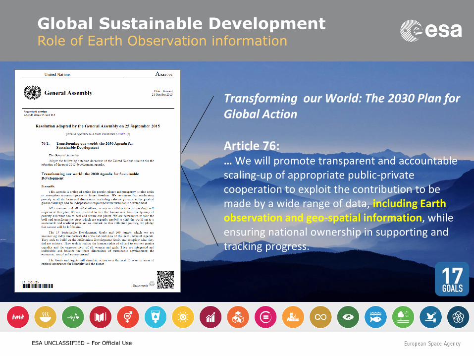
Transforming our World: The 2030 Plan for Global Action Article 76: … We will promote transparent and accountable scaling-up of appropriate public-private cooperation to exploit the contribution to be made by a wide range of data, including Earth observation and geo-spatial information, while ensuring national ownership in supporting and tracking progress.
Global Sustainable Development Role of Earth Observation information
ESA UNCLASSIFIED – For Official Use
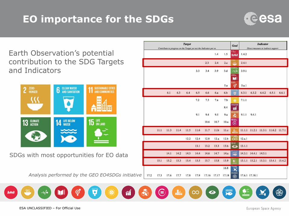
EO importance for the SDGs
Analysis performed by the GEO EO4SDGs initiative
Earth Observation’s potential contribution to the SDG Targets and Indicators
SDGs with most opportunities for EO data
ESA UNCLASSIFIED – For Official Use
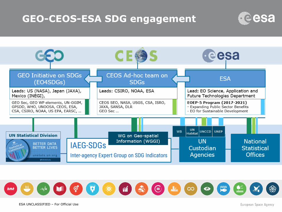
GEO-CEOS-ESA SDG engagement
WB
ESA UNCLASSIFIED – For Official Use
CEOS Ad-Hoc Team on SDGs
In the complex and evolving SDG environment,
the new CEOS AHT SDG will
take stock of the UN processes in place for the SDG implementation and of the existing participants and stakeholders,
focus its activities around the unique role that CEOS should play as coordination body of the Space community efforts to support the integration of satellite EO in support to the full realisation of the SDG’s.
CEOS AHT will align its engagement with the UN SDG agenda in the context of GEO
(GEO Programme Board, GEO Engagement Strategy, GEO initiative EO4SDGs)
and build on established relationships the CEOS Agencies have
with the custodian agencies and individual countries.
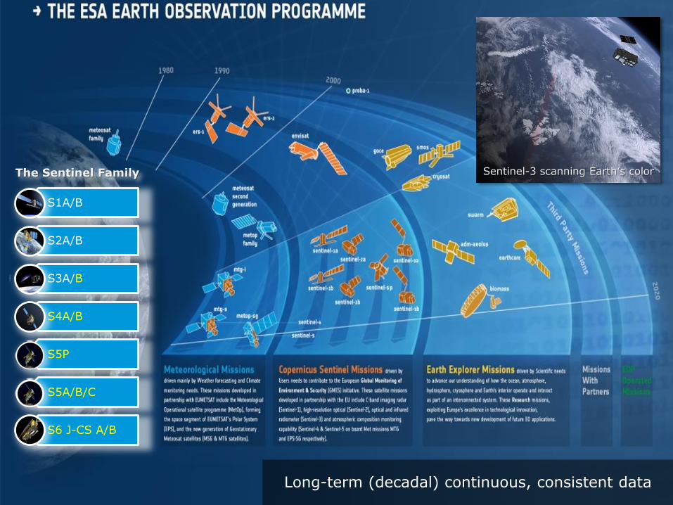
ESA UNCLASSIFIED – For Official Use Long-term (decadal) continuous, consistent data
Sentinel-3 scanning Earth’s color
S1A/B
S2A/B
S3A/B
S4A/B
S5P
S5A/B/C
S6 J-CS A/B
The Sentinel Family
ESA UNCLASSIFIED – For Official Use
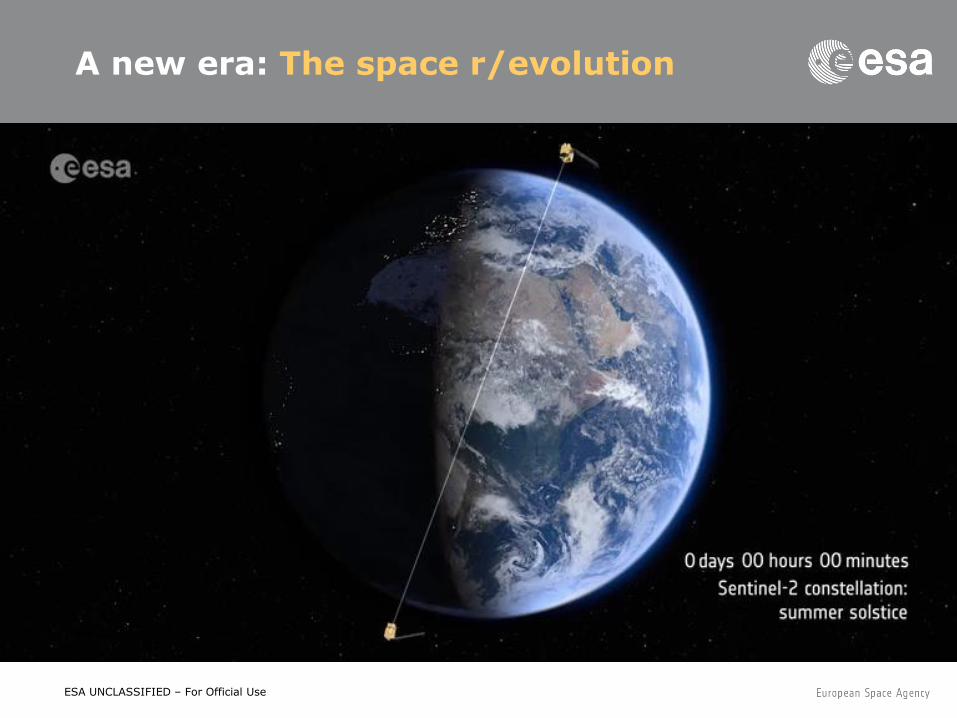
A new era: The space r/evolution
ESA UNCLASSIFIED – For Official Use
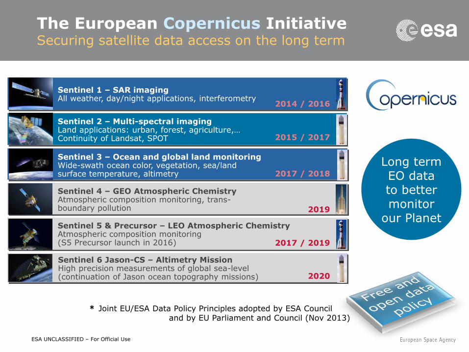
The European Copernicus Initiative Securing satellite data access on the long term
Long term EO data to better monitor
our Planet
2014 / 2016
Sentinel 1 – SAR imaging All weather, day/night applications, interferometry
2019
Sentinel 4 – GEO Atmospheric Chemistry Atmospheric composition monitoring, trans- boundary pollution
2017 / 2019
Sentinel 5 & Precursor – LEO Atmospheric Chemistry Atmospheric composition monitoring (S5 Precursor launch in 2016)
2015 / 2017
Sentinel 2 – Multi-spectral imaging Land applications: urban, forest, agriculture,… Continuity of Landsat, SPOT
2017 / 2018
Sentinel 3 – Ocean and global land monitoring Wide-swath ocean color, vegetation, sea/land surface temperature, altimetry
2020
Sentinel 6 Jason-CS – Altimetry Mission High precision measurements of global sea-level (continuation of Jason ocean topography missions)
* Joint EU/ESA Data Policy Principles adopted by ESA Council and by EU Parliament and Council (Nov 2013)
ESA UNCLASSIFIED – For Official Use
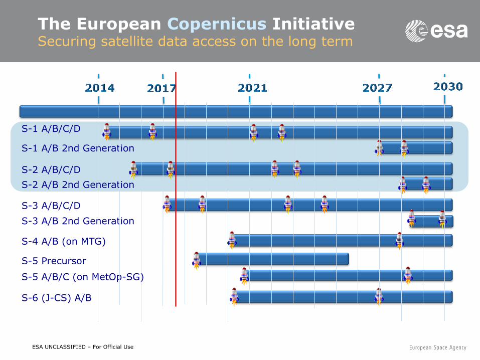
The European Copernicus Initiative Securing satellite data access on the long term
S-1 A/B/C/D
S-1 A/B 2nd Generation
S-2 A/B/C/D
S-2 A/B 2nd Generation
S-3 A/B/C/D
S-3 A/B 2nd Generation
S-4 A/B (on MTG)
S-5 Precursor
S-5 A/B/C (on MetOp-SG)
S-6 (J-CS) A/B
ESA UNCLASSIFIED – For Official Use
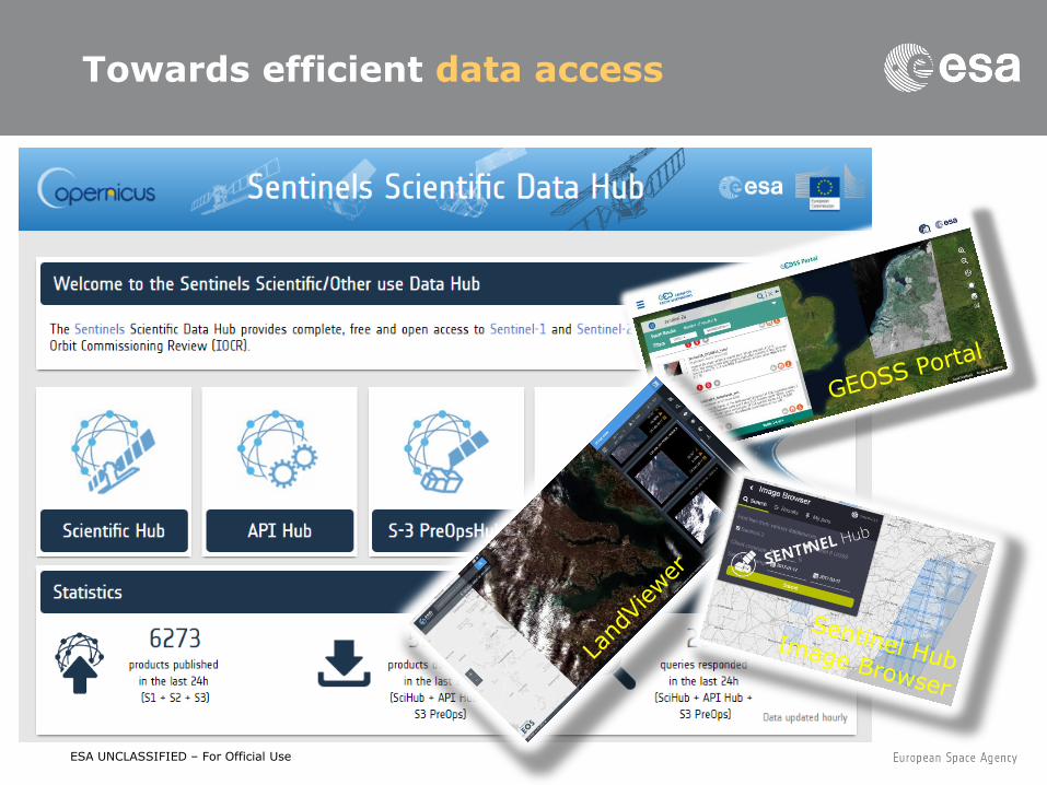
Towards efficient data access
ESA UNCLASSIFIED – For Official Use
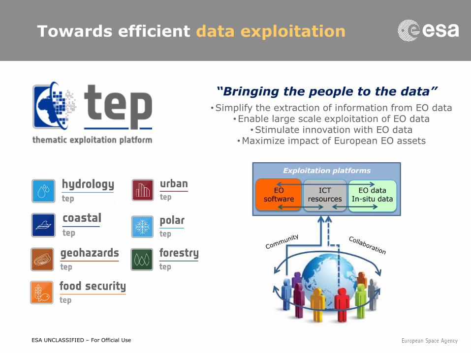
Towards efficient data exploitation
“Bringing the people to the data”
•Simplify the extraction of information from EO data •Enable large scale exploitation of EO data
•Stimulate innovation with EO data •Maximize impact of European EO assets
ESA UNCLASSIFIED – For Official Use
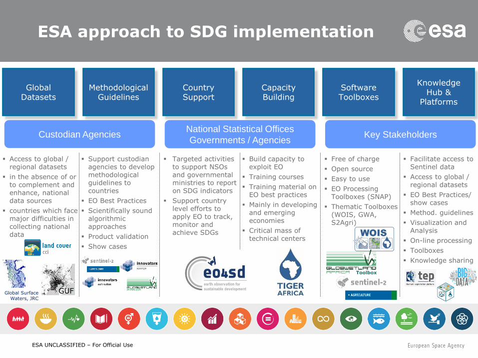
ESA approach to SDG implementation
Global Datasets
Methodological Guidelines
Software Toolboxes
Country Support
Capacity Building
Knowledge Hub &
Platforms
Toolbox
Free of charge
Open source
Easy to use
EO Processing Toolboxes (SNAP)
Thematic Toolboxes (WOIS, GWA, S2Agri)
Targeted activities to support NSOs and governmental ministries to report on SDG indicators
Support country level efforts to apply EO to track, monitor and achieve SDGs
Build capacity to exploit EO
Training courses
Training material on EO best practices
Mainly in developing and emerging economies
Critical mass of technical centers
Support custodian agencies to develop methodological guidelines to countries
EO Best Practices
Scientifically sound algorithmic approaches
Product validation
Show cases
Custodian Agencies National Statistical Offices
Governments / Agencies Key Stakeholders
Access to global / regional datasets
in the absence of or to complement and enhance, national data sources
countries which face major difficulties in collecting national data
GUF Global Surface Waters, JRC
Facilitate access to Sentinel data
Access to global / regional datasets
EO Best Practices/ show cases
Method. guidelines
Visualization and Analysis
On-line processing
Toolboxes
Knowledge sharing
ESA UNCLASSIFIED – For Official Use
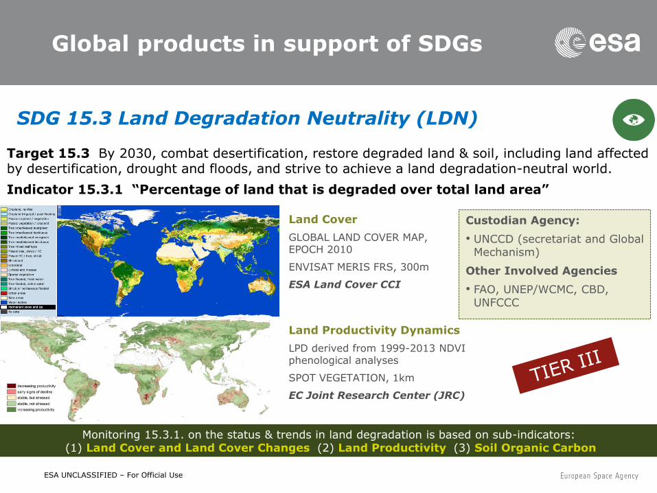
Global products in support of SDGs
SDG 15.3 Land Degradation Neutrality (LDN)
Monitoring 15.3.1. on the status & trends in land degradation is based on sub-indicators: (1) Land Cover and Land Cover Changes (2) Land Productivity (3) Soil Organic Carbon
Land Productivity Dynamics
LPD derived from 1999-2013 NDVI phenological analyses
SPOT VEGETATION, 1km
EC Joint Research Center (JRC)
Land Cover
GLOBAL LAND COVER MAP, EPOCH 2010
ENVISAT MERIS FRS, 300m
ESA Land Cover CCI
Custodian Agency:
• UNCCD (secretariat and Global Mechanism)
Other Involved Agencies
• FAO, UNEP/WCMC, CBD, UNFCCC
Target 15.3 By 2030, combat desertification, restore degraded land & soil, including land affected by desertification, drought and floods, and strive to achieve a land degradation-neutral world.
Indicator 15.3.1 “Percentage of land that is degraded over total land area”
ESA UNCLASSIFIED – For Official Use
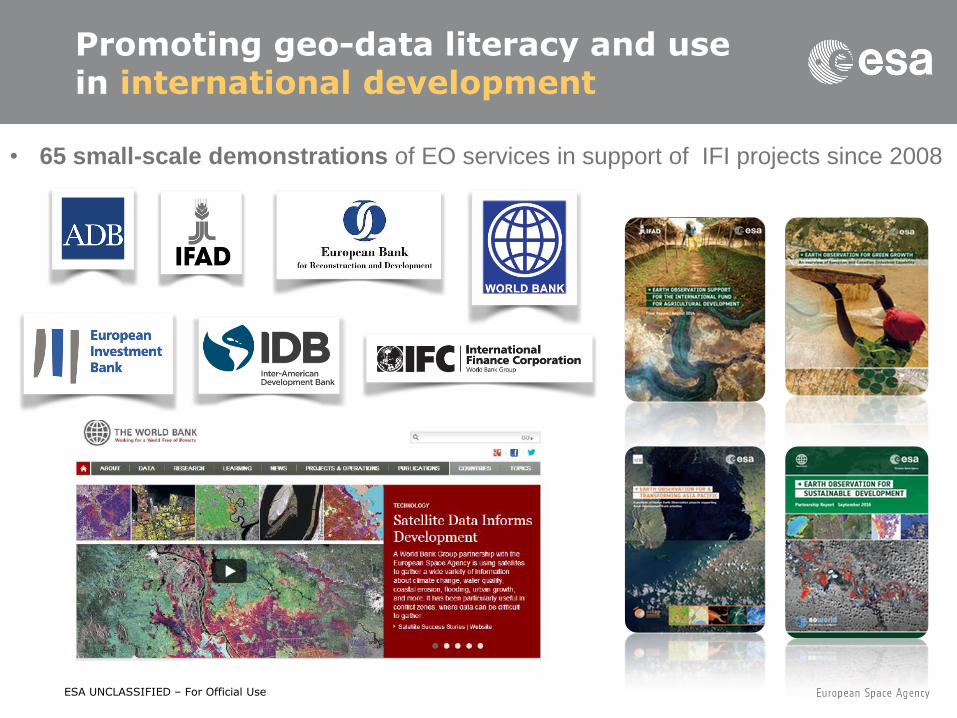
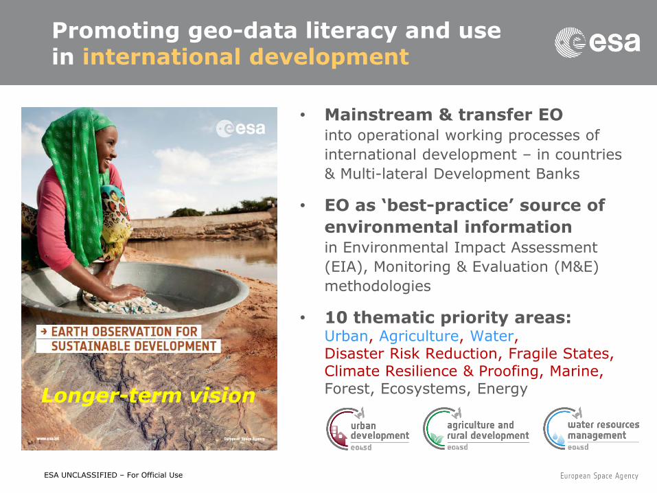
• 65 small-scale demonstrations of EO services in support of IFI projects since 2008
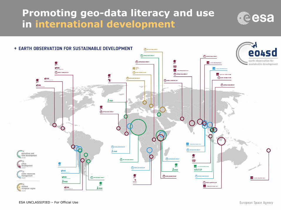
Promoting geo-data literacy and use in international development
ESA UNCLASSIFIED – For Official Use
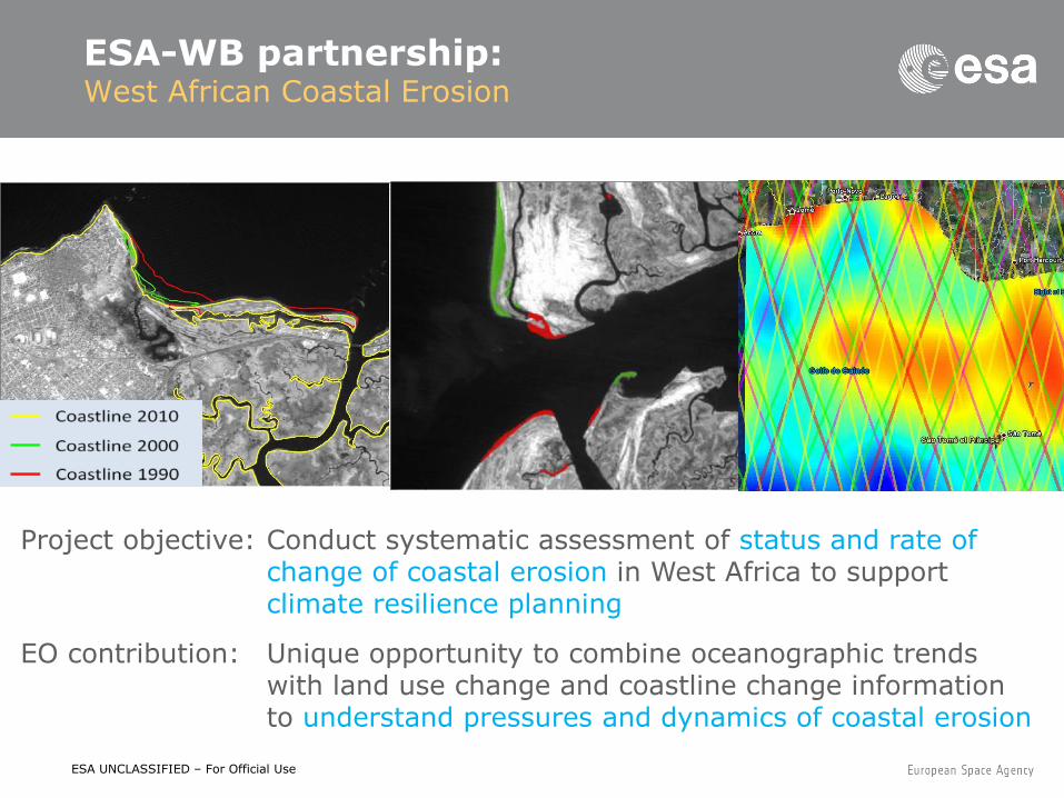
ESA-WB partnership: West African Coastal Erosion
Project objective: Conduct systematic assessment of status and rate of change of coastal erosion in West Africa to support climate resilience planning
EO contribution: Unique opportunity to combine oceanographic trends with land use change and coastline change information to understand pressures and dynamics of coastal erosion
ESA UNCLASSIFIED – For Official Use
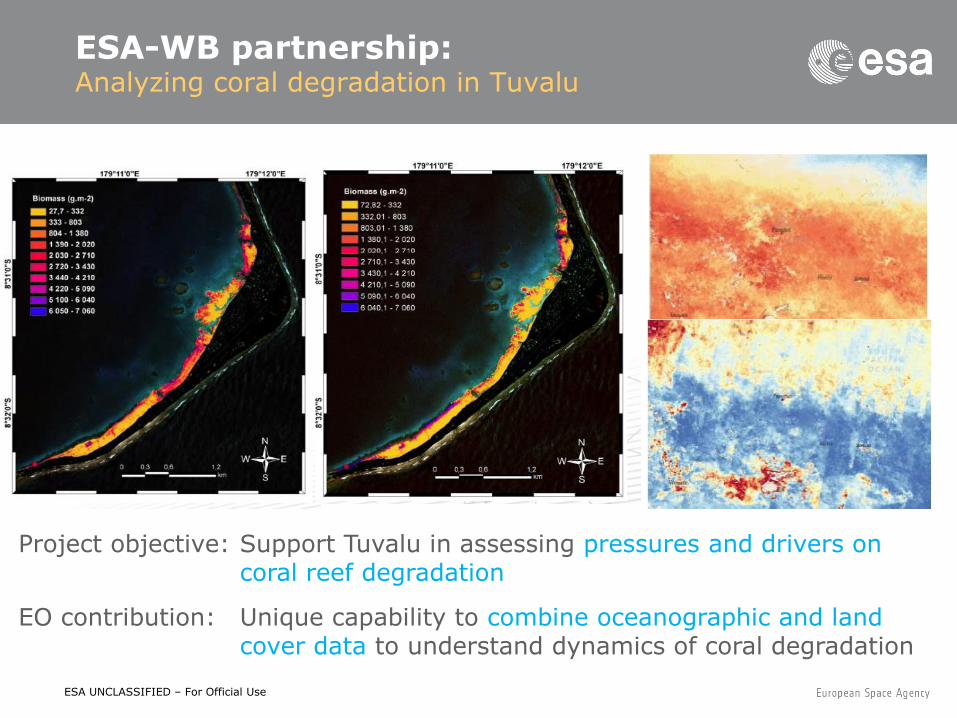
ESA-WB partnership: Analyzing coral degradation in Tuvalu
Project objective: Support Tuvalu in assessing pressures and drivers on coral reef degradation
EO contribution: Unique capability to combine oceanographic and land cover data to understand dynamics of coral degradation
ESA UNCLASSIFIED – For Official Use
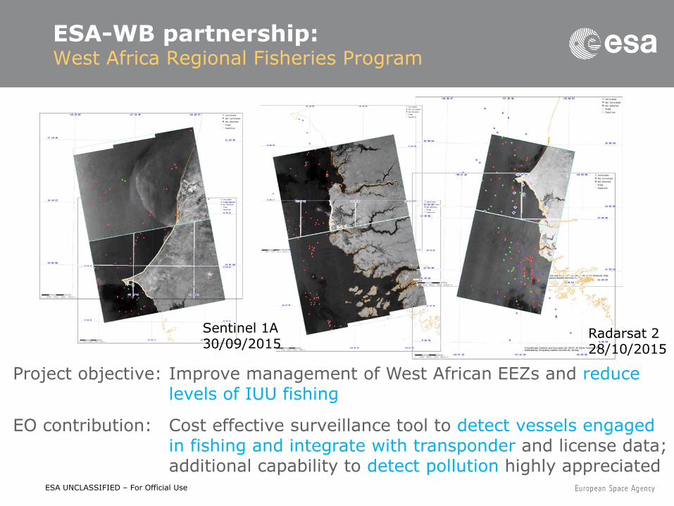
Sentinel 1A 30/09/2015
Radarsat 2 28/10/2015
Project objective: Improve management of West African EEZs and reduce levels of IUU fishing
EO contribution: Cost effective surveillance tool to detect vessels engaged in fishing and integrate with transponder and license data; additional capability to detect pollution highly appreciated
ESA-WB partnership: West Africa Regional Fisheries Program

ESA UNCLASSIFIED – For Official Use
ESA-WB partnership: LULC dynamics | platform development
ESA UNCLASSIFIED – For Official Use
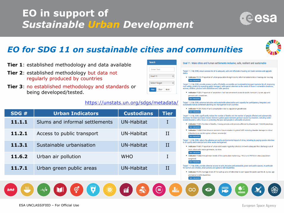
EO in support of Sustainable Urban Development
SDG # Urban Indicators Custodians Tier
11.1.1 Slums and informal settlements UN-Habitat I
11.2.1 Access to public transport UN-Habitat II
11.3.1 Sustainable urbanisation UN-Habitat II
11.6.2 Urban air pollution WHO I
11.7.1 Urban green public areas UN-Habitat II
Tier 1: established methodology and data available
Tier 2: established methodology but data not regularly produced by countries
Tier 3: no established methodology and standards or being developed/tested.
https://unstats.un.org/sdgs/metadata/
EO for SDG 11 on sustainable cities and communities
ESA UNCLASSIFIED – For Official Use
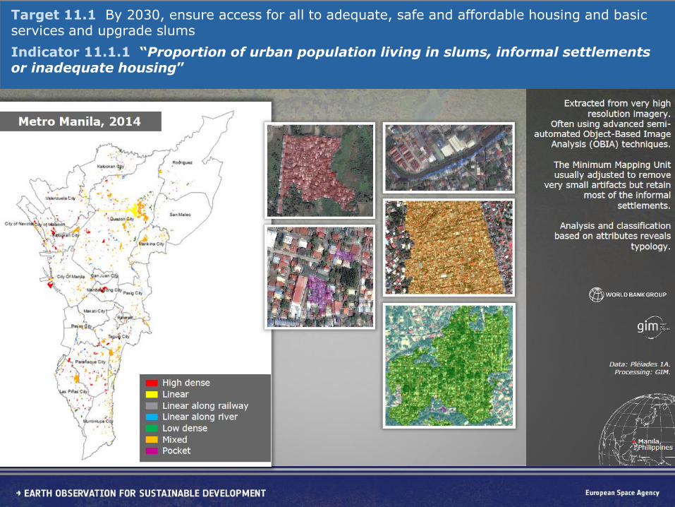
ESA-WB partnership: Detection & characterization of informal settlements
Target 11.1 By 2030, ensure access for all to adequate, safe and affordable housing and basic services and upgrade slums
Indicator 11.1.1 “Proportion of urban population living in slums, informal settlements or inadequate housing”
ESA UNCLASSIFIED – For Official Use
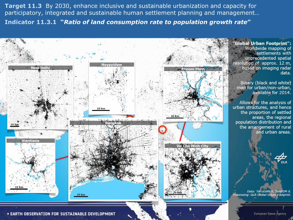
ESA-WB partnership: High-res global BU mapping | urbanTEP integration
Target 11.3 By 2030, enhance inclusive and sustainable urbanization and capacity for participatory, integrated and sustainable human settlement planning and management…
Indicator 11.3.1 “Ratio of land consumption rate to population growth rate”
ESA UNCLASSIFIED – For Official Use
ESA-WB partnership: High-res global BU mapping | urbanTEP integration
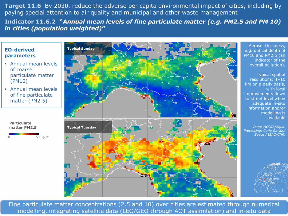
Fine particulate matter concentrations (2.5 and 10) over cities are estimated through numerical modelling, integrating satellite data (LEO/GEO through AOT assimilation) and in-situ data
Target 11.6 By 2030, reduce the adverse per capita environmental impact of cities, including by paying special attention to air quality and municipal and other waste management
Indicator 11.6.2 “Annual mean levels of fine particulate matter (e.g. PM2.5 and PM 10) in cities (population weighted)”
EO-derived parameters
Annual mean levels of coarse particulate matter (PM10)
Annual mean levels of fine particulate matter (PM2.5)
Aerosol thickness, e.g. optical depth of PM10 and PM2.5 (an
indicator of the overall pollution).
Typical spatial
resolutions: 1–10 km on a daily basis,
with local improvements down to street level when
adequate in-situ information and/or
modelling is available
Data: MODIS/Aqua.
Processing: Carlo Gavazzi Space / ISAC-CNR.
Northern Italy
Typical Sunday
Typical Tuesday
Particulate matter PM2.5
0 50 μg/m3
ESA UNCLASSIFIED – For Official Use
ESA-WB partnership: High-res global BU mapping | urbanTEP integration
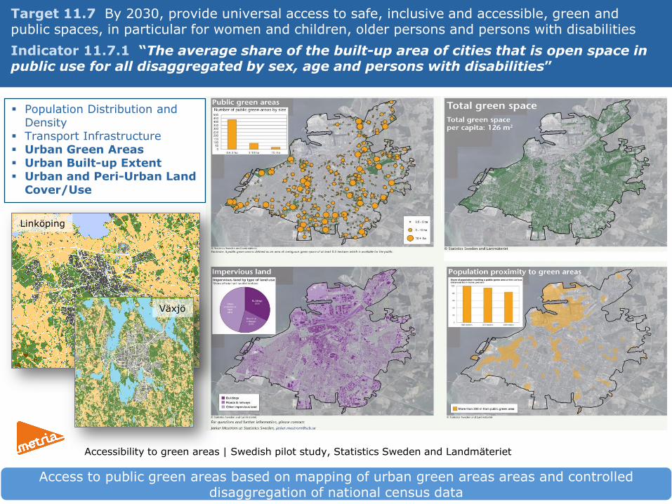
Target 11.7 By 2030, provide universal access to safe, inclusive and accessible, green and public spaces, in particular for women and children, older persons and persons with disabilities
Indicator 11.7.1 “The average share of the built-up area of cities that is open space in public use for all disaggregated by sex, age and persons with disabilities”
Access to public green areas based on mapping of urban green areas areas and controlled disaggregation of national census data
Population Distribution and Density
Transport Infrastructure Urban Green Areas Urban Built-up Extent Urban and Peri-Urban Land
Cover/Use
Accessibility to green areas | Swedish pilot study, Statistics Sweden and Landmäteriet
Linköping
Växjö
ESA UNCLASSIFIED – For Official Use
• Mainstream & transfer EO into operational working processes of
international development – in countries
& Multi-lateral Development Banks
• EO as ‘best-practice’ source of
environmental information in Environmental Impact Assessment
(EIA), Monitoring & Evaluation (M&E)
methodologies
• 10 thematic priority areas: Urban, Agriculture, Water, Disaster Risk Reduction, Fragile States, Climate Resilience & Proofing, Marine, Forest, Ecosystems, Energy
Promoting geo-data literacy and use in international development
Longer-term vision
ESA UNCLASSIFIED – For Official Use
Promoting geo-data literacy and use in international development
ESA Presentation | DD/MM/YYYY | Slide 26
ESA UNCLASSIFIED – For Official Use
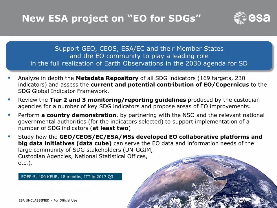
New ESA project on “EO for SDGs”
Support GEO, CEOS, ESA/EC and their Member States and the EO community to play a leading role
in the full realization of Earth Observations in the 2030 agenda for SD
Analyze in depth the Metadata Repository of all SDG indicators (169 targets, 230 indicators) and assess the current and potential contribution of EO/Copernicus to the SDG Global Indicator Framework.
Review the Tier 2 and 3 monitoring/reporting guidelines produced by the custodian agencies for a number of key SDG indicators and propose areas of EO improvements.
Perform a country demonstration, by partnering with the NSO and the relevant national governmental authorities (for the indicators selected) to support implementation of a number of SDG indicators (at least two)
Study how the GEO/CEOS/EC/ESA/MSs developed EO collaborative platforms and big data initiatives (data cube) can serve the EO data and information needs of the large community of SDG stakeholders (UN-GGIM, Custodian Agencies, National Statistical Offices, etc.).
EOEP-5, 400 KEUR, 18 months, ITT in 2017 Q3
ESA Presentation | DD/MM/YYYY | Slide 27
ESA UNCLASSIFIED – For Official Use
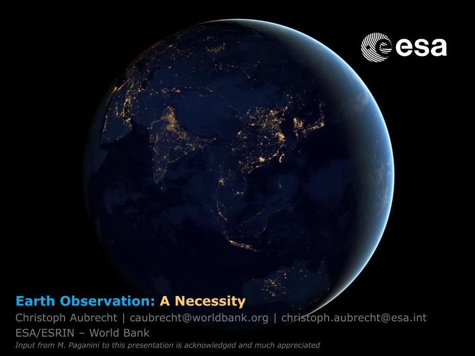
Earth Observation: A Necessity
Earth Observation: A Necessity Christoph Aubrecht | [email protected] | [email protected]
ESA/ESRIN – World Bank Input from M. Paganini to this presentation is acknowledged and much appreciated