spring lake village east grove draft environmental impact
TRANSCRIPT
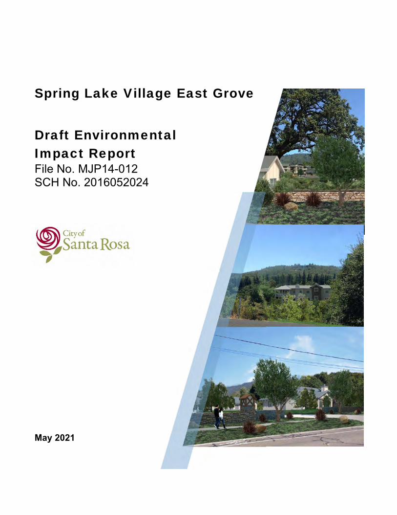
Spring Lake Village East Grove
Draft Environmental Impact Report File No. MJP14-012 SCH No. 2016052024
May 2021

City of Santa Rosa
Spring Lake Village East Grove
Draft Environmental Impact Report
Prepared for:
City of Santa Rosa Planning & Economic Development Department
100 Santa Rosa Avenue, Room 3 Santa Rosa, CA 95404
Prepared by:
2235 Mercury Way, Suite 150 Santa Rosa, CA 95407
(707) 523-1010
May 2021
Spring Lake Village East Grove Project Draft EIR | Page i
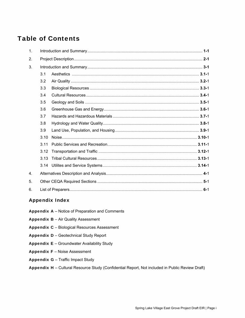
Table of Contents
1. Introduction and Summary ........................................................................................................ 1-1
2. Project Description .................................................................................................................... 2-1
3. Introduction and Summary ........................................................................................................ 3-1
3.1 Aesthetics ................................................................................................................... 3.1-1
3.2 Air Quality .................................................................................................................... 3.2-1
3.3 Biological Resources ................................................................................................... 3.3-1
3.4 Cultural Resources ...................................................................................................... 3.4-1
3.5 Geology and Soils ....................................................................................................... 3.5-1
3.6 Greenhouse Gas and Energy ...................................................................................... 3.6-1
3.7 Hazards and Hazardous Materials .............................................................................. 3.7-1
3.8 Hydrology and Water Quality ....................................................................................... 3.8-1
3.9 Land Use, Population, and Housing ............................................................................ 3.9-1
3.10 Noise .......................................................................................................................... 3.10-1
3.11 Public Services and Recreation ................................................................................. 3.11-1
3.12 Transportation and Traffic ......................................................................................... 3.12-1
3.13 Tribal Cultural Resources .......................................................................................... 3.13-1
3.14 Utilites and Service Systems ..................................................................................... 3.14-1
4. Alternatives Description and Analysis ....................................................................................... 4-1
5. Other CEQA Required Sections ............................................................................................... 5-1
6. List of Preparers ........................................................................................................................ 6-1
Appendix Index
Appendix A – Notice of Preparation and Comments
Appendix B – Air Quality Assessment
Appendix C – Biological Resources Assessment
Appendix D – Geotechnical Study Report
Appendix E – Groundwater Availability Study
Appendix F – Noise Assessment
Appendix G – Traffic Impact Study
Appendix H – Cultural Resource Study (Confidential Report, Not included in Public Review Draft)

Spring Lake Village East Grove Project Draft EIR | Page ii
Acronyms and Abbreviations µg/m3 micrograms per cubic meter -SR Scenic Road AB Assembly Bill ABAG Association of Bay Area Governments ADWF Average Daily Dry Weather Flow AERMOD AMS/EPA Regulatory Model AES Aesthetics Air Basin San Francisco Bay Area Air Basin ALUC Airport Land Use Commission AQ Air Quality ARB Air Resource Board ASCE American Society of Civil Engineers BAAQMD Bay Area Air Quality Management District BIO Biological Resources BMPs Best Management Practices CAA Clean Air Act CAAQS California Ambient Air Quality Standards CAL FIRE California Department of Forestry and Fire Protection Cal/EPA California Environmental Protection Agency Cal/OSHA California Occupational Safety and Health Administration CalEEMod California Emissions Estimator Model Caltrans California Department of Transportation CALUP Comprehensive Airport Land Use Plan CAP Climate Action Plan CARB California Air Resources Board CASQA California Stormwater Quality Association CAT California Climate Action Team CBC California Building Code CCR California Code of Regulations CCRC Continuing Care Retirement Community CDC California Department of Conservation CDFW California Department of Fish and Wildlife CDMG California Division of Mines and Geology CEC California Energy Commission CEQA California Environmental Quality Act CERCLA Comprehensive Environmental Response, Compensation and Liability Act 1980 CESA California Endangered Species Act CFGC California Fish and Game Code CFR Code of Federal Regulations CGS California Geological Survey CH4 methane CHP California Highway Patrol CIWMA California Integrated Waste Management Act CIWMP California Integrated Waste Management Board CNDDB California Natural Diversity Database CNEL Community Noise Equivalent Level CNG compressed natural gas CNPPA California Native Plant Protection Act CNPS California Native Plant Society CO carbon monoxide CO2 carbon dioxide CO2e carbon dioxide equivalent ColWMP Countywide Integrated Waste Management Plan

Spring Lake Village East Grove Project Draft EIR | Page iii
CR Cultural Resources CRLF California red-legged frog CRPR California Rare Plant Rank CUPA Certified Unified Program Agency CWA Clean Water Act dB decibel dBA A-weighted sound level DDT dichlorodiphenyltrichloroethane DOF Department of Finance DOT U.S. Department of Transportation DPM diesel particulate matter DPS distinct population segment DTSC Department of Toxic Substances Control EIR Environmental Impact Report EOP Emergency Operations Plan EPA U.S. Environmental Protection Agency ESA Endangered Species Act F.A.R. Federal Aviation Regulations Fed/OSHA Federal Occupational Safety and Health Administration FEMA Federal Emergency Management Agency FESA Federal Endangered Species Act FIGR Federated Indians of Graton Rancheria FTA Federal Transit Administration GEO Geology and Soils GHG Greenhouse Gases and Energy H2O water vapor HAS Hydrologic Sub Areas HAZ Hazards and Hazardous Materials HI Hazard Index HWQ Hydrology and Water Quality IRWP Incremental Recycled Water Program ISCST3 Gaussian Plume Air Dispersion Model? IUCN International Union for Conservation of Nature kWh Kilowatt Hours lbs pounds Ldn Day/Night Average Sound Level Leq energy equivalent sound/noise descriptor LHMP Local Hazard Mitigation Plan LID Low Impact Development LNG liquefied natural gas LRA Local Responsibility Area LS Less-than-Significant Impact LSM Less-than-Significant Impact after Mitigation Incorporated LU Land Use, Population, and Housing MBTA Migratory Bird Treaty Act mg/m3 milligrams per cubic meter mgd million gallons/day MLD Most Likely Descendent MM Modified Mercalli MMT million metric tons MRZ Mineral Resource Zone MT metric tons N2O nitrous oxide NAAQS National Ambient Air Quality Standards NAHC California Native American Heritage Commission NCCP Natural Community Conservation Planning NCRWQCB North Coast Regional Water Quality Control Board

Spring Lake Village East Grove Project Draft EIR | Page iv
NEPA National Environmental Policy Act NFIP National Flood Insurance Program NI No Impact NO2 nitrogen dioxide NOAA National Oceanic and Atmospheric Administration NOI Noise NOP Notice of Preparation NOX nitrogen oxide NPDES National Pollutant Discharge Elimination System NRCS Natural Resource Conservation Service NRHP National Register of Historic Places NWIC Northwest Information Center O3 Ozone OEHHA California’s Office of Environmental Health and Hazards OES California Office of Emergency Services OSHA Occupational Safety and Health Administration PBC’s Polychlorinated biphenyl PD 0308 Planned Development PGA Peak Ground Acceleration PG&E Pacific Gas and Electric Company PM particulate matter ppm parts per million PPV Peak Particle Velocity PRC California Public Resources Code PSR Public Services and Recreation REL reference exposure level RMS Root Mean Square ROG reactive organic gases RR-40 Rural Residential RWQCB Regional Water Quality Control Board S Significant Impact SARA Superfund Amendment and Reauthorization Act of 1986 SB Senate Bill SCWMA Sonoma County Waste Management Agency SEIR Supplemental Environmental Impact Report SMARA State Mining and Reclamation Act of 1975 SO2 sulfur dioxide SR State Route SRFD Santa Rosa Fire Department SRPW Santa Rosa Plain Watershed SU Significant and Unavoidable Impact with No Feasible Mitigation Available SUM Significant and Unavoidable after Mitigation Incorporated SVP Society of Vertebrate Palaeontology SWPPP Stormwater Pollution Prevention Plan SWRCB State Water Resources Control Board TCR Tribal Cultural Resources TACs toxic air contaminants tpy tons per year TPZ Timberland Production Zone TR Transportation and Traffic TSCA Toxic Substances Control Act UFC Uniform Fire Code UGB Urban Growth Boundry USA North Underground Service Alert North USACE U.S. Army Corps of Engineers USDA U.S. Department of Agriculture US EPA U.S. Environmental Protection Agency

Spring Lake Village East Grove Project Draft EIR | Page v
USFWS U.S. Fish and Wildlife Service USGS U.S. Geological Survey UT Utilities UWMP Urban Water Management Plan VdB vibration decibels VHFHSZ Very High Fire Hazard Severity Zone WCB Wildlife Conservation Board WDRs Waste Discharge Requirements WEAT Worker Environmental Awareness Training WUI Wildland Urban Interface
Introduction and Summary
Spring Lake Village East Grove Project Draft EIR | Page 1-1
Introduction and Summary
The City of Santa Rosa Planning and Economic Development Department has received an application from Covia Communities (formerly Episcopal Senior Communities) to develop an off-site
expansion of the existing Spring Lake Village Continuing Care Retirement Community (CCRC) located in the City of Santa Rosa, California. The project, entitled Spring Lake Village East Grove, is subject to the provisions of the California Environmental Quality Act (CEQA) because it would cause
a direct physical change in the environment and involves the issuance of discretionary approvals, permits, and entitlements. The City of Santa Rosa will serve as the lead agency for CEQA compliance because it is the public agency which has the principal responsibility for approving the project.
California Environmental Quality Act CEQA requires that discretionary decisions by public agencies be subject to environmental review.
The City of Santa Rosa has prepared this Draft Environmental Impact Report (EIR) for the project to satisfy the requirements of CEQA. This Draft EIR is an informational document to be considered by each applicable public agency prior to its approval or disapproval of the project. The purpose of the
Draft EIR is to provide public agencies and the public in general with detailed information about the effects which the proposed project may have on the environment; to list ways in which the significant effects of the project might be minimized; and to indicate alternatives to the project. Environmental
effects of the project that must be addressed include the significant effects of the project, growth-inducing effects of the project, and significant cumulative effects of past, present, and reasonably anticipated future projects.
Background Covia Communities owns and operates the Spring Lake Village CCRC located at 5555 Montgomery
Drive, referred to as Spring Lake Village. Spring Lake Village began operations in 1987 and was expanded in 2011. Spring Lake Village currently includes 437 residential units composed of independent living, assisted living, and skilled nursing units. Spring Lake Village also includes a
fitness center and auditorium; a Village Center with dining facilities, activity, and common rooms; administrative offices; a Skilled Nursing Facility; and outdoor common areas.
Covia Communities now proposes to expand Spring Lake Village by adding independent senior living
units and a central dining and community building at separate parcels to the east of the existing Spring Lake Village.
Public Scoping Process The City of Santa Rosa issued a Notice of Preparation (NOP) of an EIR to Responsible Agencies, Trustee Agencies, the Office of Planning and Research, Native American tribes, and neighboring
property owners on May 11, 2016. A public scoping meeting was held on May 23, 2016 at Whited Elementary School, 4995 Sonoma Highway, Santa Rosa, California. A total of 15 people signed into the meeting, 10 of whom spoke on the project. Nine written comments were also received during the
30-day scoping period. Copies of the written comments are included in Appendix A of this Draft EIR.
Subsequent to the May 11, 2016 NOP, Covia Communities modified the proposed Project. In accordance with the State CEQA Guidelines, the City of Santa Rosa prepared a second NOP to
inform agencies and interested parties of the modified project and the City’s intent to prepare an EIR

Introduction and Summary
Spring Lake Village East Grove Project Draft EIR | Page 1-2
on August 30, 2017. One written comment letter was received during the 30-day scoping period for the second NOP.
A copy of the NOPs is included in Appendix A of this Draft EIR.
Areas of Controversy and Key Issues to be Resolved The public scoping process identified a number of key issues to be addressed in the EIR. These issues are listed in Table 1-1 (Key Issues to be Resolved in the EIR), which provides references to the chapter and sections of the Draft EIR in which each issue is addressed.
Table 1-1 Key Issues to be Resolved in EIR
Issue Chapter / Section of EIR where
Issue is Evaluated
Potential to degrade the visual character of the project site and its surroundings
3.1 - Aesthetics
Potential to create a new source of light or glare in the area 3.1 - Aesthetics
Potential impact on cultural resources 3.4 - Cultural Resources
Potential effect of rezoning on future development in the project area
3.9 - Land Use
Potential for increased noise in residential areas from project traffic, emergency vehicles, and tree removals
3.10 - Noise
Potential impacts to traffic safety and congestion on local roadways
3.12 - Transportation
Potential impacts on State highway system 3.12 - Transportation
Potential for unsafe conditions for bicyclists and pedestrians in the project area
3.12 - Transportation
Potential impacts to pedestrian connectivity in the project area 3.12 - Transportation
Potential impacts on parking conditions in the project area 3.12 - Transportation
Potential impact on tribal cultural resources 3.13 - Tribal Cultural Resources
Availability of the Draft EIR and Public Comment Period The Draft EIR will be circulated for 45 days, from June 1, 2021 to July 15, 2021, to allow public agencies and the public in general to review and comment on the document. A public hearing on the Draft EIR will be held before the Santa Rosa Planning Commission on June 24, 2021, at 4:00 p.m.
or shortly thereafter. Please refer to the City’s website for updates at www.SRCity.org/planningcommission. Written comments on the Draft EIR will be accepted by the City until 5:00 p.m. on July 15, 2021. Written comments may be emailed to [email protected]
or mailed to the following address:
City of Santa Rosa
Planning and Economic Development Department
Attn: Amy Nicholson, Senior Planner 100 Santa Rosa Avenue, Room 3
Introduction and Summary
Spring Lake Village East Grove Project Draft EIR | Page 1-3
Santa Rosa, CA 95404
Email: [email protected]
The City encourages the electronic submission of comments. To facilitate understanding of the comments, please provide a separate sentence or paragraph for each comment and note the page
and chapter of the Draft EIR to which the comment is directed. This approach to commenting will help the City to provide a clear and meaningful response to each comment received.
Copies of the Draft EIR is available for review at the following locations:
Santa Rosa City Hall, 100 Santa Rosa Avenue, Planning and Economic Development Department (Room 3)
Online at https://srcity.org/425/Plans-Studies-EIRs
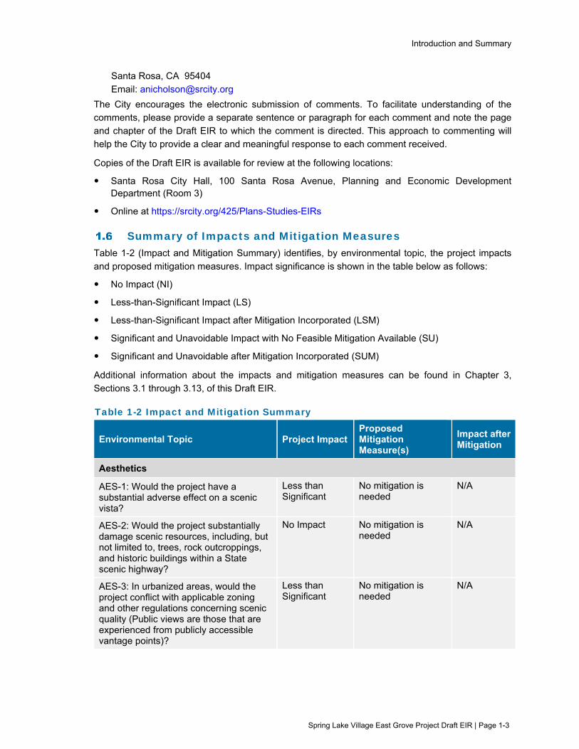
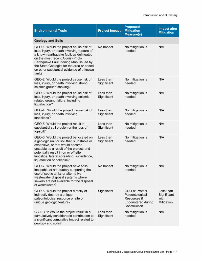
Summary of Impacts and Mitigation Measures Table 1-2 (Impact and Mitigation Summary) identifies, by environmental topic, the project impacts
and proposed mitigation measures. Impact significance is shown in the table below as follows:
No Impact (NI)
Less-than-Significant Impact (LS)
Less-than-Significant Impact after Mitigation Incorporated (LSM)
Significant and Unavoidable Impact with No Feasible Mitigation Available (SU)
Significant and Unavoidable after Mitigation Incorporated (SUM)
Additional information about the impacts and mitigation measures can be found in Chapter 3,
Sections 3.1 through 3.13, of this Draft EIR.
Table 1-2 Impact and Mitigation Summary
Environmental Topic Project Impact Proposed Mitigation Measure(s)
Impact after Mitigation
Aesthetics
AES-1: Would the project have a substantial adverse effect on a scenic vista?
Less than Significant
No mitigation is needed
N/A
AES-2: Would the project substantially damage scenic resources, including, but not limited to, trees, rock outcroppings, and historic buildings within a State scenic highway?
No Impact No mitigation is needed
N/A
AES-3: In urbanized areas, would the project conflict with applicable zoning and other regulations concerning scenic quality (Public views are those that are experienced from publicly accessible vantage points)?
Less than Significant
No mitigation is needed
N/A

Introduction and Summary
Spring Lake Village East Grove Project Draft EIR | Page 1-4
Environmental Topic Project Impact Proposed Mitigation Measure(s)
Impact after Mitigation
AES-4: Would the project create a new source of substantial light or glare which would adversely affect day or nighttime views in the area?
Less than Significant
No mitigation is needed
N/A
C-AES-1: Would the project result in a cumulatively considerable contribution to cumulative impacts related to visual resources?
Less than Significant
No mitigation is needed
N/A
Air Quality
AQ-1: Would the project conflict with or obstruct implementation of the applicable air quality plan?
No Impact No mitigation is needed
N/A
AQ-2: Would the project result in a cumulatively considerable net increase in any criteria pollutant for which the project region is non-attainment under an applicable federal or state ambient air quality standard?
Less than Significant
No mitigation is needed
N/A
AQ-3: Would the project expose sensitive receptors to substantial pollutant concentrations?
Less than Significant
No mitigation is needed
N/A
AQ-4: Would the project result in other emissions (such as those leading to odors) adversely affecting a substantial number of people?
Less than Significant
No mitigation is needed
N/A
C-AQ-1: Would the project result in a cumulatively considerable contribution to cumulative impacts related to air quality?
Less than Significant
No mitigation is needed
N/A
Biological Resources
BIO-1: Would the project have a substantial adverse effect, either directly or through habitat modifications, on any species identified as a candidate, sensitive, or special-status species in local or regional plans, policies, or regulations, or by the California Department of Fish and Wildlife or U.S. Fish and Wildlife Service?
Significant BIO-1a: Avoid Impacts to Special Status Amphibians and Reptiles
BIO-1b: Avoid Impacts to Foothill Yellow-legged Frog
BIO-1c: Avoid Impacts to Nesting Birds
BIO-1d: Avoid Impacts to Sensitive or Listed Bats
BIO-1e: Avoid Impacts to Steelhead
Less than Significant with Mitigation

Introduction and Summary
Spring Lake Village East Grove Project Draft EIR | Page 1-5
Environmental Topic Project Impact Proposed Mitigation Measure(s)
Impact after Mitigation
BIO-2: Would the project have a substantial adverse effect on any riparian habitat or other sensitive natural community identified in local or regional plans, policies, regulations, or by the California Department of Fish and Wildlife or US Fish and Wildlife Service?
Less than Significant
No mitigation is needed
N/A
BIO-3: Would the project have a substantial adverse effect on state or federally protected wetlands as defined by Section 404 of the Clean Water Act (including, but not limited to, marsh, vernal pool, coastal, etc.) through direct removal, filing, hydrological interruption, or other means?
Significant BIO-3: Compensate for Loss of Wetlands and Waters
Less than Significant with Mitigation
BIO-4: Would the project interfere substantially with the movement of any native resident or migratory fish or wildlife species or with established native resident or migratory wildlife corridors, or impede the use of native wildlife nursery sites?
Less than Significant
No mitigation is needed
N/A
BIO-5: Would the project conflict with any local policies or ordinances protecting biological resources, such as a tree preservation policy or ordinance?
Significant BIO-5: Compensate for Loss of Protected Trees
Less than Significant with Mitigation
BIO-6: Would the project conflict with the provisions of an adopted Habitat Conservation Plan, Natural Community Conservation Plan, or other approved local, regional, or state habitat conservation plan?
No Impact No mitigation is needed
N/A
C-BIO-1: Would the project result in a cumulatively considerable contribution to impacts related to biological resources?
Less than Significant
No mitigation is needed
N/A
Cultural Resources
CR-1: Would the project cause a substantial adverse change in the significance of a historical resource pursuant to §15064.5?
Less than Significant
No mitigation is needed
N/A

Introduction and Summary
Spring Lake Village East Grove Project Draft EIR | Page 1-6
Environmental Topic Project Impact Proposed Mitigation Measure(s)
Impact after Mitigation
CR-2: Would the project cause a substantial adverse change in the significance of an archaeological resource pursuant to §15064.5?
Significant CR-2a: Protection and Treatment of Cultural Resources and Tribal Cultural Resources
CR-2b and 2c: Additional Avoidance Measures
CR-2d: Protect Unanticipated Archaeological and Tribal Cultural Resources
Significant and Unavoidable with Mitigation
CR-3: Would the project disturb any human remains, including those interred outside of formal cemeteries?
Significant CR-2b and 2c: Additional Avoidance Measures
CR-3: Treatment of Human Remains, Associated Grave Goods, or Items of Cultural Patrimony
Significant and Unavoidable with Mitigation
C-CR-1: Would the project result in a cumulatively considerable contribution to impacts related to cultural or tribal cultural resources?
Significant CR-2a: Protection and Treatment of Cultural Resources and Tribal Cultural Resources
CR-2b and 2c: Additional Avoidance Measures
CR-2d: Protect Unanticipated Archaeological and Tribal Cultural Resources
CR-3: Treatment of Human Remains, Associated Grave Goods, or Items of Cultural Patrimony
Significant and Unavoidable with Mitigation
Introduction and Summary
Spring Lake Village East Grove Project Draft EIR | Page 1-7
Environmental Topic Project Impact Proposed Mitigation Measure(s)
Impact after Mitigation
Geology and Soils
GEO-1: Would the project cause risk of loss, injury, or death involving rupture of a known earthquake fault, as delineated on the most recent Alquist-Priolo Earthquake Fault Zoning Map issued by the State Geologist for the area or based on other substantial evidence of a known fault?
No Impact No mitigation is needed
N/A
GEO-2: Would the project cause risk of loss, injury, or death involving strong seismic ground shaking?
Less than Significant
No mitigation is needed
N/A
GEO-3: Would the project cause risk of loss, injury, or death involving seismic related ground failure, including liquefaction?
Less than Significant
No mitigation is needed
N/A
GEO-4: Would the project cause risk of loss, injury, or death involving landslides?
Less than Significant
No mitigation is needed
N/A
GEO-5: Would the project result in substantial soil erosion or the loss of topsoil?
Less than Significant
No mitigation is needed
N/A
GEO-6: Would the project be located on a geologic unit or soil that is unstable or expansive, or that would become unstable as a result of the project, and potentially result in on or off-site landslide, lateral spreading, subsidence, liquefaction or collapse?
Less than Significant
No mitigation is needed
N/A
GEO-7: Would the project have soils incapable of adequately supporting the use of septic tanks or alternative wastewater disposal systems where sewers are not available for the disposal of wastewater?
No Impact No mitigation is needed
N/A
GEO-8: Would the project directly or indirectly destroy a unique paleontological resource or site or unique geologic feature?
Significant GEO-8: Protect Paleontological Resources if Encountered during Construction
Less than Significant with Mitigation
C-GEO-1: Would the project result in a cumulatively considerable contribution to a significant cumulative impact related to geology and soils?
Less than Significant
No mitigation is needed
N/A

Introduction and Summary
Spring Lake Village East Grove Project Draft EIR | Page 1-8
Environmental Topic Project Impact Proposed Mitigation Measure(s)
Impact after Mitigation
Greenhouse Gas and Energy
GGE-1: Would the project generate greenhouse gas emissions, either directly or indirectly, that may have a significant impact on the environment?
Less than Significant
No mitigation is needed
N/A
GGE-2: Would the project conflict with an applicable plan, policy or regulation adopted for the purpose of reducing the emissions of greenhouse gases?
Less than Significant
No mitigation is needed
N/A
GGE-3: Would the project result in potentially significant environmental impacts due to wasteful, inefficient, or unnecessary consumption of energy resources, during project construction or operation?
Less than Significant
No mitigation is needed
N/A
GGE-4: Would the project conflict with or obstruct a state or local plan for renewable energy or energy efficiency?
No Impact No mitigation is needed
N/A
C-GGE-1: Would the project result in a cumulatively considerable contribution to a significant cumulative impact relative to greenhouse gas emissions and energy use?
Less than Significant
No mitigation is needed
N/A
Hazards and Hazardous Materials
HAZ-1: Would the project create a significant hazard to the public or the environment through the routine transport, use, or disposal of hazardous materials, or through reasonably foreseeable upset and accident conditions involving the release of hazardous materials into the environment?
Less than Significant
No mitigation is needed
N/A
HAZ-2: Would the project emit hazardous emissions or handle hazardous or acutely hazardous materials, substances, or waste within one-quarter mile of an existing or proposed school?
Less than Significant
No mitigation is needed
N/A
HAZ-3: Would the project be located on a site that is included on a list of hazardous materials sites compiled pursuant to Government Code Section 65962.5 and, as a result, create a significant hazard to the public or the environment?
No Impact No mitigation is needed
N/A

Introduction and Summary
Spring Lake Village East Grove Project Draft EIR | Page 1-9
Environmental Topic Project Impact Proposed Mitigation Measure(s)
Impact after Mitigation
HAZ-4: For a project located within an airport land use plan or, where such a plan has not been adopted, within two miles of a public airport or public use airport, would the project result in a safety hazard or excessive noise for people residing or working in the project area?
No Impact No mitigation is needed
N/A
HAZ-5: Would the project impair implementation of or physically interfere with an adopted emergency response plan or emergency evacuation plan?
No Impact No mitigation is needed
N/A
HAZ-6: Would the project expose people or structures, either directly or indirectly, to a significant risk of loss, injury, or death involving wildland fires?
Significant HAZ-6: Reduce Wildland Fire Hazards during Construction
Less than Significant with Mitigation
C-HAZ-1: Would the project result in a cumulatively considerable contribution to a significant cumulative impact related to hazards or hazardous materials?
Less than Significant
No mitigation is needed
N/A
Hydrology and Water Quality
HWQ-1: Would the project violate any water quality standards or waste discharge requirements or otherwise substantially degrade surface or ground water quality?
Significant HWQ-1: Manage Construction Dewatering
BIO-1e: Avoid Impacts to Steelhead
Less than Significant with Mitigation
HWQ-2: Would the project substantially decrease groundwater supplies or interfere substantially with groundwater recharge such that the project may impede sustainable groundwater management of the basin?
Less than Significant
No mitigation is needed
N/A
HWQ-3: Would the project substantially alter the existing drainage pattern of the site or area, including through the addition of impervious surfaces, in a manner which would result in substantial erosion or siltation on- or off-site?
Less than Significant
No mitigation is needed
N/A
HWQ-4: Would the project substantially alter the existing drainage pattern of the site or area, including through the addition of impervious surfaces, in a manner which would substantially increase the rate or amount of surface runoff in a manner which would result in flooding on- or off-site?
Less than Significant
No mitigation is needed
N/A

Introduction and Summary
Spring Lake Village East Grove Project Draft EIR | Page 1-10
Environmental Topic Project Impact Proposed Mitigation Measure(s)
Impact after Mitigation
HWQ-5: Would the project substantially alter the existing drainage pattern of the site or area, including through the addition of impervious surfaces, in a manner which would create or contribute runoff water which would exceed the capacity of existing or planned stormwater drainage systems or provide substantial additional sources of polluted runoff?
Less than Significant
No mitigation is needed
N/A
HWQ-6: Would the project substantially alter the existing drainage pattern of the site or area, including through the addition of impervious surfaces, in a manner which would impede or redirect flood flows?
No Impact No mitigation is needed
N/A
HWQ-7: In flood hazard, tsunami, or seiche zones, would the project risk release of pollutants due to project inundation?
No Impact No mitigation is needed
N/A
HWQ-8: Would the project conflict with or obstruct implementation of a water quality control plan or sustainable groundwater management plan?
No Impact No mitigation is needed
N/A
C-HWQ-1: Would the project result in a cumulatively considerable contribution to cumulative impacts related to hydrology and water quality?
Less than Significant
No mitigation is needed
N/A
Land Use, Population, and Housing
LUPH-1: Would the project physically divide an established community?
No Impact No mitigation is needed
N/A
LUPH-2: Would the project cause a significant environmental impact due to a conflict with any land use plan, policy, or regulation adopted for the purpose of avoiding or mitigating an environmental effect?
No Impact No mitigation is needed
N/A
LUPH-3: Would the project induce substantial unplanned population growth in an area, either directly (for example, by proposing new homes and businesses) or indirectly (for example, through extension of roads or other infrastructure)?
Less than Significant
No mitigation is needed
N/A

Introduction and Summary
Spring Lake Village East Grove Project Draft EIR | Page 1-11
Environmental Topic Project Impact Proposed Mitigation Measure(s)
Impact after Mitigation
LUPH-4: Would the project displace substantial numbers of existing people or housing, necessitating the construction of replacement housing elsewhere?
Less than Significant
No mitigation is needed
N/A
C-LUPH-1: Would the project result in a cumulatively considerable contribution to cumulative impacts related to land use or population?
No Impact No mitigation is needed
N/A
Noise
NOI-1: Would the project result in generation of a substantial temporary or permanent increase in ambient noise levels in the vicinity of the project in excess of standards established in the local general plan or noise ordinance, or applicable standards of other agencies?
Significant NOI-1a: Reduce Construction Noise
NOI-1b: Revise Site Plan to Reduce Operational Noise
NOI-1c: Emergency Generator Enclosure
Less than Significant with Mitigation
NOI-2: Would the project result in generation of excessive groundborne vibration or noise levels?
Significant NOI-2: Reduce Groundborne Vibration during Construction
Less than Significant with Mitigation
NOI-3: For a project located within the vicinity of a private airstrip or an airport land use plan or, where such a plan has not been adopted, within two miles of a public airport or public use airport, would the project expose people residing or working in the project area to excessive noise levels?
No Impact No mitigation is needed
N/A
C-NOI-1: Would the project plus cumulative projects result in a cumulatively considerable contribution to cumulative impacts related to noise?
Less than Significant
No mitigation is needed
N/A
Public Services and Recreation
PSR-1: Would the project result in substantial adverse physical impacts associated with the provision of new or physically altered governmental facilities, need for new or physically altered governmental facilities, the construction of which could cause significant environmental impacts, in order to maintain acceptable service ratios, response times or other performance objectives for any of the following public services: fire protection, police protection, schools, parks, and/or other public facilities?
No Impact No mitigation is needed
N/A

Introduction and Summary
Spring Lake Village East Grove Project Draft EIR | Page 1-12
Environmental Topic Project Impact Proposed Mitigation Measure(s)
Impact after Mitigation
PSR-2: Would the project increase the use of existing neighborhood and regional parks or other recreational facilities such that substantial physical deterioration of the facility would occur or be accelerated, or include recreational facilities or require the construction or expansion of recreation facilities which might have an adverse physical effect on the environment?
Less than Significant
No mitigation is needed
N/A
PSR-C-1: Would the project result in a cumulatively considerable contribution to cumulative impacts related to public services and recreational resources?
Less than Significant
No mitigation is needed
N/A
Transportation and Traffic
TR-1: Would the project conflict with a program plan, ordinance or policy addressing the circulation system, including transit, roadway, bicycle and pedestrian facilities?
Less than Significant
No mitigation is needed
N/A
TR-2: Would the project conflict or be inconsistent with CEQA Guidelines section 15064.3, subdivision (b)?
Less than Significant
No mitigation is needed
N/A
TR-3: Would the project substantially increase hazards due to a geometric design feature (e.g., sharp curves or dangerous intersections) or incompatible uses (e.g., farm equipment)?
Significant TR-3: Los Alamos Road Bike Lane Signage
Less than Significant with Mitigation
TR-4: Would the project result in inadequate emergency access?
Less than Significant
No mitigation is needed
N/A
C-TR-1: Would the project result in a cumulatively considerable contribution to a significant cumulative impact related to transportation?
Less than Significant
No mitigation is needed
N/A

Introduction and Summary
Spring Lake Village East Grove Project Draft EIR | Page 1-13
Environmental Topic Project Impact Proposed Mitigation Measure(s)
Impact after Mitigation
Tribal Cultural Resources
TCR-1: Would the project cause a substantial adverse change in the significance of a tribal cultural resource, defined in Public Resources Code section 21074 as either a site, feature, place, cultural landscape that is geographically defined in terms of the size and scope of the landscape, sacred place, or object with cultural value to a California Native American tribe, and that is listed or eligible for listing in the California Register of Historical Resources, or in a local register of historical resources as defined in Public Resources Code section 5020.1(k), or a resource determined by the lead agency, in its discretion and supported by substantial evidence, to be significant pursuant to criteria set forth in subdivision (c) of Public Resources Code Section 5024.1.
Significant CR-2a: Protection and Treatment of Cultural Resources and Tribal Cultural Resources
CR-2b and 2c: Additional Avoidance Measures
CR-2d: Protect Unanticipated Archaeological and Tribal Cultural Resources
CR-3: Treatment of Human Remains, Associated Grave Goods, or Items of Cultural Patrimony
Significant and Unavoidable with Mitigation
C-TCR-1: Would the project result in a cumulatively considerable contribution to impacts related to cultural or tribal cultural resources?
Significant CR-2a: Protection and Treatment of Cultural Resources and Tribal Cultural Resources
CR-2b and 2c: Additional Avoidance Measures
CR-2d: Protect Unanticipated Archaeological and Tribal Cultural Resources
CR-3: Treatment of Human Remains, Associated Grave Goods, or Items of Cultural Patrimony
Significant and Unavoidable with Mitigation

Introduction and Summary
Spring Lake Village East Grove Project Draft EIR | Page 1-14
Environmental Topic Project Impact Proposed Mitigation Measure(s)
Impact after Mitigation
Utilities and Service Systems
UT-1: Would the project require or result in the relocation or construction of new or expanded water, wastewater treatment or storm water drainage, electrical power, natural gas, or telecommunications facilities, the construction or relocation of which could cause significant environmental effects?
Less than Significant
No mitigation is needed
N/A
UT-2: Would the project have sufficient water supplies available to serve the project and reasonably foreseeable future development during normal, dry and multiple dry years?
Less than Significant
No mitigation is needed
N/A
UT-3: Would the project result in a determination by the wastewater treatment provider which serves or may serve the project that it has adequate capacity to serve the project’s projected demand in addition to the provider’s existing commitments?
No Impact No mitigation is needed
N/A
UT-4: Would the project generate solid waste in excess of State or local standards, or in excess of the capacity of local infrastructure, or otherwise impair the attainment of solid waste reduction goals?
Less than Significant
No mitigation is needed
N/A
UT-5: Would the project comply with federal, state, and local management and reduction statutes and regulations related to solid waste?
No Impact No mitigation is needed
N/A
C-UT-1: Would the project result in a cumulatively considerable contribution to cumulative impacts related to utilities?
Less than Significant
No mitigation is needed
N/A

Project Description
Spring Lake Village East Grove Project Draft EIR | Page 2-1
Project Description
Introduction This section describes the proposed Project, which would provide an off-site expansion of the existing Spring Lake Village Continuing Care Retirement Community (CCRC). The Project would include independent senior living units, a community building, outdoor common areas, parking
areas, paved walking paths, landscaping, drainage features, lighting, fencing, retaining walls, and off-site pedestrian, bicycle, storm water and utility improvements. The Project would include 32 independent living units supporting up to 64 residents at full occupancy.
This Project Description is organized as follows:
Section 2.1 – Introduction
Section 2.2 – Project Objectives
Section 2.3 – Location of the Proposed Project
Section 2.4 – Description of Proposed Project
Section 2.5 – Environmental Protection Actions Incorporated into Proposed Project
Section 2.6 – Required Permits and Approvals
Alternatives included in the EIR are both described and evaluated in Chapter 4, (Alternatives Description and Analysis).
Project Objectives Covia Communities owns and operates the Spring Lake Village CCRC located at 5555 Montgomery
Drive. Spring Lake Village began operations in 1987 and was expanded in 2011. Spring Lake Village currently includes 437 residential units composed of independent living, assisted living, and skilled nursing facilities.
Covia Communities is proposing to expand the existing Spring Lake Village CCRC by adding independent senior living units and a central dining and community building on three parcels to the east of the existing Spring Lake Village.
The Project is intended to achieve the following objectives:
Create and operate at least 32 new senior community care facility units for independent living, ranging in size from approximately 1,500 square feet to 1,800 square feet;
Harmonize with the aesthetic of the existing campus and with the existing neighborhood and scenic corridors near the Project site;
Expand the existing Spring Lake Village campus facilities with new on-site state of the art amenities, including recreation and dining spaces, in a safe and secure environment for senior residents, within walking distance of the main campus;
Utilize more fully the existing infrastructure, facilities, and services of the existing campus;
Incorporate sustainable design, and enhanced energy and water efficiency measures;
Serve the growing senior population by providing housing with convenient access to medical care facilities, transportation, retail, cultural, and recreational amenities;
Project Description
Spring Lake Village East Grove Project Draft EIR | Page 2-2
Continue to attract and retain seniors as part of the greater Santa Rosa community through provision of a progression of care and services on the expanded Spring Lake Village campus, allowing residents to age in place; and
Continue to provide quality senior care licensed by the State of California.
Location of Proposed Project As shown on Figure 2-1 (Regional Map), the existing Spring Lake Village CCRC is located along
Montgomery Drive in the City of Santa Rosa. The City of Santa Rosa is located in Sonoma County, approximately 45 miles north of the City of San Francisco.
The Project site is 7.28 acres in size and located approximately 1,000 feet east of the existing
Spring Lake Village CCRC. The Project site consists of three Applicant-owned properties, including a vacant parcel at 225 Los Alamos Road and two developed parcels containing single family residences at 5803 and 5815 Melita Road.
As shown on Figure 2-2 (Project Site), the Project site is surrounded to the north1 by Highway 12 and single-family residences; to the east by Los Alamos Road and multi-family residences; to the south by single-family residences, Melita Station Bed & Breakfast Inn, Melita Road, Montgomery
Drive, and Annadel State Park; and to the west by single-family residences and a church. As shown on Figure 2-3 (Proposed Project Site Plan) and Figure 2-4 (Proposed Project Improvement Plan), the Project would also include off-site improvements located along portions of Highway 12, Los
Alamos Road, and Melita Road. The Project site is located approximately 0.7 mile to the southwest of CalFire designated very high fire hazard severity zones, but within the vicinity of areas damaged by the 2020 Glass Fire, which was an approximately 67,500-acre wildfire that was active for 23
days from September 27, 2020 to October 20, 2020. The Project site is located approximately 0.1 mile northwest of properties damaged along Melita Road during the Glass Fire, and between approximately 0.25 mile and 0.7 mile southwest of properties damaged along Los Alamos Road
and adjacent roadways.
Description of Proposed Project The Project would include both on-site and off-site improvements. On-site improvements would include new residential units, a resident community building, support buildings, parking, outdoor lighting, fencing, landscaping, and other improvements. Implementation of the Project would include
removal of two existing single-family residential homes at 5803 Melita Road and 5815 Melita Road. The residences are owned by the Project applicant, Covia Communities, who currently rents the two homes. Overall, implementation of the Project would result in a net increase of 30 residential
units at the Project site and within the City of Santa Rosa. Off-site improvements would include pedestrian, bicycle, storm water, and utility improvements. The Project is anticipated to require approximately 18 months to construct. At full occupancy, the Project would support up to 64
residents.
1Highway 12 is generally considered to be oriented east to west, even though it is actually oriented southeast to
northwest near the Project site. For simplicity, this EIR will identify Highway 12 to be to the north of the Project site.
Project Description
Spring Lake Village East Grove Project Draft EIR | Page 2-3
The description of the Project is organized as follows:
Section 2.4.1 On-site Improvements
Section 2.4.2 Off-site Improvements
Section 2.4.3 Construction Information
Section 2.4.4 Operation and Maintenance
2.4.1 On-site Improvements
Residential Units
The Project would include 32 independent living residential units. As shown in Table 2-1 (Proposed Residential Units), the on-site residential buildings would include 10 single-story duplex cottages and a two-story residential Villa building.
Table 2-1 Proposed Residential Units
Land Use Number of Buildings
Living Units Bedrooms Number of
Stories Total GSF(a)
Cottages 10 20 40 1 46,400
Villa 1 12 24 2 28,540
Note: (a) Gross square feet (GSF) is defined here as the sum of all areas on all floors of the building within the outside faces of its exterior walls.
Each of the ten residential cottages would provide two independent living units, and each independent living unit would provide two bedrooms. Cottages would include individual patios, parking garages and driveway spaces. The cottages would be up to 20 feet 7 inches in height, and
would range from approximately 4,415 to 4,988 gross square feet, with a total area of approximately 46,400 gross square feet. The cottages would be arranged around a central drive aisle, pedestrian walkway, and community building. Figure 2-5 (Proposed Project Building
Perspectives) includes a rendering of the residential cottages.
A two-story residential Villa building would provide 12 independent living units. Each Villa unit would provide two bedrooms with an individual patio. Adjacent parking facilities would include a mix of
covered and uncovered surface parking spaces. The residential Villa building would be approximately 28 feet 3 inches in height (plus approximately five feet of mechanical equipment and stairway/elevator shafts above the roof peak), with an overall area of approximately 28,540 gross
square feet. Figure 2-5 (Proposed Project Building Perspectives) includes a rendering of the residential Villa, while Figure 2-6 (Proposed Project Villa Exterior Elevations) illustrates the exterior elevations of the building.
Resident Community Building
The Project would include a single-story community building for residents and their guests. The community building would be approximately 4,435 square feet in size and approximately 23 feet in
height. The community building would include kitchen and dining facilities, activity/common rooms, and administrative office space. Outdoor features would include a patio and outdoor common areas. Figure 2-5 (Proposed Project Building Perspectives) includes a rendering of the community
building.

Project Description
Spring Lake Village East Grove Project Draft EIR | Page 2-4
Other Site Improvements
The Project would include several support buildings, parking, outdoor amenities, lighting, fencing, landscaping, retaining walls, and other improvements. Figure 2-3 (Proposed Project Site Plan) illustrates the general location of these improvements. A description is provided below.
Support Buildings
The Project would include an emergency backup generator building, landscape shed, garden shed,
and an open garden pavilion, and garbage enclosure.
On-site Parking
The Project would provide approximately 72 parking spaces contained within carports, surface parking lots, and cottage unit garages. Four of the parking spaces would be accessible spaces as required by the Americans with Disabilities Act Standards for Accessible Design, two near the
community building entrance and two near the Villa entrance. Ten bicycle parking spaces would also be provided.
Outdoor Lighting
Outdoor lighting at the Project site would include exterior building light fixtures, pathway bollard fixtures, and pole mounted fixtures. Figure 2-7 (Proposed Project Site Lighting Plan) illustrates the
location and fixture types of outdoor lights. The outdoor lighting would comply with requirements contained in City Municipal Code Section 20.30.080, which includes maximum heights light standards and requirements that lighting fixtures be shielded or recessed to reduce light spillage
onto adjoining properties.
Fencing
Wooden fencing approximately 3 to 6 feet in height would be constructed along the southern perimeter of the Project site adjacent to existing contiguous residential properties. Undulating stone walls 3 to 4 feet in height would be constructed along portions of the Los Alamos Road and Melita
Road frontages.
Landscaping
Landscaping along the southwest portion of the site would include riparian and meadow plantings within and adjacent to rain gardens. Landscaping in the center of the Project site would include ornamental trees, shrubs, and grass plantings. Landscaping on the northern portion of the Project
site would include native plantings. The landscape plan includes the planting of on-site trees to replace trees removed during construction in accordance with the City of Santa Rosa Tree Ordinance. A resident garden would also be provided.
Retaining Walls
Retaining walls would be constructed to provide stability to hillside slopes. A two-tier stone/boulder
retaining wall with 4-foot tall tiers would be constructed along the north side of the Project site adjacent to Highway 12. A single tier stone/boulder retaining wall up to 4 feet in height would be constructed along the northeast portion of the Project site near a new earthen berm.
On-site Circulation and Utility Improvements
Circulation
Vehicular access to the Project site is proposed via a new driveway from Los Alamos Road. The
entrance to the Project site would be aligned with an existing entrance to a multi-family residential
Project Description
Spring Lake Village East Grove Project Draft EIR | Page 2-5
complex on the opposite side of Los Alamos Road, approximately 450 feet south of Highway 12. A secondary, emergency-only access point would be provided at Melita Road.
On-site vehicular circulation would include a circular drive. Individual driveways connecting to the main circular drive aisle would provide access to the residential cottages. The driveway and circular drive aisle have been designed for consistency with required emergency vehicle access widths. No
additional improvements, such as a stop sign or traffic signal, are proposed at the intersection of the Project driveway and Los Alamos Road.
Pedestrian access would be provided at Melita Road and Los Alamos Road. Pathways and
sidewalks would be placed throughout the site for easy pedestrian circulation to and from the residential units and the amenities provided throughout the campus.
Utilities
As shown on Figure 2-8a (Proposed Project Utility Plan – Melita Road) and Figure 2-8b (Proposed Project Utility Plan – Los Alamos Road), the development would tie into existing utilities located
within adjacent roadways. Potable and fire supply water would be supplied to the Project site from an existing 12-inch water main located in Los Alamos Road. Two existing groundwater irrigation wells located on the Project site would be retained and used to meet the Project’s irrigation
demands.
For wastewater service, the Project would connect to an existing 18-inch trunk sewer located within Melita Road.
Electricity and natural gas would be provided by PG&E from existing utility lines adjacent to the Project site, including a natural gas line located within Melita Road.
An emergency back-up generator would be located on the Project site to provide a backup power
source in the event of a power outage. The generator would be enclosed in a shed on the Project site and would be equipped with an integrated diesel tank. No separate underground or aboveground diesel storage tank is proposed.
Storm Water
The Project would create approximately 3.4 acres of new impervious surfaces and would be subject
to the City of Santa Rosa’s Low Impact Development storm water requirements. The Project design proposes collection and conveyance of storm water through a series of on-site vegetated swales and storm drains that would convey storm water to several on-site rain gardens2. As shown on
Figure 2-3 (Proposed Project Site Plan), the rain gardens would be located on the southwest portion of the Project site near Melita Road. The rain gardens would treat storm water runoff generated from rooftops, parking lots, and other impervious surfaces. The rain gardens would be
sized to provide water quality treatment and volume capture, detaining and infiltrating runoff generated by the 85th percentile storm event.
2 Rain gardens function as a soil and plant-based filtration and infiltration feature that removes pollutants though a
variety of natural physical, biological, and chemical treatment processes.
Project Description
Spring Lake Village East Grove Project Draft EIR | Page 2-6
2.4.2 Off-site Improvements
Off-site Pedestrian and Bicycle Improvements
Montgomery Drive / Melita Road Intersection
As shown on Figure 2-4 (Proposed Project Improvement Plan), the Project would include circulation
improvements within and adjacent to the intersection of Montgomery Drive and Melita Road. The improvements are intended to facilitate pedestrian connectivity between the Project site and the existing Spring Lake Village CCRC. The improvements would include construction of a 5-foot wide
crosswalk at the intersection. The intersection would be reconfigured and would include a new 5-
foot wide sidewalk connecting to the new on-site walking path at Melita Road. A raised pedestrian island with curb ramps would be provided in the middle of the crosswalk to promote pedestrian
safety and accessibility. A new sidewalk and pedestrian pathway would also be constructed on the south side of Melita Road connecting to Montgomery Drive.
Los Alamos Road
As shown on Figure 2-3 (Proposed Project Site Plan) and Figure 2-4 (Proposed Project Improvement Plan), the Project would include a publicly accessible off-street pedestrian path along
the Project’s Los Alamos Road frontage. The pathway would extend from an existing crosswalk at Highway 12 to the southeast limits of the Project site. Additionally, the Project would widen and re-stripe a section of Los Alamos Road to provide a 5-foot wide Class II bicycle lane adjacent to the
Project site as envisioned in the City of Santa Rosa Bicycle and Pedestrian Master Plan.
Highway 12
As shown on Figure 2-4 (Proposed Project Improvement Plan), the Project would improve an approximately 725-foot segment of Highway 12 with sidewalk and bike path adjacent to the eastbound travel lane of Highway 12. The proposed improvements to Highway 12 would not require
widening of the roadway.
Off-site Storm Water Improvements
As shown on Figure 2-8a (Proposed Project Utility Plan – Melita Road), the Project would construct
off-site storm drain improvements along Melita Road. The improvements are intended to increase the capacity of the immediate off-site storm drain utilities to alleviate localized flooding that periodically occurs in the Project vicinity during major rainstorms. The off-site storm drain
improvements along Melita Road include a new storm drain manhole, replacement of an existing drop inlet, installation of approximately 200 feet of new 18-inch storm drain pipe, replacement of approximately 40 feet of existing 15-inch pipe with a new 18-inch pipe, and replacement of a 12-
inch diameter storm water culvert beneath Melita Road with a new 18-inch diameter culvert with new rock slope protection placed below the new culvert discharge point.
2.4.3 Construction Information A specific construction start date has not been established for the Project. For the purposes of this
EIR, it is assumed that construction would begin in 2021 and require approximately 18 months to complete. The anticipated construction work hours are 8:00 a.m. – 5:00 p.m. Monday through Friday. The Project is not anticipated to require nighttime or weekend construction activity.

Project Description
Spring Lake Village East Grove Project Draft EIR | Page 2-7
Mobilization, Staging, and Construction Parking
Prior to construction, the applicant’s contractor would mobilize construction equipment and materials to the Project site and would likely place a job site trailer and portable sanitary facilities on the site. The primary vehicle and haul truck route to the Project site is anticipated to be Highway 12
to Los Alamos Road, with an entrance to the construction site from Los Alamos Road.
Construction staging areas, including construction worker parking, would be established on the Project site. As shown on Figure 2-4 (Proposed Project Improvement Plan), parking for construction
personnel also may potentially occur at a paved church parking lot located immediately west of the
Project site3. A temporary walking path would be constructed to allow workers to walk from the church parking lot onto the Project site. The temporary path is not intended to support the
movement of automobiles or construction equipment.
General Construction Activities
Construction is anticipated to begin with site preparation, including demolition of two existing
residences, and clearing and grading of the Project site to provide a relatively level surface for the movement of construction equipment.
Prior to demolition of the existing single-family residential homes at 5803 Melita Road and 5815
Melita Road, the buildings would be surveyed for the presence of hazardous materials (e.g. lead and asbestos-containing materials). Hazardous wastes would be required to be separated, stored, and disposed of according to local state, and federal regulations. After hazardous building materials
have been removed, demolition would proceed. Hoses or other watering equipment would be used to control dust.
Site clearing and grubbing would remove select trees, grass, and other vegetation. Approximately
140 existing trees on the Project site would be preserved. Temporary protective fencing would be installed to form a continuous barrier around each tree and/or group of trees to be preserved. Approximately 264 trees would be removed to accommodate construction of the Project. Table 2-2
(Proposed Project Tree Removals) lists the tree types that would be removed as part of the construction process. Based on the Project plans, 151 of the trees to be removed are non-exempt trees under Santa Rosa City Code Chapter 17-24 (Trees).
Following site preparation, the Project site would be rough graded to elevations shown on final improvement plans and in accordance with recommendations in the Project’s design-level geotechnical study. Rough grading activities would include building pad preparation, grading of
roadways, and installation of erosion and sediment control features. Importation of clean fill material would also occur during this phase.
Utility connections would be installed using open trench construction methods. Such methods
would include removal of surface material; excavation and shoring of a trench; installation of pipe bedding, pipelines and conduits; backfilling of the trench; and resurfacing. Trenches are anticipated to be excavated to a depth of approximately 4 to 6 feet below the ground surface.
Vertical construction activities would include construction of the residential units, community buildings, support buildings, and other site improvements. The final phase of construction is anticipated to include establishment of on-site open space areas, including installation of landscape
plantings, trees, irrigation systems, and finished hardscapes.
3 An agreement with the adjoining property owner would be required prior to any such use.

Project Description
Spring Lake Village East Grove Project Draft EIR | Page 2-8
Table 2-2 Proposed Project Tree Removals
Tree Species Approximate Number of Trees to be Removed
Tree Removals Subject to City of Santa Rosa Tree Ordinance
Black Oak (Quercus kellogii) 1
Black walnut (Juglans nigra) 7
California Buckeye (Aesculus californica) 1
Coast live oak (Quercus agrifolia) 76
Coast redwood (Sequoia sempervirens) 4
Crepe Myrtle (Lagerstroemia indica) 2
Deodar cedar (Cedrus deodara) 2
English walnut (Juglans regia) 20
Incense Cedar (Calocedrus decurrens) 2
Italian cypress (Cupressus sempervirens) 7
Juniper (Juniperus spp.) 1
London plane tree (Platanus acerifolia) 1
Mexican Fan Palm (Washingtonia robusta) 1
Olive (Olea europaea) 6
Silver Dollar Eucalyptus (Eucalyptus polyanthemos) 1
Sweetgum (Liquidambar styraciflua) 1
Valley oak (Quercus lobata) 18
Total 151
Tree Removals Exempt from City of Santa Rosa Tree Ordinance
Apple (Malus domestica) 1
Green wattle (Acacia decurrens) 95
Persimmon (Diospyros kaki) 7
Wild plum (Prunus domestica) 10
Total 113
Construction Equipment and Hauling Estimates
A variety of construction equipment would be used to construct the Project, including excavators,
rubber-tired bulldozers, backhoes, graders, cranes, forklifts, aerial lifts, cement mixers, pavers, rollers, chainsaws, industrial saws, generators, air compressors, welders, and other general construction equipment.
Material from the demolition of the single-family homes along with vegetation removed from the Project site would be off-hauled for recycling, composting, or disposal. Soil and other materials found unsuitable for reuse at the Project site would be disposed of at a regional landfill or transfer
station.
Table 2-3 (Proposed Project Haul Volumes and Trips) summarizes the quantities of construction materials, off-haul waste, and haul truck trips anticipated during construction of the Project.

Project Description
Spring Lake Village East Grove Project Draft EIR | Page 2-9
The number of construction-related vehicles traveling to and from the Project site would vary on a daily basis. For the purposes of evaluation, it is anticipated that the peak number of haul trucks
would occur during the import of construction materials and would consist of up to 24 round trips on any one day. In addition to haul trucks, it is anticipated that construction crew trips would require up to 24 round trips per day. Therefore, up to 48 vehicle round trips could occur per day at maximum.
Table 2-3 Proposed Project Haul Volumes and Trips
Construction Component Quantity Haul Truck Trips (round trip)
Project Off-haul
Demolition/Clearing 1,423 CY 142
Vegetation 339 trees and other vegetation 34
Soil 2,900 CY 290
Project In-haul
Aggregate Base (fill) 2,375 CY 238
Asphalt Concrete 901 tons 44
Pipe and Appurtenances 6,458 feet 5
Concrete 1,900 CY 189
Other Building Materials varies 760 Source: Covia Communities 2017
Traffic Controls
Construction of utility connections, pedestrian and bicycle improvements, and roadway reconfigurations would require work within the City’s right-of-way in Los Alamos Road, Melita Road,
and Montgomery Drive, as well as within Caltrans’ right-of-way along Highway 12. In accordance with City of Santa Rosa and Caltrans requirements, the applicant’s contractor would be required to develop and implement controls to minimize effects of the work on traffic and pedestrians, including
signs and flaggers conforming with the current California Manual of Uniform Traffic Control Devices.
Groundwater Dewatering
If needed, temporary groundwater dewatering would be conducted within excavations to provide a
dry work area. Dewatering would generally involve pumping water out of a trench or excavation to Baker tanks (or other similar type of settling tank). Following the settling process, the groundwater would normally be pumped to a bag and cartridge filter system (or similar system) before being
discharged to the sanitary sewer system or to a portion of the Project site sufficient in area to allow for complete infiltration into on-site soils, or for use as dust control.
2.4.4 Operation and Maintenance At full occupancy, the Project would support up to 64 residents and would be anticipated to create the equivalent of up to 12 full-time employment opportunities.
Residents would have access to the community facilities on the existing Spring Lake Village campus, and vice versa. To facilitate connectivity, a shuttle bus would connect the existing Spring Lake Village campus with the Project site. The shuttle is anticipated to stop at the Project site daily
on the half hour between 7:00 a.m. and 9:00 p.m.
Project Description
Spring Lake Village East Grove Project Draft EIR | Page 2-10
Operation of the Project is expected to generate an average of 80 daily vehicle trips4. Five daily trips are anticipated to occur during the a.m. peak hour (between 8:00 a.m. and 9:00 a.m.), and six
daily trips are anticipated to occur during the p.m. peak hour (between 4:00 p.m. and 5:00 p.m.).
Two existing groundwater wells located on the Project site are anticipated to be used to meet irrigation demands. Based on the proposed Project’s landscape plan, the irrigation demand for
initial establishment of the plantings would be approximately 2.9-acre feet per year. If necessary to comply with the City’s Water Efficient Landscape Ordinance, a reduced irrigation demand may be achieved through modifications to the landscape plan.
The Project would utilize water to be purchased from the City of Santa Rosa to meet potable water demands. Potable water demand for the community building would be approximately 670 gallons per day, which equates to approximately 0.7-acre feet per year. Potable water demand for the
residences would be approximately 288 gallons per day per dwelling unit5, which equates to approximately 10.3-acre feet per year for the 32 residential units. Therefore, the combined potable water demand anticipated for the Project would be approximately 11-acre feet per year.
The Project would include an emergency backup generator, which would be operated periodically for testing and maintenance purposes and to generate electricity in the event of an outage. There would be a maximum limit of 50 hours per year of non-emergency operation under normal
conditions allowed by the Bay Area Air Quality Management District. During testing periods, the engine would typically be run for less than one hour per day.
2.4.5 Energy Use Construction equipment, haul trucks, and worker vehicles used during construction would utilize electricity and a variety of petroleum products, including gasoline and diesel over approximately 18
months. Equipment idling times would be required to be minimized either by shutting equipment off when not in use or reducing the maximum idling time to five minutes or less (as required by the California airborne toxics control measure Title 13, Section 2485 of the California Code of
Regulations [CCR]).
Project operation would result in energy consumption in the form of electricity and natural gas for heating and cooling of buildings, generation of hot water, lighting of indoor and outdoor spaces, and
providing power to various forms of equipment. The Project would also result in energy use associated with disposal of solid waste and for pumping, distribution, and treatment of Project-related water and wastewater demands, as well as energy use associated with vehicle trips and an
emergency generator.
The site development would be subject to the State Building Energy Efficiency Standards contained in Title 24, Part 6 of the California Code of Regulations. Title 24, Part 6 applies to all new
construction of both residential and nonresidential buildings, and regulates energy consumed for heating, cooling, ventilation, water heating, and lighting. Additionally, in accordance with the City of Santa Rosa Climate Action Plan (CAP) New Development Checklist, the Project would be
conditioned to comply with the CALGreen Tier 1 Standards, which requires a 15 percent improvement over the minimum Title 24, Part 6 requirements.
4 Based on trip generation rates for Continuing Care Retirement Communities, as published by the Institute of
Transportation Engineers. 5 Based on demand factor for Low Density Residential, as published in the Santa Rosa Water Master Plan Update.

Project Description
Spring Lake Village East Grove Project Draft EIR | Page 2-11
The Project is anticipated to result in an average residential energy use of approximately 24 kilowatt hours (kWh) per day per unit, and an average community building use of approximately 259 kWh
per day. Therefore, the combined annual energy demand for operation of the Project is estimated to be approximately 375,000 kWh. Annual energy use of the building is also anticipated to include 3,264 therms of natural gas, based on energy use modeling assumptions conducted for the Project.
Environmental Protection Actions Incorporated into Proposed Project
The following environmental protection actions are typically required for projects subject to approvals by the City of Santa Rosa. The Project would comply with the following environmental protection actions, and thus each protection action is a part of the Project. The Project’s Mitigation
Monitoring and Reporting Program will include these environmental protection actions to ensure implementation.
2.5.1 Environmental Protection Action 1 – Implement Geotechnical Design Recommendations
As part of the Project design process, the applicant has engaged a California-registered Geotechnical Engineer to conduct a design-level geotechnical study for the proposed Project. Project design and construction must comply with the site-specific recommendations made in
geotechnical reports for the Project. This will include design in accordance with the seismic and foundation design criteria, as well as site preparation and grading recommendations included in the report. The geotechnical recommendations will be incorporated into the final plans and
specifications for the Project and will be implemented during construction.
2.5.2 Environmental Protection Action 2 – Implement Air Quality Control Measures during Construction
To limit dust, criteria pollutants, and precursor emissions associated with the construction activity, the Project shall implement the following Bay Area Air Quality Management District (BAAQMD) recommended Basic Construction Measures during construction:
All exposed surfaces (e.g., parking areas, staging areas, soil piles, graded areas and unpaved access roads) shall be watered or a non-toxic soil binder applied two times per day;
All haul trucks transporting soil, sand, or other loose material off-site shall be covered;
All visible mud or dirt tracked-out onto adjacent public roads shall be removed using wet power vacuum street sweepers at least once per day. The use of dry power sweeping shall be prohibited;
All vehicle speeds on unpaved areas shall be limited to 15 miles per hour;
All paving shall be completed as soon as possible after work is finished;
Idling times shall be minimized either by shutting equipment off when not in use or reducing the maximum idling time to five minutes (as required by the California airborne toxics control measure Title 13, Section 2485 of CCR). Clear signage shall be provided for construction workers at all access points;
All construction equipment shall be maintained and properly tuned in accordance with manufacturer’s specifications. All equipment shall be checked by a certified mechanic and determined to be running in proper condition prior to operation; and

Project Description
Spring Lake Village East Grove Project Draft EIR | Page 2-12
Post a publicly visible sign with the telephone number and person to contact at the Lead Agency regarding dust complaints. This person shall respond and take corrective action within 48 hours. The Air District’s phone number shall also be visible to ensure compliance with applicable regulations.
2.5.3 Environmental Protection Action 3 – Implement Greenhouse Gas Control Measures during Construction
Contractors are required to implement actions 9.2.1 through 9.2.3 of the City’s Climate Action Plan
during construction, as follows:
Action 9.2.1 - Minimize idling times either by shutting equipment off when not in use or reducing the maximum idling time to 5 minutes or less (as required by the California airborne toxics control measure Title 13, Section 2485 of CCR). Provide clear signage at all access points to remind employees of idling restrictions.
Action 9.2.2 - Construction equipment shall be maintained in accordance with manufacturer’s specifications.
Action 9.2.3 - Limit GHG emissions from construction equipment by selecting one of the following measures, as feasible and appropriate to the construction Project:
– Substitute electrified equipment for diesel- and gasoline-powered equipment where
practical.
– Use alternative fuels for construction equipment on-site, where feasible, such as compressed natural gas (CNG), liquefied natural gas (LNG), propane, or biodiesel.
– Avoid the use of on-site generators by connecting to grid electricity or utilizing solar-powered equipment.
2.5.4 Environmental Protection Action 4 – Implement Storm Water Control Measures during Construction
The Project applicant and/or its contractor will obtain coverage under State Water Resources Control Board Order No. 2009-0009-DWQ, Waste Discharge Requirements for Discharges of
Storm Water Runoff Associated with Construction and Land Disturbance Activities, as amended by Order No. 2012-0006. This will include submittal of permit registration documents (notice of intent, risk assessment, site maps, Storm Water Pollution Prevention Plan (SWPPP), annual fee, and
certifications) to the State Water Resources Control Board. The Storm Water Pollution Prevention Plan will address pollutant sources, non-storm water discharges resulting from construction dewatering, best management practices, and other requirements specified in the above-mentioned
Order. The Storm Water Pollution Prevention Plan will also include dust control practices to prevent wind erosion, sediment tracking, and dust generation by construction equipment. A Qualified Storm Water Pollution Prevention Plan Practitioner will oversee implementation of the Plan, including
visual inspections, sampling and analysis, and ensuring overall compliance.
Project contractors will implement an erosion and sediment control plan, which includes storm water best management practices (BMPs) required by the City’s storm water permit and other
applicable regulations. This erosion and sediment control may be substituted by a Storm Water Pollution Prevention Plan prepared in accordance with Order No. 2009-0009, as long as the Plan includes measures equivalent to those listed below:
Erosion Control: Schedule the Project to sequence construction activities with the
installation of erosion and sediment control measures and preserving existing vegetation.

Project Description
Spring Lake Village East Grove Project Draft EIR | Page 2-13
Utilize a combination of BMPs to minimize soil erosion, including hydraulic mulch, hydroseeding, soil binders, straw mulch, geotextiles and mats, and wood mulching (CASQA
Handbook BMP EC-1 to EC-8 or Caltrans Handbook BMP SS-1 to SS-8).
Sediment Controls: Install a combination of BMPs to detain sediment-laden runoff, including
fiber rolls, gravel bag berms, street sweeping and/or vacuuming, storm drain inlet protection,
sediment basins; check dams, silt fencing, and sand bag barriers (CASQA Handbook BMP SE-1, SE-2, SE-4, SE-5, SE-6, SE-7, SE-8, SE-10) or Caltrans Handbook BMP SC-1, SC-2, SC-4, SC-5, SC-6, SC-7, SC-8, SC-10).
Tracking Controls: Install a stabilized construction entrance/exit and entrance/exit tire wash
at the site to minimize the tracking of sediment onto public roads (CASQA Handbook BMP TR-1 and TC-3 or Caltrans Handbook BMP TC-1 and TC-3).
Additional Controls: Implement wind erosion controls and stabilized construction roadways
as needed (CASQA Handbook BMP WE-1 and TC-2 or Caltrans Handbook BMP WE-1 and TC-2).
Non-Storm Water Management: Implement a combination of BMBs to prevent the potential
for non-storm water discharges, including water conservation practices, dewatering operations, and vehicle and equipment washing/fueling/maintenance (CASQA or Caltrans
Handbook BMP NS-1, NS-2, NS-8, NS-9, NS-10).
Waste Management: Implement general site and materials management BMPs, including
material delivery and storage, stockpile management, spill prevention and control, solid
waste management, concrete waste management, and sanitary/septic waste management (CASQA and Caltrans Handbook WM-1, WM-3, WM-4, WM-5, WM-8, and WM-9).
2.5.5 Environmental Protection Action 5 – Implement MEDF Program and Lift Team Training
The Project applicant will obtain coverage in the Sonoma County Medical Facility Scene Call Program (MEDF Program). The MEDF Program includes a protocol for designated medical facilities meeting certain criteria to receive an ambulance-only response to a 911 call. The Santa
Rosa Fire Department has deemed the Project’s inclusion into the MEDF Program as being necessary for the proposed use of the site. Inclusion into the MEDF Program allows approved Skilled Nursing Facilities, Clinics, and other facilities with medical staff to defer a fire department
first response if warranted by patient condition. Certain patient conditions or specific facility requests will continue to receive a standard fire/emergency services response. In order to participate in the program, the Project applicant will submit a MEDF Program application form,
which would be reviewed by local fire and emergency responder agencies, Coastal Valleys Emergency Medical Services Agency and Redwood Empire Dispatch Communications Authority, before being approved. In addition, the Project applicant will require that lift team training be
provided to all employees working on-site as part of their first-week employment orientation.
Required Permits and Approvals This EIR is intended to apply to all the Project approvals listed below, as well as to any other permits or approvals necessary or desirable to implement the Project.
Project Description
Spring Lake Village East Grove Project Draft EIR | Page 2-14
2.6.1 City of Santa Rosa Entitlements The following discretionary actions and other approvals from the City of Santa Rosa may be required for the Project:
Rezoning: As an expansion project, the applicant is requesting that the Project parcels be rezoned from Rural Residential RR-20 and RR-40 to Planned Development (PD 0308), which is the current zone for the existing Spring Lake Village CCRC. The Planned Development zone is specifically envisioned as a mechanism to preserve and/or create distinctive, high quality, single or mixed-use developments that meet or exceed the goals of the General Plan. The requirements of this zone are intended to encourage preservation of existing amenities and creation of new amenities; provide for a variety of housing types and densities; and achieve superior relationships among uses, both within and surrounding the district. The PD 0308 would also be modified to reflect the increased site area and number of residential units associated with the Spring Lake Village CCRC.
Lot Merger: The Project would require a lot merger of APN 031-101-026, 034, and 035.
Conditional Use Permit: The Project would require a conditional use permit to accommodate the community care facilities pursuant to Chapter 20-42 of the Zoning Code.
Hillside Development Permit: The Project would require a hillside development permit pursuant to the City’s Hillside Development Standards in Chapter 20-32 of the Zoning Code.
Design Review: The Project would require design review approval from the City of Santa Rosa Design Review Board.
Grading and Building Permit: The Project would require a grading permit and a building permit.
Encroachment Permit: An encroachment permit would be necessary for improvements made within the City right-of-way.
Tree Removal Permit: The Project would require a tree removal permit.
Post-construction Storm Water: The Project would be required to comply with the Santa Rosa Area Low Impact Development storm water requirements.
2.6.2 Other Permits and Approvals The following is a list of potentially applicable permits, consultations, and approvals from federal, state and local agencies. These agencies may issue approvals for the Project, and thus need to
rely upon the EIR. This EIR is intended to apply to all the Project approvals listed below, as well as to any other permits or approvals necessary or desirable to implement the Project.
U.S. Army Corps of Engineers: The Project may require a Section 404 Permit under the Clean Water Act for filling of wetlands or other waters of the U.S.
North Coast Regional Water Quality Control Board: The Project would require a 401 Water Quality Certification under the Clean Water Act for filling of wetlands or other waters of the U.S. or Waste Discharge Permit for filling State-only wetlands, and may require a Low Threat Discharge Permit for discharge of any water from dewatering to a waterway.
State Water Resources Control Board: The Project would require a General Construction Permit for disturbance of one or more acres of soil.
California Department of Transportation: An Encroachment Permit would be necessary for improvements made within a Caltrans right-of-way along Highway 12, and a transportation permit would be required for movement of oversized or excessive load vehicles on State roadways.

Project Description
Spring Lake Village East Grove Project Draft EIR | Page 2-15
California Department of Social Services: The Project would require a Certificate of Authority for operation of a continuing care retirement community.
California Department of Alcoholic Beverage Control: The Project would require an alcoholic beverage license for operation of the dining facilities.
Bay Area Air Quality Management District: The Project would require an Authority to Construct/Permit to Operate for operation and maintenance of an emergency backup generator.
Sonoma County Human Services Department: The Project would require a License to Operate the community care facility.

AnnadelState Park
Spring Lake
Project SiteExisting Spring
Lake Village Campus
Melita Rd
Los Alamos
RdMontogomery Dr
Sources: Esri, HERE, Garmin, Intermap, increment P Corp., GEBCO,USGS, FAO, NPS, NRCAN, GeoBase, IGN, Kadaster NL, Ordnance Survey,Esri Japan, METI, Esri China (Hong Kong), (c) OpenStreetMap contributors,and the GIS User Community
Figure 2-1\\ghdnet\ghd\US\Santa Rosa\Projects\111\11109018 SLV East Grove Expansion EIR\08-GIS\Maps\Figures\Vicinity Map.mxd
0 600 1,200 1,800
Feet
© 2012. While every care has been taken to prepare this map, GHD (and DATA CUSTODIAN) make no representations or warranties about its accuracy, reliability, completeness or suitability for any particular purpose and cannot accept liability and responsibility of any kind (whether in contract, tort or otherwise) for any expenses, losses, damages and/or costs (including indirect or consequential damage) which are or may be incurred by any party as a result of the map being inaccurate,incomplete or unsuitable in any way and for any reason.
Job NumberRevision
11109018
Date 06 May 2020oSpring Lake Village East Grove EIR
Regional Map
Data source: Data Custodian, Data Set Name/Title, Version/Date. Created by:rmremillard
2235 Mercury Way Suite 150 Santa Rosa CA 95407 USA T 707 523 1010 F 707 527 8679 E [email protected] W www.ghd.com
Map Projection: Lambert Conformal ConicHorizontal Datum: North American 1983
Grid: NAD 1983 StatePlane California II FIPS 0402 Feet
Paper Size 8.5" x 11" (ANSI A)

Figure 2-2
Spring Lake Village East Grove EIR
2235 Mercury Way Suite 150 Santa Rosa California 95407 USA T 1 707 523 1010 F 1 707 527 8679 W www.ghd.com
Project Site
11109018Revision
Job Number
Date May 2020N
\\ghdnet\ghd\US\Santa Rosa\Projects\111\11109018 SLV East Grove Expansion EIR\04-Technical Work\Figures\InDesign\Project Site_v2.indd May 29, 2020 1:09 PM
LEGEND
Melita Rd
Melita Rd
Santa Rosa Creek
Santa Rosa Creek
Santa Rosa Creek
Santa Rosa Creek
Montgomery RdMontgomery Rd Los Alamos Rd
Los Alamos Rd
Fairway
Dr
Fairway
Dr
Highway 12
Highway 12
Approximate Scale
Project SiteProject Site
Villa Villa Los AlamosLos Alamos
Hope Chapel Hope Chapel ChurchChurch
Existing Spring Existing Spring Lake Village Lake Village CampusCampus
Melita Melita StationStation
Project Site
Approximate Area of Off-Site Improvements

Figure 2-3
Spring Lake Village East Grove EIR
2235 Mercury Way Suite 150 Santa Rosa California 95407 USA T 1 707 523 1010 F 1 707 527 8679 W www.ghd.com
Proposed Project Site Plan
11109018Revision
Job Number
Date Apr 2020
\\ghdnet\ghd\US\Santa Rosa\Projects\111\11109018 SLV East Grove Expansion EIR\04-Technical Work\Figures\InDesign\Proposed Proj Site Plan.indd Apr 2020

Figure 2-4
Revision Job NumberSpring Lake Village East Grove EIR
2235 Mercury Way Suite 150 Santa Rosa California 95407 USA T 1 707 523 1010 F 1 707 527 8679 W www.ghd.com
Proposed ProjectImprovement Plan
11109018
Date May 2020
Source: Adobe Associates, Inc.
G:\111\11110656 Santa Rosa AMI-AMR\04-Technical Work\PD\Figures\InDesign/P Project Improvement Plan.indd May 19, 2020 1:56 PM

Figure 2-5
Spring Lake Village East Grove EIR
2235 Mercury Way Suite 150 Santa Rosa California 95407 USA T 1 707 523 1010 F 1 707 527 8679 W www.ghd.com
Proposed ProjectBuilding Perspectives
11109018Revision
Job Number
Date Apr 2020
N
\\ghdnet\ghd\US\Santa Rosa\Projects\111\11109018 SLV East Grove Expansion EIR\04-Technical Work\Figures\InDesign\Building Perspectives.indd April 30, 2020 4:07 PM
VILLA BUILDING - PERSPECTIVE VIEW
Source: Perkins Eastman, December 2014
COMMUNITY BUILDING - 3D VIEW
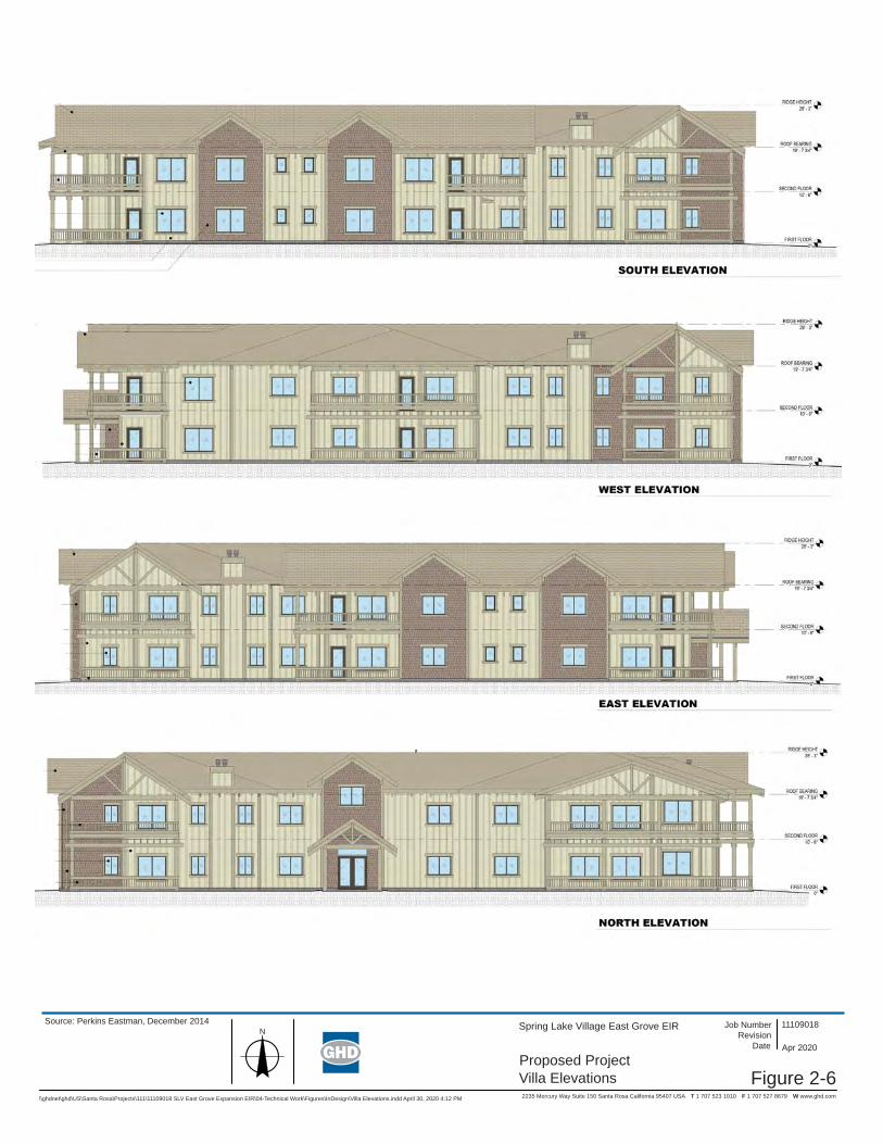
Figure 2-6
Spring Lake Village East Grove EIR
2235 Mercury Way Suite 150 Santa Rosa California 95407 USA T 1 707 523 1010 F 1 707 527 8679 W www.ghd.com
Proposed ProjectVilla Elevations
11109018Revision
Job Number
DateN
\\ghdnet\ghd\US\Santa Rosa\Projects\111\11109018 SLV East Grove Expansion EIR\04-Technical Work\Figures\InDesign\Villa Elevations.indd April 30, 2020 4:12 PM
Apr 2020
Source: Perkins Eastman, December 2014

\\ghdnet\ghd\US\Santa Rosa\Projects\111\11109018 SLV East Grove Expansion EIR\04-Technical Work\Figures\InDesign\ \\ghdnet\ghd\US\Santa Rosa\Projects\111\11109018 SLV East Grove Expansion EIR\04-Technical Work\Figures\InDesign P Proj Site Lighting.indd April 30, 2020 4:18 PM
Figure 2-7
Revision Job NumberSpring Lake Village East Grove EIR
2235 Mercury Way Suite 150 Santa Rosa California 95407 USA T 1 707 523 1010 F 1 707 527 8679 W www.ghd.com
Proposed ProjectSite Lighting Plan
11109018
Date Apr 2020
Source: Perkins Eastman, September 2017

\\ghdnet\ghd\US\Santa Rosa\Projects\111\11109018 SLV East Grove Expansion EIR\04-Technical Work\Figures\InDesign\ \\ghdnet\ghd\US\Santa Rosa\Projects\111\11109018 SLV East Grove Expansion EIR\04-Technical Work\Figures\InDesign Proposed Proj Utility Plan Melita Rd.indd April 30, 2020 3:06 PM
Figure 2-8a
Revision Job NumberSpring Lake Village East Grove EIR
2235 Mercury Way Suite 150 Santa Rosa California 95407 USA T 1 707 523 1010 F 1 707 527 8679 W www.ghd.com
Proposed Project UtilityPlan - Melita Road
11109018
Date Apr 2020
Source: Perkins Eastman, September, 2017
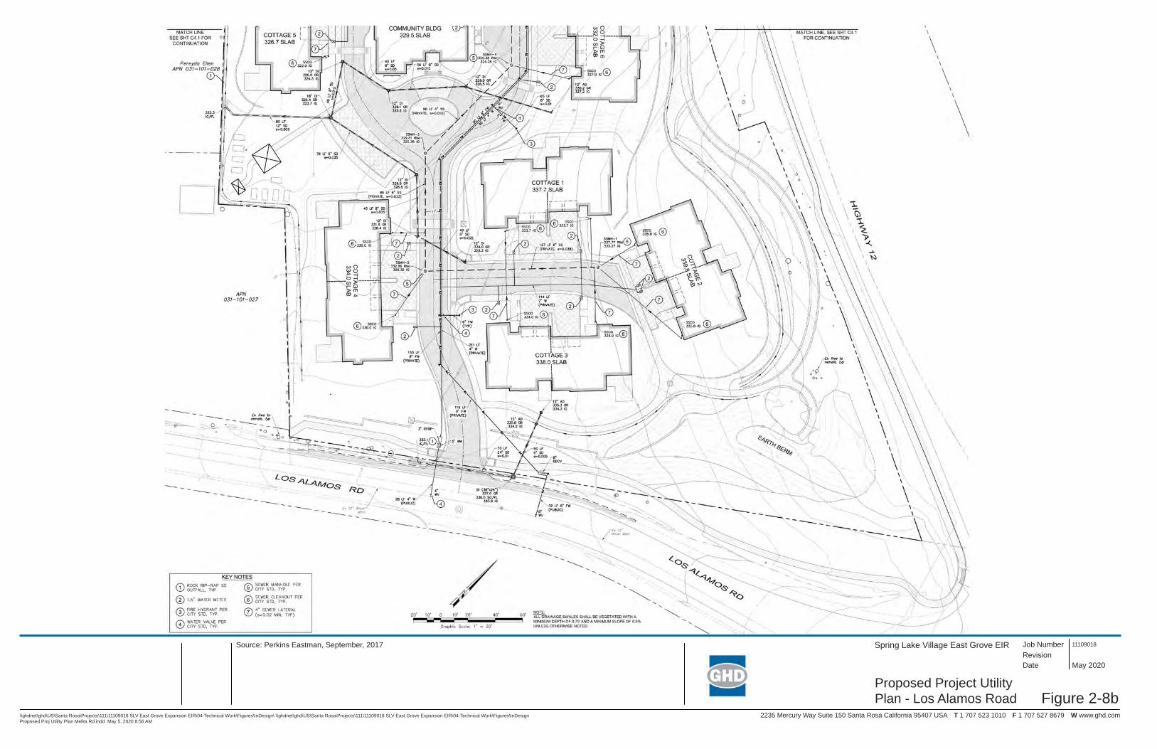
\\ghdnet\ghd\US\Santa Rosa\Projects\111\11109018 SLV East Grove Expansion EIR\04-Technical Work\Figures\InDesign\ \\ghdnet\ghd\US\Santa Rosa\Projects\111\11109018 SLV East Grove Expansion EIR\04-Technical Work\Figures\InDesign Proposed Proj Utility Plan Melita Rd.indd May 5, 2020 8:56 AM
Figure 2-8b
Revision Job NumberSpring Lake Village East Grove EIR
2235 Mercury Way Suite 150 Santa Rosa California 95407 USA T 1 707 523 1010 F 1 707 527 8679 W www.ghd.com
Proposed Project UtilityPlan - Los Alamos Road
11109018
Date May 2020
Source: Perkins Eastman, September, 2017
Introduction to Analysis
Spring Lake Village East Grove Project Draft EIR | Page 3-1
Introduction to Analysis
Scope of Analysis The City of Santa Rosa Planning and Economic Development Department received an application for the Project in 2016. The environmental review process for the Project was initiated in 2016. This Draft EIR analyzes the potential effects of the Project on the environment under the applicable environmental resource topics listed in the 2020 CEQA Guidelines Appendix G Initial Study Checklist.
Each environmental resource area potentially impacted by the Project is addressed in its own section, numbered as follows:
3.1 Aesthetics 3.2 Air Quality 3.3 Biological Resources 3.4 Cultural Resources 3.5 Geology, Soils and Seismicity 3.6 Greenhouse Gas and Energy 3.7 Hazards and Hazardous Materials 3.8 Hydrology and Water Quality 3.9 Land Use, Population, and Housing 3.10 Noise 3.11 Public Services and Recreation 3.12 Transportation 3.13 Tribal Cultural Resources 3.14 Utilities and Service Systems
Each section of Chapter 3 contains the following elements:
Setting. This subsection presents a description of the existing physical environmental conditions in the Project area with respect to each resource area at an appropriate level of detail to understand the impact analysis. It describes existing conditions and provides a baseline by which to compare the potential impacts of the Project.
Regulatory Framework. This subsection provides a brief discussion of federal, State, and local regulations and policies that are relevant to the resource.
Significance Thresholds. This subsection provides the significance thresholds for evaluation of environmental impacts.
Methodology. The methodology subsection discusses the approach to the analysis.
Impacts and Mitigation Measures. This subsection evaluates the potential for the Project to significantly affect the physical environment described in the setting. Potential impacts are identified and characterized, and where feasible, mitigation measures are identified to avoid or reduce significant impacts to a less-than-significant level.
Cumulative Impacts and Mitigation Measures. Cumulative impacts are discussed in each environmental resource section following the description of the Project-level impacts and mitigation measures. The cumulative impact analysis is based on the same setting, regulatory framework, and

Introduction to Analysis
Spring Lake Village East Grove Project Draft EIR | Page 3-2
significance thresholds presented in each resource topic section. Additional mitigation measures are identified if the analysis determines that the Project’s contribution to an adverse cumulative impact would be cumulatively considerable and, therefore, significant.
Significance Determinations The significance thresholds for each environmental resource topic are presented in each section of Chapter 3. For the impact analyses, the following categories are used to identify impact significance:
No Impact. This determination is made if a resource is absent or if a resource exists within the Project area, but there is no potential that the Project could affect the resource.
Less-than-Significant Impact. This determination applies if there is a potential for some limited impact on a resource, but the impact is not significant relative to the significance threshold.
Less-than-Significant Impact after Mitigation Incorporated. This determination applies if there is the potential for a significant impact relative to the significance threshold, but mitigation is available to reduce the impact to a less-than-significant level.
Significant and Unavoidable Impact after Mitigation Incorporated. This determination applies to impacts that are significant, and mitigation has been recommended, but the mitigation does not reduce the impact to less than significant and no additional feasible mitigation is available to reduce the impact to a less-than-significant level.
Cumulative Impact Analysis CEQA requires the discussion of cumulative impacts. Cumulative impacts are defined as “two or more individual effects which, when considered together, are considerable or which compound or increase other environmental impacts” (CEQA Guidelines Section 15355). Cumulative impacts can result from individually minor, but collectively significant, actions taking place over a period of time.
The cumulative impact analysis for each environmental resource topic is described in the appropriate subsections of this Chapter, following the description of Project impacts and mitigation measures.
Approach to Cumulative Impact Analysis Two approaches to cumulative impact analysis are discussed in CEQA Guidelines Section 15130(b). The first approach utilizes a list of probable future projects producing related or cumulative impacts. The second approach utilizes a summary of projections contained in an adopted local, regional or statewide plan, such as a general plan or related planning document, or in an adopted or certified environmental document, which describes or evaluates conditions contributing to cumulative effects.
For this Draft EIR, the cumulative impacts analysis uses the list approach for most environmental resources. For the cumulative analysis of air quality, the analysis relies upon the Bay Area Air Quality Management District’s regional projections. In developing regional thresholds of significance for criteria and precursor air pollutants, BAAQMD considered the emission levels for which a project’s individual emissions would be cumulatively considerable. If a project exceeds the identified regional significance thresholds, its emissions would be cumulatively considerable, resulting in significant adverse air quality impacts to the region’s existing air quality conditions (BAAQMD 2017a). For the cumulative analysis of traffic and transportation impacts, the analysis includes a discussion of Santa Rosa’s level of service (LOS) standard for informational purposes, which relies on the Sonoma County Transit Authority (SCTA) model which is based on planned projects in the region through 2040.

Introduction to Analysis
Spring Lake Village East Grove Project Draft EIR | Page 3-3
Table 3-1 (Projects Considered for Cumulative Impacts) provides a list of past, present, and probable future projects producing related or cumulative impacts, including a brief description of the projects and their anticipated construction schedules. Figure 3-1 (Location of Cumulative Projects) shows the location of the cumulative projects.
The geographic area considered for each environmental resource topic is defined in the cumulative impact analysis in each subsection of this Chapter.
Table 3-1 Projects Considered for Cumulative Impacts
Project Name Project Description Estimated
Construction Schedule
Project Location
A - Los Alamos Trunk Sewer Replacement
Proposed replacement of an outdated and undersized section
of Los Alamos Sewer Trunk, which runs north and parallel to Santa Rosa Creek from Elaine
Drive to Melita Road.
2022-2024, could overlap with Project
Melita Rd, ≈0.6 mile west of Project site
B - Montgomery Drive Improvements
Pedestrian improvements along Montgomery Drive, including
pedestrian pathway adjacent to westbound travel lane, sidewalk extension with curb and gutter,
Class II bike lanes, and repaving and restriping.
Completed in Summer 2018
Montgomery Drive; <0.1 mile from
Project site
C - Annadel Estates
Subdivision Extension – 10 Unit Housing Development.
Completed in 2019-2020
Highway 12; ≈0.2 mile from
Project Site D - PG&E Pipeline
Safety Project Tree removal along Highway 12. Unknown, could
overlap with Project Highway 12, east of Los Alamos Road ≈0.1 mile from
Project site E - Elnoka
Continuing Care Retirement Community
664 senior care units and 12 affordable housing units.
Phased construction between 2021-2025,
could overlap with Project
Hwy 12 at Elnoka Lane;
≈0.7 mile east of the Project Site.
F – Regional Glass Fire Debris Removal and Clean Up
Removal of structural ash and debris from properties affected
by the 2020 Glass Fire
2021-2022, could potentially overlap
with Project
Multiple properties along Melita Road, Channel Drive, and
other roadways; ≈0.5 mile east and
northeast of the Project Site.
Note Probable future cumulative projects were identified at the beginning of the environmental review process for the project, and again in 2019, 2020, and 2021.

Figure 3-1
Spring Lake Village East Grove EIR
2235 Mercury Way Suite 150 Santa Rosa California 95407 USA T 1 707 523 1010 F 1 707 527 8679 W www.ghd.com
Location ofCumulative Projects
11109018Revision
Job Number
Date May 2021N
\\ghdnet\ghd\US\Santa Rosa\Projects\111\11109018 SLV East Grove Expansion EIR\04-Technical Work\Figures\InDesign\Cumulative Projects Map Alt 2.indd May 2021
LEGEND
Montgomery Dr
Montgomery Dr
Summ
erfield Rd
Summ
erfield Rd
Mission B
lvd.M
ission Blvd.
Middle Rincon Rd
Middle Rincon Rd
Highway 12Highway 12
Highway 12
Highway 12
Oakmont
Oakmont
Dr Dr
Calistoga R
dC
alistoga Rd
Approximate Scale
0 1000
Feet
2000 3000
C
A
B
B
A
E
C
D
D
Spring Lake Village Project Location
Los Alamos Trunk Sewer Replacement
Montgomery Dr. Improvements
Annadel Estates
PG&E Pipeline Safety Project
E
F
Elnoka Continuing Care Retirement Community
Regional Glass Fire Debris Removal and Clean Up
F
F

Aesthetics
Spring Lake Village East Grove Project Draft EIR | Page 3.1-1
3.1 Aesthetics This section evaluates aesthetics-related impacts from implementation of the Project. In addition to the analysis provided in this section, the following subjects are related to aesthetics, but are evaluated in other sections of this EIR:
Compliance with Santa Rosa Tree Ordinance requirements is discussed in Section 3.3 (Biological Resources), and Section 3.6 (Greenhouse Gas and Energy).
Consistency with zoning requirements, such as height restrictions, is discussed in Section 3.9 (Land Use, Population, and Housing).
3.1.1 Setting
Visual Character Visual or aesthetic resources are generally defined as both the natural and built features of the landscape that contribute to the public’s experience and appreciation of the environment. Visual character is a general description of the visual attributes of a particular land use setting and the unique set of landscape features.
The Project site is located in a primarily residential area in east Santa Rosa. The site is bordered to the north by Highway 12 and single-family residences; to the south by single-family residences, the Melita Station Inn, and Melita Road, Montgomery Drive, and Annadel State Park; to the east by Los Alamos Road and multi-family residences; and to the west by single-family residences and Hope Chapel Church. The character of the area generally consists of a mix of Very Low to Medium High Density Residential.
The visual character of the Project site consists of a mix of annual grasslands that are more or less ruderal in character, trees, and two single-family residences. The visual character of the surrounding area consists of a mix of single-family residential dwellings, apartment complexes, open lawn and field areas, a church, and paved and landscaped parking lots. Roadways bound a large portion of the Project site. Vertical elements of the Project site and surrounding area include: mature trees; one and two-story residences and associated sheds, barns, and similar structures; utility poles; roadway signs; fencing; and light poles.
The Project site encompasses 7.28 acres, is largely vacant and is in a predominantly undeveloped condition (with the exception of two residences on the southernmost portion of the property).
Existing vegetation on the Project site consists primarily of annual grassland and coast live oak woodland. Willow riparian forest and ruderal habitats occur along Melita Road adjacent to the Project site where some of the off-site improvements would occur. The two residences are located on the southwestern portion of the property, along with two outbuildings, a carport, and three sheds. Although visible from Melita Road, the residences are partially screened from view by existing vegetation.
Light sources located on and adjacent to the Project site along Highway 12, Los Alamos Road, and Melita Road include headlights from vehicle traffic, porch and interior lighting from adjoining residential properties, and streetlights along Los Alamos Road.

Aesthetics
Spring Lake Village East Grove Project Draft EIR | Page 3.1-2
General Plan Land Use Designations and Zoning City of Santa Rosa General Plan 2035 (Santa Rosa 2009) land use designations along Montgomery Drive approaching the Project site from the west range from Medium Density Residential (8.0 to 13.0 units per acre) on the north side of Montgomery Drive to Parks and Recreation on the south side of Montgomery Drive. The parcels along Melita Road are designated Very Low Density Residential (0.2 to 2.0 units per acre). To the east of the Project site is the Villa Los Alamos condominium complex, which is designated Medium Density Residential.
As noted in Table 3.9-1 in Section 3.9, Land Use, Population, and Housing, of this Draft EIR, the height limit for the Project site’s current Rural Residential (RR-40 and RR-20) zoning is 35 feet. With the proposed rezoning of the site to Planned Development (PD-0308), the height limit at the Project site would increase to 45 feet. However, the tallest building proposed for the Project is the residential Villa building, which would be 28 feet 3 inches tall (plus approximately five feet of mechanical equipment and stairway/elevator shafts above the roof peak).
Scenic Highways and Roadways The City of Santa Rosa has designated roadways within the City that have unique scenic qualities because of their natural setting as well as historical and cultural features. The City of Santa Rosa General Plan 2035 defines a scenic road as a highway, road, drive, or street that, in addition to its transportation function, provides opportunities for the enjoyment of natural and human-made scenic resources and directs views to areas of exceptional beauty, natural resources or landmarks, or historic or cultural interest. The City of Santa Rosa General Plan 2035 designates all of the roadways adjacent to the Project site as scenic roads, including the segment of Highway 12 along the Project frontage, Los Alamos Road, Melita Road, and Montgomery Drive (Santa Rosa 2009).
Section 20-28.050 of the City’s Zoning Code summarizes visual character along three of the four scenic roadways that border the Project site: Highway 12 (Calistoga Road to Oakmont). Los Alamos Road, and Melita Road.
The California Department of Transportation (Caltrans), through its California Scenic Highway Program, has also designated segments of Highway 12 as scenic highway corridors. The portion of Highway 12 from Danielli Avenue to London Way is part of an officially designated State Scenic Highway; however, that section ends approximately one mile east of the Project site and, therefore, is not adjacent to the Project site (Caltrans 2018). Highway 12 from US Highway 101 to Danielli Avenue is listed as an eligible State Scenic Highway; the Project site is located along this section of Highway 12 (Caltrans 2018).
Views of the Project Site To the north, viewers are primarily motorists, pedestrians, and bicyclists along Highway 12. To the southeast, viewers include users of Los Alamos Road and residents of the Villa Los Alamos condominium complex. To the south, the viewers are users of Melita Road, single-family residences, and visitors of the Melita Station Inn. To the west, viewers are predominantly parishioners and employees of the Hope Chapel Church. Cobblestone Trailhead in Annadel State Park is located approximately 300 feet south of the Project boundary; however, the Project site is not visible from the trailhead parking lot or the trail due to intervening vegetation. Since all of the adjacent roadways are designated as scenic by the City, in addition to pedestrians and bicyclists, motorists traveling along the adjacent roadways are also considered sensitive viewers.
Aesthetics
Spring Lake Village East Grove Project Draft EIR | Page 3.1-3
Figures 3.1-1 through 3.1-4 provide viewpoint locations and existing views of the Project site from varying viewer locations1. Viewpoint A looks southwest towards the Project site from Highway 12 in the direction of the proposed Villa. Viewpoint B looks northeast towards the Project site from Melita Road in the direction of proposed Cottages. Viewpoint C looks west towards the Project site from Los Alamos Road near Highway 12, whereas Viewpoint D looks north from Los Alamos Road near the proposed new driveway.
3.1.2 Regulatory Framework
Federal There are no federal plans, policies, regulations, or laws related to aesthetics applicable to this Project.
State California Scenic Highway Program
Sections 260 through 263 of the State Streets and Highways Code establish the California Scenic Highways Program and require local government agencies to take the following actions to protect the scenic appearance of any designated scenic corridors:
Regulate land use and density of development;
Provide detailed land and site planning;
Prohibit off-site outdoor advertising and control on-site outdoor advertising;
Pay careful attention to and control earthmoving and landscaping; and
Scrutinize the design and appearance of structures and equipment.
Nighttime Sky – Title 24 Outdoor Lighting Standards The California legislature passed a bill in 2001 requiring the California Energy Commission (CEC) to adopt energy efficiency standards for outdoor lighting for both the public and private sectors. The CEC adopted changes to Title 24, parts 1 and 6, Building Energy Efficiency Standards, which included changes to the requirements for outdoor lighting for residential and non-residential development. The standards regulate lighting characteristics such as maximum power and brightness, shielding, and sensor controls to turn lighting on and off.
Local
City of Santa Rosa Zoning Code The following sections of the City’s Zoning Code governing scenic quality are applicable to the Project:
Section 20.30.080 (Outdoor Lighting). Applies to outdoor lighting on private property and is applicable to the Project. Section 20.30.080 includes maximum heights for outdoor light standards, as well as requirements that lighting fixtures be shielded or recessed to reduce light spillage onto adjoining properties. This includes requiring light fixtures to be directed downward and away from adjoining properties and public rights-of-way, so that no on-site fixture directly illuminates an area off-
1 Figure 3.1-1 through 3.1-4 depict existing site conditions prior to the removal of several eucalyptus trees at the
Project site for safety reasons. The trees removed were not highly visible in the photographs and do not materially alter the visual simulations conducted for the Project.
Aesthetics
Spring Lake Village East Grove Project Draft EIR | Page 3.1-4
site. Section 20.30.080 specifies that no lighting on private property shall produce an illumination level greater than one footcandle on any property within a residential zoning district except on the site of the light source.
Section 20.50.100 (Visual Analysis). Applies to project applications that are determined by the City’s Planning and Building Director to require a visual analysis. The visual analysis must consist of one or more three-dimensional depictions of a proposed project, including all proposed structures and site development, illustrating how the project will appear to observers, viewing the project from public rights-of-way and other public areas near the site. The three-dimensional visual depictions may be in the form of rendered perspectives, photo-montages, computer generated simulations, and/or any other technique deemed acceptable by the City.
Section 20.32.020 (Hillside Development). Applies to all proposed development or new land uses on the portions of a site that have a slope of 10 percent or greater. Relevant to the Project is the provision requiring that development on sites with significant natural landforms or features be designed in a manner that minimizes the alteration of the topography, drainage patterns, and vegetation on slopes of 10 percent or more.
Section 20.28.050 (Scenic Road (-SR) Combining District). The -SR combining district can be combined with any primary zoning district but the standards apply only to the portions of parcels within 125 feet from the edge of the pavement of a locally-designated scenic road (portions of a parcel more than 125 feet from a locally-designated scenic road are regulated by the standards of the primary zoning district). The -SR combining district is intended to enhance and preserve the natural and constructed features (including trees, rock walls, view corridors, road configuration, and tree canopy) that contribute to the character of scenic roads. A summary of the surrounding scenic roadways, as taken from the zoning code, is provided below. In addition, tree removal requirements of the –SR combining district are provided at the end.
Highway 12 (Calistoga Road to Oakmont). Scenic characteristics consist of the picturesque views of the surrounding hills from the valley floor as one enters and leaves Santa Rosa. The area has a semi-rural character due to the variations in development patterns consisting of rural homes on large lots and suburban subdivisions separated by open pasture. The highway has a boulevard character due to the urban improvements with a landscaped median. As the highway leaves Santa Rosa, the character changes to a rural highway. The minimum setback from Highway 12 for single story structures less than 25 feet in height is 50 feet. The setback is measured from the Highway 12 right-of-way or the back of sidewalk, whichever provides the greater setback. Additionally, landscaping plans must include dense planting of coniferous tree and shrubs to screen development from view from Highway 12.
Melita Road. Scenic characteristics consist of the many native and ornamental trees that line the roadway that give the roadway a sense of shelter and offer varied patterns in light and shadow as one travels along the corridor. The rural character is enhanced by the very narrow width and curves of the road. In addition, portions of the road parallel Santa Rosa Creek. The most scenic areas of the road lack urban street improvements. Most of the area has a very low density rural character with relatively small homes on large lots. The road has an historic feel due to the rock walls and former stagecoach station. The minimum setback from Melita Road for single story structures less than 25 feet in height is 50 feet. The setback is measured from the edge of pavement. Los Alamos Road. Scenic characteristics consist of the picturesque views of hills and valleys from the road as one enters or leaves Santa Rosa. Development along the road has a semi-

Aesthetics
Spring Lake Village East Grove Project Draft EIR | Page 3.1-5
rural-suburban character due to the very low density development, consisting mostly of low ranch style homes on large lots. Existing road improvements enhance the semi-rural character due to the lack of urban improvements. The minimum setback from Los Alamos Road for single story structures less than 25 feet in height is 30 feet.
Tree Removal. The following requirements apply to tree removal on parcels within the –SR combining district. These regulations apply in addition to those in Municipal Code Chapter 17-24 (Trees).
1. Existing developed parcels within 50 feet of a scenic road. A Tree Removal Permit is required prior to the removal of any tree, including an exempt tree. Prior to the approval of a Tree Removal Permit, the applicant shall demonstrate that the removal of the tree will not have a negative impact on the scenic quality of the corridor, or that the tree is a hazard and/or unhealthy as determined by the Planning and Building Director. If the Planning and Building Director cannot determine whether the tree is a hazard or the health of the tree, the applicant shall hire an arborist to make the determination.
2. Tree removal for new development within 100 feet of a scenic road. Special care shall be taken to preserve the maximum number of trees possible, including exempt trees. Prior to the approval of a project the applicant shall demonstrate that each tree proposed for removal shall not have a negative impact on the scenic quality of the corridor, or that the tree is a hazard or unhealthy, as determined by a certified arborist.
City of Santa Rosa General Plan The following goals and policies from the City of Santa Rosa General Plan 2035 are applicable to the Project.
UD-A Preserve and enhance Santa Rosa’s scenic character, including its natural waterways, hillsides, and distinctive districts.
UD-A-1 Maintain view corridors to natural ridgelines and landmarks, such as Taylor Mountain and Bennett Mountain.
UD-A-4 In new developments, minimize overall grading by limiting site grading to the minimum necessary for driveways, parking areas, and understructure areas.
UD-A-5 Require superior site and architectural design of new development projects to improve visual quality in the city.
UD-A-10 Relate landscape design to the natural setting. Require that graded areas within the new development be revegetated.
UD-A-13 Review guidelines for parking lot trees to ensure adequate summertime shading.
UD-E Create a framework of public spaces at the neighborhood, city, and regional scale.
UD-E-2 Provide an open space network that is linked by pedestrian and bicycle paths, and that preserves and enhances Santa Rosa’s significant visual and natural resources.

Aesthetics
Spring Lake Village East Grove Project Draft EIR | Page 3.1-6
UD-E-4 Enhance pedestrian activity and safety by designing streets, buildings, pathways, and trails to provide a visual connection with public spaces such as parks and Santa Rosa Creek.
UD-F Maintain and enhance the diverse character of Santa Rosa’s neighborhoods. Promote the creation of neighborhoods – not subdivisions – in areas of new development.
UD-F-2 Protect natural topographic features such as hillsides, ridgelines, and mature trees and stands of trees. Minimize grading of natural contours in new development.
UD-F-4 Provide visual interest in building, site, and landscape design that avoids the sense of a monotonous tract development.
T-G Identify, preserve, and enhance scenic roads through Santa Rosa in both rural and developed areas.
T-G-5 Retain existing trees and vegetation along scenic roads, as possible. Enhance roadway appearance through landscaping, using native plant material.
T-G-6 Provide large setbacks from scenic roads, as possible, to avoid encroachment of buildings on the view of the roadway.
T-G-7 Provide bikeways along scenic roads, where right-of-way exists or where its acquisition will not jeopardize roadway character.
T-G-8 Disallow on-street parking along scenic roads. Bus stops or scenic overlooks may be provided at appropriate intervals.
T-G-9 Require curbs and gutters only where they are necessary for drainage and pedestrian safety purposes.
Santa Rosa Design Guidelines Santa Rosa’s design review process ensures that new or remodeled development in the city will enhance the City’s environment and be compatible with the surrounding area. All professional offices, commercial buildings, multi-family housing units, Planned Unit Developments, and Planned Residential Zones are subject to design review. Projects are reviewed for site planning, circulation, architectural design, quality and type of materials, colors and landscaping. The staff of the Planning and Economic Development Department reviews minor projects and sign programs and the Design Review Board reviews all other projects. The City has adopted Design Guidelines to implement the Urban Design Element of the General Plan.
The following goals and guidelines are the most relevant aspects of the Santa Rosa Design Guidelines with regard to the proposed Project:
4.3.I-A. To provide for continuity of design between existing and new development.
4.3.I-B. To ensure that projects are designed in such a way as to reduce to a minimum possible negative consequences, such as: loss of privacy, noise, increased traffic and lighting overspill that infill development may have on existing neighbors.

Aesthetics
Spring Lake Village East Grove Project Draft EIR | Page 3.1-7
4.3.II-1. Integrate new development carefully into existing neighborhoods with respect to scale, level of detailing, use of materials, landscaping, and other characteristics of the neighborhood.
4.3.II-2. Where Santa Rosa's General Plan calls for a change or an intensification in land use new development should consider the character of the surrounding neighborhood or district, particularly at the edges adjacent to existing development.
4.3.II-7. Utilize shielded light fixtures to minimize on-site light straying beyond a project boundary. Hours of operation should be considered as well.
4.3.II-8. If a multi-family project is located across the street from a single-family neighborhood, design the buildings to relate to the street with individual entries, patio areas and landscaping facing the single family homes. Parking lot areas, carports, etc. should not be located along these street frontages.
4.3.II-9. When adding a duplex, triplex or fourplex to an existing single-family neighborhood, design the new structure to have the "look" of a single family home so as to enhance its compatibility.
3.1.3 Evaluation Criteria and Significance Thresholds For the purpose of this EIR, the evaluation criteria and significance thresholds summarized in Table 3.1-1 (Evaluation Criteria and Significance Thresholds) are used to determine if the Project would have a significant effect related to aesthetics and lighting.
Table 3.1-1 Evaluation Criteria and Significance Thresholds
Evaluation Criteria Significance Thresholds Sources
AES-1: Would the project have a substantial adverse effect on a scenic vista?
Major alteration of a view from a scenic vista or major obstruction in viewed area towards a scenic vista.
CEQA Guidelines Appendix G, Checklist Item I (a) City of Santa Rosa General Plan 2035
AES-2: Would the project substantially damage scenic resources, including, but not limited to, trees, rock outcroppings, and historic buildings within a State scenic highway?
Affect a scenic resource within view of a roadway designated as scenic by Caltrans.
CEQA Guidelines Appendix G, Checklist Item I (b) California Scenic Highway Program
Aesthetics
Spring Lake Village East Grove Project Draft EIR | Page 3.1-8
Evaluation Criteria Significance Thresholds Sources
AES-3: In non-urbanized areas, would the project substantially degrade the existing visual character or quality of public views of the site and its surroundings? If the project is in an urbanized area, would the project conflict with applicable zoning and other regulations concerning scenic quality (Public views are those that are experienced from publicly accessible vantage points)?
Conflict with the City of Santa Rosa’s Design Guidelines, General Plan goals and policies, and/or Zoning Code related to visual character (see Section 3.1.2, Regulatory Framework).
CEQA Guidelines Appendix G, Checklist Item I (c) City of Santa Rosa General Plan 2035 City of Santa Rosa Zoning Code Section 20-52.030 (Design Review) City of Santa Rosa Design Guidelines
AES-4: Would the project create a new source of substantial light or glare which would adversely affect day or night-time views in the area?
Non-compliance with the City’s adopted outdoor lighting standards.
CEQA Guidelines Appendix G, Checklist Item I (d) City of Santa Rosa Zoning Code Section 20-30.080
3.1.4 Approach to Analysis Visual impacts are assessed by estimating the amount of visual change introduced by a project’s components, the degree to which visual changes may be visible from scenic highways and scenic vistas, or other publicly accessible vantage points, and consistency with zoning and other local regulations governing scenic quality. Visual changes are assessed from publicly-accessible viewpoints and usually measured by three factors:
the amount of visual contrast that project components create (changes to form, line, color, texture, and scale in the landscape);
the amount of view obstruction (loss of view) that occurs; and
the degradation of specific scenic resources (e.g., removal of heritage trees or impacts on scenic vistas).
Impacts related to inconsistency with zoning and regulations governing scenic quality are assessed by evaluating the Project against the City of Santa Rosa’s Design Guidelines and General Plan goals and policies related to scenic resources. To aid in the analysis of visual impacts, photos depicting existing publicly-accessible views of the site from Highway 12, Melita Road, and two locations along Los Alamos Road were compared against visual simulations of the site with implementation of the Project from the same locations (see Figures 3.1-1 through 3.1-4). These simulations were produced from accurately scaled, three-dimensional computer models of the proposed improvements. Simulation photos were taken with a “normal” camera lens setting (roughly 50 mm or 40 degree horizontal angle of view) at about five feet in height to approximate the sense of scale that would be experienced by viewers in the field.
3.1.5 Impacts and Mitigation Measures Table 3.1-2 (Summary of Impacts - Aesthetics) provides a summary of potential impacts from the Project.

Aesthetics
Spring Lake Village East Grove Project Draft EIR | Page 3.1-9
Table 3.1-2 Summary of Impacts – Aesthetics
Evaluation Criteria Project Impact
AES-1: Would the project have a substantial adverse effect on a scenic vista? LS
AES-2: Would the project substantially damage scenic resources, including, but not limited to, trees, rock outcroppings, and historic buildings within a State scenic highway?
NI
AES-3: In urbanized areas, would the project conflict with applicable zoning and other regulations concerning scenic quality (Public views are those that are experienced from publicly accessible vantage points)?
LS
AES-4: Would the project create a new source of substantial light or glare which would adversely affect day or nighttime views in the area?
LS
C-AES-1: Would the project result in a cumulatively considerable contribution to cumulative impacts related to visual resources?
LS
Notes: NI = No Impact LS = Less than Significant
Impact AES-1: Would the project have a substantial adverse effect on a scenic vista?
Analysis: Less than Significant
Goal UD-A and Policy UD-A-1 of the Santa Rosa General Plan seeks to maintain view corridors to natural ridgelines and landmarks, such as Taylor Mountain and Bennett Mountain. Taylor Mountain is located approximately 4.5 miles southwest of the Project site. Bennett Mountain is located approximately 3.2 miles to the south of the Project site. Taylor Mountain and Bennett Mountain are not visible from the Project site or from adjacent areas, as they are obscured by views of the nearer Sonoma Mountain foothills. Therefore, the Project would not affect view corridors to Taylor Mountain or Bennett Mountain.
In addition to specific views of Taylor Mountain and Bennett Mountain, Policy UD-A-1 seeks to retain views of the Sonoma Mountain foothills that are prominently visible from many locations in the flatland areas of the city. Views of the Sonoma Mountain foothills are most noticeable looking southwest from Highway 12 (see Figure 3.1-1 Viewpoint A). The tallest building proposed for the Project is the residential Villa building, which would be approximately 28 feet 3 inches tall (plus approximately five feet of mechanical equipment and stairway/elevator shafts above the roof peak). All other buildings, including cottages and the resident community building, would be less in height. As shown in Figure 3.1-1, the visual simulation of the Project site looking south from Highway 12, indicates that the proposed Project, including the tallest building in the development, would not affect views of the Sonoma Mountain foothills natural ridgeline from the highway corridor. As seen in Figures 3.1-2, 3.1-3, and 3.1-4 the remaining vistas and ridgelines surrounding the Project site are obscured by existing topography and vegetation.
The Project site is not located along a ridgeline nor would it block the scenic view of a natural ridgeline or landmark. The impact of the Project on scenic vistas would be less than significant.

Aesthetics
Spring Lake Village East Grove Project Draft EIR | Page 3.1-10
Mitigation: No mitigation is needed.
Impact AES-2: Would the project substantially damage scenic resources, including, but not limited to, trees, rock outcroppings, and historic buildings within a State scenic highway?
Analysis: No Impact
The California Scenic Highway Program includes a list of officially designated and eligible State Scenic Highways. According to the California Scenic Highway Mapping System, the nearest designated State Scenic Highway in the Project vicinity is the portion of Highway 12 between Danielli Avenue to London Way, approximately one mile east of the Project site (Caltrans 2018). The Project site and off-site improvement areas are not located within the scenic corridor, and would therefore have no impact on associated scenic resources.
According to the California Scenic Highway Mapping System, Highway 12 adjacent to the Project site is part of an eligible State Scenic Highway (Caltrans 2018). An eligible State Scenic Highway designation differs from an official designation and does not require local jurisdictions to enact a scenic corridor protection program. No impact would result.
See impact AES-3 for further evaluation of potential Project impacts to locally-designated scenic roadways.
Mitigation: No mitigation is needed.
Impact AES-3: In urbanized areas, would the project conflict with applicable zoning and other regulations concerning scenic quality (Public views are those that are experienced from publicly accessible vantage points)?
Analysis: Less than Significant
Local regulations form the basis of the majority of the aesthetics-related requirements applicable to the Project. Because the Project is located in an urbanized area, these specific regulations serve as the basis of the analysis. The Project is considered to be located within an urbanized area because it meets the definition contained in §21071 of the Public Resources Code; specifically, it is located within an incorporated city with a population of at least 100,000 persons. Applicable local regulations include the goals and policies of the Santa Rosa General Plan and the Santa Rosa Zoning Code (Title 20 of the Municipal Code). The Zoning Code provides for the regulation of aesthetics via the Design Review process (which is informed by the adopted Design Review Guidelines) and, specific to the Project site, by the Scenic Road Combining District (which considers the appearance of development near designated scenic roads.)
Urban Design Policies UD-A-5, UD-A-10, and UD-F-4 describe the intent of the community for new development to be of high architectural value with landscape design that reflects the natural setting of the area. Value is placed on designs that create visual interest in the buildings, site, and landscaping and that avoid monotonous design. As shown in Figure 2-3 (Proposed Project Site Plan), Figures 3.1-1 through 3.1-4 (Visual Simulations), and Figure 2-5 (Proposed Project

Aesthetics
Spring Lake Village East Grove Project Draft EIR | Page 3.1-11
Building Perspectives), the development is village-like in its building and landscape layout. All internal roads curve and buildings are not located parallel or perpendicular to each other – reflecting design features that are evocative of a rural, pastoral development. The landscaping contains large amounts of greenspace and many shade trees. Changes in topography are naturalistic, consisting of earthen berms and a rain garden. The low retaining wall built from stones/boulders mimics stone walls found in surrounding agricultural areas. The building facades are heavily articulated and contain (or mimic the appearance of) numerous façade materials such as masonry, shake siding, and vertically-oriented “board and batten” siding.
Transportation Policies T-G-6 and T-G-7 call for large setbacks to preserve locally designated scenic roads and to encourage bikeways. The proposed development meets or exceeds all setbacks related to scenic roadways as described in Section 3.1.2, above. Cottages 2, 5, and accessory are located 50’ and 100’ (one and two story setbacks, respectively) from Highway 12. Cottages 1 and 4 are located approximately 80’ from Los Alamos Road. Cottages 8 and 9 are located approximately 50’ from Melita Road. The Project includes off-site bicycle and pedestrian improvements, including sidewalk and bike path adjacent to Highway 12; pedestrian pathway and Class II bike lane along Los Alamos Road; and pedestrian improvements along Melita Road (See Section 2.4.2 of Project Description for additional detail regarding off-site bike and pedestrian improvements).
Santa Rosa Zoning Code
Design Review. Section 20-52.030 of the Santa Rosa Zoning Code establishes procedures for the City’s review of the design aspects of proposed development (for example, building design, landscaping, site planning and development, and signs), in compliance with the City’s Design Guidelines. Regulatory compliance depends on the consistency of a proposed project with the adopted Design Review Guidelines, relationship to existing adjacent development, and consistency with neighborhood character.
Design Guidelines Section 3.2 Multi-Family Residential is the section of the guidelines that provides the most direction regarding the design of the proposed development. The multi-family residential section focuses on common and semi-private open space, materials, massing/articulation, and security. The proposed development contains common space in the form of the community building, pathways, community garden, and landscaped areas. Ground-level private open space is provided for each of the cottages. The buildings are all highly articulated with both horizontal and vertical projections (including the foundation), eaves, and variable roof pitches. Each façade contains a similar level of detail and articulation – thus avoiding blank or visually uninteresting walls. There are a variety of façade materials and architectural details used in the development. Façade materials include vertical board and batten siding, wood shake siding, and stucco. The roof has exposed beams and rafter tails. Design Review is a required condition of approval and will involve a thorough review of all applicable language contained in the Design Review Guidelines.
Aesthetics
Spring Lake Village East Grove Project Draft EIR | Page 3.1-12
The surrounding single-family residential development is low density and rural in nature. The single-family homes in these areas are typically conventional 1 to 2 story homes with pitched roofs. The distance between structures is typical for the rural/suburban environment but varies somewhat depending on the age of the subdivision. The adjacent multi-family residential development (Villa Los Alamos) presents the best opportunity for comparison to the proposed development. Villa Los Alamos is comprised of dark toned, heavily articulated, and steep roofed condos. The development is landscaped to provide shade and privacy throughout. The architecture, layout, and landscaping of the proposed development is similar enough to Villa Los Alamos to provide complementarily consistency but retains sufficient distinct architectural features, materials, and colors to visually stand apart. The proposed development meets all required setbacks, as noted above, and would be screened by on-site landscape vegetation. For these reasons the proposed development may be considered compatible with the existing adjacent development and is consistent with the neighborhood character.
Scenic Roads. Highway 12, Los Alamos Road, and Melita Road are designated as scenic roads in the Santa Rosa General Plan and are regulated under section 20.28.050 (Scenic Road (-SR) Combining District) of the Santa Rosa Zoning Code. This section of the Zoning Code specifies minimum setbacks for buildings near designated scenic roads. The proposed development meets all of the minimum building setbacks that are intended to protect scenic quality. (See Section 3.1.2, above, for more detailed information).
The Scenic Road Combining District also addresses the removal of trees for new development within 100 feet of a scenic road. This provision applies to both the Melita Road, Los Alamos Road, and Highway 12 frontage of the Project. It requires that a tree removal permit be obtained for all trees removed within the 100-foot band and that each tree removed cannot have a negative impact on the scenic quality of the corridor. Based on the preliminary design drawings, no trees would be removed within the 100-foot setback of Highway 12, two trees would be removed within the 100-foot setback of Los Alamos Road, and four trees would be removed within the 100-foot setback of Melita Road. Table 3.1-3 (Tree Removals Within 100-Foot Scenic Setback) summarizes the impacted trees.
Table 3.1-3 Tree Removals Within 100-Foot Scenic Setback
Species Common Name Trunk (dbh)
Height (feet) Location
Quercus lobata Valley Oak 6 35 Los Alamos Rd Quercus agrifolia Coast Live Oak 5 25 Los Alamos Rd Quercus lobate Valley Oak 7 25 Melita Rd Quercus agrifolia Coast Live Oak 5 14 Melita Rd Quercus lobate Valley Oak 5.5 20 Melita Rd Quercus agrifolia Coast Live Oak 21 45 Melita Rd
In the location along Los Alamos Road, the two trees to be removed are small, between 5 and 6 inches in diameter, and are within a cluster of 11 trees many of which are equal to or larger in size than those to be removed. As can be seen in
Aesthetics
Spring Lake Village East Grove Project Draft EIR | Page 3.1-13
Figures 3.1-3 and 3.1-4, there are numerous oak trees along this segment of Los Alamos Road, and the removal of two trees would not negatively impact the scenic quality of the corridor. In the location along Melita Road, four trees of various sizes between 5 and 21 inches would be removed. Three are small (less than 7 inches in diameter) and clustered together and one is 21-inches in diameter and set apart from the others. In Figure 3.1-2, although these trees are just out of view to the left of the frame, the scenic quality of the site from Melita Road can be seen. Note the two large trees in either corner of the frame that will be preserved as part of the Project, thus retaining some of the trees contributing to the scenic corridor. As with the Los Alamos corridor, there are several other trees that will remain along the corridor, and thus the removal of four trees, three of which are small, are not anticipated to have a negative impact on the scenic quality of the corridor. In addition, as described in Section 3.3, Biological Resources, the Project applicant would be required to comply with Santa Rosa City Code Chapter 17-24 for planting and regenerating trees, which would include plantings along Los Alamos Road and Melita Road, thus visually replacing those removed.
For the reasons described above, the design of the Project does not conflict with applicable zoning and other regulations concerning scenic quality. There would be no conflict with an applicable zoning code, and the impact from tree removals within scenic roadway corridors would be less than significant.
Mitigation: No mitigation is needed.
Impact AES-4: Would the project create a new source of substantial light or glare which would adversely affect day or nighttime views in the area?
Analysis: Less than Significant
Nighttime construction work is not anticipated for the Project. Therefore, no exterior lighting would be required during construction, and no impacts would result.
Following construction, the Project would be located in a largely built-out area where nighttime lighting currently exists, including existing street and parking lot lighting. The Project would add additional sources of nighttime light in the Project area from outdoor lighting and from lighting on buildings. The new outdoor lighting would include bollard, pole, and exterior porch lighting through the development.
As a condition of approval, the Project would be required to comply with Zoning Code lighting requirements contained in City Municipal Code Section 20.30.080, which includes maximum heights for outdoor light standards, as well as requirements that lighting fixtures be shielded or recessed to reduce light spillage onto adjoining properties. This includes requiring light fixtures to be directed downward and away from adjoining properties and public rights-of-way, so that no on-site fixture directly illuminates an area off-site. Pole-mounted light fixtures are distributed throughout the site but are not located on or very near shared property lines. This and other specific design features of the lights greatly reduce the possibility of light trespass. As described in the Project Description, the outdoor lighting would be installed to meet the requirements of City Municipal Code Section 20.30.080. Design review, required as a standard use permit condition of approval, includes review of all proposed exterior lighting to ensure such lighting would be

Aesthetics
Spring Lake Village East Grove Project Draft EIR | Page 3.1-14
compatible with City requirements and with the surrounding area. Therefore, the new exterior lighting would not create a new source of substantial nighttime light or glare.
The buildings would generally have non-reflective surfaces with interspersed windows. The façades of the buildings include various building projections and a variety of siding materials that will scatter or absorb light. No façade contains large reflective surfaces of metal or glass wall panels. Thus, no daytime glare is anticipated.
The Project’s impact on light and glare would be less than significant.
Mitigation: No mitigation is needed.
Impact C-AES-1: Would the project result in a cumulatively considerable contribution to cumulative impacts related to visual resources?
Analysis: Less than Significant
The geographic scope for the analysis of cumulative impacts on visual resources consists of the Project site and the immediate vicinity around the site. Refer to Section 3 (Environmental Analysis), Table 3-1 (Projects Considered for Cumulative Analysis), for a summary of the cumulative projects.
The proposed Project would not result in impacts relative to a State scenic highway or conflict with an applicable zoning code or regulation. Therefore, implementation of the Project would not contribute to cumulative impacts on such resources. The proposed Project would result in less than significant impacts related to impacting scenic vistas, and the creation of a new source of light and glare. The cumulative projects listed in Table 3-1 are generally located too far away from the Project site to contribute to a cumulative aesthetic impact in that the other projects would not be visible from the same public vantage points as the proposed Project. One exception is the Los Alamos Trunk Sewer Replacement, which may potentially be extended adjacent to the Project site. However, the sewer project would involve replacement of a trunk sewer with belowground improvements that would not alter the visual character of the area. Therefore, the Project would not contribute to a cumulative aesthetic impact.
Mitigation: No mitigation is needed.
3.1.6 References Caltrans. 2018. State of California Scenic Highway Mapping System. Scenic Route. Accessed April
6, 2018. http://www.dot.ca.gov/hq/LandArch/16_livability/scenic_highways/
Santa Rosa, City of. 1990. Tree Preservation Ordinance. October 2.
Santa Rosa, City of. 2005. Design Guidelines.
Santa Rosa, City of. 2009. Santa Rosa General Plan 2035. November 3.
Santa Rosa, City of. 2016. Zoning Code 20-28.050. Scenic road.

Figure 3.1-1
Spring Lake Village East Grove EIR
2235 Mercury Way Suite 150 Santa Rosa California 95407 USA T 1 707 523 1010 F 1 707 527 8679 W www.ghd.com
Proposed Project Viewpoint A – Existing View and Simulations
11109018Revision
Job Number
Date May 2020
\\ghdnet\ghd\US\Santa Rosa\Projects\111\11109018 SLV East Grove Expansion EIR\04-Technical Work\Figures\InDesign\Visual Simulations View A_2.indd May 6, 2020 4:08 PM
Source: Perkins Eastman, August, 2017
Viewpoint A Vantage Point – Looking southwest from Highway 12
Viewpoint A – Simulation from Highway 12
Viewpoint A Vantage Point – Existing views from Highway 12
Viewpoint A – Simulation from Highway 12 with 5 Year landscape growth
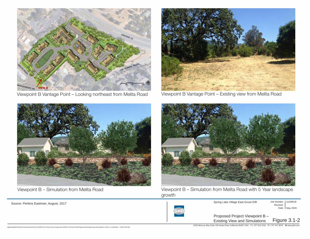
Figure 3.1-2
Spring Lake Village East Grove EIR
2235 Mercury Way Suite 150 Santa Rosa California 95407 USA T 1 707 523 1010 F 1 707 527 8679 W www.ghd.com
Proposed Project Viewpoint B – Existing View and Simulations
11109018Revision
Job Number
Date May 2020
\\ghdnet\ghd\US\Santa Rosa\Projects\111\11109018 SLV East Grove Expansion EIR\04-Technical Work\Figures\InDesign\Visual Simulations View B_2.indd May 7, 2020 9:49 AM
Source: Perkins Eastman, August, 2017
Viewpoint B Vantage Point – Looking northeast from Melita Road
Viewpoint B – Simulation from Melita Road
Viewpoint B Vantage Point – Existing view from Melita Road
Viewpoint B – Simulation from Melita Road with 5 Year landscape growth

Figure 3.1-3
Spring Lake Village East Grove EIR
2235 Mercury Way Suite 150 Santa Rosa California 95407 USA T 1 707 523 1010 F 1 707 527 8679 W www.ghd.com
Proposed Project Viewpoint C – Existing View and Simulations
11109018Revision
Job Number
Date May 2020
\\ghdnet\ghd\US\Santa Rosa\Projects\111\11109018 SLV East Grove Expansion EIR\04-Technical Work\Figures\InDesign\Visual Simulations View C_2.indd May 11, 2020 11:33 AM
Source: Perkins Eastman, August, 2017
Viewpoint C Vantage Point – Looking northeast from Melita Road
Viewpoint C – Simulation from Los Alamos Road
Viewpoint C Vantage Point – Existing view from Los Alamos Road
Viewpoint C – Simulation from Los Alamos Road with 5 Year landscape growth

Figure 3.1-4
Spring Lake Village East Grove EIR
2235 Mercury Way Suite 150 Santa Rosa California 95407 USA T 1 707 523 1010 F 1 707 527 8679 W www.ghd.com
Proposed Project Viewpoint D – Existing View and Simulations
11109018Revision
Job Number
Date May 2020
\\ghdnet\ghd\US\Santa Rosa\Projects\111\11109018 SLV East Grove Expansion EIR\04-Technical Work\Figures\InDesign\Visual Simulations View D_2.indd May 7, 2020 9:47 AM
Source: Perkins Eastman, August, 2017
Viewpoint D Vantage Point – Looking north from Los Alamos Road
Viewpoint D – Simulation from Los Alamos Road
Viewpoint D Vantage Point – Existing view from Los Alamos Road
Viewpoint D – Simulation from Los Alamos Road with 5 Year Landscape growth
Air Quality
Spring Lake Village East Grove Project Draft EIR | Page 3.2-1
3.2 Air Quality This section evaluates air quality related impacts from implementation of the Project. In addition to the analysis provided in this section, the following subjects are related to air quality, but are evaluated in other sections of this EIR:
Generation of greenhouse gas emissions, including consistency with applicable plans, policies, and regulations related to reducing emissions of greenhouse gases, is discussed in Section 3.6 (Greenhouse Gas and Energy).
3.2.1 Setting
San Francisco Bay Area Air Basin The Project site is located in Sonoma County, which is within the San Francisco Bay Area Air Basin. Ambient concentrations of air pollutants in the Project area are a product of the quantity of pollutants emitted by local sources and the atmosphere’s ability to transport and dilute such emissions. Natural factors that affect air quality and pollutant transport and dilution include terrain, wind, atmospheric stability, and the presence of sunlight.
The San Francisco Bay Area Air Basin is divided into subregions. The subregion that stretches from Santa Rosa to the San Pablo Bay is often considered as two different valleys: the Cotati Valley in the north and the Petaluma Valley in the south. The Project is located in the Cotati Valley subregion. To the east, the valley is bordered by the Sonoma Mountains, while to the west is a series of low hills, followed by the Estero Lowlands, which open to the Pacific Ocean. This low-terrain area allows marine air to travel into the Air Basin and is known as the Petaluma Gap.
Wind patterns in the Petaluma and Cotati Valleys are strongly influenced by the Petaluma Gap, with winds flowing predominantly from the west. As marine air travels through the Petaluma Gap, it splits into northward and southward paths moving into the Cotati and Petaluma Valleys. The southward path crosses San Pablo Bay and moves eastward through the Carquinez Strait. The northward path contributes to Santa Rosa's prevailing winds from the south and southeast.
When the ocean breeze is weak, strong winds from the east can predominate, carrying pollutants from the Central Valley and the Carquinez Strait. During these periods, upvalley flows can carry the polluted air as far north as Santa Rosa. The annual average wind speed in Santa Rosa is 5 mph.
Summer maximum temperatures for this subregion are in the low-to-mid-80's, while winter maximum temperatures are in the high-50's to low-60's. Summer minimum temperatures are around 50 degrees, and winter minimum temperatures are in the high 30's.
The Cotati Valley has a higher pollution potential than does the Petaluma Valley. The Cotati Valley lacks a gap to the sea, contains a larger population and has natural barriers at its northern and eastern ends. There are also industrial facilities in and around Santa Rosa. (BAAQMD 2017)
Criteria Air Pollutants and Effect The California Air Resources Board (CARB) and the U.S. Environmental Protection Agency (EPA) currently focus on the following air pollutants as indicators of ambient air quality: ozone, carbon monoxide (CO); nitrogen dioxide (NO2), sulfur dioxide (SO2); and particulate matter (PM). Because these are the most prevalent air pollutants known to be deleterious to human health and extensive health-effects criteria documents are available, they are commonly referred to as criteria air

Air Quality
Spring Lake Village East Grove Project Draft EIR | Page 3.2-2
pollutants. The Project region is in attainment for lead and sulfur dioxide, and therefore, lead and sulfur dioxide are not further discussed.
Ozone Ground-level ozone is the principal component of smog. Ozone is not directly emitted into the atmosphere, but instead forms through a photochemical reaction of reactive organic gases (ROG) and nitrogen oxides, which are known as ozone precursors. Ozone levels are highest from late spring through autumn when precursor emissions are high and meteorological conditions are warm and stagnant. Motor vehicles create the majority of ROG and nitrogen oxide emissions in the Cotati Valley sub-region. Exposure to levels of ozone above current ambient air quality standards can lead to human health effects such as lung inflammation and tissue damage and impaired lung functioning. Short-term exposure can irritate the eyes an-d cause constriction of the airways. Besides causing shortness of breath, it can aggravate existing respiratory diseases such as asthma, bronchitis, and emphysema. Chronic exposure to high ozone levels can permanently damage lung tissue. Ozone can also damage plants and trees, and materials such as rubber and fabrics (BAAQMD 2017a). The greatest risk for harmful health effects belongs to outdoor workers, athletes, children and others who spend greater amounts of time outdoors during periods of high ozone (during summer) or PM (during winter) levels (e.g., “Spare the Air” days).
Carbon Monoxide (CO) CO is a non-reactive pollutant that is toxic, invisible, and odorless. It is formed by the incomplete combustion of fuels. The largest sources of CO emissions are motor vehicles, wood stoves, and fireplaces. Unlike ozone, CO is directly emitted to the atmosphere. The highest CO concentrations occur during the nighttime and early mornings in late fall and winter. CO levels are strongly influenced by meteorological factors such as wind speed and atmospheric stability. The health threat from elevated ambient levels of CO is most serious for those who suffer from heart disease, like angina, clogged arteries, or congestive heart failure. For a person with heart disease, a single exposure to CO at relatively low levels may cause chest pain and reduce that person's ability to exercise; repeated exposures may contribute to other cardiovascular effects. High levels of CO can affect even healthy people. People who breathe high levels of CO can develop vision problems, reduced ability to work or learn, reduced manual dexterity, and difficulty performing complex tasks. At extremely high levels, CO is poisonous and can cause death.
Nitrogen Dioxide (NO2) Nitrogen dioxide is an essential ingredient in the formation of ground-level ozone pollution. NO2 is one of the nitrogen oxides emitted from high-temperature combustion processes, such as those occurring in trucks, cars, and power plants. Home heaters and gas stoves also produce NO2 in indoor settings. Besides causing adverse health effects, NO2 is responsible for the visibility reducing reddish-brown tinge seen in smoggy air in California. NO2 is a reactive, oxidizing gas capable of damaging cells lining the respiratory tract. Studies suggest that NO2 exposure can increase the risk of acute and chronic respiratory disease (BAAQMD 2017).
Sulfur Dioxide (SO2) Sulfur dioxide is a colorless gas with a strong odor. It can damage materials through acid deposition. It is produced by the combustion of sulfur-containing fuels, such as oil and coal. Refineries, chemical plants, and pulp mills are the primary industrial sources of sulfur dioxide emissions. Sulfur dioxide concentrations in the Bay Area are well below the ambient standards. Adverse health effects associated with exposure to high levels of sulfur dioxide include irritation of lung tissue, as well as increased risk of acute and chronic respiratory illness.
Air Quality
Spring Lake Village East Grove Project Draft EIR | Page 3.2-3
Particulate Matter (PM) Particulate matter is a complex mixture of tiny particles that consists of dry solid fragments, solid cores with liquid coatings, and small droplets of liquid. These particles vary greatly in shape, size, and chemical composition, and can be made up of many different materials such as metals, soot, soil, and dust. Particles 10 microns or less in diameter are defined as "respirable particulate matter" or "PM10." Fine particles are 2.5 microns or less in diameter (PM2.5) and, while also respirable, can contribute significantly to regional haze and reduction of visibility. Inhalable particulates come from smoke, dust, aerosols, and metallic oxides. Although particulates are found naturally in the air, most particulate matter found in the study area is emitted either directly or indirectly by motor vehicles, industry, construction, agricultural activities, and wind erosion of disturbed areas. Most PM2.5 is comprised of combustion products such as smoke. Extended exposure to particulate matter can increase the risk of chronic respiratory disease. PM10 is of concern because it bypasses the body’s natural filtration system more easily than larger particles and can lodge deep in the lungs. (BAAQMD 2017). PM exposure is also associated with increased risk of premature deaths, especially in the elderly and people with pre-existing cardiopulmonary disease. In children, studies have shown associations between PM exposure and reduced lung function and increased respiratory symptoms and illnesses.
Toxic Air Contaminants Toxic air contaminants (TACs) are a broad class of compounds known to cause morbidity or mortality (usually because they cause cancer or serious illness) and include, but are not limited to, the criteria air pollutants listed above. TACs are found in ambient air, especially in urban areas, and are caused by industry, agriculture, fuel combustion, and commercial operations (e.g., dry cleaners). TACs are typically found in low concentrations, even near their source (e.g., diesel particulate matter near a freeway). Because chronic exposure can result in adverse health effects, TACs are regulated at the regional, state, and federal level. The identification, regulation and monitoring of TACs is relatively new compared to that for criteria air pollutants that have established ambient air quality standards. TACs are regulated or evaluated on the basis of risk to human health rather than comparison to an ambient air quality standard or emission-based threshold.
Diesel Particulate Matter (DPM), which is a component of diesel exhaust, is the predominant TAC in urban air with the potential to cause cancer. In 1998, the results of a 10-year research program conducted by CARB demonstrated that DPM from diesel-fueled engines is a human carcinogen and that chronic (long-term) inhalation exposure to DPM poses a chronic health risk. It is estimated to represent about two-thirds of the cancer risk from TACs (based on the statewide average). According to the CARB, diesel exhaust is a complex mixture of gases, vapors, and fine particles. This complexity makes the evaluation of health effects of diesel exhaust a complex scientific issue. Some of the chemicals in diesel exhaust, such as benzene and formaldehyde, have been previously identified as TACs by the CARB, and are listed as carcinogens either under the State's Proposition 65 or under the federal Hazardous Air Pollutants program.
TACs are measured for their increased cancer risk and non-cancer risk on sensitive receptors. Sensitive receptors are locations where an identifiable subset of the general population (children, asthmatics, the elderly, and the chronically ill) that is at greater risk than the general population to the effects of air pollutants are likely to be exposed. These locations include residences, schools, playgrounds, childcare centers, retirement homes, hospitals, and medical clinics.

Air Quality
Spring Lake Village East Grove Project Draft EIR | Page 3.2-4
Existing Air Quality Conditions Table 3.2-1 (Ambient Air Quality Standards and Attainment Status), summarizes the ambient air quality standards and the attainment status of the San Francisco Bay Area Basin. The San Francisco Bay Area Air Basin is currently designated as non-attainment for the state standards for 8-hour and 1-hour ozone, 24-hour and annual PM10, and annual PM2.5, as well as for the national standards for 8-hour ozone and 24-hour PM2.5.
Table 3.2-1 Ambient Air Quality Standards and Attainment Status Pollutant Averaging
Time California Standards
California Attainment
Status
National Standards
National Attainment
Status Ozone 8-hour 0.070 ppm
(137 µg/m3) Nonattainment 0.070 ppm
(137 µg/m3) Nonattainment
1-hour 0.09 ppm (180 µg/m3)
Nonattainment None —
Carbon Monoxide 1-hour 20 ppm (23 mg/m3)
Attainment 35 ppm (40 mg/m3)
Attainment
8-hour 9.0 ppm (10 mg/m3)
Attainment 9 ppm (10 mg/m3)
Attainment
Nitrogen Dioxide 1-hour 0.18 ppm (339 µg/m3)
Attainment 0.100 ppm (188 µg/m3)
Attainment/ Unclassifiable
Annual 0.030 ppm (57 µg/m3)
— 0.053 ppm (100 µg/m3)
Attainment
Sulfur Dioxide 1-hour 0.25 ppm (655 µg/m3)
Attainment 0.075 ppm (196 µg/m3)
Attainment/ Unclassifiable
24-hour 0.04 ppm (105 µg/m3)
Attainment 0.14 ppm (365 µg/m3)
Attainment/ Unclassifiable
Annual None — 0.030 ppm (80 µg/m3)
Attainment/ Unclassifiable
Respirable Particulate Matter (PM10)
24-hour 50 µg/m3 Nonattainment 150 µg/m3 Unclassified Annual 20 µg/m3 Nonattainment None —
Fine Particulate Matter (PM2.5)
24-hour None — 35 µg/m3 Nonattainment
Annual 12 µg/m3 Nonattainment 12 µg/m3 Attainment/ Unclassified
Source: BAAQMD 2020, EPA 2012, EPA 2018 Notes:
ppm = parts per million mg/m3 = milligrams per cubic meter µg/m3 = micrograms per cubic meter
The Morris Street Sebastopol ambient air quality monitoring station is located approximately 10 miles southwest of the Project site and is the monitoring station closest to the Project site. The Sebastopol station monitors ozone, PM2.5 and NO2. The nearest ambient air quality monitoring station that monitors PM10 is the Healdsburg station, located approximately 16 miles north of the Project site. Table 3.2-2 (Ambient Air Quality Monitoring Summary) reports data from the Sebastopol and Healdsburg stations for those air pollutant levels for which the area is in nonattainment, measured over the three most recent years in which data was available (2016 to 2018).

Air Quality
Spring Lake Village East Grove Project Draft EIR | Page 3.2-5
Table 3.2-2 Ambient Air Quality Monitoring Summary
Pollutant Averaging Time Metric
Year
2016 2017 2018 Ozone1
1-Hour Max 1 Hour (ppm) 0.073 0.087 0.071 Days > CAAQS (0.09 ppm) 0 0 0
8-Hour Max 8 Hour (ppm) 0.064 0.071 0.053 Days > NAAQS (0.070 ppm) 0 1 0
Respirable Particulate Matter (PM10)
24-Hour1 Max 24 Hour (µg/m3) 43.5 161.5 278.6 Est. Days > CAAQS (50 µg/m3) * 7.4 13.5
Days > NAAQS (150 µg/m3) 0 1 2 Annual1 Annual Average (µg/m3) 13.8 17.0 17.6
Fine Particulate Matter (PM2.5)
24-Hour Max 24 Hour (µg/m3) 18.7 81.8 175.3
Days > NAAQS (35 µg/m3) 0 4 13
Annual Annual Average (µg/m3) 4.6 8.0 8.3 Source: CARB 2020
Notes: 1. State measurements * means there was insufficient D.V. = design value data available to determine the mg/m3 = milligrams per cubic meter value
3.2.2 Regulatory Framework The federal Clean Air Act of 1977 governs air quality in the U.S. In addition to being subject to federal requirements, air quality in California also is governed by more stringent regulations under the California Clean Air Act. At the federal level, the U.S. EPA administers the Clean Air Act. The California Clean Air Act is administered by the CARB and by the Air Quality Management Districts at the regional and local levels. The Bay Area Air Quality Management District (BAAQMD) regulates air quality at the regional level, which includes Sonoma County.
Federal
Federal Clean Air Act At the federal level, the U.S. EPA is responsible for enforcing the federal Clean Air Act, which establishes the National Ambient Air Quality Standards. The U.S. EPA regulates emission sources that are under the exclusive authority of the federal government, such as aircraft, ships, and certain types of locomotives. The U.S. EPA has jurisdiction over emission sources and establishes various emission standards, including those for vehicles sold in states other than California.
State and Regional
California Clean Air Act In addition to being subject to federal requirements, air quality in California also is governed by more stringent regulations under the California Clean Air Act. The California Clean Air Act is administered by the CARB and by the BAAQMD at the regional level (described below).
In California, the CARB, which is part of the California Environmental Protection Agency, is responsible for meeting the State requirements of the federal Clean Air Act, administering the California Clean Air Act, and establishing the California Ambient Air Quality Standards. The California

Air Quality
Spring Lake Village East Grove Project Draft EIR | Page 3.2-6
Clean Air Act, as amended in 1992, requires all air districts in the State to endeavor to achieve and maintain the California Ambient Air Quality Standards. The CARB regulates mobile air pollution sources, such as motor vehicles. It is responsible for setting emission standards for vehicles sold in California and for other emission sources, such as consumer products and certain off-road equipment. The CARB oversees the functions of local air pollution control districts and air quality management districts, which in turn administer air quality activities at the regional and county level.
Bay Area Air Quality Management District The BAAQMD is the regional agency responsible for air quality regulation within the San Francisco Bay Area Air Basin, regulating air quality through planning and review activities. The BAAQMD has permit authority over most types of stationary emission sources and can require stationary sources to obtain permits, impose emission limits, set fuel or material specifications, or establish operational limits to reduce air emissions. The BAAQMD’s responsibilities include operating an air quality monitoring network as well as awarding grants to reduce motor vehicle emissions, conducting public education campaigns, and many other activities.
To protect public health, BAAQMD has adopted plans to achieve ambient air quality standards. BAAQMD must continuously monitor its progress in implementing attainment plans and must periodically report to CARB and the U.S. EPA. It must also periodically revise its attainment plans to reflect new conditions and requirements.
CEQA Air Quality Guidelines
The BAAQMD publishes the CEQA Air Quality Guidelines to assist lead agencies in evaluating air quality impacts of projects and plans undergoing CEQA review in the Bay Area. The original Air Quality Guidelines were published in 1999. The CEQA Air Quality Guidelines were updated in June 2010 to include new recommended thresholds of significance (2010 Thresholds) adopted by the BAAQMD Governing Board. The BAAQMD’s Air Quality Guidelines were further updated in May 2017 to address the California Supreme Court’s 2015 opinion in California Building Industry Association vs. Bay Area Air Quality Management District, 62 Cal.4th 369. The BAAQMD’s recommended thresholds of significance are provided in Table 3.2-3.
Table 3.2-3 BAAQMD Recommended Thresholds of Significance
Pollutant Construction-Related Operational Related
ROG 54 lbs/day1 54 lbs/day1 10 tpy2 NOX 54 lbs/day1 54 lbs/day1 10 tpy2 PM10 (exhaust) 82 lbs/day1 82 lbs/day1 15 tons/year PM2.5 (exhaust) 54 lbs/day1 54 lbs/day1 10 tons/year PM10/PM2.5 (fugitive dust)
Best Management Practices
None
Local CO None 9.0 ppm (8-hour average), 20.0 ppm (1-hour average)

Air Quality
Spring Lake Village East Grove Project Draft EIR | Page 3.2-7
Pollutant Construction-Related Operational Related
Risk and Hazards for New Sources and Receptors (individual project)
Same as Operational Thresholds2
Compliance with Qualified Community Risk Reduction Plan OR Increased cancer risk of >10.0 in a million Increased non-cancer risk of > 1.0 Hazard Index (Chronic or Acute) Ambient PM2.5 increase: > 0.3 μg/m3 annual average Zone of Influence: 1,000-foot radius from property line of source or receptor
Risk and Hazards for New Sources and Receptors (cumulative)
Same as Operational Thresholds3
Compliance with Qualified Community Risk Reduction Plan OR Cancer: > 100 in a million (from all local sources) Non-cancer: > 10.0 Hazard Index (from all local sources) (Chronic) PM2.5: > 0.8 μg/m3 annual average (from all local sources) Zone of Influence: 1,000-foot radius from property line of source or receptor
Odors None 5 confirmed complaints per year averaged over three years
Source: BAAQMD 2017a Notes 1. Average daily emissions threshold. 2. The BAAQMD recommends that for construction projects that are less than one-year duration, Lead
Agencies should annualize impacts over the scope of actual days that peak impacts are to occur, rather than the full year.
The Best Management Practices (BMPs) used as the BAAQMD’s performance-measure threshold of significance for construction-generated dust are contained in the Air Quality Guidelines and are listed below for reference:
All exposed surfaces (e.g., parking areas, staging areas, soil piles, graded areas and unpaved access roads) shall be watered two times per day;
All haul trucks transporting soil, sand, or other loose material off-site shall be covered;
All visible mud or dirt tracked-out onto adjacent public roads shall be removed using wet power vacuum street sweepers at least once per day. The use of dry power sweeping shall be prohibited;
All vehicle speeds on unpaved areas shall be limited to 15 miles per hour.
All paving shall be completed as soon as possible after trenching work is finished;
Idling times shall be minimized either by shutting equipment off when not in use or reducing the maximum idling time to five minutes (as required by the California airborne toxics control measure

Air Quality
Spring Lake Village East Grove Project Draft EIR | Page 3.2-8
Title 13, Section 2485 of California Code of Regulations). Clear signage shall be provided for construction workers at all access points;
All construction equipment shall be maintained and properly tuned in accordance with manufacturer’s specifications. All equipment shall be checked by a certified mechanic and determined to be running in proper condition prior to operation;
A publicly visible sign shall be posted with the telephone number and person to contact at the Town regarding dust complaints. This person shall respond and take corrective action within 48 hours. The BAAQMD’s phone number shall also be visible to ensure compliance with applicable regulations.
2017 Clean Air Plan: Spare the Air-Cool the Climate
In April 2017, BAAQMD adopted the 2017 Clean Air Plan, Spare the Air-Cool the Climate (2017 Plan) (BAAQMD 2017c). The 2017 Plan focuses on two closely related goals: protecting public health and protecting the climate. The 2017 Plan is a multi-pollutant air quality plan addressing four categories of air pollutants:
Ground-level ozone and the key ozone precursor pollutants (reactive organic gases and NOX), as required by State law;
Particulate matter, primarily PM2.5, as well as the precursors to secondary PM2.5;
Toxic air contaminants; and
Greenhouse gases.
For air quality, the 2017 Plan updates the most recent Bay Area ozone plan, the 2010 Clean Air Plan. In addition, the 2017 Plan builds upon and enhances the BAAQMD’s efforts to reduce emissions of PM2.5 and TACs. The 2017 Plan contains 85 individual control measures in nine economic sectors: stationary (industrial) sources, transportation, energy, buildings, agriculture, natural and working lands, waste management, water, and super-GHG pollutants.
These control strategy measures are primarily policy-level and would be implemented by BAAQMD, the Metropolitan Transportation Commission, and the Association of Bay Area Governments (examples: establishing new emission limits on stationary sources, requiring new control measures on industrial facilities, implementing public education programs, promoting trip reduction programs, etc.).
Regional and Local
City of Santa Rosa General Plan The following are the goals and policies from the City of Santa Rosa General Plan 2035 that are applicable to the Project.
Goal OSC-J Take appropriate actions to help Santa Rosa and the larger Bay Area region achieve and maintain all ambient air quality standards.
Policy OSC-J-1 Review all new construction projects and require dust abatement actions as contained in the CEQA Handbook of the Bay Area Air Quality Management District.

Air Quality
Spring Lake Village East Grove Project Draft EIR | Page 3.2-9
3.2.3 Evaluation Criteria and Significance Thresholds For the purpose of this EIR, the evaluation criteria and significance thresholds summarized in Table 3.2-4 (Evaluation Criteria and Significance Thresholds) are used to determine if the Project would have a significant effect related to air quality.
Table 3.2-4 Evaluation Criteria and Significance Thresholds
Evaluation Criteria Significance Thresholds Sources
AQ:1 Would the project conflict with or obstruct implementation of the applicable air quality plan?
Conflict with Bay Area 2017 Clean Air Plan
CEQA Guidelines Appendix G, Checklist Item III (a) Bay Area 2017 Clean Air Plan
AQ-2: Would the project result in a cumulatively considerable net increase in any criteria pollutant for which the project region is non-attainment under an applicable federal or state ambient air quality standard?
Exceed BAAQMD CEQA thresholds of significance for criteria air pollutants, precursors, and carbon monoxide Non-compliance with BAAQMD recommended dust abatement actions
CEQA Guidelines Appendix G, Checklist Item III (b) BAAQMD 2017 CEQA Guidelines, Tables 2-1, 3-1, and 8-2, Sections 3.3 and 4.1 General Plan goal OSC-J and policy OSC-J-1
AQ-3: Would the project expose sensitive receptors to substantial pollutant concentrations?
Exceed BAAQMD CEQA individual project thresholds of significance for risks and hazards for new sources and receptors
CEQA Guidelines Appendix G, Checklist Item III (c) BAAQMD 2017 CEQA Guidelines, Table 2-1, Section 5
AQ-4: Would the project result in other emissions (such as those leading to odors) adversely affecting a substantial number of people?
Creation of a new odor source near existing sensitive receptors
CEQA Guidelines Appendix G, Checklist Item III (d) 2017 BAAQMD CEQA Air Quality Guidelines, Tables 2-1, 3-3. Section 7.1
3.2.4 Approach to Analysis
Use of BAAQMD Thresholds The air quality analysis in this EIR utilizes the thresholds of significance, screening criteria and levels, and impact assessment methodologies presented in the BAAQMD CEQA Air Quality Guidelines (BAAQMD 2017a).
The BAAQMD developed screening criteria and screening levels to provide lead agencies and project applicants with a conservative indication of whether a project could result in potentially significant air quality impacts. Screening criteria and screening levels are provided for the following air pollutant impact categories:
Operational criteria air pollutants and precursors
Operational community risk and hazard impacts
Carbon monoxide impacts
Construction-generated criteria air pollutants and precursors
Construction-related community risk and hazard impacts
Air Quality
Spring Lake Village East Grove Project Draft EIR | Page 3.2-10
As provided by the BAAQMD’s CEQA Air Quality Guidelines (BAAQMD 2017a), if the proposed Project meets the screening criteria for an impact category, and is consistent with the methodology used to develop the screening criteria, then its air quality impact for that category may be considered less than significant.
Modeling A construction community risk assessment was prepared for the Project (Illingworth & Rodkin 2020, Appendix B). The assessment focused on modeling on-site construction activity using construction fleet information estimated for the Project. Construction period emissions were modeled using the California Emissions Estimator Model, Version 2016.3.2 (CalEEMod) along with projected construction activity. CalEEMod provided total annual exhaust emissions (all of which was conservatively assumed to be diesel particulate matter) for the off-road construction equipment and for exhaust emissions from on-road vehicles (haul trucks, vendor trucks, and worker vehicles). A trip length of 1 mile was used to represent vehicle travel while at or near the construction site. It was assumed that these emissions from on-road vehicles traveling at or near the site would occur at the construction site.
The U.S. AMS/EPA Regulatory Model (AERMOD) dispersion model was used to calculate concentrations of diesel particulate matter and PM2.5 at existing sensitive receptors (residences) in the vicinity of the Project site. The AERMOD dispersion model is a BAAQMD-recommended model for use in modeling analysis of these types of emission activities for CEQA projects. Emissions from vehicle travel around the Project site were included in the modelled area sources. Construction emissions were modelled as occurring daily between 8 a.m. and 5 p.m.
Increased cancer risks were calculated using the modeled concentrations and BAAQMD-recommended risk assessment methods for infant exposure (third trimester through two years of age), child exposure, and for an adult exposure. The cancer risk calculations were based on applying the BAAQMD recommended age sensitivity factors to the diesel particulate matter exposures. Age-sensitivity factors reflect the greater sensitivity of infants and small children to cancer-causing TACs. Due to the relatively short, anticipated duration of Project construction activities (about one and a half years), infant exposures were assumed in calculating cancer risks for residential exposures. Because an infant (0 to 2 years of age) has a breathing rate that is greater than the breathing rate for the 3rd trimester, the contribution to total cancer risk from an infant exposure is greater than if the initial exposure assumed for the 3rd trimester is assumed. It was conservatively assumed that an infant exposure to construction emissions would occur over the entire construction period. Infant, child, and adult exposures were assumed to occur at all residences during the entire construction period.
Potential non-cancer health effects due to chronic exposure to diesel particulate matter were also evaluated. Non-cancer health hazards from TAC exposure are expressed in terms of a hazard index (HI), which is the ratio of the TAC concentration to a reference exposure level (REL). California’s Office of Environmental Health and Hazards (OEHHA) has defined acceptable concentration levels for contaminants that pose non-cancer health hazards. TAC concentrations below the REL are not expected to cause adverse health impacts, even for sensitive individuals.

Air Quality
Spring Lake Village East Grove Project Draft EIR | Page 3.2-11
3.2.5 Impacts and Mitigation Measures Table 3.2-5 (Summary of Impacts – Air Quality) provides a summary of potential impacts from the Project.
Table 3.2-5 Summary of Impacts – Air Quality
Evaluation Criteria Project Impact
AQ-1: Would the project conflict with or obstruct implementation of the applicable air quality plan?
NI
AQ-2: Would the project result in a cumulatively considerable net increase in any criteria pollutant for which the project region is non-attainment under an applicable federal or state ambient air quality standard?
LS
AQ-3: Would the project expose sensitive receptors to substantial pollutant concentrations?
LS
AQ-4: Would the project result in other emissions (such as those leading to odors) adversely affecting a substantial number of people?
LS
C-AQ-1: Would the project result in a cumulatively considerable contribution to cumulative impacts related to air quality?
LS
Notes: NI = No Impact LS = Less than Significant
Impact AQ-1: Would the project conflict with or obstruct implementation of the applicable air quality plan?
Analysis: No Impact
Per the BAAQMD Air Quality CEQA Guidelines, the BAAQMD considers a project consistent with the 2017 Clean Air Plan if it:
1. Can be concluded that a project supports the primary goals of the Plan (by showing that the project would not result in significant and unavoidable air quality impacts);
2. Includes applicable control measures from the Plan, and;
3. Does not disrupt or hinder implementation of any Plan control measure. An evaluation of each of these three criteria is provided below.
The primary goals of the 2017 Clean Air Plan are to protect air quality, public health, and the climate. As shown in Impacts AQ-2, AQ-3, and AQ-C-1, the Project would not create a localized violation of State or federal air quality standards, significantly contribute to cumulative nonattainment pollutant violations, or expose sensitive receptors to substantial pollutant concentrations. Therefore, the proposed Project would not conflict with the primary goals of the Clean Air Plan. The 2017 Plan includes 85 control measures in nine economic sectors: 1) stationary sources; 2) transportation (mobile) sources; 3) energy; 4) buildings; 5) agriculture; 6) natural and working lands; 7) waste management; 8) water; and 9) super-GHG pollutants. The control measures are not directly applicable to the proposed Project, and the Project would not disrupt or hinder implementation of any control measure. Therefore, the Project would not conflict with or obstruct implementation of the Clean Air Plan. No impact would result.

Air Quality
Spring Lake Village East Grove Project Draft EIR | Page 3.2-12
Mitigation: No mitigation is needed.
Impact AQ-2: Would the project result in a cumulatively considerable net increase in any criteria pollutant for which the project region is non-attainment under an applicable federal or state ambient air quality standard?
Analysis: Less than Significant
Potential violations of an air quality standard (State or federal standards) include the potential to emit fugitive dust (PM10/PM2.5) during earth-disturbing construction activities, and CO emissions during Project operation. Operational CO hotspots (localized violations of the State or federal CO standard) are related to increases in on-road vehicle congestion. These potential impacts are localized in nature, occurring near the emissions source.
In addition, non-attainment pollutants of concern for the Air Basin are PM10, PM2.5, and ozone. This pollution is largely a cumulative impact, in that individual projects are rarely sufficient in size to result in nonattainment of State or federal standards. Instead, a project‘s individual emissions may contribute to existing cumulatively significant adverse air quality impacts. In developing thresholds of significance for air pollutants, BAAQMD considered the emission levels for which a project‘s individual emissions would be cumulatively considerable. If a project exceeds the identified significance thresholds, its emissions are considered to be cumulatively considerable, resulting in significant adverse air quality impacts to the region‘s existing air quality conditions (BAAQMD 2017a).
Construction
Construction activities would include demolition of existing residential structures, grading, building construction, and paving. Generally, the most substantial air pollutant emissions during construction would be dust generated from site grading. The BAAQMD has identified fugitive dust from construction activities as a source of localized PM10/PM2.5. If uncontrolled, these emissions could lead to both health and nuisance impacts.
BAAQMD does not recommend a numerical threshold for fugitive dust from project construction. Instead, BAAQMD bases the determination of significance for fugitive dust on a consideration of the control measures to be implemented. If the basic construction measures recommended by BAAQMD are implemented for a project, then fugitive dust emissions during construction are not considered significant. City of Santa Rosa General Plan policy OSC-J-1 requires implementation of the BAAQMD-recommended dust abatement actions in new development projects. As described in Section 2.5 of the Project Description (Environmental Protection Actions Incorporated into the Proposed Project), Environmental Protection Action 2 would require provisions in contractor agreements for implementing the BAAQMD basic dust abatement actions. Therefore, the proposed Project would comply with General Plan policy OSC-J-1 and would meet the BAAQMD’s construction-related threshold for fugitive dust (PM10 and PM2.5). The potential impact to air quality is considered less than significant.
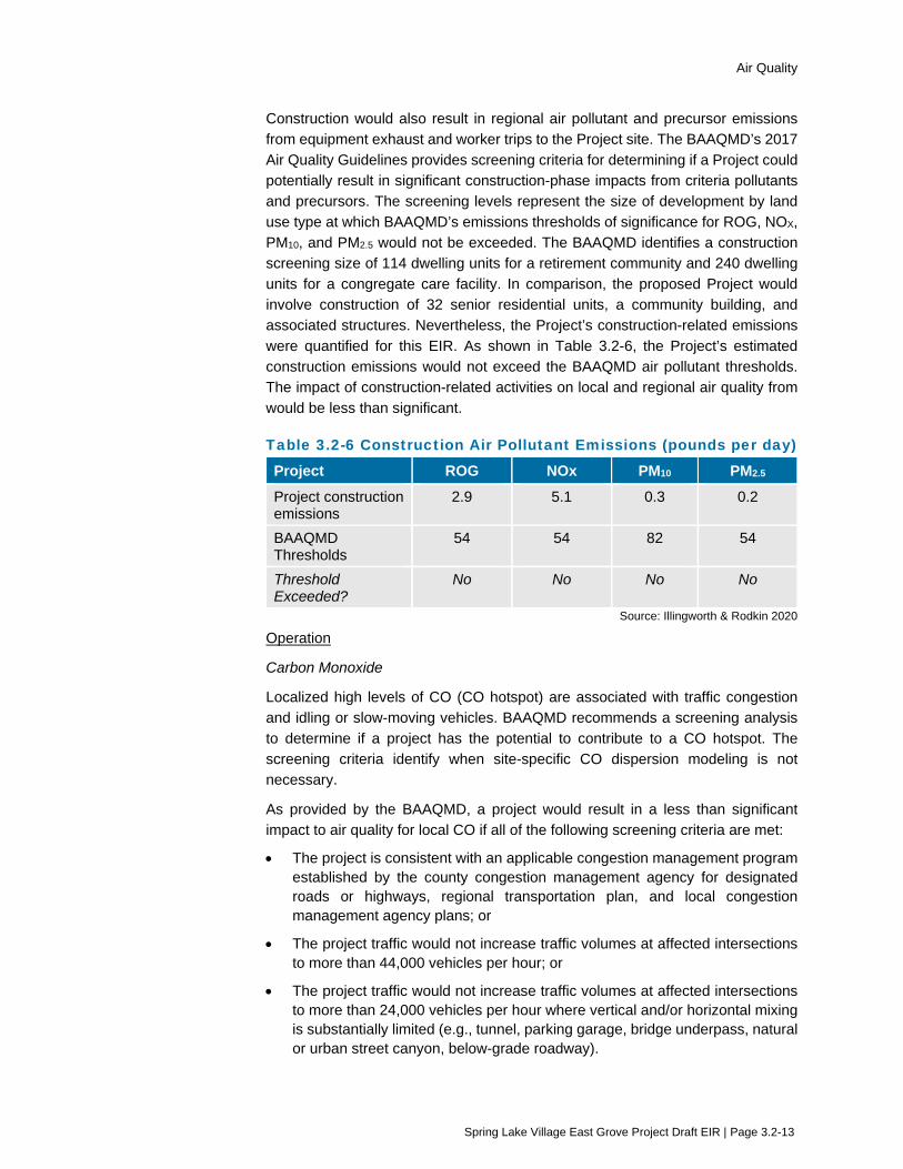
Air Quality
Spring Lake Village East Grove Project Draft EIR | Page 3.2-13
Construction would also result in regional air pollutant and precursor emissions from equipment exhaust and worker trips to the Project site. The BAAQMD’s 2017 Air Quality Guidelines provides screening criteria for determining if a Project could potentially result in significant construction-phase impacts from criteria pollutants and precursors. The screening levels represent the size of development by land use type at which BAAQMD’s emissions thresholds of significance for ROG, NOX, PM10, and PM2.5 would not be exceeded. The BAAQMD identifies a construction screening size of 114 dwelling units for a retirement community and 240 dwelling units for a congregate care facility. In comparison, the proposed Project would involve construction of 32 senior residential units, a community building, and associated structures. Nevertheless, the Project’s construction-related emissions were quantified for this EIR. As shown in Table 3.2-6, the Project’s estimated construction emissions would not exceed the BAAQMD air pollutant thresholds. The impact of construction-related activities on local and regional air quality from would be less than significant.
Table 3.2-6 Construction Air Pollutant Emissions (pounds per day)
Project ROG NOx PM10 PM2.5 Project construction emissions
2.9 5.1 0.3 0.2
BAAQMD Thresholds
54 54 82 54
Threshold Exceeded?
No No No No
Source: Illingworth & Rodkin 2020
Operation
Carbon Monoxide
Localized high levels of CO (CO hotspot) are associated with traffic congestion and idling or slow-moving vehicles. BAAQMD recommends a screening analysis to determine if a project has the potential to contribute to a CO hotspot. The screening criteria identify when site-specific CO dispersion modeling is not necessary.
As provided by the BAAQMD, a project would result in a less than significant impact to air quality for local CO if all of the following screening criteria are met:
• The project is consistent with an applicable congestion management program established by the county congestion management agency for designated roads or highways, regional transportation plan, and local congestion management agency plans; or
• The project traffic would not increase traffic volumes at affected intersections to more than 44,000 vehicles per hour; or
• The project traffic would not increase traffic volumes at affected intersections to more than 24,000 vehicles per hour where vertical and/or horizontal mixing is substantially limited (e.g., tunnel, parking garage, bridge underpass, natural or urban street canyon, below-grade roadway).
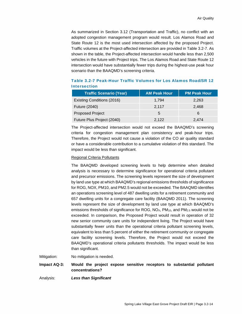
Air Quality
Spring Lake Village East Grove Project Draft EIR | Page 3.2-14
As summarized in Section 3.12 (Transportation and Traffic), no conflict with an adopted congestion management program would result. Los Alamos Road and State Route 12 is the most used intersection affected by the proposed Project. Traffic volumes at the Project-affected intersection are provided in Table 3.2-7. As shown in the table, the Project-affected intersection would handle less than 2,500 vehicles in the future with Project trips. The Los Alamos Road and State Route 12 intersection would have substantially fewer trips during the highest-use peak hour scenario than the BAAQMD’s screening criteria.
Table 3.2-7 Peak-Hour Traffic Volumes for Los Alamos Road/SR 12 Intersection
Traffic Scenario (Year) AM Peak Hour PM Peak Hour Existing Conditions (2016) 1,794 2,263 Future (2040) 2,117 2,468 Proposed Project 5 6 Future Plus Project (2040) 2,122 2,474
The Project-affected intersection would not exceed the BAAQMD’s screening criteria for congestion management plan consistency and peak-hour trips. Therefore, the Project would not cause a violation of the CO air quality standard or have a considerable contribution to a cumulative violation of this standard. The impact would be less than significant.
Regional Criteria Pollutants
The BAAQMD developed screening levels to help determine when detailed analysis is necessary to determine significance for operational criteria pollutant and precursor emissions. The screening levels represent the size of development by land use type at which BAAQMD’s regional emissions thresholds of significance for ROG, NOX, PM10, and PM2.5 would not be exceeded. The BAAQMD identifies an operations screening level of 487 dwelling units for a retirement community and 657 dwelling units for a congregate care facility (BAAQMD 2011). The screening levels represent the size of development by land use type at which BAAQMD’s emissions thresholds of significance for ROG, NOX, PM10, and PM2.5 would not be exceeded. In comparison, the Proposed Project would result in operation of 32 new senior community care units for independent living. The Project would have substantially fewer units than the operational criteria pollutant screening levels, equivalent to less than 5 percent of either the retirement community or congregate care facility screening levels. Therefore, the Project would not exceed the BAAQMD’s operational criteria pollutants thresholds. The impact would be less than significant.
Mitigation: No mitigation is needed.
Impact AQ-3: Would the project expose sensitive receptors to substantial pollutant concentrations?
Analysis: Less than Significant

Air Quality
Spring Lake Village East Grove Project Draft EIR | Page 3.2-15
Sensitive receptors are defined by the BAAQMD as facilities or land uses that include members of the population that are particularly sensitive to the effects of air pollutants, such as children, the elderly, and people with illnesses. The BAAQMD’s 2017 Air Quality Guidelines recommend assessing community risk and hazards within a 1,000-foot-radius ‘zone of influence’ from the property line of the emission source.
Construction
The two emissions of concern for construction-generated health impacts are DPM and PM2.5. Construction equipment and associated heavy-duty truck traffic generate diesel exhaust, which is a known toxic air contaminant. Diesel exhaust and PM2.5 pose both potential health and nuisance impacts to nearby receptors.
A construction health risk assessment of anticipated Project construction activities was conducted to evaluate potential health effects of sensitive receptors at nearby residences from construction emissions. A copy of the risk assessment is included in Appendix B, Air Quality Assessment.
The number and types of construction equipment and diesel vehicles, along with the anticipated length of their use for different phases of construction were based on site-specific construction activity schedules for the Project. The receptor with the highest modeled risk is considered the maximally exposed individual (MEI). The dispersion modeling indicated that the maximum-modeled diesel particulate matter and PM2.5 concentrations from construction of the Project occurred at the first floor level of a single family residence located to the northwest of the Project site north of Highway 12. Detailed unmitigated risks are provided in Table 3.2-8 with operational risks.
As shown within Table 3.2-8, cancer risk and annual PM2.5 concentrations caused by Project construction activities would not exceed the single-source significance threshold at the offsite residence with the maximum impact, or MEI. Therefore, the impact from construction would be considered less-than-significant.
Operation
As shown within Table 3.2-8, the emissions associated with routine testing and maintenance of a diesel engine standby emergency generator would not exceed the single-source significance threshold at the offsite residence with the maximum impact, assumed to be 200 feet or further away (sensitive receptor exposure). Similarly, the combined construction and emergency generator emissions would not exceed the applicable significance threshold. The impact would be less than significant.
Risks to Onsite Receptors
Per California Building Industry Assn. v. Bay Area Air Quality Management Dist. (2015) 62 Cal.4th 369, 387, CEQA focuses on how projects affect the environment, and does not include requirements to analyze how existing hazards or conditions impact a project’s users or residents. Therefore, the following review of potential health risks to the Project’s residents, or onsite receptors, is provided for informational purposes only.

Air Quality
Spring Lake Village East Grove Project Draft EIR | Page 3.2-16
The Project would introduce new sensitive receptors in the area in the form of future residences. In order to identify potential community health risks when siting a new sensitive receptor, the BAAQMD recommends using a 1,000-foot screening radius around a project site and evaluating risks from highways, major roadways, and stationary sources. The air quality assessment performed for the Project included an evaluation of such operational community risks to onsite receptors. Potential sources of emissions with a community health risk include Project related traffic on major roadways and operational maintenance of the proposed emergency generator.
The Project would be located adjacent to Highway 12, which meets the BAAQMD’s major roadway criteria of 10,000 vehicles or 1,000 trucks per day. Other local roadways in the Project vicinity, including Los Alamos Road, Melita Road, and Montgomery Drive do not meet the BAAQMD’s major roadway criteria. The proposed Project would also both include an emergency generator onsite. No other on-site or off-site stationary sources were identified within a 1,000-foot study area. The proposed emergency generator would only operate for testing and maintenance purposes and to generate electricity in the event of a power outage. The maximum risk to an onsite resident would not exceed the maximum risk to an offsite receptor and would be considered less-than-significant.
Risks to Offsite Receptors
Table 3.2-8 identifies the cancer risk, chronic hazard index, and annual PM2.5 concentration from Highway 12 at the maximally affected offsite residential dwelling, as well as Project and cumulative health risks associated with Project implementation (construction and stationary sources). The screening cancer risk levels were adjusted using a factor of 1.3744 to account for the new OEHHA guidance (detailed calculations are included in Appendix B, Air Quality Assessment). As shown in Table 3.2-8, community health risks to offsite receptors from Highway 12 and Project sources would be below the BAAQMD CEQA thresholds, therefore the impact would be less than significant.
Table 3.2-8 Health Risk to Sensitive Offsite Receptors
Source of Pollutants Cancer Risk (per million)
Annual PM2.5
(µg/m3)
Acute or Chronic
Hazard Index
Project Sources Unmitigated Project Construction (Years 0-2)
7.2 (infant) 0.04 <0.01
Emergency Generator (years 3 through 30)
0.2 <0.01 <0.01
Combined Construction & Generator
7.4 0.04 0.01
BAAQMD Single Source Threshold >10.0 >0.3 >1.0 Threshold Exceeded? No No No

Air Quality
Spring Lake Village East Grove Project Draft EIR | Page 3.2-17
Source of Pollutants Cancer Risk (per million)
Annual PM2.5
(µg/m3)
Acute or Chronic
Hazard Index
Cumulative Sources Highway 12, Link 611 (6ft elevation) at 50 feet north (Highway Screening Analysis Tool)
15.3 0.14 <0.02
Cumulative (Project plus nearby sources)
22.7 0.18 <0.03
BAAQMD Single Source Threshold 100 0.80 10.0 Threshold Exceeded? No No No
Source: Illingworth & Rodkin 2020
Mitigation: No mitigation is needed.
Impact AQ-4: Would the project result in other emissions (such as those leading to odors) adversely affecting a substantial number of people?
Analysis: Less than Significant
Implementation of the Project would not result in major sources of odor. The project type is not one of the common types of facilities known to produce odors (i.e., landfill, coffee roaster, wastewater treatment facility, etc.). Minor odors from the use of equipment during construction activities would be intermittent and temporary and would dissipate rapidly from the source with an increase in distance. Thus, the Project would not create objectionable odors affecting a substantial number of people. The impact would be less than significant.
Mitigation: No mitigation is needed.
Impact C-AQ-1: Would the project result in a cumulatively considerable contribution to cumulative impacts related to air quality?
Analysis: Less than Cumulatively Considerable (Less than Significant)
The geographic scope for assessing cumulative relative to air quality is the San Francisco Air Basin.
By its nature, air pollution is largely a cumulative impact, in that individual projects are rarely sufficient in size to result in nonattainment of ambient air quality standards. Instead, a project’s individual emissions may contribute to cumulative adverse air quality impacts. In developing regional thresholds of significance for criteria and precursor air pollutants, BAAQMD considered the emission levels for which a project’s individual emissions would be cumulatively considerable. If a project exceeds the identified regional significance thresholds, its emissions would be cumulatively considerable, resulting in significant adverse air quality impacts to the region’s existing air quality conditions (BAAQMD 2017a). Similarly, the CO threshold (the 1-hour and 8-hour state ambient air quality standards) and screening criteria take into account background ambient concentrations and total
Air Quality
Spring Lake Village East Grove Project Draft EIR | Page 3.2-18
intersection volumes, respectively. As such, the threshold and screening criteria are cumulative in nature. Finally, consistency with an attainment plan is a cumulative analysis, as it analyzes a project in regards to an adopted plan that is based on growth projections for the region. Therefore, no additional cumulative impacts analysis is required.
The project-level analysis shows that the Project would not conflict with or obstruct implementation of the applicable air quality plan, would not result in a cumulatively considerable net increase in a criteria pollutant for which the area is non-attainment, would not expose sensitive receptors to substantial pollutant concentrations, and would not create objectionable odors. The project-level analysis above also would constitute the cumulative impact analysis, and no additional cumulative impacts analysis is required. Therefore, the Project’s contribution to the cumulative impact related to air quality would not be cumulatively considerable.
Mitigation: No mitigation is needed.
3.2.6 References Bay Area Air Quality Management District (BAAQMD). 2017a. California Environmental Quality Act
Air Quality Guidelines. May.
BAAQMD. 2017b. Final 20107 Clean Air Plan: Spare the Air-Cool the Climate. April 19.
BAAQMD. 2020. Air Quality Standards and Attainment Status. Website Accessed April 9, 2020 at: http://www.baaqmd.gov/research-and-data/air-quality-standards-and-attainment-status
City of Santa Rosa. 2009. Santa Rosa General Plan 2035. November 3.
California Air Resources Board (CARB). 2020. iADAM: Air Quality Data Statistics, Trends Summaries. Website accessed on April 14, 2020at: https://www.arb.ca.gov/adam/topfour/topfour1.pp
Environmental Protection Agency (EPA). 2012. Federal Register, Vol. 77, No. 33, Rules and Regulations 9533. RIN–2060–AR06 Air Quality Designations for the 2010 Primary Nitrogen Dioxide (NO2) National Ambient Air Quality Standards. February 17.
EPA. 2018. Federal Register, Vol. 83, No. 6. Rules and Regulations 1099. EPA–HQ–OAR–2017–0003; FRL–9972–73–OAR Air Quality Designations for the 2010 Sulfur Dioxide (SO2) Primary National Ambient Air Quality Standard—Round 3. January 9.
Illingworth and Rodkin. 2020, Spring Lake Village Expansion Project Air Quality Assessment. Revised February 5.

Biological Resources
Spring Lake Village East Grove Project Draft EIR | Page 3.3-1
3.3 Biological Resources This section evaluates biological resource related impacts associated with construction and operation of the Project. In addition to the analysis provided in this section, the following subjects are related to biological resources, but are evaluated in other sections of this EIR:
Consideration of the aesthetic impact of tree removals is evaluated in Section 3.1 (Aesthetics).
Consideration of water quality impacts are addressed in Section 3.8 (Hydrology and Water Quality).
3.3.1 Setting
Regional Setting The Project site is located in the eastern portion of the City of Santa Rosa within Sonoma County, California. Biological resources within the City of Santa Rosa include sensitive aquatic and terrestrial plants, animals, and habitat. These resources can be roughly divided between those found on the Santa Rosa Plain and those located in the uplands to the east, with connections formed by creeks.
The Project area is situated near the foothills of the Sonoma Mountains and adjacent to Santa Rosa Creek. The City of Santa Rosa is bisected by the creek, which originates in the foothills of the Sonoma Mountains, and runs from east to west through the City, across the Santa Rosa Plain, and into the Laguna de Santa Rosa. Santa Rosa Creek and other creeks flowing through the city provide instream and riparian habitat that supports a distinct community of plants and animals and provides migration corridors that allow other wildlife to travel between suitable habitats that are otherwise separated by development.
Habitat within the City has predominantly been developed with a mix of residential, commercial, industrial, recreational, and agricultural uses. Developed areas have encroached on native vegetation, but numerous natural areas still remain within the city, including grasslands, woodlands, riparian areas, and vernal pools.
Local Setting Habitat within the Project area consists predominantly of annual grassland and coast live oak woodland, along with an area of seasonal wetland. The grassland and woodland understory are periodically mowed based on observations made during site visits. Santa Rosa Creek is located approximately 150 feet off-site southwest of Melita Road. The area in which off-site improvements would occur southwest of Melita Road is characterized as ruderal (oat and non-native blackberry), and is not characterized as riparian habitat associated with Santa Rosa Creek. Habitat surrounding the Project area includes urban areas related to residential development, the Santa Rosa Creek riparian corridor, and oak woodlands associated with Annadel State Park situated to the southwest.
Biological Communities Habitat occurring within the Project area includes annual grassland, seasonal wetland, coast live oak woodland, and ruderal, as described in detail below. Critical habitat and sensitive natural communities, including wetlands, known in the vicinity of the Project area are further described following the general communities. This information provides the basis for evaluating the potential for occurrence of special-status species within the Project area.

Biological Resources
Spring Lake Village East Grove Project Draft EIR | Page 3.3-2
Annual Grassland In California, annual grassland generally occurs on flat plains to gently rolling foothills throughout the Central Valley, in the coastal mountain ranges to Mendocino County, and in scattered locations in the south portion of the state. Dominant species generally found within this habitat include introduced grasses such as, brome (Bromus sp.), soft chess (Bromus mollis), and wild oat (Avena fatua). Common forbs associated with annual grassland include clover (Medicago sp.), filaree (Erodium sp.), and turkey mullein (Eremocarpus setigerus) (Mayer and Laudenslayer 1988).
The structure of this habitat varies from year to year based largely on precipitation, season, and presence of livestock. Annual plant seeds are germinated by rain in the fall months. Following these rains, plants grow slowly throughout the winter remaining relatively small until the spring when rising temperature stimulates rapid growth. Most annuals mature between April and June, although some species, such as tarweed (Madia sativa) and turkey mullein, continue to grow into the summer. Grazing by livestock typically supports a greater abundance of shorter grass (less than 12 inches tall), such as filaree and turkey mullein. Without the presence of livestock or mowing, annual grassland generally grows tall (greater than 12 inches) and dense with species such as ripgut brome (Bromus rigidus) and wild oat.
Annual grassland supports many wildlife species by providing suitable areas for foraging, nesting, and cover. Seasonal wetlands may also form within this habitat as low depression areas can retain water depending on local soils and hydrology.
Annual grassland at the Project site consists mostly of ruderal annual grassland, which is periodically mowed. Principal dominant species include: slender wild oat (Avena barbata), wild oat (Avena fatua), soft chess (Bromus hordeaceus), and Italian rye grass (Festuca perennis [=Lolium multiflorum, L. perenne]). Less common, but locally abundant, grasses include ripgut grass (Bromus diandrus), Mediterranean barley (Hordeum marinum ssp. gussoneanum), and the perennial species Harding grass (Phalaris aquatic). A variety of herbaceous associates also occur within the grassland. The herb species are mainly non-native, but a few native species are locally abundant, including miniature lupine (Lupinus bicolor), coast tarweed (Madia sativa), and Spanish-clover (Acmispon americanus var. americanus [= Lotus purshianus]) (Macmillan 2020).
Scattered trees and shrubs occur throughout the grassland within the Project site but represent less than 50 percent cover. Tree species include native coast live oak (Quercus agrifolia), valley oak (Quercus lobata), and Oregon oak (Quercus garryana), as well as non-native English walnut (Juglans regia) and ornamentals. Shrubs are widely scattered, but not abundant, with a few localized dense patches throughout the area. Shrub species include coyote brush (Baccharis pilularis ssp. consanguinea), rock grape (Vitis rupestris), and Hmalayan blackberry (Rubus armeniacus) (Macmillan 2020).
Annual grassland is typically not considered a sensitive resource by regulatory authorities.
Seasonal Wetland A seasonal wetland occurs in an approximate 0.096 acre slight depression near the northwest corner of the Project site. This area is occupied by distinct vegetation likely supported by a short duration of standing water. The dominant species is tall flatsedge (Cyperus eragrostris) with secondary species of soft chess, bur clover (Medicago polymorpha), common vetch (Vicia sativa ssp. sativa), brome fescue (Festuca [Vulpia] bromoides), and small quaking grass (Briza minor) (Macmillan 2020).

Biological Resources
Spring Lake Village East Grove Project Draft EIR | Page 3.3-3
Coast Live Oak Woodland Coast live oak woodland is present along the northwest and northeast border of the Project site, as well as along the southern boundary of the site. This habitat type corresponds to a phase of the Quercus agrifolia (coast live oak woodland) alliance (Sawyer 2009, CDFW 2010a & b, Klein 2015); to the coast live oak forest and woodland alliance (CDFW 2003), and to the coast live oak woodland habitat type (Holland 1986). In the classification scheme of CDFW, it is best referred to the Quercus agrifolia / grass association within the coast live oak woodland alliance. In the classification scheme of CNPS, this habitat type corresponds to a phase of the cismontane woodland habitat type. This alliance and the associations within it have state ranking S4, which corresponds to apparently secure natural communities and, thus, are not considered Sensitive Communities by the CDFW ranking system.
The coast live oak woodland on the site consists of individual trees or small closed-canopy stands of trees interspersed with open areas. Coast live oak is the most abundant tree species. Other trees present include the native valley oak and Oregon oak and non-native species including silver wattle (Acacia dealbata), northern California black walnut (Juglans hindsii, native elsewhere in northern California but not in the survey area), blue gum (Eucalyptus globulus), and others that were not identifiable. The understory at the Project site includes the annual grassland described above with the addition of French broom (Genista monspessulana), Spanish broom (Spartium junceum), poison oak (Toxicodendron diversilobum), and Aaron’s beard (Hypericum calycinum). Various herb species are also present in the understory with Robert geranium (Geranium robertianum) being the most abundant and widespread (Macmillan 2020).
Ruderal Ruderal habitat refers to any area with heavy and ongoing human disturbance. This habitat generally has a reduced value to wildlife when compared to other habitats, because of the ongoing human disturbance. The portion of the off-site improvement area north of Melita Road is considered ruderal and is two-tiered. The overstory includes three valley oaks, one coast live oak (alive, but with a broken trunk), and one California buckeye (Aesculus californica). The understory consists primarily of non-native weeds, including hare barley (Hordeum murinum ssp. leporinum), slender wild oat (Avena barbata), prickly lettuce (Lactuca serriola), bur-chervil (Anthriscus caucalis), bur-clover (Medicago polymorpha), spinyfruit buttercup (Ranunculus muricatus), wild radish (Raphanus sativus), and common vetch (Vicia sativa ssp. sativa) (Macmillan 2020).
Critical Habitat Critical habitat is designated by the U.S. Fish and Wildlife Service (USFWS) under the Federal Endangered Species Act (FESA). Critical habitat refers to a specific geographic area(s) that contains features essential for conservation of a threatened or endangered species and that may require special management and protection. No critical habitat was identified in the Project site, and none occurs within the immediate vicinity.
Sensitive Natural Communities Sensitive habitats include: a) areas of special concern to resource agencies, b) areas protected under the California Environmental Quality Act (CEQA), c) areas designated as sensitive natural communities by California Department of Fish and Wildlife (CDFW), and d) areas protected under local regulations and policies. For CDFW, natural communities with ranks of S1 to S3 are considered Sensitive Natural Communities to be addressed in the environmental review processes of CEQA and
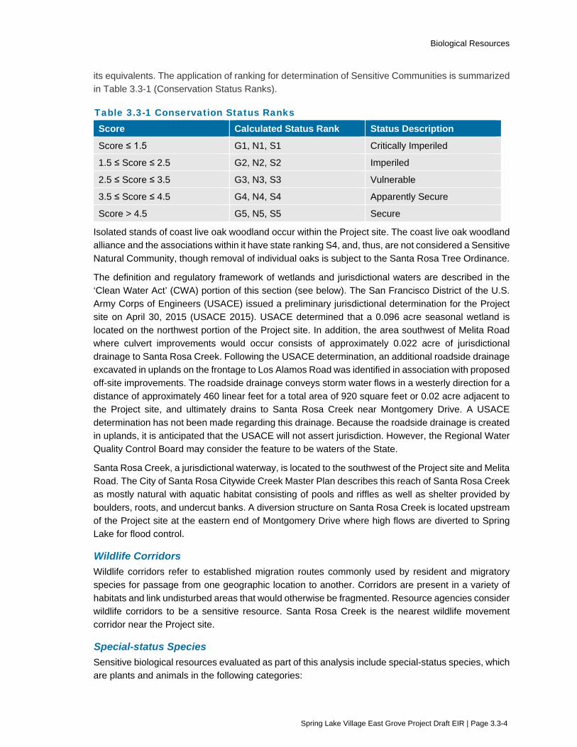
Biological Resources
Spring Lake Village East Grove Project Draft EIR | Page 3.3-4
its equivalents. The application of ranking for determination of Sensitive Communities is summarized in Table 3.3-1 (Conservation Status Ranks).
Table 3.3-1 Conservation Status Ranks Score Calculated Status Rank Status Description
Score ≤ 1.5 G1, N1, S1 Critically Imperiled
1.5 ≤ Score ≤ 2.5 G2, N2, S2 Imperiled
2.5 ≤ Score ≤ 3.5 G3, N3, S3 Vulnerable
3.5 ≤ Score ≤ 4.5 G4, N4, S4 Apparently Secure
Score > 4.5 G5, N5, S5 Secure
Isolated stands of coast live oak woodland occur within the Project site. The coast live oak woodland alliance and the associations within it have state ranking S4, and, thus, are not considered a Sensitive Natural Community, though removal of individual oaks is subject to the Santa Rosa Tree Ordinance.
The definition and regulatory framework of wetlands and jurisdictional waters are described in the ‘Clean Water Act’ (CWA) portion of this section (see below). The San Francisco District of the U.S. Army Corps of Engineers (USACE) issued a preliminary jurisdictional determination for the Project site on April 30, 2015 (USACE 2015). USACE determined that a 0.096 acre seasonal wetland is located on the northwest portion of the Project site. In addition, the area southwest of Melita Road where culvert improvements would occur consists of approximately 0.022 acre of jurisdictional drainage to Santa Rosa Creek. Following the USACE determination, an additional roadside drainage excavated in uplands on the frontage to Los Alamos Road was identified in association with proposed off-site improvements. The roadside drainage conveys storm water flows in a westerly direction for a distance of approximately 460 linear feet for a total area of 920 square feet or 0.02 acre adjacent to the Project site, and ultimately drains to Santa Rosa Creek near Montgomery Drive. A USACE determination has not been made regarding this drainage. Because the roadside drainage is created in uplands, it is anticipated that the USACE will not assert jurisdiction. However, the Regional Water Quality Control Board may consider the feature to be waters of the State.
Santa Rosa Creek, a jurisdictional waterway, is located to the southwest of the Project site and Melita Road. The City of Santa Rosa Citywide Creek Master Plan describes this reach of Santa Rosa Creek as mostly natural with aquatic habitat consisting of pools and riffles as well as shelter provided by boulders, roots, and undercut banks. A diversion structure on Santa Rosa Creek is located upstream of the Project site at the eastern end of Montgomery Drive where high flows are diverted to Spring Lake for flood control.
Wildlife Corridors Wildlife corridors refer to established migration routes commonly used by resident and migratory species for passage from one geographic location to another. Corridors are present in a variety of habitats and link undisturbed areas that would otherwise be fragmented. Resource agencies consider wildlife corridors to be a sensitive resource. Santa Rosa Creek is the nearest wildlife movement corridor near the Project site.
Special-status Species Sensitive biological resources evaluated as part of this analysis include special-status species, which are plants and animals in the following categories:

Biological Resources
Spring Lake Village East Grove Project Draft EIR | Page 3.3-5
Listed or proposed for listing as threatened or endangered under FESA or candidates for possible future listing;
Listed or candidates for listing by the State of California as threatened or endangered under the California Endangered Species Act (CESA);
Listed as Fully Protected under the California Fish and Game Code;
Taxa identified by CDFW as species of special concern or rare;
Plants assigned a California Native Plant Society (CNPS) California Rare Plant Rank (CRPR) 1A, 1B, 2A, or 2B. The ranking system is summarized as follows:
– CRPR 1A Plants presumed extirpated in California and either rare or extinct elsewhere;
– CRPR 1B Plants that are rare, threatened, or endangered in California and elsewhere;
– CRPR 2A Plants presumed extirpated in California, but common elsewhere;
– CRPR 2B Plants that are rare, threatened, or endangered in California but more common elsewhere;
Considered a locally significant species, that is, a species that is not rare from a statewide perspective but is rare or uncommon in a local context such as within a county or region (CEQA §15125 (c)) or is so designated in local or regional plans, policies, or ordinances (State CEQA Guidelines, Appendix G); or
Otherwise meets the definition of rare or endangered under CEQA §15380(b) and (d).
Tables 1 and 2 of the Biological Resources Assessment (Appendix C) for the Project list special-status species identified in the CDFW’s California Natural Diversity Database (CNDDB) and CNPS inventories within a nine USGS topographical quadrangle search range of the Santa Rosa quadrangle where the project is located. Quadrangles included in the data search were Healdsburg, Mark West Springs, Calistoga, Sebastopol, Santa Rosa, Kenwood, Two Rock, Cotati, and Glen Ellen. Species considered to be beyond their known range or to have low habitat suitability for reproduction, cover, and/or foraging within the Project area are shown to have no or low potential for occurrence on the Project site and are not discussed further in detail. Species potentially needing further study based on the analysis presented in the tables are addressed in the following sections.
Special-status Plants Several special-status plant species documented within the nine quadrangle search area were determined to have a low potential for occurrence at the Project site. No species were found to have a moderate or high potential. In addition, one species, narrow-anthered brodiaea (Brodiaea leptandra [B. californica var. leptandra]), was shown on the CNDDB as having the potential to occur within the Project area. Floristic surveys were conducted within different portions of the Project site on April 30, 2014, June 27, 2014, April 18, 2015, August 29, 2016, and April 20, 2017. An additional floristic survey was conducted on May 28, 2020. Each of the species identified as having a low potential to occur would have been observable at the time of the field surveys conducted at the Project site. The species include the following:
Franciscan onion (Allium peninsulare var. franciscanum);
Bent-flowered fiddleneck (Amsinckia lunaris);
Big-scale balsamroot (Balsamorhiza macrolepis);
Narrow-anthered brodiaea (Brodiaea leptandra [B. californica var. leptandra])

Biological Resources
Spring Lake Village East Grove Project Draft EIR | Page 3.3-6
Pappose tarplant (Centromadia [Hemizonia] parry ssp. parryi);
Sonoma spineflower (Chorizanthe valida);
Vine Hill clarkia (Clarkia imbricata);
Fragrant fritillary (Fritillaria liliacea);
Congested-headed hayfield tarplant (Hemizonia congesta ssp. Congesta)
Thin-lobed horkelia (Horkelia tenuiloba);
Baker’s goldfields (Lasthenia californica ssp. bakeri);
Contra Costa goldfields (Lasthenia conjugens);
Colusa layia (Layia septenriaonalis);
Jepson’s leptosiphon (Leptosiphon [Linanthus] jepsonii);
Woolly-headed lessingia (Lessingia hololeuca);
Cobb Mountain lupine (Lupinus sericatus);
Marsh microseris (Microseris paludosa);
Baker’s navarretia (Navarretia leucocephala ssp. bakeri);
North Coast semaphore grass (Pleuropogon hooverianus);
two-fork clover (Trifolium amoenum); and
Santa Cruz clover (Trifolium buckwestiorum).
None of the species were observed within or immediately adjacent to the Project site during the aforementioned appropriately timed surveys. Furthermore, habitat in the survey area is considered generally disturbed and ruderal reducing the likelihood of special-status plant species presence (Macmillan 2020, Appendix C).
Special Status Wildlife Based on review of species’ life history and geographic distribution data, habitat requirements, and other available species information, several special-status wildlife species have a potential for occurrence within the Project vicinity. Wildlife with a potential for occurrence within or near the Project site, based on review of available data, are presented in Table 3.3-2 and discussed further below.
Table 3.3-2 Special-status Wildlife with a Potential for Occurrence Within or in Immediate Vicinity of Project Site
Species Status General Habitat Description Potential for Occurrence
Fish
steelhead – central California coast ESU (Oncorhynchus mykiss irideus)
FT Anadromous. Generally prefer fast water in small-to-large mainstem rivers, and medium-to-large tributaries.
Potential for occurrence in Santa Rosa Creek

Biological Resources
Spring Lake Village East Grove Project Draft EIR | Page 3.3-7
Species Status General Habitat Description Potential for Occurrence
Amphibians and Reptiles
California giant salamander (Dicamptodon ensatus)
SSC Known from coastal forests near streams and seeps from Mendocino County south to Monterey County and east to Napa County. Adults may be found under rocks, logs and other debris adjacent to water sources. Aquatic larvae are found in cold, clear streams, sometimes in lakes or ponds
CNDDB occurrence records indicate potential for occurrence in Santa Rosa Creek.
Pacific pond turtle (Emys marmorata)
SSC Associated with permanent or nearly permanent water in a wide variety of habitats. Requires basking sites, nest sites may be found up to 0.5 km from water.
CNDDB occurrence records indicate potential for occurrence in Santa Rosa Creek.
foothill yellow-legged frog (Rana boylii)
SSC (Sonoma County)
Partly-shaded, shallow streams and riffles with a rocky substrate in a variety of habitats.
Santa Rosa Creek provides potential habitat for foothill yellow-legged frog and CNDDB occurrence records of species within five-mile radius of project site.
California red-legged frog (Rana draytonii)
FT, SSC Lowlands and foothills in or near permanent sources of deep water with dense, shrubby or emergent riparian vegetation.
Santa Rosa Creek provides possible dispersal corridor for California red-legged frog and CNDDB occurrence records of species within five-mile radius of project site.
Red-bellied newt (Taricha rivularis)
SSC Coastal drainages from Humboldt County to Sonoma County and inland to Lake County. Lives in terrestrial habitats and typically breeds in streams with moderate flow and clean rocky substrate.
Potential for occurrence in Santa Rosa Creek.
Birds
Swainson’s hawk (Buteo swainsoni)
ST Breeds in stands with few trees in juniper-sage flats, riparian areas and in oak savannah. Requires adjacent suitable foraging areas such as grasslands, or alfalfa or grain field supporting rodent populations.
Project site does not provide suitable foraging or nesting habitat.
Northern harrier (Circus cyaneus)
SSC Prefers open country, like grasslands, steppes, wetlands, meadows, cultivated areas.
Annual grassland at project site provide potential foraging habitat and tree nesting habitat
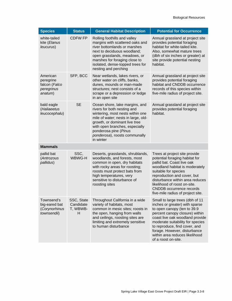
Biological Resources
Spring Lake Village East Grove Project Draft EIR | Page 3.3-8
Species Status General Habitat Description Potential for Occurrence
white-tailed kite (Elanus leucurus)
CDFW FP Rolling foothills and valley margins with scattered oaks and river bottomlands or marshes next to deciduous woodland; open grasslands, meadows, or marshes for foraging close to isolated, dense-topped trees for nesting and perching
Annual grassland at project site provides potential foraging habitat for white-tailed kite. Also, somewhat mature trees (dbh of six inches or greater) at site provide potential nesting habitat.
American peregrine falcon (Falco peregrinus anatum)
SFP, BCC Near wetlands, lakes rivers, or other water on cliffs, banks, dunes, mounds or man-made structures; nest consists of a scrape or a depression or ledge in an open site
Annual grassland at project site provides potential foraging habitat and CNDDB occurrence records of this species within five-mile radius of project site.
bald eagle (Haliaeetus leucocephalu)
SE Ocean shore, lake margins, and rivers for both nesting and wintering, most nests within one mile of water; nests in large, old-growth, or dominant live tree with open branches, especially ponderosa pine (Pinus ponderosa), roosts communally in winter
Annual grassland at project site provides potential foraging habitat.
Mammals
pallid bat (Antrozous pallidus)
SSC, WBWG-H
Deserts, grasslands, shrublands, woodlands, and forests, most common in open, dry habitats with rocky areas for roosting; roosts must protect bats from high temperatures, very sensitive to disturbance of roosting sites
Trees at project site provide potential foraging habitat for pallid bat. Coast live oak woodland habitat is moderately suitable for species reproduction and cover, but disturbance within area reduces likelihood of roost on-site. CNDDB occurrence records five-mile radius of project site.
Townsend’s big-eared bat (Corynorhinus townsendii)
SSC, State Candidate T, WBWB-
H
Throughout California in a wide variety of habitats, most common in mesic sites; roosts in the open, hanging from walls and ceilings, roosting sites are limiting and extremely sensitive to human disturbance
Small to large trees (dbh of 11 inches or greater) with sparse to open canopy (ten to 39.9 percent canopy closure) within coast live oak woodland provide moderate suitability for species to reproduce, find cover, and forage. However, disturbance within area reduces likelihood of a roost on-site.

Biological Resources
Spring Lake Village East Grove Project Draft EIR | Page 3.3-9
Species Status General Habitat Description Potential for Occurrence
long-eared myotis (Myotis evotis)
WBWG-M Found in all brush, woodland, and forest habitats from sea level to about 9,000 feet, prefers coniferous woodlands and forests; nursery colonies in buildings, crevices, spaces under bark, and snags, caves used primarily as night roosts
Trees on project site provide potential habitat for long-eared myotis reproduction, cover, and foraging.
Invertebrates
obscure bumble bee (Bombus caliginosus)
IUCN-VU Coastal areas from Santa Barbara County north to Washington State; food plant genera include Baccharis, Cirsium, Lupinus, Lotus, Grindelia, and Phacelia
Potential food plants were noted on-site and CNDDB occurrence records of this species within five-mile radius of the project site.
Leech’s skyline diving beetle (Hydroporus leechi)
FSC Aquatic habitats CNDDB occurrence records indicate Leech’s skyline diving beetle within five miles of project site. Potential habitat may be present in Santa Rosa Creek.
Source: Table compiled based on review of California Department of Fish and Wildlife Natural Diversity Database for the Santa Rosa and surrounding USGS quadrangles. February 2020.
Note FSC = U.S. Fish and Wildlife Service Species of Concern; FE = federally listed as endangered; FT = federally
listed as threatened; SE = state listed as endangered; ST = state listed as threatened; SFP = State fully protected (may not be taken or possessed without a permit from the Fish and Wildlife Commission and/or CDFW). SSC = State species of special concern; CDFS = considered sensitive by the California Department of Forestry. WBWG_H or M = Western Bat Working Group High or Medium Priority. IUCN-V = International Union for Conservation of Nature, vulnerable.
Steelhead (Oncorhynchus mykiss irideus)
Steelhead are part of the Central California Coast ESU (evolutionarily significant unit) and are federally listed as threatened. Steelhead are known to historically occur in Santa Rosa Creek. The federal listing includes all runs in coastal basins from the Russian River in Sonoma County, south to Soquel Creek in Santa Cruz County. They generally prefer fast water in small-to-large mainstem rivers, and medium-to-large tributaries. Young steelhead diet usually consists of zooplankton while adults feed on aquatic and terrestrial insects, mollusks, crustaceans, fish eggs, minnows and other small fishes (including other trout). Steelhead may spend up to seven years in freshwater before migrating to estuarine areas as smolts and then into the ocean to feed and mature. They remain at sea for up to three years before returning to the freshwater streams and rivers of their birth to reproduce. Spawning habitat consists of gravel-bottomed stream areas free of excessive silt.
California Giant Salamander (Dicamptodon ensatus)
California giant salamanders are a CDFW species of special concern. Their range includes north-central California from southern Santa Cruz County to extreme southern Mendocino and Lake Counties. Aquatic adults and larvae are found in cool, rocky streams and occasionally in lakes and ponds typically hiding within spaces between rocks in streambeds. In aquatic areas, California giant salamanders eat aquatic invertebrates, fish, and other amphibians. Their terrestrial diet consists of snails, slugs, and other invertebrates, as well as small mice, shrews, possibly reptiles, and other

Biological Resources
Spring Lake Village East Grove Project Draft EIR | Page 3.3-10
amphibians. California giant salamanders are primarily nocturnal, but may also be active during the daytime. Breeding occurs from March to May with the peak in May. Adults may be found under rocks, logs and other debris adjacent to water sources. Aquatic larvae are found in cold, clear streams, sometimes in lakes or ponds. California giant salamanders have been recorded along the Project site in association with Santa Rosa Creek.
Pacific Pond Turtle (Emys marmorata)
Pacific pond turtle is a CDFW species of special concern. The species inhabits annual and perennial aquatic habitats, such as coastal lagoons, lakes, ponds, marshes, rivers, and streams from sea level to 5,500 feet in elevation. This species requires open, dry upland habitat with friable soils for nesting and prefer to nest on unshaded slopes within 5 to 100 meters of suitable aquatic habitat. Hatchlings generally emerge in late fall but may overwinter in the nest and emerge in early spring of the following year. The species requires basking sites such as partially submerged logs, rocks, mats of floating vegetation, or open mud banks. Western pond turtles overwinter in both aquatic and terrestrial habitats; terrestrial overwintering habitat consists of burrows in leaf litter or soil. Nest predation rates are high and complete failure of nests is common, so recruitment is low and limits the species population. Western pond turtles have been recorded near the Project site in association with Santa Rosa Creek.
Foothill Yellow-legged Frog (Rana boylii)
Foothill yellow-legged frog is a CDFW species of special concern. This species is found in woodland and forest streams and rivers, and prefers flowing water with a rocky substrate (including at least some cobble-sized substrate), to which egg masses are attached. The FYLF does not aestivate and is rarely found far from a source of permanent water. Recent studies have found that FYLF are rarely found more than 12 meters from the stream channel but may move upstream or downstream as far as 7 km in response to water availability. The average distance adults were found outside the stream channel was 3 meters in all seasons with a maximum distance of 40 meters. This frog species breeds between March and early June. Egg clusters number between 100 and 1,000, typically from 200 to 300, and are attached to gravel or rocks in moving water near stream margins. FYLF occurrence is recorded in the CNDDB within five miles of the Project site and Santa Rosa Creek provides potential reproduction, cover, and forage habitat for the species.
California Red-legged Frog (Rana draytonii)
California red-legged frog (CRLF) is a federally threatened and CDFW species of special concern that is endemic to California at elevations ranging from sea level to about 5,000 feet. This species is dependent on suitable aquatic, estivation, and upland habitat. During periods of wet weather, starting with the first rainfall in late fall, red-legged frogs disperse away from their estivation sites to seek suitable breeding habitat. Aquatic and breeding habitat is characterized by dense, shrubby, riparian vegetation and deep, still or slow-moving water. Breeding occurs between late November and late April. CRLF estivate (period of inactivity) during the dry months in small mammal burrows, moist leaf litter, incised stream channels, and large cracks in the bottom of dried ponds. CRLF occurrence is recorded in the CNDDB within five miles of the Project site and Santa Rosa Creek provides a potential dispersal corridor for the species. Additionally, critical habitat for CRLF occurs within Annadel State Park to the southwest of the Project site.
Red-bellied newt (Taricha rivularis)
Santa Rosa Creek and surrounding areas provide potential habitat for red-bellied newt, which has recently been listed as a Species of Special Concern by CDFW. This species is found in coastal

Biological Resources
Spring Lake Village East Grove Project Draft EIR | Page 3.3-11
drainages from Humboldt County to Sonoma County and inland to Lake County. This species lives in terrestrial habitats and typically breeds in streams with moderate flow and clean rocky substrate.
Northern Harrier (Circus cyaneus)
Northern harrier is a CDFW species of special concern. The northern harrier ranges throughout California at elevations up to 10,000 feet. Prey includes voles and small mammals, as well as birds, frogs, small reptiles, crustaceans, insects, and rarely on fish. Northern harriers are frequently observed in meadows, grasslands, open rangelands, desert sinks, and fresh- or saltwater emergent wetlands. The species is seldom found in wooded areas. Harriers most commonly occur in or near freshwater aquatic habitats with flat or hummocky, open areas of tall, dense grasses, or moist, dry shrubs situated along water edges. The species roosts on the ground in or along the border of wetlands. Nests are placed on the ground usually in shrubby vegetation at marsh edges. Northern harrier breed from April to September and nests are single-brooded. Loss and degradation of habitat, including loss of wetlands, nest failure from human disturbance, predator-control projects, agricultural practices, and unnatural predation pressure have all contributed to the decline of northern harrier populations. Annual grassland and riparian habitats on and in the vicinity of the Project site provide possible foraging opportunities for northern harrier, but the site is not ideal for nesting and no nests were observed during site visits.
White-tailed Kite (Elanus leucurus)
White-tailed kite is a CDFW fully protected species. This kite is known to occur along the Sacramento River, Feather River, Butte Creek, Big Chico Creek, at the Gray Lodge Wildlife Area, and throughout most of Butte County from the Sierra Nevada foothills to the Sacramento River. The species preys mostly on voles and other small, diurnal mammals, as well as occasionally on birds, insects, reptiles, and amphibians. White-tailed kites forage in undisturbed, open grasslands, meadows, farmlands, and emergent wetlands. This raptor typically uses trees with dense canopies for cover and groves of dense deciduous trees for roosting. Nest placement can vary from single, isolated trees to trees within large woodlands. Nests are generally situated near the top of dense oak, willow, or other trees. Breeding season for the white-tailed kite is from February to October with the peak fledging period from May to June. Habitat loss from urbanization, including residential and commercial development, infrastructure development, and habitat fragmentation, is one of the principal threats to the species. White-tailed kite is also intolerant of noise and human activities and will abandon nesting areas that are subject to high levels of human disturbances. The Project site provides potential nesting and foraging habitat for white-tailed kite.
American Peregrine Falcon (Falco peregrinus anatum)
American peregrine falcon is a federal and state delisted species, as well as a CDFW fully protected species. This falcon is found inland throughout the Central Valley, and occasionally on the Channel Islands. The peregrine falcon frequents bodies of water in open areas with cliffs and canyons nearby for cover and nesting. The bird requires protected cliffs and ledges for cover. Riparian areas as well as coastal and inland wetlands are important habitats for the falcon yearlong, especially in nonbreeding seasons. American peregrine falcons breed near wetlands, lakes, rivers, or other water on high cliffs, banks, dunes, or mounds between March and August. The nest is a scrape on a depression or ledge in an open site. Historically, the use of the pesticide dichlorodiphenyltrichloroethane (DDT) caused the decline of the American peregrine falcon in North America. The falcon breeding populations recovered enough for the bird to be delisted from FESA and CESA. However, the American peregrine falcon is still protected in California, as competition for nest sites and predation are continuing threats to the species. American peregrine falcon occurrence

Biological Resources
Spring Lake Village East Grove Project Draft EIR | Page 3.3-12
is recorded in the CNDDB within five miles of the Project site. Annual grassland at the Project site provides possible foraging opportunities for peregrine falcon, but the site is not ideal for nesting and lacks vertical features (i.e., cliffs, mounds, etc.) typical of nest locations.
Bald Eagle (Haliaeetus leucocephalus)
Bald eagle is a federally delisted, California listed endangered, and CDFW fully protected species. The species range is wholly within North America, including Alaska, Canada, the lower 48 states, and northwest Mexico. Bald eagles may be found throughout most of California at lakes, reservoirs, rivers as well as some rangelands and coastal wetlands in the winter. In general, habitat requirements of the bald eagle include large, old-growth trees or snags in remote, mixed stands near water. Bald eagles require large bodies of water, or free flowing rivers with abundant fish, and adjacent snags or other perches. Bald eagles nest near coastlines, rivers, and large lakes where there is an adequate food supply between February and July. Annual grassland at the Project site provides possible foraging opportunities for bald eagle, but the site is not ideal for nesting and lacks elements preferred by this species for nesting (i.e., cliffs, large snags, and old growth pine trees).
Pallid Bat (Antrozous pallidus)
Pallid bat is a CDFW species of special concern and occurs throughout California except in the high Sierra Nevada Mountains. This bat forages over open ground eating a wide variety of insects and arachnids as well as large, hard-shelled prey. Prey are most often taken on the ground, but rarely taken aerially, and may also be carried to a perch or night roost for consumption. Pallid bat is found in grasslands, shrublands, woodlands, and forests from sea level up through elevations with mixed conifers. Pallid bat is a social bat and roosts in groups. The species prefers rocky areas for roosting; day roosts are in caves, crevices, mines, and occasionally in hollow trees and buildings, while night roosts may be in more open sites such as porches. Pallid bat is nocturnal and hibernates in the winter. Mating season is from October to February and young are born from April to July. Pallid bats are highly sensitive to disturbance of maternity colony sites which contributes to their decline in population. Also, loss of habitat, specifically oak woodlands, threaten the species, because pallid bat is highly associated with woodland or forest habitats. Pallid bat occurrence is recorded in the CNDDB within five miles of the Project site and trees on the Project site provide potential habitat for this species. Coastal oak woodland habitat is also moderately suitable for pallid bat reproduction and cover, but disturbance within the area reduces the likelihood of a roost on-site and no indication of a roost was noted during the site surveys.
Townsend’s Big-eared Bat (Corynorhinus townsendii)
Townsend’s big-eared bat is a state candidate for listing as threatened and a CDFW species of special concern. This bat occurs throughout the west and is distributed from the southern portion of British Columbia south along the Pacific coast to central Mexico and east into the Great Plains, with isolated populations occurring in the central and eastern U.S. Townsend’s big-eared bat has been observed yearlong in all but subalpine and alpine habitats. Habitat associations include: coniferous forests, mixed mesophytic forests, deserts, native prairies, riparian communities, active agricultural areas, and coastal habitat types. This bat requires caves, mines, tunnels, buildings, or other human-made structures for roosting. Separate sites may be used for night, day, hibernation, and maternity roosts. Most mating occurs from November to February with gestation lasting 56 to 100 days. Historically, this species has declined due to direct mortality from people and destruction or disturbance of roost sites. These bats are sensitive to light and movement, so can be easily disturbed during the day. Coastal oak woodland at the project site provides moderate suitability for this species

Biological Resources
Spring Lake Village East Grove Project Draft EIR | Page 3.3-13
to reproduce, find cover, and forage. However, disturbance within the area reduces the likelihood of a roost on-site and no indication of a roost was noted during the site surveys.
Long-eared Myotis (Myotis evotis)
Long-eared myotis is not listed under the FESA or CESA. However, this species is included on the CDFW Special Animals List and is ranked as vulnerable within California. Also, this bat is listed on the International Union for Conservation of Nature (IUCN) least concern list and the Western Bat Working Group ranks the species as medium priority for conservation and management. Long-eared myotis ranges the entire Pacific coast and in the Sierra Nevada, Cascades, and Great Basin from the Oregon border south through the Tehachapi Mountains to the Coast Ranges. Coniferous woodlands and forests are the preferred habitat for long-eared myotis. This bat roosts in buildings, crevices, spaces under bark, and snags; caves are also used as night roosts. Long-eared myotis roosts singly or in fairly small groups. This species, like most bats, is nocturnal and hibernates in the winter. Habitat loss is considered a major threat to long-eared myotis populations. Coastal oak woodland habitats provide potential habitat for long-eared myotis to reproduce, find cover, and forage.
Raptors and Migratory Birds
Trees within and adjacent to the Project site provide potential nest sites for common raptors that could also forage within the area. Migratory birds also forage and nest in a variety of habitats, including coastal oak woodland and riparian forest such as that associated with Santa Rosa Creek southwest of the Project site. Any active bird nests found within the Project area are protected under the Migratory Bird Treaty Act (MBTA) and Section 3503.5 of the California Fish and Game Code, which prohibits nest disturbance or destruction.
Obscure Bumble Bee (Bombus caliginosus)
Obscure bumble bee is not listed under the FESA or CESA. However, this species is included on the CDFW Special Animals List, which consists of all animal taxa tracked by the CNDDB regardless of their legal protection status. Obscure bumble bee is ranked as imperiled or critically imperiled within California and the IUCN lists the species as vulnerable. This bumble bee ranges from southern California to southern British Columbia along the Pacific Coast with scattered occurrence records from the east side of the Central Valley, but is uncommon or considered in decline throughout. Habitat for obscure bumble bee includes open grassy coastal prairies and Coast Range meadows. This species is considered a medium long-tongued bee that typically forages on varieties of Ceonothus, Cirsium, Clarkia, Keckiella, Lathyrus, Lotus, Lupinus, Rhododendron, Rubus, Trifolium and Vacciuium. Nesting occurs underground in abandoned rodent nests or aboveground in abandoned bird nests. Typical of bee species, colonies are annual with mated queens emerging from winter hibernation in early spring to forage and locate nest sites. Bumble bee populations as a whole are threatened by a number of factors. Obscure bumble bee in particular is likely threatened by climate change and habitat loss. The species appears to be extremely sensitive to human disturbance and does not thrive in heavy agricultural areas or urban centers, even if open spaces such as parks are present. Obscure bumble bee occurrence is recorded in the CNDDB within five miles of the Project site. However, the occurrence is from a single record collected in 1947 within Santa Rosa. The exact location is unknown. Although presence is presumed extant for this record, recent population studies between 2002 and 2003 suggest very high population decline range-wide for this species.
Leech’s Skyline Diving Beetle (Hydroporus leechi)
Leech’s skyline diving beetle is not listed under the FESA or CESA. However, this species is included on the CDFW Special Animals List and is ranked as critically imperiled within California. Leech’s

Biological Resources
Spring Lake Village East Grove Project Draft EIR | Page 3.3-14
skyline diving beetle is endemic to California and is known from several counties, including San Mateo, Marin, Sonoma, Inyo, and Siskiyou. This beetle is aquatic associated with shallow water of lacustrine habitats, specifically along the shore of ponds. The species is not well known and specific threats to this species have not been identified. Leech’s skyline diving beetle occurrence is recorded in the CNDDB within five miles of the Project site. However, the occurrence is from a single record collected in 1963 within Annadel State Park. The beetle was located along Bennett Mountain Lake west of Kenwood.
3.3.2 Regulatory Framework
Federal
Federal Endangered Species Act The FESA of 1973 (16 USC 1531 et seq.) establishes a national policy that all federal departments and agencies provide for the conservation of threatened and endangered species and their ecosystems. The Secretary of the Interior and the Secretary of Commerce are designated in the FESA as responsible for: (1) maintaining a list of species likely to become endangered within the foreseeable future throughout all or a significant portion of its range (threatened) and that are currently in danger of extinction throughout all or a significant portion of its range (endangered); (2) carrying out programs for the conservation of these species; and (3) rendering opinions regarding the impact of proposed federal actions on listed species. The FESA also outlines what constitutes unlawful taking, importation, sale, and possession of listed species and specifies civil and criminal penalties for unlawful activities.
Pursuant to the requirements of the FESA, an agency reviewing a proposed project within its jurisdiction must determine whether any federally listed or proposed species may be present in the project region, and whether the proposed project would result in a “take” of such species. The FESA prohibits “take” of a single threatened and endangered species except under certain circumstances and only with authorization from the USFWS or the National Oceanic and Atmospheric Administration (NOAA) Fisheries through a permit under Section 7 (for Federal entities) or 10(a) (for non-Federal entities) of the Act. “Take” under the FESA includes activities such as “harass, harm, pursue, hunt shoot, wound, kill, trap, capture, or collect, or to attempt to engage in any such conduct.” USFWS regulations define harm to include “significant habitat modification or degradation.” On June 29, 1995, a U.S. Supreme Court ruling further defined harm to include habitat modification “…where it actually kills or injures wildlife by significantly impairing essential behavioral patterns, including breeding, feeding, or sheltering.”
In addition, the agency is required to determine whether the project is likely to jeopardize the continued existence of any species proposed to be listed under the FESA, or result in the destruction or adverse modification of critical habitat for such species (16 USC 1536[3][4]). If it is determined that a project may result in the "take" of a federally-listed species, a permit would be required under Section 7 or Section 10 of the FESA.
Clean Water Act The Clean Water Act (CWA 1977, as amended) establishes the basic structure for regulating discharges of pollutants into waters of the U.S. It gives the U.S. Environmental Protection Agency (EPA) the authority to implement pollution control programs, including setting wastewater standards for industry and water quality standards for contaminants in surface waters. The CWA makes it

Biological Resources
Spring Lake Village East Grove Project Draft EIR | Page 3.3-15
unlawful for any person to discharge any pollutant from a point source into navigable waters, without a permit under its provisions.
Discharge of fill material into “waters of the U.S.,” including wetlands, is regulated by the USACE under Section 404 of the CWA (33 USC 1251-1376). USACE regulations implementing Section 404 define “waters of the U.S.” to include intrastate waters (such as, lakes, rivers, streams, wetlands, and natural ponds) that the use, degradation, or destruction of could affect interstate or foreign commerce. Wetlands are defined for regulatory purposes as “areas that are inundated or saturated by surface or groundwater at a frequency and duration sufficient to support, and that under normal circumstances do support, a prevalence of vegetation typically adapted for life in saturated soil conditions” (33 CFR 328.3; 40 CFR 230.3). The placement of structures in “navigable waters of the U.S.” is also regulated by the USACE under Section 10 of the Federal Rivers and Harbors Act (33 USC 401 et seq.). Projects are approved by USACE under standard (i.e., individual) or general (i.e., nationwide, programmatic, or regional) permits. The type of permit is determined by the USACE and based on project parameters.
The USACE and the EPA announced the release of the Clean Water Rule on May 27, 2015 (80 FR 124: 37054-37127). The Rule is intended to ensure waters protected under the CWA are more precisely defined, more predictable, easier to understand, and consistent with the latest science. The intent is to: 1) clearly define and protect tributaries that impact the quality of downstream waters; 2) provide certainty in how far safeguards extend to nearby waters; 3) protect unique regional waters; 4) focus on streams instead of ditches; 5) maintain the status of waters associated with infrastructure (i.e., sewer systems); and 6) reduce the need for case-specific analysis of all waters. The U.S. Court of Appeals for the Sixth Circuit stayed implementation of the Clean Water Rule pending further action of the court in October 2015. In response, the USACE and EPA resumed case-by-case analysis of waters of the U.S. determinations. Implementation of the Clean Water Rule is pending ongoing litigation.
The Fish and Wildlife Coordination Act requires consultation with the USFWS, NOAA Fisheries, and responsible state wildlife agency for any federally authorized action to control or modify surface waters. Therefore, any project proposed or permitted by the USACE under the CWA Section 404 must also be reviewed by the federal wildlife agencies and CDFW.
Section 401 of the CWA requires any applicant for a federal license or permit, which involves an activity that may result in a discharge of a pollutant into waters of the U.S., obtain a certification that the discharge will comply with applicable effluent limitations and water quality standards. CWA 401 certifications are issued by Regional Water Quality Control Boards (RWQCBs) under the California Environmental Protection Agency.
Migratory Bird Treaty Act The Migratory Bird Treaty Act (MBTA) of 1918 (16 USC 703-711) established federal responsibilities for the protection of nearly all species of birds, their eggs, and nests. A migratory bird is defined as any species or family of birds that live, reproduce or migrate within or across international borders at some point during their annual life cycle. The MBTA prohibits the take, possession, buying, selling, purchasing, or bartering of any migratory bird listed in 50 CFR Part 10, including feathers or other parts, nests, eggs, or products, except as allowed by implementing regulations (50 CFR 21).
Bald and Golden Eagle Protection Act The bald eagle (Haliaeetus leucocephalus) and golden eagle (Aquila chrysaetos) are federally protected under the Bald and Golden Eagle Protection Act (16 USC 668-668c). It is illegal to take,

Biological Resources
Spring Lake Village East Grove Project Draft EIR | Page 3.3-16
possess, sell, purchase, barter, offer to sell, purchase or barter, transport, export or import at any time or in any manner a bald or golden eagle, alive or dead; or any part, nest or egg of these eagles unless authorized by the Secretary of the Interior. Violations are subject to fines and/or imprisonment for up to one year. Active nest sites are also protected from disturbance during breeding season.
State
Porter-Cologne Water Quality Control Act The Porter-Cologne Act provides for statewide coordination of water quality regulations by establishing the California State Water Resources Control Board. The State Board is the statewide authority that oversees nine separate RWQCBs that collectively oversee water quality at regional and local levels. California RWQCBs issue CWA, Section 401 Water Quality Certifications for possible pollutant discharges into waters of the U.S. or state. In addition, for impacts to State-only jurisdictional waters, the RWQCB issues Waste Discharge Permits. The Project site is located within the North Coast Regional Water Quality Control Board.
California Department of Fish and Wildlife The California Department of Fish and Wildlife (CDFW) enforces and permits actions regulated by the California Fish and Game Code, which governs the taking or possession of birds, mammals, fish, amphibians and reptiles, as well as natural resources such as wetlands and waters of the state. The code includes the California Endangered Species Act (CESA) (Sections 2050-2115), Lake or Streambed Alteration Agreement regulations (Section 1600-1616), Native Plant Protection Act (Section 1900-1913), and Natural Community Conservation Planning (NCCP) Act (Section 2800 et seq.) as well as provisions for legal hunting and fishing, and tribal agreements for activities involving take of native wildlife.
California Endangered Species Act
The CESA includes provisions for the protection and management of species listed by the State of California as endangered, threatened, or designated as candidates for such listing (California Fish and Game Code Sections 2050 through 2085). The CESA generally parallels the main provisions of the FESA and is administered by the CDFW, who maintains a list of state threatened and endangered species as well as candidate and species of special concern. The CESA prohibits the “take” of any species listed as threatened or endangered unless authorized by the CDFW in the form of an Incidental Take Permit. Under California Fish and Game Code, “take” is defined as to “hunt, pursue, catch, capture, or kill, or attempt to hunt, pursue, catch, capture, or kill.”
The species of special concern are broadly defined as species that are of concern to the CDFW, because of population declines and restricted distributions and/or they are associated with habitats that are declining in California. Impacts to special-status plants and animals may be considered significant under CEQA.
Lake or Streambed Alteration Agreement
Streams, lakes, and riparian vegetation which serve as habitat for fish and other wildlife species are subject to jurisdiction by the CDFW under Sections 1600-1616 of the California Fish and Game Code. Any activity that will do one or more of the following: 1) substantially obstruct or divert the natural flow of a river, stream, or lake; 2) substantially change or use any material from the bed, channel, or bank of a river, stream, or lake; or 3) deposit or dispose of debris, waste, or other material containing crumbled, flaked, or ground pavement where it can pass into a river, stream, or lake; generally require a 1602 Lake and Streambed Alteration Agreement. The term “stream,” which includes creeks and

Biological Resources
Spring Lake Village East Grove Project Draft EIR | Page 3.3-17
rivers, is defined in the CCR as follows: “a body of water that flows at least periodically or intermittently through a bed or channel having banks and supports fish or other aquatic life. This includes watercourses having a surface or subsurface flow that supports or has supported riparian vegetation” (14 CCR 1.72).
Native Plant Protection Act
The CDFW administers the Native Plant Protection Act (Sections 1900–1913 of the California Fish and Game Code). These sections allow the California Fish and Game Commission to designate endangered and rare plant species and to notify landowners of the presence of such species. Section 1907 of the California Fish and Game Code allows the Commission to regulate the “taking, possession, propagation, transportation, exportation, importation, or sale of any endangered or rare native plants.” Section 1908 further directs that “…[n]o person shall import into this state, or take, possess, or sell within this state, except as incident to the possession or sale of the real property on which the plant is growing, any native plant, or any part or product thereof, that the Commission determines to be an endangered native plant or rare native plant.”
Natural Community Conservation Planning Act
The CDFW is the principal state agency responsible for implementing the Natural Community Conservation Planning (NCCP) Act of 1991. The Act is designed to conserve natural communities at the ecosystem scale while accommodating compatible land use. The NCCP plans developed in accordance with the Act seek to ensure the long-term conservation of multiple species, while allowing for compatible and appropriate economic activity to proceed.
Birds of Prey
Section 3503 of the California Fish and Game Code prohibits the take, possession, or needless destruction of the nest or eggs of any bird. Subsection 3503.5 specifically prohibits the take, possession, or destruction of any birds in the orders Falconiformes (hawks and eagles) or Strigiformes (owls) and their nests. These provisions, along with the MBTA, essentially serve to protect nesting native birds.
Fully Protected Species
The California Fish and Game Code also accords “fully protected” status to a number of specifically identified fish (Section 5515), reptiles and amphibians (Section 5050), birds (Section 3511), and mammals (Section 4700). As fully protected species, the CDFW cannot authorize any project or action that would result in “take” of these species even with an incidental take permit.
Regional and Local
Santa Rosa City Code Section 17-24, Trees In 1990, the Santa Rosa City Council passed Ordinance 2858, which enacted the following regulations to protect certain trees, while at the same time recognizing an individual property owner’s freedom in how they treat their land. The following sections apply to the Project:
Section 17-24.030 describes the conditions in which a permit is required to remove or alter any tree, including heritage, protected, or street trees.
Section 17-24.050 describes tree alteration/relocation/removal requirements on properties proposed for development. This section also describes protection measures for heritage trees that must be implemented for all development projects (including fencing during construction, avoidance of disturbance and trenching within driplines, maintaining grade around trees, and

Biological Resources
Spring Lake Village East Grove Project Draft EIR | Page 3.3-18
prohibiting the placement of paving or landscaping requiring summer irrigation in the vicinity of oaks), and a tree replacement program for all trees and heritage trees that are removed.
City of Santa Rosa General Plan The following goals and policies from the City of Santa Rosa General Plan 2035 are generally related to biological resources and apply to the Project:
(OSC)-B Conserve the city’s open spaces and significant natural features.
OSC-B-4 Require that graded areas within new developments be revegetated.
OSC-D Conserve wetlands, vernal pools, wildlife ecosystems, rare plant habitats, and waterways.
OSC-D-1 Utilize existing regulations and procedures, including Subdivision Guidelines, Zoning, Design Review, and environmental law, to conserve wetlands and rare plants. Comply with the federal policy of no net loss of wetlands using mitigation measures such as:
• Avoidance of sensitive habitat;
• Clustered development;
• Transfer of development rights; and/or
• Compensatory mitigation, such as restoration or creation.
OSC-D-3 Preserve and restore the elements of wildlife habitats and corridors throughout the Planning Area.
OSC-D-9 Ensure that construction adjacent to creek channels is sensitive to the natural environment. Ensure that natural topography and vegetation is preserved along the creek, and that construction activities do not disrupt or pollute the waterway.
OSC-E Ensure local creeks and riparian corridors are preserved, enhanced, and restored as habitat for fish, birds, mammals and other wildlife.
OSC-E-1 Maintain creek areas using practices that protect and support fish and wildlife as well as help retain hydraulic capacity.
OSC-H Conserve significant vegetation and trees and plant new trees.
OSC-H-1 Preserve trees and other vegetation, including wildflowers, both as individual specimens and as parts of larger plant communities.
OSC-H-2 Preserve and regenerate native oak trees.
OSC-H-4 Require incorporation of native plants into landscape plans for new development, where appropriate and feasible, especially in areas adjacent to open space areas or along waterways.
City of Santa Rosa Citywide Creek Master Plan The City of Santa Rosa has specific goals related to waterways within their jurisdiction. The following goals and objectives from the Santa Rosa Citywide Creek Master Plan are related to biological resources and apply to the off-site infrastructure improvements of the Project:

Biological Resources
Spring Lake Village East Grove Project Draft EIR | Page 3.3-19
Habitat (HA) Local creeks and riparian corridors are preserved, enhanced, and restored as habitat for fish, birds, mammals, and other wildlife.
Objective HA-1 Preserve healthy and/or environmentally sensitive creek areas.
Objective HA-6 Obtain and comply with all necessary regulatory agency permits.
Policy HA-6-2 Consistent with federal, state, and local regulations, impacts to existing habitat will be avoided if possible. Minimization and mitigation of any unavoidable impacts will be required.
3.3.3 Evaluation Criteria and Significance Thresholds For the purpose of this EIR, the evaluation criteria and significance thresholds summarized in Table 3.3-3 (Evaluation Criteria and Significance Thresholds) are used to determine if the Project would have a significant effect related to biological resources.
Table 3.3-3 Evaluation Criteria and Significance Thresholds
Evaluation Criteria Significance Thresholds Sources
BIO-1: Would the project have a substantial adverse effect, either directly or through habitat modifications, on any species identified as a candidate, sensitive, or special-status species in local or regional plans, policies, or regulations, or by the California Department of Fish and Wildlife or U.S. Fish and Wildlife Service?
Direct loss or harm of a sensitive or special-status species Loss or alteration of habitat that could result in the ‘take’ of a sensitive or special-status species Indirect disturbance (e.g., construction noise) that could disrupt essential activities (e.g., nesting) of a sensitive or special-status species
CEQA Guidelines Appendix G, Checklist Item IV (a) Federal and State Endangered Species Acts Migratory Bird Treaty Act Bald Eagle Protection Act Native Plant Protection Act General Plan Policies OSC-D-3, D-9, and E-1
BIO-2: Would the project have a substantial adverse effect on any riparian habitat or other sensitive natural community identified in local or regional plans, policies, regulations or by the California Department of Fish and Wildlife or U.S. Fish and Wildlife Service?
Direct removal of any riparian community, oak woodland, or other sensitive natural community (except wetlands) Alteration of a sensitive natural community that could result in local degradation Indirect disturbance that could reduce habitat function and value
CEQA Guidelines Appendix G, Checklist Item IV (b) Natural Community Conservation Act General Plan Policies H-1 and H-2

Biological Resources
Spring Lake Village East Grove Project Draft EIR | Page 3.3-20
Evaluation Criteria Significance Thresholds Sources
BIO-3: Would the project have a substantial adverse effect on state or federally protected wetlands (including, but not limited to, marsh, vernal pool, coastal, etc.) through direct removal, filling, hydrological interruption, or other means?
Placement of fill in wetlands, waters of the U.S., or waters of the State Discharge of materials into wetlands, waters of the U.S., or waters of the State Indirect disturbance that could contribute to erosion and/or negatively impact water quality of wetlands, waters of the U.S., or waters of the State
CEQA Guidelines Appendix G, Checklist Item IV (c) Clean Water Act section 404 and 401 General Plan Policy OSC-D-1
BIO-4: Would the project interfere substantially with the movement of any native resident or migratory fish or wildlife species or with established native resident or migratory wildlife corridors, or impede the use of native wildlife nursery sites?
Create a barrier to movement resulting in loss or harm to migratory or local wildlife
CEQA Guidelines Appendix G, Checklist Item IV (d) Migratory Bird Treaty Act General Plan Policy OSC-D-3
BIO-5: Would the project conflict with any local policies or ordinances protecting biological resources, such as a tree preservation policy or ordinance?
Conflict with an applicable local policy or ordinance
CEQA Guidelines Appendix G, Checklist Item IV (e) City Code Chapter 17.24 General Plan Policies OSC-H-1, H-2, and H-4
BIO-6: Would the project conflict with the provisions of an adopted Habitat Conservation Plan, Natural Community Conservation Plan, or other approved local, regional, or state habitat conservation plan?
Conflict with an approved conservation plan
CEQA Guidelines Appendix G, Checklist Item IV (f) Natural Community Conservation Planning Act
3.3.4 Approach to Analysis A Biological Resources Assessment was prepared for the Project site to identify special-status plant and wildlife species and sensitive habitats that have the potential to occur on or in the vicinity of the Project site (Macmillan 2020, Appendix C). The assessment included literature and database searches as well as site surveys to determine what species have potential to be present on the Project site. The information and data collected for the assessment have been used as the basis of this biological resources analysis.
The evaluation of potential impacts on biological resources considers both direct effects to the resource as well as indirect effects in a local or regional context. Potentially significant impacts would generally result in the loss of a biological resource or conflict with local, state, or federal agency conservation plans, goals, policies, or regulations. Actions that would potentially result in a significant
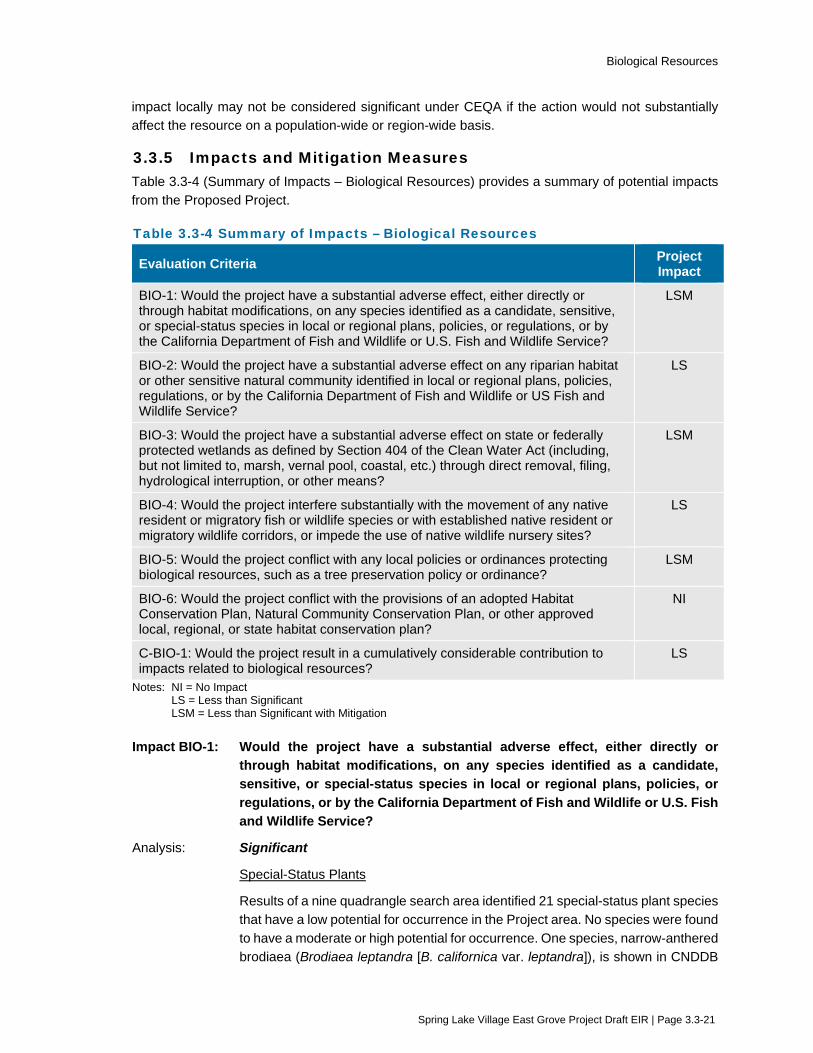
Biological Resources
Spring Lake Village East Grove Project Draft EIR | Page 3.3-21
impact locally may not be considered significant under CEQA if the action would not substantially affect the resource on a population-wide or region-wide basis.
3.3.5 Impacts and Mitigation Measures Table 3.3-4 (Summary of Impacts – Biological Resources) provides a summary of potential impacts from the Proposed Project.
Table 3.3-4 Summary of Impacts – Biological Resources
Evaluation Criteria Project Impact
BIO-1: Would the project have a substantial adverse effect, either directly or through habitat modifications, on any species identified as a candidate, sensitive, or special-status species in local or regional plans, policies, or regulations, or by the California Department of Fish and Wildlife or U.S. Fish and Wildlife Service?
LSM
BIO-2: Would the project have a substantial adverse effect on any riparian habitat or other sensitive natural community identified in local or regional plans, policies, regulations, or by the California Department of Fish and Wildlife or US Fish and Wildlife Service?
LS
BIO-3: Would the project have a substantial adverse effect on state or federally protected wetlands as defined by Section 404 of the Clean Water Act (including, but not limited to, marsh, vernal pool, coastal, etc.) through direct removal, filing, hydrological interruption, or other means?
LSM
BIO-4: Would the project interfere substantially with the movement of any native resident or migratory fish or wildlife species or with established native resident or migratory wildlife corridors, or impede the use of native wildlife nursery sites?
LS
BIO-5: Would the project conflict with any local policies or ordinances protecting biological resources, such as a tree preservation policy or ordinance?
LSM
BIO-6: Would the project conflict with the provisions of an adopted Habitat Conservation Plan, Natural Community Conservation Plan, or other approved local, regional, or state habitat conservation plan?
NI
C-BIO-1: Would the project result in a cumulatively considerable contribution to impacts related to biological resources?
LS
Notes: NI = No Impact LS = Less than Significant LSM = Less than Significant with Mitigation
Impact BIO-1: Would the project have a substantial adverse effect, either directly or through habitat modifications, on any species identified as a candidate, sensitive, or special-status species in local or regional plans, policies, or regulations, or by the California Department of Fish and Wildlife or U.S. Fish and Wildlife Service?
Analysis: Significant
Special-Status Plants
Results of a nine quadrangle search area identified 21 special-status plant species that have a low potential for occurrence in the Project area. No species were found to have a moderate or high potential for occurrence. One species, narrow-anthered brodiaea (Brodiaea leptandra [B. californica var. leptandra]), is shown in CNDDB

Biological Resources
Spring Lake Village East Grove Project Draft EIR | Page 3.3-22
records as having the potential to occur within the Project site. Floristic surveys were conducted within different portions of the Project site on April 30, 2014, June 27, 2014, April 18, 2015, August 29, 2016, April 20, 2017, and May 28, 2020. No special-status plant species were identified on the Project site or off-site improvement areas during any of the aforementioned surveys. It was concluded that due to the highly disturbed, ruderal or developed nature of the Project site and off-site improvement areas, it is unlikely that any special-status plant species occur on the site. Therefore, based on literature review, habitat disturbance, and on-site survey observations, no impact to special-status plants would result from implementation of the Project.
Special-Status Wildlife Species
Santa Rosa Creek, located southwest of Melita Road, provides instream and riparian habitat that supports a distinct community of plants and animals, including foothill yellow-legged frog (FYLF), California red-legged frog (CRLF), California giant salamander (CGS), red-bellied newt, Pacific pond turtle (PPT), and steelhead. No work would occur below the top of bank of Santa Rosa creek or within the Santa Rosa Creek riparian corridor. Work southwest of Melita Road would be limited to approximately 120 square feet for installation of a storm drain culvert replacement. This area is characterized as ruderal (oat and non-native blackberry), and no riparian habitat would be impacted. Therefore, there would be no loss of habitat for FYLF, CRLF, CGS, red-bellied newt, or PPT as a result of the Project. However, the location of the proposed storm drain culvert improvement southwest of Melita Road is within the maximum distance that FYLF, CRLF, CGS, red-bellied newt, and PPT have been documented to occur outside of stream channels. Because of this, there is a potential for these species to disperse into the area of the storm drain culvert during construction, and vegetation removal and ground disturbance would result in potentially adverse effects to the species if present. The potential impact to aquatic species, from replacement of the culvert, is considered significant.
Steelhead are known to historically occur in Santa Rosa Creek. No Project activities are proposed to occur directly within Santa Rosa Creek and dewatering of the creek would not be required. As noted above, the culvert replacement would be approximately 100 feet east of the top of bank. There would be no direct impacts to Santa Rosa Creek or steelhead habitat. However, if construction activities were to substantially increase erosion or other pollutant runoff that could degrade water quality within the Santa Rosa Creek, an indirect impact to steelhead could result. If water quality were degraded, the impact from project construction on steelhead would be significant.
Nesting Raptors and Migratory Birds
Habitat within and adjacent to the Project site provides suitable nesting opportunities for many avian species, including raptors and migratory birds. Raptors and migratory bird nests are considered to be a protected resource by federal and state agencies under the MBTA and California Code of Regulations.

Biological Resources
Spring Lake Village East Grove Project Draft EIR | Page 3.3-23
Northern harriers, American peregrine falcons, and bald eagles have a potential to occur on-site as occasional foragers or transients, but are not likely to nest on-site. Additional forage area is available locally within Annadel State Park and surrounding areas, so implementation of the Project is not expected to substantially impact the foraging ability of these species.
However, the Project site provides potential nesting and foraging habitat for white-tailed kite, which is a CDFW fully protected species, as well as numerous migratory birds. The Project has the potential to impact these species if construction activities, including removal of trees or initial grading activities, were to occur during the nesting season (February 1 through August 31). Construction activities that resulted in the destruction or disturbance of an active nest would be a significant impact.
Sensitive and Special-Status Bats
Suitable roosting habitat for pallid bat, Townsend’s big-eared bat, and long-eared myotis occurs within and adjacent to the Project site. In addition to the possible presence of these bats on-site, indirect effects such as increased noise, dust, or increased human presence may occur from construction of the Project. Disturbance or loss of habitat that could result in a “take” of sensitive or listed bat species, therefore, the impact would be significant.
Additional Species
Obscure bumble bee occurrence is recorded in the CNDDB within five miles of the Project site. However, the occurrence is from a single record collected in 1947 within Santa Rosa. Furthermore, the Project site is regularly disturbed from the nearby road, urban area, and mowing on-site, so the likelihood of regular occurrence or nesting by this bumble bee is reduced. Therefore, it is possible obscure bumble bee occur on-site as an occasional forager or transient. However, implementation of the Project is not expected to impact the species population because: (1) the species is not formally listed; (2) there are no recent records of the bee near the Project site; and (3) the species sensitivity to human disturbance precludes regular foraging or nesting on-site.
Leech’s skyline diving beetle occurrence is recorded in the CNDDB within five miles of the Project site. However, the occurrence is from a single record collected in 1963 within Annadel State Park. Although it is possible for Leech’s skyline diving beetle to be in the vicinity of the Project location, micro habitat (i.e., lake or pond margins) is not found on-site. Therefore, implementation of the Project is not expected to significantly impact the species population.
Impacts to obscure bumble bee and leach’s skyline diving beetle would be less than significant.
Mitigation: Mitigation Measure BIO-1a: Avoid Impacts to Foothill Yellow-legged Frog and Other Special Status Amphibians and Reptiles
City of Santa Rosa shall ensure the construction contractor adheres to the following measures to reduce impacts to special-status amphibians and reptiles

Biological Resources
Spring Lake Village East Grove Project Draft EIR | Page 3.3-24
during construction of the new storm drain culvert to be located on the southwest side of Melita Road:
• Prior to construction, all workers on the crew shall be trained by a qualified biologist as to the sensitivity of the special-status species potentially occurring within the construction area southwest of Melita Road. The training shall include a brief review of special-status species with the potential to occur onsite, including foothill yellow-legged frog, California red-legged frog, California giant salamander, red-bellied newt, and Pacific pond turtle. The training shall provide an overview of their habitat requirements, legal status, and protection requirements. The training shall also provide a brief overview of biological resource mitigation measures, environmental permits and proposed project plans (i.e., the SWPPP, BMPs, and any other required plans). Personnel shall sign an attendance form that will remain on file with the City of Santa Rosa for verification of training.
• Pre-construction surveys shall be performed within 48 hours prior to initiation of construction activities (including initial ground disturbing activities) related to the storm drain culvert improvements southwest of Melita Road.
• Prior to construction, a wildlife exclusion fence shall be installed along the southwest side of Melita Road along the upper limits of the Santa Rosa Creek corridor to prevent special-status amphibians and reptiles from accessing the site during construction. This fence shall be maintained during construction activities. The exclusion fence shall be installed such that the fabric is an appropriate height above ground per biologist recommendation and the fabric should be buried 4-6 inches below ground. The exclusion fence posts shall be located on the work side of the fence with the fabric on the outside relative to the stakes.
• All vegetation clearing for the storm drain culvert shall be done by hand under the supervision of a qualified biologist.
• No construction activities within the storm drain culvert area shall occur during rain events, defined as ¼ inch of rain falling within a 24-hour period. Construction activities may resume 24 hours after the end of the rain event.
• Work shall not be conducted within the storm drain culvert area southwest of Melita Road any time 30 minutes before sunrise or sunset.
Mitigation Measure BIO-1b: Avoid Impacts to Nesting Birds
The City of Santa Rosa shall ensure the following measures to avoid impacts to nesting birds are followed:
• To the extent possible, grading or removal of any vegetation shall be conducted outside the nesting season, which occurs between approximately February 1 and August 31. No preconstruction nesting bird survey is required for work conducted outside this period.
• If limiting grading or vegetation removal between August 31 and February 1 is infeasible and work must occur within the nesting season, a pre-construction nesting bird (both passerine and raptor) survey of the landscaped areas and

Biological Resources
Spring Lake Village East Grove Project Draft EIR | Page 3.3-25
trees shall be performed by a qualified biologist within 7 days of ground breaking. If no nesting birds are observed, no further action is required and work shall occur within one week of the survey to prevent impacts to individual birds that could begin nesting after the survey.
• If bird nests (either passerine and/or raptor) are observed during the pre-construction survey, a disturbance-free buffer zone shall be established around the nest tree(s) until the young have fledged, as determined by a qualified biologist. The radius of the required buffer zone can vary depending on the species, (i.e., 75 to 100 feet for passerines and 200 to 300 feet for raptors), with the dimensions of any required buffer zones to be determined by a qualified biologist based upon the distance necessary to prevent disturbance to the relevant species.
• To delineate the buffer zone around a bird nest, orange construction fencing shall be placed at the specified radius from the nest within which no machinery or workers shall intrude. After the fencing is in place there will be no restrictions on grading or construction activities outside the prescribed buffer zones.
• If initial ground disturbance is delayed or there is a break in project activities of greater than 14 days within the bird-nesting season, then a follow-up nesting bird survey should be performed to ensure no nests have been established in the interim.
Mitigation Measure BIO-1c: Avoid Impacts to Sensitive or Listed Bats
The City of Santa Rosa shall ensure the following measures to avoid impacts to roosting bats are followed.
If initial ground disturbance occurs during the bat maternity roosting season (May 1 through August 31), a qualified biologist shall conduct a bat habitat assessment of trees within 100 feet of the Project site. The assessment shall evaluate the trees for suitable entry points and roost features, and shall provide focused daytime surveys for day-roosting bats. If the biologist determines there is potential for maternity roosting bats to be present within 100 feet of construction areas, nighttime emergence surveys may be performed to determine if maternity roosting bats are present.
If bat maternity roosts are present, the biologist shall establish an appropriate exclusion zone around the maternity roost. Removal of trees that potentially support a bat maternity roost should only occur between September 1 and October 15, after the young have learned to be self-sufficient but before hibernation. Trees supporting bats should not be removed while bats are hibernating between October 15 and March 15 or otherwise while bats are present.
If a special-status bat species is found, or if suspected day roosts for special-status bats are identified, then the qualified biologist shall identify suitable measures for avoiding impacts to roosts to achieve the performance standard of ensuring bat species have relocated prior to demolition or removal of the roosting structure. Measures shall include, at a minimum, phased removal of trees where selected limbs and branches not containing cavities are removed using chainsaws on the
Biological Resources
Spring Lake Village East Grove Project Draft EIR | Page 3.3-26
first day, with the remainder of the tree removed using chainsaws or other equipment on the second day after all bats have left the roost.
The City shall also consult with the California Department of Fish and Wildlife to determine whether there is a need for any additional or equally effective alternative measures for protecting bats with young if present, and for implementing measures to exclude non-breeding bat colonies during the construction process.
Mitigation Measure BIO-1d: Avoid Impacts to Steelhead
The City of Santa Rosa shall ensure the construction contractor adheres to the following measures in order to prevent potential erosion into the off-site riparian zone associated with Santa Rosa Creek:
• Construction associated with storm drain improvements southwest of Melita Road shall occur during the dry season.
• Standard BMPs shall be implemented, including the installation of silt fences immediately downslope of the work limits for the storm drain improvements.
• All disturbed areas shall be restored post-construction and hydro seeded with a native seed mix.
• Measures outlined by permitting agencies, such as CDFW or RWQCB, to prevent diminished water quality and erosion shall also be implemented during construction.
After Mitigation: Less than Significant with Mitigation
Implementation of Mitigation Measure BIO-1a would reduce impacts to sensitive and listed amphibians and reptiles by conducting pre-construction surveys, implementing measures to exclude them from the Project site during construction, working when the species are least likely to be on-site, and providing worker education as to species’ potential presence. With implementation of Mitigation Measures BIO-1b and BIO-1c, the potential impact to raptors, migratory birds, and bats would be reduced to a less-than-significant level by locating any potential active nests or roosts before the start of construction and establish buffers and avoiding nests, if found, during construction. Implementation of Mitigation Measure BIO-1d would reduce potential indirect impacts to steelhead by taking actions to prevent degradation of the water quality within Santa Rosa Creek and erosion from project activities.
Impact BIO-2: Would the project have a substantial adverse effect on any riparian habitat or other sensitive natural community identified in local or regional plans, policies, regulations, or by the California Department of Fish and Wildlife or U.S. Fish and Wildlife Service?
Analysis: Less than Significant
Coast live oak woodland is present in the northern portion of the Project site, as well as in along the western and southern boundary of the site. This habitat type corresponds to a phase of the Quercus agrifolia (coast live oak woodland) alliance in the Manual of California, used to determine sensitive natural communities by CDFW (Sawyer et al. 2009). In the classification scheme of CNPS, this habitat type

Biological Resources
Spring Lake Village East Grove Project Draft EIR | Page 3.3-27
corresponds to a phase of the cismontane woodland habitat type. This alliance and the associations within it have state ranking S4, and, thus, are not considered sensitive habitats.
Santa Rosa Creek, located approximately 150 feet southwest of Melita Road, provides instream and riparian habitat that supports a distinct community of plants and animals. No Project work would occur below the top of bank of Santa Rosa creek or within the Santa Rosa Creek riparian corridor. Project-related work southwest of Melita Road would be limited to approximately 120 square feet for installation of a storm drain culvert replacement. This area is characterized as ruderal (oat and non-native blackberry), and no riparian habitat would be impacted.
There would be no impact to sensitive natural communities. Refer to Impact BIO-3 for an analysis of the Project’s impact to wetland resources.
Mitigation: No mitigation is needed.
Impact BIO-3: Would the project have a substantial adverse effect on state or federally protected wetlands (including, but not limited to, marsh, vernal pool, coastal, etc.) through direct removal, filling, hydrological interruption, or other means?
Analysis: Significant
In April 2015, the San Francisco District of the U.S. Army Corps of Engineers conducted a site visit of the Project site. The Corps verified a 0.096-acre seasonal wetland on the northwestern portion of the Project site, as well as 0.022 acre of other waters located off-site adjacent to Melita Road.
The on-site seasonal wetland appears to be man-made, possibly through ground disturbances associated with past agricultural uses of the property. Vegetation growing within the seasonal wetland area was predominated by weedy wetland indicator species, primarily flat nut sedge (Cyperus eragrostis). The soils within the on-site wetland area showed some evidence of prolonged saturation with the presence of some mottling in the surface soils.
After the Corps verification discussed above, a roadside drainage excavated in uplands was identified along the frontage of Los Alamos Road measuring approximately 2 feet wide. The roadside drainage conveys storm water flows in a westerly direction for a distance of approximately 460 linear feet for a total area of 920 square feet or 0.02 acre adjacent to the Project site, and ultimately drains to Santa Rosa Creek near Montgomery Drive. Because the roadside drainage is created in uplands, the U.S. Army Corps of Engineers is unlikely to assert jurisdiction. However, for the purposes of this analysis, the drainage is assumed to be jurisdiction, whether by the Corps or the State.
Based on the current design, the Project would require permanent fill of the 0.096 acre seasonal wetland, temporary impact to the 0.022 acre of other waters located adjacent to Melita Road, and permanent fill of approximately 70 linear feet of the roadside drainage along Los Alamos Road (0.003 acre). The impact of the Project on wetlands and the other jurisdictional waters would be significant.

Biological Resources
Spring Lake Village East Grove Project Draft EIR | Page 3.3-28
Mitigation: Mitigation Measure BIO-3 Compensate for Loss of Wetlands and Waters
The City of Santa Rosa shall ensure the Applicant compensates for the loss of the seasonal wetland through the purchase of wetland credits in an approved mitigation bank within the Santa Rosa Plain so that there is no net loss in wetlands. The Applicant shall compensate for impacts to other waters, by enhancing approximately 120 square feet of drainage area with the planting of native willow within the rock rip-rap at the reconstructed culvert outlet southwest of Melita Road and an additional 120 square feet downslope of this area. Any other temporarily disturbed wetlands and waters shall be restored post-construction and hydro seeded with a native seed mix to original state.
Santa Rosa Creek shall be completely avoided during construction activities. Silt fences shall be installed along the edge of the culvert where storm drain improvements are planned to reduce siltation and contaminated runoff from the improvement area into the creek during construction. Required permits from the regulatory agencies shall be received prior to the start of any on-site construction activity. The City and Applicant shall ensure any additional measures outlined in the permits are implemented.
After Mitigation: Less than Significant with Mitigation
Implementation of Mitigation Measure BIO-3 would reduce the impact of the Project on wetlands and other waters to a less-than-significant level by ensuring that no net loss in wetlands occurs, that disturbed areas are restored, and that areas are re-established.
Impact BIO-4: Would the project interfere substantially with the movement of any native resident or migratory fish or wildlife species or with established native resident or migratory wildlife corridors, or impede the use of native wildlife nursery sites?
Analysis: Less than Significant
No established wildlife corridors or native wildlife nursery sites are known within the Project site (Macmillan 2020). The riparian corridor along Santa Rosa Creek is suitable for wildlife movement. However, because the storm drain improvements along Melita Road would replace an existing underground structure, located 100 feet beyond the top of bank, and would therefore not introduce any new feature that would substantially interfere with movement within the creek corridor, the impact would be less than significant.
Mitigation: No mitigation is needed.
Impact BIO-5: Would the project conflict with any local policies or ordinances protecting biological resources, such as a tree preservation policy or ordinance?
Analysis: Significant
The Santa Rosa General Plan establishes policies and goals for the conservation of biological resources and waterways. The policies include conserving valued habitats including wetlands, vernal pools, wildlife ecosystems, rare plant habitats, waterways, and significant vegetation and trees. Valued habitats identified in the

Biological Resources
Spring Lake Village East Grove Project Draft EIR | Page 3.3-29
general plan that are present within the Project site and off-site improvement areas include native oak trees and jurisdictional wetlands Please refer to Impacts BIO-1 through BIO-3 for evaluation of impacts relative to valued habitats, as well as mitigation measures that would provide compensatory mitigation for Project-related impacts including special-status species and wetland habitats.
Tree inventories were conducted at the Project site in 2017 (Horticultural Associates 2017). The total number of trees inventoried was approximately 478 trees. Based on the current design, the Project would remove up to 264 trees, and 151 of those trees are subject to the City’s tree ordinance, including approximately 95 native oak trees. The removal of trees, including native oak trees, would be a significant impact and would require compliance with Santa Rosa’s Tree Ordinance.
Mitigation: Mitigation Measure BIO-5 Compensate for Loss of Protected Trees
The City shall ensure the Applicant complies with Santa Rosa City Code Chapter 17-24 for planting and regenerating trees. The Applicant shall apply for and obtain permit for alteration, removal or relocation, of heritage, protected, or street trees and shall comply with the mitigation ratio requirements for tree removal mandated by the City Code. Approval by the Director of the City’s Recreation and Parks Department shall be obtained, as required. Replacement trees shall be planted within the Project site; however, if the Project area is inadequate in size to accommodate the replacement trees, the trees may be planted on public property with the approval of the Director of the City’s Planning and Economic Development Department, or through payment of in-lieu fees.
The tree protection measures identified in the 2017 Tree Preservation and Mitigation Report shall be implemented. These include, but are not limited to, the following measures:
• Tree Protection Zones shall be illustrated on the Improvements Plans to show the area around each tree to be preserved that must be protected at all times with tree protection fencing. The protected area beneath the canopy of each tree shall be designated by the Project arborist to ensure long term tree viability and health.
• Tree protection fencing shall be minimum 4-feet in height at all locations, and shall form a continuous barrier around trees to be preserved.
• Trenching should be routed around the Tree Protection Zone whenever possible.
After Mitigation: Less than Significant with Mitigation
Implementation of Mitigation Measure BIO-5 would ensure compensation for loss of protected and heritage trees and implementing protective measures for the protected and heritage trees that would be preserved on-site in accordance with Santa Rosa City Code, Chapter 17-24. Implementation of this mitigation measure would reduce the impact to a less-than-significant level.

Biological Resources
Spring Lake Village East Grove Project Draft EIR | Page 3.3-30
Impact BIO-6: Would the project conflict with the provisions of an adopted Habitat Conservation Plan, Natural Community Conservation Plan, or other approved local, regional, or state habitat conservation plan?
Analysis: No Impact
The Project site is not located within the boundaries of an adopted Habitat Conservation Plan, Natural Community Conservation Plan, or other approved local, regional, or state habitat conservation plan. As such, the Project would not conflict with the provisions of an adopted habitat conservation plan. No impact would result.
Mitigation: No mitigation is needed.
Impact C-BIO-1: Would the project result in a cumulatively considerable contribution to cumulative impacts related to biological resources?
Analysis: Less than Cumulatively Considerable (Less than Significant)
The geographic boundary for cumulative impacts related to biological resources would be the range of species that would potentially be impacted by the Project.
The Project has potential impacts to special-status wildlife species, nesting birds, and wetlands. Implementation of some of the cumulative projects listed in Table 3-1 (Projects Considered for the Cumulative Analysis) could have similar impacts as described for the Project. All projects within the City of Santa Rosa are required to include measures to minimize and avoid impacts to biological resources to reduce loss of special status species habitat, to ensure no net loss of wetlands, and to protect and replace trees in accordance with the City’s tree ordinance. In addition, applicable cumulative projects throughout the range of the biological resources would be subject to regulatory permits and the conditions for protecting resources that come with such permits. Because the biological impacts that could result from the cumulative projects identified in Table 3-1 would be reduced with the incorporation of mitigation or are subject to regulatory permits, the cumulative impact to biological resources would be less than significant.
As discussed under Impact BIO-1, BIO-3, and BIO-5, the Project’s impact on biological resources would be reduced to a less-than-significant level with implementation of Mitigation Measures BIO-1a through BIO-1d, BIO-3, and BIO-5, as well as compliance with Environmental Protection Actions identified in Chapter 2 (Project Description). Therefore, the Project’s contribution to cumulative impacts related to special-status aquatic species, reptiles, nesting birds, roosting bats, wetlands, and trees would be less than significant.
Mitigation: No additional mitigation is needed.
Biological Resources
Spring Lake Village East Grove Project Draft EIR | Page 3.3-31
3.3.6 References City of Santa Rosa. 2009a. Draft Santa Rosa General Plan 2035 Environmental Impact Report.
March.
City of Santa Rosa. 2009b. Santa Rosa General Plan 2035. November 3.
City of Santa Rosa. 2013. Santa Rosa Citywide Creek Master Plan. Public Draft. May.
Mayer, K.E. and W.F. Laudenslayer, Jr., eds. 1988. A Guide to Wildlife Habitats of California. State of California Resource Agency, Department of Fish and Game. Sacramento, CA. 166 pp.
Macmillan, Lucy. 2020. Biological Resources Assessment Spring Lake Village East, Melita and Los Alamos Road, Santa Rosa, Sonoma County, California APN 031-101-026, -034 and -035. June.
Horticultural Associates. 2016. Tree Inventory and Mitigation Report. Spring Lake Village East Parcel. June 23.
U.S. Army Corps of Engineers (USACE). 2015. Letter to Lucy Macmillan from Jane M. Hicks Regarding File No. 2015-0051N. April 30.

Cultural Resources
Spring Lake Village East Grove Project Draft EIR | Page 3.4-1
3.4 Cultural Resources This section evaluates potential cultural resources impacts from implementation of the Project. In addition to the analysis provided in this section, the following related subjects are evaluated in other sections of this EIR:
Potential impacts to tribal cultural resources are addressed in Section 3.13 (Tribal Cultural Resources).
3.4.1 Setting The following sections describe the environmental setting for cultural resources within the region and Project area. Information included in this section is based, in part, on the Cultural Resources Summary prepared for the Project by Tom Origer & Associates (Origer & Associates 2020). This and
additional resource details are included in the confidential Appendix H, in accordance with Federal and State law and pursuant to requests from the Federated Indians of Graton Rancheria (FIGR) and the Lytton Rancheria.
Archaeological Resources
The cultural chronology and ethnography of the Project region are described below.
Cultural Chronology
The following cultural sequence describes both people and sites found in the northern San Francisco Bay Area.
Paleoindian Period (ca. 6000 BC – 10,000 BC+)
Archaeological evidence indicates that human occupation of California began at least 11,000 years ago. This is the time when humans first entered California. Lakeside sites were established with
probable emphasis on hunting. Milling technology is lacking in this period. Exchange of goods occurred on a one to one basis and not regularized. Social units consisted of extended families that were largely self-reliant and moved to resources as they became available and were needed. Sites
are located in habitats with the highest density of energy-efficient resources, such as around lakes, bays, and marshes, with a few special sites at locations like quarries and camps in between these locations. Sites have been found to contain only lithic materials as milling equipment has not been
found, indicating seeds were not a part of the diet at this time.
Archaic Period (ca. AD1000 – 6000 BC)
Lower Archaic Period characteristics include lakes drying due to climatic changes. Abundant milling stones suggest an emphasis on plants/small seeds for food, and little hunting occurred. Limited exchange took place, and there was a reliance on the use of local materials. Wealth was not
emphasized, and the dominant social unit appears to be the extended family. Sites during the Lower Archaic Period moved because population growth during this time would have required pursuit of slightly harder to obtain food resources. Lakes, bays, and marshes would have continued to be
occupied, but seeds began to become part of the diet and there is a movement into grassland habitats at this time.
Middle Archaic Period characteristics include a change in the climate, which became more benign.
The economy became more diverse. Acorn use was introduced, as suggested by mortars and pestles. Hunting was important as evidenced by the abundance of dart tips. Sedentism began along

Cultural Resources
Spring Lake Village East Grove Project Draft EIR | Page 3.4-2
with increased population and expansion. Sites increased during the Middle Archaic Period. In addition, sites are found in another environment, the oak woodland. Although expanding into the oak
woodland habitat, not all of these sites were developed for the exploitation of acorns. What also occurs at this time is an increase in the duration of time a site is in use.
Upper Archaic Period characteristics include the growth of social-political complexity with status
distinctions based on wealth. Shell beads gain importance, and they appear to serve as indicators of both exchange and wealth. Group-oriented religious organizations emerge with possible origin of Kuksu religious system. Exchange systems become more complex with regularized sustained
exchanges occurring between groups. Territorial boundaries were fluid. Sites during the Upper Archaic Period included major semi-permanent villages occur along lakes, marshes, and in this region, along the Laguna de Santa Rosa. This marks the beginning of extreme resource
intensification, though primarily of lake and marshland resources. There is also a high number of mortars and pestles at these bay shore sites suggesting a heavy reliance on acorns. There are few changes observed at the grassland and oak woodland sites other than an increase in the number of
formal versus expedient tools. This possibly suggests longer seasonal use of these camps.
Emergent Period (ca. AD 1800 – AD 1000)
Lower Emergent Period characteristics included the introduction of the bow and arrow, which largely replaced the dart and atlatl. South coast marine adaptations flourished. Territorial boundaries became well established, and regularized exchange between groups continued with increased goods being
exchanged. Increasing evidence has been found of distinctions in social status linked to wealth.
Upper Emergent Period characteristics include the appearance of the clam shell disk bead money economy. Increasingly more goods were moved farther. Local specialization of production and
exchange of goods grew. South and central exchange systems were interpenetrated.
Sites used in the Emergent Period time experienced major changes at the beginning of this period because of increased population placing pressure on food resources. Resource intensification shifts
away from lakes, bays, and marshes due to food limits. People begin to focus on the acorn which provides continuous and greater caloric yields, though with increase labor expenditure. During this time period, semi-permanent villages are established in oak woodland environments to facilitate
acorn harvest and storage.
Ethnography
Linguists and ethnographers tracing the evolution of languages have found that most of the
indigenous languages of the California region belong to one of five widespread North American language groups: the Hokan and Penutian phyla, Uto-Aztecan, Algic, and Athabaskan language families (Origer & Associates 2018). The distribution and internal diversity of four of these groups (all
language groups except for the Hokan) suggest that their original centers of dispersal were outside, or peripheral to, the core territory of California (Central Valley, the Sierra Nevada, the Coast Range from Cape Mendocino to Point Conception, and the Southern California coast and islands).
At the time of Euro-American settlement, people inhabiting this area spoke Southern Pomo, one of seven Pomoan languages belonging to the Hokan language stock. The Southern Pomo’s aboriginal territory falls within present-day Sonoma County. To the north, it reaches the divide between Rock
Pile Creek and the Gualala River, and to the south, it extends to near the town of Cotati. The eastern boundary primarily runs along the western flanks of Sonoma Mountain and the Mayacamas Mountains until it reaches Healdsburg, where it crosses to the west side of the Russian River. At that

Cultural Resources
Spring Lake Village East Grove Project Draft EIR | Page 3.4-3
time, the Pomo were hunter-gatherers who lived in rich environments that allowed for dense populations with complex social structures. They settled in large, permanent villages which consisted
of distributed seasonal camps and task-specific sites. Primary village sites were occupied continually throughout the year and other sites were visited in order to procure particular resources that were especially abundant or available only during certain seasons. Sites often were situated near natural
resources, particularly sources of fresh water and areas of diverse and abundant plant and animal life. In 1992 the Southern Pomo and Coast Miwok established the FIGR and were federally recognized in 2000.
Archival Research
Archaeological work in the region began over a century ago with inventories conducted in the San Francisco Bay area between 1906 and 1908. Inventories have found sites throughout Sonoma
County and parts of Marin County including sites located within less than a half-mile of the Project site. Archival research for the Project included examination of the library and project files at Tom Origer & Associates, and review of the archaeological site base maps and records, survey reports,
and other materials on file at the Northwest Information Center (NWIC), Sonoma State University, Rohnert Park. Sources of information included but were not limited to the current listings of properties on the National Register of Historic Places (National Register), California Historical Landmarks,
California Register of Historical Resources (California Register), and California Points of Historical Interest as listed in the Office of Historic Preservation’s Historic Property Directory. In addition, ethnographic literature that describes appropriate Native American groups, county histories, and
other primary and secondary sources were reviewed.
Regional Characteristics
The geology of the Project area consists of undivided, alluvial deposits that date to the Holocene
(11,700 years to present) and late Pleistocene (323,500 years to 11,700 years ago) epochs. Soils at the site belong to the Manzanita series. Manzanita soils are moderately well-drained gravelly silty loams found on alluvial fans and river terraces. Manzanita soils typically support the growth of annual
and perennial grasses, forbs, wild berry vines, small shrubs, and scattered oaks. Historically, Manzanita soils were used mainly for prunes, walnuts, grapes, hay, and pasture.
The main year-round watercourse in the Project area is Santa Rosa Creek. The original route of
Santa Rosa Creek flowed approximately 25 meters southwest of the Project site. In the early 1960s, the Central Watershed Project consisted of a variety of flood control measures that included modification to this portion of Santa Rosa Creek and moved its course an additional 15 meters away
to the southwest.
The geologic occurrence of obsidian occurs in what is now known as Trione-Annadel State Park. Annadel obsidian is usually grayish, often with banding. It is marked by a rough texture and a
somewhat non-homogenous matrix, which can make forming chippedstone tools such as projectile points, knives, and scrapers challenging. Although farther away, Napa Valley obsidian was a highly prized commodity as it was higher quality stone and more easily knapped. Basalt and other igneous
rocks are other elements of the area’s geology that were important to prehistoric people for the manufacture of handstones, metates, mortars, pestles, and choppers.
Cultural Resources
Spring Lake Village East Grove Project Draft EIR | Page 3.4-4
Historic Resources
Santa Rosa
The City of Santa Rosa is centrally located within the County of Sonoma along Highway 101 approximately 55 miles north of San Francisco. The City was officially founded in 1854. Most of the early American settlers during the mid-1800s established farmsteads throughout the area, and Santa
Rosa thrived through the first decades of the twentieth century as the trading center of the rich agricultural lands. In 1870, the first railroad was established through the City. The railroads made Santa Rosa a shipping hub for agricultural products, the lumber industry and basalt quarries.
The 1906 earthquake greatly damaged the City’s business section, and most of the commercial district had to be rebuilt. Santa Rosa continued to grow and prosper at a steady rate up to World War II. The war brought the development of two military airfields and government housing, which brought
thousands of new residents to the area. Post-war through to the 1970s, Santa Rosa continued to experience large increases in population and residential development. The growth spread out into the outlying farmsteads, which were generally replaced by large neighborhoods of tract housing and
typical suburban development.
Hamlet of Melitta1
The Project site is located within the boundary of the former hamlet of Melitta, located approximately
five miles northeast from downtown Santa Rosa. The hamlet experienced significant development along Santa Rosa Creek beginning in 1888 with the completion of the Southern Pacific Company’s Santa Rosa & Carquinez Railroad, which supported passenger trains and the regional export of
Sonoma Valley paving blocks to San Francisco. After completion of the railroad, the hamlet grew into a small community that consisted of a number of individual farms, an inn, a store, a post office, a railroad station and various buildings that supported blockmakers who worked in nearby quarries as
part of the paving brick industry. At its peak, the hamlet’s borders extended roughly from Highway 12 to the north, Melita Road to the east, Annadel State Park to the south and Spring Lake Village to the west. (Page and Turnbull 2015)
By the early 1920’s, the paving block industry had collapsed following a sharp rise after the 1906 San Francisco fire. In 1934, railroad service to the hamlet was closed and the railroad and local stations abandoned. Many of the buildings that originally comprised the hamlet of Melitta have since been
destroyed or rebuilt, however, the structure that used to contain a store and boarding house located at what is now 5850 Melita Road still exists. Built in 1915, the boarding house was later expanded to include a store circa 1932. Today the segment of the building which used to be the store is a single
family residence, and the boarding house, along with a mid-century addition, functions as a bed & breakfast known as the Melitta Station Inn. A recent historic resource evaluation of the building at 5850 Melita Road concluded that it did not qualify as a historic resource. (Page and Turnbull 2015)
1 The spelling of “Melita” or “Melitta” has alternated throughout the years. For consistency with a recent historic
resource evaluation, this EIR uses the spelling of “Melitta” when discussing the hamlet and associated buildings.

Cultural Resources
Spring Lake Village East Grove Project Draft EIR | Page 3.4-5
3.4.2 Regulatory Framework
Federal
National Historic Preservation Act
The National Register of Historic Places (NRHP) is the official list of the Nation's historic places worthy of preservation. Authorized by the National Historic Preservation Act (NHPA) of 1966, the National Park Service's NRHP is part of a national program to coordinate and support public and private efforts
to identify, evaluate, and protect America's historic and archaeological resources.
National Register Bulletin Number 15, How to Apply the National Register Criteria for Evaluation, describes the Criteria for Evaluation for the National Register as being composed of two factors (US
Department of the Interior 1997). First, the property must be "associated with an important historic context." The National Register identifies four possible context types, of which at least one must be applicable at the national, state, or local level. As listed under Section 8, "Statement of Significance,"
of the National Register of Historic Places Registration Form, these are:
Criteria A: Property is associated with events that have made a significant contribution to the
broad patterns of our history.
Criteria B: Property is associated with the lives of persons significant in our past.
Criteria C: Property embodies the distinctive characteristics of a type, period, or method of
construction or represents the work of a master, or possesses high artistic values, or represents a significant and distinguishable entity whose components lack individual distinction.
Criteria D: Property has yielded, or is likely to yield, information important to prehistory or
history.
Second, for a property to qualify under the NRHP’s Criteria for Evaluation, it must also retain "historic integrity of those features necessary to convey its significance." While a property's significance relates to its role within a specific historic context, its integrity refers to "a property's physical features
and how they relate to its significance." To determine if a property retains the physical characteristics corresponding to its historic context, the National Register has identified seven aspects of integrity: 1) location, 2) design, 3) setting, 4) materials, 5) workmanship, 6) feeling, and 7) association.
Section 106 of the NHPA prescribes specific criteria for determining whether a project would adversely affect a historic property, as defined in 36 Code of Federal Regulations (CFR) 800.5. An impact is considered significant when prehistoric or historic archaeological sites, structures, or objects
listed in or eligible for listing in the NRHP are subjected to the following effects:
physical destruction of or damage to all or part of the property
alteration of a property
removal of the property from its historic location
change of the character of the property’s use or of physical features within the property’s setting that contribute to its historic significance
introduction of visual, atmospheric, or audible elements that diminish the integrity of the
property’s significant historic features
neglect of a property that causes its deterioration
transfer, lease, or sale of the property

Cultural Resources
Spring Lake Village East Grove Project Draft EIR | Page 3.4-6
Cultural resource significance is evaluated in terms of eligibility for listing in the NRHP. NRHP significance criteria applied to evaluate the cultural resources for this Project are defined in 36 CFR
60.4.
State
California Environmental Quality Act
Historic Resources and Unique Archaeological Resources
CEQA requires lead agencies to determine if a project would have a significant effect on historical resources and unique archaeological resources. The CEQA Guidelines define a historical resource as: (1) a resource listed in the California Register of Historical Resources; (2) a resource included in
a local register of historical resources, as defined in the California Public Resources Code (PRC) Section 5020.1(k) , or identified as significant in a historical resource survey meeting the requirements of PRC Section 5024.1(g); or (3) any object, building, structure, site, area, place, record, or
manuscript that a lead agency determines to be historically significant or significant in the architectural, engineering, scientific, economic, agricultural, educational, social, political, military, or cultural annals of California, provided the lead agency’s determination is supported by substantial
evidence in light of the whole record.
If a lead agency determines that an archaeological site is a historical resource, the provisions of CEQA Statute (PRC) Section 21084.1 and CEQA Guidelines Section 15064.5 would apply. If an
archaeological site does not meet the CEQA Guidelines criteria for a historical resource, then the site may meet the threshold of CEQA Statute Section 21083 regarding unique archaeological resources. A unique archaeological resource is an archaeological artifact, object, or site about which it can be
clearly demonstrated that, without merely adding to the current body of knowledge, there is a high probability that it meets any of the following criteria:
Contains information needed to answer important scientific research questions and that there is
a demonstrable public interest in that information;
Has a special and particular quality, such as being the oldest of its type or the best available example of its type; or
Is directly associated with a scientifically recognized important prehistoric or historic event or person (CEQA Statute Section 21083.2[g]).
The CEQA Guidelines note that if a resource is neither a unique archaeological resource nor a historical resource, the effects of a project on that resource shall not be considered a significant effect
on the environment (CEQA Guidelines Section 15064[c][4]).
California Register of Historical Resources
The California Register is “an authoritative listing and guide to be used by state and local agencies,
private groups and citizens in identifying the existing historical resources of the state and to indicate which resources deserve to be protected, to the extent prudent and feasible, from substantial adverse change” (PRC Section 5024.1[a]). The criteria for eligibility to the California Register are based on
National Register criteria (PRC Section 5024.1[b]). Certain resources are determined by the statute to be automatically included in the California Register, including California properties formally determined eligible for or listed in the National Register.

Cultural Resources
Spring Lake Village East Grove Project Draft EIR | Page 3.4-7
To be eligible for the California Register as a historical resource, a prehistoric or historic-period resource must be significant at the local or State level under one or more of the following criteria:
Criteria 1: Is associated with events that have made a significant contribution to the broad
patterns of California’s history and cultural heritage;
Criteria 2: Is associated with the lives of persons important in our past;
Criteria 3: Embodies the distinctive characteristics of a type, period, region, or method of
construction, or represents the work of an important creative individual, or possesses high artistic values; or
Criteria 4: Has yielded, or may be likely to yield, information important in prehistory or history
(CEQA Guidelines Section 15064.5 [a][3]).
For a resource to be eligible for the California Register, it must also retain enough integrity to be recognizable as a historical resource and to convey its significance. The seven aspects of integrity
are: 1) location, 2) design, 3) setting, 4) materials, 5) workmanship, 6) feeling and 7) association. A resource that does not retain sufficient integrity to meet the National Register criteria may still be eligible for listing in the California Register. A resource that has lost its historic character or
appearance may still have sufficient integrity for the California Register if it maintains the potential to yield significant scientific or historical information or specific data.
Office of Historic Preservation
The California State Office of Historic Preservation (OHP) is responsible for administering federally and state mandated historic preservation programs to further the identification, evaluation, registration and protection of California’s irreplaceable archaeological and historical resources under
the direction of the State Historic Preservation Officer and the State Historical Resources Commission.
OHP reviews and comments on federally sponsored projects pursuant to NHPA Section 106, and
state programs pursuant to PRC Sections 5024 and 5024.5, which provide policies and plans for preserving and maintaining all state-owned historical resources or eligible historical resources. OHP also reviews and comments on local government and state projects pursuant to CEQA.
A variety of programs have been created by OHP in order to manage historic resources and to determine eligibility for classification as a historic resource. The programs that OHP administer includes: the NRHP, the CRHR, the California Historical Landmarks, and the California Points of
Historical Interest. Each program has different eligibility criteria and procedural requirements; the eligibility criteria listed through the NRHP (mentioned above) and CRHR (mentioned below) are used to evaluate significance of potential cultural resources within this Project.
California Public Resources Code (PRC)
Several sections of the PRC protect cultural resources. Under Section 5097.5, no person shall knowingly and willfully excavate upon, or remove, destroy, injure, or deface, any historic or prehistoric
ruins, burial grounds, archaeological or vertebrate paleontological site (including fossilized footprints), inscriptions made by human agency, rock art, or any other archaeological, paleontological, or historical feature situated on public lands, except with the express permission of the public agency
that has jurisdiction over the lands.
PRC Section 5097.98 states that if Native American human remains are identified within a project area, the landowner must work with the Native American Most Likely Descendant as identified by the
Cultural Resources
Spring Lake Village East Grove Project Draft EIR | Page 3.4-8
California Native American Heritage Commission (NAHC) to develop a plan for the treatment or disposition of the human remains and any items associated with Native American burials with
appropriate dignity. These procedures are also addressed in Section 15046.5 of the CEQA Guidelines. California Health and Safety Code Section 7050.5 prohibits disinterring, disturbing, or removing human remains from a location other than a dedicated cemetery. Section 30244 of the PRC
requires reasonable mitigation for impacts on paleontological and archaeological resources that occur as a result of development on public lands.
Pursuant to Section 21084.1 a project that may cause a substantial adverse change in the
significance of an historical resource is a project that may have a significant effect on the environment. For purposes of this section, a historical resource is a resource listed in, or determined to be eligible for listing in, the California Register of Historical Resources. Historical resources included in a local
register of historical resources, as defined in subdivision (k) of Section 5020.1, or deemed significant pursuant to criteria set forth in subdivision (g) of Section 5024.1, are presumed to be historically or culturally significant for the purposes of this section, unless the preponderance of the evidence
demonstrates that the resource is not historically or culturally significant. The fact that a resource is not listed in, or determined to be eligible for listing in, the California Register of Historical Resources, not included in a local register of historical resources, or not deemed significant pursuant to criteria
set forth in subdivision (g) of Section 5024.1 shall not preclude a lead agency from determining whether the resource may be an historical resource for purposes of this section.
A cultural landscape that meets the criteria of subdivision (a) is a tribal cultural resource to the extent
that the landscape is geographically defined in terms of the size and scope of the landscape.
A historical resource described in Section 21084.1, a unique archaeological resource as defined in subdivision (g) of Section 21083.2, or a “nonunique archeological resource” as defined in subdivision
(h) of Section 21083.2 may also be a tribal cultural resource if it conforms with the criteria of subdivision (a).
California Native American Historical, Cultural and Sacred Sites Act
This Act applies to both State and private lands. The Act requires that upon discovery of human remains, that construction or excavation activity cease and that the county coroner be notified. If the remains are Native American in origin, the coroner must notify the NAHC. The NAHC then notifies
those persons mostly likely to be descended from the Native American remains. The Act stipulates the procedures the descendants may follow for treating or disposing of the remains and associated grave goods.
California Health and Safety Code
California Health and Safety Code Section 7050.5 prohibits disinterring, disturbing, or removing human remains from a location other than a dedicated cemetery. Section 7050.5 also requires that
construction or excavation be stopped in the vicinity of discovered human remains until the Coroner can determine whether the remains are those of a Native American. If determined to be Native American, the Coroner must contact the California NAHC by telephone within 24 hours.
Regional and Local
City of Santa Rosa Landmarks and Preservation Districts
The Santa Rosa City Council adopted a Preservation Ordinance in 1988 and created the City's Cultural Heritage Board. The Board recommends to the City Council designation of landmarks and

Cultural Resources
Spring Lake Village East Grove Project Draft EIR | Page 3.4-9
preservation districts, reviews permits for alterations to landmarks and buildings within preservation districts, and promotes public awareness of historic resources. The Preservation Ordinance defines
a landmark as “any site, including significant trees or other significant permanent landscaping located thereon, place, building, structure, street, street furniture, sign, work of art, natural feature or other object having a specific historical, archaeological, cultural or architectural value in the City and which
has been designated a landmark by the City Council.” Similar to the federal and State criteria, the City uses the following specific criteria to determine historical significance:
Event. Is the property associated with an event that has made a significant contribution to
Santa Rosa’s history; or
Person. Is the property associated with the life of a person who was significant in Santa Rosa’s
history; or
Design. Does the property embody the distinctive characteristics of a type, period, or method of
construction found in Santa Rosa before 1950; or
Information. Has the property yielded, or may be likely to yield, information important in Santa
Rosa’s prehistory or history; and
Integrity. Does the property retain enough aspects of location, design, setting, workmanship,
materials, feeling, and association to convey its historic significance?
There are no City designated landmarks or preservation districts at the Project site.
City of Santa Rosa General Plan
The following goals and policies from the City of Santa Rosa General Plan 2035 are generally related to cultural resources and apply to the Project.
HP-A Protect Native American heritage.
HP-A-1 Review proposed developments and work in conjunction with the California Historical Resources Information System, Northwest Information Center at Sonoma State University, to determine whether project areas contain known
archaeological resources, either prehistoric and/or historic-era, or have the
potential for such resources.
HP-A-2 Require that project areas found to contain significant archaeological resources be examined by a qualified consulting archaeologist for recommendations concerning
protection and preservation.
HP-A-3 If cultural resources are encountered during development, work should be halted to avoid altering the materials and their context until a qualified consulting
archaeologist and Native American representative (if appropriate) have evaluated the situation, and recorded identified cultural resources and determined suitable
mitigation measures.
HP-A-4 Consult with local Native American tribes to identify, evaluate, and appropriately address cultural resources and tribal sacred sites through the development review
process.

Cultural Resources
Spring Lake Village East Grove Project Draft EIR | Page 3.4-10
HP-A-5 Ensure that Native American human remains are treated with sensitivity and dignity and assure compliance with the provisions of California Health and Safety
Code Section 7050.5 and California Public Resources Code Section 5097.98.
HP-B Preserve Santa Rosa’s historic structures and neighborhoods.
HP-B-1 Ensure that alterations to historic buildings and their surrounding settings are compatible with the character of the structure and the neighborhood. Ensure that
specific rehabilitation projects follow the Secretary of Interior’s Standards for Rehabilitation to a reasonable extent, taking into consideration economic and
technical feasibility.
HP-B-2 Preserve significant historic structures. Consider the life cycle costs when evaluating the alternatives to demolition of these structures, including the adaptive
reuse of historic buildings for contemporary uses.
HP-B-8 Preserve sites that are eligible for the National Register of Historic Places, and
pursue listing eligible sites in the Register.
3.4.3 Evaluation Criteria and Significance Thresholds For the purpose of this EIR, the evaluation criteria and significance thresholds summarized in Table
3.4-1 (Evaluation Criteria and Significance Thresholds) are used to determine if the proposed Project would have a significant effect related to cultural resources.
Table 3.4-1 Evaluation Criteria and Significance Thresholds
Evaluation Criteria Significance Thresholds Sources
CR-1: Would the project cause a substantial adverse change in the significance of a historical resource pursuant to §15064.5?
Adverse alteration of those physical characteristics of a historical resource that justify its eligibility for the NRHP, CRHR, or as a local landmark
CEQA Guidelines Appendix G, Checklist Item V (a)
General Plan Policy
HP-B-1, 2, & 8
CR-2: Would the project cause a substantial adverse change in the significance of an archaeological resource pursuant to §15064.5?
Adverse alteration of those physical characteristics of an archaeological resource that justify its eligibility for the NHRP, CRHR or as a unique archaeological resource
CEQA Guidelines Appendix G, Checklist Item V (b)
National Register Criterion D and/or California Register Criterion 4
General Plan Policy HP-A-1, 2, 3, and HP-B-8
CR-3: Would the project disturb any human remains, including those interred outside of dedicated cemeteries?
Potential disturbance of human remains, including Native American human remains, associated grave goods, or items of cultural patrimony
CEQA Guidelines Appendix G, Checklist Item V (c)
General Plan Policy HP-A-5
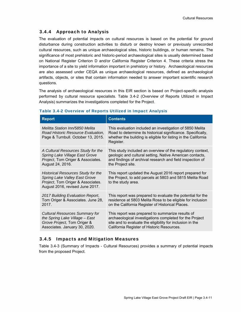
Cultural Resources
Spring Lake Village East Grove Project Draft EIR | Page 3.4-11
3.4.4 Approach to Analysis The evaluation of potential impacts on cultural resources is based on the potential for ground disturbance during construction activities to disturb or destroy known or previously unrecorded cultural resources, such as unique archaeological sites, historic buildings, or human remains. The
significance of most prehistoric and historic-period archaeological sites is usually determined based on National Register Criterion D and/or California Register Criterion 4. These criteria stress the importance of a site to yield information important in prehistory or history. Archaeological resources
are also assessed under CEQA as unique archaeological resources, defined as archaeological artifacts, objects, or sites that contain information needed to answer important scientific research questions.
The analysis of archaeological resources in this EIR section is based on Project-specific analysis performed by cultural resource specialists. Table 3.4-2 (Overview of Reports Utilized in Impact Analysis) summarizes the investigations completed for the Project.
Table 3.4-2 Overview of Reports Utilized in Impact Analysis
Report Contents
Melitta Station Inn/5850 Melita Road Historic Resource Evaluation, Page & Turnbull. October 13, 2015.
This evaluation included an investigation of 5850 Melita Road to determine its historical significance. Specifically, whether the building is eligible for listing in the California Register.
A Cultural Resources Study for the Spring Lake Village East Grove Project, Tom Origer & Associates. August 24, 2016.
This study included an overview of the regulatory context, geologic and cultural setting, Native American contacts, and findings of archival research and field inspection of the Project site.
Historical Resources Study for the Spring Lake Valley East Grove Project, Tom Origer & Associates. August 2016, revised June 2017.
This report updated the August 2016 report prepared for the Project, to add parcels at 5803 and 5815 Melita Road to the study area.
2017 Building Evaluation Report, Tom Origer & Associates. June 28, 2017.
This report was prepared to evaluate the potential for the residence at 5803 Melita Rosa to be eligible for inclusion on the California Register of Historical Places.
Cultural Resources Summary for the Spring Lake Village – East Grove Project, Tom Origer & Associates. January 30, 2020.
This report was prepared to summarize results of archaeological investigations completed for the Project site and to evaluate the eligibility for inclusion in the California Register of Historic Resources.
3.4.5 Impacts and Mitigation Measures Table 3.4-3 (Summary of Impacts - Cultural Resources) provides a summary of potential impacts from the proposed Project.

Cultural Resources
Spring Lake Village East Grove Project Draft EIR | Page 3.4-12
Table 3.4-3 Summary of Impacts – Cultural Resources
Evaluation Criteria Project Impact
CR-1: Would the project cause a substantial adverse change in the significance of a historical resource pursuant to §15064.5?
LS
CR-2: Would the project cause a substantial adverse change in the significance of an archaeological resource pursuant to §15064.5?
SUM
CR-3: Would the project disturb any human remains, including those interred outside of formal cemeteries?
SUM
C-CR-1: Would the project result in a cumulatively considerable contribution to impacts related to cultural resources?
SUM
Notes: LS = Less than Significant SUM = Significant Unavoidable with Mitigation
Impact CR-1: Would the project cause a substantial adverse change in the significance of a historical resource pursuant to §15064.5?
Analysis: Less than Significant
Impact CR-1 includes a historical evaluation of built resources (i.e. residences and other buildings) within the Project area. Please refer to Impact CR-2 for an evaluation of historic-period archaeological resources.
Residence at 5803 Melita Road
The single-family home located on the Project site at 5803 Melita Road was evaluated for listing on the California Register. The home was originally
constructed in 1950 as a single-story dwelling with a low pitched, hip roof with open eaves and composition shingles. A DPR 523 Form was prepared for the residence to evaluate whether the single-family home was eligible for listing on the CRHR.
The evaluation determined that the residence does not meet any of the criteria for inclusion in the California Register (Origer 2017b). Specifically, the structure was found to contain generic 1950s architecture that neither illustrates the
characteristics of a particular style, nor represents a transitional form between styles, and therefore isn’t considered to be associated with events that have made a significant contribution to broad patterns of local or regional history or cultural
heritage of California of the United States (Criterion 1) (Origer 2017b). Additionally, the structure was not considered an outstanding representation of 1950s architecture (Criterion 3), nor was it associated with a person of historical
importance (Criterion 2) (Origer 2017b). The structure possessed no intrinsic qualities that could answer or provide important information about our history (Criterion 4) (Origer 2017b). Therefore, demolition of the residence at 5803 Melita
Road would not impact an historic resource.
Residence at 5815 Melita Road
The single-family home located on the Project site at 5815 Melita Road was built
in 1977, approximately 42 years ago. The CRHR requires that a resource be 50 years old for listing, which is the accepted period that is considered to have provided sufficient time to pass in order to obtain a scholarly perspective on the

Cultural Resources
Spring Lake Village East Grove Project Draft EIR | Page 3.4-13
event or individuals associated with the resource and to understand the historic importance of a resource. As a rule of thumb, if a building within the geographical
scope of a survey is within five years of the 50-year threshold, then it will be cursorily reviewed by the surveyor and only included if it appears there are exceptional circumstances surrounding the resource, such as a remarkable design
or the occurrence of a notable event. The residence at 5815 Melita Road is not age-eligible for listing. Therefore, demolition of the residence at 5815 Melita Road would not impact an historic resource.
225 Los Alamos Road
Based on historical aerial photographs dating back to 1953, the Project parcel at 225 Los Alamos Road was used as a rural residential property with an established
orchard. Topographic maps show two buildings in this area as early as 1916. One building existed at the 225 Los Alamos parcel, and another building in the vicinity of 5803 and 5815 Melita Road (Origer 2017a). Neither of the two buildings
previously plotted on topographic maps are currently present at 225 Los Alamos Road. Remnants of the orchard remain present at the site today in the form of several walnut trees. Overall, the Project site is currently vacant with the exception
of an irrigation well and an accompanying enclosure located on the southern side of the property parcel. The well enclosure is composed of only remnants of the initial buildings and was determined to not have historical significance (Origer and
Associates 2017a). Removal of this structure would not impact an historic resource.
Adjacent Buildings (5850 Melita Rd / 5852 Melita Rd / 5860 Melita Rd)
The cultural resource records search determined that the Project site is located adjacent to several potential historic resources. These identified potential resources include the Melitta Station Inn located at 5850 Melita Road, and
buildings located at 5852 and 5860 Melita Road. The Project would not physically alter these properties.
Melitta Station Inn (5850 Melita Road) was constructed circa 1915 as a boarding
house in the hamlet of Melitta. The building was found to be historically associated with the development of the hamlet of Melitta, and as one of the last remaining buildings from this era. However, extensive alterations to the building and
surrounding area have removed much of the physical fabric that is representative of this significance. As such, Melitta Station Inn does not retain sufficient integrity to convey this identified historical significance and is not eligible for listing in the
CRHR (Page & Turnbull 2015). Additionally, the Project does not propose any work on or in the footprint of the building, rather Project activities would take place adjacent to the building. Implementation of the Project would not affect a historic
resource, as the Melitta Station Inn (5850 Melita Road) does not qualify as a historic resource under the California Register.
The buildings on the remaining adjacent properties, including 5852 and 5860
Melita Road, date to the early part of the 20th century. The building at 5852 is situated toward the southwest end of the parcel (away from the majority of development activities on the Project site) and faces southwest toward Melita

Cultural Resources
Spring Lake Village East Grove Project Draft EIR | Page 3.4-14
Road. This building is screened from the majority of the proposed Project by a late-20th century house and mature trees. Because the house is situated and oriented
away from the Project site, and it is screened by mature trees, it is unlikely that the Project would impact the building’s historical importance (Origer 2017a). Similarly, because the house at 5860 Melita Road is situated and oriented away from the
Project site, and is screened by mature trees, it is unlikely that the proposed Project would impact the building’s historical importance (Origer 2017a). The impact of the Project on adjacent structures would be less than significant.
Mitigation: No mitigation is needed.
Impact CR-2: Would the project cause a substantial adverse change in the significance of an archaeological resource pursuant to §15064.5?
Analysis: Significant
Based on Project-specific analysis performed by cultural resource specialists, archaeological resources that are eligible for inclusion on the California Register
of Historic Resources may be impacted by construction-related excavation and grading activities. Therefore, the Project’s construction-related impact on archeological resources would be significant.
(Please see Section 4.3.2 for a discussion of a project alternative designed to maximally avoid archeological resources.)
During operation, no ground disturbing activities would occur other than those
related to routine maintenance, such as landscaping or irrigation repair in what would be already disturbed areas. Therefore, the operational impact would be less than significant.
Mitigation: Mitigation Measure CR-2a: Protection and Treatment of Cultural Resources and Tribal Cultural Resources
The City shall ensure implementation of the following actions related to cultural
and tribal cultural resources:
Protection of Archaeological and Tribal Cultural Resources, Pre-Construction Data
Recovery, and/or Construction Monitoring
The City shall ensure that an Archaeological and Tribal Cultural Resources Treatment Plan is developed and implemented for the area outlined in the Cultural Resources Summary prepared for the Project by Tom Origer & Associates (Origer
& Associates 2020). The Treatment Plan shall be reviewed by the City, FIGR, and Lytton, and approved by the City prior to the start of Project construction. The Treatment Plan shall detail recommended steps for protecting, preserving, or data
recovery for archaeological and tribal cultural resources. The Treatment Plan shall include one or more of the following strategies to ensure that appropriate actions to protect cultural and tribal cultural resources are taken, as described in more
detail below.
1) Protection and Preservation;
2) Pre-construction data recovery; and
3) Construction Monitoring
Cultural Resources
Spring Lake Village East Grove Project Draft EIR | Page 3.4-15
Protection and Preservation
The preferred treatment of an archaeological resource is protection and
preservation. Protection can be achieved by either avoidance (not developing within the boundaries of an archaeological resource), by covering an archaeological resource with geo-fabric and sufficient fill to protect it during and
after construction, or by reducing/restricting development within the boundaries of a resource.
Pre-Construction Data Recovery
For significant resources that are not protected and preserved in place, data recovery within a sensitive area to be affected by the Project is necessary. Data recovery must be performed by qualified archaeologists using appropriate
archaeological techniques that protect the integrity of a resource and ensure that no resources are affected. Data recovery must include processing and analysis of recovered cultural materials using appropriate archaeological methods, and
preparation of the recovered materials for permanent disposition per the requirements of the Archaeological and Tribal Cultural Resources Treatment Plan.
Construction Monitoring
A program of archaeological monitoring shall be instituted for ground-disturbing activities associated with the area outlined in the Cultural Resources Summary prepared for the Project by Tom Origer & Associates (Origer & Associates 2020).
Monitoring shall be performed by a qualified archaeologist and may also include a Native American monitor and will consist of directly watching the excavation, grading, trenching, and other earth-moving processes. Monitoring shall continue
on a daily basis until the depth of excavation has been reached at which resources could not be present. This will be determined by the monitoring archaeologist based on observed soil conditions.
In the event that archaeological deposits are encountered, the piece of equipment that encounters the suspected materials must be stopped, and the find inspected by the monitoring archaeologist. If the deposit contains Historic Resources, Unique
Archaeological Resources, or Tribal Cultural Resources as defined by CEQA, all work must be stopped in the immediate vicinity and the archaeologist shall undertake data recovery of the deposit. Data recovery efforts must follow standard
archaeological methods. Work may proceed after a find has been appropriately addressed and a qualified archaeologist and tribal representative agree that no further damage would result.
Mitigation Measure CR-2b and CR-2c: Additional Avoidance Measures
The City shall ensure implementation of further avoidance measures as identified in Mitigation Measures CR-2b and CR-2c in the confidential Appendix H.
Mitigation Measure CR-2d: Protect Unanticipated Archaeological and Tribal Cultural Resources
The City shall ensure that if potential unanticipated archaeological or tribal cultural
resources are uncovered during construction, the Applicant and its contractor shall halt work, and workers shall avoid altering the materials and their context. Project
Cultural Resources
Spring Lake Village East Grove Project Draft EIR | Page 3.4-16
personnel shall not collect cultural materials, examples of which are provided in the following description. Prehistoric archaeological site indicators include:
obsidian and chert flakes and chipped stone tools; grinding and mashing implements (e.g., slabs and handstones, and mortars and pestles); bedrock outcrops and boulders with mortar cups; and locally darkened midden soils.
Midden soils may contain a combination of any of the previously listed items with the possible addition of bone and shell remains, and fire affected stones. Historic period site indicators generally include: fragments of glass, ceramic, and metal
objects; milled and split lumber; and structure and feature remains such as building foundations and discrete trash deposits (e.g., wells, privy pits, dumps).
A qualified archaeologist and representatives of FIGR and/or Lytton shall be
retained by the Applicant to investigate the find and make recommendations as to treatment and handling of those resources. If the find potentially qualifies as a historic resource, unique archaeological resource, or tribal cultural resource under
CEQA, all work must remain stopped in the immediate vicinity to allow the archaeologist and tribal representatives to evaluate any materials and recommend appropriate treatment. Avoidance of impacts to the resource are preferable. In
considering any recommended measures proposed by the archaeologist, FIGR, or Lytton, the City shall determine whether avoidance is feasible in light of factors such as the nature of the find, Project design, costs, and other considerations. If
avoidance is infeasible, other appropriate measures as recommended by the archaeologist, FIGR, or Lytton (e.g., data recovery or protection in place) shall be instituted. A buffer area around the resource would be established by a qualified
archaeologist and tribal representative to ensure that no further damage to a resource would result. Work may then proceed on other parts of the Project while mitigation for these resources is being carried out.
After Mitigation: Significant and Unavoidable with Mitigation
Implementation of Mitigation Measure CR-2a would reduce the impact to historic eligible archaeological resources by requiring the development and
implementation of an Archaeological Resource and Tribal Cultural Resource Treatment Plan, archaeological monitoring, and consultation with representatives of the FIGR and Lytton Rancheria Native American Tribes.
Implementation of Mitigation Measures CR-2b and CR-2c would further reduce the potential impact to archaeological resources by requiring further avoidance measures as identified in the confidential Appendix H.
Mitigation Measure CR-2d would further reduce the potential impact to archaeological resources by outlining procedures to be taken in the event of inadvertent discovery of archaeological or tribal cultural resources during Project
construction.
However, even with implementation of these measures, Project-related excavations and ground-disturbance may materially impair the integrity of
archaeological resources. Therefore, the impact would be significant and unavoidable, even with mitigation.

Cultural Resources
Spring Lake Village East Grove Project Draft EIR | Page 3.4-17
Impact CR-3: Would the project disturb any human remains, including those interred outside of formal cemeteries?
Analysis: Significant
No human remains have been directly observed on the Project site. However, the possibility of encountering human remains during Project construction cannot be
discounted. Therefore, the impact related to the potential disturbance of human remains during construction is considered significant.
Following construction, no ground disturbing activities are anticipated to occur
other than those related to routine maintenance of the Project, such as landscaping or irrigation repair. Therefore, it is unlikely any human remains would be encountered during operation. The operational impact would be less than
significant.
Mitigation: Mitigation Measures CR-2b and CR-2c: Additional Avoidance Measures
The City shall ensure implementation of avoidance measures as identified in
Mitigation Measures CR-2b and CR-2c in the confidential Appendix H.
Mitigation Measure CR-3: Treatment of Human Remains, Associated Grave Goods, or Items of Cultural Patrimony
Should human remains, associated grave goods, or items of cultural patrimony be encountered during Project construction, the following procedures shall be followed as required by Public Resources Code Section 5097.9 and Health and
Safety Code Section 7050.5.
If human remains are encountered, no further excavation or disturbance of the site or any nearby area shall occur until the Sonoma County Coroner has made the
necessary findings as to origin, in accordance with Health and Safety Code 7050.5. In accordance with Public Resources Code 5097.98 if the coroner believes the human remains to be those of a Native American, he or she shall contact, by
telephone, within 24 hours, the Native American Heritage Commission. The Native American Heritage Commission shall immediately notify the Most Likely Descendent (MLD) or Descendants. The Descendent shall inspect the site of the
discovery and may recommend the means for treating or disposing, with appropriate dignity, the human remains and any associated grave goods. The Descendants shall complete their inspection and make their recommendation
within 48 hours of their notification by the Native American Heritage Commission. The remains shall not be damaged or disturbed by further development until the landowner has discussed and conferred with the MLD regarding their
recommendations.
After Mitigation: Significant and Unavoidable with Mitigation
Implementation of Mitigation Measures CR-2b and CR-2c would reduce the
potential impact by requiring avoidance measures as identified in the confidential Appendix H. Mitigation Measure CR-3 would further minimize the potential impact to human remains by requiring the contractor to notify the MLD and avoid the area
if human remains are encountered, and to follow procedures outlined in Public Resources Code § 5097.9 and Health and Safety Code § 7050.5. However, even
Cultural Resources
Spring Lake Village East Grove Project Draft EIR | Page 3.4-18
with implementation of these measures, it is possible that Project-related excavations and ground-disturbance may disturb human remains or items of
cultural patrimony. Therefore, the impact would be significant and unavoidable, even with mitigation.
Impact C-CR-1: Would the project result in a cumulatively considerable contribution to
impacts related to cultural resources?
Analysis: Significant
The geographic boundary for cumulative impacts related to cultural resources
would be the range of tribe(s) culturally affiliated with the Project site and the locality of cultural resources within the Project area. Implementation of the cumulative projects listed in Table 3-1 (Projects Considered for Cumulative
Impacts) may require grading and excavation that could potentially affect cultural resources, human remains, or modify or otherwise impact historic buildings/structures. Construction activities associated with cumulative projects
would be subject to existing federal, state, local regulations, and policies for Project design and approval. CEQA requirements for protecting cultural resources and human remains would be applicable to each of the cumulative projects. The
existing federal, state and local regulations, design policies and CEQA requirements would generally reduce potential impacts to cultural resources from implementation of cumulative projects to a less-than-significant level. However, as
discussed above under the Project impact analysis, the Project may potentially impact cultural resources. The Project’s contribution to the potential cumulative impact would be cumulatively considerable, and therefore significant.
Mitigation: Mitigation Measure CR-2a: Protection and Treatment of Cultural Resources and Tribal Cultural Resources
Mitigation Measure CR-2b and CR-2c: Additional Avoidance Measures
Mitigation Measure CR-2d: Protect Unanticipated Archaeological and Tribal Cultural Resources
Mitigation Measure CR-3: Treatment of Human Remains, Associated Grave
Goods, or Items of Cultural Patrimony
Please refer to Impacts CR-2 and CR-3 for the description of Mitigation Measures CR-2a through CR-3.
After Mitigation: Significant and Unavoidable with Mitigation
As noted under Impact CR-2 and Impact CR-3, implementation of Mitigation Measures CR-2a through CR-3 would reduce the impact to cultural resources,
however, even with implementation of these measures, Project-related excavations and ground-disturbance may materially impair the integrity of cultural resources. The Project’s contribution to the cumulative impact would therefore be
significant and unavoidable, even with mitigation.

Cultural Resources
Spring Lake Village East Grove Project Draft EIR | Page 3.4-19
3.4.6 References Page & Turnbull. 2015. Melitta Station Inn/5850 Melita Road Historic Resource Evaluation.
Tom Origer & Associates. 2016. A Cultural Resources Study for the Spring Lake Village East Grove Project, Santa Rosa, Sonoma County, California. Report by J. Franco and E. Barrow. August.
Tom Origer & Associates. 2017a. Historical Resources Study for the Spring Lake Village East Grove Project Santa Rosa, Sonoma County, California. Report by J. Franco and E. Barrow. June.
Tom Origer & Associates. 2017b. 2017 Building Evaluation Report (5803 Melita Road).
Tom Origer & Associates. 2020b. Cultural Resources Summary for the Spring Lake Village – East Grove Project located at 225 Los Alamos Road and 5803 and 5815 Melita Road Santa Rosa, Sonoma County, California. January.
Geology and Soils
Spring Lake Village East Grove Project Draft EIR | Page 3.5-1
3.5 Geology and Soils This section evaluates potential environmental impacts related to geology and soils during construction and operation of the Project. In addition to the analysis provided in this section, the following subjects are related to geology and soils, but are evaluated in other sections of this EIR:
Potential hazards from naturally-occurring asbestos in soils are evaluated in Section 3.7 (Hazards and Hazardous Materials)
Potential impacts to water quality due to erosion, runoff, or alteration of drainage patterns are evaluated in Section 3.8 (Hydrology and Water Quality)
3.5.1 Setting
Regional and Local Geology Santa Rosa lies within the northeastern potion of the Cotati valley found along the Santa Rosa Plain and also includes part of the Sonoma Mountains to the east. The City is situated at the confluence of the Matanzas Creek and Santa Rosa Creek, both of which originate from the Sonoma Mountains to the east. Eastern valleys such as Rincon Valley are considered low intervening valleys at 200 to 300 feet above mean sea level with gentle slopes ranging from 0 to 15 percent. In general, Santa Rosa is underlain by volcanic deposits known as the Sonoma Volcanics, sedimentary rocks known as the Petaluma Formation, and alluvial deposits (Santa Rosa 2009). Published geologic maps indicate that the Project site is predominantly underlain by Holocene and Pleistocene alluvial deposits. The northeastern portion of the property is underlain by Pliocene fluvial and lacustrine deposits. Surface soils on the Project site are underlain by medium dense to very dense sand and gravel with varying amounts of clay, with occasional layers of clay with varying amounts of sand and gravel (RGH 2015).
Liquefaction Liquefaction occurs when loosely packed sandy or silty materials saturated with water are shaken hard enough to lose strength and stiffness. Liquefied soils behave like a liquid and are responsible for tremendous damage in an earthquake, causing pipes to leak, roads and airport runways to buckle, and building foundations to be damaged. Such liquefaction has been responsible for ground failures during almost all of California’s great earthquakes. The risk of liquefaction depends on many factors, including the height of the groundwater table and the composition of the underlying soil.
Liquefaction susceptibility is typically defined on a scale ranging from very low to very high based on the factors identified above. Most of Santa Rosa is at medium, low, or very low risk of liquefaction impacts in a seismic event. Soil samples collected from on-site geotechnical borings indicate the presence of layers with moderate potential for liquefaction on the Project site (RGH 2015). The area surrounding Santa Rosa Creek extending east to west across the City is at a high risk for liquefaction because of the presence of shallow groundwater in this area.
Landslides Landslides result when soils on a hillside become unstable and slide down toward the base of the hill. They can occur very quickly or may unfold slowly over a period of days, weeks, months, or years. Landslides can damage or destroy any structures built on or in (e.g., pipelines) the moving soil, and the flow of material can cause further damage to any structure in its path. Landslide risk depends on the types of earth materials of the hillside and the steepness of the slope. There are multiple types of landslides and they can be triggered by a number of different events, but the two most common forms

Geology and Soils
Spring Lake Village East Grove Project Draft EIR | Page 3.5-2
are earthquake-induced landslides and moisture-induced (rain, flooding, irrigation) landslides. Earthquake-induced landslides can happen when the ground shaking makes the soil looser (sometimes as a result of liquefaction) or when rocks in the slope fracture, creating unstable conditions. Moisture-induced landslides can occur when the ground soaks up enough water to cause it to weaken and become unstable.
Landslide prone areas in the City can generally be broken down into two categories, with “mostly landslides” indicating slopes that are mostly susceptible to the hazard, and “many” landslides demonstrating a slightly lower susceptibility. Most of Santa Rosa lies on flat land with little to no risk of landslides. The steeper slopes with a higher risk of landslides are generally in the northeastern part of the City. The nearest area with high landslide potential is approximately 0.05 mile south of the Project site within Annadel State Park (USGS 1997).
Seismicity and Faulting The closest fault to the Project site is the Healdsburg-Rodgers Creek fault. In addition, as shown in Table 3.5-1 (Active Faults Near the Project Area), several other active faults in the region are also active and capable of causing significant ground shaking in Santa Rosa.
The Working Group on California Earthquake Probabilities has evaluated the probability of one or more earthquakes of magnitude 6.7 or higher occurring in California over the next 30 years. The result of the evaluation indicated a 72 percent likelihood that such an earthquake event will occur in the San Francisco region by the year 2038 (WGCEP 2015). The site will therefore be subject to seismic shaking from moderate to severe earthquakes in the future. The design life of the Project can expect periodic slight to moderate earthquakes. However, the site is not located on any published Fault Zones based on the Alquist-Priolo Earthquake Fault Zoning Act, and no active faults have been mapped on or projected toward the site (RGH 2015).
Table 3.5-1 Active Faults Near the Project Area Fault Distance and Direction from the Project
Healdsburg-Rodgers Creek 3 miles southwest
Maacama 10 miles north-northwest
West Napa 16 miles east-southeast
San Andreas 23 miles southwest
Concord-Green Valley 26 miles east-southeast Source: RGH 2015
Fault Rupture Fault rupture is the actual movement and displacement of the ground’s surface along the fault boundary when an earthquake occurs. Depending on the type of fault, this displacement may be horizontal, vertical, or both. Damage from fault rupture can be severe depending on the size of the displacement, but is limited to the relatively small area along the fault boundary where the slip occurred. Not all earthquakes result in fault rupture that is visible at the surface, and strong earthquakes can occur without any discernible displacement along the boundary. However, the Project site is not located within an Alquist-Priolo fault rupture zone (RGH 2015, Santa Rosa 2009).
Geology and Soils
Spring Lake Village East Grove Project Draft EIR | Page 3.5-3
Ground Shaking Ground shaking is the primary cause of damage and injury during earthquakes. Ground-shaking impacts can lead to surface rupture, liquefaction, landslides, and infrastructure failures, which could lead to fires and other secondary hazards. The geology of the impacted area alters the amount of ground shaking felt. Thick, water-saturated, unconsolidated materials will generally experience greater shaking motion than areas of firm bedrock.
The size and magnitude of an earthquake have different ways of being measured. The magnitude is a number that characterizes the relative size of an earthquake. Magnitude is based on measurement of the maximum motion recorded by a seismograph. Many scales, such as the Richter scale, do not provide accurate estimates for the magnitudes of large earthquakes. To account for these large earthquakes, the moment magnitude scale (abbreviated as MMS; denoted as MW or M) is preferred for its ability to cover a wide range of earthquake sizes and be applied globally. The moment magnitude scale is based on the total moment release of the earthquake. Moment magnitude is a product of the distance a fault moved and the force required to move it. It is derived from modeling recordings of the earthquake at multiple stations.
Paleontological Setting Paleontological resources are the fossilized remains of plants and animals, including vertebrates (animals with backbones), invertebrates (e.g., starfish, clams, ammonites and marine coral) and fossils of microscopic plants and animals (microfossils). The age and abundance of fossils depend on the location, topographic setting and particular geologic formation in which they are found. The University of California has a number of highly sensitive Pleistocene era vertebrate finds recorded within Sonoma County, two of which are within a few miles of the Project site. The Project site is situated on ground surface that is primarily composed of undivided Holocene-Pleistocene alluvium with a narrow segment of Holocene channel. Additionally, the presence of streams in the vicinity of the Project site indicates that it is located within an alluvial floodplain capable of accumulating terrestrial fossils. (Finger 2016).
3.5.2 Regulatory Framework
Federal There are no federal plans, policies, regulations, or laws related to geology and soils applicable to the Proposed Project.
State
Alquist-Priolo Earthquake Fault Zoning Act The Alquist-Priolo Earthquake Fault Zoning Act was passed in 1972 to mitigate the hazard of surface faulting to structures for human occupancy. In accordance with this act, the State Geologist established regulatory zones, called “earthquake fault zones,” around the surface traces of active faults and published maps showing these zones. Within these zones, buildings for human occupancy cannot be constructed across the surface trace of active faults. Because many active faults are complex and consist of more than one branch, each earthquake fault zone extends approximately 200 to 500 feet on either side of the mapped fault trace. Title 14 of the California Code of Regulations (CCR), Section 3601(e), defines buildings intended for human occupancy as those that would be inhabited for more than 2,000 hours per year. The proposed Project area does not cross an Alquist-

Geology and Soils
Spring Lake Village East Grove Project Draft EIR | Page 3.5-4
Priolo Earthquake Fault Zone (CDC 2020). Therefore, the provisions of the act do not apply to the Project.
Seismic Hazards Mapping Act Like the Alquist-Priolo Act, the Seismic Hazards Mapping Act of 1990 (Public Resources Code [PRC] Sections 2690 to 2699.6) is intended to reduce damage resulting from earthquakes. While the Alquist-Priolo Act addresses surface fault rupture, the Seismic Hazards Mapping Act addresses other earthquake-related hazards, including strong groundshaking, liquefaction and seismically induced landslides. Its provisions are similar in concept to those of the Alquist-Priolo Act, where the State is charged with identifying and mapping areas at risk of strong groundshaking, liquefaction, landslides, and other corollary hazards, with cities and counties required to regulate development within mapped Seismic Hazard Zones. Under the California Seismic Hazards Mapping Act, permit review is the primary mechanism for local regulation of development. Specifically, cities and counties are prohibited from issuing development permits for sites within Seismic Hazard Zones until appropriate site-specific geologic and/or geotechnical investigations have been conducted and measures to reduce potential damage have been incorporated into the development plans. The California Geological Survey has not yet evaluated the Project site or surrounding area under the Seismic Hazards Mapping Act.
California Building Code The California Building Code (CBC), which is codified in CCR Title 24, Part 2, was promulgated to safeguard the public health, safety, and general welfare by establishing minimum standards related to structural strength, egress facilities, and general building stability. The purpose of the CBC is to regulate and control the design, construction, quality of materials, use/occupancy, location, and maintenance of all building and structures within its jurisdiction. Title 24 is administered by the California Building Standards Commission, which, by law, is responsible for coordinating all building standards.
Santa Rosa NPDES Storm Water Permit and Low Impact Development Technical Design Manual The City of Santa Rosa’s current NPDES storm water permit regulates both storm water and non-storm water discharges from public and private projects into the Santa Rosa municipal storm drain system. The permit requires a minimum set of best management practices (BMPs) to be implemented at all construction sites, as well as permanent storm water Low Impact Development (LID) BMPs in accordance with the City’s Storm Water Low Impact Development Technical Design Manual (Storm Water LID Manual) (Santa Rosa 2017).
California Public Resources Code (PRC) Section 5097.5 of the PRC protects vertebrate paleontological resources located on public land. Under Section 5097.5, no person shall knowingly and willfully excavate upon, or remove, destroy, injure, or deface, any historic or prehistoric ruins, burial grounds, archaeological or vertebrate paleontological site (including fossilized footprints), inscriptions made by human agency, rock art, or any other archaeological, paleontological, or historical feature situated on public lands, except with the express permission of the public agency that has jurisdiction over the lands.
Geology and Soils
Spring Lake Village East Grove Project Draft EIR | Page 3.5-5
Regional and Local
Local Hazards Mitigation Plan Santa Rosa’s Local Hazard Mitigation Plan (Santa Rosa 2016) provides the City’s framework to mitigate local risks to natural hazards and plan for a resilient future. The Plan provides a set of strategies to reduce vulnerability to disaster through education and outreach programs, the development of partnerships, and implementation of actions to reduce the of impacts from a disaster.
City of Santa Rosa General Plan The following goals and policies from the City of Santa Rosa General Plan 2035 are generally related geology and soils and are applicable to the Project.
NS-C Prohibit development in high-risk geologic and seismic hazard areas to avoid exposure to seismic and geologic hazards.
NS-C-1 Prior to development approval, require appropriate geologic studies to identify fault trace locations within active fault zones as designated by the provisions of the Alquist-Priolo Earthquake Fault Zoning Act. California registered geologists or engineers must conduct these studies and investigation methodologies must comply with guidelines set forth by the Alquist-Priolo Earthquake Fault Zoning Act.
NS-C-2 Require comprehensive geotechnical investigations prior to development approval, where applicable. Investigations shall include evaluation of landslide risk, liquefaction potential, settlement, seismically-induced landsliding, or weak and expansive soils. Evaluation and mitigation of seismic hazards, including ground shaking, liquefaction, and seismically-induced landslides, shall comply with guidelines set forth in the most recent version of the California Division of Mines and Geology (CDMG) Special Publication 117.
NS-C-3 Restrict development from areas where people might be adversely affected by known natural or manmade geologic hazards. Hazards might include unstable slopes, liquefiable soils, expansive soils or weak poorly engineered fills, as determined by a California registered geologist or engineer.
NS-C-8 Adopt mandatory, minimum erosion control measures for current properties and those under construction that exhibit high erosion potential, are in areas of steep slopes, or have experienced past erosion problems. Control measures shall reduce soil erosion from primary erosional agents, including wind, construction operations, and storm water runoff.
3.5.3 Evaluation Criteria and Significance Thresholds For the purpose of this EIR, the evaluation criteria and significance thresholds summarized in Table 3.5-3 (Evaluation Criteria and Significance Thresholds) are used to determine if the Project would have a significant effect related to geology and soils.

Geology and Soils
Spring Lake Village East Grove Project Draft EIR | Page 3.5-6
Table 3.5-3 Evaluation Criteria and Significance Thresholds
Evaluation Criteria Significance Thresholds Sources
GEO-1: Would the project cause risk of loss, injury, or death involving rupture of a known earthquake fault, as delineated on the most recent Alquist-Priolo Earthquake Fault Zoning Map issued by the State Geologist for the area or based on other substantial evidence of a known fault?
Placement of a structure intended for human occupancy within an Alquist-Priolo earthquake fault zone
CEQA Guidelines Appendix G, Checklist Item VII (a.i) General Plan policy NS-C-1
GEO-2: Would the project cause risk of loss, injury, or death involving strong seismic ground shaking?
Non-compliance with California Building Code Non-compliance with recommendations of project-specific geotechnical reports
CEQA Guidelines Appendix G, Checklist Item VII (a.ii) General Plan policy NS-C-2 California Building Code (CCR Title 24)
GEO-3: Would the project cause risk of loss, injury, or death involving seismic related ground failure, including liquefaction?
Non-compliance with recommendations of project-specific geotechnical reports
CEQA Guidelines Appendix G, Checklist Item VII (a.iii) General Plan policy NS-C-2 California Building Code (CCR Title 24)
GEO-4: Would the project cause risk of loss, injury, or death involving landslides?
Non-compliance with recommendations of project-specific geotechnical reports
CEQA Guidelines Appendix G, Checklist Item VII (a.iv) General Plan policy NS-C-2 California Building Code (CCR Title 24)
GEO-5: Would the project result in substantial soil erosion or the loss of topsoil?
Non-compliance with applicable erosion and sediment control measures in Santa Rosa’s NPDES stormwater discharge permit.
CEQA Guidelines Appendix G, Checklist Item VII (b) Order No. R1-2015-0030 General Plan policy NS-C-8

Geology and Soils
Spring Lake Village East Grove Project Draft EIR | Page 3.5-7
Evaluation Criteria Significance Thresholds Sources
GEO-6: Would the project be located on a geologic unit or soil that is unstable or expansive, or that would become unstable as a result of the project, and potentially result in on or off-site landslide, lateral spreading, subsidence, liquefaction or collapse?
Placement of structures on weak or unstable soils with moderate to high potential for liquefaction, lateral spreading, settlement, or expansion Non-compliance with recommendations of project-specific geotechnical reports
CEQA Guidelines Appendix G, Checklist Item VII (c) (d) General Plan policy NS-C-2 and NS-C-3 California Building Code (CCR Title 24)
GEO-7: Would the project have soils incapable of adequately supporting the use of septic tanks or alternative wastewater disposal systems where sewers are not available for the disposal of wastewater?
Installation of septic systems or wastewater disposal systems in unsuitable soils
CEQA Guidelines Appendix G, Checklist Item VII (e)
GEO-8: Would the project directly or indirectly destroy a unique paleontological resource or site or unique geologic feature?
Disturbance of a known fossil locality or located within a geologic unit that has high paleontological sensitivity
CEQA Guidelines Appendix G, Checklist Item VII (f)
3.5.4 Approach to Analysis A Geotechnical Study Report for the Project site was completed by RGH Consultants on January 6, 2015 (RGH 2015) (see Appendix D). The findings of the geotechnical study are utilized to evaluate the seismic and geologic hazards that may affect the proposed Project. The evaluation of potential impacts on paleontological resources is based on the potential for ground disturbance during construction activities to disturb or destroy known or previously unrecorded resources. Paleontological resources were assessed based on review of site-specific geologic mapping and a records search of the University of California Museum of Paleontology database.
3.5.5 Impacts and Mitigation Measures Table 3.5-4 (Summary of Impacts - Geology and Soils) provides a summary of potential impacts from the Proposed Project.
Table 3.5-4 Summary of Impacts – Geology and Soils
Evaluation Criteria Project Impact
GEO-1: Would the project cause risk of loss, injury, or death involving rupture of a known earthquake fault, as delineated on the most recent Alquist-Priolo Earthquake Fault Zoning Map issued by the State Geologist for the area or based on other substantial evidence of a known fault?
NI
GEO-2: Would the project cause risk of loss, injury, or death involving strong seismic ground shaking?
LS
GEO-3: Would the project cause risk of loss, injury, or death involving seismic related ground failure, including liquefaction?
LS
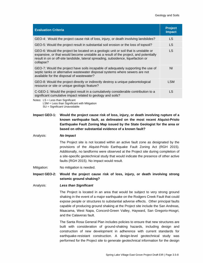
Geology and Soils
Spring Lake Village East Grove Project Draft EIR | Page 3.5-8
Evaluation Criteria Project Impact
GEO-4: Would the project cause risk of loss, injury, or death involving landslides? LS
GEO-5: Would the project result in substantial soil erosion or the loss of topsoil? LS
GEO-6: Would the project be located on a geologic unit or soil that is unstable or expansive, or that would become unstable as a result of the project, and potentially result in on or off-site landslide, lateral spreading, subsidence, liquefaction or collapse?
LS
GEO-7: Would the project have soils incapable of adequately supporting the use of septic tanks or alternative wastewater disposal systems where sewers are not available for the disposal of wastewater?
NI
GEO-8: Would the project directly or indirectly destroy a unique paleontological resource or site or unique geologic feature?
LSM
C-GEO-1: Would the project result in a cumulatively considerable contribution to a significant cumulative impact related to geology and soils?
LS
Notes: LS = Less than Significant LSM = Less than Significant with Mitigation SU = Significant Unavoidable
Impact GEO-1: Would the project cause risk of loss, injury, or death involving rupture of a known earthquake fault, as delineated on the most recent Alquist-Priolo Earthquake Fault Zoning Map issued by the State Geologist for the area or based on other substantial evidence of a known fault?
Analysis: No Impact
The Project site is not located within an active fault zone as designated by the provisions of the Alquist-Priolo Earthquake Fault Zoning Act (RGH 2015). Additionally, no landforms were observed at the Project site during completion of a site-specific geotechnical study that would indicate the presence of other active faults (RGH 2015). No impact would result.
Mitigation: No mitigation is needed.
Impact GEO-2: Would the project cause risk of loss, injury, or death involving strong seismic ground shaking?
Analysis: Less than Significant
The Project is located in an area that would be subject to very strong ground shaking in the event of a major earthquake on the Rodgers Creek Fault that could expose people or structures to substantial adverse effects. Other principal faults capable of producing ground shaking at the Project site include the San Andreas, Maacama, West Napa, Concord-Green Valley, Hayward, San Gregorio-Hosgri, and the Calaveras fault.
The Santa Rosa General Plan includes policies to ensure that new structures are built with consideration of ground-shaking hazards, including design and construction of new development in adherence with current standards for earthquake-resistant construction. A design-level geotechnical study was performed for the Project site to generate geotechnical information for the design
Geology and Soils
Spring Lake Village East Grove Project Draft EIR | Page 3.5-9
and construction (RGH 2015). The geotechnical study includes an evaluation of seismic hazards related to ground shaking. The peak ground acceleration (PGA) for the Project site is 0.68g (RGH 2015). The geotechnical study identifies the appropriate 20131 California Building Code seismic design criteria to be used for structures at the Project site. The study also identifies appropriate foundation supports to be used, including spread footings, post-tension slabs, retaining walls, and slab-on-grade designs.
As summarized in EIR Section 2.5 (Environmental Protection Actions Incorporated into the Project), implementation of Environmental Protection Action 1 is included as part of the Project. Project Measure 1 requires the Project to be designed and constructed in conformance with site-specific recommendations contained in geotechnical studies completed for the Project and any subsequent related geotechnical reports for the Project. Because the Project would be constructed in accordance with the California Building Code and with Project-specific recommendations contained in design-level geotechnical studies, the potential impact related to strong seismic ground shaking would be less than significant.
Mitigation: No mitigation is needed.
Impact GEO-3: Would the project cause risk of loss, injury, or death involving seismic related ground failure, including liquefaction?
Analysis: Less than Significant
A geotechnical study performed for the Project site identified layers of soil that exhibit moderate potential for liquefaction. The majority of the soils that exhibited the potential for liquefaction were identified between one and three feet below the ground surface. A deeper layer of soil that exhibited the potential for liquefaction was encountered in one boring at a depth of 9 to 12 feet below the ground surface. (RGH 2015).
Based on the presence of liquefiable soils at the Project site, the geotechnical study evaluated the potential for bearing capacity failure, lateral spreading and settlement to occur. Bearing capacity failure is the sudden and extreme settlement of foundations that typically occurs when the liquefied layer is relatively close (typically within two times the footing width, depending on the loads) to the bottom of the foundation. The geotechnical study determined that with remedial grading2 in accordance with its recommendations, the potential for bearing capacity failure would be low.
Lateral spreading occurs where continuous layers of liquefiable soil extend to a free face, such as a creek bank. The geotechnical report concluded that while liquefiable layers are present on the site, they are discontinuous. Therefore, the potential for liquefaction-induced lateral spreading at the Project site is anticipated to be low (RGH 2015).
1 The 2016 California Building Code became effective on January 1, 2017, replacing the 2013 standards. Seismic
design criteria identified in the geotechnical report prepared for the project remain applicable as those criteria were not altered by the new standards.
2 Remedial grading, as defined in the project geotechnical report, is the replacement of weak soils with properly compacted (engineered) fill (RGH 2015).

Geology and Soils
Spring Lake Village East Grove Project Draft EIR | Page 3.5-10
The geotechnical engineers who reviewed the Project site used an industry standard method for determining soil characteristics called a Standard Penetration Test. Using the data from this test; they projected that the potential total and differential settlement due to densification of the liquefied soils found on-site is up to 0.43 inches.
As summarized in EIR Section 2.5 (Environmental Protection Actions Incorporated into the Project), implementation of Environmental Protection Action 1 is included as part of the Project. Project Measure 1 requires the Project to be designed and constructed in conformance with site-specific recommendations contained in geotechnical studies completed for the Project and any subsequent related geotechnical reports. This would include design in accordance with recommendations for grading and foundation support and the use of select engineered fill to address liquefiable soils. Because the Project would be constructed in accordance with project-specific recommendations contained in design-level geotechnical studies, the potential impact related to seismic-related ground failure, including liquefaction, would be less than significant.
Mitigation: No mitigation is needed.
Impact GEO-4: Would the project cause risk of loss, injury, or death involving landslides?
Analysis: Less than Significant
Published landslide maps do not indicate large-scale slope instability at the Project site. Additionally, no active landslides were observed at the Project site during completion of site-specific geotechnical study field activities (RGH 2015). Retaining walls would be constructed as part of the Project to provide stability to hillside slopes along the north side of the Project site adjacent to Highway 12. The landslide-related impact would be less than significant.
Mitigation: No mitigation is needed.
Impact GEO-5: Would the project result in substantial soil erosion or the loss of topsoil?
Analysis: Less than Significant
During construction, the upper few inches of topsoil containing organic matter more than two percent by weight would be removed in areas of the Project site that require grading. The removed topsoil would either be removed from the site, or if suitable, stockpiled for re-use as topsoil in landscaped areas. As summarized in EIR Section 2.5 (Environmental Protection Actions Incorporated into the Project), implementation of Environmental Protection Action 4 is included as part of the Project. Project Measure 4 requires the Project to include development and implementation of a Storm Water Pollution Prevention Plan that would comply with applicable erosion and sediment control measures contained in the City of Santa Rosa municipal storm water permit and the State Water Board’s Construction General Permit. Both the City and State permits require the implementation of erosion control measures in order to prevent soil erosion and the resulting sedimentation or other pollution of nearby bodies of water. Because the Project would preserve topsoil on site, if suitable, and would implement applicable erosion

Geology and Soils
Spring Lake Village East Grove Project Draft EIR | Page 3.5-11
and sediment control measures during construction, the potential impact related to soil erosion or the loss of topsoil would be less than significant.
Mitigation: No mitigation is needed.
Impact GEO-6: Would the project be located on a geologic unit or soil that is unstable or expansive, or that would become unstable as a result of the project, and potentially result in on or off-site landslide, lateral spreading, subsidence, liquefaction or collapse?
Analysis: Less than Significant
A geotechnical study performed for the Project site identified 2 to 3 feet of weak, porous, compressible, clayey soils on portions of the site. The soils exhibited medium to high plasticity and moderate to very high expansion potential. The surface materials are underlain by medium dense to very dense sand and gravel with varying amounts of clay with occasional layers of clay with varying amounts of sand and gravel (RGH 2015). Weak, porous surface soils, such as those found at the site, appear hard and strong when dry but will lose strength rapidly and settle under the load of fills, foundations, slabs, and pavements as their moisture content increases and approaches saturation. The moisture content of these soils can increase as the result of rainfall, periodic irrigation, or when the natural upward migration of water vapor through the soils is impeded by, and condenses under fills, foundations, slabs, and pavements. In addition, expansive surface soils shrink and swell as they lose and gain moisture throughout the yearly weather cycle, which can result in heaving and cracking of lightly loaded shallow foundations, slabs, and pavements.
The geotechnical study determined that the detrimental effects of soil movements, such as those described in the previous paragraph, can be reduced by strengthening the soils during grading and by excavating the weak soils and replacing them with properly compacted (engineered) fill. Alternatively, satisfactory foundation support can be obtained by extending the foundation depths to more firm soils below the weak surface soils. The geotechnical study recommended both of these strategies for overcoming the weak soils found at the site.
The geotechnical study determined that the detrimental effects of the expansive soils can be reduced by pre-swelling such soils and covering them with a moisture fixing and confining blanket of properly compacted select fill. The study determined that to effectively reduce foundation and slab heave, given the expansion potential of the site’s soils, a blanket thickness of 30 inches would be needed. In exterior slab and paved areas, the select fill blanket would need to be 12 inches thick. Alternatively, the structures can be founded on post-tensioned slabs-on-grade.
As summarized in EIR Section 2.5 (Environmental Protection Actions Incorporated into the Project), implementation of Environmental Protection Action 1 is included as part of the Project. Project Measure 1 requires the Project to be designed and constructed in conformance with site-specific recommendations contained in geotechnical studies completed for the Project and any subsequent related geotechnical reports. Because the Project would be constructed in accordance with the specific recommendations contained in the geotechnical studies, the
Geology and Soils
Spring Lake Village East Grove Project Draft EIR | Page 3.5-12
potential impact related to expansive or unstable soils would be less than significant.
Mitigation: No mitigation is needed.
Impact GEO-7: Would the project have soils incapable of adequately supporting the use of septic tanks or alternative wastewater disposal systems where sewers are not available for the disposal of wastewater?
Analysis: No Impact
Wastewater from the Project would be conveyed through Santa Rosa’s wastewater collection system to the Santa Rosa Laguna Treatment Plant. The Project would not involve the construction or use of septic systems or an alternative wastewater disposal system. Therefore, no impact would result.
Mitigation: No mitigation is needed.
Impact GEO-8: Would the project directly or indirectly destroy a unique paleontological resource or site or unique geologic feature?
Analysis: Significant
A records search of the University of California Museum of Paleontology database was conducted to determine the Project site’s paleontological setting and potential for significant impact of paleontological resources. The site is situated on ground surface that is primarily composed of undivided Holocene-Pleistocene alluvium with a narrow segment of Holocene channel. To the south, in Annadel State Park, there is a unit of volcano-sedimentary rock that has the potential to preserve fossils. Additionally, the presence of streams in the vicinity of the Project site indicates that it is located within an alluvial floodplain capable of accumulating terrestrial fossils.
The University of California has a number of highly sensitive Pleistocene era vertebrate finds recorded within Sonoma County, two of which are within a few miles of the Project site. Deposit frequency of paleontological resources within Pleistocene alluvium is generally unpredictable, therefore making it difficult to determine the potential for sensitive paleontological resources to be found during the construction activities. Therefore, implementation of the Project is considered to have the potential to uncover unknown paleontological resources. This is considered a significant impact.
During operation, no ground disturbing activities would occur under the Project. Therefore, it is unlikely that the Project would impact paleontological resources. The operational impact would be less than significant.
Mitigation: Mitigation Measure GEO-8: Protect Paleontological Resources if Encountered during Construction
A qualified paleontologist shall be contracted to periodically inspect any ground disturbances that are part of construction activities including but not limited to excavations. The construction contractor shall stop all ground disturbing activities should any vertebrate fossils be encountered during construction. All ground disturbing activities within 50 feet of the find shall be temporarily halted, and a

Geology and Soils
Spring Lake Village East Grove Project Draft EIR | Page 3.5-13
qualified paleontologist shall be notified to document the discovery as needed, to evaluate the potential resource, and to assess the nature and significance of the find. Based on the scientific value or uniqueness of the find, the paleontologist may record the find and allow work to continue, or recommend salvage and recovery of the material, if it is determined that the find cannot be avoided. The paleontologist shall make recommendations for any necessary treatment that is consistent with currently accepted scientific practices. Any fossils collected from the area shall then be deposited in an accredited and permanent scientific institution where they will be properly curated and preserved.
After Mitigation: Less than Significant with Mitigation
Mitigation Measure GEO-8 provides the construction contractor with the resources to identify and evaluate all potential paleontological resources that may be encountered during construction to prevent their direct or indirect destruction. Therefore, the Project would result in a less than significant impact.
Impact C-GEO-1: Would the project result in a cumulatively considerable contribution to a significant cumulative impact related to geology and soils?
Analysis: Less than Cumulatively Considerable (Less than Significant)
The nature of geologic hazards is site-specific, and, therefore, geologic hazards do not generally accumulate as cumulative impacts. With compliance with State and local regulations and policies, construction would be consistent with current building standards for seismic and geologic hazards. Because these regulations are designed to protect the community at large, no significant cumulative impact would result.
Implementation of cumulative projects within the City of Santa Rosa may require grading and excavation that could potentially affect paleontological resources. If these resources are not protected, the cumulative effect of these projects would contribute to the continued loss of such resources. CEQA requirements for protecting paleontological resources are applicable to development throughout the City and State. As described above, a mitigation measure is provided for the Project that would reduce impacts on paleontological resources to a less-than-significant level. With implementation of the mitigation measure, the Project contribution to a cumulative impact would not be cumulatively considerable, and therefore less than significant.
Mitigation: No mitigation is needed.
3.5.6 References American Society of Civil Engineers. 2010. Minimum Design Loads for Buildings and Other
Structures. ASCE Standard ASCE/SEI 7-10.
California Department of Conservation (CDC). 1983. Special Studies Zones; Santa Rosa Quadrangle. July 1.
Field, E.H., and 2014 Working Group on California Earthquake Probabilities (WGCEP). 2015. UCERF3: A new earthquake forecast for California’s complex fault system: U.S. Geological Survey 2015–3009. March 9.

Geology and Soils
Spring Lake Village East Grove Project Draft EIR | Page 3.5-14
Finger, Kenneth L. 2016. Paleontological Records Search for Spring Lake Village East Grove Project. October 26.
RGH Consultants. 2015. Geotechnical Study Report, Spring Lake Village East Grove. January 6.
Santa Rosa, City of. 2009. Santa Rosa General Plan 2035. November 3.
Santa Rosa, City of. 2016. City of Santa Rosa Local Hazard Mitigation Plan. October.
Santa Rosa, City of. 2017. City of Santa Rosa 2017 Storm Water Technical Design Manual.
USGS. 1997. Summary Distribution of Slides and Earth Flows in Sonoma County, California.
USGS. 2016. Website searched on Sep 22, 2016. http://earthquake.usgs.gov/learn/topics/mag_vs_int.php

Greenhouse Gas and Energy
Spring Lake Village East Grove Project Draft EIR | Page 3.6-1
3.6 Greenhouse Gas and Energy This section evaluates potential environmental impacts related to greenhouse gas (GHG) emissions and energy consumption during construction and operation of the Project. In addition to the analysis provided in this section, the following subjects are related to GHG impacts, but are evaluated in other sections of this EIR:
Potential impacts to air quality are evaluated in Section 3.2 (Air Quality).
3.6.1 Setting
Greenhouse Gases Gases that trap heat in the atmosphere are referred to as GHGs because they capture heat radiated from the sun as it is reflected back into the atmosphere, much like a greenhouse. The accumulation of GHG has been implicated as the driving force for global climate change. The primary GHG are carbon dioxide (CO2), methane (CH4), nitrous oxide (N2O), ozone (O3), and water vapor (H2O).
While GHGs in the atmosphere are naturally occurring, the emission rate of CO2, CH4 and N2O has been accelerated by human activities. Emissions of CO2 are largely by‐products of fossil fuel combustion, whereas CH4 results from off‐gassing associated with such activities as agricultural practices and landfills. Other GHGs include hydrofluorocarbons, perfluorocarbons and sulfur hexafluoride, which are generated during certain industrial processes. GHGs are typically reported in “carbon‐dioxide‐equivalent” measures (CO2e) as each GHG has a different global warming potential.
Potential climate change impacts in California may include, but are not limited to, a decrease in snowpack; sea level rise; and a greater number of extreme heat days per year, high ozone days, large forest fires, and drought years. Secondary effects are likely to include impacts on agriculture, changes in disease vectors, and changes in habitat and biodiversity (CARB 2014).
The Environmental Protection Agency (EPA) reports U.S. GHG emissions for 2018 as 6,677 million metric tons of CO2e (MMT CO2e). Electricity production accounted for approximately 27 percent of national GHG emissions, matched by the transportation sector at approximately 28 percent. The industrial sector followed at approximately 22 percent. Commercial and residential fuel use and the agricultural sector accounted for the remaining 22 percent (U.S. EPA 2020).
The California Air Resources Board (CARB) estimated that in 2017 California produced about 424 MMT CO2e. The transportation sector was the highest source at 40 percent of the State’s total GHGs, followed by the industrial sector at 21 percent, and electricity generation (both in‐state and out‐of‐state) at 15 percent. Commercial and residential fuel use, recycling and waste, high global warming potential, and agricultural sectors accounted for the remaining 22 percent of the State’s total GHG emissions (CARB 2017).
The City of Santa Rosa reported community emissions for 2007 as 1.3 MMT CO2e. Fifty-one percent came from the transportation sector, followed by 35 percent from the energy sector, with the remaining 14 percent coming from solid waste, stationary sources, water and wastewater, off-road, and agriculture (Santa Rosa 2012a).
Energy City of Santa Rosa is a Community Choice Aggregation community. Consumers can choose either to purchase their electrical energy from PG&E or Sonoma Clean Power.

Greenhouse Gas and Energy
Spring Lake Village East Grove Project Draft EIR | Page 3.6-2
The Pacific Gas and Electric Company (PG&E) delivers electricity and provides natural gas service to the Project site. PG&E is regulated by the California Public Utilities Commission and purchases both gas and electrical power from a variety of sources, including other utility companies.
Sonoma Clean Power is a not-for-profit public agency whose Board of Directors is comprised of local representatives from participating cities and counties. Participating agencies include the Cities of Cloverdale, Cotati, Fort Bragg, Petaluma, Point Arena, Rohnert Park, Santa Rosa, Sebastopol, Sonoma, Willits and the Town of Windsor, and the Counties of Sonoma and Mendocino.
3.6.2 Regulatory Framework
Federal
Greenhouse Gas Emissions The U.S. Environmental Protection Agency (EPA) is the federal agency responsible for implementing the Clean Air Act (CAA). The U.S. Supreme Court ruled on April 2, 2007, that carbon dioxide is an air pollutant as defined under the CAA, and that EPA has the authority to regulate emissions of GHGs. In response to the mounting issue of climate change, EPA has taken actions to regulate, monitor, and potentially reduce GHG emissions. Actions include a national program to reduce GHG emissions and improve fuel economy for all new cars and trucks sold in the United States. However, there are no federal plans, policies, regulations, or laws related to GHGs that are directly applicable to the Project.
Energy There are no federal regulations that apply to the Project related to energy resources in Sonoma County, or there are more stringent State regulations making the federal regulation moot (e.g.: Energy Policy and Conservation Act standards for light-duty vehicles).
State
Greenhouse Gas Emissions
Executive Order S-3-05
In 2005, the Governor of California signed Executive Order S-3-05, which established GHG emission reduction targets to reduce emissions as follows:
By 2010, reduce GHG emissions to 2000 levels
By 2020, reduce GHG emissions to 1990 levels
By 2050, reduce GHG emissions to 80 percent below 1990 levels
The Secretary of the California Environmental Protection Agency (Secretary) was designated to coordinate oversight of the multi-agency efforts made to meet the targets.
The Cal/EPA Secretary must also submit biannual reports to the governor and California Legislature describing the progress made toward the emissions targets, the impacts of global climate change on California’s resources, and mitigation and adaptation plans to combat these impacts. To comply with the executive order, the Secretary of Cal/EPA created the California Climate Action Team (CAT), made up of members from various State agencies and commissions. The team released its first CAT Report in March 2006, with its most recent S-3-05-mandated CAT Report released in 2010. The report proposes to achieve the targets by building on the voluntary actions of California businesses, local governments, and communities and through State incentive and regulatory programs.
Greenhouse Gas and Energy
Spring Lake Village East Grove Project Draft EIR | Page 3.6-3
Executive Order B-30-15
On April 29, 2015, California Governor Jerry Brown announced E.O. B-30-15, which contains the following GHG emissions target:
By 2030, California shall reduce GHG emissions to 40 percent below 1990 levels
The emission reduction target of 40 percent below 1990 levels by 2030 is an interim-year goal to provide substantial progress toward the ultimate goal of reducing emissions by 80 percent below 1990 levels by 2050.
Executive Order B-55-18
Executive Order E.O. B-55-18 was issued on September 10, 2018, and includes a statewide goal of achieving carbon neutrality by 2045 and maintaining net negative emissions thereafter. The order also requires the CARB to work with relevant state agencies to ensure future Scoping Plans identify and recommend measures to achieve the carbon neutrality goal.
Assembly Bill 32, California Global Warming Solutions Act of 2006
In 2006, the Governor of California signed the Global Warming Solutions Act of 2006 (Assembly Bill 32), committing the State of California to reducing GHG emissions to 1990 levels by 2020. The statute requires the CARB to track emissions through mandatory reporting, determine the 1990 emission levels, set annual emissions limits that will result in meeting the 2020 target, and design and implement regulations and other feasible and cost effective measures to ensure that statewide GHG emissions will be reduced to 1990 levels by 2020. In December 2007, the CARB approved the 2020 emissions limit at 427 MMT CO2e. The Intergovernmental Panel on Climate Change (IPCC), which assesses scientific, technical, and socioeconomic information relevant to the understanding of climate change, has since revised the global warming potential of GHGs. Therefore, CARB recalculated the 2020 emissions limit as 431 MMT CO2e. Projected business-as-usual emissions for 2020 are 509 MMT CO2e. A reduction of 78 MMT CO2e is needed to meet the goal (CARB 2012).
Senate Bill 32 and Assembly Bill 197
Senate Bill (SB) 32, passed in 2016, extended the goals of AB 32 and codifies the GHG reduction target of 40 percent below 1990 levels by year 2030, consistent with EO B-30-15. The companion bill to SB 32, AB 197 provides additional direction to CARB in developing each update to the Scoping Plan (described further below).
Climate Change Scoping Plan
In December 2008, pursuant to AB 32, the CARB adopted the Climate Change Scoping Plan (Scoping Plan), which outlined measures to attain the 2020 GHG emissions limit. The Scoping Plan estimated that implementation of identified measures would result in a reduction of 105.3 MMT CO2e from various sectors including transportation, energy, forestry, and high global warming potential gas sectors (originally reported as 174 MMT CO2e, but updated to 105.3 MMT CO2e in the Status of Scoping Plan Recommended Measures [found at the CARB website]). This is 24 percent more than is needed to meet the 2020 mandate.
The CARB has updated the Scoping Plan twice, approving the First Update to the Climate Change Scoping Plan (Updated Scoping Plan) in May 2014, and the 2017 Scoping Plan in December 2017. The 2017 Scoping Plan identifies progress made to meet the near-term (2020) objectives of AB 32 and defines California’s climate change priorities and activities for the next several years (CARB 2017).
Greenhouse Gas and Energy
Spring Lake Village East Grove Project Draft EIR | Page 3.6-4
The 2017 Scoping Plan identifies the 2020 emissions limit as 431 MMT CO2e and the 2020 business-as-usual forecast as 509 MMT CO2e. The 2017 Climate Change Scoping Plan provides strategies for meeting the mid-term 2030 GHG reduction target set by SB 32. The plan also identifies how the State can substantially advance toward the 2050 GHG reduction target of Executive Order S-3-05, which consists of reducing GHG emissions to 80 percent below 1990 levels. The recommendations cover the key sectors, including: energy and industry; transportation; natural and working lands; waste management; and water. The recommended measures in the 2017 Scoping Plan are broad policy and regulatory initiatives that will be implemented at the State level and do not relate to the construction and operation of individual projects.
The initial Scoping Plan recommended that local governments achieve a 15-percent reduction below 2005 levels by 2020, which aligns with the State’s goal of not exceeding 1990 emissions levels by 2020. However, the 2017 Scoping Plan does not contain a recommended reduction level or percent for local government’s municipal operations.
California Building Code, Title 24
Title 24 of the CCR regulates how each new home and business is built or altered in California. It includes requirements for the structural, plumbing, electrical, and mechanical systems of buildings, and for fire and life safety, energy conservation, green design, and accessibility in and about buildings. Two sections of Title 24 – Part 6, the California Energy Code, and Part 11, the California Green Building Standards Code or CalGreen Code – contain standards that address GHG emissions related to construction.
The California Green Building Standards Code, or CalGreen, became a mandatory code beginning January 1, 2011. The code takes a holistic approach to green building by including minimum requirements in the areas of planning and design, energy efficiency, water efficiency and conservation, material conservation and resource efficiency, and environmental quality. The CalGreen code has minimum mandatory standards and two additional tiers of voluntary measures intended to achieve greater levels of efficiency that result in lower levels of GHG emissions. Local governments must enforce the minimum standards and can choose to adopt either Tier 1 or Tier 2 standards to achieve greater positive environmental impacts.
Energy
State of California Energy Action Plan
In 2003, the three key energy agencies in California— the California Energy Commission (CEC), the California Power Authority (CPA), and the California Public Utilities Commission (CPUC)— jointly adopted an Energy Action Plan (EAP) that listed goals for California’s energy future and set forth a commitment to achieve these goals through specific actions. In 2005, the CPUC and the CEC jointly prepared the EAP II to identify the further actions necessary to meet California’s future energy needs.
To the extent that efficiency, demand response, renewable resources, and distributed generation are unable to satisfy increasing energy and capacity needs, the EAP II supports the use of clean and efficient fossil-fired generation. The plan recognizes that concurrent improvements are required to the bulk electricity transmission grid and distribution facility infrastructure to support growing demand centers and the interconnection of new generation, both on the utility and customer side of the meter.
Renewable Portfolio Standards
Originally established in 2002, the California Renewable Portfolio Standard (RPS) program required that 20 percent of electricity retails sales be served by renewable resources by 2017. In subsequent

Greenhouse Gas and Energy
Spring Lake Village East Grove Project Draft EIR | Page 3.6-5
years, the bill would require publicly owned utilities (POUs), investor-owned utilities, electric service providers, and community choice aggregators to increase the percent of renewable energy resources to 33 percent by 2020.
As of January 1, 2019, SB 100 increased the RPS to 60 percent by 2030 as the most ambitious renewable energy standards in the country. Additionally, the law requires all of California’s electricity come from carbon-free resources by 2045. The California Public Utilities Commission (CPUC) and the California Energy Commission (CEC) are jointly responsible for implementing the RPS program (CPUC 2019).
Regional and Local
Bay Area Air Quality Management District The Bay Area Air Quality Management District (BAAQMD) publishes CEQA Air Quality Guidelines to assist local jurisdictions and lead agencies in complying with the requirements of CEQA regarding potentially adverse impacts to air quality. These CEQA Guidelines were updated in June 2010 to include new thresholds of significance (2010 Thresholds) adopted by the BAAQMD Governing Board.
The BAAQMD’s Guidelines were further updated in May 2017 to address the California Supreme Court’s 2015 opinion in California Building Industry Association vs. Bay Area Air Quality Management District, 62 Cal.4th 369.
The BAAQMD Air Quality CEQA Guidelines provide screening criteria for land use based projects to determine whether a project can be assumed to have a less than significant impact on GHG emissions based on it its size. If a project exceeds the screening criteria, then thresholds of significance are provided for determining impacts. The guidelines do not provide construction thresholds of significance for GHG emissions, but encourage a Lead Agency to quantify and disclose GHG emissions that could occur during construction. The BAAQMD does not, itself, have a “qualified” Climate Action Plan or other qualified GHG reduction strategy.
The GHG thresholds of significance contain the following operational thresholds:
Compliance with a Qualified GHG Reduction Strategy; or
1,100 metric tons (MT) of CO2e per year; or
4.6 MT CO2e per service population (residents plus employees) per year.
The BAAQMD Guidelines do not provide construction thresholds of significance for GHG emissions.
Regional Climate Protection Authority The Sonoma County Regional Climate Protection Authority (RCPA) is governed by a twelve member Board of Directors comprised of representatives from the Sonoma County Board of Supervisors and Council Members from each of the nine cities – Cloverdale, Cotati, Healdsburg, Petaluma, Rohnert Park, Santa Rosa, Sebastopol, Sonoma and Windsor. The RCPA has three main areas of focus: decarbonization, carbon sequestration, and resilience. The RCPA prepared the Climate Action 2020 and Beyond plan in 2016 as community-wide climate action plan (CAP) for all communities in Sonoma County. The Climate Action 2020 and Beyond plan is a regional framework that allows local governments to adopt locally-appropriate measures to reduce GHG emissions. In September 2019, the RCPA adopted a resolution declaring a climate emergency.
Greenhouse Gas and Energy
Spring Lake Village East Grove Project Draft EIR | Page 3.6-6
Sonoma Clean Power Sonoma Clean Power (SCP) formed in 2012 when the Sonoma County Board of Supervisors adopted a Joint Powers agreement between the Sonoma County Water Agency and the County of Sonoma. Participating agencies include the Cities of Cloverdale, Cotati, Fort Bragg, Petaluma, Point Arena, Rohnert Park, Santa Rosa, Sebastopol, Sonoma, Willits, and the Town of Windsor. The City of Santa Rosa joined SCP in 2013, allowing consumers the option to use Sonoma Clean Power rather than PG&E. SCP provides a number of clean energy service plans including the 91 percent carbon-free CleanStart plan, which sources 49 percent of energy from renewables, 42 percent from hydroelectric power, and 9 percent from general system power. Another option for customers is the EverGreen plan, which offers 100 percent locally-produced, renewable electricity. Renewable energy sourced by Sonoma Clean Power include wind, solar, geothermal, biomass and biowaste.
City of Santa Rosa Community-Wide Climate Action Plan In June 2012, the City of Santa Rosa adopted a community Climate Action Plan (CAP) which examines community‐wide sources of GHG emissions, identifies reduction targets, and outlines strategies for reducing emissions. As provided in the BAAQMD’s comment letter on the CAP’s Supplemental EIR to the General Plan EIR, the CAP meets the programmatic threshold for a Qualified GHG Reduction Strategy established by the BAAQMD guidelines.
The CAP compares community-wide emission reductions achieved through implementation of the CAP with the following State directives:
Scoping Plan Recommendations. The CAP would meet the State’s direction to local governments in the AB 32 Scoping Plan. Specifically, the initial Scoping Plan recommends that local agencies reduce community-wide emissions to 15 percent below 2005 levels by 2020. The City’s CAP demonstrates that community-wide emissions would be reduced to 37 percent below baseline (2007) levels by 2020.
AB 32 Statewide Target for 2020. In addition, AB 32 requires the CARB to reduce state-wide GHG emissions to 1990 level by 2020. Implementation of the City’s CAP would reduce community wide emissions to 25 percent below 1990 levels by 2015, which exceeds CARB’s state-wide target.
E.O. S-3-05 Target for 2050. As stated in the CAP, implementation of the CAP will set the City on a trajectory to achieve the state GHG reduction target set by E.O. S-3-05 of reducing GHG emissions 80 percent below 1990 levels by 2050.
To be in compliance with the CAP, the following measures and actions are required to be incorporated into new development projects, where applicable:
Measure 1.1 CALGreen Requirements for New Construction
Continue to enforce and require new development to meet Tier 1 CALGreen requirements, as amended, for new nonresidential and residential development.
Action 1.1.1 Require new development to comply with the current provisions, as amended, of CALGreen, Part 11 of the California Green Building Standards Code.
Action 1.1.3 Require all new construction to be built with net zero electricity use, beginning in 2020.
Greenhouse Gas and Energy
Spring Lake Village East Grove Project Draft EIR | Page 3.6-7
Measure 1.3 Smart Meter Utilization
Action 1.3.1 Require new construction and major remodels to install real-time energy monitors that allow building users to track their current energy use.
Measure 1.4 Tree Planting and Urban Forestry
Action 1.4.2 Implement the City's tree preservation ordinance.
Action 1.4.3 Require new development to supply an adequate number of street trees and private trees.
Measure 1.5 Cool Roofs and Pavements
Action 1.5 Require new sidewalks, crosswalks, and parking lots to be made of cool paving materials with a high solar reflectivity.
Measure 4.1 Bicycle and Pedestrian Network
Action 4.1.2 Update bicycle parking regulations for multi-family homes and commercial businesses to increase bicycle parking citywide.
Measure 4.3 Car Sharing and Transportation Demand Management Programs
Action 4.3.5 Encourage new developments with more than 50 on-site employees to provide subsidized or free transit passes to employees
Measure 5.2 Biofuel, Fuel Cell, and Alternative Fuels
5.2.1 Require new refueling stations to provide biodiesel fuel, compressed natural gas, liquefied natural gas, electric vehicle charging stations, or other alternative fuels.
Measure 7.1 Water Conservation
Action 7.1.1 Require new development to reduce potable water use in accordance with the Tier 1 standards of CALGreen.
Measure 9.1 Lawn and Garden Activity
9.1.3 Encourage the replacement of existing high maintenance and high water use landscapes (such as removing turf through the Green Exchange rebate program) with low water use vegetation to reduce the need for gas-powered lawn and garden equipment.
Measure 9.2 Construction Emissions
Action 9.2.1 Minimize idling times either by shutting equipment off when not in use or reducing the maximum idling time to 5 minutes or less (as required by the California airborne toxics control measure Title 13, Section 2485 of California Code of Regulations [CCR]). Provide clear signage at all access points to remind employees of idling restrictions.
Action 9.2.2 Construction equipment shall be maintained in accordance with manufacturer’s specifications

Greenhouse Gas and Energy
Spring Lake Village East Grove Project Draft EIR | Page 3.6-8
Action 9.2.3 Work with project applicants to limit GHG emissions from construction equipment by selecting one of the following measures, at a minimum, as appropriate to the construction project:
a. Substitute electrified equipment for diesel- and gasoline-powered equipment where practical.
b. Use alternative fuels for construction equipment on-site, where feasible, such as compressed natural gas (CNG), liquefied natural gas (LNG), propane, or biodiesel.
c. Avoid the use of on-site generators by connecting to grid electricity or utilizing solar-powered equipment.
Climate Emergency Resolution On January 14, 2020, the Santa Rosa City Council adopted a Climate Emergency Resolution. This Resolution committed the City to ongoing efforts related to climate change and GHG emission reductions through the implementation of Climate Action Subcommittee direction, the work of City departments, and the collaboration with the Regional Climate Protection Authority. The resolution includes a goal for the City to achieve a carbon neutrality by 2030, and to contribute to the development of a countywide 2030 Climate Emergency Mobilization Strategy.
City of Santa Rosa General Plan The following goals and policies from the City of Santa Rosa General Plan 2035 are generally related to greenhouse gas emissions and energy use and are applicable to the Project.
LUL-A Foster a compact rather than a scattered development pattern in order to reduce travel, energy, land, and materials consumption while promoting greenhouse gas emission reductions citywide.
LUL-A-1 As part of plan implementation – including development review, capital improvements programming, and preparation of detailed area plans – foster close land use/transportation relationships to promote use of alternative transportation modes and discourage travel by automobile.
LUL-E Promote livable neighborhoods by requiring compliance with green building programs to ensure that new construction meets high standards of energy efficiency and sustainable material use. Ensure that everyday shopping, park and recreation facilities, and schools are within easy walking distance of most residents.
LUL-E-2 As part of planning and development review activities, ensure that projects, subdivisions, and neighborhoods are designed to foster livability.
LUL-M Ensure new development and streetscape projects provide pedestrian and bicycle circulation improvements.
LUL-M-2 Require dedication of right-of-way for improvement and/or expansion of pedestrian and bicycle facilities where insufficient right-of-way currently exists.
LUL-S Develop an attractive, safe, and extensive network for pedestrian and bicyclist movements.

Greenhouse Gas and Energy
Spring Lake Village East Grove Project Draft EIR | Page 3.6-9
LUL-S-3 Link pedestrian and bicycle paths to community destinations (parks, etc.), to the surrounding rural countryside trail system, and the downtown area.
LUL-S-4 Coordinate with the Sonoma County Parks Department regarding potential linkages to the rural countryside.
UD-A Preserve and enhance Santa Rosa’s scenic character, including its natural waterways, hillsides, and distinctive districts.
UD-A-12 Promote green building design and low impact development projects.
UD-G Design residential neighborhoods to be safe, human-scaled, and livable by addressing compact development, multi-modal connectivity, and reducing energy use.
H-G Develop energy efficient residential units and rehabilitate existing units to reduce energy consumption.
H-G-1 Maximize energy efficiency in residential areas. Utilize the following techniques: implement the Santa Rosa – Build It Green (SR-BIG) program; fund energy conservation through the Housing Authority’s rehabilitation loans; promote home improvement strategies for energy efficiency; promote energy efficiency improvements that are sensitive to the historic significance of the residential structure; consider a program which would require energy efficiency improvements when a residential structure undergoes transfer of title or major renovation; the Sonoma County Energy Independence Program, which funds energy and water conservation improvements; and consider a program which requires energy audits and cost effective energy upgrades for existing residential structures.
H-G-2 Require, as allowed by the green point rating system, energy efficiency through site planning and building design by assisting residential developers in identifying energy conservation and efficiency measures appropriate to the Santa Rosa area.
H-G-3 Promote energy efficiency in the provision and use of water in all residential developments.
H-G-4 Reduce the amount of water used, encourage the use of recycled water for landscaping where available, and require compliance with the City’s Water Efficient Landscape Policy.
H-G-5 Continue to require the use of fuel efficient heating and cooling equipment and other appliances, in accordance with the City’s green building program.
T-H Expand the existing transit network to reduce greenhouse gas emissions and to provide convenient and efficient public transportation to workplaces, shopping, SMART stations, and other destinations.
T-H-8 Improve transit service along corridors where increased densities are planned.
T-J Provide attractive and safe streets for pedestrians and bicyclists.
T-J-1 Pursue implementation of walking and bicycling facilities as envisioned in the City’s Bicycle and Pedestrian Master Plan.
Greenhouse Gas and Energy
Spring Lake Village East Grove Project Draft EIR | Page 3.6-10
T-K Develop a safe, convenient, and continuous network of pedestrian sidewalks and pathways that link neighborhoods with schools, parks, shopping areas, and employment centers.
T-K-1 Link the various Citywide pedestrian paths, including street sidewalks, downtown walkways, pedestrian areas in shopping centers and work complexes, park pathways, and other creekside and open space pathways.
T-L Develop a citywide system of designated bikeways that serves both experienced and casual bicyclists, and which maximizes bicycle use for commuting, recreation, and local transport.
T-L-1 Provide bicycle lanes along all regional/arterial streets and high volume transitional/collector streets.
T-L-3 Improve bicycle networks by finishing incomplete or disconnected bicycle routes.
T-L-8 Require new development to dedicate land and/or construct/install bicycle facilities, and provide bicycle parking as specified in the Zoning Code, where a rough proportionality to demand from the project is established. Facilities such as showers and bicycle storage should also be considered.
OSC-A-1 Cooperate with various public and private entities to create new public access trails to parks, open spaces, and drainage ways within the City, as well as to trail systems outside the UGB.
OSC-H Conserve significant vegetation and trees.
PSF-A-8 Integrate the bicycle and pedestrian path networks envisioned in both the Citywide Creek Master Plan and updated Bicycle and Pedestrian Master Plan with regional park plans, so that users can safely and comfortably access the full range of public open spaces.
PSF-A-19 Provide recreational opportunities and establish bike and pedestrian paths along Santa Rosa Creek through implementation of the Santa Rosa Citywide Creek Master Plan.
GM-A Prevent urban sprawl by focusing growth within the Urban Growth Boundary.
GM-A-1 Contain urban development in the Santa Rosa area within the City’s Urban Growth Boundary.
3.6.3 Approach to Analysis The GHG impact analysis in this EIR utilizes the thresholds of significance, screening criteria and levels, and impact assessment methodologies presented in the BAAQMD CEQA Air Quality Guidelines (BAAQMD 2017). In accordance with the BAAQMD Guidelines compliance with a Qualified GHG Reduction Strategy is used to determine the Project’s impact on GHG emissions.
As described in Section 3.6.3 (Regulatory Framework), the Santa Rosa CAP is a Qualified GHG Reduction Strategy. Therefore, in accordance with the BAAQMD Guidelines, the evaluation of whether the Project would generate GHG emissions in a manner that would impact the environment
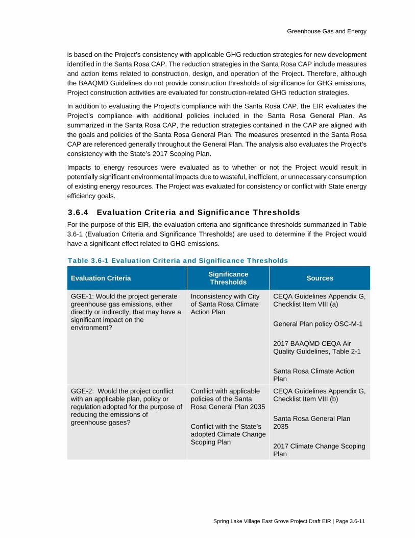
Greenhouse Gas and Energy
Spring Lake Village East Grove Project Draft EIR | Page 3.6-11
is based on the Project’s consistency with applicable GHG reduction strategies for new development identified in the Santa Rosa CAP. The reduction strategies in the Santa Rosa CAP include measures and action items related to construction, design, and operation of the Project. Therefore, although the BAAQMD Guidelines do not provide construction thresholds of significance for GHG emissions, Project construction activities are evaluated for construction-related GHG reduction strategies.
In addition to evaluating the Project’s compliance with the Santa Rosa CAP, the EIR evaluates the Project’s compliance with additional policies included in the Santa Rosa General Plan. As summarized in the Santa Rosa CAP, the reduction strategies contained in the CAP are aligned with the goals and policies of the Santa Rosa General Plan. The measures presented in the Santa Rosa CAP are referenced generally throughout the General Plan. The analysis also evaluates the Project’s consistency with the State’s 2017 Scoping Plan.
Impacts to energy resources were evaluated as to whether or not the Project would result in potentially significant environmental impacts due to wasteful, inefficient, or unnecessary consumption of existing energy resources. The Project was evaluated for consistency or conflict with State energy efficiency goals.
3.6.4 Evaluation Criteria and Significance Thresholds For the purpose of this EIR, the evaluation criteria and significance thresholds summarized in Table 3.6-1 (Evaluation Criteria and Significance Thresholds) are used to determine if the Project would have a significant effect related to GHG emissions.
Table 3.6-1 Evaluation Criteria and Significance Thresholds
Evaluation Criteria Significance Thresholds Sources
GGE-1: Would the project generate greenhouse gas emissions, either directly or indirectly, that may have a significant impact on the environment?
Inconsistency with City of Santa Rosa Climate Action Plan
CEQA Guidelines Appendix G, Checklist Item VIII (a) General Plan policy OSC-M-1 2017 BAAQMD CEQA Air Quality Guidelines, Table 2-1 Santa Rosa Climate Action Plan
GGE-2: Would the project conflict with an applicable plan, policy or regulation adopted for the purpose of reducing the emissions of greenhouse gases?
Conflict with applicable policies of the Santa Rosa General Plan 2035 Conflict with the State’s adopted Climate Change Scoping Plan
CEQA Guidelines Appendix G, Checklist Item VIII (b) Santa Rosa General Plan 2035 2017 Climate Change Scoping Plan

Greenhouse Gas and Energy
Spring Lake Village East Grove Project Draft EIR | Page 3.6-12
Evaluation Criteria Significance Thresholds Sources
GGE-3: Would the project result in potentially significant environmental impacts due to wasteful, inefficient, or unnecessary consumption of energy resources, during project construction or operation?
Result in environmental impacts due to wasteful, inefficient, or unnecessary consumption of energy resources
CEQA Guidelines Appendix G, Checklist Item VI (a)
GGE-4: Would the project conflict with or obstruct a state or local plan for renewable energy or energy efficiency?
Conflict with adopted goals and measures for energy efficiency
CEQA Guidelines Appendix G, Checklist Item VI (b) Santa Rosa Climate Action Plan Santa Rosa General Plan 2035
3.6.5 Impacts and Mitigation Measures Table 3.6-2 (Summary of Impacts - Greenhouse Gas and Energy) provides a summary of potential impacts from the proposed Project.
Table 3.6-2 Summary of Impacts – Greenhouse Gas and Energy
Evaluation Criteria Project Impact
GGE-1: Would the project generate greenhouse gas emissions, either directly or indirectly, that may have a significant impact on the environment?
LS
GGE-2: Would the project conflict with an applicable plan, policy or regulation adopted for the purpose of reducing the emissions of greenhouse gases?
LS
GGE-3: Would the project result in potentially significant environmental impacts due to wasteful, inefficient, or unnecessary consumption of energy resources, during project construction or operation?
LS
GGE-4: Would the project conflict with or obstruct a state or local plan for renewable energy or energy efficiency?
NI
C-GGE-1: Would the project result in a cumulatively considerable contribution to a significant cumulative impact relative to greenhouse gas emissions and energy use?
LS
Notes: NI = No Impact LS = Less than Significant
Impact GGE-1: Would the project generate greenhouse gas emissions, either directly or indirectly, that may have a significant impact on the environment?
Analysis: Less than Significant
Project construction activities would result in a temporary increase in GHG emissions, including exhaust emissions from construction equipment, haul trucks, and worker commute vehicles. Following construction, operation of the Project

Greenhouse Gas and Energy
Spring Lake Village East Grove Project Draft EIR | Page 3.6-13
would result in an incremental increase in GHG emissions associated with Project-related vehicle trips and increased energy demands.
As summarized in Section 3.6.3 (Approach to Analysis), the evaluation of whether the Project would generate GHG emissions in a manner that would impact the environment is based on the Project’s consistency with applicable GHG reduction strategies for new development identified in the Santa Rosa CAP. The reduction strategies in the CAP include measures and action items related to construction, design, and operation of the Project.
The CAP reduction strategies applicable to the Project are summarized in Section 3.6.2 (Regulatory Framework). In accordance with the City of Santa Rosa requirements, a compliance checklist for new development was used to determine the Project’s compliance with the CAP. An evaluation of the Project’s compliance with each Santa Rosa CAP reduction strategy is provided below.
CALGreen Requirements for New Construction
Action 1.1.3 of the CAP was adopted to coincide with California Energy Codes. Since the CAP adoption, the CEC has determined that it is not possible to achieve net zero on a wholesale basis and “net zero” has been removed from the California Energy Codes. Appendix E of the Santa Rosa CAP states that, “To be in compliance with the CAP, all measures denoted with an asterisk are required in all new development projects unless otherwise specified. If a project cannot meet one or more of the mandatory requirements, substitutions may be made from other measures listed at the discretion of the Community Development Director. CAP Goal 1.1 requires projects to comply with Tier 1 CALGreen requirements, as amended, for new non-residential and residential development. Tier 1 CALGreen does not include “net zero” GHG assumptions for development. In addition, current California Green Building Code Standards apply to all projects and has been determined by the Director to be an acceptable substitution for CAP Goal 1 – 1.1.3. Therefore, strict compliance with CAP Goal 1 – 1.1.3 is not achievable and not required for the Project.
Action 1.1.1 of the CAP requires new development to comply with the current provisions of CALGreen, Part 11 of the California Green Building Standards Code. Site development, building design, and landscaping proposed by the Project is required to, and therefore would comply with, CALGreen Tier 1 standards. Therefore, the Project would comply with Action 1.1.1 of the CAP.
Because the Project will be required to comply with Title 24 energy efficiency requirements and because electricity providers must comply with the State’s Renewable Energy Portfolio standards, the project would be consistent with the goals of the CAP.
Smart Meter Utilization
Action 1.3.1 requires new construction to install real-time energy monitors to track energy use. Sustainable design elements proposed for the Project include the installation of energy monitoring. Therefore, the Project would be compliant with Action 1.3.1.
Greenhouse Gas and Energy
Spring Lake Village East Grove Project Draft EIR | Page 3.6-14
Tree Planting and Urban Forestry
Actions 1.4.2 and 1.4.3 of the CAP require compliance with the City’s tree preservation ordinance and the provision of public and private trees in compliance with the zoning code. As described in Section 2, Project Description, the Project includes tree replacement planting at the Project site in accordance with the City of Santa Rosa Tree Ordinance. The proposed replacement trees would be 24-inch box and larger trees, for a total count of 228 trees to be planted on site. The ratio of removal to replacement would be the equivalent of planting 275 trees over the minimum required site as identified in Section 2.3.2 of the Project Description. Therefore, the Project would meet the stipulations set forth in the Santa Rosa Tree Ordinance and zoning code and would be compliant with Actions 1.4.2 and 1.4.3 of the CAP.
Cool Roofs and Pavements
Action 1.5 of the CAP requires the installation of new sidewalks, crosswalks, and parking areas with high solar reflectivity materials. The proposed sidewalks and paving that would be aggregate concrete, which is a high solar reflectivity material. Therefore, the Project would be compliant with Action 1.5 of the CAP. No other cool roof and pavement actions in the CAP are required at this time.
Bicycle and Pedestrian Network
Action 4.1.2 of the CAP requires the provision of bicycle parking consistent with City regulations. The City of Santa Rosa’s zoning code (Standard 20-36.040) requires one bicycle space per eight senior housing units, if units do not have a private garage or private bicycle storage space. The proposed units would be able to use their garages as bicycle storage facilities, therefore, they do not require extra bicycle parking. In compliance with the Santa Rosa code, the proposed site development includes the provision of a bicycle rack to be located in a parking lot near the residential Villa building. The bicycle rack would provide space for at least ten bicycles for use by residents of the villa units. Therefore, the Project would meet the stipulations set forth in the Santa Rosa zoning code and would be compliant with Action 4.1.2 of the CAP. No other bicycle and pedestrian actions in the CAP are required at this time.
Car Sharing and Transportation Demand Management Programs
Action 4.3.5 of the CAP encourages new development with more than 50 on-site employees to provide subsidized or free transit passes. As described in Section 2, Project Description, the proposed development is anticipated to create the equivalent of up to 12 full-time employment opportunities at full occupancy. Because the Project is expected to employ fewer than 50 employees, Action 4.3.5 of the CAP is not applicable to the Project as proposed. No other car sharing and transportation demand management actions in the CAP are required at this time.
Water Conservation
Action 7.1.1 of the CAP requires new development to reduce potable water use for outdoor landscaping in accordance with the Tier 1 standards of CALGreen. As described in Section 2, Project Description, the Project includes the planting of low

Greenhouse Gas and Energy
Spring Lake Village East Grove Project Draft EIR | Page 3.6-15
water use plants and the use of an existing on-site irrigation well as part of the proposed landscaping plan. This would reduce the need for potable water use for outdoor landscaping. Therefore, the Project would be compliant with Action 7.1.1 of the CAP.
Recycled Water
Action 7.3.2 of the CAP requires new development in zones anticipated to receive future recycled water to meet on-site separation requirements to allow for the use of recycled water. The proposed Project is not located proximate to current or future recycled water capabilities. Therefore, Action 7.3.2 of the CAP is not applicable to the Project. No other recycled water actions in the CAP are required at this time.
Lawn and Garden Activity
Action 9.1.3 of the CAP encourages the replacement of existing high maintenance and high water use landscapes with low water use vegetation to reduce the need for gas-powered lawn and garden equipment. As described in Section 2, Project Description, the Project includes the planting of low water use plants on the Project site. The Project’s proposed landscape plan would be required to comply with the City of Santa Rosa Water Efficient Landscape Ordinance requirements for a low water use landscape. Therefore, the Project would be compliant with Action 7.1.3 of the CAP.
The Project is anticipated to comply with the Action 9.1.2 of the CAP, which encourages new buildings to provide electrical outlets on the exterior in an accessible location to charge electric-powered lawn and garden equipment.
Construction Emissions
Actions 9.2.1, 9.2.2, and 9.2.3 of the CAP seek to reduce emissions from heavy-duty construction equipment by limiting idling and utilizing cleaner fuels, equipment, and vehicles. As described in Section 2.8 of the Project Description (Environmental Protection Actions Incorporated into the Project), Environmental Protection Action 3 would require provisions in contractor agreements for minimizing idling time to 5 minutes or less during construction, requiring construction equipment to be maintained per specifications established by the manufacturer, and using electric equipment and/or equipment using alternative fuels as feasible and appropriate. Therefore, the Project would be compliant with Actions 9.2.1, 9.2.2, and 9.2.3 of the CAP. No other construction emissions actions in the CAP are required at this time.
Voluntary Actions
While not required to do so, the Project is anticipated to conform with several additional measures outlined in the CAP. For example, the Project’s plans to improve the adjacent non-vehicular network to facilitate walking and biking would conform with Action 3.2.2 of the CAP. The Project’s plans to install traffic calming design features, such as the striped crosswalks within the intersection of Melita Road and Montgomery Drive, would conform with Action 3.6.1 of the CAP by improving pedestrian convenience and encouraging pedestrian and bicycle travel.

Greenhouse Gas and Energy
Spring Lake Village East Grove Project Draft EIR | Page 3.6-16
The Project’s plans for establishment of community gardens on the Project site would conform with Action 8.1.3 of the CAP.
As proposed, the Project would be designed and operated in a manner that is consistent with the City’s adopted CAP, therefore, potential impacts due to GHG emissions would be less than significant.
Mitigation: No mitigation is needed.
Impact GGE-2: Would the project conflict with an applicable plan, policy or regulation adopted for the purpose of reducing the emissions of greenhouse gases?
Analysis: Less than Significant
General Plan goal OSC-M and policy OSC-M-1 direct the City of Santa Rosa to meet local, regional and state targets for reduction of GHG emissions through implementation of the CAP.
As summarized in Impact GGE-1, the City’s CAP is considered a qualified GHG Reduction Strategy, as established by the BAAQMD’s guidelines and consistent with State CEQA Guidelines Section 15183.5. The CAP would meet CARB’s initial Scoping Plan recommendation that local agencies reduce community-wide emissions to 15 percent below 2005 levels by 2020. The CAP would achieve community-wide emission reductions that are consistent with AB 32’s state-wide emission reduction goal for 2020. Finally, the CAP will set the City on a trajectory to achieve the state GHG reduction target set by E.O. S-3-05 of reducing GHG emissions to 80 percent below 1990 levels by 2050. The Project would be consistent with the City’s CAP and, by extension, requirements of AB 32 and CARB’s Scoping Plan adopted to achieve the emission reduction requirements of AB 32. Therefore, the Project would comply with General Plan goal OSC-M and policy OSC-M-1 and would have a less-than-significant impact.
Mitigation: No mitigation is needed.
Impact GGE-3: Would the project result in potentially significant environmental impacts due to wasteful, inefficient, or unnecessary consumption of energy resources, during project construction or operation?
Analysis: Less than Significant
Construction
Temporary energy use in connection with Project construction would entail consumption of diesel fuel and gasoline by construction equipment and by the transportation of earth moving equipment, construction materials, supplies, and construction personnel. The Project’s estimated construction-period diesel and gasoline fuel consumption was estimated using EPA’s greenhouse gases equivalencies calculator conversion factors. It is estimated that Project construction would consume approximately 13,915 gallons of diesel fuel for off-road equipment, hauling and vendor trips. Worker trips would consume an estimated 369 gallons of gasoline. Environmental Protection Action 3, as described in Section 2 (Project Description), would require provisions in contractor agreements for minimizing idling time to 5 minutes or less during construction,
Greenhouse Gas and Energy
Spring Lake Village East Grove Project Draft EIR | Page 3.6-17
requiring construction equipment to be maintained per specifications established by the manufacturer, and using electric equipment and/or equipment using alternative fuels as feasible and appropriate. With these design features in place, wasteful, inefficient, or unnecessary use of energy resources is not anticipated during Project construction. Impacts during construction would be less than significant.
Operation
Project operation would consume energy for multiple purposes, including but not limited to building heating and cooling, lighting, appliances, and electronics. In addition, vehicle trips associated with operation would consume gasoline. Annual energy use of the buildings is anticipated to include approximately 172 MWh of electricity and 3,264 therms of natural gas. This is based on energy use assumptions of CalEEMod (Appendix B).
The Project’s estimated annual operational diesel and gasoline fuel consumption was estimated using EPA’s greenhouse gases equivalencies calculator conversion factors. It is estimated that Project operation would consume approximately 7,891 gallons of gasoline for on-road trips annually. On-road diesel-fueled trips would consume an estimated 519 gallons of diesel annually.
The estimate of the Project’s energy use does not account for energy savings that would result from implementation of State measures, including increased energy efficiency from updated Title 24 requirements, which are not reflected in CalEEMod. The increase in energy demand resulting from the Project would not be expected to require or result in the construction of new sources of energy supplies or additional energy infrastructure capacity, and the Project would not conflict with applicable energy policies or standards in the City of Santa Rosa General Plan 2035. Therefore, operation of the Project would not use large amounts of energy nor use it in a wasteful manner. The operational impact would be less than significant.
Mitigation: No mitigation is needed.
Impact GGE-4: Would the project conflict with or obstruct a state or local plan for renewable energy or energy efficiency?
Analysis: No Impact
There are no local plans for renewable energy that would apply to the Project site. Implementation of the Project would not obstruct a state plan for renewable energy. The buildings that would be constructed as part of the Project would follow Title 24 standards where applicable. There would be no conflict with a State or local plan for renewable energy, and therefore no impact would result.
Mitigation: No mitigation is needed.
Impact C-GGE-1: Would the project result in a cumulatively considerable contribution to a significant cumulative impact relative to greenhouse gas emissions or energy use?

Greenhouse Gas and Energy
Spring Lake Village East Grove Project Draft EIR | Page 3.6-18
Analysis: Less than Cumulatively Considerable (Less than Significant)
GHG emissions, by their nature, represent a cumulative global impact. However, the geographic extent of CEQA is the State of California, therefore, the geographic scope of potential cumulative impacts related to greenhouse gases resources is the State of California. Similarly, the geographic scope of potential cumulative impacts related to energy resources is the State of California.
Greenhouse Gases
It is unlikely that a single project could generate enough GHG emissions to noticeably change the global average temperature. Instead, GHG emissions contribute, on a cumulative basis, to the significant adverse environmental impacts of global climate change. Therefore, the Project analysis presented in Impact GGE-1 and Impact GGE-2 represents the cumulative analysis for impacts from GHG emissions.
According to the BAAQMD CEQA Air Quality Guidelines, if a project would generate GHG emissions above the BAAQMD threshold level, it would be considered to contribute substantially to a cumulative impact, and would be considered significant. The Project analysis in Impact GGE-1 and Impact GGE-2 found that the Project as proposed would not conflict with applicable GHG reduction strategies for new development identified in the Santa Rosa CAP. Additionally, the Project was not found to conflict with the CARB Climate Change Scoping Plan. Therefore, the Project’s contribution to cumulative GHG impacts would not be cumulatively considerable, and therefore less than significant.
Energy
As described in Impact GGE-3, the Project would have a less-than-significant impact relating to inefficient, wasteful, or unnecessary consumption of fuels or other energy resources during construction. Cumulative projects identified in Table 3-1 (Projects Considered for Cumulative Impacts) would require the consumption of fuels and other energy resources during construction. However, each of the cumulative projects would be required to comply with existing and future laws and regulations governing energy use, similar to the Project. For this reason, the Project would not make a cumulatively considerable contribution to a cumulative impact from construction related energy use.
Project operation was found to have a less-than-significant impact to energy use. As with construction energy consumption, each of the cumulative projects would be required to comply with existing and future laws and regulations governing energy use, similar to the Project. For this reason, the Project would not make a cumulatively considerable contribution to a cumulative impact from operational-related energy use.
Mitigation: No mitigation is needed.
Greenhouse Gas and Energy
Spring Lake Village East Grove Project Draft EIR | Page 3.6-19
3.6.6 References Bay Area Air Quality Management District (BAAQMD). 2017. CEQA Air Quality Guidelines. California Air Resources Board (CARB). 2012. Status of Scoping Plan Recommended Measures.
Website accessed at: http://www.arb.ca.gov/cc/scopingplan/status_of_scoping_plan_measures.pdf
CARB. 2013. California Greenhouse Gas Inventory for 2000-2011. August.
CARB. 2014. First Update to the Climate Change Scoping Plan: Building on the Framework. May.
CARB. 2016. California Greenhouse Gas Emission Inventory - 2016 Edition. Website accessed October 31, 2016: https://www.arb.ca.gov/cc/inventory/data/data.htm
CARB. 2017. California’s 2017 Climate Change Scoping Plan. November.
CARB. 2020. California Greenhouse Gas 2000-20017 Emissions Trends and Indicators Report. Website Accessed April 15, 2020 at: https://ww2.arb.ca.gov/ghg-inventory-dataNatural Resources Agency. 2014. Safeguarding California: Reducing Climate Risk. July.
California Public Utilities Commission. 2019. California Renewables Portfolio Standard (RPS). State of California. Website. http://www.cpuc.ca.gov/rps_homepage/
Santa Rosa, City of. 2012a. Climate Action Plan. June 5.
U.S. EPA. 2016. Overview of Greenhouse Gases. Website accessed October 31, 2016: https://www.epa.gov/ghgemissions/overview-greenhouse-gases
U.S. Environmental Protection Agency (U.S. EPA). 2020. Inventory of U.S. Greenhouse Gas Emissions and Sinks. Website accessed April 15, 2020: https://www.epa.gov/ghgemissions/inventory-us-greenhouse-gas-emissions-and-sinks

Hazards and Hazardous Materials
Spring Lake Village East Grove Project Draft EIR | Page 3.7-1
3.7 Hazards and Hazardous Materials This section evaluates potential environmental impacts related to hazards and hazardous materials during construction and operation of the Project. In addition to the analysis provided in this section, the following subjects are related to hazards and hazardous materials, but are evaluated in other sections of this EIR:
Potential impacts to sensitive receptors from vehicle emissions are evaluated in Section 3.2 (Air Quality).
Potential impacts to emergency access are evaluated in Section 3.12 (Transportation).
3.7.1 Setting
Summary of Hazardous Materials Hazardous materials are a wide-ranging category of substances that include toxic substances, flammable or explosive materials, corrosive substances such as acids, and radioactive substances. A material is considered hazardous if it appears on a list of hazardous materials prepared by a federal, State, or local agency, or if it has characteristics defined as hazardous by such an agency. Facts that influence the health effects of exposure to hazardous material include the dose to which the person is exposed, the frequency of the exposure, the exposure pathway, and individual susceptibility.
The California Code of Regulations (CCR) defines a hazardous material as a substance that, because of physical or chemical properties, quantity, concentration, or other characteristics, may either: (1) cause an increase in mortality or an increase in serious, irreversible, or incapacitating, illness; or (2) pose a substantial present or potential hazard to human health or environment when improperly treated, stored, transported or disposed of, or otherwise managed (CCR, Title 22, Division 4.5, Chapter 10, Article 2, Section 66260.10). Hazardous wastes refer to hazardous materials that are no longer used and have been disposed of or are awaiting disposal.
Emergencies involving hazardous materials often occur due to mechanical failure or human error. These types of emergencies also sometimes occur as a secondary impact of another emergency, such as an earthquake or flood. Hazardous material releases can occur from buildings such as factories and processing facilities, as well as from vehicles that transport chemicals or other hazardous substances. Road vehicles, trains, and (more rarely) aircraft can all suffer accidents that cause a release of hazardous materials.
Wildfire Hazards Areas vulnerable to wildfires are present throughout Santa Rosa and Sonoma County. In the greater Bay Area region, fire areas generally fall into two categories – State Responsibility Areas, where the California Department of Forestry and Fire Protection (CAL FIRE) is responsible for fire protection, and Local Responsibility Areas, where local fire departments and fire protection districts have responsibility. The Project site is located within an area under the local responsibility of the City of Santa Rosa Fire Department. For areas under local responsibility, CAL FIRE identifies very high fire hazard severity zones to local agencies. At the local level, the City of Santa Rosa has created a local Wildland-Urban Interface (WUI) zone to identify and consolidate four types of fire hazard zones in the community: moderate, high, very high, and mutual threat.

Hazards and Hazardous Materials
Spring Lake Village East Grove Project Draft EIR | Page 3.7-2
Airport Operations California’s Public Utilities Code requires that each county with an airport that is operated for the benefit of the general public establish an Airport Land Use Commission (ALUC). Among its duties, the ALUC is responsible for ensuring the safe operation of new and existing airports within its jurisdiction. The ALUC prepares an airport land use plan to address safety and other planning issues (eg., noise, land use compatibility) associated with airports in the county. From a safety perspective, the plan establishes safety compatibility standards and sets limitations on building heights and other factors that may interfere with the safe operation of the airport or that may otherwise present an aviation hazard for the public. The Charles M. Schulz Sonoma County Airport is the nearest public use airport to the Project site that is included in the Comprehensive Airport Land Use Plan (CALUP) for Sonoma County (Sonoma County 2016). The airport is located approximately 10 miles northwest of the Project site. The CALUP uses the criteria defined in Part 77 of the Federal Aviation Regulations (F.A.R.) for airspace protection standards around all public use airports in Sonoma County.
Evacuation Routes The City of Santa Rosa’s Emergency Operations Plan (EOP) designates specific evacuation planning areas and routes (Santa Rosa 2017). The Project site is located within the Melita Evacuation Planning Area, and designated evacuation travel routes identified in the Project area include Highway 12 and Montgomery Drive.
3.7.2 Regulatory Framework
Federal The primary federal agencies with responsibility for hazardous materials management include the U.S. Environmental Protection Agency, the Occupational Safety and Health Administration, and the Department of Transportation. Federal laws, regulations, and responsible agencies relevant to the project are summarized in Table 3.7-1.
Table 3.7-1 Federal Laws and Regulations Related to Hazardous Materials Management
Classification Law or Responsible Federal Agency Description
Hazardous Materials Management and Soil and Groundwater Contamination
Community Right-to-Know Act of 1986 (also known as Title III of the Superfund Amendments and Reauthorization Act [SARA])
Imposes requirements to ensure that hazardous materials are properly handled, used, stored, and disposed of and to prevent or mitigate injury to human health or the environment in the event that such materials are accidentally released.
Comprehensive Environmental Response, Compensation and Liability Act of 1980 (amended by SARA 1986 and Brownfields Amendments 2002)
Regulates the cleanup of sites contaminated by releases of hazardous substances.

Hazards and Hazardous Materials
Spring Lake Village East Grove Project Draft EIR | Page 3.7-3
Classification Law or Responsible Federal Agency Description
Hazardous Materials Transportation and Handling
U.S. Department of Transportation (DOT) Has the regulatory responsibility for the safe transportation of hazardous materials. The DOT regulations govern all means of transportation except packages shipped by mail (49 Code of Federal Regulations [CFR]).
Occupational Safety Occupational Safety and Health Act of 1970
Fed/OSHA sets standards for safe workplaces and work practices, including the reporting of accidents and occupational injuries (29 CFR).
Structural and Building Components (Lead-based paint, PCBs, and asbestos)
Toxic Substances Control Act (TSCA) Regulates the use and management of PCBs in electrical equipment, and sets forth detailed safeguards to be followed during the disposal of such items.
U.S. EPA The EPA monitors and regulates hazardous materials used in structural and building components and effects on human health.
Hazard Mitigation Planning
Stafford Act and Disaster Mitigation Act Requires state, local, and tribal governments to develop and submit to the Federal Emergency Management Agency a mitigation plan that outlines processes for identifying natural hazards, risks, and vulnerabilities of the jurisdiction.
Source: Santa Rosa 2009 and 2016
State
Soil and Groundwater Contamination The cleanup of sites contaminated by releases of hazardous substances is regulated primarily by the Comprehensive Environmental Response, Compensation and Liability Act of 1980 (CERCLA), which was amended by the Superfund Amendment and Reauthorization Act of 1986 (SARA), the Brownfields Amendments (2002) and by similar State laws. Under CERCLA, the EPA has authority to seek the parties responsible for releasing hazardous substances and to ensure their cooperation in site remediation.
Hazards and Hazardous Materials
Spring Lake Village East Grove Project Draft EIR | Page 3.7-4
The State’s Hazardous Waste and Substances Sites List (Cortese List, Government Code §65962.5) identifies sites with leaking underground fuel tanks, hazardous waste facilities subject to corrective actions, solid waste disposal facilities from which there is a known migration of hazardous waste, and other sites where environmental releases have occurred. Before a local agency accepts an application as complete for any development project, the applicant must certify whether or not the project site is on the Cortese List. Databases that provide information regarding the facilities or sites identified as meeting Cortese List requirements are managed by the DTSC and State Water Resources Control Board (SWRCB). At sites where contamination is suspected or known to have occurred, the site owner is required to perform a site investigation and conduct site remediation, if necessary. There are two cleanup standards; one for residential and the other for commercial/industrial land uses. Standards are set for soil, groundwater, soil gas, and vapor intrusion of contaminants into buildings.
Hazardous Materials and Waste The California Environmental Protection Agency (CalEPA) oversees a Unified Program for hazardous materials and waste to ensure consistency throughout the State in regard to administrative requirements, permits, inspections, and enforcement. CalEPA certifies local government agencies known as Certified Unified Program Agencies (CUPA) to implement the hazardous waste and materials standards.
Hazardous Materials Transportation The State of California has adopted Department of Transportation regulations for the intrastate movement of hazardous materials. State regulations are contained in Title 26 of the CCR. In addition, the State of California regulates the transportation of hazardous waste originating in the state and passing through the state (26 CCR). Both regulatory programs apply in California. The two State agencies that have primary responsibility for enforcing federal and State regulations and responding to hazardous materials transportation emergencies are the California Highway Patrol (CHP) and the California Department of Transportation (Caltrans).
Occupational Safety Worker health and safety in California is regulated by Cal/OSHA. California standards for workers dealing with hazardous materials (including hazardous wastes) are contained in CCR Title 8. The DTSC and the State Department of Occupational Health and Safety are the agencies that are responsible for overseeing that appropriate measures are taken to protect workers from exposure to potential groundwater contaminants. At sites known or suspected to have soil or groundwater contamination, a site health and safety plan must be prepared. The health and safety plan establishes policies and procedures to protect workers and the public from exposure to potential hazards at the contaminated site.
Emergency Response California has developed an emergency response plan to coordinate emergency services provided by federal, State, and local government, and private agencies. Responding to hazardous materials incidents is a part of this plan. The plan is administered by the State Office of Emergency Services (OES), which coordinates the responses of other agencies such as local fire and police agencies, emergency medical providers, CHP, the California Department of Fish and Wildlife, and Caltrans.
Hazards and Hazardous Materials
Spring Lake Village East Grove Project Draft EIR | Page 3.7-5
Regional and Local
Hazardous Materials and Waste The Santa Rosa Fire Department oversees the local administrative requirements, permits, and inspections related to the CalEPA Unified Program. In California, hazardous waste generators are divided into two categories, small quantity generators and large quantity generators. The designation is based on the amount of waste produced each month. Small quantity generators are those that generate less than 1,000 kilograms or more of hazardous waste per month, excluding universal wastes, and/or 1 kilogram of acutely or extremely hazardous waste per month. Generators of hazardous waste volumes in excess of the volumes listed above are categorized as large quantity generators. All regulated businesses are required to submit their regulatory reports electronically either to their local regulatory agency or with the California Environmental Reporting System known as CERS.
Soil and Groundwater Contamination In Santa Rosa, oversight of contaminated sites such as leaking underground storage tanks (USTs) is performed by the Santa Rosa Fire Department and the Regional Water Quality Control Board (RWQCB). The Santa Rosa Fire Department implements a local oversight program under contract with the SWRCB to provide regulatory oversight of the investigation and cleanup of soil and groundwater contamination from leaking petroleum underground storage tanks and above-ground storage tanks. At sites where contamination is suspected or known to have occurred, the project sponsor is required to perform a site investigation and prepare a remediation plan, if necessary. For typical development projects, actual site remediation is completed either before or during the construction phase of the project. Site remediation or development may be subject to regulation by other agencies such as the DTSC.
Wildland –Urban Interface Area Ordinance City of Santa Rosa Ordinance 3907, adopted March 3, 2009, established the boundaries of the Wildland – Urban Interface (WUI) Area within the City limits. Building standards within the WUI area are regulated by the California Building Code Chapter 7A.
Santa Rosa Local Hazard Mitigation Plan The City of Santa Rosa’s 2016 Local Hazard Mitigation Plan (LHMP), provides the framework to mitigate local risks to natural hazards and plan for a resilient futures (Santa Rosa 2016). The City prepared the LHMP to ensure that hazard profiles reflect current conditions and best available science, and the policies are consistent with current City standards and/or relevant federal, state, or local regulations, and it is consistent with the Federal Emergency Management Agency requirements. The LHMP provides strategies to mitigate anticipated disasters through education and outreach programs, development of partnerships, and the implementation of actions to reduce the impacts of a disaster. The LHMP includes an inventory of natural hazards to Santa Rosa, as well as identification of resources and evacuation routes that could be used should a hazard occur. Designated evacuation routes in the vicinity of Project site include Highway 12 and Montgomery Drive.
Santa Rosa Emergency Operations Plan The City of Santa Rosa adopted an EOP Update in 2017 (Santa Rosa 2017). The Santa Rosa EOP identifies the City’s emergency planning, organization and response policies and procedures. It addresses how the City will respond to extraordinary events or disasters, from preparation through recovery, and the responsibilities of each department and emergency operations center position. It also addresses the integration and coordination with other governmental levels and special districts.
Hazards and Hazardous Materials
Spring Lake Village East Grove Project Draft EIR | Page 3.7-6
The EOP designates specific evacuation planning areas and routes. The Project site is located within the Melita Evacuation Planning Area. Designated evacuation travel routes identified in the Project area include Highway 12 and Montgomery Drive.
City of Santa Rosa General Plan The following goals and policies from the City of Santa Rosa General Plan 2035 are generally related to hazards and hazardous materials.
NS-F Minimize dangers from hazardous materials.
NS-F-1 Require remediation and cleanup, and evaluate risk prior to reuse, in identified areas where hazardous materials and petroleum products have impacted soil or groundwater.
NS-F-2 Require that hazardous materials used in business and industry are transported, handled, and stored in accordance with applicable local regulations.
NS-G Minimize the potential for wildland fires.
NS-G-1 Require proposed developments in high or medium fire hazard areas to investigate a site’s vulnerability to fire and to minimize risk accordingly.
NS-G-2 Require new development in areas of high wildfire hazard to utilize fire-resistant building materials. Require the use of on-site fire suppression systems, including automatic sprinklers, smoke and/or detection systems, buffers and fuel breaks, and fire retardant landscaping.
NS-G-5 Require detailed fire prevention and control measures, including community firebreaks, for development projects in high fire hazard zones.
NS-G-6 Minimize single-access residential neighborhoods in development areas near open space, and provide adequate access for fire and other emergency response personnel.
3.7.3 Evaluation Criteria and Significance Thresholds For the purpose of this EIR, the evaluation criteria and significance thresholds summarized in Table 3.7-2 (Evaluation Criteria and Significance Thresholds) are used to determine if the project would have a significant effect related to hazards and hazardous materials.

Hazards and Hazardous Materials
Spring Lake Village East Grove Project Draft EIR | Page 3.7-7
Table 3.7-2 Evaluation Criteria and Significance Thresholds
Evaluation Criteria Significance Thresholds Sources
HAZ-1: Would the project create a significant hazard to the public or the environment through the routine transport, use, or disposal of hazardous materials, or through reasonably foreseeable upset and accident conditions involving the release of hazardous materials into the environment?
Non-compliance with State and federal hazardous materials or waste regulations Potential for improper transport, use, disposal, or accidental release of hazardous materials or wastes due to non-compliance with State and federal hazardous materials or waste regulations
CEQA Guidelines Appendix G, Checklist Item IX (a)(b) California (Title 8 and 26 of the CCR), and federal (CFR 29 and 49) hazardous materials and waste regulations
HAZ-2: Would the project emit hazardous emissions or handle hazardous or acutely hazardous materials, substances, or waste within one‐quarter mile of an existing or proposed school?
Use, storage, or emission, of acutely hazardous materials or waste in quantity equal to or in excess of the state thresholds and within 0.25 mile of a school
CEQA Guidelines Appendix G, Checklist Item IX (c) CEQA Guidelines Section 15186; California Health and Safety Code Section 25532, Section (j)
HAZ-3: Would the project be located on a site that is included on a list of hazardous materials sites compiled pursuant to Government Code Section 65962.5 and, as a result, create a significant hazard to the public or the environment?
Location of project on or adjacent to a site with presence or likely presence of hazardous substances or petroleum products
CEQA Guidelines Appendix G, Checklist Item IX (d) Government Code Section 65962.5 (Cortese List) CEQA Guidelines Section 15186
HAZ-4: For a project located within an airport land use plan or, where such a plan has not been adopted, within two miles of a public airport or public use airport, would the project result in a safety hazard or excessive noise for people residing or working in the project area?
Location of project within an airport land use plan or within two miles of an airport and introduction of new or increased safety hazard
CEQA Guidelines Appendix G, Checklist Item IX (e) Sonoma County Comprehensive Airport Land Use Plan
HAZ-5: Would the project impair implementation of or physically interfere with an adopted emergency response plan or emergency evacuation plan?
Location of project in areas that impair or interfere with adopted plan, including emergency access routes
CEQA Guidelines Appendix G, Checklist Item IX (f) City of Santa Rosa Evacuation Planning Area Maps

Hazards and Hazardous Materials
Spring Lake Village East Grove Project Draft EIR | Page 3.7-8
Evaluation Criteria Significance Thresholds Sources
HAZ-6: Would the project expose people or structures, either directly or indirectly, to a significant risk of loss, injury, or death involving wildland fires?
Location of project in a City of Santa Rosa WUI zone or CALFIRE designated zone. Potential for fire ignition during construction
CEQA Guidelines Appendix G, Checklist Item IX (g) City of Santa Rosa Wildland-Urban Interface Fire Area California Fire Code
3.7.4 Approach to Analysis This impact analysis focuses on the transport, use, and disposal of hazardous materials during construction, the potential to encounter hazardous substances in soil and groundwater, and the potential to discharge hazardous materials during Project operations. The evaluation was performed taking into consideration current conditions at the Project site, information in the Cortese List, and applicable regulations and guidelines. The analysis also addresses the potential for the Project to encounter hazardous materials during demolition activities; result in a release of hazardous materials from construction equipment; interfere with an adopted emergency response plan or emergency evacuation plan; conflict with a land use compatibility restriction within an airport safety zone; create fire hazards; or result in a release of hazardous materials during operation. Each potential impact is assessed in terms of the applicable regulatory requirements, and mitigation measures are identified as appropriate.
3.7.5 Impacts and Mitigation Measures Table 3.7-3 (Summary of Impacts - Hazards and Hazardous Materials) provides a summary of potential impacts from the project.
Table 3.7-3 Summary of Impacts – Hazards and Hazardous Materials
Evaluation Criteria Project Impact
HAZ-1: Would the project create a significant hazard to the public or the environment through the routine transport, use, or disposal of hazardous materials, or through reasonably foreseeable upset and accident conditions involving the release of hazardous materials into the environment?
LS
HAZ-2: Would the project emit hazardous emissions or handle hazardous or acutely hazardous materials, substances, or waste within one‐quarter mile of an existing or proposed school?
LS
HAZ-3: Would the project be located on a site that is included on a list of hazardous materials sites compiled pursuant to Government Code Section 65962.5 and, as a result, create a significant hazard to the public or the environment?
NI
HAZ-4: For a project located within an airport land use plan or, where such a plan has not been adopted, within two miles of a public airport or public use airport, would the project result in a safety hazard or excessive noise for people residing or working in the project area?
NI
HAZ-5: Would the project impair implementation of or physically interfere with an adopted emergency response plan or emergency evacuation plan?
NI
Hazards and Hazardous Materials
Spring Lake Village East Grove Project Draft EIR | Page 3.7-9
Evaluation Criteria Project Impact
HAZ-6: Would the project expose people or structures, either directly or indirectly, to a significant risk of loss, injury, or death involving wildland fires?
LSM
C-HAZ-1: Would the project result in a cumulatively considerable contribution to a significant cumulative impact related to hazards or hazardous materials?
LS
Notes: NI = No Impact LS = Less than Significant LSM = Less than Significant with Mitigation
Impact HAZ-1: Would the project create a significant hazard to the public or the environment through the routine transport, use, or disposal of hazardous materials, or through reasonably foreseeable upset and accident conditions involving the release of hazardous materials into the environment?
Analysis: Less than Significant
Construction of the Project would include the transport and use of common hazardous materials inherent to the construction process, including petroleum products for construction equipment and vehicles, and paints, asphalt materials, concrete curing compounds, and solvents for construction of project improvements. These materials are commonly used during construction, are not acutely hazardous, and would be used in relatively small quantities.
In addition to the above-mentioned materials, construction of the Project would include demolition of the existing single-family residential homes at 5803 Melita Road and 5815 Melita Road. The buildings would be surveyed for the presence of hazardous materials (e.g. lead and asbestos-containing materials), and any hazardous wastes would be required to be separated, stored, and disposed of according to local state, and federal regulations. The off-site improvements within Melita Road would require the removal and disposal of existing storm drain pipe. In the event that the storm drain pipe to be removed consists of asbestos-containing material, removal and disposal of the pipe would require compliance with health and safety protocols and acceptance by a State-approved disposal facility.
Numerous laws and regulations ensure the safe transport, use, storage, and disposal of hazardous materials (see Section 3.7.2 [Regulatory Framework]), and the Project Applicant and its contractors would be required to comply with such laws. For example, the removal of asbestos-containing materials in the residential homes and storm drain pipe, if present, would be subject to applicable Cal-OSHA and BAAQMD regulations (Regulation 11, Rule 2, Asbestos Demolition, Renovation and Manufacturing). The contractor would be required to use methods specified in the regulations for control of emissions, such as wetting and wrapping of exposed asbestos‐containing materials or other approved methods. Containment would be required during work that disturbs asbestos-containing materials, and no visible emissions to the outside air from demolition would be allowed.

Hazards and Hazardous Materials
Spring Lake Village East Grove Project Draft EIR | Page 3.7-10
Additionally, Caltrans and the California Highway Patrol (CHP) regulate the transportation of hazardous materials and wastes, including container types and packaging requirements, as well as licensing and training for truck operators, chemical handlers, and hazardous waste haulers. Cal-OSHA also enforces hazard communication program regulations which contain worker safety training and hazard information requirements, such as procedures for identifying and labeling hazardous substances, communicating hazard information related to hazardous substances and their handling, and preparation of health and safety plans to protect workers and employees.
Project construction would also be required to implement storm water best management practices during construction in accordance with City of Santa Rosa regulations and the State Water Resources Control Board General Construction Storm Water Permit. Best management practices addressing materials management would be required, including proper material delivery and storage, spill prevention and control, and management of concrete and other wastes.
Because the Applicant and its contractors would be required to comply with existing and future hazardous materials laws and regulations and applicable best management practices addressing the transport, storage, use, and disposal of hazardous materials, the potential to create a significant hazard to the public or the environment during construction of the project would be less than significant.
Operation of the proposed facility may generate wastes, including, but not limited to, paint, used oil, and pharmaceutical wastes. The Applicant would be required to comply with local requirements, including the development of a Hazardous Materials Business Plan and Hazardous Materials Inventory Reports. Because the Applicant would be required to comply with existing and future hazardous materials laws and regulations, the potential to create a significant hazard to the public or the environment through the routine transport, use or disposal of hazardous materials, substances or waste would be less than significant.
The proposed back-up emergency generator to be located on the Project site would be of a design that includes an integrated base tank. An integrated base tank is a relatively small fuel tank built into an emergency generator unit. No separate aboveground or underground fuel storage tanks or storage drums would be located on the Project site. The emergency back-up generator would be operated during a power outage and for routine maintenance in accordance with the manufacturer’s specifications. Given the nature of the generator and the limited use, routine transport of fuel to the Project site would not be required. The risk associated with the proposed back-up emergency generator would be less than significant.
Future residents, grounds crews, and employees may be expected to use small quantities of common household cleaners, batteries, fertilizers and similar products. Such materials are often referred to as household toxics. The Sonoma County Waste Management Agency implements several ongoing programs to facilitate the proper disposal of such materials, including operation of a Household Toxics Facility at the Central Disposal Site and periodic toxics collection events

Hazards and Hazardous Materials
Spring Lake Village East Grove Project Draft EIR | Page 3.7-11
and toxic rover services. Because of the availability of such programs, the potential for improper disposal of such materials is considered less than significant.
Mitigation: No mitigation is needed.
Impact HAZ-2: Would the project emit hazardous emissions or handle hazardous or acutely hazardous materials, substances, or waste within one‐quarter mile of an existing or proposed school?
Analysis: Less than Significant
The nearest school relative to the Project site is Austin Creek Elementary School, located approximately one-half mile to the north. Therefore, the primary location of Project-related construction and operational activities would not be located within one-quarter of an existing school. Additionally, no proposed schools are known to be planned within one-quarter mile of the Project site.
During construction of the Project, a portion of truck traffic would be expected to utilize Highway 12 between Los Alamos Road and Farmers Lane. Such truck traffic would occur within one-quarter mile of Austin Creek Elementary School, Douglas Whited Elementary School, St. Eugene’s Cathedral School, and possibly other schools. Anticipated truck trips would be temporary and intermittent in nature, and the Project is not anticipated to require the hauling of contaminated soils or acutely hazardous materials or wastes. Therefore, the potential for Project-related construction to emit hazardous emissions or involve handling of hazardous materials, substances, or wastes in the vicinity of a school would be less than significant.
Following construction, the Project would not emit hazardous emissions within one-quarter mile of an existing or proposed school. No operational impact would result.
Mitigation: No mitigation is needed.
Impact HAZ-3: Would the project be located on a site that is included on a list of hazardous materials sites compiled pursuant to Government Code Section 65962.5 and, as a result, create a significant hazard to the public or the environment?
Analysis: No Impact
State of California Government Code §65962.5, the Hazardous Waste and Substances Sites List (Cortese List), is a planning document used to comply with the CEQA requirements for providing information about the location of hazardous materials release sites. The online data resources that provide information on facilities or sites pursuant to Section 65962.5 include:
• DTSC EnviroStor database;
• List of Leaking Underground Storage Tank Sites by from the Water Board GeoTracker database;
• List of solid waste disposal sites identified by Water Board with waste constituents above hazardous waste levels;

Hazards and Hazardous Materials
Spring Lake Village East Grove Project Draft EIR | Page 3.7-12
• List of "active" Cease and Desist Orders and Cleanup and Abatement Orders from the Water Board; and
• List of hazardous waste facilities subject to corrective action pursuant to Section 25187.5 of the Health and Safety Code;
A search of the Cortese List was completed in May 2020 and did not identify the Project site or off-site improvement areas as being on or adjacent to a site listed pursuant to Government Code Section 65965.5 (Cal EPA 2020). In addition, research conducted for a Phase I Environmental Site Assessment in December 2012 did not identify the Project site in regulatory agency files or databases as having issues of environmental concern. According to the Phase I Environmental Site Assessment, no indication of historic use, storage or disposal of hazardous materials or waste was identified at the Project site, nor indication of historic use of underground or aboveground fuel storage tanks (EBA 2012). Therefore, the Project would not create a significant hazard to the public or the environment due to being located on a site included on a list compiled pursuant to Government Code Section 65965.5. No impact would result.
Mitigation: No mitigation is needed.
Impact HAZ-4: For a project located within an airport land use plan or, where such a plan has not been adopted, within two miles of a public airport or public use airport, would the project result in a safety hazard or excessive noise for people residing or working in the project area?
Analysis: No Impact
The nearest public airport to the Project site is the Charles M. Schulz-Sonoma County Airport, located over 10 miles to the northwest. Because the Project site is not located within an airport land use plan or within two miles of a public airport, the Project would not result in a related safety hazard in the project area. No impact would result.
Mitigation: No mitigation is needed.
Impact HAZ-5: Would the project impair implementation of or physically interfere with an adopted emergency response plan or emergency evacuation plan?
Analysis: No Impact
The Santa Rosa EOP identifies the City’s emergency planning, organization, and response policies and procedures. The EOP also addresses the integration and coordination with other governmental levels and special districts as required. The EOP outlines how the City will respond to extraordinary events or disasters, from preparation through recovery. The EOP designates specific evacuation planning areas and routes. The Project site is located within the Melita Evacuation Planning Area. Designated evacuation travel routes identified in the Project area include Highway 12 and Montgomery Drive. Los Alamos road and Melita Road, in which utility connections would be constructed, are not designated as evacuation travel routes. The Project would include installation of new sidewalk along Highway 12, but would not otherwise alter the functionality of the roadway or effect the use of Highway 12 as an evacuation route. Therefore, the Project would not impair

Hazards and Hazardous Materials
Spring Lake Village East Grove Project Draft EIR | Page 3.7-13
implementation of or physically interfere with the City’s EOP or evacuation travel routes. No impact would result.
Mitigation: No mitigation is needed.
Impact HAZ-6: Would the project expose people or structures, either directly or indirectly, to a significant risk of loss, injury, or death involving wildland fires?
Analysis: Significant
The City of Santa Rosa and CALFIRE have identified and designated areas within their jurisdiction that are at risk of wildland fires. The Project site and off-site improvement areas are not located within the established the boundaries of the Santa Rosa Wildland–Urban Interface Fire Area (Santa Rosa 2009). The Project site is not in a State Responsibility Area or within an established very high fire hazard severity zone. The nearest State Responsibility Area is located approximately 0.2-mile to the south of the Project site within Annadel State Park, and the nearest State-designated very high fire hazard severity zone is located approximately 0.75-mile to the northeast of Highway 12 and the Project site (CALFIRE 2007, 2019). The nearest Local Responsibility Area designated very high fire hazard zone is located approximately 0.70-mile to the north of Highway 12 and the Project site (CALFIRE 2008).
Although the Project site and off-site improvement areas are not located within designated areas at risk of wildland fires, it is possible that accidental fire ignition could occur during construction (e.g. related to heavy machinery usage). Because the vegetation at the Project site could be dry during construction, and because of the close proximity of nearby residences, the construction-related impact is considered significant.
The Project site could also be subject to wildland fires that spread to the Project area from surrounding areas. The Project site is located approximately 0.1 mile northwest of properties damaged along Melita Road during the 2020 Glass Fire, and between approximately 0.25 mile and 0.7 mile southwest of properties damaged along Los Alamos Road and adjacent roadways during the Glass Fire.
In the event of a fire or wildland fire, the City’s existing evacuation plan would be implemented, compliant with its standards for safety and evacuation. The Project would be required to be compliant with the current version of the California Building Code, the California Fire Code, and City of Santa Rosa Fire Department Standards. Project development plans would require review by the Santa Rosa Fire Department during the permit process to ensure compliance with applicable codes, ordinances and regulations.
The Project includes two points of emergency vehicle access to satisfy the requirements of the California Fire Code for buildings exceeding 30 feet in height. The primary emergency vehicle access would be from Los Alamos Road, with a secondary emergency vehicle access from Melita Road. Adequate turning space would be provided along the emergency access pathways to allow emergency vehicles to quickly maneuver and egress.

Hazards and Hazardous Materials
Spring Lake Village East Grove Project Draft EIR | Page 3.7-14
The Project would not impair implementation of the City's EOP or interfere with established evacuation travel routes (see Impact HAZ-5). The Project would not change existing circulation patterns or effect emergency response routes. Electrical power and natural gas would be provided by PG&E from existing underground utility lines adjacent to the Project site. All electricity, natural gas, and telecommunication infrastructure would be located underground and would tie-in to existing infrastructure. Because the Project site is located outside of the Santa Rosa Wildland–Urban Interface Fire Area and outside of designated very high fire hazard severity zones, and because the Project would require mandatory compliance with the California Fire Code and City of Santa Rosa Fire Development Standards, the operational impact would be less than significant.
Mitigation: Mitigation Measure HAZ-6: Reduce Wildland Fire Hazards during Construction
Prior to construction, the applicant and its contractor(s) shall remove and/or clear away dry, combustible vegetation from the construction site. Grass and other vegetation less than 18 inches in height above the ground shall be maintained where necessary to stabilize the soil and prevent erosion. Vehicles shall not be parked in areas where exhaust systems contact combustible materials. Fire extinguishers shall be available on the construction site to assist in quickly extinguishing any small fires, and the contractors shall have on site the phone number for the local fire department.
After Mitigation: Less than Significant with Mitigation
Implementation of Mitigation Measure HAZ-6 would require the use of construction techniques that would reduce the likelihood of wildland fires during construction of the Project. Therefore, with implementation of Mitigation Measure HAZ-6, the impact related to wildland fires would be less than significant.
Impact C-HAZ-1: Would the project result in a cumulatively considerable contribution to a significant cumulative impact related to hazards or hazardous materials?
Analysis: Less than Cumulatively Considerable (Less than Significant)
The Project would not result in impacts related to being located on a site included on a list compiled pursuant to Government Code Section 65965.5, being located within an airport land use plan or within two miles of a public or private airport, or interference with an adopted emergency response plan or emergency evacuation plan. Therefore, implementation of the Project would not contribute to any related cumulative impacts.
Similar to the proposed Project, the cumulative projects listed in Section 3, Table 3-1 (Projects Considered for Cumulative Impacts) would include the transport and use of common hazardous materials inherent to the construction process, including petroleum products for construction equipment and vehicles, and paints, asphalt materials, concrete curing compounds, and solvents for construction of site improvements. Each of the cumulative projects would be required to comply with existing and future laws and regulations governing hazardous materials that have been developed to cover multiple overlapping projects and traffic from many

Hazards and Hazardous Materials
Spring Lake Village East Grove Project Draft EIR | Page 3.7-15
sources. For this reason, the potential cumulative impact from the use, transport, and disposal of hazardous materials during construction would be less than significant. As a result, there would be no significant cumulative impact associated with increased hazards relative to hazardous materials to which the proposed project would contribute.
During construction, some portion of truck traffic from cumulative projects may also utilize Highway 12 between Los Alamos Road and Farmers Lane. Similar to the Project, truck trips associated with cumulative projects would be temporary and intermittent in nature and would be subject to Caltrans and CHP regulations. As a result, there would be no significant cumulative impact associated with increased truck traffic within the vicinity of a school to which the proposed Project would contribute.
Some of the cumulative projects may be located in areas mapped as a fire-threatened community for wildland fires. Each of the cumulative projects would be required to provide adequate fire protection and the cumulative projects would not combine to create a significant cumulative effect related to risk from fire. Therefore, the cumulative impact related to wildfire would be less than significant.
Mitigation: No mitigation is needed.
3.7.6 References Association of Bay Area Governments (ABAG). 2010. Taming Natural Disasters, Multi-Jurisdictional
Local Hazard Mitigation Plan for the San Francisco Bay Area.
California Environmental Protection Agency (CalEPA). 2016. Cortese List Data Resources. Accessed May 5, 2020 at: http://www.calepa.ca.gov/SiteCleanup/CorteseList/default.htm
California Department of Forestry and Fire Protection (CAL FIRE). 2007. Fire Hazard Severity Zones in SRA, Sonoma County. November 7.
California Department of Forestry and Fire Protection (CAL FIRE). 2008. Very High Fire Hazard Severity Zones in LRA, Sonoma County. November 10.
California Department of Forestry and Fire Protection (CalFire). 2019. CalFire FHSZ Viewer. Available online: https://www.fire.ca.gov/fire_prevention/fire_prevention_wildland_zones
EBA Engineering. 2012. Phase I Environmental Site Assessment.
Santa Rosa, City of. 2009. Wildland – Urban Interface Fire Area Map. January 28.
Santa Rosa, City of. 2017. Santa Rosa Emergency Operations Plan.
Santa Rosa, City of. 2016. City of Santa Rosa Local Hazard Mitigation Plan. October.
Sonoma County Airport Land Use Commission. 2016. Comprehensive Airport Land Use Plan (CALUP) Amendments. March 14.

Hydrology and Water Quality
Spring Lake Village East Grove Project Draft EIR | Page 3.8-1
3.8 Hydrology and Water Quality This section evaluates potential environmental impacts related to hydrology and water quality during construction and operation of the Project. In addition to the analysis provided in this section, the following subjects are related to hydrology and water quality, but are evaluated in other sections of this EIR:
Potential impacts to riparian habitat and federally protected wetlands and waters are addressed in Section 3.3 (Biological Resources).
Potential impacts related to loss of topsoil are addressed in Section 3.5 (Geology and Soils).
Potential impacts related to location on or near a hazardous materials site is addressed in Section 3.7 (Hazards and Hazardous Materials).
Potential impacts related to construction of new storm drain facilities are addressed in Section 3.14 (Utilities and Service Systems).
3.8.1 Setting
Regional Climate
The City of Santa Rosa’s climate is influenced by the Pacific Ocean and is divided into wet and dry seasons. Approximately 93 percent of the annual precipitation normally falls during the wet season, October to May, with a large percentage of the rainfall typically occurring during three or four major winter storms. According to the Western Regional Climate Center, rainfall at the nearest weather station with historical data is located in northwest Santa Rosa. This weather station has data from 1925 through 2010 and includes average precipitation totals of approximately 30.1 inches per year. The mean annual potential evapotranspiration for the area is estimated to be approximately 42 inches per year (EBA 2020).
Santa Rosa Creek Watershed
The nearest waterway to the Project site is Santa Rosa Creek, which is located approximately 150 feet southwest of the site. The Santa Rosa Creek watershed drains approximately 78.6 square miles, including agriculture, parks and open space, and urban land uses. The headwaters are on the northwestern slope of Hood Mountain, and the creek flows through the urban area of the City and then agricultural lands before joining the Laguna de Santa Rosa north of Sebastopol. The Laguna de Santa Rosa flows northerly to its confluence with Mark West Creek and on to the Russian River at Mirabel. From headwaters to its confluence with the Laguna, Santa Rosa Creek flows approximately 22 miles.
In accordance with Section 303(d) of the Federal Clean Water Act, state governments present the U.S. Environmental Protection Agency (U.S. EPA) with a list of impaired water bodies by hydrologic sub-area. Santa Rosa Creek in the Project area is considered part of the Mainstream Santa Rosa Creek watershed, which is located within the Santa Rosa Hydrologic Sub Area, and within the overall Middle Russian River Hydrologic Area. The Mainstream Santa Rosa Creek watershed is listed as impaired for indicator bacteria, sediment, and temperature (RWQCB 2012).
The current 2018 Basin Plan prepared by the North Coast Regional Water Quality Control Board (NCRWQCB) identifies the beneficial uses of surface waters in the region. The beneficial uses of the waters in the Santa Rosa Creek hydrologic subarea include: Municipal and Domestic Supply; Agricultural Supply; Industrial Service Supply; Groundwater Recharge; Navigation; Water Contact

Hydrology and Water Quality
Spring Lake Village East Grove Project Draft EIR | Page 3.8-2
Recreation; Non-Contact Water Recreation; Commercial and Sport Fishing; Warm Freshwater Habitat; Cold Freshwater Habitat; Wildlife Habitat; Rare, Threatened, or Endangered Species; Migration of Aquatic Organisms; Spawning, Reproduction, and/or Early Development. (NCRWQCB 2018)
Local Drainage
The existing storm water collection system in the Project area consists of storm drain and open drainage ditches along the edges of the site. Along Los Alamos Road, an open drainage ditch conveys storm water along the edge of the property and ultimately drains to Santa Rosa Creek near Montgomery Drive. Along Melita Road, existing storm drain pipes and an open drainage ditch conveys storm water along the north side of Melita Road, which then crosses the road beneath an existing culvert and drains towards Santa Rosa Creek. Surface water flow in Santa Rosa Creek is to the west and is perennial in nature.
Flooding and Dam Inundation
Flooding is a temporary condition in which land that is normally dry is partially or completely inundated. Flooding occurs when water bodies, such as streams, rivers, lakes, or reservoirs, are abnormally high and overflow into adjacent low-lying areas. These areas are known as floodplains, defined by their exposure to risk of recurring floods. The Federal Emergency Management Agency (FEMA) has identified several 100-year and 500-year flood zones in Santa Rosa along creeks that are prone to flood in heavy rains. The Project site and off-site improvement areas are located in an area designated by the FEMA as Zone X, which is an area of minimal flood hazard (FEMA 2008). The Project site and off-site improvement areas are not located within a 100-year flood hazard area, within a 500-year flood hazard area, or within a floodway or other special flood hazard zone.
Dam inundation is a hazard that occurs when a flood control dam/water reservoir is damaged severely enough to compromise its ability to hold back water. When a dam fails, sudden fastmoving floods migrate throughout the inundation zone. The speed and volume of these floodwaters can damage or destroy property, cause injury or loss of life, and displace large numbers of residents and employees in the flood’s path. Eight dams are located within Santa Rosa’s urban growth boundary. Five additional dams outside of the City’s borders also have the potential to cause damage within Santa Rosa in the case of failures. As illustrated on Figure 12-4 of the City of Santa Rosa General Plan, the Project site and off-site improvement areas are not located within a dam inundation zone (Santa Rosa 2009).
Regional Groundwater
The Project site is located in the Santa Rosa Plain Watershed (SRPW), and lies within the North Coast Hydrologic Region in the North Coastal Basin. The Santa Rosa Plain Watershed encompasses 262 square miles (167,680 acres) and includes a surface area of 160 square miles (102,400 acres) of groundwater basins, subbasins, or portions thereof. The Project site is located within the Santa Rosa Valley-Rincon Valley Groundwater Subbasin (Groundwater Basin 1.055.03), which is defined as a low priority basin by the California Department of Water Resources. The Project site is within a Zone 1 groundwater availability area as defined by the Sonoma County General Plan. There are two existing groundwater water supply wells (Well-225 and Well-5815) located on the Project site near Melita Road.
Hydrology and Water Quality
Spring Lake Village East Grove Project Draft EIR | Page 3.8-3
Concepts of Groundwater Hydrology
Water is present in two zones beneath the ground surface. The upper zone is the zone of aeration (or vadose zone) where pore spaces in the geologic material are partly filled with air and partly filled with water. Wells do not produce groundwater from the vadose zone because the molecules of water adhere tightly to the various geologic materials. Water stored in this zone of aeration is called soil moisture or vadose water. Soil moisture is drawn into the rootlets of growing plants. As the plants use the water, it is transpired as vapor to the atmosphere. Isolated zones of saturated soil can occur in the zone of aeration. These zones of perched groundwater can occur above low permeability layers and are separated from the main groundwater body by an underlying unsaturated zone.
The lower zone is the zone of saturation where all of the interconnected pore spaces in the geologic material are filled with groundwater, and only dissolved gaseous air is present. Groundwater in the saturated zone is either confined or unconfined. An aquifer containing unconfined groundwater is one that is not overlain by a confining bed of relatively low permeability geologic material. The upper surface of an unconfined body of groundwater is called the water table. It is represented by the level of water in a well penetrating the saturated zone. In an unconfined aquifer the water table is assumed to be connected to the atmosphere through the overlying soil pores.
A confined aquifer is overlain by relatively impermeable material and is isolated from overlying aquifers. Groundwater contained in confined aquifers is under pressure, and the level to which the water will rise in a non-pumping well is the potentiometric surface of the groundwater. The potentiometric surface is an imaginary surface that represents the upward pressure exerted by the confined groundwater on the materials overlying it.
Water recharges an aquifer through precipitation, stream flow, irrigation, or other sources by entering the ground and moving downward through the zone of aeration and into the zone of saturation. Groundwater under pressure moves toward areas of lower pressure, such as pumping depressions. In cases where the pressure relief area is along a stream channel, springs form and provide stream flow even during periods of low precipitation.
The general groundwater movement pattern of a basin can be interpreted from groundwater contour maps which show lines of equal elevation of the groundwater surface. Groundwater movement is perpendicular to the contour lines and from the higher elevation contours to the lower. The relative spacing between the contour lines indicates the hydraulic gradient of the groundwater, which is an index of the resistance encountered as the water moves through the aquifer.
3.8.2 Regulatory Framework
Federal
Clean Water Act The federal Clean Water Act, enacted by Congress in 1972 and amended several times since, is the primary federal law regulating water quality in the United States and forms the basis for several State and local laws throughout the country. The Act established the basic structure for regulating discharges of pollutants into the waters of the United States. The Clean Water Act gave the U.S. EPA the authority to implement federal pollution control programs, such as setting water quality standards for contaminants in surface water, establishing wastewater and effluent discharge limits for various industry categories, and imposing requirements for controlling nonpoint source pollution. At the federal level, the Clean Water Act is administered by the U.S. EPA and U.S. Army Corps of Engineers (USACE). At the state and regional levels in California, the act is administered and enforced by the

Hydrology and Water Quality
Spring Lake Village East Grove Project Draft EIR | Page 3.8-4
State Water Resources Control Board (SWRCB) and the nine Regional Water Quality Control Boards (RWQCBs). The Project site is within the North Coast Regional Water Quality Control Board.
National Flood Insurance Program The Federal Emergency Management Agency (FEMA) administers the National Flood Insurance Program (NFIP) to provide subsidized flood insurance to communities that comply with FEMA regulations limiting development in floodplains. FEMA also issues Flood Insurance Rate Maps identifying which land areas are subject to flooding. The maps provide flood information and identify flood hazard zones in the community. The design standard for flood protection is established by FEMA, with the minimum level of flood protection for new development determined to be the 1-in-100 annual exceedance probability (i.e., the 100-year flood event).
State
Porter Cologne Water Quality Control Act The Porter Cologne Water Quality Control Act is the primary statute covering the quality of waters in California. Under the Act, the SWRCB has the ultimate authority over State water rights and water quality policy. The nine RWQCBs regulate water quality under this Act through the regulatory standards and objectives set forth in Water Quality Control Plans (also referred to as Basin Plans) prepared for each region. The five-member State Water Resources Control Board allocates water rights, adjudicates water right disputes, develops state-wide water protection plans, establishes water quality standards, and guides the nine RWQCBs located in the major watersheds of the state. The joint authority of water allocation and water quality protection enables the SWRCB to provide comprehensive protection for California’s waters. The SWRCB is responsible for implementing the Clean Water Act, issues National Pollutant Discharge Elimination System (NPDES) permits to cities and counties through RWQCBs, and implements and enforces the NPDES General Permits.
NPDES General Permit for Storm Water Discharges Associated with Construction and Land Disturbance Activities The General Permit for Stormwater Discharges Associated with Construction and Land Disturbance Activities (Construction General Permit) (Order No. 2009-0009, as amended by Order No. 2010-0014 and 2012-006) took effect on July 1, 2010 and was amended on February 14, 2011. The Order applies to construction sites that include one or more acres of soil disturbance. To obtain coverage under the Construction General Permit, dischargers must electronically file permit registration documents, which include a Notice of Intent, Storm Water Pollution Prevention Plan (SWPPP), and other compliance related documents required by the General Permit. The SWPPP must include best management practices to identify, reduce or eliminate sediment and other pollutants in storm water and non-storm water discharges during construction.
Regional and Local
North Coast Regional Water Quality Control Board RWQCBs adopt and implement water quality control plans (Basin Plans) which recognize the unique characteristics of each region with regard to natural water quality, actual and potential beneficial uses, and water quality problems. The current 2018 Basin Plan prepared by the NCRWQCB provides a definitive program of actions designed to preserve and enhance water quality and to protect beneficial uses of water in the North Coast Region. Refer to the section above, Santa Rosa Creek Watershed, for the beneficial uses applicable to the watershed in which the Project site is located.

Hydrology and Water Quality
Spring Lake Village East Grove Project Draft EIR | Page 3.8-5
The NCRWQCB also oversees and regulates groundwater investigations, clean-up, and abatement activities at sites with identified pollution problems. NCRWQCB Order No. R1-2009-0045, Waste Discharge Requirements for Low Threat Discharges to Surface Waters in the North Coast Region, applies to discharges of excavation dewatering. This Order requires development of a Best Management Practices/Pollution Prevention Plan to characterize the discharge and to identify specific measures to control the discharge, such as sediment controls to ensure that excessive sediment is not discharged and flow controls to prevent erosion and flooding downstream of the discharge.
Santa Rosa NPDES Storm Water Permit and Low Impact Development Technical Design Manual NCRWQCB Order No. R1-2015-0030 is the City of Santa Rosa’s current NPDES storm water permit (NCRWQCB 2015). The permit regulates both storm water and non-storm water discharges from public and private projects into the Santa Rosa municipal storm drain system. The permit requires a minimum set of best management practices (BMPs) to be implemented at all construction sites, as well as permanent storm water LID BMPs. In May 2017, the City adopted its current Storm Water Low Impact Development Technical Design Manual (Storm Water LID Manual) (Santa Rosa 2017), which applies to both privately sponsored projects and capital improvement projects that meet any of the following criteria:
Development that creates or replaces 10,000 square feet or more of impervious material;
Street, road, highway, or freeway construction or reconstruction, creating or replacing 10,000 square feet or more of impervious surface;
Development that creates or replaces a combined total of 1 acre or more of new impervious surface;
Projects that meet the criteria must capture, treat, and infiltrate storm water as close to the source as possible using small scale landscape-based features located throughout the project site per the criteria in the Storm Water LID Manual.
City of Santa Rosa General Plan The following goals and policies from the City of Santa Rosa General Plan 2035 are related to hydrology and water quality and are applicable to the Project.
NS-D Minimize hazards associated with storm flooding.
NS-D-1 Ensure flood plain protection by retaining existing open areas and creating new open areas needed to retain storm water, recharge aquifers, and prevent flooding.
NS-D-3 Require that new development incorporate features that are consistent with the Standard Urban Storm Water Mitigation Plan (SUSMP) into site drainage plans that would reduce impermeable surface area, increase surface water infiltration, and minimize surface water runoff during storm events. Such features may include:
Additional landscape areas;
Parking lots with bio-infiltration systems;
Permeable paving designs; and
Storm water detention basins.

Hydrology and Water Quality
Spring Lake Village East Grove Project Draft EIR | Page 3.8-6
NS-D-5 Apply design standards to new development that help reduce project runoff into local creeks, tributaries, and drainage ways.
NS-F Minimize dangers from hazardous materials.
OSC-D Conserve wetlands, vernal pools, wildlife ecosystems, rare plant habitats, and waterways.
OSC-D-9 Ensure that construction adjacent to creek channels is sensitive to the natural environment. Ensure that natural topography and vegetation is preserved along the creek, and that construction activities do not disrupt or pollute the waterway.
OSC-I Conserve water and maintain water quality.
OSC-I-6 Protect groundwater recharge areas, particularly creeks and riparian corridors. Identify and protect other potential groundwater recharge areas.
PSF-I Manage, maintain, and improve stormwater drainage and capacity.
PSF-I-3 Require erosion and sedimentation control measures to maintain an operational drainage system, preserve drainage capacity, and protect water quality.
PSF-I-4 Require measures to maintain and improve the storm drainage system, consistent with goals of the Santa Rosa Citywide Creek Master Plan, to preserve natural conditions of waterways and minimize paving of creek channels.
PSF-I-6 Require implementation of Best Management Practices to reduce drainage system discharge of non-point source pollutants originating from streets, parking lots, residential areas, businesses, industrial operations, and those open space areas involved with pesticide application.
Santa Rosa Citywide Creek Master Plan The City of Santa Rosa has specific goals related to waterways within their jurisdiction. The following goals and policies from the Santa Rosa Citywide Creek Master Plan are generally related to hydrology and water quality for the Project:
SW-1 Maintain hydraulic capacity of creeks.
SW-1-3 Balance habitat restoration and hydraulic capacity. Provide a detailed hydraulic analysis for every project component affecting flood conveyance prior to implementation to identify allowable “roughness” values and to interpret those values in the form of a vegetation planting and monitoring plan. Consider use of detention basins and diversion channels where appropriate to maintain hydraulic capacity.
SW-2 Implement the Storm Water Low Impact Development Technical Design Manual
SW-2-1 New development and redevelopment projects shall comply with the City NPDES stormwater permit and with the Storm Water Low Impact Development Technical Design Manual.
Hydrology and Water Quality
Spring Lake Village East Grove Project Draft EIR | Page 3.8-7
SW-2-2 Stormwater treatment measures that involve small scale landscape based Low Impact Development Best Management Practices (BMPs) that treat stormwater as close to the source as possible shall be prioritized over other BMPs.
WQ-2 Use a combination of Storm Water Best Management Practices, constructed devices, and biological systems, to remove pollutants and protect water quality.
WQ-2-2 Implement the Storm Water Low Impact Development Technical Design Manual to reduce pollutants and runoff flows from new development and redevelopment projects.
3.8.3 Evaluation Criteria and Significance Thresholds For the purpose of this EIR, the evaluation criteria and significance thresholds summarized in Table 3.8-1 (Evaluation Criteria and Significance Thresholds) are used to determine if the Project would have a significant effect related to hydrology and water quality.
Table 3.8-1 Evaluation Criteria and Significance Thresholds
Evaluation Criteria Significance Thresholds Sources
HWQ-1: Would the project violate any water quality standards or waste discharge requirements or otherwise substantially degrade surface or ground water quality?
Non-compliance with Waste Discharge Requirements for Low Threat Discharges to Surface Waters in the North Coast Region. Non-compliance with the NPDES General Permit for Storm Water Discharges Associated with Construction and Land Disturbance Activities. Non-compliance with the City of Santa Rosa NPDES Storm Water Permit.
CEQA Guidelines Appendix G, Checklist Item X (a) General Plan Policies OSC-D-9, PSF-I-3, PSF-I-6, NS-D-3 SR Creek Master Plan Goal SW-2 NCRWQCB Order No. R1-2015-0030 and Santa Rosa Storm Water Low Impact Development Technical Design Manual General Construction Permit (Order No. 2009-0009, as amended by Order No. 2010-0014 & 2012-006) NCRWQCB Order No. R1-2009-0045, Waste Discharge Requirements for Low Threat Discharges to Surface Waters in the North Coast Region
Hydrology and Water Quality
Spring Lake Village East Grove Project Draft EIR | Page 3.8-8
Evaluation Criteria Significance Thresholds Sources
HWQ-2: Would the project substantially decrease groundwater supplies or interfere substantially with groundwater recharge such that the project may impede sustainable groundwater management of the basin?
Creation of a deficit in aquifer volume or lowering of groundwater levels such that the production rates of nearby domestic wells would not support existing uses. Creation of a substantial amount of new impervious surfaces that would interfere with groundwater recharge.
CEQA Guidelines Appendix G, Checklist Item X (b) General Plan Policy OSC-I-6
HWQ-3: Would the project substantially alter the existing drainage pattern of the site or area, including through the alteration of the course of a stream or river or through the addition of impervious surfaces, in a manner which would result in substantial erosion or siltation on- or off-site?
Uncontrolled runoff from construction site. Non-compliance with City storm water requirements. Non-compliance with the NPDES General Permit for Storm Water Discharges Associated with Construction and Land Disturbance Activities.
CEQA Guidelines Appendix G, Checklist Item X (c)(i) North Coast Regional Water Quality Control Board Order No. R1-2009-0050 NCRWQCB Order No. R1-2015-0030 and Santa Rosa Storm Water Low Impact Development Technical Design Manual General Plan Policy PSF-I-3, PSF-I-4, and PSF-I-6 SR Creek Master Plan Goal SW-2 and WQ-2
HWQ-4: Would the project substantially alter the existing drainage pattern of the site or area, including through the alteration of the course of a stream or river or through the addition of impervious surfaces, in a manner which would substantially increase the rate or amount of surface runoff in a manner which would result in flooding on- or off-site?
Project actions would result in on-site or off-site flooding.
CEQA Guidelines Appendix G, Checklist Item X (c)(ii) Santa Rosa Storm Water Low Impact Development Technical Design Manual General Plan Policy NS-D-5, PSF-I-3, SR Creek Master Plan Goal SW-1, SW-2, and WQ-2
Hydrology and Water Quality
Spring Lake Village East Grove Project Draft EIR | Page 3.8-9
Evaluation Criteria Significance Thresholds Sources
HWQ-5: Would the project substantially alter the existing drainage pattern of the site or area, including through the alteration of the course of a stream or river or through the addition of impervious surfaces, in a manner which would create or contribute runoff water which would exceed the capacity of existing or planned stormwater drainage systems or provide substantial additional sources of polluted runoff?
Creation of increased quantity of runoff such that capacity of storm drains would be exceeded. Project actions would result in polluted runoff.
CEQA Guidelines Appendix G, Checklist Item X (c)(iii) Santa Rosa Storm Water Low Impact Development Technical Design Manual General Plan Policy NS-D-5, PSF-I-3, SR Creek Master Plan Goal SW-1, SW-2, and WQ-2
HWQ-6: Would the project substantially alter the existing drainage pattern of the site or area, including through the alteration of the course of a stream or river or through the addition of impervious surfaces, in a manner which would impede or redirect flood flows?
Project actions would impede or redirect flood flows. Placement of aboveground facilities in a flood hazard area.
CEQA Guidelines Appendix G, Checklist Item X (c)(iv) Santa Rosa General Plan Goal NS-D
HWQ-7: In flood hazard, tsunami, or seiche zones, would the project risk release of pollutants due to project inundation?
Placement of facilities in a 100-year flood hazard area or in areas of potential inundation from dam failure, tsunami, or seiche.
CEQA Guidelines Appendix G, Checklist Item X (d) Santa Rosa General Plan Goal NS-D
HWQ-8: Would the project conflict with or obstruct implementation of a water quality control plan or sustainable groundwater management plan?
Conflict with Basin Plan Conflict with sustainable groundwater management plan.
CEQA Guidelines Appendix G, Checklist Item X (e) North Coast Regional Water Quality Control Basin Plan General Plan Policy NS-D-3
3.8.4 Approach to Analysis Potential impacts to surface water quality are evaluated for both construction and operational activities. Construction impacts are evaluated for their potential to violate water quality standards and waste discharge requirements. The evaluation also considers additional runoff from new impervious areas, and whether the stormwater treatment techniques proposed as part of the Project would provide adequate capacity and treatment.
Flood hazard impacts are evaluated by assessing the Project’s location within a FEMA flood hazard area or other potential hazard area and the extent additional impervious areas could result in flooding.
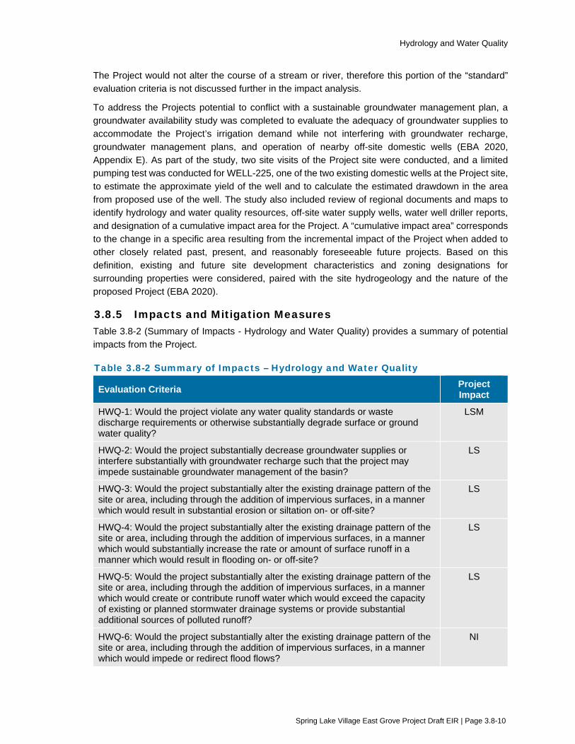
Hydrology and Water Quality
Spring Lake Village East Grove Project Draft EIR | Page 3.8-10
The Project would not alter the course of a stream or river, therefore this portion of the “standard” evaluation criteria is not discussed further in the impact analysis.
To address the Projects potential to conflict with a sustainable groundwater management plan, a groundwater availability study was completed to evaluate the adequacy of groundwater supplies to accommodate the Project’s irrigation demand while not interfering with groundwater recharge, groundwater management plans, and operation of nearby off-site domestic wells (EBA 2020, Appendix E). As part of the study, two site visits of the Project site were conducted, and a limited pumping test was conducted for WELL-225, one of the two existing domestic wells at the Project site, to estimate the approximate yield of the well and to calculate the estimated drawdown in the area from proposed use of the well. The study also included review of regional documents and maps to identify hydrology and water quality resources, off-site water supply wells, water well driller reports, and designation of a cumulative impact area for the Project. A “cumulative impact area” corresponds to the change in a specific area resulting from the incremental impact of the Project when added to other closely related past, present, and reasonably foreseeable future projects. Based on this definition, existing and future site development characteristics and zoning designations for surrounding properties were considered, paired with the site hydrogeology and the nature of the proposed Project (EBA 2020).
3.8.5 Impacts and Mitigation Measures Table 3.8-2 (Summary of Impacts - Hydrology and Water Quality) provides a summary of potential impacts from the Project.
Table 3.8-2 Summary of Impacts – Hydrology and Water Quality
Evaluation Criteria Project Impact
HWQ-1: Would the project violate any water quality standards or waste discharge requirements or otherwise substantially degrade surface or ground water quality?
LSM
HWQ-2: Would the project substantially decrease groundwater supplies or interfere substantially with groundwater recharge such that the project may impede sustainable groundwater management of the basin?
LS
HWQ-3: Would the project substantially alter the existing drainage pattern of the site or area, including through the addition of impervious surfaces, in a manner which would result in substantial erosion or siltation on- or off-site?
LS
HWQ-4: Would the project substantially alter the existing drainage pattern of the site or area, including through the addition of impervious surfaces, in a manner which would substantially increase the rate or amount of surface runoff in a manner which would result in flooding on- or off-site?
LS
HWQ-5: Would the project substantially alter the existing drainage pattern of the site or area, including through the addition of impervious surfaces, in a manner which would create or contribute runoff water which would exceed the capacity of existing or planned stormwater drainage systems or provide substantial additional sources of polluted runoff?
LS
HWQ-6: Would the project substantially alter the existing drainage pattern of the site or area, including through the addition of impervious surfaces, in a manner which would impede or redirect flood flows?
NI

Hydrology and Water Quality
Spring Lake Village East Grove Project Draft EIR | Page 3.8-11
Evaluation Criteria Project Impact
HWQ-7: In flood hazard, tsunami, or seiche zones, would the project risk release of pollutants due to project inundation?
NI
HWQ-8: Would the project conflict with or obstruct implementation of a water quality control plan or sustainable groundwater management plan?
NI
C-HWQ-1: Would the project result in a cumulatively considerable contribution to cumulative impacts related to hydrology and water quality?
LS
Notes: NI = No Impact LS = Less than Significant LSM = Less than Significant with Mitigation
Impact HWQ-1: Would the project violate any water quality standards or waste discharge requirements or otherwise substantially degrade surface or ground water quality?
Analysis: Significant
Construction
No Project activities are proposed to occur directly within Santa Rosa Creek. However, Project construction activities have the potential to degrade water quality as a result of erosion caused by earthmoving activities during construction or the accidental release of hazardous construction chemicals. In particular, the off-site stormwater drainage improvements along Melita Road would occur approximately 100 feet east of the creek channel. If not properly managed, construction activities could result in erosion, as well as the discharge of chemicals and materials, such as concrete, mortar, asphalt, fuels, and lubricants. Applicable water quality standards and waste discharge requirements could be violated, and polluted runoff could substantially degrade water quality.
SWRCB Order No. 2009-0009, as amended by Order No. 2012-0006, has been adopted for the purpose of protecting the water quality of storm water runoff, and applies to public and private construction projects that include one or more acres of soil disturbance. As the Project would both disturb greater than one acre of land, compliance with Order No. 2009-0009 would be required. As stated in Section 2.5.4 (Environmental Protection Action 4 - Implement Storm Water Control Measures during Construction), the Project applicant and/or its contractor shall obtain coverage under State Water Resources Control Board Order No. 2009-0009-DWQ. This will include submittal of permit registration documents (notice of intent, risk assessment, site maps, SWPPP, annual fee, and certifications) to the State Water Resources Control Board. The SWPPP will address pollutant sources, non-storm water discharges resulting from construction dewatering, best management practices, and other requirements specified in the above-mentioned Order. Compliance with Order No. 2012-0006, as outlined in Chapter 2, Project Description, would reduce the Project’s potential for polluted runoff during construction to substantially degrade water quality.
NCRWQCB Order No. R1-2015-0030 is the City of Santa Rosa’s current NPDES municipal storm water permit, which regulates both storm water and non-storm

Hydrology and Water Quality
Spring Lake Village East Grove Project Draft EIR | Page 3.8-12
water discharges into the municipal storm drain system. The permit applies to both public and private construction projects, and includes requirements for implementation of a minimum set of BMPs at construction sites. As the Project is located within the City of Santa Rosa, construction would be required to adhere to all requirements per Order No. R1-2015-0030. As stated in Section 2.5.4 (Environmental Protection Action 4 - Implement Storm Water Control Measures during Construction), the Project would implement the necessary BMPs in an erosion and sediment control plan, or equivalent BMPs in the SWPPP in order to comply with the City’s storm water permit.
NCRWQCB Order No. R1-2009-0045 regulates short-term discharges of clean or relatively pollutant-free wastewaters to surface waters, such as groundwater from construction dewatering. Often, groundwater generated during dewatering activities is relatively clean, but contains elevated levels of sediment and turbidity, which if discharged to the storm drain system or to surface waters, could result in localized impacts to water quality. Given the shallow groundwater levels in the Project area (as high as approximately 4 feet below the existing ground surface), excavations for foundations, utility trenches, and other improvements that extend below four feet would need to be dewatered to create a dry working surface. The discharge of sediment-laden groundwater to the storm drain system or Santa Rosa Creek during excavation dewatering could degrade water quality and violate water quality standards. Therefore, unregulated construction water discharges to surface waters or stormdrains, from excavation dewatering, could have a significant impact on water quality.
Operation
The City’s Storm Water LID Manual provides technical guidance for project designs that require the implementation of permanent storm water BMPs in accordance with the City’s NPDES storm water permit. Such projects include those that create or replace a combined total of one acre or more of impervious surface. The Project would result in approximately 3.4 acres of new impervious surfaces. As the Project would create over one acre of new impervious surfaces, it would be subject to the LID storm water design measures required by the City’s municipal storm water permit. As summarized in Chapter 2, Project Description, Section 2.4.1 (On-site Improvements), the Project design proposes collection and conveyance of storm water through a series of permanent on-site vegetated swales and storm drains that would convey storm water to several on-site rain gardens near Melita Road. The rain gardens would treat storm water runoff generated from Project-related rooftops, parking lots, and other impervious surfaces in accordance with the requirements of the City’s LID requirements. Therefore, operation of the Project would be in compliance with the City’s Storm Water LID Manual. The operational impact would be less than significant.
Mitigation: Mitigation Measure HWQ-1: Manage Construction Dewatering
If construction dewatering is required, the City shall require the Applicant and its contractor to evaluate reasonable options for dewatering management that would avoid discharging to a local surface water or storm drain. The following management options shall be considered:

Hydrology and Water Quality
Spring Lake Village East Grove Project Draft EIR | Page 3.8-13
Reuse the water on-site for dust control, compaction, or irrigation.
Retain the water on-site in a grassy or porous area to allow infiltration/evaporation.
Discharge (by permit) to a sanitary sewer.
If discharging to the sanitary sewer, the Applicant shall comply with a one-time discharge permit or other type of approval requiring, as necessary, measures for characterizing the discharge and ensuring filtering methods and monitoring to verify that the discharge is compliant with the City’s local wastewater discharge requirements.
If discharging to a local surface water or storm drain, the Applicant shall obtain coverage under NCRWQCB Order No. R1-2009-0045, Waste Discharge Requirements for Low Threat Discharges to Surface Waters in the North Coast Region. The Applicant shall submit permit registration documents to the NCRWQCB, including development of a Best Management Practices/Pollution Prevention Plan to characterize the discharge and to identify specific measures to control the discharge, such as sediment controls to ensure that excessive sediment is not discharged, and flow controls to prevent erosion and flooding downstream of the discharge. The City shall ensure that the Applicant oversees implementation of the Best Management Practices/Pollution Prevention Plan during construction dewatering activities, including visual inspections and ensuring overall compliance.
Mitigation Measure BIO-1d – Avoid Impacts to Steelhead
Please refer to Impact BIO-1, in Section 3.3, for the full description of Mitigation Measure BIO-1d.
After Mitigation: Less than Significant with Mitigation
Implementation of Mitigation Measure HWQ-1 would reduce potential Project impacts on water quality standards and waste discharge requirements from construction dewatering to a less-than-significant level by ensuring compliance with applicable waste discharge requirements, such that the discharge would not disrupt or pollute waterways. Implementation of Mitigation Measure BIO-1d would further reduce potential indirect water quality impacts to Santa Rosa Creek by taking actions to prevent degradation of water quality and erosion from off-site Project activities located in the vicinity of the creek.
Impact HWQ-2: Would the project substantially decrease groundwater supplies or interfere substantially with groundwater recharge such that the project may impede sustainable groundwater management of the basin?
Analysis: Less than Significant
Groundwater Supply
The Project site is located within the Santa Rosa Valley – Rincon Valley Subbasin (Groundwater Basin 1.055.03), which is designated as a low priority basin by the California Department of Water Resources (CDWR) in Bulletin 118 Interim Update 2016 (CDWR 2016).
Hydrology and Water Quality
Spring Lake Village East Grove Project Draft EIR | Page 3.8-14
Given the shallow groundwater levels in the Project area (approximately 4 feet below the existing ground surface), temporary groundwater dewatering may be required to provide a dry work area during certain construction activities, such as utility trenching. Dewatering methods generally involve pumping water out of a trench or excavation area. Such dewatering would be temporary and prolonged lowering of the groundwater levels in any one location would not be necessary. Such temporary dewatering would have, at most, a very small effect on localized water levels in the immediate vicinity of the excavation area. No substantial deficit in the local groundwater basin or lowering of water levels would occur. Therefore, the impact on groundwater from construction-related dewatering would be less than significant.
Following construction, domestic water supply would be provided by the City of Santa Rosa’s municipal water system, which would not decrease groundwater supplies. However, the Project proposes the use of the two existing on-site water supply wells to meet the Project’s landscape irrigation demand, which has been estimated at 2.93 acre feet of groundwater annually. The initial groundwater use is expected to be higher during the first year as the landscaping is first planted and will diminish as the vegetation matures.
To evaluate whether there are adequate existing and future groundwater supplies to accommodate the Project irrigation, the volume of water in storage within a cumulative impact area was estimated. The evaluated cumulative impact area is 317 acres in size and was calculated to have approximately 11,174 acre-feet of water in storage (EBA 2020, Appendix E). Under existing conditions, the wells serve domestic residences which demand approximately 85 acre-feet of groundwater per year. In comparison, the Project’s landscape irrigation demand is estimated to be 2.93 acre-feet per year. The Project’s groundwater supply demand represents 0.03 percent of the total groundwater in storage. The Project’s minimal groundwater use would not substantially decrease groundwater supplies such that the Project would impede sustainable groundwater management of the local sub-basin. The impact from operation of the Project on groundwater supply would be less than significant.
Potential for Well Interference
Projected groundwater drawdown characteristics associated with the Project’s landscape irrigation demand was estimated through a pumping test conducted for WELL-225 and an analytical computer model. The projected total annual groundwater use of 2.93 acre-feet per year equates to a daily water demand of 2,616 gallons per day (gpd) when averaged over the entire year. However, it is assumed that this daily water demand would vary seasonally, with most of the water use occurring during the summer and early fall. For the purpose of calculating the maximum daily water demand, it was conservatively assumed that all irrigation water use would occur over a 153-day period (i.e. May through September). Based on this assumption, the maximum daily water demand equates to 6,240 gpd for the Project.
Whereas the water demand scenario would likely occur intermittently throughout the day, the respective total volume was assumed to be pumped at one time as a
Hydrology and Water Quality
Spring Lake Village East Grove Project Draft EIR | Page 3.8-15
conservative measure to induce the maximum potential drawdown characteristics. During an October 26, 2016 pumping test, WELL-225 was pumped at a rate of about 14 gallons per minute for an 8-hour period (approximately 6,700 gallons).
The evaluation of well interference was conducted utilizing a time-versus-drawdown analytical computer model. Given a discharge rate and estimates of aquifer characteristics, the analytical model predicts groundwater drawdown as a function of distance from a pumping well. The analytical model indicated the induced drawdown would be minimal, on the order of less than one foot approximately 50 feet from the pumping well, although, seasonal variations and rate and volume of groundwater extraction may affect the magnitude of the predicted influence. Based on the drawdown characteristics and the location of the nearest existing water supply well located approximately 100 feet to the east, drawdown would not be induced at the off-site well location as a result of the anticipated pumping scenarios. Additionally, on-site WELL-225 is approximately 90 feet shallower than the adjacent off-site well, making it further unlikely that pumping would have any influence on an adjacent well. The operational impact related to potential well interference would be less than significant.
Potential Interference with Groundwater Recharge
In relation to groundwater recharge, the Project would result in the installation of approximately 3.4 acres of impervious materials onto the overall 7.28-acre site (EBA 2020). However, the Project would incorporate open areas, such as bioswale rain gardens and other permeable planting and landscaped areas conforming to City of Santa Rosa LID standards that facilitate groundwater infiltration within the Project site. Although the Project would increase the amount of impervious surface at the site compared to existing conditions, such increases are not anticipated to impact the ability of water to infiltrate into the ground. The proposed rain gardens and other permanent LID features would capture, treat, and allow infiltrating runoff generated by the 85th percentile storm event.
Based on the Project’s estimated groundwater demand of 2.93 acre-feet per year, the Project’s groundwater use would equate to approximately one percent of the water potentially available for recharge within the cumulative impact area (EBA 2020). The Project’s minimal effect on groundwater recharge would not interfere substantially with groundwater recharge at the Project site or within the cumulative impact area. The operational impact related to groundwater recharge interference would be less than significant.
Mitigation: No mitigation is needed.
Impact HWQ-3: Would the project substantially alter the existing drainage pattern of the site or area, including through the addition of impervious surfaces, in a manner which would result in substantial erosion or siltation on- or off-site?
Analysis: Less than Significant
Existing drainage in the Project area is dominated by Santa Rosa Creek, which flows approximately 100 feet south of the nearest off-site improvement area along Melita Road. As described in the Local Drainage setting section, the existing storm
Hydrology and Water Quality
Spring Lake Village East Grove Project Draft EIR | Page 3.8-16
water collection system in the Project area consists of storm drain and open drainage ditches along the edges of the site that ultimately drain to Santa Rosa Creek near Montgomery Drive. The Santa Rosa Creek channel and adjacent floodplain would remain unaltered by Project construction or operation. As part of the proposed Project, stormwater associated with all new impervious surfaces would be collected via the Project LID features, including storm water rain gardens which have been designed to comply with the City of Santa Rosa’s LID Manual and the City of Santa Rosa Storm Water NPDES Permit requirements. This includes compliance with LID design standards, including drainage management areas, numeric sizing criteria for storm water retention and treatment prior to discharge, site design measures to reduce runoff, stormwater treatment measures, and hydromodification guidelines. Stormwater would be released at the same rate as pre-project conditions, ultimately discharging to the same culvert location as under existing conditions. As a result, potential on- or off-site erosion or siltation due to increases in impervious surfaces would be less than significant.
Please refer to impact HWQ-1 for an evaluation of erosion or siltation relative to Project construction activities.
Mitigation: No mitigation is needed.
Impact HWQ-4: Would the project substantially alter the existing drainage pattern of the site or area, including through the addition of impervious surfaces, in a manner which would substantially increase the rate or amount of surface runoff in a manner which would result in flooding on- or off-site?
Analysis: Less than Significant
The Project site and off-site improvement areas are not located within a 100-year flood hazard area, within a 500-year flood hazard area, or within a floodway or other special flood hazard zone (FEMA 2008). Although the Project would create 3.4 acres of impervious surface within the existing 7.28-acre site, it is not anticipated that the additional runoff generated by the proposed improvements would not result in flooding on- or off-site. Stormwater generated as a result of the new impervious surfaces would be captured by the proposed permanent LID features which have been designed to comply with the City of Santa Rosa’s LID manual. The LID components would be installed in order to retain the increase in stormwater runoff to mimic pre-development hydrologic conditions. The LID components and drainage infrastructure would work with the existing topography of the site and would not significantly alter the existing drainage pattern of the Project site.
Additionally, off-site storm water improvements (see Section 2.4.2) are proposed in order to alleviate and prevent existing flooding that periodically occurs in the vicinity of the Project site during major rain events. With implementation of the LID components and the off-site storm water improvements it is not anticipated that flooding on- or off-site would occur. The impact would be less than significant.
Mitigation: No mitigation is needed.

Hydrology and Water Quality
Spring Lake Village East Grove Project Draft EIR | Page 3.8-17
Impact HWQ-5: Would the project substantially alter the existing drainage pattern of the site or area, including through the addition of impervious surfaces, in a manner which would create or contribute runoff water which would exceed the capacity of existing or planned stormwater drainage systems or provide substantial additional sources of polluted runoff?
Analysis: Less than Significant
On- and off-site drainage infrastructure would be installed during construction of the Project in accordance with the City of Santa Rosa LID Manual to retain the increase in runoff and mimic pre-development hydrologic conditions. The on-site LID features have been designed to capture, detain, treat, and then release runoff generated by the 85th percentile storm event. Off-site storm water drainage improvements would also be implemented to increase the capacity of the infrastructure located in the immediate vicinity of the Project site. Under existing conditions, an area within the Project vicinity occasionally floods during large storm events. Implementation of the on- and off-site storm water infrastructure would ensure the planned stormwater drainage system has adequate capacity to serve the Project. Additionally, the LID features would provide water quality treatment prior to the stormwater entering the off-site drainage system. Therefore, the Project would result in a less-than-significant impact related to exceeding the capacity of the stormwater drainage system or providing additional sources of polluted runoff.
Mitigation: No mitigation is needed.
Impact HWQ-6: Would the project substantially alter the existing drainage pattern of the site or area, including through the addition of impervious surfaces, in a manner which would impede or redirect flood flows?
Analysis: No Impact
The Project site and off-site improvement areas are located in an area designated by the FEMA as Zone X, which is an area of minimal flood hazard (FEMA 2008). The Project site and off-site improvement areas are not located within a 100-year flood hazard area, within a 500-year flood hazard area, or within a floodway or other special flood hazard zone. Additionally, as illustrated on Figure 12-4 of the City of Santa Rosa General Plan, the Project site and off-site improvement areas are not located within a dam inundation zone (Santa Rosa 2009). Therefore, implementation of the Project would not impede or redirect flood flows. No impact would result.
Mitigation: No mitigation is needed.
Impact HWQ-7: In flood hazard, tsunami, or seiche zones, would the project risk release of pollutants due to project inundation?
Analysis: No Impact
As summarized in Impact HWQ-6, the Project site and off-site improvement areas are not located within a designated flood hazard zone or dam inundation area. The Project site and off-site improvement areas are not located within a potential tsunami affected area as mapped by the California Office of Emergency Services. The potential for seiche inundation is not readily mapped for small creeks such as

Hydrology and Water Quality
Spring Lake Village East Grove Project Draft EIR | Page 3.8-18
Santa Rosa Creek. The nearest portion of the Project site is located approximately 100 feet from the Santa Rosa Creek channel and is at a higher elevation, while the nearest off-site improvement area along Melita Road is located approximately 50 feet from the channel. The distance and elevation difference, along with the relatively small channel size of Santa Rosa Creek, make it very unlikely that the Project would be exposed to risks from seiche. Therefore, implementation of the Project would not risk release of pollutants due to Project inundation. No impact would result.
Mitigation: No mitigation is needed.
Impact HWQ-8: Would the project conflict with or obstruct implementation of a water quality control plan or sustainable groundwater management plan?
Analysis: No Impact
The Project site is located within the area subject to the North Coast Water Quality Control Board’s Basin Plan (Basin Plan). The Basin Plan lists action plans and policies to achieve water quality objectives, protect present and future beneficial water uses, protect public health, and prevent nuisance (RWQCB 2018). As described under Impact HWQ-1, the Project would be required to comply with ordinance requirements, permits, and adopted BMPs that are specifically designed to reduce potential water quality impacts to a less-than-significant level. With implementation of the various requirements, BMPs, and LID features the Project would comply with all policies listed in the Basin Plan. Therefore, no impact related to obstruction of the Basin Plan would result.
As described in Impact HWQ-2, the Project site is located within the Santa Rosa Valley – Rincon Valley Subbasin, which is designated as a low priority basin designated by CDWR, therefore, the Project site is not located within a Medium or High Priority basin defined under the Sustainable Groundwater Management Act. As such, the basin is not subject to a Sustainable Groundwater Management Plan. As further summarized in Impact HWQ-2, the anticipated groundwater demand associated with landscape irrigation for the Project would not substantially decrease groundwater supplies, interfere substantially with groundwater recharge, or impede sustainable groundwater management of the basin.
The most prominent surface water feature in proximity to the Project site is Santa Rosa Creek, located approximately 150 feet southwest of the nearest on-site irrigation well. Streamflow depletion modeling conducted for the Project indicates that streamflow depletion within Santa Rosa Creek would be less than 0.0000 cubic foot per second (EBA 2020). Therefore, no streamflow depletion within Santa Rosa Creek impact would result and surface water conditions would be close to unchanged during operation of the Project. No impact would result.
Mitigation: No mitigation is needed.

Hydrology and Water Quality
Spring Lake Village East Grove Project Draft EIR | Page 3.8-19
Impact C-HWQ-1: Would the project result in a cumulatively considerable contribution to cumulative impacts related to hydrology and water quality?
Analysis: Less than Cumulatively Considerable (Less than Significant)
The geographic boundary for cumulative projects related to hydrology and water quality impacts would be the area of the sub-basin which could be potentially impacted by the Project. As described in HWQ-1 above, the Project would comply with water quality measures contained in the State Water Board’s Construction General Permit, as well as the City’s NPDES Permit. Compliance with applicable regulations as well as Mitigation Measure HWQ-1 would reduce potential water quality impacts during construction to a less-than-significant level. In addition, the Project would comply with the City’s Storm Water LID Manual to capture and treat stormwater from the new impervious surfaces created by the Project. With implementation of the LID stormwater treatment improvements it is anticipated the Project would have less than significant impacts related to water quality and runoff. Future projects, including those in Table 3-1 such as Elnoka Continuing Care Retirement Community, also would be subject to existing federal, state, and local regulations, including the City’s Storm Water LID standards and the State Water Board’s Construction General Permit regulations. Therefore, impacts to water quality during construction and operation would not be cumulatively considerable.
With regard to HWQ-3, HWQ-4, and HWQ-5, the Project includes the above mentioned LID improvements and has included improvements to existing off-site stormwater infrastructure system. With implementation of the improvements, the stormwater system would adequately accommodate stormwater from the proposed Project site and correct existing deficiencies in the system. In addition, none of the cumulative projects listed in Table 3-1 are near to the Project site such that they would use the same stormwater outfall to Santa Rosa Creek. Therefore, the Project would not contribute to a cumulative impact regarding drainage and flooding.
As described in HWQ-2, the Project’s groundwater demand would not substantially decrease groundwater supplies or interfere substantially with groundwater recharge or impede sustainable groundwater management of the local groundwater basin. The Project’s estimated annual groundwater demand of 2.93 acre feet equates to less than one percent of the groundwater in storage within the cumulative impact area and is substantially less than the amount of potential annual groundwater recharge (254 acre feet) for an average rainfall year. The Project’s contribution to a cumulative impact related to groundwater supply, would be less than significant.
With regard to HWQ-6 and HWQ-7, the Project is not located within an area that is at risk for flooding, tsunami, or seiche. Therefore, the Project could not contribute to a cumulative impact related to a release of pollutants resulting from Project inundation.
As described in HWQ-8, the Project does not conflict with the applicable Basin Plan or Sustainable Groundwater Management Plan, therefore the Project could not contribute to a cumulative impact related to a plan conflict.
Mitigation: No additional mitigation is needed.

Hydrology and Water Quality
Spring Lake Village East Grove Project Draft EIR | Page 3.8-20
3.8.6 References EBA Engineering (EBA). 2020. Groundwater Availability Study. March 6.
Department of Water Resources. 1975. Evaluation of Groundwater Resources Sonoma County. December.
California Department of Water Resources (CDWR). Bulletin 118 Interim Update 2016 (CDWR 2016).
Federal Emergency Management Agency (FEMA). 2008. FEMA National Flood Hazard Layer. Panel 06097C0734E.
North Coast Region Water Quality Control Board. 2018. Water Quality Control Plan for the North Coast Region. June.
North Coast Region Water Quality Control Board. 2015. California Regional Water Quality Control Board North Coast Region, Order No. R1-2015-0030.
Regional Water Quality Control Board (RWQCB). 2012. 303(d) list for the North Coast Region.
RGH Consultants. 2015. Geotechnical Study Report: Spring Lake Village East Grove Highway 12 and Los Alamos Road.
Santa Rosa, City of. 2009. City of Santa Rosa General Plan.
Santa Rosa, City of. 2016. 2015 Urban Water Management Plan. June
Santa Rosa, City of. 2017. City of Santa Rosa Storm Water Low Impact Development Technical Design Manual.

Land Use, Population, and Housing
Spring Lake Village East Grove Project Draft EIR | Page 3.9-1
3.9 Land Use, Population, and Housing This section evaluates potential environmental impacts related to land use, population, and housing. In addition to the analysis provided in this section, the following subjects are related to land use, population, and housing, but are evaluated in other sections of this EIR:
Potential impacts related to visual character and quality of the project, the site, and its surroundings are evaluated in Section 3.1 (Aesthetics).
Potential impacts related to project-generated noise and sensitive receptors are evaluated in Section 3.10 (Noise).
Potential impacts related to recreational facilities are evaluated in Section 3.11 (Public Services and Recreation).
Potential conflicts with the City of Santa Rosa Bicycle and Pedestrian Master Plan and impacts related to the performance of pedestrian, bicycle, and transit facilities, and designations of bicycle lanes and pedestrian corridors are evaluated in Section 3.12 (Transportation).
3.9.1 Setting
Land Use Patterns and Existing Uses
Santa Rosa voters approved a 20-year Urban Growth Boundary (UGB) measure in 1996, which encompasses an area of 45 square miles and includes incorporated and unincorporated land that will eventually be annexed and served by the City. The existing Spring Lake Village CCRC and the proposed expansion site are both located within the City limits, UGB, and Sphere of Influence of the City of Santa Rosa.
The Project is located in the eastern portion of Santa Rosa, which is located in the foothills of the Sonoma Mountains. The Project site is located in the vicinity of Santa Rosa Creek, which originates in the foothills of the Sonoma Mountains, and runs from east to west through the City, across the Santa Rosa Plain, and into the Laguna de Santa Rosa.
The Project site is located primarily in a residential area with a mix of very low to medium high density residential. The Project site is bounded to the north by Highway 12 and beyond by single-family residences; to the east by Los Alamos Road and multi-family residences; to the south by single-family residences and Melitta Station Inn, Melita Road, and Montgomery Drive; and to the west by single-family residences and a church. The Project includes off-site improvements located along portions of Los Alamos Road, Melita Road, and Highway 12.
Land Use Designation and Zoning
The Project site is currently designated as Very Low Density Residential by the City of Santa Rosa General Plan 2035. The Very Low Density Residential designation describes development densities ranging from 0.2 to 2.0 units per gross acre.
The Project site is currently zoned Rural Residential (RR-20 and RR-40) by the City of Santa Rosa. The largest of the three parcels that constitute the Project site (APN 031-101-026) is zoned RR-40 and the two smaller parcels containing single family homes (APNs 031-101-035 and 031-101-034) are zoned RR-20. The RR-20 zone is very similar to the RR-40 with regard to allowable uses and development standards, but permits a higher residential density by allowing smaller minimum lot sizes. These zones apply to areas of the City intended to accommodate residential neighborhoods with compatible agricultural uses, but where the primary uses are residential and compatible

Land Use, Population, and Housing
Spring Lake Village East Grove Project Draft EIR | Page 3.9-2
accessory uses. Other permitted uses include small community care facilities, small family day care homes, and small health care facilities. The proposed use of “Residential Senior Independent Living Facility” is considered to meet the definition of a “Community Care Facility”, as defined in the Santa Rosa Zoning Code. A Community Care Facility is a facility, place, or building that is maintained and operated to provide non-medical residential care, which may include home finding and other services, for children and/or adults, including: the physically handicapped; mentally impaired, mentally disordered, or incompetent; developmentally disabled; court wards and dependents; neglected or emotionally disturbed children; the addicted; and the aged.
Table 3.9-1 displays the zoning purposes and standards for the RR-20 and RR-40 designations, as well as for the proposed zoning designations at the Project site of PD-0308.
Table 3.9-1 Spring Lake Village East Grove Zoning
Standards City RR-20 City RR-40 City PD-0308
Density 1 unit per parcel(a) 1 unit per parcel(a) 15 units per acre (a)
Minimum lot size 20,000 sf 1 acre N/A
Primary structure setback
Front Side-Interior Side-Corner Rear
20 feet 5 feet 15 feet 20 feet
20 feet 5 feet 20 feet 20 feet
15 feet(b) 5 feet 1-story/10 feet 2-story 5 feet 1-story/10 feet 2-story 5 feet
Lot Coverage 40% 40% 60%
Primary structure height limit 35 feet 35 feet 45 feet Source: City of Santa Rosa 2010
Note (a) Allows one accessory dwelling unit (ADU)
(b) 19 feet for garages and carports
3.9.2 Regulatory Framework
Federal and State
There are no federal or State land use plans, policies, or regulations pertaining to the Project.
Regional and Local
City of Santa Rosa General Plan The following goals and policies from the City of Santa Rosa General Plan 2035 are generally related to land use and planning and are applicable to the Project.
LUL-E Promote livable neighborhoods by requiring compliance with green building programs to ensure that new construction meets high standards of energy efficiency and sustainable material use. Ensure that everyday shopping, park and recreation facilities, and schools are within easy walking distance of most residents.

Land Use, Population, and Housing
Spring Lake Village East Grove Project Draft EIR | Page 3.9-3
LUL-E-2 As part of planning and development review activities, ensure that projects, subdivisions, and neighborhoods are designed to foster livability.
Utilize the City’s Design Guidelines as a reference when evaluating the following neighborhood components:
Streets. Street design, traffic calming, and landscaping can make great contributions to the creation of successful neighborhoods. Neighborhood streets should be quiet, safe, and accommodate pedestrians and bicyclists.
Connections. Neighborhoods should be well connected to local shops and services, public plazas and gathering places, park lands, downtown, schools, and recreation by adequate and safe streets, bike lanes, public pathways, trails, general infrastructure (e.g., sidewalks and crosswalks), and transit.
Neighborhood Character. Each neighborhood should maintain a distinct identity, such as the historic preservation districts featuring Victorian cottages and California bungalows.
Diversity and Choice. Neighborhoods should provide choices for residents with different values. Different housing types and locations within the City accommodate a diverse range of needs.
LUL-E-3 Avoid concentration of large community care facilities in a single residential neighborhood.
LUL-E-4 Protect the rural quality of Very Low Density areas within the Urban Growth Boundary through design and development standards in the Zoning Code, and development review.
LUL-F Maintain a diversity of neighborhoods and varied housing stock to satisfy a wide range of needs.
LUL-F-3 Maintain a balance of various housing types in each neighborhood and ensure that new development does not result in undue concentration of a single housing type in any one neighborhood. Downtown is excepted.
GM-A Prevent urban sprawl by focusing growth within the Urban Growth Boundary.
GM-A-1 Contain urban development in the Santa Rosa area within the City’s Urban Growth Boundary.
H-D Provide housing for households with special needs
H-D-11 Encourage the development of affordable housing for the elderly, particularly for those in need of assisted and skilled nursing care. Continue to provide funding and offer incentives such as density bonuses, reduced parking requirements, design flexibility, and deferred development fees.

Land Use, Population, and Housing
Spring Lake Village East Grove Project Draft EIR | Page 3.9-4
Santa Rosa Zoning Code The Project includes a rezone from RR-20 and RR-40 to PD-0308. PD-0308 was created on September 10, 1981 to facilitate the construction of a full life senior citizen facility at 5555 Montgomery Drive. As an expansion project, the applicant is requesting that the Project parcels be rezoned to PD-308, consistent with the existing Spring Lake Village campus. The Project would be owned and operated by the same entity as the existing Spring Lake Village Community Care facility located at 5555 Montgomery Drive. While the Project site and the site of the existing facility are not contiguous, their close proximity and common ownership will allow them to function as a single entity for operational purposes. In a Policy Statement dated September 2, 1981, the development standards of the planned development are described. This Policy Statement set the base zone district as R-3-15 (which standards apply unless modified by the PD), established the permitted uses, minimum site size, maximum lot coverage, parking, and other development standards. Some of these requirements have subsequently been modified, named minimum site size and maximum number of units, as the facility has been expanded over the years. The Project must comply with the development standards contained in the Santa Rosa Zoning Code, including those requirements in PD-0308.
Santa Rosa Citywide Creek Master Plan The following are the goals and policies from the Santa Rosa Citywide Creek Master Plan that are applicable to this Project.
SW The ability of waterways to carry storm water runoff and surface drainage is protected and improved to alleviate flood risk.
SW-2 Implement the Storm Water Low Impact Development Technical Design Manual.
WQ Water quality of creeks is protected and enhanced.
WQ-2 Use a combination of Storm Water Best Management Practices (BMPs), constructed devices, and biological systems, to remove pollutants and protect water quality.
PR Private property rights are respected.
PR-1 Where discretionary land use approvals are sought, development shall, to the extent possible, be consistent with the Master Plan.
3.9.3 Evaluation Criteria and Significance Thresholds For the purpose of this EIR, the evaluation criteria and significance thresholds summarized in Table 3.9-2 (Evaluation Criteria and Significance Thresholds) are used to determine if the Project would have a significant effect related to land use, population, and housing.
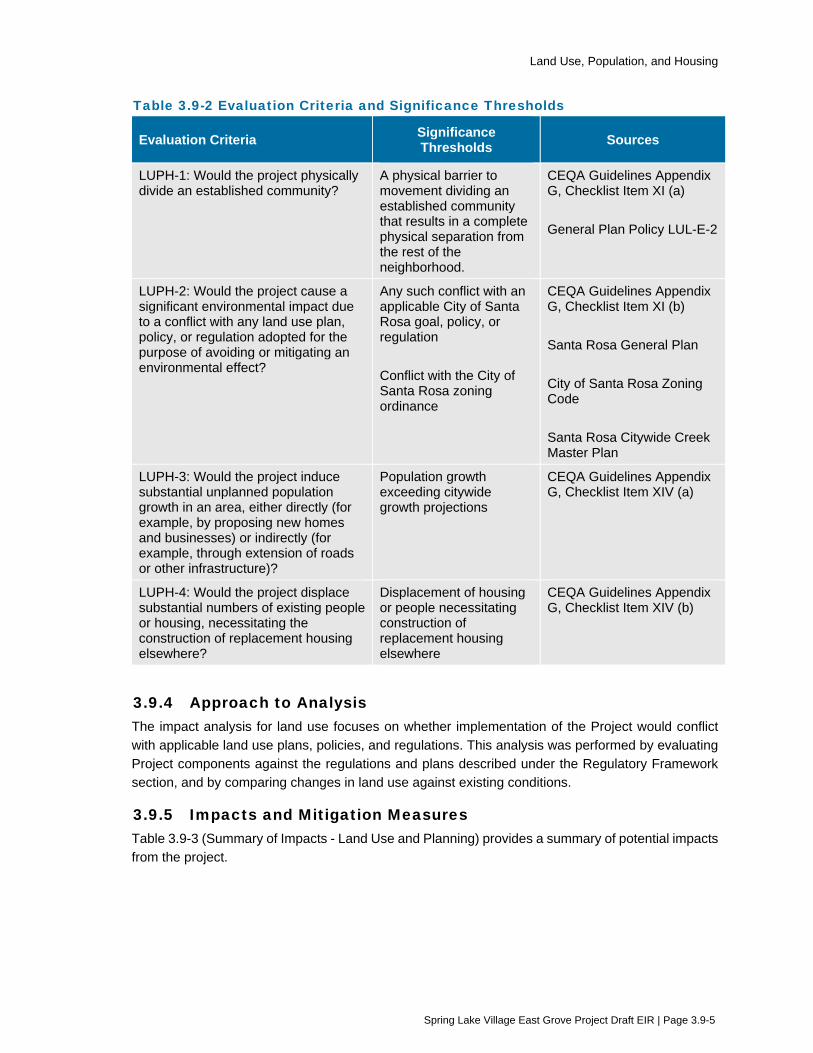
Land Use, Population, and Housing
Spring Lake Village East Grove Project Draft EIR | Page 3.9-5
Table 3.9-2 Evaluation Criteria and Significance Thresholds
Evaluation Criteria Significance Thresholds Sources
LUPH-1: Would the project physically divide an established community?
A physical barrier to movement dividing an established community that results in a complete physical separation from the rest of the neighborhood.
CEQA Guidelines Appendix G, Checklist Item XI (a) General Plan Policy LUL-E-2
LUPH-2: Would the project cause a significant environmental impact due to a conflict with any land use plan, policy, or regulation adopted for the purpose of avoiding or mitigating an environmental effect?
Any such conflict with an applicable City of Santa Rosa goal, policy, or regulation Conflict with the City of Santa Rosa zoning ordinance
CEQA Guidelines Appendix G, Checklist Item XI (b) Santa Rosa General Plan City of Santa Rosa Zoning Code Santa Rosa Citywide Creek Master Plan
LUPH-3: Would the project induce substantial unplanned population growth in an area, either directly (for example, by proposing new homes and businesses) or indirectly (for example, through extension of roads or other infrastructure)?
Population growth exceeding citywide growth projections
CEQA Guidelines Appendix G, Checklist Item XIV (a)
LUPH-4: Would the project displace substantial numbers of existing people or housing, necessitating the construction of replacement housing elsewhere?
Displacement of housing or people necessitating construction of replacement housing elsewhere
CEQA Guidelines Appendix G, Checklist Item XIV (b)
3.9.4 Approach to Analysis The impact analysis for land use focuses on whether implementation of the Project would conflict with applicable land use plans, policies, and regulations. This analysis was performed by evaluating Project components against the regulations and plans described under the Regulatory Framework section, and by comparing changes in land use against existing conditions.
3.9.5 Impacts and Mitigation Measures Table 3.9-3 (Summary of Impacts - Land Use and Planning) provides a summary of potential impacts from the project.
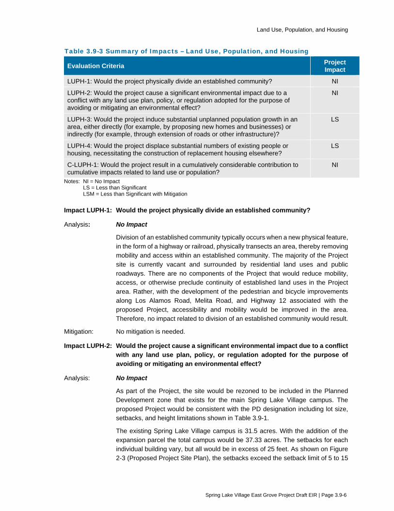
Land Use, Population, and Housing
Spring Lake Village East Grove Project Draft EIR | Page 3.9-6
Table 3.9-3 Summary of Impacts – Land Use, Population, and Housing
Evaluation Criteria Project Impact
LUPH-1: Would the project physically divide an established community? NI
LUPH-2: Would the project cause a significant environmental impact due to a conflict with any land use plan, policy, or regulation adopted for the purpose of avoiding or mitigating an environmental effect?
NI
LUPH-3: Would the project induce substantial unplanned population growth in an area, either directly (for example, by proposing new homes and businesses) or indirectly (for example, through extension of roads or other infrastructure)?
LS
LUPH-4: Would the project displace substantial numbers of existing people or housing, necessitating the construction of replacement housing elsewhere?
LS
C-LUPH-1: Would the project result in a cumulatively considerable contribution to cumulative impacts related to land use or population?
NI
Notes: NI = No Impact LS = Less than Significant LSM = Less than Significant with Mitigation
Impact LUPH-1: Would the project physically divide an established community?
Analysis: No Impact
Division of an established community typically occurs when a new physical feature, in the form of a highway or railroad, physically transects an area, thereby removing mobility and access within an established community. The majority of the Project site is currently vacant and surrounded by residential land uses and public roadways. There are no components of the Project that would reduce mobility, access, or otherwise preclude continuity of established land uses in the Project area. Rather, with the development of the pedestrian and bicycle improvements along Los Alamos Road, Melita Road, and Highway 12 associated with the proposed Project, accessibility and mobility would be improved in the area. Therefore, no impact related to division of an established community would result.
Mitigation: No mitigation is needed.
Impact LUPH-2: Would the project cause a significant environmental impact due to a conflict with any land use plan, policy, or regulation adopted for the purpose of avoiding or mitigating an environmental effect?
Analysis: No Impact
As part of the Project, the site would be rezoned to be included in the Planned Development zone that exists for the main Spring Lake Village campus. The proposed Project would be consistent with the PD designation including lot size, setbacks, and height limitations shown in Table 3.9-1.
The existing Spring Lake Village campus is 31.5 acres. With the addition of the expansion parcel the total campus would be 37.33 acres. The setbacks for each individual building vary, but all would be in excess of 25 feet. As shown on Figure 2-3 (Proposed Project Site Plan), the setbacks exceed the setback limit of 5 to 15
Land Use, Population, and Housing
Spring Lake Village East Grove Project Draft EIR | Page 3.9-7
feet for PD-0308. The tallest building is the Villa at 28 feet 3 inches, which is within the 45-foot height limit of PD-0308.
Applicable land use policies (LUL-E, LUL-F, and GM-A) include promoting livable neighborhoods, maintaining a diversity of neighborhoods and varied housing stock, and preventing urban sprawl. The Project’s pedestrian and bicycle improvements along Highway 12, Los Alamos Road, and Melita Road would all serve to promote the livability of the neighborhood and enhance the pedestrian and circulation network within the neighborhood. The nature of the Project as a senior living facility adds to the varied housing stock within the City of Santa Rosa. The expansion would add independent living facilities for the elderly including dining, fitness, and lifestyle activities, supplemented by the health care facilities on the main campus. The location of the Project is within the Urban Growth Boundary, and would not be considered sprawl.
Community care facilities are allowed in almost all zoning districts in the City through a Conditional Use Permit. However, General Plan Policy LUL-E-3 seeks to avoid the concentration of community care facilities in any single residential neighborhood. City Code 20.42-060 states community care facilities cannot be located within 300 feet of another community care facility and can be located within 1,000 feet of another facility only if mitigated properly. While the Project results in the creation of a new partially-independent residential senior independent living facility, for regulatory purposes it is considered by the City to be an expansion of the existing facility and not a new facility per City Code 20.42-060. The rationale for this finding is that the Project site is located near the existing facility (approximately 530 feet measured parcel edge to parcel edge) and that the operations and management of the expansion would be shared with the existing facility. Examples of the ways in which the existing and proposed facilities would share operations and management include leasing and administrative services, facility maintenance, staff and services, shuttle service between the two facilities, and extracurricular and enrichment services. Residents of the existing campus and the East Grove expansion site could use amenities at either location. In this way, the location of the Project is not in conflict with the Santa Rosa Zoning Code.
The Santa Rosa Creek Master Plan includes policies that focus on storm water and water quality as a means to protecting waterways in Santa Rosa. The Project would implement storm water measures, including implementing storm water rain gardens consistent with the City of Santa Rosa’s Low Impact Development Manual, consistent with Policy SW-2. The rain gardens would detain and remove pollutants through natural, physical, biological, and chemical processes prior to water entering off-site roadside drainages and Santa Rosa Creek. In addition, as noted under Environmental Protection Action 4 in Chapter 2 (Project description), the Project would implement stormwater BMPS as part of compliance with a Storm Water Pollution Prevention Plan, consistent with Policy WQ-2.
In summary, the Project would be consistent with the Santa Rosa General Plan and fulfill its goals and policies relative to providing livable, diverse neighborhoods. Upon the successful rezone, the Project would be consistent with the Santa Rosa Zoning code with regard to allowable land uses, residential densities, and the
Land Use, Population, and Housing
Spring Lake Village East Grove Project Draft EIR | Page 3.9-8
requirement to maintain a minimum 1,000 feet separation between community care facilities. The Project also would fulfill the goals and policies of the Santa Rosa Creek Master Plan relative to storm water and water quality. No impact related to a conflict with any land use plan, policy, or regulation would result.
Mitigation: No mitigation is needed.
Impact LUPH-3: Would the project induce substantial unplanned population growth in an area, either directly (for example, by proposing new homes and businesses) or indirectly (for example, through extension of roads or other infrastructure)?
Analysis: Less than Significant
Implementation of the Project would create 32 independent living units and twelve full-time employment opportunities. In 2009, the 2035 Santa Rosa General Plan EIR estimated that the population would be approximately 223,520 in 2035 and approximately 23,770 dwelling units would be added to the existing supply by that time. The 2019 population of Santa Rosa is estimated to be 176,753 according to the US Census Bureau. According to building permit data obtained from the City of Santa Rosa, 2,883 new housing units were constructed in the City between 2010 and 2019. This represents approximately 11% of the planned capacity. Therefore, the additional units to be created by the Project will not exceed the overall planned growth examined in the 2035 Santa Rosa General Plan EIR. The Project is not considered substantial unplanned population growth. It would provide needed community care housing for Santa Rosa senior citizens. Finally, the Project would not extend infrastructure or roads into areas that have not previously been accessible or developed. The potential impact from unplanned growth would be less than significant.
Mitigation: No mitigation is needed.
Impact LUPH-4: Would the project displace substantial numbers of existing people or housing, necessitating the construction of replacement housing elsewhere?
Analysis: Less than Significant
Implementation of the Project would include removal of two existing single-family residential homes at 5803 Melita Road and 5815 Melita Road. The residences are owned by the Project applicant, Covia Communities, who currently rents the two homes. Overall, implementation of the Project would result in a net increase in residential units at the Project site and within the City of Santa Rosa. Given only two residences would demolished, displacement of substantial numbers of existing people or housing would not occur, and no replacement housing elsewhere would be necessitated. The impact would be less than significant.
Mitigation: No mitigation is needed.

Land Use, Population, and Housing
Spring Lake Village East Grove Project Draft EIR | Page 3.9-9
Impact C-LUPH-1: Would the project result in a cumulatively considerable contribution to cumulative impacts related to land use or population?
Analysis: No Impact
For land use, the geographic scope for assessing cumulative impacts is the area immediately surrounding the Project site, since this area would have the most relevant land use impacts. The Project was found to be consistent with the City’s General Plan and proposed zoning requirements. Any future development that would occur within the City or in the Spring Lake Village surrounding area would be subject to further site-specific development and environmental review to determine consistency with the Santa Rosa 2035 General Plan, the City of Santa Rosa Zoning Ordinance, and other regional plans and policies, as appropriate. In addition, implementation of the cumulative projects listed in Table 3-1 (Projects Considered for Cumulative Impacts) would not displace substantial numbers of exiting people or housing. No overlapping land use impacts from cumulative projects would occur.
Mitigation: No mitigation is needed.
3.9.6 References Santa Rosa, City of. 2009. Santa Rosa General Plan 2035. November 3.
Santa Rosa, City of. 2009. Santa Rosa General Plan 2035 Environmental Impact Report. June.
Santa Rosa, City of. 2010. Santa Rosa City Code 20-22.050 Residential District General Development Standards.
Santa Rosa, City of. 2013. Santa Rosa Citywide Creek Master Plan.

Noise
Spring Lake Village East Grove Project Draft EIR | Page 3.10-1
3.10 Noise This section provides a description of the existing noise in the Project area and evaluates changes to those conditions that would result from implementation of the proposed Project. In addition to the analysis provided in this section, the following subjects are related to noise, but are evaluated in other sections of this EIR:
Noise impacts to wildlife are evaluated in Section 3.3 (Biological Resources).
3.10.1 Setting
Fundamentals of Acoustics
Noise may be defined as unwanted sound. Noise is usually objectionable because it is disturbing or annoying. The objectionable nature of sound could be caused by its pitch or its loudness. Pitch is the height or depth of a tone or sound, depending on the relative rapidity (frequency) of the vibrations by which it is produced. Higher pitched signals sound louder to humans than sounds with a lower pitch. Loudness is intensity of sound waves combined with the reception characteristics of the ear. Intensity may be compared with the height of an ocean wave in that it is a measure of the amplitude of the sound wave.
In addition to the concepts of pitch and loudness, there are several noise measurement scales which are used to describe noise in a particular location. A decibel (dB) is a unit of measurement that indicates the relative amplitude of a sound. The zero on the decibel scale is based on the lowest sound level that the healthy, unimpaired human ear can detect. Sound levels in decibels are calculated on a logarithmic basis. An increase of 10 decibels represents a ten-fold increase in acoustic energy, while 20 decibels is 100 times more intense, 30 decibels is 1,000 times more intense, etc. There is a relationship between the subjective noisiness or loudness of a sound and its intensity. Each 10 decibel increase in sound level is perceived as approximately a doubling of loudness over a fairly wide range of intensities. Technical terms are defined in Table 3.10-1 (Definitions of Acoustical Terms).
There are several methods of characterizing sound. The most common method in California is the A-weighted sound level or dBA. This scale gives greater weight to the frequencies of sound to which the human ear is most sensitive. Because sound levels can vary markedly over a short period of time, a method for describing either the average character of the sound or the statistical behavior of the variations must be utilized. Most commonly, environmental sounds are described in terms of an average level that has the same acoustical energy as the summation of all the time-varying events. This energy-equivalent sound/noise descriptor is called Leq. The most common averaging period is hourly, but Leq can describe any series of noise events of arbitrary duration.
The scientific instrument used to measure noise is the sound level meter. Sound level meters can accurately measure environmental noise levels to within about plus or minus 1 dBA. Various computer models are used to predict environmental noise levels from sources, such as roadways and airports. The accuracy of the predicted models depends upon the distance the receptor is from the noise source. Close to the noise source, the models are accurate to within about plus or minus 1 to 2 dBA.
Since the sensitivity to noise increases during the evening and at night -- because excessive noise interferes with the ability to sleep -- 24-hour descriptors have been developed that incorporate artificial noise penalties added to quiet-time noise events. The Community Noise Equivalent Level

Noise
Spring Lake Village East Grove Project Draft EIR | Page 3.10-2
(CNEL) is a measure of the cumulative noise exposure in a community, with a 5 dB penalty added to evening (7:00 p.m. - 10:00 p.m.) and a 10 dB addition to nocturnal (10:00 p.m. - 7:00 a.m.) noise levels. The Day/Night Average Sound Level (Ldn) is essentially the same as CNEL, with the exception that the evening time period is dropped and all occurrences during this three-hour period are grouped into the daytime period.
Table 3.10-1 Definition of Acoustical Terms
Term Definition
Decibel, dB
A unit describing the amplitude of sound, equal to 20 times the logarithm to the base 10 of the ratio of the pressure of the sound measured to the reference pressure, which is 20 micropascals (20 micronewtons per square meter).
Frequency, Hz The number of complete pressure fluctuations per second above and below atmospheric pressure.
A-Weighted Sound Level, dBA The sound pressure level in decibels as measured on a sound level meter using the A-weighting filter network. The A-weighting filter de-emphasizes the very low and very high frequency components of the sound in a manner similar to the frequency response of the human ear and correlates well with subjective reactions to noise. All sound levels in this section are A-weighted, unless indicated otherwise.
L01, L10, L50, L90 The A-weighted noise levels that are exceeded 1%, 10%, 50%, and 90% of the time during the measurement period.
Equivalent Noise Level, Leq The average A-weighted noise level during the measurement period.
Community Noise Equivalent Level, CNEL
The average A-weighted noise level during a 24-hour day, obtained after addition of 5 decibels in the evening from 7:00 p.m. to 10:00 p.m. and after addition of 10 decibels to sound levels in the night between 10:00 p.m. and 7:00 a.m.
Day/Night Noise Level, Ldn or DNL
The average A-weighted noise level during a 24-hour day, obtained after addition of 10 decibels to levels measured in the night between 10:00 p.m. and 7:00 a.m.
Lmax, Lmin The maximum and minimum A-weighted noise level during the measurement period.
Ambient Noise Level The composite of noise from all sources near and far. The normal or existing level of environmental noise at a given location.
Intrusive That noise which intrudes over and above the existing ambient noise at a given location. The relative intrusiveness of a sound depends upon its amplitude, duration, frequency, and time of occurrence and tonal or informational content as well as the prevailing ambient noise level.
Fundamentals of Groundborne Vibration
Ground vibration consists of rapidly fluctuating motions or waves with an average motion of zero. Several methods are typically used to quantify the amplitude of vibration including Peak Particle Velocity (PPV) and Root Mean Square (RMS) velocity. PPV is defined as the maximum

Noise
Spring Lake Village East Grove Project Draft EIR | Page 3.10-3
instantaneous positive or negative peak of the vibration wave. RMS velocity is defined as the average of the squared amplitude of the signal, usually measured in decibels referenced to 1 micro-in/sec and reported in vibration decibels (VdB). PPV and VdB vibration velocity amplitudes are used in this analysis to evaluate the effect on buildings and human response to vibration.
Low-level vibrations frequently cause irritating secondary vibration, such as a slight rattling of windows, doors or stacked dishes. The rattling sound can give rise to exaggerated vibration complaints, even though there is very little risk of actual structural damage. This rattling phenomenon may also be produced by loud airborne environmental noise causing induced vibration in exterior doors and windows. In urban environments sources of groundborne vibration include construction activities, light and heavy rail transit, and heavy trucks and buses.
Construction activities can cause vibration that varies in intensity depending on several factors. The use of pile driving and vibratory compaction equipment typically generates the highest construction related groundborne vibration levels. Because of the impulsive nature of such activities, the use of the PPV descriptor has been routinely used to measure and assess groundborne vibration and almost exclusively to assess the potential of vibration to induce structural damage and the degree of annoyance for humans.
The two primary concerns with construction-induced vibration, the potential to damage a structure and the potential to interfere with the enjoyment of life are evaluated against different vibration limits. Studies have shown that the threshold of perception for average persons is in the range of 0.008 to 0.012 in/sec PPV. Human perception to vibration varies with the individual and is a function of physical setting and the type of vibration. Persons exposed to elevated ambient vibration levels, such as people in an urban environment, may tolerate a higher vibration level.
Structural damage can be classified as cosmetic only, such as minor cracking of building elements, or may threaten the integrity of the building. Safe vibration limits that can be applied to assess the potential for damaging a structure vary by researcher and there is no general consensus as to what amount of vibration may pose a threat for structural damage to the building. Construction-induced vibration that can be detrimental to the building is very rare and has only been observed in instances where the structure is at a high state of disrepair and the construction activity occurs immediately adjacent to the structure.
Existing Ambient Noise Environment
The Project site is bordered by existing single-family residential uses to the northwest and southeast at the site entry near Melita Road, multi-family residential uses to the southeast opposite Los Alamos Road, the Hope Chapel to the northwest, and distant single family homes opposite Highway 12 to the northeast. The noise environment at the Project site and the general vicinity is dominated by traffic on Highway 12, Los Alamos Road, with distant traffic from Melita Road and Montgomery Drive.
Four long-term noise measurements were conducted on the Project site to evaluate the existing noise environment. Measurement locations LT-1 and LT-2 were conducted simultaneously over a 117-hour weekend/holiday/weekday period between 2:00 p.m. Friday, May 27th and 11:00 a.m. Wednesday, June 1st, 2016. Measurement LT-3 was conducted over a 50-hour weekday period between 12:00 p.m. Wednesday, June 1st and 2:00 p.m. Friday, June 3rd, 2016. The fourth long measurement (LT-4) was conducted over a 98-hour weekend/weekday period between 2:00pm on Friday July 14th and 4:00 p.m. on Tuesday July 18th, 2017.

Noise
Spring Lake Village East Grove Project Draft EIR | Page 3.10-4
Sound level measurement LT-1 was located in a wooded area on the Los Alamos Road frontage on a tree trunk at a distance of approximately 72 feet from the roadway centerline, which is the approximate distance of the adjacent single family home and the closest residential façades of the Los Alamos townhomes to the roadway centerline. Noise levels measured at this site were primarily produced by traffic on Los Alamos Road.
Sound level measurement LT-2 was conducted on the upper trunk of a tree approximately 230 feet from the centerline of Melita Road the Project property line shared with the single-family home to the northwest. Noise levels measured at this site were primarily produced by traffic on Montgomery and Melita Roads.
Sound level measurement LT-3 was located on a tree trunk near the future façade of the proposed residence nearest Highway 12. Noise levels measured at this site were primarily produced by traffic on Hwy 12.
Sound level measurement LT-4 was located on a tree trunk near the property line shared by the proposed development, the Hope Chapel, and the residential property north of the Project site. Noise levels measured at this site were primarily produces by traffic on Highway 12 (Illingworth &Rodkin 2017).
Table 3.10-2 summarizes the noise ambient noise levels recorded during the acoustical study performed for the Project.
Table 3.10-2 Existing Ambient Base Noise Levels
Measurement Location Period Day Night
LT-1
weekday average 53 to 60 dBA Leq 42 to 59 dBA Leq weekend average 53 to 59 dBA Leq 40 to 54 dBA Leq
Memorial Day 2016 54 to 61 dBA Leq 40 to 55 dBA Leq at night average day/night 59 dBA Ldn
LT-2
weekday average 45 to 51 dBA Leq 38 to 50 dBA Leq weekend average 44 to 51 dBA Leq 39 to 43 dBA Leq
Memorial Day 2016 45 to 52 dBA Leq 38 to 48 dBA Leq average day/night 52 dBA Ldn
LT-3 weekday average 50 to 58 dBA Leq 43 to 58 dBA Leq average day/night 59 dBA Ldn
LT-4 Weekday average 46 to 55 dBA Leq 35 to 51 dBA Leq Weekend average 47 to 55 dBA Leq 39 to 48 dBA Leq Average day/night 53 dBA Ldn
Source: Illingworth and Rodkin 2017
3.10.2 Regulatory Framework
Federal
Federal Noise Control Act of 1972 The basic motivating legislation for noise control in the U.S. was provided by the Federal Noise Control Act of 1972, which addressed the issue of noise as a threat to human health and welfare,

Noise
Spring Lake Village East Grove Project Draft EIR | Page 3.10-5
particularly in urban areas. In response to the Noise Control Act, the U.S. Environmental Protection Agency (EPA) published Information on Levels of Environmental Noise Requisite to Protect Public Health and Welfare with an Adequate Margin of Safety (EPA 1974). In summary, EPA findings were that sleep, speech, and other types of essential activity interference could be avoided in residential areas if the Ldn did not exceed 55 dBA outdoors and 45 dBA indoors. The EPA intent was not that these findings necessarily be considered as mandatory standards, criteria, or regulatory goals, but as advisory exposure levels below which there is no reason to suspect that the general population would be at risk from any of the identified health or welfare effects of noise. The EPA Levels report also identified 5 dBA as an adequate margin of safety before an increase in noise level would produce a significant increase in the severity of community reaction (i.e., increased complaint frequency, annoyance percentages, etc.) provided that the existing baseline noise exposure did not exceed 55 dBA Ldn.
Table 3.10-3 provides examples of protective noise levels recommended by the EPA. The Occupational Safety and Health Administration (OSHA) regulations protect the hearing of workers exposed to occupational noise.
Table 3.10-3 Recommended Noise Levels for Protection of Public Health and Welfare
Effect Level Area
Hearing Loss Leq(24) > 70 dBA All areas
Outdoor Activity Interference and Annoyance
Ldn > 55 dBA Outdoors in residential areas and farms and other areas where people spend widely varying amount of time and other places in which quiet is a basis for use
Leq(24) > 55 dBA Outdoor areas where people spend limited amounts of time, such as school yards and playgrounds
Indoor Activity Interference and Annoyance
Ldn > 45 dBA Indoor residential areas
Leq(24) > 45 dBA Other indoor areas with human activities, such as schools Source: EPA 1974
Note dBA = A-weighted decibels Ldn = day-night noise level Leq(24) = energy-equivalent noise level over a 24-hour period.
Federal Transit Administration The U.S. Department of Transportation, Federal Transit Administration (FTA) Office of Planning and Environment has established the following construction vibration damage criteria for various structural categories, which are commonly used to evaluate construction vibration impacts, presented in Table 3.10-4 (Construction Vibration Damage Criteria).

Noise
Spring Lake Village East Grove Project Draft EIR | Page 3.10-6
Table 3.10-4 Construction Vibration Damage Criteria Building Category PPV (inches/second)
I. Reinforced-concrete, steel or timber (no plaster) 0.5
II. Engineered concrete and masonry (no plaster) 0.3
III. Non-engineered timber and masonry buildings 0.2
IV. Buildings extremely susceptible to vibration damage 0.12
I. Reinforced-concrete, steel or timber (no plaster) 0.5
II. Engineered concrete and masonry (no plaster) 0.3 Source: FTA 2006
Note: PPV =peak particle velocity
State
2019 California Building Code, Title 24, Part 2 The current (2019) California Building Code (CBC) Chapter 12, Interior Environment, Section 1206 (Sound Transmission) contains the following interior noise requirements:
1206.4 Allowable interior noise levels. Interior noise levels attributable to exterior sources shall not exceed 45 dB in any habitable room. The noise metric shall be either day-night
average sound level (Ldn) or the community noise equivalent level (CNEL), consistent with the noise element of the local general plan.
State Building Code The development of new dormitory, apartment and other multi-family housing types other than detached single family dwellings are subject to the Noise Insulation Standards set forth in the 2007 California Building Code (Chapter 12, Appendix Section 1207.11.2). These standards establish the maximum interior noise level at an Ldn/CNEL of 45 dBA where exterior noise levels exceed an Ldn/CNEL of 60 dBA.
California Department of Transportation – Construction Vibration Caltrans recommends a vibration limit of 0.5 in/sec PPV for buildings structurally sound and designed to modern engineering standards. A conservative vibration limit of 0.25 to 0.30 in/sec PPV has been used for older buildings that are found to be structurally sound but cosmetic damage to plaster ceilings or walls is a major concern. For historic buildings or buildings that are documented to be structurally weakened, a conservative limit of 0.08 in/sec PPV is often used to provide the highest level of protection. All of these limits have been used successfully and compliance to these limits has not been known to result in appreciable structural damage. All vibration limits referred to herein apply on the ground level and take into account the response of structural elements (i.e. walls and floors) to groundborne excitation (Caltrans 2013).
Regional and Local
Santa Rosa Land Use Compatibility Standards for Community Noise The Noise and Land Use Compatibility standards adopted by the City of Santa Rosa (reference Figure 12-1 in the Santa Rosa General Plan 2035) guide the evaluation of the proposed Project’s compatibility of the noise environment on the site. These standards identify four categories for noise and land use compatibility. “Normally acceptable” noise levels are satisfactory for the specified land use provided that buildings are conventional construction. “Conditionally acceptable” noise levels
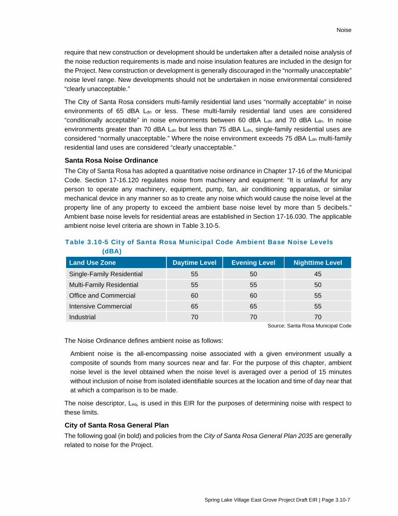
Noise
Spring Lake Village East Grove Project Draft EIR | Page 3.10-7
require that new construction or development should be undertaken after a detailed noise analysis of the noise reduction requirements is made and noise insulation features are included in the design for the Project. New construction or development is generally discouraged in the “normally unacceptable” noise level range. New developments should not be undertaken in noise environmental considered “clearly unacceptable.”
The City of Santa Rosa considers multi-family residential land uses “normally acceptable” in noise environments of 65 dBA Ldn or less. These multi-family residential land uses are considered “conditionally acceptable” in noise environments between 60 dBA Ldn and 70 dBA Ldn. In noise environments greater than 70 dBA Ldn but less than 75 dBA Ldn, single-family residential uses are considered “normally unacceptable.” Where the noise environment exceeds 75 dBA Ldn multi-family residential land uses are considered “clearly unacceptable.”
Santa Rosa Noise Ordinance The City of Santa Rosa has adopted a quantitative noise ordinance in Chapter 17-16 of the Municipal Code. Section 17-16.120 regulates noise from machinery and equipment: “It is unlawful for any person to operate any machinery, equipment, pump, fan, air conditioning apparatus, or similar mechanical device in any manner so as to create any noise which would cause the noise level at the property line of any property to exceed the ambient base noise level by more than 5 decibels.” Ambient base noise levels for residential areas are established in Section 17-16.030. The applicable ambient noise level criteria are shown in Table 3.10-5.
Table 3.10-5 City of Santa Rosa Municipal Code Ambient Base Noise Levels (dBA)
Land Use Zone Daytime Level Evening Level Nighttime Level Single-Family Residential 55 50 45 Multi-Family Residential 55 55 50 Office and Commercial 60 60 55 Intensive Commercial 65 65 55 Industrial 70 70 70
Source: Santa Rosa Municipal Code
The Noise Ordinance defines ambient noise as follows:
Ambient noise is the all-encompassing noise associated with a given environment usually a composite of sounds from many sources near and far. For the purpose of this chapter, ambient noise level is the level obtained when the noise level is averaged over a period of 15 minutes without inclusion of noise from isolated identifiable sources at the location and time of day near that at which a comparison is to be made.
The noise descriptor, Leq, is used in this EIR for the purposes of determining noise with respect to these limits.
City of Santa Rosa General Plan The following goal (in bold) and policies from the City of Santa Rosa General Plan 2035 are generally related to noise for the Project.

Noise
Spring Lake Village East Grove Project Draft EIR | Page 3.10-8
NS-B Maintain an acceptable community noise level to protect the health and comfort of people living, working and/or visiting in Santa Rosa, while maintaining a visually appealing community.
NS-B-1 Do not locate noise-sensitive uses in proximity to major noise sources, except residential is allowed near rail to promote future ridership.
NS-B-2 Encourage residential developers to provide buffers other than sound walls, where practical. Allow sound walls only when projected noise levels at a site exceed land use compatibility standards in Figure 12-1.
NS-B-3 Prevent new stationary and transportation noise sources from creating a nuisance in existing developed areas. Use a comprehensive program of noise prevention through planning and mitigation, and consider noise impacts as a crucial factor in project approval.
NS-B-4 Require new projects in the following categories to submit an acoustical study, prepared by a qualified acoustical consultant:
All new projects proposed for areas with existing noise above 60 dBA DNL. Mitigation shall be sufficient to reduce noise levels below 45 dBA DNL in habitable rooms and 60 dBA DNL in private and shared recreational facilities. Additions to existing housing units are exempt.
All new projects that could generate noise whose impacts on other existing uses would be greater than those normally acceptable (as specified in the Land Use Compatibility Standards).
NS-B-5 Pursue measures to reduce noise impacts primarily through site planning. Engineering solutions for noise mitigation, such as sound walls, are the least desirable alternative.
NS-B-6 Do not permit existing uses to generate new noises exceeding normally acceptable levels unless:
Those noises are mitigated to acceptable levels; or The activities are specifically exempted by the City Council on the basis of
community health, safety, and welfare.
NS-B-8 Adopt mitigations, including reduced speed limits, improved paving texture, and traffic controls, to reduce noise to normally acceptable levels in areas where noise standards may be exceeded (e.g., where homes front regional/ arterial streets and in areas of mixed use development).
NS-B-9 Encourage developers to incorporate acoustical site planning into their projects. Recommended measures include:
Incorporating buffers and/or landscaped earth berms; Orienting windows and outdoor living areas away from unacceptable noise
exposure; Using reduced noise-pavement (rubberized-asphalt);

Noise
Spring Lake Village East Grove Project Draft EIR | Page 3.10-9
Incorporating traffic calming measures, alternative intersection designs, and lower speed limits; and
Incorporating state-of-the-art structural sound attenuation setbacks.
NS-B-10 Work with private enterprises to reduce or eliminate nuisance noise from industrial and commercial sources that impact nearby residential areas. If progress is not made within a reasonable time, the City shall issue abatement orders or take other legal measures.
NS-B-14 Discourage new projects that have potential to create ambient noise levels more than 5 dBA DNL above existing background, within 250 feet of sensitive receptors.
3.10.3 Approach to Analysis and Significance Thresholds Potential noise impacts is evaluated based on the findings of an environmental noise assessment y performed by Illingworth & Rodkin (I&R 2017 & 2020, see Appendix F). For the purpose of this EIR, the evaluation criteria and significance thresholds summarized in Table 3.10-6 (Evaluation Criteria and Significance Thresholds) are used to determine if the Project would have a significant effect related to noise.
Table 3.10-6 Evaluation Criteria and Significance Thresholds
Evaluation Criteria Significance Thresholds Sources
NOI-1: Would the project result in generation of a substantial temporary or permanent increase in ambient noise levels in the vicinity of the project in excess of standards established in the local general plan or noise ordinance, or applicable standards of other agencies?
Cause noise level at property line of a single family residence to exceed: 60 dBA daytime level 55 dBA evening level 50 dBA nighttime level
Cause noise level at property line of a multi family residence to exceed: 60 dBA daytime level 55 dBA evening level 55 dBA nighttime level
Traffic or operation-related noise level increase of 3 dBA Ldn or greater Construction noise of 60 dBA Leq or greater when increase exceeds ambient noise level by 5 dBA Leq or more for more than one year Construction noise of 65 dBA Leq or 75 dBA Lmax at exterior facades of adjacent residences
CEQA Guidelines Appendix G, Checklist Item XIII (a) General Plan Land Use Compatibility Standards General Plan goal NS-B and policy NS-B-4 Santa Rosa Noise Ordinance

Noise
Spring Lake Village East Grove Project Draft EIR | Page 3.10-10
Evaluation Criteria Significance Thresholds Sources
NOI-2: Would the project result in generation of excessive groundborne vibration or noise levels?
Generation of groundborne vibration levels at adjacent structures exceeding 0.25 in/sec PPV
CEQA Guidelines Appendix G, Checklist Item XIII (b) Caltrans Transportation and Construction Vibration Guidance Manual
NOI-3: For a project located within the vicinity of a private airstrip or an airport land use plan or, where such a plan has not been adopted, within two miles of a public airport or public use airport, would the project expose people residing or working in the project area to excessive noise levels?
Location of project in area exposed to effects of airport noise
CEQA Guidelines Appendix G, Checklist Item XIII (b) Caltrans Transportation and Construction Vibration Guidance Manual
3.10.4 Impacts and Mitigation Measures Table 3.10-7 (Summary of Impacts - Noise) provides a summary of potential impacts from the Project.
Table 3.10-7 Summary of Impacts – Noise
Evaluation Criteria Project Impact
NOI-1: Would the project result in generation of a substantial temporary or permanent increase in ambient noise levels in the vicinity of the project in excess of standards established in the local general plan or noise ordinance, or applicable standards of other agencies?
LSM
NOI-2: Would the project result in generation of excessive groundborne vibration or noise levels?
LSM
NOI-3: For a project located within the vicinity of a private airstrip or an airport land use plan or, where such a plan has not been adopted, within two miles of a public airport or public use airport, would the project expose people residing or working in the project area to excessive noise levels?
NI
NOI-C-1: Would the project plus cumulative projects result in a cumulatively considerable contribution to cumulative impacts related to noise?
LS
Notes: NI = No Impact LS = Less than Significant LSM = Less than Significant with Mitigation
Impact NOI-1: Would the project result in generation of a substantial temporary or permanent increase in ambient noise levels in the vicinity of the project in excess of standards established in the local general plan or noise ordinance, or applicable standards of other agencies?
Analysis: Significant
In accordance with Santa Rosa General Plan policy NS-B-4, an acoustical study has been prepared for the Project by a qualified acoustical consultant. A copy of the study is included in Appendix F, Environmental Noise Assessment.
Noise
Spring Lake Village East Grove Project Draft EIR | Page 3.10-11
Construction
Neither the Santa Rosa General Plan nor the Santa Rosa Noise Ordinance (Municipal Code Chapter 17-16 Noise) contain policies or regulations that apply to construction noise. Therefore, the Project would not generate noise levels in excess of applicable local standards. However, for the purposes of analysis, the Project was further evaluated to determine if construction equipment and construction traffic would result in a substantial temporary increase in ambient noise levels.
Construction noise is generally considered significant if the noise from construction activities exceed 60 dBA Leq and the ambient noise environment by at least 5 dBA Leq at noise sensitive uses for more than one year, or construction activities result in average noise levels of 65 dBA Leq or maximum levels of 75 dBA Lmax or more at exterior facades of adjacent residences.
Site clearing and grading activities for the Project would occur within 20 feet of the nearest adjacent residence. The acoustical study performed for the Project estimates that average construction noise levels during ground clearing and excavation could reach 83 to 89 dBA Leq and 93 to 98 dBA Lmax at the exterior façade of the closest residence to the Project site (Illingworth & Rodkin 2017 & 2020). This level of construction noise would exceed the significance threshold of 60 dBA Leq and would increase noise above the ambient condition by over 5 dBA Leq and would also exceed the threshold of 65 dBA Leq or 75 dBA Lmax, which could result in speech interference inside the neighboring residence. The temporary impact of noise from construction equipment over the course of construction would be significant.
Construction-related truck traffic for the Project would occur primarily during a three to four month period involved with site clearing and excavation. During this time heavy duty trucks would be expected on local roadways, including Highway 12, Los Alamos Road, Melita Road, and Montgomery Drive. Smaller medium duty trucks would also be expected on local roadways. Heavy duty trucks traveling at a constant speed may produce sound levels of up to 72 dBA Lmax at adjacent residences along local roadways. Medium trucks traveling at a constant speed may produce sound levels of up to 62 dBA Lmax at adjacent residences (Illingworth & Rodkin 2017). The level of construction noise from haul trucks would be temporary and intermittent and would not exceed the significance threshold of 75 dBA Lmax. Therefore the impact associated with construction-related truck traffic would be less than significant.
Operation
General Plan Land Use Compatibility
Consistency with the Santa Rosa General Plan’s Land Use Compatibility Standards as it pertains to the potential exposure of Project residents to noise from the surrounding environment is provided here for informational purposes only. The General Plan’s Land Use Compatibility Standards specify normally acceptable levels for community noise in various land use areas. The “Residential – Multifamily” land use included in the City’s Land Use Compatibility Standards was

Noise
Spring Lake Village East Grove Project Draft EIR | Page 3.10-12
deemed to be the most applicable land use to the Project. For this land use, normally acceptable noise levels are identified as 65 dBA Ldn or less.
In comparison, the maximum ambient noise level measured on the property was 59 dBA Ldn, which was located adjacent to Los Alamos Road and Highway 12. Based on the ambient noise levels in the Project area, the existing noise environment is suitable for multi-family type land uses such as a senior housing. Therefore, the Project would not expose future residents to noise levels in excess of standards established in the Santa Rosa General Plan 2035.
Noise Ordinance Compatibility
The City of Santa Rosa Noise Ordinance (Municipal Code Chapter 17-16 Noise) regulates stationary sources of noise, such as mechanical equipment. If implementation of the Project resulted in an adjacent property being exposed to noise 5 decibels above its’ ambient base, a significant impact would occur.
The nearest neighboring properties to the Project site are single-family residences. Multi-family residences at the Villa Los Alamos are located approximately 110 feet away from the residential cottages proposed by the Project.
Operation of the Project would utilize ground level outdoor condensing units at the residential cottages, the Community Building, and the Villa. The location of the cottages would be as close as 23 feet from the nearest residential property line, the Community Building would be approximately 30 feet from the nearest residential property, and the Villa would be 30 feet from the nearest residential property line. The residential cottages would be 110 feet from the nearest multi-family residences (the Villa Los Alamos residences). Given these distances, the condensing units at the Villa and Community Building would produce noise levels below 50 dBA at the adjacent properties and therefore would be in compliance with the City’s Noise Ordinance. The condensing units at the cottages would generate noise levels between 54 and 57 dBA at the closest residential property line and noise levels below 45 dBA at the Villa Los Alamos residences. The condensing units may run continuously during both daytime and nighttime hours. Therefore, if the condensing units were in use during the evening and nighttime periods, as described above, they would meet the City’s Noise Ordinance limits at the Villa Los Alamos residences, however the levels would exceed the City’s Noise Ordinance standards at the single-family residences by up to 7 dBA. The impact would be significant.
An emergency generator would be located approximately 225 feet from the nearest residential property line. At that distance, the operation of the emergency generator would produce sound levels between 54 to 63 dBA within a sound attenuating enclosure at the nearest residential property line, and up to 77 dBA if a non-enclosed, open air unit is installed (Illingworth & Rodkin 2017 & 2020). Such levels would exceed the City’s Noise Ordinance limits at the nearest residential property line. The impact would be significant.
Noise
Spring Lake Village East Grove Project Draft EIR | Page 3.10-13
Other Operational Noise
Implementation of the Project is expected to result in typical noises associated with residential development, such as the voices of the residents, automobile parking, maintenance activities, and the operation of building equipment. If the operational noise results in a permanent increase in noise levels of 3 dBA Ldn or more the Project would result in a significant impact. The voices, residents parking, and maintenance activities are not anticipated to result in a substantial permanent increase in noise. In regards to traffic, the Traffic Impact Study prepared for the Project estimates that the Project would generate an average of 80 daily vehicle trips (W-Trans 2017). This increase in daily vehicle trips would not produce a 3 dBA Ldn increase in roadway noise, as a doubling of all the existing traffic on local area roadways would be required to produce a 3 dBA Ldn increase in roadway noise. Therefore, the impact related to traffic noise increases would be less than significant.
Mitigation: Mitigation Measure NOI-1a: Reduce Construction Noise
The Applicant and its contractor shall implement construction noise control measures during construction, with input from adjacent noise-sensitive land uses. Noise control measures shall include, but would not be limited to the following:
Install a temporary construction noise barrier with a height of 8 feet above grade on the Project property lines shared with the residential properties. The noise barrier shall be installed before loud construction activities begin and shall remain in place until construction within 150 feet of the barrier location is complete. The noise barrier may be composed of mass loaded construction blankets on temporary fencing or solid plywood construction barriers and should have a minimum surface weight of 1.0 lb. /ft2 and an equivalent sound transmission class rating of 25 or more.
Muffle and maintain all equipment used on site. All internal combustion engine-driven equipment shall be fitted with mufflers, which are in good condition. Good mufflers shall result in non-impact tools generating a maximum noise level of 80 dBA when measured at a distance of 50 feet.
Utilize “quiet” models of air compressors and other stationary noise sources where technology exists.
Locate stationary noise-generating equipment as far as possible from sensitive receptors when sensitive receptors adjoin or are near a construction project area.
Prohibit unnecessary idling of internal combustion engines.
Prohibit construction workers’ radios which are audible on adjoining properties.
Restrict noise-generating activities at the construction site or in areas adjacent to the construction site to the hours between 8:00 a.m. and 5:00 p.m., Monday through Friday.
Do not allow machinery to be cleaned or serviced past 6:00 p.m. or prior to 8:00 a.m. Monday through Friday.

Noise
Spring Lake Village East Grove Project Draft EIR | Page 3.10-14
The allowable hours for delivery of materials or equipment to the site and truck traffic coming to and from the site for any purpose to shall be limited to Monday through Friday between 8:00 a.m. and 5:00 p.m.
Construction or construction related activities at the Project site shall not occur on weekends or holidays.
Allowable construction hours shall be posted clearly on a sign at the construction site.
The construction contractor shall designate a “noise disturbance coordinator” who will be responsible for responding to any local complaints about construction noise. A telephone number for the disturbance coordinator shall be posted at the construction site. The Disturbance Coordinator shall:
Notify area residents of construction activities, schedules, and potential impacts.
Receive and act on complaints about construction disturbances.
Determine the cause and implement remedial measures as necessary to alleviate problems.
Clearly post his/her name and phone number(s) on a sign at the construction site.
Mitigation Measure NOI-1b: Revise Site Plan to Reduce Operational Noise
The Applicant shall incorporate the following measures into the design and construction of the Project:
The condensing units of the residential Cottages adjacent to residential property lines shall be located on the front sides of the buildings (out of line-of-sight to the neighboring residential property line).
A noise barrier fence/wall with a minimum top of wall elevation of 6 feet above the finished grade shall be constructed along the property line adjacent to and the nearest residential property line.
The noise barrier fence/wall shall be built without cracks or gaps in the face or large or continuous gaps at the base. The wall shall also have a minimum surface weight of 3.0 lbs. per sq. ft. Acceptable materials for such walls include a 2x4 wood framed wall with wood or stucco finishes, masonry, and pre-cast concrete panels. A wood fence type wall may also be used, but shall be double faced with butted vertical fence boards on each side with a continuous layer of 1/2” plywood.
Mitigation Measure NOI-1c: Emergency Generator Enclosure
The Applicant shall incorporate the following measures into the design, construction, and operation of the on-site emergency generator:
The on-site emergency generator shall be fitted with an acoustical enclosure which results in noise emissions of no more than 55 dBA at any adjacent property line, which shall be confirmed by a noise consultant.
Emergency generator testing shall only be conducted between the hours of 7 a.m. and 7 p.m.
Noise
Spring Lake Village East Grove Project Draft EIR | Page 3.10-15
After Mitigation: Less than Significant with Mitigation
Implementation of Mitigation Measure NOI-1a would reduce construction-related noise levels at the exterior façade of the closest residences to below the significance thresholds of 60 dBA Leq and 5 dBA Leq at noise sensitive uses and 65 dBA Leq and 75 dBA Lmax. Therefore, the impact level following mitigation would be less than significant.
Implementation of Mitigation Measures NOI-1b and NOI-1c would reduce noise levels associated with proposed mechanical systems and the emergency generator to meet the City’s Noise Ordinance limits. The impact level for the Project following mitigation would be less than significant.
Impact NOI-2: Would the project result in generation of excessive groundborne vibration or noise levels?
Analysis: Significant
Construction
Construction of the Project is not anticipated to generate substantial sources of groundborne noise. Construction of the Project as currently designed may require the use of a 9-ton vibratory roller within 35 feet of an adjacent residence. The use of a 9-ton vibratory roller would generate groundborne vibration levels of 0.3 in/sec PPV at the exterior facade of the nearby adjacent residence during construction. This level of groundborne vibration would exceed the significance threshold of 0.25 in/sec PPV. The impact is significant.
Operation
Following construction, no sources of groundborne vibration or groundborne noise would be anticipated as part of the Project. Therefore, the operational phase of the Project would not result in exposure of persons to or generation of excessive groundborne vibration or noise levels. No operational impact would result.
Mitigation: Mitigation Measure NOI-2: Reduce Groundborne Vibration during Construction
The Applicant and its contractors shall conduct construction activities within 45 feet of a residential property line in a manner that minimizes vibration, including:
Heavy vibratory rollers (weight rating of more than 2 tons) shall not be used on any portion of the Project site that is located within 45 feet of a residential property line.
After Mitigation: Less than Significant with Mitigation
Implementation of Mitigation Measure NOI-2 would prevent the generation of excessive groundborne vibration levels at the Project site. With implementation of this measure, construction activities would not generate vibration levels that would result in architectural damage to adjacent residential structures. Therefore, implementation of this mitigation measure would reduce the Project impact to a less-than-significant level.

Noise
Spring Lake Village East Grove Project Draft EIR | Page 3.10-16
Impact NOI-3: For a project located within the vicinity of a private airstrip or an airport land use plan or, where such a plan has not been adopted, within two miles of a public airport or public use airport, would the project expose people residing or working in the project area to excessive noise levels?
Analysis: No Impact
The Project site is not included in an adopted airport land use plan and is not located within two miles of a private airstrip or public airport. The closest airport is the Charles M. Schulz – Sonoma County Airport, which is located more than 10 miles from the Project site. Therefore, the Project would not expose people to noise in the vicinity of an airport. No impact would result.
Mitigation: No mitigation is required.
Impact C-NOI-1: Would the project plus cumulative projects result in a cumulatively considerable contribution to cumulative impacts related to noise?
Analysis: Less than Cumulatively Considerable (Less than Significant)
The geographic context for the analysis of potential cumulative noise and vibration consists of the Project site and any cumulative projects within proximity of the Project site, including construction haul routes.
As noted in Table 3-1 (Projects Considered for the Cumulative Analysis), there are no cumulative projects immediately adjacent to the Project site. Given the distance (noise typically attenuates 6 dBA per doubling of distance) and intervening terrain, the cumulative temporary construction noise impact would be less than significant. None of the cumulative projects identified in Table 3-1 are close enough to the Project site to contribute to vibration levels.
Project related future traffic would not result in an increase in the noise environment on the Project site and surrounding properties adjacent to Highway 12 and only a 0.1 dBA increase in the noise environment on the Project site and surrounding properties adjacent to Los Alamos Road. With the incorporation of Mitigation Measures NOI-1a and NOI-1b, Project operational noise would comply with the City’s Noise Ordinance limits at the adjacent residential uses. Furthermore, once the Project is completed, its occupation and use would be expected to result in typical noise associated with residential and institutional development, which are considered to be compatible with the surrounding residential and institutional land uses. Therefore, the Project’s contribution to cumulative impacts on noise would not be cumulatively considerable and therefore is less than significant.
Mitigation: No mitigation is needed.
Noise
Spring Lake Village East Grove Project Draft EIR | Page 3.10-17
3.10.5 References California Department of California (Caltrans). 2013. Transportation and Construction Vibration
Guidance Manual. September.
Environmental Protection Agency (EPA). 1974. Information of Levels of Environmental Noise Requisite to Protect Public Health and Welfare with an Adequate Margin of Safety.
Illingworth & Rodkin, Inc. 2017. Spring Lake Village East Grove Expansion Environmental Noise Assessment. September.
Illingworth & Rodkin, Inc. 2020. East Grove Expansion of Spring Lake Village - Acoustical Update for Partial or Maximum Cultural Avoidance Alternatives. March.
U.S. Department of Transportation, Federal Transit Administration (FTA), Office of Planning and Environment. 2006. Transit Noise and Vibration Impact Assessment. May.
Santa Rosa, City of. 2009a. Santa Rosa General Plan 2035.
W-Trans. 2017. Traffic Impact Study for the Spring Lake Village East Grove Project.
W-Trans. 2020. Addendum to the Traffic Study for the Spring Lake Village East Grove Project. January.

Public Services and Recreation
Spring Lake Village East Grove Project Draft EIR | Page 3.11-1
3.11 Public Services and Recreation This section provides a description of public services and recreation facilities in the Project area and evaluates changes to those conditions that would result from implementation of the Project.
3.11.1 Setting
Fire Protection and Emergency Services
The Santa Rosa Fire Department is responsible for responding to emergency incidents within the City. The Fire Department responds to calls regarding fires, alarm responses, medical emergencies, hazardous materials incidents, automobile accidents, and citizen calls for assistance. The Fire
Department also implements the Santa Rosa Emergency Operations plan which addresses how the City would respond to extraordinary events or disasters (Santa Rosa 2013).
The City of Santa Rosa Fire Department currently operates 11 fire stations within the City. The
nearest fire station to the Project site, and the primary responder, would be Fire Station #6 located at 205 Calistoga Road, approximately 1 mile to the west of the Project site. The secondary responder would be Fire Station #7, located at 6590 Stonebridge Drive, approximately 1.9 miles southeast from
the site.
Police Services
Police protection in the Project area would be provided by the Santa Rosa Police Department. The
department provides a variety of law enforcement services and programs, including day-to-day patrol activities, criminal investigations, traffic enforcement, environmental enforcement, and other specialized operations. The Santa Rosa Police Department is located at 965 Sonoma Avenue,
approximately 3.8 miles west of the Project site. Mutual aid between neighboring law enforcement agencies is provided as needed.
Schools
The Santa Rosa public school system consists of eight public school districts. The Project site is located within the Rincon Valley Union School District. The nearest public school to the Project site is Austin Creek Elementary School, located north of Highway 12 on Snowy Egret Drive,
approximately one-half mile to the north.
Parks and Recreational Facilities
The City of Santa Rosa, Sonoma County Regional Parks, and the California Department of Parks
and Recreation each operate and maintain parks in the Project area. The range of parks and recreational facilities in the area include City-operated neighborhood and community parks, as well as regional and State parks. Annadel State Park is located approximately one mile south of the
Project site and includes numerous hiking trails. Spring Lake Regional Park is located approximately one mile west of the Project site and includes multi-use trails, a lake for boating and fishing, a summer swimming lagoon, and camping and picnic areas. Table 3.11-1 (Parks in Project Vicinity) lists several
additional parks and recreational facilities, each of which is located within two miles of the Project site.
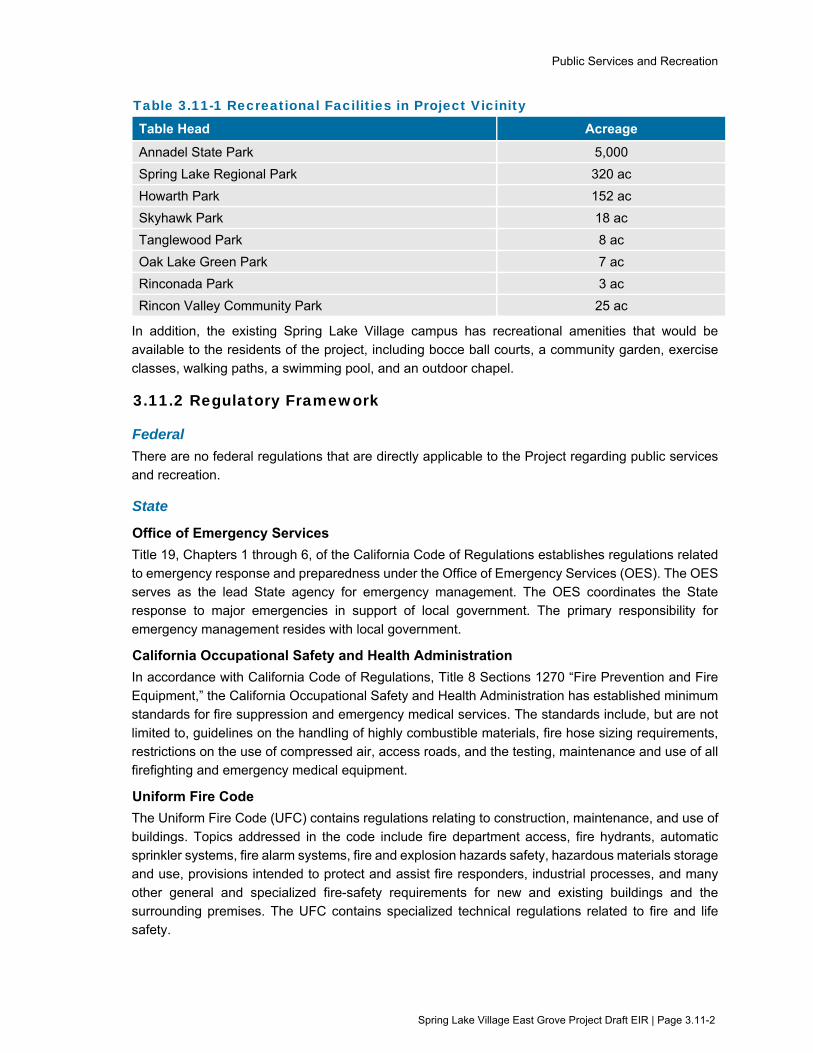
Public Services and Recreation
Spring Lake Village East Grove Project Draft EIR | Page 3.11-2
Table 3.11-1 Recreational Facilities in Project Vicinity
Table Head Acreage
Annadel State Park 5,000
Spring Lake Regional Park 320 ac
Howarth Park 152 ac
Skyhawk Park 18 ac
Tanglewood Park 8 ac
Oak Lake Green Park 7 ac
Rinconada Park 3 ac
Rincon Valley Community Park 25 ac
In addition, the existing Spring Lake Village campus has recreational amenities that would be available to the residents of the project, including bocce ball courts, a community garden, exercise
classes, walking paths, a swimming pool, and an outdoor chapel.
3.11.2 Regulatory Framework
Federal
There are no federal regulations that are directly applicable to the Project regarding public services and recreation.
State
Office of Emergency Services
Title 19, Chapters 1 through 6, of the California Code of Regulations establishes regulations related
to emergency response and preparedness under the Office of Emergency Services (OES). The OES serves as the lead State agency for emergency management. The OES coordinates the State response to major emergencies in support of local government. The primary responsibility for
emergency management resides with local government.
California Occupational Safety and Health Administration
In accordance with California Code of Regulations, Title 8 Sections 1270 “Fire Prevention and Fire Equipment,” the California Occupational Safety and Health Administration has established minimum standards for fire suppression and emergency medical services. The standards include, but are not
limited to, guidelines on the handling of highly combustible materials, fire hose sizing requirements, restrictions on the use of compressed air, access roads, and the testing, maintenance and use of all firefighting and emergency medical equipment.
Uniform Fire Code
The Uniform Fire Code (UFC) contains regulations relating to construction, maintenance, and use of
buildings. Topics addressed in the code include fire department access, fire hydrants, automatic sprinkler systems, fire alarm systems, fire and explosion hazards safety, hazardous materials storage and use, provisions intended to protect and assist fire responders, industrial processes, and many
other general and specialized fire-safety requirements for new and existing buildings and the surrounding premises. The UFC contains specialized technical regulations related to fire and life safety.

Public Services and Recreation
Spring Lake Village East Grove Project Draft EIR | Page 3.11-3
California Health and Safety Code
State fire regulations are set forth in Sections 13000 et seq. of the California Health and Safety Code, which includes regulations for building standards (as set forth in the California Building Code), fire protection and notification systems, fire protection devices such as extinguishers, smoke alarms,
high-rise building, childcare facility standards, and fire suppression training.
Regional and Local
Santa Rosa Emergency Operations Plan
The City of Santa Rosa adopted an EOP Update in 2017 (Santa Rosa 2017). The Santa Rosa EOP identifies the City’s emergency planning, organization and response policies and procedures. It
addresses how the City will respond to extraordinary events or disasters, from preparation through recovery, and the responsibilities of each department and emergency operations center position. It also addresses the integration and coordination with other governmental levels and special districts.
The EOP designates specific evacuation planning areas and routes. The Project site is located within the Melita Evacuation Planning Area. Designated evacuation travel routes identified in the Project area include Highway 12 and Montgomery Drive.
City of Santa Rosa General Plan
The following goals and policies from the City Santa Rosa General Plan 2035 are related to public
services and recreation for the Project.
PSF-E Provide fire and police services that ensure the safety of the community.
PSF-A Provide recreational facilities and parks for all sectors of the community.
PSF-A-8 Integrate the bicycle and pedestrian path networks envisioned in both the Citywide Creek Master Plan and updated Bicycle and Pedestrian Master Plan with regional park plans, so that users can safely and comfortably access the full range of public
open spaces.
3.11.3 Evaluation Criteria and Significance Thresholds For the purpose of this EIR, the evaluation criteria and significance thresholds summarized in Table 3.11-2 (Evaluation Criteria and Significance Thresholds) are used to determine if the Project would have a significant effect related to public services and recreation.

Public Services and Recreation
Spring Lake Village East Grove Project Draft EIR | Page 3.11-4
Table 3.11-2 Evaluation Criteria and Significance Thresholds
Evaluation Criteria Significance Thresholds
Sources
PSR-1: Would the project result in substantial adverse physical impacts associated with the provision of new or physically altered governmental facilities, need for new or physically altered governmental facilities, the construction of which could cause significant environmental impacts, in order to maintain acceptable service ratios, response times or other performance objectives for any of the following public services: fire protection, police protection, schools, parks, and/or other public facilities?
Inadequate police and fire service capabilities to serve the project, resulting in the need for a new or expanded fire or police station
Inadequate schools to serve the project, resulting in the need for development of a new school
Inadequate City parkland to meet citywide standard
CEQA Guidelines Appendix G, Checklist Item XV (a)
General Plan goal PSF-E
PSR-2: Would the project increase the use of existing neighborhood and regional parks or other recreational facilities such that substantial physical deterioration of the facility would occur or be accelerated, or include recreational facilities or require the construction or expansion of recreation facilities which might have an adverse physical effect on the environment?
Increased use of existing parks or other recreational facilities that results in substantial physical deterioration
Increased population resulting in the need to acquire park facilities to achieve citywide standard
CEQA Guidelines Appendix G, Checklist Item XVI (a)(b)
General Plan goal PSF-A and policy PSF-A-8
3.11.4 Approach to Analysis Potential impacts to public services and recreational facilities are evaluated for both construction and
operational activities. The evaluation considers whether the Project would affect Santa Rosa’s existing public services and recreation facilities, including fire and police protection, parkland, and educational/library services. The evaluation considers increases in public service and parkland
demands, and whether such increased demands require the need for development of new facilities to adequately serve the community. The evaluation also considers temporary disruption to park facilities during construction.
3.11.5 Impacts and Mitigation Measures Table 3.11-3 (Summary of Impacts - Public services and Recreation) provides a summary of potential impacts from the Project.

Public Services and Recreation
Spring Lake Village East Grove Project Draft EIR | Page 3.11-5
Table 3.11-3 Summary of Impacts – Public services and Recreation
Evaluation Criteria Project Impact
PSR-1: Would the project result in substantial adverse physical impacts associated with the provision of new or physically altered governmental facilities, need for new or physically altered governmental facilities, the construction of which could cause significant environmental impacts, in order to maintain acceptable service ratios, response times or other performance objectives for any of the following public services: fire protection, police protection, schools, parks, and/or other public facilities?
NI
PSR-2: Would the project increase the use of existing neighborhood and regional parks or other recreational facilities such that substantial physical deterioration of the facility would occur or be accelerated, or include recreational facilities or require the construction or expansion of recreation facilities which might have an adverse physical effect on the environment?
LS
C-PSR-1: Would the project result in a cumulatively considerable contribution to cumulative impacts related to public services and recreational resources?
LS
Notes: NI = No Impact LS = Less than Significant
Impact PSR-1: Would the project result in substantial adverse physical impacts associated with the provision of new or physically altered governmental facilities, need for new or physically altered governmental facilities, the construction of
which could cause significant environmental impacts, in order to maintain acceptable service ratios, response times or other performance objectives for any of the following public services: fire protection, police protection,
schools, parks, and/or other public facilities?
Analysis: No Impact
The Project would construct 32 independent senior living units. This increase in
housing would increase the demand for fire protection, emergency response services, and police services in the Project area.
The nearest fire station to the Project site is Fire Station #6 located at 205 Calistoga
Road, approximately 1 mile to the west of the site. The secondary responder would be Fire Station #7 located at 6590 Stonebridge Drive, approximately 2 miles southeast from the site. As stated in Section 2.5.5 (Environmental Protection
Action 5 - Implement MEDF Program and Lift Team Training), in accordance with Santa Rosa Fire Department direction, the Project applicant would obtain coverage in the Sonoma County Medical Facility Scene Call Program (MEDF Program) and
would require lift team training for employees. Inclusion of the Project in the MEDF Program and the provision of lift team training would satisfy the Santa Rosa Fire Department’s suggestions for reducing demand for fire protection and emergency
services. According to Santa Rosa Fire Department personnel, based on the scale of the Project, it would be adequately served through existing fire facilities (Personal Communication, 2021). No new or physically altered fire facilities would
be required. No impact would result.
Public Services and Recreation
Spring Lake Village East Grove Project Draft EIR | Page 3.11-6
The nearest police station to the Project site is the Santa Rosa Police Department located approximately 3.8 miles west of the site. The Project would be expected to
result in a modest increase of police calls compared with existing conditions. Development of the Project site was anticipated in the General Plan 2035, and the General Plan 2035 EIR did not find significant impacts to police protection due to
anticipated development under buildout of the General Plan. The Project would not result in new or substantially greater impacts beyond those previously identified in the Santa Rosa General Plan EIR, and no new or physically altered police facilities
would be required. No impact would result.
The proposed 32 new independent senior living units would not introduce new school age children in the Project area. Therefore, the Project would have no
impact on local school facilities. The Project could result in more people utilizing local library facilities. Rincon Valley Library is the nearest library to the Project site, located approximately two miles northwest of the Project site along Montecito
Boulevard. The Santa Rosa General Plan 2035 does not identify the anticipated need for a new library branch to serve the Rincon Valley area in which the Project is located, which is based on build-out of the General Plan. The small increase in
senior living units proposed as part of the Project would not increase demands on library services such that a new library would be needed. No impact would result.
Impact PSR-2: Would the project increase the use of existing neighborhood and regional
parks or other recreational facilities such that substantial physical deterioration of the facility would occur or be accelerated, or include recreational facilities or require the construction or expansion of recreation
facilities which might have an adverse physical effect on the environment?
Analysis: Less than Significant
The Project would include new on-site recreational facilities, including a community
building, outdoor common areas, and off-site pedestrian and bicycle improvements along State Route 12, Los Alamos Road, and Melita Road. The potential environmental impacts associated with construction of the proposed new on-site
recreational facilities and the off-site pedestrian and bicycle improvements are evaluated as part of this EIR.
The proposed 32 independent senior living units could result in more people in the
Project area utilizing local and regional parks and other recreational facilities. As shown in Table 3.11-1 (Recreational Facilities in Project Vicinity), eight primary parks and recreational facilities are located within approximately two miles of the
Project site, including Annadel State Park, Spring Lake Regional Park, Howarth Park, Skyhawk Park, Tanglewood Park, Oak Lake Green Park, Rinconada Park, and Rincon Valley Community Park. Given the number of existing park and
recreational options available in the Project vicinity and the modest increase of 32 dwelling units proposed, the Project would not increase use of parks such that substantial physical deterioration would occur or such that expansion of
recreational facilities would be required. The impact would be less than significant.
Mitigation: No mitigation is needed.

Public Services and Recreation
Spring Lake Village East Grove Project Draft EIR | Page 3.11-7
Impact C-PSR-1: Would the project result in a cumulatively considerable contribution to
cumulative impacts related to public services and recreational resources?
Analysis: Less than Cumulatively Considerable (Less than Significant)
For public services and recreation the geographic scope for assessing cumulative impacts is the City of Santa Rosa.
Because the Project would not result in impacts related to public services,
implementation of the Project would not contribute to a cumulative impacts related to public services.
The proposed Project, in conjunction with other past, present, and reasonably
foreseeable future projects, could result in a cumulative increase in recreational use and demand for new or expanded recreational facilities. As discussed in Impact PSR-2, the proposed Project would include on-site recreational facilities
and would not substantially increase demand on regional parks such that physical damage would occur, nor result in the need to acquire and develop additional off-site park facilities. The Project’s contribution to the cumulative impact on water
service and supply would be less than significant.
Mitigation: No mitigation is needed.
3.11.6 References Association of Bay Area Governments (ABAG). 2010. Taming Natural Disasters, Hazards
Mitigation Plan.
Santa Rosa, City of. 2017. Santa Rosa Emergency Operations Plan.
Santa Rosa, City of. 2016. Local Hazard Mitigation Plan. October
Sonoma County Regional Parks. 2016. Sonoma Valley Trail Feasibility Study.
Personal communication. 2021. Scott Moon, Division Chief Fire Marshal, Santa Rosa Fire
Department. May 26, 2021.

Transportation and Traffic
Spring Lake Village East Grove Project Draft EIR | Page 3.12-1
3.12 Transportation and Traffic This section evaluates potential environmental impacts related to transportation and traffic during construction and operation of the Project. In addition to the analysis provided in this section, the following subjects are related to transportation and traffic, but are evaluated in other sections of this EIR:
Potential impacts related to interfering with an adopted emergency response plan, and with the transport of hazardous materials during construction, are addressed in Section 3.7 (Hazards and Hazardous Materials).
Potential impacts related to increases in ambient noise levels due to changes in traffic levels and circulation are addressed in Section 3.10 (Noise).
3.12.1 Setting
Local Roadways
Local roadways in the Project area include Highway 12, Los Alamos Road, Melita Road, and Montgomery Drive. Highway 12 between Mountain Hawk Way and Los Alamos Road is a four-lane highway running southeast-northwest with two lanes in each direction and a 15-foot wide planted median separating the directions of travel. The roadway segment has 12-foot wide lanes and 8-foot shoulders in both directions and a posted speed limit of 55 miles per hour (mph).
Los Alamos Road between Highway 12 and Melita Road runs northeast-southwest along the Project frontage and has a 15-foot travel lane in each direction with a posted speed limit of 35 mph. The Project driveway would be located on the west side of Los Alamos Road. The intersection of Highway 12 and Los Alamos Road is a signalized four-way intersection with channelized right-turn lanes and left-turn pockets with protected left-turn phasing on the eastbound and westbound approaches. Marked crosswalks are present on the southbound, eastbound, and northbound approaches.
Melita Road between Los Alamos Road and Montgomery Drive runs east-west and is 350 feet in length. The roadway segment has two travel lanes within the 25-foot paved width. The intersection of Los Alamos Road and Melita Road is an all-way stop-controlled tee intersection with no crosswalks or street lighting.
Montgomery Drive between Melita Road and Channel Drive runs east-west and has two travel lanes with a posted speed limit of 40 mph. The roadway is 40 feet wide and has marked bicycle lanes in both directions. The intersection of Montgomery Drive and Melita Road is a tee-intersection stop controlled on the southbound Melita Road approach. No crosswalks or streetlights exist at this intersection.
Traffic Volumes and Level of Service
In accordance with California Senate Bill 743 (SB 743), effective July 1, 2020, Level of Service (LOS) no longer constitutes a transportation impact under CEQA. Instead, SB 743 changes the method used to measure transportation impacts associated with development and/or roadway projects to Vehicle Miles Traveled (VMT), and the bill requires California municipalities to use VMT to comply with CEQA assessments of transportation impacts. In addition to VMT, the City of Santa Rosa still uses the measurement method of LOS, which focuses on congestion at intersections and roadways, to address local roadway operations. Therefore, a discussion of Santa Rosa’s LOS Standard and

Transportation and Traffic
Spring Lake Village East Grove Project Draft EIR | Page 3.12-2
related information is included in this EIR for informational purposes and because the environmental review commenced prior to the effective date of SB 743.
LOS is used to rank traffic operation on various types of facilities based on traffic volumes and roadway capacity using a series of letter designations ranging from A to F. Generally, LOS A represents free flow conditions and LOS F represents forced flow or breakdown conditions. A unit of measure that indicates a level of delay generally accompanies the LOS designation.
The City of Santa Rosa's adopted LOS Standard is contained in the City of Santa Rosa General Plan 2035. General Plan Policy TD-1 states that the City will try to maintain a LOS D or better along all major corridors. Exceptions to meeting this standard are allowed where attainment would result in significant environmental degradation; where topography or environmental impacts makes improvement impossible; where attainment would ensure loss of an area's unique character; and within downtown Santa Rosa.
Table 3.12-1 summarizes the existing peak hour LOS for the intersection of Highway 12 and Los Alamos Road. Under existing conditions, the study intersection is operating acceptably during the a.m. and p.m. peak hours. At the study intersection, the weekday a.m. peak hour occurred between 8:00 and 9:00 a.m. and the p.m. peak hour occurred between 4:00 and 5:00 p.m.
Table 3.12-1 Existing Peak Hour Intersection Levels of Service
Study Intersection AM Peak PM Peak
Delay LOS Delay LOS
Highway 12 / Los Alamos Road 13.7 B 14.9 B
Source: W-Trans 2017
Bicycle and Pedestrian Facilities
The City of Santa Rosa Bicycle and Pedestrian Master Plan (Santa Rosa 2019) classifies bicycle facilities into the following four categories:
Class I (Shared Use Paths) – Paved trails completely separated from the street. They allow two-way travel by people bicycling and walking, and are often considered the most comfortable facilities for children and inexperienced riders as there are few potential conflicts between people bicycling and people driving.
Class II (Bicycle Lanes) – Striped preferential lanes on the roadway for one-way bicycle travel. Sme bicycle lanes include a striped buffer on one or both sides to increase separation from the traffic lane or from parked cars, where people may open doors into the bicycle lane.
Class III (Bicycle Routes) – Signed routes where people bicycling share a travel lane with people driving. Because they are shared facilities, bicycle routes are only appropriate on quiet, low-speed streets with relatively low traffic volumes. Some Class III bicycle routes include shared lane markings or “sharrows” that recommend proper bicycle positioning in the center of the travel lane and alert drivers that bicyclists may be present. Others include more robust traffic calming features knows as “bicycle boulevards.”
Class IV (Separated Bikeways) – On-street bicycle facilities that are physically separated from motor vehicle traffic by a vertical element or barrier, such as a curb, bollards, or vehicle parking aisle. They can allow for one- or two-way travel on one or both sides of the roadway.

Transportation and Traffic
Spring Lake Village East Grove Project Draft EIR | Page 3.12-3
In the Project area, Class II bike lanes exist on Montgomery Drive between Melita Road and Channel Drive. The Bicycle and Pedestrian Master Plan does not identify existing bicycle facilities along Highway 12, Los Alamos Road, or Melita Road in the Project vicinity. Bicyclists ride in the roadway and/or on sidewalks along these streets within the Project area.
Proposed bicycle facilities identified in the Santa Rosa Bicycle and Pedestrian Master Plan include a Class II bicycle lane along Los Alamos Road and Highway 12. The City’s Bicycle and Pedestrian Master Plan does not identify proposed bicycle facilities along Melita Road in the Project vicinity.
Existing Pedestrian Facilities
Pedestrian facilities include sidewalks, crosswalks, pedestrian signal phases, curb ramps, curb extensions, and various streetscape amenities such as lighting, benches, etc. Along Highway 12, gaps in sidewalk connectivity exist on both sides of the highway between Mountain Hawk Way and Los Alamos Road. Curb ramps and crosswalks at side-street approaches are intermittent. Intermittent lighting is provided by overhead streetlights.
Along Los Alamos Road, intermittent sidewalk coverage is provided on the east side of the roadway near Villa Los Alamos. No sidewalk coverage is provided on the west side along the proposed Project site frontage, and no streetlights are present along the road.
Along Melita Road, there are no sidewalks or streetlights present on either side of the roadway between Los Alamos Road and Montgomery Drive.
Sonoma Valley Trail Feasibility Study
Sonoma County Regional Parks is currently studying the feasibility of the Sonoma Valley Trail, an envisioned bicycle and pedestrian trail along Highway 12 in the Valley of the Moon. The Sonoma County Regional Parks Sonoma Valley Trail Feasibility Study (Feasibility Study) (Sonoma County Regional Parks 2016) contains details of the community framework, discussions of constraints and challenges that were evaluated and used in preliminary trail alignment planning, a benefits analysis, and draft trail concepts. The Feasibility Study also contains design guidelines and an implementation plan.
The Feasibility Study includes three different alternatives for the start of the trail in the vicinity of the Project site. The identified alternatives include:
Preferred Alignment. The preferred alignment identified would begin near the intersection of Montgomery Drive and Melita Road and continue east along Melita Road past Los Alamos Road.
Alternative Alignment. An alternative trail alignment would include a trail along Santa Rosa Creek east of Los Alamos Road that would connect to Highway 12.
Potential Alternative Alignment. The potential alternative alignment would begin on the Project site at Melita Road and proceed north along the edge of the Project site to Highway 12
The Feasibility Study was released upon completion, and the Sonoma County Board of Supervisors adopted a resolution accepting the finding and recommendations presented in the Feasibility Study at their February 2, 2016 meeting.
Transit Facilities
Sonoma County Transit (SCT) provides fixed route bus service in Sonoma County. SCT Route 30, 30X, and 34 provides transit service between Santa Rosa and Sonoma seven days a week and stops at the Highway 12/Los Alamos Road intersection, approximately 500 feet from the proposed Project

Transportation and Traffic
Spring Lake Village East Grove Project Draft EIR | Page 3.12-4
driveway. SCT buses are equipped with racks that can hold two or three bikes. Bicycle rack space is on a first come, first served basis. Additional bicycles are allowed on SCT buses at the discretion of the driver.
Dial-a-ride, also known as paratransit, or door-to-door service, is available for those who are unable to independently use the transit system due to a physical or mental disability. SCT Paratransit is designed to serve the needs of individuals with disabilities within Santa Rosa and the greater Sonoma County area. Paratransit service is available between 5:00 a.m. and 11:00 p.m. Monday through Friday and between 7:00 a.m. and 9:00 p.m. on Saturday and Sunday.
3.12.2 Regulatory Framework
Federal
There are no federal plans, policies, regulations, or laws related to transportation and traffic applicable to the Project.
State
California Department of Transportation Transportation analysis in California is guided by policies and standards set at the State level by the California Department of Transportation (Caltrans) for highway facilities under State jurisdiction, as well as by local jurisdictions. Any work or traffic control within the State right-of-way or from the State access-control right-of-way requires an encroachment permit issued by Caltrans. This permit requires submittal of a Traffic Control Plan, which would include plans for re-routing of vehicles, bicycles and pedestrians, and proposed road closure date(s) and hours. Traffic controls would be required in accordance with the Caltrans standards, and contractors would be required to comply with the general conditions of the encroachment permit. In addition, work that requires movement of oversized or excessive load vehicles on highway facilities requires a transportation permit by Caltrans.
Senate Bill 743 SB 743 creates a process to change the way that transportation impacts are analyzed under CEQA. In accordance with SB 743, the Governor’s Office of Planning and Research (OPR) amended the CEQA Guidelines to provide an alternative to control delay and associated LOS for evaluating transportation impacts. OPR recommends that VMT become the primary metric of transportation impact across California. For the purposes of CEQA, VMT refers to the amount and distance of automobile travel attributable to a project. By July 1, 2020, all CEQA lead agencies must analyze project’s transportation impacts using VMT.
In December 2018, OPR published the Technical Advisory on Evaluating Transportation Impacts in CEQA. The advisory contains recommendations regarding the assessment of VMT impacts under CEQA, including screening thresholds for small projects. The City of Santa Rosa uses the VMT threshold recommendations contained in the OPR Technical Advisory for evaluating projects pursuant to CEQA.
Regional and Local
Sonoma County Transportation Authority Comprehensive Transportation Plan The Sonoma County Transportation Authority (SCTA) is the countywide planning and programming agency for transportation in Sonoma County. The SCTA has developed a Comprehensive Transportation Plan that serves as the vision for transportation planning in the County. The SCTA

Transportation and Traffic
Spring Lake Village East Grove Project Draft EIR | Page 3.12-5
adopted the Updated 2016 Comprehensive Transportation Plan (CTP) in September 2016, also known as Moving Forward 2040, Sonoma County’s Comprehensive Transportation Plan. The Comprehensive Transportation Plan is a 25-year plan, the goals of which include to maintain the transportation system, relieve traffic congestion, reduce greenhouse gas emissions, plan for safety and health, and promote economic vitality.
City of Santa Rosa Encroachment Permit
The City requires that anyone wishing to create or construct an encroachment in the public right-of-way obtain permission through an encroachment permit. The term "encroachment" refers to use of public property by someone other than the City in the public right-of-way. The "public right-of-way" is defined to include those areas within any dedicated public roadway or other property within the jurisdiction of the City, whether or not the entire area is actually used for its intended purpose. The encroachment permit application would require the development and implementation of a Traffic Control Plan.
City of Santa Rosa General Plan Goals and Policies The Transportation Element of the City of Santa Rosa General Plan 2035 outlines goals and policies that coordinate the transportation and circulation system with planned land uses. The following goals and policies are relevant to the proposed Project:
T-D Maintain acceptable motor vehicle traffic flows.
T-D-1 Maintain a Level of Service (LOS) D or better along all major corridors. Exceptions to meeting the standard include:
Within downtown;
Where attainment would result in significant environmental degradation;
Where topography or environmental impact makes the improvement impossible;
Where attainment would ensure loss of an area’s unique character.
The LOS is to be calculated using the average traffic demand over the highest 60-minute period.
T-D-3 Require traffic studies for development projects that may have a substantial impact on the circulation system.
T-E Complete needed transportation improvements in a timely manner.
T-E-2 Require development projects to pay a fair share of costs for multi-modal transportation systems improvements. Periodically update the City’s impact fees to assure the adequacy of funding for needed transportation system improvements.
T-G Identify, preserve, and enhance scenic roads throughout Santa Rosa in both rural and developed areas.
T-G-7 Provide bikeways along scenic roads, where right-of-way exists or where its acquisition will not jeopardize roadway character.

Transportation and Traffic
Spring Lake Village East Grove Project Draft EIR | Page 3.12-6
T-H Expand the existing transit network to reduce greenhouse gas emissions and to provide convenient and efficient public transportation to workplaces, shopping, SMART stations, and other destinations.
T-H-7 Require community care facilities and senior housing projects with more than 25 units to provide accessible transportation services for the convenience of residents. Provision of transportation services at large facilities will reduce demand on the paratransit and fixed route transit systems.
T-H-8 Improve transit service along corridors where increased densities are planned.
T-J Provide attractive and safe streets for pedestrians and bicyclists.
T-J-1 Pursue implementation of walking and biking facilities as envisioned in the City’s Bicycle and Pedestrian Master Plan.
T-K Develop a safe, convenient, and continuous network of pedestrian sidewalks and pathways that link neighborhoods with schools, parks, shopping areas, and employment centers.
T-K-1 Link the various citywide pedestrian paths, including street sidewalks, downtown walkways, pedestrian areas in shopping centers and work complexes, park pathways, and other creekside and open space pathways.
T-L Develop a citywide system of designated bikeways that serves both experiences and casual bicyclists, and which maximizes bicycle use for commuting, recreation, and local transport.
T-L-1 Provide bicycle lanes along all regional/arterial streets and high volume transitional/collector streets.
T-L-3 Improve bicycle networks by finishing incomplete or disconnected bicycle routes.
T-L-5 Consider bicycle operating characteristics and safety needs in the design for roadways, intersections, and traffic control systems.
City of Santa Rosa Bicycle and Pedestrian Master Plan The City of Santa Rosa Bicycle and Pedestrian Master Plan Update 2018 establishes a long-term vision for improving walking and bicycling in Santa Rosa (Santa Rosa 2019). The Bicycle and Pedestrian Master Plan provides a strategy to develop a comprehensive bicycling and walking network to provide access to transit, schools, and downtown alongside support facilities like bicycle parking and pedestrian amenities. The following policies and actions are relevant to the proposed Project:
Policy 1 Integrate bicycle and pedestrian network and facility needs into all City planning documents and capital improvement projects.
Action 1.5 Ensure that all traffic impact studies, analyses of proposed street changes, and development projects address impacts on bicycling and walking facilities. Specifically, the following should be considered:
Consistency with General Plan, Area Plan, and Bicycle and Pedestrian Master Plan Update 2018 policies and recommendations

Transportation and Traffic
Spring Lake Village East Grove Project Draft EIR | Page 3.12-7
Impact on the existing bikeway and pedestrian network
Degree to which bicycle and walking travel patterns are altered or restricted by the projects
Safety of future bicycle and pedestrian operations (based on conformity to Plan Update 2018 Bicycle and Pedestrian Facility Guidelines and City, State, and Federal design standards)
Action 1.6 Require new development, or reconstruction if applicable, to address the pedestrian and bicycle circulation element based on the above considerations.
Action 1.8 Continue to implement the City's Bicycle and Pedestrian Facility Guidelines for all new development projects to support integration of transportation into land use planning decisions.
Policy 4 Design a connected, convenient, and comfortable pedestrian network to serve people of all ages and abilities.
Action 4.1 Include sidewalks on all new or retrofitted roadways.
Action 4.2 Identify and construct sidewalks in areas where they are incomplete.
Action 4.4 Plan and develop well-connected streets, sidewalks, and pathways that provide the most direct paths of travel for pedestrians. Provide connections between or through cul-de-sacs and remove barriers to walking where feasible.
Policy 5 Design accessible, comfortable, and continuous off-street paths that contribute to the framework of Santa Rosa’s active transportation network.
Action 5.1 Utilize the bicycle and pedestrian facility guidelines in this Plan Update 2018 and most recent State and Federal design standards and guidelines to develop plans for ADA-compliant off-street trails (Class I shared-use paths).
Policy 10 Ensure that bicyclists and pedestrians have accommodation in work zones.
Action 10.1 Incorporate routine accommodation for pedestrian and bicycle facilities when developing priority lists for overlay and construction projects, maintenance, and traffic control plans.
3.12.3 Evaluation Criteria and Significance Thresholds For the purpose of this EIR, the evaluation criteria and significance thresholds summarized in Table 3.12-2 (Evaluation Criteria and Significance Thresholds) are used to determine if the project would have a significant effect related to transportation and traffic.

Transportation and Traffic
Spring Lake Village East Grove Project Draft EIR | Page 3.12-8
Table 3.12-2 Evaluation Criteria and Significance Thresholds
Evaluation Criteria Significance Thresholds Sources
TR-1: Would the project conflict with a program, plan, ordinance or policy addressing the circulation system, including transit, roadway, bicycle and pedestrian facilities?
Result in intersection of Los Alamos Road and Highway 12 to deteriorate below LOS D Inadequate provision of accessible transportation services for the convenience of future residents Inconsistency with pedestrian and bicycle network envisioned in Bicycle and Pedestrian Master Plan
CEQA Guidelines Appendix G, Checklist Item XVII (a) General Plan Policies T-D-1, T-H-7, and T-L-3 City of Santa Rosa Bicycle and Pedestrian Master Plan
TR-2: Would the project conflict or be inconsistent with CEQA Guidelines section 15064.3, subdivision (b)?
Substantial increase in average per capita vehicle miles traveled Less than significant impact presumed if project generates 110 trips or fewer trips per day or meets other screening criteria specified by the OPR Technical Advisory.
CEQA Guidelines Appendix G, Checklist Item XVII (b) OPR Technical Advisory
TR-3: Would the project substantially increase hazards due to a geometric design feature (e.g., sharp curves or dangerous intersections) or incompatible uses (e.g., farm equipment)?
Non-conformance with defined safety regulations or roadway design standards, or otherwise create unsafe conditions
CEQA Guidelines Appendix G, Checklist Item XVII (c) Bicycle facility standards defined in Chapter 1000 of the Caltrans Highway Design Manual City of Santa Rosa Bicycle and Pedestrian Master Plan
TR-4: Would the project result in inadequate emergency access?
Increases in traffic, road closures, or insufficient emergency access during construction or inadequate design features to accommodate emergency vehicle access and circulation during operation
CEQA Guidelines Appendix G, Checklist Item XVII (d)
3.12.4 Approach to Analysis Potential transportation impacts are evaluated based on the findings of a traffic study performed by Whitlock and Weinberger Transportation, Inc. (W-Trans 2017 & 2020, see Appendix G). The analysis presented in the traffic study was completed in accordance with the criteria established by the City of Santa Rosa and is consistent with standard traffic engineering techniques. In accordance with recent revisions to the State CEQA Guidelines, LOS no longer constitutes a transportation impact under CEQA. However, the traffic study evaluates the project against Santa Rosa’s LOS Standard for informational purposes and because the environmental review commenced prior to the effective date of SB 743.

Transportation and Traffic
Spring Lake Village East Grove Project Draft EIR | Page 3.12-9
The traffic study determined the existing LOS at the intersection of Highway 12 and Los Alamos Road using the “signalized” methodology published in the Highway Capacity Manual (2000) by the Transportation Research Board, and estimated the number of new vehicle trips that would be associated with the Project based on standard trip generation rates as published in Trip Generation Manual, 9th Edition (2012) by the Institute of Transportation Engineers (ITE). The ITE rates were higher than actual traffic volumes surveyed entering and exiting the existing Spring Lake Village facility, at least partially because a shuttle service from the Spring Lake Village complex would replace several passenger vehicle trips. To be conservative, the ITE rates were used in the traffic study analysis to determine trip generation associated with the Project. The study used Sonoma County Transportation Authority’s travel demand model to estimate future volumes of traffic in the study intersection in the year 2040, and estimated the amount of traffic from pending or approved projects to be analyzed under cumulative conditions. The study then assessed if the increased traffic from the Project (in existing conditions and future conditions) and from cumulative projects would exceed the City’s established LOS standard, and therefore be in conflict with this standard.
The traffic study also evaluated the VMT for the Project by multiplying the average trip length (using the Sonoma County Transportation Authority’s Traffic Analysis Zones model) by the Project’s daily trip generation estimate which, similarly to the ITE model for Project-related trip generation, over-estimated VMT due to the proposed shuttle service. A quantitative VMT threshold was not determined in the traffic study, however the proposed shuttle service is noted to decrease the estimated VMT associated with the Project. The traffic study also evaluated the suitability of the proposed bicycle and pedestrian facilities, the adequacy of the proposed emergency access and parking facilities, the adequacy of transit facilities to serve the site, and an assessment of site distance and sight lines from Project’s access road. The Project is also evaluated for consistency with adopted plans and policies regarding bicycle and pedestrian facilities, and for the potential for construction activities to limit emergency access in the project area.
3.12.5 Impacts and Mitigation Measures Table 3.12-2 (Summary of Impacts - Transportation and Traffic) provides a summary of potential impacts from the project.
Table 3.12-2 Summary of Impacts – Transportation and Traffic
Evaluation Criteria Project Impact
TR-1: Would the project conflict with a program plan, ordinance or policy addressing the circulation system, including transit, roadway, bicycle and pedestrian facilities?
LS
TR-2: Would the project conflict or be inconsistent with CEQA Guidelines section 15064.3, subdivision (b)?
LS
TR-3: Would the project substantially increase hazards due to a geometric design feature (e.g., sharp curves or dangerous intersections) or incompatible uses (e.g., farm equipment)?
LSM
TR-4: Would the project result in inadequate emergency access? LS
C-TR-1: Would the project result in a cumulatively considerable contribution to a significant cumulative impact related to transportation?
LS
Notes: LS = Less than Significant LSM = Less than Significant with Mitigation

Transportation and Traffic
Spring Lake Village East Grove Project Draft EIR | Page 3.12-10
Impact TR-1: Would the project conflict with a program plan, ordinance or policy addressing the circulation system, including transit, roadway, bicycle and pedestrian facilities?
Analysis: Less than Significant
Construction
Construction-Generated Traffic
Construction of the Project is expected to begin in 2021 and continue for approximately 18 months. During this time, vehicle trips would vary depending on the work activity at the site. A construction staging area and construction personnel parking would occur at the Project site. The primary vehicle and haul truck travel route to the Project site would be Highway 12 to Los Alamos Road. An off-site construction-worker parking area may potentially be used on the adjacent Hope Chapel parking lot. If this site were used, access would be directly from Highway 12, thus reducing construction-worker trips accessing Los Alamos Road. Because use of this site is contingent on the Applicant entering into an agreement with the property owner, for the purposes of this analysis, all construction-worker trips are assumed to enter at Los Alamos Road.
As identified in Section 2 (Project Description), Project off-haul during demolition and grading would result in approximately 466 round trips, while haul-in trips associated with construction would result in approximately 1,236 total round trips over the duration of grading and building construction. The number of construction-related vehicles traveling to and from the Project site would vary on a daily basis. For the purposes of evaluation, it is anticipated that the peak number of haul trucks would occur during the import of construction materials, and would consist of up to 24 round trips on any one day. In addition to haul trucks, it is anticipated that construction crew trips would require up to 24 round trips per day. Therefore, up to 48 vehicle round trips could occur per day, during peak construction, at maximum.
The level of short-term traffic generation that would occur during Project construction is not substantial in relation to the existing traffic loads and capacity of Los Alamos Road, which accommodates a combined north and southbound volume of 4,716 vehicles daily between Melita Road and Highway 12 (Pacific Traffic & Transit Data Services 2017). The Santa Rosa General Plan and the OPR guidance does not establish standards related to construction-related traffic, however, it is noted that the Project’s estimated maximum construction trips per day would be below the 110 trip per day operational screening threshold suggested by OPR guidance (OPR 2018). The construction-period impact on LOS would be less than significant.
Temporary Lane Closures
Construction of off-site improvements would require activity within the Montgomery Drive / Melita Road intersection, as well as within Melita Road, Los Alamos Road and Highway 12. At the Montgomery Drive / Melita Road intersection, improvements would include reconfiguration of the intersection with a new berm,

Transportation and Traffic
Spring Lake Village East Grove Project Draft EIR | Page 3.12-11
installation of new sidewalks, and a raised island with curb ramps. Offsite improvements along Los Alamos Road would include widening and re-striping of the road to provide a 5-foot wide Class II bicycle lane consistent with the City of Santa Rosa Bicycle and Pedestrian Master Plan and installation of a publicly accessible off-street pedestrian path, both to be located along the Project’s Los Alamos Road frontage. Work within the roadways would also include utility connections in Melita Road and Los Alamos Road, and a new pedestrian sidewalk along Highway 12.
Construction of utility improvements and pedestrian and bicycle improvements within portions of the Los Alamos Road, Melita Road, Highway 12, and the Montgomery Drive / Melita Road intersection may require temporary partial lane closures. In accordance with City of Santa Rosa and Caltrans requirements, the construction contractor would be required to obtain an applicable encroachment permit from the City for work within Melita Road and Los Alamos Road, and from Caltrans prior to work within the Highway 12 right-of-way. The encroachment permit application would, in both cases, require the development and implementation of traffic and pedestrian control plans to preserve access and ensure public safety, which would typically include:
Traffic controls, signs, and flaggers conforming with current California Manual of Uniform Traffic Control Devices.
Pedestrian and bicycle control devices;
Notifications/arrangements for any driveway access restrictions;
Notifications to public transit agencies, emergency vehicles, and school systems;
Scheduling of major lane/road closures during off-peak hours
The traffic controls would reduce the temporary safety hazards to pedestrian facilities. Therefore, impacts related to lane closures during construction would be less than significant.
Operation
Intersection Level of Service (Informational)
In accordance with City policies, a traffic study was prepared for the Project to determine the potential operational impact on the circulation system. The traffic study included a determination of the number of new trips associated with the project and the existing and future LOS at the Highway 12/Los Alamos Road intersection.
The traffic study determined that the Highway 12/Los Alamos Road intersection currently operates at a LOS B overall during both the a.m. and p.m. peak hours. Regarding new operational traffic, the traffic study estimated that the Project would result in 80 new daily trips, 5 of which would occur during the a.m. peak hour, and 6 during the p.m. peak hour. Upon the addition of Project-related traffic to the existing volumes, the Highway 12/Los Alamos Road intersection is expected to continue operating acceptably at LOS B during both peak hours, with only a 0.1-second increase in average delay (W-Trans 2017 & 2020). As such, the study
Transportation and Traffic
Spring Lake Village East Grove Project Draft EIR | Page 3.12-12
intersection is expected to continue operating acceptably at the same levels of service and with an imperceptible change in average delay upon the addition of Project-generated traffic. The Project would not conflict with General Plan Policy T-D-1.
The traffic study also estimates the amount of traffic from pending or approved projects to be analyzed under cumulative conditions. Evaluation of the project in conjunction with other projects is contained in the Cumulative Impacts section at the end of this chapter.
Pedestrian Facilities
Proposed pedestrian facility improvements would include a publicly accessible off-street pedestrian path along Los Alamos Road adjacent to the Project site within the City’s right-of-way, effectively linking the Project site to the SCT stop at Highway 12/Los Alamos Road. The Project also would improve an approximately 725-foot segment of Highway 12 with a sidewalk adjacent to the eastbound travel lane and include a sidewalk connection to the Montgomery Drive / Melita Road intersection where a crosswalk with a center island refuge would be provided to connect to Montgomery Drive. Pedestrian facilities serving the Project site would be adequate upon completion of the proposed improvements. The Project would not conflict with adopted policies, plan, or programs supporting pedestrian facilities, including Policy 4 of the City of Santa Rosa Bicycle and Pedestrian Master Plan. No impact would result.
Bicycle Facilities
Proposed off-site bicycle facility improvements along Los Alamos Road would include the widening and restriping of the road along the Project frontage to provide a 5-foot Class II bicycle lane consistent with the City of Santa Rosa Bicycle and Pedestrian Master Plan. The proposed bicycle lane would begin at Highway 12 and terminate at the Project site’s southeastern property boundary. Existing bicycle facilities along Montgomery Drive together with the proposed improvements along Los Alamos Road and the shared use of minor streets provide adequate access for bicyclists in the Project area. The Project is expected to generate minimal bicycle trips given the size and nature of the facility, and those can easily be accommodated by the proposed on- and off-site improvements. No impact would result. Further evaluation of the bicycle facility safety is provided in Impact TR-3.
Proposed Sonoma Valley Trail
As stated in Section 3.12.1, Sonoma County Regional Parks has studied the feasibility of the Sonoma Valley Trail, an envisioned bicycle and pedestrian trail along Highway 12 that would begin near the Project site. The Sonoma Valley Trail is currently in the planning phase and the County Board of Supervisors accepted the findings and recommendations presented in the Feasibility Study. As provided within the Sonoma County Regional Parks Feasibility Study for the Sonoma Valley Trail, the Feasibility Study is not yet a “project” that requires adoption, approval or commitment of funding, and has not been approved or adopted itself. Rather the recommendations presented in the Feasibility Study have been accepted (via resolution) by the Board of Supervisors. The Feasibility Study includes three

Transportation and Traffic
Spring Lake Village East Grove Project Draft EIR | Page 3.12-13
different alternatives for the start of the trail in the vicinity of the Project site (Sonoma County Regional Parks 2016). The identified alignment alternatives, as described in detail in the setting section, are the Preferred Alignment, the Alternative Alignment, and the Potential Alternative Alignment.
Implementation of the Project would preclude development of the Potential Alternative Alignment as this alternative alignment utilizes a portion of the Project site. However, the Project would not conflict with implementation, or preclude development, of either the Preferred Alignment or the Alternative Alignment. Because the Project would hinder development of the least favorite alignment, but not interfere with the two preferred alignments, the Project would not conflict with the preliminary plans for the Sonoma Valley Trail. No impact would result.
Transit Access
SCT Route 30 stops at the Highway 12/Los Alamos Road intersection, approximately 500 feet from the proposed Project driveway. Existing transit routes are adequate to accommodate Project-generated transit trips. Existing stops are within acceptable walking distance of the site and continuous sidewalks would be provided by the Project. No transit-related conflict would result.
Accessible Transportation for Seniors
An existing shuttle loop operated as part of the Spring Lake Village CCRC would be extended to the Project site, and residents would be able to access the existing Spring Lake Village complex via shuttle which would run daily every 30 minutes between the hours of 7:00 a.m. and 9:00 p.m. Therefore, the Project would comply with City Policy T-H-7, which requires community care facilities and senior housing projects with more than 25 units to provide accessible transportation services for the convenience of residents. No impact would result.
Mitigation: No mitigation is needed.
Impact TR-2: Would the project conflict or be inconsistent with CEQA Guidelines section 15064.3, subdivision (b)?
Analysis: Less than Significant
As noted in the OPR guidelines, agencies are directed to choose metrics that are appropriate for their jurisdiction to evaluate the potential impacts of a project in terms of VMT. The City of Santa Rosa uses the VMT threshold recommendations contained in OPR’s 2018 Technical Advisory on Evaluating Transportation Impacts in CEQA. Therefore, OPR’s screening thresholds for Land Use Projects, found in the Technical Advisory, is used (OPR 2018). According to the technical advisory projects that generate or attract fewer than 110 trips per day may be assumed to cause a less-than-significant transportation impact.
The Project is estimated to generate 80 trips on a daily basis, less than OPR’s screening threshold. In addition, the Project incorporates Transportation Demand Management practices. This includes adequate facilities to allow residents to walk or bicycle between the Project site and the main campus of Spring Lake Village. In addition, the Project would include a shuttle service that would allow residents to make off-site trips, such as for medical appointments and shopping, in multi-

Transportation and Traffic
Spring Lake Village East Grove Project Draft EIR | Page 3.12-14
passenger vehicles. Similarly, a shuttle service between the Project site and the main campus would accommodate short trips that might otherwise be made by private vehicle.
The Project would not conflict with or be inconsistent with an applicable threshold of significance adopted per CEQA Guidelines section 15064.3, subdivision (b). The Project’s estimated 80 trips per day would be below the 110 trip per day screening threshold suggested by OPR guidance (OPR 2018), and the Project incorporates applicable Transportation Demand Management Program practices for a senior community facility. The Project’s impact on VMT would be less than significant.
Impact TR-3: Would the project substantially increase hazards due to a geometric design feature (e.g., sharp curves or dangerous intersections) or incompatible uses (e.g., farm equipment)?
Analysis: Significant
Construction
The presence of construction vehicles and equipment on nearby roadways and at the Project site would temporarily increase the normal traffic hazard in the Project area. Construction of improvements along Melita Road, Los Alamos Road, and HIGHWAY 12 would cause temporary safety hazards to pedestrians and roadway users. However, as described under Impact TR-1, implementation of traffic and pedestrian control plans and as required by encroachment and transportation permits would mandate traffic and pedestrian control plans, which would include: traffic controls, signs, and flaggers conforming; pedestrian and bicycle control devices; notifications to public transit agencies, emergency vehicles, and school systems; and scheduling of major lane/road closures during off-peak hours. The controls would reduce the temporary safety hazards, and impacts related to traffic and construction activity during construction would be less than significant.
Operation
As provided in the Project’s traffic study, the collision history for the study area was reviewed to determine if any trends or patterns may indicate a safety issue. The analysis included a review of the collision history for the Highway 12 / Los Alamos Road intersection and segments of Highway 12, Los Alamos Road, and Melita Road. The analysis indicated that the Highway 12 / Los Alamos Road intersection had a lower collision rate than the statewide average for signalized four-way intersections. This indicates that the intersection is performing acceptably with regards to safety. In addition, because the Project would include vehicular access from Los Alamos Road and not from Highway 12, the potential for the Project to cause speed differentials and increase conflicts on Highway 12 is considered low.
The traffic study performed for the Project also evaluated site distance at the proposed new driveway (W-Trans 2017 & 2020). The analysis concluded that a minimum sight distance of 315 feet is required for adequate lines of sight between drivers in the Project driveway and oncoming drivers. In comparison, sight distances along Los Alamos Road at the proposed driveway are adequate to accommodate speeds of 40 mph, however sight distance to the north is

Transportation and Traffic
Spring Lake Village East Grove Project Draft EIR | Page 3.12-15
compromised by a bush that appears to be in the road right-of-way. However, the bush would be removed to accommodate planned frontage improvements, and the Conceptual Planting Plan shows new landscaping trees would be set back farther from the road than the existing bush and would therefore not compromise the future line of sight. Therefore, adequate site distances at the Project driveway are provided. The Project’s impact creating potential hazards would be less than significant.
The Project as proposed would result in a bike lane along Los Alamos Road that would end mid-block at the southeastern corner of the Project site. This situation is not uncommon in areas where not all properties are fully developed. It is reasonable to conclude that the bike lane would be extended further upon development of other properties adjacent to the Project along Los Alamos Road. However, because the bike lane would end mid-block, there would be a potential safety hazard related to bicycle lane continuity until such time that a bike lane extension from Los Alamos Road to Melita Road occurs. The potential impact would be significant.
Mitigation: Mitigation Measure TR-3: Los Alamos Road Bike Lane Signage
The City shall ensure the Applicant amends the Los Alamos Road Frontage improvement plans to include signage to notify both riders and drivers of a mid-block bicycle lane change between Los Alamos Road and Melita Road. Signage shall be designed and implemented to the satisfaction of the City and shall not substantially reduce line-of-sight from the proposed Project driveway.
After Mitigation: Less than Significant with Mitigation
Implementation of Mitigation Measure TR-3 would reduce the impact to bicycle lane continuity to a less-than-significant level by including signage to notify riders and drivers of the mid-block bicycle lane change.
Impact TR-4: Would the project result in inadequate emergency access?
Analysis: Less than Significant
Construction
As identified in Impact TR-3, presence of construction vehicles and equipment on nearby roadways and at the Project site would temporarily increase the normal traffic hazard in the Project area. Construction of improvements along Melita Road, Los Alamos Road, and Highway 12 could temporarily result in a slight delay of access of emergency vehicles to the site and general vicinity. The Applicant and its construction contractor(s) would be required to prepare traffic control plans for review and acceptance of planned work within the City of Santa Rosa and Caltrans right-of-way. Implementation of the traffic controls would then be required during construction, including the use of signs, flaggers, scheduling of partial lane closures during off-peak hours, pedestrian and bicycle control devices, notifications/arrangements for any driveway access restrictions, notifications to emergency responders and public transit agencies, and ability to accommodate access by emergency vehicles during construction. Through required compliance with City of Santa Rosa and Caltrans traffic control requirements, which would

Transportation and Traffic
Spring Lake Village East Grove Project Draft EIR | Page 3.12-16
include submittal of a Traffic Control Plan, potential temporary delays to emergency access during construction would be less than significant.
Operation
The Project site would be served by a single primary access point off of Los Alamos Road, as well as a secondary, emergency-only access point to be provided off of Melita Road. Although the City of Santa Rosa’s Street Design Standards do not require a secondary access point for developments with less than 50 residential units, the inclusion of a secondary emergency-only access point would provide improved overall emergency access to the Project site. In the event of a medical emergency occurring while the primary driveway was blocked, emergency access could be gained via the secondary emergency access from Melita Road. The driveways are designed to provide Fire Department vehicles with adequate turn-around space for larger vehicles. Therefore, emergency access is expected to be acceptable. No operational impact would result.
Mitigation: No mitigation is needed.
Impact C-TR-1: Would the project result in a cumulatively considerable contribution to a significant cumulative impact related to transportation?
Analysis: Less than Cumulatively Considerable (Less than Significant)
The geographic scope for the analysis of cumulative impacts on transportation and circulation consists of the areas that use the same roadways as the Project.
Implementation of cumulative projects identified in Table 3-1 (Projects Considered for Cumulative Impacts) is not anticipated to result in overlapping construction-related traffic near the Project site due to location and/or schedule. Two of the five projects listed in Table 3-1 have already been completed and therefore do not result in overlapping construction-related traffic near the Project site.
The PG&E Pipeline Safety Project is located east of Los Alamos Road, and therefore is not expected to overlap with construction-related traffic near the Project site (located on the western side of Los Alamos Road) because density in this area decreases due to greater distance from Santa Rosa. The implementation schedule for the PG&E project is unknown, and construction of the proposed Project would last for up to approximately 18 months. Therefore, should the PG&E Pipeline Safety Project be implemented during the proposed Project, the potential for overlapping construction-related traffic would be short-term and would likely occur on Highway 12, a four-lane highway, and would not result in cumulatively considerable contributions to access or safety impacts.
Construction of the Project may overlap with the Los Alamos Trunk Sewer Replacement project, the nearest portion of which would be located along Melita Road approximately 0.6 mile west of the Project site. The potential for overlapping construction-related traffic would be short-term and would not likely occur on Melita Road, as Project related construction traffic would primarily utilize Highway 12 and would not result in cumulatively considerable contributions to access or safety impacts.
Transportation and Traffic
Spring Lake Village East Grove Project Draft EIR | Page 3.12-17
Construction of the Project may overlap with the Elnoka Continuing Care Retirement Community, located approximately 0.7 mile east of the Project site off of Highway 12. If the Elnoka project is implemented simultaneously with the proposed Project, the potential for overlapping construction-related traffic would be short-term and would likely be limited to Highway 12, a four-lane highway, and would not result in cumulatively considerable contributions to access or safety impacts.
For operational traffic, the Traffic Impact Study for the Project evaluated a cumulative conditions scenario for horizon year 2040 in accordance with the Sonoma County Transportation Authority’s travel demand model. In accordance with recent revisions to the State CEQA Guidelines, LOS no longer constitutes a transportation impact under CEQA. However, the traffic study evaluates the project against Santa Rosa’s LOS Standard for informational purposes and because the environmental review commenced prior to the effective date of SB 743. Segment volumes for the cumulative scenario were obtained from the County’s gravity demand model maintained by the Sonoma County Transportation Authority, which accounts for planned projects. Upon the addition of Project-generated traffic to the anticipated cumulative scenario volumes, the study intersection is expected to continue to operate at a LOS B, which is considered acceptable.
As discussed in Impact TR-2, the Project’s estimated 80 trips per day would be below the 110 trip per day screening threshold for determining a less than significant impact, as suggested by OPR guidance. The Project as proposed also incorporates a Transportation Demand Management practices of connected pedestrian facilities and shuttle service. Therefore, the Project’s VMT would not be cumulatively considerable, and therefore would be less than significant.
Because the cumulative projects identified in Table 3-1 (Projects Considered for Cumulative Impacts) are not likely to result in overlapping construction-related traffic or roadway modifications near the Project site and because there is a secondary emergency access to the Project site from Melita Road, the cumulative impact associated with transportation hazards or emergency access would be less than significant.
Mitigation: No mitigation is needed.
3.12.6 References City of Santa Rosa. 2009. Santa Rosa General Plan 2035. November.
City of Santa Rosa. 2019. Bicycle and Pedestrian Master Plan Update 2018. March.
Office of Planning and Research (OPR). 2018. Technical Advisory on Evaluating Transportation impacts in CEQA. State of California Governor’s Office of Planning and Research. December.
Pacific Traffic & Transit Data Services. 2017. Traffic Counts: Los Alamos Road between Melita and Sonoma Highway. February.
Sonoma County Regional Parks. 2016. Sonoma Valley Trail Feasibility Study. February.

Transportation and Traffic
Spring Lake Village East Grove Project Draft EIR | Page 3.12-18
Sonoma County Transportation Authority (SCTA). 2016. Moving Forward 2040, Sonoma County’s Comprehensive Transportation Plan. September.
W-Trans. 2017. Traffic Impact Study for the Spring Lake Village East Grove Project. September.
W-Trans. 2020. Addendum to the Traffic Study for the Spring Lake Village East Grove Project. January.

Tribal Cultural Resources
Spring Lake Village East Grove Project Draft EIR | Page 3.13-1
3.13 Tribal Cultural Resources This section evaluates potential tribal cultural resources impacts from implementation of the Project. In addition to the analysis provided in this section, the following related subjects are evaluated in other sections of this EIR:
Potential impacts to cultural resources are addressed in Section 3.4 (Cultural Resources).
3.13.1 Setting The following sections describe the environmental setting for tribal cultural resources within the region
and Project area. Information included in this section is based, in part, on the Cultural Resources Summary prepared for the Project by Tom Origer & Associates (Origer & Associates 2020). This and additional resource details are included in the confidential Appendix H, which has been withheld from
public disclosure for confidentiality reasons in accordance with Federal and State Law and pursuant to requests from the Federated Indians of Graton Rancheria (FIGR) and the Lytton Rancheria.
Assembly Bill 52 Consultation
Formal notification of the Project pursuant to Assembly Bill (AB) 52 and Public Resources Code Section 21080.3.1 was initiated between the City of Santa Rosa, Federated Indians of Graton Rancheria (FIGR) and the Lytton Rancheria of California in May 2016. On June 3, 2016, the Lytton
Rancheria acknowledged receipt of the above-referenced referral for AB 52 purposes and requested to initiate consultation under AB 52. Although FIGR did not formally request consultation during the initial notification period, they have been included in further consultation efforts between the City of
Santa Rosa and Lytton Rancheria.
The Lytton Rancheria initially requested that the City and Project Applicant conduct a Phase I archaeological survey for the Project. Subsequent to the initial consultation request, the City of Santa
Rosa required completion of the Phase I archaeological survey. A consultation meeting was then held between representatives of Lytton Rancheria, FIGR, City of Santa Rosa staff, and the Project Applicant on December 12, 2017 to discuss the results of the Phase I survey. Lytton Rancheria and
FIGR representatives requested that the Project design incorporate measures to protect against disturbance of potential tribal cultural resources.
On March 28, 2018, the City of Santa Rosa submitted a consultation package to Lytton Rancheria
and FIGR that included a summary of cultural resource investigations that had been completed to date at the site, avoidance measures proposed by the Project Applicant, and draft mitigation measures for the Project EIR. Subsequent to the March 28, 2018, consultation package, the City met
with representatives from Lytton Rancheria and FIGR at the Project site on June 7, 2018. In June 2019, the City of Santa Rosa submitted an updated consultation package to Lytton Rancheria and FIGR that included updated summaries of cultural resource investigations and updated draft
mitigation measures for the Project EIR. A conference call between the City of Santa Rosa, Lytton Rancheria, and FIGR was held on February 9, 2021 to discuss the consultation summary to date and the status of the EIR. Lytton Rancheria and FIGR noted the importance of protecting against potential
disturbance of tribal cultural resources. On February 10, 2021, the City of Santa Rosa submitted an updated consultation package to Lytton Rancheria and FIGR that included drafts of the EIR impact evaluation and mitigation measures for both tribal cultural resources and cultural resources. On April
29, 2021, FIGR provided responses to the City of Santa Rosa in advance of releasing the Draft EIR.
Tribal Cultural Resources
Spring Lake Village East Grove Project Draft EIR | Page 3.13-2
Native American Heritage Commission
Tom Origer and Associates contacted the Native American Heritage Commission (NAHC) on June 29, 2016 and May 1, 2017 requesting a review of the Sacred Lands File for information on Native American cultural resources in the Project area, and the names of Native American individuals and
groups that would be appropriate to contact who may be able to provide additional information on the potential for cultural resources in the study area. Responses from the NAHC were received via email on July 13, 2016 and May 5, 2017 indicating their records search did not indicate the presence of
Native American cultural resources. The NAHC response also included a list of Native American individuals and organizations that may have knowledge of cultural resources in the study area. Letters were sent to all groups on the NAHC list informing them of the proposed Project and asking for any
additional information or concerns. On July 29, 2016, letters were sent to representatives of the Cloverdale Rancheria of Pomo Indians, the Dry Creek Rancheria of Pomo Indians, the FIGR, the Lytton Rancheria of California, the Stewarts Point Rancheria, and Ya-Ka-Ama. An additional letter
was sent to the FIGR on July 7, 2016. Letters were also sent to representatives of the FIGR and the Lytton Rancheria of California on May 2, 2017. A final letter was sent to the Middletown Rancheria on June 1, 2017.
A response was received from the Dry Creek Rancheria of Pomo Indians on July 5, 2016 stating that they were not aware of any resources in the area. The Stewarts Point Rancheria responded on July 7, 2016 stating that the Project is outside of their aboriginal territory and that they have no comments
or concerns at this time. The Lytton Rancheria of California responded on July 14, 2016 that the Tribe had no specific information about the Project area but believed there was potential for tribal cultural resources to be found in the area and the Tribe would be consulting further with the lead agency
(discussed above in AB 52 consultation). The FIGR responded via email on May 25, 2017 that the Tribe would review the Project within 10 business days, however no responses from FIGR were received during that time period. The Middletown Rancheria responded on June 27, 2017 that the
Tribe had no specific comments and requested that all work to cease if evidence of human habitation is found as the Project progresses and to be contacted immediately. No other responses were received from the letters sent under the NAHC process.
3.13.2 Regulatory Framework
State
California Environmental Quality Act
Tribal Cultural Resources
CEQA requires lead agencies to determine if a proposed project would have a significant effect on
tribal cultural resources. CEQA section 21074 defines a tribal cultural resources as: (1) Sites, features, places, cultural landscapes, sacred places, and objects with cultural value to a California Native American Tribe that are included or determined to be eligible for inclusion in the California
Register of Historical Resources, or included in a local register of historical resources as defined in subdivision (k) of Section 5020.1; (2) A resource determined by the lead agency, in its discretion and supported by substantial evidence, to be significant pursuant to criteria set forth in subdivision (c) of
Section 5024.1.
While some tribal cultural resources include physical archaeological resources, described above, tribal cultural resources are not limited to physical resources that have scientific significance. Tribal
cultural resources also include cultural landscapes and non-unique archaeological resources.

Tribal Cultural Resources
Spring Lake Village East Grove Project Draft EIR | Page 3.13-3
Nonunique resources are resources that are deemed culturally significant to a tribe, but do not contain information needed for scientific purposes, and may not be the best specimen in terms of quality,
uniqueness, or age.
California Register of Historical Resources
The California Register is “an authoritative listing and guide to be used by state and local agencies,
private groups and citizens in identifying the existing historical resources of the state and to indicate which resources deserve to be protected, to the extent prudent and feasible, from substantial adverse change” (PRC Section 5024.1[a]). The criteria for eligibility to the California Register are based on
National Register criteria (PRC Section 5024.1[b]). Certain resources are determined by the statute to be automatically included in the California Register, including California properties formally determined eligible for or listed in the National Register.
To be eligible for the California Register as a historical resource, a prehistoric or historic-period resource must be significant at the local or State level under one or more of the following criteria:
Criteria 1: Is associated with events that have made a significant contribution to the broad
patterns of California’s history and cultural heritage;
Criteria 2: Is associated with the lives of persons important in our past;
Criteria 3: Embodies the distinctive characteristics of a type, period, region, or method of
construction, or represents the work of an important creative individual, or possesses high artistic values; or
Criteria 4: Has yielded, or may be likely to yield, information important in prehistory or history
(CEQA Guidelines Section 15064.5 [a][3]).
For a resource to be eligible for the California Register, it must also retain enough integrity to be recognizable as a historical resource and to convey its significance. The seven aspects of integrity are: 1) location, 2) design, 3) setting, 4) materials, 5) workmanship, 6) feeling and 7) association. A
resource that does not retain sufficient integrity to meet the National Register criteria may still be eligible for listing in the California Register. A resource that has lost its historic character or appearance may still have sufficient integrity for the California Register if it maintains the potential to
yield significant scientific or historical information or specific data.
Office of Historic Preservation
The California State Office of Historic Preservation (OHP) is responsible for administering federally
and state mandated historic preservation programs to further the identification, evaluation, registration and protection of California’s irreplaceable archaeological and historical resources under the direction of the State Historic Preservation Officer and the State Historical Resources
Commission.
OHP reviews and comments on federally sponsored projects pursuant to NHPA Section 106, and state programs pursuant to PRC Sections 5024 and 5024.5, which provide policies and plans for
preserving and maintaining all state-owned historical resources or eligible historical resources. OHP also reviews and comments on local government and state projects pursuant to CEQA.
A variety of programs have been created by OHP in order to manage historic resources and to
determine eligibility for classification as a historic resource. The programs that OHP administer includes: the NRHP, the CRHR, the California Historical Landmarks, and the California Points of Historical Interest. Each program has different eligibility criteria and procedural requirements; the

Tribal Cultural Resources
Spring Lake Village East Grove Project Draft EIR | Page 3.13-4
eligibility criteria listed through the NRHP (mentioned above) and CRHR (mentioned below) are used to evaluate significance of potential cultural resources within this Project.
California Public Resources Code (PRC)
Several sections of the PRC protect cultural resources. Under Section 5097.5, no person shall knowingly and willfully excavate upon, or remove, destroy, injure, or deface, any historic or prehistoric
ruins, burial grounds, archaeological or vertebrate paleontological site (including fossilized footprints), inscriptions made by human agency, rock art, or any other archaeological, paleontological, or historical feature situated on public lands, except with the express permission of the public agency
that has jurisdiction over the lands.
PRC Section 5097.98 states that if Native American human remains are identified within a project area, the landowner must work with the Native American Most Likely Descendant as identified by the
California Native American Heritage Commission (NAHC) to develop a plan for the treatment or disposition of the human remains and any items associated with Native American burials with appropriate dignity. These procedures are also addressed in Section 15046.5 of the CEQA
Guidelines. California Health and Safety Code Section 7050.5 prohibits disinterring, disturbing, or removing human remains from a location other than a dedicated cemetery. Section 30244 of the PRC requires reasonable mitigation for impacts on paleontological and archaeological resources that
occur as a result of development on public lands.
Pursuant to Section 21084.1 a project that may cause a substantial adverse change in the significance of an historical resource is a project that may have a significant effect on the environment.
For purposes of this section, a historical resource is a resource listed in, or determined to be eligible for listing in, the California Register of Historical Resources. Historical resources included in a local register of historical resources, as defined in subdivision (k) of Section 5020.1, or deemed significant
pursuant to criteria set forth in subdivision (g) of Section 5024.1, are presumed to be historically or culturally significant for the purposes of this section, unless the preponderance of the evidence demonstrates that the resource is not historically or culturally significant. The fact that a resource is
not listed in, or determined to be eligible for listing in, the California Register of Historical Resources, not included in a local register of historical resources, or not deemed significant pursuant to criteria set forth in subdivision (g) of Section 5024.1 shall not preclude a lead agency from determining
whether the resource may be an historical resource for purposes of this section.
A cultural landscape that meets the criteria of subdivision (a) is a tribal cultural resource to the extent that the landscape is geographically defined in terms of the size and scope of the landscape.
A historical resource described in Section 21084.1, a unique archaeological resource as defined in subdivision (g) of Section 21083.2, or a “nonunique archeological resource” as defined in subdivision (h) of Section 21083.2 may also be a tribal cultural resource if it conforms with the criteria of
subdivision (a).
Assembly Bill 52
AB 52, the Native American Historic Resource Protection Act, sets forth a proactive approach
intended to reduce the potential for delay and conflicts between Native American and development interests. AB 52 adds tribal cultural resources to the specific cultural resources protected under CEQA. Under AB 52, a tribal cultural resource is defined as a site, feature, place, cultural landscape
(must be geographically defined in terms of size and scope), sacred place, or object with cultural value to a California Native American tribe that is either included or eligible for inclusion in the

Tribal Cultural Resources
Spring Lake Village East Grove Project Draft EIR | Page 3.13-5
California Register, or included in a local register of historical resources. A Native American Tribe or the lead agency, supported by substantial evidence, may choose at its discretion to treat a resource
as a tribal cultural resource. AB 52 also mandates lead agencies to consult with tribes, if requested by the tribe, and sets the principles for conducting and concluding consultation. Refer to the Tribal Cultural Resource section above for a summary of the City’s consultation process with Lytton
Rancheria and FIGR.
California Native American Historical, Cultural and Sacred Sites Act
This Act applies to both State and private lands. The Act requires that upon discovery of human
remains, that construction or excavation activity cease and that the county coroner be notified. If the remains are Native American in origin, the coroner must notify the NAHC. The NAHC then notifies those persons mostly likely to be descended from the Native American remains. The Act stipulates
the procedures the descendants may follow for treating or disposing of the remains and associated grave goods.
California Health and Safety Code
California Health and Safety Code Section 7050.5 prohibits disinterring, disturbing, or removing human remains from a location other than a dedicated cemetery. Section 7050.5 also requires that construction or excavation be stopped in the vicinity of discovered human remains until the Coroner
can determine whether the remains are those of a Native American. If determined to be Native American, the Coroner must contact the California NAHC by telephone within 24 hours.
Regional and Local
City of Santa Rosa Landmarks and Preservation Districts
The Santa Rosa City Council adopted a Preservation Ordinance in 1988 and created the City's Cultural Heritage Board. The Board recommends to the City Council designation of landmarks and preservation districts, reviews permits for alterations to landmarks and buildings within preservation
districts, and promotes public awareness of historic resources. The Preservation Ordinance defines a landmark as “any site, including significant trees or other significant permanent landscaping located thereon, place, building, structure, street, street furniture, sign, work of art, natural feature or other
object having a specific historical, archaeological, cultural or architectural value in the City and which has been designated a landmark by the City Council.” Similar to the federal and State criteria, the City uses the following specific criteria to determine historical significance:
Event. Is the property associated with an event that has made a significant contribution to
Santa Rosa’s history; or
Person. Is the property associated with the life of a person who was significant in Santa Rosa’s
history; or
Design. Does the property embody the distinctive characteristics of a type, period, or method of
construction found in Santa Rosa before 1950; or
Information. Has the property yielded, or may be likely to yield, information important in Santa
Rosa’s prehistory or history; and
Integrity. Does the property retain enough aspects of location, design, setting, workmanship,
materials, feeling, and association to convey its historic significance?
There are no City designated landmarks or preservation districts at the Project site.

Tribal Cultural Resources
Spring Lake Village East Grove Project Draft EIR | Page 3.13-6
City of Santa Rosa General Plan
The following goals and policies from the City of Santa Rosa General Plan 2035 are generally related to cultural resources and apply to the Project.
HP-A Protect Native American heritage.
HP-A-1 Review proposed developments and work in conjunction with the California
Historical Resources Information System, Northwest Information Center at Sonoma State University, to determine whether project areas contain known archaeological resources, either prehistoric and/or historic-era, or have the
potential for such resources.
HP-A-2 Require that project areas found to contain significant archaeological resources be
examined by a qualified consulting archaeologist for recommendations concerning
protection and preservation.
HP-A-3 If cultural resources are encountered during development, work should be halted to avoid altering the materials and their context until a qualified consulting archaeologist and Native American representative (if appropriate) have evaluated
the situation, and recorded identified cultural resources and determined suitable
mitigation measures.
HP-A-4 Consult with local Native American tribes to identify, evaluate, and appropriately address cultural resources and tribal sacred sites through the development review
process.
HP-A-5 Ensure that Native American human remains are treated with sensitivity and dignity and assure compliance with the provisions of California Health and Safety
Code Section 7050.5 and California Public Resources Code Section 5097.98.
3.13.3 Evaluation Criteria and Significance Thresholds For the purpose of this EIR, the evaluation criteria and significance thresholds summarized in Table
3.13-1 (Evaluation Criteria and Significance Thresholds) are used to determine if the proposed Project would have a significant effect related to tribal cultural resources.

Tribal Cultural Resources
Spring Lake Village East Grove Project Draft EIR | Page 3.13-7
Table 3.13-1 Evaluation Criteria and Significance Thresholds
Evaluation Criteria Significance Thresholds Sources
TCR-1: Would the project cause a substantial adverse change in the significance of a tribal cultural resource, defined in Public Resources Code section 21074 as either a site, feature, place, cultural landscape that is geographically defined in terms of the size and scope of the landscape, sacred place, or object with cultural value to a California Native American tribe, and that is listed or eligible for listing in the California Register of Historical Resources, or in a local register of historical resources as defined in Public Resources Code section 5020.1(k), or a resource determined by the lead agency, in its discretion and supported by substantial evidence, to be significant pursuant to criteria set forth in subdivision (c) of Public Resources Code Section 5024.1.
Adverse alteration of those physical characteristics of a tribal cultural resource that justify its eligibility for the CRHR or in a local register of historical resources
Adverse alteration of a tribal cultural resource that cause it to be significant to a California Native American Tribe
CEQA Guidelines Appendix G, Checklist Item XVIII (a)
Public Resource Code 21074, 5020.1(k), 5024.1, and 21080.3.
General Plan Goal
HP-A
3.13.4 Approach to Analysis The evaluation of potential impacts on tribal cultural resources is based on the potential for alteration of a known or previously unrecorded tribal cultural resources.. In evaluating tribal cultural resources under CEQA, a lead agency considers the significance of the resource to a California Native
American tribe. The analysis in this EIR section is based on the formal consultation of the Project pursuant to AB 52 and Public Resources Code Section 21080.3.1 between the City of Santa Rosa, FIGR, and the Lytton Rancheria of California, as well as Project-specific analysis performed by
cultural resource specialists.
3.13.5 Impacts and Mitigation Measures Table 3.13-2 (Summary of Impacts – Tribal Cultural Resources) provides a summary of potential impacts from the proposed Project.
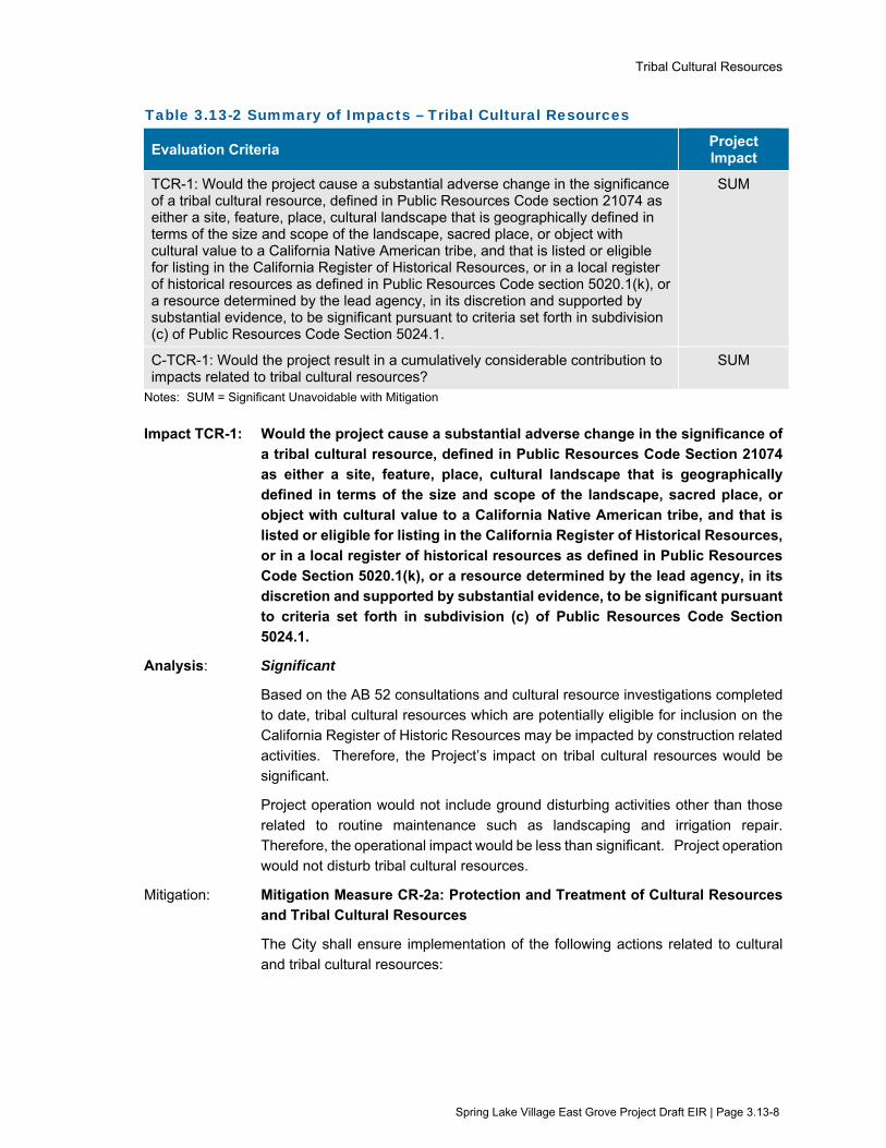
Tribal Cultural Resources
Spring Lake Village East Grove Project Draft EIR | Page 3.13-8
Table 3.13-2 Summary of Impacts – Tribal Cultural Resources
Evaluation Criteria Project Impact
TCR-1: Would the project cause a substantial adverse change in the significance of a tribal cultural resource, defined in Public Resources Code section 21074 as either a site, feature, place, cultural landscape that is geographically defined in terms of the size and scope of the landscape, sacred place, or object with cultural value to a California Native American tribe, and that is listed or eligible for listing in the California Register of Historical Resources, or in a local register of historical resources as defined in Public Resources Code section 5020.1(k), or a resource determined by the lead agency, in its discretion and supported by substantial evidence, to be significant pursuant to criteria set forth in subdivision (c) of Public Resources Code Section 5024.1.
SUM
C-TCR-1: Would the project result in a cumulatively considerable contribution to impacts related to tribal cultural resources?
SUM
Notes: SUM = Significant Unavoidable with Mitigation
Impact TCR-1: Would the project cause a substantial adverse change in the significance of a tribal cultural resource, defined in Public Resources Code Section 21074 as either a site, feature, place, cultural landscape that is geographically
defined in terms of the size and scope of the landscape, sacred place, or object with cultural value to a California Native American tribe, and that is listed or eligible for listing in the California Register of Historical Resources,
or in a local register of historical resources as defined in Public Resources Code Section 5020.1(k), or a resource determined by the lead agency, in its discretion and supported by substantial evidence, to be significant pursuant
to criteria set forth in subdivision (c) of Public Resources Code Section 5024.1.
Analysis: Significant
Based on the AB 52 consultations and cultural resource investigations completed to date, tribal cultural resources which are potentially eligible for inclusion on the California Register of Historic Resources may be impacted by construction related
activities. Therefore, the Project’s impact on tribal cultural resources would be significant.
Project operation would not include ground disturbing activities other than those
related to routine maintenance such as landscaping and irrigation repair. Therefore, the operational impact would be less than significant. Project operation would not disturb tribal cultural resources.
Mitigation: Mitigation Measure CR-2a: Protection and Treatment of Cultural Resources and Tribal Cultural Resources
The City shall ensure implementation of the following actions related to cultural
and tribal cultural resources:

Tribal Cultural Resources
Spring Lake Village East Grove Project Draft EIR | Page 3.13-9
Protection of Archaeological and Tribal Cultural Resources, Pre-Construction Data
Recovery, and/or Construction Monitoring
The City shall ensure that an Archaeological and Tribal Cultural Resources Treatment Plan is developed and implemented for the area outlined in the Cultural Resources Summary prepared for the Project by Tom Origer & Associates (Origer
& Associates 2020). The Treatment Plan shall be reviewed by the City, FIGR, and Lytton, and approved by the City prior to the start of Project construction. The Treatment Plan shall detail recommended steps for protecting, preserving, or data
recovery for archaeological and tribal cultural resources. The Treatment Plan shall include one or more of the following strategies to ensure that appropriate actions to protect cultural and tribal cultural resources are taken, as described in more
detail below.
1) Protection and Preservation;
2) Pre-construction data recovery; and
3) Construction Monitoring
Protection and Preservation
The preferred treatment of an archaeological resource is protection and
preservation. Protection can be achieved by either avoidance (not developing within the boundaries of an archaeological resource), by covering an archaeological resource with geo-fabric and sufficient fill to protect it during and
after construction, or by reducing/restricting development within the boundaries of a resource.
Pre-Construction Data Recovery
For significant resources that are not protected and preserved in place, data recovery within a sensitive area to be affected by the Project is necessary. Data recovery must be performed by qualified archaeologists using standard
archaeological techniques. Data recovery must include processing and analysis of recovered cultural materials using appropriate archaeological methods, and preparation of the recovered materials for permanent disposition (e.g., re-burial in
a location that would be protected in perpetuity) per the requirements of the Archaeological and Tribal Cultural Resources Treatment Plan.
Construction Monitoring
A program of archaeological monitoring shall be instituted for ground-disturbing activities associated with the area outlined in the Cultural Resources Summary prepared for the Project by Tom Origer & Associates (Origer & Associates 2020).
Monitoring shall be performed by a qualified archaeologist and may also include a Native American monitor and will consist of directly watching the excavation, grading, trenching, and other earth-moving processes. Monitoring shall continue
on a daily basis until the depth of excavation has been reached at which resources could not be present. This will be determined by the monitoring archaeologist based on observed soil conditions.
In the event that archaeological deposits are encountered, the piece of equipment that encounters the suspected materials must be stopped, and the find inspected

Tribal Cultural Resources
Spring Lake Village East Grove Project Draft EIR | Page 3.13-10
by the monitoring archaeologist. If the deposit contains Historic Resources, Unique Archaeological Resources, or Tribal Cultural Resources as defined by CEQA, all
work must be stopped in the immediate vicinity and the archaeologist shall undertake data recovery of the deposit. Data recovery efforts must follow standard archaeological methods. Work may proceed after a find has been appropriately
addressed and a qualified archaeologist and tribal representative agree that no further damage would result.
Mitigation Measure CR-2b and CR-2c: Additional Avoidance Measures
The City shall ensure implementation of further avoidance measures as identified in Mitigation Measures CR-2b and CR-2c in the confidential Appendix H.
Mitigation Measure CR-2d: Protect Unanticipated Archaeological and Tribal
Cultural Resources
The City shall ensure that if potential unanticipated archaeological or tribal cultural resources are uncovered during construction, the Applicant and its contractor shall
halt work, and workers shall avoid altering the materials and their context. Project personnel shall not collect cultural materials, examples of which are provided in the following: obsidian and chert flakes and chipped stone tools; grinding and
mashing implements (e.g., slabs and handstones, and mortars and pestles); bedrock outcrops and boulders with mortar cups; and locally darkened midden soils. Midden soils may contain a combination of any of the previously listed items
with the possible addition of bone and shell remains, and fire affected stones. Historic period site indicators generally include: fragments of glass, ceramic, and metal objects; milled and split lumber; and structure and feature remains such as
building foundations and discrete trash deposits (e.g., wells, privy pits, dumps).
A qualified archaeologist and representatives of FIGR and/or Lytton shall be retained by the Applicant to investigate the find and make recommendations as to
treatment and handling of those resources. If the find potentially qualifies as a historic resource, unique archaeological resource, or tribal cultural resource under CEQA, all work must remain stopped in the immediate vicinity to allow the
archaeologist and tribal representatives to evaluate any materials and recommend appropriate treatment. Avoidance of impacts to the resource are preferable. In considering any recommended measures proposed by the archaeologist, FIGR, or
Lytton, the City shall determine whether avoidance is feasible in light of factors such as the nature of the find, Project design, costs, and other considerations. If avoidance is infeasible, other appropriate measures as recommended by the
archaeologist, FIGR, or Lytton (e.g., data recovery or protection in place) shall be instituted. A buffer area around the resource would be established by a qualified archaeologist and tribal representative to ensure that no further damage to a
resource would result. Work may proceed on other parts of the Project while mitigation for these resources is being carried out.
Mitigation Measure CR-3: Treatment of Human Remains, Associated Grave
Goods, or Items of Cultural Patrimony
Should human remains, associated grave goods, or items of cultural patrimony be encountered during Project construction, the following procedures shall be

Tribal Cultural Resources
Spring Lake Village East Grove Project Draft EIR | Page 3.13-11
followed as required by Public Resources Code Section 5097.9 and Health and Safety Code Section 7050.5.
If human remains are encountered, no further excavation or disturbance of the site or any nearby area shall occur until the Sonoma County Coroner has made the necessary findings as to origin, in accordance with Health and Safety Code 7050.5.
In accordance with Public Resources Code 5097.98 if the coroner believes the human remains to be those of a Native American, he or she shall contact, by telephone, within 24 hours, the Native American Heritage Commission. The Native
American Heritage Commission shall immediately notify the Most Likely Descendent (MLD) or Descendants. The Descendent shall inspect the site of the discovery and may recommend the means for treating or disposing, with
appropriate dignity, the human remains and any associated grave goods. The Descendants shall complete their inspection and make their recommendation within 48 hours of their notification by the Native American Heritage Commission.
The remains shall not be damaged or disturbed by further development until the landowner has discussed and conferred with the MLD regarding their recommendations.
After Mitigation: Significant and Unavoidable with Mitigation
Implementation of Mitigation Measure CR-2a would reduce the impact to tribal cultural resources by requiring the development and implementation of an
Archaeological Resource and Tribal Cultural Resource Treatment Plan, archaeological monitoring, and consultation with representatives of the FIGR and Lytton Rancheria Native American Tribes. Implementation of Mitigation Measures
CR-2b and CR-2c would further reduce the potential impact to tribal cultural resources by requiring avoidance measures as identified in the confidential Appendix H.
Mitigation Measure CR-2d would reduce the potential impact to currently unknown tribal cultural resources by outlining procedures to be taken in the event of inadvertent discovery of resources during Project construction. Mitigation
Measure CR-3 also would minimize the potential impact to tribal cultural resources by requiring the contractor to notify the MLD and avoid the area if human remains are encountered, and to follow procedures outlined in Public Resources Code §
5097.9 and Health and Safety Code § 7050.5.
However, even with implementation of these measures, Project-related excavations and ground-disturbance may materially impair the integrity of tribal
cultural resources. Therefore, the impact would be significant and unavoidable, even with mitigation.
Impact C-TCR-1: Would the project result in a cumulatively considerable contribution to
impacts related to tribal cultural resources?
Analysis: Significant
The geographic boundary for cumulative impacts related to tribal cultural resources
would be the range of tribe(s) culturally affiliated with the Project site and the locality of related tribal cultural resources. Implementation of the cumulative

Tribal Cultural Resources
Spring Lake Village East Grove Project Draft EIR | Page 3.13-12
projects listed in Table 3-1 (Projects Considered for Cumulative Impacts) may require grading and excavation that could potentially affect tribal cultural
resources. Construction activities associated with cumulative projects would be subject to existing federal, state, local regulations, and policies for Project design and approval. CEQA requirements for protecting tribal cultural resources would be
applicable to each of the cumulative projects. The existing federal, state and local regulations, design policies and CEQA requirements would generally reduce potential impacts to tribal cultural resources from implementation of cumulative
projects to a less-than-significant level. However, as discussed above under the Project impact analysis, the Project may potentially impact tribal cultural resources. The Project’s contribution to the potential cumulative impact would be cumulatively
considerable, and therefore significant.
Mitigation: Mitigation Measure CR-2a: Protection and Treatment of Cultural Resources and Tribal Cultural Resources
Mitigation Measure CR-2b and CR-2c: Additional Avoidance Measures
Mitigation Measure CR-2d: Protect Unanticipated Archaeological and Tribal Cultural Resources
Mitigation Measure CR-3: Treatment of Human Remains, Associated Grave Goods, or Items of Cultural Patrimony
Please refer to Impact TCR-1 for the description of Mitigation Measures CR-2a
through CR-3.
After Mitigation: Significant and Unavoidable with Mitigation
As noted under Impact TCR-1, implementation of Mitigation Measures CR-2a
through CR-3 would reduce the impact to tribal cultural resources, however, even with implementation of these measures, Project-related excavations and ground-disturbance may materially impair the integrity of tribal cultural resources. The
Project’s contribution to the cumulative impact would therefore be significant and unavoidable, even with mitigation.
3.13.6 References Tom Origer & Associates. 2016. A Cultural Resources Study for the Spring Lake Village East Grove
Project, Santa Rosa, Sonoma County, California. Report by J. Franco and E. Barrow. August.
Tom Origer & Associates. 2017. Historical Resources Study for the Spring Lake Village East Grove Project Santa Rosa, Sonoma County, California. Report by J. Franco and E. Barrow. June.
Tom Origer & Associates. 2020b. Cultural Resources Summary for the Spring Lake Village – East
Grove Project located at 225 Los Alamos Road and 5803 and 5815 Melita Road Santa Rosa, Sonoma County, California. January.
Utilities
Spring Lake Village East Grove Project Draft EIR | Page 3.14-1
3.14 Utilities and Service Systems This section provides a description of the existing utilities in the Project area and evaluates changes to those conditions that would result from implementation of the proposed Project. In addition to the analysis provided in this section, the following subjects are related to utilities, but are evaluated in other sections of this EIR:
Potential impacts related to storm water runoff that could exceed the capacity of existing or planned storm water drainage systems are evaluated in Section 3.8 (Hydrology and Water Quality).
3.14.1 Setting
Water Distribution and Supply
The City of Santa Rosa is a retail water supplier to residential and commercial accounts located within the City’s service area. According to the City’s 2015 Urban Water Management Plan (UWMP), the City provided water to 53,193 customers and supplied 16,539 acre-feet of water (Santa Rosa 2016).
The majority of the City’s potable water supply comes from the Russian River watershed and is delivered under contractual agreement by Sonoma Water. Sonoma Water produces water from the Russian River that is pumped from groundwater wells below the river bed. Six groundwater wells, also known as collectors, pump the water through natural sands and gravels that act as a filtering system. Sonoma Water adds chlorine to its water supply to provide residual disinfection throughout its water transmission system. Sonoma Water also adjusts the pH of its water. City owned and maintained water distribution facilities include treated water reservoirs, pipelines, pump stations, and one well treatment facility.
Under its current agreement with Sonoma Water, the City is entitled to receive up to an annual volume of 29,100 acre feet per year (AFY) and an average of 40 million gallons per day (mgd) from Reach 1, 2 and 3a of the Intertie Aqueduct, 40 mgd from the Santa Rosa Aqueduct, 4.0 mgd from the Sonoma Aqueduct, or a maximum combined average total of 56.6 mgd for a one-month period from all aqueducts. In addition to Sonoma Water’s supply, the City has two active production wells which provide up to 2,300 AFY. The City is also the owner and operator of the Subregional Water Reuse System, providing up to 140 AFY of recycled water for approved uses which offset potable water use within Santa Rosa. (Santa Rosa 2016)
Wastewater Collection, Treatment, and Disposal
The City’s wastewater system collects, treats, and disposes of sewage from residential, commercial, and industrial uses. Wastewater generated from the City is collected and transported to the Subregional Laguna Water Reuse Facility (Laguna Treatment Plant) for treatment and disposal. The Laguna Treatment Plant provides tertiary treatment of wastewater collected from the four subregional partners that include Santa Rosa, Rohnert Park, Cotati, and Sebastopol, as well as the South Park Sanitation District. Recycled water is disposed of through Geysers recharge, agricultural irrigation, urban reuse, and discharge to the Russian River.
The Laguna Treatment Plant is currently permitted to treat an average dry weather flow (ADWF) of 21.34 mgd, 16.31 mgd of which is allocated for the City of Santa Rosa. The Laguna Treatment Plant’s ADWF in 2017 was 14.5 mgd, indicating that approximately 6.84 mgd of capacity is available (Santa Rosa 2017a). The City of Santa Rosa approved an Incremental Recycled Water Program in 2004,

Utilities
Spring Lake Village East Grove Project Draft EIR | Page 3.14-2
which would be implemented as growth occurs, eventually increasing the Laguna Treatment Plant’s ADWF capacity to 25.89 mgd (19.14 mgd of which would be allocated to Santa Rosa).
Storm Water Collection and Treatment
The Santa Rosa Public Works Department maintains storm water pipes and structures within the City. The City of Santa Rosa’s current municipal storm water permit regulates both stormwater and non-stormwater discharges from public and private projects with the intent to reduce stormwater pollution, protect the water quality of creeks and waterways, and promote infiltration.
The existing storm water collection system in the Project area consists of storm drain and open drainage ditches along the edges of the project site. Along Los Alamos Road, an open drainage ditch conveys storm water along the edge of the property and ultimately drains to Santa Rosa Creek near Montgomery Drive. Along Melita Road, existing storm drain pipes and an open drainage ditch conveys storm water along the north side of Melita Road, which then crosses the road beneath an existing culvert and drains towards Santa Rosa Creek.
Solid Waste
The City of Santa Rosa currently contracts with the North Bay Corporation to provide solid waste collection and curbside recycling for residential and commercial uses in Santa Rosa. The North Bay Corporation provides a single-stream recycling program (all recyclables in one container). The North Bay Corporation collects and transports commercial and residential solid waste to the Central Disposal Site Transfer Station at 500 Meacham Road in the City of Petaluma. Sonoma County’s municipal solid waste is then delivered to three out-of-County landfills within the Bay Area, including the Redwood Landfill in Marin County, Keller Canyon Landfill in Contra Costa County, and Potrero Hills Landfill in Solano County.
Gas, Electricity, Cable and Telephone
The Pacific Gas and Electric Company (PG&E) provides electricity and natural gas service to the project area. PG&E is regulated by the California Public Utilities Commission and purchases both gas and electrical power from a variety of sources, including other utility companies. AT&T provides cable and telephone service to the area.
3.14.2 Regulatory Framework
Federal
There are no federal plans, policies, regulations, or laws related to utilities that would be applicable to the project.
State and Regional
Urban Water Management Planning Act The Urban Water Management Planning Act (UWMP Act) was originally established by Assembly Bill 797 (AB 797) on September 21, 1983. The primary objective of the UWMP Act is to direct “urban water suppliers” to develop an Urban Water Management Plan which provides a framework for long-term water supply planning, and documents how urban water suppliers are carrying out their long-term resource planning responsibilities to ensure adequate water supplies are available to meet existing and future water demands. The UWMP Act applies to water suppliers that provide over 3,000 acre-feet per year or have over 3,000 connections. The City of Santa Rosa 2015 Urban Water Management Plan was adopted by Resolution No. 28799 of the City Council on June 14, 2016.
Utilities
Spring Lake Village East Grove Project Draft EIR | Page 3.14-3
California Integrated Waste Management Act The California Integrated Waste Management Act (CIWMA), also known as Assembly Bill 939, required each jurisdiction in the state to divert 25 percent of its solid waste from landfill or transformation facilities by 1995 and 50 percent by 2000. Accepted diversion methods include source reduction, recycling and composting activities. The CIWMA also required each County to prepare a Countywide Integrated Waste Management Plan (CoIWMP), which is the main planning document for solid waste management in each County. Sonoma County’s CoIWMP is the principal planning document for solid waste management in Sonoma County. The CoIWMP identifies goals and objectives of the County and the incorporated cities in the County with respect to solid waste reduction, recycling diversion, and disposal of solid waste. Concurrent with the preparation of the CoIWMP, all incorporated cities in the County and the County entered into a Joint Power Agreement which formed the Sonoma County Waste Management Agency (SCWMA) to deal with household hazardous waste, yard and wood waste, and public education. The most recent update to the CoIWMP was adopted and certified by SCWMA in February 2010.
Local
Wastewater Permit The City has a National Pollutant Discharge Elimination System (NPDES) Permit for operation of the Laguna Treatment Plant and is required to comply with applicable regulations regarding wastewater treatment. Wastewater within the City of Santa Rosa may be discharged into City sewers for collection, treatment, and disposal by the City, provided that such wastes do not contain prohibited substances or exceed limitation of wastewater volume or strength, as applicable. The City of Santa Rosa Municipal Code includes specific wastewater discharge prohibitions. These include, but are not limited to, limits and prohibitions related to pH, temperature, toxic pollutants, and malodorous liquids. Daily maximum allowable discharge limits are established for metals, biochemical oxygen demand, pH, total toxic organics, total suspended solids, total petroleum hydrocarbons, total dissolved solids, and other constituents.
City of Santa Rosa General Plan Goals and Policies The following goals and policies from the City of Santa Rosa General Plan 2035 are generally related to utilities for the project.
PSF-F Ensure that an adequate supply of water is available to serve existing and future needs of the City.
PSF-F-1 Utilize high quality water from the SCWA aqueduct system as the primary water supply.
PSF-F-2 Ensure that water supply capacity and infrastructure are in place prior to occupancy of new development.
PSF-F-3 Develop available groundwater resources for the purpose of providing a supplemental source of water in the event of an emergency.
PSF-G Ensure that adequate sewer capacity is available to serve existing and future needs of the City.
PSF-G-2 Maintain existing levels of wastewater service by preserving and improving infrastructure, including replacing sewer mains as necessary.

Utilities
Spring Lake Village East Grove Project Draft EIR | Page 3.14-4
PSF-H Meet the city’s solid waste disposal needs, while maximizing opportunities for waste reduction and recycling.
PSF-H-1 Continue contracting for garbage and recycling collection services. Expand the single-stream recycling program (all recyclables in one container) to all users.
PSF-H-4 Require provision of attractive, convenient recycling bins and trash enclosures in residential and non-residential development.
PSF-I Manage, maintain, and improve stormwater drainage and capacity.
PSF-I-1 Require dedication, improvement, and maintenance of stormwater flow retention areas as a condition of approval.
PSF-I-2 Require developers to cover the costs of drainage facilities needed for surface runoff generated as a result of new development.
3.14.3 Evaluation Criteria and Significance Thresholds For the purpose of this EIR, the evaluation criteria and significance thresholds summarized in Table 3.14-1 (Evaluation Criteria and Significance Thresholds) are used to determine if the project would have a significant effect related to utilities.
Table 3.14-1 Evaluation Criteria and Significance Thresholds
Evaluation Criteria Significance Thresholds Sources
UT-1: Would the project require or result in the relocation or construction of new or expanded water, wastewater treatment or storm water drainage, electrical power, natural gas, or telecommunications facilities, the construction or relocation of which could cause significant environmental effects?
Inadequate water supply, storm water drainage, natural gas, or telecommunications infrastructure to serve the site
CEQA Guidelines Appendix G, Checklist Item XIX (a) General Plan goals PSF-F, G, I General Plan policies PSF-F-2, PSF-F-4, G-2, I-1, I-8
UT-2: Would the project have sufficient water supplies available to serve the project and reasonably foreseeable future development during normal, dry and multiple dry years?
Inadequate water supply capacity or infrastructure to serve the needs of the project
CEQA Guidelines Appendix G, Checklist Item XIX (b) General Plan policy PSF-F-2
UT-3: Would the project result in a determination by the wastewater treatment provider which serves or may serve the project that it has adequate capacity to serve the project’s projected demand in addition to the provider’s existing commitments?
Inadequate sewer capacity to serve the project and future needs of the City
CEQA Guidelines Appendix G, Checklist Item XIX (c) General Plan goal PSF-G

Utilities
Spring Lake Village East Grove Project Draft EIR | Page 3.14-5
Evaluation Criteria Significance Thresholds Sources
UT-4: Would the project generate solid waste in excess of State or local standards, or in excess of the capacity of local infrastructure, or otherwise impair the attainment of solid waste reduction goals?
Inadequate regional landfill capacity to serve the project Violation of solid waste reduction goals
CEQA Guidelines Appendix G, Checklist Item XIX (d) General Plan goal PSF-H
UT-5: Would the project comply with federal, state, and local management and reduction statutes and regulations related to solid waste?
Non-compliance with applicable solid waste diversion regulations
CEQA Guidelines Appendix G, Checklist Item XIX (e) General Plan goal PSF-H
3.14.4 Approach to Analysis Potential impacts on utilities are analyzed based on the potential for the proposed Project to affect the wastewater, water, stormwater, solid waste, and other utility facilities during construction or operation, as indicated in the thresholds above.
3.14.5 Impacts and Mitigation Measures Table 3.14-2 (Summary of Impacts - Utilities) provides a summary of potential impacts from the project.
Table 3.14-2 Summary of Impacts – Utilities
Evaluation Criteria Project Impact
UT-1: Would the project require or result in the relocation or construction of new or expanded water, wastewater treatment or storm water drainage, electrical power, natural gas, or telecommunications facilities, the construction or relocation of which could cause significant environmental effects?
LS
UT-2: Would the project have sufficient water supplies available to serve the project and reasonably foreseeable future development during normal, dry and multiple dry years?
LS
UT-3: Would the project result in a determination by the wastewater treatment provider which serves or may serve the project that it has adequate capacity to serve the project’s projected demand in addition to the provider’s existing commitments?
NI
UT-4: Would the project generate solid waste in excess of State or local standards, or in excess of the capacity of local infrastructure, or otherwise impair the attainment of solid waste reduction goals?
LS
UT-5: Would the project comply with federal, state, and local management and reduction statutes and regulations related to solid waste?
NI
C-UT-1: Would the project result in a cumulatively considerable contribution to cumulative impacts related to utilities?
LS
Notes: NI = No Impact LS = Less than Significant

Utilities
Spring Lake Village East Grove Project Draft EIR | Page 3.14-6
Impact UT-1: Would the project require or result in the relocation or construction of new or expanded water, wastewater treatment or storm water drainage, electrical power, natural gas, or telecommunications facilities, the construction or relocation of which could cause significant environmental effects?
Analysis: Less than Significant
Water Facilities
The proposed Project would construct 32 dwelling units and a community building with kitchen facilities, which would increase potable water demand on the site. Two existing irrigation wells would be used to provide landscaping irrigation. Using the assumptions established by the 2014 Water Master Plan Update (City of Santa Rosa 2014), development of the Project site as proposed would be projected to result in a water demand of approximately 11 acre-feet per year. In actuality, the Project is anticipated to require a smaller demand than that noted above, in part due to the proposed use of the existing groundwater irrigation wells and having fewer occupants per unit than an average household.
The total water demand within Santa Rosa in 2020 is estimated to be 24,289 acre feet per year (Santa Rosa 2016), and the water supply available within the City is estimated to be 7,251 acre feet in 2020. Therefore, adequate water supplies would be available to serve the estimated 11 acre feet demand for the proposed Project, and construction of new water treatment facilities or expansion of existing facilities would not be required. Therefore, no environmental impacts associated with construction of new treatment facilities or expansion of existing facilities would result.
Wastewater Treatment Facilities
During construction, groundwater may be generated during re-development or testing of the existing irrigation wells located on the Project site, or during dewatering operations if necessary to provide a dry work area. Groundwater generated during construction activities may potentially be conditioned to be discharged to the City’s wastewater collection system, which would then convey the water to the Laguna Treatment Plant. The City of Santa Rosa conditionally allows the discharge of wastewater generated as a result of purging groundwater wells and groundwater dewatering for projects that will not exceed six months. Prior to any such discharges, the project Applicant or its construction contractor would be required to obtain and implement a one-time wastewater discharge permit from the City of Santa Rosa. Because the discharge of groundwater to the Laguna Treatment Plant would be temporary in nature and would not substantially alter existing wastewater characteristics or result in the need for new treatment methods, the impact would be less than significant.
Using generation rates established in the 2016 Sanitary Sewer System Master Plan Update (Santa Rosa 2016), the proposed Project would be expected to produce approximately 3,560 gpd of wastewater (based on 64 residents and 12 employees). The Laguna Treatment Plant’s ADWF in 2017 was 14.5 mgd, indicating that approximately 6.84 mgd of capacity is available. Based on the existing capacity of the Laguna Treatment Plant and the projected Project

Utilities
Spring Lake Village East Grove Project Draft EIR | Page 3.14-7
wastewater flows, the Project can be adequately served from existing wastewater treatment facilities. Therefore, the Project would not require or result in the construction of new wastewater treatment facilities or expansion of existing facilities, and no environmental impacts associated with construction of new treatment facilities or expansion of existing facilities would result.
Following construction, the project Applicant would be required to obtain a wastewater discharge permit from the City of Santa Rosa for the non-residential discharge from the Community Building and kitchen. The permit would be required to be in place prior to the discharge of operational wastewater into the wastewater collection system. The proposed kitchen would be required to include approved and properly sized grease removal devices, and food service activities would be subject to regulations and inspections by the City of Santa Rosa Utilities Department Environmental Compliance Section. As a primarily residential land use, the proposed Project would not generate wastewater strengths that would compel special treatment to meet the purposes of the City’s wastewater treatment requirements. The new residences would not alter existing wastewater characteristics or result in the need for new treatment methods.
Storm Water
The Project includes new on-site and off-site storm water facilities as identified in Section 2, Project Description. The on-site facilities include vegetated swales and storm drain inlets that will drain to new on-site rain garden detention basins. The off-site facilities include a new storm drain to be installed along Melita Road and an upsized culvert across Melita Road.
Project plans indicate that the new storm water facilities would comply with the City of Santa Rosa Standard Urban Storm Water Mitigation Plan and the City of Santa Rosa Low Impact Development Technical Design Manual (Santa Rosa 2017b). A drainage analysis was completed for the Project to calculate existing and future runoff at the Project site and to evaluate the adequacy of the storm water drainage capacity to serve the site. The drainage analysis indicates that upsizing an existing 12-inch culvert that crosses Melita Road to an 18-inch culvert would improve the existing drainage conditions, and therefore, is proposed as part of the Project. Therefore, the adequacy of the storm water drainage system to serve the site has been evaluated and necessary on-site and off-site improvements have been identified and incorporated into the proposed Project design. The potential environmental impacts associated with construction of the new and expanded storm water drainage facilities are evaluated as part of this EIR. No additional storm water drainage facilities or expansion of existing facilities beyond those identified in the project description and evaluated in the EIR would be required. The impact related to storm water drainage capacity is less than significant.
Other Utilities
Electrical power and natural gas would be provided by PG&E from existing utility lines adjacent to the Project site, including a natural gas line located within Melita Road. All electricity, natural gas, and telecommunication infrastructure would be located underground and would tie-in to existing infrastructure. The potential
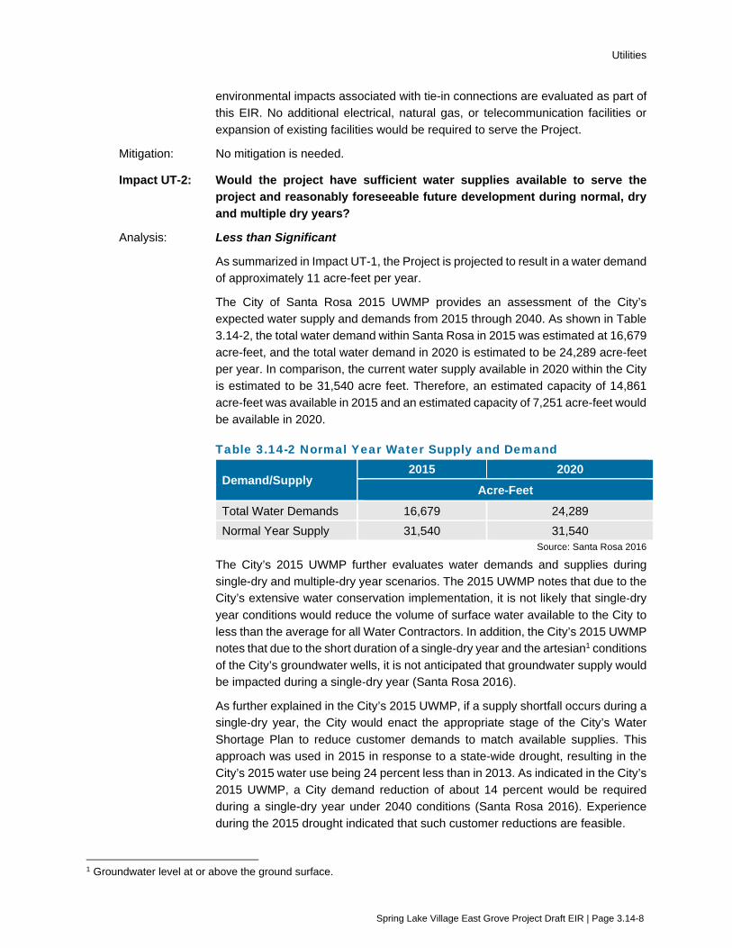
Utilities
Spring Lake Village East Grove Project Draft EIR | Page 3.14-8
environmental impacts associated with tie-in connections are evaluated as part of this EIR. No additional electrical, natural gas, or telecommunication facilities or expansion of existing facilities would be required to serve the Project.
Mitigation: No mitigation is needed.
Impact UT-2: Would the project have sufficient water supplies available to serve the project and reasonably foreseeable future development during normal, dry and multiple dry years?
Analysis: Less than Significant
As summarized in Impact UT-1, the Project is projected to result in a water demand of approximately 11 acre-feet per year.
The City of Santa Rosa 2015 UWMP provides an assessment of the City’s expected water supply and demands from 2015 through 2040. As shown in Table 3.14-2, the total water demand within Santa Rosa in 2015 was estimated at 16,679 acre-feet, and the total water demand in 2020 is estimated to be 24,289 acre-feet per year. In comparison, the current water supply available in 2020 within the City is estimated to be 31,540 acre feet. Therefore, an estimated capacity of 14,861 acre-feet was available in 2015 and an estimated capacity of 7,251 acre-feet would be available in 2020.
Table 3.14-2 Normal Year Water Supply and Demand
Demand/Supply 2015 2020
Acre-Feet Total Water Demands 16,679 24,289 Normal Year Supply 31,540 31,540
Source: Santa Rosa 2016
The City’s 2015 UWMP further evaluates water demands and supplies during single-dry and multiple-dry year scenarios. The 2015 UWMP notes that due to the City’s extensive water conservation implementation, it is not likely that single-dry year conditions would reduce the volume of surface water available to the City to less than the average for all Water Contractors. In addition, the City’s 2015 UWMP notes that due to the short duration of a single-dry year and the artesian1 conditions of the City’s groundwater wells, it is not anticipated that groundwater supply would be impacted during a single-dry year (Santa Rosa 2016).
As further explained in the City’s 2015 UWMP, if a supply shortfall occurs during a single-dry year, the City would enact the appropriate stage of the City’s Water Shortage Plan to reduce customer demands to match available supplies. This approach was used in 2015 in response to a state-wide drought, resulting in the City’s 2015 water use being 24 percent less than in 2013. As indicated in the City’s 2015 UWMP, a City demand reduction of about 14 percent would be required during a single-dry year under 2040 conditions (Santa Rosa 2016). Experience during the 2015 drought indicated that such customer reductions are feasible.
1 Groundwater level at or above the ground surface.

Utilities
Spring Lake Village East Grove Project Draft EIR | Page 3.14-9
If a supply shortfall occurred during a multiple-dry year scenario, the City would enact the appropriate stage of the City’s Water Shortage Plan to reduce customer water demands.
Based on the findings of the City of Santa Rosa 2015 UWMP, the proposed Project’s water demand could be adequately served from existing water supply entitlements. Although the Project would result in an increase in the dwelling unit density and a potential increase in water demand previously unaccounted for in the 2014 Water Master Plan Update, such increases would not require or result in the need to acquire new or expanded entitlements. Therefore, the impact would be less than significant.
Mitigation: No mitigation is needed.
Impact UT-3: Would the project result in a determination by the wastewater treatment provider which serves or may serve the project that it has adequate capacity to serve the project’s projected demand in addition to the provider’s existing commitments?
Analysis: No Impact
As summarized in Impact UT-1, the Project would be expected to produce approximately 3,560 gpd of wastewater (based on 64 residents and 12 employees). The Laguna Treatment Plant is currently permitted to treat an ADWF of 21.34 mgd, 16.31 mgd of which is allocated for the City of Santa Rosa. The City of Santa Rosa also approved an Incremental Recycled Water Program in 2004 which would be implemented as growth occurs, eventually increasing the Laguna Treatment Plant’s ADWF capacity to 25.89 mgd (19.14 mgd of which would be allocated to Santa Rosa). The Laguna Treatment Plant’s ADWF in 2017 was 14.5 mgd, indicating that approximately 6.84 mgd of capacity was available. Based on the existing capacity of the Laguna Treatment Plant and the projected Project wastewater flows, the Laguna Treatment Plant has adequate capacity to serve the project’s projected wastewater demand in addition to existing commitments. No impact would result.
Mitigation: No mitigation is needed.
Impact UT-4: Would the project generate solid waste in excess of State or local standards, or in excess of the capacity of local infrastructure, or otherwise impair the attainment of solid waste reduction goals?
Analysis: Less than Significant
Construction of the Project would result in a temporary increase in solid waste disposal needs associated with construction waste. Construction wastes would include solid waste from demolition of the two single-family homes, site clearing, grading, tree removal, and street improvements, including demolished asphalt pavement and concrete. Excavated soils may be utilized for backfill at the project site or off-hauled with other construction debris for recycling or disposal as required by City and County regulations.

Utilities
Spring Lake Village East Grove Project Draft EIR | Page 3.14-10
Following construction, the Project would generate approximately 128 pounds (0.06 tons) of solid waste per day, or approximately 46,720 pounds (23.36 tons) per year. Such volumes are based on a standard residential waste generation rate of 4.0 pounds per dwelling unit per day, as provided by the California Department of Resources Recycling and Recovery (CalRecycle). The Project would also provide a dining area to serve the residents. This is estimated to generate approximately 0.005 pounds of waste per square foot per day.
Solid waste within the City of Santa Rosa is collected and transported to the Central Disposal Site Transfer Station. Municipal solid waste is then disposed of at both the Central Disposal site and at out-of-County landfills within the Bay Area. Out-of-County landfills include Redwood Sanitary Landfill in the City of Novato, Potrero Hills Landfill in Suisun City, Vasco Road Landfill in the City of Livermore, and Keller Canyon Landfill in the City of Pittsburg.
As shown in Table 3.14-4, sufficient capacity exists at regional landfills to accommodate the Project’s solid waste disposal needs. Solid waste generated during construction and operation of the Project would represent a small fraction of the daily permitted tonnage of these facilities. Therefore, the Project’s solid waste disposal needs would be sufficiently accommodated by existing landfills, and the impact would be less than significant.
Table 3.14-4 Landfill Capacity Summary
Landfill Location Remaining Capacity
(cubic yards)
Estimated Closure Date
Central Petaluma 9 million 2034
Redwood Novato 26 million 2024
Potrero Hills Suisun City 13.9 million 2048
Vasco Road Livermore 7 million 2022
Keller Canyon Pittsburg 63.4 million 2030 Source: CalRecycle, 2016
Mitigation: No mitigation is needed.
Impact UT-5: Would the project comply with federal, state, and local management and reduction statutes and regulations related to solid waste?
Analysis: No Impact
No applicable federal solid waste regulations would apply to the Project. At the State level, the Integrated Waste Management Act mandates a reduction of waste being disposed and establishes an integrated framework for program implementation, solid waste planning, and solid waste facility and landfill compliance. The City of Santa Rosa has entered into a franchise agreement to provide construction and demolition debris collection service within the City in accordance with Municipal Code Chapter 9-12. The existing franchise agreement requires that the franchisee recycle 50 percent of all construction and demolition debris collected within the City. The City of Santa Rosa also maintains a collection
Utilities
Spring Lake Village East Grove Project Draft EIR | Page 3.14-11
services contract to provide solid waste collection and curbside recycling for residential and commercial uses in Santa Rosa. Solid waste disposal services provided within Santa Rosa must follow the applicable State and local regulations related to the collection of solid waste. Compliance with applicable statutes and regulations would be conditionally required as part of Project. Therefore, no impact would result.
Mitigation: No mitigation is needed.
Impact C-UT-1: Would the project result in a cumulatively considerable contribution to cumulative impacts related to utilities?
Analysis: Less than Cumulatively Considerable (Less than Significant)
Water
For water service, the geographic scope for assessing cumulative impacts is the area within the City of Santa Rosa potable water service area. The proposed Project, in conjunction with other past, present, and reasonably foreseeable future projects, could result in a cumulative increase in water demand and the need for new or expanded water facilities. As discussed in Impact UT-1 and UT-2, the proposed Project would not create the need for new or expanded water facilities or demand a significant amount of the existing water supply. Based on the City of Santa Rosa’s Urban Water Management Plan, there is adequate water supply in normal years to meet demands through 2040. As indicated in the City’s 2015 UWMP, a City demand reduction of about 14 percent would be required during a single-dry year under 2040 conditions (Santa Rosa 2016). Experience during the 2015 drought indicated that such customer reductions are feasible. If a supply shortfall occurred during a multiple-dry year scenario, the City would enact the appropriate stage of the City’s Water Shortage Plan to reduce customer water demands. The Project’s contribution to the cumulative impact on water service and supply would be less than significant.
Wastewater
For wastewater service the geographic scope for assessing cumulative impacts is the wastewater treatment service area of the City of Santa Rosa. As discussed in the above Project-specific analysis, however, service demand by the proposed Project would not result in a significant impact on wastewater treatment capacity or create the need for new or expanded wastewater treatment facilities. Currently, the City of Santa Rosa expects capacity to be adequate to serve the Project combined with other anticipated projects, and no significant cumulative impact would occur. The effect of the proposed Project on wastewater service, in combination with other past, present, and foreseeable projects, would be less than significant.
Electricity
For electricity, the geographic scope for assessing cumulative impacts consists of the PG&E distribution grid the Project is located on. The proposed Project, in conjunction with other past, present, and reasonably foreseeable future projects, could result in a cumulative increase in electricity demands and the need for new
Utilities
Spring Lake Village East Grove Project Draft EIR | Page 3.14-12
or expanded facilities. As discussed in the above Project-specific analysis, the Project would only require a marginal amount of electricity. Therefore, it is not anticipated that the Project would contribute significantly to a cumulative impact related to insufficient electricity. The cumulative effect of the proposed Project on electricity supply would be less than significant.
Solid Waste
For solid waste disposal service, the geographic scope for assessing cumulative impacts consists of the service area for the landfills serving the region the Project is within. Construction and operation of the proposed Project in conjunction with past, present, and reasonably foreseeable future projects, could result in a cumulative increase in construction and operation-related solid waste and debris. Implementation of state and local waste reduction and diversion requirements and programs has and would continue to reduce the potential for exceeding existing capacities of the regional landfills, which still have adequate capacity. For these reasons, the effect of the proposed Project on solid waste disposal service, in combination with other past, present, and foreseeable projects, would be less than significant.
Mitigation: No mitigation is needed.
3.14.6 References CalRecycle. 2016. Solid Waste Information System. Accessed October 28, 2016, online at:
http://www.calrecycle.ca.gov/SWFacilities/Directory/
CalRecycle. 2016. Estimated Solid Waste Generation Rates. Accessed March 26, 2018, online at: https://www2.calrecycle.ca.gov/WasteCharacterization/General/Rates.
Santa Rosa, City of. 2009. Santa Rosa General Plan 2035. November 3.
Santa Rosa, City of. 2014. Sanitary Sewer Master Plan Update.
Santa Rosa, City of. 2016. City of Santa Rosa, 2015 Urban Water Management Plan. June
Santa Rosa, City of. 2017a. Laguna Subregional Water Reclamation System 2017 Annual Report.
Santa Rosa, City of. 2017b. Storm Water Low Impact Development Technical Design Manual.

Alternatives Description and Analysis
Spring Lake Village East Grove Project Draft EIR | Page 4-1
Alternatives Description and Analysis
4.1 Introduction This chapter presents the alternatives analysis for the Project. CEQA and the CEQA Guidelines require that an EIR “describe a range of reasonable alternatives to the project, or to the location of the project, which would feasibly attain most of the basic objectives of the project, but would avoid or
substantially lessen any of the significant effects of the project, and evaluate the comparative merits of the alternatives” (CEQA Guidelines Section 15126.6[a]). In addition, an EIR must identify alternatives that were considered by the lead agency and were rejected as infeasible during the
scoping process and should briefly explain the reasons underlying the lead agency’s determination (CEQA Guidelines Section 15126 [(c]).
For ease of reference, the project objectives identified in Chapter 2, the Project Description, are
repeated below:
Create and operate at least 32 new senior community care facility units for independent living, ranging in size from approximately 1,500 square feet to 1,800 square feet;
Harmonize with the aesthetic of the existing campus and with the existing neighborhood and scenic corridors near the Project site;
Expand the existing Spring Lake Village campus facilities with new on-site state of the art amenities, including recreation and dining spaces, in a safe and secure environment for senior residents, within walking distance of the main campus;
Utilize more fully the existing infrastructure, facilities, and services of the existing campus;
Incorporate sustainable design, and enhanced energy and water efficiency measures;
Serve the growing senior population by providing housing with convenient access to medical care facilities, transportation, retail, cultural, and recreational amenities;
Continue to attract and retain seniors as part of the greater Santa Rosa community through provision of a progression of care and services on the expanded Spring Lake Village campus, allowing residents to age in place; and
Continue to provide quality senior care licensed by the State of California.
One of the alternatives analyzed must be the “No Project” alternative. CEQA Guidelines Section 15126.6(e)(1) states that the purpose of describing and analyzing the no project alternative is “to
allow decision makers to compare the impacts of approving the proposed project with the impacts of not approving the proposed project.” The no project analysis is required to “discuss the existing conditions at the time the notice of preparation is published…as well as what would be reasonably
expected to occur in the foreseeable future if the project were not approved, based on current plans and consistent with available infrastructure and community services” (Section 15126.6[e][2]).
The alternatives are described and analyzed below, followed by a matrix (Table 4-1) that compares
the impacts of the alternatives to that of the Project. This section also includes a description of those alternatives that were considered but not carried forward in the analysis.
4.2 Alternatives Considered but not Carried Forward in this EIR During the preliminary planning process, the EIR scoping process, and the environmental analysis, several alternatives to the Project were evaluated and/or suggested. These alternatives are

Alternatives Description and Analysis
Spring Lake Village East Grove Project Draft EIR | Page 4-2
summarized below, and are evaluated to determine if they meet the qualifications for alternatives, as required under CEQA.
In accordance with CEQA requirements, an alternative must meet the following three criteria: 1) the alternative would attain most of a project’s basic objectives; 2) the alternative would avoid or substantially reduce the significant environmental impacts of the proposed project; and 3) the
alternative must be potentially feasible. An EIR need not analyze an alternative whose impact cannot be reasonably ascertained and whose implementation is remote and speculative. Furthermore, an EIR need not consider every conceivable alternative, but must consider a reasonable range of
alternatives that will foster well-informed decision-making and public participation.
4.2.1 Main Street Alternative During preliminary planning of the Project, the Applicant developed a secondary Project alternative to be evaluated, identified as the Main Street Alternative, which was included in a Notice of Preparation to agencies and interested parties on August 30, 2017. The Main Street Alternative was
to be located on the same site as the proposed Project and would have included the same total number of independent living units, namely 32 units supporting up to 64 residents at full occupancy. The Main Street Alternative had the same vehicle access and off-site pedestrian, bicycle, storm water
and utility improvements as the proposed Project. The Main Street Alternative also would have removed the existing single-family residential homes at 5803 Melita Road and 5815 Melita Road. After reviewing the potential environmental impacts of the Main Street Alternative, it was determined
that the alternative would not substantially reduce the significant environmental impacts of the proposed Project. Impacts to cultural resources and tribal cultural resources would remain significant and unavoidable. Therefore, the alternative is not evaluated further in this EIR.
4.2.2 Partial Avoidance Alternative During the EIR process, the Applicant developed an alternative that would partially respond to the significant cultural resources and tribal cultural resource impacts identified for the proposed Project.
This alternative would include the same number of independent living units, vehicle access, and off-site pedestrian, bicycle, storm water and utility improvements as the proposed Project. This alternative also would remove the existing single-family residential homes at 5803 Melita Road and
5815 Melita Road. After reviewing the potential environmental impacts of this alternative, it was determined that it would be the same as the proposed Project even with incorporation of Mitigation Measures CR-2b and CR-2c into the design. The Partial Avoidance Alternative would not
substantially reduce the significant environmental impacts of the proposed Project. Impacts to cultural resources and tribal cultural resources would remain significant and unavoidable. Therefore, the Partial Avoidance Alternative is not evaluated further in this EIR.
4.2.3 Access Road off Highway 12 or Melita Road During the EIR scoping process, a commenter suggested the vehicular access point to the Project
site be moved from Los Alamos Road to either Highway 12 or Melita Road. However, no impacts were identified that would be reduced or avoided by moving the primary access road to either Highway 12 or Melita Road. In addition, given the speeds along Highway 12, an access point at this
location could pose a safety impact to slower moving vehicles attempting to enter and exit the site. Thus, the alternative would not offer any environmental advantage over the Project. Therefore, the alternative was not evaluated further in this EIR.

Alternatives Description and Analysis
Spring Lake Village East Grove Project Draft EIR | Page 4-3
4.3 Analysis of Alternatives This section describes the Project alternatives that were selected and analyzed in accordance with CEQA Guidelines Section 15126.6(a). The rule of reason was used for the range of alternatives considered. The alternatives are limited to those that would avoid or substantially lessen any of the
significant effects of the Project. No off-site alternative was identified as being feasible, as the Project is proposed as an expansion of the existing Spring Lake Village CCRC located at 5555 Montgomery Drive that is intended to be within walking distance of the main campus, and because the Project
Applicant does not own other property within the vicinity that may be utilized while meeting the Project’s basic objective. Other alternatives that were considered are described in Sections 4.2.1, 4.2.2 and 4.2.3 above, however they did not substantially lessen the significant impacts, so were not
carried forward.
Two alternatives are evaluated further in this EIR: the No Project Alternative (Alternative 1) and the Maximum Avoidance Alternative (Alternative 2).
4.3.1 Alternative 1: No Project Alternative The Project site is 7.28 acres in size, consisting of three parcels, two of which have single family residential units and associated improvements. The third parcel is vacant, consisting mostly of annual
grassland and coast live oak woodland. Details regarding the existing environmental setting of the Project site can be found in each of the respective environmental topic sections.
Under the No Project Alternative, the existing residences at 5803 and 5815 Melita Road would
continue to operate, with no anticipated change in use or to the existing site layout. Therefore, any impacts related to these two parcels would not occur. While there are no impacts solely associated with these two parcels, impacts related to certain resources such as tribal cultural resources or the
removal of trees would be lessened overall under the No Project Alternative.
Under the No Project Alternative, there would be no improvement of off-site pedestrian and bicycle facilities along Highway 12, Los Alamos Road, or Melita Road, or off-site storm drain facilities along
Los Alamos Road or Melita Road. The property at 225 Los Alamos Road would remain as a RR-40 zoned property that may be developed in the future. Therefore, under the No Project Alternative, the vacant parcel at 225 Los Alamos Road, totaling 5.77 acres, could be developed under current land
use and zoning designations, subject to discretionary approval by the City of Santa Rosa. Based on the existing zoning designation of the vacant parcel (RR-40), the parcel could potentially be subdivided into five lots, with each lot supporting one single-family residence, one accessory dwelling
unit, and one junior accessory dwelling unit (total of 15 dwelling units). Alternatively, the vacant RR-40 zoned parcel could also support a 2 units/acre multifamily residential development, or approximately 10 multifamily residential units. Any future development would be subject to
discretionary approval and environmental review by the City of Santa Rosa.
Development of the vacant parcel, in compliance with the current land use and zoning designations, would be consistent with the City of Santa Rosa General Plan 2035 and would not result in any
increase in unplanned growth. Impacts related to the development of these units are analyzed and mitigated in the Santa Rosa General Plan 2035 Environmental Impact Report (General Plan EIR). The General Plan EIR found that all significant impacts from implementation of the General Plan
would be less than significant after implementation of mitigation, with the exception of air quality and greenhouse gas emissions. Since certification of the General Plan EIR, the issues related to both the air quality and greenhouse gas emission significant unavoidable impacts have been resolved. The
growth projections in the City of Santa Rosa General Plan 2035 have been incorporated into the 2017

Alternatives Description and Analysis
Spring Lake Village East Grove Project Draft EIR | Page 4-4
Bay Area Clean Air Plan, which is the current applicable regional air quality planning document, and the City adopted a Climate Action Plan in 2012 which addresses community-wide greenhouse gas
emissions, implementing a program to reduce emissions in accordance with State directives.
For the purposes of this EIR, impact levels for the No Project Alternative assume maximum allowable buildout of the vacant parcel at 225 Los Alamos Road, which could be either one single-family
residence with one accessory dwelling unit, or a 12-unit multi-family residential development. Because of the relatively large size of the parcel at 225 Los Alamos Road, it is anticipated that a smaller density project consistent with existing RR-40 zoning would be able to avoid the identified
on-site archaeologically sensitive areas, and subsequently that the potential impact to cultural resources and tribal cultural resources would be mitigatable to a less-than-significant level. Similarly, it is anticipated that a smaller density project consistent with existing RR-40 zoning would be able to
avoid the small 0.096 acre on-site seasonal wetland. Therefore, the impact to cultural, tribal cultural, and wetlands is expected to be reduced under the No Project Alternative.
Finally, with regard to off-site improvements, the No Project Alternative would not improve off-site
storm water drainage facilities along Melita Road to alleviate existing localized flooding nor improve the pedestrian and bicycle infrastructure fronting the Project site. Localized flooding would continue and safe multi-model connections would not be implemented.
4.3.2 Alternative 2: Maximum Avoidance Alternative
Description
This alternative responds to the significant cultural resources and tribal cultural resource impacts of
the proposed Project (see Figure 4-1, Maximum Avoidance Alternative Site Plan). The residential Villa building would be located in the same location as proposed under the Project, however, it would be a three-story building as opposed to a two-story building. The residential Villa would provide 18
independent living units, and would be 36 feet 9 inches in height plus any rooftop mechanical equipment or stairway/ elevator shafts, expected to add approximately 5 additional feet to the peak of the roof. The residential unit mix would include seven on-site residential cottages as opposed to
the ten residential cottages under the proposed Project. The resident community building would be the same as in the proposed Project. While total residential units would remain the same as the Project at 32 units, the mix would change from 12 Villa units and 20 cottage units to 18 Villa units and
14 cottage units. The alternative also would include the same vehicle access, emergency access, and off-site pedestrian, bicycle, storm water and utility improvements as the proposed Project.
The existing residences at 5803 and 5815 Melita Road would remain in place and would be used
either as rented living units or utilized as office space for the Spring Lake Village CCRC. Under this alternative, the southern portion of the Project site, near Melita Road, would be utilized for storm water treatment and landscaping improvements. Utility connections and an emergency vehicle
access road through the southern portion of the property would remain as envisioned under the proposed Project. The construction schedule, construction haul truck trips, tree removals, and operational water, sewer, and irrigation groundwater demands would be substantially the same as
the proposed Project.
A comparison of Alternative 2 to the Proposed Project is provided in Table 4-1.

Alternatives Description and Analysis
Spring Lake Village East Grove Project Draft EIR | Page 4-5
Table 4-1 Comparison of Alternative 2 and Proposed Project
Construction Component Proposed Project Alternative 2
Villa 2 story 28 feet 3 inches tall
(plus rooftop equipment and stairway/ elevator shaft estimated
at 5 feet above peak)
12 units
3 story 36 feet 9 inches tall
(plus rooftop equipment and stairway/ elevator shaft estimated
at 5 feet above peak)
18 units
Cottages 10 cottages 20 units
7 cottages 14 units
Resident Community Building 4,435 GSF 23 feet tall
No Change
Total Units & Bedrooms 32 units 64 bedrooms
No Change
Analysis
The following discussion focuses on the difference between the impacts of implementing the Project and the impacts of implementing Alternative 2. All environmental protection actions identified in Chapter 2 and mitigation measures identified in Chapter 3 are applicable to Alternative 2. Refer to
Table 4-2 at the end of this section for a summary comparison of the Project’s impacts to the Alternative’s impacts.
Aesthetics
Under Alternative 2, the tallest building would be the Villa at 36 feet 9 inches (plus rooftop equipment and stairway/ elevator shaft estimated at 5 feet above the peak), which is within the 45-foot height
limit of the proposed PD-0308 zoning. To aid in the analysis of visual impacts, visual simulations of the site with implementation of Alternative 2 were completed (see Figures 4-2-A through 4-2-D)1. As shown in Figure 4-2-A, the visual simulation of the taller 3-story Villa building under Alternative 2
looking south from Highway 12 would not affect views of the Sonoma Mountain foothills natural ridgeline from the highway corridor. Similar to the proposed Project, Alternative 2 exceeds (complies with) all setback requirements related to scenic roadways. As a condition of approval, Alternative 2
would be required to comply with Zoning Code lighting requirements contained in City Municipal Code Section 20.30.080, which includes maximum heights for outdoor light standards, as well as requirements that lighting fixtures be shielded or recessed to reduce light spillage onto adjoining
properties. Under Alternative 2, the same trees that would be removed for the Project within the 100-foot setback of Los Alamos Road and Melita Road would be removed for Alternative 2, and the Project would be required to comply with Santa Rosa City Code Chapter 17-24 for planting and regenerating
trees, which would include plantings along Los Alamos Road and Melita Road, thus visually replacing those removed. Under Alternative 2, the two existing single-family residential homes at 5803 Melita Road and 5815 Melita Road would not be removed, minimizing visual changes from Melita Road.
Overall, Alternative 2 would have equivalent aesthetic impacts as compared to the proposed Project.
1 Figure 4-2-A through 4-2-D depict existing site conditions prior to the removal of several eucalyptus trees at the
Project site for safety reasons. The trees removed were not highly visible in the photographs and do not materially alter the visual simulations conducted for the Project.

Alternatives Description and Analysis
Spring Lake Village East Grove Project Draft EIR | Page 4-6
Air Quality
Under Alternative 2, the amount of development and construction activity would be similar to the proposed Project design. However, the footprint of construction activity would change slightly, as the residences at 5815 and 5803 Melita Drive would remain in place. The Air Quality Assessment
(Appendix B) evaluated the potential for construction activities to affect 5815 and 5803 Melita Drive as sensitive receptors under Alternative 2. The maximum impacts were identified to be the same as for the proposed Project and would be less than significant. Similar to the proposed Project,
Alternative 2 would result in the generation of criteria area pollutants and dust during construction and implementation. The air quality impacts associated with the proposed Project were determined to be less than significant with implementation of Environmental Protection Action 2, which would
require provisions in contractor agreements for implementing the BAAQMD basic dust abatement actions. The impacts of Alternative 2 would similarly be less than significant with implementation of Environmental Protection Action 2.
Biological Resources
Impacts to biological resources associated with the proposed Project were determined to be less than
significant with implementation of mitigation measures. Comparative to the proposed Project, impacts to biological resources under Alternative 2 would be marginally reduced due to the reduction in area that would be disturbed in the southern portion of the Project site near Melita Road. However, the
potential to impact each of the species identified in Section 3.4 during the construction phase would remain the same under Alternative 2, and all identified mitigation measures (Mitigation Measures BIO-1a, 1b, 1c, 1d, 3, and 5) would remain applicable. Therefore, the impacts related to biological
resources for Alternative 2 would be equivalent to the proposed Project.
Cultural Resources and Tribal Cultural Resources
Under the proposed Project, cultural resources and tribal cultural resource impacts were determined to be significant and unavoidable impacts with mitigation because Project-related construction may materially impact cultural and tribal cultural resources. Alternative 2 would result in less disturbance
at the Project site and a smaller overall Project footprint. Under Alternative 2, the two existing single-family residential homes at 5803 Melita Road and 5815 Melita Road would not be removed, further reducing the extent of excavation within the Project site.
The same mitigation measures for the proposed Project (Mitigation Measures CR-2a, 2b, 2c, 2d, and 3) would be applicable to Alternative 2 (see Section 3.4 and 3.13). Implementation of Mitigation Measure CR-2a would reduce the impact to historic register eligible archaeological resources and
tribal cultural resources by requiring the development and implementation of an Archaeological Resource and Tribal Cultural Resource Treatment Plan, archaeological monitoring, and consultation with representatives of the FIGR and Lytton Rancheria Native American Tribes. Implementation of
Mitigation Measures CR-2b and CR-2c would further reduce the potential impact to cultural and tribal cultural resources by requiring further avoidance measures as identified in the confidential Appendix H. Mitigation Measure CR-3 would minimize the potential impact to human remains by requiring the
contractor to notify the MLD and avoid the area if human remains are encountered.
With a reduction in the area of ground disturbance, Alternative 2 would substantially reduce direct disturbance, and with implementation of mitigation measures identified above, the potential for
impacts to archaeological resources, human remains, and tribal cultural resources (Impact CR-2, CR-3, and TCR-1) would be reduced to a less-than-significant level.

Alternatives Description and Analysis
Spring Lake Village East Grove Project Draft EIR | Page 4-7
Geology and Soils
Alternative 2 would be located on the same site as the proposed Project and would include the same general level of excavation and earthwork. Similar to the proposed Project, Alternative 2 would require implementation of Environmental Protection Action 1, which requires design and construction
to be in conformance with site-specific recommendations contained in geotechnical studies and any subsequent related geotechnical reports. In addition, the same mitigation measure for the proposed Project related to paleontological resources would be required for Alternative 2 to reduce impacts to
a less-than-significant level (reference Section 3.5).
Greenhouse Gas Emissions and Energy
Similar to the proposed Project, Alternative 2 would result in a temporary increase in GHG emissions during Project construction, including exhaust emissions from on-road haul trucks, worker commute vehicles, and off-road heavy-duty equipment. Comparatively, construction-related GHG emissions
associated with Alternative 2 would substantially be the same as the estimated emissions for the proposed Project. As with the proposed Project, Alternative 2 would result in a less than significant impact to GHG emissions, because neither the Project nor Alternative 2 would conflict with the City’s
adopted Climate Action Plan. Comparatively, construction-related, and operational energy use under Alternative 2 would be substantially the same as the proposed Project. As with the proposed Project, Alternative 2 would result in a less than significant impact to energy resources because it would not
result in a substantial increase in energy use, in inefficient, wasteful, or unnecessary consumption of fuels or other energy resources, or conflict with an applicable plan for energy efficiency.
Hazards and Hazardous Materials
Although Alternative 2 would result in slightly less excavation than the proposed Project, the general risk for accidental spills of construction fuels and accidental fire ignition during construction would
remain the same as the proposed Project. Under Alternative 2, the two existing single-family residential homes at 5803 Melita Road and 5815 Melita Road would not be removed, and therefore Alternative 2 would not result in the need for handling potentially hazardous building materials (e.g.
lead and asbestos-containing materials). The same mitigation measures for the proposed Project would apply to Alternative 2 to reduce construction-related impacts associated with wildfire risk to a less-than-significant level (reference Section 3.7). Operationally, Alternative 2 would result in the
same use of small quantities of common household cleaners, batteries, fertilizers, and similar products, as well as periodic maintenance of a backup generator. The operational impacts related to hazards and hazardous materials for Alternative 2 would be less than significant, equivalent to the
proposed Project.
Hydrology and Water Quality
Alternative 2 would be located on the same site as the proposed Project and would include the same general level of excavation and earthwork, with the exception that the two existing single-family residential homes at 5803 Melita Road and 5815 Melita Road would not be removed. Similar to the
proposed Project, Alternative 2 would require implementation of Environmental Protection Action 4, which requires implementation of storm water controls during construction to ensure compliance with applicable requirements and to prevent erosion, sedimentation, or water quality impacts from
occurring. In addition, the same mitigation measure for the proposed Project related to managing construction dewatering and avoiding water quality impacts to Santa Rosa Creek would be required for Alternative 2 to reduce impacts to a less-than-significant level (reference Section 3.8). Alternative
2 would have the same irrigation groundwater demands as the proposed Project, which would be adequately served by the on-site groundwater supply well without substantially decreasing

Alternatives Description and Analysis
Spring Lake Village East Grove Project Draft EIR | Page 4-8
groundwater supplies or interfering with off-site domestic wells. Therefore, impacts related to hydrology and water quality under Alternative 2 would be equivalent to what would occur under the
proposed Project.
Land Use, Population, and Housing
As with the proposed Project, implementation of Alternative 2 would result in less-than-significant impacts to land use, population, and housing. Alternative 2 would be located on the same site as the proposed Project and would include the same total number of independent living units, namely 32
units supporting up to 64 residents at full occupancy. Alternative 2 would not induce substantial unplanned population growth and would be consistent with applicable City land use policies and zoning requirements. Under Alternative 2, the two existing single-family residential homes at 5803
Melita Road and 5815 Melita Road would not be removed, and therefore Alternative 2 would result in preservation of existing housing as compared to the proposed Project. Overall, land use, population, and housing impacts under Alternative 2 would be similar to what would occur under the
proposed Project.
Noise
Similar to the proposed Project, Alternative 2 would generate construction-related noise associated with the use of heavy equipment for construction. The activities under Alternative 2 would generally occur for the same amount of time and utilize the same equipment as the proposed Project.
Alternative 2 would place residential uses in the same proximity to Highway 12 as the Project, thus noise levels would continue to meet City noise standards. Alternative 2 would not place any project residential uses or the emergency generator closer to any adjacent (non-project) residential property
lines. Because of this, operational noise from Alternative 2 on surrounding noise sensitive uses would remain the same as that discussed for the Project. Alternative 2 would not generate significantly more or less noise from the occupation and use of the residential units or traffic on area roadways than the
proposed Project. The same mitigation measures for the proposed Project construction and operational activity would apply to Alternative 2 to reduce impacts to a less-than-significant level (reference Section 3.10). Therefore, the impacts related to noise for Alternative 2 would be equivalent
to the proposed Project.
Public Services and Recreation
It is anticipated that Alternative 2 would have nominal impacts to public services and recreation similar to the proposed Project. Alternative 2 would include the same number of residential units as the proposed Project and would be adequately served through existing public services and regional
recreational facilities. Therefore, impacts to public services and recreation associated with Alternative 2 would be less than significant, equivalent to what would occur under the proposed Project.
Transportation
Transportation impacts associated with Alternative 2 would be equivalent to the proposed Project as it is anticipated that the construction phase would still require similar, if not equivalent, construction
worker and equipment trips, and the operation of the development would generate equivalent trips within the Project Area. Alternative 2 would include the same off-site pedestrian facilities along Highway 12, Los Alamos Road, or Melita Road as the proposed Project. Implementation of Mitigation
Measure TR-1 would be applicable to Alternative 2, and would reduce the impact to bicycle safety to a less-than-significant level by including signage to notify riders and drivers of the mid-block bicycle lane change (reference Section 3.12 Transportation). Therefore, impacts to transportation under
Alternative 2 would be equivalent to what would occur under the proposed Project.

Alternatives Description and Analysis
Spring Lake Village East Grove Project Draft EIR | Page 4-9
Utilities and Service Systems
Utility and service system impacts associated with Alternative 2 would be equivalent to the proposed Project. Alternative 2 would have the same water, sewer, and groundwater demands as the proposed Project, and would be adequately served by all required utilities and public services. Therefore,
impacts to public services and utilities associated with Alternative 2 would be less than significant (reference section 3.13 Utilities and Service Systems), and equivalent to what would occur under the proposed Project.
4.3.3 Comparison of Alternatives Table 4-2 (Alternatives Analysis Matrix) compares the impacts of the Project with each of the
alternatives. Impact levels for the No Project Alternative assume maximum allowable buildout of the vacant parcel at 225 Los Alamos Road, which could be either one single-family residence with one accessory dwelling unit, or a 12-unit multi-family residential development. Impact significance is
shown in the table below as follows:
No Impact (NI)
Less-than-Significant Impact (LS)
Less-than-Significant Impact after Mitigation Incorporated (LSM)
Significant and Unavoidable Impact with No Feasible Mitigation Available (SU)
Significant and Unavoidable after Mitigation Incorporated (SUM)
Table 4-2 Alternatives Analysis Matrix
Impact Category Project Alternative 1 -
No Project
Alternative 2 - Maximum Avoidance
Aesthetics
AES-1: Would the project have a substantial adverse effect on a scenic vista?
LS LS LS
AES-2: Would the project substantially damage scenic resources, including, but not limited to, trees, rock outcroppings, and historic buildings within a State scenic highway?
NI NI NI
AES-3: In urbanized areas, would the project conflict with applicable zoning and other regulations concerning scenic quality (Public views are those that are experienced from publicly accessible vantage points)?
NI NI NI
AES-4: Would the project create a new source of substantial light or glare which would adversely affect day or nighttime views in the area?
LS LS LS
Air Quality
AQ-1: Would the project conflict with or obstruct implementation of the applicable air quality plan?
NI NI NI
AQ-2: Would the project result in a cumulatively considerable net increase in any criteria pollutant for which the project region is non-attainment under an applicable federal or state ambient air quality standard?
LS LS LS

Alternatives Description and Analysis
Spring Lake Village East Grove Project Draft EIR | Page 4-10
Impact Category Project Alternative 1 -
No Project
Alternative 2 - Maximum Avoidance
AQ-3: Would the project expose sensitive receptors to substantial pollutant concentrations?
LS LS LS
AQ-4: Would the project result in other emissions (such as those leading to odors) adversely affecting a substantial number of people?
LS LS LS
Biological Resources
BIO-1: Would the project have a substantial adverse effect, either directly or through habitat modifications, on any species identified as a candidate, sensitive, or special-status species in local or regional plans, policies, or regulations, or by the California Department of Fish and Wildlife or U.S. Fish and Wildlife Service?
LSM LSM LSM
BIO-2: Would the project have a substantial adverse effect on any riparian habitat or other sensitive natural community identified in local or regional plans, policies, regulations, or by the California Department of Fish and Wildlife or US Fish and Wildlife Service?
LS LS LS
BIO-3: Would the project have a substantial adverse effect on state or federally protected wetlands as defined by Section 404 of the Clean Water Act (including, but not limited to, marsh, vernal pool, coastal, etc.) through direct removal, filing, hydrological interruption, or other means?
LSM LS LSM
BIO-4: Would the project interfere substantially with the movement of any native resident or migratory fish or wildlife species or with established native resident or migratory wildlife corridors, or impede the use of native wildlife nursery sites?
LS LS LS
BIO-5: Would the project conflict with any local policies or ordinances protecting biological resources, such as a tree preservation policy or ordinance?
LSM LSM LSM
BIO-6: Would the project conflict with the provisions of an adopted Habitat Conservation Plan, Natural Community Conservation Plan, or other approved local, regional, or state habitat conservation plan?
NI NI NI
Cultural Resources
CR-1: Would the project cause a substantial adverse change in the significance of a historical resource pursuant to §15064.5?
LS LS LS
CR-2: Would the project cause a substantial adverse change in the significance of an archaeological resource pursuant to §15064.5?
SUM LSM LSM
CR-3: Would the project disturb any human remains, including those interred outside of formal cemeteries?
SUM LSM LSM

Alternatives Description and Analysis
Spring Lake Village East Grove Project Draft EIR | Page 4-11
Impact Category Project Alternative 1 -
No Project
Alternative 2 - Maximum Avoidance
Geology and Soils
GEO-1: Would the project cause risk of loss, injury, or death involving rupture of a known earthquake fault, as delineated on the most recent Alquist-Priolo Earthquake Fault Zoning Map issued by the State Geologist for the area or based on other substantial evidence of a known fault?
NI NI NI
GEO-2: Would the project cause risk of loss, injury, or death involving strong seismic ground shaking?
LS LS LS
GEO-3: Would the project cause risk of loss, injury, or death involving seismic related ground failure, including liquefaction?
LS LS LS
GEO-4: Would the project cause risk of loss, injury, or death involving landslides?
LS LS LS
GEO-5: Would the project result in substantial soil erosion or the loss of topsoil?
LS LS LS
GEO-6: Would the project be located on a geologic unit or soil that is unstable or expansive, or that would become unstable as a result of the project, and potentially result in on or off-site landslide, lateral spreading, subsidence, liquefaction or collapse?
LS LS LS
GEO-7: Would the project have soils incapable of adequately supporting the use of septic tanks or alternative wastewater disposal systems where sewers are not available for the disposal of wastewater?
NI NI NI
GEO-8: Would the project directly or indirectly destroy a unique paleontological resource or site or unique geologic feature?
LSM LSM LSM
Greenhouse Gas and Energy
GGE-1: Would the project generate greenhouse gas emissions, either directly or indirectly, that may have a significant impact on the environment?
LS LS LS
GGE-2: Would the project conflict with an applicable plan, policy or regulation adopted for the purpose of reducing the emissions of greenhouse gases?
LS LS LS
GGE-3: Would the project result in potentially significant environmental impacts due to wasteful, inefficient, or unnecessary consumption of energy resources, during project construction or operation?
LS LS LS
GGE-4: Would the project conflict with or obstruct a state or local plan for renewable energy or energy efficiency?
NI NI NI

Alternatives Description and Analysis
Spring Lake Village East Grove Project Draft EIR | Page 4-12
Impact Category Project Alternative 1 -
No Project
Alternative 2 - Maximum Avoidance
Hazards and Hazardous Materials
HAZ-1: Would the project create a significant hazard to the public or the environment through the routine transport, use, or disposal of hazardous materials, or through reasonably foreseeable upset and accident conditions involving the release of hazardous materials into the environment?
LS LS LS
HAZ-2: Would the project emit hazardous emissions or handle hazardous or acutely hazardous materials, substances, or waste within one-quarter mile of an existing or proposed school?
LS LS LS
HAZ-3: Would the project be located on a site that is included on a list of hazardous materials sites compiled pursuant to Government Code Section 65962.5 and, as a result, create a significant hazard to the public or the environment?
NI NI NI
HAZ-4: For a project located within an airport land use plan or, where such a plan has not been adopted, within two miles of a public airport or public use airport, would the project result in a safety hazard or excessive noise for people residing or working in the project area?
NI NI NI
HAZ-5: Would the project impair implementation of or physically interfere with an adopted emergency response plan or emergency evacuation plan?
NI NI NI
HAZ-6: Would the project expose people or structures, either directly or indirectly, to a significant risk of loss, injury, or death involving wildland fires?
LSM LSM LSM
Hydrology and Water Quality
HWQ-1: Would the project violate any water quality standards or waste discharge requirements or otherwise substantially degrade surface or ground water quality?
LSM LSM LSM
HWQ-2: Would the project substantially decrease groundwater supplies or interfere substantially with groundwater recharge such that the project may impede sustainable groundwater management of the basin?
LS LS LS
HWQ-3: Would the project substantially alter the existing drainage pattern of the site or area, including through the addition of impervious surfaces, in a manner which would result in substantial erosion or siltation on- or off-site?
LS LS LS
HWQ-4: Would the project substantially alter the existing drainage pattern of the site or area, including through the addition of impervious surfaces, in a manner which would substantially increase the rate or amount of surface runoff in a manner which would result in flooding on- or off-site?
LS LS LS

Alternatives Description and Analysis
Spring Lake Village East Grove Project Draft EIR | Page 4-13
Impact Category Project Alternative 1 -
No Project
Alternative 2 - Maximum Avoidance
HWQ-5: Would the project substantially alter the existing drainage pattern of the site or area, including through the addition of impervious surfaces, in a manner which would create or contribute runoff water which would exceed the capacity of existing or planned stormwater drainage systems or provide substantial additional sources of polluted runoff?
LS LS LS
HWQ-6: Would the project substantially alter the existing drainage pattern of the site or area, including through the addition of impervious surfaces, in a manner which would impede or redirect flood flows?
NI NI NI
HWQ-7: In flood hazard, tsunami, or seiche zones, would the project risk release of pollutants due to project inundation?
NI NI NI
HWQ-8: Would the project conflict with or obstruct implementation of a water quality control plan or sustainable groundwater management plan?
NI NI NI
Land Use, Population, and Housing
LUPH-1: Would the project physically divide an established community?
NI NI NI
LUPH-2: Would the project cause a significant environmental impact due to a conflict with any land use plan, policy, or regulation adopted for the purpose of avoiding or mitigating an environmental effect?
NI NI NI
LUPH-3: Would the project induce substantial unplanned population growth in an area, either directly (for example, by proposing new homes and businesses) or indirectly (for example, through extension of roads or other infrastructure)?
LS NI LS
LUPH-4: Would the project displace substantial numbers of existing people or housing, necessitating the construction of replacement housing elsewhere?
LS NI NI
Noise
NOI-1: Would the project result in generation of a substantial temporary or permanent increase in ambient noise levels in the vicinity of the project in excess of standards established in the local general plan or noise ordinance, or applicable standards of other agencies?
LSM LSM LSM
NOI-2: Would the project result in generation of excessive groundborne vibration or noise levels?
LSM LSM LSM
NOI-3: For a project located within the vicinity of a private airstrip or an airport land use plan or, where such a plan has not been adopted, within two miles of a public airport or public use airport, would the project expose people residing or working in the project area to excessive noise levels?
NI NI NI

Alternatives Description and Analysis
Spring Lake Village East Grove Project Draft EIR | Page 4-14
Impact Category Project Alternative 1 -
No Project
Alternative 2 - Maximum Avoidance
Public Services and Recreation
PSR-1: Would the project result in substantial adverse physical impacts associated with the provision of new or physically altered governmental facilities, need for new or physically altered governmental facilities, the construction of which could cause significant environmental impacts, in order to maintain acceptable service ratios, response times or other performance objectives for any of the following public services: fire protection, police protection, schools, parks, and/or other public facilities?
NI NI NI
PSR-2: Would the project increase the use of existing neighborhood and regional parks or other recreational facilities such that substantial physical deterioration of the facility would occur or be accelerated, or include recreational facilities or require the construction or expansion of recreation facilities which might have an adverse physical effect on the environment?
LS LS LS
Transportation
TR-1: Would the project conflict with a program plan, ordinance or policy addressing the circulation system, including transit, roadway, bicycle, and pedestrian facilities?
LS LS LS
TR-2: Would the project conflict or be inconsistent with CEQA Guidelines section 15064.3, subdivision (b)?
LS LS LS
TR-3: Would the project substantially increase hazards due to a geometric design feature (e.g., sharp curves or dangerous intersections) or incompatible uses (e.g., farm equipment)?
LSM LS LSM
TR-4: Would the project result in inadequate emergency access?
LS LS LS
Tribal Cultural Resources
TCR-1: Would the project cause a substantial adverse change in the significance of a tribal cultural resource, defined in Public Resources Code section 21074 as either a site, feature, place, cultural landscape that is geographically defined in terms of the size and scope of the landscape, sacred place, or object with cultural value to a California Native American tribe, and that is listed or eligible for listing in the California Register of Historical Resources, or in a local register of historical resources as defined in Public Resources Code section 5020.1(k), or a resource determined by the lead agency, in its discretion and supported by substantial evidence, to be significant pursuant to criteria set forth in subdivision (c) of Public Resources Code Section 5024.1.
SUM LSM LSM

Alternatives Description and Analysis
Spring Lake Village East Grove Project Draft EIR | Page 4-15
Impact Category Project Alternative 1 -
No Project
Alternative 2 - Maximum Avoidance
Utilities and Service Systems
UT-1: Would the project require or result in the relocation or construction of new or expanded water, wastewater treatment or storm water drainage, electrical power, natural gas, or telecommunications facilities, the construction or relocation of which could cause significant environmental effects?
LS LS LS
UT-2: Would the project have sufficient water supplies available to serve the project and reasonably foreseeable future development during normal, dry, and multiple dry years?
LS LS LS
UT-3: Would the project result in a determination by the wastewater treatment provider which serves or may serve the project that it has adequate capacity to serve the project’s projected demand in addition to the provider’s existing commitments?
NI NI NI
UT-4: Would the project generate solid waste in excess of State or local standards, or in excess of the capacity of local infrastructure, or otherwise impair the attainment of solid waste reduction goals?
LS LS LS

Figure 4-1
Spring Lake Village East Grove EIR
2235 Mercury Way Suite 150 Santa Rosa California 95407 USA T 1 707 523 1010 F 1 707 527 8679 W www.ghd.com
Alternative 2 Site Plan
11109018Revision
Job Number
Date May 2020
\\ghdnet\ghd\US\Santa Rosa\Projects\111\11109018 SLV East Grove Expansion EIR\04-Technical Work\Figures\InDesign\Alt 2 Site Plan.indd May 2020

Figure 4-2-A
Spring Lake Village East Grove EIR
2235 Mercury Way Suite 150 Santa Rosa California 95407 USA T 1 707 523 1010 F 1 707 527 8679 W www.ghd.com
Viewpoint A Simulation – Alternative 2
11109018Revision
Job Number
Date May 2020
\\ghdnet\ghd\US\Santa Rosa\Projects\111\11109018 SLV East Grove Expansion EIR\04-Technical Work\Figures\InDesign\Visual Simulations View A_Alt 2.indd May 29, 2020 1:23 PM
Source: Perkins Eastman, February, 2020
Viewpoint A Vantage Point – Looking southwest from Highway 12
Viewpoint A – Simulation from Highway 12
Viewpoint A Vantage Point – Existing views from Highway 12
Viewpoint A – Simulation from Highway 12 with 5 Year landscape growth
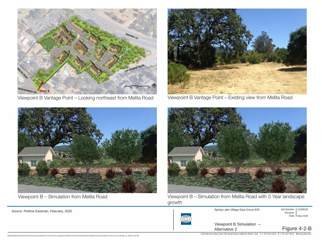
Figure 4-2-B
Spring Lake Village East Grove EIR
2235 Mercury Way Suite 150 Santa Rosa California 95407 USA T 1 707 523 1010 F 1 707 527 8679 W www.ghd.com
Viewpoint B Simulation – Alternative 2
11109018Revision
Job Number
Date May 2020
\\ghdnet\ghd\US\Santa Rosa\Projects\111\11109018 SLV East Grove Expansion EIR\04-Technical Work\Figures\InDesign\Visual Simulations View B_Alt 2.indd May 11, 2020 11:29 AM
Source: Perkins Eastman, February, 2020
Viewpoint B Vantage Point – Looking northeast from Melita Road
Viewpoint B – Simulation from Melita Road
Viewpoint B Vantage Point – Existing view from Melita Road
Viewpoint B – Simulation from Melita Road with 5 Year landscape growth
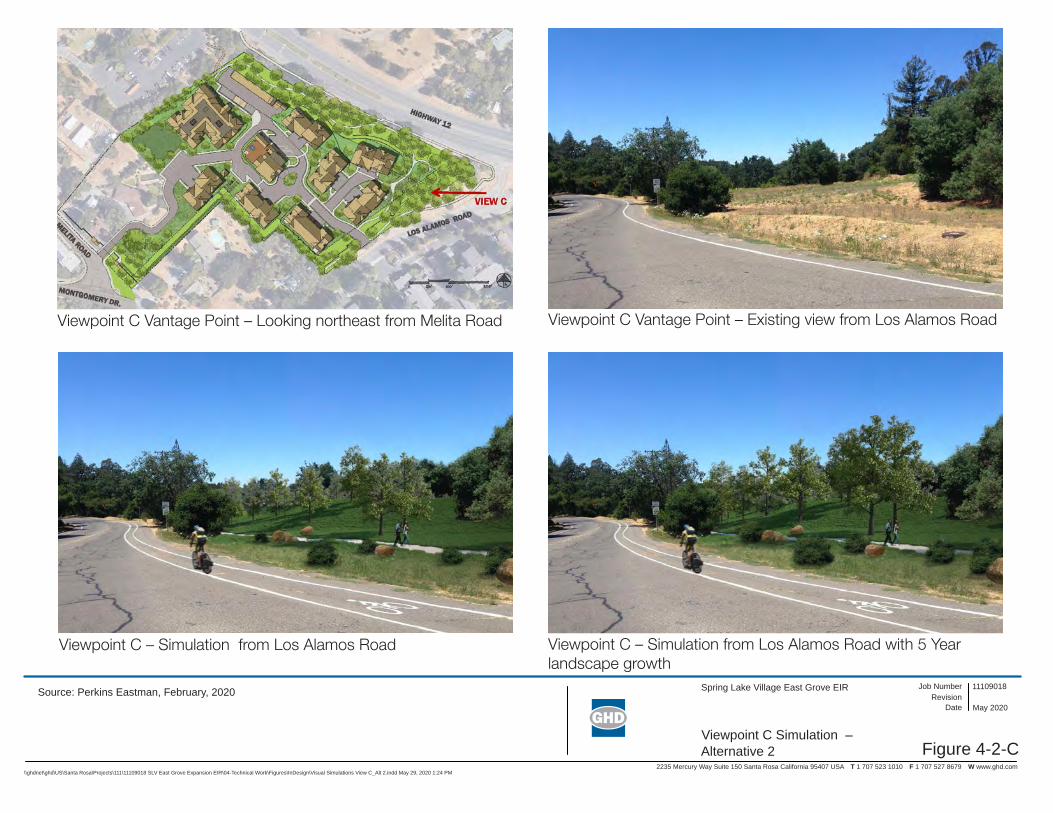
Figure 4-2-C
Spring Lake Village East Grove EIR
2235 Mercury Way Suite 150 Santa Rosa California 95407 USA T 1 707 523 1010 F 1 707 527 8679 W www.ghd.com
Viewpoint C Simulation – Alternative 2
11109018Revision
Job Number
Date May 2020
\\ghdnet\ghd\US\Santa Rosa\Projects\111\11109018 SLV East Grove Expansion EIR\04-Technical Work\Figures\InDesign\Visual Simulations View C_Alt 2.indd May 29, 2020 1:24 PM
Source: Perkins Eastman, February, 2020
Viewpoint C Vantage Point – Looking northeast from Melita Road
Viewpoint C – Simulation from Los Alamos Road
Viewpoint C Vantage Point – Existing view from Los Alamos Road
Viewpoint C – Simulation from Los Alamos Road with 5 Year landscape growth

Figure 4-2-D
Spring Lake Village East Grove EIR
2235 Mercury Way Suite 150 Santa Rosa California 95407 USA T 1 707 523 1010 F 1 707 527 8679 W www.ghd.com
Viewpoint D Simulation – Alternative 2
11109018Revision
Job Number
Date May 2020
\\ghdnet\ghd\US\Santa Rosa\Projects\111\11109018 SLV East Grove Expansion EIR\04-Technical Work\Figures\InDesign\Visual Simulations View D_Alt 2.indd May 29, 2020 1:25 PM
Source: Perkins Eastman, February, 2020
Viewpoint D Vantage Point – Looking north from Los Alamos Road
Viewpoint D – Simulation from Los Alamos Road
Viewpoint D Vantage Point – Existing view from Los Alamos Road
Viewpoint D – Simulation from Los Alamos Road with 5 Year Landscape growth

Other CEQA Required Sections
Spring Lake Village East Grove Project Draft EIR | Page 5-1
Other CEQA Required Sections
5.1 Effects Found Not to Be Significant CEQA Guidelines Section 15128 requires an EIR to briefly describe any possible significant effects that were determined not to be significant and were, therefore, not discussed in detail in the EIR. For the purposes of this Draft EIR, an evaluation of agricultural and forest resources, mineral resources,
and wildfire were eliminated from further evaluation in the scoping phase of the environmental analysis for the reasons presented below.
5.1.1 Agriculture and Forest Resources The Project site does not include any Prime Farmland, Unique Farmland, Farmland of Statewide Importance, or land covered by a Williamson Act contract (CDC 2016, CDC 2013a). In addition, the
Project site is not zoned for agricultural, forest land, or timberland, nor are there any agricultural or forest lands within the site. No impact to agriculture or forestry resources would result.
5.1.2 Mineral Resources Construction of the Project would not result in the loss of a known mineral resource or availability of
a locally-important mineral resource recovery site as delineated on a land use plan, such as a local general plan or a specific plan. Neither the California Department of Conservation Mineral Land Classification studies (CDC 2013b) nor the Sonoma County Aggregate Resource Management
(ARM) Plan (Sonoma County 2010) designate the Project site as having a known mineral resource. No impact to mineral resources would result.
5.1.3 Wildfire The Project site is not located in or contiguous to a State Responsibility Area (SRA) or lands classified as very high fire severity zones (VHFHSZ). The Project site is located approximately 0.2 miles from
the nearest designated SRA in Annadel State Park, and approximately 0.75 miles from the nearest lands classified as a VHFHSZ northeast of Highway 12 (CalFire FHSZ Viewer 2019). Additionally, the Project site is not located with the City’s Wildland-Urban Interface Area Zone. As such, the CEQA
Guidelines Appendix G Checklist section for wildfire is not applicable to the Project. The Project site is located in the vicinity of areas damaged by the Glass Fire, which was an approximately 67,500-acre wildfire that was active for 23 days from September 27, 2020 to October 20, 2020. The wildfire
destroyed 1,555 structures, as well as damaged 282 additional structures, including structures along Los Alamos Road north of Highway 12 and Melita Road. The Project site is located approximately 0.1 mile northwest of properties damaged along Melita Road during the Glass Fire, and between
approximately 0.25 mile and 0.7 mile southwest of properties damaged along Los Alamos Road and adjacent roadways. Impacts related to potential exposure of people or structures to risks involving wildland fires is evaluated in this Draft EIR in Section 3.7 (Hazards and Hazardous Materials).
5.2 Significant Unavoidable Effects Section 15126.2(c) of the CEQA Guidelines requires that an EIR identify any significant
environmental effects that cannot be avoided if the Project were implemented, including those that can be mitigated but not reduced to a level of insignificance. The analysis presented in this EIR concludes that implementation of the proposed Project would result in significant and unavoidable
impacts to cultural resources and tribal cultural resources.
Other CEQA Required Sections
Spring Lake Village East Grove Project Draft EIR | Page 5-2
Under Impact CR-2, which evaluates the potential for the Project to cause a substantial adverse change in the significance of an archaeological resource pursuant to §15064.5, it was determined
that the Project could result in a significant unavoidable impact because Project-related construction may materially impact archaeological resources.
Under Impact CR-3, which evaluates the potential for the Project to disturb human remains, it was
determined that the Project could result in a significant unavoidable impact if human remains are encountered during construction.
Under Impact TCR-1, which evaluates the potential for the Project to cause a substantial adverse
change in the significance of a tribal cultural resource, it was determined that the Project could result in a significant unavoidable impact to a tribal cultural resource if impacted by construction.
Implementation of Mitigation Measure CR-2a would reduce the impact to archaeological resources
and tribal cultural resources by requiring the development and implementation of an Archaeological Resource and Tribal Cultural Resource Treatment Plan and archaeological monitoring in consultation with representatives of the FIGR and Lytton Rancheria Native American Tribes. Implementation of
Mitigation Measures CR-2b and CR-2c would further reduce the potential impact to archaeological resources and tribal cultural resources by requiring further avoidance measures as identified in the confidential Appendix H. Mitigation Measure CR-2d would reduce the potential impact to
archaeological resources and tribal cultural resources by outlining procedures to be taken in the event of inadvertent discovery of such resources during construction. Mitigation Measure CR-3 would minimize the potential impact to inadvertent discovery of human remains and tribal cultural resources
by requiring the contractor to notify the MLD and avoid the area if human remains are encountered, and to follow procedures outlined in Public Resources Code § 5097.9 and Health and Safety Code § 7050.5. However, even with implementation of the mitigation measures, significant Project-related
excavations and ground-disturbance may materially impair the integrity of archaeological and tribal cultural resources. Therefore, the impact on cultural resources and tribal cultural resources would be significant and unavoidable, even with mitigation.
5.3 Significant Irreversible Environmental Changes Section 21100(b)(2)(B) of CEQA requires that an EIR include a discussion of significant irreversible
environmental changes that would result from Project implementation. CEQA Guidelines Section 15126.2(d) describes irreversible environmental changes in the following manner:
“Uses of nonrenewable resources during the initial and continued phases of the project
may be irreversible since a large commitment of such resources makes removal or nonuse thereafter unlikely. Primary impacts and, particularly, secondary impacts (such as highway improvement which provides access to a previously inaccessible area) generally commit
future generations to similar uses. Also, irreversible damage can result from environmental accidents associated with the project. Irretrievable commitments of resources should be evaluated to assure that such current consumption is justified.”
Construction activities associated with the Project would result in an irretrievable and irreversible commitment of non-renewable resources through the use of construction materials. This would include the use of fossil fuels (such as gasoline, diesel and oil) during the construction period, and
the use of earth minerals and ores (such as concrete and steel). The Project would expand the Spring Lake Village CCRC in an area that has already been developed with supporting infrastructure and would not expand off-site roadways; therefore, the Project would not modify regional access or result
in access to a previously inaccessible area. As a proposed CCRC expansion, the Project is not
Other CEQA Required Sections
Spring Lake Village East Grove Project Draft EIR | Page 5-3
representative of a land use type that would result in accidents that could lead to irreversible environmental damage. Overall, given the Project’s low consumption of irretrievable resources, such
commitment is justified.
5.4 Growth-inducing Impacts of the Project CEQA requires that the EIR evaluate the growth-inducing impacts of the Project. CEQA Guidelines Section 15126.2(d) describes growth-inducing impacts in the following manner:
“[T]he ways in which the proposed project could foster economic or population growth, or
the construction of additional housing, either directly or indirectly, in the surrounding environment. Included in this are projects which would remove obstacles to population growth (a major expansion of a waste water treatment plant might, for example, allow for
more construction in service areas). Increases in the population may tax existing community service facilities, requiring construction of new facilities that could cause significant environmental effects. Also discuss the characteristic of some projects which
may encourage and facilitate other activities that could significantly affect the environment, either individually or cumulatively. It must not be assumed that growth in any area is necessarily beneficial, detrimental, or of little significance to the environment.” (CEQA
Guidelines Section 15126.2[e]).
The State CEQA Guidelines do not distinguish between planned and unplanned growth for purposes of considering whether a project would foster additional growth. Therefore, for purposes of this EIR,
to reach the conclusion that the Project is growth-inducing as defined by CEQA, the EIR must find that it would foster (i.e., promote, encourage, or allow) additional growth in economic activity, population, or housing, regardless of whether the growth is already approved by and consistent with
local plans. The conclusion does not determine that induced growth is beneficial or detrimental, consistent with Section 15126.2(d) of the State CEQA Guidelines. If the analysis conducted for the EIR results in a determination that a project is growth-inducing, the next question is whether that
growth may cause adverse effects on the environment. Environmental effects resulting from induced growth (i.e., growth-induced effects) fit the CEQA definition of “indirect” effects in Section 15358(a)(2) of the State CEQA Guidelines.
Growth-inducing impacts can occur when development of a project imposes new burdens on a community by directly inducing population growth, or by leading to the construction of additional development in the project area. Also included in this category are projects that would remove
physical obstacles to population growth, such as the construction of a new roadway into an undeveloped area or a wastewater treatment plant with excess capacity to serve additional new development. Construction of these types of infrastructure projects cannot be considered isolated
from the immediate development that they facilitate and serve. Projects that physically remove obstacles to growth or projects that indirectly induce growth are those that may provide a catalyst for future unrelated development in the area (such as a new residential community that requires
additional commercial uses to support residents). The growth-inducing potential of a project could also be considered significant if it fosters growth in excess of what is assumed in the local master plans and land use plans, or in projections made by regional planning agencies.
The Project would provide 32 independent living units to serve up to 64 residents. Two existing Applicant-owned single-family residences would be removed as part of the Project. The Project is also anticipated to create the equivalent of up to 12 full-time employment opportunities. The vacant
parcel at 225 Los Alamos Road, totaling 5.77 acres, is currently zoned as RR-40. Under the existing

Other CEQA Required Sections
Spring Lake Village East Grove Project Draft EIR | Page 5-4
zoning, the maximum buildout of the vacant parcel could be either one single-family residence with one accessory dwelling unit, or a 12-unit multi-family residential development. While the Project
would create new residential units and employment opportunities beyond that which was analyzed in the 2035 Santa Rosa General Plan EIR, the increase is not expected to result in substantial unplanned population growth. It would provide needed community care housing for senior citizens
and would be an off-site expansion of an existing local facility. It is anticipated that a majority of the new employees would be existing residents of Santa Rosa and surrounding communities. Therefore, the increase in employment opportunities would not result in an increase in population that would
require the construction of additional housing. The Project would be constructed within the City’s Urban Growth Boundary and would not result in the extension of urban infrastructure to an area that is currently not serviced. The additional demand for utilities and public services generated by
operation of the proposed Project would be met with existing facilities. The Project would not extend or expand utility systems, roadways or highways, or otherwise remove an obstacle to population growth or result in the provision of access to a previously inaccessible area. Therefore, the proposed
Project would not result in significant growth-inducing impacts.
5.5 Environmentally Superior Alternative If it is determined that the No Project Alternative would be the environmentally superior alternative, then the EIR shall also identify an environmentally superior alternative among the other Project alternatives (Section 15126.6[e][2]). For reference, significance is determined based on substantial
or potentially substantial adverse changes of any of the physical environmental conditions due to the Project. The degree of change is evaluated against existing environmental conditions. Please refer to Chapter 4, Alternatives Description and Analysis, for a comparison of the primary differences in
environmental impacts among the alternatives and the Project.
Alternative 1, the No Project Alternative, is the Environmentally Superior Alternative, in that it would not have any impacts greater than identified in the Santa Rosa General Plan and General Plan EIR
and would have fewer impacts than the Project or Alternative 2 (Maximum Avoidance Alternative). When the No Project Alternative is selected as the Environmentally Superior Alternative, the CEQA Guidelines require that an environmentally superior alternative be selected from among the other
alternatives. The Maximum Avoidance Alternative and the Project have similar impacts, except as follows:
The Maximum Avoidance Alternative (Alternative 2) would result in less direct disturbance at the Project site and a smaller overall Project footprint. Under Alternative 2, the two existing single-family residential homes at 5803 Melita Road and 5815 Melita Road would not be removed, further reducing the extent of excavation within the Project site. The reduction of development and avoidance of deeper ground-disturbance elements under Alternative 2 would substantially reduce direct disturbance, and with implementation of mitigation measures identified in Section 3.4 and Section 3.13, the impacts to cultural resources (Impact CR-2 and CR-3) and tribal cultural resources (Impact TCR-1) would be reduced to a less-than-significant level.
Therefore Alternative 2 is considered the Environmentally Superior Alternative.
5.6 Energy Resources To guarantee that energy implications are considered in project decisions, Appendix F, Energy Conservation, in the CEQA Guidelines requires that EIRs “include a discussion of the potential energy impacts of proposed projects, with particular emphasis on avoiding or reducing inefficient, wasteful
and unnecessary consumption of energy.” An evaluation of potential impacts related to the energy

Other CEQA Required Sections
Spring Lake Village East Grove Project Draft EIR | Page 5-5
consumption of the Project and the applicability of state or local plans for renewable energy and energy efficiency is discussed in Section 3.6 (Greenhouse Gas and Energy).
5.7 References California Department of Conservation (CDC). 2016. Sonoma County Important Farmland 2016.
California Department of Conservation (CDC). 2013a. Sonoma County William Act FY 2013/2014.
Available online: ftp://ftp.consrv.ca.gov/pub/dlrp/WA/Sonoma_13_14_WA.pdf
California Department of Conservation (CDC). 2013b. Mines and Mineral Resources Interactive Web Maps. Available online: https://maps.conservation.ca.gov/mineralresources/#webmaps
County of Sonoma. 2010. Aggregate Resource Management Plan.
California Department of Forestry and Fire Protection (CalFire). 2019. CalFire FHSZ Viewer. Available online: https://www.fire.ca.gov/fire_prevention/fire_prevention_wildland_zones

List of Preparers
Spring Lake Village East Grove Project Draft EIR | Page 6-1
List of Preparers
6.1 City of Santa Rosa (Lead Agency) Amy Nicholson, Senior Planner
Kristinae Toomians, Senior Planner
Clare Hartman, Deputy Director – Planning
Ashle Crocker, City Attorney
6.2 GHD Inc. Brian Bacciarini, Senior Environmental Scientist
Kristine Gaspar, Senior Environmental Planner
Patricia Collins, Senior Environmental Planner
Chryss Meier, Senior Environmental Planner
Haley Cahill, Environmental Planner
Kerry McNamee, Environmental Planner
Elissa Overton, Project Coordinator
Renee Remillard, Graphic Designer
6.3 Technical Consultants Illingworth & Rodkin, Air Quality and Noise
Lucy Macmillan, Biological Resources
Tom Origer & Associates, Cultural Resources and Tribal Cultural Resources
EBA Engineering, Groundwater
W-Trans, Transportation