st anns trench location - surrey archaeological society
TRANSCRIPT

Registered Charity No: 272098 ISSN 0585-9980
SURREY ARCHAEOLOGICAL SOCIETYCASTLE ARCH, GUILDFORD GU1 3SXTel/ Fax: 01483 532454E-mail: [email protected]: www.surreyarchaeology.org.uk
Bulletin 415 June 2009
ST ANNS’ HEATH SCHOOL:Abby Guinness and the children from the school
85412_SAS/Bulletin/Issue415 1/6/09 09:13 Page 1

AN EXCAVATION AT ST ANNS’ HEATH SCHOOL, VIRGINIA WATERRebecca Lambert
In 2006 planning consent was granted to Charles Church Homes to construct a newschool playing field on a parcel of grazing land to the east of St Ann’s Heath School,Virginia Water (TQ 0032 6777), as well as a new housing development on part of theoriginal playing field to the west. As part of the planning consent, an archaeologicalinvestigation of the site was requested, prior to any redevelopment taking place. Theneed to maintain a green space for the use of the school meant that no groundworkscould take place on the site of the new residential area until the construction of thenew playing field was complete. The site was therefore investigated in two separatephases (fig 1), and this report provides an overview of the fieldwork carried out inPhase 1, ahead of the construction of the new playing field. In August 2006 an archaeological evaluation was undertaken by Surrey CountyArchaeological Unit staff, who supervised the machine excavation of ten trenchesacross the proposed development area. The site was located on the Bagshot Bedssand, but gravel deposits of the Taplow Terrace were also noted during the fieldwork.The site had a variable topography, with fairly level ground at the northern end of thesite, but with sloping ground to the south that continued beyond the site boundarydown to the Bourne. This north/south slope was not as steep, however, on itseast/west axis, creating the impression of a shallow dell across the southern part ofthe site. Very little archaeological material had been found previously in the general area, butthe location of the site close to the River Bourne gave it additional potential,particularly with regard to the prehistoric periods. The evaluation trenches revealed avariety of features, primarily ditches, crossing the site, some of which appeared to be
2
Middle Bronze Age
Late Bronze Age/Early Iron Age
Mid–Late Iron Age
Medieval
Post Medieval
Modern
TT4
seg117
seg266
seg147
seg142
231
210
219
239
234
218
seg268
216 206
seg269
273
seg 275
274
232 233
209
237232
244
293250
232
261252
252257
260
254
255
253
252
seg308
288
292291
290
289285 slot
280 294 320 slot309
285
284
303
285
299
305
304
283
281270
271
263262267272278 262
270
282
242
241 248241
298
297 241
314
slot264
312
310241
251
259
312seg 321
314
296seg 322
cut 302
223221
220
225
slot230
228
222
276314
312
slot277
208
207206
226
235236
213217
214
211
212
227
224
215
307
306
249
208
240
208
TT3
285
295
seg 287
258
273seg313
256
210
270
254
246
seg279
115 seg114
207
113
314
seg129
seg131
130
seg112
111
seg286
324
245
seg247
243
116
146
141
160not
excavated
seg316
seg315
284 seg317
seg300
319
311
105
seg106
TT6
TT5
0 10metres
85412_SAS/Bulletin/Issue415 1/6/09 09:13 Page 2
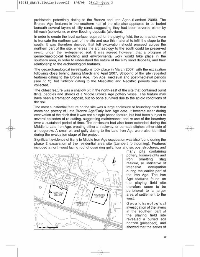
prehistoric, potentially dating to the Bronze and Iron Ages (Lambert 2006). TheBronze Age features in the southern half of the site also appeared to be buriedbeneath several layers of silty sand, suggesting they had been covered either byhillwash (colluvium), or river flooding deposits (alluvium). In order to create the level surface required for the playing field, the contractors wereto truncate the northern part of the site and use this material to infill the slope to thesouth. It was therefore decided that full excavation should proceed across thenorthern part of the site, whereas the archaeology to the south could be preservedin-situ under the re-deposited soil. It was agreed however, that a program ofgeoarchaeological trenching and environmental work would take place in thesouthern area, in order to understand the nature of the silty sand deposits, and theirrelationship to the archaeological features.
The geoarchaeological investigations took place in March 2007, with the excavationfollowing close behind during March and April 2007. Stripping of the site revealedfeatures dating to the Bronze Age, Iron Age, medieval and post-medieval periods(see fig 2), but flintwork dating to the Mesolithic and Neolithic periods was alsocollected.
The oldest feature was a shallow pit in the north-east of the site that contained burntflints, pebbles and sherds of a Middle Bronze Age pottery vessel. The feature mayhave been a cremation deposit, but no bone survived due to the acidic conditions ofthe soil. The most substantial feature on the site was a large enclosure or boundary ditch thatcontained pottery of Late Bronze Age/Early Iron Age date. It became clear duringexcavation of the ditch that it was not a single phase feature, but had been subject toseveral episodes of re-cutting, suggesting maintenance and re-use of the boundaryover a sustained period of time. The enclosure had also been extended during theMiddle to Late Iron Age, creating either a trackway, or perhaps ditches either side ofa hedgerow. A small pit and gully dating to the Late Iron Age were also identifiedduring the evaluation stage of the project. Significant evidence of Early to Middle Iron Age occupation was also found during thephase 2 excavation of the residential area site (Lambert forthcoming). Featuresincluded a north-west facing roundhouse ring gully, four and six post structures, and
many pits containingpottery, loomweights andiron smelting slagresidue, all indicative ofintensive occupationduring the earlier part ofthe Iron Age. The IronAge features found onthe playing field sitetherefore seem to beperipheral to a largerarea of settlement to thewest. G e o a r c h a e o l o g i c a linvestigation of the layersin the southern part ofthe playing field siterevealed a buried soilhorizon (palaeosol), andshowed that the series of
3
N
0 100m
NEW PLAYINGFIELD SITE
RESIDENTIALAREA SITE
ST ANN’S HEATHSCHOOL
85412_SAS/Bulletin/Issue415 1/6/09 09:13 Page 3

layers identified during the evaluation, were waterlain deposits that had formedduring the Late Bronze Age/Early Iron Age within a shallow dell (Green, in Lambert2008). The deposits were colluvial, and had been created by soil from a destabilisedlandscape upslope of the dell, being washed downhill and then settling at the base ofthe slope. The presence of the large Late Bronze Age/Early Iron Age boundary ditchat the north end of the site shows considerable anthropogenic activity in the areaduring this period, and prehistoric farming or clearance activities probably caused thedestabilisation of the landscape. The discovery of these layers is therefore of someimportance, as they suggest land clearance and, by implication, farming activities,first occurring in the later prehistoric period.Two stretches of ditch were identified as belonging to the late medieval period, andthey may have originally formed a single field boundary running roughly north-southacross the centre of the site. A series of ditches dating to the 17th or 18th centurywere also discovered, cutting through all the earlier features, and lying on a differentalignment to both the medieval and prehistoric boundaries. The ditches were spacedroughly 20m apart and seem to form a field system, but as they were not shown onthe 1840 Tithe, or later Ordnance Survey maps, it is assumed they became obsoleteby the mid 19th century. Residual Roman pottery was also recovered from one of thepost medieval ditches, suggesting a presence during this period even though noRoman features were identified.The location of the excavation in the grounds of St Ann’s Heath School gave a superbopportunity to incorporate an outreach project for the school, and SCAU educationofficer Abby Guinness arranged an assembly and a series of site visits for 240children over the course of two days in March 2007. The children had the chance tohandle artefacts from the site and SCAU’s education handling collection, and learnabout the work of archaeologists. Many aspects of what the children saw during thesite visits were incorporated into their academic project work for the rest of the term.Parents from the local community were also invited to an evening tour of the site, andlearnt much about the archaeology and local history of their area.The archaeological discoveries made at St Ann’s Heath School are of greatimportance on both a local and regional level, and the information gathered gainsincreased significance when put into context with the discoveries made at theadjacent residential area site. The excavation also provided an excellent opportunityfor community involvement and education, often seen as being difficult to incorporateinto commercial projects, and it is envisaged that further outreach work will take placein the form of formal evening lectures for interested groups. An assessment report forthe excavation has been completed and it is hoped that the site will be brought to fullpublication later in 2009.
AcknowledgementsThe fieldwork was commissioned and funded by Charles Church Homes Southern,and SCAU would like to thank them for their support of the project so far. Thanks alsoto the site contractors, Kestral, for their friendly approach to our presence on site. Thefieldwork was directed by myself (Rebecca Lambert), and project managed by RobPoulton and Nowal Shaikhley, and we wish to thank the following staff for theircontributions to the project; Abby Guinness for her guidance on educational mattersand for giving on-site tours for the school; Tom Munnery, Simon Hind, Lietta Marzialiand Ian Groves for their hard work on site and during post excavation work; NickMarples for his work on site and producing the flint report, and MOLAS excavationstaff Nigel Wilson and Tim B, for adapting so quickly to working outside their usualremit. The pottery and other finds were analysed by Phil Jones, and Giles Pattisonproduced the plans and illustrations. Recognition also goes to staff at ArchaeoScape(now QUEST), in particular Rob Batchelor for co-ordinating the geoarchaeological
4
85412_SAS/Bulletin/Issue415 1/6/09 09:13 Page 4

fieldwork, and to Mercedes Planas of Souterrain survey specialists, for completingthe GPS survey and plans. Thanks also to Joy Whitfield of the Egham Museum, forher documentary and photographic research relating to the early 20th century use ofthe site.Finally, a big thank you must of course extend to the staff and children ofSt Ann’s Heath School, in particular the Headteacher Mr Graham Bollands, forshowing such interest and enthusiasm for the whole process and the archaeologydiscovered.
References(Available in the SyAS library at Castle Arch, and the HER at Surrey History Centre, Woking)
Lambert, R, 2006 An archaeological evaluation at St Ann’s Heath School, Virginia Water,Surrey. Client report prepared by Surrey County Archaeological Unit
Lambert, R, 2008 An assessment of the results of an archaeological excavation on the site ofthe new playing field at St Ann’s Heath School, Virginia Water, Surrey. Client report preparedby Surrey County Archaeological Unit (November 2008). [available June 2009]
Lambert, R, forthcoming An assessment of the results of an archaeological excavation, on thesite of the new residential development at St Ann’s Heath School, Sandhills Lane, VirginiaWater, Surrey
A FUNERARY LANDSCAPE ON MERROW DOWNS?Helen Chapman Davies
The concept of Merrow Downs as a significant funerary landscape, extending over avery lengthy timespan from the prehistoric into the Saxon period, appears plausiblefrom the information available.A Bronze Age barrow was excavated on Merrow Downs by Pitt Rivers (then A LaneFox) in 1877, which he briefly recorded. A few lines by Lasham noted that the barrow‘contained a British urn’. The location seems to have been to the south-east ofLevylsdene and nearby the Hare Warren (both outlined on Figure 1) in Walnut TreeBottom. It may have been a short distance down the slope from what is now the 2ndgreen on Merrow Golf Course, the surmised location indicated by an ‘X’ on Figure 1.It was reported by Gardner that in 1901 a skull, and nearby an iron spearhead, bothplaced in the Society’s collection, were found by Mr Walter Blake of the Hare Warren.The spearhead was judged to be ‘Roman’ while the skull was that of a ‘British’ maleand ‘evidently belonged to a member of one of the tribes contemporary with theRoman occupation’. A rather nasty injury had been sustained, as ‘Transverselyacross the vertex of the skull is a sword-cut 2 1/4 inches long, which passes rightthrough the bone’ although ‘ … on further investigation it was seen that the woundwas quite old’. The unfortunate man ‘… survived his injury, certainly for many years,and probably suffered little if any inconvenience from it …’. The remaining skeletalevidence that would have been associated with the skull, and any further gravegoods, were evidently not recognised or recovered. It would be informative to re-examine the spearhead today, to determine its age more accurately.Also in 1901, a brief article by Elsley reports that Mr Blake found another spearhead‘which appears to be of the early Iron Age, to judge from its sharp ridge; butunfortunately the socket is missing. … The spear is 123/4 inches long’. The find wasmade ‘near a field called Copthorne, where two old track-ways meet’, where Mr Blakealso found the ‘British’ skull and ‘Roman’ spearhead. From the Tithe Map andSchedule for Merrow of 1841 it was ascertained that entry 39 was given as CroptThorn Row, a one-acre narrow belt of woodland abutted by two arable fields to itsnorth, Merrow Downs to its south and south-west, and close to the parish boundarywith West Clandon to the east. The name Cropt Thorn Row and its position on the
5
85412_SAS/Bulletin/Issue415 1/6/09 09:13 Page 5

map suggest this was the remains of an older boundary hedgerow (at TQ041 501).It is surmised that the finds were made either in one of the fields or on the Downs;old trackways and paths abound in the area. The wood and adjacent fields were inthe ownership of the Trustees of Guildford Hospital (Abbot’s Hospital), purchased in1622 to provide an income for the Hospital.
Mr A H Bowles, Lord Onslow’s land agent, was of the opinion that the finds were notnear enough to point to any connection between the two weapons. But this does begthe question: Was this area in fact an Iron Age burial ground? Unfortunately thearticle does not indicate the circumstances in which the finds were made, whetherany digging works were taking place or in what manner the ground had beendisturbed sufficiently to reveal the skull and spearheads. The recovery of an Iron Agespearhead could suggest an associated but undiscovered burial. Again, thespearhead, also placed in the Society’s collection, would benefit from furtherexamination today to determine its age more precisely. One is led to ask otherquestions: Was Mr Blake an ‘antiquarian digger’ who made a hobby of roaming theDowns undertaking small excavations? What had he seen to attract him to search forand find these artefacts? Is there more beneath the soil?
A Romano-British ‘urn field’ (outlined on Figure 1) was briefly reported by Lasham inthe Collections Vol 13. By the merest chance, Lasham was informed in 1896 by MrA H Bowles, land agent to Lord Onslow, owner of Merrow Downs, of the discovery offragments of urns. For a month or more, ‘trenching and digging operations had been
6
OS map of 1920 showing suggested site of Bronze Age barrow, Hare Warren, UrnField, Levylsdene and The Fairway, Merrow.
85412_SAS/Bulletin/Issue415 1/6/09 09:13 Page 6

carried on in a field situated to the leftof the road towards St Martha’s Lodge(known today as One Tree Hill Road)and contiguous to Merrow Downs’.Unfortunately the reasons for the‘trenching and digging’ operations arenot given. The field was arable andperhaps drainage pipes were beinginstalled to improve conditions. Duringthese groundworks, ‘many urns hadbeen destroyed as of no value’.However, Lasham did manage tosalvage two urns ‘in a fairly perfectcondition’ which he sketched (Figure 2)noting that ‘in shape and form theyappear to be Romano-British … of fine
proportions; they both have cross-markings for ornamentation slightly traced on thesides. The urns contained remains of cremated interments’. From the widedistribution of the large number of urns calculated to have been destroyed, andfragments recovered, ‘some twelve distinct varieties’ of urns were identified, and anextensive burial site suggested.Lasham also recorded that ‘during the course of trenching, a floor of puddled clay, alarge quantity of burnt flints and charcoal, and a number of broken urns or vesselswere found together. … From rims set up from these fragments, one vessel wouldcertainly measure 34in across the mouth and would be quite 14in in depth. Some ofthese fragments are of course gritty clay, but they all appear to be lathe turned …’.Lasham noted that ‘The soil is sandy loam 420 O D; the gound faces the west; thesetting sun would be in full view from this chosen position’. This ‘chosen position’ isnow beneath playing fields in the use of Guildford County School. Lasham’s notes doraise some questions: How large an area did the burial site in fact cover? Was thefloor of puddled clay, the burnt flints and charcoal, evidence of a habitation site of aperiod prior to, contemporary with, or later than, the Romano-British burials? Of whatperiod were the associated broken urns or vessels?Documentation compiled by Pitt Rivers and deposited in Salisbury Museum wasstudied by Saunders, who published a paper in 1980 discussing six Saxon barrowsexcavated by Pitt Rivers in October 1876 on Merrow Downs. Four of these barrowswere recorded as being ‘in a cluster on the top of the hill just south of Level’s Dean’(Levylsdene) with the other two barrows nearby. Fragments of burnt bone were foundin Barrows 1-3, but nothing was identified in Barrows 4-6. An iron knife wasexcavated from Barrow 3, described as ‘6 inches long … and 3⁄4 in greatest breadth’which was deposited in the Pitt Rivers Museum, Oxford. Saunders was informed that‘The groove along the back edge is a feature not found before the 7th century and …that whilst this feature is typical of knives from 7th century cemeteries it also lastsuntil the 9th century, possibly later’. Saunders also notes that in 1957 a Saxonspearhead and the remains of a male skeleton were found at the rear of a house inLevylsdene (the estate now a development of modern housing). Unfortunately areport on these finds has proved elusive. Were these Saxons still holding on to theirpagan beliefs and burying grave goods, or doubtful Christians still using pagan burialpractices?The skeleton of a child tentatively suggested to be Saxon was discovered inSeptember 1973 in the garden of a house in The Fairway, a development adjacentto Levylsdene, which was reported by Bird. The skeleton was found during ground-work for a house extension, but in the absence of the owners was unfortunately
7
Two cinerary urns recovered from the siteof ‘Urn Field’ in 1896 (from Lasham,Frank. An “Urn Field” at Merrow, Guild-ford. SyAs Collections 13, p26).
85412_SAS/Bulletin/Issue415 1/6/09 09:13 Page 7
disturbed and then dug out by the builders carrying out the work. This actionprevented systematic investigation of the burial. It was however possible to examinethe grave in which the child had been buried and to establish the rough position ofthe body within it before the foundation trenches were filled with concrete. The gravehad been cut into natural chalk to a depth of about 50 cm, and cannot have beenmore than about 1.20 metres in length. A report on the bones identified the body as‘probably of a male of between 6 and 8 years, approximately 124 cm in height’. It wastentatively suggested to be ‘cetainly old enough to be Saxon’. No dating evidencewas recovered and it was not possible to suggest a date for the burial ‘except thatany period earlier than medieval would seem to be reasonable’. The grave burialwould suggest a Christian form of burial.The report concludes that ‘There is at present no other evidence to suggest that therewas a Saxon burial ground in the area and it is likely that the Fairway child is merelyan isolated grave’. Nevertheless, the site of The Fairway (shown on Figure 1) andLevylsdene estate were once part of the landscape of Merrow Downs, and given thecircumstances of The Fairway discovery, it is possible that any further burials havenot been recognised or have been ignored during construction works. Thus theimplication for these burials within an existing funerary landscape must beconsidered. To add to the suggested ‘sacred’ funerary landscape of Merrow Down,we find the adjacent Harrowhill Copse, (‘harrow’ from OE hearg), to the east of theDowns, possible ‘and near or containing a pagan sacred grove’, surely not acoincidence.Of considerable significance is the probability that the construction of Guildford GolfClub’s Merrow Downs Course will have obliterated archaeological evidence for burialsites. The initial 6-hole course was extended eastwards in 1888 to create an 18-holecourse, and the present 18-hole course was constructed in 1901, extending evenfurther eastwards. Nevertheless, what is known is already suggestive of continuity inthe use of Merrow Downs as a funerary landscape. The evidence for passage andoccupation by these people (and other possible ‘ritual’ sites) is suggested fromthe nearby areas of Tyting and St Martha’s Hill. In addition, the identificationof new Roman sites on the flank of the North Downs was reported in Bulletin411. Of particular interest are two sites in Clandon Park at West Clandon andone site on Merrow Golf Course, which are believed to represent domesticoccupation sites. Do the sites in Clandon Park have any link with finds made by MrWalter Blake?
AcknowledgementsWith grateful thanks to: Margaret Dierden for many long exchanges of ideas andunfailing encouragement; the staff of Surrey Archaeological Society at Castle Arch;the staff of the Surrey History Centre.
ReferencesBird, DG Merrow: Skeleton of a Child (TQ 02955023). Surrey Archaeological Society
Collections Vol 71, 1977. Extracted from Bulletin 103, Jan 1974, p 184.Elsley, FH Spear and lance heads, and a quern, now in Guildford Museum. Surrey
Archaeological Society Collections Vol 25, p 140.Field, John English Field Names. A Dictionary. 1872. David & Charles, p 98.Gardner, Eric On a skull found on Merrow Down. Surrey Archaeological Society Collections Vol
25, pp 139-140.Jones, Phil Eight new Roman sites on the flank of the North Downs. Surrey Archaeological
Society Bulletin, 411, November 2008, pp 3-4.Lasham, Frank Surrey Archaeological Society Collections Vol 13, pp 25-27.Surrey History Centre. References 864/1/91, 864/1/92.Taylor, Brian Abbot’s Hospital Guildford. 1999. St Thomas’s Trust, Guildford.
8
85412_SAS/Bulletin/Issue415 1/6/09 09:13 Page 8

GUILDFORD PARK: A TOPOGRAPHICAL-CUM-TOPONYMICALAPPROACH Rob BriggsThe recent debate on Guildford Park and its obliquely recorded Domesday-erapredecessor associated with the royal manor of Stoke has understandably dwelt inno small measure upon the post-Conquest documentary evidence, whose obviousrelevance to the park in the 12th and 13th centuries unfortunately does not equate toit constituting unequivocal testimony of the park’s origins and early nature, as can beseen by comparing Dennis Turner’s initial article and Derek Renn’s response. Sincethere is next to no chance of a hitherto-unknown written record being discovered thatmight resolve the question of the location and extent of the 11th century park, otherlines of enquiry must be opened up. Naturally I can hardly claim what follows is anymore insightful or conclusive than the contributions of the aforementioned, but byconsidering the place-names and land divisions which characterise the locallandscape new contributions can be made to what will hopefully be an ongoingdebate on the park and its place in local (and indeed county) history.Both Turner and Renn find common ground in preferring Stoke to have been theprimary royal centre in the vicinity, although they differ in some of the details. Thisviewpoint arguably relies too heavily on the testimony of Domesday Book at theexpense of other evidence, particularly since Guildford is named roughly twocenturies earlier than Stoke, when it appears as a ham - usually taken to signify anestate – in the will of King Alfred (Sawyer 1507). The excellent reappraisal of thisdocument by Patrick Wormald published in 2001 has opened up the possibility thatmany of the places bequeathed in the will were probably bookland properties, estatesrecently acquired by the crown and consequently able to be passed on to Alfred’sdiverse heirs far more easily than supposedly immutable demesne holdings(Kingston, notable for its absence from the will, was almost certainly an example ofthe latter). The subsequent documented history of many of these would imply theproperties in the will were often important places, at least some of which would havebeen at the centres of extensive landholdings.
9
The Guildford Parks.
85412_SAS/Bulletin/Issue415 1/6/09 09:13 Page 9
Mary Alexander’s interpretation of the geography of the Guildford area at the time ofits appearance in King Alfred’s will (published in Alexander 2004, 6) sufferssomewhat for its elaborateness, since it requires the town-name at the time of thewill’s compilation to have identified no more than the ford across the Wey, and theadjacent estate centre on the higher ground a little to the east to have been knownas Stoke. The latter half of this hypothesis is based upon the outmoded view given inThe Place-Names of Surrey (Gover et al 1934, 151) that Stoke remembers a lostfortified place (its derivation from Old English stoc is not in doubt), an etymologywhich Mary herself no longer accepts (pers comm). By contrast, the premise that theestate centre of Gyldeforda was within the envelope of the historic town is far moresolid. Several authors have drawn attention to the distinctive nature of the propertyboundaries of the area around St Mary’s church when compared to the rest of themedieval town centre, interpreting this as denoting the pre-burghal origin ofoccupation here. Some, but not all, have gone so far as to conjecture that this mighthave been the heart of the royal ham mentioned in King Alfred’s will (O’ Connell &Poulton 1984, 44 and Robertson 2003, 4 & 8 do so), an attractive idea, but one thatfor now awaits archaeological confirmation.
It may nevertheless be possible to combine the hints of a potentially Middle Saxonsettlement discernible in the urban topography of the St Mary’s vicinity with theappearance of Guildford in King Alfred’s will in a way not previously considered. JohnBlair has suggested many of the hamas named in the will may have actually beenminsters annexed by the West Saxon royal house (Blair 2005, 324-27), althoughGuildford does not feature as either an Anglo-Saxon minster or ‘sub-minster’ (animprovised term that does not feature in his more recent published work) in EarlyMedieval Surrey. This may be because one of the primary concerns of his appraisalof the county’s early ecclesiastical geography was to find evidence for the pastoralinfluence of the minster communities, relatively straightforward for the majorfoundations (Chertsey, Farnham and to a lesser extent Woking) but far harder toachieve for the more numerous minor minsters. By contrast he devoted comparablylittle space to considering the possible status of the founders of many of the latter,probably locally-important aristocrats who would arguably have cared more aboutecclesiastical patronage enhancing their own prestige than ensuring the neatpastoral division of the region. This is not the place to undertake a reassessment ofthe evidence for Surrey minsters, although one is long overdue (a simple comparisonof the map in Blair 1991, 93, with the equivalent for Kent in Everitt 1986, 188, servesto show more must have existed, however inconsequential mid-Saxon Surrey mayhave been), but for now it may be tentatively proposed that the tangible origins of thesettlement at Guildford could have been ecclesiastical, not secular.
What was very likely the royal settlement in the late 9th century was clearly retainedso as to form a distinctive part of the new burh probably established in the reign ofAthelstan (925-39 – Hill 2000), perhaps functioning as a “Kingsbury” akin to thosefound in a number of other Late Saxon southern towns (St Albans, Aylesbury, Wilton– Slater 1998; Blair 2005, 326; Dodgson 1996, 103). However, by the time of theDomesday Survey it had apparently been superseded by a new estate centre atStoke. Its place-name reveals it to have originally been a secondary place (OE stocis most commonly translated as “outlying/dependent settlement”), and logicallyGuildford must have been the centre it was then subordinate to. An attendant shift inecclesiastical primacy may be visible in the Domesday record of a church with half ahide of land within the Stoke estate, although – architecturally at least – the medievalparish church exhibits no trace of unusually lavish fabric that is time and again thehallmark of churches with origins as minsters (in contrast to St Mary’s Guildford).Wherever the Domesday church may have been, the settlement at Stoke itself (andit need not then have been in the vicinity of the later medieval parish church) was
10
85412_SAS/Bulletin/Issue415 1/6/09 09:13 Page 10

more than likely deliberately raised up from humble origins, not simply to serve as aroyal estate centre, but more importantly as a royal hunting lodge too.This still does not resolve the thorniest issue of all - the location of the Domesday-eraroyal park. There is a temptation to place much of the estate within it, yet it shouldnot be forgotten how Domesday Book has Stoke as the site of land for 16 ploughs,implying a significant proportion of the estate must have been given over to arableproduction. Such land use – a taxable activity to the Domesday commissioners –would have conflicted with the practice of hunting (however occasional the latteractivity may have been), and may explain why Domesday fails to place this within theking’s park, unlike the woodland in which the swine grazed. The king’s park fails tobe mentioned in any of the Domesday entries for the vills contiguous to Stoke(Worplesdon, Burpham and West Clandon in Woking Hundred; maybe Compton,Loseley and Littleton to its south in Godalming – the extra-urban territorial extent ofGuildford at the time is an unknown quantity in this equation), despite the first threeof the above-mentioned all having had woodlands, which leads one to the conclusionthat it was confined to the Stoke estate.There is no way of telling whether the Domesday estate extended west of the Wey,as the medieval parish did, but it may be this western portion of the latter that holdsthe key to understanding the place of the royal park within the former. When viewedon a map – such as the one which accompanies this article – Stoke’s northern andwestern parochial boundary was on the whole remarkably regular, almost parabolicin shape, and paying no heed to either the underlying geology or natural boundaryfeatures. Could it have defined the edge of the king’s park as it existed at the time ofthe Domesday Survey? Della Hooke, in an excellent article on pre-Conquestwoodlands, discusses the Old English term haga which occurs not infrequently inAnglo-Saxon charter-bounds, concluding it represented ‘a particularly strong type ofenclosure hedge around a wooded area’ (Hooke 1989, 123). She maps a number ofAnglo-Saxon hagae in north-west Hampshire, all coinciding with parish boundaries inan area that included the forests of Finkley and Dygherlye (later reckoned as part ofthe royal Forest of Chute: Hooke 1989, 127-28). Some of these survive as substantialearthworks consisting of both banks and ditches. I do not know the extent to whichthese might resemble the former Stoke parish boundary, whose line is still readilytraceable at the margins of suburban north Guildford, meaning it would be a relativelystraightforward exercise to compare any stretches of it which have survived majorphysical degradation or obliteration with known hagae from elsewhere.One might suppose the Domesday-era park associated with Stoke was establishedin the later Anglo-Saxon period, enclosing part of a much larger area onceappurtenant to Guildford, the land beyond thereafter being reconstituted into theDomesday manors of Worplesdon and Burpham (both had been held from KingEdward before the Conquest). At the heart of the area encompassed by this putativeearly park boundary is Stoughton, whose name almost certainly derives fromOld/Middle English stoc-tun (here perhaps meaning something along the lines of“farm/hamlet subordinate to Stoke” – compare with the instances of the compoundburh-tun given in Draper 2008, 249), making it an unusual “tertiary” place-name – thatis to say one which identifies a settlement secondary to one whose own appellationimplies one-time subordinate status. It is unlikely Stoughton could have come intobeing prior to the creation of a new Guildford Park, whether before or after Henry II’scoronation in late 1154. The new park probably took in an extensive area to the southof the Woking-Godalming Hundred boundary, which its predecessor may haveabutted but did not cross (if the Domesday evidence is to be believed). Should theboundary of the twelfth-century park have indeed been coterminous with thatrecorded in the early-seventeenth century, it would have overlain a small portion ofits putative precursor in a manner not altogether at odds with Turner’s cautious
11
85412_SAS/Bulletin/Issue415 1/6/09 09:13 Page 11
postulation of their inter-relationship. The remainder may have been disemparked,thereby occasioning the opportunity for the development of Stoughton. Ultimately,however, this paragraph and those which precede it are based largely uponfragmentary evidence whose insuperable limitations shall doubtless ensure differentinterpretations will continue to be proffered in the years to come.
ReferencesAlexander, M, 2006, “With ramparts crown’d”: The early history of Guildford Castle, Guildford
MuseumBlair, J, 1991, Early Medieval Surrey, Alan SuttonBlair, J, 2005, The Church in Anglo-Saxon Society, Oxford University PressDodgson, J McN, 1996, ‘A linguistic analysis of the place-names in the Burghal Hidage’, in D H
Hill & A R Rumble, eds., The Defence of Wessex: the Burghal Hidage and Anglo-Saxonfortifications, Manchester University Press, 98-121
Draper, S, 2008, ‘The Significance of Old English Burh in Anglo-Saxon England’, Anglo-SaxonStudies in Archaeology and History, 15 , 240-53
Everitt, A, 1986, Continuity and colonisation: the evolution of Kentish settlement, LeicesterUniversity Press
Gover, J E B, A Mawer and F M Stenton, 1934, The Place-Names of Surrey, English Place-Name Society, 11,Cambridge University Press
Hill, D, 2000, ‘Athelstan’s Urban Reforms’, Anglo-Saxon Studies in Archaeology and History, 11,173-85
Hooke, D, 1989, ‘Pre-Conquest Woodland: its Distribution and Usage’, Agricultural HistoryReview, 37.2, 113-29
O’ Connell, M & R Poulton, 1984, ‘The Towns of Surrey’, in J Haslam, ed., Anglo-Saxon Townsin Southern England, Phillimore, 37-52
Robertson, J, 2004, Extensive Urban Survey of Surrey: Guildford, Surrey County ArchaeologyUnit
Sawyer, P, 1968, Anglo-Saxon charters: an annotated list and bibliography, Royal HistoricalSociety [updated online version at http://www.esawyer.org.uk/]
Slater, T R, 1998, ‘Benedictine Town Planning in Medieval England: Evidence from St Albans’,in T R Slater & G Rosser, eds., The Church in the Medieval Town, Ashgate, 155-76
Wormald, P, 2001, ‘On pa wæpnedhealfe: Kingship and royal property from Æthelwald toEdward the Elder’, in N J Higham & D H Hill, eds., Edward the Elder 899-924, Routledge,264-79
COUNCIL NEWS
NEWS FROM THE TOOLS Geoff StonehouseA newly up-dated inventory is now available from myself, Pauline Hulse and CastleArch. Tools are ready for the new digging season.We have added two marquees; one 3m square and one 4m square. Each hascolour-coded poles and illustrated erecting instructions (resulting from trial erections)and should be followed to avoid putting them up in the wrong order.Our theodolite and new (last year) dumpy level have been re-calibrated.Happy and fruitful digging and do return the tools in the clean condition in which theyare issued.
LOCAL SOCIETIESA note to Programme Organisers Maureen RobertsTalks arranged by local societies often have a wider than local interest and for thisreason we aim to bring them to the attention of our members by publishing details atthe end of each issue of the Bulletin. We hope, incidentally, that this may help withfunding through the modest admission charges made to non-members and perhapsto even increase membership.
12
85412_SAS/Bulletin/Issue415 1/6/09 09:13 Page 12
All works well when Programme Organisers provide details of meetings in good time.This does not always happen. A lot of my time is spent searching for information fromnewsletters and websites – a rather hit or miss affair as newsletters appearinfrequently and do not always list meetings while web sites are often sadly out ofdate.Now that the Bulletin appears only six times each year, it is even more important tohave early notification. A list of copy and publication dates for the forthcoming yearalways appears in the final issue of each year, but in case they are no longer to handthe dates for the rest of 2009 are:
416 copy date 17th July publication 8th August417 copy date 11th September publication 10th October418 copy date 6th November publication 5th December
Some programme organisers helpfully provide dates for the entire year, but wherethis is not possible, a note, telephone call or email to me at Castle Arch, Tel: 01483532454 or email: [email protected] before each copy date will be fine.Your help would be to our mutual advantage and much appreciated by me.
LIBRARY ACCESSMembers wishing to access the Society’s library prior to the Museum’s opening timenow need to use the main Museum door on Quarry Street. Please ring the bell on theintercom and await instructions. Once in you now need to sign in the book to the leftof the door to conform to fire regulations.Thank you.
ROMAN STUDIES GROUP
CONFERENCE 2010The 2010 Conference of the Roman Studies Group will be held on Saturday May 8thin Chertsey. The theme will be ‘Agriculture and Food in Southern Roman Britain’. Theaim of the conference is to bring together recent and current research and views onthe characteristics of agriculture and diets in the Southern part of the Province, aswell as the changes which were wrought in the landscape and lifestyles. Specialistspeakers will contribute on topics including Rural Settlement in South EasternEngland, The Environment, Field Systems and Farming Technology, Crops,Livestock and Diets.We are planning a major conference on subjects which rarely receive a regionalbroad coverage. Further details will be available later this year including a full list ofspeakers and booking details. Meanwhile please make a note of the date.
MEDIEVAL STUDIES FORUM
SAXON SURREYThe Forum held a very successful meeting devoted to the Saxon period in Surrey on28th March at St Mary’s in Guildford. This featured presentations from David Bird andour guest speaker Martin Welch on the transitions that took place in the South Eastfrom about 250 AD through to 700 AD; coming from, as it were, the opposite ends ofthe continuum and using very different types of evidence, these contributions fromthe two specialists proved most thought provoking. After lunch we had detailed andmost interesting presentations from our members Patrick Molineux (on Saxon estatesas delineated in Domesday) and Rob Briggs (on aspects of place names). Mary
13
85412_SAS/Bulletin/Issue415 1/6/09 09:13 Page 13

Alexander was unfortunately unable to give her presentation on Saxon Guildford, buta summary of her material was given by Richard Savage. The meeting thenadjourned to Castle Arch where Nick Booth deputised for Mary in arranging a mostappreciated viewing of some of the Saxon reserve collection held at the Museum.
WOKING PALACEWe are very pleased to report that the joint Woking Palace Archaeological Project2009 has now been awarded a total of £20,000 in grants (£9,000 from Surrey CountyCouncil, £6,000 from the Society and £5,000 from Woking Borough Council) and with‘in kind’ support from Archaeology South-East (of University College London) andQUEST (of the University of Reading) is able to carry out the programme of surveysand excavations submitted to English Heritage for approval earlier this year. See theseparate note in this Bulletin regarding opportunities for Society members toparticipate in the excavations.
VILLAGES STUDIESThe next meeting of the Forum will take place on 14th November 2009 at Bansteadand will feature presentations on a further selection of Surrey’s towns and largersettlements, including Croydon, Kingston, Lingfield and Haslemere. Please note yourdiaries now.For further details of any of these items please contact Richard and Pamela Savageat 01483 768875 or [email protected]
SURREY ARCHAEOLOGICAL RESEARCH FRAMEWORK
RELIGION IN SOCIETY AND THE LANDSCAPE2009 CONFERENCESaturday 10th OctoberThe Dixon Hall, Leatherhead Institute, LeatherheadThis is the third conference on the Research Framework, with speakers well qualifiedin their subjects, including Judith Roebuck of English Heritage who will give thekeynote presentation, brought together through the good offices of the MedievalStudies Group, particular emphasis is placed on the role of monastic foundations inthe rural economy and their effects on the landscape. It seems that not evendomestic architecture escaped the influence of religion. There will also be aninformed look at votive deposits in rivers and elsewhere. David Bird will be speakingon how Celtic forms of worship continued in the landscape and settlements. This isan aspect of the Framework that we haven’t reviewed before and we expect thisconference to stimulate as much new thinking as the previous two have. Full detailsand a booking form are included with this bulletin and will also feature on the website.
Draft Programme9.45am Registration10 Barney Sloane, Head of Historic Environment Commissions, English
Heritage (Conference Chairman) Opening remarks10.05 Liquid Assets? Watery deposition in Surrey and beyond. Jon Cotton,
Senior Curator (Prehistory), Museum of London10.35 Roman-period Religion in Society and the Landscape in Surrey David
Bird, Chairman of the Roman Studies Group 11.05 Coffee break11.35 Monastic Houses in the South East Keynote presentation – Judith
Roebuck, English Heritage
14
85412_SAS/Bulletin/Issue415 1/6/09 09:13 Page 14

Panel Discussion12.30 Lunch
Introduction to afternoon Barney Sloane The Granges and Smaller Properties of Waverley Abbey Mark Service,Birkbeck MA Archaeology GraduateThe Smaller Religious Houses: Reigate and Tandridge PrioriesDennis Turner, Past President of the Society
2.45 Tea break3 Monastic Mills Alan Crocker, Surrey Industrial History Group
The influence of Winchester Diocesan carpenters on Surrey’sdomestic buildings Rod Wild, Co-ordinator Surrey DendrochronologyProject, DBRG
4 Panel Discussion & Closing Remarks 4.30 Disperse
RESEARCH COMMITTEE
In October 2008 the Council of Surrey Archaeological Society resolved:“That the Archaeological Research, Grants and Community ArchaeologyCommittees be dissolved and a Research Committee be formed consisting of aChairman appointed by Council, a Treasurer and Secretary appointed by theCommittee and one representative from each group and committee active inresearch together with up to three co-opted members and as many invited non-votingmembers of other organisations as seems appropriate.”The Committee is to be responsible for:
● The Surrey Research Framework● Organising the Annual Research Symposium● Research projects run by the Society● Supporting external projects● Administration of grants for these purposes
This Committee has now been formed and met for the first time in March 2009. ItsOfficers are:Chairman – Dr D Bird (Roman Studies Group)Treasurer – Mr C HaywardSecretary – Mrs R Hooker (Prehistoric Group)Committee members – David Graham (SAS President, ex officio)
David Calow (SAS Hon Secretary, ex officio)Richard Savage (Medieval Forum & Village Studies)Bob Bryson (Surrey Industrial History Group)Margaret Broomfield (Artefacts & Archives Research Group)Peter Harp (Plateau Group)Janet Balchin (Surrey Local History Committee)Andrew Norris (Historic Buildings Committee)
Members representing Groups or Committees have been asked to send substitutesif they are unable to attend. It is anticipated that further members will be co-opted indue course, and that others will be invited to attend specific meetings.The aims of the Committee are to foster and support the research process to ensurethat research is one of the main activities of the Society. Consideration is being givento the provision of skills training and the fostering of co-operation betweencommittees in order to maximise the considerable achievements of the variousgroups of the Society. The Committee intends to use its ability to offer grants to
15
85412_SAS/Bulletin/Issue415 1/6/09 09:13 Page 15

support this process. A note about applications for grants will appear in a forthcomingBulletin, but if a delay might cause difficulties please contact the Secretary of theCommittee via Castle Arch.
Rose Hooker, Secretary, Research Committee
MISCELLANY
ANSTIEBURY HILLFORT Mike RubraGraham Hayman’s very interesting report on the excavations at Anstiebury Camp,Coldharbour in 1989 and 1991 (Surrey Archaeological Collections 94 pp 191-207)refers to recommendations made then, saying that “ … it was agreed that much ofthe interior of the hillfort would be laid down to pasture …”. It further indicates thatthis was implemented (p 206).However, as many of us interested in hillforts are only too aware, the interior ofAnstiebury Camp, one of our Surrey Scheduled Ancient Monuments, has twentyyears later, as can easily be seen, reverted to woodland and is now comprehensivelycovered with young trees, mostly quick growing birch with estimated girths (at 1.5m)of 25cm and upwards.So, sadly, despite the sensible recommendations made earlier and the manysubsequent efforts made by English Heritage, lack of ongoing maintenance hasallowed trees to recolonise the interior of the hillfort and their root systems to invadeany archaeology that might be remaining, and which, as the intended pasture, couldhave remained available for research.
ST MARY’S AUGUSTINIAN PRIORY, MERTON On Sunday 1st May 2005, at the eighth Nones to be held in the remains of theChapter House, a group from Huntington presented the organisers with a plaquecommemorating the coming of the canons of St Mary’s Huntington to Merton Priory.Gilbert the Norman was born in Normandy and was known for his generosity to thepoor. He was Queen Matilda’s godson1 and became the longest serving sheriff forSurrey, Cambridge and Huntington. He personally oversaw the building of MertonPriory and is credited with founding at least three parish churches, Kingston, MertonPark and Bedford. For the record of Gilbert’s life we are indebted to an article writtenby Master Gervase, who wrote quoting an eyewitness.Each church history mentions Gilbert the Norman as their founder, but none give theirsources. However, it is possible to find references to each church in The Records ofMerton Priory, published 18982. The history of St Peter de Merton, Bedford states“… a few words about the dedication of the church. The ‘de Merton’ which follows thename of the apostle St Peter has traditionally been traced to Merton Priory in Surrey.The Canons who founded the Priory in the eleventh century held the advowson ofthis church, and were patrons, until the dissolution of the monasteries …”.The history of All Saints, Kingston states “In about 1120-30, Gilbert the Norman,Sheriff of Surrey, built a large church in Kingston. This was shaped in the form of across, with its tower at the centre. The nave was as long as the present one but wasprobably without aisles. East of the tower was the chancel and to the north and southof it were two transepts of a depth equal to the present aisles. … Little or nothing nowremains of Gilbert the Norman’s church. Some of the stones in the pillars under thetower may be Norman, and there are some Norman stones (shaped with an axe)where the end nave pillar on the south joins the west wall; these are thought to haveformed part of the wall of the old Norman nave. When the Victorians were buildingthe present west porch, they uncovered a large Norman doorway cased up in an 18th
16
85412_SAS/Bulletin/Issue415 1/6/09 09:13 Page 16

century classical entrance; they photographed it and then unfortunately destroyedit.”2,4.Gilbert died 29th July 11253 by which time there were 36 brothers living at MertonPriory. By 1125 Thomas a Becket had trained there. Guy de Merton (founder ofTaunton Priory) had taught there and the charter of 1121 had been signed by twoarchbishops, fourteen bishops, two abbots and five earls.
Friends of Merton Priory
1 Queen Matilda was the first wife of Henry I. His second wife, Adeliza of Louvain, was the firstto sign the charter in 1121
2 The Records of Merton Priory by Major Alfred Heales3 MS Lix in Corpus Christi College, Cambridge and Arundel MS 284 SyAS Collections Vol. VIII p.13 “Gilbert Norman, the munificent founder of Merton Priory, is
stated by Dugdale (footnote: Dugdale, Monasticon, vi p 247) (adopting Leland as hisauthority) to have given to that house as an endowment the living of Kingston”
LEITH HILL AND HLITH Gavin SmithI have often wondered why Surrey’s Leith Hill, the highest point in south-eastEngland, should carry such an unprepossessing name as Old English (OE) hlith,apparently meaning ‘slope’1. Gelling and Cole’s2 nonetheless fascinating account ofthis place-name element draws attention to its notable appearance in Beowulf, wherethere seem to be undertones of ‘menace’; amongst other references is ‘steapstanhlitho’ (‘steep stony-hlith’). After describing relevant instances on the ground, theauthors propose a meaning for hlith of ‘concave hillside’.However, there is a possibility that hlith might be a standard English word, or variantof same. Clark Hall3 notes that hlith occurs ‘only or mainly in poetical texts’ but whileit is thought to mean ‘precipice, hill-side’, etc., it can also be a side-form of hlid ,modern English ‘lid’, carrying, according to Clark Hall, analogous meanings of‘covering, opening, vault’, etc. That hlith / hlid might be a unity is encouraged byEkwall’s4 observation that hlith has a side-form hlid; Lydd in Kent appearing forexample to be hlid. So, using Occam’s Razor (ie. using the fewest possibleassumptions to explain a thing), might hlith be hlid and mean ‘lid’? This is not as daftas it sounds.Leith Hill is (or was) famous for The Landslip on its steep southern face, and ThePlace-Names of Surrey thinks that the hill’s name refers to this southern slope. So itis interesting that the other instances of hlith in Surrey (Lythe Hill by Haselmere, andBowlhead Green not far away) occupy equivalent geological locations, where shelvesof hard Lower Greensand overlie unreliable Atherfield Clay and landslips are ahazard. Indeed the whole flank of Leith Hill is shown on the O.S. Geological Survey1:50,000 map as covered by periglacial landslips. If hlith / hlid means ‘lid, covering’,this could indeed be an analogy for ‘landslip’: a treacherous, unstable lid to theUnderworld. Geomorphologically, landslips create residual concave upper slopes. A modified but parallel explanation might be applied to Lydd upon the once shiftinggravel spits of Dungeness, and to Lytham St Anne’s among the sand-dunes ofLancashire’s Fylde coast.5 In each case a sense ‘lid, covering (material)’ isappropriate. Thus the ‘steep stony-hlith ’ of Beowulf would mean a scree, or perhapstumbled cliff-face. The Place-Names of Surrey, while recording only the three ‘major’hlith names, notes that hlith is ‘fairly common’ in ‘field and minor’ names6: fromwhich I suggest that landslips may have been commoner in the days when Surrey’sheaths were over-grazed and bare, in contrast to today when Leith Hill’s landslip isobscured and stabilized by the growth of secondary woodland consequent upon theending of common-land grazing. Conceivably, a particular form of hlid (ie. hlith)
17
85412_SAS/Bulletin/Issue415 1/6/09 09:13 Page 17
continued to be used in dialect in landscape contexts. Note that hlid is cognate withmodern ‘lean’ (and ‘ladder’), the basic sense being ‘something that leans over orcovers’. Thus the clue to an apparently place-names-specific element like hlith may lie in astandard OE cognate, in this instance hlid. In an analogous example I haveproposed7 a revised meaning for hyrst as ‘coppice’ (rather than ‘wooded hill’), in thisinstance adapting Ekwall’s view8 that it is cognate with Welsh prys and Old Germanhurst (both ‘brushwood’), but more particularly perhaps with standard OE hris, ‘twig,branch’ and ‘covered with brushwood?’9. A parallel accepted example might be gaersin the common Surrey field-name gaerstun , ‘paddock, grassy enclosure’10 in that ifgaers were not known to be a side-form of standard OE graes, ‘grass’11, then theinterpretation OE of gaerstun would be far more difficult.
1 Gover, J.E.B., Mawer, A. & Stenton, F.M., 1934, The Place-Names of Surrey, CUP2 Gelling, M., & Cole, A., 2000, The Landscape of Place-Names, Shaun Tyas; pages 182-5 3 Clark Hall, J.R., 1960, A Concise Anglo-Saxon Dictionary, 4th edn., Toronto UP4 Ekwall, E., 1960, The Concise Oxford Dictionary of English Place-Names, 4th edn., OUP;
pp. 243-45 Ekwall, pp. 308 and 3106 Gover et al, pp. 345 and 3617 Smith, G., 2005, Old English leah and the Surrey rough commons, SAS Bulletin 385, pp.
7-108 Ekwall, p. 2609 Clark Hall, p. 194. My implied parallel is with the cognate pair Old English hors / Old High
German hros, both ‘horse’ (The Concise Oxford Dictionary, 5th edn., OUP, 1974, p. 587);for the switch –y- / -i- note the cognate pair hys / his (‘his’) (Clark Hall, p. 202)
10 Gover et al, p. 36011 Clark Hall, pp. 146 and 159
PUBLICATIONS
“Ravensbury” Merton Histories No. 10 by E.N. Montague. ISBN 978 1 903899 564. Published by Merton Historical Society.Ravensbury is considered to be that part of Lower Mitcham lying on the north bankof the River Wandle between Mitcham Bridge and Morden Hall Park. In the MiddleAges two large houses occupied choice sites by the waterside. After the arrival of theCarews to the area a succession of houses were built at Ravensbury, enablingpeople to live in London and also to escape to the countryside at weekends. Themanor of Ravensbury was transferred by its estate to Nicholas Throgmorton, whotook the name of Carew. The manor was to remain in the hands of the Carews forseveral centuries until sold by Frank Carew to the Prince’s Golf Club, but with thenewly created Board of Governors of Mitcham Common buying it in 1926.Vestry minutes show that in about 1753 John Arbuthnott, described as a mostextensive manufactory at Ravensbury, was now living in a house of the same name.Two years later Sir Nicholas Carew granted property in Mitcham and Morden to JohnArbuthnott for 99 years. He was involved in calico printing and was also interested infarming and in 1760 was noticed as a farmer by others in the trade. Throughout thereign of George IV Ravensbury House continued to attract the attention oftopographical writers and artists. Ravensbury House was kept for a few years but in1827 the land was leased to Henry Hoare.For possibly 300 years Ravensbury was one of three centres of the textile bleachingand printing industries on the banks of the River Wandle. There can be little doubtthat Peter Mauvillain’s works were on the river Wandle near Ravensbury House. The
18
85412_SAS/Bulletin/Issue415 1/6/09 09:13 Page 18
embellishment of textiles with colours capable of withstanding washing was achievedby the use of mordants. The 1780 Mitcham land tax records list Thomas Hatcher asa member of the calico print works. Later, after Thomas Hatcher died, we find theworks in the hands of William Fenning. With the appearance of Edward Walmesleyin 1827 we enter a new and what seems to be the last period of the factory’s history.Edward died in about 1840 and the business really died with him.
EXCAVATIONS
WOKING PALACE 2009Surrey Archaeological SocietyWednesday 22nd July to Sunday 9th AugustThe manor of Woking has a long history, being held by the Crown from at least thetime of Edward the Confessor through to 1189. By 1327 the manor house wasalready surrounded by a double moat which enclosed eight acres of buildings,fishponds and gardens. Lady Margaret Beaufort started major building works on thesite which led to the creation of the Palace of Woking, with further majorimprovements by Henry VII, Henry VIII and Elizabeth I. The Palace was demolishedin about 1625 and remained as farmland until the site was bought by WokingBorough Council in 1988. Members of the Society are invited to apply for places on this summer’s excavations,the days of which are expected to be as follows:Wednesday 22nd July to Sunday 26th JulyWednesday 29th July to Sunday 2nd AugustTuesday 4th August to Friday 7th AugustThere will also be a Public Open Day on Sunday 9th August (see website for furtherdetails closer to the time).Members who have at least five days excavation experience will join teams under thesupervision of Rob Poulton of the Surrey County Archaeological Unit, while thosewith less or no practical experience will have the opportunity to ‘dig for a day’ in theCommunity Archaeology trench, supervised by Abby Guinness. Places are limitedand those interested should apply as soon as possible. All places are free tomembers of the Society.Further details can be obtained from Richard Savage [email protected] or by phoning 01483 768875
SYON HOUSE TRAINING EXCAVATIONUniversity of London Birkbeck Faculty of Lifelong LearningJune-July 2009There will be five Monday-Friday courses at the lost Abbey of Syon, Middlesex, theonly Bridgettine monastery in England. As such, the site is of unique archaeologicaland historical interest.The five-day courses provide practical training in archaeological excavation andrecording techniques, initial finds processing and other aspects of archaeologicalinvestigation. Training is by on-site professional archaeologists and will be geared toall levels of experience, including absolute beginners.Courses commence on 8th June, 15th June, 22nd June, 29th June and 6th July andrun from 9.30am-5pm. Attendance may be counted towards the excavation
19
85412_SAS/Bulletin/Issue415 1/6/09 09:13 Page 19

requirements for Certificates and Diplomas. Cost £200 per week.To enrol call 020 7631 6651 Further information on Birkbeck Archaeology Courses obtainable from The ExecutiveOfficer, Brett O’Shaughnessy, Archaeology Desk, Birkbeck Faculty of LifelongLearning, 26 Russell Square, Bloomsbury, London WC1B 5DQ; tel. 0207631 6627; Email : [email protected] ; www.bbk.ac.uk/ce/archaeology
ASHTEAD ROMAN VILLA AND TILEWORKS26th August to 13th September 2009The Roman Studies Group is undertaking a fourth season of excavation on AshteadCommon. Working days are grouped as three sets of 5 days from Wednesday toSunday each week.Dates are Wednesday to Sunday 26th to 30th August, 2nd to 6th September and 9thto 13th September with the possibility of needing 14/15th September for tidying upetc. Last year’s work brought evidence for several periods of activity on the villa site itself.Survey work during the Spring should provide information for further investigationover the larger tileworks complex. Our enthusiasm has to be moderated by the statusof the site as a Scheduled Monument, an area of Special Scientific Interest and aNational Nature Reserve but with the considerable assistance of the City of Londonwho own the site there are far more possibilities than we are allowed volunteers.As time and numbers are limited priority will be given to those able to sign up for oneor more complete 5 day weeks. No charge will be made for Roman Study Groupmembers. Members of the Surrey Archaeological Society who are not members ofthe Roman Studies Group are asked to pay £5 covering all three weeks. Othervolunteers are asked to pay £25 for each five-day week that they attend. Anyone interested in taking part who has not already been in touch please contactStella Fagg on [email protected] or 07850 285245
ROMAN BATHS AT BAX FARM, TEYNHAMKent Archaeological Field SchoolAugust 31st-18th SeptemberThe first evaluation trench in 2007 exposed a cornucopia of archaeological featureswhich included the concrete base of a large corn mill, a sunken road or ‘hollow-way’,Anglo-Saxon buildings and the remains of a massive stone-built Roman bath house.The masonry structure, c10m across, enclosed a central rectangular frigidarium poolover 5m across. Work in 2009 will focus on uncovering the full extent of this uniquebath house and associated buildings. KAFS members fee £20 per day; non-members £30 per day.
Archaeological Training Week7th-11th SeptemberBeginners are welcome on this Monday to Friday training course, with the option tocontinue for further days (same daily fee applies). Topics taught each day are:Monday: History of the site and why dig?Tuesday: Excavation techniquesWednesday: Site surveyThursday: Archaeological recording
20
85412_SAS/Bulletin/Issue415 1/6/09 09:13 Page 20

Friday: Small finds recordingFurther details for the above may be obtained from Kent Archaeological Field School,School Farm Oast, Graveney Road, Faversham, Kent ME13 8UP; tel. 01795 532548;e-mail [email protected] Further details on the website at www.kafs.co.uk
COURSES
NONSUCH GOLDSTUDY DAY Bourne Hall Museum, EwellSaturday 18th July & Site Tours Sunday 19th July 2009‘Nonesuch … which no equal hath in art or fame …’Five hundred years since Henry VIII became King, and fifty since Nonsuch Palacewas uncovered, this special study day explores the wealth and power of Tudorpalaces. The programme features Martin Biddle, excavator of Nonsuch, and willinclude a showing of recently re-discovered film footage of the 1959 dig.
Programme10.30am Royal Splendour at the Court of Henry VIII: Furnishing the Royal
Palaces Maria Hayward (University of Southampton)11.10 ‘No lesse delectable’ – Oatlands Palace and the Emergence of
the Tudor Country House Rob Poulton (Surrey County ArchaeologicalUnit)
11.50 Richmond: ‘The mirror and pattern of all palaces of delight’ BobCowie (Museum of London Archaeology)
12.30pm ‘Every nook and corner of the palace’: Tudor Archaeology atHampton Court, 1885-2009 Kent Rawlinson (Historic Royal Palaces)
1.10 lunch2 Diana, deer and daffodils: the landscape history of Nonsuch Park
Jeremy Harte (Bourne Hall Museum)2.40 Nonsuch Mansion Gerald Smith (Friends of Nonsuch)3.20pm tea3.50pm The excavation of Nonsuch Palace 1959 A film by Geoffrey Walker
(Epsom Cine & Video Society)4.20pm Reconstructing Nonsuch Martin Biddle (Hertford College, Oxford)5pm close Tickets: £15 for the study day only; £20 for the whole weekend including site visits. Available from the Friends of Bourne Hall Museum, Spring Street, Ewell, SurreyKT17 1UF. Contact the Museum on 020 8394 1734; email [email protected]
CENTRE FOR CONTINUING EDUCATIONUniversity of SussexSummer Archaeology CoursesOur summer courses are suitable either for beginners or for those with someexperience, ie those considering archaeology at university (minimum age 16),amateur archaeologists, undergraduates, and those undertaking university extra-mural courses in archaeology. Most of the courses are based at Barcombe, nearLewes, where research excavations have been taking place each summer since
21
85412_SAS/Bulletin/Issue415 1/6/09 09:13 Page 21

2001 (our 2009 Open Afternoon of the Roman bathhouse excavations in ChurchField will be on Sunday 26th July, 1-5pm). Other venues include Fishbourne RomanPalace, near Chichester, and Michelham Priory, near Hailsham.
Courses at Barcombe:An Introduction to Field Archaeology. Code: X9003. 4 Saturdays starting 13 June.
12 Level 1 credits. £160 full fee (£64 concessionary rate). Tutor: Chris Butler.Excavation Training Courses. Codes: X9164-7. Monday-Friday (ie 5 days). 4
separate courses. Starting: 13 July; 20 July; 27 July; 3 August . 18 L1 credits. £200(£140 conc.) Tutors: David Rudling et al.
Geoarchaeology in Action. Weekend of 25-26 July. 6 L1 credits. £80 (£56 conc.)Tutor: Michael Allen.
Site Photography for Archaeologists. Code: X9405. Weekend of 1-2 August. 6 L1credits. £80 (£56 conc.). Tutor: Lisa Fisher.
Planning and Section Drawing. Code: X9223. Weekend of 8-9 August. 6 L1 credits.£80 (£56 conc.). Tutor: Jane Russell.
Course at Michelham Priory:Ancient Crafts and Technologies. Code: X9006. Monday-Friday 13-17 July. 18 L1
credits. £200 (£140 conc.). Tutors: Tristan Bareham et al.
Course at Fishbourne Roman Palace:Conserving Archaeological Finds. Code: X9268. Wednesday-Thursday 29-30
July. 6 L1 credits. £55 (£32 conc.) Tutor: Eveline Van Breeman.
For further information or to enrol, please contact:Centre for Continuing Education, Essex House, University of Sussex, Falmer,Brighton, BN1 9QQ. Tel: 01273 678527 and email: [email protected]/cce/archaeology
KENT ARCHAEOLOGICAL FIELD SCHOOLLandscape Archaeology July 11th/12th and 18th/19thA course in two parts spread over two weekends. The first will be devoted to the sixmain categories of information: field archaeology, aerial photography, maps, localhistory and place-names. The second weekend will trace, section by excavation andrecord a new significant bank and ditch boundary.
An Introduction to Anglo-Saxon Pottery September 12th/ 13thThis course will introduce students to the practical problems of identifying Anglo-Saxon pottery.
An Introduction to Roman Pottery October 3rd/4thThe course will introduce students to the practical problems of identifying Romanpottery.
Archaeological drawing October 8th/ 9thA beginner’s and refresher course introducing participants to drawing archaeologicalartefacts, including practical sessions demonstrating how to illustrate pottery, bone,metal and other artefacts found on archaeological sites.Cost for each weekend course: KAFS members £60; non-members £70.Further information on all the above courses can be obtained from KentArchaeological Field School – contact details as above.
22
85412_SAS/Bulletin/Issue415 1/6/09 09:13 Page 22

LECTURE MEETINGS
9th June“Ranmore and Denbies” Walk and talk to Westcott Local History Group. Meet atRanmore Church at 7.30 pm for an evening visit to see and hear about Ranmore andDenbies mansion.17th June“Mountains, Mules and Malaria – Soldiering with the British Salonika Force 1915-1918” by Alan Wakefield to the Surrey Branch, Western Front Association at The DayCentre, Lushington Road, Cobham (behind Waitrose) at 7.45 p.m. Visitors verywelcome £3.24th June“East Surrey Underground” by Peter Burgess to the Croydon Natural History &Scientific Society in the Small Hall of the United Reformed Church hall, AddiscombeGrove, East Croydon at 7.45pm. 25th June“Arthur and the Parrot (an eccentric and long-forgotten vicar of Addlestone)” by Jimand June Knight to Egham-by-Runnymede Historical Society in the Main Hall,Literary Institute, High Street, Egham at 8pm. Visitors welcome £2.29th JuneAGM followed by “Historic Clapham” by Michael Green to Wandsworth HistoricalSociety at the Friends’ Meeting House, Wandsworth High Street (oppositeWandsworth Town Hall) at 8 pm.7th July“Surrey on Film” by Di Stiff to the Dorking Local History Group at the Friends’ MeetingHouse, Butter Hill, Dorking at 7.30pm. Visitors £1.14th JulyAGM followed by A Bastille Day Special talk by Jacqueline Bannerjee to the WestcottLocal History Group in the Reading Room, Institution Road, Westcott at 7.45 pm.15th July“Snipers – The Patient Killers” by Julian Whippy to the Surrey Branch of the WesternFront Association at The Day Centre, Lushington Drive, Cobham (behind Waitrose)at 7.45 p.m. Visitors very welcome £3.17th JulyAnnual Garden Party of Guildford Archaeology and Local History Group at 7 pm.Venue to be announced.30th July“Hardwick Court Farm and its surroundings” by Carl Boyde to Egham-by-RunnymedeHistorical Society in the Main Hall, Literary Institute, High Street, Egham at 8pm.Visitors welcome £2.
© Surrey Archaeological Society 2009 The Council of the Surrey Archaeological Society desires it to be known that it is not responsiblefor the statements or opinions expressed in the Bulletin.
Next Issue: Copy required by 10th July for the August issue.Editor: Phil Jones, 5, Hampton Road, Newbury, Berks RG14 6DB. Tel: 01635 581182 andemail: [email protected]
23
85412_SAS/Bulletin/Issue415 1/6/09 09:13 Page 23

The children of St Anns’Heath School and (right)
a Middle Bronze Agecremation Urn.
85412_SAS/Bulletin/Issue415 1/6/09 09:13 Page 24