stakeholder communication and engagement plan...stakeholder communication and engagement plan...
TRANSCRIPT

Stakeholder Communication
and Engagement Plan Wheeler Ridge-Maricopa
Management Area of the Kern County
Subbasin
FINAL
August 8 2018 EKI B60038.00
Prepared by

Stakeholder Communication and Engagement Plan Wheeler Ridge-Maricopa Management Area
1
TABLE OF CONTENTS
1. Introduction ........................................................................................................................................4
2. Objectives and Decision-Making .........................................................................................................6
2.1. GSA and Management Area Description and Boundary .............................................................6
2.2. WRMWSD Structure and Decision-Making Process ....................................................................6
2.3. Desired Outcome .........................................................................................................................7
2.4. Communication Objectives to Support the GSP Chapter ............................................................8
2.5. Challenges for the Plan Area .......................................................................................................8
3. Stakeholder Identification ...................................................................................................................9
3.1. Holders of overlying groundwater rights .....................................................................................9
3.2. Municipal Well Operators ............................................................................................................9
3.3. Public Water Systems ..................................................................................................................9
3.4. Local Land Use Planning Agencies ...............................................................................................9
3.5. Environmental Users of Groundwater .......................................................................................10
3.6. Surface Water Users ..................................................................................................................10
3.7. The Federal Government ...........................................................................................................10
3.8. California Native American Tribes .............................................................................................10
3.9. Disadvantaged Communities .....................................................................................................10
3.10. Groundwater Monitoring Entities ..........................................................................................11
4. Stakeholder Survey and Mapping .....................................................................................................12
5. Messages ...........................................................................................................................................13
6. Venues for Engaging..........................................................................................................................14
6.1. District Board Meetings .............................................................................................................14
6.2. Stakeholder Workshops .............................................................................................................14
6.3. Website Communication ...........................................................................................................14
6.4. Stakeholder Surveys ..................................................................................................................15
7. Implementation Timeline ..................................................................................................................16
8. Evaluation and Assessment...............................................................................................................17
References and Technical Studies ................................................................................................................18
APPENDIX A – Stakeholder Survey ...............................................................................................................19

Stakeholder Communication and Engagement Plan Wheeler Ridge-Maricopa Management Area
2
List of Tables Table 1 Stakeholder Constituency – “Lay of the Land” Exercise Table 2 Likely Questions and Responses Table 3 GSP and C&E Efforts by Phase List of Figures Figure 1 WRMWSD Management Area and KGA GSA List of Appendix Appendix A Stakeholder Survey

Stakeholder Communication and Engagement Plan Wheeler Ridge-Maricopa Management Area
3
Glossary / Abbreviations ACSD Arvin Community Services District AEWSD Arvin-Edison Water Storage District CASGEM California Statewide Groundwater Elevation Monitoring CC Coordination Committee CCR California Code of Regulations CWC California Water Code CWD Cawelo Water District C&E Communications and Engagement DAC Disadvantaged Communities DWR California Department of Water Resources GSA Groundwater Sustainability Agency GSP Groundwater Sustainability Plan HCM Hydrogeologic Conceptual Model JPA Joint Powers Agreement KCWA Kern County Water Agency KGA Kern Groundwater Authority KTWD Kern-Tulare Water District KWBA Kern Water Bank Authority NKWSD North Kern Water Storage District RRBWSD Rosedale-Rio Bravo Water Storage District SCEP Stakeholder Communication and Engagement Plan SGMA Sustainable Groundwater Management Act SSJMUD Southern San Joaquin Municipal Utility District SWID Shafter-Wasco Irrigation District SWSD Semitropic Water Storage District TCWD Tejon-Castac Water District WDWA Westside District Water Authority WKWD West Kern Water District WRMWSD Wheeler Ridge-Maricopa Water Storage District
Stakeholder Communication and Engagement Plan Wheeler Ridge-Maricopa Management Area
4
1. INTRODUCTION
The Wheeler Ridge-Maricopa Water Storage District (WRMWSD or District) has developed this Stakeholder Communication and Engagement Plan (SCEP) to describe its approach to communication and engagement throughout the Groundwater Sustainability Plan (GSP) Chapter development process. This SCEP was prepared in accordance with California Water Code (CWC), the GSP Regulations (Title 23 of the California Code of Regulations [CCR] §354.10 [see above]), and the California Department of Water Resources (DWR) Guidance Document for Groundwater Sustainability Plan Stakeholder Communication and Engagement (DWR, 2018), as well as additional reference documents recommended by DWR for guidance. Communication and engagement efforts carried out as described in this SCEP will help to ensure that local beneficial uses and users of groundwater are adequately considered in the GSP Chapter development process as required by GSP Regulations (23-CCR §354.10). Specifically, in this SCEP:
• Section 2 describes the District and Groundwater Sustainability Agency (GSA) decision-making process (23-CCR §354.10(d)(1));
• Section 3 identifies stakeholders;
• Section 4 describes how the District intends to build upon its current understanding of stakeholders in the Management Area (23-CCR §354.10(d)(3) and CWC §10723.4);
• Section 5 describes the key messages for communication and engagement efforts, and anticipated questions as well as possible responses (23-CCR §354.10(d)(4));
• Section 6 identifies opportunities for public engagement and how public input an response will be used (23-CCR §354.10(d)(2));
§ 354.10. Each Plan shall include a summary of information relating to notification and communication by the Agency with other agencies and interested parties including the following: (a) A description of the beneficial uses and users of groundwater in the basin, including the
land uses and property interests potentially affected by the use of groundwater in the basin, the types of parties representing those interests, and the nature of consultation with those parties.
(b) A list of public meetings at which the Plan was discussed or considered by the Agency. (c) Comments regarding the Plan received by the Agency and a summary of any responses by
the Agency. (d) A communication section of the Plan that includes the following:
(1) An explanation of the Agency’s decision-making process. (2) Identification of opportunities for public engagement and a discussion of how public
input and response will be used. (3) A description of how the Agency encourages the active involvement of diverse social,
cultural, and economic elements of the population within the basin. (4) The method the Agency shall follow to inform the public about progress implementing
the Plan, including the status of projects and actions.
Stakeholder Communication and Engagement Plan Wheeler Ridge-Maricopa Management Area
5
• Section 7 describes the Communications and Engagement (C&E) implementation timeline, including when this SCEP will be updated to inform the public about GSP Chapter implementation progress, including the status of projects and actions (23 CCR §354.10(d)(4));
• Section 8 describes SCEP assessment and evaluation during the GSP Chapter development process.

Stakeholder Communication and Engagement Plan Wheeler Ridge-Maricopa Management Area
6
2. OBJECTIVES AND DECISION-MAKING
This SCEP is designed to effectively engage a variety of relevant stakeholders in the development of a GSP Chapter that will guide the District, in coordination with the Kern Groundwater Authority (KGA) GSA, to demonstrate sustainability by 31 January 2040 and maintain sustainability through the Sustainable Groundwater Management Act (SGMA)’s 50-year planning timeline.
2.1. GSA and Management Area Description and Boundary
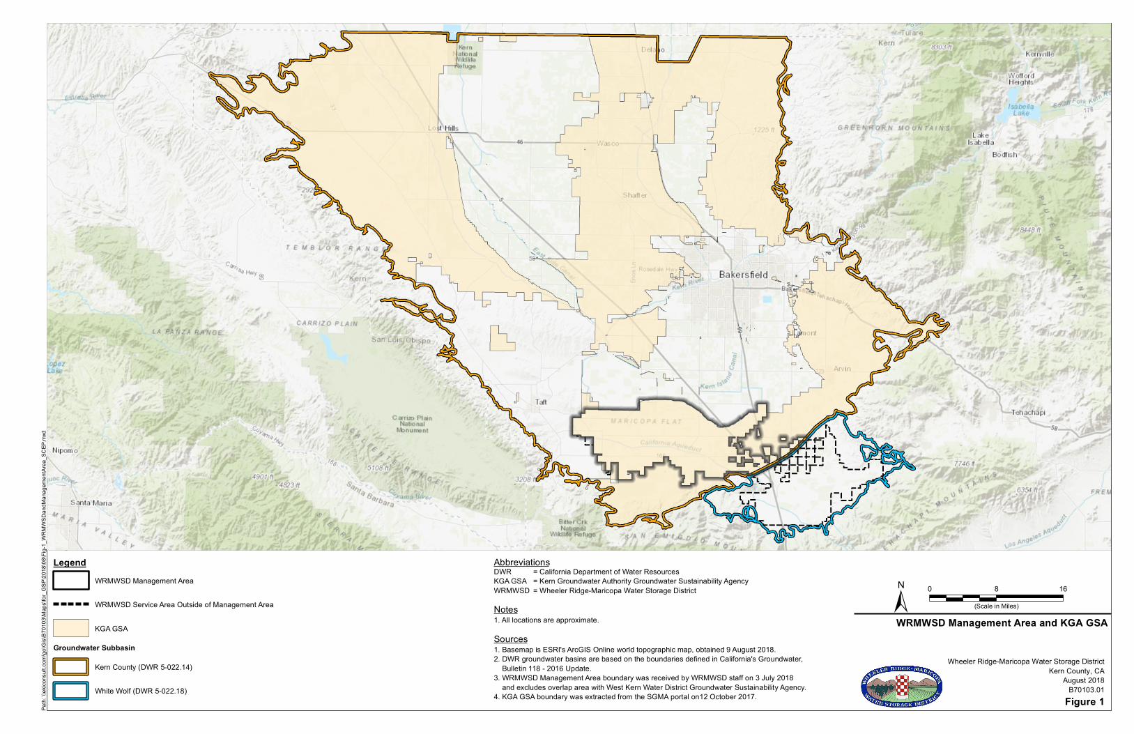
The WRMWSD is a public agency whose jurisdiction encompasses about 147,000 acres of land in Kern County, California, at the southern end of the San Joaquin Valley. The WRMWSD is one of the member agencies of the KGA GSA. The KGA GSA overlies a portion of the Kern County Subbasin (Basin; DWR 5-022.18) of the San Joaquin Valley Basin. The Wheeler Ridge-Maricopa Management Area (Management Area) comprises approximately 91,000 acres of the KGA GSA, as shown in Figure 1. The remainder of the WRMWSD service area is located outside of the Management Area and within the White Wolf Subbasin. The Basin is a high priority basin that has been designated as being in critical groundwater overdraft condition and has a GSP submission deadline of 31 January 2020.
2.2. WRMWSD Structure and Decision-Making Process
Key GSP Chapter development and implementation decisions are made by the WRMWSD Board of Directors (District Board). The WRMWSD staff help to guide the GSP Chapter development technical consultant team and provide feedback on draft work products.
2.2.1. WRMWSD Board Structure and Meetings The District is governed by an elected nine-member Board of Directors. District Board meetings are held on the second Wednesday of the month (unless otherwise noticed) and are open to the public. District Board meeting agendas and packets are posted to the WRMWSD website (https://wrmwsd.com) at least 72 hours before each Board meeting. An ad-hoc committee of the District Board has been formed that will support more detailed engagement with the GSP Chapter development process. The ad-hoc committee will meet on an as-needed basis.
2.2.2. KGA Board Structure and Meetings Per the Joint Powers Agreement (JPA) executed on 22 March 2017, the KGA GSA Board is composed of one representative from each of the general member agencies (Arvin Community Services District [ACSD], Arvin-Edison Water Storage District [AEWSD], Cawelo Water District [CWD], Kern County Water Agency [KCWA], Kern-Tulare Water District [KTWD], Kern Water Bank Authority [KWBA], North Kern Water Storage District [NKWSD], Rosedale-Rio Bravo Water Storage District [RRBWSD], Semitropic Water Storage District [SWSD], Shafter-Wasco Irrigation District [SWID], Southern San Joaquin Municipal Utility District [SSJMUD], Tejon-Castac Water District [TCWD], West Kern Water District [WKWD], Westside District Water Authority [WDWA], and WRMWSD plus one representative from the County as well as the City of Shafter).

Stakeholder Communication and Engagement Plan Wheeler Ridge-Maricopa Management Area
7
The KGA GSA Board meetings are held on the fourth Wednesday of every month and are open to the public. The KGA GSA Board meeting agendas and packets are posted to the KGA website (www.kerngwa.com\board-of-directors.html). The KGA GSA Board is supported by a Coordination Committee (CC) that is composed of one to two (1-2) representatives from each voting party of the KGA GSA and encompasses residential, agricultural, environmental, rural, domestic well, and municipal interests1. The specific role of the KGA’s CC is to make recommendations to the KGA GSA Board regarding technical and other matters (e.g., stakeholder outreach) related to GSP development. The CC meetings are held the first Monday of each month, and they are open to the public. Meeting agendas and packets are posted to the KGA website (www.kerngwa.com/committees.html).
2.3. Desired Outcome
The WRMWSD aims to develop a GSP Chapter that sets its Management Area on a path to maintain sustainability through SGMA’s 50-year planning timeline.
1 Kern Groundwater Authority Communication & Engagement Plan (http://www.kerngwa.com/assets/kga-communication---engagement-plan---may-2018.pdf)

Stakeholder Communication and Engagement Plan Wheeler Ridge-Maricopa Management Area
8
2.4. Communication Objectives to Support the GSP Chapter
The WRMWSD SCEP efforts aim to support development of a GSP Chapter that meets the needs of beneficial uses and users of groundwater in the Management Area and reflects and incorporates stakeholder input as appropriate. The WRMWSD aims to be knowledgeable about and anticipate stakeholder interests and concerns.
2.5. Challenges for the Plan Area
The WRMWSD is aware of and plans to address the following challenges:
• Several large landowners in the District overlie both the Basin and the White Wolf Subbasin (White Wolf Basin; DWR 5-022.18). The WRMWSD will need to coordinate with entities and landowners in the White Wolf Basin to ensure that communication and engagement efforts conducted by the District and the KGA GSA align with communication and engagement efforts in the White Wolf Basin. Should substantially different groundwater management decisions be made in each basin, WRMWSD will communicate with stakeholders near and straddling the basin boundary to help them understand how GSP implementation in each basin will impact them.
• Irrigated agriculture is the primary land use in the District. It is anticipated that there will be concerns regarding how SGMA compliance could impact that land and water use. The District will be open and transparent in decisions that will have a substantial impact on beneficial users of groundwater, and will engage stakeholders early in the decision-making process to consider their interests and concerns.
Stakeholder Communication and Engagement Plan Wheeler Ridge-Maricopa Management Area
9
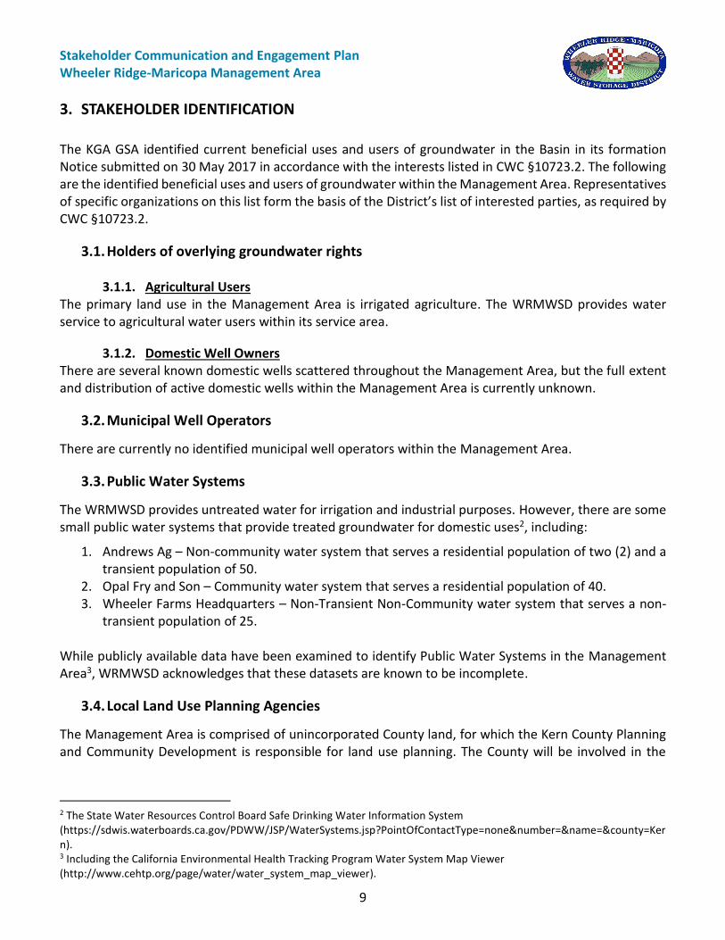
3. STAKEHOLDER IDENTIFICATION
The KGA GSA identified current beneficial uses and users of groundwater in the Basin in its formation Notice submitted on 30 May 2017 in accordance with the interests listed in CWC §10723.2. The following are the identified beneficial uses and users of groundwater within the Management Area. Representatives of specific organizations on this list form the basis of the District’s list of interested parties, as required by CWC §10723.2.
3.1. Holders of overlying groundwater rights
3.1.1. Agricultural Users The primary land use in the Management Area is irrigated agriculture. The WRMWSD provides water service to agricultural water users within its service area.
3.1.2. Domestic Well Owners There are several known domestic wells scattered throughout the Management Area, but the full extent and distribution of active domestic wells within the Management Area is currently unknown.
3.2. Municipal Well Operators
There are currently no identified municipal well operators within the Management Area.
3.3. Public Water Systems
The WRMWSD provides untreated water for irrigation and industrial purposes. However, there are some small public water systems that provide treated groundwater for domestic uses2, including:
1. Andrews Ag – Non-community water system that serves a residential population of two (2) and a transient population of 50.
2. Opal Fry and Son – Community water system that serves a residential population of 40. 3. Wheeler Farms Headquarters – Non-Transient Non-Community water system that serves a non-
transient population of 25. While publicly available data have been examined to identify Public Water Systems in the Management Area3, WRMWSD acknowledges that these datasets are known to be incomplete.
3.4. Local Land Use Planning Agencies
The Management Area is comprised of unincorporated County land, for which the Kern County Planning and Community Development is responsible for land use planning. The County will be involved in the
2 The State Water Resources Control Board Safe Drinking Water Information System (https://sdwis.waterboards.ca.gov/PDWW/JSP/WaterSystems.jsp?PointOfContactType=none&number=&name=&county=Kern). 3 Including the California Environmental Health Tracking Program Water System Map Viewer (http://www.cehtp.org/page/water/water_system_map_viewer).

Stakeholder Communication and Engagement Plan Wheeler Ridge-Maricopa Management Area
10
development and implementation of the KGA GSP (which includes the District’s GSP Chapter) through its participation in the KGA GSA.
3.5. Environmental Users of Groundwater
There is minimal interaction between groundwater and surface water in the Management Area, except in the area of known perched groundwater along the northern boundary. While this perched groundwater appears to support localized wetlands areas, as mapped by DWR4, this system is disconnected from and not part of the principal aquifer. In most of the Management Area, the groundwater table is encountered more than 200 feet below ground surface and thus there is no groundwater contribution to streamflow or other surface water features. Wind Wolves Preserve is a nature preserve that is adjacent to the Management Area.
3.6. Surface Water Users
Surface water features in the Basin include ephemeral streams draining the San Emigdio Mountains, several small lakes and ponds, the California Aqueduct, and a network of irrigation canals and ditches. The US Bureau of Land Management holds appropriative water rights, Wildlands Conservancy holds diversion water rights, and CalMat Co. holds both appropriative and diversion water rights on San Emigdio Creek5. There are also several entities with diversion rights from springs near the boundary of the Basin. These include inactive rights held by Dole Dried Fruit & Nut Company and active federal claims held by USDA – Los Padres National Forest.
3.7. The Federal Government
Two parcels located south of the Rim Ditch within the Management Area, Southeast ¼ of Section 20 and South ½ of Section 22 within Township 32 South, Range 26 East, are identified as federal lands owned by the US Bureau of Land Management.
3.8. California Native American Tribes
There are no identified California Native American tribal lands within the Management Area.
3.9. Disadvantaged Communities
There were no Disadvantaged Community Places identified within the Management Area (U.S. Census, 2015). A portion of US Census Tracts 33.04, 33.06, and 62.02, which overlie almost the entire Management Area, was identified as a Disadvantaged Community Census Tract based on an average household income less than 80% of the State median (U.S. Census, 2015). Census Tract 33.06 includes a Severely Disadvantaged Community Census Block Group (Block Group 1 of Census Tract 33.05) in the southern portion of the Management Area.
4 DWR NC Dataset Viewer (https://gis.water.ca.gov/app/NCDatasetViewer/). 5 According to the SWRCB Electronic Water Rights Information Management System (eWRIMS), accessed 26 July 2018.

Stakeholder Communication and Engagement Plan Wheeler Ridge-Maricopa Management Area
11
As described in the KGA GSA Community & Engagement Plan to engage residents of disadvantage communities/areas, the KGA GSA is coordinating with Self-Help Enterprises (SHE) to identify convenient times and locations for public outreach meetings and to distribute meeting notices.
3.10. Groundwater Monitoring Entities
The WRMWSD submitted a notice to become a monitoring entity for its service area under the California Statewide Groundwater Elevation Monitoring (CASGEM) Program in 2011. The current status for this application process is under review and pending development of the CASGEM monitoring network. However, AEWSD is a Monitoring Entity in the Basin and overlaps with the Management Area. AEWSD is a member of the KGA GSA and will be involved in coordinating GSP Chapter development Additionally, Kern River Fan Group (comprised of Kern Delta Water District, Henry Miller Water District, and Buena Vista Water Storage District) is a Monitoring Entity just north of the Management Area. Henry Miller Water District and Buena Vista Water Storage District have formed their own GSAs, and Kern Delta Water District is part of the Kern River GSA. Monitoring coordination will be included in a coordination agreement as required by the GSP Regulations (23-CCR §357.4).

Stakeholder Communication and Engagement Plan Wheeler Ridge-Maricopa Management Area
12
4. STAKEHOLDER SURVEY AND MAPPING
The WRMWSD intends to update its list of stakeholders based on new information as appropriate. To learn more about its stakeholders, WRMWSD has coordinated with the KGA GSA to distribute a stakeholder survey (Appendix A) by:
• Posting the survey on WRMWSD website (https://wrmwsd.com/ );
• Having copies of the survey available at WRMWSD Board meetings and stakeholder workshops;
• Sending the survey in water bill mailings or special mailings; and
• Coordinating with the community organizations (e.g., Kern County Farmers Bureau, Self-Help Enterprises, etc.) to distribute the survey to diverse members of the population that may not be otherwise be reached.
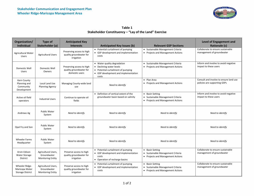
Based on current knowledge of stakeholders, WRMWSD has completed a “Lay of the Land” exercise in Table 1, identifying specific stakeholder organizations/individuals, stakeholder type, key interests and issues, the sections of the GSP Chapter likely to be relevant to this stakeholder, and the level of engagement (e.g., inform, consult, involve) expected with each stakeholder organization/individual. Given that WRMWSD will gain more knowledge of the interests, issues, and challenges of stakeholders over the course of GSP Chapter development, Table 1 will be updated as part of GSP Chapter development. Should WRMWSD need to learn more about specific stakeholders, individual meetings will be arranged to find out more about their issues, interests, and challenges. In addition to the more detailed stakeholder survey, WRMWSD intends to maintain a simple form or an e-mail request link on its webpage for individuals to enroll in WRMWSD interested parties list and provide their contact information. Table 1 Stakeholder Constituency – “Lay of the La
d” Exercise

Stakeholder Communication and Engagement Plan Wheeler Ridge-Maricopa Management Area
13
5. MESSAGES
The WRMWSD aims to convey consistent high-level messaging to stakeholders throughout GSP Chapter development and implementation. The following are the key messages that will form the foundation for communication and engagement efforts:
1. WRMWSD aims to engage with diverse stakeholders to best represent their interests in the GSP Chapter development process;
2. Key GSP Chapter development decisions will be made in an open and transparent fashion during public District Board meetings; and
3. Technical GSP Chapter development progress will be communicated in an accessible manner to support stakeholder understanding and input.
Additionally, the GSA has developed Table 2 to document anticipated questions as well as possible responses. Table 2 will be updated, as needed, to add additional, frequently received questions as well as to build upon responses based on GSP Chapter development progress. Table 2 Likely Questions and Responses
Likely Questions Responses
How can I participate in the GSP Chapter development and implementation process?
District Board meetings are open to the public and held at 8:30 AM on the second Wednesday of the month unless otherwise noticed in the District Headquarters, 12109 Highway166, Bakersfield CA 93313. Stakeholder workshops will be held throughout the GSP Chapter development process, and will be publicized on WRMWSD website
(https://wrmwsd.com/).
Will I have to fallow my land? We are currently in the initial phases of GSP Chapter development. Projects and management actions to achieve sustainability will be discussed later in the process, with opportunity for stakeholder input.
What types of management actions or projects are going to occur in my area?
We are currently in the initial phases of GSP Chapter development. Projects and management actions to achieve sustainability will be discussed later in the process, with opportunity for stakeholder input.
Are pump meters going to be required? Who will pay for meters?
We are currently in the initial phases of GSP Chapter development. Projects and management actions to achieve sustainability will be discussed later in the process, with opportunity for stakeholder input.
Who is paying for GSP Chapter development and implementation?
Agencies in the Basin have obtained state funding to support specific efforts related to GSP development (https://www.water.ca.gov/Work-With-Us/Grants-And-Loans/Sustainable-Groundwater). The WRMWSD will pay for GSP Chapter development and will contribute to the development of a GSP Umbrella by the KGA GSA. The actual cost to the landowner has yet to be determined.

Stakeholder Communication and Engagement Plan Wheeler Ridge-Maricopa Management Area
14
6. VENUES FOR ENGAGING
The WRMWSD intends to provide a variety of opportunities for engagement with stakeholders. Stakeholder input received will inform and be incorporated into corresponding sections of the GSP Chapter as appropriate.
6.1. District Board Meetings
As described in Section 2.2.1, District Board meetings are open to the public and are a consistent venue for public engagement. The WRMWSD understands that Basin-wide public outreach meetings will direct residents to the member agency in whose management area they reside, and welcomes residents within its Management Area, including the overlying DAC areas, to attend its public board meetings.
6.2. Stakeholder Workshops
Stakeholder workshops will be held to communicate progress on GSP technical components to stakeholders and to receive input on upcoming decisions and work efforts. At least two stakeholder workshops and one public hearing will be held during GSP Chapter development:
• Stakeholder Workshop #1 – held 24 May 2018 – SGMA Overview, draft results of Basin Setting Information, Preliminary Undesirable Results, and Key Policy Decisions
• Stakeholder Workshop #2 – to be held in Winter 2018/2019 – Draft Sustainable Management Criteria and Discussion of Projects and Management Actions.
• Public Hearing – Review of the draft GSP Chapter. The WRMWSD will publicize all stakeholder workshops on its website (https://wrmwsd.com/) and to its list of interested parties and will coordinate with community organizations (e.g., Kern County Farmers Bureau, Self-Help Enterprises, etc.) to send out emails and mailings as appropriate. The KGA GSA is holding a series of stakeholder workshops focused on Basin-wide GSP development. The WRMWSD will coordinate with the KGA GSA as appropriate about their respective stakeholder workshops. Additional stakeholder workshops may be held during GSP Chapter implementation. The timing and content of these stakeholder workshops will be determined when the GSP Implementation Plan is developed shortly before GSP Chapter submission.
6.3. Website Communication
The WRMWSD will update its website with WRMWSD Board meeting materials as described in Section 2.2.1, and will additionally update the website with key GSP Chapter updates.

Stakeholder Communication and Engagement Plan Wheeler Ridge-Maricopa Management Area
15
6.4. Stakeholder Surveys
The WRMWSD intends to learn about stakeholder interests using surveys that will be distributed as discussed in Section 4. This stakeholder survey is included as Appendix A.

Stakeholder Communication and Engagement Plan Wheeler Ridge-Maricopa Management Area
16
7. IMPLEMENTATION TIMELINE
The GSA’s C&E implementation timeline aligns with a four phase GSP Chapter development timeline, as described in Table 3 below. Table 3 GSP Development and C&E Efforts by Phase
Phase Timeframe Overall GSP Efforts (led by technical consultant team)
C&E Efforts (led by the WRMWSD staff)
GSP Foundation May 2018 –
September 2018
• Select and design a Data Management System (DMS)
• Conduct data gaps assessment
• Evaluate numerical groundwater model options
• Develop SCEP
• Distribute Stakeholder Survey
• Update Stakeholder Constituency Table
Basin Characterization and Analysis
May 2018 – October
2018
• Implement plan for filling data gaps
• Develop Hydrogeologic Conceptual Model (HCM) and definition of groundwater conditions
• Develop water budget
• Assess existing monitoring programs
• Conduct Stakeholder Workshop #1
• Update Stakeholder Constituency Table
Sustainability Planning
August 2018 –
December 2018
• Evaluate potential management areas
• Develop sustainable management criteria
• Identify projects and management actions
• Create GSP implementation plan
• Finalize monitoring network and protocols
• Conduct Stakeholder Workshop #2
• Update Stakeholder Constituency Table
• Update SCEP to reflect plan for C&E efforts during GSP Implementation
GSP Preparation and Submittal
December 2018 – January
2020
• Compile complete draft GSP
• Revise draft GSP (if necessary) per stakeholder feedback
• Finalize GSP and submit to DWR
• Distribute draft GSP
• Hold Public Hearing on draft GSP
• Assess C&E progress and plan for C&E related to GSP Implementation
• Update Stakeholder Constituency Table
The WRMWSD will update this SCEP while creating a GSP Chapter implementation plan. This update will focus on informing the public about GSP implementation progress, including the status of projects and actions (23-CCR §354.10(d)(4)).

Stakeholder Communication and Engagement Plan Wheeler Ridge-Maricopa Management Area
17
8. EVALUATION AND ASSESSMENT
The WRMWSD intends to assess its SCEP during GSP Chapter development, as shown in Table 3. The WRMWSD staff will present brief summaries of SCEP implementation progress at District Board meetings and will lead a discussion about lessons learned and what can be improved as part of GSP implementation. The following questions will guide SCEP evaluation:
• What worked well? o What allowed us insight into stakeholder concerns? o What types of materials best communicated GSP development to stakeholders?
• What didn’t work as planned? o Could materials (e.g., presentation slides, website pages) have been improved to better
communicate GSP development progress? o Are certain stakeholder groups less represented in the GSP development process than they
should be?
• What do we plan on doing differently during the next phase based on what we have learned?
• How much of our communication and engagement budget have we spent relative to work completed? Do we have enough remaining budget to complete our SCEP?

Stakeholder Communication and Engagement Plan Wheeler Ridge-Maricopa Management Area
18
REFERENCES AND TECHNICAL STUDIES
CWC, 2015. Community Water Center. Collaborating for Success: Stakeholder Engagement for Sustainable Groundwater Management Act Implementation. July 2015.
DWR, 2018. California Department of Water Resources. Guidance Document for Groundwater
Sustainability Plan Stakeholder Communication and Engagement. January 2018. DWR, 2018. NC Dataset Viewer. https://gis.water.ca.gov/app/NCDatasetViewer/ Kern Groundwater Authority Communication & Engagement Plan. May 2018.
http://www.kerngwa.com/assets/kga-communication---engagement-plan---may-2018.pdf SDWIS. Safe Drinking Water Information System. Water System Details, accessed 14 May 2018.
https://sdwis.waterboards.ca.gov/PDWW/JSP/WaterSystems.jsp?PointOfContactType=none&number=&name=&county=Kern
SDWIS. Safe Drinking Water Information System. Water System Details for Andrews Ag, accessed 14 May
2018. https://sdwis.waterboards.ca.gov/PDWW/JSP/WaterSystemDetail.jsp?tinwsys_is_number=1413&tinwsys_st_code=CA&wsnumber=CA1502004.
SDWIS. Safe Drinking Water Information System. Water System Details for Opal Fry and Son, accessed 14
May 2018. https://sdwis.waterboards.ca.gov/PDWW/JSP/WaterSystemDetail.jsp?tinwsys_is_number=1267
&tinwsys_st_code=CA&wsnumber=CA1500216. SDWIS. Safe Drinking Water Information System. Water System Details for Wheeler Farms Headquarters,
accessed 14 May 2018. https://sdwis.waterboards.ca.gov/PDWW/JSP/WaterSystemDetail.jsp?tinwsys_is_number=1417&tinwsys_st_code=CA&wsnumber=CA1502017.
U.S. Census, 2015. US Census American Community Survey, 2010-2014.
Stakeholder Communication and Engagement Plan Wheeler Ridge-Maricopa Management Area
Table 1 Stakeholder Constituency – “Lay of the Land” Exercise
1 of 2
Organization/ Individual
Type of Stakeholder (a)
Anticipated Key Interests Anticipated Key Issues (b) Relevant GSP Sections
Level of Engagement and Rationale (c)
Agricultural Water Users
Agricultural Users Preserving access to high quality groundwater for
irrigation
• Potential curtailment of pumping
• GSP development and implementation costs
• Sustainable Management Criteria
• Projects and Management Actions
Collaborate to ensure sustainable management of groundwater
Domestic Well Users
Domestic Well Owners
Preserving access to high quality groundwater for
domestic users
• Water quality degradation
• Declining water levels
• Potential curtailment of pumping
• GSP development and implementation costs
• Sustainable Management Criteria
• Projects and Management Actions
Inform and involve to avoid negative impact to these users
Kern County Planning and Community
Development
Local Land Use Planning Agency
Managing County-wide land use
Need to identify
• Plan Area
• Projects and Management Actions
Consult and involve to ensure land use policies are supporting GSPs
Active oil field operators
Industrial Users Continue to operate oil
fields
• Definition of vertical extent of the groundwater basin based on salinity
• Basin Setting
• Sustainable Management Criteria
• Projects and Management Actions
Inform and involve to avoid negative impact to these users
Andrews Ag Public Water
System Need to identify Need to identify Need to identify Need to identify
Opal Fry and Son Public Water
System Need to identify Need to identify Need to identify Need to identify
Wheeler Farms Headquarter
Public Water System
Need to identify Need to identify Need to identify Need to identify
Arvin-Edison Water Storage
District
Agricultural Users, Groundwater
Monitoring Entity
Preserve access to high quality groundwater for
irrigation
• Potential curtailment of pumping
• GSP development and implementation costs
• Operation of recharge basins
• Basin Setting
• Sustainable Management Criteria
• Projects and Management Actions
Collaborate to ensure sustainable management of groundwater
Wheeler Ridge-Maricopa Water Storage District
Agricultural Users, Groundwater
Monitoring Entity
Preserve access to high quality groundwater for
irrigation
• Potential curtailment of pumping
• GSP development and implementation costs
• Basin Setting
• Sustainable Management Criteria
• Projects and Management Actions
Collaborate to ensure sustainable management of groundwater

Stakeholder Communication and Engagement Plan Wheeler Ridge-Maricopa Management Area
Table 1 Stakeholder Constituency – “Lay of the Land” Exercise
2 of 2
Organization/ Individual
Type of Stakeholder (a)
Anticipated Key Interests Anticipated Key Issues (b) Relevant GSP Sections
Level of Engagement and Rationale (c)
Wind Wolves Preserve
Environmental Users
Preserve ecosystem
• Analyzing potential groundwater dependence of ecosystems
• Basin Setting
• Sustainable Management Criteria
• Projects and Management Actions
Inform and involve to sustain ecosystem
The US Bureau of Land
Management
Surface Water Users
Need to identify
Need to identify
Need to identify
Need to identify
CalMat Co. Surface Water
Users Need to identify
Need to identify
Need to identify
Need to identify
Wildlands Conservancy
Surface Water Users
Need to identify
Need to identify
Need to identify
Need to identify
U.S. Bureau of Land
Management
The Federal Government
Need to identify
Need to identify
Need to identify
Need to identify
Abbreviations:
CWC = California Water Code
DWR = California Department of Water Resources
GSA = Groundwater Sustainability Agency
GSP = Groundwater Sustainability Plan
SGMA = Sustainable Groundwater Management Act
Notes:
(a) Type of stakeholder based on CWC §10723.2 (e.g., agricultural groundwater users, municipal well operators, etc.).
(b) Any documented issues (media coverage, statements, reports, etc.), specific issues such as past events, or issues that have been otherwise communicated to or
are anticipated by the GSA.
(c) Level of engagement based on the International Association of Public Participation Spectrum of Public Participation, as referenced in DWR’s Guidance
Document for Groundwater Sustainability Plan Stakeholder Communication and Engagement (DWR, 2018).
Path:
\\ekic
onsu
lt.com
\go\G
is\B7
0103
\Map
s\for_
GSP\2
018\0
8\Fig-
1_WR
MWSD
andM
anag
emen
tArea
_SCE
P.mxd
AbbreviationsDWRKGA GSAWRMWSD
Notes1. All locations are approximate.
Sources1. Basemap is ESRI's ArcGIS Online world topographic map, obtained 9 August 2018.2. DWR groundwater basins are based on the boundaries defined in California's Groundwater, Bulletin 118 - 2016 Update.3. WRMWSD Management Area boundary was received by WRMWSD staff on 3 July 2018 and excludes overlap area with West Kern Water District Groundwater Sustainability Agency.4. KGA GSA boundary was extracted from the SGMA portal on12 October 2017.
Legend
WRMWSD Management Area and KGA GSA
Kern County, CAAugust 2018
B70103.01Figure 1
Wheeler Ridge-Maricopa Water Storage District
= California Department of Water Resources= Kern Groundwater Authority Groundwater Sustainability Agency= Wheeler Ridge-Maricopa Water Storage District 0 8 16
(Scale in Miles)±WRMWSD Management Area
WRMWSD Service Area Outside of Management Area
KGA GSA
Groundwater Subbasin
Kern County (DWR 5-022.14)
White Wolf (DWR 5-022.18)

Stakeholder Communication and Engagement Plan Wheeler Ridge-Maricopa Management Area
19
APPENDIX A – STAKEHOLDER SURVEY
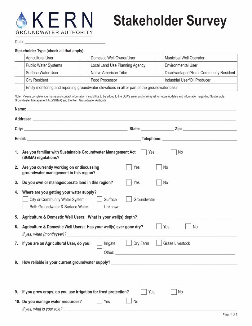
Date: _______________________________________
Stakeholder Type (check all that apply): Agricultural User Domestic Well Owner/User Municipal Well Operator Public Water Systems Local Land Use Planning Agency Environmental UserSurface Water User Native American Tribe Disadvantaged/Rural Community ResidentCity Resident Food Processor Industrial User/Oil ProducerEntity monitoring and reporting groundwater elevations in all or part of the groundwater basin
Note: Please complete your name and contact information if you’d like to be added to the GSA’s email and mailing list for future updates and information regarding Sustainable Groundwater Management Act (SGMA) and the Kern Groundwater Authority.
Name: _____________________________________________________________________________________________________
Address: __________________________________________________________________________________________________
City: __________________________________________________ State: ________________ Zip: __________________________
Email: _______________________________________________________ Telephone: ____________________________________
1. Are you familiar with Sustainable Groundwater Management Act Yes No (SGMA) regulations?
2. Are you currently working on or discussing Yes No groundwater management in this region?
3. Do you own or manage/operate land in this region? Yes No
4. Where are you getting your water supply? City or Community Water System Surface Groundwater Both Groundwater & Surface Water Unknown
5. Agriculture & Domestic Well Users: What is your well(s) depth? ________________________________________________
6. Agriculture & Domestic Well Users: Has your well(s) ever gone dry? Yes No If yes, when (month/year)? __________________________________________________________________________________
7. If you are an Agricultural User, do you: Irrigate Dry Farm Graze Livestock
Other: __________________________________________________________
8. How reliable is your current groundwater supply? _____________________________________________________________
________________________________________________________________________________________________________
________________________________________________________________________________________________________
9. If you grow crops, do you use irrigation for frost protection? Yes No
10. Do you manage water resources? Yes No If yes, what is your role? ____________________________________________________________________________________
Stakeholder Survey
Page 1 of 2

11. What is your primary interest in land or water resources management? ________________________________________
_______________________________________________________________________________________________________
______________________________________________________________________________________________________
______________________________________________________________________________________________________
12. Do you have concerns about groundwater management? Yes No
If so, what are they? ______________________________________________________________________________________
________________________________________________________________________________________________________
_______________________________________________________________________________________________________
________________________________________________________________________________________________________
________________________________________________________________________________________________________
________________________________________________________________________________________________________
_______________________________________________________________________________________________________
13. Do you have requests or recommendations regarding groundwater management? Yes No
If so, what are they? _______________________________________________________________________________________
________________________________________________________________________________________________________
________________________________________________________________________________________________________
________________________________________________________________________________________________________
________________________________________________________________________________________________________
14. Any other information the Kern Groundwater Authority should be aware of or take into consideration while developing the Groundwater Sustainability Plan (GSP)?
________________________________________________________________________________________________________
________________________________________________________________________________________________________
________________________________________________________________________________________________________
________________________________________________________________________________________________________
________________________________________________________________________________________________________
________________________________________________________________________________________________________
________________________________________________________________________________________________________
________________________________________________________________________________________________________
Please return completed surveys to the Kern Groundwater Authority by emailing [email protected], faxing to (661) 479-7172, or mail to Kern Groundwater Authority, 1800 30th Street, Suite 280, Bakersfield, CA 93301. Stakeholder Surveys may also be completed online by visiting www.kerngwa.com.
Page 2 of 2