standardizing gas network data collection
TRANSCRIPT
City Gas Distribution
Standardizing Gas Network Data Collection
Dr. Pradeep N
and
Mitika Garg


Who We Are
Presence since
year 1996
5000+Customers
spanning
multiple industries
HUMAN HEALTH
EDUCATION
DEFENSE/SECURITY
AGRICULTURE
URBAN PLANNINGWATER
LAND RECORDS
DISASTER
MANAGEMENT
ENERGY/POWER
NATURAL
RESOURCES
ENVIRONMENT
INFRASTRUCTUREBANKING
OIL & GAS
MANUFACTURING
TRANSPORTATION
INSURANCE
TELECOMMUNICATIONS
REMOTE SENSING
WATER
RESOURCES
E-GOVERNANCE
and many more…
ChennaiBengaluru
Hyderabad
Kolkata
Mumbai
Ahmedabad
Noida
Parwanoo
Nagpur
Our India Presence
Thiruvananthapuram
Bhopal
Chandigarh
Ranchi
Dehradun
Raipur
Esri India Office Locations
Direct sales coverage

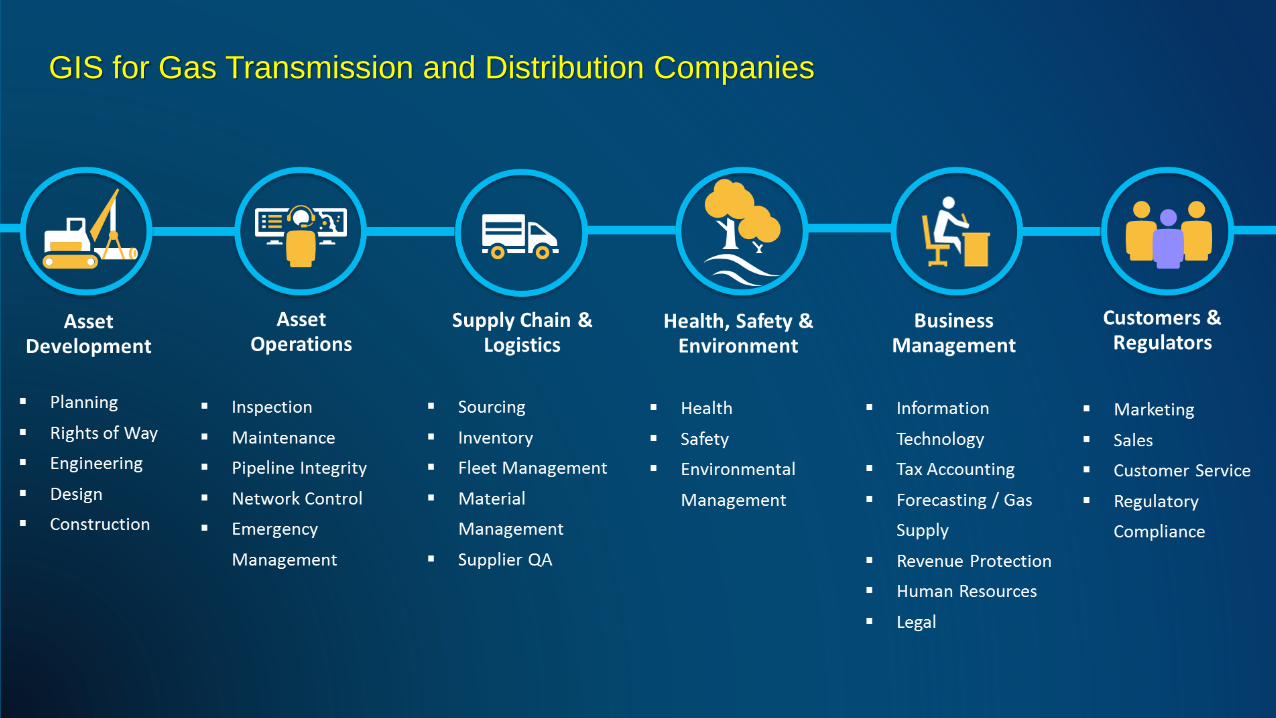
GIS for Gas Transmission and Distribution Companies

Challenges across CGD companies
City
Gas
Challenges
Common Data Model
Coordination between different
departments
Third party Damages
Multi-Site Survey & Multi
Contractor Management
Regulatory and
Compliance
Common Standards
&
Symbols

ArcGIS for Utilities | A Complete GIS
System
of Record System
of Engagement
System
of InsightCreates real business value… …across the utility enterprise

Complete data model
Ease of editing
End-End Connectivity & Tracing
Planning & Forecasting
Engineering & Design
Geospatial Information that Drives your Business..
System
of Record
System of Record
ArcGIS for Utilities | A Complete GIS

CAD / BIM
VectorImagery
Lidar / Point
Cloud
Multidimensional
Data
Real-Time
(IoT)
3DBig Data
Tabular
Unstructured
Voxels
Terrain
Web Maps, Layers
& 3D Scenes
Geospatial
Infrastructure
Integrates many types of Data from Distributed ServersGIS

Standardizing workflows for gas network data collection
Data model finalization
(Single data model for all contractors)
Landbase creation
(drone surveys, imageries,
custom basemaps)
Publishing to enterprise and
enable field collection apps
As Built
Creation
Data health checks (As built
editing and analysis

Landbase creation
(drone surveys, imageries,
custom basemaps)
Digitization
Base map creation – Satellite Images
Ortho Photo Creation – via Drone Surveys
Administration Boundaries
Landbase creation

Data Model - City Gas Distribution Network Assets

City Gas Distribution Data Model
Devices and Facilities Overview
Gas Devices and Facilities
Gas Device
Meter Setting
Squeeze Off
Rural Tap
Gas Valve
Pressure Monitoring Device
Gas Lamp
Relief Valve
Gas Station
Town Border Station
Regulator Station
Abandoned Gas Device
Abandoned Removed Gas Device
Gas Meter
Regulator
Valve Inspection
Structures
Gas Structure
Vault
Station Structure
Fittings
Gas Fitting
Controllable Fitting
Non-Controllable Fitting
Condition Equipment
Oderizer
Strainer
Scrubber
Line Heater
Alcohol Injection Equipment
Pipe and Maintenance
Pipes
Gas Pipe
Distribution Main
Service
Gathering Field Pipe
Sub Transmission Main
Transmission Main
Crossing Inspection
Electric Survey
Abandoned Gas Pipe
Abandoned Removed Gas Pipe
Gas System
Emergency Isolation System
Maintenance
Control Point
Pipe Exposure
Exposed Pipe Inspection
Leak Report
Leak Repair
Coupon
Leak Survey Area
Gas Pipe Casing
Pipe Line Marker
Main Job Separator
Drip
Cathodic Protection
CP devices
CP Anode
CP Bond Junction
CP Rectifier
CP Test Point
CP Bond Wire
CP System
CP Area
CP Rectifier Cable

CGD Asset Intelligence
Gas transmission and distribution companies need to learn ever
more, in as close to real time as possible, about
▪ their pipe network
▪ its condition
▪ activity in and around it,
▪ and the surroundings
through which it passes
▪ devices features, manufacturers
▪ pressure, quality and quantity of gas
▪ maintenance schedule etc.
Asset IQ
GOAL
DRIVERS
Business Regulatory
All functional areas and roles

City Gas Distribution –GIS Symbols for standardizing data sets
• More Attractive, More Intuitive Point Symbol
• Flexibility to personalize these symbol
• Color and Container Shapes for categorization
Geospatial Infrastructure
Desktop Web Device
Server Online Content
and Services
Portal
Identity
Security
Providing Mapping, Analysis, Data
Management, and Collaboration
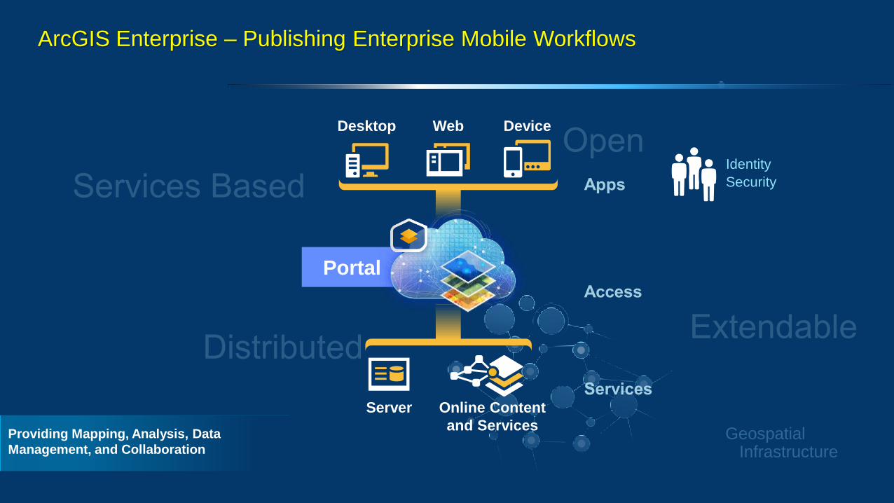
ArcGIS Enterprise – Publishing Enterprise Mobile Workflows

UnderstandProvide visual context
in the field with maps
Capture
NavigateYour roads, your data –
even while offline
Improve coordination and operational efficiency in the field
Plan
Optimize efficiency in field operations with the power of location intelligence
Field Operations | Take the power of location anywhere
Use location to coordinate
field activities
Perform accurate data
collection and inspections
MonitorMake decisions at a glance
Collector
Survey123
Tracker
Workforce
Navigator
Explorer
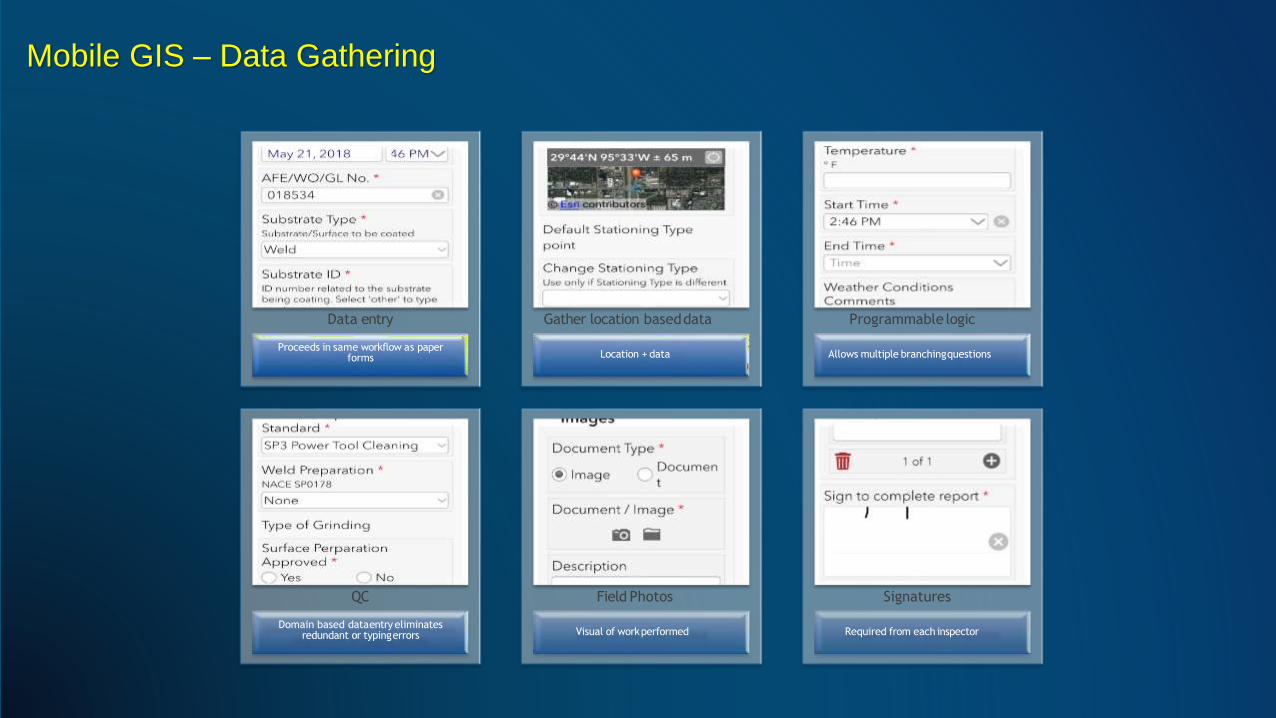
Mobile GIS – Data Gathering
Data entry
Proceeds in same workflow as paper forms Location + data
Gather location baseddata
Allows multiple branchingquestions
Programmable logic
QC
Domain based dataentry eliminates redundant or typingerrors Visual of workperformed
Field Photos
Required from each inspector
Signatures

Geo-centric
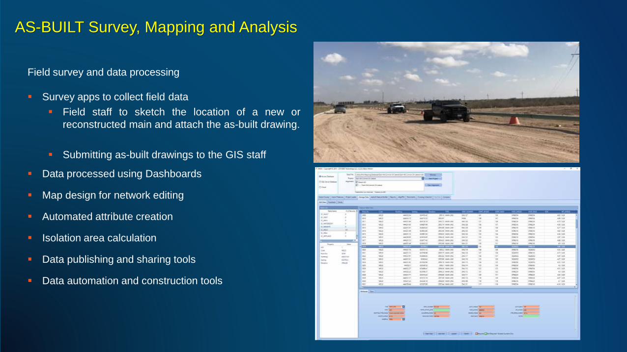
AS-BUILT Survey, Mapping and Analysis
Field survey and data processing
▪ Survey apps to collect field data
▪ Field staff to sketch the location of a new or
reconstructed main and attach the as-built drawing.
▪ Submitting as-built drawings to the GIS staff
▪ Data processed using Dashboards
▪ Map design for network editing
▪ Automated attribute creation
▪ Isolation area calculation
▪ Data publishing and sharing tools
▪ Data automation and construction tools

Data Quality and Health Checks
• Data validation checks using the ArcGIS Data
Reviewer extension for data quality
management.
Tracking and
Reporting
Improve Visual review
Automate detection
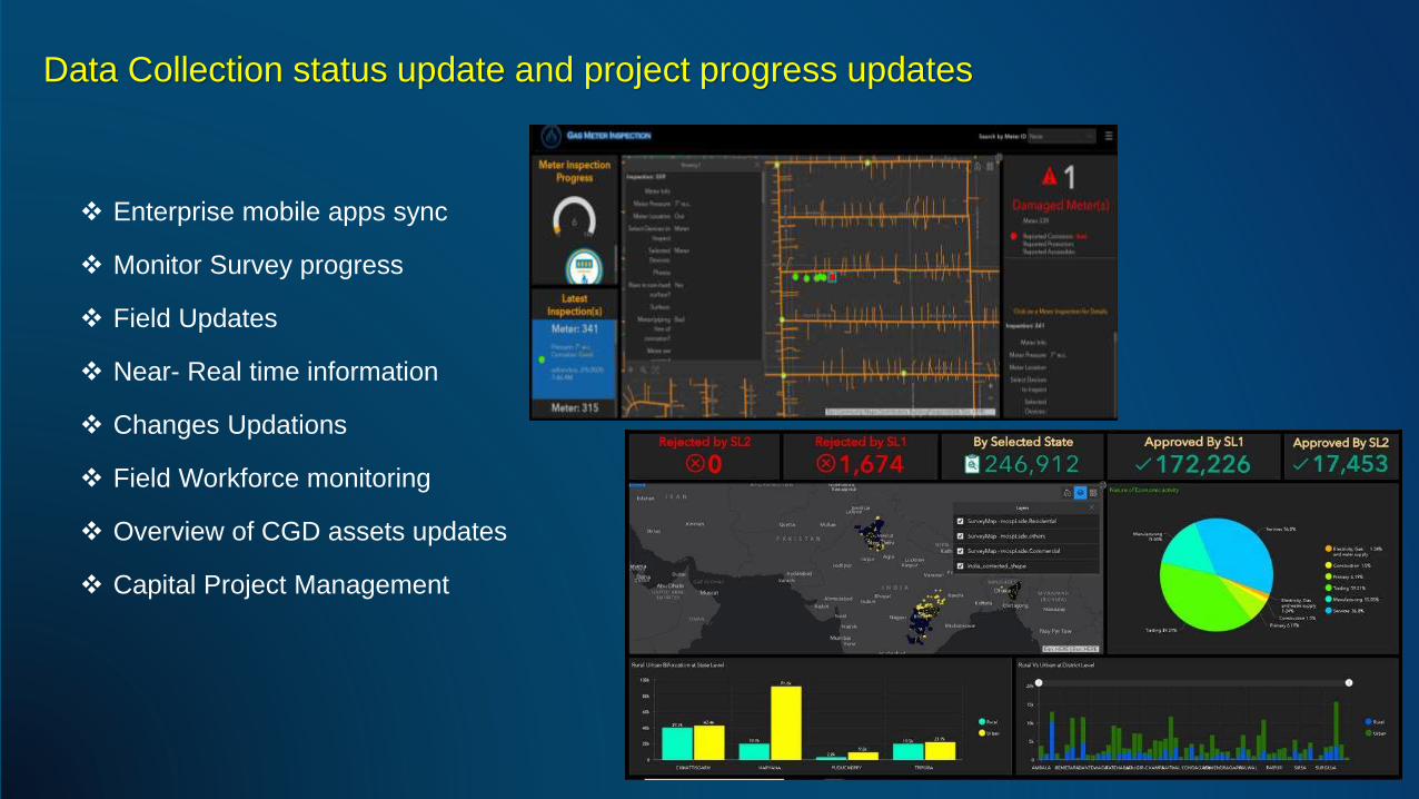
Data Collection status update and project progress updates
❖ Enterprise mobile apps sync
❖ Monitor Survey progress
❖ Field Updates
❖ Near- Real time information
❖ Changes Updations
❖ Field Workforce monitoring
❖ Overview of CGD assets updates
❖ Capital Project Management

Upcoming Webinars
Register at https://www.esri.in/en-in/industries/utilities/webinars

Join GeoNet Community - Connect, Collaborate and Share experiences
Community of customers, partners, Esri staff, and other GIS and geospatial professionals
https://community.esri.com/
