status of mineral resource information for the standing ... · status of mineral resource...
TRANSCRIPT
STATUS OF MINERAL RESOURCE INFORMATION FOR THE STANDING ROCK INDIAN RESERVATION,
NORTH DAKOTA AND SOUTH DAKOTA
By
Lee R. Rice Richard Bretz
U.S. Bureau of Mines South Dakota Geological Survey
Administrative Report BIA-41
1978
CONTENTS
SUMMARY AND CONCLUSIONS . . . . . . . . . . . . . . . . . . . . . . . . . . . . . . . . . . . . . . . . . . . . . . . . . 1
INTRODUCTION . . . . . . . . . . . . . . . . . . . . . . . . . . . . . . . . . . . . . . . . . . . . . . . . . . . . . . . . . . . . . . . . 1
Previous Work . . . . . . . . . . . . . . . . . . . . . . . . . . . . . . . . . . . . . . . . . . . . . . . . . . . . . . . . . . . . . 2
Land Status. . . . . . . . . . . . . . . . . . . . . . . . . . . . . . . . . . . . . . . . . . . . . . . . . . . . . . . . . . . . . . . . 2
Map Coverage . . . . . . . . . . . . . . . . . . . . . . . . . . . . . . . . . . . . . . . . . . . . . . . . . . . . . . . . . . . . . 3
Physiography . . . . . . . . . . . . . . . . . . . . . . . . . . . . . . . . . . . . . . . . . . . . . . . . . . . . . . . . . . . . . . 3
GEOLOGY . . . . . . . . . . . . . . . . . . . . . . . . . . . . . . . . . . . . . . . . . . . . . . . . . . . . . . . . . . . . . . . . . . . . . 4
General . . . . . . . . . . . . . . . . . . . . . . . . . . . . . . . . . . . . . . . . . . . . . . . . . . . . . . . . . . . . . . . . . . . 4
Stratigraphy . . . . . . . . . . . . . . . . . . . . . . . . . . . . . . . . . . . . . . . . . . . . . . . . . . . . . . . . . . . . . . . 4
Outcropping Rock Units . . . . . . . . . . . . . . . . . . . . . . . . . . . . . . . . . . . . . . . . . . . . . . . 4
Subsurface Rock Units. . . . . . . . . . . . . . . . . . . . . . . . . . . . . . . . . . . . . . . . . . . . . . . . . 5
Structure. . . . . . . . . . . . . . . . . . . . . . . . . . . . . . . . . . . . . . . . . . . . . . . . . . . . . . . . . . . . . . . . . . 5
GEOPHYSICS . . . . . . . . . . . . . . . . . . . . . . . . . . . . . . . . . . . . . . . . . . . . . . . . . . . . . . . . . . . . . . . . . . . 6
MINERAL RESOURCES . . . . . . . . . . . . . . . . . . . . . . . . . . . . . . . . . . . . . . . . . . . . . . . . . . . . . . . . . . 6
General . . . . . . . . . . . . . . . . . . . . . . . . . . . . . . . . . . . . . . . . . . . . . . . . . . . . . . . . . . . . . . . . . . . 6
Energy Resources. . . . . . . . . . . . . . . . . . . . . . . . . . . . . . . . . . . . . . . . . . . . . . . . . . . . . . . . . . . 6
Lignite . . . . . . . . . . . . . . . . . . . . . . . . . . . . . . . . . . . . . . . . . . . . . . . . . . . . . . . . . . . . . 6
General . . . . . . . . . . . . . . . . . . . . . . . . . . . . . . . . . . . . . . . . . . . . . . . . . . . . . . . 6
Production . . . . . . . . . . . . . . . . . . . . . . . . . . . . . . . . . . . . . . . . . . . . . . . . . . . . 7
Reserves . . . . . . . . . . . . . . . . . . . . . . . . . . . . . . . . . . . . . . . . . . . . . . . . . . . . . . 7
Mining Methods. . . . . . . . . . . . . . . . . . . . . . . . . . . . . . . . . . . . . . . . . . . . . . . . 8
Potential Development. . . . . . . . . . . . . . . . . . . . . . . . . . . . . . . . . . . . . . . . . . . 8
Petroleum . . . . . . . . . . . . . . . . . . . . . . . . . . . . . . . . . . . . . . . . . . . . . . . . . . . . . . . . . . . 8
General . . . . . . . . . . . . . . . . . . . . . . . . . . . . . . . . . . . . . . . . . . . . . . . . . . . . . . . 8
Geologic Setting and Controls . . . . . . . . . . . . . . . . . . . . . . . . . . . . . . . . . . . . . 8
Exploration. . . . . . . . . . . . . . . . . . . . . . . . . . . . . . . . . . . . . . . . . . . . . . . . . . . . 9
Lease Status . . . . . . . . . . . . . . . . . . . . . . . . . . . . . . . . . . . . . . . . . . . . . . . . . . . 9
Potential Resources . . . . . . . . . . . . . . . . . . . . . . . . . . . . . . . . . . . . . . . . . . . . . 9
Natural Gas . . . . . . . . . . . . . . . . . . . . . . . . . . . . . . . . . . . . . . . . . . . . . . . . . . . . . . . . 11
General . . . . . . . . . . . . . . . . . . . . . . . . . . . . . . . . . . . . . . . . . . . . . . . . . . . . . . 11
Occurrence and Extent . . . . . . . . . . . . . . . . . . . . . . . . . . . . . . . . . . . . . . . . . . 11
Production and Uses . . . . . . . . . . . . . . . . . . . . . . . . . . . . . . . . . . . . . . . . . . . 11
Uranium . . . . . . . . . . . . . . . . . . . . . . . . . . . . . . . . . . . . . . . . . . . . . . . . . . . . . . . . . . . 11
General . . . . . . . . . . . . . . . . . . . . . . . . . . . . . . . . . . . . . . . . . . . . . . . . . . . . . . 11
Geologic Setting and Controls . . . . . . . . . . . . . . . . . . . . . . . . . . . . . . . . . . . . 11
Geothermal Energy . . . . . . . . . . . . . . . . . . . . . . . . . . . . . . . . . . . . . . . . . . . . . . . . . . 12
Geothermal Gradients . . . . . . . . . . . . . . . . . . . . . . . . . . . . . . . . . . . . . . . . . . 12
Development Potential. . . . . . . . . . . . . . . . . . . . . . . . . . . . . . . . . . . . . . . . . . 12
NONMETALLIC MINERAL RESOURCES . . . . . . . . . . . . . . . . . . . . . . . . . . . . . . . . . . . . . . . . . . 12
Sand and Gravel . . . . . . . . . . . . . . . . . . . . . . . . . . . . . . . . . . . . . . . . . . . . . . . . . . . . . . . . . . . 12
Stone . . . . . . . . . . . . . . . . . . . . . . . . . . . . . . . . . . . . . . . . . . . . . . . . . . . . . . . . . . . . . . . . . . . 13
Volcanic Ash . . . . . . . . . . . . . . . . . . . . . . . . . . . . . . . . . . . . . . . . . . . . . . . . . . . . . . . . . . . . . 13
Clay and Shale . . . . . . . . . . . . . . . . . . . . . . . . . . . . . . . . . . . . . . . . . . . . . . . . . . . . . . . . . . . . 14
RECOMMENDATIONS . . . . . . . . . . . . . . . . . . . . . . . . . . . . . . . . . . . . . . . . . . . . . . . . . . . . . . . . . . 14
REFERENCES . . . . . . . . . . . . . . . . . . . . . . . . . . . . . . . . . . . . . . . . . . . . . . . . . . . . . . . . . . . . . . . . . 15
_________________________________________________________________________________________________
Status of Mineral Resource Information For The Standing Rock Indian Reservation, North Dakota And South Dakota Lee R. Rice and Richard Bretz
SUMMARY AND CONCLUSIONS
Known and/or potential mineral resources of
the Standing Rock Indian Reservation that can be
developed with existing technology include lignite,
petroleum, natural gas, uranium, sand and gravel,
rock, clay and shale, and bentonite and volcanic
ash. Only the development of potential petroleum
and uranium resources promise to yield revenues to
the Standing Rock Sioux Tribe; other resources
may provide needed construction materials and
help reduce dependence on imported materials, but
are not likely to be commercially developed.
Lignite reserves, though substantial, are of
limited commercial value at this time because of
their distance from potential markets and because
of diverse land ownership. Moderate potential
exists for the development of small petroleum
fields, but little potential is indicated for develop
ment of natural gas resources. There is an un
known, although probably small, potential for the
discovery and development of shallow subsurface
uranium deposits. Enough sand and gravel, rock,
clays, and shales are present on the reservation to
meet anticipated local construction requirements.
No metallic mineral resources of any significance
are known to occur.
Petroleum exploration should be encouraged
by a concerted study of all existing petroleum
exploration data to identify prospective areas and
help evaluate the potential of this resource. Some
initial pilot studies of the surface and subsurface
stratigraphy and depositional environments of the
exposed Upper Cretaceous and Paleocene units
should be encouraged to evaluate their uranium
potential.
INTRODUCTION
This report was prepared for the Bureau of
Indian Affairs by the U.S. Bureau of Mines and the
U.S. Geological Survey under an agreement to
compile and summarize available information on
the geology, mineral resources, and economic
development potential of certain Indian lands.
Source materials were published and unpublished
reports and personal communications. There was
no fieldwork.
The Standing Rock Reservation includes all of
Sioux County, North Dakota, and Corson County,
South Dakota. In addition, the southern boundary
of the reservation takes in portions of 219 sections
in Dewey County (3,561.11 acres) and part of 103
sections in Ziebach County, South Dakota
(1,731.91 acres) (Figure 1). The 2,320,275-acre
reservation is bounded on the north by Cedar
Creek and the Cannonball River and on the east by
the impounded Missouri River waters of Lake
Oahe (Figure 2). The Cheyenne River Indian
Reservation abuts the Standing Rock Reservation
on the south, and the eastern boundaries of Perkins
and Adams Counties delimit the reservation to the
west at the 102d meridian.
There are several communities on the reserva
tion: McIntosh and Fort Yates are the county seats
of Corson and Sioux Counties. Tribal headquarters
for the Standing Rock Sioux Tribe is at Fort Yates.
Approximately 4,700 Indians reside on or adjacent
to the reservation. According to the 1970 census,
the total population of Sioux and Corson Counties
is 8,626.
Commercial air transportation is available at
Bismarck, 39 miles north of the reservation. Sur-
BIA Administrative Report 41 (1978) 1
_________________________________________________________________________________________________
Status of Mineral Resource Information For The Standing Rock Indian Reservation, North Dakota And South Dakota Lee R. Rice and Richard Bretz
face transportation by bus and train is available,
and hard-surfaced, all-weather roads and numerous
graveled and graded roads serve the area. U.S.
Highway 12 crosses the reservation east to west,
and State Highways 6, 63, and 65 provide connect
ing routes north and south across the reservation.
Previous Work
Although the areas adjacent to the Missouri
River were described in the account of the Lewis
and Clark expedition of 1804-1806 (Lewis and
Clark, 1814), and the region of the Standing Rock
Reservation was visited by F. V. Hayden in 1853
1854 (Meek and Hayden, 1956), the first official
study of the area was not until 1884 when Willis
(1885) studied the lignite resources of the Great
Sioux Reservation. Calvert, Beekly, Barnett, and
Pishel studied the geology of the Standing Rock
and Cheyenne River Indian Reservations in 1909
(Calvert and others, 1914).
Several other investigations were conducted on
the Standing Rock Indian Reservation. Compre
hensive published reports are those of Bluemle
(1975), Calvert, Beekly, Barnett, and Pishel
(1914), Denson (1950), Morgan and Petsch (1945),
and Randich (1975). Reports on smaller areas
include those of Artzner (1974), Lindberg (1944),
Mello (1969), Rothrock (1947), Russell (1926),
Strassberg (1954), Waage (1968), and Wilson
(1922b). Numerous paleontological studies and
regional stratigraphic studies include all or part of
the reservation.
Land Status
Under the terms of the 1868 Treaty of Fort
Laramie, the Sioux accepted a territory extending
to the western slopes of the Black Hills bounded
by the Niobrara River on the south, the Missouri
River on the east, and the Cannonball River on the
north. Congress created seven separate reservations
for the Sioux in 1889 (25 Stat. 888) and estab
lished the present Standing Rock Reservation
boundary. This boundary encompasses 3,625
square miles in Sioux County, North Dakota, and
Corson, Dewey, and Ziebach Counties, South
Dakota. Ownership of more than 60 percent of the
land within the reservation boundary no longer
resides with the Standing Rock Sioux Tribe or with
tribal members. The division of surface ownership
is shown on Figure 3, and the distribution of the
294,840.41 acres of remaining tribal land within
the reservation boundary is shown on Figure 4.
Locally mineral and surface ownership have
been severed, so the status of mineral ownership
within the reservation boundary is less clearly
defined than is the surface ownership. Four catego
ries of mineral ownership on the reservation
include: (1) surface and mineral ownership resid
ing with allottees or non-Indians (including gov
ernment agencies), (2) surface and mineral owner
ship residing with the Standing Rock Sioux Tribe,
(3) tribal ownership of the mineral estate but not
the surface, and (4) lands where mineral ownership
may reside with the tribe but could not be readily
determined. Figure 4 shows the relationships of
lands in these categories to the total area of the
reservation. The distribution of lands in these
categories is shown on Figure 5, which illustrates
BIA Administrative Report 41 (1978) 2
_________________________________________________________________________________________________
Status of Mineral Resource Information For The Standing Rock Indian Reservation, North Dakota And South Dakota Lee R. Rice and Richard Bretz
the fragmented surface and mineral ownership.
Extensive development of any mineral resource
may thus involve allottees and non-Indian owners
as well as the Standing Rock Sioux Tribe.
Map Coverage
Recent topographic maps covering the entire
area of Corson and Sioux Counties are the Bis
marck and McIntosh sheets of the Army Map
Service 1:250,000 series, published by the United
States Geological Survey. These maps have a
contour interval of 100 feet and a scale of approxi
mately 4 miles to the inch.
Several maps of the United States Geological
Survey 7½-minute quadrangle series provide
excellent topographic coverage for nearly all of
both Corson and Sioux Counties as shown on
Figure 6. Contour intervals are 10 or 20 feet and
the scale is 1:24,000 (2,000 feet to the inch).
Geologic maps covering nearly all of Corson
County have been published by the South Dakota
Geological Survey (Figure 7). These maps provide
planimetric control and geologic data at a scale of
1:62,500 (about 1 mile to the inch).
Physiography
The Standing Rock Indian Reservation lies
within the Missouri Plateau division of the Great
Plains physiographic province (Rothrock, 1943, p.
8, and Knudson, 1974).
The South Dakota portion is subdivided into
the Cretaceous Tablelands and Pierre Hills subdi
visions (Rothrock, 1943, p. 8) whereas the North
Dakota portion is subdivided into the glaciated and
unglaciated Missouri Plateau subdivisions
(Knudson, 1974) (Figure 8).
The Cretaceous Tablelands portion is charac
terized by uplands of low relief containing ponds
and lakes. Eroded areas form flattopped and coni
cal buttes and sparsely vegetated badlands. Locally
relief is as much as 100 to 250 feet, particularly in
the badland areas near major drainages and on the
buttes.
The Pierre Hills portion is characterized by
smooth rounded hills and gentle slopes and valleys,
except for areas near major drainages. The buttes
and badlands are much less prevalent than in the
Cretaceous Tablelands area.
The glaciated Missouri Plateau portion is
characterized by a rolling to hilly erosional topog
raphy, with scattered boulders and other evidence
of glaciation. General relief is low, but locally
ranges from 250 to 500 feet.
The unglaciated subdivision of the Missouri
Plateau is similar in all respects to the glaciated
portion except that the surface is devoid of boul
ders or other evidence of glaciation.
Cedar Creek and the Cannonball River form
the northern boundary, the Missouri River forms
the eastern boundary, and the Grand River flows
through the southern portion of the reservation.
These streams are perennial and are characterized
by moderately wide alluvial valleys and a succes
sion of terraces. The Oahe Reservoir has flooded
the alluvial valley of the Missouri and the alluvial
valleys of the Grand and Cannonball near their
mouths.
Altitudes on the reservation range from more
than 2,600 feet in the extreme west to less than
1,650 feet in the extreme southeast.
BIA Administrative Report 41 (1978) 3

_________________________________________________________________________________________________
Status of Mineral Resource Information For The Standing Rock Indian Reservation, North Dakota And South Dakota Lee R. Rice and Richard Bretz
GEOLOGY
General
Geology of the Standing Rock Indian Reserva
tion is dominated by a thick sedimentary rock
sequence. Neither igneous nor volcanic rocks are
present.
Outcrops in Corson and Sioux Counties are of
shales, silts, clays, and sands of both Paleocene
and Cretaceous age. Weathering products of these
sediments as well as glacially derived material,
consisting primarily of boulders of igneous and
metamorphic rocks with isolated remnants of
outwash, till, and loess, comprise the surface
deposits.
Oil tests and deep-water borings reveal a
geologic section consisting of several thousand feet
of sedimentary strata overlying the Precambrian
basement complex of igneous and metamorphic
rocks (Table 1).
Stratigraphy
��������������������
Rocks of Tertiary age exposed in the Standing
Rock Indian Reservation are the Pliocene Ogallala
Formation(?) and the Paleocene Tongue River,
Cannonball, and Ludlow Formations of the Fort
Union Group. Those of Upper Cretaceous age are
the Hell Creek Formation, Fox Hills Formation,
and the Pierre Shale (Figure 9). These units are
covered locally by Holocene and Pleistocene
alluvium, terrace deposits, loess, and glacial drift.
The Ogallala Formation(?), which may actually
be Hell Creek or Fox Hills siliceous sandstone,
consists of up to 10 feet of green-gray silica ce
mented sandstone, which caps several buttes in
eastern Corson County. The Tongue River Forma
tion, which occurs only in the extreme northwest
ern corner of the reservation as scattered erosional
remnants, consists of 25 feet of sandstone with a
few clay pebbles (Stevenson, 1956b). The Cannon
ball Formation, of which only the lower 100 feet or
less is preserved (Denson, 1950), consists of
poorly exposed sandstone and mudstone, which
occurs on the divide between the Grand and Can
nonball Rivers. The Ludlow Formation consists of
65 to 250 feet of sands, silts, sandy and silty clays,
and numerous lenses of calcareous sandstone. At
the base are one or more lignite seams from 0 to 34
inches thick and associated sediments designated
the Shadehill lignite facies; from 25 to 80 feet
above the base are one or more lignite seams from
1 to 34 inches thick and associated sediments
designated the Hillen lignite facies.
The Hell Creek Formation, the youngest Upper
Cretaceous unit, ranges from 330 to 430 feet thick.
In South Dakota the formation consists of the
Upper Hell Creek Unit, the middle Isabel-Firesteel
Lignite Facies, and the Lower Hell Creek unit; in
North Dakota, it consists of the Pretty Butte Mem
ber, the Huff Member, the Fort Rice Member, the
Breien Member, and the Crowghost Member. The
Isabel Firesteel bed continues into North Dakota
but does not receive formal recognition. The
Breien Member of North Dakota is a marine
tongue which does not extend far, if at all, into
South Dakota. Locally unconformable below the
Hell Creek is the Fox Hills Formation, with an
BIA Administrative Report 41 (1978) 4
_________________________________________________________________________________________________
Status of Mineral Resource Information For The Standing Rock Indian Reservation, North Dakota And South Dakota Lee R. Rice and Richard Bretz
average thickness of 250 feet (Denson, 1950),
which consists of, in South Dakota, from top to
bottom, the Colgate, Bullhead, Timber Lake, and
Trail City Members. The North Dakota sequence
is the same, except that the Trail City Member is
not recognized. Gradationally below the Fox Hills
is the Pierre Shale, which underlies all of the
reservation, and is as much as 1,400 feet thick
(Morgan and Petsch, 1945); however only the
upper 300 feet is exposed and consists of the Elk
Butte, Mobridge, and Virgin Creek members. The
Mobridge Member tends to lose its identity to the
west and northwest, where it and the overlying Elk
Butte are called the Upper Pierre unit (Stevenson,
1959, 1960a,b; Pettyjohn, 1961).
�������� ����������
The exposed Paleocene and Late Cretaceous
units are underlain by about 9,000 feet of older
sedimentary rocks, as listed in Table 1.
Structure
The Standing Rock Indian Reservation is in the
eastern and southeastern part of the Williston
Basin, a north- to northwest-trending structural
feature that extends from South Dakota into
Canada. The United States portion of the Williston
Basin is as much as 300 miles wide (east-west) and
400 miles long (north-south). It is bounded on the
east and southeast by the Canadian Shield and
Sioux Ridge, on the south by the Kennedy Basin,
on the southwest and west by the Chadron Arch,
Black Hills, Cedar Creek Anticline, and Poplar
Dome and continues into Canada as the Moose
Jaw Synclinorium (Figure 10).
The main structural feature of the reservation
area is the east flank of a large northwest- to north-
trending syncline, known as the Lemmon Syncline,
which defines the axis of the Williston Basin. A
series of smaller, poorly defined anticlines and
synclines lie on the eastern flank of the Lemmon
Syncline (Figure 10) which may define the south
ward extension of the Nesson anticline. Rock units
in the area dip very gently to the northwest, but
locally dip to the north, west, and east in the areas
of the more conspicuous folds. The structural relief
is approximately 2,500 feet; the structurally highest
parts being in the eastern and southeastern edge of
the reservation, and the structurally lowest parts in
the extreme northwestern corner of the reservation.
Smaller, subsidiary folds are common on or near
the reservation, and, although irregular, tend to
occur in two sets, one trending northwest and the
other trending northeast. Where these sets inter
sect, small, low amplitude anticlinal and domal
structures were formed, with reported closures of
45 to 50 feet (Wilson, 1922b) and, in adjacent
Emmons County, of 30 to 80 feet (Fisher, 1952).
No major faults are known to cross the reserva
tion, but numerous small normal faults, a few
grabens, and a few reverse faults occur on or near
the reservation. Displacement along the faults is
usually less than 3 feet (Curtiss, 1952), and only
rarely is as much as 50 to 60 feet (Curtiss, 1954b),
or 100 feet (Denson, 1950; Russell, 1926).
BIA Administrative Report 41 (1978) 5
_________________________________________________________________________________________________
Status of Mineral Resource Information For The Standing Rock Indian Reservation, North Dakota And South Dakota Lee R. Rice and Richard Bretz
GEOPHYSICS
Geophysical surveys are used to define the
structure and characteristics of subsurface rock
strata. These include magnetic, radiometric, seis
mic, resistivity, and gravity surveys. Many geo
physical surveys were made on parts or all of the
Standing Rock Indian Reservation, but many of the
survey data gathered by private companies are
confidential and unpublished. However, some data
have been published as gravity and magnetic maps
(Carlson, 1950; Jordan, 1940; Petsch, 1959, 1967;
U.S. Geological Survey and South Dakota Geolog
ical Survey, 1975).
Figure 11 is the Bouguer gravity anomaly map
of the reservation adapted from a gravity anomaly
map of the United States (American Geophysical
Union, and the U.S. Geological Survey, 1964). The
minus 70-milligal anomaly astride the state line in
north central Corson County and south central
Sioux County is indicative of igneous Precambrian
rocks at depth (Schoon and McGregor, 1974;
Lidiak, 1971).
Results of a ground magnetometer survey of
Corson, Dewey, and Ziebach Counties were pub
lished by the South Dakota Geological Survey
(Petsch, 1959). Data from this survey for the South
Dakota portion of the reservation are presented on
Figure 12. This map reveals much about the base
ment complex and the structure of Corson County
(Lidiak, 1971). The Mahto North and South,
Mobridge, and Trail City highs imply the presence
of either ridges or prominences on the Precambrian
surface or compositional changes in the basement
rocks in this area and, in the former case, indicate
possible structural traps for petroleum. The moder
ately steep gradients on these highs suggest moder
ate gradients in the Precambrian surface that might
have been caused by faults in the basement com
plex, if indeed, the highs are not due to composi
tional changes.
MINERAL RESOURCES
General
Mineral resources of the Standing Rock Indian
Reservation include lignite, natural gas, geother
mal energy, rock, clay, shale, volcanic ash, and
sand and gravel. These appear to be the only
commodities with potential for commercial devel
opment with existing technology. In addition,
petroleum and uranium are potential resources.
Currently there are 75 leases for petroleum and
natural gas on tribal and allotted lands. Much of
the private, non-Indian lands also are under lease.
Energy Resources
�����
General.--The first survey of lignite resources
in the area of the reservation was made by Willis in
1884 (Willis, 1885). He found "beds of inferior
lignite" and concluded, "It may be definitely said
there is no workable coal of any kind within the
area surveyed."
Work by Calvert, Beekly, Barnett, and Pishel
(1914) concluded, "The quantity is not sufficient to
justify the establishment of an extensive mining
plant, even if the lignite were of good quality.
Mining will therefore continue to be limited (as it
BIA Administrative Report 41 (1978) 6
_________________________________________________________________________________________________
Status of Mineral Resource Information For The Standing Rock Indian Reservation, North Dakota And South Dakota Lee R. Rice and Richard Bretz
now is) to a few small prospects where lignite is
taken out for local consumption."
Some lignite seams in the Ludlow Formation
are as much as 33 inches thick, but they are of
limited extent and occur only in the northwestern
parts of the reservation (Denson, 1950; Stevenson
and others, 1954b; Stevenson and Loken, 1957).
The outcrop trace of this lignite in the South
Dakota portion of the reservation is shown on
Figure 13.
More extensive deposits occur in a zone ap
proximately 40 to 80 feet above the base of the
Hell Creek Formation, and have been traced over
wide areas of the reservation (Denson, 1950)
(Figure 13). This lignite is referred to as the Isabel-
Firesteel.
The carbonaceous material in the Ludlow and
Hell Creek Formations is almost black or very dark
brown, has a brown streak, and contains enough
moisture so that appreciable slacking occurs upon
exposure to air (Searight, 1930). This material is
classified as lignite by the U.S. Bureau of Mines
and the U.S. Geological Survey. The deposits of
the Standing Rock Indian Reservation are thin and
lenticular, and average less than 1,000 feet in width
and 2 and 3 feet in thickness (Curtiss, 1954).
Representative analyses of the Hillen,
Shadehill, and Isabel Firesteel lignites are listed in
Table 2. In general, the lignite contains between 30
and 40 percent moisture, about 20 to 30 percent
fixed carbon, and has a low heating value.
Production.--There are several mines in
Corson, Dewey, and Zieback Counties, in the
South Dakota portion of the reservation (Figure
13). U.S. Bureau of Mines records (Table 3)
indicate that lignite production from Corson
County did not exceed 40,000 tons per year during
the peak mining period from 1938 to 1944. After
1944, the mines in Corson County operated only
intermittently.
There is little information about lignite produc
tion in the North Dakota section of the reservation
(Sioux County). Denison (1950) reports that there
were three mines four miles south of Porcupine in
T. 131 N., Rs. 83 and 84 W., but no evidence
remains of any operations. The maximum lignite
thickness in this area is 28 inches (Calvert and
others, 1914, p. 45). As Sioux County was part of
Morton County until 1914, there is no way to
determine if any of the listed production in Table
3 for Morton County was derived from the reserva
tion. Production from Morton County was first
recorded in 1884, however, Wilder and Wood
(1903) give an extensive account of workings and
development of lignite mining in North Dakota,
but they do not indicate any development in the
area of what is now Sioux County.
Reserves.--Although outcrops of the Hell
Creek Formation extend over nearly half of the
reservation, the highly variable nature of the Isabel
Firesteel lignite facies makes it difficult to estimate
lignite reserves. Searight (1931) estimated that
5,381,000 tons of lignite of thickness greater than
30 inches occur in the Dewey County portion of
the reservation north of Isabel. Drill-hole data
shown on Figure 13 indicate no minable lignite
present in Corson County west of R. 19 E. or north
of T. 22 N. Also, there appears to be almost no
lignite remaining in the Ziebach County portion of
the reservation. The U.S. Bureau of Mines esti-
BIA Administrative Report 41 (1978) 7
_________________________________________________________________________________________________
Status of Mineral Resource Information For The Standing Rock Indian Reservation, North Dakota And South Dakota Lee R. Rice and Richard Bretz
mates lignite reserves of 30,000,000 tons for
Corson County (Hamilton and others, 1975, p.
204). This estimate represents reserves of accept
able quality and quantity deemed to be minable at
a profit under existing market conditions. A study
of the lignite reserves of North Dakota (Pollard and
others, 1972) indicated a lack of commercial
lignite in Sioux County. Thus, the lignite reserves
of the Standing Rock Indian Reservation total
about 35.4 million tons.
Mining Methods.--Early mine operators em
ployed horsedrawn drag scrapers along lignite
outcrops where the relatively thin overburden
could readily be removed. Steam shovels later
were employed in mining, permitting removal of
thicker overburden and enabling mining to extend
further from the outcrop. Eventually, draglines
were used to strip overburden, and power shovels
removed the lignite (Van Sant, 1959).
Mining operations continued to be small scale
in Corson County; mines were operated intermit
tently when price and demand made such ventures
profitable. As lignite at established pits thinned or
decreased in quality, because of partings or in
cluded carbonaceous shale, or when the overbur
den became too thick, new pits were opened
nearby.
Potential Development.--The potential for
using lignite from the Standing Rock Reservation
for power generation, or in carbonization, hydroge
nation, or gasification facilities appears remote
because of the limited reserves and the distance
from any potential market. Moreover, the diverse
pattern of surface and mineral ownership will
create difficulties in the commercial development
of lignite.
� ���� ��
General.--Petroleum is not being produced on
the Standing Rock Indian Reservation, but explora
tion and drilling are expected to continue.
Three shows of oil and gas have been found in
drill holes on the reservation. The test holes are
listed in Table 4 and their locations are shown on
Figure 14. Of these wells, only three penetrated to
the Precambrian. Correlations between some of the
holes are shown on Figure 15.
The nearest producing fields are the Lantry
"field" in Dewey County, about 60 miles south of
the center of the reservation, and in Harding
County, South Dakota, and Bowman County,
North Dakota, about 120 airline miles west of the
center of the reservation.
Geologic Setting and Controls.--The Standing
Rock Indian Reservation is near the southeast edge
of the Williston Basin. The deepest part of the
basin occurs near Williston, North Dakota, where
the sedimentary sequence overlying basement
granite is believed to be 16,000 to 20,000 feet thick
(Hamke and others, 1966).
Pre-Cretaceous sediments within the basin thin
or pinchout eastward and southeastward onto the
Canadian Shield in central and eastern North and
South Dakota. Intermittent uplift of this land mass
caused onlapping, offlapping, and erosional pinch-
outs of all strata below the Cretaceous (Miller,
1971). Unconformities at the base of the Jurassic
sedimentary rocks, at the base of the Triassic, at
BIA Administrative Report 41 (1978) 8
_________________________________________________________________________________________________
Status of Mineral Resource Information For The Standing Rock Indian Reservation, North Dakota And South Dakota Lee R. Rice and Richard Bretz
the base of the Permian, at the base of the Pennsyl
vanian, at the top and bottom of the Devonian, and
at the bottom of the Ordovician may provide traps
for petroleum (Anderson, 1974).
Three large structures are of regional signifi
cance: the Nesson anticline, the Poplar anticline,
and the Cedar Creek anticline (Figure 11). All
three of the large structures were the sites of
petroleum discoveries, but only the Nesson anti
cline might extend into the northwestern and
western portion of the reservation.
Exploration.--Although drilling on the reserva
tion has been relatively limited, a great deal of
geophysical exploration has taken place. A sum
mary of the 27 oil tests drilled to date is presented
in Table 4. Many of these holes failed to test all of
the deeper favorable zones; 6 holes did not pene
trate to greater than 3,500 feet (Jurassic), and a
majority of the drill holes (15) did not reach below
the Mississippian. Only three drill holes extended
to the Precambrian. Thus, the Standing Rock
Indian Reservation remains largely unexplored.
Lease Status.--More than 16,000 acres of tribal
and allotted lands have been leased for oil and gas
(Table 5). Chevron Oil Co. is the major lease
holder with oil and gas leases on 13,112 acres of
tribal and allotted lands. Chevron's leases on
private, government, tribal, and allotted lands in
Corson and Sioux Counties total approximately
380,000 acres (Griffin, 1977). These leases are for
periods of 5 and 10 years and are due to expire in
October 1980.
In 1974, the Tribal Council placed a morato
rium on all natural resource leases of reservation
lands (Resolution No. 51-75, passed Sept. 6,
1974). The moratorium was to remain in effect
until pending Federal strip mining legislation was
passed, and a study of the impacts of resource
development on "Tribal lifestyle, cultural values,
and livelihood" was completed by the Tribe.
Potential Resources.--There is some possibility
of finding small pools of oil and/or gas on the
Standing Rock Indian Reservation. Most of these
pools will be stratigraphic traps, as no large, well
developed structural traps are known.
The potential of the various rock units beneath
the reservation are discussed below in order of
decreasing age and depth (see Table 1). This
discussion is based largely on Sandberg and
Prichard (1964, p. 157-159), Reishus (1968, p. 21
22), Schoon (1971, p. 32-36, 38), Schoon (1972, p.
11, 14), and somewhat on North Dakota Geologi
cal Society (1962).
Cambrian rocks are productive of hydrocarbons
in only a few localities in the United States and are
considered to be unproductive in the Williston
Basin area; therefore the Deadwood Formation has
little or no potential.
The Winnipeg Formation is considered by
Sandberg and Prichard to be of secondary impor
tance in potential production. This unit has yielded
many promising oil shows in the northern
Williston Basin, but may be largely flushed of
hydrocarbons in the reservation.
The Ordovician Red River Formation has one
of the greatest potentials for petroleum production
in the area, as many of the producing fields in
extreme northwestern South Dakota and extreme
southwestern North Dakota are in this unit. A few
BIA Administrative Report 41 (1978) 9
_________________________________________________________________________________________________
Status of Mineral Resource Information For The Standing Rock Indian Reservation, North Dakota And South Dakota Lee R. Rice and Richard Bretz
of the wells on or near the reservation obtained oil
shows in this unit.
The Stony Mountain Formation has produced
a few oil shows in North Dakota, but there is no
production and the potential is low.
The Ordovician-Silurian Stonewall Formation,
the Silurian Interlake Group, and the Devonian
formations, which produce some of the oil in
Montana and North Dakota, are considered to have
a potential of secondary importance, due to limited
extent or thinness.
The Lodgepole, Mission Canyon, and Charles
Formations, which comprise the Madison Group,
have a very high potential. These units, along with
the Red River Formation, are responsible for 80 to
90 percent of the petroleum production in the
United States portion of the Williston Basin.
Although oil shows from these intervals were
encountered on the reservation, the incidence is not
particularly high, so the potential may not be as
high as originally assessed in 1964 by Sandberg
and Prichard.
The Kibbey Sandstone, which produces some
oil and displays quite a few oil shows in North
Dakota, should have some potential in the reserva
tion, as units above and below it have good poten
tial. It merits at least some drill stem testing to
determine its future.
The Pennsylvanian Amsden Formation and
Permo-Pennsylvanian Minnelusa Formation have
high potential in the area, as the Barker Dome
Field in Harding County, South Dakota produces
from the Minnelusa. Also, the Minnelusa unit is
productive in the Powder River Basin in Wyoming
and has yielded many shows of oil on the flanks of
the Black Hills. The potential for stratigraphic
traps is high, as the formation is a complex of
shales, sandstones, limestone, dolomites, and
anhydrites. Schoon (1972, p. 22) considers it to be
the potential oil producing "sleeper," at least in
Harding and Butte Counties. The unit, along with
the Amsden, certainly merits consideration on the
reservation.
The Permo-Triassic Spearfish Formation yields
a few oil shows and a little production in North
Dakota, but the pay zones are in lithologic subunits
that are probably not present on the reservation, so
its potential is small.
The Jurassic rocks have little or no potential,
with the possible exception of the Sundance For
mation, which may prove to have a small potential.
Since the formation consists of interbedded shales
and sandstones, potential stratigraphic traps are
quite possible.
The Lower Cretaceous Inyan Kara Group
(Lakota Formation and Fall River Sandstone) has
a possibility for hydrodynamic traps, but strati
graphic traps are believed to be less numerous than
in the overlying Newcastle-Dakota interval
(Schoon, 1972, p. 11).
The units at the shallowest depth that have the
greatest potential for oil production are in the
Newcastle-Dakota interval. No commercial oil
well production from the Dakota exists at the
present time in North and South Dakota, but
Cretaceous sandstones that are age and strati
graphically equivalent to the Dakota do produce at
several localities in Montana and Wyoming adja
cent to the Black Hills.
BIA Administrative Report 41 (1978) 10
_________________________________________________________________________________________________
Status of Mineral Resource Information For The Standing Rock Indian Reservation, North Dakota And South Dakota Lee R. Rice and Richard Bretz
�����������
General.--Although small quantities of natural
gas occur on the reservation, current development
of this resource does not seem warranted. How
ever, future price increases may see development
of this resource for local use.
Occurrence and Extent.--Natural gas was
recovered from water wells in the central part of
South Dakota shortly before 1900. Gas was sepa
rated from water and used for heating, cooking,
and power generation in the city of Pierre during
the 1890's. This gas occurs in the Dakota Sand
stone (Newcastle) aquifer and is not accompanied
by shows of oil. Figure 14 shows the extent of the
Pierre gas field in Corson County.
Production and Uses.--Except for the commer
cial use of natural gas in the city of Pierre from
about 1894 to 1913, no systematic production or
use of this resource has been attempted (Agnew,
1961). The maximum rate of production from a
well in the Pierre field was about 85,000 cubic feet
of gas per day, but this rate dropped to about
15,000 cubic feet per day within 6 years (Schoon,
1971). Annual production from the Pierre field is
very small, being limited to heating or cooking on
ranches where gas is produced from water wells.
������
General.--No surface occurrences of uranium
have been reported from the Standing Rock Indian
Reservation (Curtiss, 1955a, p. 97). The Williston
Basin area contains uranium in the Paleocene
sedimentary rocks west and northwest of the
reservation, notably in the North and South Bel-
field areas of Billings County, North Dakota
(Noble, 1973) and in the Cave Hills and Slim
Buttes areas of Harding County, South Dakota
(Schnabel, 1975).
Other uranium occurrences in North Dakota are
in the Little Badlands area of Stark County, the
Sentinel Butte area of Golden Valley County, the
Chalky Buttes area of Slope County, and the
Medicine Pole Hills of Bowman County. Those in
South Dakota are in the Short Pine Hills area of
Harding County and the Lodgepole Buttes area of
Perkins County (Jacob, 1976, p. 6).
These known surface occurrences, coupled
with recent studies on the Fox Hills Formation
(Cvancara, 1976a), the Hell Creek and Ludlow
Formations (Moore, 1976), the Cannonball Forma
tion (Cvancara, 1976b), and the Tongue River and
Sentinel Butte Formations (Jacob, 1976) suggest a
possibility of shallow subsurface occurrences of
uranium in the Standing Rock Indian Reservation.
Geologic Setting and Controls.--The uranium
was most likely derived from volcanic ash. Down
ward moving water leached the uranium from the
ash. The reducing action of the lignite precipitated
the uranium.
The most likely target areas in which to search
for epigenetic uranium are below the volcanic ash
(see Bentonite and Volcanic Ash section), particu
larly in eastern Sioux County, where the ash rests
on or near the top of the Bullhead Member, and in
the permeable sandstone of the Timber Lake
Member. This epigenetic uranium would be
leached from the volcanic ash by ground-water
BIA Administrative Report 41 (1978) 11
_________________________________________________________________________________________________
Status of Mineral Resource Information For The Standing Rock Indian Reservation, North Dakota And South Dakota Lee R. Rice and Richard Bretz
action and redeposited in lower permeable units
containing organic material.
The potential for shallow subsurface syngenetic
and epigenetic deposits of uranium on the reserva
tion, particularly from the Fox Hills and Hell
Creek, is favorable and warrants more detailed
surface and subsurface stratigraphic work.
� ��� ������ ���
Geothermal Gradients.--The rate of increase of
temperature with depth below the surface of the
earth is called the geothermal gradient and varies
widely from one location to another; it is a func
tion of rock type and proximity to a heat source.
A value for the geothermal gradient (G) can be
obtained from the relationship:
100( T - t)G =
D
If T is the formation temperature (in degrees
Fahrenheit) at depth, t is the mean annual tempera
ture at ground level (ºF), and D is the distance in
feet from the surface to the depth of temperature
measurement, then G will represent the rate of
change of temperature in ºF per 100 feet of depth.
The average worldwide geothermal gradient is
about 1.6 ºF/100 feet.
The mean annual temperature at the surface in
the area of the Standing Rock Reservation is
approximately 40ºF. Using this value and the
reported bottom-hole temperatures and artesian
flow temperatures from oil tests and selected water
wells on the reservation, a table of calculated
geothermal gradients in the reservation area has
been prepared (Table 6). These data show anoma
lously high geothermal gradients in wells bottomed
in the Hell Creek, Fox Hills, and Newcastle For
mation and anomalously low geothermal gradients
for wells penetrating to the Precambrian basement.
These conditions indicate a possible disequilibrium
of thermal waters in strata above the Precambrian,
a condition that may reasonably be expected to
occur in a large structural basin where circulating
groundwater may reach several thousand feet
below the surface before migrating upslope, trans
porting geothermal heat from the deeper portions
to the flanks of the basin. The number of data
points is too small, however, to place much em
phasis on the apparent anomalies. Figure 16 is an
isogeothermal gradient map of the reservation
derived from the data in Table 6.
Development Potential.--Development of the
geothermal resources of the Standing Rock Reser
vation does not appear likely. The near-normal
geothermal gradients in the area and the relatively
low temperatures encountered at reasonable depths
do not make convincing arguments for the invest
ment in equipment necessary to utilize the avail
able heat energy.
NONMETALLIC MINERAL RESOURCES
Nonmetallic resources of the Standing Rock
Indian Reservation include sand and gravel, stone,
volcanic ash, clay, and shale.
Sand and Gravel
Sand and gravel are the only mineral commodi
ties currently produced from the reservation and
BIA Administrative Report 41 (1978) 12
_________________________________________________________________________________________________
Status of Mineral Resource Information For The Standing Rock Indian Reservation, North Dakota And South Dakota Lee R. Rice and Richard Bretz
annual production is valued at approximately
$50,000. Most of the material is obtained from
borrow pits near points of use (Figure 17). Good
quality concrete aggregate is relatively scarce south
and west of the Missouri River and Lake Oahe.
Terraces along major streams provide a ready
source of sand and gravel, but shale pebbles and
concretions in the material render it generally
unsuitable for concrete aggregate (Carlson, 1964).
Some butte-capping sandstone units are mined and
crushed to provide road material.
Supplies of sand and gravel appear sufficient
for local use, but the relatively small size of indi
vidual deposits and the distance from potential
markets indicate that there is little potential for
expansion of sand and gravel operations on the
reservation.
Stone
Glacial boulders and sandstone are the two
types of stone available for use in concrete aggre
gate and as riprap on the reservation.
Sandstones of the Fox Hills Formation form
butte caps in the eastern and central parts of the
reservation. The end use of this material, however,
is strongly dependent on the cementing material
and inclusions. The cements generally are calcite,
opal, and silica, but also include clays and iron
oxides. Only silica-cemented sandstone (quartzite)
is suitable for concrete aggregate because the other
cementing materials either are too weak or they
react chemically to weaken the finished concrete.
Most of the sandstones are suitable for riprap and
are widely employed for this purpose.
Glacial boulders are less widely used than
sandstone, but are readily available over much of
the eastern half of the reservation (Figure 10).
These consist of granite or related igneous rock,
but some schist and quartzite boulders also are
present. They are used as a base course in road
construction and as riprap on exposed embank
ments, stock dams, and irrigation ditches.
Although there are ample supplies of stone on
the reservation for local use, the small size of
individual deposits and the distance from any
potential market severely limit any development of
this resource.
Volcanic Ash
A bed of volcanic ash occurs in Sioux County
in T. 130 N., Rs. 82, 83, and 84 W. (Manz, 1962).
The deposit has not been studied in Sioux County,
but a similar deposit in southern Morton County
was found to be about 7 feet thick (Laird and
Mitchell, 1942). About 15 miles east of the Mis
souri River in Emmons County, near Linton, a bed
of volcanic ash 26 feet thick lies 15 feet above the
top of the lower part of the Fox Hills Formation,
and about 45 feet above the Pierre Shale (Fisher,
1952). Because these deposits have not been
extensively studied, there is no known correlation
between the deposits in Sioux, Morton, and
Emmons Counties, but the deposits presumably
represent the same bed of volcanic ash.
Suitable volcanic ash is extensively used in
road construction, concrete admixtures and aggre
gates, railroad ballast, abrasive materials, and
absorbents. Several hundred tons of ash from the
deposit near Linton could be calcined to form an
BIA Administrative Report 41 (1978) 13
_________________________________________________________________________________________________
Status of Mineral Resource Information For The Standing Rock Indian Reservation, North Dakota And South Dakota Lee R. Rice and Richard Bretz
acceptable pozzolan for use as an admixture in
portland cement concrete. In addition, the work
showed that the dried material could be mixed with
lime and used to stabilize shaly soils for use as a
road base.
Clay and Shale
Clay and shale occur in all outcropping forma
tions on the Standing Rock Indian Reservation.
Potential products from these materials include
specialized clays such as bentonite, structural
products such as brick and tile, pottery and refrac
tory materials, and construction products such as
cement material, lightweight aggregate, and road
materials.
Bentonite commonly occurs throughout Creta
ceous sediments in North and South Dakota
(Budge, 1926), but it seldom occurs in sufficient
thickness or is of adequate quality to constitute an
economic deposit. Several thin but non-commer-
cial bentonite layers occur in outcrops of the Pierre
Shale and the Hell Creek Formation. There are no
known occurrences of other specialized clays, such
as china clay, fire clay, or Fuller's earth, on the
reservation (Holmes and Van Sant, 1968; Manz,
1953).
Common clay occurring in the Pierre Shale has
been widely used for the manufacture of brick and
other structural clay products in South Dakota
(Manz, 1973a), but local demand can probably be
filled by the nearby brick plant at Mandan, North
Dakota.
Ceramic clays, pottery clays, and refractory
material may be present in some portions of the
Hell Creek Formation and the Pierre Shale, but
they have not been studied.
Lightweight aggregate is made from the Pierre
Shale at Rapid City, South Dakota (Cole and
Zellerstrom, 1954), and might be used for this
purpose on the reservation (Manz, 1954).
The bentonitic clays and shales generally are
not suitable for road material because they become
plastic and very slippery when wet. Gravel from
butte-capping sandstones and from glacial boulders
are combined with weathered shale and lime to
prepare suitable road material. No extensive
development of clay and shale for road material is
likely.
RECOMMENDATIONS
Further study of the oil and gas possibilities of
the Standing Rock Indian Reservation is war
ranted. Such a study should assemble all available
drill-hole and geophysical data to determine the
most prospective portions of the reservation for
future exploration.
A limited field study to explore for uranium-
bearing lignites is recommended.
BIA Administrative Report 41 (1978) 14
_________________________________________________________________________________________________
Status of Mineral Resource Information For The Standing Rock Indian Reservation, North Dakota And South Dakota Lee R. Rice and Richard Bretz
REFERENCES Agnew, A. F., 1958, Oil and gas developments in
South Dakota, 1957: South Dakota Geological
Survey Oil and Gas Map 1, scale 1: 1,000,000.
Agnew, A. F., and Lange, A. U., 1961, Oil tests in
South Dakota before June 1961: South Dakota
Geological Survey Oil and Gas Map 6, scale
1:1,000,000.
Agnew, A. F., and Tychsen, P. C., 1965, A guide
to the stratigraphy of South Dakota: South
Dakota Geological Survey Bulletin 14, 195 p.
American Geophysical Union, and U.S. Geological
Survey, 1964, Bouguer gravity anomaly map of
the United States (exclusive of Alaska and
Hawaii): Washington, D. C., U.S. Geological
Survey.
Anderson, S. B., 1954, Stratigraphic section of the
Mississippian System in North Dakota: North
Dakota Geological Survey Report of Investiga
tions 16, 2 sheets.
_____,1963, Selected Devonian possibilities in
North Dakota: North Dakota Geological Sur
vey Miscellaneous Series 17.
_____,1966, A look at the petroleum potential of
southwestern North Dakota: North Dakota
Geological Survey Report of Investigations 42,
3 sheets.
_____,1967, Where North Dakota's best Newcastle
sand trends are located: North Dakota Geologi
cal Survey Report of Investigation 46, 4 p.
_____,1974, Pre-Mesozoic paleogeologic map of
North Dakota: North Dakota Geological Sur
vey Miscellaneous Map 17, scale 1:1,000,000.
Anderson, S. B., and Mendoza, H. A., 1960, Con
tour map of the Pre-Mesozoic surface in North
Dakota: North Dakota Geological Survey
Miscellaneous Map 6, scale 1:1,000,000.
Aresco, S. J., Haller, C. P., and Abernathy, R. F.,
1957, Analyses of tipple and delivered samples
of coal (collected during the Fiscal Year 1956):
U.S. Bureau of Mines Report of Investigations
5332, 28 p.
_____,1960, Analyses of tipple and delivered
samples of coal (collected during the Fiscal
Year 1959): U.S. Bureau of Mines Report of
Investigations 5615, 34 p.
Artzner, D. G., 1974, Palynology of a volcanic ash
in the Fox Hills Formation (Maestrichtian) of
Emmons, Morton, and Sioux Counties, North
Dakota: M.S. Thesis, Kent State University,
122 p.
Ashmore, H. T., 1971, Petroleum potential of
North Dakota, in Future petroleum provinces
of the United States; their geology and poten
tial: American Association of Petroleum Geol
ogists Memoir, No. 15, p. 692-705.
Austin, R. B., and Hammond, C. R., 1962, Devel
opments in Montana, North Dakota, and South
Dakota in 1961: American Association Petro
leum Geologists Bulletin, v. 46, no. 6, p. 961
968.
Babcock, E. J., 1901, Report of the Geological
Survey of North Dakota: North Dakota Geo
logical Survey First Biennial Report, 103 p.
_____,1906, The uses and values of North Dakota
clays, in Fourth Biennial Report of the State
Geological Survey of North Dakota, p. 191
243.
BIA Administrative Report 41 (1978) 15
_________________________________________________________________________________________________
Status of Mineral Resource Information For The Standing Rock Indian Reservation, North Dakota And South Dakota Lee R. Rice and Richard Bretz
Baker, C. L., 1947, Deep borings of western South
Dakota: South Dakota Geological Survey
Report of Investigations 57, 112 p.
_____,1948, Additional well borings in South
Dakota: South Dakota Geological Survey
Report of Investigations 61, 40 p.
_____,1951, Well borings in South Dakota: South
Dakota Geological Survey Report of Investiga
tions 67, 65 p.
_____,1952, Areal geology of the Mobridge quad
rangle: South Dakota Geological Survey Geo
logic Quadrangle Map, scale 1:62,500.
Baker, C. L., and Carlson, Carl, 1952, Areal geol
ogy of the Mobridge quadrangle: South Dakota
Geological Survey Geologic Quadrangle Map,
scale 1:62,500.
Baldwin, Brewster, 1951a, Areal geology of the
Mahto quadrangle: South Dakota Geological
Survey Geologic Quadrangle Map, scale
1:62,500.
_____,1951b, Areal geology of the Pollock quad
rangle: South Dakota Geological Survey Geo
logic Quadrangle Map, scale 1:62,500.
Baldwin, Brewster, Glass, M. G., Klein, A. F., Jr.,
and Carlson, C. A., Jr., 1950, Areal geology of
the Wakpala quadrangle: South Dakota Geo
logical Survey Geologic Quadrangle Map,
scale 1:62,500.
Baldwin, Brewster, and Doran, Paul, 1951, Areal
Geology of the Mahto quadrangle: South
Dakota Geological Survey Geologic Quadran
gle Map, scale 1:62,500.
_____,1951, Areal geology of the Pollock quad
rangle: South Dakota Geological Survey Geo
logic Quadrangle Map, scale 1:62,500.
Ballard, F. V., 1963, Structural and stratigraphic
relationships in the Paleozoic rocks of eastern
North Dakota: North Dakota Geological Sur
vey Bulletin 40, 42 p.
Bergstrom, J. R., 1956, The general geology of
uranium in southwestern North Dakota: North
Dakota Geological Survey Report of Investiga
tions 23, map with text.
Bluemle, J. P., 1971a, Topographic map of bed
rock surface of North Dakota: North Dakota
Geological Survey Miscellaneous Map 12,
scale 1:500,000.
_____,1971b, Depth to bedrock in North Dakota:
North Dakota Geological Survey Miscella
neous Map 13, scale 1:500,000.
_____,1975, Guide to the geology of southwestern
North Dakota: North Dakota Geological Sur
vey Educational Series 9, 37 p.
Bolin, E. J., 1955a, Areal geology of the Bison
quadrangle: South Dakota Geological Survey
Geologic Quadrangle Map, scale 1:62,500.
_____,1955b, Areal geology of the Meadow quad
rangle: South Dakota Geological Survey Geo
logic Quadrangle Map, scale 1:62,500.
_____,1956a, Areal geology of the Sorum quad
rangle: South Dakota Geological Survey Geo
logic Quadrangle Map, scale 1:62,500.
_____,1956b, Areal geology of the Strool quadran
gle: South Dakota Geological Survey Geologic
Quadrangle Map, scale 1:62,500.
Bolin, E. J., and Petsch, B. C., 1954, Well logs in
South Dakota east of the Missouri River: South
Dakota Geological Survey Report of Investiga
tions 75, 95 p.
BIA Administrative Report 41 (1978) 16
_________________________________________________________________________________________________
Status of Mineral Resource Information For The Standing Rock Indian Reservation, North Dakota And South Dakota Lee R. Rice and Richard Bretz
Brown, Beverly, 1959, List of oil and gas tests in
South Dakota: South Dakota Geological Sur
vey Circular 30, 18 p.
Budge, W. E., 1926, North Dakota clays: North
Dakota University Departmental Bulletin, v.
11, no. 1, p. 38-45.
Calvert, W. R., Beekly, A. L. Barnett, V. H., and
Pishel, M. A., 1914, Geology of the Standing
Rock and Cheyenne River Indian Reservations,
North and South Dakota: U.S. Geological
Survey Bulletin 575, 49 p.
Carlson, C. G., 1960, Stratigraphy of the Winnipeg
and Deadwood Formations in North Dakota:
North Dakota Geological Survey Bulletin 35,
149 p.
_____,1964, Sand gravel, in The mineral resources
of North Dakota: University of North Dakota
General Extension Division, Grand Forks,
North Dakota, p. 87-100.
_____,1967, Cross section of Paleozoic rocks of
western North Dakota: North Dakota Geologi
cal Survey Miscellaneous Series 34, 3 p.
Carlson. C. G., and Anderson, S. B., 1965, Sedi
mentary and tectonic history of North Dakota
part of Williston Basin: American Association
Petroleum Geologists Bulletin, v. 49, no. 11, p.
1833-1846.
_____,1973, Stratigraphy, in Mineral and water
resources of North Dakota; report prepared by
the U.S. Geological Survey and the U.S. Bu
reau of Reclamation in collaboration with
North Dakota Geological Survey, University of
North Dakota, and the U.S. Bureau of Mines at
the request of Quentin N. Burdick of North
Dakota, of the Committee on Interior and
Insular Affairs, United States Senate: Washing
ton, U.S. Government Printing Office, p. 30
41.
______,1973, Structure, in Mineral and water
resources of North Dakota; report prepared by
the U.S. Geological Survey and the U.S. Bu
reau of Reclamation in collaboration with
North Dakota Geological Survey, University of
North Dakota, and the U.S. Bureau of Mines at
the request of Quentin N. Burdick of North
Dakota, of the Committee on Interior and
Insular Affairs, United States Senate: Washing
ton, U.S. Government Printing Office, p. 43
44.
Carlson, C. G., Bakken, W. E., and Kume, Jack,
1960, Subsurface geology and development of
petroleum in North Dakota: North Dakota
Geological Survey Bulletin 34, 12 p.
Carlson, C. G., and Eastwood, W. P., 1962, Upper
Ordovician and Silurian rocks of North Da
kota: North Dakota Geological Survey Bulletin
38, 52 p.
Carlson, L. A., 1950, Magnetic anomalies in South
Dakota, Part 2 of Magnetic observations in
South Dakota: South Dakota Geological Sur
vey Report of Investigations 66, p. 23-35.
Clapp, C. H., and Babcock, E. J., 1906, Economic
geology of North Dakota clays, in Fourth
Biennial Report of the State Geological Survey
of North Dakota, p. 95-189.
Clayton, Lee, and Freers, T. F., editors, 1967,
Glacial geology of the Missouri Coteau, guide
book: North Dakota Geological Survey Miscel
laneous Series 30, 170 p.
BIA Administrative Report 41 (1978) 17
_________________________________________________________________________________________________
Status of Mineral Resource Information For The Standing Rock Indian Reservation, North Dakota And South Dakota Lee R. Rice and Richard Bretz
Clayton, Lee, Moran, S. R., and Bickley, W. B.,
Jr., 1976, Stratigraphy, origin, and climatic
implications of Late Quaternary upland silt in
North Dakota: North Dakota Geological Sur
vey Miscellaneous Series No. 54, 15 p.
Cole, W. A., and Zetterstrom, J. D., 1954, Investi
gation of lightweight aggregates of North and
South Dakota: U. S. Bureau of Mines Report
of Investigations 5065, 43 p.
Colton, R. B., Lemke, R. W., and Lindvall, R. M.,
1963, Preliminary glacial map of North Da
kota: U.S. Geological Survey Miscellaneous
Geologic Investigations Map I-331.
Cook, C. W., 1976, A mechanical well log study of
the Poplar Interval of the Mississippian Madi
son Formation in North Dakota: North Dakota
Geological Survey Report of Investigations 52,
20 p.
Crandell, D. R., 1950, Revision of Pierre Shale of
central South Dakota: American Association of
Petroleum Geologists Bulletin, v. 34, no. 12, p.
2,337-2,346.
Curtiss, R. E., 1951, Cement materials near
Mobridge, South Dakota, in Report of the
South Dakota State Cement Commission to the
Thirty-second Session of the Legislative As
sembly of the State of South Dakota: South
Dakota State Cement Commission, p. 63-81.
_____,1952, Areal geology of the Isabel quadran
gle: South Dakota Geological Survey Geologic
Quadrangle Map, scale 1:62,500.
_____,1954a, Areal geology of the Black Horse
Butte quadrangle: South Dakota Geological
Survey Geologic Quadrangle Map, scale
1:62,500.
_____,1954b, Areal geology of the Firesteel Creek
quadrangle: South Dakota Geological Survey
Geologic Quadrangle Map, scale 1:62,500.
_____,1954c, Areal geology of the Glad Valley
quadrangle: South Dakota Geological Survey
Geologic Quadrangle Map, scale 1:62,500.
_____,1954d, Areal geology of the Gopher quad
rangle: South Dakota Geological Survey Geo
logic Quadrangle Map, scale 1:62,500.
______,1954e, Areal geology of the Worthless
Creek quadrangle: South Dakota Geological
Survey Geologic Quadrangle Map, scale
1:62,500.
_____,1955a, Preliminary report of the uranium in
South Dakota: South Dakota Geological Sur
vey Report of Investigations 74, 102 p.
_____,1955b, Areal geology of the Cash quadran
gle: South Dakota Geological Survey Geologic
Quadrangle Map, scale 1:62,500.
_____,1955c, Areal geology of the Date quadran
gle: South Dakota Geological Survey Geologic
Quadrangle Map, scale 1:62,500.
Curtiss, R. E., Stoley, A. K., Bartling, J. L., and
Nielsen, M. F., 1952, Areal geology of the
Isabel quadrangle: South Dakota Geological
Survey Geologic Quadrangl e Map,
scale1:62,500, text on reverse.
Curtiss, R. E., Steece, F. V., Bolin, E. J., Erickson,
H. D., and Foley, W. L., 1954a, Areal geology
of the Black Horse Butte quadrangle: South
Dakota Geological Survey Geologic Quadran
gle Map, scale 1:62,500, text on reverse.
BIA Administrative Report 41 (1978) 18
_________________________________________________________________________________________________
Status of Mineral Resource Information For The Standing Rock Indian Reservation, North Dakota And South Dakota Lee R. Rice and Richard Bretz
Curtiss, R. E., Nielsen, M. F., Doyle, A. C., Foley,
W., and Steece, F. V., 1954b, Areal geology of
the Firesteel Creek quadrangle: South Dakota
Geological Survey Geologic Quadrangle Map,
scale 1:62,500, text on reverse.
Curtiss, R. E., Steece, F. V., Fairbanks, D. L.,
Bolin, E. J., Foley, W. L., and Erickson, H. D.,
1954c, Areal geology of the Glad Valley quad
rangle: South Dakota Geological Survey Geo
logic Quadrangle Map, scale 1:62,500, text on
reverse.
Curtiss, R. E., Stillwell, L. G., Steece, F V.,
Dodson, C., and Hanson, R. C., 1954d, Areal
geology of the Gopher quadrangle: South
Dakota Geological Survey Geologic Quadran
gle Map, scale 1:62,500, text on reverse.
_____,1954e, Areal geology of the Worthless
Creek quadrangle l2: South Dakota Geological
Survey Geologic Quadrangle Map, scale
1:62,500. text on reverse.
Cvancara, A. M., 1976a, Geology of the Fox Hills
Formation (Late Cretaceous) in the Williston
basin of North Dakota, with reference to ura
nium potential: North Dakota Geological
Survey Report of Investigations 55, 15 p.
_____,1976b, Geology of the Cannonball Forma
tion (Paleocene) in the Williston basin, with
reference to uranium potential: North Dakota
Geological Survey Report of Investigations 57,
21 p.
Denson, N. M., 1950, The lignite deposits of the
Cheyenne River and Standing Rock Indian
Reservations, Corson, Dewey, and Ziebach
Counties, South Dakota, and Sioux County,
North Dakota: U.S. Geological Survey Circular
78, 22 p.
Denson, N. M., Bachman, G. O., Zeller, H. D.,
Gill, J. R., Moore, G. W., and Melin, R. E.,
1355, Uraniferous coal beds in parts of North
Dakota, South Dakota, and Montana: U.S.
Geological Survey Coal Investigations Map C
33.
Denson, N. M., Bachman, G. O., Gill, J. R., Hale,
W. L., Jr., Kepferle, R. C., Mapel, W. J.,
Masursky, Harold, Melin, R. E., Moore, G. W.,
Pipiringos, G. N., Read, C. B., Schopf, J. M.,
Vine, J. D., and Zeller, H. D., 1959, Uranium
in coal in the western United States: U.S.
Geological Survey Bulletin 1055, 315 p.
Dow, W. G., 1967, The Spearfish Formation in the
Williston basin of North Dakota: North Dakota
Geological Survey Bulletin 52, 28 p.
Erickson, J. M., 1974, Revision of the Gastropoda
of the Fox Hills Formation, upper Cretaceous
(Maestrichtian) of North Dakota: Bulletin of
American Paleontology, v. 66, no. 284, p. 131
253.
Feldman, R. M., 1972, Stratigraphy and paleoe
cology of the Fox Hills Formation (Upper
Cretaceous) of North Dakota: North Dakota
Geological Survey Bulletin 61, 65 p.
Fisher, S. P., 1952, The geology of Emmons
County, North Dakota: North Dakota Geologi
cal Survey Bulletin 26, 47 p.
Flint, R. F., 1955, Pleistocene geology of eastern
South Dakota: U.S. Geological Survey Profes
sional Paper 262, 173 p.
Fournier, R. E., 1969, Geology of the Red Elm
quadrangle: South Dakota Geological Survey
Geologic Quadrangle Map, scale 1:62,500.
BIA Administrative Report 41 (1978) 19
_________________________________________________________________________________________________
Status of Mineral Resource Information For The Standing Rock Indian Reservation, North Dakota And South Dakota Lee R. Rice and Richard Bretz
Frye, C. I., 1964, Marine tongues in the Hell Creek
Formation, North Dakota: The Compass, v. 41,
no. 2, p. 167-171.
_____,1969, Stratigraphy of the Hell Creek Forma
tion in North Dakota: North Dakota Geological
Survey Bulletin 54, 65 p.
Gries, J. P., 1939, A structural survey of part of the
upper Missouri Valley in South Dakota: South
Dakota Geological Survey Report of Investiga
tions 31, 46 p.
_____,1940, A structural survey of northeastern
Stanley County, South Dakota: South Dakota
Geological Survey Report of Investigations 34,
64 p.
_____,1942, Economic possibilities of the Pierre
Shale: South Dakota Geological Survey Report
of Investigations 43, 79 p.
_____,1975a, Paleozoic rocks, in Mineral and
water resources of South Dakota: South Da
kota Geological Survey Bulletin 16 (revised),
p. 32-38.
_____,1975b, Manganese, in Mineral and water
resources of South Dakota: South Dakota
Geological Survey Bulletin 16 (revised), p.
104-108.
Hamilton, P. A., White, D. H., Jr., and Matson, T.
K., 1975, The reserve base of U.S. coals by
sulfur content (in two parts), part 2, the West
ern States: U.S. Bureau of Mines Information
Circular 8693, p. 204-206.
Hamke, J. R., Marchant, L. C., and Cupps, C. Q.,
1966, Oilfields in the Williston basin in
Montana, North Dakota, and South Dakota:
U.S. Bureau of Mines Bulletin 629, 487 p.
Hansen, D. E., 1955, Subsurface correlations of the
Cretaceous Greenhorn-Lakota interval in North
Dakota: North Dakota Geological Survey
Bulletin 29, 46 p.
Hansen, D. E., 1957, Structure map on top of
Fuson; North Dakota Geological Survey Mis
cellaneous Map 4, scale 1:1,000,000.
_____,1960, North Dakota has rapid Mesozoic
facies changes: North Dakota Geological
Survey Report of Investigations 34, 5 p.
Hansen, Miller, 1957, Structure map on Precam
brian: North Dakota Geological Survey Miscel
laneous Map 5, scale 1:1,000,000.
______,1959, Clays of North Dakota as a potential
source of alumina: North Dakota Geological
Survey Report of Investigations 33, 15 p.
Hansen, Miller, 1960, Regional gravity map of
northwestern North Dakota: North Dakota
Geological Survey Report of Investigations 35,
map with text, scale about 1 inch to 1 mile.
Haraldson, H. C., 1953, Geomagnetic survey of
part of the east edge of Williston basin: North
Dakota Geological Survey Report of Investiga
tions 10, map with text.
Harksen, J. C., 1975, Tertiary sedimentary rocks,
in Mineral and water resources of South Da
kota: South Dakota Geological Survey Bulletin
16 (revised), p. 43-45.
Harrer, C. M., 1964, Iron, in Mineral and water
resources of South Dakota: South Dakota
Geological Survey Bulletin 16, p. 56-59.
Hedges, D. J., 1964, List of oil and gas tests in
South Dakota before July 1, 1964: South
Dakota Geological Survey Circular 34, 30 p.
BIA Administrative Report 41 (1978) 20
_________________________________________________________________________________________________
Status of Mineral Resource Information For The Standing Rock Indian Reservation, North Dakota And South Dakota Lee R. Rice and Richard Bretz
Holmes, R. W., and Van Sant, Joel, 1968,
Refractory-clay deposits of Nebraska, North
Dakota, and South Dakota: U.S. Bureau of
Mines Open-File Report 9-68, 113 p.
Hoppin, R. A., 1955a, Areal geology of the Chance
quadrangle: South Dakota Geological Survey
Geologic Quadrangle Map, scale 1:62,500.
_____,1955b, Areal geology of the Coal Springs
quadrangle: South Dakota Geological Survey
Geologic Quadrangle Map, scale 1:62,500.
Hunt, J. B., 1962, Gravity maps of north-central
North Dakota: North Dakota Geological Sur
vey Report of Investigations 39, scale about 1
inch to 2 miles, with text.
Hunt, J. B., 1963, Gravity maps of central North
Dakota: North Dakota Geological Survey
Report of Investigations 40, scale about 1 inch
to 2 miles, with text.
Jacob, A. F., 1976, Geology of the upper part of
the Fort Union Group (Paleocene), Williston
basin, with reference to uranium: North Dakota
Geological Survey Report of Investigations 58,
49 p.
Jordan, W. H., 1940, Magnetic map of South
Dakota based on data taken by the United
States Coast and Geodetic Survey: South
Dakota Academy Science Proceedings, 1940,
v. 20, p. 58-60.
Karsten, Andrew, 1956, Characteristics and behav
ior of certain South Dakota shales under ex
pansion to produce lightweight aggregate:
South Dakota Natural Resources Commission,
43 p.
Klett, M. C., and Erickson, J. M., 1974, Type and
reference sections for a new member of the
Fox Hills Formation, Cretaceous, south-central
North Dakota [abs.]: North Dakota Academy
Science Proceedings, v. 28, pt. I, p. 17.
_____,1976, Type and reference sections for a new
member of the Fox Hills Formation, upper
Cretaceous (Maestrichtian) in the Missouri
Valley region, North and South Dakota: North
Dakota Academy Science Proceedings, v. 28,
pt. II, p. 3-24.
Kresl, R. J., 1964, Physiographic divisions of
North Dakota: Compass, v. 41, no. 2, p. 104
107.
Kume, Jack, 1963, The Bakken and Englewood
Formations in North Dakota and northwestern
South Dakota: North Dakota Geological Sur
vey Bulletin 39, 87 p.
Laird, W. M., 1941, Selected deep well records:
North Dakota Geological Survey Bulletin 12,
31 p.
_____,1944, The stratigraphy and structure of
North Dakota: North Dakota Geological Sur
vey Bulletin 18, 11 p.
_____,1964, Resume of the Stratigraphy and
structure of North Dakota in Third interna
tional Williston basin symposium: Billings
Geological Society, North Dakota Geological
Survey, and Saskatchewan Geological Society;
Regina, Saskatchewan, p. 39-44.
Laird, W. M., and Mitchell, R. H., 1942, The
geology of the southern part of Morton County,
North Dakota: North Dakota Geological Sur
vey Bulletin 14, p. 23-42.
BIA Administrative Report 41 (1978) 21
_________________________________________________________________________________________________
Status of Mineral Resource Information For The Standing Rock Indian Reservation, North Dakota And South Dakota Lee R. Rice and Richard Bretz
Laird, W. M., and Towse, D. F., 1953, Stratigraphy
of North Dakota with reference to oil possibili
ties: North Dakota Geological Survey Report
of Investigations 2 (revised), 2 sheets.
Lewis, Meriwether, and Clark, William, 1814,
History of the expedition under the command
of Lewis and Clark to the sources of the Mis
souri, thence across the Rocky Mountains and
down the Columbia, performed during the
years 1804-1806, by order of the government
of the United States, in Original Journals of the
Lewis and Clark expedition, 1804-1806, edited
by Ruben G. Thwaites: v. 1, p. 164-207,
(1904).
Lidiak, E. G., 1971, Buried Precambrian rocks of
South Dakota: Geological Society America
Bulletin, v. 82, no. 5, p. 1411-1419.
Lindberg, M. L., 1944, Heavy mineral correlation
of the Fox Hills, Hell Creek, and Cannonball
sediments, Morton and Sioux Counties, North
Dakota: Journal Sedimentary Petrology, v. 14,
no. 14, no. 3, p. 131-143.
Lindsey, K. B., 1953, Petroleum in the Williston
Basin, including parts of Montana, North and
South Dakota, and Canada: U.S. Bureau of
Mines Report of Investigations 5055, 70 p.
Lupton, C. T., and Marks, E. M., 1924, Oil possi
bilities in South Dakota west of the Missouri
River: Oil and Gas Journal, v. 23, no. 5, p. 78,
80, 82, and 84.
Mallory, W. W., (ed.), 1972, Geologic atlas of the
Rocky Mountain region: Denver, Colorado,
Rocky Mountain Association Geologists.
Manz, O. E., 1953, Investigation of some North
Dakota clays and shales: North Dakota Geo
logical Survey Report of Investigations 13, 36
p.
____,1954, Investigation of lightweight aggregate
possibilities of some North Dakota clays and
shales: North Dakota Geological Survey Re
port of Investigations 17, 48 p.
Manz, O. E., 1962, Investigation of pozzolanic
properties of the Cretaceous volcanic ash
deposit near Linton, North Dakota: North
Dakota Geological Survey Report of Investiga
tions 38, 42 p.
_____,1973a, Clay and lightweight aggregate, in
Mineral and water resources of North Dakota:
North Dakota Geological Survey Bulletin 63,
p. 122-129.
____,1973b Volcanic ash, in Mineral and water
resources of North Dakota: North Dakota
Geological Survey Bulletin 63, p. 129-130.
McCaslin, J. C., 1972, South Dakota explorers
look for the much-needed hit: Oil and Gas
Journal, v. 70, no. 52, p. 137.
Mello, J. F., 1969, Foraminifera and stratigraphy
of the upper part of the Pierre Shale and lower
part of the Fox Hills Sandstone (Cretaceous),
northcentral South Dakota: U.S. Geological
Survey Professional Paper 611.
Merewether, E. A., 1975, Mesozoic rocks in Min
eral and water resources of South Dakota:
South Dakota Geological Survey Bulletin 16
(revised), p. 38-43.
BIA Administrative Report 41 (1978) 22
_________________________________________________________________________________________________
Status of Mineral Resource Information For The Standing Rock Indian Reservation, North Dakota And South Dakota Lee R. Rice and Richard Bretz
McCauley, G., 1964, Regional framework of
Paleozoic sedimentation in western Canada
and northwestern United States in Third inter
national Williston basin symposium; Billings
Geological Society, North Dakota Geological
Survey, and Saskatchewan Geological Society;
Regina, Saskatchewan, p. 7-36.
Mickelson, J. C., Baker, C. L., Bolenbaugh, W. R.,
Doran, P. G., and Grenfell, M. R., 1950, Areal
geology of the Mouth of Moreau quadrangle:
South Dakota Geological Survey Geologic
Quadrangle Map, scale 1:62,500.
Miller, B. W., 1971, Petroleum potential of South
Dakota, in Future petroleum provinces of the
United States; their geology and potential:
American Association of Petroleum Geologists
Memior No. 15, v. 1, p. 706-717.
Moe, D. L., Lightweight concrete aggregate from
South Dakota shales: Brookings, Agricultural
Experiment Station Circular 96, 12 p.
Moore, W. L., 1976, The Stratigraphy and environ
ments of deposition of the Cretaceous Hell
Creek Formation (reconnaissance) and the
Paleocene Ludlow Formation (detailed), south
western North Dakota: North Dakota Geologi
cal Survey Report of Investigations 56, 40 p.
Morgan, R. E., and Petsch, B. C., 1945, A geologi
cal survey in Dewey and Corson Counties,
South Dakota: South Dakota Geological Sur
vey Report of Investigations 49, 53.
Noble, E. A., 1973, Uranium in coal, in Mineral
and water resources of North Dakota: North
Dakota Geological Survey Bulletin 63, p. 80
83.
North Dakota Geological Society, 1962, Oil and
gas fields of North Dakota, 1962, A sympo
sium: North Dakota Geological Society, 220 p.
North Dakota Geological Survey, 1973, Mineral
and water resources of North Dakota: North
Dakota Geological Survey Bulletin 63, 252 p.
North Dakota Geological Survey, 1977, Produc
tion statistics and engineering data (on) oil in
North Dakota, second half of 1976: North
Dakota Geological Survey, 267 p.
Norton, J. J., 1975, Geology in Mineral and water
resources of South Dakota: South Dakota
Geological Survey Bulletin 16 (revised), p. 13
28.
Petroleum Information Corp., 1928-____, Well
Completion cards: Petroleum Information
Corp., Denver, Colorado.
Petsch, B. C., 1942, The Medicine Butte anticline:
South Dakota Geological Survey Report of
Investigations 45, 24 p.
_____,1953, Structure map of South Dakota,
Greenhorn datum: South Dakota Geological
Survey general map, scale 1 inch=19 miles.
______,1955a, Areal geology of the Govert quad
rangle: South Dakota Geological Survey Geo
logic Quadrangle Map, scale 1-62,500.
_____,1955b, Areal geology of the Reva quadran
gle: South Dakota Geological Survey Geologic
Quadrangle Map, scale 1:62,500.
_____,1959, Magnetometer map of Corson,
Dewey, and Ziebach Counties, South Dakota:
South Dakota Geological Survey Oil and Gas
Map 4, scale 1 inch=5.5 miles.
BIA Administrative Report 41 (1978) 23
_________________________________________________________________________________________________
Status of Mineral Resource Information For The Standing Rock Indian Reservation, North Dakota And South Dakota Lee R. Rice and Richard Bretz
Petsch, B. C., 1967, Magnetometer map of South
Dakota: South Dakota Geological Survey
Mineral Resources of Investigations Map 4,
scale 1 inch=11.6 miles.
Pettyjohn, W. A., and Lange, U., 1961, Geology of
the Glencross quadrangle: South Dakota Geo
logical Survey Geologic Quadrangle Map, (text
on reverse), scale 1: 62,500.
Polland, B. C., Smith, M. B., and Knox, C. C.,
1972, Strippable lignite reserves of North
Dakota: location, tonnage, and characteristics
of lignite and overburden: U.S. Bureau of
Mines Information Circular 8537, 37 p.
Pettyjohn, W. A., 1961, Geology of the Glencross
quadrangle: South Dakota Geological Survey
Geologic Quadrangle Map, scale 1:62,500.
Reishus, Mark, 1968, The Newcastle Formation in
the Williston Basin of North Dakota: North
Dakota Geological Survey Report of Investiga
tions 47, 26 p.
Rist, Pat, 1955, Oil and gas tests, 1911-1955:
South Dakota Geological Survey Oil and Gas
Map, scale 1:750,000.
Robinson, C. S., Mapel, W. J., and Cobban, W. A.,
1959, Pierre Shale along western and northern
flanks of Black Hills, Wyoming, and Montana:
American Association of Petroleum Geologists
Bulletin, v. 43, no. 1, p. 101-123.
Rothrock, E. P., 1943, A geology of South Dakota,
Part I, the surface: South Dakota Geological
Survey Bulletin 13, 88 p.
_____,1944, A geology of South Dakota, Part III,
mineral resources: South Dakota Geological
Survey Bulletin 15, 255 p.
_____,1947, Geology of the Missouri River and
vicinity near Mobridge: South Dakota Geologi
cal Survey Report of Investigations 58, 29 p.
_____,1955, South Dakota as an oil prospect, in
North Dakota Geological Society Guidebook,
South Dakota Black Hills (3rd) Field Confer
ence, September 1955: North Dakota Geologi
cal Society Guidebook, p. 76-80.
Russell, W. L., 1926, The possibilities of oil in
western Corson County: South Dakota Geolog
ical Survey Circular 27, 18 p.
Sandberg, C. A., 1962, Geology of the Williston
Basin, North Dakota, Montana, and South
Dakota, with reference to subsurface disposal
of radioactive wastes: U.S. Geological Survey
Report TEI-809 Open-File Report, 148 p.
Sandberg, C. A., and Prichard, G. E., 1964, Petro
leum and natural gas, in Mineral and water
resources of South Dakota: South Dakota
Geological Survey Bull. 16, p. 151-160.
Schnabel, R. W., 1975, Uranium, in Mineral and
water resources of South Dakota: South Da
kota Geological Survey Bulletin 16 (revised),
p. 172-176.
Schoon, R. A., 1964, Selected formation tops in oil
and gas tests in South Dakota drilled before
January 1, 1964: South Dakota Geological
Survey Circular 35, 66 p
_____,1966, Oil and gas tests of Corson County:
South Dakota Geological Survey Oil and Gas
Map, scale 1 inch=4 miles.
_____,1967, South Dakota, in Stratigraphic cross
section of Paleozoic rocks - Oklahoma to
Saskatchewan: American Association Petro
leum Geologists Cross Society Publication 5,
p. 10-12.
BIA Administrative Report 41 (1978) 24
_________________________________________________________________________________________________
Status of Mineral Resource Information For The Standing Rock Indian Reservation, North Dakota And South Dakota Lee R. Rice and Richard Bretz
_____,1970, Results from drill stem tests of oil
tests in South Dakota drilled before July 1,
1970: South Dakota Geological Survey Circu
lar 41, 57 p.
_____,1972, Review of oil possibilities in Harding
and Butte Counties with emphasis on the
Newcastle Sandstone: South Dakota Geologi
cal Survey Report of Investigations 106, 14 p.
_____1974, Generalized stratigraphic column of
central and northwestern South Dakota: South
Dakota Geological Survey Map 6, Educational
Series.
Schoon, R. A., and McGregor, D. J., 1974, Geo
thermal potentials in South Dakota: South
Dakota Geological Survey Report of Investiga
tions 110, 76 p.
Searight, W. V., 1930, A preliminary report of the
coal resources of South Dakota: South Dakota
Geological Survey Report of Investigations 3,
46 p.
Searight, W. V., 1931, The Isabel-Firesteel coal
area: South Dakota Geological Survey Report
of Investigations 10, 34 p.
_____,1932, Slacking properties of South Dakota
coals: South Dakota Geological Survey Report
of Investigations 12, 17 p.
Shride, A. F., Fischer, E. C., Larrabee, D. M.,
Weeks, R. A., Sohn, I. G., and Fox, E. L., 1947
, Construction materials and non-metallic
mineral resources of North Dakota: U.S. Geo
logical Survey Missouri Basin Studies, no. 14,
index map with text.
South Dakota Geological Survey, 1953 (revised),
Panel diagram of subsurface formations in
South Dakota: South Dakota Geological Sur
vey general map, 1 inch=20 miles.
Stanton, T. W., 1917, A Cretaceous volcanic ash
bed on the Great Plains in North Dakota:
Washington Academy Science Journal, v. 7, p.
80-81.
Steece, F. V., 1961, Preliminary map of the Pre
cambrian surface of South Dakota: South
Dakota Geological Survey Mineral Resources
Investigations Map 2, scale about 1 inch to 17
miles.
______,1962, Precambrian basement rocks of
South Dakota: South Dakota Academy Science
Proceedings, v. 41, p. 51-56.
______,1976, Two new South Dakota fields
opened last year: Western Oil Reporter, v. 33,
no. 4, p. 43-44.
Stevenson, R. E., 1954a, Areal geology of the
Haynes quadrangle: South Dakota Geological
Survey Geologic Quadrangle Map, scale
1:62,500.
______,1954b, Areal geology of the Morristown
quadrangle: South Dakota Geological Survey
Geologic Quadrangle Map, scale1:62,500.
_____,1954c, Areal geology of the Thunder Hawk
quadrangle: South Dakota Geological Survey
Geologic Quadrangle Map, scale 1:62,500.
_____,1956a, Areal geology of the Bullhead quad
rangle: South Dakota Geological Survey Geo
logic Quadrangle Map, scale 1:62,500.
_____,1956b, Areal geology of the Ellingson
quadrangle: South Dakota Geological Survey
Geologic Quadrangle Map, scale 1:62,500.
_____,1956c, Areal geology of the Lodgepole
quadrangle: South Dakota Geological Survey
Geologic Quadrangle Map, scale 1:62,500.
BIA Administrative Report 41 (1978) 25
_________________________________________________________________________________________________
Status of Mineral Resource Information For The Standing Rock Indian Reservation, North Dakota And South Dakota Lee R. Rice and Richard Bretz
_____,1957a, Areal geology of the McIntosh
quadrangle: South Dakota Geological Survey
Geologic Quadrangle Map, scale 1:62,500.
______,1957b, Areal geology of the McLaughlin
quadrangle: South Dakota Geological Survey
Geologic Quadrangle Map, scale 1:62,500.
______,1959, Geology of the Miscol quadrangle:
South Dakota Geological Survey Geologic
Quadrangle Map, scale 1:62,500.
______,1960a, Geology of the Little Eagle quad
rangle: South Dakota Geological Survey Geo
logic Quadrangle Map, scale 1:62,500.
_____,1960b, Geology of the Timber Lake quad
rangle: South Dakota Geological Survey Geo
logic Quadrangle Map, scale 1:62,500.
Stevenson, R. E., 1956, Preliminary report on the
major structural features of South Dakota:
South Dakota Academy Science Proceedings
199, v. 34, p. 71-77.
Stevenson, R. E., and Hale, R. L., 1957, Areal
geology of the McLaughlin quadrangle: South
Dakota Geological Survey Geologic Quadran
gle Map, scale 1:62,500, text on reverse.
Stevenson, R. E., Loken K., Doyle, A. C., and
Swift, D., 1954a, Areal Geology of the
Morristown quadrangle: South Dakota Geolog
ical Survey Geologic Quadrangle Map, scale
1:62,500, text on reverse.
Stevenson, R. E., Stoley, A, K., Doyle, A. C., and
Swift, D., 1954b, Areal geology of the Thunder
Hawk quadrangle: South Dakota Geological
Survey Geologic Quadrangle Map, scale
1:62,500, text on reverse.
Stevenson, R. E., and Hale, R. L., 1956, Areal
geology of the Bullhead quadrangle: South
Dakota Geological Survey Geologic Quadran
gle Map, scale 1:62,500, text on reverse.
Stevenson, R. E., and Loken, Kent, 1957, Areal
geology of the McIntosh quadrangle: South
Dakota Geological Survey Geologic Quadran
gle Map, scale 1:62,500, text on reverse.
Stevenson, R. E., and Booker, R. K., 1959, Geol
ogy of the Miscol quadrangle: South Dakota
Geological Survey Geologic Quadrangle Map,
scale 1:62,500, text on reverse.
Stevenson, R. E., and Johnson, C. L., 1960a,
Geology of the Little Eagle quadrangle: South
Dakota Geological Survey Geologic Quadran
gle Map, scale 1:62,500, text on reverse.
Stevenson, R. E., Booker, R. K., and Johnson, C.
L., 1960b, Geology of the Timber Lake quad
rangle: South Dakota Geology Survey Geo
logic Quadrangle Map, scale 1:62,500, text on
reverse.
Strassberg, Morton, 1954, Summary of the Ohio
Oil Company Standing Rock Sioux Tribal No.
1, Sioux County, North Dakota: North Dakota
Geologic Survey Circular 91, 8 p.
Thom, W. T., Jr., 1922, Oil possibilities of South
Dakota: American Association Petroleum
Geologists Bulletin, v. 6, no. 6, p. 551-553.
Towse, D. F., 1951, Geology, oil and gas develop
ment, possibilities of the Williston Basin:
Petroleum Engineer, November, 1951.
_____,1952, Subsurface geology of southcentral
North Dakota: North Dakota Geological Sur
vey Bulletin 27, 23 p.
BIA Administrative Report 41 (1978) 26
_________________________________________________________________________________________________
Status of Mineral Resource Information For The Standing Rock Indian Reservation, North Dakota And South Dakota Lee R. Rice and Richard Bretz
_____,1953, Stratigraphic sections of the Devo
nian System in western North Dakota and
adjacent areas: North Dakota Geological Sur
vey Report of Investigations 12, 1 sheet.
U.S. Geological Survey, U.S. Bureau of Reclama
tion, South Dakota Geological Survey, and
South Dakota School of Mines and Technol
ogy, 1964, Mineral and water resources of
South Dakota: South Dakota Geological Sur
vey Bulletin 16, 295 p.
U.S. Geological Survey, South Dakota Geological
Survey, South Dakota School of Mines and
Technology, U.S. Bureau of Reclamation, and
U.S. Bureau of Mines, 1975, Mineral and
water resources of South Dakota: South Da
kota Geological Survey Bulletin 16 (revised),
313 p.
Waage, K. M., 1968, The type Fox Hills Forma
tion, Cretaceous (Maestrichtian), South Da
kota, Part I, Stratigraphy and paleo
environments: Peabody Museum of Natural
History (Yale University) Bulletin 27, 175 p.
Ward, Freeman, 1917, Oil in South Dakota: South
Dakota Geological Survey Circular 1, 4 p.
_____,1925, The structures of western South
Dakota: South Dakota Geological Survey
Circular 25, 7 p.
Wilder, F. A., and Wood, L. H., 1903, Report on
the lignite by counties: North Dakota Geologi
cal Survey Biennial Report 2, p. 56-162.
Willis, Bailey, 1885, The lignites of the Great
Sioux Reservation; a report on the region
between the Grand and Moreau Rivers, Da
kota: U.S. Geological Survey Bulletin 21, 16 p.
Wilson, J. H., 1936, A proposed geophysics pro
gram of exploration for Nebraska and the
Dakota: Geophysics, v. 1, no. 2; p. 189-195.
Wilson, R. A., 1922a, The possibilities of oil in
South Dakota, A preliminary discussion: South
Dakota Geological Survey Bulletin 10, 97 p.
_____,1922b, The possibilities of oil in northern
Dewey County: South Dakota Geological and
Natural History Survey Circular 10, 9 p.
_____,1923, The bearing of geologic features in
South Dakota upon oil possibilities: American
Association Petroleum Geologists Bulletin, v.
7, no. 5, p. 507-516.
Winchester, D. E., Hares, C. J., Lloyd, E. R., and
Parks, E. M., 1916, The lignite field of north
western South Dakota: U.S. Geological Survey
Bulletin 627, 169 p.
Wing, M. E., 1938, A structural survey of the
Pierre gas field: South Dakota Geological
Survey Report of Investigations 29, 21 p.
Wulf, G. R., and Gries, J. P., 1963, South Dakota-
new oil frontier: Oil and Gas Journal, v. 61, no.
48, p. 192-194.
BIA Administrative Report 41 (1978) 27
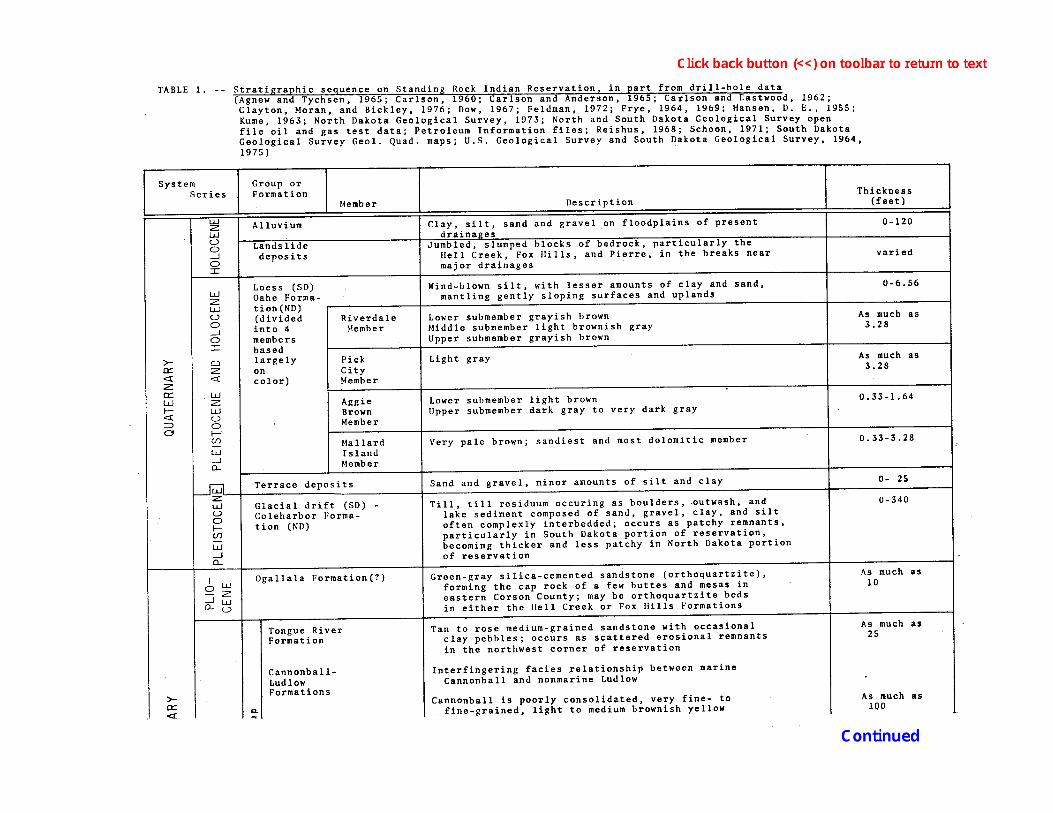
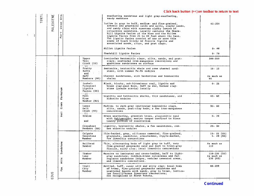
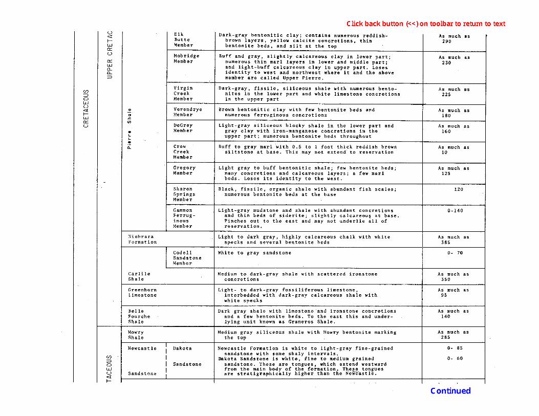
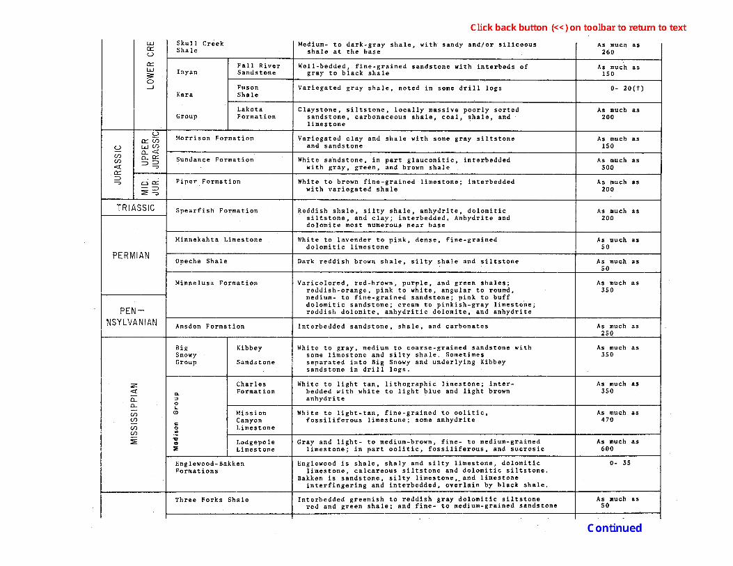
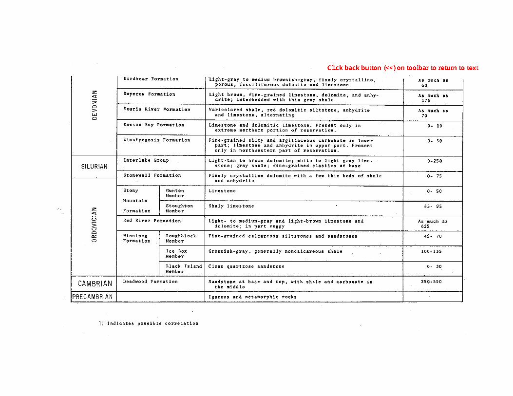
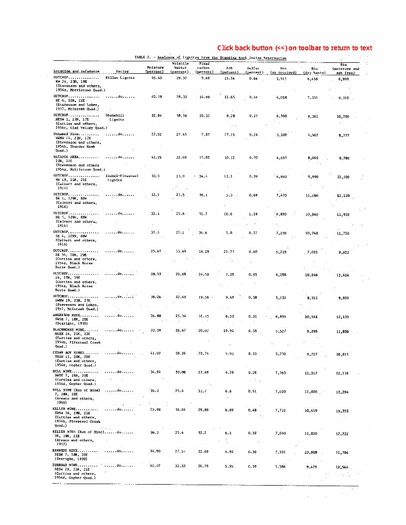
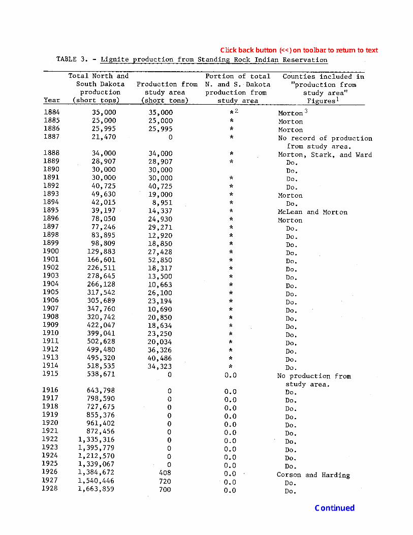
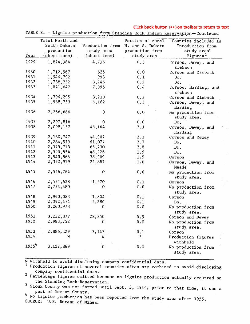
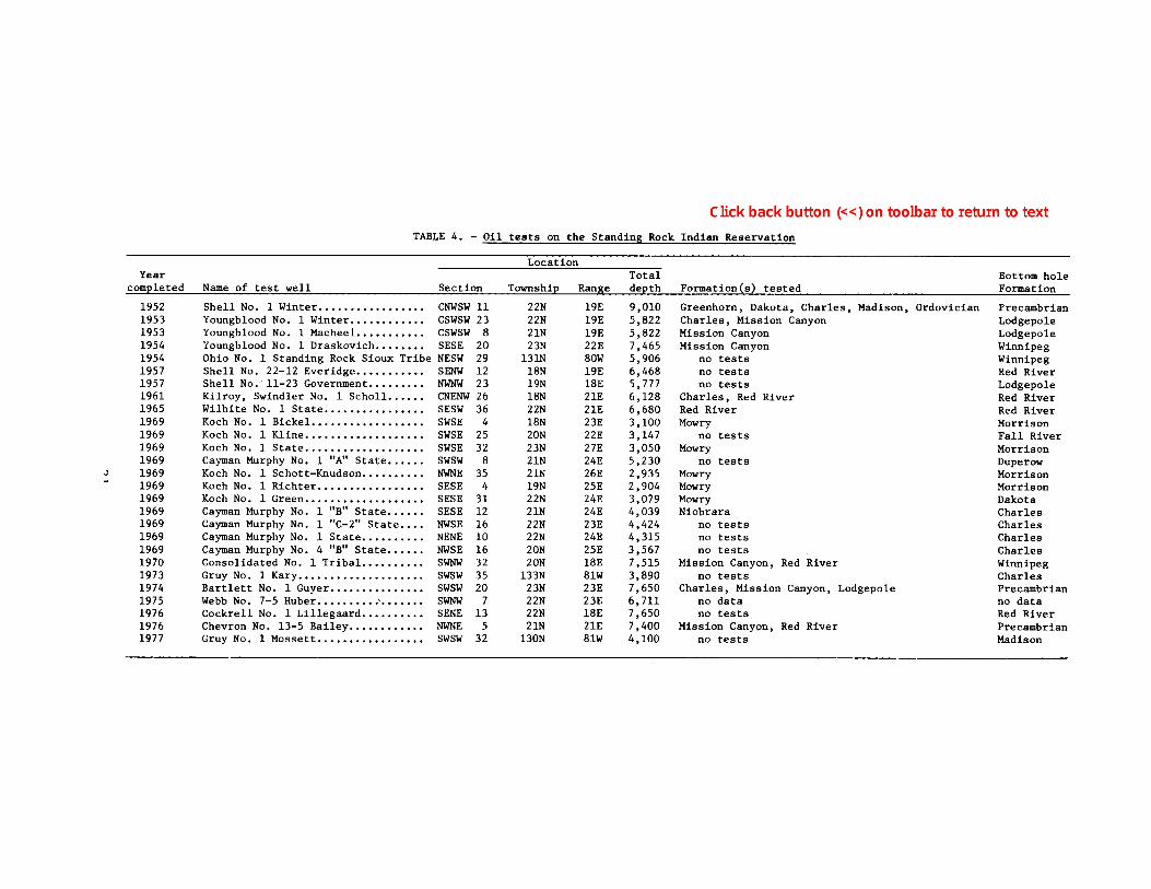
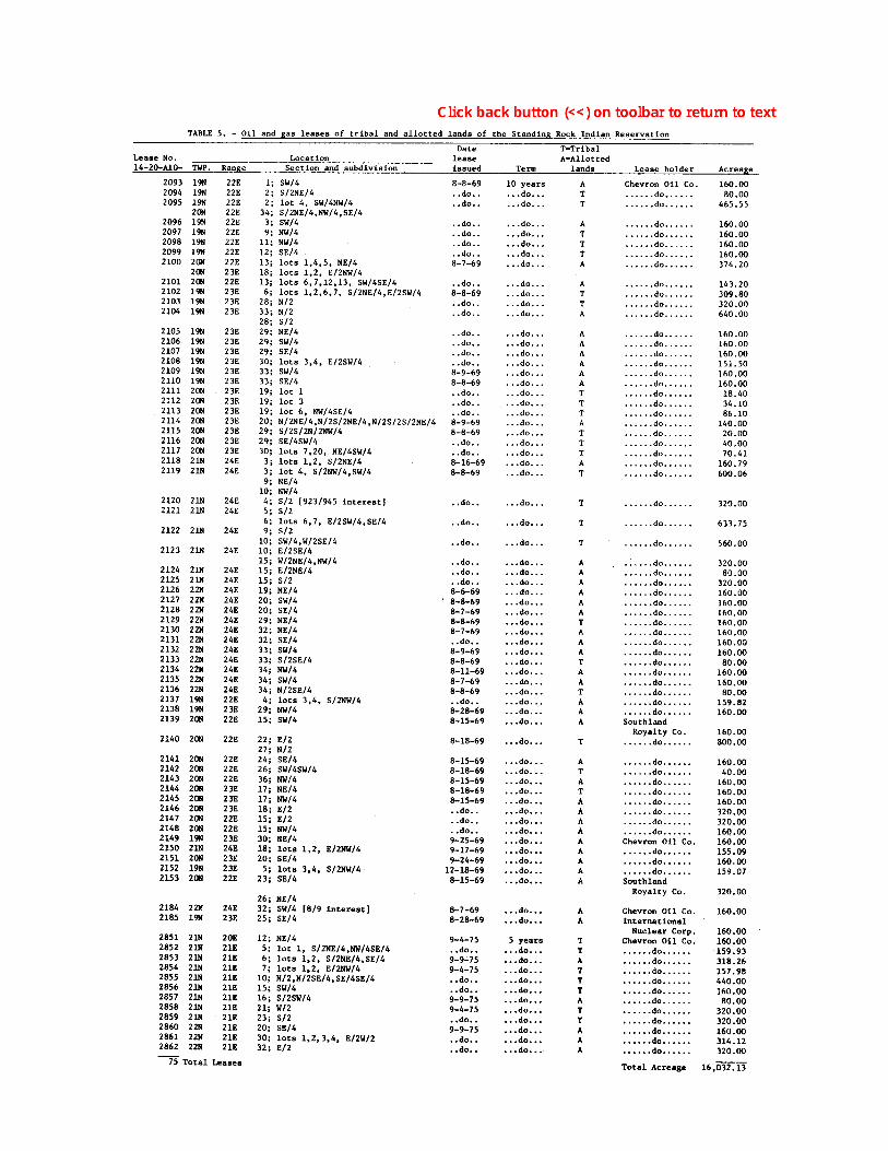
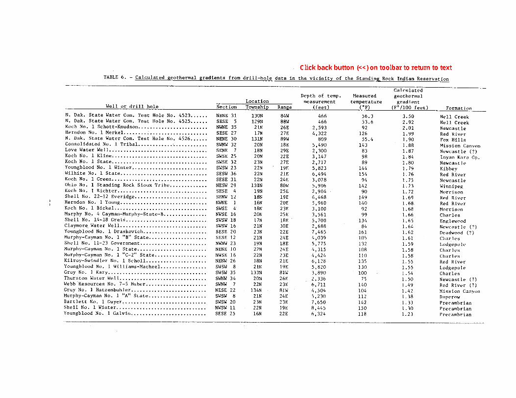
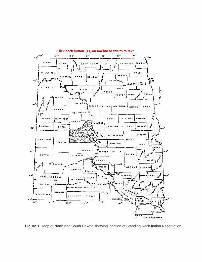
Figure 1. Map of North and South Dakota showing location of Standing Rock Indian Reservation.
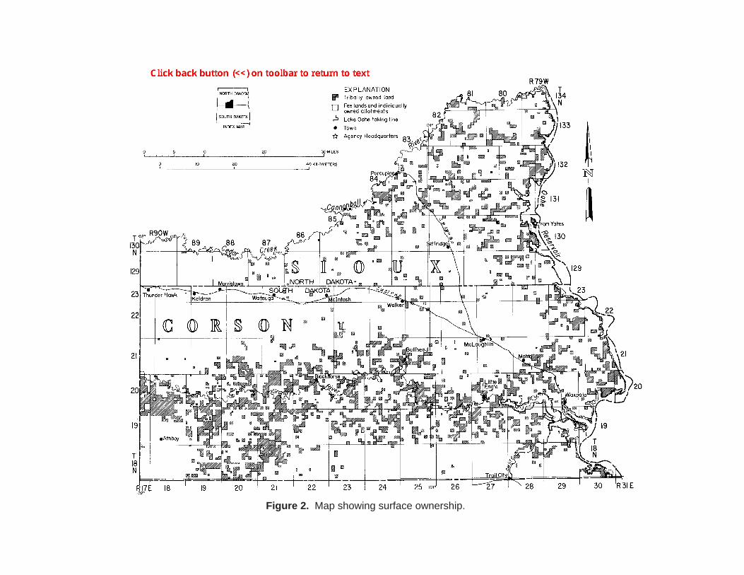
Figure 2. Map showing surface ownership.
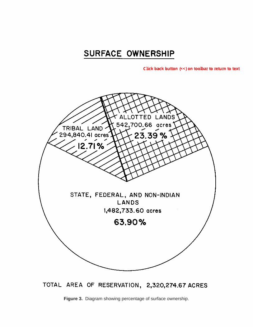
Figure 3. Diagram showing percentage of surface ownership.
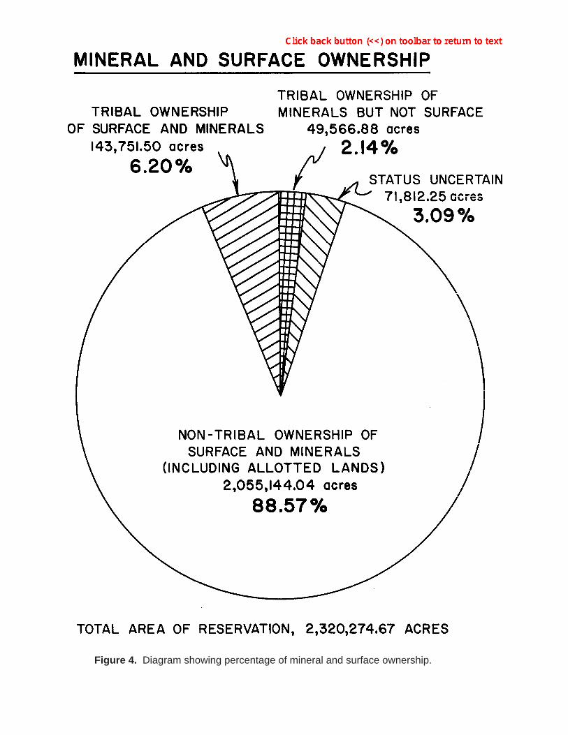
Figure 4. Diagram showing percentage of mineral and surface ownership.
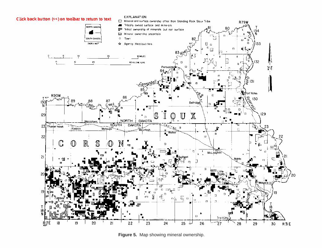
Figure 5. Map showing mineral ownership.
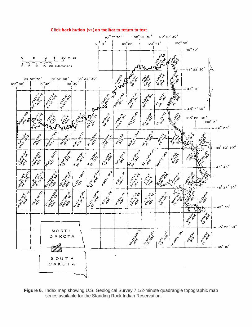
Figure 6. Index map showing U.S. Geological Survey 7 1/2-minute quadrangle topographic map series available for the Standing Rock Indian Reservation.
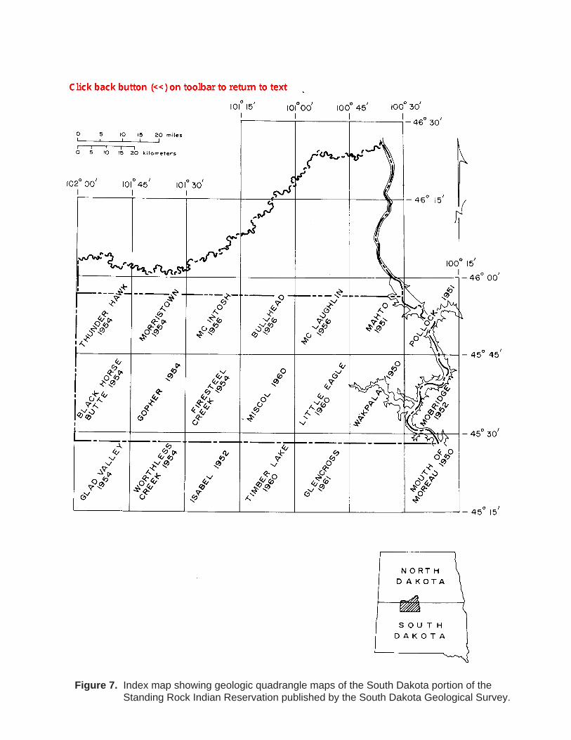
Figure 7. Index map showing geologic quadrangle maps of the South Dakota portion of the Standing Rock Indian Reservation published by the South Dakota Geological Survey.
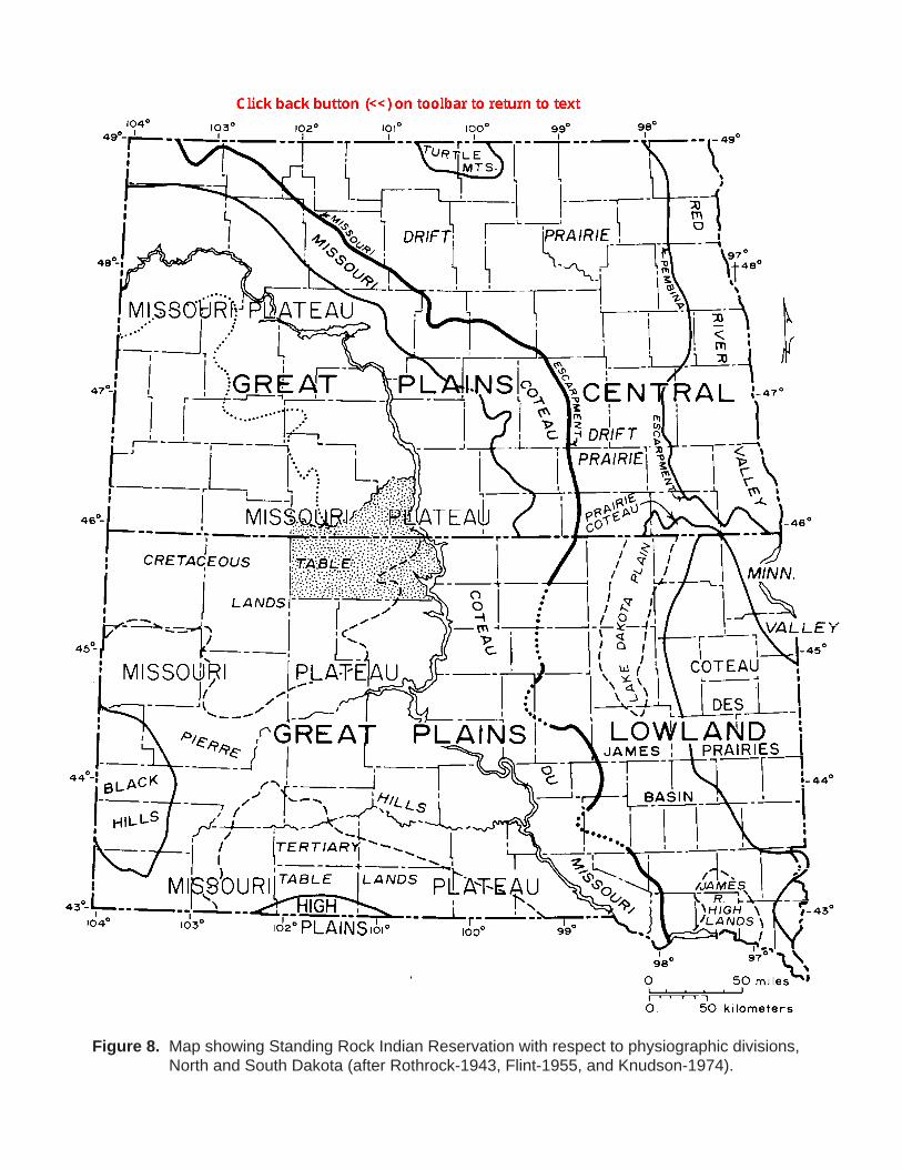
Figure 8. Map showing Standing Rock Indian Reservation with respect to physiographic divisions, North and South Dakota (after Rothrock-1943, Flint-1955, and Knudson-1974).
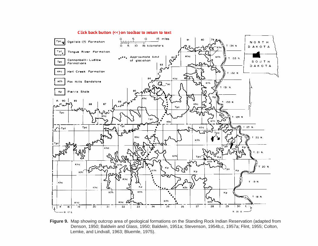
Figure 9. Map showing outcrop area of geological formations on the Standing Rock Indian Reservation (adapted from Denson, 1950; Baldwin and Glass, 1950; Baldwin, 1951a; Stevenson, 1954b,c, 1957a; Flint, 1955; Colton,
Lemke, and Lindvall, 1963; Bluemle, 1975).
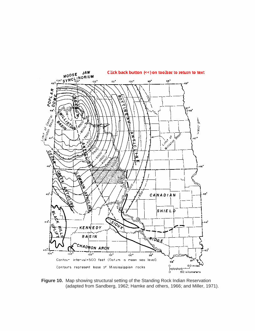
Figure 10. Map showing structural setting of the Standing Rock Indian Reservation (adapted from Sandberg, 1962; Hamke and others, 1966; and Miller, 1971).
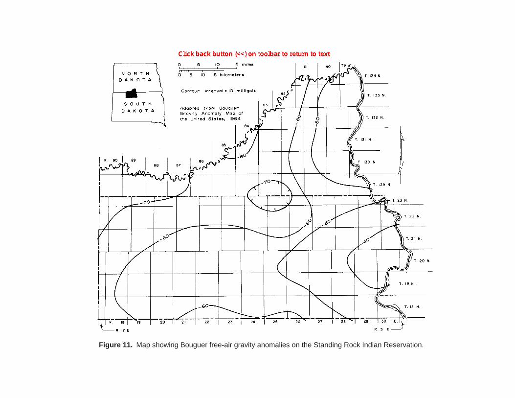
Figure 11. Map showing Bouguer free-air gravity anomalies on the Standing Rock Indian Reservation.
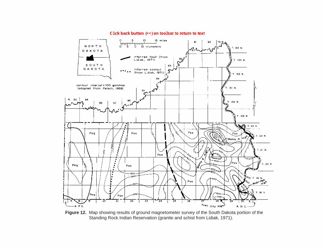
Figure 12. Map showing results of ground magnetometer survey of the South Dakota portion of the Standing Rock Indian Reservation (granite and schist from Lidiak, 1971).
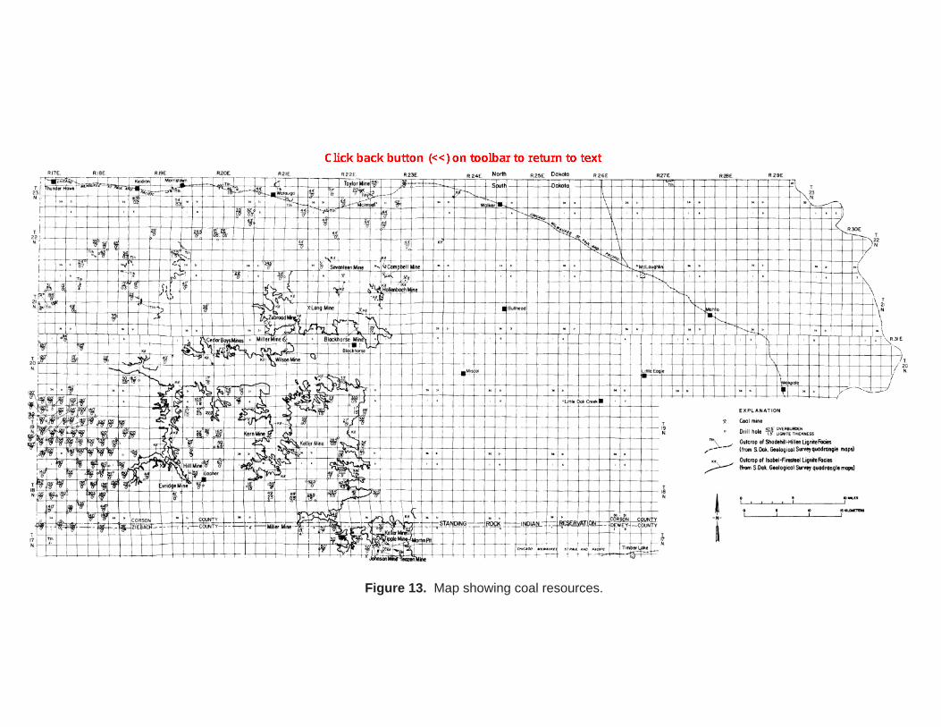
Figure 13. Map showing coal resources.
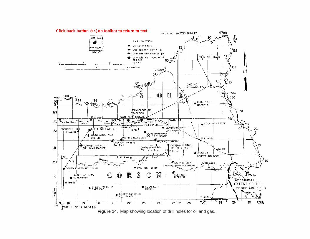
Figure 14. Map showing location of drill holes for oil and gas.
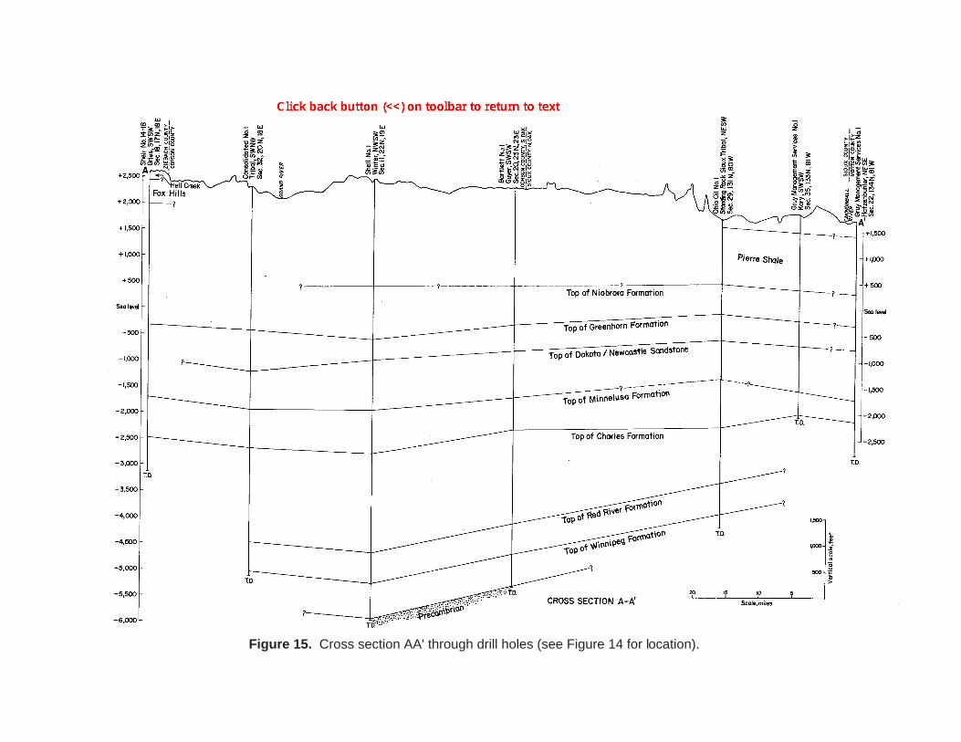
Figure 15. Cross section AA' through drill holes (see Figure 14 for location).
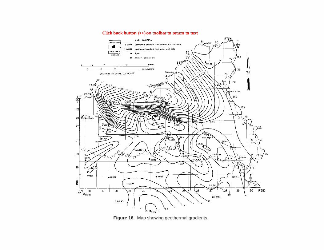
Figure 16. Map showing geothermal gradients.
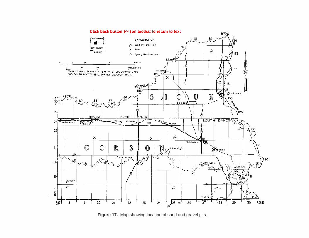
Figure 17. Map showing location of sand and gravel pits.