supplementary environmental impact statement...
TRANSCRIPT

PREPARED FORFIRST SOLAR (AUSTRALIA) PTY LTD
276 PERSEVERANCE LANE, BERYL
Beryl Solar Farm
SUPPLEMENTARY ENVIRONMENTAL IMPACT STATEMENT PERMISSIBILITY

55 MOUNTAIN STREET BROADWAY NSW ~ PO BOX 438 BROADWAY NSW 2007 ~ TELEPHONE [02] 9211 4099 FAX [02] 9211 2740 EMAIL: [email protected] ~ WEB SITE: www.bbcplanners.com.au
ABN 24 061 868 942
SUPPLEMENTARY
ENVIRONMENTAL IMPACT STATEMENT PERMISSIBILITY
BERYL SOLAR FARM
276 PERSEVERANCE LANE, BERYL Prepared for First Solar (Australia) Pty Ltd
By BBC Consulting Planners
Job 17-238
17 November 2017

Certification This supplementary report to the Environmental Impact Statement (the EIS) for the Beryl Solar Farm prepared by NGH Environment Pty Ltd dated April 2017 has been prepared to address the requirements of the Environmental Planning and Assessment Regulation 2000, concerning the current State Significant Development development application (SSD DA) for the site. This report provides an independent and expert review of the permissibility of the project, in particular that part of the proposed solar farm located on R5 Large Lot Residential zoned land under the Mid-Western Regional Local Environmental Plan 2012 (the LEP). This report should be read as a Supplementary Report to the original EIS and Submissions Report prepared by NGH Environmental Pty Ltd dated April 2017 and July 2017, respectively. A comprehensive site and locality inspection was undertaken on the 13/11/2017.
STATEMENT OF VALIDITY
Environmental Impact Statement prepared under Part 4 of the Environmental Planning and Assessment Act 1979
Prepared by: Philip Bull - Associate Director
Qualifications: Philip - BA (Syd), MUP (Melb) PIA
Address: BBC Consulting Planners 55 Mountain Street Broadway NSW 2007
Proponent: First Solar (Australia) Pty Ltd,
Proponent’s Address: First Solar (Australia) Pty Ltd, Level 3 16 Spring St, Sydney, NSW 2000 Australia www.firstsolar.com
Proposed Development: Solar Farm
Land to which the Proposed Development relates:
The Beryl Solar Farm is located on Lot 20 DP 1173059, Lot 1 DP 1012926, Lot 1 DP 190927 and Lot 1 DP 1016556, Beryl.
Declaration: Pursuant to clause 6(f), Part 3, Schedule 2 of the Environmental Planning and Assessment Regulation 2000, I declare that this addendum Environmental Impact Statement (EIS): • has been prepared in accordance with Schedule 2 of the
Environmental Planning and Assessment Regulation

STATEMENT OF VALIDITY 2000, the requirements of Part 4 of the Environmental Planning and Assessment Act 1979;
• contains all available information that is relevant to the environmental assessment of the development in term of the issue of permissibility; and
• that the information contained in this addendum EIS is neither false nor misleading.
Signature:
Philip Bull
Date: 17 November 2017
Table of Contents 1. INTRODUCTION ..............................................................................................1
1.1 Overview ........................................................................................................ 1 1.2 Documents relied on ..................................................................................... 1
2. THE SITE AND ITS CONTEXT ........................................................................3 2.1 The Site .......................................................................................................... 3 2.2 Locality ........................................................................................................... 4
3. THE PROPOSAL ..............................................................................................5 4. PLANNING CONTROLS ..................................................................................6
4.1 Environmental Planning and Assessment Act ............................................ 6 4.2 State Environmental Planning Policy (State and Regional Development)
2011 ................................................................................................................ 9 4.3 State Environmental Planning Policy (Infrastructure) 2007 ...................... 10 4.4 Mid-Western Regional Local Environmental Plan 2012 ............................ 12
4.4.1 The R5 Zoning ................................................................................................ 12 4.4.2 Large lot residential on the R5 land ................................................................ 14 4.4.3 A solar farm on the R5 Land ........................................................................... 16 4.4.4 Highest and best use of the R5 land ............................................................... 17
5. REVIEW OF DPE ASSESSMENT REPORT .................................................. 18 5.1.1 The availability of R5 land ............................................................................... 18 5.1.2 impacts on the rural character of the locality .................................................. 22 5.1.3 Inconsistency with the LEP and Infrastructure SEPP ..................................... 23 5.1.4 General merit observations of use of the R5 land .......................................... 23 5.1.5 The appropriateness of the land use .............................................................. 24
6. CONCLUSION ................................................................................................ 25

FIGURES Figure 1: Location Figure 2: Site Figure 3A: Aerial Photo Figure 3B: Aerial Photo – Wider Area Figure 4A: Zoning Map – Mid-Western Regional LEP 2012 Figure 4B: Ground Water Map – Mid-Western Regional LEP 2012 Figure 4C: Lot Size Map – Mid-Western Regional LEP 2012 Figure 4D: Heritage Map – Mid-Western Regional LEP 2012 Appendix 1: 2017 Land Use Strategy - Gulgong rural lifestyle opportunities map
Page | 1
1. INTRODUCTION 1.1 Overview This Supplementary Report has been prepared to accompany a SSD DA lodged pursuant to Part 4 of the Environmental Planning and Assessment Act 1979 (“the Act”), for a Solar Farm at 276 Perseverance Lane, Beryl. The objective of this Report is provide an independent review of the proposal’s permissibility and appropriateness on the land on statutory planning grounds. The proposal has been through the necessary regulatory tests to progress to a complete SSD DA e.g. SEARs and community consultation. The proposal has been assessed and reported to the NSW Planning Assessment Commission (PAC) for its meeting of 21 November 2017. The proposal is undetermined. The Assessment Report for the proposal prepared by officers of the NSW Department of Planning and Environment dated October 2017 generally supports the proposal and its environmental impacts, other than a concern raised about the permissibility of a solar farm of this size on the part of the site zoned R5 Large Lot Residential under the LEP. The reasons given for exclusion of the R5 land from the recommended consent are that the proposed development:
• will reduce the amount of R5 land that is available for large lot residential development;
• may increase potential impacts on the rural character of the locality, and
• is inconsistent with the provisions of the LEP and the State Environmental Planning Policy (Infrastructure) 2017.
The Assessment Report recommends part approval of the proposal. Consent is not recommended for a solar farm on the R5 land. The exclusion of the R5 land from the approval would reduce the electricity generating capacity of the Beryl solar farm from ~87MW to ~74MW per annum. A reduction in capacity of ~13MW or 15%.
1.2 Documents relied on Andrew Neil 2003: Rural Residential, Industrial and Residential Strategy (the 2003 Residential
Strategy) http://www.midwestern.nsw.gov.au/council/council-documents/Strategies/Rural-Residential-Industrial-and-Residential-Strategy/
Edge Rural and Environmental Planning Consultants 2003: Mudgee Shire Rural Lands Study
(the 2003 Rural Strategy) http://www.midwestern.nsw.gov.au/council/council-documents/Strategies/Rural-Residential-Industrial-and-Residential-Strategy/
Footprint Sustainable Engineering Pty Ltd 31 August 2017: Proposed Solar Farm, Beryl New
South Wales Hydrological and Hydraulic Analysis (the Flood Report).

Page | 2
https://majorprojects.accelo.com/public/686942625dfde20edc8328232878cc2a/02.%20Beryl%20Solar%20-%20Assessment%20Report%20-%20Appendix%20F%20-%20Additional%20Information.pdf
NGH Environment Pty Ltd April 2017: Environmental Impact Statement for the Beryl Solar
Farm (the EIS) https://majorprojects.accelo.com/public/65a79662f3131e2470831ef0e66ebfca/01.%20Beryl%20Solar%20EIS%20-%20Main%20Report.pdf
NGH Environmental Pty Ltd July 2017: Submissions Report (the Submission Report) https://majorprojects.accelo.com/public/8330eba56adba27dbcf1af9321fcfdb5/01.%20Beryl%20Solar%20RTS%20-%20Main%20Report.pdf
NGH Environmental Pty Ltd August 2017: Landscape Management Strategy (the Landscape
Strategy) https://majorprojects.accelo.com/public/686942625dfde20edc8328232878cc2a/02.%20Beryl%20Solar%20-%20Assessment%20Report%20-%20Appendix%20F%20-%20Additional%20Information.pdf
NSW Department of Planning and Environment October 2017: State Significant Development
Assessment Beryl Solar Project (SSD 8183) Assessment Report (the Assessment Report). https://majorprojects.accelo.com/public/bf9d00a9947280b0d731922bca0ace61/01.%20Beryl%20Solar%20-%20Assessment%20Report.pdf
Parsons Brinckerhoff Australia Pty Limited Revision E (February 2017): Mid-Western Regional Comprehensive Land Use Strategy (the 2017 Land Use Strategy) http://www.midwestern.nsw.gov.au/council/council-documents/Strategies/Draft-Comprehensive-Land-Use-Strategy/
Preston NSW Land and Environment Court of NSW in Taralga Landscape Guardians Inc v Minister for Planning and RES Southern Cross Pty Ltd [2007] NSWLEC 59 https://www.caselaw.nsw.gov.au/decision/549f99533004262463b0dde4
Page | 3
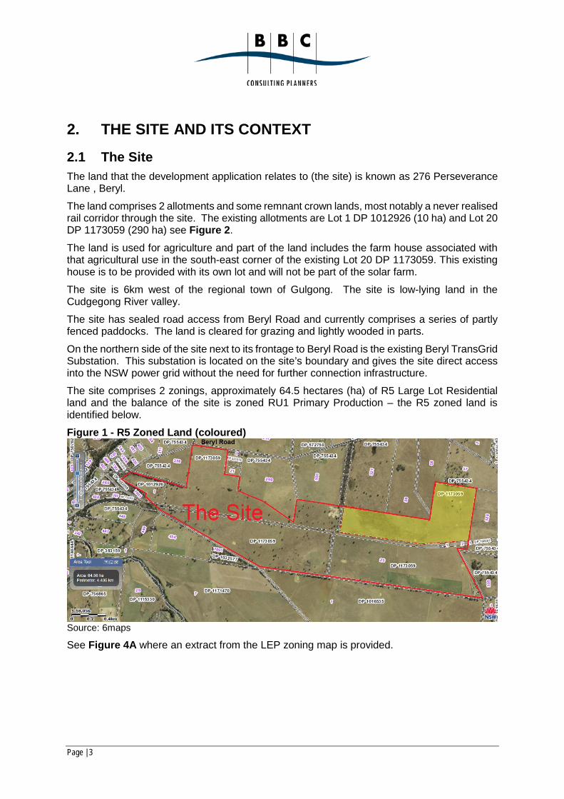
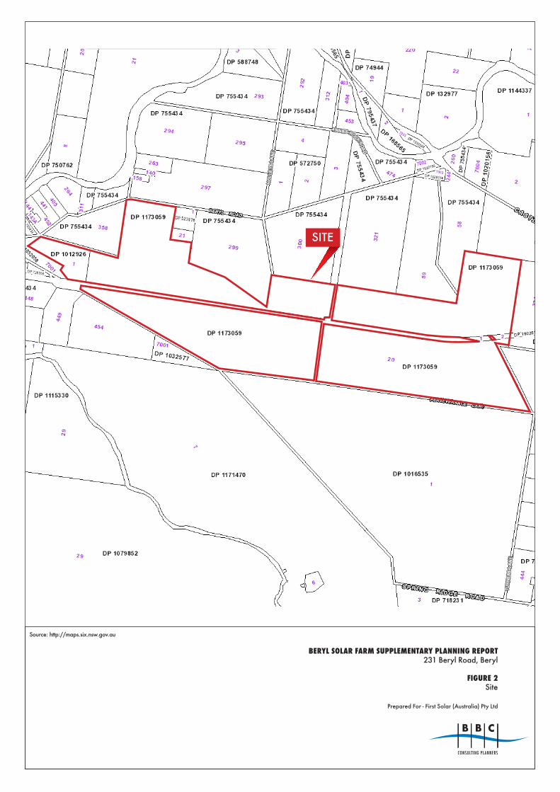
2. THE SITE AND ITS CONTEXT 2.1 The Site The land that the development application relates to (the site) is known as 276 Perseverance Lane , Beryl. The land comprises 2 allotments and some remnant crown lands, most notably a never realised rail corridor through the site. The existing allotments are Lot 1 DP 1012926 (10 ha) and Lot 20 DP 1173059 (290 ha) see Figure 2. The land is used for agriculture and part of the land includes the farm house associated with that agricultural use in the south-east corner of the existing Lot 20 DP 1173059. This existing house is to be provided with its own lot and will not be part of the solar farm. The site is 6km west of the regional town of Gulgong. The site is low-lying land in the Cudgegong River valley. The site has sealed road access from Beryl Road and currently comprises a series of partly fenced paddocks. The land is cleared for grazing and lightly wooded in parts. On the northern side of the site next to its frontage to Beryl Road is the existing Beryl TransGrid Substation. This substation is located on the site’s boundary and gives the site direct access into the NSW power grid without the need for further connection infrastructure. The site comprises 2 zonings, approximately 64.5 hectares (ha) of R5 Large Lot Residential land and the balance of the site is zoned RU1 Primary Production – the R5 zoned land is identified below. Figure 1 - R5 Zoned Land (coloured)
Source: 6maps
See Figure 4A where an extract from the LEP zoning map is provided.

Page | 4
2.2 Locality The site is in a Central West of NSW approximately 6km west of the township of Gulgong in the Mid-Western Regional Council local government area. The locality is characterised by agricultural uses interspersed with some large lot residential development. Illustrative figures demonstrating the site’s locality, dimensions and core local planning controls are attached. In general, this report adopts the site and locality descriptions in the current EIS reporting for the proposal.

Page | 5
3. THE PROPOSAL The proposal is for the construction, operation and decommissioning of the Beryl Solar Farm. The farm is to harvest solar energy to generate electricity via solar arrays mounted on piers. The arrays would have a maximum height of 3m at the extent of their operating range of rotation. A series of associated site works, and infrastructure is proposed, connecting wiring and a separate and smaller substation behind the existing TransGrid substation and a new Essential Energy substation unrelated to the proposal which is currently under construction. The solar farm is to have a capacity to generate up to 87MWac of electricity for injection into the NSW grid. The solar farm infrastructure has a life of 30 years and the proposal includes details of how the farm would be decommissioned. Nevertheless, the consent sought is not a time limited consent and when the life of the current infrastructure is reached (30 years) the solar farm will either be decommissioned, and the land made available for an alternate use or the solar infrastructure renewed. The site is an amalgamation of 2 lots (Lot 1 DP 1012926 and Lot 20 DP 1173059) and the consolidation of remanent crown land within the boundaries of these lots. The proposal also includes a land subdivision, whereby the balance of the land is consolidated into a single lot of approximately 320 hectares to be the site of the solar farm and a separate lot of 12 ha created for the existing house on the site (this lot is not part of the solar farm). The current proposal is as described in the Submission Report prepared by NGH Environment Pty Ltd dated July 2017.
Page | 6
4. PLANNING CONTROLS 4.1 Environmental Planning and Assessment Act Section 89E(3) of Environmental Planning and Assessment Act (the EPA Act) allows the Minister to approve a part prohibited State Significant Development (SSD) Development Application (DA) noting that the site includes R5 zoned land where a solar farm of this scale is a prohibited use under the LEP. The relevant provisions of the EPA Act are provided below (our emphasis added):
“89E Consent for State significant development
(1) The Minister is to determine a development application in respect of State significant development by:
(a) granting consent to the application with such modifications of the proposed development or on such conditions as the Minister may determine, or
(b) refusing consent to the application.
Note. Section 380AA of the Mining Act 1992 provides that an application in respect of State significant development for the mining of coal can only be determined if it is made by or with the consent of the holder of an authority under that Act in respect of coal and the land concerned.
(2) Development consent may not be granted if the development is wholly prohibited by an environmental planning instrument.
(3) Development consent may be granted despite the development being partly prohibited by an environmental planning instrument.
(4) If part of a single proposed development that is State significant development requires development consent to be carried out and the other part may be carried out without development consent:
(a) Part 5 does not apply to that other part of the proposed development, and
(b) that other part of the proposed development is taken to be development that may not be carried out except with development consent.
(5) A development application in respect of State significant development that is wholly or partly prohibited may be considered in accordance with Division 4B of Part 3 in conjunction with a proposed environmental planning instrument to permit the carrying out of the development. The Secretary may (despite anything to the contrary in section 54) undertake the functions of the relevant planning authority under Part 3 for a proposed instrument if it is initiated for the purpose of permitting the carrying out of the development (whether or not it contains other provisions).
(6) If the determination under section 56 (Gateway determination) for a planning proposal declares that the proposed instrument is principally concerned with permitting the carrying out of State significant development that would otherwise be wholly prohibited:
(a) the proposed instrument may be made only by the Planning Assessment Commission under a delegation from the Minister, and

Page | 7
(b) the development application for the carrying out of that development may be determined only by the Planning Assessment Commission under a delegation from the Minister.
The site’s planning framework is hierarchical in as much as the provisions of the EPA Act supersede those of relevant SEPPs, as do the provisions of SEPPs supersede those of relevant LEPs and associated Environmental Planning Instruments (EPIs). The concept of the site’s statutory hierarchy is a crucial concept in this instance as the proposal’s permissibility and environmental performance is determined within that hierarchy and the proposal is made under an empowering EPI, where the purpose of that EPI is to supersede local planning controls in preference for State planning controls. The site’s planning hierarchy also layers and prioritises the environmental assessment of the proposal, in as much as policy objectives of the Act and higher-level EPIs supersede those of lower level and less relevant EPIs. In this instance the proposal is made as a SSD DA under the State Environmental Planning Policy (State and Regional Development) 2011 (the State and Regional Development SEPP). The primary planning consideration in this instance is the State significant benefits of the project. The objects of the Act are (relevant objects our emphasis added):
“5 Objects The objects of this Act are: (a) to encourage:
(i) the proper management, development and conservation of natural and artificial resources, including agricultural land, natural areas, forests, minerals, water, cities, towns and villages for the purpose of promoting the social and economic welfare of the community and a better environment,
(ii) the promotion and co-ordination of the orderly and economic use and development of land,
(iii) the protection, provision and co-ordination of communication and utility services,
(iv) the provision of land for public purposes, (v) the provision and co-ordination of community services and facilities, and (vi) the protection of the environment, including the protection and
conservation of native animals and plants, including threatened species and ecological communities, and their habitats, and
(vii) ecologically sustainable development, and (viii) the provision and maintenance of affordable housing, and
(b) to promote the sharing of the responsibility for environmental planning between the different levels of government in the State, and
Page | 8
(c) to provide increased opportunity for public involvement and participation in environmental planning and assessment.”
In terms of object 5(a) (i) of the Act, the expert evidence provided in the EIS has demonstrated that the proposed solar farm has an acceptable impact on its natural environment. It is acknowledged that the use alienates the site from its current agricultural use for at least 30 years; however, the solar farm will still allow for some incidental grazing over the land and its long-term effect on the agricultural potential of the land is potentially positive. The operation of the solar farm does not degrade the land (indeed it allows the land to lay fallow during operation of the solar farm) and when or if the solar farm is decommissioned the agricultural potential of the land is likely to be enhanced. More importantly, the use directly addresses the broader intent of this object by ‘promoting the social and economic welfare of the community and a better environment’ via the generation of sustainable renewable energy. In terms of object 5(a) (ii) of the Act, a solar farm in this location takes advantage of the adjoining TransGrid substation and existing electricity infrastructure that allows direct transmission of the electricity generated into the NSW power grid. The proximity to the existing infrastructure mitigates the impact of the development. Given the location and nature of the use proposed, the proposal supports the orderly and economic use and development of the land. In terms of object 5(a) (vi), as stated the proposed use of the site as a solar farm in part allows the existing agricultural land to lay fallow relative to the current and typical usage during the operation of the solar farm. The EIS identified the land as containing some small areas of modified native woodland. The landscape strategy for the land seeks to retain areas of quality vegetation and mitigation measures are included in the proposal to reduce biodiversity impacts of the proposal. Any areas of existing native woodland that were deemed to be of high quality have been avoided by the proposal and will be protected in perpetuity by the establishment of biodiversity offset areas. The use of the land for a solar farm will have an acceptable impact on the land in terms of the protection of the environment, including the protection and conservation of native animals and plants, including threatened species and ecological communities, and their habitats. In terms of object 5(a) (vii), the proposal provides renewable solar energy into the NSW power grid. As stated in the EIS (see Proposal Need and Benefits page xv of the Executive Summary), the proposal will help implement a variety of Federal and State government policy commitments to reduce greenhouse gas emissions, assists with the transition from fossil fuel to cleaner electricity generation and contributes towards satisfaction of NSW Government’s Renewable Energy Action Plan. A core purpose of the project is the promotion of ecologically sustainable development. The proposal is fully compliant with the relevant objects of the Act and the use of Section 89E(3) of the Act is warranted on policy grounds to facilitate this project.

Page | 9
4.2 State Environmental Planning Policy (State and Regional Development) 2011
The State and Regional Development SEPP, noting relevant provision of the SEPP provided below:
8 Declaration of State significant development: section 89C
(1) Development is declared to be State significant development for the purposes of the Act if:
(a) the development on the land concerned is, by the operation of an environmental planning instrument, not permissible without development consent under Part 4 of the Act, and
(b) the development is specified in Schedule 1 or 2.
In terms of schedule 1, the development is electricity generating works: Schedule 1
20 Electricity generating works and heat or co-generation
Development for the purpose of electricity generating works or heat or their co-generation (using any energy source, including gas, coal, biofuel, distillate, waste, hydro, wave, solar or wind power) that:
(a) has a capital investment value of more than $30 million, or
(b) has a capital investment value of more than $10 million and is located in an environmentally sensitive area of State significance.
The project has a capital investment value of $171,000,000.00. It is noted the State and Regional Development SEPP further clarifies the assessment hierarchy for the proposal, specifically excluding DCPs from consideration in the assessment of SSD DAs:
11 Exclusion of application of development control plans
Development control plans (whether made before or after the commencement of this Policy) do not apply to:
(a) State significant development, or
(b) development for which a relevant council is the consent authority under section 89D (2) of the Act.
The aims of the State and Regional Development SEPP are: 3 Aims of Policy
The aims of this Policy are as follows:
(a) to identify development that is State significant development,
(b) to identify development that is State significant infrastructure and critical State significant infrastructure,

Page | 10
(c) to confer functions on joint regional planning panels to determine development application
While broad, the above aims reinforce the focus provided by the Act in terms of the assessment of this proposal on ‘State significant’ criteria. The proposal is SSD and satisfies the provisions and aims of the State and Regional Development SEPP.
4.3 State Environmental Planning Policy (Infrastructure) 2007 The relevant provision of the State Environmental Planning Policy (Infrastructure) 2007 (the Infrastructure SEPP) are provided below (our emphasis added):
34 Development permitted with consent
(1) Development for the purpose of electricity generating works may be carried out by any person with consent on any land in a prescribed rural, industrial or special use zone.
(2) Development for the purpose of a back-up electricity generating plant that operates for not more than 200 hours in any year may be carried out by any person with consent on any land.
(2A) Development for the purpose of the expansion of existing electricity generating works may be carried out by or on behalf of a public authority with consent on any land that is adjacent to the existing works.
(2B) Consent is not required to carry out any such development on land if the development could, but for subclause (2A), be carried out on that land without consent.
(3) Development for the purpose of, or resulting in, a change of fuel source of an existing coal or gas fired generating works by a proportion of more than 5 per cent in any 12 month period may only be carried out with consent.
(4) If, under any environmental planning instrument (including this Policy), development for the purpose of:
(a) industry, or
(b) a waste or resource management facility,
may be carried out on land with consent, development for the purpose of electricity generating works that generate energy from waste, or from gas generated by waste, may also be carried out by any person with consent on that land.
(5) Without limiting subclause (1), development for the purpose of a small wind turbine system may be carried out by any person with consent on any land.
(6) However, subclause (5) only applies in relation to land in a prescribed residential zone if:
(a) the small wind turbine system has the capacity to generate no more than 10kW, and

Page | 11
(b) the height of any ground-mounted small wind turbine in the system from ground level (existing) to the topmost point of the wind turbine is no more than 18m.
(7) Solar energy systems Except as provided by subclause (8), development for the purpose of a solar energy system may be carried out by any person with consent on any land.
(8) Development for the purpose of a photovoltaic electricity generating system may be carried out by a person with consent on land in a prescribed residential zone only if the system has the capacity to generate no more than 100kW.
A prescribed rural, industrial or special use zone under the Infrastructure zone is (our emphasis added):-
prescribed rural, industrial or special use zone means any of the following land use zones or a land use zone that is equivalent to any of those zones:
(a) RU1 Primary Production, (b) RU2 Rural Landscape,
(c) RU3 Forestry,
(d) RU4 Primary Production Small Lots,
(e) IN1 General Industrial,
(f) IN2 Light Industrial,
(g) IN3 Heavy Industrial,
(h) IN4 Working Waterfront,
(i) SP1 Special Activities,
(j) SP2 Infrastructure.
The majority of the site is zoned RU1 and is being used for electricity generating works in accordance with the Infrastructure SEPP. The R5 Large Lot Residential land is a prescribed residential zone under the Infrastructure SEPP. The Infrastructure SEPP does not prohibit electricity generation on residential land, as it also provides for specific provisions for electricity generation works with capacity of up to 100kW on residential land. The application is not lodged under the Infrastructure SEPP. This SEPP is a consideration in the assessment of the DA and the provisions for electricity generation on residential land are not a prohibition on greater electricity generation on the R5 land when the proposal is made as SSD. The aims of the Infrastructure SEPP are:
2 Aim of Policy
The aim of this Policy is to facilitate the effective delivery of infrastructure across the State by:

Page | 12
(a) improving regulatory certainty and efficiency through a consistent planning regime for infrastructure and the provision of services, and
(b) providing greater flexibility in the location of infrastructure and service facilities, and
(c) allowing for the efficient development, redevelopment or disposal of surplus government owned land, and
(d) identifying the environmental assessment category into which different types of infrastructure and services development fall (including identifying certain development of minimal environmental impact as exempt development), and
(e) identifying matters to be considered in the assessment of development adjacent to particular types of infrastructure development, and
(f) providing for consultation with relevant public authorities about certain development during the assessment process or prior to development commencing
The proposal is consistent with the aims of the Infrastructure SEPP and the solar farm furthers the aims of certainty, efficiency and flexibility in terms of the provision of electricity infrastructure as articulated in the SEPP. Or to put the proposition differently, to exclude the R5 land from the proposed solar farm based on the Infrastructure SEPP’s provision would not achieve the aims of the SEPP.
4.4 Mid-Western Regional Local Environmental Plan 2012
4.4.1 The R5 Zoning The zone objectives and range of permissible land uses in the R5 Large Lot Residential is provided below:
Zone R5 Large Lot Residential
1 Objectives of zone
• To provide residential housing in a rural setting while preserving, and minimising impacts on, environmentally sensitive locations and scenic quality.
• To ensure that large residential lots do not hinder the proper and orderly development of urban areas in the future.
• To ensure that development in the area does not unreasonably increase the demand for public services or public facilities.
• To minimise conflict between land uses within this zone and land uses within adjoining zones.
2 Permitted without consent
Extensive agriculture; Home-based child care; Home businesses; Home occupations; Roads; Water reticulation systems
3 Permitted with consent
Page | 13
Aquaculture; Bed and breakfast accommodation; Cellar door premises; Dual occupancies; Dwelling houses; Garden centres; Home industries; Intensive plant agriculture; Landscaping material supplies; Markets; Neighbourhood shops; Plant nurseries; Roadside stalls; Secondary dwellings; Serviced apartments; Waste or resource transfer stations; Water recycling facilities; Any other development not specified in item 2 or 4
4 Prohibited
Advertising structures; Agriculture; Air transport facilities; Airstrips; Amusement centres; Animal boarding or training establishments; Boarding houses; Boat building and repair facilities; Boat launching ramps; Boat sheds; Car parks; Cemeteries; Charter and tourism boating facilities; Commercial premises; Correctional centres; Crematoria; Dairies (pasture-based); Electricity generating works; Entertainment facilities; Environmental facilities; Exhibition homes; Exhibition villages; Forestry; Freight transport facilities; Function centres; Heavy industrial storage establishments; Helipads; Highway service centres; Home occupations (sex services); Industrial retail outlets; Industrial training facilities; Industries; Jetties; Marinas; Mooring pens; Moorings; Mortuaries; Passenger transport facilities; Public administration buildings; Recreation facilities (indoor); Recreation facilities (major); Registered clubs; Research stations; Residential accommodation; Restricted premises; Rural industries; Service stations; Sex services premises; Storage premises; Tourist and visitor accommodation; Transport depots; Truck depots; Vehicle body repair workshops; Vehicle repair stations; Veterinary hospitals; Warehouse or distribution centres; Waste or resource management facilities; Water recreation structures; Water supply systems; Water treatment facilities; Wharf or boating facilities
Under the LEP the works are defined as ‘electricity generating works’ which is prohibited in the R5 zone and defined as
electricity generating works means a building or place used for the purpose of making or generating electricity.
As noted, small scale electricity generation works up to 100kW is permissible under the Infrastructure SEPP, superseding the above local prohibition, in the R5 zone. The proposal conflicts with the first 2 housing based objectives of the R5 zone in the short to medium term as the solar farm will displace the future use of the R5 for rural lifestyle purposes. Once decommissioned though, there is no reason the site could not be used for residential purposes. The proposal is considered to satisfy the last 2 zone objectives concerning demand for public services and conflict between adjoining land uses. Indeed, the proposal makes a significant contribution to local services by generating electricity and provides a desirable buffer between small lot residential land to the north and agricultural land to the south. The proposal in part conflicts with the R5 zone housing objectives and furthers other R5 zone objectives. The proposal also provides for the creation of a new residential lot that is separated from the solar farm and maintains the residential capacity of the land.

Page | 14
The R5 land to be used as part of the solar farm is not currently functioning as large lot residential land. There are no houses or subdivisions in place for this land. The solar farm use will not alienate the use of this land for residential purposes as it has not yet taken up its R5 use. Also, as with the agricultural function of the land on the other parts of the site, the solar farm sits lightly on the land and can be decommissioned, and the land used for other purposes. As noted, under the Act electricity generation works are permissible with consent as part of a SSD DA and the use of the R5 zoned land within the proposal is a merit issue.
4.4.2 Large lot residential on the R5 land The part of the site zoned R5 comprises approximately 64.5 ha. The principal control for the development of R5 land is a minimum lot size requirement of 12 ha. A subdivision of this land would require development consent and a merit assessment of an appropriately made DA. Nominally the land could produce 5 residential lots; however, given the flooding constraints of the land a 4 lot subdivision is considered more likely as described below. The R5 land has an ephemeral water course on it and is part flood prone. The location of that water course and flood plain is shown in the below extract from the site’s Flood Report. Figure 2 - Flood Mapping

Page | 15
Source: Footprint Sustainable Engineering August 2017: Proposed Solar Farm, Beryl New South Wales Hydraulic Analysis
The flood levels in the above flood plain are estimated to reach up to 500mm deep for the 1 in 5 year flood event. On inspection of this part of the site, the areas where water ponds are discernible via changes in ground cover as illustrated in the below photograph (the areas susceptible to ponding have darker ground cover). It was also observed that a significant section of farm fencing had been knocked down adjacent to an existing culvert, likely due to flowing water of material volume. Photo 1 - View of R5 zoned land
Source: site visit 13/11/2017
This part of the site is constrained, and a preliminary analysis based on flooding potential only would indicate lot sizes would have to be slightly larger than the 12 ha minimum to allow for reasonable areas of land on each lot for home sites. A potential 4 lot subdivision is illustrated overleaf.

Page | 16
Figure 3 - Potential Subdivision
Source: BBC and Nearmaps
It should also be noted that this land is not serviced, and each lot would have to provide its own on-site waste treatment, water services and seek power and telecommunications connections to adjoining infrastructure. It is understood that one property directly to the north had an electricity connection cost more than $75,000 quoted by the supplier. Vehicular access to the properties would also need to be established. The optimal residential use of the land is likely to be for 4-5 lots each with either a dwelling house or dual occupancy on it. The potential residential occupancy of the land would be approximately 5-10 households. Given the average household occupancy of 2.4 persons for the Gulgong area in the 2016 census, this would equate to accommodation for 12 to 24 persons.
4.4.3 A solar farm on the R5 Land The use of the R5 land for solar energy production would produce ~13MW of electricity on. In year 1 the R5 land could produce 33,000 MWh - equivalent to the electricity needs of 3700 average NSW homes. The R5 land could displace 24,900 metric tons each year of carbon dioxide emissions - equivalent to taking 6725 cars of the road. For example, at the 2016 census the Mudgee urban area comprises 4,962 dwellings and Gulgong 925. The potential electricity generated by the R5 land could power Gulgong and its hinterland or most of Mudgee’s needs. The use of the site for electricity generation is also not affected by the site’s flooding constraint, as the solar arrays are elevated above the 500mm flood level and allow for the movement of

Page | 17
water across the site. The operation also does not present an environmental risk to transient flood waters in the same way that domestic septic systems may. The use of the R5 land provides a buffer between existing R5 land to the north and east of the site and agricultural land to the south. Rural lifestyle uses often create conflict for adjoining working farms. The solar farm would also provide for a landscape plan for the entire site and management of the land.
4.4.4 Highest and best use of the R5 land The use of the land for a solar farm provides for a higher environmental benefit, is more suited to the constraints and opportunities of the land (noting the location of TransGrid substation) and provides for less environmental risk to the land and locality than use of this land for rural lifestyle purposes. A solar farm will provide for consistent environmental management, no risk in terms of domestic waste management overflow during flood events and reduced conflict with adjoining agricultural uses. Use of the land for a solar farm provides for National, State and local environmental benefits whereas use of the land for rural lifestyle purposes provides for dubious local benefits only.
Page | 18
5. Review of DPE Assessment Report The Assessment Report takes the position that the local R5 zone requirements should take precedence over the SSD policy requirements and therefore the R5 land should be excluded from the proposed solar farm. The basis of this decision is articulated in the Assessment Report and the reasons provided are reviewed below.
5.1.1 The availability of R5 land The Assessment Report contends that the proposed solar farm will reduce the amount of R5 land that is available for large lot residential development and that this is a planning reason to exclude this part of the site from the proposed solar farm. In this regard, the 2003 Rural Lands Study and 2003 Rural Residential Strategy and the more recent 2017 Land Use Strategy have been reviewed (see references Section 1.2 of this report). In the Gulgong locality large lot residential living (rural lifestyle land) emerged as a land use in the 1970s (often on marginal agricultural land). The creation of this type of subdivision created social and environmental issues for the occupants and servicing difficulties for those lots. Nevertheless, there is also considered to be a desire and market for large lot residential living that is viewed as an opportunity for this community. The 2003 Rural Lands Study describes the land use associated with large lot residential as:
“Rural residential use development is the use of rural land for primarily residential purposes. The main source of income is not from a pursuit carried out on the land. Most rural residential use dwellers move there for lifestyle rather than for the land’s productive potential. As a result of this and the lack of an agricultural pursuit, the household does not have any affinity with the productive potential of the land and therefore does not usually understand the issues associated with agriculture. This lack of understanding often leads to rural land use conflict with the adjoining or near agricultural uses. (Sinclair, 2001).
The main thing that separates urban housing from rural residential use housing is the size of the lots and distances between the dwellings, which create a sense of openness. Rural residential use development, broadly speaking has two types:
“Rural (Urban) Fringe development is that style of development, which is within the servicing catchments and in close proximity to an urban centre. It may have reticulated water and in fact may have reticulated sewerage although most effluent disposal will be on site. It will also have a garbage service. The lot size is generally in the range of 4000 square metres to 2 hectares and it is in "estate" style of development. At the smaller lot size, it is more akin to residential than rural and therefore, lots of less than 1 ha are considered to be large lot urban.
Rural Living development is a residential use of the land within a rural environment. It is not necessarily near an existing urban centre and does not have reticulated water or any other form of service, which would generally be provided in a rural urban fringe zone or urban centre. The lot sizes are generally 2 hectares and larger”. (Sinclair 2001)” (Pages 135-136)

Page | 19
The 2003 Rural Lands Study reviews the then existing large lot residential lots created in the 1970s and states:
“Rural Living development includes the existing rural small holdings zones and these should be fully developed before any more land is released. These areas were originally subdivided in the 1970s, when there was a 10 ha minimum across the Shire.
There are approximately 2,000 of them scattered throughout the Shire.
There are a number of problems with these areas at the present and they include:
• Isolation from facilities and services • Poor soils which erode easily and are difficult to construct roads • Rural land use conflict with adjoining agricultural production • Traffic generation and the impact on road surfaces and the ability to adequately
fund the necessary maintenance • Clearing of vegetation for dwelling houses • The owner not living on the land full time • Domestic pets which are only there intermittently injuring and killing wildlife and
sheep and cattle on adjoining properties. • All of these issues need to be addressed before any decision is made to create
any more of these types of lots.
(Page 175)
The 2003 Rural Residential Strategy recommends the following strategy for large lot residential:
“Options for Gulgong are substantially simpler as there is an existing supply of residential and rural-residential land and more limited demand which is unlikely to increase substantially in the future. The most likely options are: to
1. Rationalize the boundary between the 2(c) and 1(c2) zones and expand the rural residential area to the south of the existing township.
This option would address the short to medium term supply issue for rural residential development close to the town. In the long term the potential for residential expansion would be severely limited as it will not be economically feasible to further develop sewered 4000 m2 allotments. Even lots in the range of 1 to 2 hectares have been shown to severely inhibit or prevent future subdivision. The residentially zoned area of the town would effectively be fixed at today’s zone boundary.
2. Rezone a combination of 2(c) and 1(c2) land on the fringes of the town to accommodate large urban lots of say 2000m2 to 4000m2 to provide for expansion of the rural-residential market and provide expanded 1(c1) zones adjoining this to provide larger lots.
The current zone boundaries generally follow current cadastral boundaries with some fairly irregular land use patterns resulting. An outer edge of development of the town could be defined to provide certainty in management of land use conflicts at the fringe and a means of ensuring that the character of the town will not be substantially changed in the long term.”
(Page 41)

Page | 20
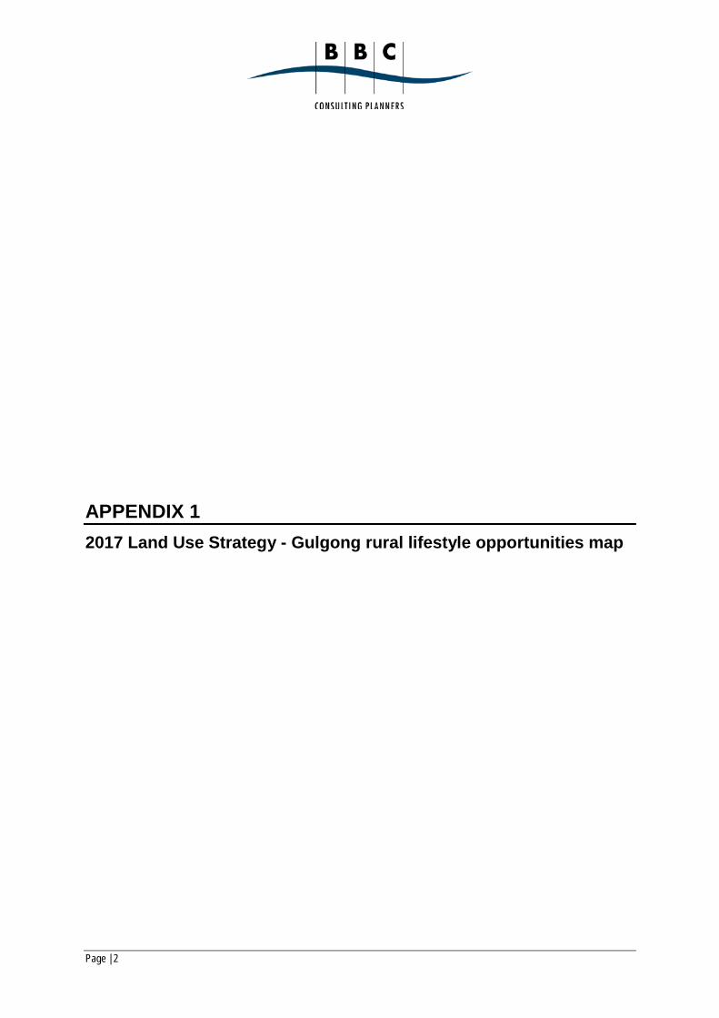
The 2017 Land Use Strategy takes a more quantitative position on large lot residential, noting that it is a land use that is ‘in demand’. The Gulgong locality is identified as a secondary market for large lots behind the Mudgee area. This Strategy makes observations/recommendations for the Gulgong area which are:
• An annual demand in the Gulgong catchment is 5-10 lots/annum. • Large lot residential opportunities to be within 5km of the town of Gulgong. • The minimum lot size for subdivision for rural lifestyle will be 12 ha where reticulated water
and sewer is not available. This size is considered to ensure more sustainable use of the local ground water and surface water resources and has regard to Rural SEPP Principles.
The Strategy recommends a staged approach to meeting demand for large lot residential land in the Gulgong locality as summarised in the table overleaf and constraints map at Appendix 1. Extract 2017 Land Use Strategy – Gulgong Locality Staging
Source: Parsons Brinckerhoff Australia Pty Limited Revision E (February 2017): Mid-Western Regional Comprehensive Land Use Strategy
The area around the site is identified in area C West of Gulgong – see relevant extract from rural lifestyle opportunities map overleaf and full map Appendix 1.

Page | 21
Extract from Rural lifestyle opportunities map
Source: Parsons Brinckerhoff Australia Pty Limited Revision E (February 2017): Mid-Western Regional Comprehensive Land Use Strategy page 70.
The R5 zoned land within the site is identified for short term development for large lot residential, estimated to provide 19 lots. As stated, the R5 land to be used as a solar farm would provide for 4-5 large lots. This would reduce the capacity of area C down to 14-15 lots. Current land use studies concerning large lot residential development promote this type of development based on market demand and not as a form of socially or environmentally responsible development. As stated, this sort of settlement pattern has a demonstrated history of adverse impacts in terms of isolating occupants, alienating rural land and creating conflicts between land uses and creating demand for services and infrastructure that are not able to be met. The area C land identified around the site is also just on the periphery of the 5km radius from the Gulgong township suggested as the environmentally responsible location for such development. The proposed use of the R5 zoned land as a solar farm will reduce the short-term availability of large lot residential land by 4-5 lots, this equates to approximately 1 year of demand for such land in the Gulgong locality. There are ample opportunities for the creation of alternate large lot land in this locality as demonstrated in the 2017 Land Use Strategy without the need for rezoning, for example areas identified for medium to longer-term take-up (L and M priority areas in the table) could be prioritised to absorb this demand without the need for rezonings.

Page | 22
The loss of 4-5 lots of rural lifestyle land west of Gulgong conflicts with the current 2017 Land Use Strategy; however, it is not necessarily an adverse planning impact. The use of this land for a solar farm and loss from rural lifestyle use could be considered a positive development, in as much as:
• The solar farm provides State, National and Global level benefit in terms of the supply of renewable energy, whereas the use of the land for rural lifestyle purposes provides a dubious local benefit only;
• The landscape and mitigation strategies proposed for the solar farm will not adversely impact on the adjoining land for use as rural lifestyle land;
• The solar farm use does not degrade the land, the use can be decommissioned and the longer-term use of this land for rural lifestyle purposes is not prejudiced by the solar farm; and
• The solar farm will provide over 150 construction jobs and 3 full time operational jobs. A successful large lot residential community require off-farm employment which a solar farm provides.
The use of the R5 land on the site as a solar farm has a short-term impact on the availability of rural lifestyle land in the Gulgong locality that can be addressed via a minor change in the current 2017 Land Use Strategy. Land identified for later release could be brought forward and in the longer term additional land rezoned for this purpose. However, it is the opinion of the author that this would not be required. The impact of the loss of the R5 land from rural lifestyle development is negligible and able to be managed. The loss of the R5 land from the proposed solar farm has significant impacts on the capacity of the proposed farm that are not readily able to be addressed.
5.1.2 impacts on the rural character of the locality The Assessment Report contends the proposed solar farm will have a potential impact on the rural character of the locality and that this is a reasonable planning reason to exclude the land from the proposed solar farm. The use of the R5 land as a solar farm will have an impact on the rural character of the area, in as much as rural land will be used for electricity generation. Nevertheless, electricity generation is a permissible and expected use on RU1 Primary Production land. The R5 land on the site is undeveloped for its large lot residential purpose. If this land was developed for its zoned purpose it would have a not dissimilar impact on the rural character of the locality, in as much as the rural use of the land would cease. The proposal also includes substantial screen plantings and maintenance strategies that will reduce the visual impacts of the proposed solar farm from adjoining rural land. There is already substantial electricity infrastructure in this locality i.e. the TransGrid substation and associated poles and wires. This infrastructure is part of the character of this rural area and the proposal is not introducing a land use that is foreign or unexpected. This concern is not grounds to exclude the R5 land from the solar farm because:
• The loss of the agricultural function of the land is part of the zoned purpose of the R5 land;
• The substantial character impacts on the rural character of the locality are supported on the RU1 land and the removal of the R5 land will not significantly ameliorate this impact;

Page | 23
• Adequate mitigation measures are proposed as part of the proposal via landscaping, management strategies and potential decommissioning of the solar farm; and
• The locality’s character includes electricity infrastructure and the solar farm is an expected addition to the locality’s character.
The proposal’s impacts on the rural character of the locality is not grounds to exclude the R5 land from the solar farm proposal.
5.1.3 Inconsistency with the LEP and Infrastructure SEPP The Assessment Report contends the proposed solar is inconsistent with the provisions of the LEP and the Infrastructure SEPP and that this is a planning reason to exclude this part of the site from the proposed solar farm. The application is not made under the LEP or the Infrastructure SEPP. It is made under the provisions of the State and Regional Development SEPP. As stated in Section 4 of this report, in NSW statutory assessment is hierarchical and it is appropriate to give greatest weight in the assessment of this application to the objects of the Act and aims of the State and Regional Development SEPP. The use of the R5 land as a solar farm is compliant with the Act and its primary EPI. The application is SSD and it has National and State level benefits in terms of promoting sustainable development and renewal energy production. The primary statutory test for the proposal is not compliance with the local zoning regime but whether the proposal satisfies the State based objectives and purpose of the State and Regional Development SEPP. The proposal satisfies these tests and it is therefore appropriate that the provisions of the LEP are superseded (and those of the Infrastructure SEPP, noting that its provisions reflect local zonings). The proposal’s inconsistency with the LEP and Infrastructure SEPP are not a reason to exclude the R5 land from the solar farm proposal. Indeed, the planning framework for this proposal is set up precisely to ensure that State based planning objective override local policy.
5.1.4 General merit observations of use of the R5 land As noted in the zoning map (see Figure 5A) there is a patchwork of R5 land near the site. On inspection of this land it is largely indistinguishable from the RU1 Primary Production Land. Up-take of R5 land in this locality is slow and there would appear to be no visible evidence of demand for R5 land not satisfied in this locality. The R5 land to be used for solar farming is low-lying and part flood affected. This land has a 1 in 5 year peak flood level of 500mm above natural ground. A 500mm flood level is a significant constraint for residential use. This environmental constraint would add to the cost of constructing housing in this location and increase potential risks to that housing in terms of isolation and damage by flooding (noting that the land is unsewered). Whereas the site’s flooding constraint is not a risk for a solar farm. The panels are pier mounted and can sustain a 700mm+ flood peak before any risk of damage. Other infrastructure such as trenched wiring is suitably protected and not affected by flood.

Page | 24
A solar farm is a better use of the R5 zoned land based on reduced environmental risks generated by flooding. The site is also located on the suggested boundary of R5 land (i.e. 5km from Gulgong). The land to south is zoned RU1 Primary Production Land. The use of the site as a solar farm in part performs a buffer purpose between rural lifestyle and agricultural land.
5.1.5 The appropriateness of the land use Energy, extractive industries and industrial uses are a common historic and existing theme in this locality. Noting the original development of the locality in the 1870s powered by minerals exploration, then shale oil and then coal mining in the hinterland of the site (e.g. Glen Davis and the upper Hunter Valley). Relative to historic energy production in this locality, the proposed solar farm has minimal impact. Given the existing TransGrid substation located next to the site, the proposed solar farm is not an unexpected form of development on the land. In terms of established planning practice as to how local interests and should be prioritised over higher level State and National interests, the Chief Judge of the Land and Environment Court of NSW in Taralga Landscape Guardians Inc v Minister for Planning and RES Southern Cross Pty Ltd [2007] NSWLEC 59, was clear that higher level interests should prevail. Although this judgement was in the context of the visual assessment of a windfarm and a third-party appeal, his Honour’s conclusion at [352]-[353]:
352 It follows from what has been set out in this decision that I am satisfied that the overall public benefits outweigh any private disbenefits either to the Taralga community or specific landowners.
353 I am also satisfied that there is no rational basis upon which to require the deletion of any of the turbines originally proposed and thus I am satisfied that the full original scope of the windfarm should be permitted.
Court practice is clear that State planning objectives supersede local. The above principles apply more so to this proposal, as the site lacks the heritage significance of the Taralga locality (this area was settled earlier, and the nearby village is heritage listed) and the then proposed wind turbines are more visually obtrusive structures than solar arrays. The author is also an occasional visitor to the Taralga area and it is noted that this locality has prospered since the construction of the proposed wind turbines.
Page | 25
6. CONCLUSION The use of the R5 land as part of the proposed solar farm is permissible under the Act. The proposal is an SSD DA made under the State and Regional Development SEPP, it complies with the applicable land use criteria of the Act and this SEPP. The proposal’s statutory assessment is hierarchical, and it is reasonable and intended that the provisions of the Act and State and Regional Development SEPP override those of the LEP. The LEP’s provisions are a merit consideration. The proposed solar farm has merit. A solar farm has National, State and local benefits in terms of renewable energy generation. The loss of the R5 land from the supply of large lot residential land in the Gulgong locality will have minor impacts that are readily manageable (e.g. there is other R5 land in the locality). The environmental benefits of rural lifestyle development are also dubious and the desire to preserve this land for this purpose appears to be based on market demand for such land as opposed to the social or environmental benefits of such development. Whereas the environmental benefits of use of the land as a solar farm are readily quantifiable and address National and State policy objectives. The use of the land as a solar farm has general land use merit in its context as the use can be decommissioned relatively simply and the land made available for alternative uses. Once the land is subdivided for rural lifestyle purposes it is unlikely to revert to a productive agricultural purpose. When used as a solar farm, the land will be managed and landscaped to minimise impacts on adjoining land uses. The solar farm also performs a desirable buffer purpose between rural lifestyle land to the north and east and agricultural land to the west and allows the land to lay fallow. This buffer purpose is consistent with the locational principles for rural lifestyle land recommended for the Gulgong locality by the 2017 Land Use Strategy noting the site is 6-6km from the township. The site has contextual merit as a solar farm (noting the location of the TransGrid substation). On review, there are no sound planning reasons to exclude the R5 zoned land from the current SSD DA to use the site as a solar farm and in this instance the use of Section 89E(3) of the Act is warranted on policy grounds to facilitate this project.

Page | 1
FIGURES

BERYL SOLAR FARM SUPPLEMENTARY PLANNING REPORT231 Beryl Road, Beryl
FIGURE 1Location
Prepared For - First Solar (Australia) Pty Ltd
Source: http://maps.six.nsw.gov.au 0 2km
N
SITE
BERYL SOLAR FARM SUPPLEMENTARY PLANNING REPORT231 Beryl Road, Beryl
FIGURE 2Site
Prepared For - First Solar (Australia) Pty Ltd
Source: http://maps.six.nsw.gov.au
SITE

BERYL SOLAR FARM SUPPLEMENTARY PLANNING REPORT231 Beryl Road, Beryl
FIGURE 3AAerial Photo - Detail
Prepared For - First Solar (Australia) Pty Ltd
SITE
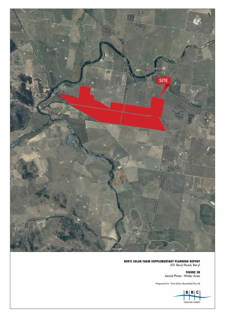
BERYL SOLAR FARM SUPPLEMENTARY PLANNING REPORT231 Beryl Road, Beryl
FIGURE 3BAerial Photo - Wider Area
Prepared For - First Solar (Australia) Pty Ltd
SITE

BERYL SOLAR FARM SUPPLEMENTARY PLANNING REPORT231 Beryl Road, Beryl
FIGURE 4AZoning Map - Mid-Western Regional LEP 2012
Prepared For - First Solar (Australia) Pty Ltd
SITE

BERYL SOLAR FARM SUPPLEMENTARY PLANNING REPORT231 Beryl Road, Beryl
FIGURE 4BGroundwater Vulnerability Map - Mid-Western Regional LEP 2012
Prepared For - First Solar (Australia) Pty Ltd
SITE

BERYL SOLAR FARM SUPPLEMENTARY PLANNING REPORT231 Beryl Road, Beryl
FIGURE 4CLot Size Map - Mid-Western Regional LEP 2012
Prepared For - First Solar (Australia) Pty Ltd
SITE

BERYL SOLAR FARM SUPPLEMENTARY PLANNING REPORT231 Beryl Road, Beryl
FIGURE 4DHeritage Map - Mid-Western Regional LEP 2012
Prepared For - First Solar (Australia) Pty Ltd
SITE
Page | 2
APPENDIX 1 2017 Land Use Strategy - Gulgong rural lifestyle opportunities map

Figure 4-4 Rural lifestyle opportunities - 5km offset area surrounding Gulgong
Mid-Western Regional Council
J:\A
353-
EN
VPL
N\P
RO
J\21
1669
7A_L
and_
Use
_Stra
te\1
0_G
IS\P
roje
cts\
ArcV
iew
\211
6697
A_2
061a
_Con
stra
ints
_opp
ortu
nity
_Pre
cinc
ts_G
ulgo
ng.m
xd
- VB
04
Apr
il 08
A
B
C
F
E
D
424.4 ha
379.4 ha
326.7 ha
191.9 ha
183.1 ha
86 ha
GULGONG
HOME RULE
Town
Rural locality
Main Road
Rail line
Cadastre
Town Offset5 Km offset
Travel Distance
5 Km
Constraints
Class 3 land (otherwise unconstrained)
Opportunity
Opportunity areas and prioritisationShort term
Medium term
Long term
0 2 4 6 Km