survey of highway construction materials...
TRANSCRIPT
/
SURVEY OF HIGHWAY CONSTRUCTION MATERIALS
IN THE TOWN OF I-IINESBURG, CHITTENDEN COUNTY, VERMONT
Prepared by
STATE OF VERMONT AGENCY OF TRANSPORTATION
MATERIALS & RESEARCH DIVISION
ENGINEERING GEOLOGY SUBDIVISION
Montpelier, Vermont
March, 1982
State of Vermont Agency of Transportation Materials & Research Division April, 1982

TABLE OF CONTENTS -
Page
Introduction
Acknowledgements 1
History 1
Enclosures 1 - 2
Location 3
County and Town Outline Map of Vermont
Survey of Rock Sources
Procedure for Rock Survey 4
Discussion of Rock and Rock Sources 5 - 6
Survey of Sand and Gravel Deposits
Procedure for Sand and Gravel Survey 7
Discussion of Sand and Gravel Deposits 8
Suninary of Rock Formations in the Town of Hinesburg 9 - 10
Glossary of Selected Geological Terms 11 - 14
Bibliography * 15
Partial Specifications for Highway Construction Materials Appendix I
Hinesburg Granular Data Sheets Table I
Hinesburg Property Owners - Granular Supplement I
Hinesburg Rock Data Sheets Table II
Hinesburg Property Owners - Rock Supplement II
Granular Materials Map Plate I
Rock Materials Map Plate II

Page 1
Acknowledgments
This project acknowledges the surf icial geological information obtained
- from Professor D. P. Stewart of Miami University, Oxford, Ohio and the bed-
rock information from the Centennial Geologic Map of Vermont, C. G. Doll.
History
The Materials Survey Project was initiated in 1957 by the Vermont
Department of Highways with the assistance of the Bureau of Public Roads to
compile an inventory of highway construction materials in the State of
Vermont. Previously, investigations for highway construction materials were
conducted only as the immediate situation required and only limited areas
were surveyed. Since no overall picture of material resources was available,
highway contractors or resident engineers were required to locate the mate-
rials for their respective projects and the samples were tested by the
- Materials & Research Division. The additional expense of exploration for
J construction materials resulted in higher construction costs being paid by
the State. The Materials Survey Project was formed to minimize this factor
by enabling the State and the contractors to use available information on
material resources and to project cost estimates. Knowledge of locations
of suitable materials is an important factor in planning highways.
The sources of construction materials are located by this Project
- through ground reconnaissance, study of maps and aerial photographs, and
geological and physiographic interpretation. Maps, data sheets and work
sheets furnish information of particular use to contractors and construction
personnel, and should be studied together for maximum benefit.
1. Enclosures
Included in this report are two -surface-geology maps, one defining the
location of tests on bedrock, the other defining the location of tests on

Page 2
granular materials. These maps are based on 15-minute or 7- 31-ininute
quadrangles of the United States Geological Survey enlarged or reduced to
1:31250 or 1" = 2604'. The various rock formations and types are delineated
on the Bedrock Map of the township. This information is obtained from:
Vermont Geological Survey Bulletins, Vermont State Geologist Reports, United
States Geological Survey Bedrock Maps, Centennial Geologic Map of Vermont,
the Surf icial Geologic Map of Vermont and other references.
The granular materials map shows areas of various types of glacial
deposits (outwash, moraines, kames, kame terraces, eskers, etc.) which are
potential sources of gravel and sand. This information was obtained primar-
ily from a survey conducted by Professor D. P. Stewart of Miami University,
Oxford, Ohio, who mapped the glacial features of the State of Vermont during
the summer months from 1956 to 1966. Further information is obtained from
the Soil Survey (Reconnaissance) of Vermont (conducted by the Bureau of -
Chemistry and Soils of the United States Department of Agriculture), avail-
able Soil Surveys of individual counties (by the Soil Conservation Service
of the United States Department of Agriculture), Vermont Geological Survey
Bulletins, United States Geological Survey Quadrangles, aerial photographs
and other sources. The location of each test area is represented by a Map
Identification Number.
This report contains data sheets with detailed information on each test
taken in the Granular and Bedrock areas. Data is also used from an active
card file compiled by the Materials & Research Division over a period of years.
Some cards are not used because they are incomplete or have unusable information
on the location of the deposit.
Work sheets containing more detailed information and a field sketch of
the area, and laboratory test results are on file in the Materials & Research
Division of the Agency of Transportation, State of Vermont.
ft

C A IF A 0 A
•r---
, ,I.ltuI
---•-v•--••
flow /
•(JPII f
litilili Il Jill! 1111111
ITII1LL
_gj.ui %
I L - 'IE
/ / 111101N ( ,tN
Isti 4i •iS.l8T(
_ Y ,_.... /
/ 2.. N .- )
It ,4 / l,ll,,ts'ko'tuiucti, • IIIINIIILI S
I ""
/ llIiiStiit5!__.., t•IIU • / 5/ \N -
" Iitii•iIi ,/
_ / - / C,! Still" '
/ q- •l ul.iuIui Is, ISIS iitt stilt sit. /
/ ILII1T
/
ulFissip
N/.lull • 1, i4:1:E::;' • , / .j IL•tII
lullS :, %, •
/ J 511th
S lIlt liSt
/ CIlIlIlhI :' / ,/
11111 JIll
) until.. /
/ list iii. / 1%
,..___ / -.. ,, hltllillt5/ ShuT
S. F
7 1111111 / --
tithhhlill / ,A&luullliLL\?_..uih,iItst.
S.,,555hthL1C1 I 'IJILISIU , f ivilli
/ (
._ S. •
5•Z1ESSEN /
L
slush / II
shill IilIT,.'L.,i hillS /
ilultil
liLLiSJhl 1 uoomiv /
\im\<'
0.
/ IIITILLI CilIlil 4
106110ESTEN / I
G
J Ilitliuli /itI.uIu / 111111
1 .. ,I •_ L.. /u •- / Cliiicj
'.,.tsi,,c t
1 lillihT
/
• C 511111 / 5 ,. I 1• /
P151111 /' £
mintesta1,11111161911 / •__ /
lllllti7 / iui
, ftl..istLulic - / C
. / -I
••-
•% h
TlitS
I..... • -.._. /
/ I -. /• — , •.(PtIIhtittl 5I1ll I I
,
ituulIlIlt st IiLl tiut IUITII .' ' / 111111
' . jr' uihiutiftI
/wL
.
111 11
,.,!,, I /IIPIIII1 stt I--.--.
1151111
(111111 lllwl/ - I 4, / hill! 4
I I o,I I ar-... i 111111? _.._,1uIShiitihi/C at
I , . 111111
I I •',../uuinuiLu ,
I liullililT I 1151111 \
1 I
T Ic siu1t _,__1,
•• ••••._ %çCliLIil -- IlIuiThit /
/ 0
IIItiIIulT __i 11111151
1151115
/ .---
DiStillt ( • ._i I' , . I IllililCi / • 4,_ I s'
I-- 'S.
/ — —
11 -------% LIICISTII I
. ,,L/. 1111 .,' / sluruhu/
/ ill.IL ,
lutlilIl
I' ROT, 5,_. ,i ALTIN
1111151 ile115111 I
_-- I--
-li ChiTliliti ' /sTSCluhiiCl/ _,
I , S /
1(1111 I huuuusi,uI tilillili \ ,_ /
1*11111 . & I
r, "
' -1 S..• .__ 1 Plhlhti
I- ----_ (I \_- , 1
•-- ,/ . — Lrr / 40 VIII 111(1' I / SlihIhhll
1111111 1555 USIISTII / ,fuistivans / NAVIN I t_
-1 sttim!f._cJ1_.___?._ ,hVlIlStlCI.,
I
at '
Ill , / / 51111111
POILTIETL_ ')/tt,ii.,,ii SihliSuIhT ' COUN1Y AND TO/N
PtThIhli I l'I
I J 11
I hISIlIC f SS -. - OUTLINE MAP
I \ I hMUT47't-T
I__ksniso IT lILLY
• OF
uhtLs5).'Iu1lu111t uLLuu;rthl
ZusL.0 \ E R lvi 0 11 1
- ------------ --------
lT l TIltS
JutlThthuulL
'
I- L
rALTIMOR
515151 "1 I I
115115 .ssu
111111eiT IhutlYihl £11111 I SPIIICFIILI
im.jr-..l ! u
-----U
I01
latmocon,ChirThi
SINISATE uillILt JL. i
/ i I
L
I ------------ I JIIIICI / , 4
I I
11111111 SillIltIll 11151s b ulSIluillIl 4
ShIFlllllTICL • •. I- -1 ')• huh
tillhlTJ
S I 1111111 ,..L............. • .p I •lIh
IT
I----4--
1
uiu.usti•s I1098FIllJ I
t
4. iltulIhIll I 1111111 I I I
IlAInIHI.
I I • I " I HIOHWAT PtANNINS DIVISION
-----------------14
VERMONT DEPARTMENT OF HIGHWAYS
PlhhIt 11*111, IlitilIllI *11111 suuu.,s SCAI_E S I I S i.0
I IIII... --
I
M ASSACHUSE TTS DECEHOER3I.1974

Page 3
LOCATION
The town of Hinesburg is in the southern part of Chittenden County, on
the west side of Vermont. It is bounded on the north by Shelburne, St.
George, Williston and Richmond, on the west by Charlotte, on the east by
Huntington, and on the south by Monkton and Starksboro (See County and
Town Outline Map of Vermont on the following page.)
The western half of Hinesburg lies within the Champlain Lowlands, and the
eastern half lies within the Green Mountain Physiographic Subdivisions of
the New England Uplands. The lowlands are basically flat with a few long,
low, rolling hills. In contrast, the Green Mountains are characterized
by steep-sided hills and mountains. Elevations range from 1650s in the
southeast corner to 350' in the southwest corner where Lewis Creek enters
Charlotte.
The major drainage in town is to the west. In the northern partof town,
the LaPlatte River and its main tributary, Patrick Brook, drain Lake Iroquois
and Lower Pond. In the south, drainage is via Lewis Creek and its main
tributary, Hollow Brook. All drainage eventually goes to Lake Champlain.
rA
Page 4
SURVEY OF ROCK SOURCES
Procedure for Rock Survçy
- The method employed by the project in a survey of possible sources of
rock for highway construction is divided into two main stages: office and
field Investigations.
The office investigation is conducted during the winter months and
comprises the mapping and description of rock types perused from many ref-
erence sources, as acknowledged in the bibliography. These references differ
considerably in dependability due to subsequent developments and studies that
have contributed to the obsolescence of a number of reports. The results of
samples taken by other individuals are analyzed, and their location is mapped
when possible. As complete a correlation as possible is made of the available
geological information concerning the area under consideration.
The field investigation is begun by making a cursory survey of the entire
town. The information obtained from the preliminary survey, and that from
the office investigation, is used to determine where sampling will be concen-
trated. When a promising source has been determined by rock type, volume of
material, accessibility, adequate exposure and relief, chip samples are taken
with a hammer across the strike or trend of the rock, and are submitted to
the Materials & Research Division for abrasion testing by the Deval Method
(AASHTO T-3) and the Los Angeles Method (AASHTO T-96). Samples taken by the chip
method are often within the weathered zone of the outcrop and thus may give a less
satisfactory test result than fresh material from unweathered rock. When the
rock is uniform, and the chip samples yield acceptable abrasion test results,
the material source is listed in this report as being satisfactory.
Ift
Page 5
DISCUSSION OF ROCK AND ROCK SOURCES
The information on the Rock Materials Map (Plate II) is simplified. For
a more detailed description of the respective rock formations, see the
Suninary of Rock Formations included in this report.
Occasionally, rocks belonging to the same formation and exhibiting similar
characteristics (i.e., color and texture) produce different abrasion test
results due to differing physical properties or chemical compositions. There-
fore, in no case should satisfactory test results obtained in one area be
construed to meanthat the same formation, even in the same area, will not
later produce unsatisfactory materials; this is particularly true of meta-
morphic rocks.
The western half of town is underlain by Dolomite, Limestone, Marble, and
Quartzite. The main formations involved are Cutting dolomite, Shelburne
limestone and marble, Danby quartzite and dolomite, Winooski dolomite,
Clarendon Springs dolomite, Monkton quartzite, Dunham dolomite, Cheshire
quartzite, and Bascom dolomite limestone, and marble. Because of the large
number of formations involved, much of the rock is graded from one to the
other giving many impure samples, but all of these generally yield satis-
factory results.. Therefore, rock quality should remain high. All test
areas are in the western half of the town.
The formations in the eastern half of town are Underhill phyllite and schist
(Fairfield Pond member), Bascom phyllite (Brownell Mountain member), and
Pinnacle graywacke and conglomerate. All these formations are generally of
poor quality, although the Pinnacle will occasionally yield a passing sample,
None was tested.

Page 6
Discussion of Rock and Rock Sources (cont.)
There are many suitable quarry sites in town, but only eight (8) were
sampled. All of these were chosen on a basis of potential quarry sites
as well as rock type. They were spread around the town to give a variety
of formations. All areas tested yielded satisfactory results.

Page 7
SURVEY OF SAND AND GRAVEL SOURCES
Procedure for Sand and .Gravel Sun,
- The method used for conducting the survey of possible sources of sand
and gravel for highway construction is divided into two main stages: office
and field investigations.
The of fice.investigation is conducted during the winter months and
comprises the mapping of potentially productive areas from various references.
Of these references, the survey of glacial deposits mapped by Professor
.Stewart is particularly helpful when used with soil-type maps, aerial photo-
graphs, and United States Geological Survey Quadrangles. The last two are
used in the recognition and location of physiographic features indicating
glacial deposits, and in the study of drainage patterns. The locations of
existing pits are mapped, as are the locations in which samples were taken
- by other individuals.
The field investigation is begun by making a cursory survey of the en-
tire town. All pits, and any areas that show evidence of glacial or fluvial
deposition are noted, and later investigated by obtaining samples from pit
faces and other exposed surfaces. Test holes in pit floors and extensions
are later dug with a backhoe to a depth of approximately 11 feet to obtain
material which is submitted to the Materials & Research Division for
gradation, sieve analysis and AASHTO T-4 Method stone abrasion test.
ft

Page 8
DISCUSSION OF SAND AND GRAVEL DEPOSTIS
Most of the granular material is located in the south-central part of
town, at the base of the mountains (a large terrace feature east of Vt.
Rte. 116 and west of the mountains). At the south end of this feature
is a large commercial pit (Area #19) owned by Hinesburg Sand & Gravel.
Hinesburg Sand and Gravel also owns pits at Areas #7 (sand), #13 (gravel),
#16 and #17 (sand and gravel). All have acceptable material. The main
pit is the primary source of material in town.
The town of Hinesburg owns a large pit (Area #6) with acceptable material,
but due to legal problems, it is not available to the general public.
Other areas in town with acceptable material are (in order of abundance
and access) Areas #14, #15, #12, #8, #2, #9 9 #10, #4, and #1. All are
pits except #15 and #12.
Area #11 is a pit with apparent reserves, but testing was not permitted.
(
Page 9
SUMMARY OF ROCK FORMATIONS IN THE TOWN OF HINESBIJRG
Champlain and Vermont Valley Sequence
Bascom Formation: Interbedded dolomite, limestone or marble, clacareous
sandstone, quartzite, and limestone breccia; irregular dolomite
layers, thin sandy laminae, and slaty or phyllitic partings char-
acterize limestone and marble of lower, middle, and upper parts
of the Bascom respectively.
Bascom Formation (Brownell Mt. member): Calcareous phyllite in the upper
part of the Bascom Formation of the east limb of the Hinesburg Syn.
clinorium.
Cheshire Quartzite: Very massive, white ta faintly pink or buff vitreous
quartzite near the top in west-central and south-western Vermont;
predominately a less massive appearing, mottled gray, somewhat phyl-
litic quartzite, dolomitic sandstone, and conglomerate near the base
of the formation in west-central Vermont.
Clarendon Springs Formation: Fairly uniform, massive, smooth-weathered
gray dolomite characterized by numerous geodes and knots of white
quartz; quartz sandstone and irregular masses of chert are near the
top.
Cutting Dolomite: Typical Cutting is a massive, gray weathered, nondescript
dolomite with a finely laminated calcareous sandstone at the base.
Danby Formation: Comprised of white vitreous quartzite beds, often cross-
laminated, interbedded with gray dolomite. White quartzite beds,
more than a foot thick, separated by 10 to 12 feet of dolomite In
eastern areas, increases westward to continuous sections of white to
pink weathered, massively bedded quartzite.

Page 10
Suninary of Rock Formations (cont).
Dunham Dolomite: Buff-weathered siliceous dolomite, pink and cream mot-
-
tied or buff to gray on fresh surface; lower part is sandy and re-
sembles the Winooski dolomite.
Monkton Quartzite: Distinctively red quartzite interbedded with lesser
buff and white quartzite and relatively thick sections of dolomite
like that of the Winooski; the quartzites thin to the east, and they
become gray and phyllitic to the east and south.
Shelburne Formation: The Sheiburne is chiefly a white marble or gray lime-
stone characterized by raised reticular lines of gray dolomite on
the weathered surface.
Winooski Formation: Buff-weathered, pink, buff and gray dolomite; beds 4
inches to a foot thick separated by thin, protruding, red, pink, green,
and black siliceous partings.
Green Mountain Sequence
Pinnacle Formation: Schistose graywacke, gray to buff, commonly striped, quartz-
al bi te-seri ci te-bi oti te-chl on te rock predominates; quartz-cobble and boul -
der conglomerate is common, chiefly near the base.
- Underhill Formation (Fairfield Pond member): Green quartzitic schist (quartz-
sen cite-al bite-chiori te-bioti te); serici te-quartz-chl on te phylli te,
locally purple or red, common in lower part.

Page 11
GLOSSARY OF SELECTED GEOLOGIC TERMS
Albite:
Alluvial:
Bedding:
Bedrock:
Bi oti te:
The light-colored, sodium end-member of the continuous plagio-clase feldspar series which is found in alkali rocks. The name is often compounded with the names of rocks containing the mineral.
Pertaining to material carried or laid down by running water.
The arrangement of rock or soil in layer, strata, or beds.
The more or less solid, undisturbed rock in place at the surface, or beneath superficial deposits of gravel, sand, or soil.
A platy, dark silicate mineral known as black mica.
Calcareous: Containing calcium carbonate. When combined with rock names, it indicates a considerable proportion of CaCO3 together with an equal or predominant amount of the material indicated by the rock name.
Carbonaceous: Containing carbon.
Carbonate Rocks: Rocks composed of the molecule CO 3 combined with calcium, magnesium, etc. Includes limestones, dolomites, and marbles.
Chlorite: A group of green hydrous silicates of aluminum, ferrous iron, and magnesium which occur as plate-like crystals or scales in metamorphic rocks.
Conglomerate: The consolidated equivalent of gravel. There may be considerable range in the size and composition of constituent fragments. The finer material between the larger fragments may be fine particulate matter or a natural cement such as calcium carbonate, clay, iron oxide, or silica.
Cross-bedding: A diagonal arrangement of beds in sedimentary rocks where the layers are inclined at various angles to the more general planes of stratification or the formational contact. Sand dunes, river channels, and delta show extensive cross-bedding.
Delta: A predominantly alluvial deposit built by a stream entering a standing body of water. It usually is formed like the Greek letter delta.
Deltaic: Relating to alluvial deposits built by a stream entering a standing body of water. Deltas are formed like the Greek letter delta.
Dip: The downward slope of a vein or stratum measured from the hori- zontal.
Dolomite: A rock consisting predominantly of the mineral dolomite, CaMg(CO3)2.
Drainage: The manner in which the water of an area passes off by surface streams and rivers, or by subsurface channels.

Page 12
Drainage Basin: A part of the surface of the earth that is occupied by a drainage system, or that contributes surface water to the system.
Fluvial: Pretaining to streams.
Foliation: The banding or lamination of metamorphic rocks as contrasted to the stratification of sediments. Foliation implies the ability to split along nearly parallel surfaces due to the parallel dis-tribution of layers or lines of one or more conspicuous minerals in the rock. The layers may be smooth, flat, undulating, or strongly crumpled.
Garnet: An important group of silicate minerals which contain aluminum, calcium, chromium, ferric and ferrous iron, magnesium, and man-ganese. Garnets are commonly deep red, brown, or black, but may be any color except possibly blue.
Graywacke: Dark, hard sandstone having angular grains of quartz and feld- spar in a matrix of micas, chlorite, and clay minerals.
Greenstone: A field term for metamorphic rocks which have a distinctive color due to chlorite, epidote, or actinolite. It is usually derived from dark igneous rocks and is tough and hard. It is crushed to form good-to-excellent aggregate.
Interbeds: Occur between, or lie adjacent and parallel to, other beds of usually a different nature.
Kame: A conical hill of generally poorly stratified drift deposited against glacial ice by streams flowing in or on the ice.
Kame Moraine: An accumulation of material deposited directly from the frontal portion of glacial ice, and partly sorted by water. The deposits may form as coalescent knolls, hummocks, ridges, etc.
Lamina: A thin layer of stratified rock no more than 1 cm. thick.
Lenticular: Pertains to a mass of rock or earth that thins out in all dir- ections from the center like a double-convex optical lens.
Limestone: A bedded sedimentary dei?rnsit containing from 40% tomore than 98% calcium carbonate; sand and clay are common impurities. It is the most important, widespread carbonate rock.
Metamorphic Rocks: Rocks formed from pre-existing rocks altered by heat, pressure or the infiltration of gases and liquids below the zones of oxidation and cementation. Metamorphic rocks are formed-in place while remaining essentially solid.
Mica: Any tabular, rock-forming minerals having perfect cleavage in one direction which yields thin, tough, elastic flakes.
Page 13
Phyllite: A fine-grained, metamorphic rock' intermediate between the mica schists and slates, into which it may grade. Its cleavage is due to the high content of the potash mica, sericite, which gives the rock a distinctive silvery appearance. Its fracture is intermediate between the rather splintery fissility of schist, and the smooth, even cleavage of slate; however, phyllite is not as tough as slate.
Phyllitic Pertaining to fine-grained, foliated metamorphic rock inter- mediate between the mica schists and slates, into which it may grade. Cleavage is due to the large amount of potash mica, sericite.
Physiographic: Pertaining to the physical divisions of the earth's surface.
Piedmont: Lying, or formed at the base of mountains.
Quartz: The most coimnon mineral (Si02). It is transparent, translucent, opaque, or variously colored due to impurities, and occurs with equal ease across both grains and cement.
Quartzite: The coninon, siliceous, metamorphic equivalent of sandstone composed of quartz grains so firmly bonded that fractures occur with equal ease across both grains and cement.
Schist: A crystalline, metamorphic rock having secondary foliation or lamination based on the parallelism of platy or needle like grains which causes a tendency to split along the foliation.
Schistose: Pertaining to schist.
Sedimentst All materials deposited from the waters of streams, lakes, seas, or more generally, deposited by wind or ice.
Sericite: A metamorphic mineral (very similar to muscovite) which occurs as minute flakes or scales in schists gneisses, and phyllites.
Siliceous: Containing, or pertaining to silica (Silicon Dioxide, Si.0 2 ).
Strike: The direction of a line formed by the intersection of a layer with the horizontal.
Syncline A fold of rock strata that is concave upward, in which younger formations occur toward the center of curvature.
Synclinorium: A composite fold consisting of connected anticlines and synclines which, grouped together, form an arch. They are relatively large features extending for several miles.
Talus: A heap of rock fragments derived from, and lying at the base of, a cliff or very steep slope. The fragments may be large or small. The aggregate heap usually has its form determined by gravity and the angle of rest of the material.
Page 14
Till:
Viterous:
Water Table:
Weathered:
An unsorted, unstratified, unconsolidated, heterogeneous mixture of clay, silt, sand, gravel, and boulders deposited directly by glacial ice.
Glassy
The upper limit of the portion of the ground which is wholly saturated with water. -
Showing the effects of exposure to the atmosphere.

Page 15
Bibliography
Flint, Richard F. Glacial Geology and the Pleistocene Epoch. New York: John Wiley and Sons, Inc., 1947
Heinrich, E. W. Microscopic Petrography. New York: McGraw-Hill Co., Inc., 1956
Kemp, James F. A Handbook of Rocks. New York: D.Van Nostrand Co., Inc., 1949
National Academy of Sciences, National Research Council. Highway Research Board. SOLj1 Exploration and Mapping, Highway Research Board Bulletin 28 Washington, D.C.: National Academy of Sciences-National Research Board 1950.
Pirsson, L.V. Rock and Rock Minerals. New York: John Wiley and Sons, Inc., 1949
Stokes, William L. and Varnes, David J. Glossary of Selected Geolo9ic Terms, Colorado Scientific Society Proceedings, Vo. 16. Denver, Cob.: Colorado Scientific Society, 1955
U.S. Department of Agriculture. Bureau of Chemistry and Soils. Soil Survey (Reconnaissance) of Vermont, By D.V. Goodman, W.J. Latimer, F.R. Lesh, S.O.Perkins, and L.R. Smith (1930).
U.S. Department of Interior. Geological Survey Burlington Quadrangle, Vermont, 15 Minute Series (Topographic) (1948)
Vermont Department of Water Resources. Geological Survey. Surficial Geologic Map of Vermont, edited by Charles G. Doll (1970)
Vermont Department of Water Resources. Geological Survey. The Surficial Geology and PleistoceneHistory of Vermont, Bu David P. Stewart and Paul Mac-Cliltock, Bulletin No. 31(1969)
Vermont Development Department. Geological Survey. Centennial Geologic Map of Vermont, edited by Charles G. Doll (1961)
Vermont Development Department. Geological Survey. The Glacial Geology of Vermont by David P. Stewart, Bulletin No. 19 (1961)

Appendix I
PARTIAL SPECIFICATIONS FOR HIGHWAY CONSTRUCTION MATERIALS
Listed below are partial specifications for Highway Construction Materials as they apply to this report at date of publication. For a complete list of specif 1-cations see Standard Specifications for Highway and Bridge Construction, approved and adopted by the Vermont Department of Highways, March, 1976.
DIVISION 700 - MATERIALS
703.03 SAND BORROW AND CUSHION. Sand borrow shall consist of material reasonably free from silt, loam, clay, or organic matter. It shall be obtained from approved sources and shall meet the requirements of the following table:
TABLE 703.03A - SAND BORROW AND CUSHION
Sieve Percentage by Weight Passing Square Mesh Sieves
Designation TOTAL SAMPLE SAND PORTION
2" 100 1½" 90-100 ½" 70-100
No. 4 60-100 100 No.100 0-30 No. 200 0- 12
703.05 GRANULAR BORROW. Granular borrow shall be obtained from approved sources, consisting of satisfactorily graded, free draining, hard, durable stone and coarse sand reasonably free from loam, silt, clay, or organic material.
The Granular Borrow shall meet the requirements of the following table:
TABLE 703.05A - GRANULAR BORROW
Sieve Percentage by Weight Passing Square Mesh Sieves Designation TOTAL SAMPLE SAND PORTION
No. 4 20-100 100 No. 200 0- 15
The maximum size stone particles of the Granular Borrow shall not exceed 2/3 of the thickness of the layer being spread.
704.05 GRAVEL FOR SUB-BASE. Gravel for Sub-base shall consist of material reason-ably free from silt, loam, clay, or organic-matter. It shall be obtained from approved - sources and shall meet the following requirements:
ft

Appendix I (con' t.)
(a) Gradin&. The gravel shall meet the requirements of the following table: -
- TABLE 704. 05A - GRAVEL FOR SUB-BASE
Sieve Percentage by Weight Passing Square Mesh Sieves Designation TOTAL SAMPLE SAND PORTION
No. 4 20-60 100
No. 100 0- 18 No. 200 0 8
The stone portion of the gravel shall be uniformly graded from coarse to fine, and the maximum size stone particles shall not exceed 2/3 the thickness of the layer being placed.
(b) Percent of Wear. The percent of wear of the gravel shall be not more than 25 when tested in accordance with AASHTO T-4, or more than 40 when tested in accordance with AASHTO T-96.
704.06 CRUSHED STONE FOR SUB-BASE. Crushed stone for sub-base shall consist of clean, hard, crushed stone, uniformly graded, reasonably free from dirt, deleterious
- material, pieces which are structurally weak and shall meet the following requirements:
(a) Source. This material shall be obtained from approved sources and the area from which this material is obtained shall be stripped and cleaned before blasting.
(b) Grading. This material shall meet the requirements of the following table:
TABLE 704.06A - CRUSHED STONE FOR SUB-BASE
Sieve Percentage by Weight Passing Square Mesh Sieves Designation TOTAL SAMPLE
4½" 100 4" 90-100 1½" 25- 50 No.4 0-15
(c) Percent of Wear. The percent of wear of the parent rock shall be not more than 8 when tested in accordance with AASHTO T-3, or the crushed stone a percent of wear of not more than 40 when tested in accordance with AASHTO T-96.
Appendix I (con't.)
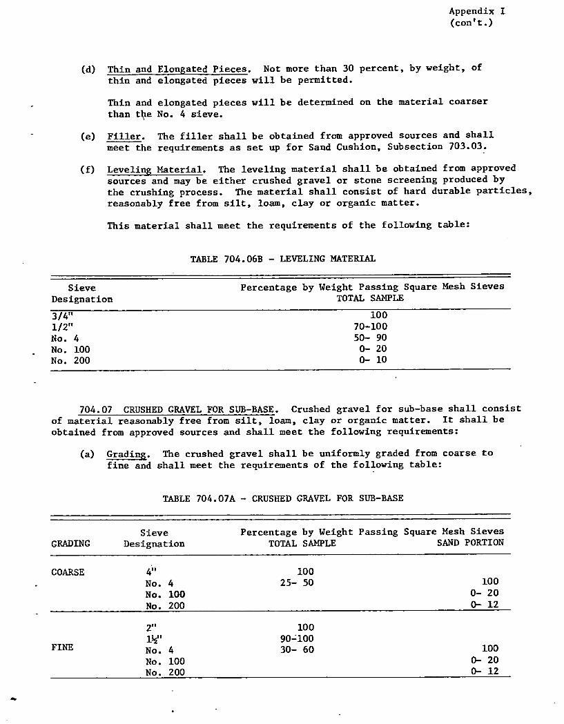
(d) Thin and Elongated Pieces. Not more than 30 percent, by weight, of thin and elongated pieces will be permitted.
- Thin and elongated pieces will be determined on the material coarser than t1ie No. 4 sieve.
(e) Filler. The filler shall be obtained from approved sources and shall meet the requirements as set up for Sand Cushion, Subsection 703.03.
(f) Leveling Material. The leveling material shall be obtained from approved sources and may be either crushed gravel or stone screening produced by the crushing process. The material shall consist of hard durable particles, reasonably free from silt, loam, clay or organic matter.
This material shall meet the requirements of the following table:
TABLE 704.06B - LEVELING MATERIAL
Sieve Percentage by Weight Passing Square Mesh Sieves Designation TOTAL SAMPLE
3/4" 100 1/2" 70-100 No. 4 50- 90 No.100 0-20 No. 200 0- 10
704.07 CRUSHED GRAVEL FOR SUB-BASE. Crushed gravel for sub-base shall consist of material reasonably free from silt, loam, clay or organic matter. It shall be obtained from approved sources and shall meet the following requirements:
(a) Grading. The crushed gravel shall be uniformly graded from coarse to fine and shall meet the requirements of the following table:
TABLE 704.07A - CRUSHED GRAVEL FOR SUB-BASE
Sieve GRADING Designation
Percentage by Weight TOTAL SAMPLE
Passing Square Mesh Sieves SAND PORTION
COARSE 4" 100 No. 4 25- 50 100 No. 100 0- 20 No. 200 0- 12
2" 100 1½" 90-l00
FINE No. 4 30- 60 100 No. 100 0- 20 No.200 0- 12
a.

Appendix I (con't.)
(b) Percent of Wear. The percent of wear of the parent gravel shall be not more than 20 when tested in accordance with AASHTO T-4, or the crushed gravel a percent of wear of not more than 35 when tested In accordance with AASHTO T-96.
(c) Fractured Faces. At least 30 percent, by weight, of the stone content shall have at least one fractured face.
Fractured faces will be determined on the material coarser than the No. 4 sieve.
704.09 DENSE GRADED CRUSHED STONE FOR SUB-BASE. Dense graded crushed stone for sub-base shall consist of clean, hard, crushed stone, uniformly graded, reason-ably free from dirt, deleterious material and pieces which are structurally weak, and shall meet the following requirements:
(a) Source. This material shall be obtained from approved sources and the area from which this material is obtained shall be stripped and cleaned before blasting.
(b) Grading. This material shall meet the requirements of the following table:
TABLE 704. 09A - DENSE GRADED CRUSHED STONE FOR SUB-BASE
Sieve Percentage by Weight Passing Square Mesh Sieves Designation TOTAL SANPLE
3½" 100 3" 90-100 2" 75-100 1" 50- 80
½" 30- 60 No.4 15-40 No. 200 0- 10
(c) Percent of Wear. The percent of wear of the parent rock shall be not more than 8 when tested In accordance with AASHTO T-3, or the crushed stone a percent of wear of not more than 40 when tested In accordance with AASHTO T-96.
(d) Thin and Elongated Pieces. Not more than 30 percent, by weight, of thin or elongated pieces will be permitted.
Thin and elongated pieces will be determined on the material coarser than the No. 4 sieve.
704.10 GRAVEL BACKFILL FOR SLOPE STABILIZATION. Gravel backfill for slope stabilization shall be obtained from approved sources, consisting of satisfactorily graded, free draining, hard, durable stone and coarse sand reasonably free from loam,
ft

Appendix I (con' t.)
silt, clay, and organic material.
The gravel backfill shall meet the requirements of the following table:
TABLE 704.10A - GRAVEL BACKFILL FOR SLOPE STABILIZATION
Sieve Percentage by Weight Passing Square Mesh Sieves Designation TOTAL SAMPLE SAND PORTION
No. 4 20-50 100 No. 100 0- 20 No. 200 0- 10
The stone portion of the gravel backfill shall be uniformly graded from coarse to fine, and the maxiun.mi size stone particles shall not exceed 2/3 the thickness of the layer being placed.
704.11 GRANULAR BACKFILL FOR STRUCTURES. Granular backfill for structures shall be obtained from approved sources, consisting of satisfactorily graded, free draining granular material reasonably free from loam, silt, clay, and organic material.
The granular backfill shall meet the requirements of the following table:
TABLE 704.11A - GRANULAR BACKFILL FOR STRUCTURES
Sieve Percentage by Weight Passing Square Mesh Sieves Designation TOTAL SAMPLE SAND PORTION
3" 100 2½" 90-100 No. 4 50-100 100 No. 100 0 18 No.200 0- 8
ft

1A404 2C Rev.. / lY
STATE OF VERMONT AGENCY OF TRANSPORTATION
iATER1ALS & RESEARCH DIVISION - GEOLOGY SIJB-DIVISIOtl
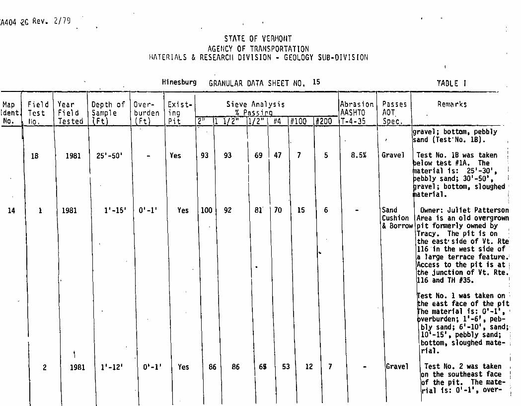
Hinesburg GRANULAR DATA SHEET NO. 1 rnni P T
Map Ident No.
Field Test No,
Year Field Tested
Depth of Sample *(Ft)
Over- burden (Ft)
Exist- ing Pit
Sieve Analysis % Passipg
Abrasion AASHTO T-4-35
Passes AOT Spec.
Remarks
2 1 1/211 I1/2 11 114 11100 11200 1 1 1981 0.51_251 O'-0.5' Yes 100 100 94 86 50 27 -
- Owner: Henry & Elan M artin. Area is a sma nulti-leveled pit in a knoll against a steep ill. The area is 0.04 nile north of TH No. 6 he access is 0.09 mil' ast of the junction 01 H No. 6 and TH. #15.
est No. 1 was taken oi ;he north face of the pper level of the pit he material is: 0'-0 verburden 0.5'-10' 9 sand; 10 1 -13 1 , silty sand; 13'-15', pebbly fine gravel; 15-22, sand; 22'-25', silty sand; bottom, sloughe material.
2 1981 1 6 1 -20' 0 1 -0.5' Yes 100 94 85 66 17 13 - Granular Test No.. 2 was taken Borrow the northeast face of (Sand) the pit. The materia
is: 0'-0.5', overburd 0,5I_3S sand; 3'-6', silt, 6 1 -20 1 , silty fine gravel; bottom, sloughed material.

A404 2C Rev.. 2/79
STATE OF VERMONT - AGENCY OF TRANSPORTATION
IiI\TERIALS & RESEARCH DIVISION - GEOLOGY SUB-DIVISION
Hinesburg GRANULAR DATA SHEET NO, 2 TADLE I
Map Field Year Depth of Over- Exist- 1 Sieve Analysis Abrasion Passes Remarks Ident Test Field Sample burden ing % Passirg AASHTO AOT. No. Io. Tested tFt) (Ft) Pit _I1 1/2" 1/2" 114 ll1OO 1#200 T-4-35 _Spec.
3 1981 5 1 -10' 0 1 -2' Yes 100 100 90 76 24 17 - - Test No. 3 was taken on the northwest face of ' the middle level, of the pit. The material is: 0'-2', overburden; 2'-4' till; 4 1 -5', silt; 5'-7 1 , pebbly fine gravel;
I 71_QS 41 rl. 0 1 _ -u • U I U.J UI UU, IJ
10 1 , silty gravel; bot-tom, sloughed material.
Sand Test No. 4 was taken on Cushion the north face of the & Borrow lowest level of the pit.
The material is: 0-7 1 ,
pebbly sand; bottom, sloughed material.
- Test No: 5 was taken 180' N 400 E of area ntrance. The material
0'-l', overburden; 1 -7 1 , till; 7 1 .8 1 9 lit; bottom, silt.
Test No. 6 was taken 50' east of Test No. 3. The mteria1 is: 0 1 -6 1 , till, bottom, ). ) till.
4 1981 I
Yes
100
100 95 8112019 I - I
5
1981 1 1'-8' ' Os-is
No
79 65
52143133 I -
6
1981 0 1 -6' - Yes 100 I 100 1100 152145 135 I -

tA404 2C Rev. 2/79
STATE OF VERMOtLT AGENCY OF TRANSPORTATION
I'ATER1ALS & RESEARCH DIVISION - GEOLOGY SUB-DIVISION
Hinesburg GRANULAR DATA SHEET NO. 3 TArn r T
Map Field Year Depth of Over- Exist- Sieve Analysis Abrasion Passes Remarks Ident Test Field Sample burden ing % Passipg _____ _____ AASHTO AOl No. t4o, Tested Ft) (Ft) Pit T-4-35 Spec. 2"I1 1/2" 1/2" 4 0100 #200
7 1981 0 1 -6' - Yes 86 76 59 44 46 40 - - Test No. 7. was taken 50' S 25° E of Test No 2. The material is: 0 6 1 , silt and stones; b torn, silt and stones.
8 1981 1 6 -8' 0 1 -1' No 100 100 90 76 24 11 - Sand Test No. 8 was taken o Cushion the south side of the & Borrow knoll in the field eas
of the pit. The mate- rial Is: O'-l', overbu den; 1'-8', sand; bot- tom, sand.
9 1981 1 6 -8' O'-l' No 100 100 87 70 42 29 - - Test No. 9 was taken . atop the knoll In the
field west of the pit. Ehe material is: 0 1 -1' )verburden; 1'-8',till ottom, till.
2 1 1981 1 1 -15' O'-l' Yes 100 100 89 80 19 9 - Sand Owner: Hector Aube. - Cushion Area is 3 small pits
& Borrow and adjoining fields on the south side of TH #6. Access to the area is 0.10 mile nor east of the junction I
III #6 and TH #15.
Test No. 1 was taken the east face of the

73 57 2 I 1981 I0.5'-12' 0''-0.5 I Yes 190 1 84
1. 1981
1981 11_91 0 9 -1' No 95 92 72 59 12
16 11
5
7
42 9 O.5'-lO' 3 Yes • WIN 78 100 I
southeast pit. The material is: 0-11, overburden; 1'-15', interbedded sand and peb- )ly sand; bottom, slou- jhed material.
20.1% ranular Test No. 2 was taken on lorrow the northeast face of the Gravel) iortheast pit. The mate-
ial is: 0'-0.5', over- urden; 0.5'-12', sand and sandy gravel; (pos- sibly previously dis- turbed); bottom, sb- ughéd material.
19.4% Gravel Test No. 3 was taken on the north face of the southwest pit. The Paterial Is: 0 1 -0.5', verburden; 0.510, ilty gravel; bottom, boughed material.
11.3% Gravel Test No. 4 was taken 155' N 600 E of Test No. 3 The material is: 0' -1', overburden; 1'-10't silty gravel; bottom, silty gravel and water.
[A404 2C Key. 41 /'J
STATE OF VERMONT AGENCY OF TRANSPORTATION
IATE1UI\LS & RESEARCH DIVISION - GEOLOGY SUB-DIVISION
Hinesburg GRANULAR DATA SHEET NO. 4
I' I
TABLE I
Map Field Year Depth of Over- Exist- Sieve Analysis Abrasion Passes Remarks
IdentL No. ,
Test r;.
Field Tested
Sample Ft'I
burden (Ft)
ing Pit
% Pnssirg 2" Ii 1/2" 11/2" 1 //4 111100 111200
AASHTO T-4-35 Spec.
TA404 2C Rev. 209
STATE OF VERMONT AGENCY OF TRANSPORTATION
MATERIALS & RESEARCH DIVISION - GEOLOGY SUB-DIVISION
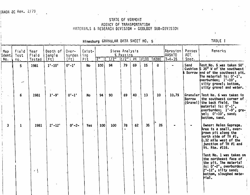
Hinesburg GRANULAR DATA SHEET NO. 5
Map Field Year Depth of Over- Exist- Ident Test Field Sample burden ing
I No. Mo. Tested IFO (Ft) Pit
5 1 1981 1 1 1 -1' O'-l' j No
Sieve Analysis % Pssirg
!"l 1/2" 1/2" (/4 hOC
1001 94 79 1 697 15
' Abrasion t Passes
AASHTO AOT,
200 T-4-35 Spec.
8 - Sand Cushion Borrow
10 10.7% Granular Borrow (Gravel)
26 - -
TABLE I
Remarks
est No. 5was taken 50' 350 W of the southwest
nd of the southeast pit. he material is: 0'-1 1
,
verburden; is_los, silty gravel; bottom, silty gravel and water.
Test No. 6 was taken in the southwest corner of the back field. The Imaterial is: O'-i', overburden; 1 1 -9 1 , gra-Yel; 0'-lO', sand; bottom, sand.
Owner: Helen Geprage. rea Is a small, over-rown pit along the orth side of TH #1, .32 mile west of the junction of TH #1 and Vt. Rte. #116.
Test No. 1 was taken on the northeast face of the pit. The material is: 0'-2', overburden; 2 1 -12', silty sand; ottom, sloughed mate-ial.
6 1981
0 , -li
No
94 1 90 1 69 140 .\ 13
3
1 1981 2'-12' 0'-2- Yes 100 100 78 62 35
.1 1
tA404 2C Rev. 2/79
STATE OF VERMONT AGENCY OF TRANSPORTATION
Ili\TERIALS & RESEARCH DIVISION - GEOLOGY SuB-DIVISION
Abrasion Passes AASHTO AOl, T-4-35 Spec.
Hinesburg GRANULAR DATA SHEET NO. 6
A& Field Year Depth of Over- Exist- Sieve Analysis den Test Field Sample burden ing % Pnssirg No. tiC. Tested Ft (Ft) P i t 2" 11 1/2" 11/2" 114 1#100
4 1 1981 1 6 -8' 0 1 -1' Yes 100 90 76 58 ii
5 1 1981 1 1 -6' 0 , -1' Yes 100 100 93 76 68 56 -
I /
TABLE I
Remarks
Area is a small, badly sloughed, waterfl 1 led pit on the west side
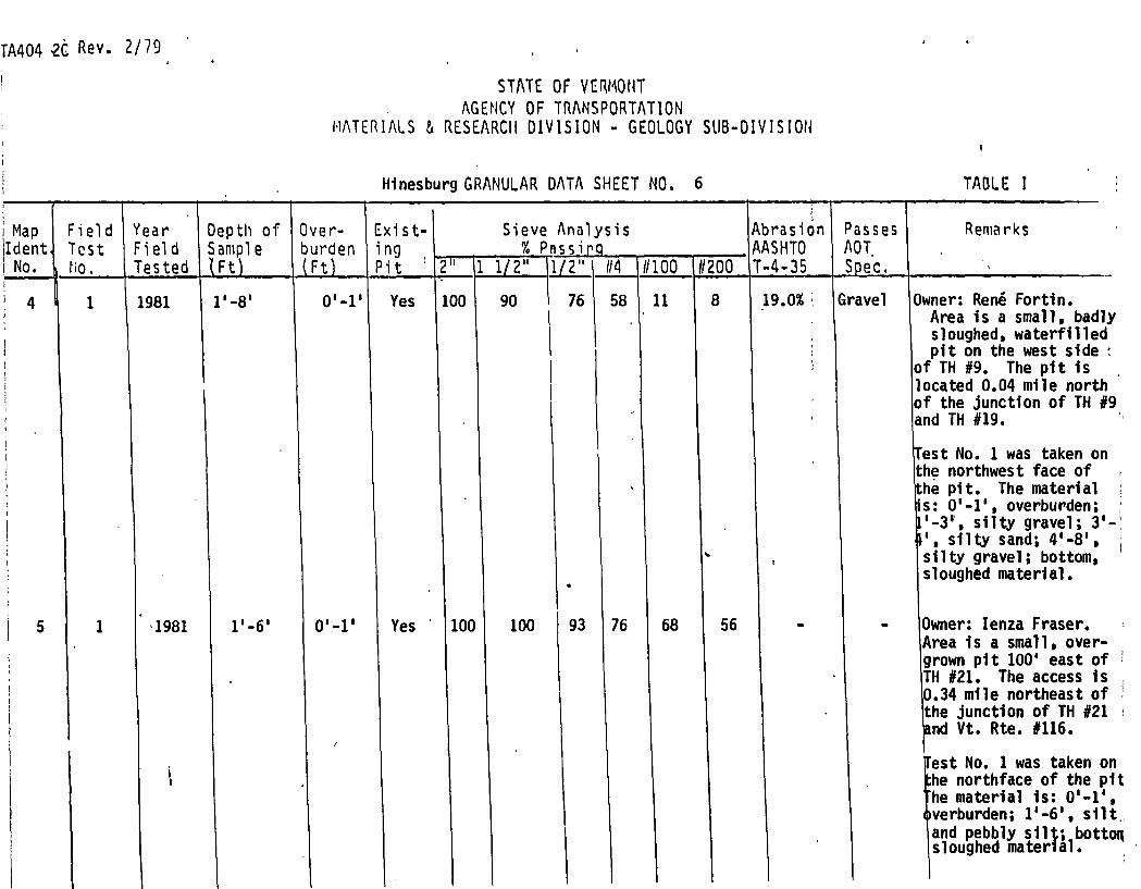
of TH #9. The pit is located 0.04 mile north of the junction of TH #9 and TH #19.
est No. 1 was taken on the northwest face of he pit. The material 5: 0 1 -1 1 , overburden; 1...3$, silty gravel; 3
silty sand; 4 1 -8', silty gravel; bottom, sloughed material.
Owner: Ienza Fraser. Area Is a small, over-grown pit 100' east of TH #21. The access Is 0.34 mile northeast of the junction of TH #21 nd Vt. Rte. #116.
est No. 1 wa taken on he northface
s of the pit
he material is: O'-i', verburden; 1 1 -6 1 , silt., and pebbly silt; botto, sloughed material.
Gravel lowner: René Fortin.

A404 2t Rev. 2/79
STATE OF VERMOHT AGENCY OF TRANSPORTATION
IATEfl1ALS & RESEARCH DIVISION - GEOLOGY SUB-DIVISION
Hinesburg GRANULAR DATA SHEET NO, 7 TABLE I
Map Field Year Depth of Over- I Exist- Sieve Analysis Abrasion Passes Remarks [dent Test Field Sample burden ing % Pnssirg AASHTO AOl,
No. IIQ. Tested TFt) (Ft) Pit - 2h 1 1/2 11 1112 11 114 9100_ #200_ T-4-35 Spec.
6 1 1981 - - Stock..a . 100 100 92 71 14 8 - Sand ner: Town of Hlnesburg. pile Cushion Hra is alarge multi-
& Borrow level, many lobed pit which the town uses as their source of material but cannot sell conner-
I cially with the except- ion possibly of Town funded projects. The pit is located 0.05 mile; north of TH #22. The am access Is 0.07 mile: est of the junction of H #9 and TH #22.
est No. 1 was taken rom a stockpile of creened material. The material Is pebbly,fine gravel.
2A 1981 3'-22' 0 1 -3' Yes 100 90 79 63 6 3 17.3 Sand Test No. 2A was taken Cushion on the west face of & Borrow the main pit near the
s hed. The material is: 1 -3 1 ,overburden; 3'- ', gravel; 8'-20 1 , peb- ly fine gravel; 20 1 - I 2 ', pebbly sand; bot- om , pebbly sand (Test o.2B).

TA404 2C Rev. 2/79,
STATE OF VERMONT AGENCY OF TRANSPORTATION
I'ATERIALS & RESEARCU DIVISION - GEOLOGY
Hinesbueg GRANULAR DATA SHEET NO. 8
SUB-DIVISIOt
TABLE I
Map Field Year Depth of Over- Exist- Sieve Analysis Abrasion Passer Remarks Ident Test Field Sample burden ing % Passipg AASHTO AOl, No. No, Tested IFO (Ft) Pit 2 11 1 1/2" 1/2" /14 1/100_I#200 T-4-35 Spec.
2B 1981 22'-30' - Yes 100 100 100 94 6 2 - Sand Test No. 2B was taken be- Cushion low Test No. 2A. The Borrow material is: 22 1 _301,
interbedded sand and peb- bly sand; bottom, gravel (Test No. 20.
2C 1981 30-55' - Yes 96 88 74 50 5 2 15.2% Gravel Test No. 2C was taken be- low Test No. 2B. The iaterial is: 30 1 -55', ravel; bottom, sloughed aterial.
3A 1981 2'-25' 0 6 -2' Yes 93 93 82 65 iq 8 16.1% Granular Test No. 3A was taken on -
- Borrow the west face of the (Gravel) northeast lobe of the pit.
The material Is: 0 1 2 9 overburden; 210 1 9 gra- vel; 10 1 -16', pebbly sand 16'-25', gravel; bottom, gravel (Test 0B).
3B 1981 15'-50' - Yes 96 89 64 39 7 5 10.8% Gravel Test No. 3B was taken be- 110w Test No. 3A. The aterial Is: 25 1 -50 1 ,
jravel; bottom, sloughed iaterial.
4 1981 1'-18' - 0'- is Yes 95 91 69 49 5 3 15.9% Gravel Test No. 4 was taken on he south face of the eat end of the uppermost lev el. The material ls:O' 1', overburden; 1'-18',

TA 404 2C Rev. 1/82
STATE OF VERMONT AGENCY OF TRANSPORTATION
MATERIALS & RESEARCH DIVISION - GEOLOGY SUB-DIVISION
GRANULAR DATA SHEET NO. 9 TAPIr T
Map Ident. No.
Field Test No.
Year Field Tested
Depth of Sample (Ft)
Over- burden (Ft)
Exist- Sieve Analysis ing % Pasjpa_ Pit 11 1/2" #4 #100 1#200
Abrasion AASHTO T-4-35
Passes AOl Spec.
Remarks
interbedded gravel and pel bly fine gravel; bottom, sloughed material.
5 1981 2'-15' 0 1 -2' Yes 100 100 95 85 3 2 - Sand Test No. 5 was taken 1001 Cushion west of Test No. 4. The & Borro material Is: 0 1 -2 1 , over•
burden; 2'-15 1 , pebbly sat bottom, sloughed material,
6 1981 2 1 -12' 0 1 -2' Yes 100 100 95 83 8 3 - Sand Test No. 6 was taken on Cushion south face at the west en Borrow of the upper level. The
material Is: 0 1 -2 1 , overb den; 2'-12 1 9 Interbedded gravel, pebbly fine grave and pebbly sand; bottom, sloughed material.
7 1981 2'25' 0 1 -2' Yes 100 95 88 73 9 4 - Sand Test No. 7 was taken on t Cushion northwest face of the old Borrow section of pit on the sou
side of the feature. The material Is: 0 1 -2 1 , overb den; 2 1 -6 1 , pebbly fine g vel; 6'18', pebbly sand; 18'-22', pebbly fine gray 22-25', pebbly sand bot sloughed material.
8 1981 2'-28' 0 1 -2' Yes 100 96 86 66 21 15 - Granular Test No. 8 was taken on orrow the north face of the old (Sand) section of the pit on the
south side of the feature The material Is: 01-2',

TA 404 2C Rev. 1/82
STATE OF VERMONT AGENCY OF TRANSPORTATION
MATERIALS & RESEARCH DIVISION - GEOLOGY SUB-DIVISION
GRANULAR DATA SHEET NO. 10 TABLE I
Map Field Ident. Test No. No.
Year Field Tested
Depth of Sample 2!Ft (Ft)
Over- rden
)
Exist- ing Pit
Sieve Analysis % Pajjn..._
Abrasion AASHTO T-4-35
Passes AOT Spec.
Remarks
- 1 1/2" 11 . #4 #100 1#200
overburden; 2'-10', peb- bly fine gravel; 10 1 -16', pebbly sand; 16'-22 1 , peb bly fine gravel; 22 1 -28 1 ,
pebbly sand; bottom, slou ed material.
7 1 1981 0.5'-20' 0'-0.5' Yes 100 100 86 66 15 1 - Sand Owner: Paul Casey (Hines. Cushion burg Sand & Gravel). Are & Borrov is a multi-leveled, part
ly overgrown pit formerly owned by Peters. The pit complex Is 250' east of TI #9. The access Is 0.50 rn north of the junction of #9 and Vt. Rte #116.
èst No. 1 was taken on ti past face of the upper le f the pit. The material )'-0.5', overburden; 0.5'. nterbeddèd sand to pebbl, 9ne gravel; bottom, slou 'd material.
2 1981 3 1 -25' 0 1 -3' Yes 100 100 88 74 15 5 - Sand Test No. 2 was taken on Cushion east face of the lower l & Borrow el of the pit. The mat
rial Is: 0'-3', overburch 3'-25', beds of sand and pebbly sand; bottom, sloi
Ii ed material.
I
TA 404 2C Rev. 1/82
STATE OF VERMONT AGENCY OF TRANSPORTATIQN.
MATERIALS & RESEARCH DIVISION - GEOLOGY SUB-DIVISION
Hinesburg GRANULAR DATA SHEET NO. 11 TABLE I
Map Field Ident.I Test No. No.
Year Field Tested
Depth of Sample (Ft)
Over- burden (Ft)
Exist- ing Pit
Sieve Analysis - % Passijg_..
Abrasion AASHTO 1-4-35
Passes AOl Spec.
Remarks
'- 11/2 1/4 #100 #200
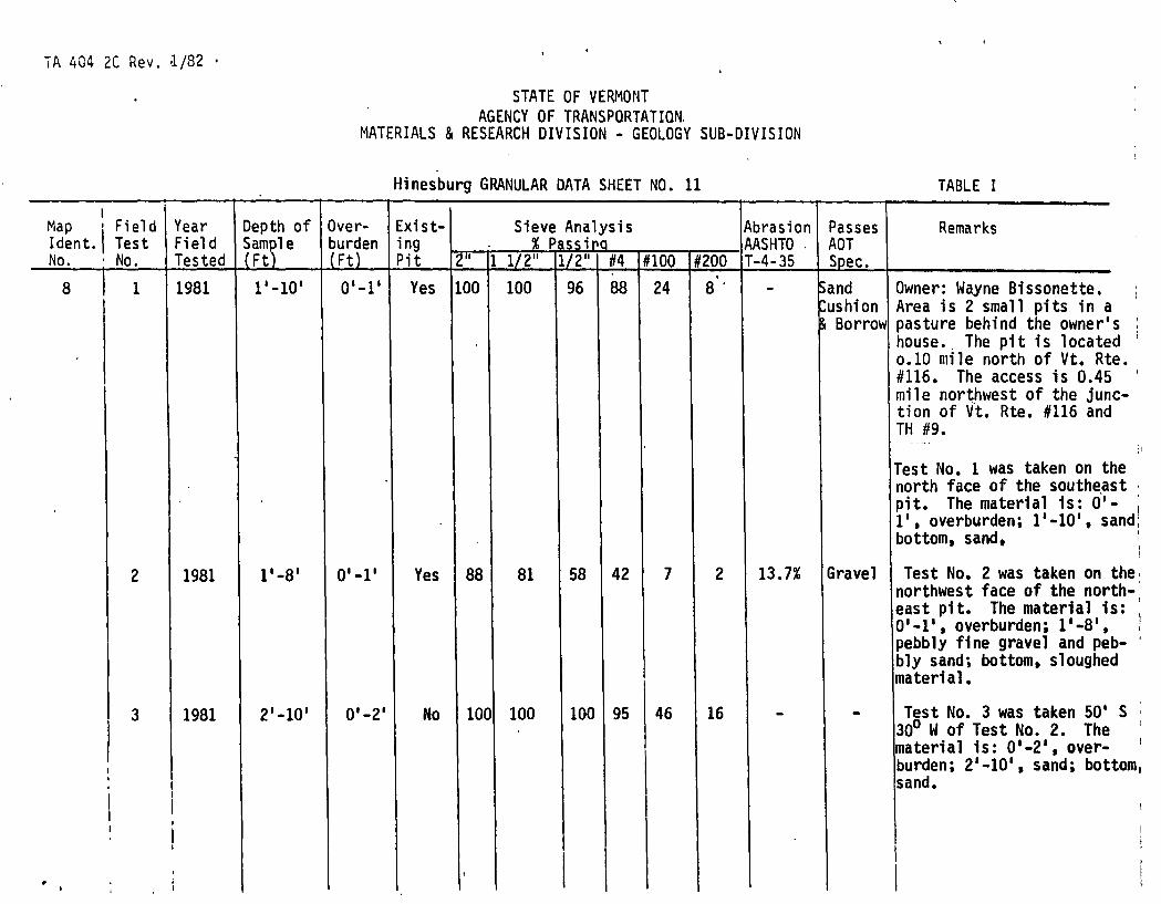
8 1 1981 1 1 -10' 0 1 -1 6 Yes 100 100 96 88 24 8 - and Owner: Wayne Bissonette.
ushion Area is 2 small pits in a i Borrow pasture behind the owner'
house.. The pit is locate o.10 mile north of Vt. Rt #116. The access is 0.45 mile northwest of the jun tion of Vt. Rte. #116 and TH#9.
Test No. 1 was taken on ti north face of the southe,a pit. The material Is: 0' 1', overburden; l'-lO', S bottom, sand,
2 1981 1 1 -8' O'-l' Yes 88 81 58 42 7 2 13.7% Gravel Test No. 2 was taken on northwest face of the nor east pit. The material 1 O'-i', overburden; l'-8 1 ,
pebbly fine gravel and pe bly sand; bottom, sloughe material.
3 1981 2 1 -10' O'-2' No 100 100 100 95 46 16 - - Test No. 3 was taken 50' 300 W of Test No. 2. The material Is: 0 1 -2', over- burden; 2'-10', sand; bot sand.

4404 2C Rev. 2/19
STATE OF VERMONT AGENCY OF TRANSPORTATION
IATERlALS & RESEARCH DIVISION - GEOLOGY SUB-DIVISION
Hlnesburg GRANULAR DATA SHEET NO. 12 TABLE I
Map Field Year Depth of Over- Exist- dent Test Field Sample burden ing No. tiC, Tested Ft) (Ft) Pit
9 'I 1 I 1981 I 1 1 -10' I o'-i' I Yes
Sieve Analysis ¼ Passirg
"1 1/2" 112" 114 -
L00 100 95 80 9
2 1981 1 6 -10' 0 0 -1' No 100 100 11 100 100 1 81
Abrasion Passes Remarks
AASHTO AOT,
00 T-4-35 Spec.
- ' Sand Owner: Everett 0Brian. Cushion Area is a large field & Borrow and the west end of the
former 'town pit (closed). Vt. Rte. #116 now bi-sects the old pit. The area is on the west side of Vt. Rte. 1116, at the junction of Vt. Rte. 116 1 nd TH #9.
Irest No. 1 was taken in he floor of the old pit. he material is: 0'-1 1 ,
verburden; 1'-10 1 , peb-bly sand; bottom, pebbly sand.
36 - - Test No. 2 was taken In the southwest corner of the field. The material is: O'a'i', overburden; 1 1 4', fine sand; 9 1 -10 1 , sIlty sand; bottom, ilty sand.
5 - Sand Owner: Everett O'Brian ushion rea is a pasture which Borrow is the extension for
the former town pit. The pit itself Is now an overgrown barnyard and was not sampled.
10 1
2981
1'-9'
0, _i
1 No
Iw
I 100 184 I 68 I 11
p
4404 2t Rev. 2/79
STATE OF VERM0T AGENCY OF TRANSPORTATION
MATERIALS & RESEARCH DIVISION - GEOLOGY S1JB-DIVISIOt
Hinesburg GRANULAR DATA SHEET NO, 12 TAnir T
Map dent No.
Field Test No,
Year Depth of Field Sample Tested tFt)
Over- burden (Ft)
Exist- ing Pit
Sieve Analysis % Pnssirg
Abrasion AASHTO T-4-35
Passes /\OT Spec,
Remarks
2 11 1 1/2" 1/2" 114 1/100 11200
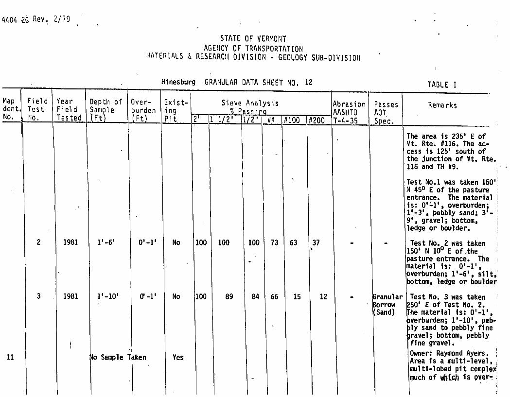
The area is 235' E of Vt. Rte. #116. The ac- cess is 125' south of the junction of Vt. Rt 116 and TH #9.
Test No.1 was taken 15 N 450 E of the pasture entrance. The materla Is: 0 11.1 1 , overburden; 1 1 -3 1 , pebbly sand; 3' 9 1
, gravel; bottom, ledge or boulder.
2 1981 1 1 -6' O'-l' No 100 100 100 73 63 37 - - Test No. 2 was taken 150 1 N 100 E of .the pasture entrance. The material is: O'-i', overburden; 1'-6', sil bottom, ledge or bould
3 - 1981 1 1 -10' (Y-1' No 100 89 84 66 15 12 - ranular Test No. 3 was taken orrow 50' E of Test No. 2. (Sand) he material Is: O'-i'
verburden; 1'-10', pe ly sand to pebbly fin ravel; bottom, pebbly fine gravel.
11 o Sample I ken Yes Owner: Raymond Ayers. Area is a multi-level multi-lobed pit compl much of whtch is gyer
Ii
er

M0 ev. 41 /i
STATE OF VERMONT AGENCY OF TRANSPORTATION
MATERIALS & RESEARCH DIVISION - GEOLOGY SIJB-DIVJSION
Hinesburg GRANULAR DATA SHEET NO. 13 TABLE I
Map Field Year Depth of 0ve?- Exist- Sieve Analysis Abrasion Passes Remarks Ident Test Field Sample burden ing % Pnssirg AASHTO AOT, No. tio. Tested Ft) (Ft) Pit V' 11 1/2" 1/2" 114 1/100 10200 _T-4-35 Spec.
grown. Although there - are apparent reserves,
the owner does not wish to sell and did not al- low samples to be taken.
12 1A 1981 20'-35' 0 , -li No 100 100 t 66 44 9 5 12.8% Gravel Owner: Wayne Bissonette,' rea ooded knoll in
lures
pas, about 400' W f TH #40, 0.83 mile south of the junction of TH #30 and Vt. Rte.
• #116.
Test No. 1A was taken on the southeast side of the knoll starting about 20! from the crest. The
• material Is: l'of over- burden; 20'-35', gravel; ottom, pebbly sand (Test No. 1B).
lB 1981 35 1 -45' - No 100 100 91 76 14 9 - Sand Test No. lB was taken Cushion below Test No. 1A. The & Borrow material is: 35'-40',
pebbly sand; 40'-45', sand; bottom, silty sand.
2A 1981 1 1 -6' 0 6 -1' No 100 100 100 97 51 19 - - Test 2A was taken atop he knoll 100' north- est of Test No. 1A.
iv-fU't -'
STATE OF VERMONT AGENCY OF TRANSPORTATION
MATERIALS & RESEARCH DIVISION - GEOLOGY SuB-DIVISION
Hlnesburg GRANULAR DATA SHEET NO, 14 TABLE I
Map Field Year Depth of Over- Exist- Sieve Analysis Abrasion Passes Remarks
Ident Test Field Sample burden ing %Passirq AASHTO AOT
No. tio. TestedIFt) (Ft) Pit 2" 11 1/2" 1/2" 1 114 111100 1 #200 T-4-35 Spec, The material Is: 0 1 -1 1 ,
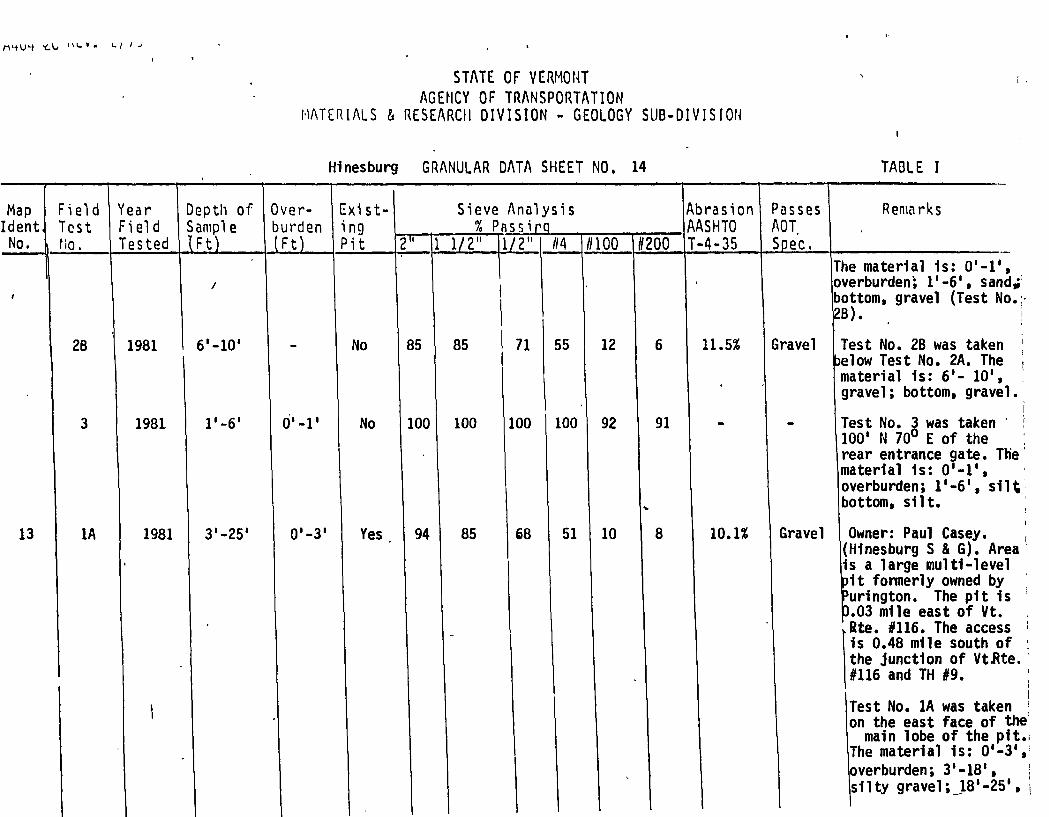
j overburden; 1'-6 1 , sand,; bottom, gravel (Test No.;
2B 1981 6'-10' - No 85 85 I 71 55 12 6 11.5% Gravel Test No. 2B was taken )elow Test No. 2A. The material Is: 6 1 - 10 1 9 gravel; bottom, gravel.
3 1981 1 0 -6' O'-l' No 100 100 100 1100 92 91 - I - Test No was taken
13 1 1A 1 . 1981 1 3 1 -25' 0 1 -3' Yes 94 85 1 68 I 51 1 10 8 10.1%
100' N 70 E of the rear entrance gate. The' material Is: 0'-l', overburden; i'-6', sIlt bottom, silt.
Gravel Owner: PaulCasey. (Hlnesburg S & 6). Area Is a large multi-level It formerly owned by urington. The pit Is
P.03 mIle east of Vt. Rte. #116. The access Is 0.48 mIle south of the junction of Vt.Rte. #116 and TH #9.
Test No. 1A was taken on the east face of the' main lobe of the pit.
The material Is: 0'-3' 9 overburden; 3'-18' 9 silty gravel;_18'-25'9
gravel; bottom, pebbly sand (Testlo. 1B).
5 8.5% Gravel Test No. lB was taken elow test #1A. The taterial is: 25 1 -30', ebbly sand; 30'-50', ravel; bottom, sloughed aterial.
6 - Sand Owner: Juliet Patterson Cushion Area is an old overgrown & Borrow pit formerly owned by
Tracy. The pit Is on the east side of Vt. Rte 116 In the west side of a large terrace feature. Access to the pit is at the junction of Vt. Rte. 116 and TH #35.
est No. 1 was taken on he east face of the pit he materIal is: Ol_i*, verburden; V-6 1 , peb- bly sand; 6-10', sand; 10'-15', pebbly sand; bottom, sloughed mate- rial.
7 - Gravel Test No. 2 was taken on the southeast face of the pit. The mate- rial Is: 0 1 ..1 I 9 overe.
lB
1981 I 25'-50' I
Yes
93 I
I 69 47
7
14 1 1981 1-15' Yes 100
92 81 170
15
2 1981 1'-12' O'-i' Yes 86 86 63 53 12
A404 2C Rev. 2/79
STATE OF VERMONT AGENCY OF TRANSPORTATION
fATER1ALS & RESEARCH DIVISION - GEOLOGY SUB-DIVISION
Hinesburg GRANULAR DATA SHEET NO, 15 TABLE I
Map Field Year Depth of Over- Exist- Sieve Analysis Abrasionj Passesl Remarks dent Test Field Sample burden ing ¼ Passirg AASHTO AOl, No. to, Tested tFt) (Ft) Pit 211 11 1/2" 11/2" 114 1 1/ 100 111200 T-4-35 Spec.

A404 2C Rev. 2/79
STATE OF VERMONT AGENCY OF TRANSPORTATION
IATER1ALS & RESEARCH DIVISION - GEOLOGY SuB-DIVISION
Hinesburg GRANULAR DATA SHEET NO. 16
TAnI r I
Map (dent No.
Field Test to,
Year Field Tested
Depth of Sample tFt)
Over- burden (Ft)
Exist- ing Pit
Sieve Analysis % Pnssirg
Abrasion AASHTO T435
Passes AOT, Spec.
Remarks
2 11 11 1/2" 1/2" 114 11100 9200 burde:; Pe 1-4 1 0 gravel; 4-8 bbly fine gra- vel; 8 1 -10 9 pebbly sand; 10'-12', pebbly fine gravel; bottom, sloughed material.
1981 1 1 -8' 0 1 -1' No 100 100 92 79 13 6 - Sand Owner: Wayne Bissonet Cushion Area is a sloping corn & Borrow field on the west side
of TH #30 with the higI est point being in the southeast corner.Acces to the field Is 1.30 iiles south of the jun tion of TH #30 and Vt. tte. 116.
rest No. 1 was taken itop the highest point in the field. The mati ial is: 0 1 -1, overbu en; 1 1 -3', pebbly sand:and pebbly fine gravel; 3 1 -8 1 , sand; bottom, sand.
2 19I 0.5-10' 0'-0.5' No 90 84 55 30 13 7 9.1% Gravel Test No.2
No. 1. The material is: 0'-1', overburden 0.5'-10', gravel; bot
torn, gravel.

'A404 2C Rev. 2/79
TABLE I
Remarks I II1 .JuIIIJI IJ'.II ,JII IuI UJ.) - 'I.JIII'd CVI
No. Mo. Tested tFt) (Ft) Pit 2'1 1/2" 1/2" 114 1 11100 111200 T-4-35 Spec, 3 1981 4110' O'-l' No 100 100 100 90 36 - 22 — — Test No. 3 was taken
100' S 60 W of Test No. 2. The material is: 0 1 - 1', overburden; 1'-4 1 ,
silt: 4'-10'. sand: bot-
4 1981 1'-10' O'-l' No 100 100 I 100 84 15 9 —
16 1 1981 1'-30'
Yes, 94 89 68 44 10 7 14.8%
STATE OF VERMONT AGENCY OF TRANSPORTATION
MATERIALS & RESEARCH DIVISION - GEOLOGY SUB-DIVISION
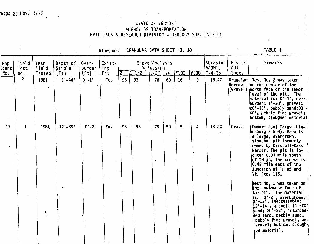
Hinesburg GRANULAR DATA SHEET NO. 17
Map Field Year Depth of Over- Exist-' Sieve Analysis Abrasion Passes r1n+ Tr.c 4r1 4zm nir,1 kti',1tr. 4rn "L Pnceir.r, trcwm LCT
torn, pebbly fine gravel.
Test No. 4 was taken 200' S 350 W of Test No. 3. The material is: 0 1 -1 1 ,
verburden; 1'-6', sand; '-10', pebbly sand; bot- om, pebbly fine gravel.
Gravel Owner: Paul Casey (Hines- urg S& G). Area is a large, 2 level pit in the south edge of a large terrace. The pit is 0.10 mIle north of TH No. 5. The access is 0.39 mile east of the junction of Vt. Rte. 116 and TH #5'.
est No. 1 was taken on he north face of the top, evel of the pit. The aterial is: O'-i', over-burden; 1 1 -20 1 , gravel; 20 1 -23 1 , silty gravel; 23'-30', gravel; boti,m, sloughed material.
Abrasion Passes AASHTO T\OT,
200 T-4-35 Spec.
Remarks
9 18.4% Granular Test No. 2 was taken Borrow on the center of the (Gravel) north face of the lower
level of the pit. The aterial is: 0'-1', over- burden; 1'-20, gravel; 0'-30'., pebbly sand;30 1 -
0 1 , pebbly fine gravel; ottom, sJoughed material
4 13.8% Gravel Owner: Paul Casey (Hin- esburg S & G). Area is a large, overgrown, sloughed pit formerly owned by Driscoll-Cass Warner. The pit is 10- cated 0.03 mile south of TH #5. The access is 0.48 mile east of the junction of TH #5 and Vt. Rte. 116.
est No. 1 was taken on he southwest face of he pit. The material s: 01_21, overburden;
1 -12 1 , inaccessable; 2'-14', gravel; 14'-20', and; 20'-23', Interbed- ed sand, pebbly sand, pebbly fine gravel, and gravel; bottom, slough- ed material.
17 1 1981 121 _35S 0 1 -2' Yes 93 93
75 1 58
5
Map Fied Year Ident Test Fie'd No. to, Tested
2 1981
Depth of Over- Exist- Sample burden ing Ft (Ft) P i t 1 1 -40' O'-l' Yes
Sieve flnalysis % Pass irg
112" 1/2" 1 114 93 1 76 60 13 16
A404 2C Rev. c/1Y
STATE OF VERMONT AGENCY OF TRANSPORTATION
I'ATER1ALS & RESEARCH DIVISION - GEOLOGY SUB-DIVISION
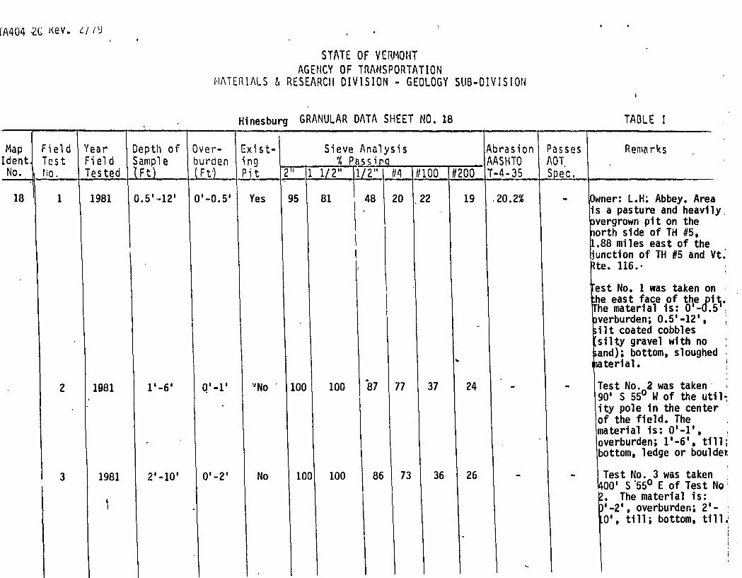
Hinesburg GRANULAR DATA SHEET NO. 18 TABLE I
Ii\404 2C Rev. 41 /Y
STATE OF VERMOt1T AGEIICY OF TRANSPORTATION
tATER1ALS & RESEARCH DIVISION - GEOLOGY SIJB-DIVISIOt4
Hinesburg GRANULAR DATA SHEET NO, 18 TABLE I
Map Field Year Depth of Over- Exist- Sieve Analysis Abrasion Passes Remarks Ident Test Field Sample burden ing % Pnssirg AASHTO AOT,
No. No. Tested tFt) (Ft) Pit 2" 1 1/2" 1/2" 114 /1100_ 11200 T-4-35 Spec.
18 1 1981 0.5'-12' 0'-0.5' Yes 95 81 48 20 22 19 20.2% - Owner: L.I1. Abbey. Area I is a pasture and heavily,
wergrown pit on the iorth side of TH #5, .88 miles east of the
I junction of TH #5 and Vt. te. 116.
èst No. 1 was taken on he east face of the he material is: O'-0.5 verburden; 0.5 1 _12 1 9 lit coated cobbles silty gravel with no and); bottom, sloughed aterial.
2 1981 1 1 -6' 0'-.l' 'No 100 100 87 77 37 24 - - Test No. 2 was taken 90' S 550 W of the util-, ity pole in the center of the field. The material is: 0-1', overburden; 1'-6', till;
lbottom, ledge or boulder
3 1981 2' -10' 0' -2' No 100 100 86 73 36 26 - -
Test No. 3 was taken 400' S 55° E of Test No
The material is: 1 -2 1 , overburden; 2'- 0 1
, till; bottom, till.

A404 2C ev. 41 I':)
TABLE I
Remarks
4 1981 2 1 -8' 01 -2' No 100 100 100 6; 39 33 - I Tpct Nn 4 wac tkAn
5 1981 1, 1 -10' 0'-1' No 100 92 62 34 38 34 19.6%
19
1
1981 I 86'-95'
01_21 1 Yes I 84 1 81
29
13
10
9.2%
I.
Test No. 1 was taken on the north lce of the amsection of the pit The material Is: 0'-2 1 ,
overburden; 2 1 -85' 1 1n-accessable; 85 1 -95,
STATE OF VERMONT AGENCY OF TRANSPORTATION
IATERIALS & RESEARCH DIVISION - GEOLOGY SUB-DIVISION
Hinesburg GRANULAR DATA SHEET NO, 19
Map Field Year Depth of Over- Exist- Sieve Analysis Abrasion Passes dent Test Field Sample burden ing % Pnssir'Q AASHTO AOl.
Ttr1 lFtl (Ft) Pit 2" Ii 1/2" 11/2" I 114 111100 111200 T-4-35 Spec.
400' S 450 E of Test No. 3. The material Is: 0'-2', overburden; 2 1 -8 1 ,
till; bottom, till.
Test No. 5 was taken In he southwest corner of he pasture northeast of, theplt. The material Is: 0-1', overburden; 1 1 -10 6 , silty gravel; bottom, silty gravel.
Owner: Paul Casey .(Hlnesburg S & G) Area Is a huge comercial pit and the major supplier of granular material to the Greater Burlington rea. The area is 0.55 lie east of Vt. Rte. 16. The access Is 0.25 lie south of the junc-ion of Vt. Rte. 116 and H#5.

A404 c KeY. 41 /J
STATE OF VERMONT AGEMCY OF TRANSPORTATION
IATERIALS & RESEARCH DIVISION - GEOLOGY SUB-DIVISION
Hlnesburg GRANULAR DATA SHEET NO, 20 TABLE I
Map Field Year Depth of Over- Exist- Sieve 'Analysis q
Abrasion Passes Remarks (dent Test Field Sample burden ing ¼ Pnssrg AASHTO AOT No. tiO, Tested Ft) (Ft) Pit 2" 11 1/2" 1J2u 114 111100 1 11200 T-4-35 Spec.
interbedded sands.arid gravels; bottom, slooghe material..
2 1981 Stockpile - Yes 100 100 95 83 8 3 - Sand Test No. 2 was taken
• I Cushion from a sand stockpile. & Borrow The material fssand.

- Table I
- Supplement I
Hinesburg Property Owners - Granular Map Identification No.
Abbey,L.H. . . . . • 18
Aube, Hector . 2
Ayers, Raymond o . 11
Bissonette, Wayne • • 8, 12, 15
Fortin, Rena . . - 4
Fraser, Ienza 0 0 5
Geprags, Helen • . . 3
Hinesburg Sand & Gravel • . . • 7, 13, 16, 17, 19
Hinesburg, Town Of . . • • 6
Martin, Henry and Elan .
OBrian, Everett • • 9, 10
Patterson, Juliet . . . . . . 14
404A 2C Rev. 2/7
STATE OF VERMONT AGENCY OF TRANSPORTATION
MATERIALS & RESEARCH DIVISION ENGINEERING GEOLOGY SUB-DIVISION
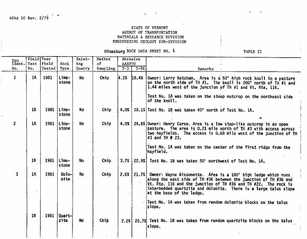
Hinesburg ROCK DATA SHEET NO. 1 TABLE II
1ap Ident. No.
Field Test No.
Year Field Tested
Rock Type
Exist- ing Quarry
Method of Sampling
Abrasion AASHTO
Remarks T-3 T-96
1A 1981 Lime- No Chip 4.2% 18.4% Owner: Larry Ketcham. Area is a 50' high rock knoll in a pasture stone on the north side of TH #1. The knoll is 200' north of III #1 and
1.44 miles west of the junction of TH #1 and Vt. Rte. 116.
Test No. 1A was taken on the steep outcrop on the northeast side of the knoll.
lB 1901 Lime- No Chip 4.0% 18.1% Test No. lB was taken 40' north of Test No. 1A. stone
2 1A 1981 Lime- No Chip 4.0% 24.6% Owner: Henry Carse. Area is a low step-like outcrop in an open stone pasture. The area is 0.21 mile north of IH #3 with access across
two hayfields. The access is 0.68 mile west of the junction of TH #3 and TH 0 23.
Test No. 1A was taken on the center of the first ridge from the hayfield.
lB 1981 Lime- No Chip 3.7% 22.9% Test No. lB was taken 50' northwest of Test No. 1A. stone
3 1A 1981 Dolo- No Chip 2.6% 21.7% Owner: Wayne Bissonette. Ai'ea is a 100' high ledge which runs mite along the east side of TH #36 between the junction of TH #36 and
Vt. Rte. 116 and the junction of TH #36 and TH #22. The rock is interbedded quartzlte and dolomite. There is a large talus slope
- at the base of the ledge.
• Test No. 1A was taken from random dolomite blocks on the talus slope.
lB • 1981 Quart- zite No Chin 2.2% 25.7% Test No. lB was taken from random quartzite blocks on the talus
slope.

404A 2C Rev. 2/79
STATE OF VERMONT AGENCY OF TRANSPORTATION
MATERIALS & RESEARCH DIVISION ENGINEERING GEOLOGY SUB-DIVISION
HinesburocK DATA SHEET NO. 2 TABLE II
1ap Ident. No.
Field Test No.
Year Field Tested
Rock Type
Exist- ing Quarry
Method of Sampling
Abrasion AASHTO
Remarks T-3 T-96
4 1A 1981 Quartz No Chip 6.2% 21.5% Owner: Don & Lyle Baldwin. Area is a ridge with a north-south ite - orientation running along the west side of TH #26. The test site Dolo was about 50' west of TM #26, 0.70 mile north of the junction of mite TM #26 and TM #23. The test site seems to be on or near the
contact of the Winooski Dolomite and the Monkton Quartzite, and the rock seems to be graded between the two types.
A Test No. 1/was taken 75' northwest of TH #26 at the corner of the fenceline.
lB 1981 Quart No Chip 3.3% 26.3% Test No. lB was taken 30' south of Test Ho. 1A. zltë Dolo -
mite -
5 1A 1981 uartz No Chip 2.9% 19.1% Owner: Rod Isham. Area Is a 60' high, north-south ridge with ite - numerous exposureson the southwest corner. The area Is about ' Dolo- 500' north of TM #27 across the cornfield. Access is 0.38 mIle nite' west of the junction of TM #27 and TM #4.
- Test No. 1A was taken on the west side of the southwest corner of the ridge.
lB 1981 Quart. No Chip 3.3% 26.3% Test No. lB was taken on the south side of the southwest corner of zite the ridge. Dolo- mite
6 1A 1981 Dab- No thip 4.7% 20.6% Owner: Rod Isham. Area is a rock knoll on a low ridge 150' north mite of TM #27, 0.20 mIle west of the junction of TM #27 and TM #4.
The rock knoll has 40' of relief on the south side.
Test No. lÀ was taken on the top half of the knoll
404A 2C Rev. 2/79
S TATE OF VERMONT AGENCY OF TRANSPORTATION
MATERIALS & RESEARCH DIVISION ENGINEERING GEOLOGY SUB-DIVISION
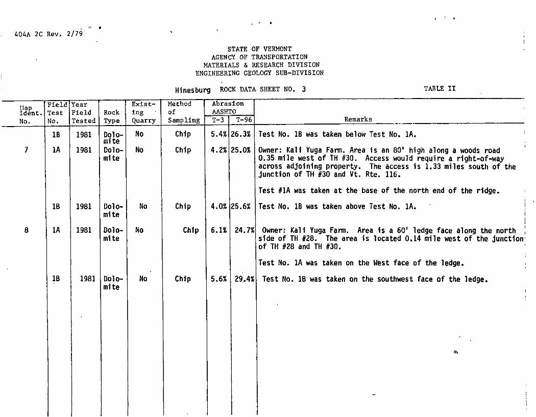
Hinesburg ROCK DATA SHEET NO. 3 TABLE II
idnt. No.
Field Test No.
Year Field Tested
Rock Type
Exist- ing Quarry
Method of Sampling
Abrasion AASIITO
Remarks T-3 T-96
lB 1981 Dolo- No Chip 5.4% 26.3% Test No. lB was taken below Test No. 1A. mite
7 1A 1981 Dolo- No Chip 4.2% 25.0% Owner: Kali Vuga Farm. Area is an 80' high along a woods road mite 0.35 mile west of TH #30. Access would require a right-of-way
across adjoining property. The access is 1.33 miles south of the junction of TH #30 and Vt. Rte. 116.
Test #1A was taken at the base of the north end of the ridge.
lB 1981 Dolo- No Chip 4.0% 25.6% Test No. lB was taken above Test No. 1A. mite
8 1A 1981 Dolo- No Chip 6.1% 24.7% Owner: Kali Vuga Farm. Area is a 60 ledge face along the north mite side of TH #28. The area is located 0.14 mile west of the junction
of TH #28 and III #30.
Test No. 1A was taken on the Wst face of the ledge.
lB 1981 Dolo- No Chip 5.6% 29.4% Test No. lB was taken on the southwest face of the ledge. mite
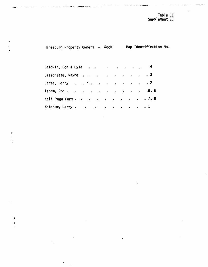
Table II Supplement II
Hinesburg Property Owners - Rock
Map Identification No.
Baldwin, Don & Lyle . . . . . . .. 4
Bissonette, Wayne . . . . . . . . . 3
Carse,Henry . . .. . . . . . . .2
Isham,Rod. . . . . . . . . .5,6
Kali Yuga Farm . • . . . . . . . . 7, 8
Ketcham, Larry . . . . . . . . . 1
a
$

