survey of highway construction materials in the...
TRANSCRIPT

IL
SURVEY OF HIGHWAY CONSTRUCTION MATERIALS
IN THE TOWN OF JOHNSON, LAHOILLE COUNTY, VERMONT
Prepared by
STATE OF VERMONT AGENCY OF TRANSPORTATION
MATERIALS & RESEARCH DIVISION
ENGINEERING GEOLOGY SUBDIVISION
Montpelier, Vermont
April, 1980
State of Vermont Agency of Transportation Materials & Research Division April, 1980
*
L 5'

TABLE OF CONTENTS
S Introduction Page
Acknowledgements ............................................ 1
Histo ..................................................... 1.
Enclosures.................................................. 1 - 2
Location .......................................................... 3
County and Town Outline Map of Vermont
Survey of Rock Sources
Procedure for Rock Survey................................... 4
Discussion of Rock and Rock Sources......................... 5
Survey of Sand and Gravel Deposits
Procedure for Sand and Gravel Survey....................... 6
Discussion of Sand and Gravel Deposits ..................... 7
C Summary of Rock Formations in the Town of Johnson ............... 8
Glossary of Selected Geologic Terms .............................. 9 - 12
Bibliography..................................................... 13
Partial Specifications f or Highway Construction Materials ........ Appendix I
Johnson Granular Data Sheets ..................................... Table I
Johnson Property Owners - Granular............................... Supplement -
Johnson Rock Data Sheet .......................................... Table II
Johnson Property Owners - Rock ................................... Supplement
Granular Materials Map ........................................... Plate I
Rock Materials MaP ................................................ Plate II
4

Page 1
Acknowledgments
This project acknowledges the surf icial geological information obtained
from Professor D. P. Stewart of Miami University, Oxford, Ohio and the bed-
rock information from the Centennial Geologic Map of Vermont, C. G. Doll.
History
The Materials Survey Project was initiated in 1957 by the Vermont
Department of Highways with the assistance of the Bureau of Public Roads to
compile an inventory of highway construction materials in the State of
Vermont. Previously, investigations for highway construction materials were
conducted only as the immediate situation required and only limited areas
were surveyed. Since no overall picture of material resources was available,
highway contractors or resident engineers were required to locate the mate-
rials for their respective projects and the samples were tested by the
Materials & Research Division. The additional expense of exploration for
construction materials resulted in higher construction costs being paid by
the State. The Materials Survey Project was formed to minimize this factor
by enabling the State and the contractors to use available information on
material resources and to project cost estimates. Knowledge of locations
of suitable materials is an important factor in planning highways.
The sources of construction materials are located by this Project
through ground reconnaissance, study of maps and aerial photographs, and
geological and physiographic interpretation. Maps, data sheets and work
sheets furnish information of particular use to contractors and construction
personnel, and should be studied together for maximum benefit.
Enclosures
Included in this report are two surface-geology maps, one defining the
location of tests on bedrock, the other defining the location of tests on
V
$
a

Page 2
granular materials. These maps are based on 15-minute or 7-½-minute
quadrangles of the United States Geological Survey enlarged or reduced to
1:31250 or 1" = 2604'. The various rock formations and types are delineated
on the Bedrock Nap of the township. This information is obtained from:
Vermont Geological Survey Bulletins, Vermont State Geologist Reports, United
States Geological Survey Bedrock Naps, Centennial Geologic Map of Vermont,
the Surf icial Geologic Map of Vermont and other references.
The granular materials map shows areas of various types of glacial
deposits (outwash, moraines, kames, katne terraces, eskers, etc.) which are
potential sources of gravel and sand. This information was obtained primar-
ily from a survey conducted by Professor D. P. Stewart of Miami University,
Oxford, Ohio, who mapped the glacial features of the State of Vermont during
the suimner months from 1956 to 1966. Further information is obtained from
the Soil Survey (Reconnaissance) of Vermont (conducted by the Bureau of
Chemistry and Soils of the United States Department of Agriculture), avail-
able Soil Surveys of individual counties (by the Soil Conservation Service
of the United States Department of Agriculture), Vermont Geological Survey
Bulletins, United States Geological Survey Quadrangles, aerial photographs
and other sources. The location of each test area is represented by a Map
Identification Number.
This report contains data sheets with detailed information on each test
taken in the Granular and Bedrock areas. Data is also used from an active
card file compiled by the Materials & Research Division over a period of years.
Some cards are not used because they are incomplete or have unusable information
on the location of the deposit.
Work sheets containing more detailed information and a field sketch of
the area, and laboratory test results are on file in the Materials & Research
Division of the Agency of Transportation, State of Vermont.

Page 3
LOCATION
The town of Johnson is in the north-central part of Lanioille County
in the northwest section of north-central Vermont. It is bounded on the
north by Belvidere, the northeast by Eden, the east by Hyde Park, the
southeast and south by Morristown, the west by Cambridge, and the north-
west by Waterville (see County and Town Outline Map of Vermont on the
following page).
The western half of Johnson lies in the Green Mountain Physiographic
Subdivision, and the eastern half lies in the Vermont Piedmont Physiographic
Subdivision of the New England Upland. The Green Mountains are characterized
by steep-sided hills and mountains in the south, southwest, and north corners
of town. The Vermont Piedmont is characterized by rounded hills of moderate
relief. Elevations range from 3,300 feet atop a peak south of Daniels
Notch, to below 450 feet in the western corner of Johnson where the Lamoille
River crosses the Cambridge Town Line. East of the mountains the land is
typified by rounded hills of less relief.
Primary drainage is northwestward via the Lamoille River, its south-
f lowing tributaries: Foote, Joe, Bell, Muckler, Gihon, and Wild Brooks, and
its north-flowing tributaries: Smith, French Hill, Boulley, Waterman, Hall,
and Belding Pond Brooks. Judevine Brook rises in the northwest corner of
Johnson and flows westward through Waterville and Cambridge.
Belding Pond is the only significant body of standing water in
Johnson. S

L6II 38Il33Q 3 S A H 3 V S S V II
lullilli
L
I ----sNOiSi.$JO ONINNV1d 1VRH0114
SAVMHIH dO iN3VDiVd30 1NOV3A rI
At G7Vt3tdI p suilnhlTul
ilhiliulit I
. lihiliOl
I I
Ih1suha.uu , ----- ----- -I
I I
uuuuiuhInhiIhu.IhtnucI ---•1- liJhahi I
I_i • Cl .uonuuvi p L 4
I-- ----1 I (IINSIIII / II!1010111
I / viiv.ir 101101311
I IllI011If 33101 1 1111113111 1 hIIil$ 11N3111331I 1011103
-, ____1 ---- ----- lz
0011 I
15 I i uluhI I
I p 111111
1*311110 I 1U0113 h00il Lh0'u1I.n ......JT r--.
4 J 11111
nlul,j i
_-----.__ ' hI0$IlI_ :
11 lilava
lhi*sihii$ha I uoioui I.. --------- —
.1.. o as000n, I l • I
I • 11100 II I I 1
: T —p4— __ uiuiio n 1 oonull4 4 oii
' - I totilwav
dVV 3NlliflO ,rnuuhu I
ty •o
'I,
1111/ 110111118 I0IuhuI13 -, 111*1104
NMOI GNV A..LNflOO --
-7 I
uitouosoiu/ q
1 111*11
3 I 1in lilt
I / —---'
118111$ / 111111 /
/ .uvuu,i
uuojsttie uuvnoio Noon.
/
-.- I I
- 0
131110$ / .._ ,1 uios 110111118 /
-... ,/ bull / /
I •.oio&uu /
A i*,.,i, 11110$
IN / 110*110*
—------------------------
•(.__ l 11011/13 t.. % 101013111
, ••-._ / 111111 I
/ 10*110*1
/ F --
13*3111 11081111 I
/ 11111111 / \t
/ .
r--J 1lll0IO)I
IhS1hiI3 /
I I P
11110111 /
1- 4 I ilhionul o*u
I
1111103 /. I1IIhlh0II/I&_
I p . --
b , ____•i J
I_,__ p M 1
00131i.olI/ __ / ••• II
•_\ 1101117
/14I1011l13it c
111111 11131I1 o% 11*11
lilo1011 1111111 b i 11111111
I 1111101 /
7_L A
131111 / •% I I
, / uu'su,h/ 1001 01111 I 6"
11111*1 % 111111
/ nouo,u,*u •,oiipi
1411111 •1lI*uio11----. ' uuc*juou I ,
I
lip I
it
-1 • I
-----.. -S-I,
0 / 6/
t,lhl1hl1101 " 1.. % 1110311*3
111111 / 1113111
1111188$ / — I0lI, I *011111 I 940S.114.------I)
3 0)
/ F 111111*11 ,..L
p 1lII0hI
3
/ o'# " — ,• % —
I 001101 --."ç!3oo n
_•& ••,/ — \I$hllllI \i
— / 111113 / *IlIu11Vt • " '
-S
10503 / / ,1'-_••.____
1
, Illl2I /
1*1111111 IN
/
/ ---cullollIll - 1113113 )uuo.0
( llS •13I11t ' 1t _1 c --.
•>
10 / hi
11011011
11111118 *uui i 110111 / .I......._.( 100111 / -
/ \ / -. •,_•('
IL/
111A
— I I
'. Pj'S / 13111111 ._ / • ).4 I 1111
/ 01111
110131* 0011*1 \ I 0 M
.5 _I 0iI16iIlI$.. /
1111111 Ljs
v--- I A
flhlIlill, I 130111*l N ,t
I
lk
/ 11101 /
/ );uousulln /
cuhu 11111 - -S 111003 , I
i \ •11IiihIlo7' ,/ / nO.80 7
13111613 / 11111 / 10*11 l011,'j 111111 11081*113/
/ - 'I S. PGi S. ?c: iI / -4-Ih10l lIlI1l,/>\. / O ' I NI '
1111 01101 11011801 o*nuoi
.< hio.looI'$
, / 11131111 I
hIlII*1 111111 / / • / lI jJ s
S. ) / 1018111 / ,/ 111111
11l*0I1ulI _S$,
/ 1*111
I 181*110* Ps 1311*10011
/
-s 1180111 / Is S. lIIOlIul0II /
'I liii
1l1l01tl0l '.-r- Ill Ii
I / 1111110
IOIOI 1IININ / ,,Lri____i
I--------I
11
101*1s. / / I -----------
101111111 1 /
/\( 11111187 i 11111311
$1110
I .5 .5 S. 1111$'! /1lou1 IIIlIl •
t_.1 1111111 '' \ lJf 111*1311
1*11111. I
o
11111*1
£1011 I
1111170* I S.

C
Page 4
SURVEY OF ROCK SOURCES
Procedure for Rock Survey
The method employed by the project in a survey of possible sources of
rock for highway construction is divided into two main stages: office and
field investigations.
The office investigation is conducted during the winter months and
comprises the mapping and description of rock types perused from many ref-
erence sources, as acknowledged in the bibliography. These references differ
considerably in dependability due to subsequent developments and studies that
have contributed to the obsolescence of a number of reports. - The results of
samples taken by other individuals are analyzed, and their location is mapped
when possible. As complete a correlation as possible is made of the available
geological information concerning the area under consideration.
The field investigation is begun by making a cursory survey of the entire
town. The information obtained from the preliminary survey, and that from
the office investigation, is used to determine where sampling will be concen-
trated. When a promising source has been determined by rock type, volume of
material, accessibility, adequate exposure and relief, chip samples are taken
with a hammer across the strike or trend of the rock, and are submitted to
the Materials & Research Division for abrasion testing by the Deval Method
(AASHTO T-3) and the Los Angeles Method (AASHTO T-96). Samples taken by the chip
method are often within the weathered zone of the outcrop and thus may give a less
satisfactory test result than fresh material from unweathered rock. When the
rock is uniform, and the chip samples yield acceptable abrasion test results,
the material source is listed in this report as being satisfactory.
ft

Page 5
Discussion of Rock and Rock Sources
The information on the Rock Materials Map (Plate II) is simplified.
For a more detailed description of the respective rock formations, see the
Sununary of Rock Formations included in this report.
Occasionally, rocks belonging to the same formation and exhibiting
similar characteristics (i.e., color and texture) produce different abra-
sion test results owing to differing physical properties or chemical
compositions. Therefore, in no case should satisfactory test results
obtained in one area be construed to mean that the same formation, even
in the same area, will not later produce unsatisfactory materials; this
is particularly true of metamorphic rocks.
Metamorphic rocks of the Green Mountain Sequence underlie the town.
- Rocks of the Hazens Notch Formation are mapped as underlying most of
Johnson. The Pinnacle Formation schist, and the Underhill schist and
phyllite comprise nearly all of the remainder of the rocks in town. The
schists, and the phyllites and schists have not yielded satisfactory con-
struction material where sampled in other towns, either.
The Hazens Notch schist was sampled at Map Identification Number 2
but yielded unsatisfactory abrasion test results. A talc mine in an ultra-
maf Ic rock body in the northeast corner of town yielded rock from the grout
piles which had satisfactory abrasion test results; however, there might be
difficulty in getting the necessary permits to use this rock for construction
purposes.
The Formations mapped as underlying Johnson from west-to-east are: the
Underhill schist and phyllite, the Hazens Notch schist, quartzIte, and gneiss,
ft
the Pinnacle schist, a small (mapped)zone of Stowe greenstone, the Hazens
Notch schist, and the Plutonic rocks (tiltramafics).
Page 6
SURVEY OF SAND AND GRAVEL SOURCES
Procedure for Sand and Gravel Survey
The method used for conducting the survey of possible sources of sand
and gravel for highway construction is divided into two main stages: office
and field investigations.
The office investigation is conducted during the winter months and
comprises the mapping of potentially productive areas from various references.
Of these references, the survey of glacial deposits mapped by Professor
Stewart is particularly helpful when used with soil-type maps, aerial photo-
graphs, and United States Geological Survey Quadrangles. The last two are
used in the recognition and location of physiographic features indicating
glacial deposits, and in the study of drainage patterns. The locations of
existing pits are mapped, as are the locations in which samples were taken
by other individuals.
The field investigation is begun by making a cursory survey of the en-
tire town. All pits, and any areas that show evidence of glacial or fluvial
deposition are noted, and later investigated by obtaining samples from pit
faces and other exposed surfaces. Test holes in pit floors and extensions
are later dug with a backhoe to a depth of approximately 11 feet to obtain
material which is submitted to the Materials & Research Division for
gradation, sieve analysis and AASHTO T-4 Method stone abrasion test.

Page 7
Discussion of Sand and Gravel Deposits
Results of this survey indicate that granular deposition in Johnson
is limited to features between 450 feet and 850 feet elevation. There are
several pits having acceptable Sand Borrow and Cushion Item 703.03, and
Gravel for Sub-base Item 704.05, which are not in any mapped granular feature.
These pits were found from 830 feet to 850 feet elevation. Many sources of
granular material are mapped as occurring in lake sediment areas. -
The most promising sources of Gravel for Sub-base Item 704.05 are
listed with the most favorable first: pits at Map Identification Numbers
32, 30, 31, and 19. Many good sources of gravel occur between 500 feet and
700 feet elevation.
Good sources of Sand Borrow and Cushion occur mainly between 525 feet
and 850 feet elevation. The most promising sources of Sand Borrow and
Cushion Item 703.03 are listed with the most favorable first: Map Identi-
fication Numbers 30, 5, 11, 9, 10, and 2; all are pits except Numbers 5,
9, and 10.
There are several other granular areas with acceptable material; how-
ever, these were not listed because they were very close to depletion, or
there are plans for commercial, residential, or agricultural development.

Page 8
- SUMMARY OF ROCK FORMATIONS IN THE TOWN OF JOHNSON
Green Mountain Sequence
Stowe Formation, greenstone and amphibolite: Epidote-albite-chlorite rocks contain actinolite and hornblende where more metamorphosed.
Plutonic Rocks: Ultramaf Ic: serpentinite, carbonate rock, talc-carbonate rock, and steatite.
Camels Hump Group
Underhill Formation: Silvery, gray-green, quartz-sericite-albite--chlorite-biotite schist containing abundant lenticular segregations of granular white quartz; locally quartz-sericite-albite-chlorite phyllite; porphyroblasts of albite, garnet, and magnetite are common and locally very abundant in gneissic facies in axial anticlines of the Green Mountain anticlinorium.
Pinnacle Formation (Foot Brook member): Sericite (muscovite-paragonite)- quartz-chlorite-chloritoid schist; minor carbonaceous interbeds.
liazens Notch Formation: Interbedded carbonaceous and non-carbonaceous quartz- sericite-albite-chiorite schist; grades to quartzite and gneiss.
Hazens Notch Formation schis t: Sericite-quartz-chlorite-albite-magnetite schist, near Hyde Park.
0

Page 9
GLOSSARY OF SELECTED GEOLOGIC TERMS
Actinolite: A variety of amphibole occurring in greenish bladed crystals or in masses.
Albite: The light-colored, sodium end-member of the continuous plagioclase feldspar series which is found in alkali rocks. The name is often com-pounded with the names of rocks containing the mineral.
Amphibolite: A green-to-black, schistose, metamorphic rock consisting mostly of amphibole (i.e., tremolite, actinolite, hornblende, or arfvedsonite).
Anticline: A fold of rock strata that is convex upward, in which the older formations occur toward the, center of curvature.
Anticlinorium: A composite fold consisting of connected anticlines and synclines which, grouped together, form an arch. The term applies to rela-tively large features extending f or several miles.
Bedding: The arrangement of rock or soil in layers, strata, or beds.
Bedrock: The more or less solid, undisturbed rock in place at the surface, or beneath superficial deposits of gravel, sand, or soil.
Biotite: A platy, dark silicate mineral commonly known as black mica.
Carbonaceous: Containing carbon.
Carbonate Rocks: Rocks composed of the molecule CO 1 combined with calcium, magnesium, etc. Includes limestones, dolomites, ana marbles.
Chlorite: A group of green hydrous silicates of aluminum, ferrous iron, and magnesium which occur as plate-like crystals or scales in metamorphic rocks.
Chlorltoid: A brittle member of the mica mineral group.
Delta: A predominantly alluvial deposit built by a stream entering a standing body of water. It usually is formed like the Greek letter delta.
Drainage basin: A part of the surface of the earth that is occupied by a drainage system or contributes surface water to that system.
Epidote: A calcium-aluminum-iron silicate mineral that usually occurs in rocks as formless grains or masses. It is usually some shade of green, but pistachio-green or yellowish-green are most common.
Fades: The composite nature of 'sedimentary deposits that reflects the conditipns and environment of their origins.
Garnet: An important group of minerals in which aluminum, calcium, chromium, ferric- and ferrous iron, magnesium, and manganese combine with a silicate.

Page 10
They are commonly deep red, brown, or black, but may be any color except possibly blue.
Gneiss: A metamorphic rock having alternate banks of light minerals (rich in feldspar and quartz), and dark minerals (rich in hornblende and mica).
Cneissic: Raving the banded, streaked, and foliated appearance and texture of gneiss which is a more or less banded metamorphic rock with the mineral composition of granite.
Greenstone: A field term for rocks so metamorphosed or otherwise altered that they assume a distinctive color owing to the presence of chlorite, epidote, or actinolite. Greenstone is usually derived from dark igneous rocks. Normally tough and hard, it is crushed to produce good-to-excellent aggregate.
Hornblende: A common, dark variety of the amphibole group of silicate minerals. It is usually black, dark green, or brown, has a hardness of 5 to 6, a specific gravity of about 3.0, and often occurs in prismatic masses in igneous and metamorphic rocks.
Interbeds: Occur between, or lie adjacent and parallel to, other beds of usually a different nature.
Kame: A conical hill of generally poorly stratified drift deposited against glacial ice by streams flowing in or on the ice.
Kame Terrace: Stratified sands and gravels deposited by streams flowing between a glacier and an adjacent valley wall.
Lenticular: Pertains to a mass of rock or earth that thins out in all direc-tions from the center like a double-convex optical lens.
Magnetite: A magnetic mineral composed of iron ferrate (Fe304, or FeFe203).
Metamorphic Rocks: Rocks formed from pre-existing rocks altered by heat, pressure, or the infiltration of gases and liquids below the zones of oxida-tion and cementation. Metamorphic rocks are reconstructed in place while remaining essentially solid.
Muscovite: An important member of the mica group of silicate minerals; known also as white mica, potash mica, or isinglass.
Paragonite: A mica similar in appearance to muscovite but containing sodium instead of potassium.
Phyllite: A fine-grained, metamorphic rock intermediate between the mica schists and slates, into which it may grade. Its cleavage is due to the high content of the potash mica, sericite, which gives the rock a distinctive silvery appearance. Its fracture is intermediate between the rather splintery fissility of schist, and the smooth, even cleavage of slate; however, the rock is not as tough as slate.

Page 11
Physiographic: Pertaining to the physical divisions of the earth's surface.
Piedmont: Lying, or formed at the base of mountains.
Plutonic: Pertaining to the depths of the earth, generally applied to rocks and intrusions that have consolidated at great depths. Such rocks have cooled slowly under great pressure and are typically entirely crystalline and non-porphyrltic. In a more general way the term is used to designate any igneous rock of deep-seated origin.
Porphyroblasts: Large crystals which have formed in place within the fine-grained matrix of a metamorphic rock. They are produced by heat, pressure, and infiltrating solutions in pre-existing rocks.
Quartz: The most common mineral (Sb 2). It occurs as hexagonal crystals or amorphous masses. It is transparent, translucent, opaque, or variously colored due to impurities.
Quartzite: The common, siliceous rock which is the metamorphic equivalent of sandstone composed of quartz grains so firmly bonded that fractures occur with equal ease across the grains and the cementing material.
Relief: The relative difference in elevation between the summits and the lowlands of a particular region.
Schist: A crystalline, metamorphic rock having secondary foliation or lamina-tion based on the parallelism of platy or needle-like grains which causes a tendency to split along the foliation.
• Sediments: All materials deposited from the waters of streams, lakes, seas, or more generally, deposited by wind or ice.
Segregation: The concentration of one or more minerals that have formed together during crystallization of molten rock in place.
Sericite: A metamorphic mineral very similar to muscovite; it occurs in minute flakes or scales in schists, gneisses, and phyllites.
Serpentinite: A metamorphic rock consisting primarily of the mineral serpen-tine derived mainly from the alteration of igneous rocks containing olivine or other magnesium-rich minerals. The process whereby these minerals are changed to serpentine is known as serpentinization.
Shoal: A sand-or gravel-bar that makes the water shallow; specifically an elevation which is not rocky, and on which there is a depth of water of six fathoms (36 feet) or less. The material is sorted and coarsened by subsequent wave-act ion.
• Steatite: Also known as soapstone. It is essentially an impure, and massive- to-schistose talc and may grade into talc schists. Its distinguishing characteristics are its softness (it can be cut with a knife), and its greasy or soapy feel.

Page 12
Till: An unsorted, unstratified, unconsolidated, heterogeneous mixture of clay, silt, sand, gravel, and boulders deposited directly by glacial ice.
Ultramaf Ic: Pertaining to igneous rocks that have a low percentage of silica (less than 45%), virtually no quartz or feldspar, and a correspondingly high percentage of iron, magnesium, and calcium. These rocks may occur as individual masses, or as segragations in larger igneous bodies.

Page 13
BIBLIOGRAPHY
Flint, Richard F. Glacial Geology and the Pleistocene Epoch. New York: John Wiley and Sons, Inc., 1947.
Heinrich, E. W. Microscopic Petrography. New York: McGraw-Hill Co., Inc., 1956.
Kemp, James F. A Handbook of Rocks. New York: D. Van Nostrand Co., Inc., 1949.
National Academy of Sciences. National Research Council. Highway Research Board. Soil Exploration and Mapping, Highway Research Board Bulletin 28. Washington, D. C.: National Academy of Sciences - National Research Board, 1950.
Pirsson, L. V. Rock and Rock Minerals. New York: John Wiley and Sons, Inc., 1949.
Stokes, William L. and Varnes, David J. Glossary of Selected Geologic Terms, Colorado Scientific Society Proceedings, Vol. 16. Denver, Colorado: Colorado Scientific Society, 1955.
- U. S. Department of Agriculture. Bureau of Chemistry and Soils. Soil Survey (Reconnaissance) of Vermont, by K. V. Goodman, W. J. Latimer, F. R. Lesh, S. 0. Perkins, and L. R. Smith (1930).
U. S. Department of Interior. Geological Survey. Hyde Park Quadrangle, Vermont, 15 Minute Series (Topographic) (1953).
U. S. Department of Interior. Department of Army. Mount Mansfield Quadrangle, Vermont, 15 Minute Series (Topographic) (1948).
Vermont. Department of Water Resources. Geological Survey. Surf icial Geologic Map of Vermont, edited by Charles G. Doll (1970).
Vermont. Department of Water Resources. Geological Survey. The Surficial Geology and Pleistocene History of Vermont, by David P. Stewart and Paul MacClintock, Bulletin No. 31 (1969).
Vermont. Development Department. Geological Survey. Centennial Geologic Nap of Vermont, edited by Charles C. Doll (1961).
Vermont. Development Department. Geological Survey. The Glacial Geology of Vermont, by David P. Stewart, Bulletin No. 19 (1961).

Appendix I
PARTIAL SPECIFICATIONS FOR HIGHWAY CONSTRUCTION MATERIALS
Listed below are partial specifications for Highway Construction Materials as they apply to this report at date of publication. For a complete list of specif 1-cations see Standard Specifications for Highway and Bridge Construction, approved and adopted by the Vermont Department of Highways, March, 1976.
DIVISION 700 - MATERIALS
703.03 SAND BORROW AND CUSHION. Sand borrow shall consist of material reasonably free from silt, loam, clay, or organic matter. It shall be obtained from approved sources and shall meet the requirements of the following table:
TABLE 70303A - SAND BORROW AND CUSHION
Sieve Percentage by Weight Passing Square Mesh Sieves Designation TOTAL SAMPLE SAND PORTION
2" 100 1½" 90-100 ½" 70-100
No. 4 60-100 100
No. 100 0- 30 No.200 0- 12
703.05 GRANULAR BORROW. Granular borrow shall be obtained from approved sources, consisting of satisfactorily graded, free draining, hard, durable stone and coarse sand reasonably free from loam, silt, clay, or organic material.
The Granular Borrow shall meet the requirements of the following table:
TABLE 703.05A - GRANULAR BORROW
Sieve Percentage by Weight Passing Square Mesh Sieves Designation TOTAL SAMPLE SAND PORTION
No. 4 20-100 100 No.200 0-15
The maximum size stone particles of the Granular Borrow shall not exceed 2/3 of the thickness of the layer being spread.
704.05 GRAVEL FOR SUB-BASE. Gravel for Sub-base shall consist of material reason-ably free from silt, loam, clay, or organic matter. It shall be obtained from approved sources and shall meet the following requirements:
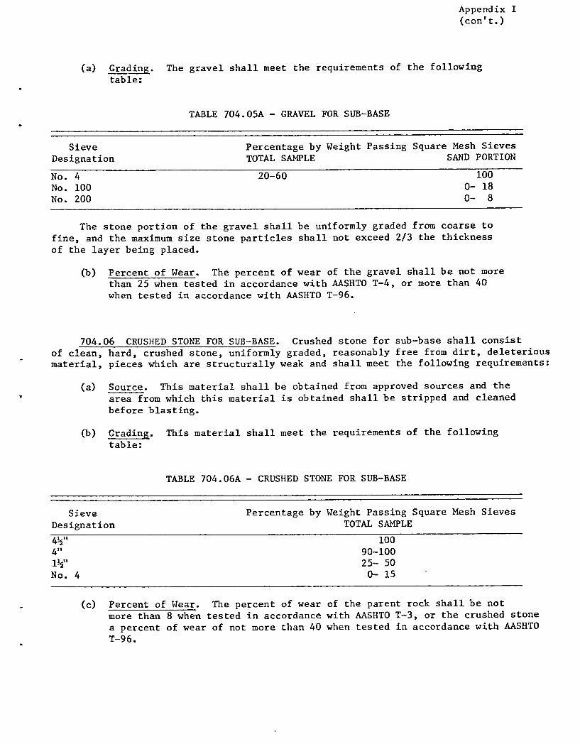
Appendix I (con' t.)
(a) Grading. The gravel shall meet the requirements of the following table:
TABLE 704.05A - GRAVEL FOR SUB-BASE
Sieve Percentage by Weight Passing Square Mesh Sieves Designation TOTAL SANPLE SAND PORTION
No. 4 20-60 100 No. 100 0 18 No. 200 0- 8
The stone portion of the gravel shall be uniformly graded from coarse to fine, and the maximum size stone particles shall not exceed 2/3 the thickness of the layer being placed.
(b) Percent of Wear. The percent of wear of the gravel shall be not more than 25 when tested in accordance with AASHTO T-4, or more than 40 when tested in accordance with AASHTO T-96.
704.06 CRUSHED STONE FOR SUB-BASE. Crushed stone for sub-base shall consist of clean, hard, crushed stone, uniformly graded, reasonably free from dirt, deleterious material, pieces which are structurally weak and shall meet the following requirements:
(a) Source. This material shall be obtained from approved sources and the IV area from which this material is obtained shall be stripped and cleaned
before blasting.
(b) Grading. This material shall meet the requirements of the following table:
TABLE 704.06A - CRUSHED STONE FOR SUB-BASE
Sieve Percentage by Weight Passing Square Mesh Sieves Designation TOTAL SANPLE
4½" 100 4" 90-100 1½" 25- 50 No.4 0-15
(c) Percent of Wear. The percent of wear of the parent rock shall be not more than 8 when tested in accordance with AASHTO T-3, or the crushed stone a percent of wear of not more than 40 when tested in accordance with AASHTO T-96.

Appendix I (con't.)
(d) Thin and Elongated Pieces. Not more than 30 percent, by weight, of thin and elongated pieces will be permitted.
Thin and elongated pieces will be determined on the material coarser than the No. 4 sieve.
(e) Filler. The filler shall be obtained from approved sources and shall meet the requirements as set up for Sand Cushion, Subsection 703.03.
(f) Leveling Material. The leveling material shall be obtained from approved sources and may be either crushed gravel or stone screening produced by the crushing process. The material shall consist of hard durable particles, reasonably free from silt, loam, clay or organic matter.
This material shall meet the requirements of the following table:
TABLE 704.06B - LEVELING MATERIAL
Sieve Percentage by Weight Passing Square Mesh Sieves Designation TOTAL SANPLE
3/4t1 100 1/2" 70-100 No. 4 50- 90 No. 100 0- 20 No. 200 0- 10
704.07 CRUSHED GRAVEL FOR SUB-BASE. Crushed gravel for sub-base shall consist of material reasonably free from silt, loam, clay or organic matter. It shall be obtained from approved sources and shall meet the following requirements:
(a) Grading. The crushed gravel shall be uniformly graded from coarse to fine and shall meet the requirements of the following table:
TABLE 704.07A - CRUSHED GRAVEL FOR SUB-BASE
Sieve Percentage by Weight Passing Square Mesh Sieves GRADING Designation TOTAL SAMPLE SAND PORTION
COARSE 4" 100 No. 4 25- 50 100
No. 100 0- 20 No. 200 0- 12
2" 100 1½" 90-100
FINE No. 4 30- 60 100
No. 100 0- 20 No.200 - 0- 12

Appendix I (con' t.)
(b) Percent of Wear. The percent of wear of the parent gravel shall be not more than 20 when tested in accordance with AASHTO T-4, or the crushed gravel a percent of wear of not more than 35 when tested in accordance with AASHTO T-96.
(c) Fractured Faces. At least 30 percent, by weight, of the stone content shall have at least one fractured face.
Fractured faces will be determined on the material coarser than the No. 4 sieve.
704.09 DENSE GRADED CRUSHED STONE FOR SUB-BASE. Dense graded crushed stone for sub-base shall consist of clean, hard, crushed stone, uniformly graded, reason-ably free from dirt, deleterious material and pieces which are structurally weak, and shall meet the following requirements:
(a) Source. This material shall be obtained from approved sources and the area from which this material is obtained shall be stripped and cleaned before blasting.
(b) Grading. This material shall meet the requirements of the following table:
TASLE 704.09A - DENSE GRADED CRUSHED STONE FOR SUB-BASE
Sieve Percentage by Weight Passing Square Nesh Sieves Designation TOTAL SANPLE
3½" 100 3" 90-100 2" 75-100 1" 50- 80
½" 30- 60 No. 4 15- 40 No. 200 --9- 10
(c) Percent of Wear. The percent of wear of the parent rock shall be not more than 8 when tested in accordance with AASHTO T-3, or the crushed stone a percent of wear of not more than 40 when tested in accordance with AASHTO T-96.
(d) Thin and Elongated Pieces. Not more than 30 percent, by weight, of thin or elongated pieces will be permitted.
Thin and elongated pieces will be determined on the material coarser than the No. 4 sieve.
704.10 GRAVEL BACKFILL FOR SLOPE STABILIZATION. Gravel backfill for slope stabilization shall be obtained from approved sources, consisting of satisfactorily graded, free draining, hard, durable stone and coarse sand reasonably free from loam,

Appendix I (con' t.)
silt, clay, and organic material.
The gravel backfill shall meet the requirements of the following table:
TABLE 704.10A - GRAVEL BACKFILL FOR SLOPE STABILIZATION
Sieve Percentage by Weight Passing Square Mesh Sieves Designation TOTAL SAMPLE SAND PORTION
No. 4 20-50 100 No. 100 0- 20 No.200 0-10
The stone portion of the gravel backfill shall be uniformly graded from coarse to fine, and the maximum size stone particles shall not exceed 2/3 the thickness of the layer being placed.
704.11 GRANULAR BACKFILL FOR STRUCTURES. Granular backfill for structures shall be obtained from approved sources, consisting of satisfactorily graded, free draining granular material reasonably free from loam, silt, clay, and organic material.
The granular backfill shall meet the requirements of the following table:
TABLE 704.11A - GRANULAR BACKFILL FOR STRUCTURES
Sieve Designation
3' , 2½" No. 4 No. 100 No. 200
Percentage by Weight Passing Square Mesh Sieves TOTAL SAMPLE SAND PORTION
100 90-100 50-100 100
0- 18 0- 8

p 1 I p S
I'A 404 2C Rev. 2/79p
STATE OF VERMONT AGENCY OF TRANSPORTATION
MATERIALS & RESEARCH DIVISION - GEOLOGY SUB-DIVISION
JOHNSON GRANULAR DATA SHEET NO. 1
TABLE I
ip Ident. No.
Field Test No.
Year
Field Tested
Depth of Sample (Ft)
Over- Burden (Ft)
Exist- ing Pit
Sieve Analysis % Passing - -
-
Abrasion AASIITO T-4-35
Passes AOT Spec.
Remarks 2" 1-1/2" 1/2" 114 //100 11200
1979 1-12 0-1 No 68 68 62 53 52 27 - - Owner: Maurice Hoadley. Area is a meadow with a lower level on the east side of the Gihon River. Area is 0.1 mile west of Town Highway No. 28 (in the northeast corner of town). Access is on the west side of Town Highway, 0.11 mile south of the Hyde Park Town Line. Area is just west of, and above a low horse pasture with large boulders and heavy, wet soil.
Test No. 1 was In the south- west corner of meadow. Material is: O'-l', overburden; l'-12', silty fine sand with angular stones; bottom, silty fine sand with angular stones.
2 1979 0.5-4 - 0-0.5 Yes 100 98 85 63 5 3 - Sand Test No. 2 was In a very tiny pit near a field-ditch. Mate- rial is: 0'-0.5', overburden; 0.5'-4', pebbly gravel or gravelly sand; bottom, till. Material is just a skim.
3 1979 0.5-6 0-0.5 No 90 82 58 39 9 5 19.7% Gravel Test No. 3 was in the southwest end of a small field on the lower level. Material is: 0'-0.5', overburden; 0.5'-6', coarse

TA 404 2C Rv. 2/7
STATE OF VERMONT AGENCY OF TRANSPORTATION
MATERIALS & RESEARCH DIVISION - GEOLOGY SUB-DIVISION
.JOHNSON GRANULAR DATA SHEET No.2 TABLE I
Map Field Year Depth of Over- Exist Sieve Analysis Abrasion Passes Ident. Test Field Sample Burden ing - % Passing AASHTO AOT Remarks
2" 1-1/2" 1/2" -
#4 #100 #200 No. No. Tested (Ft) (Ft) Pit T-4-35 Spec.
gravel with some boulders; bot- tom, silty fine sand. This is a recent fluvial gravel. Rocks up to 24" were excavated.
4 1979 1.5-6 0-1.5 No 85 85 66 47 11 5 22.3% Gravel Test No. 4 was in northeast end of small, lower field, 100' N750E of Test No. 3. Material Is: 0'-1.5', overburden; 1.5'- 6 1 , gravel; bottom, bedrock or boulders. What material there Is, looks good, but there is not much.
2 1-A 1978 1-5 0-1 Yes 100 90 76 62 3 2 28.2% Sand Owner: Raymond Chauvin. Former owner: Jude Spear. Owner says material Is available if he can sell enough to make it worthwhile. Area Is a pit in cornfields, 0.05 mile northwest of Town Highway No. 28; access is 0.49 mile north of the junction of Town Highways No. 28 and 29.
• Test No. 1-A was in the north face of upper level of pit. Material Is: O'-l', overburden; 1'-5', interbedded sand, pebbly gravel, and fine gravel; bottom, Test No. 1-B. Material is mostly a sand with a skim of pebbly gravel.

TA 404 2C Rv. 2/7
STATE OF VERMONT AGENCY OF TRANSPORTATION
MATERIALS & RESEARCH DIVISION - GEOLOGY SUB-DIVISION
JOHNSON GRANULAR DATA SHEET NO. 3 TABLE I
Hap Ident. No.
Field Test No.
Year Field Tested
Depth of Sample (Ft)
Over- Burden (Ft)
Exist ing Pit
Sieve Analysis - % Passing
-
Abrasion AASHTO T-4-35
Passes AOT Spec.
Remarks 2" 1-1/2" 1/2" #4 #100 #200
1-B 1979 5-10 - Yes 100 96 76 56 4 3 28.2% Gran. Test No. 1-B was below Test Borrow No. i-A. Material is: 5'-10', Gravel quite uniform, pebbly, fine
gravel (poorly gradeI); bottom, pebbly fine gravel.
2 1979 1-12 0-1 No 100 100 96 86 7 3 - Sand Test No. 2 was in southeast corner of field, 550' S530W of old barn. Material is: 0 , -i', overburden; 1'-7', pebbly sand; 7'-8', sand; 8'-12', pebbly sand; bottom, pebbly sand.
3 1979 1-11 0-1 No 100 98 76 57 3 2 28.6% Gran. Test No. 3 was in west corner Borrow of field, 470' N60°W of Test No. 2. Gravel Material is: 0'-l', overburden;
i'-ll', quite uniform gravel; bottom, gravel.
4 1979 2-10 0-2 No 100 100 94 85 7 4 - Sand Test No. 4 was in north corner of field, 500' N700E of Test No. 3. Material is: 0'-2' 9 overburden; 2'-6', pebbly sand; 6'-8', sand with some pebbles; 8 1 -10 1 , pebbly sand; bottom, sand.
5 1979 1-10 0-1 No 98 90 67 49 5 3 27.8% Cran. Test No. 5 was in field, 250' Borrow S700W of Test No. 4. Material Gravelis: 0'-l', overburden; 1'-7',
gravelly sand or fine gravel;

TA 404 2C Rv. 2/7
STATE OF VERMONT AGENCY OF TRANSPORTATION
MATERIALS & RESEARCH DIVISION - GEOLOGY SUB-DIVISION
JOHNSON GRANULAR DATA SHEET NO.4 TABLE I
Hap Ident. No.
Field Test No.
Year Field Tested
Depth of Sample (Ft)
Over- Burden (Ft)
Exist- ing Pit
Sieve Analysis - ¼ Passing
-
Abrasion AASHTO T-4-35
Passes AOT Spec.
Remarks 2" 1-1/2" 1 1/2" 1/4 #100 #200
7'-8.5', silty sand; 8.5'-10', gravel; bottom, gravel.
6 1979 2-10 0-2 No 100 100 97 91 30 12 - Sand Test No. 6 was near center of field, 170' south of Test No. 4. Material Is: 0'-2' 0 overburden; 2 1 -6 1 , pebbly sand; 6'-10', sand; bottom, gravel.
7 1979 1-11 0-1 No 100 100 90 86 18 4 - Sand Test No. 7 was near barn in northeast corner of field, 440' N700E of Test No. 6. Material is: 0'-1 1 , overburden; l'-7.5', pebbly sand; 7.5'-11', sand; bottom, sand.
8 1979 1-11 0-1 Yes 100 100 100 97 28 10 - Sand Test No. 8 was in pit floor, - 50' S10°W of Test No. 1-B.
Material is: O'-l', overburden; l'-4', pebbly sand and fine gravel; 4'-5', sand; 5'-7.5, pebbly fine gravel; 7.5'-11', sand; bottom, sand.
9 1979 1-12 0-1 Yes 100 100 100 98 86 38 - - Test No. 9 was in floor of lower level of pit. Material is: O'-l', overburden; l'-12', silty fine sand; bottom, silt- clay.

TA 404 2C Rv. 2/7'9 '
STATE OF VERMONT AGENCY OF TRANSPORTATION
MATERIALS & RESEARCH DIVISION - GEOLOGY SUB-DIVISION
JOHNSON GRANULAR DATA SHEET NO, 5 TABLE I
Map Ident. No.
Field Test No.
Year Field Tested
Depth of Sample (Ft)
Over- Burden (Ft)
Exist ing Pit
Sieve Analysis % Passing -
-
Abrasion AASHTO T-4-35
Passes AOT Spec.
Remarks 2" 1-1/2" 1/2"1 #4 #100 #200
10 1979 1-11 0-1 No 100 100 100 97 15 6 - Sand Test No. 10 was in southwest corner of field north of pit. Material is: 0'-l', overburden; i t -li', quite uniform sand; bottom, sand.
11 1979 0.5-10 0-0.5 No 100 100 100 97 18 3 - Sand Test No. ii was in the northwest corner of the field north of pit, 315' N200E of Test No. 10. Mate- rial is: 0'-0.5', overburden; 0.5'-4', sand; 4'-5', pebbly sand; 5'10', sand; bottom, sand.
12 1979 1-11 0-1 No 100 100 100 96 28 12 - Sand Test No. 12 was in northeast corner of field north of pit, 465' S750E of Test No. 11. Material is: O'-i', overburden; l'-2 1 , sand; 2'-3', dirty gravel; 3 1 -6', pebbly sand; 6 1 -7 1 , dirty gravel; 7'-11', sand; bottom, silty sand and water.
13 1979 1-11 0-1 No 100 88 82 79 21 6 - Cran. Test No. 13 was near farm Borrow house in southeast corner of (Sand) field north of pit, 360' S35 °W
of Test No. 12. Material is: 0 1 -l', overburden; 1'-5.5', - gravelly sand; 5.5'-7', pebbly sand; 7'-8', sand; 8'-11 1 , silty

Fl 1.04 2C Rev. 2/79
STATE OF VERMONT AGENCY OF TRANSPORTATION
MATERIALS & RESEARCR DIVISION - GEOLOGY SUB-DIVISION
JOHNSONGRANULAR DATA SHEET NO, 6 TABLE I
Hp Field Year Depth of Over- Exist• Sieve Analysis Abrasion Passes Ident. Test Field Sample Burden ing % Passing - -
- AASHTO AOT Remarks 2" 1-1/2" 1/2' (/4 0100 (/200 10. No. Tested (Ft) (Ft) Pit T-4-35 Spec.
sand; bottom, silty sand.
14 1979 0.5-10 0-0.5 No 100 100 94 85 4 3 - Sand Test No. 14 was near the center of the field north of pit, 310' S75 0W of Test No. 12, and 240' N25°W of Test No. 13. Material is: 0'-0.5', overburden; 0.5'-4', pebbly sand; 4'-5', sand; 5'-6 1 , pebbly sand; 6'-10', sand; bottom, sand.
3 1 1978 1-9 0-1 Yes 86 86 65 52 10 6 21.9% Gravel Owner: Roy Lamphear. Former owner: Elvin Howard. Area is a sprawling, shallow pit which seems to be nearly depleted. Area is 0.04 mile southeast of Iermont Route 100-C; access is 0.24 mile northeast of the junc- tion of Town Highway No. 26 and Terinont Route 100-C.
Test No. 1 was in spur on pper face of east end of pit. raterial is: O'-l', overburden; l'-8 1
, gravel; 8'-9', sand; ,ottom, sand.
2 1979 0-9 - Yes 100 100 100 10( 34 14 - Gran. Test No. 2 was in northeast Borrow face of lower (active) level in (Sand) the northeast end of pit, 50'
S400W of Test No. 1.
TA 404 2C Rv. 2/79
STATE OF VERMONT AGENCY OF TRANSPORTATION
MATERIALS & RESEARCH DIVISION - GEOLOGY SUB-DIVISION
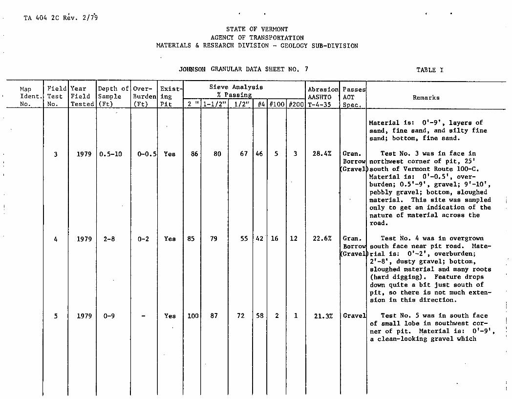
JOHNSON GRANULAR DATA SHEET NO, 7 TABLE I
Map Ident. No.
Field Test No.
Year Field Tested
Depth of Sample (Ft)
Over- Burden (Pt)
ExistS ing Pit
Sieve Analysis % Passing -
-
Abrasion AASHTO T-4-35
Passes AOT Spec.
Remarks 2" 1-1/2" 1/2" #4 #100 #200
Material is: 0'-9', layers of sand, fine sand, and silty fine sand; bottom, fine sand.
3 1979 0.5-10 0-0.5 Yes 86 80 67 46 5 3 28.4% Gran. Test No. 3 was in face in Borrow northwest corner of pit, 25' Gravel south of Vermont Route 100-C.
Material is: 0'-0.5', over- burden; 0.5'-9', gravel; 9'-10', pebbly gravel; bottom, sloughed material. This site was sampled only to get an indication of the nature of material across the road.
4 1979 2-8 0-2 Yes 85 79 55 42 16 12 22.6% Gran. Test No. 4 was in overgrown Borrow south face near pit road. Mate- Gravel rial is: 0'-2 1 , overburden;
2 1 -8', dusty gravel; bottom, sloughed material and many roots (hard digging). Feature drops down quite a bit just south of pit, so there is not much exten- sion in this direction.
5 1979 0-9 - Yes 100 87 72 58 2 1 21.3% Gravel Test No. 5 was in south face of small lobe in southwest cor- ner of pit. Material is: 0'-9 1 ,
a clean-looking gravel which

TA 404 2C Rv. 2/7
STATE OF VERMONT AGENCY OF TRANSPORTATION
MATERIALS & RESEARCH DIVISION - GEOLOGY SUB-DIVISION
JOHNSON GRANULAR DATA SHEET NO. 8 TABLE I
Map Ident. No.
Field Test No.
Year Field Tested
Depth of Sample (Ft)
Over- Burden (Ft)
Exist- ing Pit
Sieve Analysis % PSSi18 - -
-
Abrasion AASHTO T-4-35
Passes AOT Spec.
Remarks 2" 1-1/2" 1/2" //4 #100 #200
caves very readily; bottom, sloughed material. There is very little extension to the southwest.
6 1979 1-13 0-1 Yes 74 74 58 39 7 4 23.4% Gravel Test No. 6 was in northwest face of small lobe in southwest part of pit. Material is: 0'-l', overburden; l'-13',
- gravel; bottom, sloughed material.
7 1979 0.5-9 0-0.5 Yes 100 100 97 92 50 16 - - Test No. 7 was in floor in south side of middle of pit. Material is: 0'-0.5', overburden; 0.5'-2', pebbly sand; 2'-6', sand; 6'-9', silty fine sand; bottom, silty fine sand and water.
8 1979 0.5-10 0-0.5 Yes 100 100 97 90 63 24 - - Test No. 8 was in floor near access road, 250' N80°W of Test No. 7. Material is: 0'-0.5' 0 overburden; 0.5'-2', fine gravelly sand; 2'-4', pebbly sand; 4'-6', sand; 6'-10 1 , silty fine sand; bottom, silty fine sand and water.
9 1979 0-10 - Yes 94 92 84 69 7 4 - Gran. Test No. 9 was in southeast Borrow floor of west lobe of pit, 40' (Sand) northeast of Test No. 5.

'I'A 404 2C Rev. 2/79
STATE OF VERMONT AGENCY OF TRANSPORTATION
MATERIALS & RESEARCH DIVISION - GEOLOGY SUB-DIVISION
JOHNSON GRANULAR DATA SHEET NO. 9 TABLE I
- Map Field Year Depth of Over- Exist- Sieve Analysis Abrasion Passes Ident. Test Field Sample Burden ing - % Passing
- AASHTO AOT Remarks 2" 1-1/2" 1/2" #4 1/100 #200 IJo. No. Tested (Ft) (Ft) Pit T-4--35 Spec.
Material is: O'-lO', layers of pebbly fine gravel and pebbly sand; bottom, fine gravel, pebbly sand, and water.
4 1-A 1978 0-5 - Yes 100 100 100 100 21 15 - Gran. Owner: Town of Johnson. Borrow Area is a pit complex and an (Sand) uncut field. Pit is part of
the Johnson Land Fill, 0.15 mile west of Town Highway No. 28. Access is 0.23 mile north of the junction of Town Highways No. 28 and 29.
Test No. 1-A was in southeast face of the southernmost lobe of pit. Material is: 0'-5', silty fine sand, becoming moist from 3 1 -5 1 ; bottom, gravel.
1-B 1978 5-10 - Yes 90 84 53 36 7 5 23.5% Gravel Test No. 1-B was below Test No. 1-A. Material is: 5'-10', hard-packed gravel; bottom, sloughed material.
2-A 1978 Stock pile Yes 100 100 - 51 15 10 40.6% Gran. Test No. 2-A was from a stock- Borrow pile of crushed gravel near south Crushe [ lobe of pit. Gravel

TA 404 2C Rev. 2/7
STATE OF VERMONT AGENCY OF TRANSPORTATION
MATERIALS & RESEARCH DIVISION - GEOLOGY SUB-DIVISION
JOhNSON GRANULAR DATA SHEET NO, 10 TABLE I
Map Ident. No.
Field Test No.
Year Field Tested
Depth of Sample (Ft)
Over- Burden (Ft)
Exist ing Pit
Sieve Analysis - % Passing -
-
Abrasion AASHTO T-4-35
Passes ACT Spec.
Remarks 2" 1-1/2" 1/2" #4 #100 #200
2-B 1978 Stock - pile Yes 100 100 - 57 16 10 42.1% Gran. Test No. 2-B was from a Borrow stockpile of crushed gravel
( rushed near south lobe of pit. Gravel
3 1978 1.5-8 0-1.5 Yes 68 60 43 34 4 2 24.8% Gravel Test No. 3 was in east face of east lobe of pit near access road. Material is: 0'-1.5', overburden; 1.5'-6', hard-packed gravel; 6'-7', gravelly sand; 7 1 -8', pebbly sand; bottom, sloughed material.
4-A 1978 0.5-6 0-0.5 Yes 93 90 65 36 3 2 22.9% Gravel Test No. 4-A was in the north- west face of the southertnost lobe of pit, 200' N60 °W of Test No. 1. Material is: 0'-0.5', overburden; 0.5 1 -6', gravel with a silt-clay coating; bottom, sand (Test No. 4-B).
4-B 1978 6-8 - Yes 100 100 100 94 5 4 - Sand Test No. 4-B was below Test No. 4-A. Material is: 6'-8', sand; 8'-11', sloughed material; hole caved too much to sample.
5 1978 0-5.5 - Yes 100 100 98 90 4 2 - Sand Test No. 5 was in northwest face of small northwest lobe of pit. Material is: 0'-l', pebbly fine gravel; l'-2', pebbly sand; 2 1 -2.5', a layer of cemented

TA 404 2C Rev. 2/79 k
STATE OF VERMONT AGENCY OF TRANSPORTATION
MATERIALS & RESEARCH DIVISION - GEOLOGY SUB-DIVISION
JOHNSON GRANULAR DATA SHEET NO, 11 TABLE I
Map Ident. No.
Field Test No.
Year Field Tested
Depth of Sample (Pt)
Over-Burden (Ft)
Exist• ing Pit
Sieve Analysis - % Passing -
-
Abrasion AASHTO T-4-35
Passes AOT Spec.
Remarks 2" 1-1/2" 1/2" #4 #100 #200
pebbles with a silt-clay coating; 2.5'-5', coarse pebbly sand; 5'-5.5', sand with some cobbles; bottom, sloughed material.
6-A 1978 Stock pile Yes 100 100 - 57 16 12 43.2% Gran. Test No. 6-A was from a stock- lorrow pile of crushed gravel.
(C ushed ravel)
6-B 1978 Stock pile Yes 100 100 - 72 26 5 40.2% Gran. Test No. 6-B was from a stock- orrow pile of crushed gravel.
(C ushed ravel)
7 1979 1.5-10 0-1.5 Yes 100 100 100 10 7 2 - Sand Test No. 7 was in upper floor in east lobe of old pit, 200' north of land-fill access. Material is: 0'-1..5', overburden; 1.5'-3, gravelly sand; 3'-10', sand; bottom, silty fine sand or silt-clay.
8 1979 6-11 0-6 Yes 100 100 100 98 80 36 - - Test No. 8 was in floor, 60' S600W of, and 10' below Test No. 7. Material Is: 0'-6', overburden; 6'-11', sand or silty fine sand; bottom, silty fine sand.

TA 404 2CRe. 2/79k *
STATE OFVERMONT AGENCY OF TRANSPORTATION
MATERIALS & RESEARCH DIVISION - GEOLOGY SUB-DIVISION
JOHNSON GRANULAR DATA SHEET NO, 12
TABLE I
Map Ident. No.
Field Test No.
Year Field Tested
Depth of Sample (Ft)
Over-Burden (Ft)
Exist- ing Pit
Sieve Analysis - % Passing -
-
Abrasion AASHTO T-4-35
Passes AOT Spec.
Remarks 2" 1-1/2" 1/2"1 /14 11100 11200
9 1979 2-8 0-2 No 93 82 52 39 7 4 27.5% Cran. Test No. 9 was in the south- Borrow west corner of the field east Gravel of the land fill. Material is:
0 1 -2 1 , overburden; 2'-8', gravel with 1" to 3" stones; bottom, sand.
10 1979 1-11 0-1 No 90 87 67 48 10 6 24.0% Gravel Test No. 10 was in the south- east corner of field, 450' S45 0E of, and 7' below Test No. 9. Material is: O'-l', overburden; 1'-5.5', sand or silty sand; 5.5'-7', gravel; 7'-8.5', sand; 8.5'-11', gravelly sand; bottom, gravel.
11 1979 2.5-12 0-2.5 No 92 83 59 40 11 6 27.7% Cran. Test No. 11 was in field Borrow near pit drive, 265' N25 0E of (Grave: )Test No. 10. Material Is:
0'-2.5', overburden; 2.5'-12', gravel; bottom, gravel.
12 1979 0.5-11 0-0.5 Yes 100 100 100 lOi 68 21 - - Test No. 12 was in floor along blocked access road, 115' N250W of Town Highway No. 28. Material is: 0'-0.5', over- burden; 0.5'-6.5', silty fine sand; 6.5'-8.5', layer of silt- clay; 8.5'-11', sand; bottom, silty fine sand.

TA 404 2C Re$. 2/79'
STATE OF VERMONT AGENCY OF TRANSPORTATION
MATERIALS & RESEARCH DIVISION - GEOLOGY SUB-DIVISION
JOHNSON GRANULAR DATA SHEET NO, 13 TABLE I
Map Ident. No.
Field Test No.
Year Field Tested
Depth of Sample (Ft)
Over-Burden (Ft)
Exist- ing Pit
Sieve Analysis % Passing - -
-
Abrasion AASHTO T-4-35
Passes AOT Spec.
Remarks 2" 1-1/2" 1/2" //4 (/100 1/200
13 1979 1-12 0-1 Yes 100 100 100 100 83 26 - - Test No. 13 was in floor, 140' NlO°W of Test No. 12. Material is: O'-l', overburden; l'-4', fine sand; 4t...5t, layer of silt-clay; 5'-8', sand; 8'-9', layer of silt-clay; 9'-12 1 ,
sand; bottom, sand.
14 1979 1-12 0-1 Yes 100 100 96 93 37 12 - Gran. Test No. 14 was in floor, sorrow 160' S750E of Test No. 13. (Sand) Material is: 0'-l', overburden;
1'-12', sand or silty fine sand; bottom, silty fine sand.
15 1979 0.5-14 0-0.5 Yes 85 85 58 45 7 5 25.6% Gran. Test No. 15 was in north face lorrow of old pit, 40' N750E of Test
(.ravel) No. 14. Material is: 0'-0.5', overburden; 0.5'-4', gravel; 4'-6 1 , sand; 6'-6.5', layer of silt-clay; 6.5'-12', gravel; 12'-14', sand; bottom, sand.
16 1979 1-12 0-1 Yes 100 100 100 100 57 16 - - Test No. 16 was in floor, 135' N50W of Test No. 14. Material is: 0'-l', overburden; 1 1 -7', silty fine sand; 7'-8', layer of silt-clay; 8'-12 1 ,
silty fine sand; bottom, silty fine sand.

TA 404 2C Red. 2/79'
STATE OF.VERMONT AGENCY OF TRANSPORTATION
MATERIALS & RESEARCH DIVISION - GEOLOGY SUB-DIVISION
JOHNSON GRANULAR DATA SHEET NO, 14 TABLE I
Map Field Year Depth of Over- Exist• Sieve Analysis Abrasion Passes Ident. Test Field Sample Burden ing % Passing
- AASHTO AOT Remarks 2" 1-1/2" 1/2"1 114 11100 11200 No. No. Tested (Ft) (Pt) Pit T-4-35 Spec,
17 1979 1-10 0-1 Yes 100 100 100 99 64 16 - - Test No. 17 was in floor, 210' west of Test No. 16. - Material is: O'-l', overburden; 1 1 -2 1 , pebbly sand; 2 1 -10 1 ,
sand; bottom, silt-clay.
18 1979 1-11 0-1 Yes 100 100 99 96 52 14 - Gran. Test No. 18 was in floor of Borrow upper lobe near land fill 210' (Sand) N350W of Test No. 17. Material
is: 0'-1 1 , overburden; pebbly sand; 2 1 -11', sand; bottom, moist silt-clay.
19 1979 0-10 - Yes 100 100 100 99 61 35 - - Test No. 19 was in floor, 190' S550W of Test No. 18. Material is: O'-lO', sand; bottom, silt-clay.
5 1 1979 1-11 0-1 No 100 100 94 84 6 4 - Sand Owner: Bingham C. Day. As of May, 1979 property was for sale through Marble R. E. Area is a large flat field northeast of the junction of Town Highways No. 5 and 28 and Vermont Route 100-C. Access is north from Town Highway No. 28, 0.12 mile east of the above junction. Area was formerly part of the sod farm.

TA 404 2C Rev. 2/79 '
STATE OF.VERMONT AGENCY OF TRANSPORTATION
MATERIALS & RESEARCH DIVISION - GEOLOGY SUB-DIVISION
JOHNSON GRANULAR DATA SHEET NO, 15
TABLE I
Map Ident. No.
Field Test No.
Year Field Tested
Depth of Sample (Ft)
Over- Burden (Ft)
Exist- ing Pit
Sieve Analysis % Passing - -
-
Abrasion AASHTO T-4-35
Passes AOT Spec.
Remarks 2" 1-1/2" 1/2" 114 11100 #200
Test No. 1 was in field, 130' N15 0E of Town Highway No. 28. Material is: O'-l', overburden; 1'-4', sand; 4'-7', pebbly sand; 7'-11', sand; bottom, sand. Test-hole caved very readily.
2 1979 1-11 0-1 No 100 100 100 89 16 5 - Sand Test No. 2 was In field, 240' N250E of Test No. 1. Material is: O'-l', overburden; l'-5', sand; 5 1 -9.5', pebbly sand; 9.5'-11', sand; bottom, sand. Test-hole caved very readily.
3 1979 0.5-12 0-0.5 No 100 100 93 86 5 3 - Sand Test No. 3 was in field, 280' N60°W of Test No. 2. Material is: 0'-0.5', overburden; 0.5'-2', sand; 2'-4', pebbly sand; 4'-5', sand; 5'-8.5', pebbly sand; 8.5'-12', sand; bottom, sand. The material in Test No. 3 was in thinner beds and more varied than that in Tests No. 1 and 2.
4 1979 0.5-12 0-0.5 No 100 100 100 94 7 3 - Sand Test No. 4 was near tree line at north end of field, 340' N720E of Test No. 3. Material is: O'-O.S', overburden; 0.5'- 2', sand; 2'-3', pebbly sand;

TA 404 2C Rev'. 2/79
STATE OF VERMONT AGENCY OF TRANSPORTATION
MATERIALS & RESEARCH DIVISION - GEOLOGY SUB-DIVISION
JOHNSON GRANULAR DATA SHEET NO, 16 TABLE I
Hap Ident. No.
Field Test No.
Year Field Tested
Depth of Sample (Ft)
Over- Burden (Ft)
ExistS ing Pit
Sieve Analysis % Passing - -
-
Abrasion AASIITO T-4-35
Passes AOT Spec.
Remarks 2" 1-1/2" 1/2" 1/4 1/100 1/200
3'-6', sand; 6'-10', pebbly sand; 10'-12', sand; bottom, sand. Material Is not as pebbly as that in Test No. 1, 2, and 3.
5 1979 0.5-11 0-0.5 No 100 100 92 84 6 4 - Sand Test No. 5 was In field, 390' S270E of Test No. 4. Material is: overburden; 0.5'- 5', sand; 5'-9', pebbly sand; 9'-11 1 , sand; bottom, sand.
6 1979 1-9 0-1 No 100 100 100 96 11 6 - Sand Test No. 6 was in east edge of field, 445' S350E of Test No. 5. MaterIal is: O'-l', overburden; 1 1 -6 1 , sand; 6'-9', coarse sand; bottom, bedrock or large boulder.
7 1979 1-11 0-1 No 100 100 100 10 9 3 - Sand Test No. 7 was In northeast corner of field near woods, 270' N300E of Test No. 6. Material is: 0'-i', overburden; l'-li', fairly clean, coarse, quite uniform sand; bottom, sand.
8 1979 1-11 0-1 No 100 100 92 81 7 5 - Sand Test No. 8 was in field near road, 330' N75 0W of Test No. 6, 130' north of road. Material is: O'-l', overburden; l'-4', sand; 4'-5 1 , fine gravelly sand;
TA 404 2C Rev'. 2/79'
STATE OF VERMONT AGENCY OF TRANSPORTATION
MATERIALS & RESEARCH DIVISION - GEOLOGY SUB-DIVISION
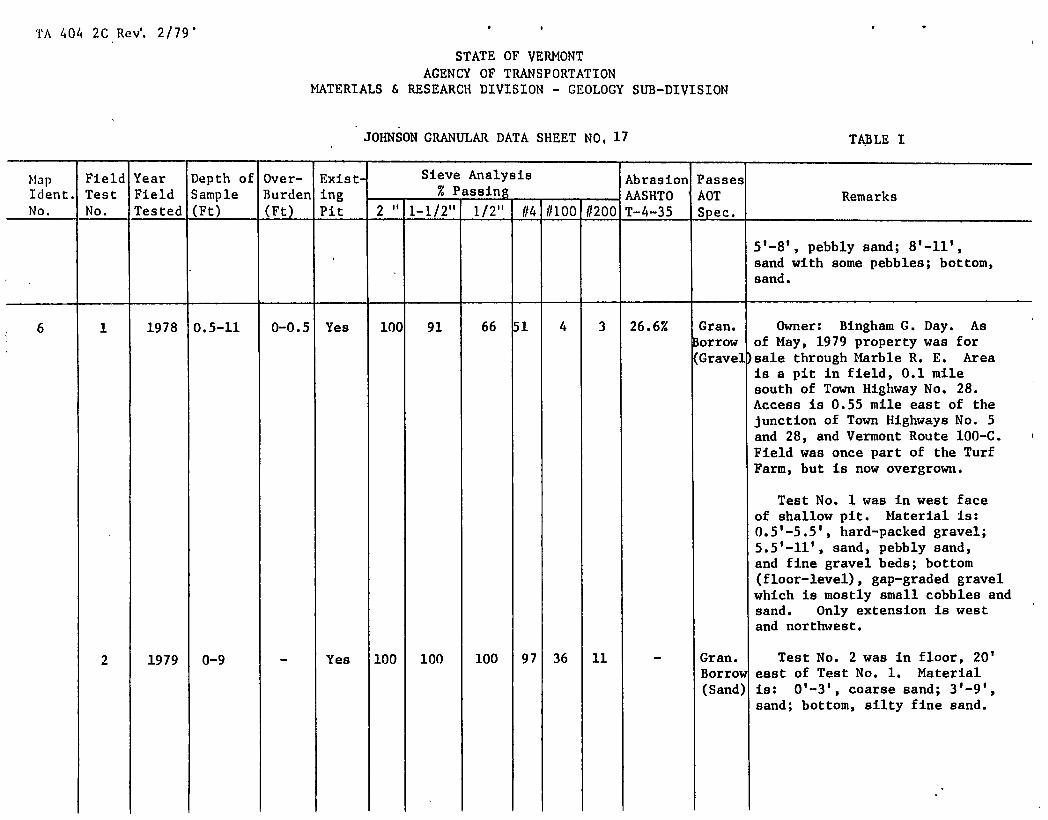
JOHNSON GRANULAR DATA SHEET NO, 17 TABLE I
Map Field Year Depth of er- ExistS Sieve Analysis Abrasion Passes Ident. Test Field Sample rden r(F ing - % Passing -
- AASHTO AOT Remarks 2" 1-1/2" 1/2" #4 #100 #200 No. No. Tested (Ft)
t Pit T-4-35 Spec.
5 1 -8', pebbly sand; 8'-11', sand with some pebbles; bottom, sand.
6 1 1978 0.5-11 0-0.5 Yes 100 91 66 51 4 3 26.6% Cran. Owner: Bingham C. Day. As lorrow of May, 1979 property was for (Grave])sale through Marble R. E. Area
is a pit in field, 0.1 mile south of Town Highway No. 28. Access is 0.55 mile east of the junction of Town Highways No. 5 and 28, and Vermont Route 100-C. Field was once part of the Turf Farm, but is now overgrown.
Test No. 1 was in west face of shallow pit. Material is: 0.5'-5.5', hard-packed gravel; 5.5'-11', sand, pebbly sand, and fine gravel beds; bottom (floor-level), gap-graded gravel which is mostly small cobbles and sand. Only extension is west and northwest.
2 1979 0-9 - Yes 100 100 100 97 36 11 - Gran. Test No. 2 was in floor, 20' Borrow east of Test No. 1. Material (Sand) is: 0'-3', coarse sand; 3'-9',
sand; bottom, silty fine sand.

TA 404 2C Rev. 2/79W 0*
STATE OF VERMONT AGENCY OF TRA1'SPORTATION
MATERIALS & RESEARCH DIVISION - GEOLOGY SUB-DIVISION
JOHNSON GRANULAR DATA SHEET NO, 18
TABLE I
Map Ident. No.
Field Test No.
Year Field Tested
Depth of Sample (Ft)
Over- Burden (Ft)
Exist ing Pit
Sieve Analysis % Passing - -
-
Abrasion AASHTO T-4-35
Passes AOT Spec.
Remarks 2" 1-1/2" 1/2" 114 11100 1/200
3 1979 0-12 - Yes 100 100 100 lOC 21 5 - Sand Test No. 3 was in floor, 270' N600E of Test No. 2. Material is: O'-12 1 , sand; bottom, sand.
4 1979 3-6.5 0-3 No 97 97 78 58 21 15 33.8% Gran. Test No. 4 was in field, 135' Borrow N450E of telephone pole #01. Gravel Material is: 0'-3', overburden;
3 1 -6.5 1 , silty gravel; bottom, silt-clay and water.
5-A 1979 1-5.5 0-1 No 100 100 93 84 27 13 - Gran. Test No. 5-A was in field, orrow 135 0 N55 W of Telephone pole #01. (Sand) Material is: 0'-l', overburden;
l'-5.5 1 , sand; bottom, gravel (Test No. 5-B).
5-B 1979 5.5-10.5 - No 91 88 72 58 9 6 21.6% Gravel Test No. 5-B was below Test No. 5-A. Material Is: 5.5'- 10.5', gravel; bottom, gravel and water.
6 1979 1.5-7.5 0-1.5 No 96 94 72 59 10 5 23.1% Gravel Test No. 6 was in fIeld, 180' S30°W of Telephone pole #01. Material is: 0 , -i', overburden; 1'-6.5', gravel; 6.5'-7.5', pebbly gravel; bottom, sand.
7 1979 1-12 0-1 No 100 95 72 52 6 4 33.2% Gran. Test No. 7 was in small Borrow clearing, 110' N60 0of, and 12' (Grave )

TA 404 2C Re. 2/79
STATE OF VERMONT AGENCY OF TRANSPORTATION
MATERIALS & RESEARCH DIVISION - GEOLOGY SIJB-DIVISION
JOhNSON GRANULAR DATA SHEET NO, 19 TABLE I
Map Field Year Depth of Over- Exist• Sieve Analysis Abrasion Passes Ident. Test Field Sample Burden ing - % Passing -
- AASHTO AOT Remarks 2" 1-1/2" 1/2" //4 11100 #200 No. No. Tested (Ft) (Ft) Pit T-4-35 Spec,
above Test No. 3. Material is: O'-l', overburden; 1'-12 1 ,
gravel or pebbly gravel; bottom, gravel.
7 1 1979 1.5-11 0-1.5 No 100 87 80 71 7 4 - Cran. Owner: Merrill Locke. Area Borrow is a long meadow northeast of (Sand) Town Highway No. 30. The access
is 0.43 mile southeast of the junction of Town Highway No. 30 and Vermont Route 100-C. Land is leased as meadow to a local farmer.
Test No. 1 was along the north- east edge of meadow. Material Is: O'-l.S', overburden; 1.5'- 3 1 , pebbly fine gravel; 3'-5', pebbly sand; 5'-6', sand; 6'-11', pebbly sand; bottom, sand. Ex- cess pebbles could be easily screened from this material to produce a good sand.
8 1 1979 1-5 0-1 Yes 100 100 100 100 91.0 87.3 - - Owner: David Lane. Area is a tiny pit in large field north- east of Town Highway No. 30,
TA 404 2C Red. 2/79'
STATE OF VERMONT AGENCY OF TRANSPORTATION
MATERIALS & RESEARCH DIVISION - GEOLOGY SUB-DIVISION
JOHNSON GRANULAR DATA SHEET NO, 20 TABLE I
Map Field Year Depth of Over- Exist Sieve Analysis Abrasion Passes Ident. Test Field Sample Burden ing % Passing - AASHTO AOT Remarks
2" 1-1/2" 1/2" #4 1/100 -
#200 No. No. Tested (Ft) (Ft) Pit T-4-35 Spec,
just vest of the Hyde Park Town Line.
Test No. 1 was in floor of small pit at east end of field. Material is: 0'-l', overburden; 1 1 -5 1 , silt-clay. Material is classed as silt.
2 1979 1-7 0-1 No 100 100 100 10 48 17 - - Test No. 2 was in corner of field, 90' N65 0E of, and 7' above Test No. 1. Material is: 0 1 -l', overburden; l'-7 1 , sand; bottom, silt-clay and a seep of water.
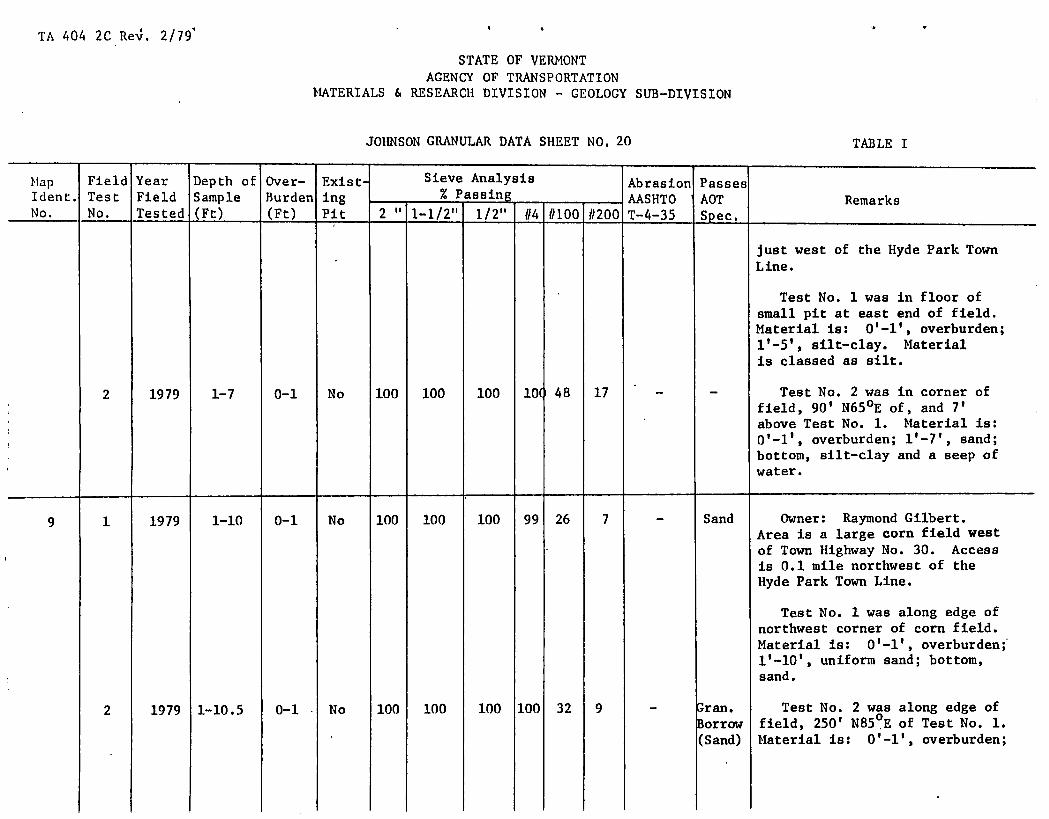
9 1 1979 1-10 0-1 No 100 100 100 99 26 7 - Sand Owner: Raymond Gilbert. Area is a large corn field west of Town Highway No. 30. Access is 0.1 mile northwest of the Hyde Park Town Line.
Test No. 1 was along edge of northwest corner of corn field. Material is: O'-l', overburden; 1 1 -10 1 , uniform sand; bottom, sand.
2 1979 1-10.5 0-1 No 100 100 100 100 32 9 - ran. Test No. 2 was along edge of 3orrow field, 250' N85 0E of Test No. 1.
(Sand) Material is: 0'-1 1 , overburden;

TA 404 2C Revs. 2/79'
STATE OF VERMONT AGENCY OF TRANSPORTATION
MATERIALS & RESEARCH DIVISION - GEOLOGY SUB-DIVISION
JOHNSON GRANULAR DATA SHEET NO, 21 TABLE I
Map Field Year Depth of Over- ExistS Sieve Analysis Abrasion Passes Ident. Test Field Sample Burden ing - % Passing -
- AASHTO AOT Remarks 2" 1-1/2" 1/2" #4 #100 #200 No. No. Tested (Ft) (Ft) Pit T-4-35 Spec.
1 1 -10.5 1 , quite uniform sand; bottom, sand.
3 1979 1-12 0-1 No 100 100 100 lO( 21 5 - Sand Test No. 3 was in corner of field, 670' S20 °W of Test No. 2. Material is: O'-l', overburden; i'-12', quite uni- form sand; bottom, sand.
4 1979 1-12 0-1 No 100 100 100 10 48 33 - - Test No. 4 was near west edge of field road, 375' N5 °W of Test No. 3. Material is: 0 , -1 1
, overburden; l'-12', quite uniform, brown sand; bottom, sand.
5 1979 1-7.5 0-1 No 100 100 100 101 81 32 - - Test No. 5 was near middle of field, 275' S800E of Test No. 4, and 280' S1O°E of Test No. 2. Material is: 0'-l', overburden; 1'-7.5', sand, bot- tom, silt-clay.
10 1 1979 1-10 0-1 No 100 100 95 87 26 10 - Sand Owner: Merrill Locke. Area - is a meadow leased by owner to
a local farmer. Field is south- west of Town Highway No. 30; access is 0.4 mile southeast of the junction of Town Highway No. 30 and Vermont Route 100-C.

TA 404 2C Rev. 2/79
STATE OF VERMONT AGENCY OF TRANSPORTATION
MATERIALS & RESEARCH DIVISION - GEOLOGY SUB—DIVISION
JOHNSON GRANULAR DATA SHEET NO, 22 TABLE I
Map Field Year Depth of Over- Exist- Sieve Analysis Abrasion Passes Ident. Test Field Sample Burden ing % Passing - -
- AASHTO AOT Remarks 2" 1-1/2" 1/2" //4 //100 #200 No. No. Tested (Ft) (Ft) Pit T-4-35 Spec.
Test No. 1 was in the south corner of meadow. Material is: O'-l', overburden; 1'-3', pebbly sand; 3'4', sand; 4'-6', pebbly sand; 6'-10', pebbly sand with smaller pebbles than In the 4'-6' interval; bottom, sand.
11 1 1978 0.5-15 0-0.5 Yes 100 100 100 99 5 3 - Sand Owner: Raymond Inkel. Area is a large field with an over- grown pit at the southeast edge (bordering Vermont Route 100-C). Field is rented to Wayne Steam who has it planted to alfalfa. Access is 0.1 mile south of the junction of Town highway No. 30 and Vermont Route 100-C.
Neighbor said that a nearby drilled-well went through 85' of white sand to reach water.
Test No. 1 was in face at west end of pit and was sampled to show what the material in the field was like. Material Is: 0'-0.5', overburden; 0.5'-15', sand; bottom, sloughed material (sand, but caves too much to sample).
TA 404 2C Rev. 2/79' '
STATE OF VERMONT AGENCY OF TRANSPORTATION
MATERIALS & RESEARCH DIVISION - GEOLOGY SUB-DIVISION
JOHNSON GRANULAR DATA SHEET NO, 23 TABLE I
Hap Field Year Depth of Over- Exist. Sieve Analysis Abrasion Passes Ident. Test Field Sample Burden ing % Passing - -
- AASHTO AOT Remarks 2" 1-1/2" 1/2"1 #4 #100 #200 No. No. Tested (Ft) (Ft) Pit T-4-35 Spec.
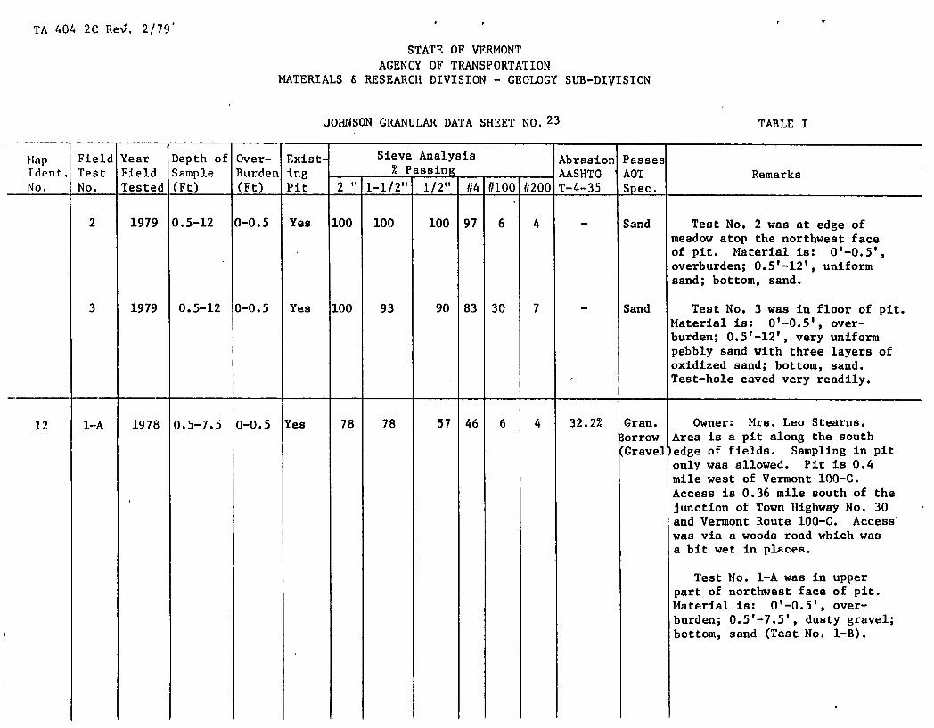
2 1979 0.5-12 0-0.5 Yes 100 100 100 97 6 4 - Sand Test No. 2 was at edge of meadow atop the northwest face of pit. Material Is: 0 1 -0.5 1 ,
overburden; 0.5'-12', uniform sand; bottom, sand.
3 1979 0.5-12 0-0.5 Yes 100 93 90 83 30 7 - Sand Test No. 3 was in floor of pit. Material is: 0'-0.5', over- burden; 0.5'-12', very uniform pebbly sand with three layers of oxidized sand; bottom, sand. Test-hole caved very readily.
12 1-A 1978 0.5-7.5 0-0.5 Yes 78 78 57 46 6 4 32.2% Gran. Owner: Mrs. Leo Stearns. lorrow Area is a pit along the south Gravel 'edge of fields. Sampling in pit
only was allowed. Pit is 0.4 mile west of Vermont 100-C. Access is 0.36 mile south of the junction of Town Highway No. 30 and Vermont Route 100-C. Access was via a woods road which was a bit wet In places.
Test No. 1-A was in upper part of northwest face of pit. Material is: 0'-0.5', over- burden; 0.5'-7.5', dusty gravel; bottom, sand (Test No. 1-B).

TA 404 2C Re'. 2/79' p
STATE OF.VERMONT AGENCY OF TRANSPORTATION
MATERIALS & RESEARCH DIVISION - GEOLOGY SUB-DIVISION
JOhNSON GRANULAR DATA SHEET NO. 24
TABLE I
Hap Ident. No.
Field Test No.
Year Field Tested
Depth of Sample (Ft)
Over- Burden (Ft)
Exist- ing Pit
Sieve Analysis - % Passing
-
Abrasion AASHTO T-4-35
Passes AOT Spec,
Remarks 2" 1-1/2" 1/2" 114 //100 11200
Material is a skim of gravel and resembles a shoal or possibly a delta.
1-B 1978 7.5-25 - 'es 100 100 100 93 15 5 - Sand Test No. 1-B was below Test No. 1-A. Material is: 7.5 1 - 17', sand; 17'-19', pebbly sand; 19'-19.5', layer of silt-clay; 19.5'-22', pebbly sand; 22'-25', layers of sand and silty sand; bottom, sand and pebbly sand.
1-C 1978 25-40 - Yes 100 96 85 73 19 8 - Sand Test No. 1-C was below Test No. 1-B. Material is: 25 1 -40 1 - layers of sand and pebbly sand; bottom, sand and pebbly sand. Face caved very readily.
2-A 1978 0.5-7 0-0.5 Yes 95 95 81 69 11 5 - Gran. Test No. 2-A was in top part of Borrow middle of south face of newest (Sand) pit. Material is: 0'-0.5',
overburden; 0.5'-7', layers of sand, pebbly sand, gravel, and a silt-clay seam; bottom, pebbly sand (Test No. 2-B).
2-B 1978 7-16 - Yes 100 100 94 83 11 6 - Sand Test No. 2-B was below Test No. 2-A. Material is: 7'-9', pebbly sand; 9'-10', gravel; lO'-ll', pebbly sand; ll'-13', sand; 13'-14', silty fine sand;

TA 404 2C Rev: 2/79
STATE OF VERMONT AGENCY OF TRANSPORTATION
MATERIALS & RESEARCH DIVISION - GEOLOGY SUB-DIVISION
JOHNSON GRANULAR DATA SHEET NO.25
TABLE I
- Mp Ident. No.
Field Test No.
Year Field Tested
Depth of Sample (Ft)
Over- Burden (Ft)
Exist- ing Pit
Sieve Analysis % Passing - - -
Abrasion AASHTO T-4-35
Passes AOT Spec.
Remarks 2" 1_1/2t 1/2" //4 1/100 //200
14'-16', sand with a few random pebbles; bottom, sand and pebbly sand (Test No. 2-C).
2-C 1979 16-23 - Yes 100 100 97 85 34 27 - - Test No. 2-C was below Test No. 2-B. Material is: 16'-23', layers of sand and pebbly sand; bottom, sand and pebbly sand. Test caved very readily; very difficult getting this sample.
3 1979 0.5-10.5 0-0.5 Yes 100 96 84 79 19 8 - Sand Test No. 3 was in northwest floor of pit, 15' southeast of Test No. 1-C. Material is: 0'-0.5', overburden; 0.5'-2', pebbly sand; 2'-3', sand; 3'-5', pebbly sand; 5'-10.5', sand; bottom, sand.
4 1979 0-12 - Yes 100 100 95 87 22 8 - Sand Test No. 4 was in floor, 15' northeast of Test No. 2-C. Material is: 0 1 -5 1
, pebbly sand; /
5'-12', sand; bottom, sand.
5 1979 0-13 - Yes 100 100 94 85 25 8 - Sand Test No. 5 was in floor of small, north lobe of lower (south) pit. Material is: 0'-13', sand with a few pebbles; bottom, sand.
6 1979 1-11 0-1 Yes 100 100 89 76 14 7 - Sand Test No. 6 was in floor near east end of pit, 170' N80 0E of
TA 404 2C Re. 2/79'
STATE OF VERMONT AGENCY OF TRANSPORTATION
MATERIALS & RESEARCH DIVISION - GEOLOGY SUB-DIVISION
JOHNSON GRANULAR DATA SHEET NO, 26 TABLE I
Map Field Year Depth of Over- Exist- Sieve Analysis Abrasion Passes Ident. Test Field Sample Burden ing % Passing - -
- AASHTO AOT Remarks 2" 1-1/2" 1/2" (14 (/100 1/200 No. No. Tested (Ft) (Ft) Pit T-4-35 Spec.
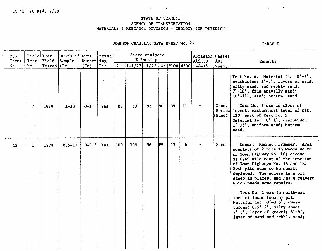
Test No. 4. Material is: O'-l', overburden; 1'-7', layers of sand, silty sand, and pebbly sand; 7'-10', fine gravelly sand; lO'-ll', sand; bottom, sand.
7 1979 1-13 0-1 Yes 89 89 82 80 35 11 - Gran. Test No. 7 was in floor of Borrow lowest, easterninost level of pit, (Sand) 130' east of Test No. 5.
Material is: O'-l', overburden; uniform sand; bottom,
sand.
13 1 1978 0.5-11 0-0.5 Yes 100 100 96 85 11 6 - Sand Owner: Kenneth Brimmer. Area consists of 2 pits in woods south of Town Highway No. 18; access is 0.69 mile east of the junction of Town Highways No. 16 and 18. Both pits seem to be nearly depleted. The access is a bit steep in places, and has a culvert which needs some repairs.
Test No. 1 was in northwest face of lower (south) pit. Material is: 0'-0.5', over- burden; 0.5'-2', silty sand; 2'-3', layer of gravel; 3'-6', layer of sand and pebbly sand;

TA 404 2C Re. 2/79
STATE OF VERMONT AGENCY OF TRANSPORTATION
MATERIALS & RESEARCH DIVISION - GEOLOGY SUB-DIVISION
JOHNSON GRANULAR DATA SHEET NO, 27 TABLE I
ip Ident. No.
Field Test No.
Year Field Tested
Depth of Sample (Ft)
Over- Burden (Ft)
Exist- ing Pit
Sieve Analysis % Passing - -
-
Abrasion AASHTO T-4-35
Passes AOT Spec.
Remarks 2" 1-1/2" 1/2" 114 #100 #200
6 1 -7', cobbles; 7'-9', pebbly sand and coarse sand; 9'-10', layer of gravel; lO'-ll', sand; ll'-13', sloughed material.
2 1978 0.5-8 0-0.5 Yes 100 100 95 82 6 4 - Sand Test No. 2 was in west face of lower (south) pit, 70' S350W of Test No. 1. Material is: 0'-0.5', overburden; 0.5'-3', sand and pebbly sand; 3'-4', fine gravel layer; 4'-6', sand; 6 1 -7 1 , some cobbles over a layer of silt-clay; 7'-8', sand; bot- torn, sloughed material. The pit floor seems to be close to silt- clay.
3 1979 1-6 0-1 Yes 96 87 73 59 14 5 8.6% GraveJ Test No. 3 was in small clearing just west of access road. Material is: 0'-l', overburden; 1'-2', sand; 2'-6', dirty gravel; bottom, silty fine sand.
The topography and material are quite similar to that of Map Identification No. 1. Note: Bedrock was encountered at 1' below floor in the south- ern most pit, and 2' below the

TA 404 2C Rest. 2/79
STATE OF VERMONT AGENCY OF TRANSPORTATION
MATERIALS & RESEARCH DIVISION - GEOLOGY SUB-DIVISION
JOhNSON GRANULAR DATA SHEET NO, 28 TABLE I
Map Field Year Depth of Over- Exist- Sieve Analysis Abrasion Passes Ident. Test Field Sample Burden ing % Passing -
- AASHTO AOT Remarks 2" 1-1/2" 1/2"1 1/4 1/100 1/200 No. No. Tested (Ft) (Ft) Pit T-4-35 Spec.
floor in two places in the middle and north lobes of the southern pit.
14 1 1978 1-9 0-1 Yes 100 100 85 73 28 15 - Gran. Owner: Charles Patch, Jr. orrow Former owner. Phil Stearns. (Sand) Area is a small, inactive pit
in a small field, 0.03 mile west of Town Highway No. 39; access is 0.09 mile south of the junction of Town Highways No. 1 and 39. Area appears to be nearly depleted.
Test No. 1 was in northwest face of pit. Material is: O'-l', overburden; 1'-9', non- descript, poorly sorted pebbly sand, pebbly gravel, and several layers of silt-clay; bottom, sloughed material.
2 1978 1-6.5 0-1 Yes 92 92 82 61 16 11 - Cran. Test No. 2 was In southwest lorrow face of pit, 60' south of Test (Sand) No. 1. Material is: O'-l',
overburden; 1'-3', dusty fine gravel; 3'-5.5', layers of silt- clay; 5.5'-6.5', sand and pebbly sand; bottom, pebbly fine gravel.

TA 404 2C ReV. 2/79'
STATE OF VERMONT AGENCY OF TRANSPORTATION
MATERIALS & RESEARCH DIVISION - GEOLOGY SUB-DIVISION
JOhNSON GRANULAR DATA SHEET NO, 29 TABLE I
Map Ident. No.
Field Test No.
Year Field Tested
Depth of Sample (Ft)
Over-Burden (Ft)
Exist- ing Pit
Sieve Analysis - % Passing_
Abrasion AASHTO T-4-35
Passes AOT Spec.
Remarks 2" 1-1/2" 1/2"1 1/4 1/100 //200
3 1978 1-11 0-1 No 100 89 69 48 12 7 26.0% Gran. Test No. 3 was in face of 3orrow bank at south end of field, (Grave: )l40' south of Test No. 2.
Material Is: O'-l', overburden; 1 1 -11 1 , zones of dirty, silty gravel, sand, rock fragments, and gravel; bottom, sloughed material.
4-A 1979 0.5-7 0-0.5 No 100 100 100 89 35 14 - Gran. Test No. 4-A was near tree lorrow line, 10' west of, and above (Sand) Test No. 2. Material Is:
0 1 -0.5 1 , overburden; 0.5'-7', sand or silty fine sand; bottom, dirty gravel (Test No. 4-B).
4-B 1979 7-10 - No 100 100 72 54 25 16 32.0% - Test No. 4-B was below Test No. 4-A. Material is: 7'-10', dirty gravel; bottom, silty fine sand.
5 1979 0.5-7 0-0.5 Yes 95 92 77 61 36 22 30.7% - Test No. 5 was in floor, 15' east of Test No. 2. Material Is: 0 1 -0.5 1 , overburden; 0.5'-2', pebbly sand; 2'-4', boulders; 0-7 1 , silty fine sand and stones; bottom, silty fine sand and stones. There were many 4" to 8" stones.
6 1979 1.5-10 0-1.5 No 96 87 71 53 15 9 18.9% Gran. Test No. 6 was near tree line, Borrow on lower level of meadow, 175' (Gravel )S35°W of Test No. 5.

TA 404 2CRe. 2/79'
STATE OF VERMONT ACENCY OF TRANSPORTATION
MATERIALS & RESEARCH DIVISION - GEOLOGY SUB-DIVISION
JOhNSON GRANULAR DATA SHEET NO, 30
TABLE I
Map Field Year Depth of Over- Exist Sieve Analysis Abrasion Passes Ident. Test Field Sample Burden ing % Passing - -
- AASHTO AOT Remarks 2" 1-1/2" 1/2" 1/4 1/100 1/200 No. No. Tested (Ft) (Ft) Pit T-4-35 Spec.
Material is: 0'-1.5', over- burden; 1.5'-10', quite uniform but dirty gravel; bottom, gravel.
15 1 1978 1-19 0-1 Yes 100 100 98 87 12 5 - Sand Owner: Luther looper. Area is a pit between fields and a wooded knoll. Pit is 0.09 mile east of Town Highway No. 39. Access is 0.38 mile south of the junction of Town highways No. 1 and 39. Many pines were planted on the wooded knoll. Pit is on the north edge of the knoll.
Test No. 1 was in south-south- west face of lower pit level. Material is: O'-l', overburden; 1 1 -19 1 , layers of sand, coarse sand, pebbly sand, and pebbles; bottom, sloughed material.
2 1978 1-23 0-1 Yes 100 100 98 88 10 6 - Sand Test No. 2 was in upper part of middle of southeast face of lowest pit level, 90' N250E of Test No. 1. Material is: 0 1 -1 1 , overburden; l'-7', pebbly, very fine, silty gravel; 7'-23', layers of sand, pebbly sand, and silty sand; bottom, sloughed material.

TA 404 2C Re. 2/79'
STATE OF VERMONT AGENCY OF TRANSPORTATION
MATERIALS & RESEARCH DIVISION - GEOLOGY SUB-DIVISION
JOHNSON GRANULAR DATA SHEET NO, 31 TABLE I
Map Ident. No.
Field Test No.
Year Field Tested
Depth of Sample (Ft)
Over- Burden (Ft)
Exist- ing Pit
Sieve Analysis % Passing - -
-
Abrasion AASHTO T-4-35
Passes AOT Spec.
Remarks 2" 1-1/2" 1/2" 114 11100 11200
3 1978 0.5-13 0-0.5 Yes 100 100 100 93 17 6 - Sand Test No. 3 was In southeast face of upper level. Material Is: overburden; 0.5'- 2 • 5', pebbly fine gravel; 2.5'- 13', sand with a few thin layers of pebbles and a bit of silt- clay; bottom, sloughed material.
4 1978, 0.5-18 0-0.5 Yes 100 100 100 97 29 13 - Gran. Test No. 4 was in south face Borrow of upper south end of pit, 120' (Sand) S70°W of Test No. 3. Material
is: i_•5 overburden; 0.5'-7', sand and pebbly sand layers; 7'-9', silt-clay; 9'-14', sand; l4'-16', silt-clay; 16'-18', sand; bottom, sloughed material.
5 1979 0.5-10 0-0.5 Yes 100 100 99 86 15 7 - Sand Test No. 5 was in floor of northeast corner of the lowest, northeast lobe of pit. Material Is: 0 1 -0.5', overburden; 0.5'- 2.5', pebbly sand; 2.5'-5', sand;5'-6', pebbly sand; 6'-10', sand; bottom, silt-clay and boulder or bedrock.
6 1979 1-11 0-1 Yes 100 100 92 77 14 5 - Sand Test No. 6 was in floor, 115' S60°W of Test No. 5. Material is: 0'-l', overburden; l'-4', pebbly sand; 4'-5', sand; 5'-9', pebbly sand; 9'-11', sand; bot- torn, silt-clay and boulders.
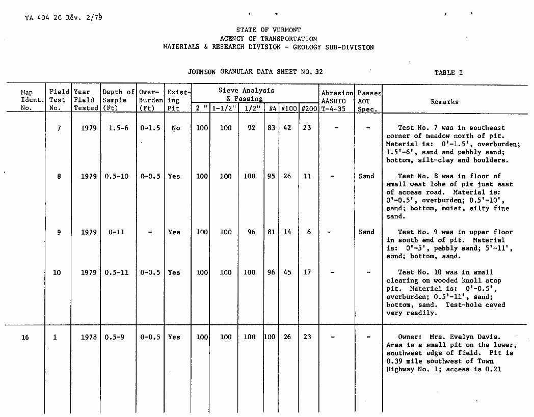
TA 404 2C Rv. 2/7
STATE OF VERNONT AGENCY OF TRANSPORTATION
MATERIALS & RESEARCH DIVISION - GEOLOGY SUB-DIVISION
JOHNSON GRANULAR DATA SHEET NO, 32 TABLE I
Map Field Year Depth of Over- Exist Sieve Analysis Abrasion Passes Ident. Test Field Sample Burden ing - % Passing - AASHTO AOT Remarks
2" 1-1/2" 1/2" #4 #100 -
1/200 No. No. Tested (Ft) (Ft) Pit T-4-35 Spec.
7 1979 1.5-6 0-1.5 No 100 100 92 83 42 23 - - Test No. 7 was in southeast corner of meadow north of pit.
- Material is: 0'-1.5', overburden; 1.5 1 -6', sand and pebbly sand; bottom, silt-clay and boulders.
8 1979 0.5-10 0-0.5 Yes 100 100 100 95 26 11 - Sand Test No. 8 was In floor of small west lobe of pit just east of access road. Material is: 0'-0.5', overburden; 0510 sand; bottom, moist, silty fine sand.
9 1979 0-11 - Yes 100 100 96 81 14 6 - Sand Test No. 9 was In upper floor In south end of pit. Material Is: 0'-5', pebbly sand; 5-11 1 ,
sand; bottom, sand.
10 1979 0.5-11 0-0.5 Yes 100 100 100 96 45 17 - - Test No. 10 was in small clearing on wooded knoll atop pit. Material is: 0'-0.5', overburden; 0.5'-11', sand; bottom, sand. Test-hole caved very readily.
16 1 1978 0.5-9 0-0.5 Yes 100 100 100 100 26 23 - - Owner: Mrs. Evelyn Davis. Area is a small pit on the lower, southwe8t edge of field. Pit is 0.39 mile southwest of Town Highway No. 1; access is 0.21

TA 404 2C R&v. 2/7
STATE OF VERMONT AGENCY OF TRANSPORTATION
MATERIALS & RESEARCH DIVISION - GEOLOGY SUB-DIVISION
JOHNSON GRANULAR DATA SHEET NO. 33 TABLE I
Map Field Year Depth of Over- Exist- Sieve Analysis Abrasion Passes Ident. Test Field Sample Burden ing - % Passing AASHTO AOT Remarks
2" 1-1/2" 1/2" -
#4 #100 #200 No. No. Tested (Ft) (Ft) Pit T-4-35 Spec.
mile northwest of the junction of Town Highways No. 1 and 11. Pit is on the east end of a low, wooded knoll.
Test No. 1 was near center of low pit face. Material is: 0'-0.5', overburden; 0.5'-8.5', silty fine sand with some silt- clay layers; 8.5'-9', sand; bottom, silty fine sand.
2 1979 0-6 - Yes 100 100 100 IOC 32 15 - Gran. Test No. 2 was in north floor sorrow of pit. Material is: 0'-6', (Sand) sand; bottom, silt-clay. (Note:
there is some gravel and a lot of water from 8' to 12' in the Test hole).
3 1979 1-9 0-1 Yes 100 97 81 68 30 20 - - Test No. 3 was in floor in southwest corner of pit, 90' S15°W of Test No. 2. Material is: O'-l', overburden; 1'-3', pebbly gravel; 3'-4', layer of silt-clay; 4'-6', boulders; 6 1 -9 1 , gravel and water; bottom, bedrock or very large boulders.
17 1 1978 1.5-6 0-1.5 No 100 100 100 10C 45 21 - - Owner: Edward French. Area is a large field south of Town Highway No. 37 (near a very sharp curve to the north).

TA 404 2C R'ev. 2/79
STATE OF VERMONT AGENCY OF TRANSPORTATION
MATERIALS & RESEARCH DIVISION - GEOLOGY SUB-DIVISION
JOBNSON GRANULAR DATA SHEET NO. 34 TABLE I
Map Ident. No.
Field Test No.
Year Field Tested
Depth of Sample (Ft)
Over- Burden (Ft)
Exist- ing Pit
Sieve Analysis - % Passing
-
Abrasion AASHTO T-4-35
Passes AOT Spec,
Remarks 2" 1-1/2" 1/2" 1/4 1/100 #200
Access is 0.52 mile north of the junction of Town Highway No. 37 and Vermont Route 15.
Test No. 1 was in south face of low roadside bank. Material is: 0'-1.5', overburden; 1.5'6', firmly packed, silty fine sand with thin seams of silt-clay; bottom, silt-clay.
2 1979 1.5-12 0-1.5 No 100 100 100 100 48 15 - Gran. Test No. 2 was in north end Borrow of meadow, just south of small (Sand) wooded knoll. Material is:
0'-1.5', overburden; 1.5'-4', coarse sand; 4'-9', sand; 9'-12', slightly moist sand; bottom, moist, silty fine sand.
3 1979 1-9 0-1 No 100 100 96 90 45 36 - - Test No. 3 was in southwest corner of field, 340' S350W of Test No. 2. Material is: 0'-l', overburden; l'-5', sand; 5'-6 .5', silty fine sand; 6.5'-9', sand; bottom, silt-clay.
4 1979 1-11 0-1 No 100 100 100 97 38 22 - - Test No. 4 was in west end of uncut field, 250' N85°W of Test No. 2. Material is: O'-l',

TA 404 2C ReV. 2/79
STATE OF VERMONT AGENCY OF TRANSPORTATION
MATERIALS & RESEARCH DIVISION - GEOLOGY SUB-DIVISION
JOIThSON GRANULAR DATA SHEET NO, 35 TABLE I
i.ip Ident. No.
Field Test No.
Year Field Tested
Depth of Sample (Ft)
Over- Burden (Ft)
Exist- ing Pit
Sieve Analysis - % Passing
Abrasion AASHTO T-4-35
Passes AOT Spec.
Remarks 2" 1-1/2" 1/2" (/4 (/100 1/200
overburden; 1 1 -6', sand; 6'-11', silty fine sand; bottom, silt- clay.
5 1979 1-10 0-1 No 100 100 97 92 27 12 - Sand Test No. 5 was along south edge of field, 2751 east of Test No. 4, and 220' S15 0E of Test No. 2. Material Is: 0'-1 1 ,
overburden; l'-4', fine sand; 4 1 -7 1 , pebbly sand; 7'-10', silty fine sand; bottom, silt-clay.
6 1979 2-10 0-2 No 100 100 100 91 37 28 - - Test No. 6 was in sag of field, 205' N55 0W of Test No. 5. Material Is: 0'-2', overburden; 2'-4', silty fine sand; 4'-6', pebbly sand; 6 1 -10', silty fine sand; bottom, silt-clay. Water was encountered at 7'.
7 1979 1-12 0-1 No 100 100 95 90 31 16 - - Test No. 7 was atop a low rise near east end of field, 270' N700E-of Test No. 5. Material is: 0 1 -1 1 , overburden; l'-5', silty fine sand; 5'-6', pebbly sand; 6'-7.5', fine sand; 7.5'-8.5', pebbly sand; 8.5'-12', silty fine sand; bottom, silty fine sand.
8 1979 1-6 0-1 No 100 100 100 100 80.7 80.4 - - Test No. 8 was in the south end of the lower meadow.

TA 404 2C Rev: 2/79
STATE OF VERMONT AGENCY OF TRANSPORTATION
MATERIALS & RESEARCH DIVISION - GEOLOGY SUB-DIVISION
JOHNSON GRANULAR DATA SHEET NO,36 TABLE I
Hap Field Year Depth of Over- Exist- Sieve Analysis Abrasion Passes Ident. Test Field Sample Burden ing % Passing - -
- AASHTO AOT Remarks 2" 1-1/2" 1/2" 1/4 #100 1/200 No. No. Tested (Ft) (Ft) Pit T-4-35 Spec. -
Material is: O'-i', overburden; 1 1 -6 1 , silt-clay; bottom, silt- clay.
18 1 1979 1-12 0-1 No 100 100 100 99 85 52 - - Owner: Erie Morse. Area is a lobate field which is south- west of Map Identification No. 17. Area is 0.18 mile south of Town highway No. 37. Access is 0.52 mile north of the junc- tion of Town Highway No. 37 and Vermont Route 15.
Test No. 1 was near drop-off at south end of field. Material is: 0'-1', overburden; l'-4', pebbly sand; 4'-12', fine sand; bottom, silty fine sand.
2 1979 1-12 0-1 No 100 100 100 100 96 48 - - Test No. 2 was near edge of drop-off at north end of field, 160' N150E of Test No. 1. Material is: 0'-l', overburden; l'-4', pebbly sand; 4'-12', silty fine sand; bottom, silty fine sand.
3 1979 1-5 0-1 No 100 100 100 100 96 61 - - Test No. 3 was in low point between two fields, 200' north
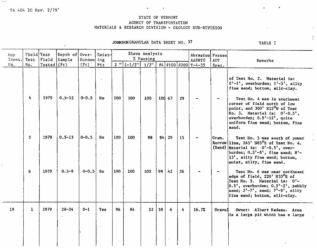
TA 404 2C ReV. 2/79 '
STATE OF VERMONT AGENCY OF TRANSPORTATION
MATERIALS & RESEARCH DIVISION - GEOLOGY SUB-DIVISION
J0SONCRANULAR DATA SHEET NO, 37 TABLE I
Map Field Year Depth of Over- Exist- Sieve Analysis Abrasion Passes Ident. Test Field Sample Burden ing - % Passing - AASHTO AOT Remarks
2" 1-1/2" 1/2" /14 /1100 -
11200 No. No. Tested (Fr) (Fr) Pit T-4-35 Spec.
of Test No. 2. Material is: O'-l', overburden; 1'-5', silty fine sand; bottom, silt-clay.
4 1979 0.5-12 0-0.5 No 100 100 100 10 67 29 - - Test No. 4 was in southwest corner of field north of low point, and 300' N150W of Test No. 3. Material is: 0'-0.5', overburden; 0.5'-12', quite uniform fine sand; bottom, fine sand.
5 1979 0.5-13 0-0.5 No 100 100 98 94 29 15 - Gran. Test No. 5 was south of power Borrow line, 245' N650E of Test No. 4. (Sand) Material is: 0'-0.5 1 , over-
burden; 0.5'-8', fine sand; 8'- 13', silty fine sand; bottom, moist, silty, fine sand.
6 1979 0.5-9 0-0.5 No 100 100 100 98 42 26 - - Test No. 6 was near northeast edge of field, 220' N330E of Test No. 5. Material is: 0'- 0.5', overburden; 0.5'-2', pebbly sand; 2'-7', sand; 7'-9', silty fine sand; bottom, silt-clay.
19 1 1979 28-34 0-1 Yes 96 84 52 38 6 4 16.7% Gravel Owner: Albert Nadeau. Area is a large pit which has a large

. I *
TA 404 2C Rev. 2/79
STATE OF VERMONT AGENCY OF TRANSPORTATION
MATERIALS & RESEARCH DIVISION - GEOLOGY SUB-DIVISION
JOHNSON GRANULAR DATA SHEET N0 1 38
TABLE I
-- Nap Field Year Depth of Over- Exist Sieve Analysis Abrasion Passes Tdent. Test Field Sample Burden ing % Passing -
- AASHTO AOT Remarks 2" 1-1/2" 1/2"1 #4 #100 #200 No. - No. Tested (Ft) (Ft) Pit T-4-35 Spec.
commercial aggregate operation in the yard. Area is north of Vermont Route 15. Access is via plant's driveway, 0.55 mile southeast of the junction of Town Highway No. 51 and Vermont Route 15. Working face is 0.25 mile from entrance. Owner said he would not sell to the State.
Test No. 1 was in the lower part of steep, southwest face of east lobe of pit. Material is: overburden; l'-28', treacherous, vertical face of uniform, pebbly, fine gravel (inaccessible); 28'-34', sand and fine gravel; bottom, sloughed material.
2 1979 35-41 0-1 Yes 100 100 93 83 25 13 - Sand Test No. 2 was in bottom of east face, 120' N350E of Test lo. 1. Material is: O'-l', overburden; 1'-35', sloughed material (sand, silt, and some stones); 35'-41', sand with a few stones; bottom, sloughed material.
- 1 1978 17-28 0-2 Yes 100 100 100 87 6 4 - Sand George Desmarais. 20 Area is a
mile south and west of Town

'I'A 404 2C Rev. 2/79'
STATE OF VERMONT ACENCY OF TRANSPORTATION
MATERIALS & RESEARCH DIVISION - GEOLOGY SUB-DIVISION
JOHNSON GRANULAR DATA SHEET NO, 39 TABLE I
Map Tdent. No.
Field Test No.
Year Field Tested
Depth of Sample (Ft)
Over- Burden (Ft)
Exist ing Pit
Sieve Analysis % Passing -
-
Abrasion AASHTO T-4-35
Passes AOT Spec.
Remarks 2" 1-1/2" 1/2" /14 11100 #200
Highway No. 51. Right-of-way to property is owned by Chellis Collins. Access is 0.55 mile east of, and uphill from, the junction of Town Highway No. 51 and Vermont Route 15. Area is limited by property lines.
Test No. 1 was In northeast face of pit. Material is: 0 1 -2', overburden; 2'-17', sand and pebbly sand on a vertical face which is not accessible; 17'-22', pebbly sand; 22'-24 1 ,
sand; 24'-26', pebbly sand; 26'-27', sand; 27'-28', silty fine sand; bottom, silty fine sand.
2 1978 10-20 0-1 Yes 92 92 76 57 8 5 19.8% Gravel Test No. 2 was in middle of face at south end of pit. Material Is: 0'-l', overburden; l'-lO', gravel on a vertical face which Is not accessible; 10'-14', gravel; 10-15', sand; l5'-16', pebbly coarse sand; l6'-20', pebbly sand; bottom sloughed material.
3 1979 0-10.5 - Yes 100 100 100 98 76 42 - - Test No. 3 was In floor, 60' northeast of Test No. 2.

TA 404 2C Rev. 2/79'
STATE OF VERMONT AGENCY OF TRANSPORTATION
MATERIALS & RESEARCH DIVISION - GEOLOGY SUB-DIVISION
JOHNSON GRANULAR DATA SHEET NO, 40
TABLE I
Map Field Year Depth of Over- Exist- Sieve Analysis Abrasion Passes Ident. Test Field Sample Burden ing % Passing -
- AASHTO AOT Remarks 2" 1-1/2" 1/2" #4 11100 #200 No. - No. Tested (Ft) (Ft) Pit T-4-35 Spec.
Material is: 0'-3', sand; 3 1 -6.5 1 , silty fine sand; 6.5'- 10.5 1 , silty sand; bottom, silty sand.
4 1979 0-10.5 - Yes 100 100 92 82 21 10 - Sand Test No. 4 was in floor at west end of pit, 90' N75 0W of Test No. 3. Material is: 0'- 2.5', pebbly sand; 2.5'-5', sand; 5 1 -6 1 , pebbly sand; 6'-10.5', gravelly sand; bottom, gravelly sand.
21 1 1978 1-8 0-1 Yes 100 100 99 92 7 6 - - Owner: Chellis Collins. Area is a large pit 0.35 mile south of Town Highway No. 51. The access is 0.55 nii1e north- east of, and uphill from the junction of Town Highway No. 51 and Vermont Route 15. Pit is In woods. Extension is south- westerly into woods.
Test No. 1 was in southwest face of north lobe of pit. Material is: overburden; l'-S', pebbly sand; 5'-8', coarse sand; bottom, sloughed material.

TA 404 2C Rev. 2/79
STATE OF VERMONT AGENCY OF TRANSPORTATION
MATERIALS & RESEARCH DIVISION - GEOLOGY SUB-DIVISION
JOHNSON GRANULAR DATA SHEET NO. 41 TABLE I
Map Ident. flo.
Field Test No.
Year Field Tested
Depth of Sample (Ft)
over- Burden (Ft)
Exist- ing Pit
Sieve Analysis - % Passing -
-
Abrasion AASHTO T-4-35
Passes AOT Spec.
Remarks 2" 1-1/2" 1/2" 114 11100 1/200
2 1978 1-8 0-1 Yes 100 100 96 78 12 4 - Sand Test No. 2 was in southeast face of north lobe of pit, 65' N650E of Test No. 1. Material is: 0'-l', overburden; l'-4.5', pebbly sand; 4.5'-6', sand; 6'-7', pebbly coarse sand; 7'-8', sand; bottom, sloughed material.
3 1978 1-19 0-1 Yes 100 91 81 68 20 15 15.6% Gran. Test No. 3 was in face of Borrow upper south-southwest end of pit. (Sand) Material is: 0'-l', overburden;
l'-2', sand; 2'-5', poorly graded gravel with sand; 5'-6', sand; 6 1 7 1 , layer of silt-clay; 7'-9', sticky, silt-clay coated gravel; 9 1 -10 1 , sand; 10'-12', gravel; 12 1 -15 1 , silty sand; 15'-17', layer of silt-clay; 17 1 -19 1 ,
sand and poorly graded fine gravel; bottom, silt-clay coated gravel.
4-A 1978 0.5-12 0-0.5 Yes 100 100 100 95 11 6 - Sand Test No. 4-A was in upper face In northeast corner of pit. Material is: 0'-0.5', over- burden; 0.5'-12', sand with some pebbly sand zones and a few random small cobbles near the base of upper slope; bottom sloughed material.

TA 404 2C Rev.' 2/79
STATE OF VERMONT AGENCY OF TRANSPORTATION
MATERIALS & RESEARCH DIVISION - GEOLOGY SUB—DIVISION
JOHNSON CRANULAR DATA SHEET NO, 42 TABLE I
Hp ldint. !o.
Field Test No.
Year Field Tested
Depth of Sample (Ft)
Over- Burden (Ft)
ii- ing Pit
Sieve Analysis % Passing - -
-
Abrasion AASHTO T-4-35
Passes AOT Spec.
Remarks 2"
1_1/2h1 1/2" 114 (1100 11200
4-B 1978 0.5-6 0-0.5 Yes 100 100 95 81 15 9 - Sand Test No. 4-B was in lower face in northeast corner of pit. Material is: 0'-0.5',-overburden; 0.5 1 -2 1 , sand; 2'-4', pebbly fine gravel; 4'-5', fine sand; 5'-6', sand with random small cobbles; bottom, sand.
5 1978 1-14 0-1 Yes 100 100 92 89 19 10 - Sand Test No. 5 was in southeast face in upper level of pit. Material is: 0'-l', overburden; l'-5', sand; 5'-6', layer of pebbly sand; 6'-14', sand; bottom, sand.
6 1979 0.5-10.5 0-0.5 Yes 100 100 93 49 7 5 17.9% Gravel Test No. 6 was in northwest floor of upper level of pit, 90' south of Test No. 1 and 165' S850W of Test No. 7. Material is: 0'-0.5', overburden; 0.5'- 10.5', very uniform, pebbly fine gravel (most stones are 1" or smaller); bottom, pebbly fine gravel.
7 1979 0-12 - Yes 100 100 100 99 20 7 - Sand Test No. 7 was in southeast floor of upper level of pit. 4aterial is: coarse pebbly sand; 2.5'-5', sand; 5'-12', sand and fine sand; ottom, fine sand.

IA 404 2C Rev., 2/79
STATE OF VERMONT AGENCY OF TRANSPORTATION
MATERIALS & RESEARCR DIVISION - GEOLOGY SUB—DIVISION
JOHNSON GRANULAR DATA SHEET NO, 43 TABLE 3
- ldnt. Uo.
Field Test No.
Year Field Tested
Depth of Sample (Ft)
Over- Burden (Ft)
Exist ing Pit
Sieve Analysis - % Passing - -
Abrasion AASHTO T-4-35
Passes AOT Spec.
Remarks 2" 1-1/2" 1/2" 114 11100 11200
8 1979 0.5-11 0-0.5 Yes 100 100 98 94 33 19 - - Test No. 8 was in floor, 80' east of Test No. 6. Material is: 0'-0.5', overburden; 0.5'-6', pebbly sand; 6'-11', silty fine sand; bottom, silty fine sand.
9 1979 0-12 - Yes 100 100 100 97 29 16 - - Test No. 9 was in southwest floor of upper level of pit, 95' S300E of Test No. 6. Material is: 0 1 -1 1 , pebbly sand; l'-7', sand; 7'-12', fine sand; bottom, silty fine sand.
10 1979 1-13 0-1 Yes 100 100 98 94 41 20 - - Test No. 10 was in brushy clearing atop pit, 30' S250E of Test No. 3. Material is: 0'-1 1 ,
overburden; l'-13', uniform fine sand; bottom, fine sand.
11 1979 0-12 - Yes 100 100 100 98 36 19 - - Test No. 11 was in small clearing atop pit, 35' east of rest No. 5. Material is: 0'- 12', silty fine sand; bottom, 3ilty fine sand.
12 1979 1-12 0-1 No 100 100 99 95 21 10 - Sand Test No. 12 was in small learing, 100' southeast of the unction of two access roads. taterial is: O'-l', overburden; 1 1 -6 1 , sand; 6'-7', pebbly layer; 7'-12', pebbly sand; bottom, sand.
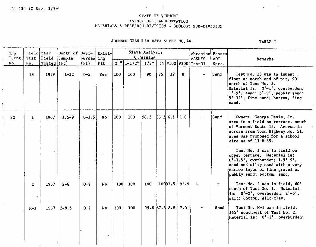
TA 404 2C Rev. 2/79
STATE OF VERMONT AGENCY OF TRANSPORTATION
MATERIALS & RESEARCH DIVISION - GEOLOGY SUB-DIVISION
JOHNSON GRANULAR DATA SHEET NO, 44 TABLE I
M.ip Field Year Depth of over- Exist- Sieve Analysis Abrasion Passes Ident. Test Field Sample Burden ing - % Passing -
- AASHTO AOT Remarks 2" 1-1/2" 1/2" 1/4 11100 11200 No. No. Tested (Ft) (Ft) Pit T-4-35 Spec.
13 1979 1-12 0-1 Yes 100 100 90 75 17 8 - Sand Test No. 13 was in lowest floor at north end of pit, 90' north of Test No. 2. Material is: 0'-l', overburden; 1 1 -5 1 , sand; 5'-9', pebbly sand; 9 1 -12 1 , fine sand; bottom, fine sand.
22 1 1967 1.5-9 0-1.5 No 100 100 96.3 36.5 6.1 1.0 - Sand Owner: George Davis, Jr. Area is a field on terrace, south of Vermont Route 15. Access is across from Town Highway No. 51. Area was proposed for a school site as of 11-8-65.
Test No. 1 was in field on upper terrace. Material is: 0'-1.5', overburden; 1.5'-9', sand and silty sand with a very narrow layer of fine gravel or pebbly sand; bottom, sand.
2 1967 2-6 0-2 No 100 100 100 10097.5 93.5 - - Test No. 2 was in field, 60' south of Test No. 1. Material is: 0'-2', overburden; 2'-6', silt; bottom, silt-clay.
M-1 1967 2-8.5 0-2 No 100 100 95.8 37.5 8.8 7.0 - Sand Test No. M-1 was in field, 165' southwest of Test No. 2. Material is: 0'-2', overburden;

TA 404 2C Rev. 2/79
STATE OF VERMONT AGENCY OF TRANSPORTATION
MATERIALS & RESEARCH DIVISION - GEOLOGY SUB-DIVISION
JOHNSON GRANULAR DATA SHEET NO, 45 TABLE I
Hap Ident. o.
Field Test No.
Year Field Tested
Depth of Sample (Ft)
Over- Burden (Ft)
Exist- ing Pit
Sieve Analysis - % Passing
Abrasion AASHTO T-4-35
Passes AOT Spec.
Remarks 2" 1-1/2" 1/2"
-
//4 //100 //200
2 1 -5 1 , sand; 5'-6', fine gravel or pebbly sand; 6'-8.5', sand; bottom, sand.
M-2 1967 3-7.5 0-3 No 100 100 100 100 98.5 96.5 - - Test No. 14-2 was in lower level of meadow, 285' southeast of Test No. M-l. Material is: 0'-3', overburden; 3'-7.5', silt; bottom, silt-clay.
M-3 1967 2-8 0-2 No 100 100 98.8 ME 45.0 21.0 - - Test No. M-3 was in lower level of meadow, 155' east of Test No. M-1. Material is: 0'-2', overburden; 2'-8', silty sand; bottom, silty sand.
1967 3-10 0-3 No 100 100 91 52.4 3.3 1.0 - - Test No. 11-4 was in lower level of meadow, 155' southwest of Test No. M-2. Material is: 0'-3', overburden; 3'-5', coarse sand; 5'-6', pebbly sand or fine gravel; 6'-10', coarse sand; bottom, sand.
M-5 1967 3-8.5 0-3 No 100 100 94.8 B9.6 11.7 3.8 - Sand Test No. M-5 was in west end of lower level of meadow, 305' southwest of Test No. M-4. Material is: 0'-3', overburden; 3'-5 1 , sand; 5'-6', fine sand; 6'-8.5', sand; bottom, sand.

'lA 404 2C Rev 2/79 0
STATE OF VERMONT AGENCY OF TRANSPORTATION
MATERIALS & RESEARCH DIVISION - GEOLOGY SUB-DIVISION
JOHNSON GRANULAR DATA SHEET NO.46 TABLE I
Map Field Year Depth of Over- Exist- Sieve Analysis Abrasion Passes ident. Test Field Sample Burden ing % Passing - -
- AASHTO AOT Remarks 2" 1-1/2" 1/2" 114 11100 11200 No. No. Tested (Ft) (Ft) Pit T-4--35 Spec.
H-6 1967 3-8 0-3 No 100 100 82.2 59 3 1.5 - Gran. Test No. M-6 was in west end Borrow of lower level of meadow, 290' (Sand) south of Test No. 11-5.
Material is: 0'-3', overburden; 3'-5 1 , sand; 5'-6', silty sand; 6'-8', sand; bottom, sand.
M-7 1967 3-6 0-3 No 100 100 100 )9.392.5 88.5 - - Test No. M-7 was near center of terrace, 190' southeast of Test No. M-6. Material is: 0'-3', overburden; silt; bottom, silt-clay.
M-8 1967 2-7 0-2 No 100 89.6 81.4 i3.4 2.5 1.3 - Gran. Test No. M-8 was in field, Borro 200' northeast of Test No. N-7. (Sand) Material is: 0'-2', overburden;
2'-7', sand with some gravelly sand layers; bottom, sand.
M-9 1967 2.5-9 0-2.5 No 100 100 100 100 48 24 - - Test No. M-9 was in field, 190' south of Test No. M-8. faterial is: 0'-2.5', overburden; 2.5 1 -9 1 , silty sand;' bottom, silty sand.
M-lO 1967 1.5-8 0-1.5 No 100 100 86.2 8.3 2.7 0.8 - Sand Test No. M-10 was in field, 200' east of Test No. M-9. Material is: 0'-1.5 1 , over- burden; 1.5'-8', pebbly sand and sand; bottom, sand

1'\ 404 2C Rev'. 2/79' I
'
STATE OF VERMONT AGENCY OF TRANSPORTATION
MATERIALS & RESEARCH DIVISION - GEOLOGY SUB-DIVISION
JOHNSON GRANULAR DATA SHEET NO, 47
TABLE I
Map Field Year Depth of Over- Ex1st Sieve Analysis Abrasion Passes Ident. Test Field Sample Burden Ing % Passing - AASHTO AOT Remarks
2" 1-1/2" 1/2" 1/4 1/100 //200 1Io. No. Tested (Ft) (Ft) Pit T-4-35 Spec.
23 1 1978 0.5-19 0-0.5 Yes 100 100 100 99 9 7 - Sand Owner: Perry Blanchard. Former owner: Robert Venticinque. Area is a small pit with gently sloping faces which almost seem to be like a bull-dozed and smoothed slope of a pit. The material extends easterly in a wooded knoll. Area is 175' south of the east end of Town Highway No. 46. Access is 0.86 mile east of the junction of Town Highways No. 45 and 46. Small pit was inactive at time of sampling.
Test No. 1 was on north face of wooded knoll. Material is: 0'-0.5', overburden; 0.5'-19', well-sorted and well-drained sand; bottom, sloughed sand.
2 1978 0.5-11 0-0.5 Yes 100 100 100 99 8 6 - Sand Test No. 2 was on west face of wooded knoll, 30' southwest of Test No. 1. Material is: O'-O.S', overburden; 0.5'-11', sand; bottom, sloughed sand. The top ofTest No. 1 is higher than, but east of the top of Test No. 2.

TA 404 2C Rev. 2/79
STATE OF VERMONT AGENCY OF TRANSPORTATION
MATERIALS & RESEARCH DIVISION - GEOLOGY SUB-DIVISION
JOHNSON GRANULAR DATA SHEET NO.48 TABLE I
Hap Ident. No.
Field Test No.
Year Field Tested
Depth of Sample (Ft)
Over- Burden (Ft)
Exist- ing Pit
Sieve Analysis % Passing - -
-
Abrasion AASIITO T-4-35
Passes AOT Spec.
Remarks 2" 1-1/2" 1/2"1 114 #100 #200
24 1 1978 2.5-11 0-2.5 Yes 100 100 93 81 8 5 - Sand Owner: Lawrence Rogers. Former owner Katherine Patch (owner's grandmother).
Area is a large corn field with a pit on a wooded knoll in the southwest corner of the field. Area is at the south end of a private drive, 0.21 mile south of Town Highway No. 46. Access is 0.34 mile southeast of the junction of Town Highways No. 45 and 46. Corn fields are leased to McClure.
Test No. 1 was in north face of pit. Material is: 0'-2.5', overburden; 2.5'-3', silty, hard- packed gravel; 3'-5', layer of silt; 5'-11', inclined beds of clean, coarse sand and coarse, - pebbly sand; bottom, sloughed material.
2-A 1978 3.5-11 0-3.5 Yes 79 69 51 36 8 6 23.9% Gravel Test No. 2-A was in south face of pit, 120' south of Test No. 1. Material is: 0'- 3.5 1 , overburden; 3.5 gravel with a coating of silt- clay; (material caved very readily); bottom, gravel (Test No. 2-B).

TA 404 2C Rei,. 2/79k
STATE OF VERMONT AGENCY OF TRANSPORTATION
MATERIALS & RESEARCH DIVISION - GEOLOGY SUB-DIVISION
JOHNSON GRANULAR DATA SHEET NO 1 49 TABLE I
Map Ident. Uo.
Field Test No.
Year Field Tested
Depth of Sample (Ft)
over- Burden (Ft)
Exist- ing Pit
Sieve Analysis % Passing
-
Abrasion AASHTO T-4-35
Passes AOT Spec.
Remarks 2" 1-1/2" 1/2" 114 11100 1/200
2-B 1979 11-14 - Yes 88 77 61 48 19 11 22.1% Gran. Test No. 2-B was below Borrow Test No. 2-A. Material is: Gravel ll'-l2', gravel with sub-rounded
stones; 12'-14', gravel with a high silt-clay content and angular stones; bottom, same.
3 1979 1-10 0-1 Yes 100 100 100 95 99 60 - - Test No. 3 was in northwest floor of pit, 90' N25 0E of Test No. 2. Material is: 0'- 1', overburden; l'-7', fine silty sand; 7'-10', silty fine sand and some layers of silt- clay; bottom, silt-clay and silty fine sand; water was en- countered at 9'.
4 1979 2.5-10.5 0-2.5 No 100 92 56 39 9 7 20.0% Gravel Test No. 4 was in corn field, 170' S550E of Test No. 3. aterial is: 0'-2.5 1 , over- burden; 2.5'-6', gravel (a bit on the coarse side); 6'-7 1 ,
bouldery gravel; 7'-10.5', fine gravel; bottom, fine gravel.
5 1979 4-11.5 0-4 No 92 84 66 50 35 22 37.3% - Test No. 5 was in field, 225' S30°W of Test No. 4. Material is: 0'-4', overburden; 4'-6', ,ouldery gravel; 6'-11.5', silty gravel; bottom, silty gravel.

TA 404 2C Rev. 2/79
STATE OF VERMONT AGENCY OF TRANSPORTATION
MATERIALS & RESEARCH DIVISION - GEOLOGY SUB-DIVISION
JOHNSON GRANULAR DATA SHEET NO, 50 TABLE I
Hap Ident. No.
Field Test No.
Year Field Tested
Depth of Sample (Ft)
Over- Burden (Ft)
ExistS ing Pit
Sieve Analysis - % Passing -
Abrasion AASHTO T-4-35
Passes AOT Spec.
Remarks 2" 1-1/2" 1/2" (/4 (/100
- //200
6 1979 1-8 0-1 No 80 80 66 60 32 16 - Test No. 6 was in field near rook, 140' S600E of, and 6' below Test No. 5. Material is: 0'-l', overburden; l'-3', silty fine sand; 3 1 -4 1 , gravel; 4'- 55t, layer of boulders (8" to 24"); 5.5'-8', silty gravel; bottom, silty gravel. Water was encountered at 8'.
7 1979 2-6 0-2 No 74 70 49 32 12 6 16.5% Gravel Test No. 7 was in northeast corner of field, 360' N500E of Test No. 6. Material is: 0'-2', overburden; 2'-3.5', fine gravel with tabular stones; 3.5'-6 1 , gravel and much water; bottom, gravel with tabular stones and much water.
8 1979 2-7 0-2 No 86 82 63 47 13 7 15.9% Gravel Test No. 8 was in field near road and trailer, 255' N30°W of Test No. 7. Material is: 0'-2', overburden; 2'-7', gravel with tabular stones; bottom, gravel with tabular stones. Water was encountered at 5'.
9 1979 4-8 0-4 No 79 69 47 37 20 10 21.3% Gran. Test No. 9 was in field, 130' Borrow S40°W of, and 6' above Test No. 8, Gravel)and 160' N300E of Test No. 4.

'I'A 404 2C Rev. 2/79 w
STATE OF VERMONT AGENCY OF TRANSPORTATION
MATERIALS & RESEARCH DIVISION - GEOLOGY SUB—DIVISION
JOHNSON GRANULAR DATA SHEET NO, 51 TABLE I
Map Ident. tJo.
Field Test No.
Year Field Tested
Depth of Sample (Ft)
Over- Burden (Ft)
Exist- Ing Pit
Sieve Analysis - % Passing
Abrasion AASHTO T-4-35
Passes AOT Spec.
Remarks 2" 1-1/2" 1/2"
-
//4 (/100 //200
Material is: 0'-4', overburden (mostly sand--not sampled); 4 1 -8', gravel; bottom, sand. Water was encountered at 8'.
10 1979 2-9 0-2 No 79 79 63 52 26 11 35.1% Gran. Test No. 10 was in field, 105' Borrow S30°W of Test No. 4, and 120' Gravel N30°E of Test No. 5. Material is:
0'-2', overburden; 2'-7' dirty gravel;7'-9', a layer of boul- ders; bottom, silty fine sand. Most of the stones are from 3" to
11 1979 1.5-11 0-1.5 No 83 77 57 39 15 7 23.5% Gravel Test No. 11 was in field, 150' S800
E of Test No. 10 (at edge of drop-off). Material is: 0'-1.5', overburden; 1.5'-5', pebbly fine gravel; 5'-8', bouldery gravel with 8" to 24" stones; 8'-11', gravel; bottom, gravel. A water seep was encountered at 11'.
12 1979 1.5-9 0-1.5 No 100 93 64 43 32 22 22.3% - Test No. 12 was in field near fenced-in stripped area, 170' S30°W of Test No. 1. Material is: 0'-1.5', overburden; 1.5'- 4 1 , fine gravel; 4'-7', bouldery coarse gravel with angular-to- tabular, 12" to 30" stones; 7 1 -9', gravel; bottom, moist gravel and silt-clay.

'17.. 404 2C Rev.' 2/79
STATE OF VERMONT ACENCY OF TRANSPORTATION
MATERIALS & RESEARCH DIVISION - GEOLOGY SUB-DIVISION
JOHNSON GRANULAR DATA SHEET NO 1 52 TABLE I
M3) Field Year Depth of Over- Exist- Sieve Analysis Abrasion Passes 1d.nt. Test Field Sample Burden ing - % Passing AASHTO AOT Remarks
2" 1-1/2" 1/2" //4 /1100 //200 io. No. Tested (Ft) (Ft) Pit T-4-35 Spec.
25 1 1979 1.5-10 0-1.5 No 100 100 97 92 89 65 - - Owner: Lawrence Rogers.
Area is an irregularly sloping field east of Town highway No. 45. Access is 0.3 mile south of the junction of Town Highways No. 45 and 46.
Test No. 1 was 155' south of the north end of field, and 120' east of Town Highway No.45. Material is: O'-l.S', over- burden; 1.5'-10', silty fine sand;' bottom, silty fine sand.
2-A 1979 1.5-4.5 0-1.5 No 100 89 68 55 25 13 25.9% Gran. Test No. 2-A was in corn field, Borrow 240' S20°W of Test No. 1. Gravel) aterial is: 0'-1.5', over-
)urden; 1.5'-4.5', silty gravel; )ottonl, sand (Test No. 2-B).
2-B 1979 4.5-10 - No 100 100 87 77 52 21 - - Test No. 2-B was below Test o. 2-A. Material is: 4.5'- 10', sand or silty fine sand; ottom, silty fine sand.
26 1 1978 8-16 0-1 No 100 100 100 100 93.5 71.0 - - Owner: Katherine Patch. rea is a steep-faced bank ad- acent to the southwest side of 'own Highway No. 45.

TA 404 2C Rev 2/79 -
STATE OF VERMONT AGENCY OF TRANSPORTATION
MATERIALS & RESEARCH DIVISION - GEOLOGY SUB-DIVISION
JOHNSON GRANULAR DATA SHEET NO.53 TABLE I
iap Field Year Depth of Over- Exist- Sieve Analysis Abrasion Passes Ident. Test Field Sample Burden ing % Passing - -
- AASHTO AOT Remarks 2" 1-1/2" 1/2" #4 1/100 #200 No. No. Tested (Ft) (Ft) Pit T-4-35 Spec.
Test No. 1 was on slope of bank. Material is: 0'-l', overburden; l'-8', vertical face of silt-clay, not accessible; 8'-16', very hard-packed layers of silt and silt-clay; bottom, sloughed silt or silt-clay.
27 1 1978 3-15 0-3 Yes 100 100 89 81 48 35 - - Owner: Frederick Dezaine, Jr. Area is an inactive, nearly depleted, heavily overgrown, trash-strewn, sloughed pit ad- jacent to the west side of Town Highway No. 45. Access is 0.55 mile east of the junction of Town Highways No. 2 and 45.
Test No. 1 was in northwest face of pit. Material is: 0'-3', overburden; 3'-8', silty fine sand; 8'-10', sand; 10'-13', pebbly sand or pebbly very fine gravel; 13'-15', sand; bottom, sloughed material and vegetation.
28 1 1978 1-40 0-1 Yes 100 91 82 74 17 10 - Sand Owner: Manchester Lumber Co. Area is an inactive, nearly depleted, steep-faced pit which

r,\ 404 2C Rev 2/79
STATE OF VERMONT AGENCY OF TRANSPORTATION
MATERIALS & RESEARCR DIVISION - GEOLOGY SUB-DIVISION
JOHNSON GRANULAR DATA SHEET NO, 54 TABLE I
- Map I Field Year Depth of Over- Exist- Sieve Analysis Abrasionj Passes 1dnt. Test Field Sample Burden ing % Passing - -
- AASHTO AOT Remarks 2" 1-1/2" 1/2" 04 0100 //200 Uo. No. Tested (Ft) (Ft) Pit T-4-35 Spec.
is adjacent to the northwest side of Town Highway No. 45, and northeast of the railroad tracks. The pit is used for log storage and lumber storage, and there is no extension. The ac- cess is 0.35 mile east of the junction of Town Highways No. 2 and 45.
Test No. 1 was on the high face of steep bank west of the road. Material is: O'-l', overburden; 1'-3', gravel; 3'-5', sand; 5'-7', pebbly fine gravel; 7 1 -8 1 , layer of silt-clay; 8'- 12', pebbly sand; 12'-15', sand; 15 1 -30', sand; 30 1 -32 1 , pebbly sand; 32'-36', poorly sorted, hard-packed gravel with a silt- clay coating; 36'-40', poorly graded gravel consisting of riostly sand and cobbles (not auch intermediate sizes); bottom, and and sloughed material.
29 1 1978 3-21 0-1 Yes 100 100 98 90 18 10 - Sand Owner: Floyd Tinker, Jr. rea is a tiny, sloughed, over- ;rown, inactive, nearly depleted

TA 404 2C Rev 2/79
STATE OF VERMONT AGENCY OF TRANSPORTATION
MATERIALS & RESEARCH DIVISION - GEOLOGY SUB-DIVISION
JO1SON GRANULAR DATA SHEET NO, 55 TABLE I
Map Field Year Depth of Over- Exist- Sieve Analysis Abrasion Passes Ident. Test Field Sample Burden ing % Passing - -
- AASHTO AOT Remarks 2" 1-1/2" 1/2" 114 1/100 11200 No. No. Tested (FtY (Ft) Pit T-4-35 Spec.
pit just west of Town Highway No. 5. Access is 0.05 mile south of the junction of Town Highways No. 5 and 44.
Test No. 1 was in west- southwest face of pit. Material looks good, but is so limited as to be uneconomical. Material is: O'-l', overburden; 1'-3', pebbly sand which is too steep to reach; 3'-S', pebbly sand; 5'-7', sand; 7'-12', pebbly fine gravel; 12'- 15', sand; 15'-17', layer of silt- clay or silty fine sand; 17'-21', sand with a bit of silty fine sand; bottom, sloughed material.
30 1-A 1978 1-11 0-1 Yes 94 91 69 45 21 11 25.5% Gran. Owner: Clifton Wescom. Area Borrow consists of two pits alongside Gravel Town Highway No. 82, and the
extension into a large field south of the pits. Owner stated that the pits were limited and he wants the material for his own use and in the trailer park nearby. Pits are 0.4 mile south of the junction of Vermont Route 15 and Town Highway No. 82.

1',\ 1,04 2C Rev.. 2/79
STATE OF VERMONT AGENCY OF TRANSPORTATION
MATERIALS & RESEARCU DIVISION - GEOLOGY SUB—DIVISION
JOHNSON GRANULAR DATA SHEET NO, 56 TABLE I
Map 1thnt. 1.1 0.
Field Test No.
Year Field Tested
Depth of Sample (Ft)
Over- Burden (Ft)
ixist- ing Pit
Sieve Analysis % Passing -
Abrasion AASHTO T-4-35
Passes AOT Spec.
Remarks 2" 1-1/2" 1/2"
-
//4 (/100 (/200
Test No. 1-A was in the southwest face of lower level of pit north of Town Highway No. 82. Material is: O'-l', overburden; l'-7', hard-packed gravel; 7'-9', zone of pebbly gravel; cobbles and sand, (a gap-graded gravel); bottom, sloughed material.
1-B 1979 11-16 - Yes 100 100 86 69 16 10 - Sand Test No. 1-B was below Test No. 1-A. Material is: 11 1 -16 1 ,
gravelly sand; bottom, sand.
2 1978 0.5-10 0-0.5 Yes 100 100 98 92 11 5 - Sand Test No. 2 was In low east face of pit west of Town Highway No. 82. Material is: O'-O.S', overburden; 0.5'-5', layers of sand, silty sand, and pebbly sand; 5'-6', pebbly coarse sand; 6'-10', sand; bottom, sloughed material. Deposit seems to have been a delta or shoal.
3 1979 0.5-12 0-0.5 Yes 95 91 65 42 16 7 - Gravel Test No. 3 was In southwest Grada- floor of main pit, 25' south- tIon east of Test No. 1. Material only) Is: 0'-0.5', overburden; 0.5'-
12', gravel; bottom, gravel. A

TA 404 2C Rev: 2/79
STATE OF VERMONT AGENCY OF TRANSPORTATION
MATERIALS & RESEARCR DIVISION - GEOLOGY SUB—DIVISION
JOHNSON GRANULAR DATA SHEET NO, 57 TABLE I
ldLnt. Uo.
Field Test No.
Year Field Tested
Depth of Sample (Ft)
Over— Burden (Ft)
Exist- ing Pit
Sieve Analysis % Passing -
-
Abrasion AASHTO T-4--35
Passes AOT Spec.
Remarks 2" 1-1/2" 1/2" //4 (/100 (/200
large amount of the stones were over 4" and would need a crusher to use them. There was no wear test on this material due to mechanical failure of test machine.
4 1979 1.5-12 0-1.5 Yes 81 78 60 41 42 39 - - Test No. 4 was in floor, 240' N700E of Test No. 3. Material is: 0'-1.5', overburden; 1.5 1 - 6 1 , gravel; 6'-8', layer of 8" to 20"boulders; 8'-12', gravel; bottom, gravel. The gravel has a lot of silt-clay coating which might account for the high per- cent of fines.
5 1979 0.5-12 0-0.5 Yes 100 100 100 100 16 9 - Sand Test No. 5 was in upper pit level near access road. Material is: 0'-0.5', over- burden; 0.5'- 7', sand; 7'-11 1 , silty fine sand; ll'-12', sand; bottom, sand.
6 1979 0.5-7 0-0.5 No 100 94 82 68 22 20 27.8% - Test No. 6 was at edge of upper level of terrace in field west of access road. Material is: 0'-0.5', overburden; 0.5'- 3.5', pebbly fine gravel; 3.5'- 5 1 , sand; 5'-7', gravelly sand or sandy gravel; bottom, silt-
• clay.

• V
TA 404 2C Rev. 2/79
STATE OF VERMONT AGENCY OF TRANSPORTATION
MATERIALS & RESEARCH DIVISION - GEOLOGY SUB-DIVISION
JO1ThSON GRANULAR DATA SHEET NO.58
TABLE I
Map Ident.
- No.
Field Test No.
Year Field Tested
Depth of Sample (Ft)
Over- Burden (Ft)
Exist- ing Pit
Sieve Analysis % Passing - -
-
Abrasion AASHTO T-4--35
Passes AOT Spec.
Remarks 2" 1-1/2" 1/2" 114 //100 //200
7 1979 0.5-11 0-0.5 Yes 100 100 85 65 8 5 23.0% Sand Test No. 7 was in floor of, small pit, below and west of Town Highway No. 82. Material is: 0 1 -0.5', overburden; 0.5'- 11', gravelly sand; bottom, gravel.
8-A 1979 1-6 0-1 No 100 100 100 99 47 24 - - Test No. 8-A was near the south corner of large, uncut field southwest of pit. Material is: 0'-l', overburden; 1 1 -6 1 , sand; bottom, gravel (Test No. 8-B).
8-B 1979 6-12 - No 100 96 72 55 14 8 - Gravel Test No. 8-B was below Test Grada- No. 8-A. Material is: 6'-12', tion quite uniform gravel; bottom, only) gravel. There is no wear test
on this material due to mechanic- al failure of test machine.
9-A 1979 1-7 0-1 No 100 100 100 100 36 27 - - Test No. 9-A was near fence in north corner of field, 380' N20W of Test No. 8. Material is: 0 1 -1 1 , overburden; sand; bottom, gravel (Test No. 9-B).
9-B 1979 7-12 - No 79 77 57 45 12 8 23.8% Gravel Test No. 9-B was below Test No. 9-A. Material is: 7'-12',

TA 404 2C Rev. 2/79
STATE OF VERMONT AGENCY OF TRANSPORTATION
MATERIALS & RESEARCH DIVISION - GEOLOGY SUB-DIVISION
JOHNSON GRANULAR DATA SHEET NO.59 TABLE I
Map ident. No.
Field Test No.
Year Field Tested
Depth of Sample (Ft)
Over- Burden (Ft)
Exist- ing Pit
Sieve Analysis % Passing - -
-
Abrasion AASHTO T-4-35
Passes AOT Spec.
Remarks 2" 1-1/2" 1/2" #4 #100 #200
quite uniform river gravel; bottom, gravel.
10 1979 1.5-12 0-1.5 No 94 94 86 76 8 4 19.4% Gran. Test No. 10 was in east Borrow corner of field near pit, 450' (Sand) S500E of Test No. 9, and 360'
N770E of Test No. 8. Material is: O'-l.S', overburden; 1.5'- 4', sand; 0-6', layers of sand and pebbly sand; 6 '-8.5', pebbly fine gravel; 8.5'-10', pebbly sand; 10'-12', fine gravel; bottom, gravel.
11-A 1979 2-6 0-2 No 100 100 100 100 14 4 - Sand Test No. 11-A was in field, 200' N750W of Test No. 10. Material is: 0'-2', overburden; 2'-6 1 , sand; bottom, gravel (Test No. li-B).
11-B 1979 6-12 - No 83 71 54 44 11 6 21.0% Gravel Test No. 11-B was below Test No. 11-A. Material is:
- - 6 1 -12 1 , quite uniform river gravel; bottom, gravel.
12 1979 5.5-11 0-5.5 No 100 95 71 53 18 13 16.0% Gran. Test No. 12 was near west end - Borrow of narrow field between the
Gravel river and Town Highway No. 82. Material is: 0'-5.5 1 , over- burden; 5.5'-6.5', pebbly sand;

I'A 404 2C Rev. , 2/79
STATE OF VERMONT AGENCY OF TRANSPORTATION
MATERIALS & RESEARCh DIVISION - GEOLOGY SUB-DIVISION
JOHNSON GRANULAR DATA SHEET NO 1 60 TABLE I
Kip Field Year Depth of Over- Exist- Sieve Analysis Abrasion Passes Ident. Test Field Sample Burden ing % Passing - AASHTO AOT Remarks
2" 1-1/2" 1/2" (/4 (1100 (/200 Uo. No. Tested (Ft) (Ft) Pit T-4-35 Spec.
6.5'-7 1 , sand; 7'-11', gravel; bottom, gravel.
13 1979 4-11 0-4 No 100 81 66 48 8 5 21.9% Gravel Test No. 13 was in field north of pit access road, 320' N650E of Test No. 12. Material is: 0'-4', overburden; 0-11', gravel; bottom, gravel.
14 1979 0.5-8.5 0-0.5 No 100 100 100 10C 82 53 - - Test No. 14 was in field southeast of Town Highway No. 82, 245' N55 E of Test No. 13. Material is: 0'-0.5', overburden; 0.5'-8.5', silty fine sand; bottom, gravel.
31 1 1979 1-9 0-1 No 90 87 59 43 17 7 18.0% Gravel Owner: Camille Lehouiller. Area is a large corn field with a tiny pit on the northeast edge of a terrace. Area is just south of Vermont Route 15, and east of Foote Brook. Access is 0.04 mile east of the junction of Vermont Route 15 and Town Highway No. 39.
Test No. 1 was in northwest corner of large corn field. Material is: 0'-l', over- burden; 1'-3', pebbly sand;

Ti 404 2C Rev.' 2/79 *
STATE OF VERMONT AGENCY OF TRANSPORTATION
MATERIALS & RESEARCH DIVISION - GEOLOGY SUB-DIVISION
JOIThSON GRANULAR DATA SHEET NO. 61 TABLE I
NJj) Ident.
Field Test
Year Field
Depth of Sample
Over- Burden
Exist• ing
Sieve Analysis % Passing -
Abrasion AASHTO
Passes AOT Remarks
2" 1-1/2" 1/2" 114 11100 1/200 Uo. No. Tested (Ft) (Ft) Pit T-4-35 Spec,
3'-4 1 , pebbly gravel; 4'-5', sand; 5'-8', coarse gravel with 4" to 8" stones; 8 1 -9 1 ,
fine gravel; bottom, wet, silty sand.
Owner allowed only this one hole in northwest corner of field, but he said the whole field is gravel under a couple of feet of topsoil.
2 1979 1-10 0-1 Yes 92 92 77 47 11 8 19.3% Gravel Test No. 2 was in floor of tiny pit, 555' west of Test No. 1. Material is: O'-l', overburden; l'-lO', uniform fine gravel; bottom, fine gravel.
3 1979 8-15 0-8 Yes - - - - - - 13.2% Gravel Test No. 3 was in middle of (wear face of pit near Foote Brook, only) 15' west of Test No. 2.
Material is: 0'-8', silty fine sand or silt-clay in a vertical f ace which is inaccessible; 8'-15', gravel with a silt-clay coating; bottom, sloughed material. There was no gradation test run on this sample.
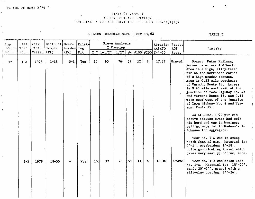
TA 404 2C Rev. 2/79
STATE OF VERMONT AGENCY OF TRANSPORTATION
MATERIALS & RESEARCU DIVISION - GEOLOGY SUB-DIVISION
JOHNSON GRANULAR DATA SHEET NO, 62 TABLE I
NJ1)
1dnt. 10.
Field Test No.
Year Field Tested
Depth of Sample (Ft)
Over- Burden (Ft)
Exist. ing Pit
Sieve Analysis - % Passing -
-
Abrasionl AASHTO T-4-35
Passes AOT Spec.
Remarks 2" 1-1/2" 1/2" //4 //100 (/200
32 1-A 1978 1-18 0-1 Yes 90 90 76 57 12 8 17.7% Gravel Owner: Peter Kuliman. Former owner was Audibert. Area is a high, silty-faced pit on the northeast corner
S of a high meadow terrace. Area is 0.23 mile southeast of Vermont Route 15. Access is 0.46 mile northeast of the junction of Town Highway No. 43 and Vermont Route 15, and 0.15 mile southwest of the junction of Town Highway No. 4 and Ver- mont Route 15.
As of June, 1979 pit was active because owner had sold his herd and was in business
- selling material to Nadeau's in Johnson for aggregate.
Test No. 1-A was in steep north face of pit. Material is: 0 1 -l', overburden; l'-18 1 ,
S quite good-looking gravel which caves very easily; bottom, sand.
1-B 1978 18-30 - Yes 100 92 76 59 11 6 18.3% Gravel Test No. 1-B was below Test No. 1-A. Material is: 18'-20', sand; 20'-24', gravel with a silt-clay coating; 20-26',

17 404 2C Rev.' 2/79
STATE OF VERJIONT AGENCY OF TRANSPORTATION
MATERIALS & RESEARCH DIVISION - GEOLOGY SUB-DIVISION
JOhNSON GRANULAR DATA SHEET NO.63 TABLE I
K]1) Field Year Depth of Over- Exist- Sieve Analysis Abrasion Passes Idnt. Test Field Sample Burden ing - % Passing
- AASHTO AOT Remarks 2" 1-1/2" 1/2" 114 1/100 1/200 Iho. No. Tested (Ft) (Ft) Pit T-4.-35 Spec,
fine gravel with a silt-clay binder which makes the gravel very hard-packed and very hard to dig; 26'-28', gravel with a silt-clay binder; 28'-30', gravel and gravelly sand with silt-clay; bottom, sloughed material.
2 1979 0-11 - Yes 96' 88 62 34 18 13 1.8.7% 'iranular Test No. 2 was in northwest Borrow face of lowest level in pit.
(;ravel) Material is: 0 , -11', gravel; bottom, gravel. There was quite a bit of water on the floor of lowest (active) level, and quite a bit of fines--but these might have washed in from else- where.
There is a large reserve of materials, but they would have to be checked as development proceeded - to determine how uniform it is.
33 i-A 1978 1-17 0-1 Yes 100 93 87 76 21 10 - Sand Owner: Claude Lehouiller. Area is a narrow pit below the east edge of a corn field. Pit is 0.04 mile south of Vermont

T 404 2C Rev.. 2/79
STATE OF VERMONT AGENCY OF TRANSPORTATION
MATERIALS & RESEARCU DIVISION - GEOLOGY SUB-DIVISION
JOIINSONCRANULAR DATA SHEET NO,64 TABLE I
Map 1dnt. Uo.
Field Test No.
Year Field Tested
Depth of Sample (Ft)
Over- Burden (Ft)
Exist- ing Pit
Sieve Analysis - % Passing -
-
Abrasion AASHTO T-4-35
Passes AOT Spec.
Remarks 2" 1-1/2" 1/211 114 (/100 (/200
Route 15. The access is 0.21 mile east of the junction of Town Highway No. 43 and Vermont Route 15. The access Is good but steep over the railroad tracks.
Test No. 1-A was in northwest face of middle lobe of pit. Material is: O'-l' overburden; 1 1 -7 1 , pebbly fine gravel; 7'- 8 1 , sand; 8'-10', layer of silt- clay; 10'-12', sand; 12'-13', pebbly fine gravel 13'-16', sand; 16'-16.5', pebbly sand; 16.5'-17', sand; bottom, sloughed material.
1-B 1979 17-22 - Yes 100 100 93 81 25 16 - - Test No. 1-B was below Test No. 1-A. Material is: 17'- 22', layers of sand, pebbly sand, and fine gravelly sand; bottom, sand. Face caved very readily.
2 1978 1-8 0-1 Yes 100 100 100 100 69 23 - - Test No. 2 was In northwest face of north lobe of pit. Material Is: 0'-l', over- burden; l'-4', silty fine sand; 4 1 -8 1 , very silty fine sand or silt-clay.

T 404 2C Rev.' 2/79
STATE OF.VERMONT AGENCY OF TRANSPORTATION
MATERIALS & RESEARCU DIVISION - GEOLOGY SUB-DIVISION
JOHNSON GRANULAR DATA SHEET NO, 65 TABLE I
Map Field Year Depth of Over- Exist• Sieve Analysis Abrasion Passes Ident. Test Field Sample Burden ing % Passing - AASHTO AOT Remarks
2" 1-1/2" 1/2" (/4 11100 (/200 Uo. No. Tested (Ft) (Ft) Pit T-4-35 Spec.
3 1979 0-12 - - Yes 100 100 100 97 53 24 - - Test No. 3 was in floor of pit, 15' southeast of Test No. 1-B.
4 1979 2-12 0-2 No 100 100 100 96 30 15 - Gran. Test No. 4 was near access Borrow road in trash area northwest of (Sand) and above pit. Material is:
0'-2 1 , overburden; 2'-4', sand; 4'-12', silty fine sand; bottom, moist silty fine sand or silt- clay.
34 1 1979 0.5-8 0-0.5 Yes 100 100 100 10C 46 11 - Gran. Owner: Claude Lehouiller. Borrow Area is pit north of Vermont (Sand) Route 15, west of picnic area.
Access is 0.33 mile west of the junction of Town Highway No. 43 and Vermont Route 15. Pit was opened 5/2/79 and worked by Palazzi for the Pleasant Valley Road project in Underhill. Material seems quite fine and silty (very dusty in the area).
Test No. 1 was in east face of pit. Material is: 0'-0.5', overburden; 0.5 1 -8 1 , silty fine sand; bottom, sloughed material. Very dusty.

r1 404 2C Rev.' 2/79
- STATE OF VERJIONT AGENCY OF TRANSPORTATION
MATERIALS & RESEARCU DIVISION - GEOLOGY SUB-DIVISION
JOHNSON GRANULAR DATA SHEET NO, 66 TABLE I
1.1.11) Field Year Depth of over- ii- Sieve Analysis Abrasion Passes 1dLnt. Test Field Sample Burden ing % Passing - -
- AASHTO AOT Remarks 2" 1-1/2 11 { 1/2" 1/4 1/100 11200 No. No. Tested (Ft) (Ft) Pit T-4--35 Spec.
2 1979 0-11 - Yes 100 100 100 97 61 42 - - Test No. 2 was in floor in north end of pit. Material is: 0 1 -7', fine silty sand; 7'-11 1 ,
silty fine sand; bottom, silty fine sand. There are very thin layers of silt-clay through part of Test No. 2.
3 1979 7-12 0-7 Yes 100 100 100 100 97 90 - - Test No. 3 was in floor, 150' S70°W of Test No. 2. Material is: 0'-7', not in place (strippings that were buried); 7'-12', fine sand or silty fine sand; bottom, silt-clay.
4 1979 0-11 - Yes 100 100 100 100 45 29 - - Test No. 4 was in floor in south end of pit, 100'S50 0E of Test No. 3, and 125' S250W of Test No. 2. Material is: O'-S', sand; 5'-11', silty fine sand; bottom, silty fine sand.
35 1 1979 6-18 0-6 Yes 100 100 100 100 94 65 - - Owner: Claude Lehouiller. Area is a small, inactive, and nearly depleted pit along north edge of plowed field, 0.3 mile northwest of Vermont Route 15. The access is 0.30 mile west of the junction of Vermont Route 15 and Town Highway No. 71. Access

TA 404 2C Rev.' 2/79 '
STATE OF VERMONT AGENCY OF TRANSPORTATION
MATERIALS & RESEARCH DIVISION - GEOLOGY SUB-DIVISION
JOHNSON GRANULAR DATA SHEET NO, 67 TABLE I
Mp Field Year Depth of Over- icist- Sieve Analysis Abrasion Passes Idint. Test Field Sample Burden ing % Passing - AASHTO AOT Remarks
2" 1-1/2" 1/2" 04 (/100 (/200 Uo. No. Tested (Ft) (Ft) Pit T-4-35 Spec.
branches to left from the pit road to Map Identification No. 34. Owner was thinking of flattening the feature and using it to plant corn.
Test No. 1 was in northwest face of small pit. Material is: 0 1 -6 1 , overburden; 6'-7', silty fine sand; 7'-8', sand; 8'-12', silty fine sand with layers of silt-clay; 12'-18', layers of silt or silt-clay with random angular rock fragments; bottom, silt-clay.
2 1979 1-8 0-1 Yes 100 100 100 100 47 17 - - Test No. 2 was in floor, 15' southeast of Test No. 1. Material is: O'-l', overburden; 1 1 -8 1 , silty fine sand; bottom, silt-clay.
36 1 1978 1.5-9 0-1.5 Yes 100 95 85 70 35 21 - - Owner: Claude Lehouiller. Former owner: Maurice Smith. Area is an inactive, small, nearly depleted pit between the south edge of field and the Lamoille River. Pit has several manure piles on the floor. Ac- cess is 1.88 miles west of the

TA 404 2C Rev: 2/79 q
STATE OF VERMONT AGENCY OF TRANSPORTATION
MATERIALS & RESEARCH DIVISION - GEOLOGY SUB-DIVISION
JOHNSON GRANULAR DATA SHEET NO, 68 TABLE I
Map Ident. No.
Field Test No.
Year Field Tested
Depth of Sample (Ft)
Over- Burden (Ft)
Exist- ing Pit
Sieve Analysis % Passing
- - -
Abrasion AASHTO T-4-35
Passes AOT Spec.
Remarks 2" 1-1/2" 1/2" #4 #100 #200
junction of Town Highway No. 4 and Vermont Route 15. Pit is 0.19 mile south of Town Highway No. 4. The faces are sloughed and overgrown.
Test No. 1 was in north face of pit. Material is: O'-1.5', overburden; 1.5'-2', silty fine
+ sand; 2 1 -3.5', layer of silt- clay; 3.5 1 -4.5', pebbly fine gravel; 4.5'-5', silty fine sand; 5'-6', sand; 6'-6.5', silty fine sand; 6.5'-8', gravel; 8 1 -9', layer of silt-clay; bottom, sloughed material.
2 1978 1-8 0-1 Yes 100 96 83 66 11 7 - Sand Test No. 2 was in face near access road in southwest corner of pit, 155' S30°W of Test No. 1. Material is: 0'-l', overburden; l'-2 1 , silty fine sand; 2'-8', fine gravel and pebbly sand layers; bottom, fine gravel. Material caves so quickly that thicknesses were not determined.
3 1979 0.5-10.5 0-0.5 Yes 100 100 100 100 98 46 - - Test No. 3 was in floor, 20' southwest of Test No. 1. Material is: 0'-0.5', overburden;
+ 0.5'-10.5', silty fine sand; bottom, silt-clay.

$
'1';.. 1,34 2C Rev. 2/79
STATE OF VERMONT AGENCY OF TRANSPORTATION
MATERIALS & RESEARCH DIVISION - GEOLOGY SUB—DIVISION
JOHNSON GRANULAR DATA SHEET NO, 69
TABLE I
Map Field Year Depth of Over- Exist- Sieve Analysis Abrasion Passes Ident. Test Field Sample Burden ing % Passing - AASHTO AOT Remarks
2" 1-1/2" 1/2" (/4 (/100 (/200 Uo. No. Tested (Ft) (Ft) Pit T-4-35 Spec.
4 1979 0.5-3 0-0.5 No 100 80 68 54 43 42 - - Test No. 4 was instripped area west of access road in field, 185' N60 0E of Test No. 1. Material is: 0'-0.5', over- burden; 0.5'-2.5', gravel; bottom, silt-clay.
37 1 1978 0-2 - No 100 94 67 40 2 1 15.9% Gravel Owner: Victor Hunt. Area is a gravel bar In the Lamoille River. Bar is 0.18 mile north of the junction of access road and Vermont Route 15. Access Is 1.36 miles west of the junction of Town Highway No. 43 and Vermont Route 15. Area was sampled after quite a lot of material had been removed; there is new gravel brought in every spring.
Test No. 1 was In very low face near south (upstream) end of gravel bar. Material is: 0 1 -2 1 , gravel; bottom, gravel and water. There are several smaller bars downstream which might be usable for gravel. According to owner, there might be about 2,000 to 3,000 cubic yards of gravel deposited each

r;.. 404 2C Rev.' 2/79 '
STATE OF VERNONT AGENCY OF TRANSPORTATION
MATERIALS & RESEARCH DIVISION - GEOLOGY SUB-DIVISION
JOHNSON GRANULAR DATA SHEET NO, 70 TABLE I
Map Field Year Depth of Over- Exist- Sieve Analysis Abrasion Passes 1dnt. Test Field Sample Burden ing % Passing - AASHTO AOT Remarks
2" 1-1/2" 1/2" (/4 (/100 (/200 110. No. Tested (Ft) (Ft) Pit T-4-35 Spec.
year. Sample was taken at low water.
38 1-A 1978 1-20 0-1 Yes 88 87 81 60 5 3 23.1% Gravel Owner: A Johnson Lumber Co. Area is a small, high-altitude pit on the edge of a steep, wooded, irregularly shaped knoll. Area is on the east side of the Long Trail, 0.41 mile southeast of the junction of Town Highway No. 43 and the Long Trail. Pit is 0.8 mile south of Vermont Route 15. Access is via a rough woods road which has many, hidden, abrupt, rough water-bars.
Feature might have been a delta formed by a stream flowing roughly northwesterly. Exten- sion would be into wooded knoll uphill and southeast of the pit.
Test No. 1-A was in upper part of southeast face. Mate- rial is: 0'-l', overburden; 1 1 -2 1 , gravel; 2'-4', fine gravel; 4'-8', sand; 8'-14', pebbly sand or pebbly fine gravel; 14'-20', pebbly sand; bottom, pebbly fine gravel

404 2C Rev? 2/79
STATE OF VERMONT AGENCY OF TRANSPORTATION
MATERIALS & RESEARCIt DIVISION - GEOLOGY SUB—DIVISION
JOHNSON GRANULAR DATA SHEET NO, 71 TABLE I
ti.p Field Year Depth of Over- Exist- Sieve Analysis Abrasion Passes ident. Test Field Sample Burden jpg - % Passing - - AASHTO AOT Remarks
2" 1-1/2" 1/2" (/4 (/100 1/200 Uo. No. Tested (Ft) (Ft) Pit T-4-35 Spec.
(Test No. 1-B).
1-B 1978 20-28 - Yes 100 93 81 71 9 4 22.9% Sand Test No. 1-B was below Test No. 1-A. Material is: 20'-24', pebbly fine gravel; 24'-26', sand with a few small cobbles; 26 1 -28',' gap-graded gravel con- sisting of a sand and cobbles
- with no intermediate-sized particles; bottom, sloughed material.
2 1979 1-7 0-1 Yes 100 100 81 75 51 24 - - Test No. 2 was in floor of small pit. Material is: 0 1 -l', overburden; l'-7', silty fine sand; bottom, silt-clay,
I boulders, and water.

TABLE I SUPPLEMENT
it- JOHNSON PROPERTY OtNERS - GRANULAR
Map Identification Number
LT
If
Blanchard, Perry.................................... Brier, Kenneth....................................
Chauvin, Raymond.................................... Collins, Chellis....................................
Davis, Evelyn (11rs.) ................................ Davis, George H.,Jr................................. Day, Binghani G...................................... Desinarais, George................................... Dezaine, Frederick, Jr..............................
French, Edward......................................
Gilbert, Raymond....................................
Hoadley, Maurice.................................... Hooper, Luther...................................... Hunt, Victor........................................
Inkel , Raymond......................................
Johnson, A. , Lumber Co.............................. Johnson, Town of....................................
Kulinian, Peter......................................
Lainphear, Roy....................................... Lane, David......................................... Lehouiiler, Canil1e................................. Lehouiller, Claude.................................. Locke, Merrill ........... ...........................
Manchester Lumber Co................................ Morse, Erie.........................................
Nadeau, Albert......................................
Patch, Charles, Jr.................................. Patch. Katherine (Mrs.) .............................
23 13
2 21
16 22 5, 6 20 27
17
9
1 15 37
ii
38 4
32
3 8
31 33,34,35,36 7,10
28 18
19
14 26
Rogers, Lawrence....................................24,25
Stearns,Leo (Mrs.) .................................12
Tinker, Floyd, Jr...................................29
Wescom, Clifton.....................................30

404A 2C Rev. 2/79
STATE OF VERMONT AGENCY OF TRANSPORTATION
MATERIALS & RESEARCH DIVISION ENGINEERING GEOLOGY SUB-DIVISION
JOHNSON ROCK DATA SHEET NO. 1
TABLE II
Field Year Exist- Method Abrasion Ident. Test Field Rock ing of AASHTO No., No. Tested Type Quarry Sampling Remarks T-3 T-96
1-A 1978 Ultra Yes Chip - 36.5% Owner: Eastern Magnesia Talc Co. Area is the grout piles mafica south of the actual mine. Area is on the east side of Town
Highway No. 5. Access is 0.57 mile north of the junction of Town Highways No. 5 and 18. In 1978 the mine was producing 300 tons of waste per month. The samples were taken along base of grout pile southwest of mine head. The rock is some- what slippery and might not be usable for construction or highway projects.
1-B 1979 Ultra Yes Chip - 40.1%
mafic;
2 1 1978 schist No Chip - 53.1% Owner: Hahlon Bidwell. Area is an exposure of the Hazens Notch schist on the southwest side of a low, thinly wooded ridge, northeast of Town Highway No. 5. Access is 0.3 mile northwest of the junction of Town Highways No. 5 and 45.

p
it
TABLE II SUPPLT
JOHNSON PROPERTY OWNERS - ROCK Map Identification Number
Bidwell, Malilon ............................. . ........ 2
Eastern Magnesia Talc Co ............................. 1
4