technical report on the pocitos west project, salta province, argentina · 2017-08-03 · pocitos...
TRANSCRIPT

TECHNICAL REPORT
on the POCITOS WEST PROJECT, Salta Province, Argentina
Prepared for:
Liberty One Lithium Corp.
1920 -1177 W Hastings Street
Vancouver, BC, V6E 2K3, Canada
Prepared by:
Nivaldo Rojas
Fellow AusIMM 227551
Guayaquil 265 –Barrio Arizu
Godoy Cruz (5501)- Mendoza- Argentina
EFFECTIVE DATE: June 22nd, 2017

2
TABLE OF CONTENTS
1. SUMMARY ........................................................................................................................................ 6
2. INTRODUCTION ................................................................................................................................ 9
3. RELIANCE ON OTHER EXPERTS ....................................................................................................... 10
4. PROPERTY LOCATION AND DESCRIPTION ...................................................................................... 11
4.1 Property Location ..................................................................................................................... 11
4.2 Property Description ................................................................................................................ 12
4.3 Type of Mineral Tenure ............................................................................................................ 14
4.4 Interest in Property .................................................................................................................. 15
4.5 Work Permitting ....................................................................................................................... 16
5. ACCESSIBILITY, CLIMATE, LOCAL RESOURCES, INFRASTRUCTURE AND PHYSIOGRAPHY .............. 17
5.1 Accessibility .............................................................................................................................. 17
5.2 Climate ..................................................................................................................................... 17
5.2.1 Meteorological Data Sources ......................................................................................................... 17
5.2.2 San Antonio de los Cobres Weather Station .................................................................................. 18
5.2.3 Hombre Muerto Weather Station .................................................................................................. 18
5.2.4 Pastos Grandes Weather Station .................................................................................................... 19
5.3 Local Resources ........................................................................................................................ 20
5.4 Infrastructure in the Region ..................................................................................................... 21
5.4.1 Road Connections ........................................................................................................................... 21
5.4.2 Electrical Power Connection ........................................................................................................... 21
5.4.3 Natural Gas ..................................................................................................................................... 21
5.4.4 Railway Antofagasta-Salta .............................................................................................................. 22
5.5 Physiography ............................................................................................................................ 22
5.5.1 Topography ..................................................................................................................................... 22
5.5.2 Air Quality ....................................................................................................................................... 24
5.6 Biosphere (Vegetation and Fauna) ........................................................................................... 24
5.6.1 Vegetation ...................................................................................................................................... 24
5.6.2 Fauna .............................................................................................................................................. 25
5.7 Hydrosphere ............................................................................................................................. 25
6. HISTORY .......................................................................................................................................... 27
7. GEOLOGICAL SETTING AND MINERALIZATION .............................................................................. 28

3
7.1 Regional Geology ...................................................................................................................... 28
7.2 Local Geology ........................................................................................................................... 29
7.2.1 Geomorphology .............................................................................................................................. 29
7.2.2 Geology ........................................................................................................................................... 31
8. DEPOSIT TYPES ............................................................................................................................... 36
9. EXPLORATION ................................................................................................................................. 37
9.1 Vertical Electrical Sounding Survey (VES) ................................................................................. 37
10. DRILLING & PUMPING TESTS ........................................................................................................ 39
11. SAMPLE PREPARATION, ANALYSES AND SECURITY .................................................................... 41
11.1 Sample preparation ................................................................................................................ 41
11.2 Sample Analyses ..................................................................................................................... 41
11.2.1 Laboratory Analytical Procedures for Drainable Porosity ............................................................ 41
11.2.2 Laboratory Analytical Procedures for Total Porosity .................................................................... 42
11.2.3 Laboratory Analytical Procedures for Brine Chemistry ................................................................ 43
11.3 Quality Control Results and Analyses..................................................................................... 44
12. DATA VERIFICATION ..................................................................................................................... 45
13. MINERAL PROCESSING AND METALLURGICAL TESTING .............................................................. 46
14. MINERAL RESOURCE ESTIMATES ................................................................................................. 47
15. MINERAL RESERVE ESTIMATES .................................................................................................... 48
16. MINING METHODS ....................................................................................................................... 49
17. RECOVERY METHODS ................................................................................................................... 50
18. PROJECT INFRASTRUCTURE .......................................................................................................... 51
19. MARKET STUDIES AND CONTRACTS ............................................................................................. 52
20. ENVIRONMENTAL STUDIES, PERMITTING AND SOCIAL OR COMMUNITES STUDIES .................. 53
21. CAPITAL AND OPERATING COSTS ................................................................................................ 54
22. ECONOMIC ANALYSIS .................................................................................................................. 55
23. ADJACENT PROPERTIES ................................................................................................................ 56
24. OTHER RELEVANT DATA AND INFORMATION .............................................................................. 59
25. INTERPRETATION AND CONCLUSIONS ......................................................................................... 60
26. RECOMMENDATIONS ................................................................................................................... 61
27. REFERENCES ................................................................................................................................ 63
27.1 References mentioned in the text. ........................................................................................ 63
27.2 General references not cited in text. ..................................................................................... 64

4
28. ABBREVIATIONS............................................................................................................................ 66
29. CERTIFICATE OF AUTHOR ............................................................................................................. 68
22. APPENDIXES .................................................................................................................................. 70
22.1 Appendix on Legal Opinion .................................................................................................... 70
FIGURES
Figure 4.1: Location of the Pocitos West project, Pocitos Salar, Salta, Argentina............................. 11
Figure 4.2: Location of the Pocitos West Properties with respect the Salar de Pocitos and San Antonio de los Cobres. ....................................................................................................................... 12
Figure 4.3: Map of the properties optioned to Liberty One Lithium Corp in the Salar de Pocitos basin. .................................................................................................................................................. 14
Figure 5.2 General Infrastructure for the Pocitos West Region ........................................................ 22
Figure 5.3: General Topography in the Pocitos Region ...................................................................... 23
Figure 7.1: Structural setting of Puna Region showing location of Salar de Pocitos. ........................ 29
Figure 7.2: Strongly folded outcrops of the Coquena Fm. in Pozuelos Ridge .................................... 31
Figure 7.3: General Geology on the Salar de Pocitos Basin ............................................................... 32
Figure 7.4: Cross Section EW Sierra de Macon- Cordon de Pozuelos ................................................ 33
Figure 7.5: View east from the Project area. In the foreground are terraced Quaternary deposits, to the right outcrops of the re-worked Tertiary sediments, behind which are evaporite deposits of Pocitos salar, and in the background the Copalayo ridge. ................................................................. 34
Figure 7.6: View of the western sector of the Pocitos salt flat where terrigenous/evaporite facies are exposed ........................................................................................................................................ 35
Figure 9.1: Location of the measured SEV stations at Pocitos West ................................................. 37
Figure 9.2: Distribution of the layers the underground layers. Resistivity model at Pocitos West. (N-S Section). Sections show resistivity measures in ohm/metre and VES stations survey locations. .. 38
Figure 9.3: Distribution of the layers building the underground resistivity model at Pocitos West (East-West Section). ........................................................................................................................... 38
Figure 10.1: Diagram of use of Drive Point Device System. ............................................................... 39
Figure 10.2: Double Packer ................................................................................................................ 39
Figure 11.1: Screened and wrapped pucks for drainable porosity by centrifuge .............................. 42
Figure 15.1: Property Map for Pocitos Salar ...................................................................................... 58

5
TABLES
Table 4.1: Properties optioned to Liberty One at Pocitos Region. Corner coordinates (Gauss Kruger/Posgar Zone 3). ...................................................................................................................... 13
Table 5.1: Climate Data collected in Pastos Grandes Salar, 2012. ..................................................... 19
Table 5.2 Climate Data collected in Pastos Grandes Salar 2012. ...................................................... 19
Table 11.1: List of the Basic Suite of Analyses for Lithium-Bearing Brine Samples .......................... 43
Table 15.1: Mining Properties at properties valid a Salar de Pocitos ................................................ 56
Table 26.1 Recommended Exploration Activities, Schedule and Cost Estimates .............................. 61
Table 26.2 Recommended Phase I Exploration Cost Estimates ......................................................... 62

6
1. SUMMARY
The present technical report (the “Report”) was requested by Liberty One Lithium Corp. (CVE:LBY - “The
Company,” or “Liberty One”) to support its option to acquire majority interest in a set of 11 mining
properties identified as: POCITOS 200 (file N° 20,166), POCITOS 202 (file N° 20,168), POCITOS 204 (file N°
20,170) and POCITOS 206 (the “Granted Properties”); and POCITOS 201 (file N° 20,167), POCITOS 203 (file
N° 20,169), POCITOS 205 (file N° 20,171), POCITOS 207 (file N° 20,173), POCITOS 208 (file N° 20,174),
POCITOS 209 (file N° 20,175) and POCITOS 211 (file N° 20,177) (the “Solicited Properties”, and jointly as the
Granted Properties, the “Properties”).
The Property is centered along the central west margin of the north-south elongate present-day Salar de
Pocitos basin and covering 15,857 hectares.
Argentinean law provides for the granting of two types of mining rights: exploration permits (“cateos”)
which are limited in duration and which allow for the exploration of a mineral property, and mining permits
(minas), which allow for the exploitation of the minerals in the subject property. The designations of the
permits in respect of the Property are mining permits. Mining permits are unlimited in duration and remain
the holder’s property as long as the holder meets their obligations under the Argentinean National Mining
Code, including biennial canon payments and minimum investment commitments.
Liberty One can acquire up to an 80-per-cent interest in the Pocitos West project consisting of 15,857.34
hectares (39,183 acres). As consideration for grant of the option and pursuant to the terms of the Option
Agreement, the Company will pay Millennial Lithium aggregate cash consideration of US$5,500,000 and
incur an aggregate of $1,000,000 of staged expenditures to earn a 70% interest in the Property. The
Company will earn a further 10% interest in the Property if it completes a bankable commercial feasibility
study on the Property within 42 months of the closing of the Transaction.
On its side, Millennial Lithium can acquire a 100% interest in the Property in consideration of making the
following payments and share issuances to the Vendor: A non-refundable deposit of US$100,000 (the
“Deposit”) paid to the Vendors and an additional US$150,000 (the “First Option Payment”) which was due
upon receipt of Exchange approval of the Option. The Option may be exercised within three years by
making a total of US$4,500,000 in payments (the “Option Exercise Price,” including the Deposit and the First
Option Payment): (i) $250,000 (U.S) six months from the date of the Agreement; (ii) $500,000 (U.S.) twelve
months from the date of the Agreement; (iii) $500,000 (U.S.) eighteen months from the date of the
Agreement; (iv) $500,000 (U.S.) twenty-four months from the date of the Agreement; (v) $500,000 (U.S.)
thirty months from the date of the Agreement; and (vi) $2,000,000 (U.S.) thirty-six months from the date of
the Agreement.
The Property exhibits slightly anomalous surficial lithium and potassium brines and has been tested by
surface geochemical sampling, vertical electrical sounding (VES) geophysical surveying and by 12 shallow
wells drilled by Dirección General de Fabricaciones Militares (DGFM) testing for the presence of shallow
brine with significant lithium and potassium assays.
The salar basin is in the Altiplano-Puna region of Argentina – Bolivia – Chile, known as the Lithium Triangle.

7
Basins in this region have proved to host the largest portion of lithium brine resources in the world. These
basins started evolving as inland closed lakes in a basin and range structural environment generated by
alternating compressional and extensional regimes over the back-arc of the Andean magmatic belts. Basin
evolution began almost 20 million years ago as closed basins in a relatively dry environment, resulting in
gradational sediments (gravels-sands-clays) and salt water (brine) concentrations. These brines are
sometimes enriched in lithium and potassium, likely due to concentration from Miocene and younger
ignimbrite fields, intermediate to acidic Miocene lava flows, and structurally controlled alkali rick hot-
springs over the flanks portions of the basins.
Present day brine accumulations occur in near-surface, porous halite evaporate halite deposits, and
importantly in large volumes of unconsolidated to poorly consolidated clastic sediments. In the former case,
alternating seasonal dry and rainy seasons resulted in partial dissolution of rock salt packages permitting
development of cavities (porosity) and concentration of saturated salt brines rich in lithium, potassium and
sodium chlorides. Normally, there are several alkali rock packages along the vertical section of the Salar with
proven occurrences over the first 20 metres (m) from surface, as occurs at the Atacama Salar in Chile, and in
deeper positions at Olaroz-Cauchari, Salinas Grandes, the Salar del Hombre Muerto and others in Argentina.
In recent years, important accumulations of brine have been identified in much thicker sequences of clastic
sediments statigraphically above, below and interbedded with the evaporite layers.
Mineral properties in the Salars of the Puna have been studied for lithium and potassium since the 1970s
when the Argentinean Government through “Dirección General de Fabricaciones Militares” (DGFM)
completed extensive exploration of the Andean Salars. This governmental effort resulted in the definition of
the Salar de Hombre Muerto West, an “Atacama type” salt-hosted deposit, where in 1997 the Mina Fenix
operation was initiated by FMC Lithium Corporation. A new wave of exploration for lithium began between
2007 - 2010, when international players - primarily Australian and Canadian “small cap” explorers - utilized
exploration techniques including surface geochemistry; geophysical surveys and extensive drilling over
numerous basins including Salar de Olaroz (Orocobre, Australian); Salinas Grandes (Orocobre & others);
Salar de Cauchari (Lithium Americas Corp, Canadian); Salar del Rincon (ADY Resources - Australian); Salar de
Pastos Grandes (ERAMINE, French); Salar de Pozuelos (Lithea, Argentine-Korean); Salar de Diablillos (Rodinia
Inc., now Lithium X, Canadian); Salar del Hombre Muerto East (Lithium 1, Canadian and Galaxy Lithium,
Australian); Salar de Llullaillaco (International Lithium Corp, Chinese-Canadian). A renewed appetite for
lithium developed in early 2016 as new companies and various joint ventures showed renewed interest in
the already known salars and other less explored areas, including the large Salar de Arizaro, Salar de
Incahuasi (Salta), Salar de Pocitos, Salar de Rio Grande (Salta), Salar de Antofalla, the Carachipampa basin in
Catamarca, Salar de Jama, Laguna de Vilama, and Laguna de Guayatayoc basin in Jujuy.
While located adjacent to well-known resources and firmly within the known trend of lithium-bearing salars
in northern Argentina, Pocitos Salar has been subject to only limited exploration, mainly surficial.
Hydrogeological conditions have likely resulted in limited exposures at the present-day surface of brine that
may be contained in the basin. As a result, there has been limited attention paid to Pocitos, and only a
limited amount of the prior work has been reported by professionals recognized by the CIM as Qualified
Persons.
Exploration programs include the above mentioned study by DGFM; surface sampling campaigns by Lacus

8
Minerals and Li3 Energy Inc. (Li3E) (OTCBB: LIEG); TEM geophysics by Southern Lithium Corp (CVE:SNL) and
Millennial Lithium Corp. in the north-west extreme of the basin and VES surveys by Pepinnini Corp. (ASX:
PNN) on the northwestern and eastern margins of the basin.
The Dirección General Fabricaciones Militares in 1979 reported a reconnaissance sampling campaign over a
number of Puna salars. “The campaign at Pocitos consisted of 12 shallow auger holes and one surface
sample”. Of the 12 auger holes, two reported anomalous values of 155ppm (Hole P12) and 417ppm Li (Hole
P8).
Li3E reported in a press release their 2010 shallow sampling campaign and geophysics results. The sampling
was near-surface on two 6km x 2km grids, located to the north-east of the Pocitos West properties. The
campaign returned values of 100-300ppm Li in the eastern area, and 1-200 ppm Li in the western grid. A
resistivity survey over the Li3E prospect area reportedly identified three target areas, including one highly
conductive zone of 0.2 ohm-meters at 250 meters deep, and other possible mixed brine zones of 0.4 - 0.75
ohm/m that encase the high conductivity layer from near surface to 450 m.
Lacus Minerals also reported in 2010 on their sampling and geophysics overseen same area, that was later
optioned to Li3E. While Lacus did not report geochemical assay values, they included in their report
distribution maps for 95 samples collected at 6.8 meters and below indicating values up to 255ppm Li. Their
geophysical survey consisted of 42 soundings from which the interpretation indicated a possible 140m thick
conductive brine layer with the top at a depth of 150m. According to Lacus, the brine-bearing horizon could
be projected to the surface at the western margin of the basin, comprising the western limit of Millennial’s
claims and consisting of conglomerate and sandstone.
This Report has been prepared by Nivaldo Rojas, a member of the Mining Engineer Institute of Chile (IIMCH
by its Spanish acronym), and a Fellow of the Australasian Institute of Mining and Metallurgy recognized by
CIM as meeting the conditions of being a Qualified Person (QP) under the requirements of Canadian
National Instrument 43-101. The nominated QP for this study is familiar with the geology and operation of
lithium deposits and visited the Property during 2017, verifying the general geology in the field and
assessing community impact and general environmental matters in and around the Property.
The author recognizes the subject of this technical report as a project of merit and recommends further
works to advance the Pocitos West mining licenses (minas) toward the initial exploration stage designed, if
successful, to contribute to a Preliminary Economic Assessment. The next two phases of work that can be
positively identified at this stage are:
Drilling to assess the possible brine-hosting aquifers at depth, and
Pumping tests and preliminary evaporation and processing trials to ascertain and confirm extractability
and the conceptual purification and refining process.
The first phase will commence in July 2017 and continue to September, 2017 at an estimated cost of
CDN$1.3 million. A resource in-fill drilling phase can be defined after the confirmatory drilling and if
justified, will likely be added as part of the second phase of work identified herein.

9
2. INTRODUCTION
The present report was requested by Liberty One Lithium Corp. to evaluate their investment in the majority
acquisition of certain mining properties duly registered at the Salta Mining Court. Registration in the Mining
Court of Salta includes files with correlative numbers from 20166 through 20177 and a total covered surface
of 15,857.34 hectares.
Adjacent and nearby properties have been subject to different studies based on drill testing, geophysical
surveys and geochemical testing. These studies indicated potential for commercial lithium-potassium brine
concentrations. The Property is located on the central-west portion of the Salar de Pocitos basin, within the
Argentinean portion of the Lithium Triangle of South America Argentina-Bolivia-Chile.
Liberty One’s main interest is to define possible resources and develop facilities to produce concentrated
lithium brines, lithium carbonate or other lithium compounds, and possibly by-products that might include
potassium salts, borates and other chemical compounds of value.
The format and content of this Report is prepared in accordance with the requirements of National
Instrument 43-101 – Standards of Disclosure for Mineral Projects including Form 43-101F1 – Technical
Report and Companion Policy 43-101CP – To National Instrument 43-101 Standards of Disclosure for
Mineral Projects, of the Canadian Securities Administrators (“NI43-101”).
Exploration data used in the Report were made available to the author by Liberty One, the Vendor, through
Millennial and on geologic information available in the public domain.
Nivaldo Rojas, a “qualified person” (“QP”) who is independent of Liberty One Lithium Corp., supervised the
preparation of this Report. Mr. Rojas has extensive experience in exploration over the Argentinean Puna
region and in exploration of lithium-potassium bearing brines in it. He has the required knowledge for the
evaluation of lithium resources incorporating his background and knowledge in the field of mineral
economics, engineering processing, and geology of mineral deposits.
The author has visited the Pocitos West properties January 20th, 2016 verifying the general geology in the
field, confirming geophysics findings and infrastructure, and assessing community impact at the Salar de
Pocitos, and general environmental matters in and around the Property.

10
3. RELIANCE ON OTHER EXPERTS
This report was prepared by the independent QP Nivaldo Rojas. The nominated QP for this study is familiar
with the geology and operation of lithium brine deposits and has visited the Properties in several occasions,
most recently from January 20th to 22nd, verifying previous exploration in the field and assessing community
impact and general environmental matters in and around the Property.
For the purpose of this Report, the QP has relied on the due diligence and title opinion on the Property
dated March 15, 2017 completed by Dr. Lucas Granillo Ocampo, a Partner of the law firm Estudio Garrido
Abogados, of Avenida del Libertador 498 - piso 23 - C1001ABR - Buenos Aires - Argentina. The text of the
Legal Opinion accompanies the Report as Appendix 22.1.
The QP also relied on the professional work of geologist Carlos Enrique Ganam from Salta who has
completed an analysis of the properties surrounding the Pocitos West tenements.

11
4. PROPERTY LOCATION AND DESCRIPTION
4.1 Property Location
In the regional scenery the Pocitos West Project lies within a high elevation-arid climate plateau known as
the Altiplano or Puna territory of Bolivia-Chile-Argentina. This particular region has been named as the
Lithium Triangle, which holds the 75% of the lithium reserves and resources worldwide (Figure 4.1).
Figure 4.1: Location of the Pocitos West project, Pocitos Salar, Salta, Argentina
The block of properties addressed in this report are located in the Los Andes Department, in the Central
portion of the Puna region of Salta Province, northwestern Argentina. They lie along the western margin of
the Salar de Pocitos Basin (Figure 4.2), centered 15 kilometres (km) west-southwest of the small town of
Pocitos, some 85 kilometers west of the regional administrative centre of San Antonio de los Cobres, and

12
165km northwest of the Salta provincial capital. The Property is 350km straight line distant east-south-east
of Antofagasta, the closest sea port (Figure 4.2). The central coordinates of the claim block are
24°29’33”south latitude and 67°05’39” west longitude, at an average elevation of 3,785 metres above sea
level (masl).
Figure 4.2: Location of the Pocitos West Properties with respect the Salar de Pocitos and San Antonio de los Cobres.
4.2 Property Description
The present surface expression of the Pocitos Salar is elongate in a north-south direction, measuring 57 km
north-south, varying between 6-9 kilometers east-west. The salt pan is almost completely flat with portions
of the older salar surface covered by talus and alluvial fan.
The mining properties being acquired by Liberty One (Table 4.1, figure 4.3) are registered to Marcela Ines
Casini and Rodrigo Castañeda Nordmann, of Salta, Argentina. The properties are irregularly shaped and
cover a surface area of 1585.34 hectares. The properties lie along the edge of the present-day salar, in an

13
area that is covered by a wide portion of sediments washed from over-thrust older Tertiary red sediments
(Figure 4.1 and 4.2).
Table 4.1: Properties optioned to Liberty One at Pocitos Region. Corner coordinates (Gauss Kruger/Posgar Zone 3).
Name File Location x=East (m) y=East (m) Status Surface
POCITOS 200 20166 Pocitos 3,384,582.66 7,305,533.13 Granted 1,458.57
3,387,546.20 7,305,533.13
3,388,959.68 7,301,559.12
3,384,582.66 7,301,559.12
POCITOS 201 20167 Pocitos 3,390,017.90 7,298,583.91 Pending 1,459.68
3,388,959.68 7,301,559.12
3,384,582.66 7,301,559.12
3,384,582.66 7,298,583.91
POCITOS 202 20168 Pocitos 3,384,582.66 7,298,583.91 Granted 1,496.48
3,390,017.90 7,298,583.91
3,390,017.90 7,295,830.61
3,384,582.66 7,295,830.61
POCITOS 203 20169 Pocitos 3,384,582.66 7,295,830.61 Pending 1,496.48
3,390,017.90 7,295,830.61
3,390,017.90 7,293,077.32
3,384,582.66 7,293,077.32
POCITOS 204 20170 Pocitos 3,384,582.66 7,293,077.32 Granted 1,496.48
3,390,017.90 7,293,077.32
3,390,017.90 7,290,324.02
3,384,582.66 7,290,324.02
3,384,582.66 7,293,077.32
3,390,017.90 7,293,077.32
3,390,017.90 7,290,324.02
3,384,582.66 7,290,324.02
POCITOS 205 20171 Pocitos 3,390,017.90 7,298,583.91 Pending 1,456.83
3,390,017.90 7,289,649.54
3,392,599.39 7,289,649.54
3,392,599.39 7,293,687.21
3,391,860.47 7,293,403.51
POCITOS 206 20.172 Pocitos 3,384,582.66 7,290,324.02 Granted 1,496.48
3,390,017.90 7,290,324.02
3,390,017.90 7,287,570.73
3,384,582.66 7,287,570.73
POCITOS 207 20173 Pocitos 3,386,332.01 7,287,570.73 Pending 1,379.16
3,386,332.01 7,286,132.77
3,392,564.87 7,286,132.77
3,392,564.87 7,288,239.89
3,392,015.69 7,288,239.89
3,392,015.69 7,289,121.08
3,392,599.39 7,289,121.08
3,392,599.39 7,289,649.54
3,390,017.90 7,289,649.54
3,390,017.90 7,287,570.73
POCITOS 208 20.174 Pocitos 3,387,040.77 7,286,132.77 Pending 1,235.63
3,392,564.87 7,286,132.77
3,392,564.87 7,283,895.97
3,387,040.77 7,283,895.97
POCITOS 209 20.175 Pocitos 3,392,564.87 7,283,895.97 Pending 1,377.59
3,388,166.00 7,283,895.97
3,388,166.00 7,280,764.27
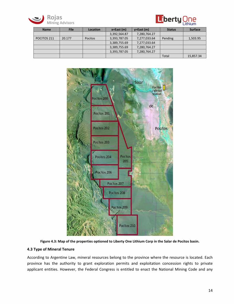
14
Name File Location x=East (m) y=East (m) Status Surface
3,392,564.87 7,280,764.27
POCITOS 211 20.177 Pocitos 3,393,787.05 7,277,033.64 Pending 1,503.95
3,389,755.69 7,277,033.64
3,389,755.69 7,280,764.27
3,393,787.05 7,280,764.27
Total 15,857.34
Figure 4.3: Map of the properties optioned to Liberty One Lithium Corp in the Salar de Pocitos basin.
4.3 Type of Mineral Tenure
According to Argentine Law, mineral resources belong to the province where the resource is located. Each
province has the authority to grant exploration permits and exploitation concession rights to private
applicant entities. However, the Federal Congress is entitled to enact the National Mining Code and any

15
substantive mining legislation which is similarly applicable in all of the country. Provinces have the authority
to regulate the procedural aspects of the National Mining Code and to organize each enforcement authority
within its territory.
In general, there are two types of mining rights that can be granted under Argentinean mining law:
Exploration Permits (usually refer to as “Cateos”) that are limited in time and have limited obligations,
and
Exploitation Concessions (usually refer to as “Minas” or “Claims”) that are unlimited in time as long as
obligations set out in the National Mining Code are met by the title holders.
All concessions are granted by the regulating province either by a judicial (Salta) or administrative decision,
depending on the province. An Exploration Permit can be transformed into a Mining Permit any time before
the expiry date of the Exploration Permit by presenting a report and paying a canon (rent). Tenure for
exploitation concessions is indefinite, providing that semi-annual payments are made in February and July
each year.
In the Salta province all concessions are granted by a judge in the Mining Court. Each property is recorded
by number in the Mining Court registry, and each property has its own judicial file. In addition, the Mining
Secretariat records the property in the graphic register, and adds the property to an overall digital map of
the mining properties for the province.
The eleven separate minas, or claims that make up the Pocitos West Property are “minas” or mining permits
and therefore are unlimited in duration, provided that the biannual rents are paid each year. In respect of
mining permits relating to exploitation of lithium, the biannual rents equate to AR$1,600 (approximately
$100 USD) per 100 hectares (at the present exchange rate of $16/USD).
4.4 Interest in Property
Millennial Lithium Corp. and the Vendors of Pocitos West executed a definitive option agreement that
defines the material terms and conditions of the Option. A non-refundable deposit of US$100,000 (the
“Deposit”) was paid to the Vendors, as well as the additional US$150,000 (U.S.) (the “First Option Payment”)
which was due upon receipt of Exchange approval of the Option.
The Option may be exercised within three years by making a total of US$4,500, in payments (the “Option
Exercise Price”): (i) the $100,000 Deposit and the First $150,000 Option Payment: (ii) $250,000 six months
from the date of the Agreement; (iii) US$500,000 (U.S.) twelve months from the date of the Agreement; (iv)
US$500,000 eighteen months from the date of the Agreement; (v) US$500,000 twenty-four months from
the date of the Agreement; (vi) $500,000 (U.S.) thirty months from the date of the Agreement; and (vii)
$2,000,000 (U.S.) thirty-six months from the date of the Agreement.
Upon payment of the full Option Exercise Price, Millennial will have earned a 100% interest in Pocitos West.
No securities of the Company are to be issued in conjunction with exercise of the Option.
On acquiring the property rights, Millennial in turn optioned a majority interest in the mining rights to
Liberty One, who can acquire up to an 80-per-cent interest in the Pocitos West project consisting of
15,857.34 hectares (39,183 acres). As consideration for grant of the option and pursuant to the terms of the

16
Option Agreement, the Company will pay Millennial Lithium aggregate cash consideration of US$5,500,000
and incur an aggregate of $1,000,000 of staged expenditures to earn a 70% interest in the Property. The
Company will earn a further 10% interest in the Property if it completes a bankable commercial feasibility
study on the Property within 42 months of the closing of the Transaction.
4.5 Work Permitting
The permitting process in Argentina is very straightforward, particularly in Salta. The permit to mine is
granted as part of the mining license but environmental approval is required by the office of the Mining
Secretary for the Province of Salta. This authorization is obtained by filing an Environmental Impact Report
(“Informe Impacto Ambiental”) or IIA).
The contents of these reports will vary according to the type and stage of activity being carried out on the
property. The information requested is submitted administratively as an extraction permit, covering
quarries, water and brine. The areas to be addressed, as requested by the Mining Secretary are:
The nature of the contractual agreement between the company applying and the owner;
The drilling schedule;
Submission of a form stating that the company is debt free; and
Statement of the company’s legal address in Salta.
The Company, working through Ingenieria & Ambiente Consultora S.R.L. (IAC) has submitted the necessary
documentation and anticipates approvals for exploration by mid-June, 2017. In addition, the Environmental
Impact Report must be renewed every two years or when there is a change in activity expected to occur on
the property.
The Property acquisition was subject to a thorough legal due diligence which revealed no other significant
factors and risks that may affect access, title or right and the ability to work on the property.

17
5. ACCESSIBILITY, CLIMATE, LOCAL RESOURCES, INFRASTRUCTURE AND PHYSIOGRAPHY
5.1 Accessibility
Access from Salta is via National Route 51 (RN-51) 170 km west and northwest to San Antonio de los Cobres.
From San Antonio de los Cobres, the route follows 66 km continuing on RN-51 to the junction of Provincial
Route 27 (RP 27) at the abandoned village of Cauchari. From there on RP 27, there are 36km to the town of
Pocitos. The project area is located 10 km west of the village, on the un-numbered continuation of RP 27
towards Tolar Grande and the international Socompa Pass (Figure 4.1).
From Antofagasta, Chile, the access to the project area is via the Panamerican Highway (5N) for 70 km to
Baquedano, proceeding east along routes 365, 367 and 23 for some 300 km to the Sico international pass.
From Sico, the most convenient access to the project site is 110 km via routes RN-51 and RP-27 through
Cauchari and Salar de Pocitos (Figure 4,1).
5.2 Climate
Climate conditions in the Puna region are characterized by extremely aridity, occasional high winds, low
temperature and high altitude, resulting in oxygen depleted air. The average annual rainfall decreases
significantly from east to west and from north to south. For example, rainfall averages 115 millimetres (mm)
at San Antonio of Cobres (coordinates S24.2232°, W66.3192°), while it is just 32 mm in Unquillal Railroad
Station (coordinates S24.535729, W67.205349°). In the areas of San Antonio de los Cobres and Salar del
Hombre Muerto, records indicate winter precipitations, mainly as snow and hail, but in small quantities.
Snow at the Puna does not accumulate on the ground for long, due to the high evaporation, the extreme
dryness of the air and constant strong winds. Nevertheless, in places, strong wind accumulates snow in low
areas and road cuts making access by vehicular traffic at times temporarily difficult during winter. These
accumulations become stronger and more frequent at higher elevation (over 4,200 masl).
Wide diurnal temperature differences are common during both summer and winter. Thermal amplitudes of
30°C to 35°C are common, and are more pronounced during the winter months.
Rainfall during the mid-summer months (late December - early March) can sometimes disrupt exploration
activities. Local rainfall in this region of the Puna averages 70mm per year. In dry years, the rain does not
significantly impact exploration activities. In others the rain can be heavy enough to inundate low areas in
salars with a very shallow level of water. The Pocitos West claim area is elevated above the floor of the salar
and is accessible by an elevated, well maintained road, enabling uninterrupted operations year-round.
Disruptive snowfall is not common in this portion of the Puna, but when it does occur it can stop operations
for a matter of days, but no more than a week.
Net annual evaporation (evaporation minus precipitation) in this region of the Puna is typically 2,500mm
per year, with evaporation rates peaking mid-spring to early summer (August - December), and late summer
to mid-autumn (February - June). Solar evaporation slows in the cooler winter months, and can be locally
offset by rain showers during the mid-summer months. In general, evaporation variations are predictable
and can be managed by experienced evaporations ponds operators.
5.2.1 Meteorological Data Sources

18
Climate data have been collected within and around the nearby Pocitos salar area by several organizations.
The most relevant are:
In San Antonio de los Cobres town and in Hombre Muerto Salar (Tincalayu mine), by the Argentinean
National Weather Service (Servicio Meteorológico Nacional - SMN);
At the nearby Pastos Grandes salar, by Eramine Sudamerica S.A. during 2011 and 2012;
To the north at Rincon Salar by Enirgi/ADY and;
In Pocitos at the FMC gas compression facility.
5.2.2 San Antonio de los Cobres Weather Station
Located at Latitude: S24.2208°, Longitude: W66.3162° and an altitude of 3,770masl and 80km NE of the
Project center. Climate parameters are as follows:
Rainfall: The annual average rainfall is 103.9 mm with the highest occurrence in the period January to
March. The annual average maximum recorded is 144 mm.
Temperature: The annual average temperature is 8.6 degrees Celsius. The period from November to
February is the highest monthly average and is in the order of 12°C, while the coldest month is July at 2.2°C.
The maximum and minimum measured temperatures are 27°C and -21°C, respectively. The absolute
maximum temperature for the period was 27°C, recorded in December and the absolute minimum -16°C in
July.
Humidity: The Media Annual Relative Humidity is 43.8 percent. Monthly Average Maximum Humidity is in
July at 58% and the minimum in October at 34%.
Frost: The average annual frequency of frost days is 223, most frequently between April and October.
Wind: The wind tends to be very strong in the Puna, with gusts as high as 100 kilometres per hour (kph)
usually occurring between noon and dusk. The strongest winds are recorded in the months of July and
August. When the wind coincides with heavy snow, white-outs (locally referred to as “Viento Blanco, or
White Wind”) can cause stoppages in mining work and the movement of people and vehicles. The prevailing
wind direction is from the northwest quadrant, shifting southerly during the mid-summer months. Wind
speed and wind direction are shown in Figure 5.1.
5.2.3 Hombre Muerto Weather Station
Located in the Tincalayu Mine Weather Station in the NW corner of the salar (S25.2715°, W67.0509°), at an
altitude of 4,010 masl, 138km SSW of. Climate parameters are as follows:
Rainfall: The annual median rainfall is 63.8 mm, with the monthly highest rainfall being January with 31.4
mm. During August through November, rainfall is rare. According to recorded data, the month of January
has the highest monthly rainfall and averages close to 50% of the annual total. A measurement in February,
2014 records exceptionally high precipitation of 144mm recorded in 4 days. In the Hombre Muerto Salar,
snowfall occurs occasionally in the winter months and rainfall between November and early March.
Temperature: The average annual temperature is 4.7°C. The warmest months are January and February
with an average monthly temperature of 10.9°C and 10.3°C, respectively. The coldest month is July with a

19
monthly average temperature of -28°C degrees Celsius. The maximum and minimum mean annual
temperatures are 13.9°C and -4 ° C, respectively. The absolute minimum temperature in January is -10°C
and -28°C in July, while the absolute maximum temperature is 26°C and 12°C, respectively.
Frosts: The average annual frequency of days with frost is on the order of 350 days.
There is no data for humidity or wind from the Hombre Muerto Weather Station.
5.2.4 Pastos Grandes Weather Station
Eramine Sudamerica S.A. collected information with their own weather station, the Eramine Weather
Station, sited close to their pilot plant at coordinates S24.560009° W-66.696311°, some 45km east of the
project and at approximately 3,800masl. The station gathered information every 5 minutes, totaling 8,236
to 8,930 readings for a full month.
The information was collected during April, May, June, August, September, October, November and
December 2012 and January to September 2013.
Based on this collection of data from April 2012 to September 2013, with the interruption of July 2012, the
following data was compiled (Tables 5.2.1 & 5.2.2):
Table 5.1: Climate Data collected in Pastos Grandes Salar, 2012.
Temperature: The average annual temperature is 6.3°C. The warmest months are December, January and
February with an average monthly temperature of 13.6°C, 11.2°C and 12.9°C, respectively. The coldest
month is July with a monthly average temperature of -14.2°C. The maximum and minimum mean annual
temperatures are 13.6°C and 0.2°C, respectively. The absolute minimum temperature in January is -1.2°C
and -14.2°C in July, while the absolute maximum temperatures are 26.2°C and 14.2°C, respectively.
Table 5.2 Climate Data collected in Pastos Grandes Salar 2012.

20
Wind: The annual average wind speed recorded in the nearby Pastos Grandes Salar is 13.8 km/h and the
maximum annual rate was recorded in August at 75.6 km/h (Figure 5.1).
Atmospheric Pressure: In Pastos Grandes salar the annual atmospheric pressure in 2012 was 963.8 bars.
The minimum atmospheric pressure was registered in December at 944.2 bars and the maximum
atmospheric pressure was registered in August at 983 bars.
Humidity: The average annual humidity recorded in the Salar de Pastos Grandes is 23.2%. The minimum
humidity was recorded in the months of August and September with 3% and the maximum humidity was
recorded in February at 64%.
Figure 5.1 Wind Speed and Direction at Pastos Grandes
5.3 Local Resources
While no significant resources are available at the Property itself, basic first aid, accommodation and food
can be found at the village of Pocitos, some 10 kilometers distant.

21
5.4 Infrastructure in the Region
No local production of basic domestic or industrial goods is found at the Property or neighbouring areas.
Most of the provisions needed are brought from Salta or San Antonio de los Cobres. The village at Pocitos,
with less than 100 inhabitants and 10 Km northeast of the Property, provides basic infrastructure including
a domestic water system and diesel based power generation of 220 volts, a first aid station with ambulance
service, public basic school and a small number of basic hosting and restaurant services. It is also the
terminus of the Puna Gasoduct, now feeding a dedicated extension for the Mina Fenix (lithium) operation at
Salar del Hombre Muerto and recently feeding the Tincalayu borate operation (borate-tincal) with a
5”pipeline connection. With the extension to Tincalayu, the pipeline in its present configuration will be fully
subscribed at peak usage, however there are several new infrastructure projects in the Puna region that are
likely to ease that shortage within 5 years or less.
The town of San Antonio de Los Cobres, at 105 km and approximately one and three quarter hour drive
from Pocitos is the center of the Department of Los Andes. With a population of approximately 6,000
people, it is an active commercial and tourist center with several hotels (2-3 stars) and a number of
restaurants that provide good support for explorers in the region.
Major infrastructure is linked to San Antonio de los Cobres and Salta with connections to Chile and other
communities of the Puna region, as shown in Figure 5.2.
5.4.1 Road Connections
National Route RN-51, passing through San Antonio de los Cobres connects Salta city in Argentina with the
port town of Antofagasta in Chile on the Pacific coast. RN-51 between Salta – San Antonio de los Cobres
segment (170 km) is more than 70% paved. From San Antonio de los Cobres, Route RN-51 leads via 140km
of well-mainlined gravel road to the international border at the Sico Pass. From there, Chilean routes 23,
367 and 365 the 300 km to Antofagasta, the most populated city in northern Chile and the largest sea
harbour in the region.
5.4.2 Electrical Power Connection
The 600 megawatt (MW), 375 kilovolt (KV) power line between Salta and Mejillones in Chile passes 35km to
the north of the Property. The line was built with the aim to transport energy from Argentina to Chile, but
was out of service from 2009. In February, 2016 the line resumed operation and transports 110 MW from
Mejillones (Chile) to the Argentinean Interconnected System. In the event that an external power supply to
Pocitos is required, a transformer station and a power line of 35 km could connect to the main line. At this
time there are also a number of photovoltaic solar projects which, along with passive solar, are becoming a
viable alternative to heretofore more traditional power supplies.
5.4.3 Natural Gas
A natural gas pipeline (Gas de la Puna) passing through San Antonio de los Cobres has its main station at the
nearby Estación Salar de Pocitos. At Salar de Pocitos there is an industrial park where a gas distribution
pipeline feeds the Mina Fenix (at Salar del Hombre Muerto) and other operations being developed in the
Puna, as the Mina Fenix and Tincalayu Mine. This is another alternative for power supply for a potential
lithium operation at Salar de Pocitos.

22
Figure 5.2 General Infrastructure for the Pocitos West Region
5.4.4 Railway Antofagasta-Salta
An existing railroad between Salta and Antofagasta is administrated by two different companies: The
Chilean Ferrocarril Antofagasta – Bolivia (Luksic Group) and the Argentinean state owned Ferrocarril
Belgrano. It consists of a narrow gauge railway connecting Antofagasta (Chile) in the Pacific coast to the
northern part of Argentina with connections to Buenos Aires on the Atlantic coast. It is presently out of
service, although temporarily maintained in both country segments. The reactivation of this connection is
being promoted between the regional governments and funded by a federal infrastructure initiative. The
Chilean portion has worked hauling copper cathodes and providing general supply for the Escondida and
Zaldivar mines. More recently, it has worked intermittently transporting borates, fruit, cattle and grains
between Salta and Antofagasta. Transportation costs to the Pacific coast and the port of Antofagasta using
this link would benefit lithium operation on the Puna, in particular at Pocitos itself.
5.5 Physiography
5.5.1 Topography
The present-day Salar de Pocitos comprises an area of some 300 square kilometres of mostly flat sandy-silty

23
salt crust. The Salar is bounded by surrounding mountain ranges: i) north the volcanoes of Tultul, Del Medio,
Pocitos and El Quevar; ii) to the east the Sierra de Pozuelos; iii) at the south small hills of the Sierra de
Incahuasi; and iv) to the west the El Macón and Calalaste ranges (Figure 5.3).
Figure 5.3: General Topography in the Pocitos Region
The surface area of the salar is sufficient to host evaporation ponds as envisioned by Liberty One for a
25,000 - 40,000 tonne per annum producing plant. While pond sizing has yet to be determined, a 25ktpa
lithium operation can be anticipated to require approximately 9 to 11 square kilometres of total ponds area,
including liming ponds, halite concentration ponds, potash ponds and final lithium concentration ponds. The
areas covered by minas controlled by Liberty One are in themselves more than sufficient to contain the
required ponds, but in the case the topography within the minas is not appropriate, it is possible to apply

24
for a “servidumbre”, or easement for adjacent areas related to infrastructure and operations.
Development of soils in the Puna area is scarce, classified as skeletal soils of Aridisol type. These are soils of
arid zones, ocher, with very low organic matter, low fertility and coarse texture.
According to the map of the soils of Nadir and Chafatinos (UNSA, 1990), in the area of Pocitos Salar, soils are
lithosols of the Earth Group “E”. Lithosols are a type of azonal soil consisting chiefly or partly of weathered
rock fragments that are typically found on steep slopes and have no economic value. There is a relatively
wide zone of soil at the western edge of the Pastos Grandes Salar but within the salar, surface soil is crusted
salt or solid halite. According to the SEGEMAR (Argentina Geological Mining Service) classification (Soil
Taxonomy, 2006), the Pocitos salar has a saline soil type "La". Soils in the remaining territory where
consolidated rock outcrops and on natural elevations are classified as EKtc-14 and ENi -6 soils.
5.5.2 Air Quality
Air at the elevation of Salar de Pocitos is dry, at 30-40% humidity with low air oxygen levels.
Wind is intense in the winter season, especially in the afternoons, typically decreasing at night and morning.
Dust and sand storms occur occasionally, at times lasting several days, and are intense enough to carry clays
and sand in suspension. During the remainder of the year the wind is less intense and with little suspended
material. In general, air quality is good and free of infectious or harmful contaminants.
5.6 Biosphere (Vegetation and Fauna)
Salar de Pocitos has characteristics of both the “Puneña” and “Altoandina” provinces, both belonging to the
Andean Patagonian domain within the Neotropical Region (Cabrera and Willink, 1980).
5.6.1 Vegetation
Typical vegetation in the Puna area is low shrub steppe types, with specimens isolated from each other and
with bare soil between.
Excessive cold, wind and the lack of water are some of the features of the severe climatic conditions, which
bring a poor regional vegetation of xerophile and halophile types. Typical are low shrubs, rusticated plants,
tiny leaves or absence of them, presence of thorn, powerful and deep root or shallow-expanded root
systems.
The Property has zones without vegetation, as happens over the saline crust and rocky outcrops at such
high elevation.
The "Altoandina province" is situated about 4,200 masl and exhibits a cold climate all year. Precipitation is
typically snow or hail. Winds are variable and can be intense. Vegetation coverage of the surface is less than
5% and comprises herbaceous growth of low to medium height, characterized by Poaceae family as
Deyeuxia Vulva ("Iru"), D. Tristoides ("cola de zorro"), Digitaria Californica ("pasto puna"), Diplachne Dubia
("cortadera") and Distichlis Humilis ("pasto del salitral").
The "Puneña province" is between 3,200 and 4,000 masl and is characterized by dry and cold weather with
seasonal variations in temperature being less than daily. Precipitation occurs between November and April
and decreases from east to west and north to south.

25
In the humid Puna places (as Salar de Pastos Grandes) the landscape is dominated by stipa and fescue
dolichophila grasses. In the highest areas of the Puna, vegetation is short having adapted to the radiation,
dryness, strong winds and severe cooling temperatures.
Over the driest areas of the Puna, scattered grasses and low shrubs occur in varying scarcity. These include:
Fabiana sp, Adesmia sp, Parastrephia sp, Bacharis sp, Maihuenopsis and Polylepis sp tomentela
(endangered), Ferozerable Prosopis (used as firewood), Trichosereus pascana (endangered and used in
construction), Larrea divaricata ("Jarilla hembra"), Artemisia vulgaris ("Ajenjo"), Haplopapus rigidus (locally
"Bailabuena" and endangered due to medicinal use), Alcantholippia deserticola phil (locally "rica rica" and
endangered due to medicinal use), Baccharis incarum ("Tola"), and Senecio eriophyton or Escalonia
Resinosa ("Chachacoma").
5.6.2 Fauna
The fauna of the Puna is characterized by its adaptation to extreme living conditions as a result of the
aridity, intense sunlight during the day and very low temperatures at night. Many animals are nocturnal,
and mostly live protected under rocks or in cracks. Others live in burrows or otherwise have adopted
behaviors allowing them to withstanding the harsh environment in which they live.
Cabrera and Willink (1980) describe the animal species in the Puneña biogeographic province. In the Pocitos
area exist camelids, including vicuña (Vicugna vicugna) and llama (Lama glama), the latter domesticated.
Fox (Dusicyon, Lycalopex) represent a carnivorous species in the area.
Among rodents common to the area, a mole, named Oculto or Tuco-Tuco (Ctenomys opimus) contributes to
desertification of large areas as it feeds on roots of local flora. Additionally, the Puna mouse (Auliscomys
sublimis) and the Chinchilla (Chinchilla brevicaudata) live in the region.
Birds in the region include the Parina or Pink Flamingo (Andean flamingo, Anas Puna); live in moist and salty
lagoons, along with the Andean Goose, (Guayata or Huallata - Chloephaga melanoptera). The queue or
quevo (Tinamotis pentlandi) inhabits the highlands and is similar to a large partridge. The Nandu enano
comparable with the species Pterocnemia pennata (its classification is questioned) inhabit the lower plains
of the region. Small parrots, pigeons and owls exist as sporadic inhabitants.
The donkey (donEquus africanus asinuskey) is a species introduced by inhabitants of the area. Although
domesticated, it competes for food with llamas and vicunas. Pumas (concolor concolor) are occasionally
seen in the region.
5.7 Hydrosphere
A large portion of northwestern Argentina lies within the area of endorheic basins region and geologically
belongs to the Puna Geological Province, as defined by Turner (1972) and the Sub-Province of Puna Austral
in agreement to Alonso and Gutierrez (1984). All waters in the Puna environment whether meteoric,
thermal sources and springs drain to closed or centripetal basins where they accumulate or evaporate.
The Salar de Pocitos lies in the Puna Region-Puna Austral region. From the hydrogeological point of view it
corresponds to the Mountainous Front Province, according to the criterion of their origin (Issar - Passchier,
1990).

26
External and internal factors influencing the characteristics of the Pocitos Salar basin include Quaternary
and modern rocks occurring in the Pocitos Basin area and exhibit the highest permeability. Among them
alluvial, colluvial and terraced deposits occur in the lower slopes of mountainous terrains. Pre-existing rock
units exhibit primary permeability as a result of grain size composition as well as secondary permeability,
caused by tectonic deformation and weathering.
Low rainfall rates registered in the area and intense solar radiation result in strong evaporation of 5 to 8
mm/day, resulting in a condition of intense aridity. As a result, many closed basin collection center produces
one salt deposition each year. These hydrological systems have little to no permanent water courses.
The Salar de Pocitos is a centripetal or closed basin with its lower sector at an elevation of 3,785 masl. The
basin is fed by temporary streams coming from the northwest, west drainages from the El Macon Range,
east (Arroyo Agua Amarga), and from northeast (drainages from the Quebrada de Mamaturi which drains
the El Quevar volcano).
The outstanding features of this basin, from the geomorphologic - hydrological point of view include the
alluvial cone developed by Rio Agua Blanca, draining from El Quevar Mountain to the northeast, and a wide
alluvial cone associated with the un-named stream draining the Tertiary red-bed sediments that passes
west to east through the south-central portion of the Pocitos West property. The origin of the streams is
from snow melt, seasonal rainfall and to a lesser extent from geothermal sources. Alluvial cones according
to the grain size of the particles and transport energy of streams are divided into three sectors:
a) Apical, consisting of thick and coarse materials, associated with the maximum gradient or altitude and
producing the largest recharge of water, although this also occurs along all its extent due to precipitations
and associated infiltration.
b) Medium comprised of materials of smaller grain sizes with respect to the apical.
c) Distal, made up of fine grain material in the area where water emerges to the surface and the closest to
the salt lake (Salar). Marsh or fresh water springs are seen in this sector.

27
6. HISTORY
The mining and exploration history of the Pocitos salar includes mainly exploration for ulexite (borates) and
minor exploration and development for sodium sulphate at the southern extreme of the basin. Lithium-
related activity included a 1979 regional program by Dirección General Fabricaciones Militares (DGFM),
more recent work by Lacus and Li3E, consisting of near-surface sampling and geophysics; and geophysics
surveys reported by Pepinnini Minerals and by Millennial Lithium.
Pocitos salar was one of many in Chile, Argentina, Bolivia and Peru that were explored in the early 19th
century, primarily by the Pacific Coast Borax Company, the predecessor of Rio Tinto Borax. There has been
intermittent small scale mining for ulexite at Salar de Pocitos, but nothing on the scale of the borate mines
at Hombre Muerto, Diablillos, Centenario or Cauchari.
The southern portion of Pocitos Salar has been the site of intermittent sodium sulphate development and
small-scale mining. As reported by DGFM, a 20cm bed of sodium sulphate had been mined in the southern
sector. Largely inactive due to lack of infrastructure and market, the area has been considered for
exploitation to supply the mineral to various potential lithium producers with brine deficient in SO4 for
evaporation processes.
Both Li3E and Lacus Minerals reported in 2010 the results of geophysics and surface sampling programs for
the same area within the core of the salar, to the east of the Liberty One Lithium properties. Lacus reported
a 95 sample program with a minimum of 6.8 meter deep hand-dug holes. The sample map (but no
numerical assays) reported by Lacus indicates scattered surface anomalies for Li, of up to 194 mg/L.
Both Lacus and Li3E reported results of geophysics surveys. Both were variations of conductivity surveys,
identifying and quantifying an estimated depth for conductive layers that can be interpreted in this setting
to be brine-rich sections. The Li3E report claimed to have identified potential brine bearing section from
near surface to as deep as 550 meters throughout their 4km long survey profile. Lacus measured 42
conductivity (VES) stations immediately to the east of the current Liberty One claims, and claimed to have
identified near surface and discreet deep brine aquifers. The near surface aquifer lies at an average 10
meters depth and is an estimated 40m thick. Lacus claimed the deeper conductive horizon lies at 150meters
to the top of the conductor, and is on average 140m thick.
In February 2017, Pepinnini Minerals Ltd. reported the results of resistivity surveys over their properties on
both the east and west margins of the salar. They reported finding up to three conductive layers over an
average thickness of 181 meters from as shallow as 2.1 meters to as deep as 264 meters.
Also in February 2017, Millennial Lithium in partnership with Southern Lithium contracted a Transient
Electromagnetic Survey (TEM) covering 20.25 square kilometres at the north end of the Pocitos basin. The
results indicated a continuous north-south trending conductive unit over a distance greater than 6
kilometres, the full length of their “Cruz” Property.

28
7. GEOLOGICAL SETTING AND MINERALIZATION
7.1 Regional Geology
The Salar de Pocitos sits in the vicinity of the intersection of two main geological features consisting of
north-south structurally controlled basins and northwest magmatic-structural corridors. The intersection
between these structural units has a significant influence in the evolution of the western portion of the
Central Andes of South America. The north-south structures exhibit in general periods of normal and
reverse faulting, whereas the north-west structures are characterized by reverse and dextral offsets (Coira
et al., 1982; Marret et al., 1994; Allmendinger et al. 1997; Chernicoff et al., 2002).
These structural features are of regional-continental scale, and were developed inland on the western
continental margin from at least the middle Paleozoic. Periods of compression and relaxation are
characterized by reverse and normal faulting, forming a succession of basin and range style morphology
along the continental back-arc regions. This is a consequence of a compressive-erosive subduction
contributing to the uplift of the Puna/Altiplano highland terrains. These elevated enclosed basins hosted
high altitude seas and lakes that evolved as extended inland depressions. The intersection of the north-
south and north-west main features and other northeast structures generated weak spots where
magmatism and hydrothermal activity has been developed at least from the Cretaceous.
This main set of structures and especially those of northwest orientation repeat along intervals of 80-150
km (Figure 7.1), conditioning succession of magmatic-hydrothermal-mineralization northwest oriented
corridors at the Argentinean-Chilean-(Bolivian) Altiplano (Puna). The best developed from north to south
include the Calama-Olacapato-Toro in the area of Salar de Pocitos, Archibarca-Cerro Galan (Hombre
Muerto) and the Culampajá in the southern portion of the Puna Block (Figure 7.1).
In the Pocitos area several parallel north-south structures intercept the Calama-Olacapato-Toro lineament
characterized by Upper Miocene-Oligocene acidic-intermediate volcanism and development of large
volcanic cones including the nearby Cerros del Rincon-Tultul-Del Medio-Pocitos, and to the east, El Quevar-
El Azufre and the Acay systems. Large ignimbrite fields, major caldera nests, surge pyroclastic fields, as well
as hot spring systems have contributed calcium-magnesium and sodium-potassium-lithium and boron
anomalous solutions that have concentrated in the basins over time. These concentrations occur
throughout the geologic column at different levels and positions of the salt lakes and salars dating from the
early Tertiary.
The lithology of the area is comprised of Precambrian meta-sediments consisting of slates and phyllites of
the Puncoviscana Formation and Lower Ordovician turbidites (shales and sandstone) of the Caucota and
Copalayo formations. These sedimentary units are intruded by Late Ordovician granitoids (Oire Eruptive
Complex or Eruptive Belt of the Puna), consisting of large feldspar dacitic porphyries, granites and
granodiorites. These rocks are overlain by Tertiary continental sedimentary units (Pastos Grandes
Group/Geste, Pozuelos, Sijes, Singuel Formations) consisting of red-beds, tuffs, halite, borates and gypsum.
The Tertiary sedimentary units are covered by Upper Miocene volcanics, characteristically dacitic lava flows
and subvolcanic intrusions (Aguas Calientes Formation), dacitic tuffs and ignimbrites of the Tajamar
Formation. The sequence is topped by Recent-Quaternary sediments covering the upper part of the salar

29
basins with salt deposits, slope deposits and eolian sandstones (Turner, 1972).
Figure 7.1: Structural setting of Puna Region showing location of Salar de Pocitos.
7.2 Local Geology
7.2.1 Geomorphology
The setting corresponds to the Puna Austral or Salto-Catamarqueña (Alonso et al 1984b), comprising a

30
series of physiographic and structural aspects that distinguish it from the Northern Puna or Jujeña. The
Puna, in general, consists of raised blocks separated by endorheic elongated basins occupied by evaporite
deposits, or salars. The ridges separating the basins have a north-south orientation and are typical in form
of uplifting in blocks as the result of reverse faulting.
The area of the Pocitos West claims lie in an area of higher relief, up to 100 m in elevation above the Pocitos
salt flats.
The Pocitos Salt Flats, together with the Rincon Salar lie within the same original tectonic depression,
bounded to the east by the Pozuelos Ridge (4,981 m) and to the west by the Macon summits (5,548 m). The
“del Medio”, “Pocitos” ad Tul-Tul Neogene volcanoes, ranging 5,314 m 5,100 m, constitutes the northern
boundary of the salt lake north of which the Rincon salt lake is located. The Los Pozuelos ridge constitutes
the eastern boundary of the basin, while the Macon - Calalaste mountain ranges define the western
boundary.
The eastern and western margins of the salar have distinctly different geometries. On the western margin,
the boundary between the clastic alluvial fan facies and the evaporitic facies is well defined: the alluvial
deposits constitute terraces elevated with respect to the salar. On the eastern edge, the contact between
the distal accumulations of the Pozuelos ridge and the evaporitic deposits is gradual. There, remnants of
sandy-loam deposits with scattered gypsum and gypsum intercalations are evident, suggestive of a slightly
humid climatic pulse that briefly interrupted the typical Holocene aridity.
Pocitos is a mixed type salar: terrigenous and evaporitic. The terrigenous facies are composed of clay, silt
and fine sand with salt efflorescence and crystalline matrix. The evaporite facies varies from north to south,
but occurs mainly as a salt crust. On the surface, two morphological types of saline crust have developed,
distinguished by color, one light brown and the other white with light grey. The surface varies between
rough and hard throughout the central salar, with a smooth surface occurring primarily at the margins.
The Tertiary-aged sedimentary deposits along west margin (to the south and west of the Liberty One claims)
have little resistance to erosion, showing rounded reliefs and in some cases forming badlands.
The surface runoff in the northern Pocitos Salt Flat is southward; towards the south the salar is dry. The
wettest areas correspond to the contact of alluvial fans with the margins of the salar. The in-flow of water
from the south end of the salar is at times more intense, at times forming “vegas” and small lagoons
(Aguada de Huapal).
The greatest number of perimeter springs are located at the salar’s northern end, at the foot of the Tul-Tul
volcano. In this sector, the salt hosts subsurface water and even forms swampy areas in the summer.
At the eastern margin of Pocitos salar, the contributions of flow are more evenly dispersed, sourced from
the western flank of the Pozuelos ridge. The most important contributions are those of the Quebrada
Honda River and of the Incahuasi ravine, sourced from the Quevar and Azufre mountains.
Although the network of streams that originate from the eastern foothills of the Calalaste-Macon mountain
range is dense, the porosity of the sediments through which they travel and the great distance to the
western margin of the salar, suggests that the flows from that areas are almost nonexistent, excepting the
Quebrada de Macon, which flows during summer.

31
7.2.2 Geology
Ordovician
Copalayo - Coquena Formations and equivalents
Ordovician sedimentary Tolar Chico, Las Vicuñas, Coquena and equivalent Formations are widely distributed
in the area; comprised of mainly fossiliferous metapelites and metapsamites, they are associated with
magmatic units, including pillow basalts, and pyroclastic and ecliptic rocks (figures 7.2, 7.3 and 7.4).
Ordovician outcrops located east of Pocitos Salt Flats (Pozuelos Rim, Unquillal Hill and Copalayo Rim) are
composed of shale, limolite and yellowish-green sandstone, with evidence of low-grade regional
metamorphism and intercalations of submarine acid volcanic material up to 1 m thick.
Upper Ordivician - Silurian
A set of Ordovician outcrops in the Western Puna area form a volcano-sedimentary and intrusive belt
known as the Eruptive Strip of the Western Puna. Assigned to the Upper Ordovician (Coira et al., 1999), the
Chachas, Taca Taca (419 ± 16 Ma), Arita (419-418 Ma), Macón - Navarro (429 ± 36 Ma) and La Chance occur
in the mountain ranges between Arizaro and Pocitos basins.
In the Macon range, granodiorites can be identified, varying from tonalites and granites with biotite and
hornblende, with alanite, apatite, zirconium and titanite. They are coarse-grained and their colors vary from
gray to pink. The associated pluton is shallow and contains microgranular mafic fragments.
At the southern end of the Pocitos Salt Flats mafic and ultramafic rocks (gabbro and serpentine) are well
developed. These occur as fine layers interspersed between the greywackes.
Figure 7.2: Strongly folded outcrops of the Coquena Fm. in Pozuelos Ridge

32
Figure 7.3: General Geology on the Salar de Pocitos Basin
Cross Section EW Sierra del Macon- Filo de Colapayo

33
Figure 7.4: Cross Section EW Sierra de Macon- Cordon de Pozuelos
Tertiary sediments
Pastos Grandes Group
Tertiary sedimentation began in a single basin developed on a Precambrian-Paleozoic basement. During its
evolution, the basin was divided into smaller basins, each of which shows a remarkable vertical
development due to subsidence. This continental clastic sedimentation, with intercalations of evaporites
and pyroclastites, due to the lithological differences, was divided in three formations (from base to
uppermost): Geste, Pozuelos and Sijes, to which later one more unit was added, the Singuel Formation. In
the area of the Liberty One mines, only the Geste and Pozuelos formations are represented.
Geste Formation: The Geste Formation demonstrates a strong angular discordance with the Ordovician
sedimentary rocks of the Copalayo - Coquena Formation. It is comprised of conglomerates, argillaceous
sandstones and sandy marls of intense reddish to purple color. The thickness of the formation is laterally
variable. Turner (1960) estimated the thickness at 1500 meters, while Gutierrez (1981) measured 550
meters. It should be noted that both authors considered the thickness in different sections. Gutierrez
(op.cit.) considers as Formation Pozuelos part of what Turner includes in his Geste Formation. At the level of
the El Paso gorge the Formation measures 150 meters thick, according to Alonso, 1986. Based on its fossil
content it has been assigned a Paleogene age, which corresponds to the Mammalian age.
Pozuelos Formation: Above the Geste Formation are superimposed conglomerates, sandstones, sandy
fangolites, argillites and evaporites of reddish brown, light brown, pink and gray, belonging to the Pozuelos
Formation.
The lower part of the profile is predominantly composed of conglomerates and marly sandstones. Towards
the upper limits are politic material and evaporites. The middle proton hosts younger saline deposits,
whereas in the upper third there is a deformed mass of rock salt that has been described and defined as the
"Pastos Grandes salt megalobody" (Alonso et al., 1984). Towards the upper limit the formation becomes
pelitic with some intercalations of gypsum, tuffs, tuffites, and borates.
Based on profile measurements Alonso (1986) considers a minimum thickness of the formation of 1500
meters. The age is estimated on the basis of dating on zircon crystals in tuffs that gave an age of 7.6 Ma
(Vandervoort, 1995).

34
Tertiary volcanics
Tertiary volcanism covers the northern end of the basin with lava and ignimbrites. These are linked to the
complex formed by the Tul-Tul strata from the Middle and Pocitos to the north, and to the northeast the
Quevar Volcanic Complex (Figure 7.4).
The Tul Tul, Medio and Pocitos peaks have a main body formed by hypersensitive hornblende or
lamprobolitic andesite. Andesitic flows and fall deposits are also linked to the activity of this complex.
To the north and east, the Quevar Volcanic Complex includes a wide variety of lava types (andesites, dacites
and rhyolites) and ignimbrite deposits.
Quaternary
Surface sediments
Quaternary terraces were developed on the western margin of Pocitos Salt Flat. These comprise
intercalations of sediments of variable granulometry, from gravel and sand to silty - loam facies. Silty clay
facies correspond to lake deposits, while the sand and gravel represent river environments (Figure 7.5).
Figure 7.5: View east from the Project area. In the foreground are terraced Quaternary deposits, to the right
outcrops of the re-worked Tertiary sediments, behind which are evaporite deposits of Pocitos salar, and in the
background the Copalayo ridge.
Terraces elevated above the salar are indicative of active tectonism in the region from the Tertiary to the
present.

35
Neo-tectonism is evident in the anticline which elevated the Los Colorados ridge. The ridge is comprised of
folded continental Tertiary and Quaternary sediments.
Piedmont deposits
Cones and coalescent alluvial fans formed by the streams that drain the Pozuelos ridge and flow into the
salt comprise piedmont deposits in some areas surrounding the salar. The granulometry is mainly coarse
with intercalations of sand and gravel. In the distal parts, the transition to the evaporite facies is evident, in
the form of interbedded finer grained sediments and lacustrine sediments.
Evaporite deposits
Pocitos is mixed-type salar, consisting of surficial terrigenous classics and crystalline halite. There occurs a
marked zonation of the evaporitic facies in the longitudinal direction as shown in Figure 7.6.
Figure 7.6: View of the western sector of the Pocitos salt flat where terrigenous/evaporite facies are exposed
Ulexite and caliche-travertine accumulations occur in the northern areas of the salar, halite and gypsum
predominates in the center, and southern portion is dominated by selenite and mirabilite-thenardite
(Battaglia et al., 2001).
According to Battaglia, the evaporitic mineralization of Pocitos salar is related to the activity of old thermal
springs aligned along the fracture define the eastern edge of the salar. Solutions rich in boron, lithium,
chlorine and sulfur of hydrothermal origin ascended to the surface through fractures associated with
magmatic chambers related to the Pocitos, Tul Tul and del Medio eruptive complex that constitutes the
northern limit of the salar.

36
8. DEPOSIT TYPES
Pocitos Salar is classified as a “Silver Peak, Nevada” type terrigenous salar. Silver Peak, Nevada, USA was
the first lithium-bearing brine deposit exploited in the world. Lithium-enriched brine deposits associated
with this type of setting are characterized by containment in restricted basins within deep structural
depressions filled with sediments, typically interbedded units of clays, salt (halite), sands and gravels.
Typical of these cases, at Pocitos the salar surface is presently comprised of clay, silt and sand, with sodium
chloride, sulphates, carbonates and borates.
Continental brines are the primary source of lithium products worldwide. Bradley, et al. (2013) noted that
“all producing lithium brine deposits share a number of first-order characteristics: (1) arid climate; (2) closed
basin containing a playa or salar; (3) tectonically driven subsidence; (4) associated igneous or geothermal
activity; (5) suitable lithium source-rocks; (6) one or more adequate aquifers; and (7) sufficient time to
concentrate a brine.” Large deposits are mined in Chile at the Salar de Atacama (SQM and Albemarle), In
Argentina at Salar de Hombre Muerto (FMC); the Olaroz salar basin (Orocobre), and in Clayton Valley,
Nevada (Albemarle), the only North American producer.
Recent discoveries, particularly in northern Argentina illustrate the importance of sedimentary sequences in
the host basins. Discoveries since 2010 in the Cauchari, Olaroz, Centenario and Pastos Grandes salars
involve deeper, early basin in-fill coarse sediments hosting lithium and potassium-enriched brines. It
appears that as the regional tectonic relaxation gave rise to pull-apart basins, the first sediment to fill these
basins were coarse, higher energy sediments derived from the nearby steep terrain. These coarser
sediments have more and larger pore spaces, increasing the transmissivity of the formation. As the basins
filled and the higher topography was eroded, the sediments tended to become finer. Runoff and
hydrothermal fluids concentrated in the closed basins, common salt (NaCl) tended towards saturation,
while lithium, boron, potassium and other elements became more concentrated as fresh water evaporated
at the surface, and in particular at the basin margins.
As the trapped fluids became brackish and eventually evolved into brines containing greater than
10,000ppm contained salts, the density increased, typically to slightly in excess of 1.2g/cm3. The more dense
brine tends to separate and sink beneath fresh water and less saturated solutions, and even to start
migrating outwards beneath the encroaching fresh water at the basin margins.
Lithium concentrations tend to increase in a direct relationship to density, thus it is not surprising to find
more consistent and higher grades at depth. The deeper, coarser sediments at the same time tend to make
higher yielding aquifers. The Pocitos program will focus on exploration for brine, testing for lithium content,
and in addition will target deeper sediments to both increases the probability for resource and to improve
well brine yields, which has the potential to reduce operating costs if the project is developed.

37
9. EXPLORATION
The only work to date completed on behalf of the Company has been desktop research and a
conductivity/resistivity geophysical survey consisting of Vertical Electric Sounding (VES). This survey was
conducted to define subsurface concentrations of conductive brine. This field work was contracted by
Millennial Lithium on behalf of Liberty One.
9.1 Vertical Electrical Sounding Survey (VES)
A Vertical Electrical Sounding (VES) survey was conducted by Tecnología y Recursos (Technology and
Resources), a Salta-based geophysics firm that specializes in this type of work. The primary objective of the
program was to detect and trace the sub-surface extent of the salar brine beneath the recent alluvial cover
comprising most of the Liberty One properties. Eleven (11) survey sites were measured, one for each of the
Liberty One properties. The VES survey point locations are shown in Figure 9.1.
Figure 9.1: Location of the measured SEV stations at Pocitos West

38
The VES readings are modeled on a simplified 4 layer basis, comprising the following packages as defined by
Tecnología y Recursos (Figures 9.2 and 9.3) in which conductive and resistive layers are defined as:
HRS: Upper Resistive Layer. In the Pocitos west these are likely dry alluvial sediments.
HCS: Upper Conductive Layer. This might represent saturated to semi-saturated alluvium, or possibly a
mixed halite. In the case of sediments, the resistivity values suggest fresh to brackish fluids.
HCI: Lower Conductive Layer. This can be either consolidated clay-dominant sediments, brine-saturated
coarser sediments, or a combination of both.
HRI: Lower Resistive Layer. Possibly Tertiary sediments or a clay-rich aquitard with reduced fluid content.
As shown in the longitudinal section, the lower conductive layer was detected over most of the 25 kilometer
length of the north-south section. Furthermore, the west-east section suggests that the lower conductive
layer is relatively flat, as would be expected of buried paleo-salar sediments as opposed to tilted basement
material.
Figure 9.2: Distribution of the layers the underground layers. Resistivity model at Pocitos West: (N-S Section).
Sections show resistivity measures in ohm/metre and VES stations survey locations.
Figure 9.3: Distribution of the layers building the underground resistivity model at Pocitos West (East-West Section).

39
10. DRILLING & PUMPING TESTS
The Pocitos West properties have not yet been drilled. The plan is to initially drill as many as three
exploration core holes to test the extension of the potential brine-saturated zone, represented by the HCI
response in the VES analysis. If this initial reconnaissance drilling program is successful, the Company will
complete the core holes with two inch diameter casing as monitoring wells for follow-up well drilling.
The core drilling will be undertaken using a local drilling contractor employing a portable drilling machine,
typically a Sandvik DE710 or Atlas-Copco c6c, which are readily available locally, or equivalent machines of
the same or greater capacity. Core size is HQ (63.5mm OD core) or NQ (47.6mm OD). Sampling for fluids in
the formation is undertaken while drilling using a drive-point sampler (Figure 10.1), or post-drilling using a
hydraulic double-packer (Figure 10.2).
Figure 10.1: Diagram of use of Drive Point Device System.
Figure 10.2: Double Packer

40
The drive point system entails lowering a perforated vessel, or drive point (Figure 10.1) through the empty
core barrel into the sediments beneath the coring point. The drive point is sealed to prevent the ingress of
drill hole fluids. Once the pipe above the drive point is confirmed to be dry, the seal is perforated, allowing
the fluids in the drive point and entering through the screened orifices to enter the pipe. That fluid is then
sampled using simple bailing tool.
The double packer system is the same as that commonly used in oil and gas exploration. As shown in Figure
10.2. The packer consists of two inflatable seals (packers) that are inflated using hydraulic pressure to seal
off discreet interval in an open drill hole. Once the seals have been inflated, the intervening interval is
cleaned by injecting water and the competence of the seal is tested. On confirmation that the zone is
sealed, the flow is reversed to obtain a depth-specific sample of the desired interval.
If a pumping test well is justified by the core drilling results, a hole will be drilled using conventional rotary
techniques. Ideally the hole will be drilled with a 16” diameter and the well-constructed with 10-inch
diameter slotted casing, isolated from the formation by a filter consisting of gravel of a size appropriate for
the formation and casing slot size. A typical design is 0.5 -0.75 slots in the casing and 1.0-1.5 mm gravel.

41
11. SAMPLE PREPARATION, ANALYSES AND SECURITY
11.1 Sample preparation
The program for preparation, assaying, physical parameters and security, as recommended to the Company,
are indicated in the following parameters. Neither porosity samples (core) nor chemistry samples (brine)
will be subjected to additional preparation prior to shipment to participating laboratories. After the samples
are sealed on site, they will be stored in a cool location and then shipped in sealed containers to the
laboratories for analysis.
11.2 Sample Analyses
Porosity analyses will be conducted by Core Laboratories Petroleum Services Division, Houston, Texas. Core
Laboratories provides state of the art petrophysical and geological analysis and interpretation of core
samples from rock, and has demonstrated that its Quality Management System is in compliance with ISO
9000-2008 Certificate of Registration. Selected representative samples are to be submitted for laboratory
analyses.
Brine chemistry samples will be analyzed by laboratories with known and verifiable experience analyzing
lithium-bearing brines. One of the logical choices for the Pocitos West project includes Alex Stewart
Laboratory in Mendoza, Argentina. Accredited to ISO 9001, they operate according to Alex Stewart Group
standards consistent with ISO 17025 methods at other laboratories. Selected duplicate samples are to be
sent to a second accredited laboratory, as part of the QA/QC procedure.
11.2.1 Laboratory Analytical Procedures for Drainable Porosity
Laboratory analytical procedures for drainable porosity by centrifuge, as described by Core Laboratories
consists of the following steps
1. Cut 38mm (1.5-inch) diameter cylindrical plug from sample material (plunge cut or drill); typical
length is about 45 mm (1.75-inch).
2. Freeze sample material with dry ice if needed to maintain integrity.
3. Caliper bulk volume of the cylindrical plug, and weigh sample.
4. Encapsulate plug as needed in Teflon and nickel foil, with nickel screen on ends of plugs, and weigh
encapsulated sample (Figure 11.1).
5. Calculate bulk density as (mass of plug before encapsulation)/(Caliper bulk volume).
6. Place plug in brine and saturate under vacuum to ensure full saturation: A sample of brine was from
the project area will be shipped to Core Laborites for this purpose.
7. Record weight of saturated core.
8. Desaturate samples in high speed centrifuge for 4 hours. Spin rates are calculated to give drainage
pressure of 1 pound per square inch (psi) for poorly cemented or loose sands; and 5psi for clay and
halite. Pressure is calculated at the center of the plug placed in the centrifuge.

42
9. Collect any drainage and record volume; discard drained fluid. (Fluid collected from these cores is not
representative of in situ brines, due to re-saturation with NaCl.
10. Remove plug from centrifuge and record weight.
a. Drained fluid volume is calculated as (saturated plug weight – drained plug weight)/density
b. Drainable porosity is calculated as (Drained fluid volume)/(Caliper bulk volume)
Drainable porosity is given as a fraction of the total rock volume and is unitless. For example, if a rock has a
volume of 100 milliliter (ml), and 10 ml of fluid can drain from the rock, the drainable porosity is 10/100, or
0.10. Although determined by laboratory methods, the drainable porosity is essentially the same as specific
yield as defined in classical aquifer mechanics.
Figure 11.1: Screened and wrapped pucks for drainable porosity by centrifuge
11.2.2 Laboratory Analytical Procedures for Total Porosity
After drainable porosity measurements, the plug samples from the centrifuge are analyzed for total
porosity, using the following steps:
1. Oven dry sample for 5 days at 115.6 degrees Celsius (240 degrees Fahrenheit)
2. Weigh oven-dried sample
3. Assume that all weight loss is pure water lost from pore space: Therefore volume of water lost
due to oven-drying is calculated as

43
4. ((Drained plug weight)-(Oven-dried plug weight))/(water density of 1 g/cc)
5. Total porosity is calculated as ((Drained fluid volume) + (Oven drying fluid loss))/(Caliper bulk
volume)
Total porosity, like drainable porosity, is given as a fraction of the total rock volume and is unitless.
11.2.3 Laboratory Analytical Procedures for Brine Chemistry
Samples from Pocitos west will be analyzed by a laboratory selected for extensive experience in lithium
brine analysis and based on performance judged from the results of an ongoing “round robin” of analyses
for samples from the nearby Pastos Grandes project to select laboratories on the basis of best performance
in terms of accuracy and precision.
Table 11.1 lists the basic suite of analyses requested from the labs. Each laboratory uses the same methods
based upon American Public Health Association (APHA), Standard Methods for Examination of Water and
Wastewater, Environmental Protection Agency (EPA), and American Society for Testing Materials (ASTM)
protocols. Physical parameters, including pH, conductivity, density, and total dissolved solids are
determined directly upon brine samples. Determination of lithium, potassium, calcium, sodium and
magnesium is achieved by fixed dilution of filtered samples and direct aspiration into inductively coupled
plasma instruments (Table 11.1).
Table 11.1: List of the Basic Suite of Analyses for Lithium-Bearing Brine Samples
Analysis Type Alex Stewart University of Antofagasta Acme Method Description
Physical Parameters
Total dissolved solids SM 2540-C APHA 2540-C 2B05-B Total Dissolved Solids Dried at 180°C
pH SM 4500-H+-B APHA 4500-H+-B 2B02 Electrometric Method
Conductivity SM 2510-B APHA 2510-B 2B03 Meter
Density IMA-28 Pycnometer 2B14 Pycnometer
Alkalinity SM 2320-B APHA 2320-B 2B06 Titration Method
Alkalinity (carbonates) SM 2320-B APHA 2320-B 2B13-B Titration Method
Alkalinity (bicarbonates) SM 2320-B APHA 2320-B 2B13-B Titration Method
Inorganic Parameters
Boron (B) IMA-23-Version
1 APHA 4500-B-C 2C Carmine Method
Chloride (Cl) SM 4500-Cl-B APHA 4500-Cl-B 2B12 Argentometric Method
Sulphates (SO4) SM 4500-SO4-C APHA 4500-SO4-C SO4 Gravimetric Method with Ignition of Residue
Dissolved metals
Lithium (Li) ICP-13 APHA 3500-Li-B 2C Direct Aspiration - ICP or AA Finish
Potassium (K) LACM16 APHA 3500-K-B 2C Direct Aspiration - ICP or AA Finish
Sodium (Na) LACM16 APHA 3500-Na-B5 2C Direct Aspiration – ICP or AA Finish
Calcium (Ca) LACM16 APHA 3111-B-D 2C Direct Aspiration – ICP or AA Finish
Magnesium (Mg) ICP-13 APHA 3111-B-D 2C Direct Aspiration - ICP or AA Finish

44
11.3 Quality Control Results and Analyses
Analytical quality will be monitored through the use of randomly inserted quality control samples, including
standards, blanks and duplicates, as well as check assays at independent laboratories. In each batch of
samples submitted to the laboratory, at least one blank, one low grade standard, one high grade standard
and two sample duplicates will be included. Approximately 38 percent of the samples submitted for
analysis are to be quality control samples.

45
12. DATA VERIFICATION
Independent Qualified Person Nivaldo Rojas has conducted the following forms of data verification:
Visit to the Project site, controlling drill hole proposal, infrastructure and the proposed base of
operation at the village of Pocitos;
Review of publicly information on the geology of the Salar de Pocitos.

46
13. MINERAL PROCESSING AND METALLURGICAL TESTING
The Property is at a relatively early stage of exploration. No metallurgical testing or assessment of potential
mineral processing regimes has been conducted to date. Such testing and assessment will follow in the
recommendations outlined in this report.

47
14. MINERAL RESOURCE ESTIMATES
The pre-exploration work conducted to date for the Pocitos West Property is preliminary and includes
mainly research of regional and local geology and comparative studies of similar setting with known lithium
resources in this region. It is not possible at this stage to develop a resource or reserve estimates with the
existing dataset, nor to comment on resource potential

48
15. MINERAL RESERVE ESTIMATES
The pre-exploration work conducted to date for the Pocitos West Property is preliminary and includes
mainly research of regional and local geology and comparative studies of similar setting with known lithium
resources in this region. It is not possible at this stage to develop a resource or reserve estimates with the
existing dataset, nor to comment on resource potential.

49
16. MINING METHODS
The pre-exploration work conducted to date for the Pocitos West Property is preliminary and includes
mainly research of regional and local geology and comparative studies of similar setting with known lithium
resources in this region. It is not possible at this stage to develop a resource or reserve estimates with the
existing dataset, nor to comment on mining methods.

50
17. RECOVERY METHODS
The pre-exploration work conducted to date for the Pocitos West Property is preliminary and includes
mainly research of regional and local geology and comparative studies of similar setting with known lithium
resources in this region. It is not possible at this stage to develop a resource or reserve estimates with the
existing dataset, nor to comment on recovery methods.

51
18. PROJECT INFRASTRUCTURE
Infrastructure for the project consists of existing roads, and facilities available at the local village of Pocitos.
Camp and communications will be provided in the village between The Company’s local operating partner
Proyecto Pastos Grandes, S.A., and drilling contractor Hidrotec S.R.L.
The camp consists of a combination of rented local accommodations, and portable housing, office, sanitary
and commissary units. Power for the camp and office facilities is provided part of the time by the local
village authorities, and consists of a diesel-fueled generator and local distribution network.
Gas from the Puna gas pipeline is to be made available in the village, but has yet to be fully connected and
commissioned. Compressed propane for heating and cooking in the camp will be brought in by the
Company’s operating partner and the drilling/camp contractors.
Fuel for the drilling operations is purchased from the national oil company, YPF and transported to site by a
local Salta provider, Petroandina. Fuel storage at first will be provided by the drilling contractor. If results
justify further investment, the company will permit and invest in a dedicated fuel depot, to which YPF will
deliver directly.

52
19. MARKET STUDIES AND CONTRACTS
The project is at the preliminary exploration stage and does not yet support or justify neither market studies
nor commitments to supply. Justification for the project is provided by existing market conditions for
lithium compounds, particularly in the high growth lithium battery market. Current global supply is
struggling to meet the explosive growth in the market.
According to Goldman Sachs (2016), lithium demand is estimated to triple from 170,000 metric tonne per year (tpa) of lithium carbonate equivalent (LCE) in 2015, to as much 530.000 tpa in 2025. This is led primarily by lithium battery demand growth, which is considered reasonable to a little bit optimistic. as shown by the new lithium projects and forecasted new industry demand.

53
20. ENVIRONMENTAL STUDIES, PERMITTING AND SOCIAL OR COMMUNITES STUDIES
An environmental report approved by the office of the Provincial Mining Secretary is required for all stages
of exploration and mining activity in Argentina. The Province of Salta requires that environmental impact
reports for exploration specify not only the type of activity and the anticipated environmental impact and
mitigation methods, but that the report includes a notification of completion of community consultation.
The EIR was first presented in January, 2017. Answers to observations were presented in May, along with
the notification of the community consultation. Approval of the report is anticipated in July.

54
21. CAPITAL AND OPERATING COSTS
Capital and operating costs have not yet been determined.

55
22. ECONOMIC ANALYSIS
An economic analysis has not yet been determined pending exploration results.

56
23. ADJACENT PROPERTIES
A number of mining tenements surround the Property addressed in this Technical Report. They are
identified in Table 15.1. These properties have been classified according to their name, registration file
number, surface (hectares) and name of the registered concessionary, including some important
observations, at the Mine Court of Salta. Property distribution is shown in the claim map in Figure 15.1
indicating relevant ground coverage by individual concessionaries. These relevant properties are presently
controlled by Pepinnini Minerals Ltd. (ASX: PNN); Pure Energy Minerals Ltd. (TSXV: PE); Southern Lithium
Corp (CVE: SNL); and Millennial Lithium Corp. (TSX.V) Other nearby active properties includes Surnatron;
Latin American Minerals Argentina S.A., and minor coverage by third parties.
Table 15.1: Mining Properties at properties valid a Salar de Pocitos
Name File Hectares Ownership Status
LINDA 20326 487,25 Vacant - Pending the opinion of REMSA
TABAPOCITOS 02 20017 2964,49 PEPINNINI S.A.
TABAPOCITOS 01 19984 1100 Third parties
POCITOS 1 22741 1388,00 PEPINNINI S.A.
PAYO PO 301 22229 605,38 Vacant -REMSA
POCITOS 303 20578 695,16 Mine to released. Not yet published in official bulletin
Pocitos 213 20179 1503,00 Vacant or mining cadastre not updated
TABAPOCITOS 04 20015 968,95 Vacant or mining cadastre not updated
ARENAS BLANCAS I 22110 1309,09 ADRIEL ALEXIS ARENAS
GIOVI 21966 100,00 MINERALES DE ALTURA S.R.L.
AMARGA 01 21962 1500,00 RAFAEL ARGAÑARAZ OLIVERO
AMANECER 17745 2500,00 LEA ELIANA CRUZ (Millennial - Southern Lithium)
JIM 21048 3500,00 LATIN AMERICAN MINERALS ARGENTINA S.A.
LOLITA II 21507 6000,00 Mine to release. Not yet published in official bulletin
QUEVAR DECIMA NOVENA 20706 4493,52 SILEX ARGENTINA SA
PAPADOPULOS LVII 19786 628,32 LITHIUM ARGENTINA RESOURCES S.A.
LA BLANQUITA II 19922 620,95 EUSEBIO ROBERTO ALEGRE
CATEO 20953 6879,00 MINAS ARGENTINAS S.A.
CATEO 20953 2da lib 715,24 Area to release. Not yet published in official bulletin
QUEVAR VIGESIMO SEXTA 22087 992,00 SILEX ARGENTINA SA
QUEVAR SEXTA 19992 2494,00 SILEX ARGENTINA SA
QUIRON II 21370 2933,00 SILVIA RENE RODRIGUEZ
SUI 21049 1388,30 LATIN AMERICAN MINERALS ARGENTINA S.A.
POCITOS 19575 100,00 MARIO ANGEL BLAS MONCHOLI
DOÑA JACINTA SEGUNDA 21115 2292,00 LATIN AMERICAN MINERALS ARGENTINA S.A.
DOÑA JACINTA SEGUNDA BL 21116 1984,00 LATIN AMERICAN MINERALS ARGENTINA S.A.
POCITOS 1 19457 1516,00 EKEKO S.A.
POCITOS 2 19458 532,078 EKEKO S.A.
POCITOS 3 19459 800,00 LAROTONDA CLAUDIO ANTONIO
POCITOS 303 20578 695,00 Area to release. Not yet published in official bulletin
CATEO 19287 – 1º 1500,00 Area to release. Not yet published in official bulletin
CATEO 19287 – 2º 1138,69 Area to release. Not yet published in official bulletin
AGUAMARGA 1 19083 2756,28 Vacant
POCITOS 6 19462 576,06 LAROTONDA CLAUDIO ANTONIO

57
Name File Hectares Ownership Status
POCITOS 7 19463 800 EKEKO S.A.
POCITOS 304 20579 342,08 Area to release. Not yet published in official bulletin
POCITOS 9 19465 599,33 Lapis Argentina Compañía Minera S.A
POCITOS 10 19466 340,19 Vacant -REMSA
Pocitos 214 20180 1313,29 Vacant or mining cadastre not updated
Pocitos 215 20181 1120,55 Vacant
Pocitos 216 20182 1503,95 Vacant
Pocitos 217 20183 1503,95 Vacant
Pocitos 218 20184 1433,65 Vacant
Pocitos 219 20185 1433,65 Vacant
Pocitos 220 20186 1327,90 Vacant
Pocitos 221 20187 1118,70 Vacant
Pocitos 222 20188 1178,25 Vacant
ALBA SILVIA 18828 1420,00 JORGE ENRIQUE MORENO Y ALBA SILVIA SALAS
Fernando I 12509 200,00 SURNATRON S.A.
AGUAMARGA 2 19084 3528,50 Vacant or mining cadaster, not updated
AGUAMARGA 7 19089 3500,00 Vacant or mining cadastre not updated
AGUAMARGA 11 19093 3500,00 Vacant or mining cadastre not updated
AGUAMARGA 16 19098 3500,00 Vacant or mining cadastre not updated
AGUAMARGA 19 19099 3134,30 Vacant or mining cadastre not updated
AGUAMARGA 21 19103 2592,30 Vacant or mining cadastre not updated
MARIBEL 18012 360,00 MARIO ROJO
LAURA 18013 400,00 MARIO ROJO
ROSANA 18014 397,63 LITHEA INC. SUC. ARGENTINA
CATALINA I 15988 800,00 ADY RESOURCES
CATALINA II 15989 800,00 SURNATRON S.A.
CATALINA III 15990 322,40 SURNATRON S.A.
CATALINA V 15992 436,76 SURNATRON S.A.
CATALINA VI 16095 800,00 SURNATRON S.A.
CATALINA VII 16096 800,00 SURNATRON S.A.
CATALINA VII 16097 800,00 SURNATRON S.A.
AGUAMARGA 23 19105 1774,10 Vacant or mining cadastre not updated
AGUAMARGA 25 19107 1601,93 Vacant or mining cadastre not updated
HORNO HUAICO 12437 401,19 LITHEA INC. SUC. ARGENTINA
HORNO HUAICO I 12438 100,21 SURNATRON S.A.
MARIA AUXILIADORA 9328 763.98 ADY RESOURCES
NICODEMUS 11873 162.39 SURNATRON S.A.
LILA 17697 202,87 MARIO ROJO
CRISTINA 9337 100,00 SURNATRON S.A
PACIFICA 9335 100,00 SURNATRON S.A
VALENCIANA 12036 809,00 SURNATRON S.A
AMALIA II 15912 600,00 SURNATRON S.A
AMALIA III 15913 800,00 SURNATRON S.A
AMALIA IV 15914 800,00 SURNATRON S.A
AMALIA V 16098 800,00 SURNATRON S.A
POCITOS A01 22716 615,55 Pure Energy
Pocitos 210 20176 1500,00 Pure Energy
Pocitos 212 20178 1375,00 Pure Energy
POCITOS 4 19460 529,68 Pure Energy

58
Name File Hectares Ownership Status
ALCALA I 19389 2454,90 Pure Energy
POCITOS 5 19461 800,00 Pure Energy
POCITOS 8 19464 660,49 Pure Energy
TABAPOCITOS 03 20019 564,00 Pure Energy
ALCALA III 19392 2254,97 Pure Energy
ALCALA II 19390 2314,00 Pure Energy
Figure 15.1: Property Map for Pocitos Salar

59
24. OTHER RELEVANT DATA AND INFORMATION
In the opinion of the QP responsible for this Technical Report there are no relevant information or data that
need to be added at the time of this report. There is no new property ownership data addressing the
validity and extend of the property.

60
25. INTERPRETATION AND CONCLUSIONS
Based on the results of past work and recent field examinations, the author concludes that the Pocitos West
is a project of merit for initial exploration and, if successful, it can evolve through rapid development for
lithium and potassium brine mineralization.
Past work by DGM, Li3E Inc., and Lacus Minerals confirm continuous areas of weakly-moderately anomalous
lithium-potassium values over large areas of the salar. These groups exploration followed up with
geophysics, the results of which suggest that multiple brine-bearing aquifers may occur to a depth of some
450 meters, with a particularly responsive target between 200 to 450 meters depth. Neither company
followed up with work sufficient to identify or quantify the deeper resource potential. More recent
geophysics studies published by the Company, as well as Pepinnini Minerals and Southern Lithium in
partnership with Millennial Lithium, target various parts of the salar, and all indicate the potential for brine-
bearing sediments at depth.
Reconnaissance Drilling by DGFM targeted only near-surface sediments, and did not extend much below the
immediate sub-surface. Shallow pits excavated by Lacus and Li3E, years later include only surface and sub-
surface sampling.
Research and field examinations revealed stratigraphic evidence suggesting that the Pocitos Salar was, at its
maximum extent, wider than the present day expression of 6-10 km in an east-west direction, and that a
large portion of the area is a paleo-salar extending to the west beneath post-mineral cover.
From examination of the existing data and field interpretations, the author concludes that the Pocitos Salar
has the possibility to host lithium-enriched brine. Furthermore, recent developments in other lithium
resource areas have shown that the more highly enriched brine resources and more transmissive aquifers
are found at greater depths in the salars of the region.
The author considers there are only minor uncertainties that can affect the confidence in the information
used for this assessment. Sampling as reported by DGM did not include a discussion of QA/QC protocols, if
any, and thus the accuracy and reliability is uncertain. However, other regional results as reported by DGM
have been proven reliable by subsequent explorers and developers, with two existing active lithium
producers in the region, and multiple projects reported to NI43-101 standards. Sampling results for surface
samples as reported by Lacus and Li3E was reportedly subject to a QA/QC program, however those
protocols, standards qualification data and program results were not published in a report written to NI43-
101 standards, and thus cannot be relied upon.
The main uncertainties introduces by the aforementioned risks are the accuracy of the sampling data, and
interpretation of geophysics in an areas that has never been drilled. However, given the aforementioned
affirmation of the DGM data, and the background of Li3E with their project at Maricunga Salar in Chile, the
author considers the risks to minimize sufficiently to justify further exploration.

61
26. RECOMMENDATIONS
The Pocitos West project is an initial-stage project for which existing data and its location within a region
productive for lithium suggest a reduced level of risk that can justify further exploration efforts and
expenditures.
The Pocitos West target covering some 150 square kilometers is considered relatively large, however it can
be tested to determine the potential for development of a resource in a rather short time. If initial deep
reconnaissance drilling is successful in identifying lithium-bearing brine of commercial interest, further
exploration work will be undertaken to determine the resources of lithium in brine, the effective recovery of
brine and the economic viability and subsequent mining and refining operations.
The initial exploration at Pocitos West would consist of the following staged proposal (Table 26.1):
Stage 1:
1. Core drilling to identify and test potentially productive brine aquifers, and;
1. Further surface geophysics to target resource in-fill drilling (CSAMT, seismic and VES).
Stage 2:
3. Follow-on rotary drilling and well construction.
4. Pumping trials.
5. Basic process test works (including lab and field evaporation trials).
6. NI43-101 technical report update.
Table 26.1 Recommended Exploration Activities, Schedule and Cost Estimates
Stage Activities Schedule
I Drill Testing - test for lithium content to depth, test brine recovery.
July 2017 to September 2017
II In-fill resource drilling, pumping tests, evaporation testing – lab and field pilot studies, geophysics, weather monitoring.
October 2017 to June 2018
Stage I: testing for lithium brine content: three core/monitoring holes drilled to a depth of 350m and
adjacent pumping test well, if justified (assumed here to be 350m also). Costs include field and
administrative support, environmental reporting and permits. The costs involved in the Stage 1 are spread
in the figures indicated at Table 18.2, adding in total $CN3 Million.
Stage II: At the completion of Phase I activities, if successful, Liberty One will be in a position to evaluate the
Property for its potential to host a resource of lithium brines amenable to current extraction and processing
methods. Contingent on the Company confirming the presence of lithium brines similar to those
encountered in adjacent and nearby basins, the Company would continue its exploration program with a
Phase II (Table 26.2) program advancing the project to include evaporation testing and other field
monitoring. The cost of Stage 2 are estimated at $CN 8 Million.

62
Table 26.2 Recommended Phase I Exploration Cost Estimates
Phase I - Component Cost ($CDN)
Core drilling 1,000,000
Site set up 15,000
Environmental and consulting 25,000
Fuel 67,200
Fuel delivery & storage 5,000
Camp and lodging 7,500
Local accommodation 7,500
Drill crew lodging 20,000
Geologists 50,000
Technicians 20,000
Vehicles 48,000
Assaying and analytical 25,000
Total 1,290,200

63
27. REFERENCES
27.1 References mentioned in the text.
Allmendinger, R.W., Jordan, T.E., Kay, S.M., and Isacks, B.L., 1997, The Evolution of the Altiplano-Puna
Plateau of the Central Andes: Annual Review of Earth and Planetary Science, v. 25, p. 139-174.
Alonso, R. y R. Gutiérrez. 1984. Puna Austral bases para el subprovincialismo geológico de la Puna
Argentina. Actas IX Congreso Geológico Argentino, Actas1: 43-63, Bariloche.
Alonso, R.N., Gutíerrez, R. y Viramonte, J. 1984b. Megacuerpos salinos cenozoicos en La Puna Argentina. IX
Congreso Geológico Argentino, Actas 1: 25-42, Bariloche.
Anon. 2016. Goldman Sachs Global investment Research, April 2016.
Battaglia R.R., Sánchez M.C., Esteban J. y J.A. Salfity, 2001 Las facies evaporíticas en el salar de Pocitos,
Puna de Salta. VII Congreso Argentino de Geología Económica, Actas 2, P. 60-66. Salta
Cabrera, A. L. y Willink, W.; 1980. Biogeografía de América Latina. Segunda edición corregida. Colección de
Monografías Científicas de la Secretaría General de la Organización de los Estados Americanos, Programa
Regional de Desarrollo Científico y Tecnológico, Washington D.C.,
Chernicoff, C.J., Richards, J.P., and Zappettini, E.O., 2002, Crustal lineament control on magmatism and
mineralization in northwestern Argentina: geological, geophysical, and remote sensing evidence: Ore
Geology Reviews, v. 21, p. 127-155.
Coira, B., Davidson, J., Mpodozis, C., and Ramos, V., 1982, Tectonic and Magmatic Evolution of the Andes of
Northern Argentina and Chile: Earth Science Reviews, v. 18, p. 303-332.
Igarzábal, A. P. 1984. Estudio geológico de los recursos mineros en salares del NOA (Puna Argentina).
Proyecto de Investigación. Consejo de Investigación. Universidad Nacional de Salta.
Issar, A.; Passchier, R. 1990. Regional Hydro Geological Concepts, International Contributions to
Hydrogeology. Groundwater Recharge Vol. 8, 1990, 23-94.
Marrett, R. A., Allmendinger, R. W., Alonso, R. N., Drake, R.E., 1994. Late Cenozoic tectonic evolution of the
Puna Plateau and adjacent foreland, northwestern Argentine Andes. Journal of South American Earth
Sciences 7 (2), 179-207 .
Nadir A. y T. Chafatinos. 1990. Los Suelos del NOA (Salta y Jujuy), Universidad Nacional de Salta. Argentina.
Turner, J.C.M., 1972. Puna. Geología Regional Argentina. Academia Nacional de Ciencias de Córdoba. (A.
Leanza, Ed.), p. 91-116. Córdoba.
Vandervoort, D.S., Jordan, T.E., Zeitler, P.K. and Alonso, R.N. 1995. Chronology of internal drainage
development and uplift, southern Puna plateau, Argentine central Andes. Geology, 23: 145-148.

64
27.2 General references not cited in text.
Alonso, R. N., 1999. Los salares de la Puna y sus recursos evaporíticos, Jujuy, Salta y Catamarca. En Recursos
Minerales de la República Argentina (Ed. E. O. Zappettini), Instituto de Geología y Recursos
Minerales. SEGEMAR, Anales 35: 1907-1921, Buenos Aires
Alonso, R.N., Jordan, T.E., Tabbutt, K.T. and Vandevoort, D.S. 1991. Giant evaporate belts of the Neogene
central Andes. Geology, 19: 401-404.
Alonso, R.N., Menegatti, N., 1990. La Formación Blanca Lila (Pleistoceno) y sus depósitos de boratos (Puna
Argentina): II Congreso Geológico Argentino, Actas I, p. 43-63.
Chernicoff, C.J., Richards, J.P., and Zappettini, E.O., 2002, Crustal lineament control on magmatism and
mineralization in northwestern Argentina: geological, geophysical, and remote sensing evidence: Ore
Geology Reviews, v. 21, p. 127-155.
Christian, V., 2008. Informe de monitoreo Arqueológico Bianual, Proyecto Maktub, Salar de Hombre
Muerto, Provincia de Catamarca.
Freymark, J., Strecker, M.; Bookhagen, B; Bekeschus, B.; Eckelmann, F. y Alonso, R. 2013. Quaternary
shortening in the central Puna Plateau of NW Argentina: Preliminary results from the Salar de Pocitos, Salta
province (24.5° S, 67° W). EGU General Assembly 2013, held 7-12 April, 2013 in Vienna, Austria, id.
EGU2013-8228.
Garrett, D. 2004. Handbook of lithium and natural calcium chloride: their deposits, processing, uses and
properties. 1st ed. Elsevier Ltd, Amsterdam, San Diego, Oxford, London.
Houston, J. 2006. Evaporation in the Atacama desert: An empirical study of spatio-temporal variations and
their causes. Journal of Hydrology, 330: 402-412.
Igarzábal, A. P. 1984. Estudio geológico de los recursos mineros en salares del NOA (Puna Argentina).
Proyecto de Investigación. Consejo de Investigación. Universidad Nacional de Salta.
Jordan, T.E., Alonso, R.N. 1987. Cenozoic stratigraphy and basin tectonics of the Andes Mountains, 20-28oS
latitude. American Association of Petroleum Geologists Bulletin, 71:49-64.
Kraemer, B., Adelmann, D., Alten, M., Schnurr, W., Erpenstein, K., Kiefer, E., van den Bogaard, P. and Gorler,
K. 1999. Incorporation of the Palaeogene foreland into the Neogene Puna plateau: The Salar de Antofalla
area, NW Argentina. Journal of South American Earth Sciences, 12: 157-182.
Kunasz, I. 2005. Global lithium dynamics. In Symposium 2005 Window to the World, Volume II. Geological
Society of Nevada. 1251-1257.
Lamb, S., Hoke, L., Kennan, L., and Dewey, J., 1997, Cenozoic evolution of the Central Andes in Bolivia and
northern Chile in Burg, J.P., and Ford, M., eds., Orogeny Through Time: Geological Society, London, Special
Publication 121, p. 237-264.
Lanouette, Patrick. 2017. Transient basin interconnectivity as a result of variable climate conditions on the
Puna Plateau, NW Argentina. MSc Thesis Universität Potsdam.

65
López, S., 2016. Informe de Impacto Ambiental Bianual Mina “La Buscada” Expediente N° 17.589 – Etapa de
Explotación. Dpto. Los Andes, Provincia de Salta.
Lowenstein, T. 2000. 80 ka Paleoclimate Record from Salar de Hombre Muerto,
Argentina, www.geol.binghamton.edu/faculty/lowenstein/hm/hombremuerto.html
Lowenstein, T., Hein, M.C., Bobst, A.L., Jordan, T.E., Godfrey, L.V., Ku, T.L. and Luo, S. 2001. A 106Kyr
paleoclimate record from the Salar de Atacama, Chile: Evidence for wet Late Glacial climates.
Quade, J. and Seltzer, G. (editors) Paleoclimatology of the Central Andes. PEPI USGS Workshop Abstracts,
Tucson, Arizona.
Ovejero-Toledo, A. 2007. Estudio geológico de sondeos en la transecta E-O de las evapofacies halíticas en el
Salar del Rincon (Salta). Tésis Profesional. Universidad Nacional de Salta.
Turner, J.C.M., 1972. Puna. Geología Regional Argentina. Academia Nacional de Ciencias de Córdoba. (A.
Leanza, Ed.), p. 91-116. Córdoba.
Vandervoort, D.S., Jordan, T.E., Zeitler, P.K. and Alonso, R.N. 1995. Chronology of internal drainage
development and uplift, southern Puna plateau, Argentine central Andes. Geology, 23: 145-148.

66
28. ABBREVIATIONS
Abbreviation Meaning
" : Inch
% : Percentage, per cent
°C : Celsius Degrees
ACME : ACME Labs
ASA : Alex Stewart Argentina S.A.
Ausimm : Australasian Institute of Mining and Metallurgy
Ave : Average
CSAMT : Controlled Source Audio Magnetotelluric
Corp : Corporation
DGFM : Dirección General de Fabricaciones (Spanish acronym)
DIZ : Area of Direct Influence (Spanish acronym)
ERAMET : Eramet Sudamerica S.A.
Eramin : Mother House of ERAMET (French)
ha : Hectare
HP : Horse Power
ICP : Inductively Coupled Plasma Analysis
IIMCH : Instituto de Ingenieros de Minas de Chile (Spanish acronym)
km : kilometres
km2 : square kilometres
kmh : Kilometres per hour
kph : kilometres per hour
KV : kilovolt
L : Litre
L/secons : litres per second
LCE : Lithium carbonate equivalent
Lps : litres per second
m : metres
m3/h/m : Cubic meter per hour per meter

67
mA : Million Year, Million Annum
masl : metres above sea level
mg/L : Milligrames per litre
milli-siemens/second : Milli Siemens per second
mm : millimetres
mm/day : Millimetres day
mS/cm : MilliSiemens/centimetre
MT : Magnetotelluric
MW : megawatt
NNE-SSW : Northnortheast-southsouthwest
NW : Northwest
ohm/m : Ohm/metre
PASMA : Assistence Tho the Argentinean Mining Sector ( Spanish acronism)
QA/QC : Quality Assurance/Quality Control
Qbl : Blanca Lila Formation
QP : Qualified Person
Qs : Quaternary and modern sediments
RBRC : Geotechnical testing
RN : National Route
RP : Provincial Route
SMN : Argentinean National Weather Service, Spanish acronism)
Spec. Grav. : Speciphic Gravity
SW : Southwest
TDS : Total Dissolved Solids
TEM : Time Domain Electromagnetics
UNSa : Universidad Nacional de Salta (Spanish acronism)
VES : vertical electrical sounding
WNW : west northwest

68
29. CERTIFICATE OF AUTHOR
I, Nivaldo Rojas, FAusIMM, do hereby certify that:
1) I am an independent Mining Engineer and a partner of Rojas Mining Advisors, since 1998; our main office is
located at Guayaquil 285, Barrio Arizu, Godoy Cruz, Mendoza 5501, Argentina.
2) I have the following academic and professional qualifications and experience:
a. I am a graduate of Universidad de Atacama (Copiapo, Chile) with a B.Sc. in Mining Engineering obtained
in 1982;
b. I have worked in mining and mineral exploration continuously since graduation from university;
c. I am a Fellow in good standing of the Australasian Institute of Mining and Metallurgy – AusIMM (no.
227551);
d. Experience relevant to this Report:
i. Understanding of the geology and mining of mineral deposits present at the Argentinean Puna for over 30
years;
ii. Over 10 years of experience in lithium mineral exploration and project evaluation;
3) I have read the definition of “qualified person” set out in National Instrument 43-101 (NI 43- 101) and certify
that by reason of my education, affiliation with a professional association (as defined by NI 43-101) and past
relevant work experience, I fulfill the requirements to be a "qualified person" for the purposes of NI 43-101
because I have the appropriate level of membership in one of the Accepted Foreign Associations and
Membership Designations as indicated in Appendix A of NI 43-101;
4) I visited the Pocitos West Project on January 20th to 22th, 2017
5) I am responsible for the technical review and writing of the report entitled “Technical Report on the Pocitos
West Project, Salta Province, Argentina” with an effective date of June 22, 2017.
6) I am independent of the Pocitos West Property and independent of the Liberty One One Lithium Corp, the
Vendors of the vendors of the Pocitos West Property.
7) I state that, as at the date of the certificate, to the best of my qualified knowledge, information and belief,
the Technical Report contains all scientific and technical information that is required to be disclosed to make
the Technical Report not misleading;
8) I have no personal knowledge, as of the date of this certificate, of any material fact or material change which
is not reflected in this Technical Report;
9) I am independent of the Issuer as defined in Section 1.5 of NI 43-101; and
10) I have read National Instrument 43-101 and Form 43-101F1, and the Technical Report has been prepared in
compliance with that instrument and form.
Effective Date: June 22nd, 2017.
Date of Original Signing and Sealed: August 2nd, 2017.

69
(Signed) “N. D. Rojas”
Nivaldo Rojas, FAusIMM

70
22. APPENDIXES
22.1 Appendix on Legal Opinion

71

72