tetbury and tetbury upton neighbourhood plan … · tetbury and tetbury upton neighbourhood plan...
TRANSCRIPT
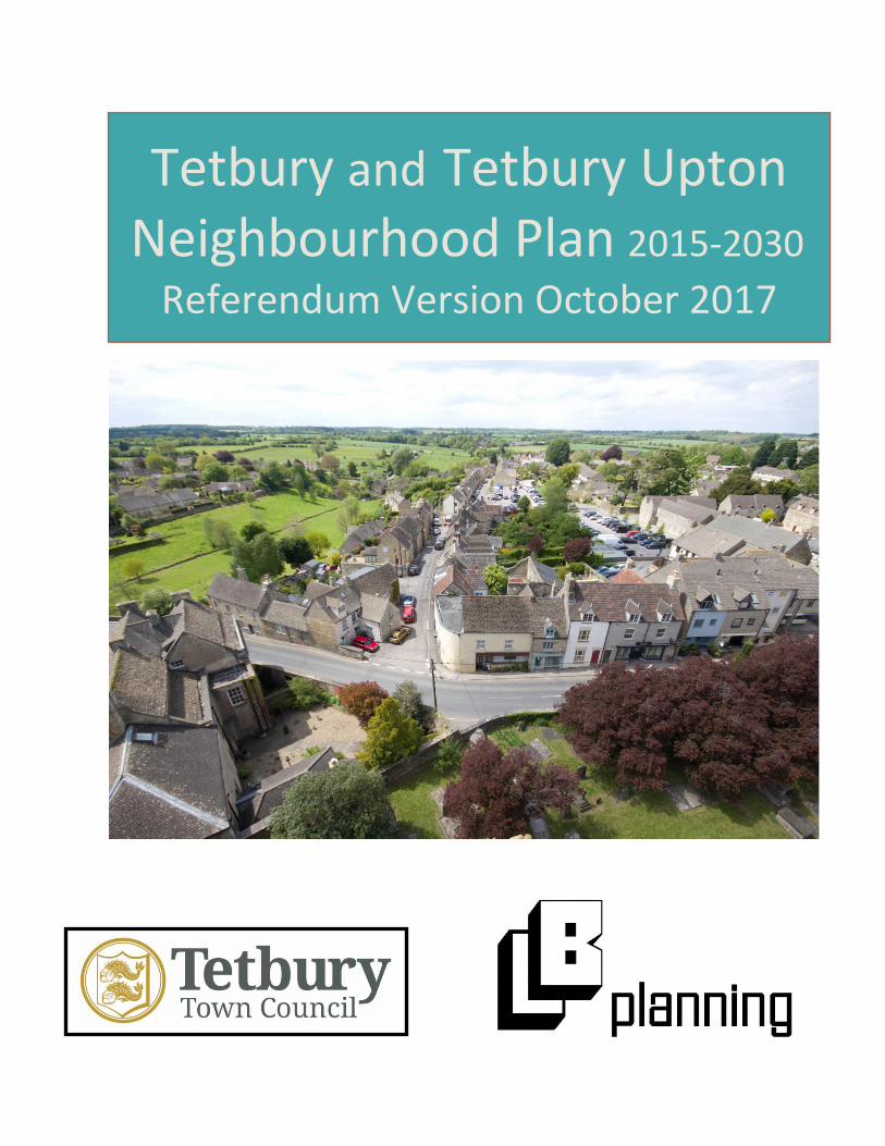
Tetbury and Tetbury Upton Neighbourhood Plan 2015-2030
Referendum Version October 2017
1
Tetbury and Tetbury Upton Neighbourhood Plan Referendum Version October 2017
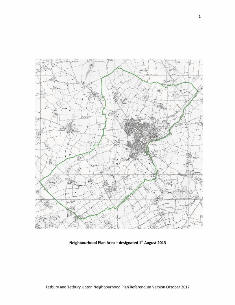
Neighbourhood Plan Area – designated 1st August 2013
2
Tetbury and Tetbury Upton Neighbourhood Plan Referendum Version October 2017
FOREWORD.
Welcome to the Tetbury and Tetbury Upton Neighbourhood Plan.
The Tetbury Neighbourhood Plan Working Group have carried out a
huge amount of work to produce this Neighbourhood Plan which
encompasses all the key planning issues that will affect the town in
the future.
Neighbourhood Plans are a new type of planning document following
on from The Localism Act (2011) which introduced Neighbourhood
Development Plans as policies that focus on local planning and give
communities the opportunity to become involved in their future.
For some years now Tetbury has been discussing what shape the
town should take into the future, ‘Planning for Real’ was probably the
first public consultation that gave townspeople the opportunity to
describe their forward vision and following this there have been a
number of public consultations and workshops that have contributed
to the content of this plan. Discussions have also taken place with
planning professionals, landowners, developers, local organisations,
local health professionals, neighbouring parish councils and the
District Council. The proposals that result from these discussions are
in this document and they will determine the way that our town can
develop into the future.
The Tetbury community now has a chance to approve the plan in a
referendum.
Tetbury Town Council is very grateful for the huge amount of work
carried out by the Neighbourhood Plan Working Group without their
commitment and dedication we would not have such a quality
document that reflects joint working between many local
organisations and the community consultations.
Stephen Hirst

3
Tetbury and Tetbury Upton Neighbourhood Plan Referendum Version October 2017
Mayor of Tetbury
Table of Contents
1 What is Neighbourhood Planning………………………………………………………………………………….… 4
2 Introduction to Tetbury and Tetbury Upton…………………………………………………..……………..… 7
3 Vision for Tetbury……………………………………………………………………………………………………..……14
4 The Policies…………………………………………………………………………………………………………………… 15
4.1 Housing and Design ……………………………………………………………………………………………………. 15
4.2 Town Centre and Transport …………………………………………………………………………………………24
4.3 Open Spaces and Community …………………………………………………………………………………….. 36
4.4 Landscape, Heritage and Ecology ………………………………………………………………………………. 41
Appendix 1: Potential Cycle Routes …………………..……………………………………………………………… 46
Appendix 2: List of Interest and Specialist Groups in Tetbury ……………….………………………….. 47
Appendix 3: Projects that could support the aims of the Neighbourhood Plan ………………… 48
Abbreviations used in the text:
NPPF National Planning Policy Framework 2012
CDC Cotswold District Council
LPA Local Planning Authority – CDC
TTUNP Tetbury and Tetbury Upton Neighbourhood Plan also called “the Plan”.
TDNPG Tetbury and District Neighbourhood Planning Group

4
Tetbury and Tetbury Upton Neighbourhood Plan Referendum Version October 2017
1. What is Neighbourhood Planning?
1.1 Neighbourhood Development Plans are a new sort of planning policy. They deal with
smaller areas normally at greater detail than Local Plans, but have statutory development plan
status within their Local Planning Authority area. The nearest equivalent prior to
neighbourhood plans were Parish Plans, which did not carry the same statutory weight when
planning applications were being considered.
1.2 Local communities were empowered to undertake neighbourhood planning when the
Localism Act 2011 came into being. The Neighbourhood Plan Regulations of 2012 set out the
more detailed requirements and process to follow. Figure 1 shows the process that needs to be
followed during the development of a Neighbourhood Plan.
Figure1: The main stages of the Neighbourhood Plan (NP) process
1.3 Giving communities greater control over planning policy in this way is intended to
encourage positive planning for sustainable development. The National Planning Policy
Framework (NPPF) states that:
“neighbourhood planning gives communities direct power to develop a shared vision for
their neighbourhood and deliver the sustainable development they need”.
5
Tetbury and Tetbury Upton Neighbourhood Plan Referendum Version October 2017
1.4 Tetbury Town Council are the designated authority able to prepare a neighbourhood plan in
the town. They have joined with Tetbury Upton Parish Council to prepare a Tetbury
Neighbourhood Plan that covers both parishes and thus both the town and its wider rural area.
1.5 The regulations and legislation make it clear that this must be done with full consultation
and wider involvement from the whole community. The Tetbury and District Neighbourhood
Planning Group (TDNPG) have been meeting and working on the plan for three years now. The
group includes Town and Parish Councillors, as well as representatives from organisations such
as the CPRE (Campaign for the Preservation of Rural England), the Civic Society, Feoffees, the
Women’s Institute, Tetbury Hospital and the Chamber of Commerce.
1.6 The TDNPG has organized consultation several times during the work on this draft plan, with
a questionnaire exploring what issues concerned local people going out in 2014 and a Visioning
session was run by Planning Aid.
1.7 Besides the Local Authority, other key stakeholders for the development of planning policy
for Tetbury have been consulted, for example the Cotswolds Conservation Board for AONB
issues. Where relevant, initial advice from them has been incorporated.
1.8 Evidence work undertaken and commissioned includes a Housing Needs Survey, site
allocations work, a Leisure Strategy, Town Centre Traffic Study, Open Spaces Assessment and a
survey of local businesses. The group also undertook a Character and Townscape Assessment of
Tetbury, the results of which have been included in a separate report that is intended to inform
design requirements for development in Tetbury. Together with the Town Centre Traffic Study,
these documents were also available during the six week consultation period on the draft Plan.
1.9 Policy Background and Basic Conditions
There is a legal requirement that any neighbourhood plan meets the ‘Basic Conditions’, which
are as follows:
It must have regard to with national policies and advice contained in guidance issued by
the Secretary of State;
It must contribute to the achievement of sustainable development;
Policies must be in ‘general conformity’ with the strategic policies of the Local Plan
for the area; and
It must be compatible with EU obligations and human rights law; EU obligations
normally means environmental protection directives.
6
Tetbury and Tetbury Upton Neighbourhood Plan Referendum Version October 2017
1.9.1 The National Planning Policy Framework (NPPF) sets out government planning policy for
England, and the National Planning Practice Guidance website offers guidance on how this
policy should be implemented. These are the main national policies that must be complied
with, and this plan has paid due regard to them.
1.9.2 Cotswold District Council is the Local Planning Authority (LPA), and Gloucestershire County
Council is the highway authority. The LPA is currently progressing a new Local Plan, which is due
to be submitted for examination this summer. The previous Adopted Local Plan is the official
Plan policies in this document have to be in general conformity with, but in order that this Plan
is ‘future-proofed’, regard has also been paid to policies in the emerging Local Plan 2011-2031.
1.9.3 The Neighbourhood Plan (TTUNP) has to comply with these Basic Conditions, and how it
does this is set out in the Basic Conditions Statement submitted to Cotswold DC with the Plan. It
also had a Consultation Statement submitted with it, that shows the consultation undertaken in
its preparation including the formal six week consultation for Regulation 14.
1.9.4 Besides the Basic Conditions, there are some other requirements set out in legislation that
the TTUNP must comply with. These include the requirements that the Plan deals solely with
landuse issues, and only on land within the defined Neighbourhood Plan Area – the town and
parishes of Tetbury and Tetbury Upton.
7
Tetbury and Tetbury Upton Neighbourhood Plan Referendum Version October 2017
2. Introduction to Tetbury and Tetbury Upton
History and current Character
2.1 Tetbury in Gloucestershire is a Cotswold hill-town of great historic and architectural interest
set in attractive undulating farmland countryside. It has over 1300 years of recorded history
back to the year 681 – and there is evidence of settlement even earlier, with two Bronze Age
round barrows and an Iron Age hill fort, all scheduled ancient monuments. There is also
evidence of Roman presence and the Historic Environment Record has 375 entries for the two
parishes.
2.2 The core of the modern town remains substantially as it was in the 16th and 17th Century
when it reached the height of its prosperity as a wool town. It is often difficult to recognise the
even older houses that lie behind the 18th or 19th Century facades.
2.3 During the early part of the 19th Century the wool trade in Tetbury withered away which,
although sad in itself, had one significant benefit namely the town was spared the uglier
excesses of the Industrial Revolution.
2.4 It is now prosperous and twice the size it used to be in the 18th Century. Its curving streets
match curving contours; the shapes of its open spaces and the facades and complex roof-scapes
of the houses indicate organic growth rather than the dictates of planners’ geometry. All of
these contribute to the skyline dominated by the Parish Church of St Mary the Virgin and St
Mary Magdalen (St Marys’) whose tall and elegant spire greets the visitor arriving from all
directions. Because of all this and its large number of listed buildings grouped together, a large
part of the town in 1971 was designated a Conservation Area. There is also a Conservation Area
at Doughton and Highgrove, to the south of the town, designated in 1990.
2.5 The town is picturesque but is not a museum piece. Its prosperity depends on a wide range
of local manufacturing and servicing enterprises situated mainly in light industrial estates on its
periphery and on numerous shops, hotels, pubs and restaurants. Because of its Cotswold
location, history and architecture its prosperity is supplemented by tourism. Its attractive range
of shops is characterized by small individual retail units (eg boutiques, gift shops) and antique
shops which help to give Tetbury its unique character.
2.6 Tetbury also has all the modern amenities expected in a market town of its size – a newly
modernised hospital, good schools, sports grounds plus all the usual health and community
facilities. During the consultation process that developed this Plan, deficiencies in medical
services particularly concerning GP practices were identified. Similarly people raised concerns

8
Tetbury and Tetbury Upton Neighbourhood Plan Referendum Version October 2017
about educational provision and problems with the range and availability of pre-school
provision, as well as a lack of youth facilities. The Plan does have proposals where possible for
more outdoor recreational facilities, but as a landuse plan can’t deal with the issue of providing
a comprehensive youth service.
2.7 Tetbury Upton is a small village to the north west of Tetbury and the parish of Tetbury
Upton covers most of the rural area around Tetbury Town. It is the largest Parish area in the
Cotswold District and, unlike most other parishes, it is entirely rural. It includes the settlements
of:
Charlton Court
Charlton Down Covert
Doughton
Estcourt Grange
Hermits Cave
Hookshouse
Ilsom
Tetbury Common
Tetbury Upton
Tetbury Upton Parish falls within the Cotswolds Area of Outstanding Natural Beauty. The Parish
contains many working farms and estates including Duchy Home Farm and Highgrove House,
home of the Prince of Wales and the Duchess of Cornwall and the birthplace of Duchy Originals.
The majority of the buildings in the Parish are in the typical Cotswold vernacular style. There are
26 Grade 2 listed buildings including Highgrove House and most of the settlement of Tetbury
Upton. Upton House itself is Grade 2 Star and Doughton Manor is Grade 1 listed.
9
Tetbury and Tetbury Upton Neighbourhood Plan Referendum Version October 2017
Tetbury – the Community
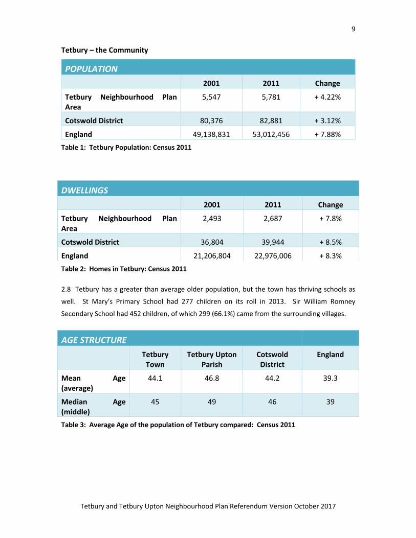
Table 1: Tetbury Population: Census 2011
Table 2: Homes in Tetbury: Census 2011
2.8 Tetbury has a greater than average older population, but the town has thriving schools as
well. St Mary’s Primary School had 277 children on its roll in 2013. Sir William Romney
Secondary School had 452 children, of which 299 (66.1%) came from the surrounding villages.
Table 3: Average Age of the population of Tetbury compared: Census 2011
POPULATION
2001 2011 Change
Tetbury Neighbourhood Plan Area
5,547 5,781 + 4.22%
Cotswold District 80,376 82,881 + 3.12%
England 49,138,831 53,012,456 + 7.88%
DWELLINGS
2001 2011 Change
Tetbury Neighbourhood Plan Area
2,493 2,687 + 7.8%
Cotswold District 36,804 39,944 + 8.5%
England 21,206,804 22,976,006 + 8.3%
AGE STRUCTURE
Tetbury Town
Tetbury Upton Parish
Cotswold District
England
Mean Age (average)
44.1 46.8 44.2 39.3
Median Age (middle)
45 49 46 39
10
Tetbury and Tetbury Upton Neighbourhood Plan Referendum Version October 2017
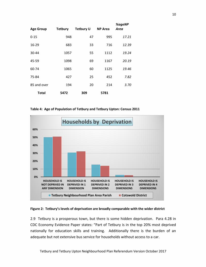
Age Group Tetbury Tetbury U NP Area %ageNP Area
0-15 948 47 995 17.21
16-29 683 33 716 12.39
30-44 1057 55 1112 19.24
45-59 1098 69 1167 20.19
60-74 1065 60 1125 19.46
75-84 427 25 452 7.82
85 and over 194 20 214 3.70
Total 5472 309 5781
Table 4: Age of Population of Tetbury and Tetbury Upton: Census 2011
Figure 2: Tetbury’s levels of deprivation are broadly comparable with the wider district
2.9 Tetbury is a prosperous town, but there is some hidden deprivation. Para 4.28 in
CDC Economy Evidence Paper states: “Part of Tetbury is in the top 20% most deprived
nationally for education skills and training. Additionally there is the burden of an
adequate but not extensive bus service for households without access to a car.
0%
10%
20%
30%
40%
50%
60%
HOUSEHOLD IS NOT DEPRIVED IN ANY DIMENSION
HOUSEHOLD IS DEPRIVED IN 1
DIMENSION
HOUSEHOLD IS DEPRIVED IN 2 DIMENSIONS
HOUSEHOLD IS DEPRIVED IN 3 DIMENSIONS
HOUSEHOLD IS DEPRIVED IN 4 DIMENSIONS
Households by Deprivation
Tetbury Neighbourhood Plan Area Parish Cotswold District
11
Tetbury and Tetbury Upton Neighbourhood Plan Referendum Version October 2017
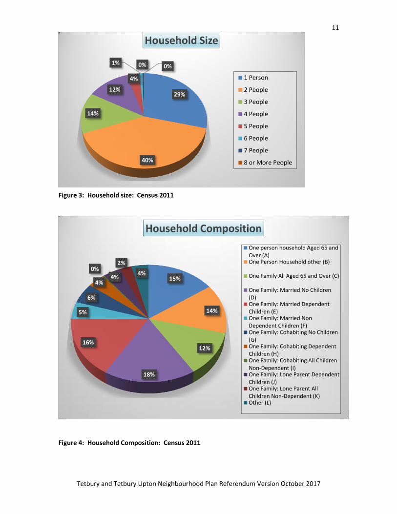
Figure 3: Household size: Census 2011
Figure 4: Household Composition: Census 2011
29%
40%
14%
12%
4%
1% 0% 0%
Household Size
1 Person
2 People
3 People
4 People
5 People
6 People
7 People
8 or More People
15%
14%
12%
18%
16%
5%
6%
4%
0% 4%
2%
4%
Household Composition
One person household Aged 65 andOver (A)One Person Household other (B)
One Family All Aged 65 and Over (C)
One Family: Married No Children(D)One Family: Married DependentChildren (E)One Family: Married NonDependent Children (F)One Family: Cohabiting No Children(G)One Family: Cohabiting DependentChildren (H)One Family: Cohabiting All ChildrenNon-Dependent (I)One Family: Lone Parent DependentChildren (J)One Family: Lone Parent AllChildren Non-Dependent (K)Other (L)
12
Tetbury and Tetbury Upton Neighbourhood Plan Referendum Version October 2017
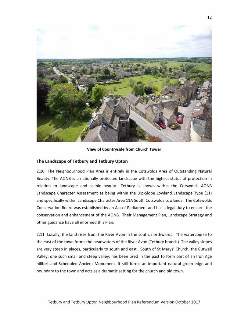
View of Countryside from Church Tower
The Landscape of Tetbury and Tetbury Upton
2.10 The Neighbourhood Plan Area is entirely in the Cotswolds Area of Outstanding Natural
Beauty. The AONB is a nationally protected landscape with the highest status of protection in
relation to landscape and scenic beauty. Tetbury is shown within the Cotswolds AONB
Landscape Character Assessment as being within the Dip-Slope Lowland Landscape Type (11)
and specifically within Landscape Character Area 11A South Cotswolds Lowlands. The Cotswolds
Conservation Board was established by an Act of Parliament and has a legal duty to ensure the
conservation and enhancement of the AONB. Their Management Plan, Landscape Strategy and
other guidance have all informed this Plan.
2.11 Locally, the land rises from the River Avon in the south, northwards. The watercourse to
the east of the town forms the headwaters of the River Avon (Tetbury branch). The valley slopes
are very steep in places, particularly to south and east. South of St Marys’ Church, the Cutwell
Valley, one such small and steep valley, has been used in the past to form part of an Iron Age
hillfort and Scheduled Ancient Monument. It still forms an important natural green edge and
boundary to the town and acts as a dramatic setting for the church and old town.

13
Tetbury and Tetbury Upton Neighbourhood Plan Referendum Version October 2017
2.12 The farm land abutting the built up area is generally well managed and in good condition.
This is less true to the north of the town, where most development and expansion of Tetbury
has taken place. The resulting Gateways into Tetbury from the North are consequently
uninspiring, in sharp contrast to the entrance from South and East, and to an extent from the
West.
Northern Gateway – London road from Cirencester direction
14
Tetbury and Tetbury Upton Neighbourhood Plan Referendum Version October 2017
Southern Gateway – Bath Road
3. Vision for Tetbury
“Tetbury will become the most vibrant Market town in the Cotswolds. With its
continuing strong sense of community, it will keep pace with growth, whilst at the
same time preserving and celebrating its heritage and stunning countryside.”
3.1 The vision was originally developed by the Neighbourhood Planning Group. The objectives
below that follow from it, have come partly from topic groups working on the Neighbourhood
Plan, and partly from the land-use implications of the Town Council’s Community Plan.
Objectives
1. The historic fabric and heritage of Tetbury will be conserved, enhanced and celebrated;
2. Tetbury’s unique urban and green landscape within the town and beyond will be protected
and enhanced in line with the ethos of the Cotswold AONB;
3. The town centre will be re-balanced to honour its historic heritage as well as its crucial
shopping and meeting role and its environmental quality will be improved;
4. Community facilities will facilitate and encourage community engagement and cohesion;
5. Suitable space for performance Arts and other cultural activities will be provided;
6. Safe, direct and enjoyable links for walking and cycling to the town centre and other key
attractors will be developed to promote sustainable travel;
7. Affordable homes will be provided that offer a range of tenure types to suit evidenced local
need and be well integrated into new housing developments;
8. New housing sites will provide the CDC housing allocation and housing provision to reflect
the type of dwelling in local demand;
9. Tetbury will have a flourishing local economy where quality jobs are available locally;
10. A high standard of sport and leisure provision will serve the whole community and keep
people fit and active into old age;
11. The provision of Infrastructure including medical and educational provision will be
promoted and supported wherever possible so that Tetbury has efficient and caring services
to suit the needs of a growing modern community.
15
Tetbury and Tetbury Upton Neighbourhood Plan Referendum Version October 2017
4. Policies
The policies in this plan flow from the Vision and Objectives, and are based on the results of
consultation and evidence gathered by the Town Council, Cotswold District Council (CDC) and
other bodies as referenced at the back of this document. They are divided into four topic areas;
to facilitate introduction to the evidence and other justification for each of them.
4.1 Housing and Design
Objectives
7. Affordable homes will be provided that offer a range of tenure types to suit evidenced local
need and be well integrated into new housing developments.
8. New housing sites will provide the CDC housing allocation and housing provision to reflect the
type of dwelling in local demand.
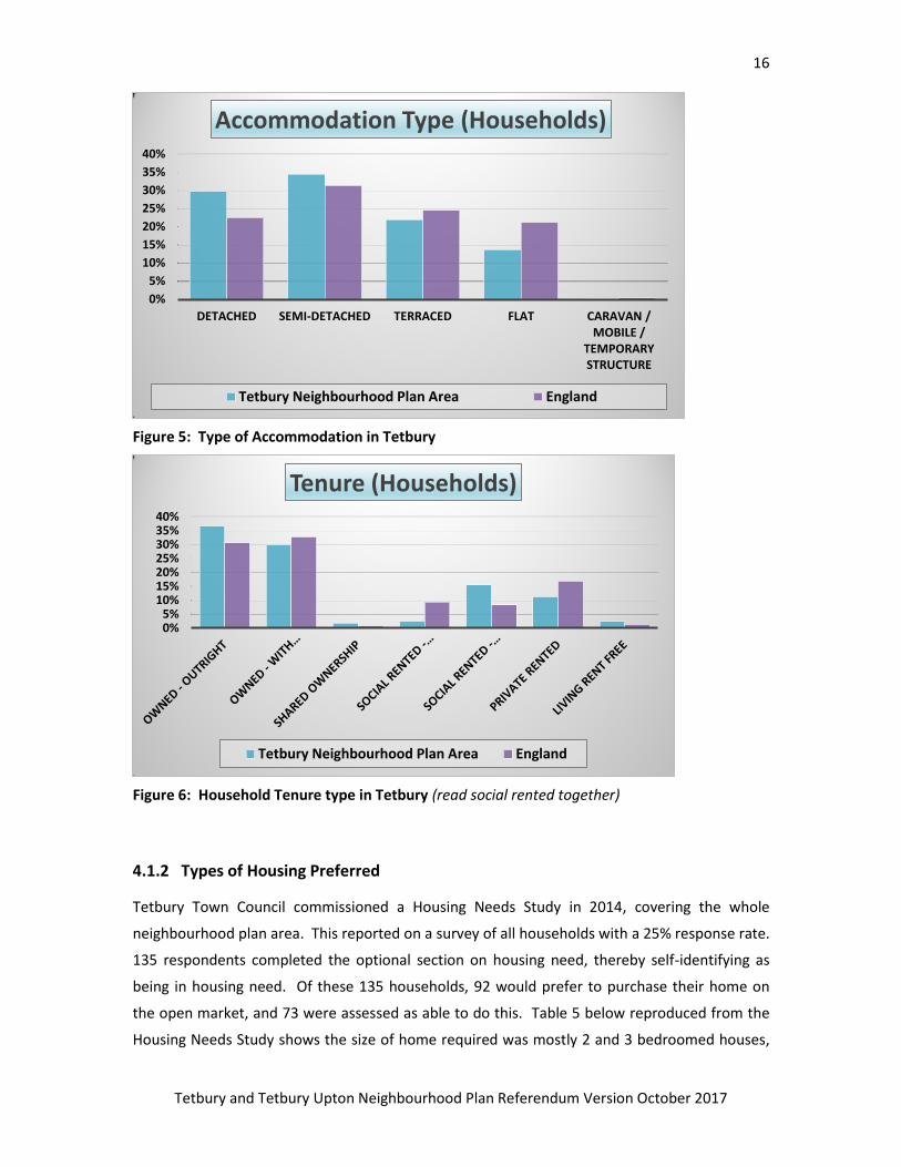
4.1.1. Tetbury’s Housing
Tetbury has more detached and semi-detached accommodation than is average for England, as
could be expected with its rural nature. There is also slightly less private rented
accommodation, which roughly accounts for the slightly above average level of owner
occupation in the town. Tables 5 and 6 however still show a reasonably well balanced
community in terms of its housing. It should be noted that the Social Housing columns in Table
6 should be amalgamated; the separation is due to previous council tenants still identifying
their house as ‘council’ on the census.
16
Tetbury and Tetbury Upton Neighbourhood Plan Referendum Version October 2017
Figure 5: Type of Accommodation in Tetbury
Figure 6: Household Tenure type in Tetbury (read social rented together)
4.1.2 Types of Housing Preferred
Tetbury Town Council commissioned a Housing Needs Study in 2014, covering the whole
neighbourhood plan area. This reported on a survey of all households with a 25% response rate.
135 respondents completed the optional section on housing need, thereby self-identifying as
being in housing need. Of these 135 households, 92 would prefer to purchase their home on
the open market, and 73 were assessed as able to do this. Table 5 below reproduced from the
Housing Needs Study shows the size of home required was mostly 2 and 3 bedroomed houses,
0%
5%
10%
15%
20%
25%
30%
35%
40%
DETACHED SEMI-DETACHED TERRACED FLAT CARAVAN / MOBILE /
TEMPORARY STRUCTURE
Accommodation Type (Households)
Tetbury Neighbourhood Plan Area England
0%5%
10%15%20%25%30%35%40%
Tenure (Households)
Tetbury Neighbourhood Plan Area England

17
Tetbury and Tetbury Upton Neighbourhood Plan Referendum Version October 2017
with a significant proportion wanting a 2 bed bungalow. Flats are not in much demand, and
there was some demand for sheltered accommodation (bungalow demand can be assumed to
include some demand from the elderly). There have been several recent permissions for
housing particularly suited to the elderly, and so this need is considered met for the present.
Policy 1: Types of Housing
Housing development should, where appropriate and viable, provide for a range of dwelling
types and sizes, to reflect local demand.
Dwelling Type No, of Bedrooms Households wanting
this type of dwelling
House
1 bed 5
2 beds 36
3 beds 37
4 beds 17
Bungalow
1 bed 2
2 beds 17
3 beds 5
4 beds 1
Flat – ground floor 1 bed 1
2 beds 1
Flat above ground floor 1 bed 3
2 beds 1
Sheltered 1 bed 1
2 beds 1
Care home/residential 1
TOTAL 129
Table 5: Responses to Question C8 – ‘What type of property do you need?

18
Tetbury and Tetbury Upton Neighbourhood Plan Referendum Version October 2017
4.1.3 Enhancing and conserving Tetbury’s Townscape
The design and appearance of all development in the town is important, not just within the
Conservation Area. In the past new development has tended to avoid reflecting local styles,
something the Cotswold Design Code has been working hard to rectify since it was first
introduced in 2000. The NPPF is supportive of good design and respecting and reinforcing local
distinctiveness in the design of development (para 58), as is Policy D1 of the emerging Local
Plan.
4.1.3.1 A Townscape and Character Assessment of Tetbury has been produced as an evidence
base for this Plan, in order that attributes specific to Tetbury are protected and enhanced in
future development. Survey work included noting places where particularly striking views of the
surrounding countryside could be enjoyed, and these are proposed to be protected, and
opportunities for views within the town, to the Church Spire for example, be exploited if
possible.
4.1.3.2 Enhancing and conserving the town’s character and conservation is important for the
development of the increasingly important tourism industry. The Cotswolds AONB
Management Plan (page 60) states that “The Cotswolds remains a popular destination for both
overseas and domestic
visitors, attracting some
23 million leisure visits
every year. Valued at
more than £1 billion to
the local economy,
tourism is the number
one industry in the
Cotswolds AONB.” It is
important that Tetbury
benefits fully from this.
Cutwell, Tetbury
Policy 2: Enhancement of Tetbury’s Townscape and Character.
Development Proposals will be required to pay regard to the Tetbury Townscape and
Character Assessment Report 2016 and the Cotswold Design Guide 2000 and any future
adopted update to the Cotswold Design Guide.
19
Tetbury and Tetbury Upton Neighbourhood Plan Referendum Version October 2017
4.2 Town Centre and Transport
Objectives
3. The town centre will be re-balanced to honour its historic heritage as well as its crucial
shopping and meeting role and its environmental quality will be improved.
6. Safe, direct and enjoyable links for walking and cycling to the town centre and other key
attractors will be developed to promote sustainable travel.
4.2.1 Introduction
Tetbury sits at the junction of several roads – the most important being the A433 – Cirencester
to Bath/Bristol route. Two other major routes the A4135 (Tetbury to Dursley/M5/A46/M4) and
the B4014 (Malmesbury to Stroud) also pass through the Town Centre. The town is sufficiently
removed from other larger settlements, giving it a degree of self-containment. It also acts as a
local centre for the surrounding area.
4.2.1.1 Gloucestershire County Council (GCC) is responsible for most Highway matters and it also
has an important controlling role in public transport. Cotswold District Council (CDC) has
responsibility for off-street public car parks and, because of its development management and
local planning role, it works in partnership with GCC and other bodies and is able to apply
considerable influence. Sustrans, a charitable organisation, works with GCC on cycle networks
and a proposed local section links Tetbury with Kemble station.
4.2.1.2 Through traffic, particularly heavy goods vehicles, is a long standing issue in Tetbury. A
by-pass proposal was abandoned in 1995 and a weight restriction was subsequently introduced.
This has reduced but not eliminated the problem, and there is a feeling that it is not well
enforced.
4.2.1.3 The present population (2013) is approximately 5,500. It is expected that many more
houses, presently, estimated at about 760 (adding about 1850 people) will be constructed over
the plan period, thus adding to traffic volumes and congestion. There is a need for traffic
calming and other infrastructure and environmental improvements to be put in hand,
particularly in the centre of town in order that the historic and shopping environments are not
overwhelmed by the traffic movement role of the street. The Atkins Study introduced below
addressed these issues.
20
Tetbury and Tetbury Upton Neighbourhood Plan Referendum Version October 2017
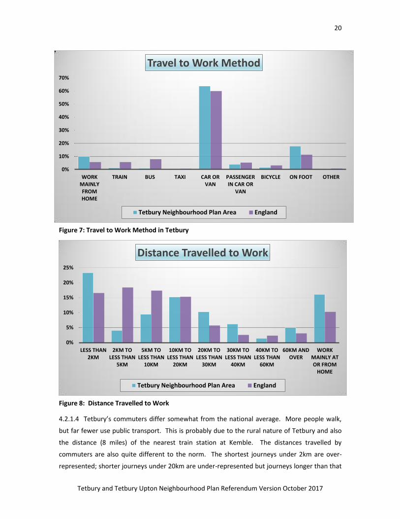
Figure 7: Travel to Work Method in Tetbury
Figure 8: Distance Travelled to Work
4.2.1.4 Tetbury’s commuters differ somewhat from the national average. More people walk,
but far fewer use public transport. This is probably due to the rural nature of Tetbury and also
the distance (8 miles) of the nearest train station at Kemble. The distances travelled by
commuters are also quite different to the norm. The shortest journeys under 2km are over-
represented; shorter journeys under 20km are under-represented but journeys longer than that
0%
10%
20%
30%
40%
50%
60%
70%
WORK MAINLY FROM HOME
TRAIN BUS TAXI CAR OR VAN
PASSENGER IN CAR OR
VAN
BICYCLE ON FOOT OTHER
Travel to Work Method
Tetbury Neighbourhood Plan Area England
0%
5%
10%
15%
20%
25%
LESS THAN 2KM
2KM TO LESS THAN
5KM
5KM TO LESS THAN
10KM
10KM TO LESS THAN
20KM
20KM TO LESS THAN
30KM
30KM TO LESS THAN
40KM
40KM TO LESS THAN
60KM
60KM AND OVER
WORK MAINLY AT OR FROM
HOME
Distance Travelled to Work
Tetbury Neighbourhood Plan Area England
21
Tetbury and Tetbury Upton Neighbourhood Plan Referendum Version October 2017
are again over-represented. The short journeys are people working and living in the town, but
if work can only be found outside Tetbury, then the journey to work immediately becomes
significantly longer in most cases.
% Households
No Cars 12.6
1 car/van 40.1
2 cars/van 34.3
3 cars/van 9.1
4 cars/van 3.8
Table 6: Vehicle Ownership by Household for Cotswold District
4.2.2 The Town Centre
4.2.2.1 This is the shopping and business area of Tetbury and the hub where all main roads
meet. It is located near the southern end of town for historic reasons; on the flatter land north
of the early medieval routes entering the town from Bath and Malmesbury, and close to St
Marys’. It is heavily congested by traffic at certain times. There are 4 existing off-street car
parks serving the Town Centre, these are – The Chipping (60 spaces) – chargeable – West Street
(58 spaces) - chargeable, Church Street (35 spaces) – chargeable. The most remote Railway Lane
(90 spaces) free. There are also 21 free spaces on Highway land in the middle of Gumstool Hill.
Several comments during consultation identified a lack of parking in the Town Centre.
4.2.2.2 Other environmental problems from traffic identified by residents were a threat to
safety from road traffic; noise and fumes; volume and speed of traffic and a lack of safe crossing
points. Several road junctions in the town centre are felt to be poorly designed and generally
traffic is felt to be intimidating and off-putting to shoppers and visitors. The Atkins 2016
‘Tetbury Town Centre Urban Design and Public Realm Opportunities Evaluation Report’ (Atkins
2016 Report) notes all these, and servicing issues along the A433 corridor. Generally HGV traffic
levels and noise levels were identified in the report as being a particular problem. Calls have
been made for changes to the trunk road routes in the vicinity of Tetbury, but this is beyond the
scope of this Plan.
22
Tetbury and Tetbury Upton Neighbourhood Plan Referendum Version October 2017
4.2.2.3 The town has a Medieval Town Centre abutted by some 13 ancient streets all within a
Conservation Area. In these streets there are some 100 shops, cafes, 4 hotels, and numerous
other types of business. There are also some 200 or so residents without on-site parking. This
results in cars parked on the streets and, inevitably, more congestion. The Atkins 2016 Report
has identified some areas in the town centre where parking restrictions could be lifted.
4.2.2.4 The Atkins 2016 Report considered the key junctions in the Town Centre, and found
there was often a very poor quality environment for non-car users particularly on Long Street
and Church Street. It also considered the visual impact of road markings, signage and surfaces,
and found that they are often obtrusive in the historic setting of the town. Their report has not
worked up final solutions to identified problems, but did offer initial proposals for altered
junctions on Long Street that would address these issues and could help discourage excessive
HGV journeys through the town centre. It contains some useful and imaginative ideas as to how
enjoyment of the historic fabric could be melded with the transport role of the streets, and in
particular promotes a better setting for the iconic Market Place, currently rather diminished by
being surrounded by tarmac. The Atkins study rightly states that they have identified some
quick wins as well as more expensive highway improvements. The report’s measures cannot all
be achieved with planning powers, but they are aimed at achieving key planning objectives.
4.2.2.5 If traffic can be calmed, pedestrian facilities improved and the historic and visual setting
of the town improved, then shopping trips and visitor numbers in the town can be expected to
increase, with an associated benefit to local businesses. Safe and comfortable pedestrian
movement is important, and better signage for walking journeys is needed for tourists and
visitors both within and around the Town Centre. With considerable new development in the
town, the issue of traffic problems has become particularly sensitive, as it is probable that they
will worsen as more people live in the Town.
4.2.2.6 The Local Plan Employment Study suggests in para 11.41 that policy supporting the
enhancement of Town Centres is important for the development of food, accommodation and
other tourist facilities, as well as the benefit for local residents. Tetbury is also specifically
mentioned as suffering from considerable loss of office space in the town centre to residential
change of use. This is of course development that only requires prior notification normally, but
particularly in the primary retail area of this Key Retail Area as defined in the emerging Local
Plan conversion will need to be considered carefully against policy requirements to maintain the
vibrancy and business success of the town centre.
23
Tetbury and Tetbury Upton Neighbourhood Plan Referendum Version October 2017
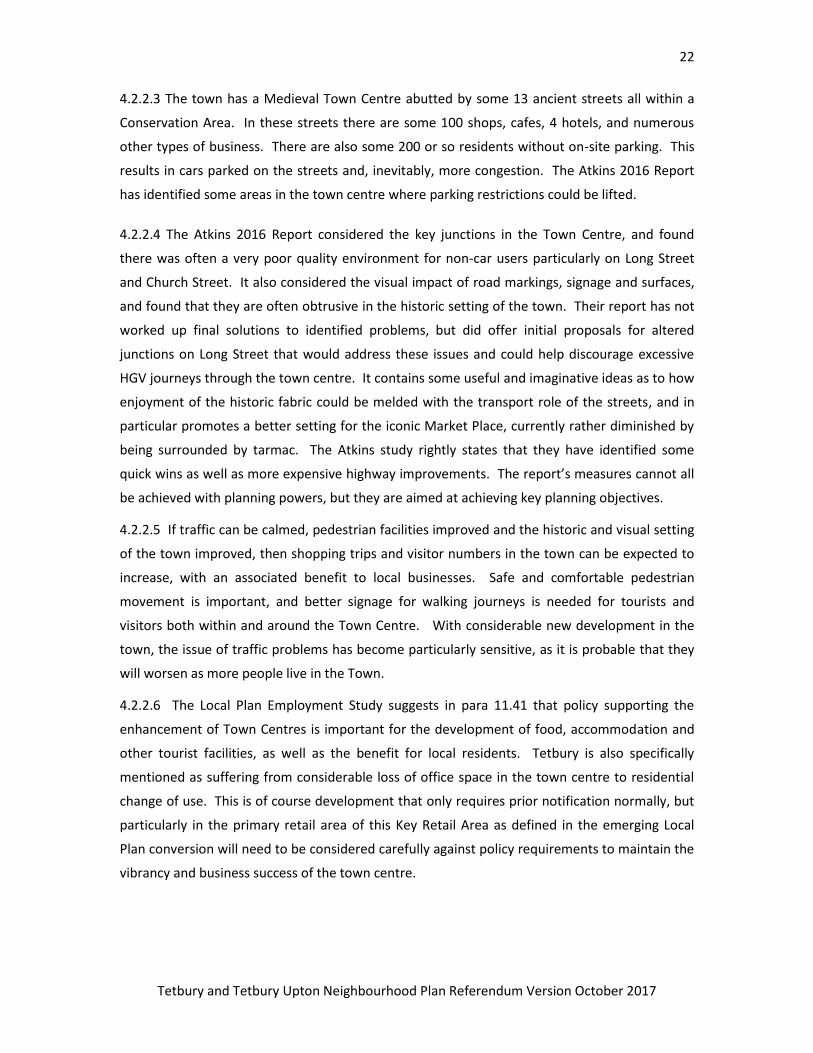
Figure 9
24
Tetbury and Tetbury Upton Neighbourhood Plan Referendum Version October 2017
Community Action: Town Centre
The Town Council will seek to work with other parties to enhance the town centre (indicated by
the purple boundary on Figure 10). This will include working to realise the suggestions made in
the Atkins Report referred to earlier and seeking appropriate developer contributions to
support town centre improvements. The Town Council will, where possible, seek to discourage
the change of offices in the town centre to residential use.
For reference, this is not a Policy, but enables the Neighbourhood Plan to capture the
objectives set out.
4.2.3 Sustainable Travel
Tetbury is a very walkable town and fairly flat because most of the town is on a plateau.
However, not all parts of the town connect well with the Town Centre. The town, in large
measure, is also suitable for cycling which is growing in popularity. Both walking and cycling are
healthy and fun. They reduce the reliance on the motor car and thereby reduce congestion, but
better facilities such as cycle routes and bike parking are needed if people are to be encouraged
out of their cars. The NP survey (July 2014) section A9 revealed a considerable interest in
cycling. Of the 482 people who responded 47% indicated that they would be encouraged most
by the provision of off road route cycle paths and road cycle lanes.
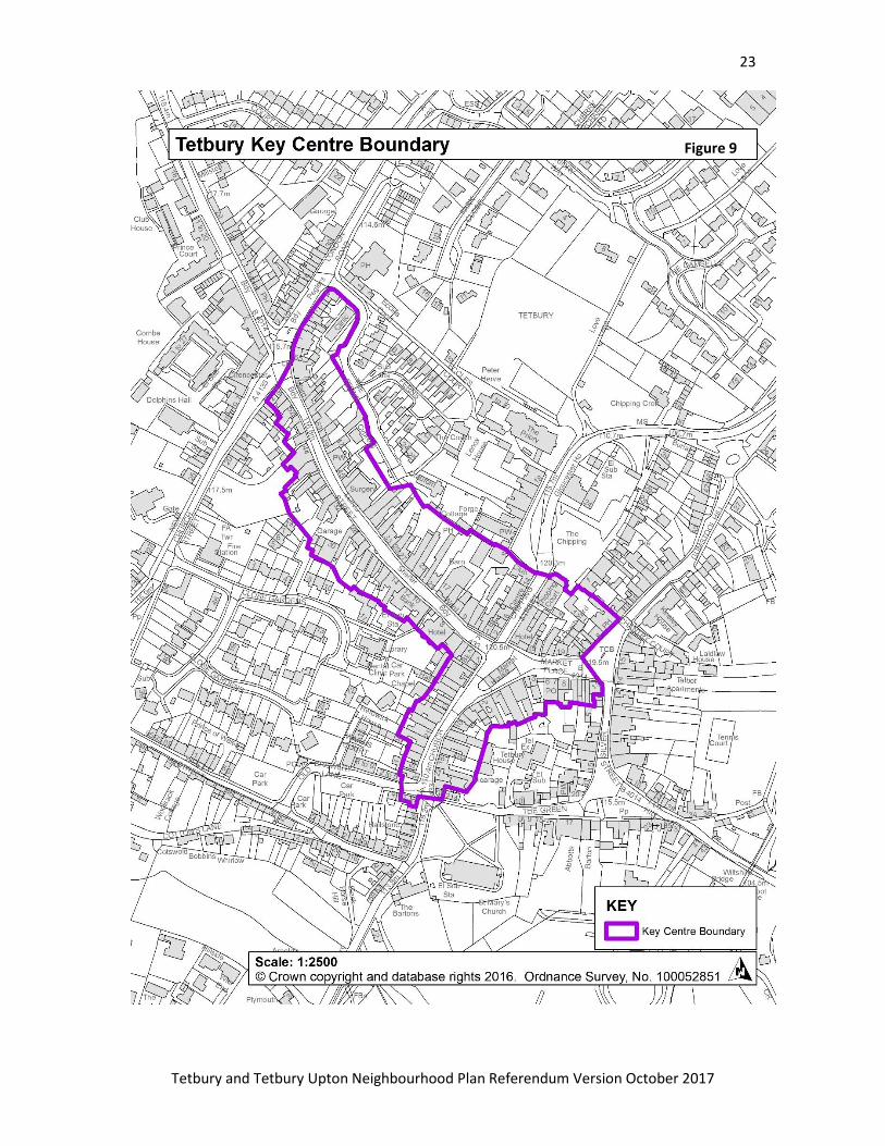
Market Place, Tetbury
25
Tetbury and Tetbury Upton Neighbourhood Plan Referendum Version October 2017
4.2.3.1 A railway spur was built in the late 19th century linking the town with the Swindon-
Gloucester line at Kemble but this was closed in the 1960s. The remains of the station area now
form a car park in the valley bottom east of the town and the former Goods Shed is a
community facility. The Disused Railway is a cycle and pedestrian route within Tetbury Town,
and there is the potential to extend the link on this, and nearly paths and lanes, to form an off-
road connection to the nearest active station at Kemble. The disused railway is crossed by the
Neighbourhood Area boundary at least three times on this route, meaning that the line in its
entirety cannot be designated in this Plan (which must only deal with land within the
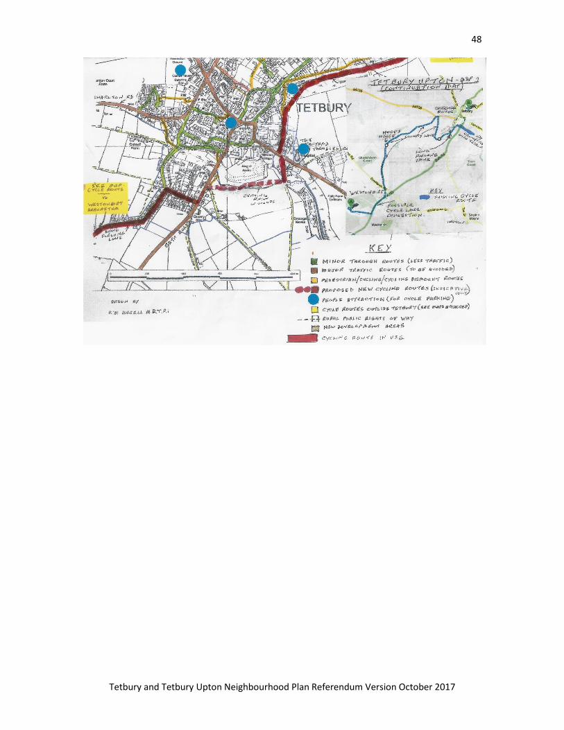
Neighbourhood Area). The line could also be extended south as shown in appendix 1.
4.2.3.2 Tetbury is only moderately served by bus services and they are rarely used by
commuters as shown by Figure 8. In the NP Survey 2014 (Section A1) the overwhelming
response was that a radical overhaul was needed to make them more practical, useful and
affordable. 53% of respondents offering a view considered bus services poor and improvements
overdue. In the Survey the highest number of comments were in favour of more frequent
services (Section A6). There is also a need to ensure that the new development in the North of
the town is provided with adequate bus linkage to Tetbury town centre. Promoting Sustainable
Travel is supported by the emerging Local Plan (Policy INF4).
Policy 3: Promotion of Sustainable Transport
Measures to increase the use of cycling and walking within the town will be supported. The
provision of sustainable travel links between new development sites and the town centre; and
the provision of a new cycle link towards Kemble Station, will be supported.
4.2.4 Rights of Way Network
4.2.4.1 Tetbury and its rural hinterland are reasonably provided with public rights of way,
although most of these are footpaths and not accessible to cyclists or horses. An extensive and
unbroken rights of way network is a good resource for local people to use for exercise and
recreation. It is also a tourist and visitor attraction with local economic benefits. The
Gloucestershire Rights of Way Improvement Plan (ROWIP) 2011-2026 promotes working with
local councils to implement improvements to the Rights of Way, as well as working on
maintenance. The ROWIP’s role as defined by government (page 5) is to assess:
The extent to which local public rights of way meet the present and likely future needs
of the public;
26
Tetbury and Tetbury Upton Neighbourhood Plan Referendum Version October 2017
The opportunities provided by local public rights of way for exercise and other forms of
outdoor recreation and enjoyment of the authority‘s area;
The accessibility of local public rights of way to blind and partially sighted people and
others with mobility problems.
The ROWIP does not deal with the details of site specific work, and so the assessment offered
here aims to provide the local detail.
4.2.4.2 An audit of the existing network in the Neighbourhood Area was undertaken with a view
to ascertaining where gaps in the network existed. These missing links or severance issues
mean that paths cannot be linked together effectively when planning walks, or used
unaccompanied by minors due to hazards such as busy roads or dangerous crossings of main
roads. These problems can be overcome with reasonably low-cost solutions, such as central
islands to aid road crossing rather than expensive signaled crossings. Longer links can be
negotiated along the edge of a field or on highway land beside a road. These do not need to be
a formal footway path with kerb solution in rural areas, a simple unsealed path is more in
keeping with the footpath network generally, and the landscape of the AONB.
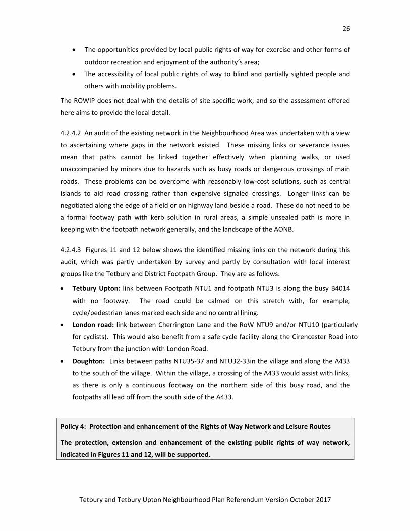
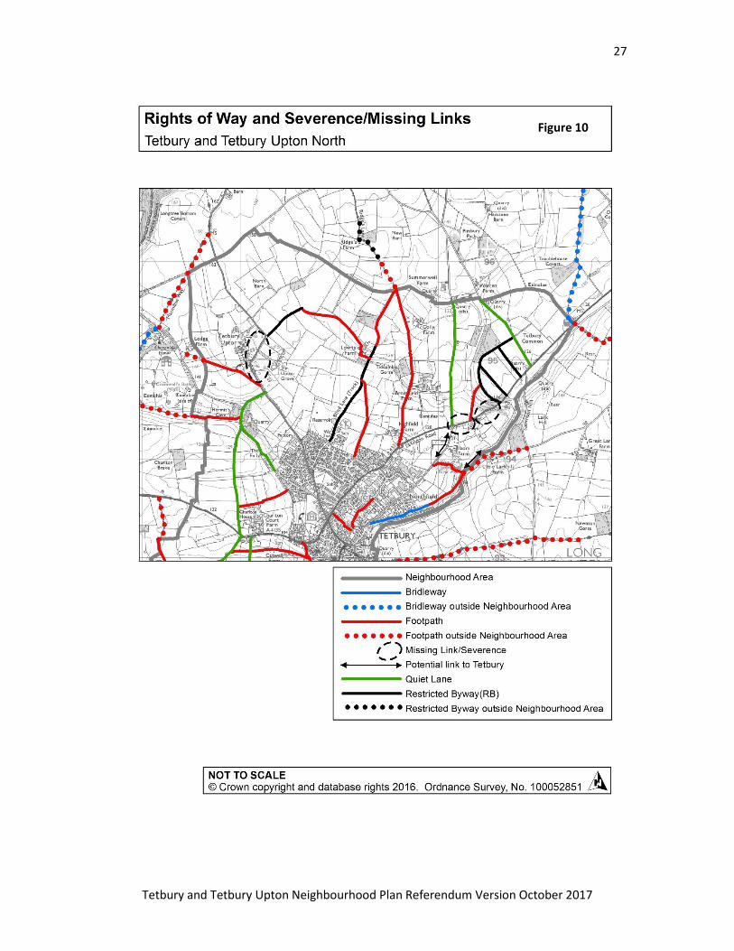
4.2.4.3 Figures 11 and 12 below shows the identified missing links on the network during this
audit, which was partly undertaken by survey and partly by consultation with local interest
groups like the Tetbury and District Footpath Group. They are as follows:
Tetbury Upton: link between Footpath NTU1 and footpath NTU3 is along the busy B4014
with no footway. The road could be calmed on this stretch with, for example,
cycle/pedestrian lanes marked each side and no central lining.
London road: link between Cherrington Lane and the RoW NTU9 and/or NTU10 (particularly
for cyclists). This would also benefit from a safe cycle facility along the Cirencester Road into
Tetbury from the junction with London Road.
Doughton: Links between paths NTU35-37 and NTU32-33in the village and along the A433
to the south of the village. Within the village, a crossing of the A433 would assist with links,
as there is only a continuous footway on the northern side of this busy road, and the
footpaths all lead off from the south side of the A433.
Policy 4: Protection and enhancement of the Rights of Way Network and Leisure Routes
The protection, extension and enhancement of the existing public rights of way network,
indicated in Figures 11 and 12, will be supported.
27
Tetbury and Tetbury Upton Neighbourhood Plan Referendum Version October 2017
Figure 10
28
Tetbury and Tetbury Upton Neighbourhood Plan Referendum Version October 2017
Figure 11
29
Tetbury and Tetbury Upton Neighbourhood Plan Referendum Version October 2017
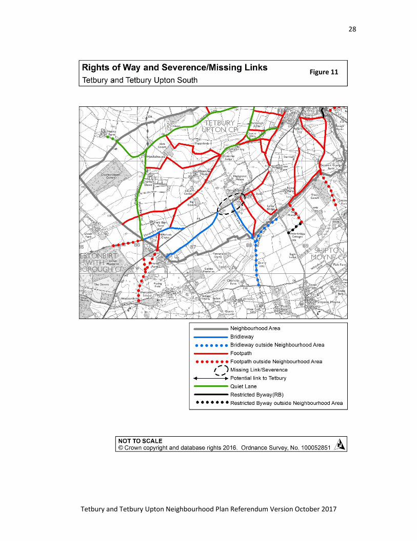
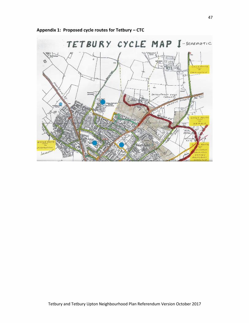
4.2.4.4 Bridleways will also need attention as a resource for horse-riding and cyclists, both of
these modes of travel not being permitted to use Public Footpaths. A map of suggested cycle
routes accompanies this plan, as Appendix 1.
Sign on the Former Railway Path in Tetbury
30
Tetbury and Tetbury Upton Neighbourhood Plan Referendum Version October 2017
4.3 Open Spaces and Community
Objectives
4. Community facilities will facilitate and encourage community engagement and cohesion.
5. Suitable space for performance Arts and other cultural activities will be provided.
9. Tetbury will have a flourishing local economy where quality jobs are available locally;
10. A high standard of sport and leisure provision will serve the whole community and keep
people fit and active into old age;
11. The provision of Infrastructure including medical and educational provision will be
promoted and supported wherever possible so that Tetbury has efficient and caring services to
suit the needs of a growing modern community.
4.3.1 Tetbury is a socially self-sufficient community with an ancient tradition in the Feoffees of
self-organisation that has followed through to the present day. The Feoffees were originally the
trust set up to manage the town when it was to sold by Lord Berkeley in1633. They are now
trustees of the remaining Charities. Social capital is still strong in the town; Appendix 2 Shows
the range of local activity groups currently meeting in Tetbury.
4.3.2 There are a wealth of local community facilities, and active projects for upgrading and
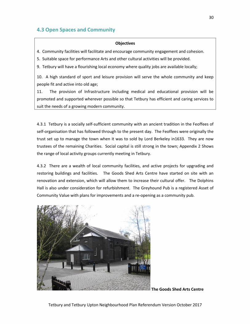
restoring buildings and facilities. The Goods Shed Arts Centre have started on site with an
renovation and extension, which will allow them to increase their cultural offer. The Dolphins
Hall is also under consideration for refurbishment. The Greyhound Pub is a registered Asset of
Community Value with plans for improvements and a re-opening as a community pub.
The Goods Shed Arts Centre
31
Tetbury and Tetbury Upton Neighbourhood Plan Referendum Version October 2017
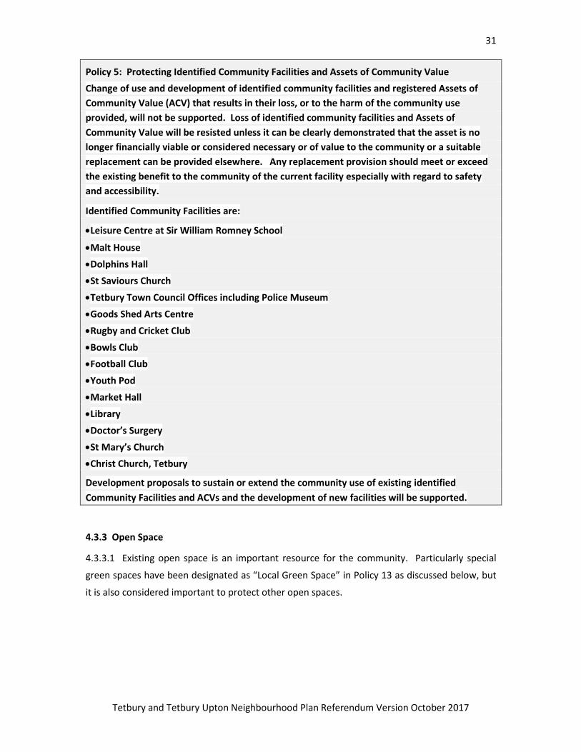
Policy 5: Protecting Identified Community Facilities and Assets of Community Value
Change of use and development of identified community facilities and registered Assets of
Community Value (ACV) that results in their loss, or to the harm of the community use
provided, will not be supported. Loss of identified community facilities and Assets of
Community Value will be resisted unless it can be clearly demonstrated that the asset is no
longer financially viable or considered necessary or of value to the community or a suitable
replacement can be provided elsewhere. Any replacement provision should meet or exceed
the existing benefit to the community of the current facility especially with regard to safety
and accessibility.
Identified Community Facilities are:
Leisure Centre at Sir William Romney School
Malt House
Dolphins Hall
St Saviours Church
Tetbury Town Council Offices including Police Museum
Goods Shed Arts Centre
Rugby and Cricket Club
Bowls Club
Football Club
Youth Pod
Market Hall
Library
Doctor’s Surgery
St Mary’s Church
Christ Church, Tetbury
Development proposals to sustain or extend the community use of existing identified
Community Facilities and ACVs and the development of new facilities will be supported.
4.3.3 Open Space
4.3.3.1 Existing open space is an important resource for the community. Particularly special
green spaces have been designated as “Local Green Space” in Policy 13 as discussed below, but
it is also considered important to protect other open spaces.
32
Tetbury and Tetbury Upton Neighbourhood Plan Referendum Version October 2017
Figure 12

33
Tetbury and Tetbury Upton Neighbourhood Plan Referendum Version October 2017
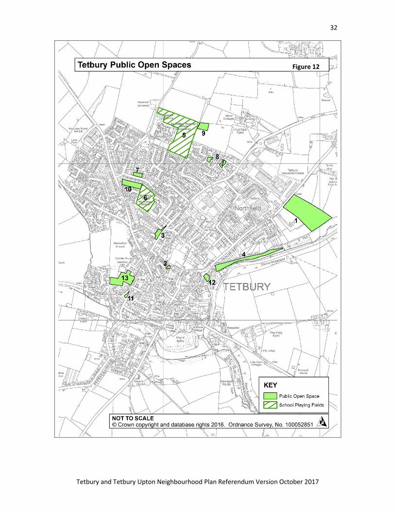
Policy 6: Open Space
Development that results in the loss of, or harm to, the following areas of Open Space as
shown on figure 13 will be resisted:
1. Preston football pitch
2. Anniversary Gardens
3. London road flowerbeds
4. Herd Lane Allotments
5. Sir William Romney School Playing Field
6. St Mary’s School Playing Field
7. St Mary's Open Space
8. Malthouse Walk; Bartley Croft
9. Suffolk Close Playground
10. Allotments near St Mary’s School
11. The Knapp
12. Millenium Green
13. St Saviours Churchyard
4.3.4 Local Employment Opportunities
4.3.4.1 The 2014 Economy Evidence Paper for the Cotswold Local Plan does not have
specific comparison figures for Tetbury, but para 5.26 mentions that office rental rates
are below the Cotswold average in the town, and para 5.30 reports that employment
land values in Tetbury are low for the Cotswolds. This plan has already mentioned that
office space is being lost in the town centre, and the Town Council is keen to promote
employment opportunities therefore.
4.3.4.2 Tetbury has longer than average commuting out of the town and more of it
than the national average (tables 8 and 9). Encouragement of home working and small
start-up businesses could improve these statistics by reducing the amount of
commuting overall and thus reducing carbon emissions. Although Tetbury has above
the national average percentage of people working from home at just under 10%, it is
not as high as for Cotswold District, which at 13.3% is the 7th highest in the country.
This suggests there is room for further development of this mode of working in Tetbury.

34
Tetbury and Tetbury Upton Neighbourhood Plan Referendum Version October 2017
Policy 7 – Supporting start-up Businesses
Proposals for start-up businesses from home requiring planning permission and live-work
units within residential areas will be supported subject to: the reuse of existing buildings
where possible; and not resulting in undue harm to the living conditions of neighbouring
occupiers or to highway safety
35
Tetbury and Tetbury Upton Neighbourhood Plan Referendum Version October 2017
4.4 Landscape, Heritage and Ecology
Objectives
1. The historic fabric and heritage of Tetbury will be conserved, enhanced and celebrated.
2. Tetbury’s unique urban and green landscape within the town and beyond will be protected
and enhanced.
4.4.1 Local Green Space
4.4.1.1 is a new designation of green spaces that have a special significance in their local area.
It is a designation to be applied to special areas on open space which should have outstanding
attributes such as historic, visual, community or ecological value, as set out in the NPPF paras 76
and 77.
4.4.1.2 In Tetbury the Local Green Space designation is appropriate for the following areas of
open space, often because of the visual and historic importance they have in the setting and
appearance of the Old Town and sometimes more because of their intrinsic community value.
1. Recreation Ground: A valued and much-used community recreation facility strategically
located near the centre of town.
2. Railway Path: A valued informal recreational resource and sustainable travel route on the
historic former rail link to Tetbury.
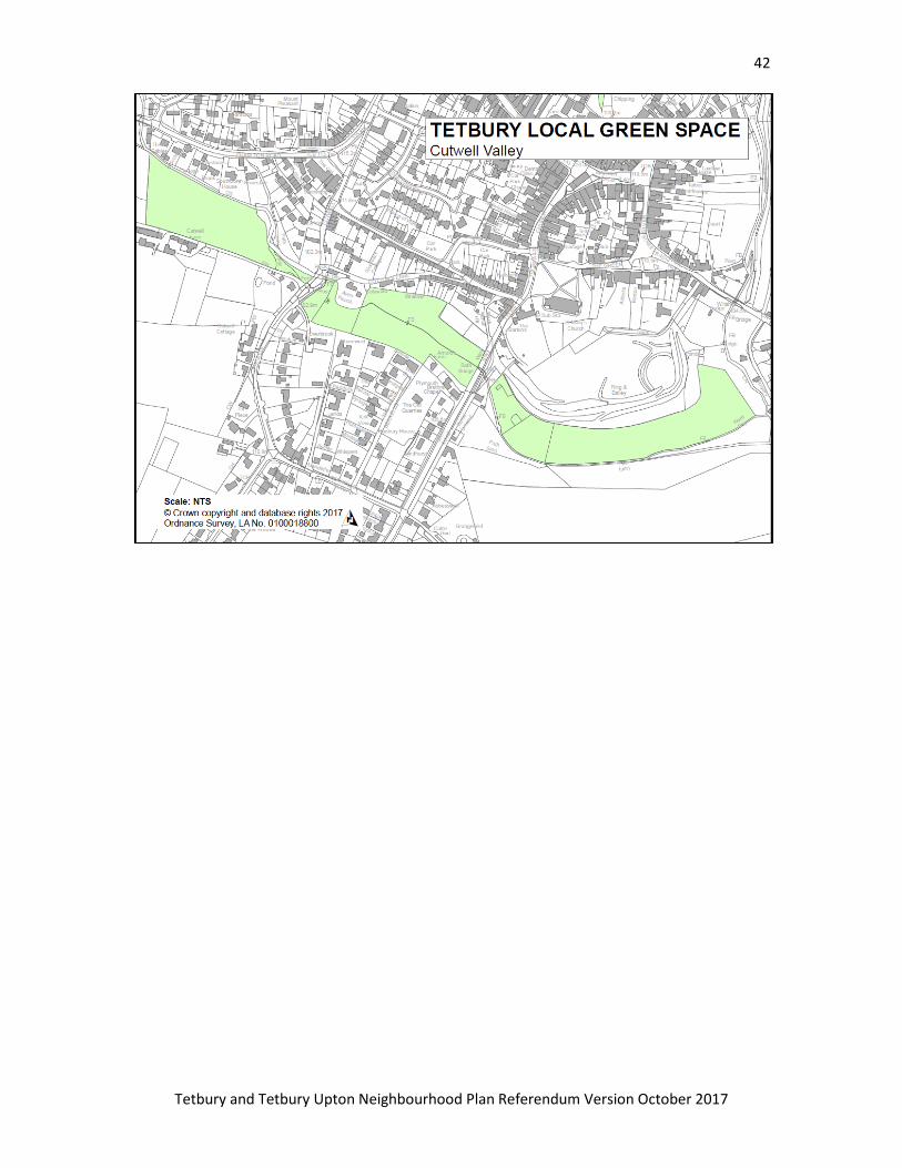
3. Cutwell Valley: These small fields visually frame the historic edge of Tetbury including the
former castle site - an ancient monument. They have visual and historic Significance and
preserve the beauty and setting of the old town and Church. Several important views to the
countryside are taken over them from the Bath Bridge.
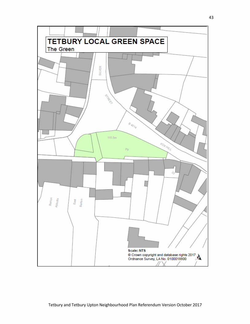
4. The Green: Together with The Chipping, The Green is a small area of green open space
visually very important for the setting of the conservation area and old Tetbury. They are both
also important publically accessible green space in a part of town that does not have much.
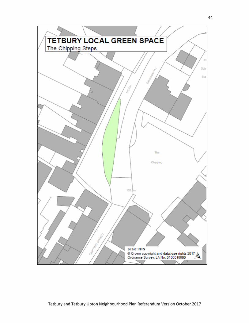
5. The Chipping Steps: Designated as Local Green Space for similar reasons to The Green; the
green space at Chipping Steps frames an iconic feature in Tetbury.
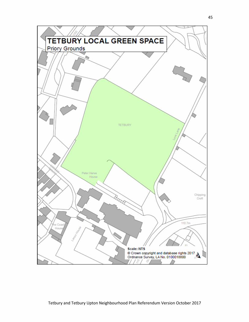
6. Priory Grounds: Historic setting of The Priory, a listed building in the conservation Area. This
green area also has an important visual role in the wider historic town.
36
Tetbury and Tetbury Upton Neighbourhood Plan Referendum Version October 2017
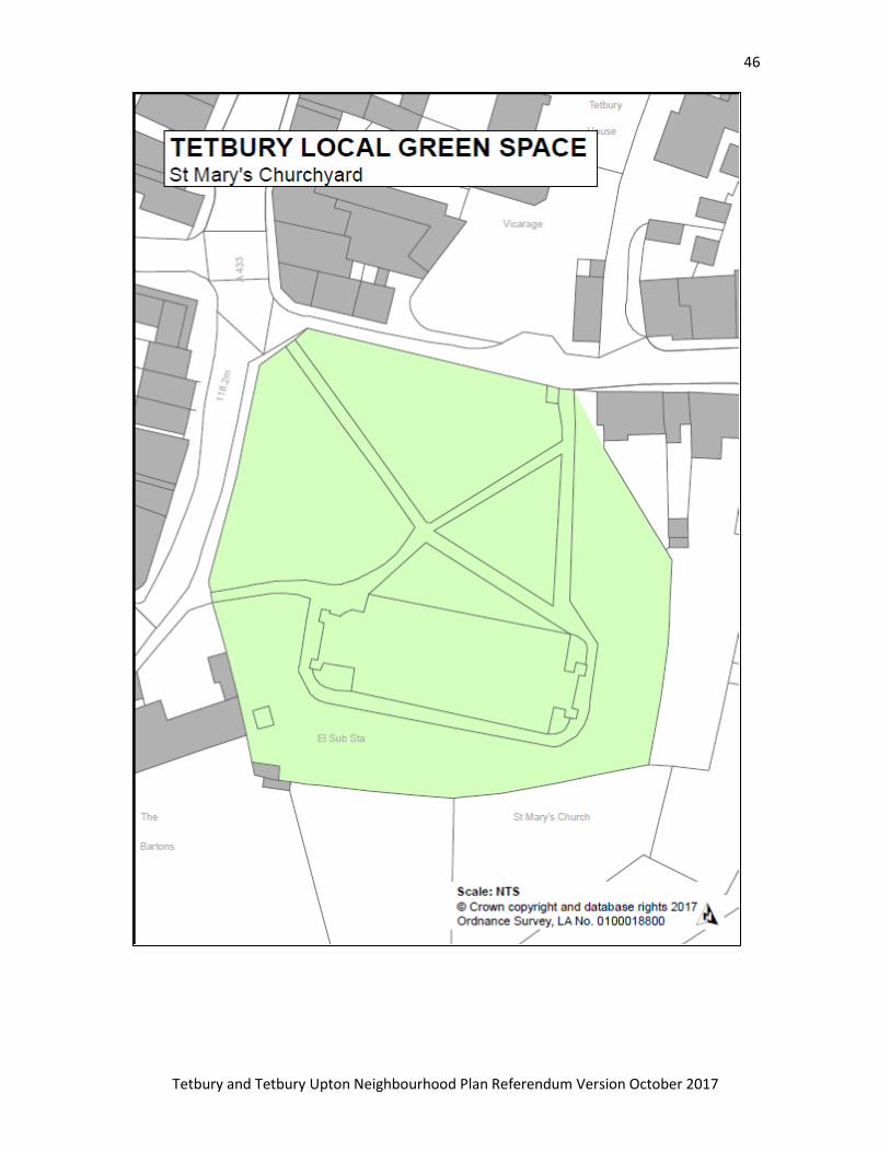
7. St Mary's Churchyard: Is a historic open space and important area of green within the
conservation area. It has many listed memorials within it, surrounds an iconic church and is an
area of tranquility in the mostly built environment of the Old Town.
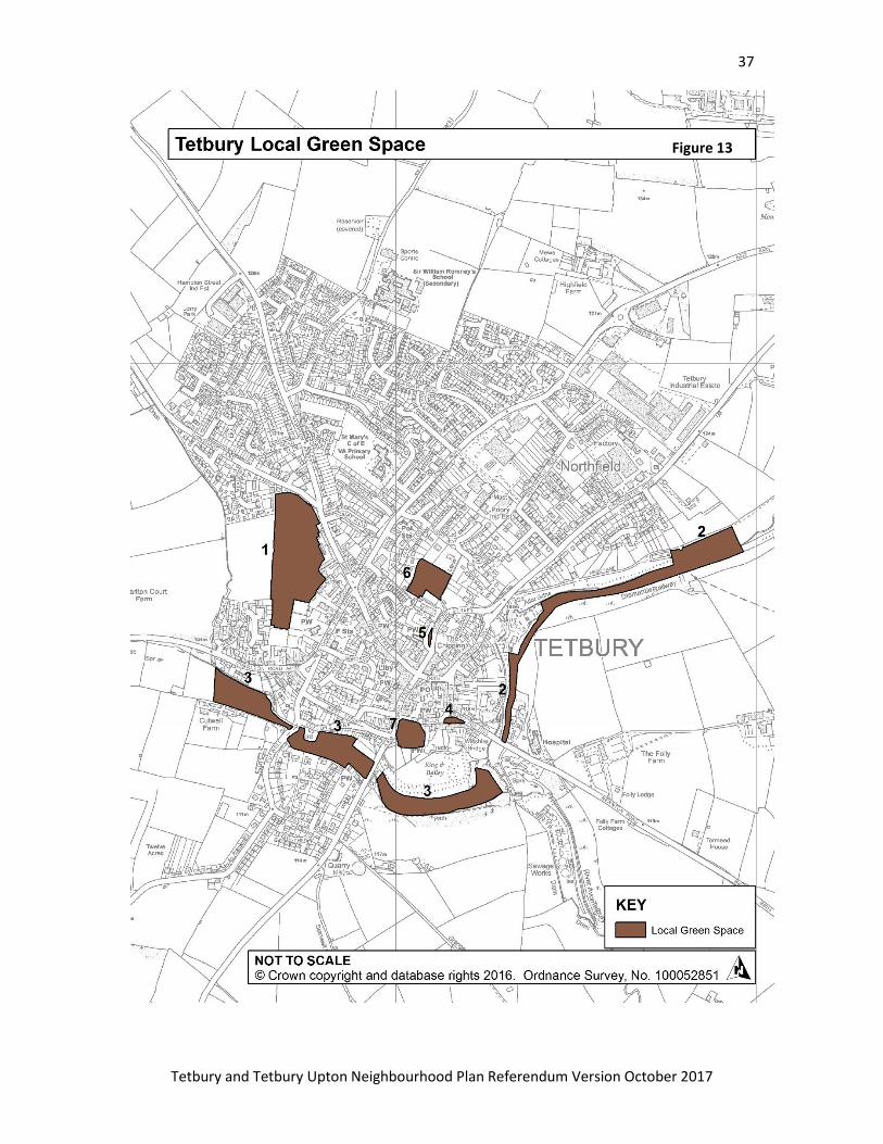
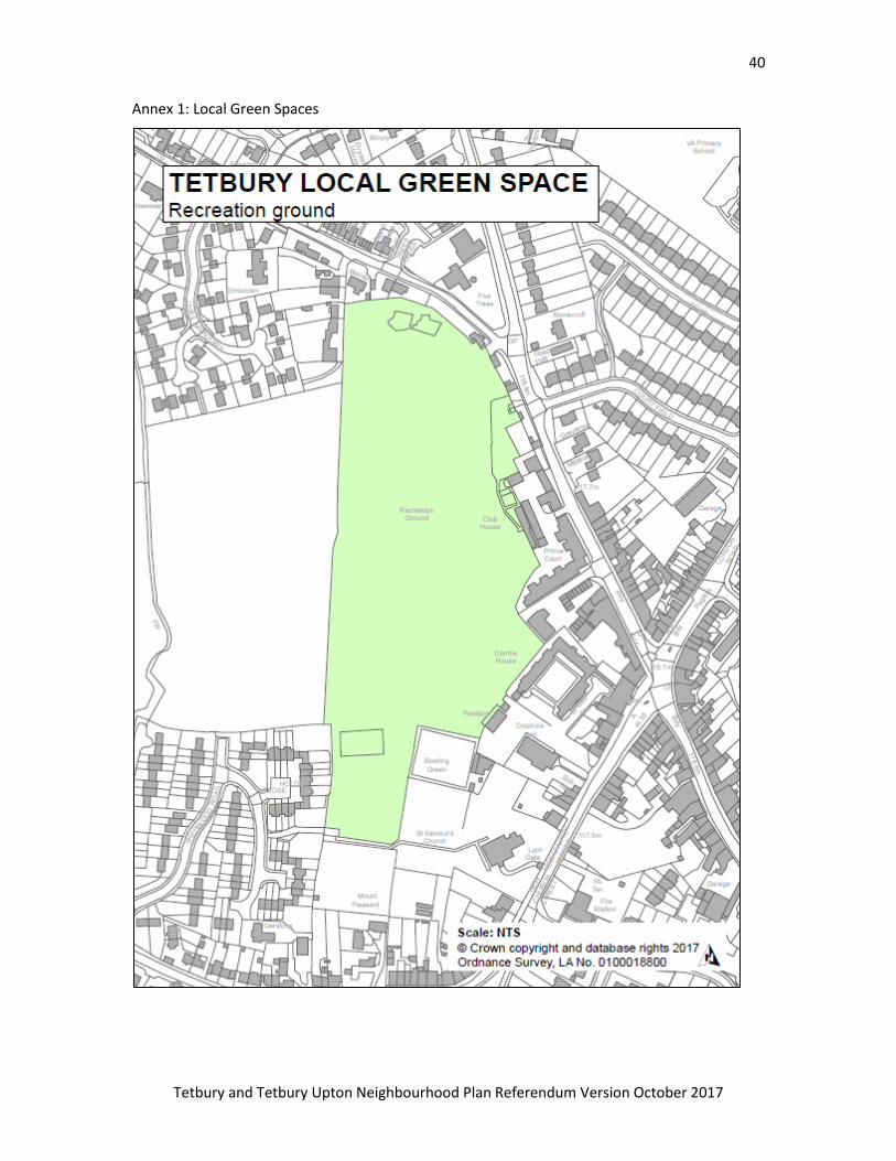
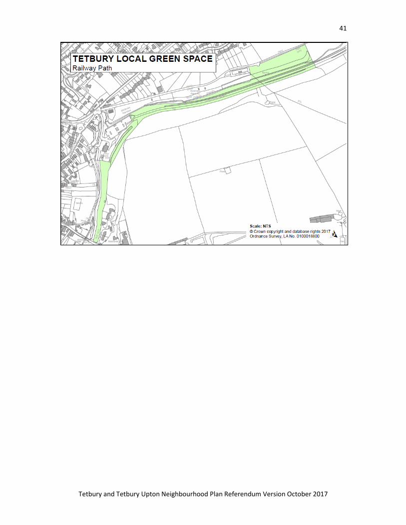
Policy 8: Local Green Space
The following areas (shown on Figure 14) are designated as Local Green Space:
1 Recreation Ground
2 Railway Path
3 Cutwell Valley
4 The Green
5 The Chipping Steps
6 Priory Grounds
7 St Mary's Churchyard
Development of Local Green Space is ruled out other than in very special circumstances.
Scale plans are enclosed at Annex 1, at the end of this document.
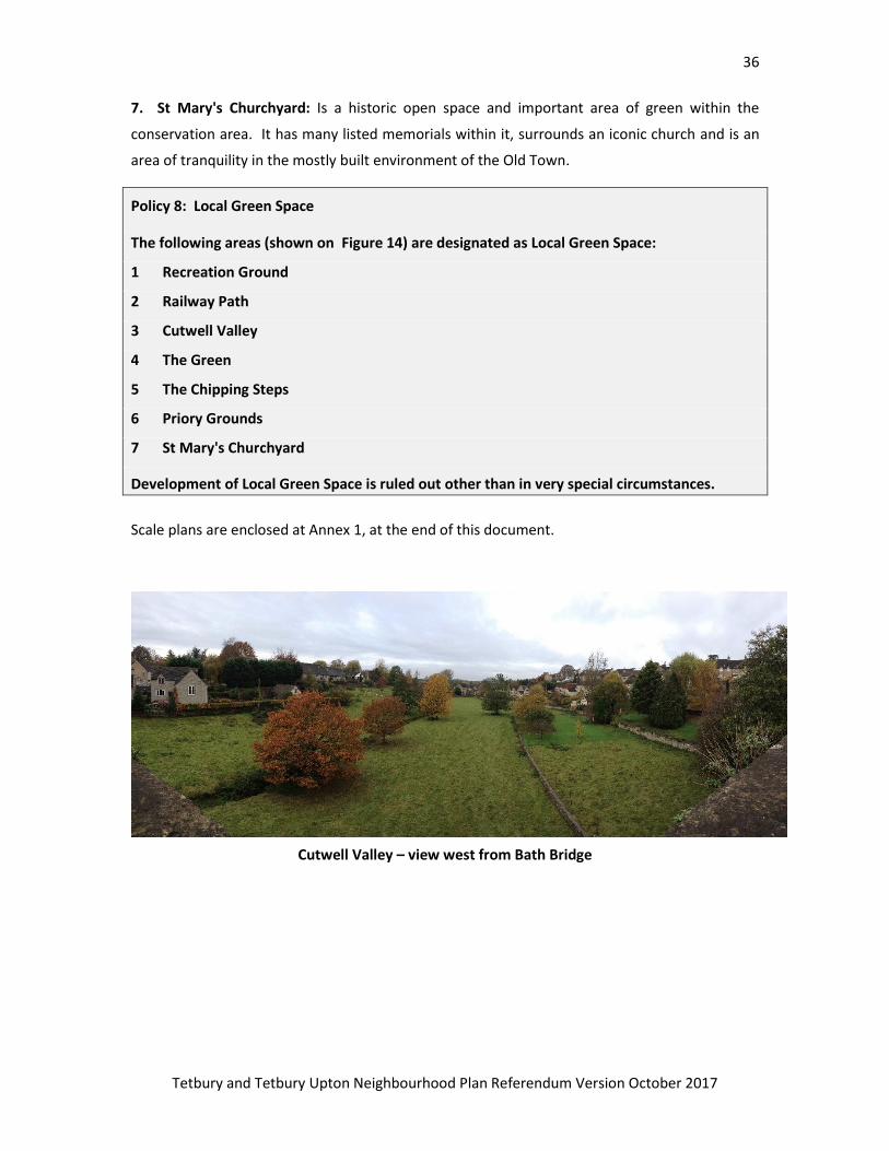
Cutwell Valley – view west from Bath Bridge
37
Tetbury and Tetbury Upton Neighbourhood Plan Referendum Version October 2017
Figure 13
38
Tetbury and Tetbury Upton Neighbourhood Plan Referendum Version October 2017
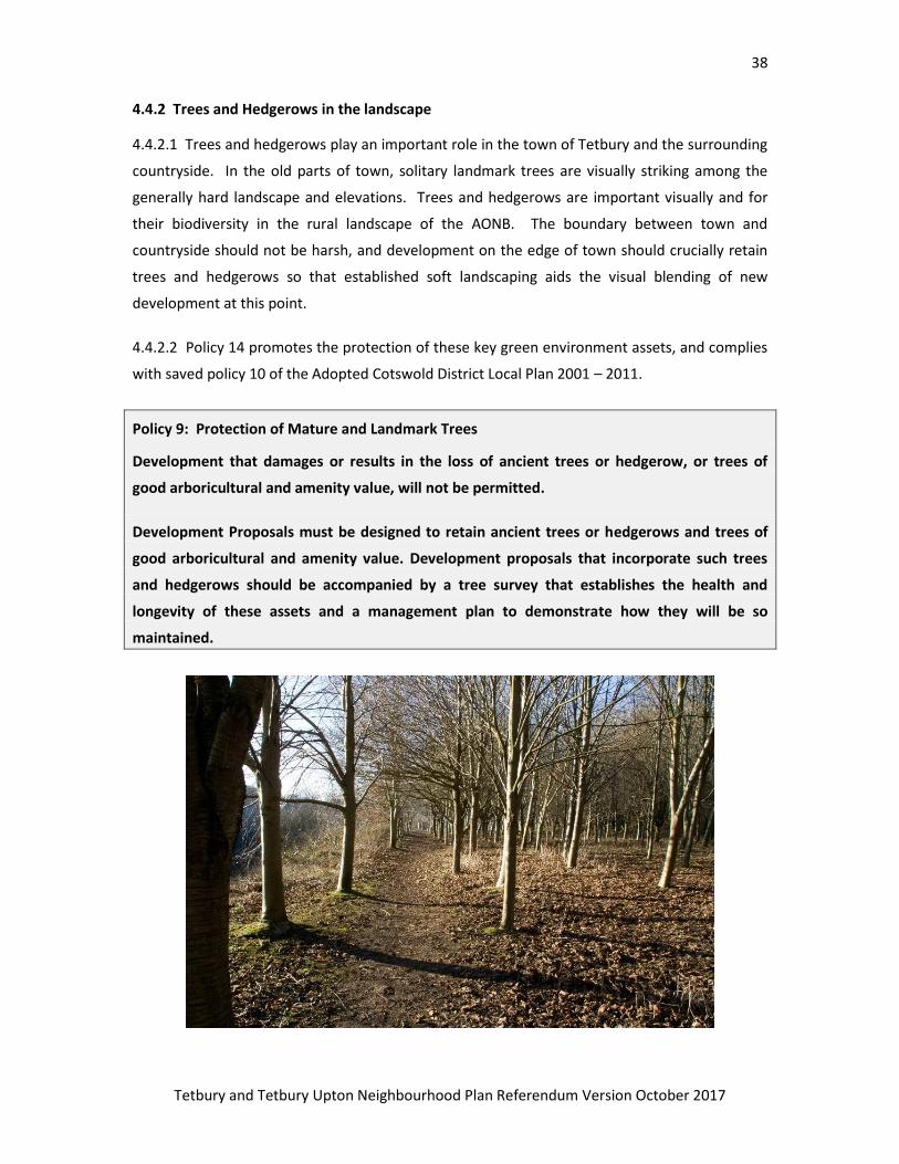
4.4.2 Trees and Hedgerows in the landscape
4.4.2.1 Trees and hedgerows play an important role in the town of Tetbury and the surrounding
countryside. In the old parts of town, solitary landmark trees are visually striking among the
generally hard landscape and elevations. Trees and hedgerows are important visually and for
their biodiversity in the rural landscape of the AONB. The boundary between town and
countryside should not be harsh, and development on the edge of town should crucially retain
trees and hedgerows so that established soft landscaping aids the visual blending of new
development at this point.
4.4.2.2 Policy 14 promotes the protection of these key green environment assets, and complies
with saved policy 10 of the Adopted Cotswold District Local Plan 2001 – 2011.
Policy 9: Protection of Mature and Landmark Trees
Development that damages or results in the loss of ancient trees or hedgerow, or trees of
good arboricultural and amenity value, will not be permitted.
Development Proposals must be designed to retain ancient trees or hedgerows and trees of
good arboricultural and amenity value. Development proposals that incorporate such trees
and hedgerows should be accompanied by a tree survey that establishes the health and
longevity of these assets and a management plan to demonstrate how they will be so
maintained.
39
Tetbury and Tetbury Upton Neighbourhood Plan Referendum Version October 2017
Reference and Evidence Documents
NPPF 2012
NPPG 2014 and as updated
Cotswold Local Plan 2001 – 2011
Emerging Cotswold District Local Plan 2011 - 2031
Study of land surrounding Key Settlements in Cotswold District: Update White Consultants 2014
Development strategy and Site Allocations Cotswold DC Jan 2015
Local Plan Planning Policies Cotswold DC Nov 2015 Reg18 Consultation
Tetbury Town and Tetbury Upton Housing Needs Survey Report July 2014 Gloucestershire Rural
Community Council
Tetbury Traffic Study 2014 Gloucestershire County Council
Tetbury Town Centre Urban Design and Public Realm Opportunities Evaluation Report - Atkins 2016
Rights of Way and Countryside Access Improvement Plan 2011-2026 Gloucestershire County Council
Cotswolds Conservation Board Management Plan 2013 - 2018
Cotswold Design Guide 2000 Cotswold District Council
Economy Evidence Paper 2014 Cotswold District Council
Tetbury Townscape and Character Assessment 2016
Cotswolds AONB Landscape Character Study 2002
CTC Residential Land Monitoring Statistics 2016
Cotswold AONB Position Statement on Neighbourhood Plans 2015
Civic Society Town Centre etc Assessment 2010
CDC SHMA, Further Update, Affordable Housing April 2016
40
Tetbury and Tetbury Upton Neighbourhood Plan Referendum Version October 2017
Annex 1: Local Green Spaces
41
Tetbury and Tetbury Upton Neighbourhood Plan Referendum Version October 2017
42
Tetbury and Tetbury Upton Neighbourhood Plan Referendum Version October 2017
43
Tetbury and Tetbury Upton Neighbourhood Plan Referendum Version October 2017
44
Tetbury and Tetbury Upton Neighbourhood Plan Referendum Version October 2017
45
Tetbury and Tetbury Upton Neighbourhood Plan Referendum Version October 2017
46
Tetbury and Tetbury Upton Neighbourhood Plan Referendum Version October 2017
47
Tetbury and Tetbury Upton Neighbourhood Plan Referendum Version October 2017
Appendix 1: Proposed cycle routes for Tetbury – CTC
48
Tetbury and Tetbury Upton Neighbourhood Plan Referendum Version October 2017
49
Tetbury and Tetbury Upton Neighbourhood Plan Referendum Version October 2017
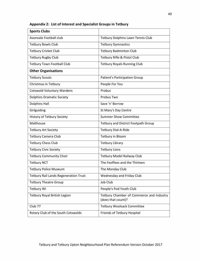
Appendix 2: List of Interest and Specialist Groups in Tetbury
Sports Clubs
Avonvale Football club Tetbury Dolphins Lawn Tennis Club
Tetbury Bowls Club Tetbury Gymnastics
Tetbury Cricket Club Tetbury Badminton Club
Tetbury Rugby Club Tetbury Rifle & Pistol Club
Tetbury Town Football Club Tetbury Royals Running Club
Other Organisations
Tetbury Scouts Patient's Participation Group
Christmas in Tetbury People For You
Cotswold Voluntary Wardens Probus
Dolphins Dramatic Society Probus Two
Dolphins Hall Save 'n' Borrow
Girlguiding St Mary's Day Centre
History of Tetbury Society Summer Show Committee
Malthouse Tetbury and District Footpath Group
Tetbury Art Society Tetbury Dial-A-Ride
Tetbury Camera Club Tetbury in Bloom
Tetbury Chess Club Tetbury Library
Tetbury Civic Society Tetbury Lions
Tetbury Community Choir Tetbury Model Railway Club
Tetbury NCT The Feoffees and the Thirteen
Tetbury Police Museum The Monday Club
Tetbury Rail Lands Regeneration Trust Wednesday and Friday Club
Tetbury Theatre Group Job Club
Tetbury WI People's Pod Youth Club
Tetbury Royal British Legion Tetbury Chamber of Commerce and Industry (does that count)?
Club 77 Tetbury Woolsack Committee
Rotary Club of the South Cotswolds Friends of Tetbury Hospital
50
Tetbury and Tetbury Upton Neighbourhood Plan Referendum Version October 2017
Additional to the Neighbourhood Plan and not part of the formal Plan:
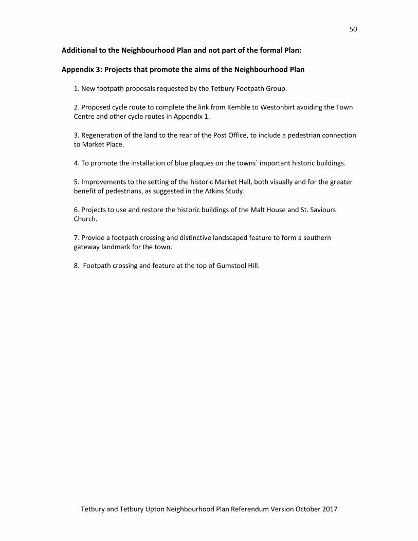
Appendix 3: Projects that promote the aims of the Neighbourhood Plan
1. New footpath proposals requested by the Tetbury Footpath Group.
2. Proposed cycle route to complete the link from Kemble to Westonbirt avoiding the Town Centre and other cycle routes in Appendix 1.
3. Regeneration of the land to the rear of the Post Office, to include a pedestrian connection to Market Place.
4. To promote the installation of blue plaques on the towns` important historic buildings.
5. Improvements to the setting of the historic Market Hall, both visually and for the greater benefit of pedestrians, as suggested in the Atkins Study.
6. Projects to use and restore the historic buildings of the Malt House and St. Saviours Church.
7. Provide a footpath crossing and distinctive landscaped feature to form a southern gateway landmark for the town.
8. Footpath crossing and feature at the top of Gumstool Hill.