the charter an introduction -...
TRANSCRIPT

Francesco SartiEuropean Space Agency(updated 2007)
Francesco SartiEuropean Space Agency(updated 2007)
International CharterSpace and Major DisastersInternational CharterSpace and Major Disasters
The Charter
An Introduction
The Charter
An Introduction
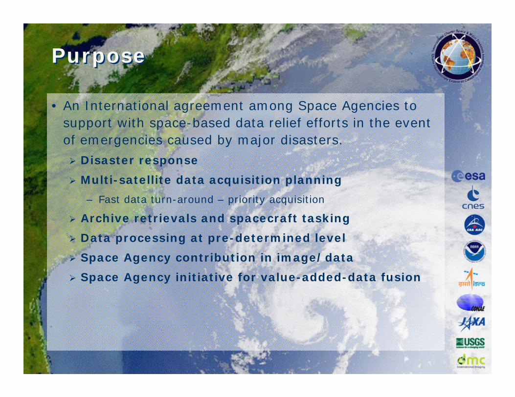
PurposePurpose
• An International agreement among Space Agencies to support with space-based data relief efforts in the event of emergencies caused by major disasters.
Disaster response
Multi-satellite data acquisition planning
– Fast data turn-around – priority acquisition
Archive retrievals and spacecraft tasking
Data processing at pre-determined level
Space Agency contribution in image/data
Space Agency initiative for value-added-data fusion

PurposePurpose
• Serves:
National civil protection, emergency & rescue organizations.
Extended to UN specialized agencies through UNOOSA:
– UNOSAT
– UNOCHA
– UNDP
• Has been activated over all continents for a variety of disasters.
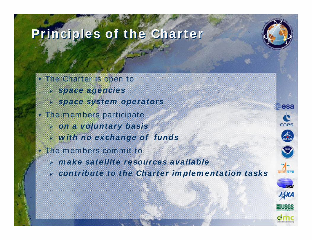
Principles of the CharterPrinciples of the Charter
• The Charter is open to space agenciesspace system operators
• The members participate on a voluntary basiswith no exchange of funds
• The members commit to make satellite resources availablecontribute to the Charter implementation tasks

Charter HistoryCharter History
• Following the UNISPACE III conference held in Vienna, Austria in June 1999.
ESA and CNES initiated the International Charter in July 1999.
• CSA (Canadian Space Agency) signed the Charter on October 20, 2000.
• Charter implementation by identifying and creating a number of functional units and preparing the necessary policies and plans.
• Charter declared operational as of November 1, 2000 after formal rehearsals and qualification tests.
• First activation of the Charter: Slovenian landslide November 11, 2000.
RADARSAT-1
ERS-2 and ENVISAT
SPOT 2, 4 & 5
IRS
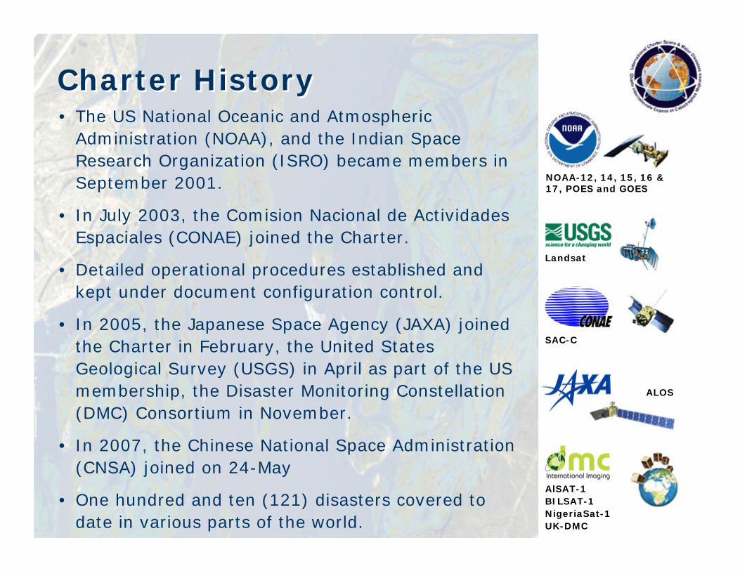
Charter HistoryCharter History• The US National Oceanic and Atmospheric
Administration (NOAA), and the Indian Space Research Organization (ISRO) became members in September 2001.
• In July 2003, the Comision Nacional de ActividadesEspaciales (CONAE) joined the Charter.
• Detailed operational procedures established and kept under document configuration control.
• In 2005, the Japanese Space Agency (JAXA) joined the Charter in February, the United States Geological Survey (USGS) in April as part of the US membership, the Disaster Monitoring Constellation (DMC) Consortium in November.
• In 2007, the Chinese National Space Administration (CNSA) joined on 24-May
• One hundred and ten (121) disasters covered to date in various parts of the world.
NOAA-12, 14, 15, 16 & 17, POES and GOES
Landsat
SAC-C
ALOS
AlSAT-1BILSAT-1NigeriaSat-1UK-DMC

Membership & Resources
MERIS, POES, GOES, SAC-C, MODIS TERRA/AQUA
Optical MR
ALOS AVNIR/PRISM, BILSAT, ALSAT, NigeriaSat, UKDMC, Beijing-1, CBERS-2
Ikonos, QuickBird, GeoEye
Optical HR/VHR
SPOT2, SPOT4, SPOT5, IRS-1C, IRS-P6, IRS-P5, CHRIS/PROBA, LANDSAT5, LANDSAT7, HYPERION, ASTER,
ERS-2, RADARSAT-1, ENVISAT, ALOS PALSARRadar

CSACSACanadaCanada
NOAANOAAUSGSUSGSUSAUSA
CONAECONAEArgentina
CNESCNESFranceFrance
ESAESADMCDMCEuropeEurope
ISROISROIndiaIndia
JAXAJAXAJapan
Charter Member AgenciesCharter Member Agencies

Charter Functional UnitsCharter Functional Units
• Authorized Users (AUs)
• On-Duty Operator (ODO)
• Emergency on-Call Officer (ECO)
• Project Manager (PM)
• Data processing and distribution facilities
• Value-Added Resellers (VARs)

Authorized User (AU)
On-Duty Operator(ODO)
Emergency on-Call Officer
(ECO)CSA
ESA
CNES
RADARSAT-1
ERS-2 and ENVISAT
SPOT-1, 2, 4 & 5
NOAA
ISRO
NOAA-12, 14, 15, 16 & 17, POES and GOES
IRSProject Manager
(PM)
End User (EU) Value-Added Reseller (VAR)
Disaster
CONAE SAC-C
JAXA ALOS
Charter Operational LoopCharter Operational Loop
USGS
DMC
Landsat
DMC Constellation

Information FlowInformation Flow
On-Duty Operator(ODO)
Request Form
Emergency On-Call Officer(ECO)
Project Manager(PM)
Satellite Planners(PA)
Phone, email, fax
Time scaleTime scale0
3hrs
daysMap product generation
Civil Protection Authority 24h/24h
Project Manager (PM)
Emergency on-Call Officer (ECO)
ESA ERS-2
CNES SPOT
CSA etc…RADARSAT
On Duty Operator(ODO)
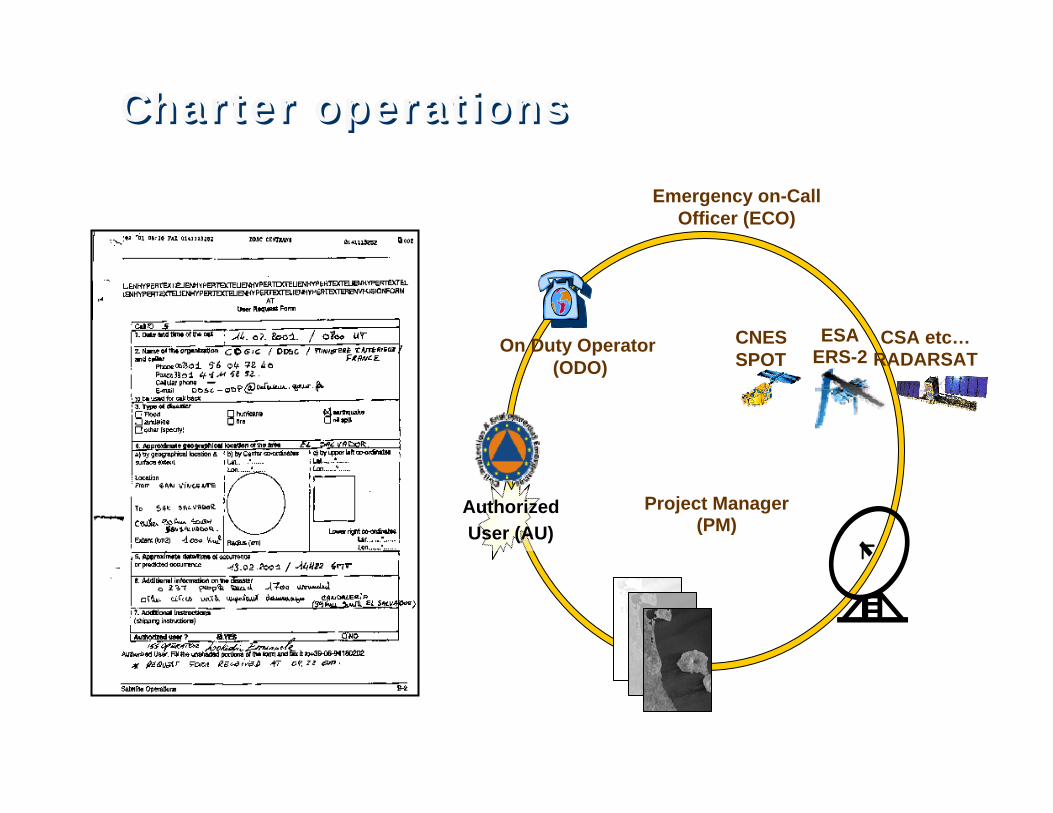
Charter operationsCharter operations
Authorized User (AU)

Project Manager (PM)
Emergency on-Call Officer (ECO)
ESA ERS-2
CNES SPOT
CSA etc…RADARSAT
On Duty Operator(ODO)
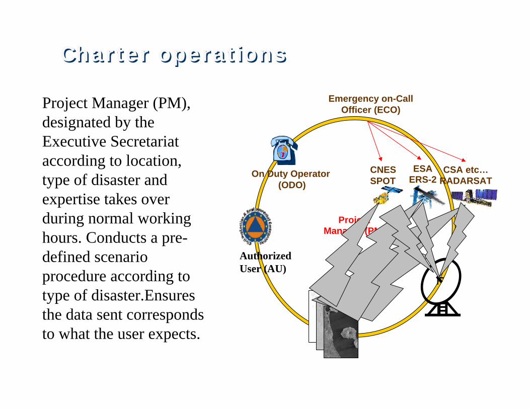
Authorized Users (AU) are the only Bodies authorised to request services. They usually represent the national Civil Protection Authorities (CPA) of the partner agencies. On-Duty Operator (ODO). Available 24h/day (ESA at ESRIN, Frascati Italy), receives calls from Authorized Users requesting space data and services; contacting the ECO within 1 hour. Emergency on - Call Officer (ECO): Available 24h/day. Analyses requests with the Authorized Usersand decides on most timely and appropriate actions according to the type of disaster, using updated procedures. ECO function rotates among partner agencies on a weekly basis.
Authorized User (AU)
Charter operationsCharter operations
Project Manager (PM)
Emergency on-Call Officer (ECO)
ESA ERS-2
CNES SPOT
CSA etc…RADARSAT
On Duty Operator(ODO)
Project Manager (PM), designated by the Executive Secretariat according to location, type of disaster and expertise takes over during normal working hours. Conducts a pre-defined scenario procedure according to type of disaster.Ensuresthe data sent corresponds to what the user expects.
Authorized User (AU)
Charter operationsCharter operations
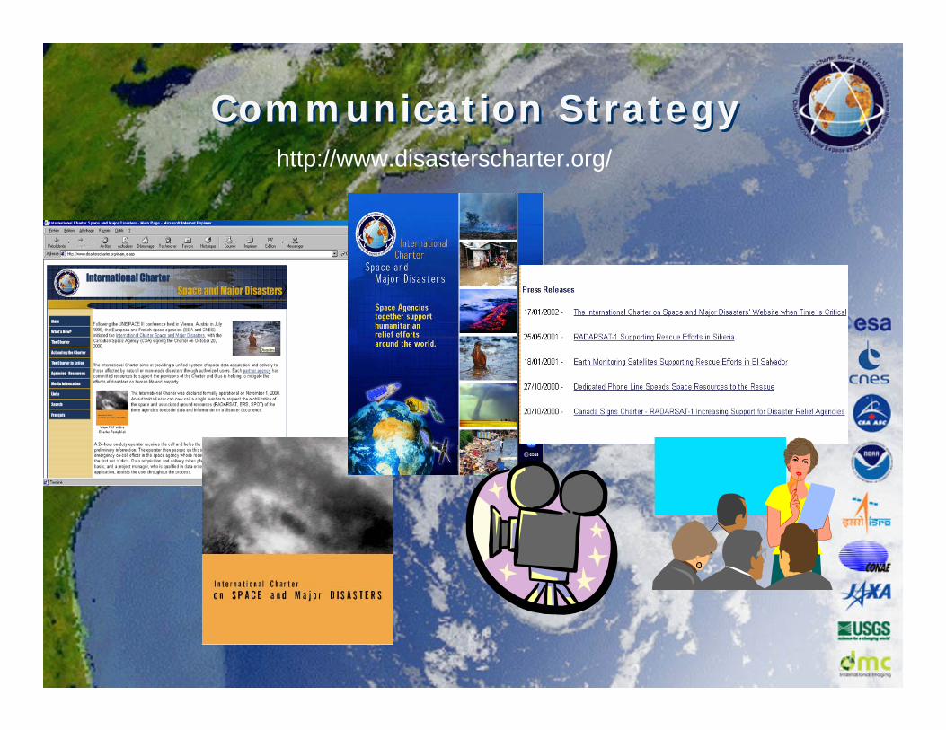
Communication StrategyCommunication Strategyhttp://www.disasterscharter.org/
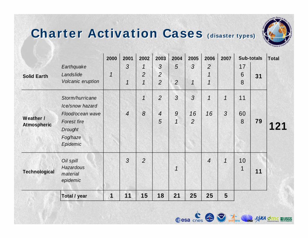
Charter Activation Cases (disaster types)Charter Activation Cases (disaster types)
2000 2001 2002 2003 2004 2005 2006 2007 TotalEarthquake 3 1 3 5 3 2 17Landslide 1 2 2 1 6Volcanic eruption 1 1 2 2 1 1 8
Storm/hurricane 1 2 3 3 1 1 11Ice/snow hazardFlood/ocean wave 4 8 4 9 16 16 3 60Forest fire 5 1 2 8DroughtFog/hazeEpidemic
Oil spill 3 2 4 1 10Hazardous material epidemic
1 1
Total / year 1 11 15 18 21 25 25 5
121
Sub-totals
Weather / Atmospheric
Solid Earth
Technological 11
79
31

Volcanic Eruption
Nyiragongo, Congo
FranceCaucassus, RussiaManitoba,
Canada
Austria 1&2
Czeck Republic 1&2Germany 1,2&3British Columbia, Canada
Etna, IT
Lena River, Russia
Earthquake
Oil Spill
Galapagos, Ecuador
El Salvador 1&2
Yucatan, MexicoGujarat, India
Northern FranceSaône, & Rhône France
Denmark
SloveniaLago Maggiore, IT
Nias Island, Indonesia
Gulf of Aden, Yemen
Lebanon 1&2
Galicia, Spain
Morocco
Central America
LandslideFlood/ocean waveStorm/hurricane
Stromboli, IT
Santa Fe, Argentina 1
Bingol, Turkey
Assam, India
Algeria 1&2
Soufrière, Montserrat
North Ossetia, Russia
Forest Fire
Portugal
Nepal
USA
Dominican Republic
Philippines 1&3
Bolivia
Nabire,Indonesia
Al Hoceïma, Morocco
Caprivi,Namibia
Hindu Kush, Afghanistan 1&2
Other
North Korea
Canary Islands, Spain
Hispaniola, Haiti
Tehran, Iran3
Patagonia, Argentina 2
Sudan 1&2
Georgetown, Guyana
Grenada Island
Bolivia 2
Gonaives, Haiti
Philippines 2&5
Guaranda Municipe, Colombia
Sweden
Banda Aceh, Indonesia
Cuddalore, India
Sri Lanka 1&2Galeras Volcano, Colombia
Rarotonga, Cook Islands
Charter Activation Cases (regions)Charter Activation Cases (regions)
Iran 1,2&4
Ethiopia 1
Kenya 1&2
Romania 1,2&3Bulgaria
British Columbia, Canada
ChinaIndia
Louisiana, USA
Florida, USA
Switzerland
Kashmir, PakistanKashmir, India
Comoros
English Channel 1&2
Hungary
Java, Indonesia 3&4
Suriname
Venezuela
Philippines 4Ethiopia 2&3
Pakistan 1&2
Argentina 3
Luxembourg
Somalia
Indonesia 5
Argentina 4
Bolivia-Paraguay-Argentina Mozambique

Data Units Used for Various DisastersData Units Used for Various Disasters
Earthquake 14317 activations
20 8 19 2320 8 19 23
VolcanicVolcanic EruptionEruption 72728 activations
New
Archive Archive
POES LANDSAT ENVISAT ERS SPOT RADARSAT IRS SAC-C DMCPOES LANDSAT ENVISAT ERS SPOT RADARSAT IRS SACPOES LANDSAT ENVISAT ERS SPOT RADARSAT IRS SAC--C DMCC DMC
21 8 61 29 20 2 2
813
44 29
32
14
15
11
9
2 11 4
16
53 15
4
10
13

Data Units Used for Various DisastersData Units Used for Various Disasters
5 14 15 14
Landslide 486 activations
202 154 346 200 194 9 2202 154 346 200 194 9 20 62 10 62 1
Flood 1188Flood 118860 activations
New
Archive Archive
POES LANDSAT ENVISAT ERS SPOT RADARSAT IRS SAC-C DMCPOES LANDSAT ENVISAT ERS SPOT RADARSAT IRS SACPOES LANDSAT ENVISAT ERS SPOT RADARSAT IRS SAC--C DMCC DMC
14
11
3
7
8
6
8
79
123
92
62
125
221
88
112
137
57
27 119 5210
1
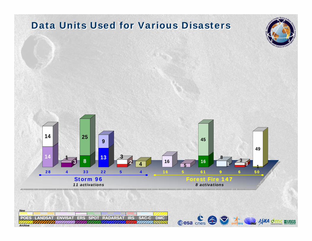
Data Units Used for Various DisastersData Units Used for Various Disasters
28 4 33 22 5 4
Storm 9611 activations
16 5 61 9 6 516 5 61 9 6 500
Forest Forest FireFire 1471478 activations
New
Archive Archive
POES LANDSAT ENVISAT ERS SPOT RADARSAT IRS SAC-C DMCPOES LANDSAT ENVISAT ERS SPOT RADARSAT IRS SACPOES LANDSAT ENVISAT ERS SPOT RADARSAT IRS SAC--C DMCC DMC
165
16
45
18
33
1
49
14
14
31 8
25
13
9
23
4

Data Units Used for Various DisastersData Units Used for Various Disasters
20 20 24 24 2 2
Oil Spill 9210 activations
3 1
Hazardous Material 51 activation
New
Archive Archive
POES LANDSAT ENVISAT ERS SPOT RADARSAT IRS SAC-C DMCPOES LANDSAT ENVISAT ERS SPOT RADARSAT IRS SACPOES LANDSAT ENVISAT ERS SPOT RADARSAT IRS SAC--C DMCC DMC
5
1520
5
19
3
21
11 11 14
1

France Meuse, Jan 2002France Meuse, Jan 2002

France Meuse river flooding 31/12/01France Meuse river flooding
31/12/01
34

Ossetia glacier, 27/09/02Ossetia glacier, 27/09/02

Alternating Polarization Mode, IS2, HH&HV, 19 August, 11:30 New ASAR mode =
improved capability for mapping flooded areas
Elbe floods. August 2002

Elbe floods. August 2002Elbe floods. August 2002
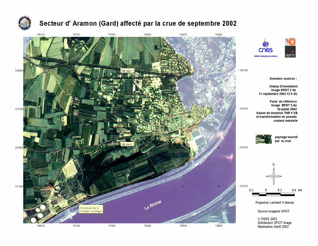
Gard floods, 9/09/02Gard floods, 9/09/02
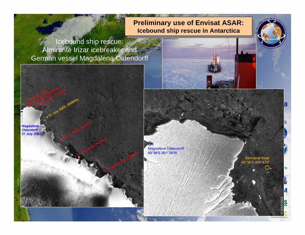
Icebound ship rescue: Almirante Irizar icebreaker and
German vessel Magdalena Oldendorff
Preliminary use of Envisat ASAR: Icebound ship rescue in Antarctica
Preliminary use of Envisat ASAR: Icebound ship rescue in Antarctica
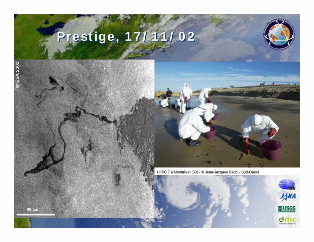
Prestige, 17/11/02Prestige, 17/11/02

Galapagos, oil spill, 26/01/01Galapagos, oil spill, 26/01/01
• On Jan 16, a major oil spill occurred near the Galapagos Islands
• Authorised User: EC Civil Protection Unit
• Project Manager: CSA
• These are two images of RADARSAT which were used to monitor the spill. The spill can be seen radiating (21/01) from the western tip of San Cristobal Island and moving northwest . The top image (30/01) shows the spill moving away northward

El Salvador 2nd earthquake, 14/02/01El Salvador 2nd earthquake, 14/02/01
Ortho-rectification SPOT done at IGN Espace
The Rio Jiboa valley blocked by huge landslides originating on both sides of the valley. The soil is made
volcanic ash (powdery and unstable)
Rio Jiboa Valley
San Vicente Volcano
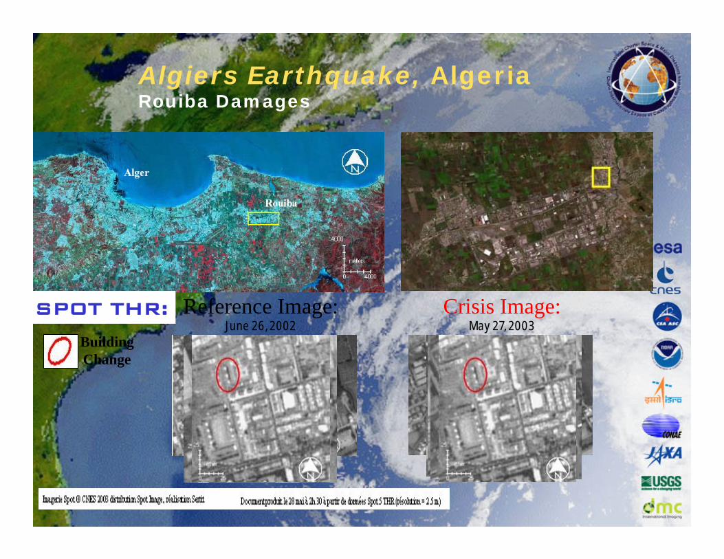
Algiers Earthquake, AlgeriaRouiba Damages
Reference Image:June 26, 2002
Crisis Image:May 27, 2003
SPOT THR:
Building Change

Algiers Earthquake, AlgeriaBoumerdes Damages
Building ChangeStructural Anomaly

Algiers Earthquake, AlgeriaChange Maps
Algiers RegionBoumerdes Region
Change detection maps produced using SPOT 4/5 images.
Changes appear in yellow
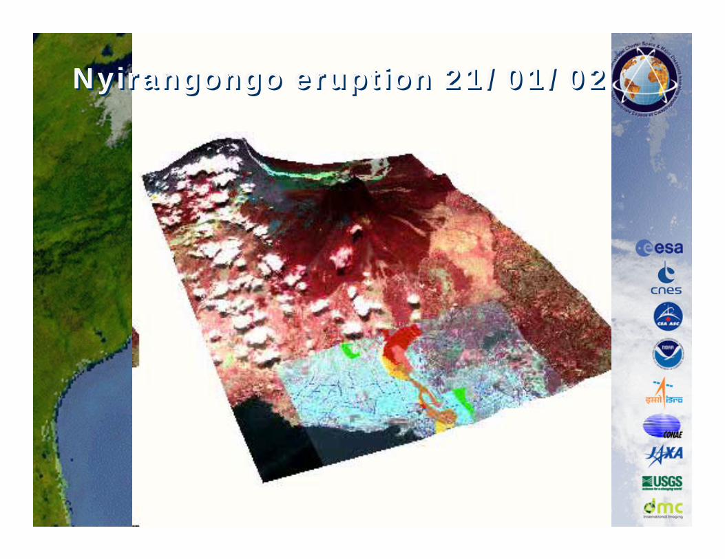
Nyirangongo eruption 21/01/02Nyirangongo eruption 21/01/02
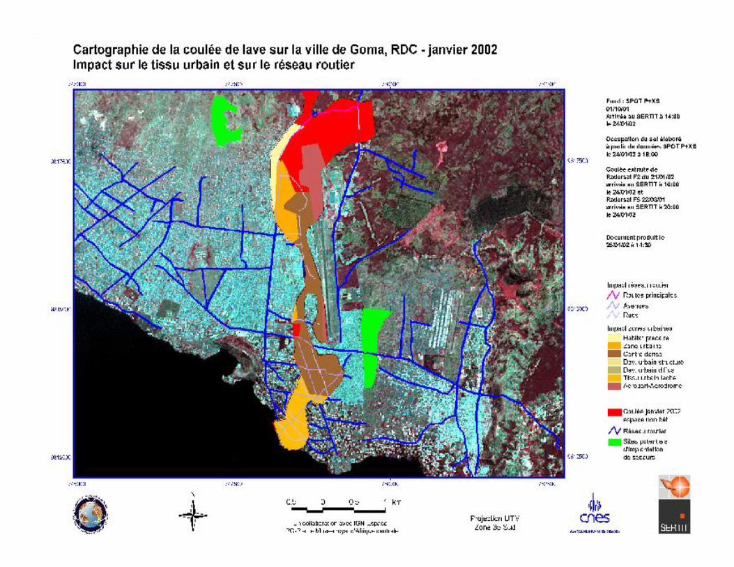
Nyirangongo eruption 21/01/02Nyirangongo eruption 21/01/02

ValidationValidation
Not detectedGood
False alarm