the lithological succession in east kutai basin, east kalimantan
TRANSCRIPT
International Journal of Science and Research (IJSR) ISSN (Online): 2319-7064
Volume 3 Issue 4, April 2014 www.ijsr.net
The Lithological Succession in East Kutai Basin, East Kalimantan, Indonesia: Revisited in a New
Data on Litho-Biostratigraphic Sunardi .E1, Isnaniawardhani .V 1, Cibaj .I2, Amiruddin3, Haryanto .I1
1Faculty of Geology, Padjadjaran University Jl. Raya Bandung Sumedang Km. 21 Jatinangor, Indonesia 45363
2Total E&P Indonesie, Balikpapan Head Office, Jakarta, Indonesia
3Geological Survey Center, Jl. Dipenogoro Bandung, Indonesia
Abstract: Discontinuous of lithological successive in the Kutai Basin was controlled by stratigraphic framework and geological structures. Integrated detail surficial mapping and laboratory analyses, supported by remote sensing interpretation, led to compile the lithological succession based on recent lithostratigraphy and biostratigraphy data. Serpentinite and deep marine turbiditic metasedimentbasement are the oldest exposure rocks in study area. Tertiary rocks was situated unconformably on basement with tectonic boundaries.Interval A (eq. Kuaro Formation) comprise of beach pebbly sandstone overlain by repeated channel sandstone, shale/silt and coal beds. Lepidocyclina limestone of Interval B (eq. Pamaluan Formation) represents carbonate build ups on a shelf in inner to outer neritic zone since Early Miocene (Te zone, N.5 to N.7 or NN.2 to NN.4 zone). They are overlain by turbiditic carbonate layers and conglomeraticsand in a continental slope, channel and leeve. Six siliciclastic prograding shallow marine of Interval C (eq. Bebulu Formation)unconformably rest on older rocks. The coarsening up carbonaceous shale/silt overlain by sandstone refected strom activities wasdeposited in shoreface in Middle Mocene (N.7-N.8 or NN.4 to NN.5), capped by outer shelf break transgressive carbonate build up(Tf.1-2 zones). A platform limestone were recorded on the top of this interval. Interval D (eq. Pulau Balang Formation) is composed of a number sequences reflecting fluvial, delta and shalow marine depositional environments. Thirty prograding sequences are observed in this interval that characterized by progressively shallower facies, such as fluviatile flood plain carbonaceous shale and silt covered by channel sandstone; prodelta shale/siltstone by deltaplain shale and coal beds. At Interval E (eq. Balikpapan Formation), several fluviatil retrograding sequences indicated by repeating fining upward channel sandstone, flood plain shale/mudstone and marsh coal beds during latest Middle to Late Miocene in supratidal and intertidal zone with brackish influence. A series of deltaic sequences, prodeltashales and coal beds, as well sandstone delta front, presented in various levels during Middle-Late Miocene at upper section (Interval F eq. Kampung Baru Formation). Pre-Tertiary basement and Tertiary rocks in East Kutai Basin were generated by structural geology inNW-SE and NE-SW directions; besides N-S minor trend. Tectonic activities controlled the successions concerning with lateral andvertical lithologic distributions.
Keywords: East Kutai Basin, prograding, lithologic succession, delta, lithostratigraphy, biostratigraphy.
1. Introduction
Kutai Basin constitute the largest Tertiary Basin in Western Indonesia having significant contribution in energy production in the world. The previous studies has investigated discontinuous of outcrop sections depicting the lithological sequences controlled by stratigraphic framework and geological structures of the basin. This study was conducted to recognize the lithological succession in eastern part of Kutai Basin based on detail surficial mapping and laboratory analyses. It provides the valuable information to support exploration activities regarding many hydrocarbon fields located in and around this area.
The East Kutai Basin is bounded to the north by the Mangkaliat Ridge, to the south by WNW-ESE trending Paternoster Ridge, to the east by Makasar Through, and to the west by older sediment sequences named as Lower Kutai Basin [6]. There is structural deepening of formation to the east, showing younger formation to the east, to the still active depocenter of the basin [5]. The oldest sediments consist of early to mid-Eocene sand and shale with coaly intervals resting on Jurrasic - Cretaceous basement. The late Eocene to early Miocene section is composed of platform
carbonates with local reefal developments. During mid-Miocene the carbonate platform was drowned by regressive sand, shale and coal. Clastic deposition continued until Pliocene when the major Meratus uplift was culminated. Fluvial, delta and shelf shift continuously seaward and landward during the geological time constituting a complex geological history of the basin [1]-[3]-[4] [6]-[7]-[9]-[10]-[11].
2. Methodology
The study area that situated in the easternmost of Kalimantan, administratively belongs to Balikpapan, Pasir, Samarinda and Tenggarong Regencies (Figure 1), has been regionally mapped by Geological Research and Development Centre [4] -[9]-[10]-[11]. Using a compilation of remote sensing interpretation based on Land sat Imagery ETM 7, DEM – SRTM and topographic maps supported by secondary data, the detailed geological mapping has been created on several traverses. The lithological successions exposed at sections of Muru River, Kuaro, Samuntai, Tewe River, Pakaso River, Longkali, Balikpapan – Pamaluan, Kota Bangun – Tenggarong – Samarinda and its surroundings. The mapping was conducted to identify geomorphological features, lithological type and any
Paper ID: 020131572 707

International Journal of Science and Research (IJSR) ISSN (Online): 2319-7064
Volume 3 Issue 4, April 2014 www.ijsr.net
general/special characteristics (mineral composition, grain size, weathering, diagnostic sedimentary structures, fossils content, contact surface), lateral and vertical stratigraphic distribution, as well as tectonically produced structural geology (lineation, joint, fold, fault) and deformation markers. Petrologic studies on lithologic samples are for the purposes of mineralogy composition, rocks texture and structure determining as well as environmental interpretation.
Figure 1: Easternmost of Kalimantan as the location of study
Thirty one samples which representative of each sequence were selected from 218 observation sites to biostratigraphyc analyses on foraminifera and nannofossil. This is focused in determining age and depositional environment to perform a comprehensive reconstruction geological setting. Age refers to appearance of index fossils, whereas depositional environment to fossils assemblages, abundance and diversity. Integrated data analyes suggested successive lithology in space and time stratigraphycal framework.
3. Result and Discussion
Integrated analyses of litho-and bio-stratigraphy have mapped lithological succession in East Kutai Basin, and grouped into: Pre-Tertiary basement and Tertiary rocks.
3.1 Pre-Tertiary Basement
The massive, green to dark blue, highly jointed, fractured and slickensided serpentinite ultrabasic rocks cropped out at Kuaro and Batukijang. In other location, deep marine turbiditic metasediment basement which comprises deformed polymict conglomerate, olistolite lime mud (< 20µm), and red to drak grey pelagic sediments are exposed at Tewe River. These oldest rocks have been interpreted correlating to Jurrasic Ultramafic Complex [10].
3.2 Tertiary Lithological Succesion
The oldest Tertiary rocks exposing in East Kutai basin is Early Miocene in age and situated un-conformably on basement with tectonic boundaries.
3.2.1. Interval A (eq. Kuaro Formation) At Muru River, a 21.5 m thick finning upward pebbly
sandstone of beach deposits with silica and siliceous clasts stated at the lowest of 144.5 m thick series. They are overlain by repeated 5 to 10 cm in thickness fine grained sandstone, 2-30 cm shale/silt and 20 cm coal beds respectively. Bioturbation, lenticular beddings with carbonaceous laminae, swamp organic materials content are founded in some locations (Figure 2). At Tewe River, the series are capped by several thick cross bearing sandstone beds of distributary channel developed that reflected a regresive phase.
Figure 2: Stratigraphic Section of Pre-Tertiary Basement and Tertiary Rocks (Intervals A , B) at Muru River
3.2.2. Interval B (eq. Pamaluan Formation)At Muru River, there is a succession of genetic lithological sequences with an observed total thickness more than 250 m of interbedded shales (2-5 m thick) and limestone beds. Lepydocyclina limestone represents carbonate build ups on a shelf since Early Miocene (dated as Te zone in Adam’s larger foraminiferal biostratigraphic zonation [2]. Lower Pamaluan limestone are covered by shale, contains nodules, rich in smaller benthic foraminifera. Dominated Asterorotalia, Bolivina, Bulimina, Cibicides, Elphidium,Lenticulina, Nonion, Pararotalia, and Uvigerina smaller benthic foraminifera in biostratigraphic samples indicated that this section was deposited in inner to middle neritic bathymetric zone (20-100 m depth). Appearance of Operculina, Heterostegina, Calcarina and Marginoporalarger foraminifera in Lepidocyclina limestone pointed out similar bathymetric ranges. Appearance of abundant Uvigerina, Bulimina, Bolivina, Brizalina and a variety of other froms including nodosariids in other samples represented an outer neritic zone (100-200 m depth).
These series are overlain by 30 to 50 cm thick each wacke/packstone and grainstone bedsets containing clay and serpentinite clast interbedding with dark grey shales.
Paper ID: 020131572 708
International Journal of Science and Research (IJSR) ISSN (Online): 2319-7064
Volume 3 Issue 4, April 2014 www.ijsr.net
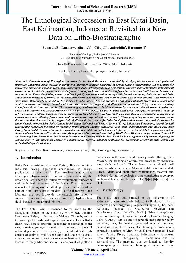
Gradded bedding, pararel lamination, convolute are dominant sedimentary structures especially at lower part of this turbiditic carbonate layers, while small flute cast is common on the base of upper sequences. Structural and textural sediment characterized channel and levee deposits. A slope carbonate with Zoophycos ichnofossil features resting on top this series. Based on previous paleontological
analyses, they are formed in acontinental [10]. At Pakaso River and near Samuntai, the 1.5 m thick, composed of well bed wackestone and grainstone with clay pebbles and serpentinite clasts overlain by carbonaceous sandstone and shales beds (Figure 3).
Figure 3: Stratigraphic Section of Interval B at Pakaso River and Samuntai Area
Interlaminated carbonaceous black shales and very fine grained sandstone, sometimes contains noduls and organic matters, capped on top of that carbonate beds. By turn, a composite of channel and leeve conglomeratic, quartz-lithic sandstone exhibiting coarsening and thickening up varied from 3 m to 12 m in thickness. Bouma’s sequences structures, slump, small load, flute cast and Zoophycosbioturbation are common in sandstone, as well ripple mark at the very top. This succession was formed at a coastal where sediment is supplied by marine process.
According to biostratigraphic analyses on limestone and shale samples, the whole sequences was deposited during Early Miocene. Te zone [2] is determinated to this interval by the association of Lepidocyclina (Eulepidina),Myogypsinoides and Spiroclypeous larger benthic foraminifera. That very low abundance of planktic foraminifera in this interval makes it difficulties the age interpretation. Appearance of Catapsydrax stainforthi and Globigerinella insueta in lower samples identified that
sediments is included in N.5 to N.7 zone of Blow’s foraminiferal biostratigraphic zonation [12]-[13]. In other hand, Discoaster druggi, Helicosphaera ampliaperta and Sphenolithus heteromorphus in samples as markers to NN.2 to NN.4 zone of Martini’s nannoplankton biostratigraphic zonation [8].
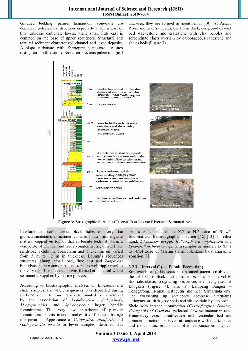
3.2.3. Interval C (eq. Bebulu Formation) Stratigraphically this section is situated unconformably on the total 750 m thick clastic sequences of upper interval B. Six siliciclastic prograding sequences are recognized at Longkali (Figure 4); also at Kampung Bangun – Tenggarong, Itchiku, Batuputih and near Samarinda city. The coarsening up sequences comprise alternating carbonaceous dark grey shale and silt overlain by sandstone. Shale with intense bioturbation (Glossofungites, Skolitos, Crosspodia of Cruziana) reflected slow sedimentation rate. Hummocky cross stratification and lenticular bed are common structures observed at sandstone with quartz, mica and minor lithic grains, and often carbonaceous. Typical
Paper ID: 020131572 709
International Journal of Science and Research (IJSR) ISSN (Online): 2319-7064
Volume 3 Issue 4, April 2014 www.ijsr.net
structures, redistributed fossils, well sorted grain refected strom activities in shoreface (inner shelf). Ammonia,Asterorotalia, Cibicides, Elphidium, Nonion, Pararotalia,Quinqueloculina and larger forms Calcarina, Heterostegina,Marginopora and Operculina benthic indicated an inner neritic setting (20-50 m depth). Only rarely are planktic forms recorded. Silisiclastic sequences were covered by trangressive thick limestone, somestimes contains of carbonaceous materials traces. Carbonate layers rich in
larger foraminifera (Discocyclina sp.) followed toward the top by layers with platy coral, and solitary corals respectively. They are accumulated as outer shelf break carbonate. It is consistent with presence of anomalinids, buliminids eg. Uvigerina, Bulimina, Bolivina/Brizalina and a variety of benthic forms including nodosariids that suggested an outer neritic zone (100-200 m). On the top, a platform limestone was observed near Krayan Area.
Figure 4: Stratigraphic Section of Interval C at Longkali Area
Appearance of Lepidocyclina (Nephrolepidina) and Myogypsina larger foraminifera in the interval is sugested Tf.1-2 zones [2] or equal with latest early to middle Miocene. Age at this interval dated as N.7-N.8 zones [12]-[13] due to appearance of Globigerinatella insueta and Hastigerina praesiphonifera planktic foraminifera. Sphenolithus heteromorphus dan Calcidiscus macyntyreinannofossils in NN.4 to NN.5 zones suggested range in equal age [8].
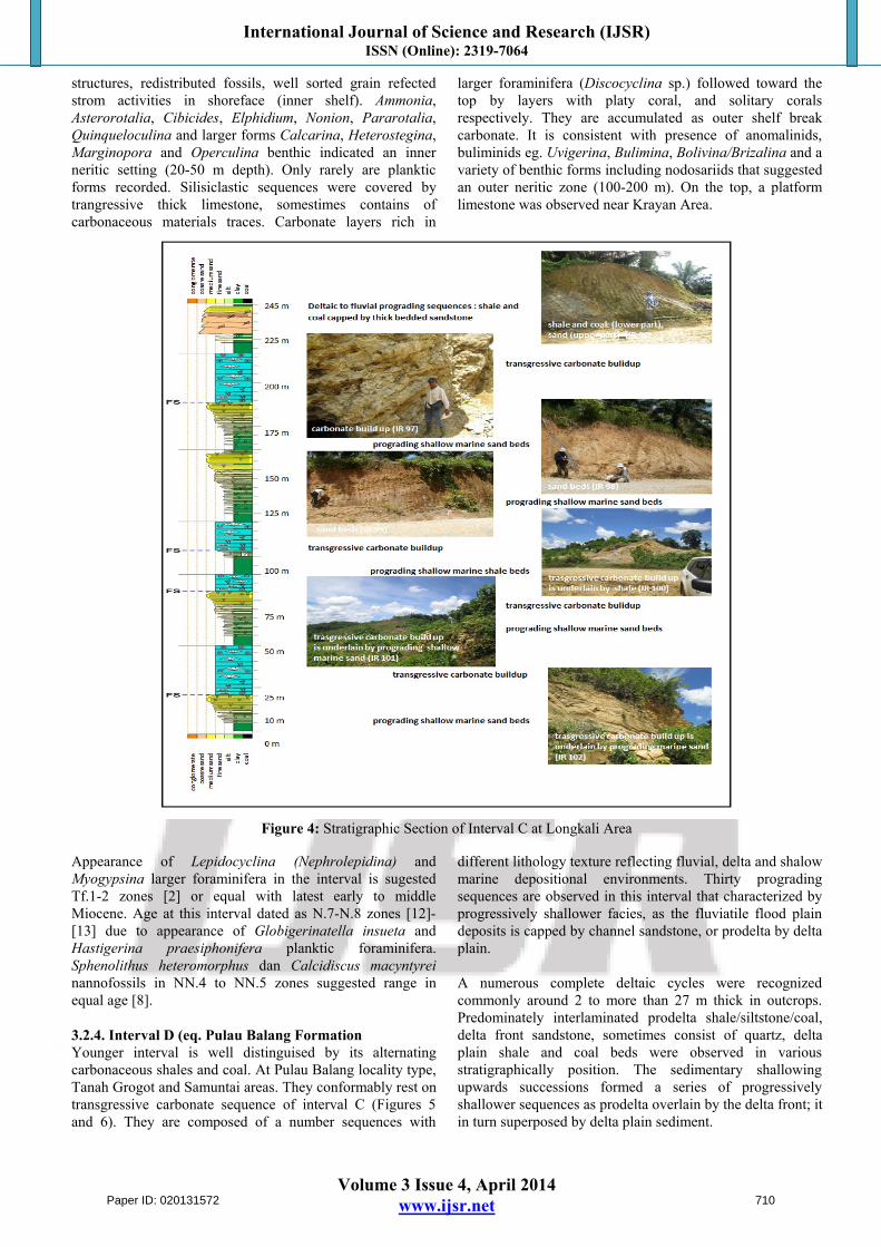
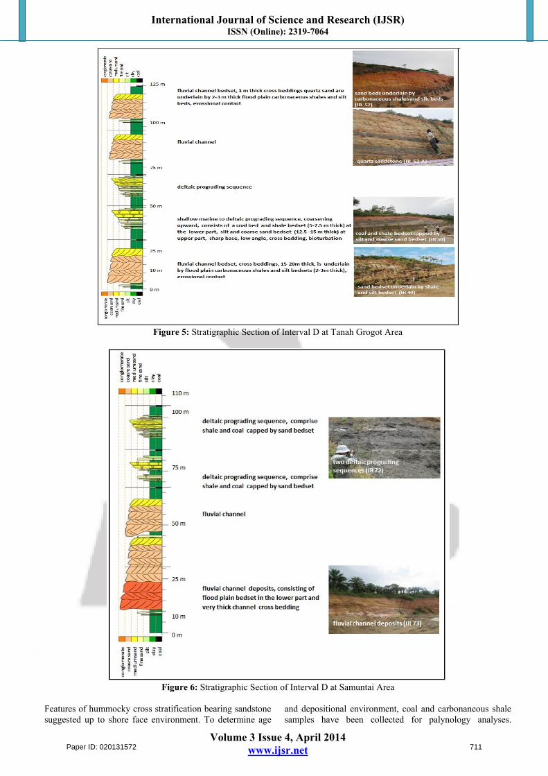
3.2.4. Interval D (eq. Pulau Balang FormationYounger interval is well distinguised by its alternating carbonaceous shales and coal. At Pulau Balang locality type, Tanah Grogot and Samuntai areas. They conformably rest on transgressive carbonate sequence of interval C (Figures 5 and 6). They are composed of a number sequences with
different lithology texture reflecting fluvial, delta and shalow marine depositional environments. Thirty prograding sequences are observed in this interval that characterized by progressively shallower facies, as the fluviatile flood plain deposits is capped by channel sandstone, or prodelta by delta plain.
A numerous complete deltaic cycles were recognized commonly around 2 to more than 27 m thick in outcrops. Predominately interlaminated prodelta shale/siltstone/coal, delta front sandstone, sometimes consist of quartz, delta plain shale and coal beds were observed in various stratigraphically position. The sedimentary shallowing upwards successions formed a series of progressively shallower sequences as prodelta overlain by the delta front; it in turn superposed by delta plain sediment.
Paper ID: 020131572 710
International Journal of Science and Research (IJSR) ISSN (Online): 2319-7064
Volume 3 Issue 4, April 2014 www.ijsr.net
Figure 5: Stratigraphic Section of Interval D at Tanah Grogot Area
Figure 6: Stratigraphic Section of Interval D at Samuntai Area
Features of hummocky cross stratification bearing sandstone suggested up to shore face environment. To determine age
and depositional environment, coal and carbonaneous shale samples have been collected for palynology analyses.
Paper ID: 020131572 711
International Journal of Science and Research (IJSR) ISSN (Online): 2319-7064
Volume 3 Issue 4, April 2014 www.ijsr.net
Presence of Florschuetzia levipoli, Spiniferites romusus and marine dinoflagelates persumed that this interval is formed in marine infuence condition. It is probably deposited in mangrove to sublittoral.
3.2.5. Interval E (eq. Balikpapan Formation) Several fluviatil retrograding sequences indicated by repeating fining upward channel sandstone, flood plain shale/mudstone and marsh coal beds. Sandstone are medium to coarse grained, occasionally fine grianed, predominately composed by quartz with glauconite traces, generally calcareous. Shale are grey, generally non calcareous and common contains of carbonaceous material. At upper part, 10 - 70 m thick a fining upward stacking pattern fluvial sandstone covered coal beds which are present with maximum thickness of 10 m. Log wood fossils are often founded in this overbank sandstone. This interval is formed Middle to Late Miocene in age in a supratidal and intertidal zone [10] with occasional brackish water influences.
3.2.6. Interval F (eq. Kampung Baru Formation)A series of prograding sequences of coarsening up deltaic deposits follow upper in the section. By turn, there was identified a number of deltaic sedimentation cycles of Kampung Baru Formation. The prodelta shales and coal beds as well sandstone delta front presented in various levels during Middle-Late Miocene.
3.3. Geological Structure
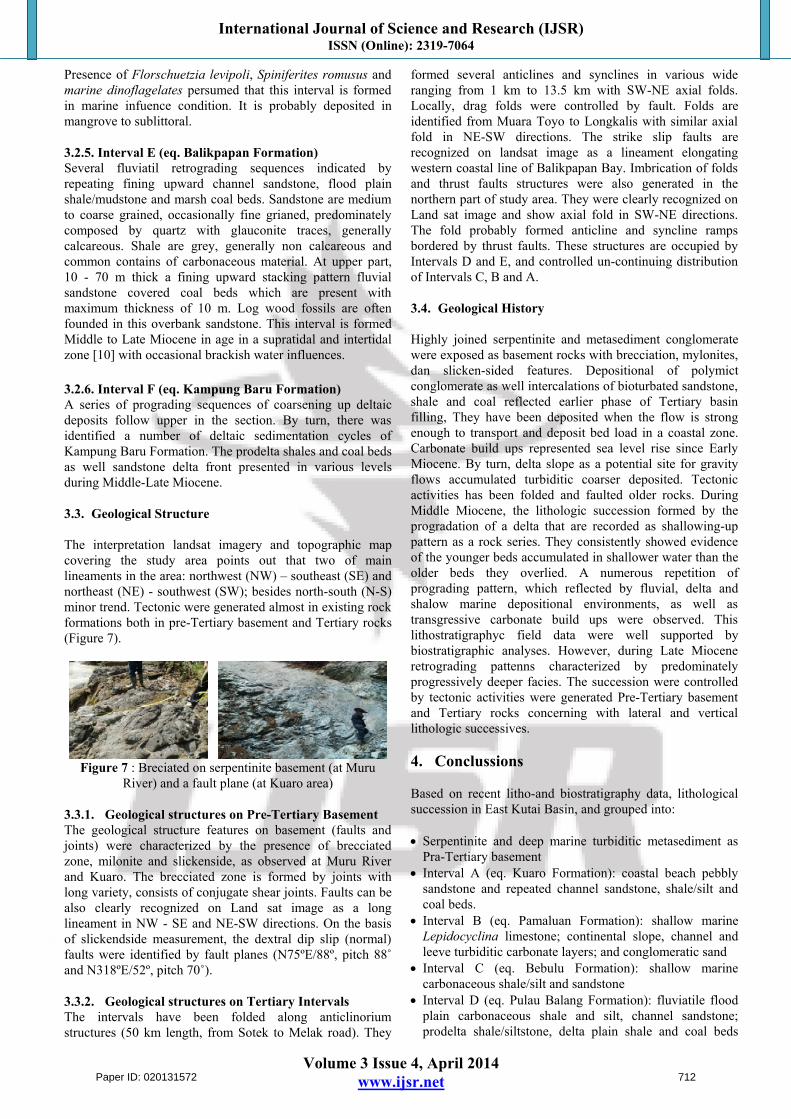
The interpretation landsat imagery and topographic map covering the study area points out that two of main lineaments in the area: northwest (NW) – southeast (SE) and northeast (NE) - southwest (SW); besides north-south (N-S) minor trend. Tectonic were generated almost in existing rock formations both in pre-Tertiary basement and Tertiary rocks (Figure 7).
Figure 7 : Breciated on serpentinite basement (at Muru River) and a fault plane (at Kuaro area)
3.3.1. Geological structures on Pre-Tertiary Basement The geological structure features on basement (faults and joints) were characterized by the presence of brecciated zone, milonite and slickenside, as observed at Muru River and Kuaro. The brecciated zone is formed by joints with long variety, consists of conjugate shear joints. Faults can be also clearly recognized on Land sat image as a long lineament in NW - SE and NE-SW directions. On the basis of slickendside measurement, the dextral dip slip (normal) faults were identified by fault planes (N75ºE/88º, pitch 88˚and N318ºE/52º, pitch 70˚).
3.3.2. Geological structures on Tertiary Intervals The intervals have been folded along anticlinorium structures (50 km length, from Sotek to Melak road). They
formed several anticlines and synclines in various wide ranging from 1 km to 13.5 km with SW-NE axial folds. Locally, drag folds were controlled by fault. Folds are identified from Muara Toyo to Longkalis with similar axial fold in NE-SW directions. The strike slip faults are recognized on landsat image as a lineament elongating western coastal line of Balikpapan Bay. Imbrication of folds and thrust faults structures were also generated in the northern part of study area. They were clearly recognized on Land sat image and show axial fold in SW-NE directions. The fold probably formed anticline and syncline ramps bordered by thrust faults. These structures are occupied by Intervals D and E, and controlled un-continuing distribution of Intervals C, B and A.
3.4. Geological History
Highly joined serpentinite and metasediment conglomerate were exposed as basement rocks with brecciation, mylonites, dan slicken-sided features. Depositional of polymict conglomerate as well intercalations of bioturbated sandstone, shale and coal reflected earlier phase of Tertiary basin filling, They have been deposited when the flow is strong enough to transport and deposit bed load in a coastal zone. Carbonate build ups represented sea level rise since Early Miocene. By turn, delta slope as a potential site for gravity flows accumulated turbiditic coarser deposited. Tectonic activities has been folded and faulted older rocks. During Middle Miocene, the lithologic succession formed by the progradation of a delta that are recorded as shallowing-up pattern as a rock series. They consistently showed evidence of the younger beds accumulated in shallower water than the older beds they overlied. A numerous repetition of prograding pattern, which reflected by fluvial, delta and shalow marine depositional environments, as well as transgressive carbonate build ups were observed. This lithostratigraphyc field data were well supported by biostratigraphic analyses. However, during Late Miocene retrograding pattenns characterized by predominately progressively deeper facies. The succession were controlled by tectonic activities were generated Pre-Tertiary basement and Tertiary rocks concerning with lateral and vertical lithologic successives.
4. Conclussions
Based on recent litho-and biostratigraphy data, lithological succession in East Kutai Basin, and grouped into:
Serpentinite and deep marine turbiditic metasediment as Pra-Tertiary basement
Interval A (eq. Kuaro Formation): coastal beach pebbly sandstone and repeated channel sandstone, shale/silt and coal beds.
Interval B (eq. Pamaluan Formation): shallow marine Lepidocyclina limestone; continental slope, channel and leeve turbiditic carbonate layers; and conglomeratic sand
Interval C (eq. Bebulu Formation): shallow marine carbonaceous shale/silt and sandstone
Interval D (eq. Pulau Balang Formation): fluviatile flood plain carbonaceous shale and silt, channel sandstone; prodelta shale/siltstone, delta plain shale and coal beds
Paper ID: 020131572 712
International Journal of Science and Research (IJSR) ISSN (Online): 2319-7064
Volume 3 Issue 4, April 2014 www.ijsr.net
delta plain. Interval E (eq. Balikpapan Formation): channel sandstone,
flood plain shale/mudstone and marsh coal beds Interval F (eq. Kampung Baru Formation): prodelta shales
and coal beds, sandstone delta front
Extensive prograding phases as shallowing-up sequences were recorded since Early Miocene (formation of Intervals A, B, C and D) in fluvial, delta and shallow marine depositional environments), where as retrograding phases were significantly observed during Late Miocene (Interval E formation). Interval F unconformably rest on older rocks and presented prograding deposits.
Limestone as carbonate build ups formed on a shelf in inner to outer neritic zone during Early Miocene (Te zone) and in outer neritic during Middle Miocene (Tf.1-2 zones). A platform carbonate were recorded in latest Middle Miocene. Tertiary rocks was situated unconformably on basement with tectonic boundaries. Tectonic activities were indicated by features of structural geology in NW-SE, NE-SW and N-S directions.
References
[1] Asikin, “Tectonic Evolution of Kutai Basin,” Vico Indonesia, 1995
[2] C.G. Adams, “A Reconsideration of the East Indian Letter Classification of the Tertiary,” Bulletin of the British Museum (Natural History) Geologi, Vol. 19 (3), 1970.
[3] G.P. Allen and Chambers J. L. C., Sedimentation in the Modern and Miocene Mahakam Delta, Indonesia Petroleum Association, Jakarta, 1998.
[4] Heryanto and Sanyoto, “Geological Map of the Amuntai Quadrangle, Kalimantan”, Geological Research and Development Center, 2007.
[5] I. Cibaj, “A fluvial Series in the Middle Miocene of Kutai Basin: A Major Shilf from Proto-Mahakan Shallow Marine to the Continental Environment,” in Proceedings of AAPG Hedberg Conference, Jakarta, Indonesia, pp. 1-11, 2009.
[6] I. Cibaj, “Fluvial Channel Complexes in the Middle-Miocene of Lower Kutai Basin, East Kalimantan – The Stacking Pattern of Sediments,” in Procedings of Indonesian Petroleoum Association, Thirty Annual Convention, Jakarta, p. 53-67, 2010.
[7] I. Cibaj, Slope Deposits-transition to Shelf Sand Lobes and Trangressive Carbonates Middle Miocene Deltaic Deposits,” Total Indonesie IPA Mahakam Field Trip, 2011.
[8] Martini, “Standard Tertiary and Quaternary Calcareous Nannoplankton Zonation.” In Farinaci(A) Ed, Procedings of 2nd Planktonic Conference, Vol. 2, Rome, pp. 739-785, 1970
[9] N. Suwarna and T. Apandi, “Geological Map of Longiram Quadrangle, Kalimantan,” Geological Research and Development Center, 2010
[10] S. Hidayat and I. Umar., “Geological Map of the Balikpapan Quadrangle, Kalimantan”, Geological Research and Development Center, 1994.
[11] S. Supriatna, Sukardi and E. Rustandi., “Geological Map of the Samarinda Quadrangle, Kalimantan”, Geological Research and Development Center, 2011.
[12] W.H. Blow, “Late Middle Eocene to Recent Planktonic Foraminiferal Biostratigraphy,” in Procedings of International Conference Planktonic Microfosil 1 st., Geneva (1967), Leiden, E.J. Brill, V.1, pp. 199 – 422, 1969
[13] W.H. Blow, The Cenozoic Globigerinida, Leiden, E.J Brill, 1979
Author Profile
Edy Sunardi is a lecture on Sedimentology and Quarternary Geology in Faculty of Geology Padjadjaran University. He is interested in sedimentology and stratigraphy research (including magnetostratigraphy).
Vijaya Isnaniawardhani is a lecture on Micropaleontology in Faculty of Geology Padjadjaran University. She is interested in biostratigraphy and biofacies research based on foraminifera and nannofossils.
Irfan Cibaj is a consultant at working for Total Indonesie. He works as silicoclastic sedimentologist at Total E&P
Amiruddin is a senior researcher in Geological Survey Center, Bandung
Iyan Haryanto is a lecture on Structural Geology in Faculty of Geology Padjadjaran University.
Paper ID: 020131572 713