the many paths to a common ground: a comparison of
TRANSCRIPT
International Global Navigation Satellite Systems Society IGNSS Symposium 2011
University of New South Wales, Sydney, NSW, Australia
15 – 17 November 2011
The many paths to a common ground: A comparison
of transformations between GDA94 and ITRF
Joel Haasdyk Survey Infrastructure and Geodesy, Land and Property Information
NSW Department of Finance & Services, Bathurst NSW 2795, Australia (ph)+61 2 6332 8485, (fax)+61 2 6332 8479, [email protected]
Volker Janssen Survey Infrastructure and Geodesy, Land and Property Information
NSW Department of Finance & Services, Bathurst NSW 2795, Australia (ph)+61 2 6332 8426, (fax)+61 2 6332 8479, [email protected]
ABSTRACT
Digital positioning data are currently collected and stored in a variety of reference frames or datums. Before different data can be compared or combined, they must be brought together onto the same datum. The practice of transforming from one datum to another is certainly not difficult and the necessary parameters are available in many different software packages. To complicate this issue, today’s datum of choice may well be a global, and therefore dynamic, datum such as the International Terrestrial Reference Frame (ITRF). In a dynamic datum it is important to note both the datum realisation (e.g. ITRF2000, ITRF2005, ITRF2008, etc.) and the epoch at which the data are valid. We must also be able to propagate the data from one epoch to another, if desired, by taking tectonic motion into account. Since the Geocentric Datum of Australia (GDA94) was introduced there have been several refinements of ITRF, and also refinements of the transformation parameters between GDA94 and ITRF. As a result, there are many different combinations of transformation and propagation by which the data can be ‘moved’ from GDA94 to a particular ITRF and vice versa. This paper demonstrates that differences up to several centimetres in both horizontal and vertical coordinates can result from following different ‘paths of transformation’ and suggests that some but not all users need to be careful of the methods employed by their software. Additionally, what is often not considered is the effect of the formal errors in the transformation procedure on the estimated error of the output coordinates. We discuss and demonstrate these effects for several sample transformations to give the reader a better understanding of the effect of transformations on the quality of their data. KEYWORDS: Coordinate transformation, tectonic motion, GDA94, ITRF, error propagation.
1. INTRODUCTION There is no doubt that positioning plays an increasingly important role in modern society. The Spatial Information Council of Australia and New Zealand (ANZLIC, 2010) reports that local economic benefits of billions of Australian dollars can be achieved through accurate and reliable positioning capabilities in the fields of agriculture, mining, engineering and construction, asset management, logistics, navigation and emergency management.
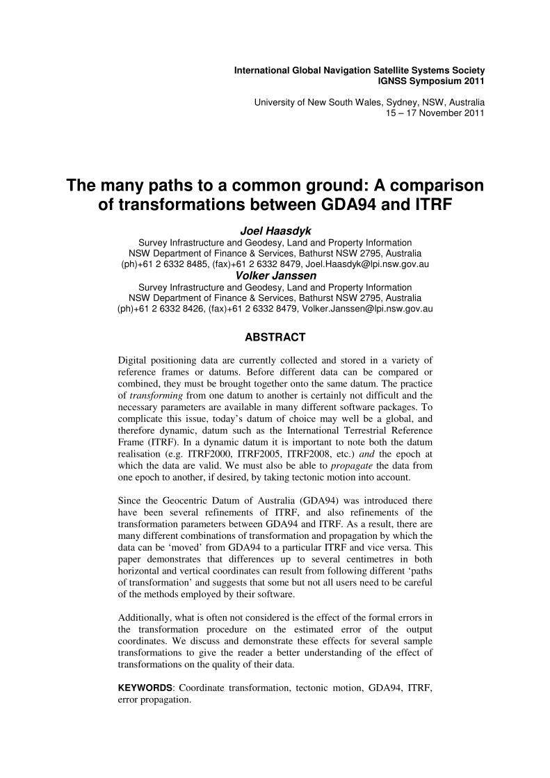
In order to be meaningful, positioning data must be gathered and reported in a well-defined ‘coordinate system’ and ‘datum’, in which any given point can be characterised by a unique set of coordinates. A coordinate system is an abstract method for defining coordinates in space, e.g. in reference to an ellipsoid of defined size and shape, expressed in Cartesian coordinates (X, Y, Z), in curvilinear geographic coordinates (�, �, h), or in local topocentric coordinates (n, e, u) (Figure 1). A datum effectively defines the origin, orientation and scale of the coordinate system at a certain instant in time (epoch), generally by adopting a set of station coordinates (Janssen, 2009). Converting between coordinate systems, i.e. Cartesian coordinates to geographic coordinates on the same ellipsoid or vice versa, is mathematically rigorous and introduces no error. In contrast, transforming between datums is subject to any error in the adopted coordinates of the common points used to determine the transformation parameters, as well as the number and distribution of these common points.
Figure 1: Ellipsoidal coordinate reference systems: Cartesian, geographic, and local topocentric.
The official horizontal coordinate datum in Australia is the Geocentric Datum of Australia (GDA94) (ICSM, 2006) and its associated Universal Transverse Mercator (UTM) map projection, the Map Grid of Australia (MGA94), which are defined as equivalent to the International Terrestrial Reference Frame ITRF92 (IERS, 2011) at epoch 1994.0. While GDA94 is not a 3-dimensional datum, an ellipsoidal height component is often determined either by GNSS observations or by combining orthometric heights from the Australian Height Datum (AHD71) with an appropriate geoid model (Brown et al., 2011) to allow the 3-dimensional transformations described below. For more information on coordinate systems and datums in the Australian context, the reader is referred to Janssen (2009) and Geoscience Australia (GA, 2011a). It is important to note that GDA94 is by no means the only datum used in Australia. Any organisation which has been gathering data for a prolonged period, or which makes use of data from other sources, is likely to employ several datums including (but not limited to) AHD71, AGD66, AGD84, GDA94, ITRF2000, ITRF2005, ITRF2008, WGS84, and even datums superseded 50 or more years ago (prior to 1966).

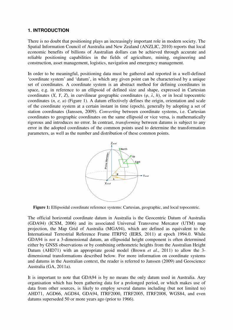
Additionally, the latest scientific-quality ITRF dynamic datums are not restricted to scientific users. Many online processing services, e.g. AUSPOS (GA, 2011b), PPP services (NRCan, 2011), as well as commercial products commonly used in agriculture or GIS applications, e.g. OmniSTAR (Trimble Navigation, 2011), return results in the latest ITRF valid at the epoch in which the data were gathered, and may or may not offer transformations to GDA94. It should come as no surprise that directly comparing coordinates from different datasets without accounting for their underlying datum can result in significant errors. As an example, the introduction of GDA94 resulted in a shift of all Australian map coordinates by approximately 200 metres to the Northeast, compared to the previous official datum, the Australian Geodetic Datum (AGD) (ICSM, 2006). Therefore directly comparing coordinates from AGD and GDA datasets would result in a 200 metre error. It follows that while GDA94, ITRF and WGS84 are all current geocentric datums similar at the centimetre to metre-level, the assumption that they are identical “for all practical purposes” is being challenged by now common GNSS measuring techniques that can detect these discrepancies (Stanaway, 2007). And while newer datums generally represent ‘only’ centimetre-level refinements in datum definitions, ignoring these differences would introduce errors that may exceed the accuracy specifications required for a given application. Transformation parameters that allow data to be transferred between datums are commonly supplied by national or international agencies. As new datums are defined (or refined) based on increased amounts of input data and improved processing techniques, new and better transformation parameters are published. Online or downloadable tools are available, e.g. from NSW Land and Property Information (LPI, 2011), to assist with current and historical transformations, and conversions between coordinate types (e.g. Cartesian to geographic coordinates). However, because of the existence of both current and recently-superseded transformation parameters, there are many different paths that can be followed between the various current datums. Figure 2 illustrates the ‘landscape’ of current and recently-superseded transformations published for the Australian context between GDA94 and several ITRF. Three distinct epochs are noted in Figure 2 because of their common usage, although any epoch is equally valid: 1994.0 represents the epoch of the definition of GDA94, 2000.0 represents an arbitrary epoch in which coordinates are commonly reported to allow direct comparisons at the same epoch, and ‘current’ represents the date at which the data were observed.
This paper demonstrates that differences of up to several centimetres in both horizontal and height coordinates can result from simply following different ‘paths of transformation’, using GDA94 to ITRF2005 as an example. Some transformation parameters shown in Figure 2 have been superseded (e.g. Dawson and Steed, 2004), but only recently, and it is likely that many software packages continue to use outdated parameters. Without vigilance, it is easily possible to apply the same transformation to different datasets (e.g. GDA94 to ITRF2005) but using different parameters. Current metadata records may be insufficient to make this distinction. Finally, while an estimate of the quality of transformation parameters is usually published, the effect of the transformation procedure itself on the estimated error of the output coordinates is often not considered. Transformation software usually supplies only coordinate values (and not their quality) as output. We discuss and demonstrate the computation of formal errors for several transformations, given the published parameters and their standard deviations, to give the reader a better understanding of the effect of transformations on the quality of their data.
Figure 2: Landscape of current transformations available for the Australian context.
Refer to Tables 1 & 2 for the associated parameters. 2. TRANSFORMATION MODELS 2.1 Static vs. Dynamic Datums The Australian plate, one of many tectonic plates covering the surface of the Earth, is constantly moving, but does not experience significant internal deformation and is often assumed to be a rigid plate (Tregoning, 2003). For this reason, Australian national datums (e.g. AGD, GDA) have historically been ‘static’ datums, fixed to points on the Australian plate, in which the coordinates of a ground mark do not change over time. As a result, the epoch at which the coordinates or observation is valid is not routinely defined. In contrast, within a ‘dynamic’ datum, the coordinates for a point continuously change (e.g. due to tectonic motion in the global context), and the same ground mark will have many different coordinates, but only one unique set of coordinate per epoch. Therefore, both the datum and the epoch must be defined for all coordinates reported in a dynamic datum. The epoch should always be declared in decimal years in parentheses: e.g. ITRF2005(2011.878) indicates a coordinate in ITRF2005 valid at noon on 17 November 2011 (day 320.5). 2.2 Transformation vs. Propagation Three distinct types of coordinate manipulation are demonstrated in Figure 2, and discussed in more detail in sections 2.2 through 2.5. In particular, the distinction is made between propagation where coordinate values change over time due to some velocity (e.g. tectonic motion) of the mark within the same datum, and transformation where coordinate values change due to the choice of a new datum with a different origin, orientation and/or scale. 1. Moving from Left to Right (or vice versa) within Figure 2 represents a transformation,
from datum to datum, with input and output coordinates valid at the same epoch (e.g. data valid at 17 November 2011 in ITRF2005 can be transformed to data valid at 17 November 2011 in ITRF2008).
2. Moving from Top to Bottom (or vice versa) within Figure 2 represents the change in coordinates over time in the same dynamic datum (e.g. ITRF2005), where the velocity of that mark is used to propagate the coordinates through time, within the same datum.
3. Diagonal movements within Figure 2 represent the special case of the transformation between a static datum (GDA94) and a dynamic datum (e.g. ITRF2005). In this case, the published transformation parameters account for the differences in the origin, orientation and scale of the datums, as well as the propagation of the Australian plate over time.
2.3 Transformation Equations Transformation parameters are commonly supplied for the transformation between current and/or historical Australian datums by the relevant national or international agencies, i.e. Geoscience Australia (e.g. Dawson and Woods, 2010) and the International Earth Rotation and Reference Systems Service (e.g. Altamimi et al., 2011; IERS, 2011). Transformation parameters are also commonly determined for transformations between national and local datums, as used on construction or mine sites, and also by every surveyor who performs a site transformation (also known as site calibration or localisation) when using CORSnet-NSW (Janssen and McElroy, 2010). The two most common transformation models are the 7- and 14-parameter similarity transformations using Cartesian coordinates (X, Y, Z). A similarity transformation assumes that scale change is the same in all directions, and thus preserves the relative shape of the network, while modifying the underlying point coordinates (Harvey, 2009). Of these 14 parameters, 7 parameters (three translations TX TY TZ, three rotations RX RY RZ, and one scale change sc) define the relationship between two datums at a certain point in time, known as the reference epoch. The additional 7 parameters define the rate of change of these translations, rotations and scale change. Note that if both datums in the transformation are static, i.e. there is no change in point coordinates over time, then the 7 rate parameters would equal zero and the transformation would be the same at any epoch. The general form of the 7-parameter transformation model can be expressed in matrix form:
�������� = ������ + (1+��) � � ���� ��� ��� � �������� (1)
The relevant parameters for selected transformations are listed in Table 1. Equation 1 applies the assumption of small rotations angles (<10”), allowing a simplification of the rotation matrix (Harvey, 2009) but this requires rotation parameters to be converted to radians. The reverse transformation (from datum B to datum A) can be performed by simply applying the same parameters with opposite sign. If the coordinate epoch is different to the reference epoch, then the 7 parameters can be adjusted using their rates, effectively turning into a 14-parameter transformation (Equation 2). Here, (t – t0) represents the difference between the coordinate epoch and the reference epoch. It is important to note that the sign convention used throughout this paper is the method historically used in Australia which assumes that rotations are of the coordinate axes themselves (where positive is anti-clockwise when viewed along the positive axis towards the origin). In contrast, the method used by the IERS assumes that rotations are of the points
around the coordinate axes. Rotation parameters may be reported with opposite signs by different organisations and software, but if applied correctly will give the same result (Dawson and Woods, 2010).
�������� = ��� ����� ��� � ����� ���� ��� � ����� ���� ��� � ��� � + (1+�� � ��� ��� � ��))…
…� � � �� �� � ��� �� � �� �� � ����� � �� �� � ��� �� � ��� �� � ���� � �� �� � ��� ��� � ��� �� � ��� � �������� (2)
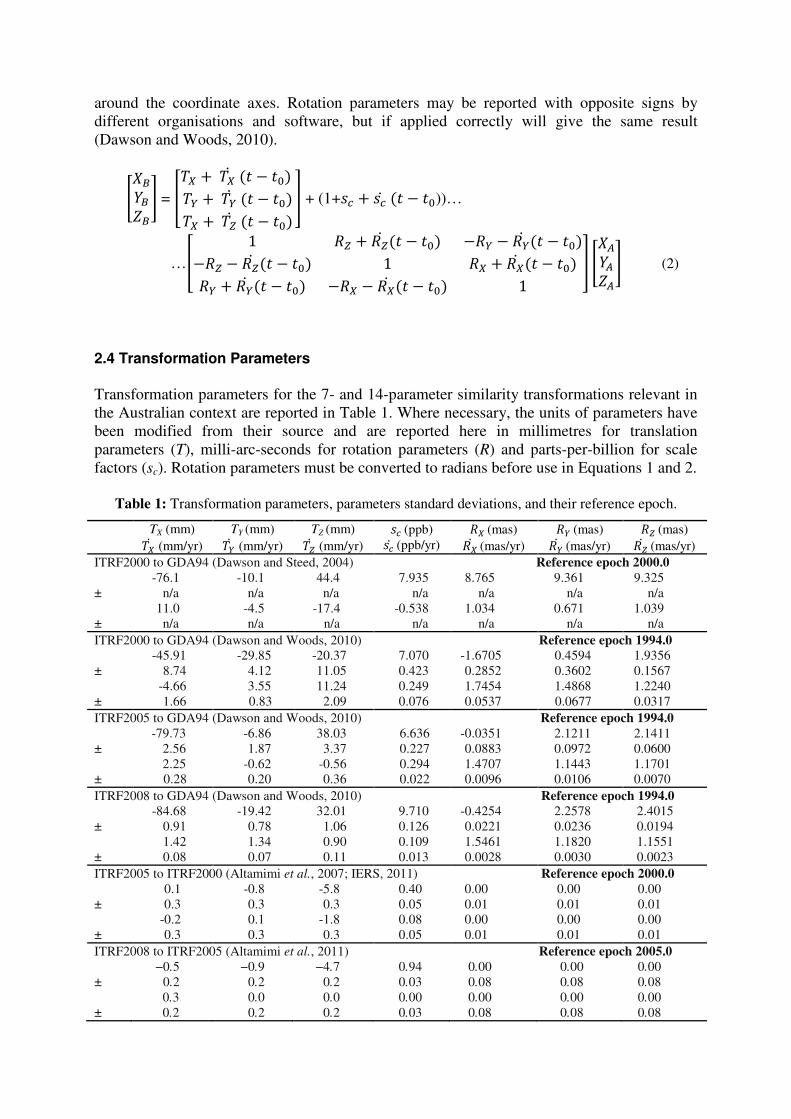
2.4 Transformation Parameters Transformation parameters for the 7- and 14-parameter similarity transformations relevant in the Australian context are reported in Table 1. Where necessary, the units of parameters have been modified from their source and are reported here in millimetres for translation parameters (T), milli-arc-seconds for rotation parameters (R) and parts-per-billion for scale factors (sc). Rotation parameters must be converted to radians before use in Equations 1 and 2.
Table 1: Transformation parameters, parameters standard deviations, and their reference epoch.
TX (mm) TY (mm) TZ (mm) �� (ppb) �� (mas) � (mas) � (mas) ��� (mm/yr) �� (mm/yr) �� (mm/yr) ��� (ppb/yr) ��� (mas/yr) �� (mas/yr) �� (mas/yr)
ITRF2000 to GDA94 (Dawson and Steed, 2004) Reference epoch 2000.0 -76.1 -10.1 44.4 7.935 8.765 9.361 9.325 ± n/a n/a n/a n/a n/a n/a n/a 11.0 -4.5 -17.4 -0.538 1.034 0.671 1.039 ± n/a n/a n/a n/a n/a n/a n/a ITRF2000 to GDA94 (Dawson and Woods, 2010) Reference epoch 1994.0 -45.91 -29.85 -20.37 7.070 -1.6705 0.4594 1.9356 ± 8.74 4.12 11.05 0.423 0.2852 0.3602 0.1567 -4.66 3.55 11.24 0.249 1.7454 1.4868 1.2240 ± 1.66 0.83 2.09 0.076 0.0537 0.0677 0.0317 ITRF2005 to GDA94 (Dawson and Woods, 2010) Reference epoch 1994.0 -79.73 -6.86 38.03 6.636 -0.0351 2.1211 2.1411 ± 2.56 1.87 3.37 0.227 0.0883 0.0972 0.0600 2.25 -0.62 -0.56 0.294 1.4707 1.1443 1.1701 ± 0.28 0.20 0.36 0.022 0.0096 0.0106 0.0070 ITRF2008 to GDA94 (Dawson and Woods, 2010) Reference epoch 1994.0 -84.68 -19.42 32.01 9.710 -0.4254 2.2578 2.4015 ± 0.91 0.78 1.06 0.126 0.0221 0.0236 0.0194 1.42 1.34 0.90 0.109 1.5461 1.1820 1.1551 ± 0.08 0.07 0.11 0.013 0.0028 0.0030 0.0023 ITRF2005 to ITRF2000 (Altamimi et al., 2007; IERS, 2011) Reference epoch 2000.0 0.1 -0.8 -5.8 0.40 0.00 0.00 0.00 ± 0.3 0.3 0.3 0.05 0.01 0.01 0.01 -0.2 0.1 -1.8 0.08 0.00 0.00 0.00 ± 0.3 0.3 0.3 0.05 0.01 0.01 0.01 ITRF2008 to ITRF2005 (Altamimi et al., 2011) Reference epoch 2005.0 −0.5 −0.9 −4.7 0.94 0.00 0.00 0.00 ± 0.2 0.2 0.2 0.03 0.08 0.08 0.08 0.3 0.0 0.0 0.00 0.00 0.00 0.00 ± 0.2 0.2 0.2 0.03 0.08 0.08 0.08
2.5 Propagation within Dynamic Datums Transformations between two dynamic datums are only valid at the epoch defined for the transformation. While the 14 parameters supplied allow a transformation at any epoch, the input and output coordinates are still only valid at the epoch defined for the transformation. In other words, it is not possible to take data observed in ITRF2008(2011.878) and directly transform to ITRF2005(2000.0). Instead, a two-step procedure must be followed which includes:
1) a transformation from ITRF2008(2011.878) to ITRF2005(2011.878) 2) a propagation from ITRF2005(2011.878) to ITRF2005(2000.0)
OR 1) a propagation from ITRF2008(2011.878) to ITRF2008(2000.0) 2) a transformation from ITRF2008(2000.0) to ITRF2005(2000.0)
The velocities for a given point can be measured over time, or inferred from a model such as the commonly employed NNR-NUVEL1A model (DeMets et al., 1994) or the most recently available ITRF2005 plate model (Altamimi et al., 2007). These models typically define the motion of several rigid, irregular edged tectonic plates, including the Australian plate. The motion is described by a rate of rotation (�, in degrees per Million years) about an Euler Pole (representing an axis of rotation different from the Earth’s spin axis) defined by latitude (�) and longitude (�). In practice, the computed velocity represents a linear motion (at non-geological time scales) that is assumed to be valid at all epochs, but in reality a ground mark may be subject to complex tectonic motions or local deformation that is not captured within such a model. The calculation of a site-specific velocity from the ITRF2005 plate model, and the propagation of a position from time t0 to time t, is described in Stanaway and Roberts (2009) and is reproduced here, with parameters listed in Table 2:
������= ������������� �������!"��� �!"��� ������������ � (3)
������ ��
= ��� ������ �������� ����� � #$%� (4)
��&�&�&� =�������� + ��� ������ �������� ����� �� � ���� #$%� (5)
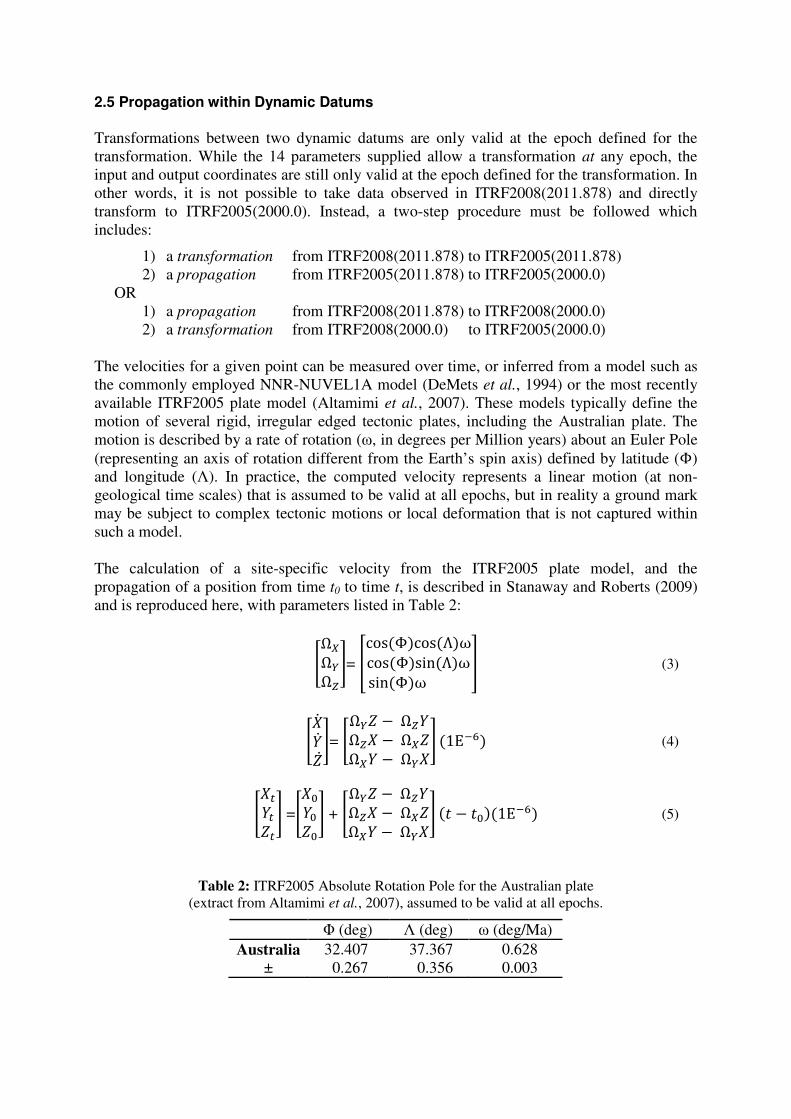
Table 2: ITRF2005 Absolute Rotation Pole for the Australian plate (extract from Altamimi et al., 2007), assumed to be valid at all epochs.
� (deg) � (deg) � (deg/Ma) Australia 32.407 37.367 0.628
± 0.267 0.356 0.003
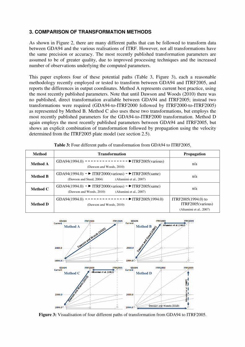
3. COMPARISON OF TRANSFORMATION METHODS As shown in Figure 2, there are many different paths that can be followed to transform data between GDA94 and the various realisations of ITRF. However, not all transformations have the same precision or accuracy. The most recently published transformation parameters are assumed to be of greater quality, due to improved processing techniques and the increased number of observations underlying the computed parameters. This paper explores four of these potential paths (Table 3, Figure 3), each a reasonable methodology recently employed or tested to transform between GDA94 and ITRF2005, and reports the differences in output coordinates. Method A represents current best practice, using the most recently published parameters. Note that until Dawson and Woods (2010) there was no published, direct transformation available between GDA94 and ITRF2005; instead two transformations were required (GDA94-to-ITRF2000 followed by ITRF2000-to-ITRF2005) as represented by Method B. Method C also uses these two transformations, but employs the most recently published parameters for the GDA94-to-ITRF2000 transformation. Method D again employs the most recently published parameters between GDA94 and ITRF2005, but shows an explicit combination of transformation followed by propagation using the velocity determined from the ITRF2005 plate model (see section 2.5).
Table 3: Four different paths of transformation from GDA94 to ITRF2005.
Method Transformation Propagation
Method A GDA94(1994.0) ITRF2005(various) (Dawson and Woods, 2010)
n/a
Method B GDA94(1994.0) ITRF2000(various) ITRF2005(same) (Dawson and Steed, 2004) (Altamimi et al., 2007)
n/a
Method C GDA94(1994.0) ITRF2000(various) ITRF2005(same) (Dawson and Woods, 2010) (Altamimi et al., 2007)
n/a
Method D GDA94(1994.0) ITRF2005(1994.0) (Dawson and Woods, 2010)
ITRF2005(1994.0) to ITRF2005(various)
(Altamimi et al., 2007)
Figure 3: Visualisation of four different paths of transformation from GDA94 to ITRF2005.
Method A Method B
Method C
Method D
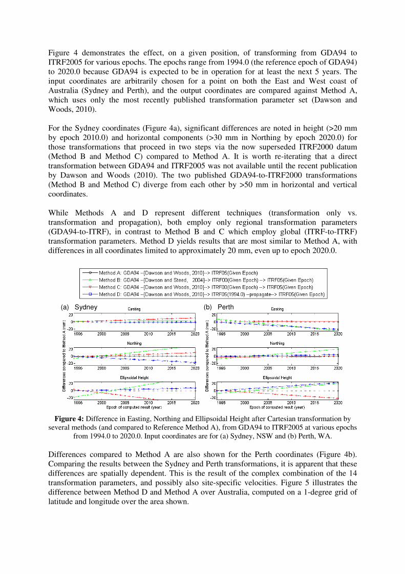
Figure 4 demonstrates the effect, on a given position, of transforming from GDA94 to ITRF2005 for various epochs. The epochs range from 1994.0 (the reference epoch of GDA94) to 2020.0 because GDA94 is expected to be in operation for at least the next 5 years. The input coordinates are arbitrarily chosen for a point on both the East and West coast of Australia (Sydney and Perth), and the output coordinates are compared against Method A, which uses only the most recently published transformation parameter set (Dawson and Woods, 2010). For the Sydney coordinates (Figure 4a), significant differences are noted in height (>20 mm by epoch 2010.0) and horizontal components (>30 mm in Northing by epoch 2020.0) for those transformations that proceed in two steps via the now superseded ITRF2000 datum (Method B and Method C) compared to Method A. It is worth re-iterating that a direct transformation between GDA94 and ITRF2005 was not available until the recent publication by Dawson and Woods (2010). The two published GDA94-to-ITRF2000 transformations (Method B and Method C) diverge from each other by >50 mm in horizontal and vertical coordinates. While Methods A and D represent different techniques (transformation only vs. transformation and propagation), both employ only regional transformation parameters (GDA94-to-ITRF), in contrast to Method B and C which employ global (ITRF-to-ITRF) transformation parameters. Method D yields results that are most similar to Method A, with differences in all coordinates limited to approximately 20 mm, even up to epoch 2020.0.
Figure 4: Difference in Easting, Northing and Ellipsoidal Height after Cartesian transformation by
several methods (and compared to Reference Method A), from GDA94 to ITRF2005 at various epochs from 1994.0 to 2020.0. Input coordinates are for (a) Sydney, NSW and (b) Perth, WA.
Differences compared to Method A are also shown for the Perth coordinates (Figure 4b). Comparing the results between the Sydney and Perth transformations, it is apparent that these differences are spatially dependent. This is the result of the complex combination of the 14 transformation parameters, and possibly also site-specific velocities. Figure 5 illustrates the difference between Method D and Method A over Australia, computed on a 1-degree grid of latitude and longitude over the area shown.
(a) Sydney (b) Perth
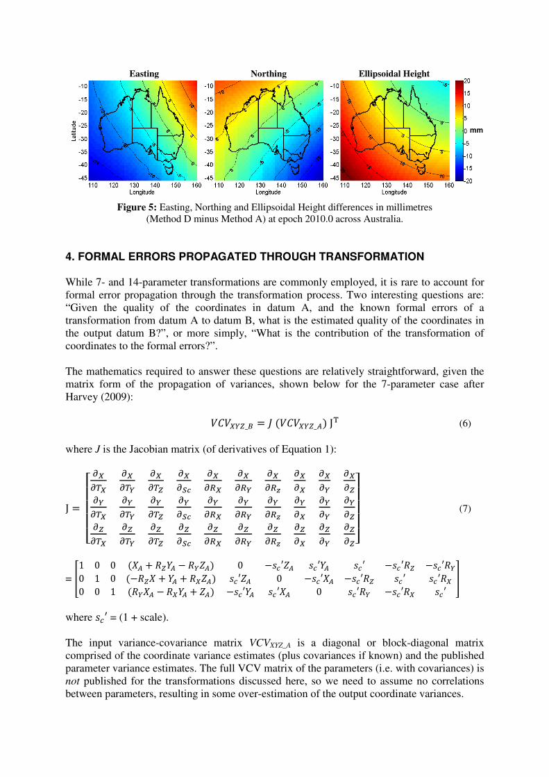
Figure 5: Easting, Northing and Ellipsoidal Height differences in millimetres
(Method D minus Method A) at epoch 2010.0 across Australia. 4. FORMAL ERRORS PROPAGATED THROUGH TRANSFORMATION While 7- and 14-parameter transformations are commonly employed, it is rare to account for formal error propagation through the transformation process. Two interesting questions are: “Given the quality of the coordinates in datum A, and the known formal errors of a transformation from datum A to datum B, what is the estimated quality of the coordinates in the output datum B?”, or more simply, “What is the contribution of the transformation of coordinates to the formal errors?”. The mathematics required to answer these questions are relatively straightforward, given the matrix form of the propagation of variances, shown below for the 7-parameter case after Harvey (2009): '('�)� * +��'('�)���,- (6) where J is the Jacobian matrix (of derivatives of Equation 1):
, *� .///0 12132 12134 12135 12167 12182 12184 12189 1212 1214 121514132 14134 14135 14167 14182 14184 14189 1412 1414 141515132 15134 15135 15167 15182 15184 15189 1512 1514 1515:;
;;< (7)
= � = = ��� � ��� � ���� = ���>�� ��>�� ��> ���>� ���>�= = ���� � �� � ����� ��>�� = ���>�� ���>� ��> ��>��= = ���� � ���� � ��� ���>�� ��>�� = ��>� ���>�� ��> � where ��> = (1 + scale). The input variance-covariance matrix VCVXYZ_A is a diagonal or block-diagonal matrix comprised of the coordinate variance estimates (plus covariances if known) and the published parameter variance estimates. The full VCV matrix of the parameters (i.e. with covariances) is not published for the transformations discussed here, so we need to assume no correlations between parameters, resulting in some over-estimation of the output coordinate variances.
Easting Northing Ellipsoidal Height
mm
If the epoch of transformation is different to the reference epoch, then a similar Jacobian matrix can be prepared for Equation 2 (the 14-parameter version of the transformation). Alternatively, and more simply, the parameters can be modified by their rates as per Equation 8, and the parameter quality �?@&�� determined for any epoch, as per Equation 9 (which is simply the linear format of Equation 6), given each parameter p, its rate of change @�, the transformation epoch t, and the reference epoch t0: @& * @&A ���� � ���@� (8)
?@&B * �C DEFDEFAGB ?@&AB �� �HDEFDE� IB ?@�B������(assuming no correlations) (9)
The conversion of the VCV between Cartesian and geographic coordinates is not shown here, but is detailed in Harvey (2009). Conversion to UTM coordinates is beyond the scope of this paper, but the conversion to a local topocentric system (North, East, Up) is easily obtained given the position’s geodetic latitude (�) and longitude (�), after Leick (1995): '('JKL * ���'('�����3 (10)
where � *� �� �MN�O�PQ���R� � �MN�O� �MN��R� PQ���O���MN��R� PQ���R� =PQ���O�PQ���R� PQ��O� �MN��R� �MN��O��� (11)
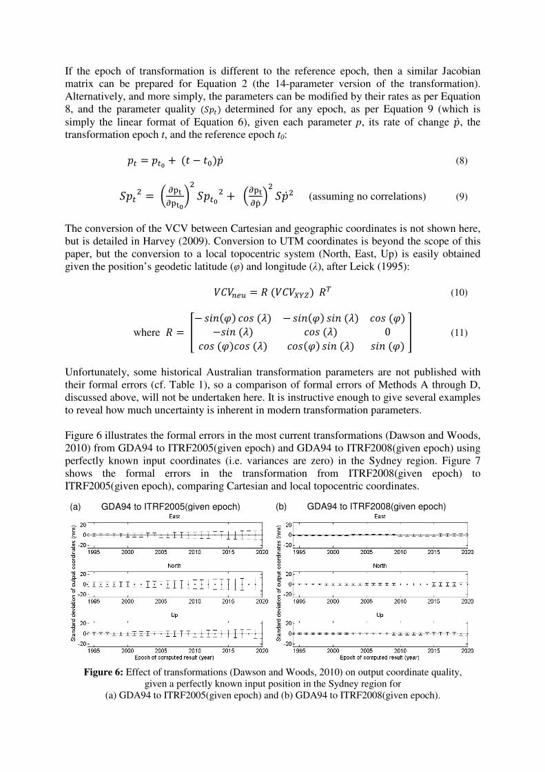
Unfortunately, some historical Australian transformation parameters are not published with their formal errors (cf. Table 1), so a comparison of formal errors of Methods A through D, discussed above, will not be undertaken here. It is instructive enough to give several examples to reveal how much uncertainty is inherent in modern transformation parameters. Figure 6 illustrates the formal errors in the most current transformations (Dawson and Woods, 2010) from GDA94 to ITRF2005(given epoch) and GDA94 to ITRF2008(given epoch) using perfectly known input coordinates (i.e. variances are zero) in the Sydney region. Figure 7 shows the formal errors in the transformation from ITRF2008(given epoch) to ITRF2005(given epoch), comparing Cartesian and local topocentric coordinates.
Figure 6: Effect of transformations (Dawson and Woods, 2010) on output coordinate quality,
given a perfectly known input position in the Sydney region for (a) GDA94 to ITRF2005(given epoch) and (b) GDA94 to ITRF2008(given epoch).
(a) GDA94 to ITRF2005(given epoch) (b) GDA94 to ITRF2008(given epoch)
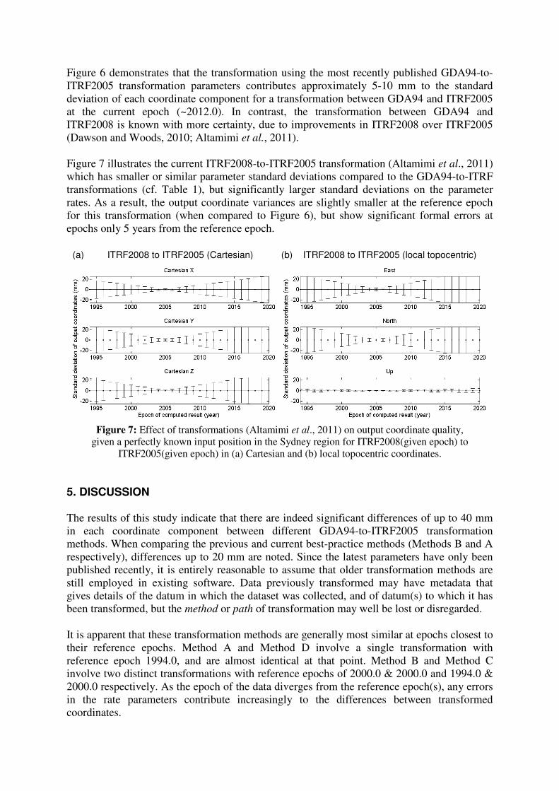
Figure 6 demonstrates that the transformation using the most recently published GDA94-to-ITRF2005 transformation parameters contributes approximately 5-10 mm to the standard deviation of each coordinate component for a transformation between GDA94 and ITRF2005 at the current epoch (~2012.0). In contrast, the transformation between GDA94 and ITRF2008 is known with more certainty, due to improvements in ITRF2008 over ITRF2005 (Dawson and Woods, 2010; Altamimi et al., 2011). Figure 7 illustrates the current ITRF2008-to-ITRF2005 transformation (Altamimi et al., 2011) which has smaller or similar parameter standard deviations compared to the GDA94-to-ITRF transformations (cf. Table 1), but significantly larger standard deviations on the parameter rates. As a result, the output coordinate variances are slightly smaller at the reference epoch for this transformation (when compared to Figure 6), but show significant formal errors at epochs only 5 years from the reference epoch.
Figure 7: Effect of transformations (Altamimi et al., 2011) on output coordinate quality,
given a perfectly known input position in the Sydney region for ITRF2008(given epoch) to ITRF2005(given epoch) in (a) Cartesian and (b) local topocentric coordinates.
5. DISCUSSION The results of this study indicate that there are indeed significant differences of up to 40 mm in each coordinate component between different GDA94-to-ITRF2005 transformation methods. When comparing the previous and current best-practice methods (Methods B and A respectively), differences up to 20 mm are noted. Since the latest parameters have only been published recently, it is entirely reasonable to assume that older transformation methods are still employed in existing software. Data previously transformed may have metadata that gives details of the datum in which the dataset was collected, and of datum(s) to which it has been transformed, but the method or path of transformation may well be lost or disregarded. It is apparent that these transformation methods are generally most similar at epochs closest to their reference epochs. Method A and Method D involve a single transformation with reference epoch 1994.0, and are almost identical at that point. Method B and Method C involve two distinct transformations with reference epochs of 2000.0 & 2000.0 and 1994.0 & 2000.0 respectively. As the epoch of the data diverges from the reference epoch(s), any errors in the rate parameters contribute increasingly to the differences between transformed coordinates.
(b) ITRF2008 to ITRF2005 (local topocentric) (a) ITRF2008 to ITRF2005 (Cartesian)
Method D represents a scenario that may be encountered more and more frequently when using scientific GNSS processing software such as Bernese (Dach, et al., 2007). A priori coordinates are often supplied for such processing in ITRF and valid at a common epoch, e.g. ITRF2005(2000.0). Site-specific velocities are computed by time-series analysis or from a tectonic plate model, and the a priori coordinates are explicitly propagated to the epoch of the observations before processing. The output is then given in that same ITRF datum, at the epoch of the data, e.g. ITRF2005(2011.878). If the data are ultimately desired in the GDA94 datum, then essentially two approaches are available: (1) using the most recent ITRF(current epoch)-to-GDA94 14-parameter transformation as in Method A, or (2) propagating the output coordinates back to the common epoch (using the same site-specific velocities as above) before transforming from ITRF2005(2000.0) to GDA94 as in Method D. The difference between these approaches is illustrated in Figures 4 and 5, and can reach up to 20 mm in each coordinate component. This study is limited to the analysis of differences between GDA94-to-ITRF2005 transformations, even though the ITRF2008 datum and associated transformation parameters were released earlier this year. The purpose of this study was to highlight the existence of significant coordinate differences that can result from the choice of transformation method, and not to exhaustively test all available parameters. The ITRF2008 plate model is expected to be released soon (Altamimi, pers. comm.), and this too will offer yet another small but significant improvement over the ITRF2005 model, for those seeking the highest precision when propagating coordinates. In the same sense, we include the discussion of the propagation of coordinate quality using imperfectly known transformation parameters in order to increase the users’ understanding of the effects of transformations on the coordinate quality of their data. The main lessons here are that for all transformations, the quality of output coordinates degrades with greater time separation from the transformation’s reference epoch, and that high standard deviations of the transformation parameter rates can overwhelm a high-quality transformation with only several years’ separation from the reference epoch. Transformations involving the most recent datums generally contribute less uncertainty than similar transformations to earlier, less accurate datums (cf. Figure 6). Intuitively, it also makes sense that the GDA94-to-ITRF transformations contribute less uncertainty than the ITRF-to-ITRF transformations; the former make a general comparison of coordinates in two datums limited to a single rigid tectonic plate where site velocities are reasonably consistent, while the latter attempts the same comparison but on a global scale with complex interactions between coordinates on different tectonic plates. It is also instructive to note that the output quality of the direct GDA94-to-ITRF2005 transformation is quite evenly spread around the East, North and Up components. In contrast, even though the quality of the ITRF2008-to-ITRF2005 transformation parameters is similar for the Cartesian X, Y, Z axes (in both translation and rotation), the resulting horizontal uncertainty is much greater than the vertical uncertainty (cf. Figure 7). While the standard deviations of the Cartesian coordinate output from the transformation are symmetrical (variances in X, Y, Z output coordinates are very similar), this topocentric horizontal and vertical asymmetry is evident only when the full VCVXYZ matrix output from Equation 6 is rotated as per Equation 10. It should be noted that if the VCVXYZ from Equation 6 is stripped of its off-diagonal covariance terms (as is often the case when only the variances of the 3 coordinate components
are stored) before rotating, then the resulting North, East, Up coordinate qualities are much more similar to each other (data not shown). The asymmetry occurs when using the full VCVXYZ because while the translation, rotation and scale parameters in the ITRF2008-to-ITRF2005 transformation are quite small, the reported uncertainty in the rates of rotation are the largest contributor to output quality (cf. Table 1, and consider for example a rotation of the entire Earth around its normal rotation axis, where 0.08 mas/yr equates to 2.5 mm/yr tangential to the Earth’s surface at the equator). As a result, there is very little uncertainty in the estimated translation of the coordinates, but the uncertainty of the rotation parameters manifest as uncertainty in the horizontal component. These relationships are stored after the transformation, in the covariance terms of the full VCVXYZ matrix. Harvey (2009) recommends the use of the full VCV matrix of the transformation parameters, especially in the context of national geodetic networks, which only cover small portions of the Earth’s surface and thus may have very highly correlated parameters. Unfortunately, the full VCV matrix of the parameters is rarely published, and is not available for the transformations discussed here. Ignoring the covariance is most likely to result in an over-estimation of the output coordinate variances. It would be informative to further investigate and compare the correlations in the national and international transformation parameters discussed here, and determine the actual effect of using the full VCV on the output coordinate qualities. Formal error propagation in Method A through D have not been directly compared, since not all transformation parameters employed have published variance estimates. Because of this, we have also omitted a discussion on the propagation of formal errors when using site-specific velocities to propagate coordinates between epochs (as in Method D). It would be informative to further investigate the uncertainties in site-specific velocities derived from global tectonic plate models or time-series analysis, and their effects on coordinate quality. It should be noted that the aim of this analysis is to demonstrate a possibly source of relative error for multiple points reported in the same nominal datum, if transformed by different methods. No claims are made here about the absolute accuracy of each transformation, nor the consistency of coordinates obtained by different observation methods. Dawson and Woods (2010) discuss in detail the limitations in the underlying GDA94 datum definition, and highlight significant coordinate discrepancies discovered using modern GNSS technology. The redefinition of GDA with additional high precision GNSS data, and in terms of the latest ITRF, would significantly reduce the uncertainties in GDA94 and align the national and global datums more closely. But such a redefinition would not eliminate the need to transform existing datasets, nor remove the complex interactions between static and dynamic datums. Finally, while this analysis focuses on the transformation of individual point coordinates between datums, small modifications of the equations for the propagation of error would also allow the propagation of relative uncertainty of vectors between multiple points. 6. CONCLUSIONS Recently a number of new transformation parameters have been published, allowing users in the Australian context to transform data between our current static GDA94 datum and the latest scientific-quality, dynamic ITRF datums. These ITRF datums are not restricted to scientific users, with coordinates routinely provided in ITRF by online processing services and commercial DGPS providers. The need to understand and apply the best transformation
methodology is always increasing. This paper has demonstrated that significant differences of up to 40 mm in each coordinate component (Easting, Northing and Ellipsoidal Height) can occur depending on the choice of the transformation method and parameters applied between GDA94 and ITRF2005. While it may be reasonable to disregard these differences for many navigation, mapping and GIS purposes, users requiring relative coordinate qualities at the centimetre-level will need to be aware of the transformation methods employed by their software, and the transformation methods previously used on existing data, especially if mixing data from different sources. Analysis of the propagation of coordinate quality through these transformations has revealed that there are significant differences in output coordinate quality depending on the transformation employed. National transformations covering a single tectonic plate (e.g. GDA94-to-ITRF) generally have smaller formal errors than global transformations (ITRF-to-ITRF). The latter require generalisations, at a global scale, of complex tectonic motions and therefore are inherently less certain, especially if comparing data from different epochs. For all transformations, there is a significant change in the expected quality of output as the epoch of the data becomes more remote from the specified reference epoch. Therefore, given the increased number of possible transformation methods available, it is recommended that users increase vigilance with regard to the use of multiple datums and the transformations between them. Any user who may be working with data from multiple datums can achieve the highest coordinate quality and the most consistent coordinates by applying the latest transformation parameters (e.g. Method A) to their original datasets. While most users (and software) will be most comfortable applying a 14-parameter transformation, the use of explicit coordinate propagation using site-specific velocities (as in Method D) is at the discretion of the user and may be more appropriate for some applications. Metadata for transformed data should include information on the specific transformation and propagation methods employed, with reference to the source of any transformation parameters, site-velocities and epoch(s) used in the transformation. REFERENCES Altamimi Z, Collilieux X, Legrand J, Garayt B, Boucher C (2007) ITRF2005: A new release of the
International Terrestrial Reference Frame based on time series of station positions and Earth Orientation Parameters, Journal of Geophysical Research 112: B09401, doi:10.1029/2007JB004949.
Altamimi Z, Collilieux X, Métivier L (2011) ITRF2008: An improved solution of the international terrestrial reference frame, Journal of Geodesy 85(8): 457-473.
ANZLIC (2010) The Spatial Information Council National Positioning Infrastructure (NPI) Policy, http://www.anzlic.org.au/Infrastructures/National+Positioning+Infrastructure+-+NPI/NPI+Policy+document/Downloads_GetFile.aspx?id=285 (accessed Oct 2011).
Brown NJ, Featherstone WE, Hu G, Johnston GM (2011) AUSGeoid09: A more direct and more accurate model for converting ellipsoidal heights to AHD heights, Journal of Spatial Science 56(1): 27-37.
Dach R, Hugentobler U, Fridez P, Meindl M (2007) Bernese GPS Software Version 5.0, Astronomical Institute, University of Bern, Bern, 612pp.
Dawson J, Steed J (2004) International Terrestrial Reference Frame (ITRF) to GDA94 coordinate transformations, http://www.ga.gov.au/image_cache/GA3795.pdf (accessed Oct 2011).
Dawson J, Woods A (2010) ITRF to GDA94 coordinate transformations, Journal of Applied Geodesy 4(4): 189-199.
DeMets C, Gordon RG, Argus DF, Stein S (1994) Effect of recent revisions to the geomagnetic reversal time scale on estimates of current plate motions, Geophysical Research Letters 21(20): 2191–2194.
GA (2011a) Geodetic datums, http://www.ga.gov.au/earth-monitoring/geodesy/geodetic-datums.html (accessed Oct 2011).
GA (2011b) AUSPOS – Online GPS Processing Service, http://www.ga.gov.au/geodesy/sgc/wwwgps/ (accessed Oct 2011).
Harvey BR (2009) Practical Least Squares and Statistics for Surveyors, Monograph 13 (third edition), School of Surveying and Spatial Information Systems, University of New South Wales, Sydney, Australia, 332pp, ISBN 0-7334-2339-6.
ICSM (2006) Geocentric Datum of Australia technical manual (version 2.3), http://www.icsm.gov.au/icsm/gda/gdatm/index.html (accessed Oct 2011).
IERS (2011) The International Terrestrial Reference Frame (ITRF), http://itrf.ensg.ign.fr (accessed Oct 2011).
Janssen V (2009) Understanding coordinate systems, datums and transformations in Australia, Proceedings of the Surveying & Spatial Sciences Institute Biennial International Conference (SSC2009), Adelaide, Australia, 697-715.
Janssen V, Haasdyk J, McElroy S, Kinlyside D (2011) CORSnet-NSW: Improving positioning infrastructure for New South Wales, to appear in Proceedings of the Surveying & Spatial Sciences Institute Biennial International Conference (SSSC2011), Wellington, New Zealand.
Janssen V, McElroy S (2010) Coordinates and CORSnet-NSW: Dealing with distortions in GDA94, Position 50: 24-27.
Leick A (1995) GPS Satellite Surveying (second edition), John Wiley & Sons, New York, 233-243.
LPI (2011) Conversion software, http://www.lpma.nsw.gov.au/surveying/geodesy/ conversions_software (accessed Oct 2011).
NRCan (2011) Online Global GPS Processing Service (CSRS-PPP), http://www.geod.nrcan.gc.ca/products-produits/ppp_e.php (accessed Oct 2011).
Stanaway R (2007) GDA94, ITRF, WGS84: What’s the difference? Working with dynamic datums, http://www.quickclose.com.au/stanawayssc2007.pdf (accessed Oct 2011).
Stanaway R, Roberts C (2009) A simplified parameter transformation model from ITRF2005 to any static geocentric datum (e.g. GDA94), Proceedings of the International Global Navigation Satellite Systems Society Symposium (IGNSS2009), Surfers Paradise, Australia, 15pp.
Tregoning P (2003) Is the Australian Plate Deforming? A space geodetic perspective, Evolution and Dynamics of the Australian Plate, Geological Society of Australia Special Publication 22 and Geological Society of America Special Publication 372, 49-58.
Trimble Navigation (2010) OmniSTAR network datum, http://www.omnistar.com.au/technical-information/omnistar-network-datum/ (accessed Oct 2011).