the study of folding & faulting folding
TRANSCRIPT
1 Geography | Leaving Certificate | Martina Duffy
Subject: Leaving Certificate Geography
Teacher: James Campbell
LESSON 7-8
The Study of Folding & FaultingFoldingTypes of Folds
Fold Mountains
Munster Ridge & Valley
Faulting3 Types of Faults
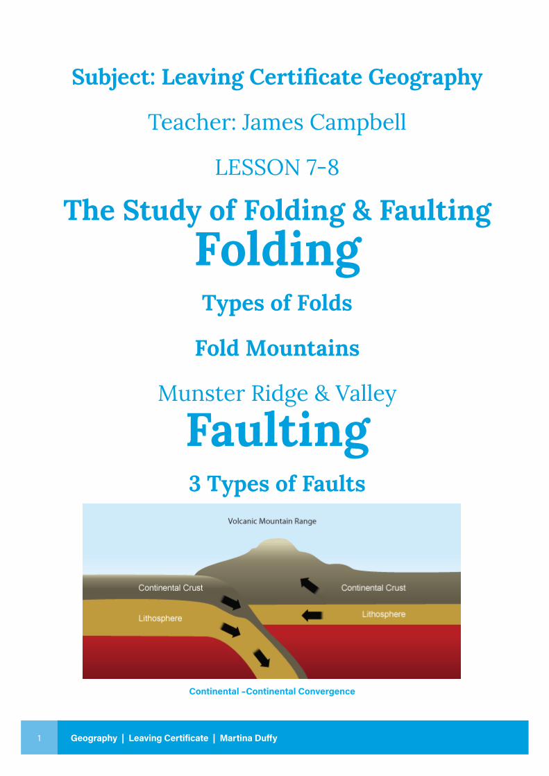
Continental –Continental Convergence
2
Geo
grap
hy |
Leav
ing
Cert
ifica
te L
ESSO
N 7
- 8
FoldingKey Words:
◉ Folding
◉ Anticline
◉ Syncline
◉ Limb
◉ Overfolds
◉ Overthrusts
◉ Recumbent Fold
◉ Caledonian Folding
◉ Armorican Folding – Munster Ridge & Valley
Province
◉ Alpine Folding
3 Geography | Leaving Certificate | Martina Duffy
THE STUDY OF FOLDING
FOLDING:Definition:
The Process of Folding: “A structure that once was flat may be bent or buckled into a series of wave like folds and hollows” Folding occurs along Destructive Plate Boundaries where converging plates collide and buckle. The collision forces the land upwards”.
Most major Fold mountain ranges were formed by the collision of continental plates- Andes, Appalachians, Alps and Himalayas. Fold mountains are formed by crust which has been uplifted and folded (bent/bruised/buckled) by compressional forces over millions of years.
Folding bends layers of rocks without breaking them often creating a series of peaks and valleys, anticlines and synclines. These rocks are ductile – folded and deformed without breaking.
Example:The Himalayas were formed when the Eurasian Plate converged with the Indo-Australian Plate. Sea floor sediments were compressed and uplifted into Fold Mountains. Fold mountains are worn down and re-shaped by weathering and erosion.
The process of Folding is similar to pushing inwards on opposite ends of a piece of paper or pushing it up from below.
• The process of folding can be compared to a sheet of corrugated iron on a roof top.
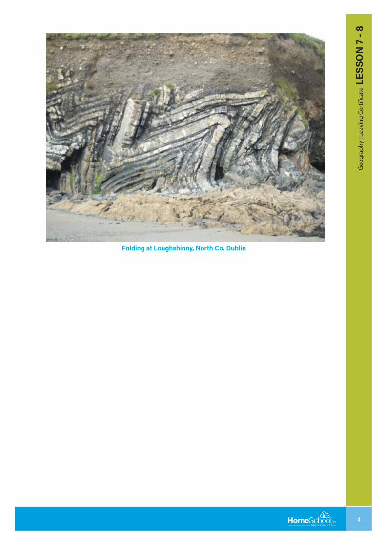
• Folding is evident in Loughshinny, North Co. Dublin and the Rock of Cashel, Co. Tipperary.
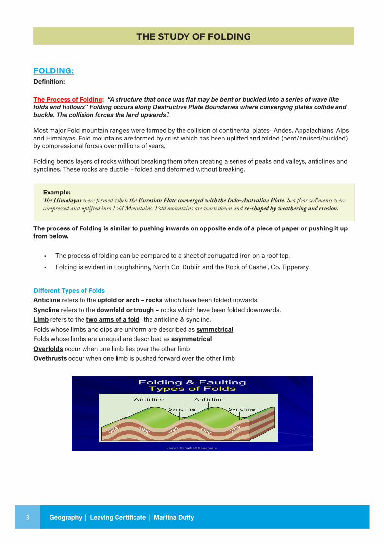
Different Types of FoldsAnticline refers to the upfold or arch – rocks which have been folded upwards.Syncline refers to the downfold or trough – rocks which have been folded downwards.Limb refers to the two arms of a fold- the anticline & syncline.Folds whose limbs and dips are uniform are described as symmetricalFolds whose limbs are unequal are described as asymmetricalOverfolds occur when one limb lies over the other limbOvethrusts occur when one limb is pushed forward over the other limb
James Campbell Geography
Folding & FaultingTypes of Folds
4
Geo
grap
hy |
Leav
ing
Cert
ifica
te L
ESSO
N 7
- 8
Folding at Loughshinny, North Co. Dublin
5 Geography | Leaving Certificate | Martina Duffy
SAMPLE QUESTION 1: EXPLAIN THE FORMATION OF THE THREE TYPES OF FOLD MOUNTAINS? (30m)
This question requires 15 SRPs
• The global distribution of Fold Mountains is closely related to plate tectonics. Fold Mountains occur at convergent plate boundaries where two continental plates collide. (1 SRP = 2m)
• When two continental plates collide, there is no subduction as both plates are of similar density. This collision leads to the formation of Fold Mountains. (1SRP = 2m)
Folding results in the formation of Fold Mountains of which there are three types:
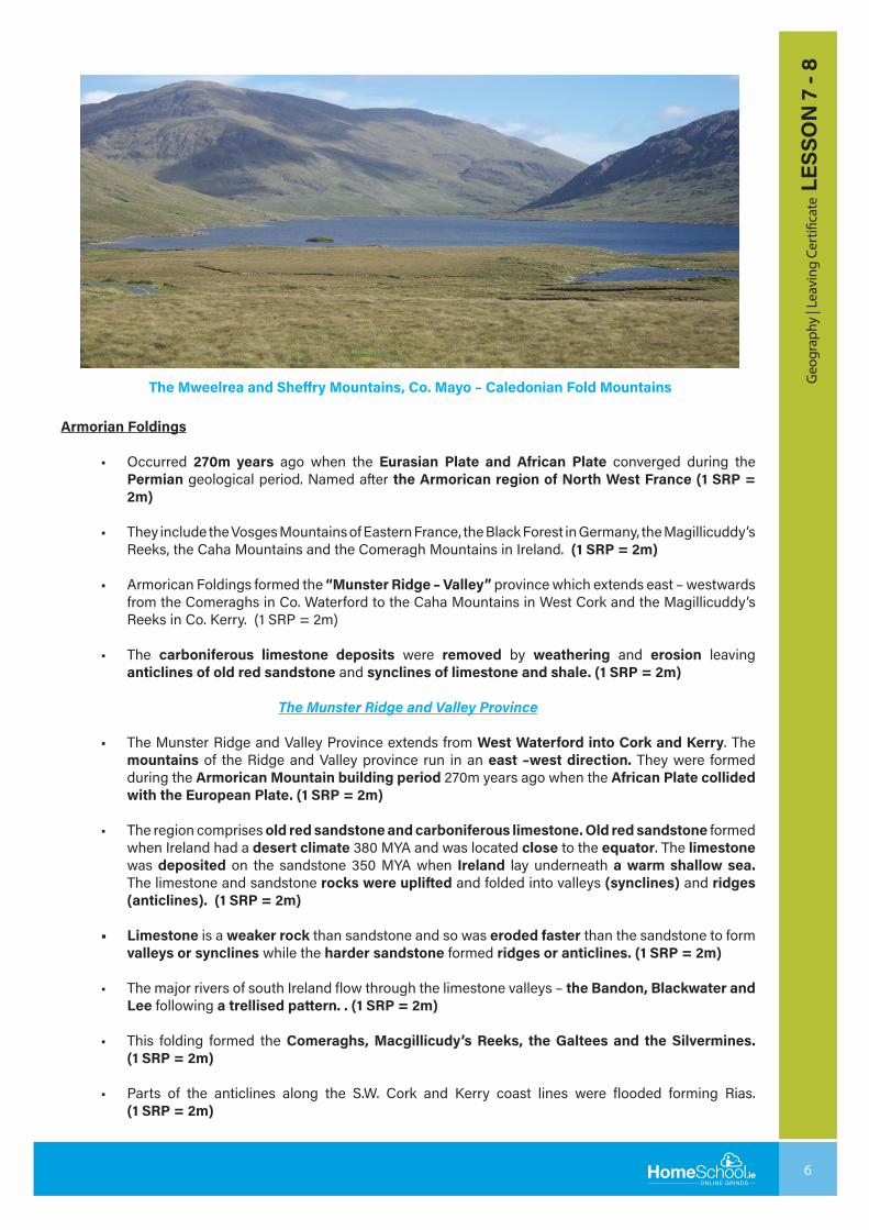
Caledonian Foldings
• Occurred 450m years ago when the North American & Eurasian Plates converged during the Silurian geological period. During the folding, magma intruded into the upfolds to form granite (igneous) and metamorphic rocks (quartzite). (1 SRP = 2m)
• Both plates were travelling in a SW-NE direction, so the resulting folds have a SW-NE trend. When formed they were higher than today’s Alps, but they have been reduced by weathering and erosion. Caledonian peaks in Ireland vary between 600m and 700m in height. The name comes from Caledonia, the Roman name for Scotland. (1 SRP = 2m)
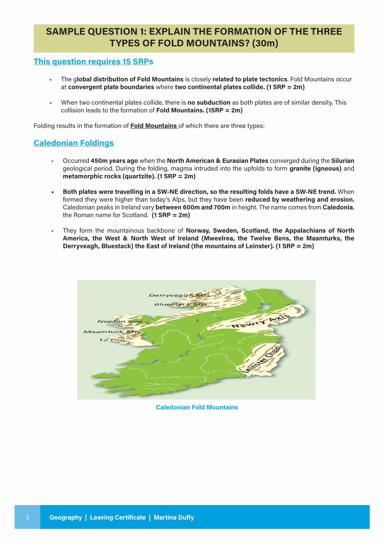
• They form the mountainous backbone of Norway, Sweden, Scotland, the Appalachians of North America, the West & North West of Ireland (Mweelrea, the Twelve Bens, the Maamturks, the Derryveagh, Bluestack) the East of Ireland (the mountains of Leinster). (1 SRP = 2m)
Caledonian Fold Mountains
6
Geo
grap
hy |
Leav
ing
Cert
ifica
te L
ESSO
N 7
- 8
The Mweelrea and Sheffry Mountains, Co. Mayo – Caledonian Fold Mountains
Armorian Foldings
• Occurred 270m years ago when the Eurasian Plate and African Plate converged during the Permian geological period. Named after the Armorican region of North West France (1 SRP = 2m)
• They include the Vosges Mountains of Eastern France, the Black Forest in Germany, the Magillicuddy’s Reeks, the Caha Mountains and the Comeragh Mountains in Ireland. (1 SRP = 2m)
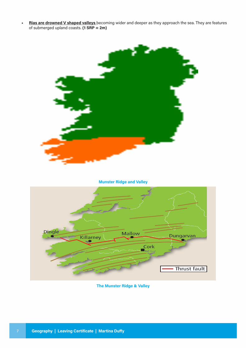
• Armorican Foldings formed the “Munster Ridge – Valley” province which extends east – westwards from the Comeraghs in Co. Waterford to the Caha Mountains in West Cork and the Magillicuddy’s Reeks in Co. Kerry. (1 SRP = 2m)
• The carboniferous limestone deposits were removed by weathering and erosion leaving anticlines of old red sandstone and synclines of limestone and shale. (1 SRP = 2m)
The Munster Ridge and Valley Province
• The Munster Ridge and Valley Province extends from West Waterford into Cork and Kerry. The mountains of the Ridge and Valley province run in an east –west direction. They were formed during the Armorican Mountain building period 270m years ago when the African Plate collided with the European Plate. (1 SRP = 2m)
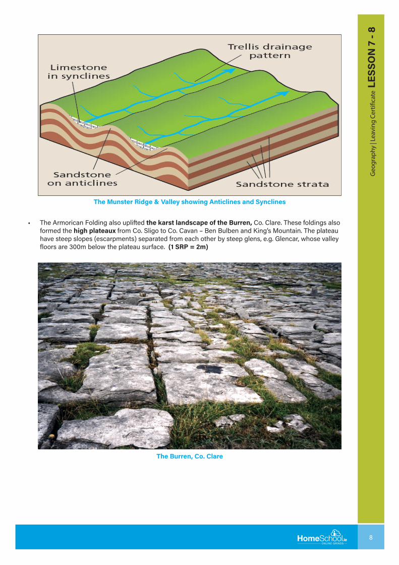
• The region comprises old red sandstone and carboniferous limestone. Old red sandstone formed when Ireland had a desert climate 380 MYA and was located close to the equator. The limestone was deposited on the sandstone 350 MYA when Ireland lay underneath a warm shallow sea. The limestone and sandstone rocks were uplifted and folded into valleys (synclines) and ridges (anticlines). (1 SRP = 2m)
• Limestone is a weaker rock than sandstone and so was eroded faster than the sandstone to form valleys or synclines while the harder sandstone formed ridges or anticlines. (1 SRP = 2m)
• The major rivers of south Ireland flow through the limestone valleys – the Bandon, Blackwater and Lee following a trellised pattern. . (1 SRP = 2m)
• This folding formed the Comeraghs, Macgillicudy’s Reeks, the Galtees and the Silvermines. (1 SRP = 2m)
• Parts of the anticlines along the S.W. Cork and Kerry coast lines were flooded forming Rias. (1 SRP = 2m)
7 Geography | Leaving Certificate | Martina Duffy
• Rias are drowned V shaped valleys becoming wider and deeper as they approach the sea. They are features of submerged upland coasts. (1 SRP = 2m)
The Munster Ridge & Valley
Munster Ridge and Valley
8
Geo
grap
hy |
Leav
ing
Cert
ifica
te L
ESSO
N 7
- 8
The Munster Ridge & Valley showing Anticlines and Synclines
The Burren, Co. Clare
• The Armorican Folding also uplifted the karst landscape of the Burren, Co. Clare. These foldings also formed the high plateaux from Co. Sligo to Co. Cavan – Ben Bulben and King’s Mountain. The plateau have steep slopes (escarpments) separated from each other by steep glens, e.g. Glencar, whose valley floors are 300m below the plateau surface. (1 SRP = 2m)
9 Geography | Leaving Certificate | Martina Duffy
Alpine Foldings
• These occurred 30m years ago. They are the youngest and the tallest fold mountains forming the Alps, the Himalayas and the Andes.
• The African Plate moved northwards and collided with the Eurasian Plate. The plates were uplifted to form the mountains of the Alps which are over 4000m in height, stretching for over 1050km from Southern France to Austria. Mont Blanc, France at 4807m is the highest peak in the Alps.
• The Himalayas, the tallest mountains in the world, formed when the Indo-Australian plate collided with the Eurasian plate 50m years ago. 70m years ago the Indian subcontinent started moving northwards to the Eurasian plate, closing the Tethys Sea. Mount Everest, in the Himalayas, is 8848m above sea level. The Himalayas stretch for over 2,400 km across Pakistan, India, Nepal and Bhutan.
• The Andes, stretching for over 7200km, formed 50m years ago when the Nazca plate collided with the South American plate. The tallest peak is Aconcagua (6959m) in Argentina.
• Alpine fold mountains are high and more rugged than the older mountains because they have had less time to be weathered and eroded. Alpine foldings did not affect Ireland. (1 SRP = 2m)
(15 SRPs = 30m)
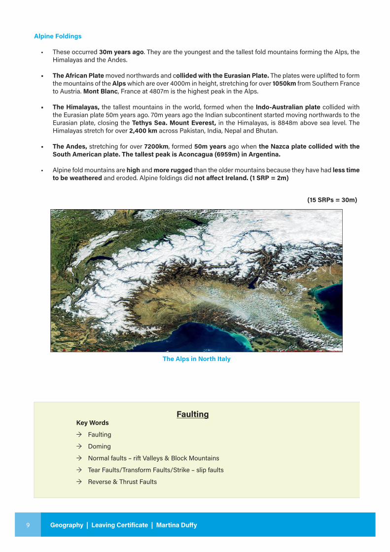
The Alps in North Italy
FaultingKey Words
→ Faulting
→ Doming
→ Normal faults – rift Valleys & Block Mountains
→ Tear Faults/Transform Faults/Strike – slip faults
→ Reverse & Thrust Faults
10
Geo
grap
hy |
Leav
ing
Cert
ifica
te L
ESSO
N 7
- 8
FAULTING
Definition & Explanation
• Faulting occurs when rocks are displaced relative to each other forming a fault line.
• A Fault Line is a fracture along which one section of the earth’s crust has been displaced relative to
another.
• This displacement may be vertical or horizontal or a combination of both. It results from compression
and tension associated with continental drift.
Doming: (necessary for the short questions @8m each)
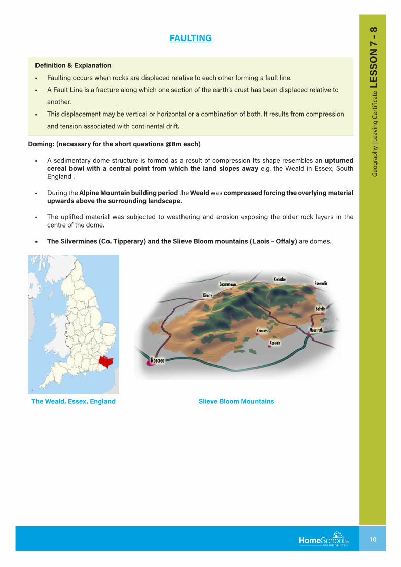
• A sedimentary dome structure is formed as a result of compression Its shape resembles an upturned cereal bowl with a central point from which the land slopes away e.g. the Weald in Essex, South England .
• During the Alpine Mountain building period the Weald was compressed forcing the overlying material upwards above the surrounding landscape.
• The uplifted material was subjected to weathering and erosion exposing the older rock layers in the centre of the dome.
• The Silvermines (Co. Tipperary) and the Slieve Bloom mountains (Laois – Offaly) are domes.
The Weald, Essex, England Slieve Bloom Mountains
11 Geography | Leaving Certificate | Martina Duffy
SAMPLE QUESTION 3: WITH THE AID OF DIAGRAMS EXPLAIN THE THREE TYPES OF FAULTS? (30m)
This question requires 15 SRPs
There are three types of fault:(1) Normal Faults;
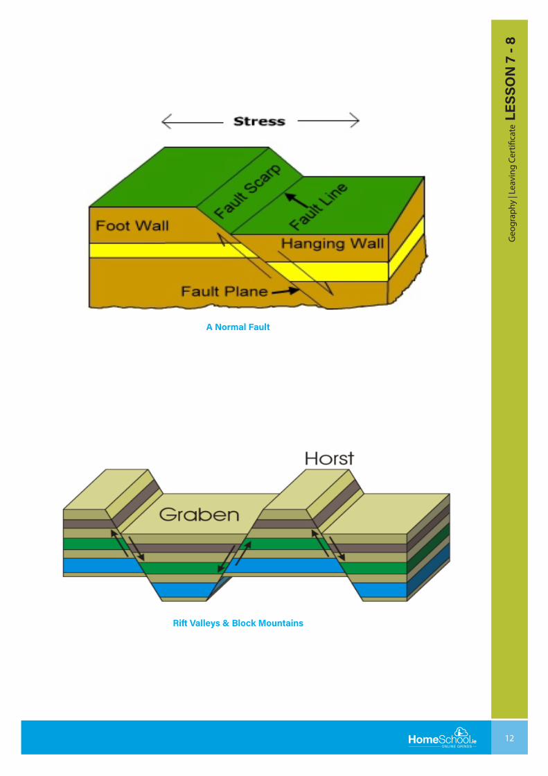
• These faults occur when plates move apart. (1SRP = 2m)
• The movement is vertical - one block slips vertically down past another. The exposed section is called a scarp. Normal faulting forms Rift Valleys (Graben) and Block Mountains (Horst). (1SRP = 2m)
• Rift Valleys form when a section of the earth’s surface slips downwards,(vertical downward movement) under the influence of gravity, between two parallel faults. (1 SRP = 2m)
• Rift Valleys or Graben are long and narrow with steep sides e.g. the Rhine Rift Valley, which was formed when a block of crust between the Vosges Mountains in France and the Black Forest in Germany collapsed forming the Rhine Rift Valley. (1 SRP = 2m)
• Glenmore (Scotland), the Dead Sea, the East African Rift Valleys which extend for 4800 kms (3000 miles) from Syria to the River Zambesi in East Africa, the Death Valley in California, Lough Neagh. (1 SRP = 2m)
• Block Mountains form when either two plates converge a block of land is uplifted or the surface on both sides of the fault may sink down leaving the central block standing. (1 SRP = 2m)
• The Ox Mountains, Co. Sligo, The Vosges Mountains, France, the Harz Mountains, The Black Forest and the Rhine Highlands, Germany are block mountains. (1 SRP = 2m)
The African Rift Valley extending for over 6,000 km from the Red Sea in the north to Mozambique in the south is located in a zone of normal faults which have developed due to divergence as a result of convection currents below the African continent. The faults are 40km to 60km wide. The land between the faults has dropped vertically downwards forming a large flat floored steep-sided rift valley. Parts of the valley are more than 150m below sea level. It is widening at a rate of 4mm per year. In some parts of the valley magma is coming to the surface forming volcanoes e.g. Mount Kenya & Mount Kilimanjaro. Some lakes have formed on the floor of the Rift Valley e.g. Lake Tanganyika, 1,420m deep. The eastern part of Africa will split to form a new continent and a new divergent plate boundary. This new plate will be called the Somali Plate.
12
Geo
grap
hy |
Leav
ing
Cert
ifica
te L
ESSO
N 7
- 8
A Normal Fault
Rift Valleys & Block Mountains
13 Geography | Leaving Certificate | Martina Duffy
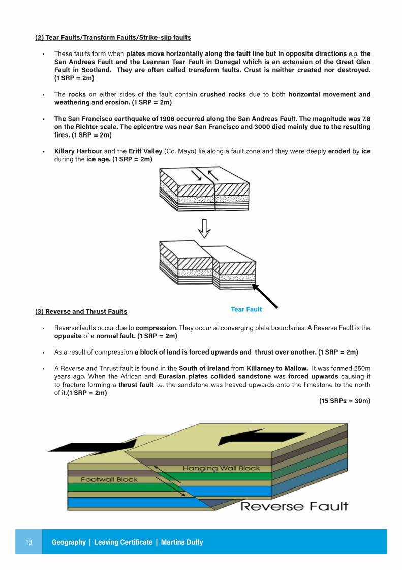
Tear Fault
(2) Tear Faults/Transform Faults/Strike-slip faults
• These faults form when plates move horizontally along the fault line but in opposite directions e.g. the San Andreas Fault and the Leannan Tear Fault in Donegal which is an extension of the Great Glen Fault in Scotland. They are often called transform faults. Crust is neither created nor destroyed. (1 SRP = 2m)
• The rocks on either sides of the fault contain crushed rocks due to both horizontal movement and weathering and erosion. (1 SRP = 2m)
• The San Francisco earthquake of 1906 occurred along the San Andreas Fault. The magnitude was 7.8 on the Richter scale. The epicentre was near San Francisco and 3000 died mainly due to the resulting fires. (1 SRP = 2m)
• Killary Harbour and the Eriff Valley (Co. Mayo) lie along a fault zone and they were deeply eroded by ice during the ice age. (1 SRP = 2m)
(3) Reverse and Thrust Faults
• Reverse faults occur due to compression. They occur at converging plate boundaries. A Reverse Fault is the opposite of a normal fault. (1 SRP = 2m)
• As a result of compression a block of land is forced upwards and thrust over another. (1 SRP = 2m)
• A Reverse and Thrust fault is found in the South of Ireland from Killarney to Mallow. It was formed 250m years ago. When the African and Eurasian plates collided sandstone was forced upwards causing it to fracture forming a thrust fault i.e. the sandstone was heaved upwards onto the limestone to the north of it.(1 SRP = 2m) (15 SRPs = 30m)
14
Geo
grap
hy |
Leav
ing
Cert
ifica
te L
ESSO
N 7
- 8Plate Movement
Explain how the movement of tectonic plates has impacted on the development of the Irish landscape using examples that you have
studied. (30m)
This question requires 15 SRPs
The movement of plate tectonics has greatly impacted on the development of the Irish landscape. The Ireland of today did not exist until about 400 million years ago. (1 SRP = 2m)
4.6 billion years ago the earth comprised one super landmass – Pangaea. Overtime Pangaea up into two super continents, Laurasia and Gondonwland. Laurisa travelled northwards and Gondonwland travelled southwards. (1 SRP = 2m)
Ireland as we know it formed part of the Laurasian landmass. Ireland through its geological past has witnessed converging and diverging, undergoing the processes of subduction and sea floor spreading respectively. Ireland has moved from its early location south of the equator to its present location at 53°N. It has moved very slowly over this time, at the rate of 1cm to 2cm per year due to the theory of thermal convection, the engine behind the theory of continental drift/plate tectonics. (1 SRP = 2m)
About 850m years ago North West Ireland was part of the North American plate which was lying close to the equator. Southern Ireland lay beyond an ocean, several thousand miles to the south, close to the tropic of Capricorn. (1 SRP = 2m)
Between 440 million and 400 million years ago the two parts of Ireland merged when the separating ocean closed and the two plates collided. The collision took place in a line running from Galway to Dundalk. The impact of this collision can be seen in Ireland today in the form of the Caledonian Fold Mountains. (1 SRP = 2m)
The Caledonian Fold Mountains of NW Ireland and the granites of Donegal and Wicklow were formed due to this collision. The Caledonian Foldings occurred 450m years ago when the North American and Eurasian plates converged during the Silurian geological period. This was an example of continental to continental convergence. These same fold mountains form the mountainous backbone of Norway, Sweden, Scotland and the Appalachian Mountains of NE USA. (1 SRP = 2m)
During the Caledonian folding period the Leinster Batholith was formed. During the foldings magma intruded into the upfolds to form granite forming the Leinster Batholith. A batholith is a dome shaped mass of igneous rocks, mainly granite, formed by the intrusion of magma into cavities as it forces its way upwards into the crust. It extends for 120kms from Killiney in Co. Dublin to Thomastown in Co. Kilkenny. (1 SRP = 2m)
About 320 million years ago Ireland lay beneath a warm shallow tropical sea near the equator. This period witnessed the formation of limestone on the bed of these seas. The limestone formed from the remains of compressed sea creatures which were laid down in layers. (1 SRP = 2m)
Approximately 270 million years ago the Eurasian Plate and the African Plate converged during the Permian geological period. This was a period of continental to continental convergence. This convergence resulted in the Armorican Foldings. The Armorican Folding formed the Munster Ridge & Valley landscape comprising anticlines of sandstones and synclines of limestone. The Munster Ridge and Valley runs east to west from the Comeragh Mountains in Waterford to the Caha Mountains in Cork and the Magillicuddy’s Reeks in Co. Kerry. (1 SRP = 2m)
The Armorican Foldings also uplifted the karst landscape of the Burren. The Burren is a very distinctive landscape comprising unique surface features such as limestone pavements and underground features such as dripstone formations. (1 SRP = 2m)
15 Geography | Leaving Certificate | Martina Duffy
• Between 200 million years ago and 140 million years ago Ireland continued to drift northwards. Marine sediments, rich in organic matter were deposited. Overtime these deposits became oil and gas. The gas in the Corrib gas field, 70 kms of the NW Mayo coast was starting to form around now. The gas in the field was trapped in geological formations called anticlines and fault traps. (1 SRP = 2m)
• 65 million years ago the European and American Plates diverged. Ireland experienced sea floor spreading. Ireland was located in an equatorial region. Ireland was undergoing an intensive period of igneous activity i.e. volcanic activity in the NE corner of Ireland which formed the Giant’s Causeway. Very fluid molten rock was ejected through fissures in the overlying chalk bed forming an extensive lava plateau – the Antrim Derry Plateau. (1 SRP = 2m)
• By 25 million years ago Ireland was close to assuming its present location. The intervening period of erosion resulted in soil formation and most of the rocks were covered in soil. Brown earth soils started to form in areas covered with deciduous forests with good drainage while in poorly drained areas gleys and podzols were formed. By about 3 million years ago the present day landscape of Ireland had more or less formed. (1 SRP = 2m)
• My answer proves that continental drift/plate tectonics has affected Ireland. Over millions of years Ireland, once in two parts, has moved from south of the equator to its present location, 53°n. Our climate is no longer tropical, but instead is a Cool Temperate Oceanic climate. (1 SRP = 2m)
• Also, we are no longer close to a plate boundary so volcanic activity and plate movement do not affect Ireland anymore. There is evidence of an extinct volcano at Slemish, Co. Armagh and a fault line in Leannan Co. Donegal. The most recent earthquakes in Ireland proved that earthquakes continue to occur in the interior of plates. (1 SRP = 2m)

16
Geo
grap
hy |
Leav
ing
Cert
ifica
te L
ESSO
N 7
- 8
Questions on Folding & Faulting
17 Geography | Leaving Certificate | Martina Duffy
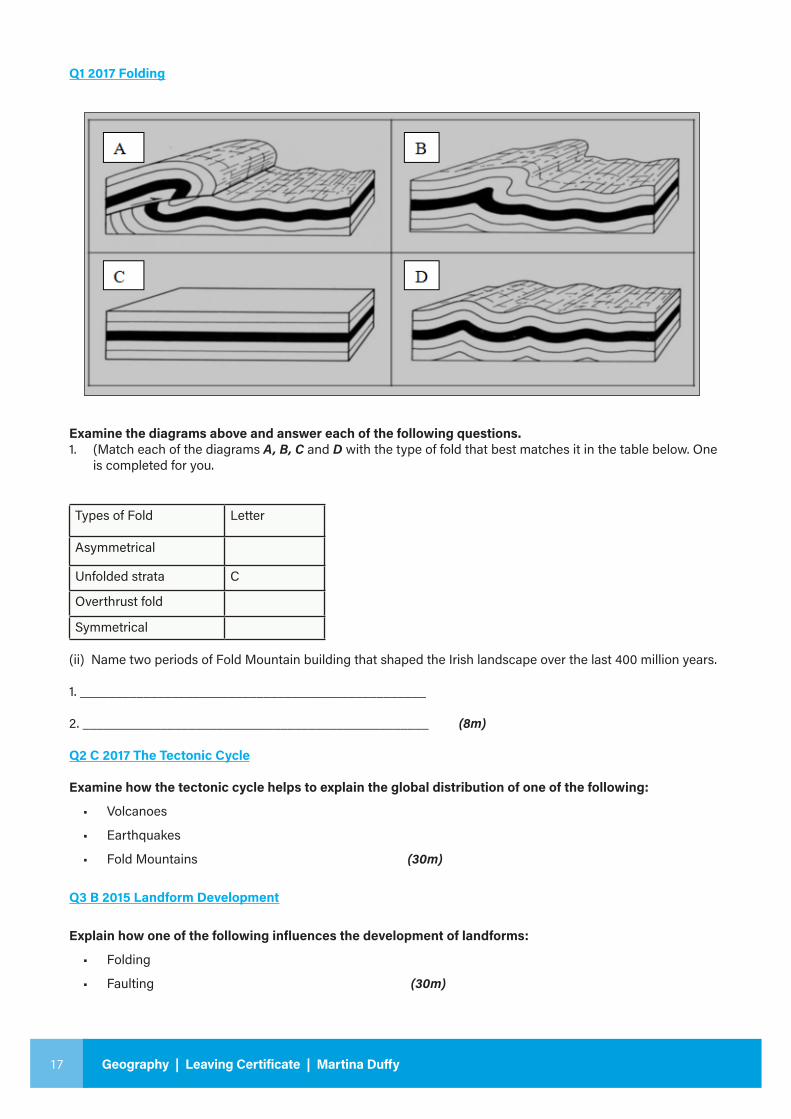
Q1 2017 Folding
Examine the diagrams above and answer each of the following questions.1. (Match each of the diagrams A, B, C and D with the type of fold that best matches it in the table below. One
is completed for you.
Types of Fold Letter
Asymmetrical
Unfolded strata C
Overthrust fold
Symmetrical
(ii) Name two periods of Fold Mountain building that shaped the Irish landscape over the last 400 million years.
1. _________________________________________________
2. _________________________________________________ (8m)
Q2 C 2017 The Tectonic Cycle
Examine how the tectonic cycle helps to explain the global distribution of one of the following:
• Volcanoes
• Earthquakes
• Fold Mountains (30m)
Q3 B 2015 Landform Development
Explain how one of the following influences the development of landforms:
• Folding
• Faulting (30m)
18
Geo
grap
hy |
Leav
ing
Cert
ifica
te L
ESSO
N 7
- 8
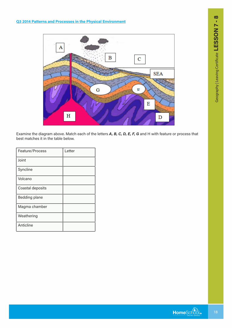
Q3 2014 Patterns and Processes in the Physical Environment
Examine the diagram above. Match each of the letters A, B, C, D, E, F, G and H with feature or process that best matches it in the table below.
Feature/Process Letter
Joint
Syncline
Volcano
Coastal deposits
Bedding plane
Magma chamber
Weathering
Anticline
19 Geography | Leaving Certificate | Martina Duffy
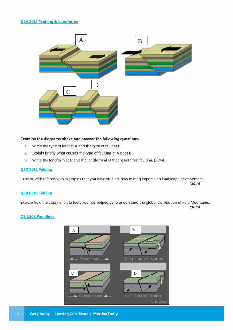
Q2A 2013 Faulting & Landforms
Examine the diagrams above and answer the following questions.
1. Name the type of fault at A and the type of fault at B.
2. Explain briefly what causes the type of faulting at A or at B.
3. Name the landform at C and the landform at D that result from faulting. (20m)
Q3C 2012 Folding
Explain, with reference to examples that you have studied, how folding impacts on landscape development. (30m)
Q2B 2010 Folding
Explain how the study of plate tectonics has helped us to understand the global distribution of Fold Mountains. (30m)
Q8 2008 Faultlines
20
Geo
grap
hy |
Leav
ing
Cert
ifica
te L
ESSO
N 7
- 8
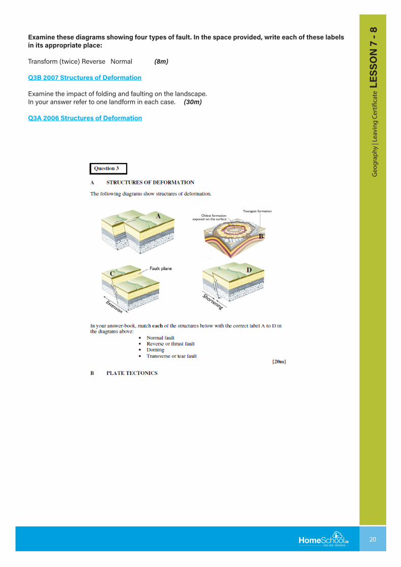
Examine these diagrams showing four types of fault. In the space provided, write each of these labels in its appropriate place:
Transform (twice) Reverse Normal (8m)
Q3B 2007 Structures of Deformation
Examine the impact of folding and faulting on the landscape.In your answer refer to one landform in each case. (30m)
Q3A 2006 Structures of Deformation
21 Geography | Leaving Certificate | Martina Duffy
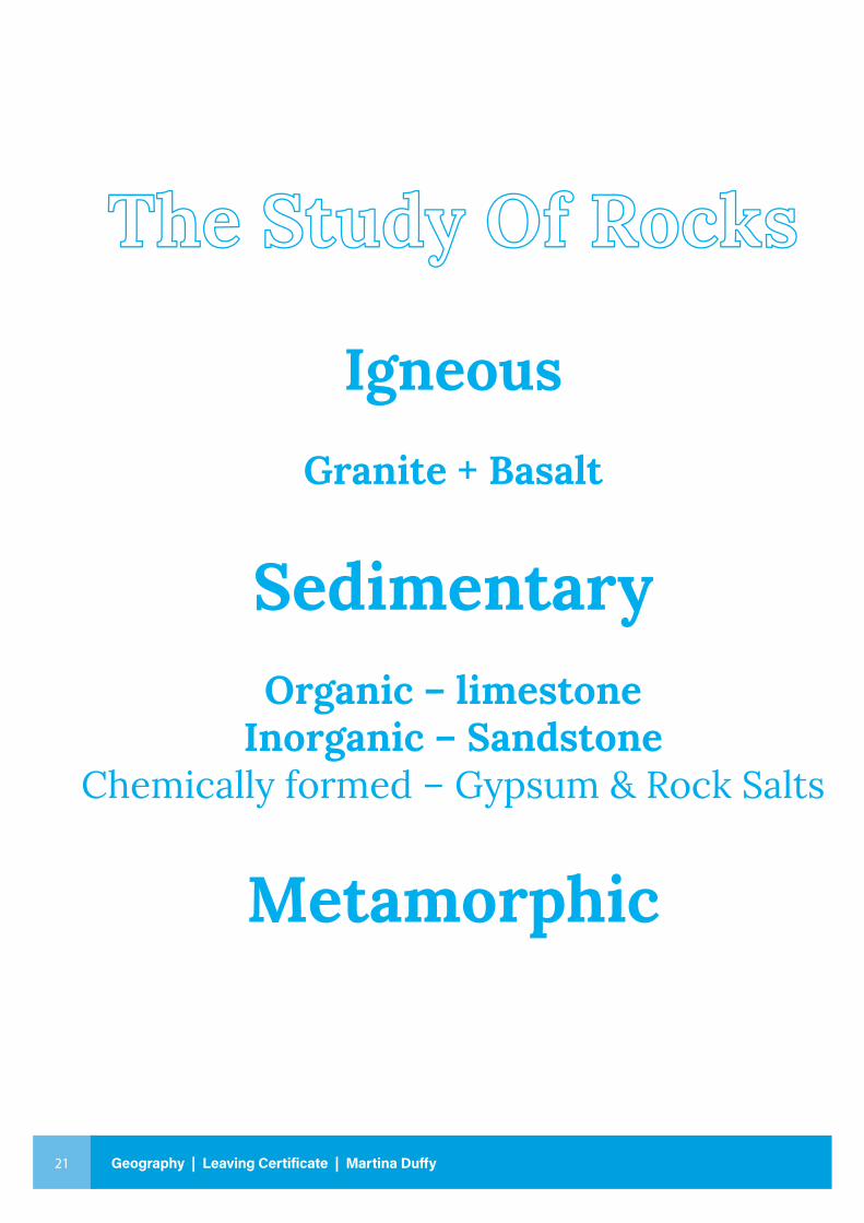
The Study Of Rocks
IgneousGranite + Basalt
SedimentaryOrganic – limestone
Inorganic – SandstoneChemically formed – Gypsum & Rock Salts
Metamorphic

22
Geo
grap
hy |
Leav
ing
Cert
ifica
te L
ESSO
N 7
- 8