tower place - bridgeport, ct
TRANSCRIPT

889 BARNUM AVENUE | BRIDGEPORT, CT
SEPTEMBER 2017
TOWER PLACEADAPTIVE REUSE STRATEGY

ACKNOWLEDGEMENTSOVERSIGHT COMMITTEE MEMBERS
Mayor Joseph Ganim | City of BridgeportJohn Gomes, CAO | City of Bridgeport
John Urquidi, City Engineer | City of BridgeportGuillermo Marin | East Side NRZ
Keith Williams | East End NRZFrancisco Borres | Mill Hill NRZTom Stilley | DuPont Properties
Michael Taylor | Vita Nuova/DuPont representativeMarian Whiteman | General Electric CompanyPam Elkow | General Electric Representative
Marc Brunetti | Yale New Haven Health/Bridgeport HospitalTodd McClutchy | JHM Group
Kim Morque | Spinnaker Real Estate PartnersLud Spinelli | Optimus Healthcare
Kevin Reed | Bridgeport Trade and Technology CenterMelissa Kaplan-Macey | Regional Plan Association
James Slaughter | Park City Communities
STAFF SUPPORT, CITY OF BRIDGEPORT—OPEDDean Mack, Planner II
Lynn Haig, Planning DirectorCurtis Denton, GIS Administrator
Frank Croke, Senior Economic Development AssociateParag Agrawal, Former Planning Director
Emily Provonsha, Former Planner II
FUNDED BYState of Connecticut, Office of Policy and Management (OPM)Transit-Oriented Development (TOD) Planning Grant Program
PLANNING TEAMGoody Clancy | VHB | W-ZHA
Simpson Grumpertz & Heger | VJ Associates

CONTENTSAbout Tower Place .................................................... 2
Site context and history ............................................. 2
Tower Place ....................................................................6
Adaptive reuse potential ......................................... 8
Existing building conditions and suitability......... 8 for marketable program
Land use and development strategy ................... 12
Market potential and positioning ...........................12
Land use recommendations and scenarios ......14
Recommended zoning updates .............................15
Development scenario characteristics ...............16
Traffic analysis ............................................................. 17
Redevelopment land use scenarios ................... 20
Sample redevelopment phasing sequence ......22
Economic feasibility and .........................................25 development strategy
Near-term use possibilities ..................................28
Urban design guidelines ........................................30
Recommended site layout principles ................ 30
Applying the Urban and Architectural ................35 Design Guidelines
Regulating plan ...........................................................36
Building types ..............................................................37
Frontage types ........................................................... 38
Architectural design guidelines .......................... 48
1BARNUM STATION TOD PLAN |
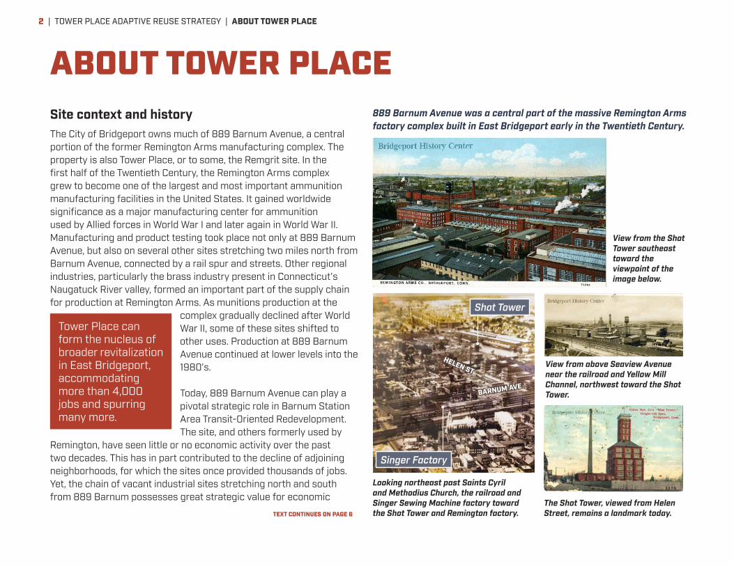
Site context and historyThe City of Bridgeport owns much of 889 Barnum Avenue, a central portion of the former Remington Arms manufacturing complex. The property is also Tower Place, or to some, the Remgrit site. In the first half of the Twentieth Century, the Remington Arms complex grew to become one of the largest and most important ammunition manufacturing facilities in the United States. It gained worldwide significance as a major manufacturing center for ammunition used by Allied forces in World War I and later again in World War II. Manufacturing and product testing took place not only at 889 Barnum Avenue, but also on several other sites stretching two miles north from Barnum Avenue, connected by a rail spur and streets. Other regional industries, particularly the brass industry present in Connecticut’s Naugatuck River valley, formed an important part of the supply chain for production at Remington Arms. As munitions production at the
complex gradually declined after World War II, some of these sites shifted to other uses. Production at 889 Barnum Avenue continued at lower levels into the 1980’s.
Today, 889 Barnum Avenue can play a pivotal strategic role in Barnum Station Area Transit-Oriented Redevelopment. The site, and others formerly used by
Remington, have seen little or no economic activity over the past two decades. This has in part contributed to the decline of adjoining neighborhoods, for which the sites once provided thousands of jobs. Yet, the chain of vacant industrial sites stretching north and south from 889 Barnum possesses great strategic value for economic
ABOUT TOWER PLACE
The Shot Tower, viewed from Helen Street, remains a landmark today.
Looking northeast past Saints Cyril and Methodius Church, the railroad and Singer Sewing Machine factory toward the Shot Tower and Remington factory.
Tower Place can form the nucleus of broader revitalization in East Bridgeport, accommodating more than 4,000 jobs and spurring many more.
View from the Shot Tower southeast toward the viewpoint of the image below.
View from above Seaview Avenue near the railroad and Yellow Mill Channel, northwest toward the Shot Tower.
889 Barnum Avenue was a central part of the massive Remington Arms factory complex built in East Bridgeport early in the Twentieth Century.
Singer Factory
Shot Tower
BARNUM AVE
HELEN ST
TEXT CONTINUES ON PAGE 6
| TOWER PLACE ADAPTIVE REUSE STRATEGY | ABOUT TOWER PLACE2

CONNECTICUT’S NEXT GREAT ECONOMIC GROWTH CORRIDOR
Tower Place is uniquely positioned to form the nucleus of a new center of jobs and amenities driving economic development for area neighborhoods, Bridgeport as a whole, and southwestern Connecticut. Opportunity can be maximized by following a mixed-use, transit-oriented development approach, emphasizing employment-related uses near the planned Barnum Station, and including housing, neighborhood retail, parks and other community uses as well. Benefits can include:
• 1,800 to 2,400 new jobs on-site
• 3,000 to 4,000 new jobs in Bridgeport as a whole
• 4,000 to 5,000 or more new jobs in Fairfield and New Haven Counties as a whole
• $300 million to $500 million in new income to people in the region
• Collaborative, connected “innovation district” work environment that builds Connecticut’s strategic economic sectors
• New jobs, transportation choices, housing options, parks, retail, and cultural activity serving adjoining neighborhoods
• Restoration of polluted soils and crumbling buildings as productive areas to work, live, play and learn, along a natural greenway
Barnum Avenue can transform into a prime development address, with easy access by rail and road.
Tower Place, together with the Barnum Station site, can be redeveloped with around Barnum Avenue to establish an attractive, high-value center for employment, living, and community uses.
EXISTING POTENTIAL
Barnum Station site Barnum Avenue Tower Place
New mixed-use real-estate development flanking Barnum Avenue
Yellow Mill Greenway
TOWER PLACE ADAPTIVE REUSE STRATEGY | ABOUT TOWER PLACE | 3
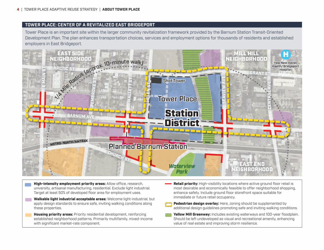
High-intensity employment priority areas: Allow office, research, university, artisanal manufacturing, residential. Exclude light industrial. Target at least 50% of developed floor area for employment uses.
Walkable light industrial acceptable areas: Welcome light-industrial, but apply design standards to ensure safe, inviting walking conditions along these properties.
Housing priority areas: Priority residential development, reinforcing established neighborhood patterns. Primarily multifamily, mixed-income with significant market-rate component.
Retail priority: High-visibility locations where active ground floor retail is most desirable and economically feasible to offer neighborhood shopping, enhance safety. Include ground floor storefront space suitable for immediate or future retail occupancy.
Pedestrian design overlay: Here, zoning should be supplemented by additional design guidelines promoting safe and inviting walking conditions.
Yellow Mill Greenway: Includes existing waterways and 100-year floodplain. Should be left undeveloped as visual and recreational amenity, enhancing value of real estate and improving storm resilience.
TOWER PLACE: CENTER OF A REVITALIZED EAST BRIDGEPORTTower Place is an important site within the larger community revitalization framework provided by the Barnum Station Transit-Oriented Development Plan. The plan enhances transportation choices, services and employment options for thousands of residents and established employers in East Bridgeport.
| TOWER PLACE ADAPTIVE REUSE STRATEGY | ABOUT TOWER PLACE4
BARNUM AVE
SEAVIEW AVE
WATERVIEW AVE
Yellow MillChannel
I-95
ARCT
IC S
T
HELEN ST
DowntownBridgeport
Bridgeport Hospital
Bridgeport Hospital
Steelpointe Harbor
Tower Place
Barnum Station site
Barnum Station entrance
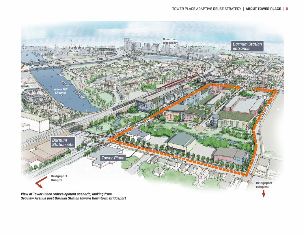
View of Tower Place redevelopment scenario, looking from Seaview Avenue past Barnum Station toward Downtown Bridgeport
TOWER PLACE ADAPTIVE REUSE STRATEGY | ABOUT TOWER PLACE | 5
development. Located along a corridor generally following Seaview Avenue and the Yellow Mill Greenway, the sites form one of the most significant aggregations of underutilized industrial land in Connecticut, and have convenient access to several highways—Interstate 95, and Connecticut Routes 8, 15 and 25. A number of light industrial operations remain in this corridor, finding it a competitive location. Two large flex space facilities, the Bridgeport Trade and Technology Center and Bridgeport Innovation Center, consistently attract small businesses that grow. Yale New Haven Health’s Bridgeport Hospital campus, Bridgeport’s largest employer, lies just east of the corridor. Hundreds of acres of vacant land offer opportunity for redevelopment that can expand upon these business and employment anchors, and help enhance adjoining neighborhoods with additional housing options, community services, and park amenities.
The State of Connecticut and City of Bridgeport have identified the opportunity to stimulate transformative reinvestment in the area through transit-oriented development. A new Northeast Corridor rail station in East Bridgeport, configured to accommodate local and express Metro-North passenger trains as well as possible Amtrak service, is under design. 889 Barnum Avenue is one of the largest and most accessible sites around this station—just a three- to ten-minute walk to various parts of the site from planned rail platforms. The City controls more than 15 developable acres between 889 Barnum Avenue (approximately 9 developable acres), and a second site facing it on the south side of Barnum Avenue (approximately 6.5 developable acres), where the station itself as well as real estate development can be located. This acreage on the two sites offers the most significant development opportunity in the study area, owing to its large size, station proximity and city control.
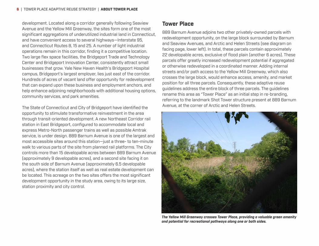
Tower Place889 Barnum Avenue adjoins two other privately-owned parcels with redevelopment opportunity, on the large block surrounded by Barnum and Seaview Avenues, and Arctic and Helen Streets (see diagram on facing page, lower left). In total, these parcels contain approximately 22 developable acres, exclusive of flood plain (another 6 acres). These parcels offer greatly increased redevelopment potential if aggregated or otherwise redeveloped in a coordinated manner. Adding internal streets and/or path access to the Yellow Mill Greenway, which also crosses the large block, would enhance access, amenity, and market position for all three parcels. Consequently, these adaptive reuse guidelines address the entire block of three parcels. The guidelines rename this area as “Tower Place” as an initial step in re-branding, referring to the landmark Shot Tower structure present at 889 Barnum Avenue, at the corner of Arctic and Helen Streets.
The Yellow Mill Greenway crosses Tower Place, providing a valuable green amenity and potential for recreational pathways along one or both sides.
| TOWER PLACE ADAPTIVE REUSE STRATEGY | ABOUT TOWER PLACE6
On ten acres of the Tower Place site near the planned station, primarily utilizing 889 Barnum Avenue, it is possible to accommodate well over half a million square feet of new building development, including 1,800 to 2,400 or more jobs on-site. Neighborhood-serving retail, community uses, and/or housing are also possible within this capacity. Additional economic activity spurred off-site by this development could support as many as 1,200 to 1,600 additional jobs in the city, and as many as 2,200 to 2,800 additional jobs in Fairfield and New Haven counties overall. Employee income associated with these jobs in the two counties could range from about $200 million to over $500 million. Redevelopment of other portions of Tower Place, and/or additional city-controlled land across Barnum Avenue at the station site, could increase this opportunity significantly further.
Tower Place can form the nucleus of broader revitalization in East Bridgeport accommodating more than 4,000 jobs and spurring many more. This represents opportunity for a major center of economic development for Bridgeport and Connecticut as a whole. Market and feasibility considerations, development scenarios, and development strategies to seize this opportunity are described in greater detail on the following pages.
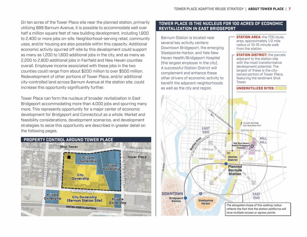
Barnum Station is located near several key activity centers: Downtown Bridgeport, the emerging Steelpointe Harbor, and Yale New Haven Health/Bridgeport Hospital (the largest employer in the city). A successful Station District will complement and enhance these other drivers of economic activity to benefit the adjacent neighborhoods as well as the city and region.
The elongated shape of this walking radius reflects the fact that the station platforms will have multiple access or egress points.
STATION AREA: the TOD study area, approximately 1/2 mile radius or 10-15 minute walk from the station
STATION DISTRICT: the parcels adjacent to the station site with the most transformative development potential. The largest of these is the city-owned portion of Tower Place, featuring the landmark Shot Tower.
UNDERUTILIZED SITES:
PROPERTY CONTROL AROUND TOWER PLACE
TOWER PLACE IS THE NUCLEUS FOR 100 ACRES OF ECONOMIC REVITALIZATION IN EAST BRIDGEPORT
TOWER PLACE ADAPTIVE REUSE STRATEGY | ABOUT TOWER PLACE | 7

Existing building conditions and suitability for marketable programSeveral structures that formerly served industrial production or office functions remain at 889 Barnum Avenue. The buildings demonstrate a variety of configurations and conditions; several other buildings were previously demolished. The century-old Shot Tower, rising ten slender stories on the northwest corner of the site at Arctic and Helen Streets, is an iconic although deteriorating landmark in East Bridgeport. The other remaining factory buildings, including a nearly continuous line of buildings along Barnum Avenue, are also in serious disrepair and present a safety and public image problem. Several
buildings were severely damaged by fire, and all show damage from vandalism and water infiltration through open window and roof areas. The soil and groundwater have environmental contamination left over from the site’s industrial history, creating an additional barrier to redevelopment.
ADAPTIVE REUSE POTENTIAL
Building 93’s wooden support structure is rotting, causing portions of floors to sag and collapse.
A clear, clean, safe site will be highly visible and is the best strategy to promote private redevelopment.
A large fire in 2010 destroyed Buildings 342 and 343; a subsequent 2014 fire heavily damaged Buildings 339, 340 and 341.
ARTIC STREET
BARNUM AVENUE
HEL
EN S
TREE
T
A
ABC
D
E
F
EXISTING STRUCTURES AT 889 BARNUM AVENUE
Building 93Buildings 77 & 875Building 330
Building 339
Building 341
Shot Tower
| TOWER PLACE ADAPTIVE REUSE STRATEGY | ADAPTIVE REUSE POTENTIAL8
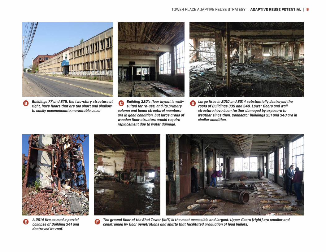
The ground floor of the Shot Tower (left) is the most accessible and largest. Upper floors (right) are smaller and constrained by floor penetrations and shafts that facilitated production of lead bullets.
Large fires in 2010 and 2014 substantially destroyed the roofs of Buildings 339 and 340. Lower floors and wall structure have been further damaged by exposure to weather since then. Connector buildings 331 and 340 are in similar condition.
Building 330’s floor layout is well-suited for re-use, and its primary
column and beam structural members are in good condition, but large areas of wooden floor structure would require replacement due to water damage.
Buildings 77 and 875, the two-story structure at right, have floors that are too short and shallow to easily accommodate marketable uses.
A 2014 fire caused a partial collapse of Building 341 and destroyed its roof.
B
E F
C D
TOWER PLACE ADAPTIVE REUSE STRATEGY | ADAPTIVE REUSE POTENTIAL | 9

As part of this planning process, an analysis was conducted of the feasibility and desirability of rehabilitating and re-occupying the remaining buildings. Factors considered included historic significance, structural condition and repair needs, rehabilitation cost, suitability for the most likely future uses, and internal contamination. These findings led to the following conclusions:
• A clear, clean, safe site will be highly visible and is the best strategy to promote private redevelopment.
• Environmental remediation of soils at 889 Barnum Avenue to an industrial/commercial development standard is anticipated to occur at no cost to the City or future developers. This is based on an agreement between the City and the successor entity to Remington Arms. Residential development on the site would require remediation to a higher standard, potentially imposing additional costs on the City or future developer.
• There are social and placemaking reasons for preserving the Shot Tower for its iconic and historic value. However, economic reuse will be challenging and require significant commitment and investment from a private partner. The practical floor area available for use is limited by the relatively small area of upper floors, and presence of large factory equipment and floor penetrations. The approximately 8,600 square foot first floor appears most practical for re-use; upper floors, offering only about 3,500 square feet each at most, pose greater challenges.
• The cost to renovate the other buildings, remediate contamination in them, and fit them out for reuse is very expensive compared to the likely economic return from any reasonable reuse. The only building that both retains the majority of its structure in good condition, and offers floor configurations and character suitable for marketable commercial or residential use, is Building 330, located at the corner of Barnum Avenue and Helen Street. The building contains about 45,000 square feet of floor area divided among four floors above
grade. Even here, overall costs for renovation are likely to total at least double the cost of building comparable new space. Historic tax credits, if available, could potentially cover much of the difference.
• It would likely take at least two years, and possibly five to ten years or longer, to secure interested entities and funding necessary to undertake building renovation. Meanwhile, both the Shot Tower and Building 330 deteriorate further due to weather exposure through open windows and roof areas, increasing ultimate renovation costs. Either building would require investment of about $2 million for temporary weather enclosures as soon as possible, to preserve potential for future renovation.
• Unless a developer with successful experience in historic building renovation demonstrates strong interest in renovating Building 330, this study recommends that the building be demolished in order to most effectively attract private investment in redevelopment.
See pages 25–27 for additional discussion of the economics of rehabilitation and new construction.
Based on these findings, the immediate next steps are to stabilize and secure the Shot Tower and possibly Building 330 at the corner of Barnum and Helen, demolish the remaining buildings, remediate the soil, and create an attractive interim condition using landscape and possibly interim uses (see pages 28–29 for possibilities). These improvements will create a much more positive image for the Tower Place site, and safer conditions for people on and around the site, setting the stage for future private investment in this key location.
| TOWER PLACE ADAPTIVE REUSE STRATEGY | ADAPTIVE REUSE POTENTIAL10
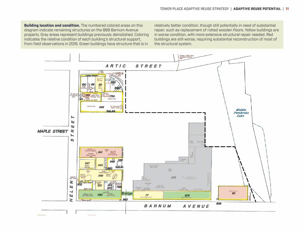
Building location and condition. The numbered colored areas on this diagram indicate remaining structures on the 889 Barnum Avenue property. Gray areas represent buildings previously demolished. Coloring indicates the relative condition of each building’s structural support, from field observations in 2016. Green buildings have structure that is in
relatively better condition, though still potentially in need of substantial repair, such as replacement of rotted wooden floors. Yellow buildings are in worse condition, with more extensive structural repair needed. Red buildings are still worse, requiring substantial reconstruction of most of the structural system.
TOWER PLACE ADAPTIVE REUSE STRATEGY | ADAPTIVE REUSE POTENTIAL | 11

Market potential and positioningPrivate sector market interest is essential if redevelopment is to occur. Thus, market positioning analysis was conducted for this study, to determine whether Tower Place and its environs could be successfully repositioned to attract a significant amount of real estate development. This analysis indicates that high-density employment uses—like office, healthcare, and research, that bring relatively high numbers of
employees per unit land area—can be marketable and deserve priority at Tower Place. Such uses not only would be most attracted to Barnum Station’s transit access, but also would likely produce the greatest economic returns to the City and region, over time. Multi-family housing and light industry also deserve significant presence in the half-mile radius surrounding Barnum Station, owing to ongoing market interest and the additional housing and job options they can provide the community. But on sites like Tower Place within three blocks of the station—an area referred to here as the Barnum Station District—prioritizing high-density employment uses for at least half of developed floor area would do the most to generate economic benefits.
There is little doubt that Barnum Station will generate housing demand once it is operational. Indeed, the Station Area is already seeing increased housing demand from a combination of households coming from Bridgeport, from neighboring communities, and from New York City. Likewise, the area’s established position as a place for light industry is expected to continue to drive incremental growth in demand for flex space. A big question for this plan, however, was whether the station, and presence of large redevelopment sites near it, would generate demand for office development nearby. New analysis indicates that the station and surrounding land, anchored by Tower Place, can indeed establish an important new address for office development.
LAND USE AND DEVELOPMENT STRATEGYHigh-density employment uses—like office, healthcare, and research, that bring relatively high numbers of employees per unit land area—can be marketable and deserve priority at Tower Place.
The Barnum Station Area represents one of the largest transit-oriented development opportunities on the Northeast Corridor north of New York City.
The Barnum Station District is well-positioned to attract new growth and provide improved transit access to the regional economy.
| TOWER PLACE ADAPTIVE REUSE STRATEGY | LAND USE AND DEVELOPMENT STRATEGY12
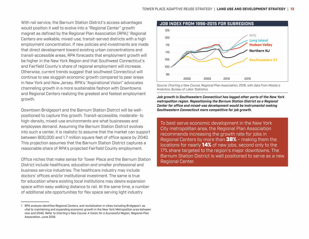
With rail service, the Barnum Station District’s access advantages would position it well to evolve into a “Regional Center” growth magnet as defined by the Regional Plan Association (RPA).1 Regional Centers are walkable, mixed-use, transit-served districts with a high employment concentration. If new policies and investments are made that direct development toward existing urban concentrations and transit-accessible areas, RPA forecasts that employment growth will be higher in the New York Region and that Southwest Connecticut’s and Fairfield County’s share of regional employment will increase. Otherwise, current trends suggest that southwest Connecticut will continue to see sluggish economic growth compared to peer areas in New York and New Jersey. RPA’s “Aspirational Vision” advocates channeling growth in a more sustainable fashion with Downtowns and Regional Centers realizing the greatest and fastest employment growth.
Downtown Bridgeport and the Barnum Station District will be well-positioned to capture this growth. Transit-accessible, moderate- to high-density, mixed-use environments are what businesses and employees demand. Assuming the Barnum Station District evolves into such a center, it is realistic to assume that the market can support between 800,000 and 1.7 million square feet of office space by 2040. This projection assumes that the Barnum Station District captures a reasonable share of RPA’s projected Fairfield County employment.
Office niches that make sense for Tower Place and the Barnum Station District include healthcare, education and smaller professional and business service industries. The healthcare industry may include doctors’ offices and/or institutional investment. The same is true for education where existing local institutions may desire expansion space within easy walking distance to rail. At the same time, a number of additional site opportunities for flex space serving light industry
1 RPA analysis identifies Regional Centers, and revitalization in cities including Bridgeport, as vital to maintaining and expanding economic growth in the New York Metropolitan area between now and 2040. Refer to Charting a New Course: A Vision for a Successful Region, Regional Plan Association, June 2016.
To best serve economic development in the New York City metropolitan area, the Regional Plan Association recommends increasing the growth rate for jobs in Regional Centers by more than 38% – making them the locations for nearly 14% of new jobs, second only to the 17% share targeted to the region’s major downtowns. The Barnum Station District is well positioned to serve as a new Regional Center.
Source: Charting a New Course, Regional Plan Association, 2016, with data from Moody’s Analytics, Bureau of Labor Statistics
Job growth in Southwestern Connecticut has lagged other parts of the New York metropolitan region. Repositioning the Barnum Station District as a Regional Center for office and mixed-use development would be instrumental making Southwestern Connecticut more competitive for job growth.
15 Charting a New Course | Regional Plan Association | June 2016
age of 58,000 jobs annually. The biggest job growth came from high-wage sectors such as professional and technical services and management services, low-wage industries such as retail and food services, and health care and education, which showed growth across occupa-tions with a broad range of skills and incomes. Financial services, which provided much of the region’s growth in earnings, actually declined slightly in employment, partly because of continuing fallout from the financial crisis. Manufacturing continued its long-term decline, falling at the rate of 3% per year.
Unlike the preceding decades, New York City grew faster than any other part of the region, slightly more than Long Island and the Hudson Valley, twice as much as northern New Jersey, and much more than southwestern Connecti-cut. This pattern strengthened over the last decade. From 1996-2001, New York City grew at a rate similar to the rest of the region. It declined relative the rest of the region in the years immediately following 2001, but since 2004 has grown much faster than the rest of the region.
Many of the factors contributing to these trends appear to be durable. Both domestic and global cities that have dense concentrations of high-skill workers like New York are increasing their dominance in high-value, high-wage industries. Millennials, many now in their 30s, are still favoring walkable, transit-oriented places more than their parents did at the same age. Retiring boomers, too, are
are comparable, with both coming four years after the trough of the region’s two deepest postwar recessions, and the period as a whole includes two strong expansions followed by recessions.
showing a strong preference for less auto-dependent places, and many are looking to move to smaller, more centrally located homes.2 Even if the majority of millen-nials live in suburban communities as they get older, the share living in cities or small downtowns will still likely be large enough to anchor significant urban growth. While many of the industry trends are likely to moderate, sec-2 Eighty percent of 18-34 year-olds would like to live in places where they don’t need a car to get around (Rockefeller Millennials Survey, Rockefeller Foundation and Transporta-tion for America, 2014), a finding that would have been unlikely with baby boomers at a similar age. A survey by the American Planning Association (Investing in Economic Growth and Competitiveness, 2014) found convergence of current preferences across generations, with millennials, boomers and Generation X’ers born in between desiring to move away from auto-dependent neighborhoods.
Figure 3: Change in Jobs by Industry,1996-2015
-400K -40K
-19K -16K
-5K -1K
+9K +17K
+38K +73K +83K +92K
+109K +156K +161K
+176K +251K
+285K +485K
-500K -400K -300K -200K -100K 0 100K 200K 300K 400K 500K K600K
Manufacturing Finance and insurance Wholesale trade Information Utilities Mining
Transportation & WarehousingReal Estate, Rental & Leasing
Management of Companies & EnterprisesArts, Entertainment & Recreation
ConstructionGovernment
Other ServicesAdministrative & Support, Waste Management, Remediation Services
Educational ServicesRetail Trade
Professional, Scientific & Technical ServicesAccommodation & Food Services
Health Care & Social Assistance
Source: Moody’s Analytics, Bureau of Labor Statistics
Figure 4: Job Index from 1996-2015 for Subregions
95
100
105
110
115
120
125
2000 2005 2010 2015
Job Index from 1996-2015 for Subregions
Southwestern CT
Hudson Valley Long Island
Northern NJ
NYC
Source: Moody’s Analytics, Bureau of Labor Statistics
120
110
100
952000
NYCLong IslandHudson Valley
Northern NJ
Southwestern CT
2005 2010 2015
125
115
105
JOB INDEX FROM 1996-2015 FOR SUBREGIONS
TOWER PLACE ADAPTIVE REUSE STRATEGY | LAND USE AND DEVELOPMENT STRATEGY | 13
will remain available in East Bridgeport. This will ensure continued availability of a broad spectrum of jobs accessible to Bridgeport residents. It also supports continued competitiveness of Bridgeport businesses in precision manufacturing and health care sectors that help drive economic development in Connecticut.
Land use recommendations and scenariosTo achieve the market repositioning and redevelopment described above, zoning for Tower Place must be changed. Under Bridgeport’s Zoning and Subdivision Regulations, the site is currently zoned I-L, a light industrial designation that allows substantial office space only through special permit, and does not allow several key uses potentially desirable as part of redevelopment, including medical service, college/university facilities, housing or parkland. The development standards of current I-L zoning are also incompatible with those needed for transit-accessible, moderate to higher-density mixed-use development. Standards should be changed to produce new development that is pedestrian-friendly, fits well with adjoining neighborhoods, and creates a predictable, high-value setting for future developers and tenants. Bridgeport’s existing DVD-TOD zoning category is an example of a zoning approach to land use and development standards that would be appropriate for Tower Place in most respects. Dimensional standards of the existing NCVD zoning category also could also serve as an appropriate precedent for portions of Tower Place where lower building heights are desired.
Several development scenarios were created for Tower Place to demonstrate possibilities and principles for land use and urban design, test economic feasibility of redevelopment, and simulate development phasing possibilities. Economic feasibility findings are discussed on page 25. Key variables explored in the scenarios include real estate market positioning, land use mix, amount of development, and extent of taxable uses versus non-taxable uses, such as medical or educational facilities that may be desirable as a primary or secondary presence. The scenarios are described on pages 16-17 and illustrated on pages 20-21. Expected economic impacts from each scenario are summarized on pages 20-21 and detailed on page 25.
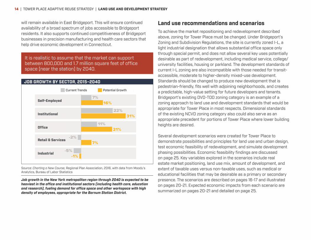
It is realistic to assume that the market can support between 800,000 and 1.7 million square feet of office space [near the station] by 2040.
17 Charting a New Course | Regional Plan Association | June 2016
tured implicitly to the extent that the region’s high relative costs result from past limits on housing supply or other constraints. By contrast, the NYMTC forecast puts greater emphasis on the region’s development constraints. It uses third-party forecasts, including Moody’s, as a base, and then adjusts industry totals on a county basis to account for local development capacity.3 Given the differences in approach, the Moody’s forecast is a more appropriate basis for determining how much the regional economy could grow based solely on demand and competitiveness with other domestic and international regions, uncon-strained by the supply of housing, transportation and other infrastructure.
The adjusted Moody’s forecast doesn’t represent the highest possible job growth for the region. If either global or national growth is stronger than Moody’s baseline pre-diction, then the region could see more job growth even if the region’s relative competitiveness remains unchanged.
The type of job growth will affect the type of skills that are needed and the type of work spaces the region will need to create. Compared with past trends, the adjusted Moody’s forecast projects more moderate declines in manufacturing, slower growth in retail trade, modest growth in finance and slower growth in nearly every service category, whether in export industries like profes-sional services or locally driven industries such as health care and social assistance. Differences between past trends and future growth are consistent with slowing growth in the working age population and potential for labor-reducing automation in industries from retail trade to health care. They don’t necessarily mean that wages will continue to stagnate or that income inequality will get bet-
3 A full explanation of the process can be found in Draft 2050 Socioeconomics and Demographics Forecast Report, New York Metropolitan Transportation Council, March 2015.
ter or worse, because there could be substantial change in the types of occupations and skill requirements within industries.
The largest share of the growth, about one million jobs, will be in office industries such as finance and professional services. At current rates of office space per worker, that could require as much as 200 million square feet of office space, about eight times the amount projected to be built in the Hudson Yards district of Manhattan. But employers are putting more workers into less space, a trend that is likely to continue and hold down the amount of new space that is needed. Industrial jobs—manufacturing, transpor-tation, warehousing and construction—are projected to decline slightly, but space will be needed for a million workers in factories, warehouses and other industrial loca-tions. Retail and service jobs will grow much less than in the recent past, while health and education will still repre-sent the fastest growing sector. The demand for hospitals, other medical institutions and higher education facilities is likely to continue growing throughout the region, while the need for new primary and secondary school space will vary by the demographics of different localities.
A Larger and More Diverse PopulationSeveral converging trends will shape the tri-state area’s population and labor force in the next 25 years. The fastest growing age group—those over 65—is also the cohort that has consistently had more out-migration than in-migration. Compared with previous decades, older adults are healthier and work longer, which could delay post-retirement migration. The age group that has nearly always had more people moving in than moving out—people in their 20s and early 30s—is likely to be sought after throughout the U.S. as a shrinking labor force puts a premium on new entrants to the workforce. So far, the region has retained its appeal for young adults. The flow of new immigrants to the region is likely to continue, but the number and composition could change in response to changes in relative wages in other parts of the world or to new national policies regulating immigration.
The factors that will have the biggest influence on migra-tion, and therefore on population growth, are career opportunities and the cost of living. The chance to pros-per and get ahead has always been the region’s primary attraction, while lack of affordability, particularly high housing costs, is arguably its main inhibitor. So the num-ber and quality of jobs that are created and the relative cost of living compared with other regions will be the main determinants of how much the region’s population grows. Job and population growth are mutually reinforcing. More jobs attract more people and a larger labor supply attracts
Figure 6: Job Growth by Sector, 2015-2040
Current Trends Potential Growth
-1%
7%
21%
31%
16%
-5%
-2%
11%
22%
7%
Industrial
Retail &Services
O�ce
Institutional
Self-Employed
Source: Regional Plan Association; Moody’s Analytics, Quarterly Census of Economics and Wages
Current Trends
Self-Employed
Institutional
Office
Industrial
Retail & Services
Potential Growth
JOB GROWTH BY SECTOR, 2015–2040
Source: Charting a New Course, Regional Plan Association, 2016, with data from Moody’s Analytics, Bureau of Labor Statistics
Job growth in the New York metropolitan region through 2040 is expected to be heaviest in the office and institutional sectors (including health care, education and research), fueling demand for office space and other workspace with high density of employees, appropriate for the Barnum Station District.
| TOWER PLACE ADAPTIVE REUSE STRATEGY | LAND USE AND DEVELOPMENT STRATEGY14
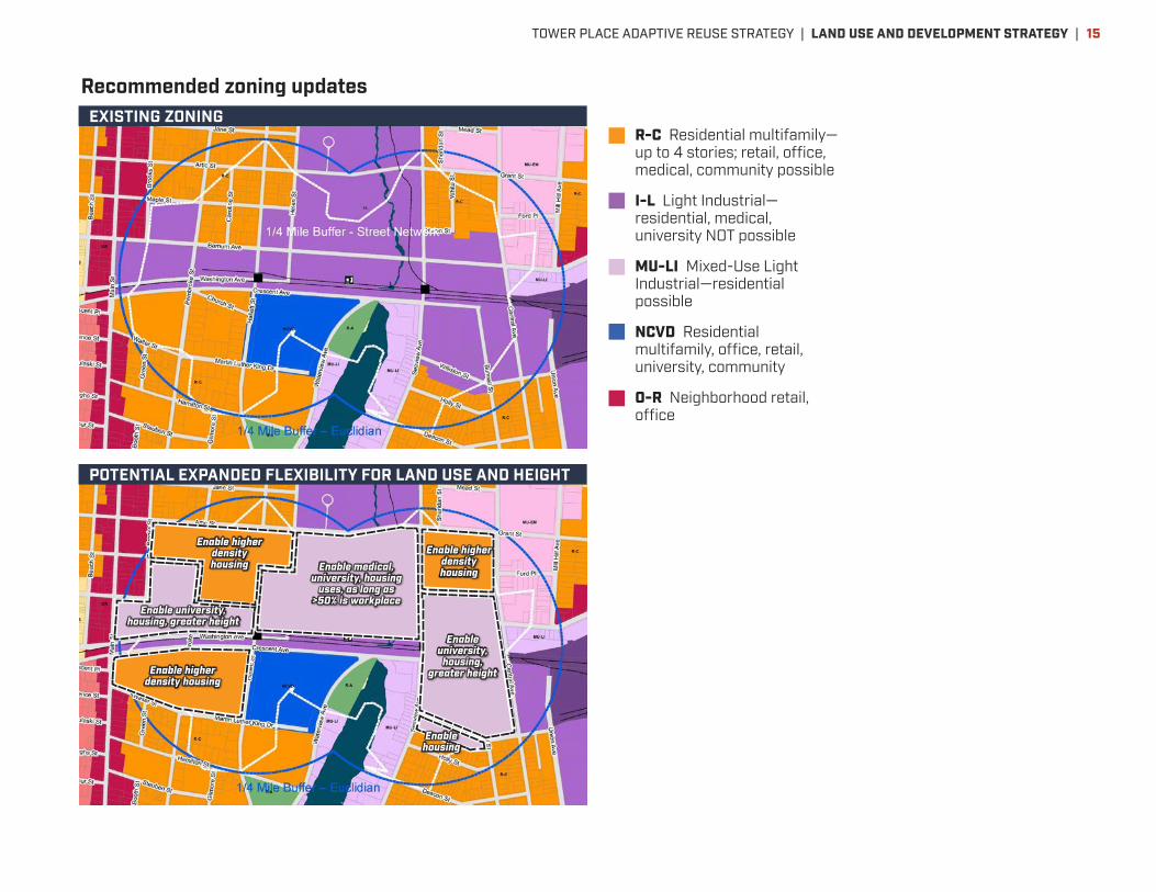
Recommended zoning updates
Enable higher density housing
Enable higher density housing
Enable higher density housing
Enable housing
Enable university, housing,
greater height
Enable medical, university, housing
uses, as long as >50% is workplace
Enable university, housing, greater height
R-C Residential multifamily—up to 4 stories; retail, office, medical, community possible
I-L Light Industrial—residential, medical, university NOT possible
MU-LI Mixed-Use Light Industrial—residential possible
NCVD Residential multifamily, office, retail, university, community
O-R Neighborhood retail, office
EXISTING ZONING
POTENTIAL EXPANDED FLEXIBILITY FOR LAND USE AND HEIGHT
TOWER PLACE ADAPTIVE REUSE STRATEGY | LAND USE AND DEVELOPMENT STRATEGY | 15

Development scenario characteristics
Light Industry/Flex. This scenario demonstrates possibilities under current market conditions and positioning, assuming no rail station or other investments that transform the
site’s market position. Light industrial/flex development could be feasible in the near term, but offers significantly less economic development benefit than other scenarios. This is because its development form tends to favor buildings of just one or two stories, and does not produce enough value to justify multi-level parking, thus accommodating fewer workers relative to site area. Light industry/flex development potential would not benefit significantly from creation of a rail station, and thus does not by itself justify such a major transit investment. Because light industry/flex development tends to favor buildings with fewer windows and entrances than office or residential buildings, and leaves significant site area dedicated to surface parking, it also does not support the pedestrian-friendly street environment necessary for other existing and future development in the area to benefit from a rail station.
Low Density Office. This scenario demonstrates two possible development approaches: current market positioning if regional office space demand were to significantly
increase—leveraging the site’s good highway access but not rail transit service—and future transit-oriented market positioning, but with minimal investment in parking and streets. This scenario offers significantly greater economic benefits than the light industry/flex scenario, because it accommodates several times as many jobs in the same area. At the same time, it falls far short of the economic benefit potential of higher-density, mixed-use scenarios.
Office/Innovation. This scenario assumes the site is repositioned for transit-oriented mixed-use development focused around high-density employment. The scenario is
well-suited to an “innovation district” approach that brings together workforce with a variety of skills, and a variety of employment facilities in a collaborative setting. Uses could include a mix of traditional
office space, research space (dry and/or wet labs), fabrication space, university or other educational presence, an incubator or innovation center designed and programmed to convene different research and business perspectives, community uses, and/or dining, retail and public spaces offering amenity. Innovation districts have proven to be powerful economic development engines in many communities, but each must be programmed to reflect the unique assets of its location. Principal common characteristics are a high density of development (average building heights of three or more stories), pedestrian-friendly setting, flexibility of development program, an anchor in the form of a collaborative work center or major institution, and convenient access to housing and amenities. The office/innovation scenario for Tower Place assumes no housing on-site. The scenario has two variations: one (3A) assuming that most development is taxable property owned by for-profit entities (but including a smaller non-taxable component representing a potential non-profit anchor institution), and one (3B) assuming that most development is non-taxable institutional use. The non-profit variation would provide job and income benefits that are generally over 60% greater than those of the Low Density Office scenario. The mainly for-profit variation would provide at least twice the job and income benefits of the Low Density Office variation.
Office/Innovation with Housing. This scenario is similar to the Office/Innovation scenario with mainly for-profit development, but devotes about a quarter of developed
floor area to housing. A cost premium for additional soil remediation is assumed. Some economies in parking development are assumed, as the housing could share a portion of parking with employment-related uses. This scenario produces slightly lower job benefits and slightly higher income benefits than the non-profit Office/Innovation scenario.
The ultimate development opportunity at Tower Place will be affected by a variety of market and economic feasibility factors over time. No current scenario can pinpoint an optimal future mix. It is also possible that a preliminary phase of an Office/Innovation development approach could include a Low Density Office component that is joined by higher-
1
2
3
4
| TOWER PLACE ADAPTIVE REUSE STRATEGY | LAND USE AND DEVELOPMENT STRATEGY16

density development over time. However, among the scenarios, some version of an Office/Innovation development scenario—with a smaller or greater component of non-profit employment and/or housing depending on feasibility at future points in time—clearly promises the greatest economic benefit to Bridgeport and the larger Fairfield and New Haven County region. This range of scenarios also fully leverages the planned Barnum Station as an economic development asset.
Development of this magnitude could easily take 10 to 20 years to accomplish. Therefore, it is important to understand how interim phases of development might be best configured to maximize their immediate value and set the stage for higher-value development afterward. Diagrams on pages 22-24 simulate an example phasing sequence with strategies to accomplish this.
Traffic analysisDevelopment at the scale of these scenarios can have significant impacts on area traffic volumes and patterns, even assuming that an increased share of the area’s trips will be taken by train, bus, bike or on foot. Street improvements will be necessary to enhance traffic flow and to ensure safety and convenience for travelers by car, transit, bike and foot alike. This study assessed potential traffic impacts to understand what extent of street improvements should be anticipated. Because full redevelopment of the Tower Place site is not expected to occur for at least ten years, a partial redevelopment scenario was analyzed to understand the potential traffic impacts and street improvements needed for initial development phases. This partial development scenario represents three-quarters or more of the office space (the prime driver of peak-hour traffic) assumed in Tower Place development scenarios 3a, 3b and 4, plus potential light industrial development on nearby sites. As actual development proposals emerge and indicate a specific amount and mix of development, additional traffic analysis should be conducted.
Parking analysis for the initial development phases assumed these factors influencing traffic:
• Planned Barnum Station rail service is available, encouraging higher usage of transit than typical in the study area today.
• Planned improvements to Seaview Avenue between Barnum Avenue and the Lake Success Eco-Business Park.
• Barnum Station project street changes, including improvements to Barnum Avenue, and removal of Crescent Avenue between Pembroke Street and Waterview Avenue.
\\vhb\proj\Wat-LD\42216.00\graphics\FIGURES\Traffic\Figure 1.dwg
Figure 1Study AreaBarnum TOD42216.00Bridgeport, Connecticut
BASEMAP PROVIDED BY THE CONNECTICUT DEPARTMENT OF TRANSPORTATION CITY OF BRIDGEPORT TOWN ROADS MAP
Not to Scale
STUDY AREA INTERSECTIONS
ASSUMED DRIVEWAY LOCATION ** Site information provided by Goody Clancy
KEY:
CORE TRANSFORMATION DEVELOPMENT SITE *
TOWER PLACE ADAPTIVE REUSE STRATEGY | LAND USE AND DEVELOPMENT STRATEGY | 17
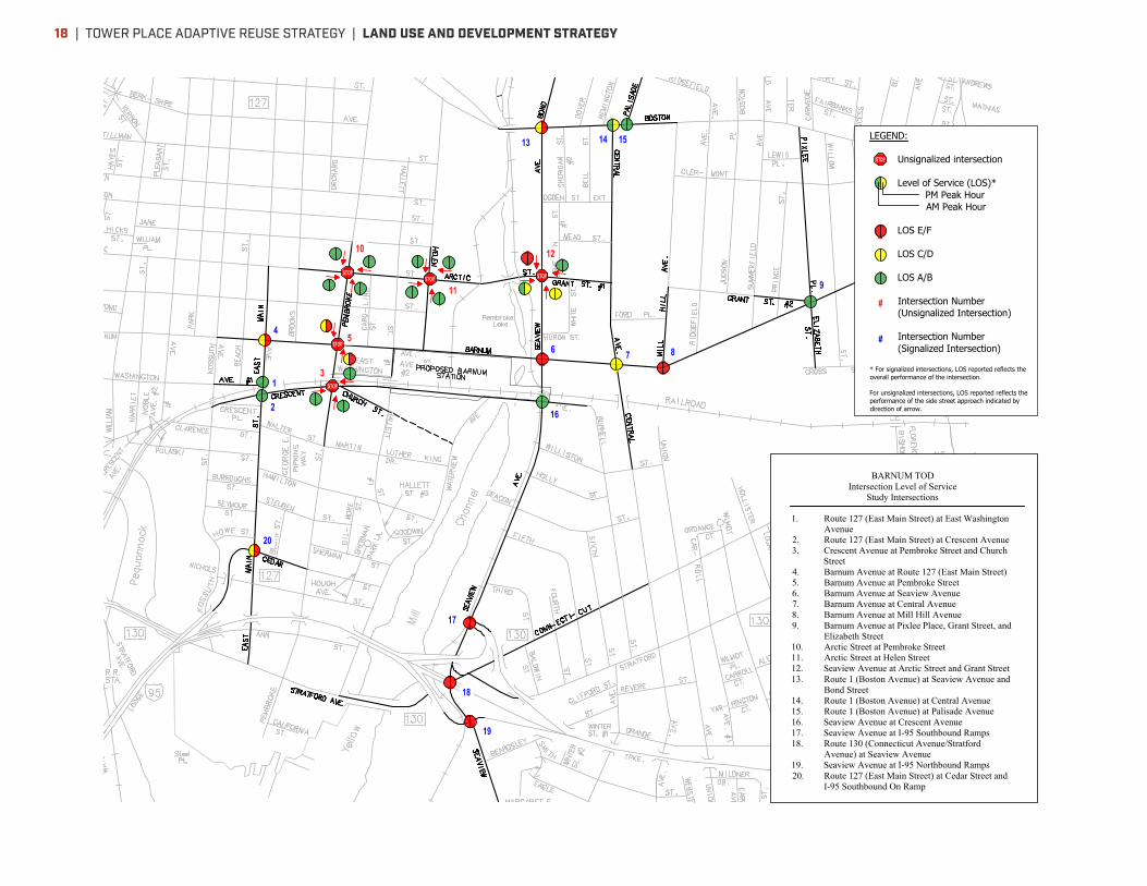
\\vhb\proj\Wat-LD\42216.00\graphics\FIGURES\Traffic\LOS Summary.dwg
Figure 42040 Core Transformation LOSBarnum TOD42216.00Bridgeport, Connecticut
BASEMAP PROVIDED BY THE CONNECTICUT DEPARTMENT OF TRANSPORTATION CITY OF BRIDGEPORT TOWN ROADS MAP
Not to Scale
LEGEND:
Unsignalized intersection
Level of Service (LOS)*PM Peak HourAM Peak Hour
LOS E/F
LOS C/D
LOS A/B
Intersection Number(Unsignalized Intersection)
Intersection Number(Signalized Intersection)
* For signalized intersections, LOS reported reflects theoverall performance of the intersection.
For unsignalized intersections, LOS reported reflects theperformance of the side street approach indicated bydirection of arrow.
BARNUM TODIntersection Level of Service
Study Intersections
1. Route 127 (East Main Street) at East WashingtonAvenue
2. Route 127 (East Main Street) at Crescent Avenue3. Crescent Avenue at Pembroke Street and Church
Street4. Barnum Avenue at Route 127 (East Main Street)5. Barnum Avenue at Pembroke Street6. Barnum Avenue at Seaview Avenue7. Barnum Avenue at Central Avenue8. Barnum Avenue at Mill Hill Avenue9. Barnum Avenue at Pixlee Place, Grant Street, and
Elizabeth Street10. Arctic Street at Pembroke Street11. Arctic Street at Helen Street12. Seaview Avenue at Arctic Street and Grant Street13. Route 1 (Boston Avenue) at Seaview Avenue and
Bond Street14. Route 1 (Boston Avenue) at Central Avenue15. Route 1 (Boston Avenue) at Palisade Avenue16. Seaview Avenue at Crescent Avenue17. Seaview Avenue at I-95 Southbound Ramps18. Route 130 (Connecticut Avenue/Stratford
Avenue) at Seaview Avenue19. Seaview Avenue at I-95 Northbound Ramps20. Route 127 (East Main Street) at Cedar Street and
I-95 Southbound On Ramp
| TOWER PLACE ADAPTIVE REUSE STRATEGY | LAND USE AND DEVELOPMENT STRATEGY18
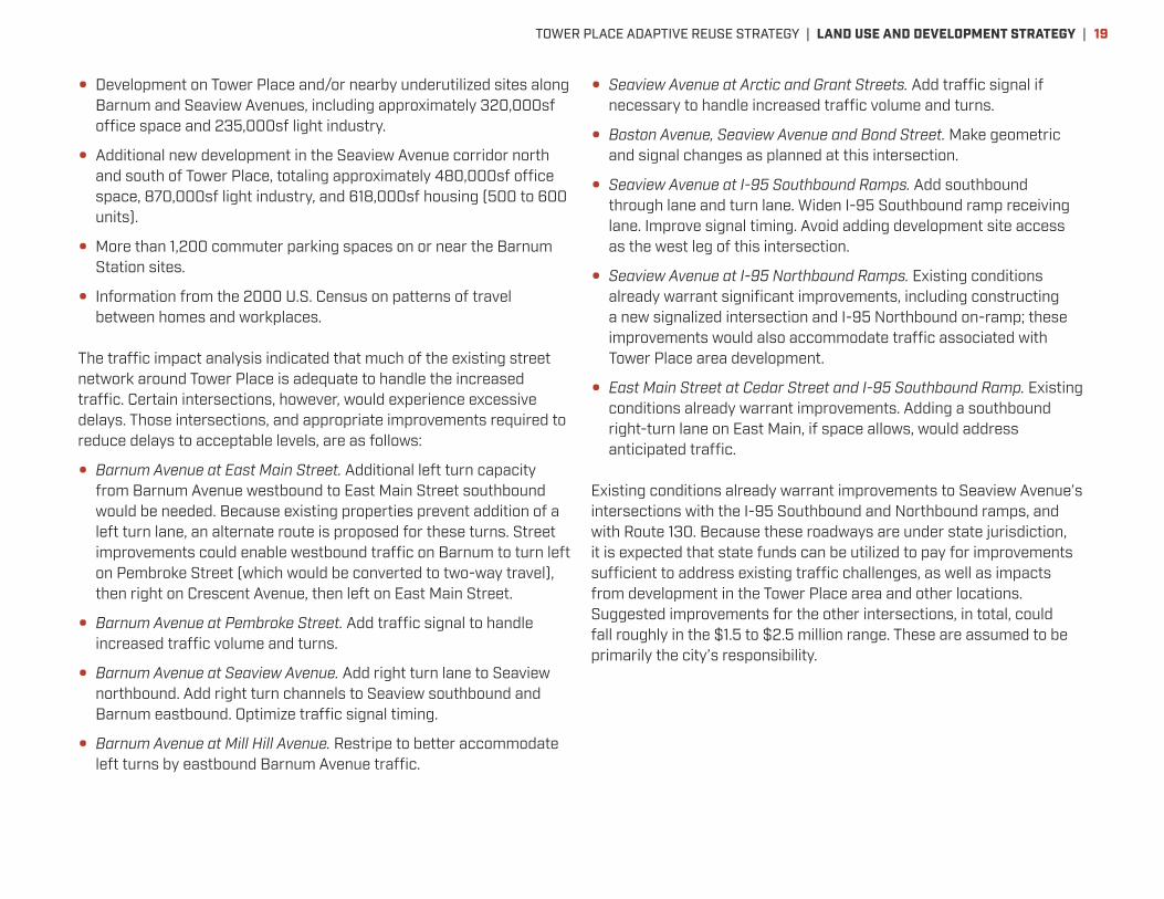
• Development on Tower Place and/or nearby underutilized sites along Barnum and Seaview Avenues, including approximately 320,000sf office space and 235,000sf light industry.
• Additional new development in the Seaview Avenue corridor north and south of Tower Place, totaling approximately 480,000sf office space, 870,000sf light industry, and 618,000sf housing (500 to 600 units).
• More than 1,200 commuter parking spaces on or near the Barnum Station sites.
• Information from the 2000 U.S. Census on patterns of travel between homes and workplaces.
The traffic impact analysis indicated that much of the existing street network around Tower Place is adequate to handle the increased traffic. Certain intersections, however, would experience excessive delays. Those intersections, and appropriate improvements required to reduce delays to acceptable levels, are as follows:
• Barnum Avenue at East Main Street. Additional left turn capacity from Barnum Avenue westbound to East Main Street southbound would be needed. Because existing properties prevent addition of a left turn lane, an alternate route is proposed for these turns. Street improvements could enable westbound traffic on Barnum to turn left on Pembroke Street (which would be converted to two-way travel), then right on Crescent Avenue, then left on East Main Street.
• Barnum Avenue at Pembroke Street. Add traffic signal to handle increased traffic volume and turns.
• Barnum Avenue at Seaview Avenue. Add right turn lane to Seaview northbound. Add right turn channels to Seaview southbound and Barnum eastbound. Optimize traffic signal timing.
• Barnum Avenue at Mill Hill Avenue. Restripe to better accommodate left turns by eastbound Barnum Avenue traffic.
• Seaview Avenue at Arctic and Grant Streets. Add traffic signal if necessary to handle increased traffic volume and turns.
• Boston Avenue, Seaview Avenue and Bond Street. Make geometric and signal changes as planned at this intersection.
• Seaview Avenue at I-95 Southbound Ramps. Add southbound through lane and turn lane. Widen I-95 Southbound ramp receiving lane. Improve signal timing. Avoid adding development site access as the west leg of this intersection.
• Seaview Avenue at I-95 Northbound Ramps. Existing conditions already warrant significant improvements, including constructing a new signalized intersection and I-95 Northbound on-ramp; these improvements would also accommodate traffic associated with Tower Place area development.
• East Main Street at Cedar Street and I-95 Southbound Ramp. Existing conditions already warrant improvements. Adding a southbound right-turn lane on East Main, if space allows, would address anticipated traffic.
Existing conditions already warrant improvements to Seaview Avenue’s intersections with the I-95 Southbound and Northbound ramps, and with Route 130. Because these roadways are under state jurisdiction, it is expected that state funds can be utilized to pay for improvements sufficient to address existing traffic challenges, as well as impacts from development in the Tower Place area and other locations. Suggested improvements for the other intersections, in total, could fall roughly in the $1.5 to $2.5 million range. These are assumed to be primarily the city’s responsibility.
TOWER PLACE ADAPTIVE REUSE STRATEGY | LAND USE AND DEVELOPMENT STRATEGY | 19
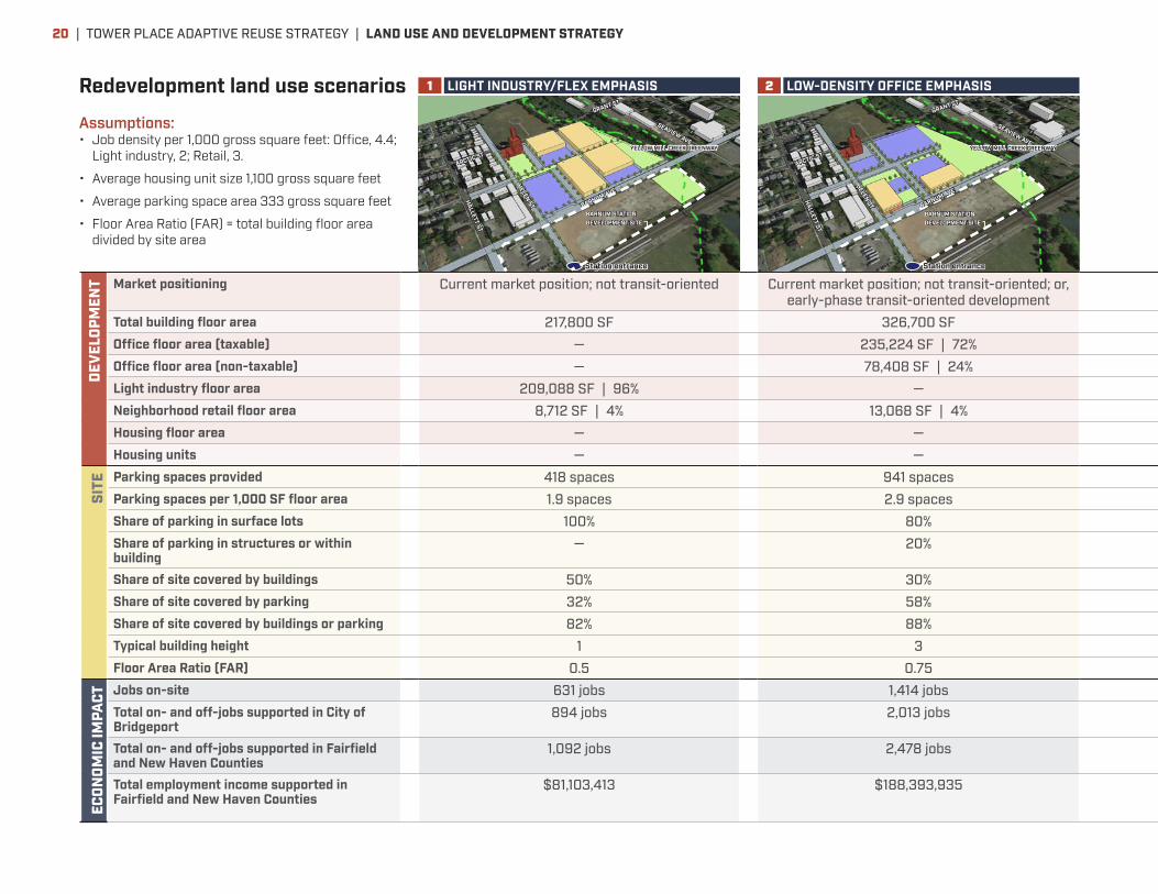
Redevelopment land use scenariosDE
VELO
PMEN
T Market positioning Current market position; not transit-oriented Current market position; not transit-oriented; or, early-phase transit-oriented development
Repositioned for transit-oriented development Repositioned for transit-oriented development Repositioned for transit-oriented development
Total building floor area 217,800 SF 326,700 SF 566,280 SF 566,280 SF 566,280 SFOffice floor area (taxable) — 235,224 SF | 72% 407,722 SF | 72% — 305,791 SF | 54%Office floor area (non-taxable) — 78,408 SF | 24% 135,907 SF | 24% 543,629 SF | 96% 101,930 SF | 18%Light industry floor area 209,088 SF | 96% — — — —Neighborhood retail floor area 8,712 SF | 4% 13,068 SF | 4% 22,651 SF | 4% 22,651 SF | 4% 22,651 SF | 4%Housing floor area — — — — 135,907 SF | 24%Housing units — — — — 124 units
SITE Parking spaces provided 418 spaces 941 spaces 1,631 spaces 1,631 spaces 1,223 spaces
Parking spaces per 1,000 SF floor area 1.9 spaces 2.9 spaces 2.9 spaces 2.9 spaces 2.2 spacesShare of parking in surface lots 100% 80% — — —Share of parking in structures or within building
— 20% 100% 100% 100%
Share of site covered by buildings 50% 30% 37% 37% 37%Share of site covered by parking 32% 58% 26% 26% 26%Share of site covered by buildings or parking 82% 88% 64% 64% 64%Typical building height 1 3 4 4 4Floor Area Ratio (FAR) 0.5 0.75 1.3 1.3 1.3
ECON
OMIC
IMPA
CT Jobs on-site 631 jobs 1,414 jobs 2,424 jobs 2,496 jobs 1,818 jobsTotal on- and off-jobs supported in City of Bridgeport
894 jobs 2,013 jobs 4,023 jobs 3,430 jobs 3,040 jobs
Total on- and off-jobs supported in Fairfield and New Haven Counties
1,092 jobs 2,478 jobs 5,288 jobs 4,195 jobs 4,010 jobs
Total employment income supported in Fairfield and New Haven Counties
$81,103,413 $188,393,935 $508,647,164 $303,411,901 $384,254,672
BARNUM STATIONDEVELOPMENT SITE
BARNUM AVE
ARCTIC ST
Station entrance
HELEN ST
SEAVIEW AVE
HALLETT ST
YELLOW MILL CREEK GREENWAY
GRANT ST
1 LIGHT INDUSTRY/FLEX EMPHASIS
BARNUM STATIONDEVELOPMENT SITE
BARNUM AVE
ARCTIC ST
HELEN ST
SEAVIEW AVE
HALLETT ST
Station entrance
YELLOW MILL CREEK GREENWAY
GRANT ST
2 LOW-DENSITY OFFICE EMPHASIS
Assumptions:• Job density per 1,000 gross square feet: Office, 4.4;
Light industry, 2; Retail, 3.
• Average housing unit size 1,100 gross square feet
• Average parking space area 333 gross square feet
• Floor Area Ratio (FAR) = total building floor area divided by site area
| TOWER PLACE ADAPTIVE REUSE STRATEGY | LAND USE AND DEVELOPMENT STRATEGY20

DEVE
LOPM
ENT Market positioning Current market position; not transit-oriented Current market position; not transit-oriented; or,
early-phase transit-oriented developmentRepositioned for transit-oriented development Repositioned for transit-oriented development Repositioned for transit-oriented development
Total building floor area 217,800 SF 326,700 SF 566,280 SF 566,280 SF 566,280 SFOffice floor area (taxable) — 235,224 SF | 72% 407,722 SF | 72% — 305,791 SF | 54%Office floor area (non-taxable) — 78,408 SF | 24% 135,907 SF | 24% 543,629 SF | 96% 101,930 SF | 18%Light industry floor area 209,088 SF | 96% — — — —Neighborhood retail floor area 8,712 SF | 4% 13,068 SF | 4% 22,651 SF | 4% 22,651 SF | 4% 22,651 SF | 4%Housing floor area — — — — 135,907 SF | 24%Housing units — — — — 124 units
SITE Parking spaces provided 418 spaces 941 spaces 1,631 spaces 1,631 spaces 1,223 spaces
Parking spaces per 1,000 SF floor area 1.9 spaces 2.9 spaces 2.9 spaces 2.9 spaces 2.2 spacesShare of parking in surface lots 100% 80% — — —Share of parking in structures or within building
— 20% 100% 100% 100%
Share of site covered by buildings 50% 30% 37% 37% 37%Share of site covered by parking 32% 58% 26% 26% 26%Share of site covered by buildings or parking 82% 88% 64% 64% 64%Typical building height 1 3 4 4 4Floor Area Ratio (FAR) 0.5 0.75 1.3 1.3 1.3
ECON
OMIC
IMPA
CT Jobs on-site 631 jobs 1,414 jobs 2,424 jobs 2,496 jobs 1,818 jobsTotal on- and off-jobs supported in City of Bridgeport
894 jobs 2,013 jobs 4,023 jobs 3,430 jobs 3,040 jobs
Total on- and off-jobs supported in Fairfield and New Haven Counties
1,092 jobs 2,478 jobs 5,288 jobs 4,195 jobs 4,010 jobs
Total employment income supported in Fairfield and New Haven Counties
$81,103,413 $188,393,935 $508,647,164 $303,411,901 $384,254,672
BARNUM STATIONDEVELOPMENT SITE
BARNUM AVE
ARCTIC ST
HELEN ST
SEAVIEW AVE
HALLETT ST
GRANT ST
YELLOW MILL CREEK GREENWAY
Station entrance
4 HOUSING/OFFICE/INNOVATION EMPHASIS
BARNUM STATIONDEVELOPMENT SITE
YELLOW MILL CREEK GREENWAY
BARNUM AVE
ARCTIC ST
GRANT ST
HELEN ST
SEAVIEW AVE
HALLETT ST
Station entrance
3B OFFICE/INNOVATION EMPHASIS (NON-PROFIT)
BARNUM STATIONDEVELOPMENT SITE
YELLOW MILL CREEK GREENWAY
BARNUM AVE
ARCTIC ST
GRANT ST
HELEN ST
SEAVIEW AVE
HALLETT ST
Station entrance
3A OFFICE/INNOVATION EMPHASIS (FOR-PROFIT)
TOWER PLACE ADAPTIVE REUSE STRATEGY | LAND USE AND DEVELOPMENT STRATEGY | 21
BARNUM STATIONDEVELOPMENT SITE
BARNUM AVE
ARCTIC ST
Station entrance
HELEN ST
SEAVIEW AVE
HALLETT ST
YELLOW MILL CREEK GREENWAY
PARK TRAIL HEAD
TRUCK DRIVER TRAINING OROTHER INTERIM COMMERCIAL USE
RAIL COMMUTER PARKINGWITH SOLAR POWER ARRAYS
INTERIM NEIGHBORHOOD PARKWITH SITE HISTORY INTERPRETIVESIGNAGE/TEMPORARY VISITOR’S CENTER
SHOT TOWER REHABILITATIONWORK YARD
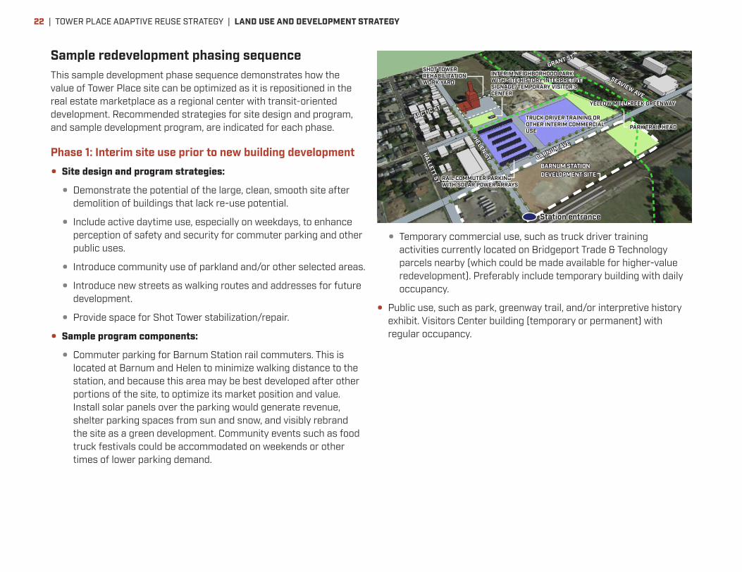
GRANT STSample redevelopment phasing sequenceThis sample development phase sequence demonstrates how the value of Tower Place site can be optimized as it is repositioned in the real estate marketplace as a regional center with transit-oriented development. Recommended strategies for site design and program, and sample development program, are indicated for each phase.
Phase 1: Interim site use prior to new building development
• Site design and program strategies:
• Demonstrate the potential of the large, clean, smooth site after demolition of buildings that lack re-use potential.
• Include active daytime use, especially on weekdays, to enhance perception of safety and security for commuter parking and other public uses.
• Introduce community use of parkland and/or other selected areas.
• Introduce new streets as walking routes and addresses for future development.
• Provide space for Shot Tower stabilization/repair.
• Sample program components:
• Commuter parking for Barnum Station rail commuters. This is located at Barnum and Helen to minimize walking distance to the station, and because this area may be best developed after other portions of the site, to optimize its market position and value. Install solar panels over the parking would generate revenue, shelter parking spaces from sun and snow, and visibly rebrand the site as a green development. Community events such as food truck festivals could be accommodated on weekends or other times of lower parking demand.
• Temporary commercial use, such as truck driver training activities currently located on Bridgeport Trade & Technology parcels nearby (which could be made available for higher-value redevelopment). Preferably include temporary building with daily occupancy.
• Public use, such as park, greenway trail, and/or interpretive history exhibit. Visitors Center building (temporary or permanent) with regular occupancy.
| TOWER PLACE ADAPTIVE REUSE STRATEGY | LAND USE AND DEVELOPMENT STRATEGY22

BARNUM STATIONDEVELOPMENT SITE
BARNUM AVE
ARCTIC ST
HELEN ST
SEAVIEW AVE
HALLETT ST
Station entrance
YELLOW MILL CREEK GREENWAY
GRANT ST
BARNUM STATIONDEVELOPMENT SITE
YELLOW MILL CREEK GREENWAY
BARNUM AVE
ARCTIC ST
GRANT ST
HELEN ST
SEAVIEW AVE
HALLETT ST
Station entrance
Phase 3: Maturing office/innovation address
• Site design and program strategies:
• Enable redevelopment prior to or soon after Barnum Station opening by leveraging site’s current assets, including greenway and convenient highway access.
• Set the stage for transit-oriented development, establishing Barnum Avenue as a quality workplace address and allowing later, higher-density phases to be closer to Barnum Station.
• Minimize near-term parking costs.
• Sample program components:
• Office building overlooking Yellow Mill Greenway, approximately 60,000-70,000sf on 3-4 floors.
• Office building on private parcel at Arctic Street, overlooking Yellow Mill Greenway, up to 120,000sf on 4 floors.
• Housing or small office building adjacent to Shot Tower and neighborhood park, approximately 40,000sf on 3-4 floors.
• Ground floor of Shot Tower rehabilitated for community and/or retail use, approximately 4,000-8,000sf.
• Surface parking (interim).
Phase 2: Preliminary redevelopment and repositioning
• Site design and program strategies:
• Enable redevelopment prior to Barnum Station opening by leveraging site’s current assets, including greenway and convenient highway access.
• Set the stage for transit-oriented development, establishing Barnum Avenue as a quality workplace address and allowing later, higher-density phases to be closer to Barnum Station.
• Minimize near-term parking costs.
• Sample program components:
• Innovation Center anchor facility on Barnum Avenue overlooking Yellow Mill Greenway, approximately 10,000 to 20,000sf on 1-2 floors. Meeting, co-working and business support program.
• Office building along Barnum Avenue, approximately 80,000sf on 3-4 floors.
• Surface parking (interim).
TOWER PLACE ADAPTIVE REUSE STRATEGY | LAND USE AND DEVELOPMENT STRATEGY | 23

BARNUM STATIONDEVELOPMENT SITE
BARNUM AVE
ARCTIC ST
GRANT ST
HELEN ST
SEAVIEW AVE
HALLETT ST
YELLOW MILL CREEK GREENWAY
Station entrance
BARNUM STATIONDEVELOPMENT SITE
BARNUM AVE
ARCTIC ST
GRANT ST
HELEN ST
SEAVIEW AVE
HALLETT ST
YELLOW MILL CREEK GREENWAY
Station entrance
Phase 5: Expanding transit-oriented district
• Site design and program strategies:
• Continue to build structured parking to enable development on interim surface parking areas.
• Activate new streets on site as addresses for new development.
• Encourage higher-density development as increased transit usage reduces share of trips requiring auto travel.
• Add pedestrian-oriented retail serving new users on and near the site, particularly near corner of Barnum and Helen, as demand allows.
• Sample program components:
• Office and/or housing buildings at corner of Barnum Avenue and Helen Street, approximately 120,000sf-150,000sf or more on 4-5 floors.
• Office building(s) on private Arctic Street site, approximately 100,000sf-150,000sf or more on 3-5 floors.
• Parking structures accommodating another 700-800 cars
Phase 4: Maturing transit-oriented district
• Site design and program strategies:
• Build structured parking to enable development on interim surface parking areas.
• Activate new streets on site as addresses for new development.
• Introduce pedestrian-oriented retail serving new users on and near the site, as demand allows.
• Sample program components:
• Office building along Barnum Avenue, approximately 80,000sf or more on 3-4 floors.
• Parking structure accommodating 700-800 cars
• Housing or office space lining parking structure, approximately 20,000-30,000sf on 2-4 floors.
| TOWER PLACE ADAPTIVE REUSE STRATEGY | LAND USE AND DEVELOPMENT STRATEGY24
DEMOLITIONINTERIM STABILIZATIONSTRUCTURE AND ENVELOPE
STRUCTURE AND ENVELOPE
INTERNAL PARTITIONS,SYSTEMS, ELEVATORS
INTERNAL PARTITIONS,SYSTEMS, ELEVATORS
NEW CONSTRUCTION BUILDING 330 RENOVATION
$424 TOTAL
$167 TOTAL
0
$50
$100
$150
$200
$250
$300
$350
$400
$450
ENCLOSURE AND REPAIR COSTS FOR SHOT TOWER AND BUILDING 330
SHOT TOWER (BUILDINGS 98-100) BUILDING 330
Temporary enclosure (near-term requirement)
$2 million $2 million
Permanent structural and enclosure repairs (longer-term)
$5.5 million $9.9 million
Total $7.5 million $11.9 millionPotential useable floor area (gross)
14,800sf (8,600sf on ground floor of buildings 98 and 99; 6,200sf on floors 5 and 6 of Building 98)
45,120sf (4 floors @ 11,280sf)
Enclosure and repair costs per square foot of useable floor area
Over $500/sf Over $260/sf
Economic feasibility and development strategyAnother precondition for redevelopment is economic feasibility. Not only must there be market interest in a site, but also the possibility of providing building space geared to that market at a price it is willing
to pay. Land use scenarios 3A and 4 were analyzed from the perspective of a developer, assessing whether the returns from new development merited the cost and risk involved in developing it.
Adaptive reuse
As discussed on page 10, rehabilitating existing Tower Place buildings for adaptive re-use would cost significantly more than new construction. The table at right summarizes the overall estimated costs to, first, stabilize the Shot Tower and Building 330 to protect them from further deterioration, and second, make permanent repairs to the structure and enclosure. These repairs would be required to restore the buildings to use. While the Shot Tower is a priority for preservation due to its history and landmark appearance, it has relatively little potential useable floor area and high restoration costs, and so has been excluded from the economic feasibility analysis for new development. It deserves its own dedicated effort for fundraising and stabilization to preserve its presence and tell its history.
By comparison, Building 330 (the only other building potentially suitable for re-use) has floor configurations that are appropriate for adaptive reuse as office or residential space, but also imposes restoration costs that significantly exceed costs of new building construction. The table at bottom right breaks down anticipated construction costs for Building 330 and new construction, on the basis of one square foot of new building area. The analysis indicates that creating useable space in Building 330 would cost well over twice
Private investment in large-scale new development at Tower Place is economically feasible, if supported by typical New Markets Tax Credit and/or Tax-Increment Financing programs.
COMPARISON OF NEW CONSTRUCTION AND REHABILITATION COSTS
Cost
per
squ
are
foot
floo
r ar
ea
TOWER PLACE ADAPTIVE REUSE STRATEGY | LAND USE AND DEVELOPMENT STRATEGY | 25
the amount needed to build comparable space in a new building, even when the cost of demolishing the building is added to new construction costs. Due to this particularly high cost premium, the development economics analysis for Tower Place assumed that Building 330 is demolished, and its site reconfigured for new development. This should not necessarily be interpreted as a recommendation for demolition. If a developer with experience in building restoration expresses interest in restoring Building 330 to use in spite of its cost premiums, they should be encouraged to do so. However, this economic feasibility analysis does not address such a scenario. Economic feasibility analysis methodology and assumptions
A development scenario was considered feasible if its projected net operating income was sufficient to cover capital cost obligations and a reasonable investment return to the developer. In cases where these standards were not met, potential supplementary public financing sources that could achieve feasibility were identified. Key assumptions for the analysis were based on internet research, interviews with people knowledgeable about the Bridgeport real estate market and development conditions, and professional experience in the region. These assumptions include:
• Full-service rent for office space within walking distance of Barnum Station: $28.00 per rentable square foot. Today, the high end of the Class A office market in Downtown Bridgeport is understood to be $27.00 per square foot, full-service. Operating costs are assumed to average $8.50 per square foot.
• Residential rental rate within walking distance of Barnum Station: $2.20 per square foot per month, or approximately $2,050 per month for a one-bedroom apartment. Operating costs are assumed to average $5,250 per year, exclusive of property taxes.
• Retail rent within walking distance of Barnum Station: $17.00 per square foot per month, full service.
• For the non-profit office component, non-profit organizations are assumed to own their own building. A turnkey development is assumed, wherein a developer is hired for a fee to construct the building on behalf of the non-profit.
• Development parcel(s) can be obtained from the City at negligible cost. However, economic calculations do assume the developer pays for demolition of existing structures, at a cost of $21.25 per square foot of existing floor area.
• A reasonable private investment threshold was assumed to be a cash-on-cash return of at least 6% in the first stabilized year of operation, and an internal rate of return on equity of 16% over a ten-year holding period.
• Construction cost averages $150.00 per square foot for all building space. Tenant improvement costs for office and retail space are additional. Parking costs average $1,000 per surface parking space and $18,000 per structured parking space.
• Additional assumptions are specified in a memorandum on file with the City of Bridgeport.
Conclusions
Both Scenarios 3A (Office/innovation emphasis, with non-profit office and retail components) and 4 (similar to 3A but with approximately one quarter of building area devoted to housing) are feasible if subsidy from conventional New Markets Tax Credits and Tax-Increment Financing could be available. The amount of subsidy generated by these two gap funding sources together is more than enough to cover the gap that is present with private financing only (see chart, page 27). The Tower Place development project, under either program scenario, is an appropriate candidate for New Markets Tax Credits, as it is located in an economically impacted area, and includes a significant commercial (office and retail) program component. The project site can also be readily included as part of a Tax-Increment Financing district, in which future property tax growth can be dedicated to pay for certain development costs such as infrastructure and gap financing.
| TOWER PLACE ADAPTIVE REUSE STRATEGY | LAND USE AND DEVELOPMENT STRATEGY26
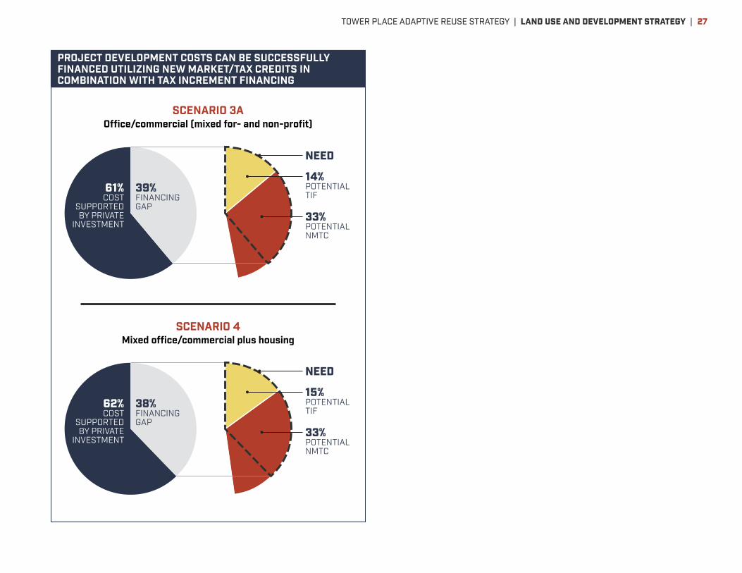
PROJECT DEVELOPMENT COSTS CAN BE SUCCESSFULLY FINANCED UTILIZING NEW MARKET/TAX CREDITS IN COMBINATION WITH TAX INCREMENT FINANCING
61%COST
SUPPORTED BY PRIVATE
INVESTMENT
39%FINANCING GAP
14%POTENTIAL TIF
NEED
33%POTENTIAL NMTC
SCENARIO 3AOffice/commercial (mixed for- and non-profit)
SCENARIO 4Mixed office/commercial plus housing
62%COST
SUPPORTED BY PRIVATE
INVESTMENT
38%FINANCING GAP
15%POTENTIAL TIF
NEED
33%POTENTIAL NMTC
TOWER PLACE ADAPTIVE REUSE STRATEGY | LAND USE AND DEVELOPMENT STRATEGY | 27

NEAR-TERM USE POSSIBILITIESBringing activity to Tower Place soon will provide immediate benefits to nearby residents and employers, while helping reposition the site as a place for larger-scale reinvestment. A combination of public and commercial uses is desirable. Public uses could provide immediate recreation and education opportunities, leveraging the Yellow Mill
Greenway and the site’s historic industrial heritage. Facilities may be temporary or permanent. Commercial uses should be interim in nature, to enable higher-value redevelopment when market opportunity emerges. Activities can take place on a temporary brownfields cap, if site remediation is not yet complete.
The Yellow Mill Greenway offers opportunity not only for a nature trail, but related educational programming highlighting wildlife and natural systems.
Example from Boston Nature Center in Boston’s Mattapan neighborhood, operated by Mass Audubon on a former state hospital site.
Example from Millikan Park on Detroit’s riverfront.
Example from Wilmington, DE riverfront.
HISTORY, NATURE AND EDUCATION
The National Park Service established the Coltsville National Historic Park in 2015 in Hartford’s historic Coltsville district, telling the history of another one of Connecticut’s major arms manufacturers. The park service or another historical organization should be invited to tell the story of Bridgeport’s Remington site, through programming and restoration, focusing on the Shot Tower.
i
National Park Service
U.S. Department of the Interior
Coltsville November 2009Special Resource Study
0710-0601 Final File.indd 1
11/12/09 2:33 PM
| TOWER PLACE ADAPTIVE REUSE STRATEGY | NEAR-TERM POSSIBILITIES28

Dog parks can be very successful in light industrial areas, and build community among people who come from multiple neighborhoods. Example from Somerville, MA.
Sport courts can be reconfigured to support multiple games, and require little site preparation aside from a hard surface.
Food trucks and containers configured for food or retail can be easily positioned to support temporary or ongoing events.
Existing truck driver training on other sites near Tower Place could be relocated to Tower Place, enabling other sites to redevelop with higher-value uses.
A plant nursery can be located on a flat, paved area with minimal site preparation.
The ground floor of the Shot Tower could be rehabilitated as a co-working space helping small, local businesses grow.
Rail commuter parking could be combined with solar panels, sheltering parking spaces from sun and snow, providing revenue, and helping rebrand the site as a desirable place for new investment. Example from redeveloped brownfields site nearby in Fairfield.
RECREATION AND EVENTS
COMMERCIAL USES
TOWER PLACE ADAPTIVE REUSE STRATEGY | NEAR-TERM POSSIBILITIES | 29

Recommended site layout principlesThe large size of Tower Place—about 12.3 acres west of the Yellow Mill Greenway, and another 3.4 acres east of the Greenway, after the 100-year flood plain is excluded—offers significant flexibility for development site layout, scale, land use, and phasing. At the same time, a number of current and planned conditions on and around the site affect how development should be planned to maximize its value to future owners and users, as well as to help stabilize and enhance the value of surrounding properties. Fixed conditions
• Parcelization. West of the Yellow Mill Greenway, a property line divides Tower Place between a parcel under City ownership to the south and west, and a parcel under private ownership to the north east. An additional privately-owned parcel lies east of the Yellow Mill Greenway. Whether or not these parcels are aggregated under single ownership makes a big difference in Tower Place’s development potential. The City-owned portion is significantly larger—roughly 8.9 developable acres (about 9.9 acres total before deduction of the Shot Tower and 100-year floodplain)—than the privately-owned portions. These include roughly 3.4 contiguous developable acres (about 6.4 acres total before deduction of 100-year floodplain) west of the Greenway, and another roughly 3.4 developable acres (about 4.1 acres before deduction of the 100-year floodplain) between the Yellow Mill Greenway and Seaview Avenue. This means that the City-owned portion retains considerable capacity and flexibility, as well as the best access and visibility, even without aggregation. Aggregation of the contiguous private parcel would, however, offer more opportunity to optimize layout of buildings, interior streets and parking, given the irregular geometry of the line dividing the
parcels. It would also significantly enhance development opportunity and design on the privately-owned parcel, and along Arctic Street and the Yellow Mill Greenway. Aggregation of the Seaview Avenue parcel would enable a coordinated development approach framing the Yellow Mill Greenway, would enhance the visibility of Tower Place from principal regional highway connections, and offers the closest proximity to Yale New Haven/Bridgeport Hospital.
• Barnum Station. Access to the planned Barnum Station will occur where an extension of Helen Street meets the railroad embankment. Tower Place is optimally located to benefit from convenient, safe pedestrian access to and from the station. The southwest corner of Tower Place, closest to the station, is within about 350 feet, or a two-minute walk, of the station entrance. The northeast corner at Arctic Street and Seaview Avenue, farthest from the station, is within about 2,200 feet via Helen and Arctic streets, or an eight- to ten-minute walk. These distances are well within the range people willingly walk to access transit. Moreover, the design of Tower Place development has an important opportunity to create safe, welcoming walking conditions that enhance its development opportunity and reduce the cost and area devoted to parking.
• The Shot Tower. The Shot Tower occupies the northwest corner of the site, at the intersection of Arctic and Helen Streets. The Tower should be retained and restored as a key part of Tower Place’s history, and an important local landmark. The building’s relatively small footprint on the city-controlled site area—about 0.6 acres—and its corner location away from Barnum Avenue minimize its constraint on other development. Its potential for re-use is limited by relatively small floor area, so associated parking demand is also likely to be limited. Direct use and programming of the Shot Tower as part of broader site redevelopment is strongly encouraged. However, given
URBAN DESIGN GUIDELINES| TOWER PLACE ADAPTIVE REUSE STRATEGY | URBAN DESIGN GUIDELINES30
the building’s use constraints and location, it is also acceptable to consider it a fully separate use, under separate management if appropriate.
• Other former factory buildings. If former factory buildings other than the Shot Tower are retained and restored, the most appropriate ones would be Building 330 at the southwest corner of the site, and possibly one or more of the adjoining buildings to the north. Building 330 occupies a valuable location at the corner of Barnum Avenue and Helen Streets—the closest part of Tower Place to Barnum Station’s entrance. The narrow footprints and four- to six-story height of Building 330 and adjoining buildings to the north mean that these buildings use site area efficiently, and could accommodate a significant amount of new program while still leaving most of the site available for development of new buildings, parking, access and green space.
Frontages
Each street and park frontage around Tower Place—and potential new street frontage within the site—presents distinct conditions of access, visibility and character of adjoining development parcels. Thus these guidelines provide design standards that respect these distinct conditions, through the following four Frontage Types. The Frontage Types are described in greater detail beginning on page 38, including dimensional guidelines and images of appropriate design examples. These design standards apply to the edges of developed parcels; interior parcel areas are not directly affected by them, but are subject to height limits and other standards of the base zoning district.
• The Station Gateway Street Frontage Type applies along Barnum Avenue. This frontage is a premier address for mixed-use, pedestrian-oriented development that benefits from convenient access to Barnum Station, and helps support important walkable connections to Barnum Station from other area blocks and properties. It is highly visible and accessible, and can accommodate significant building scale. The frontage includes a bus stop serving the station, on the north side of Barnum Avenue near Helen.
• The Multiple-Use Street Frontage Type applies to Seaview Avenue, Arctic Street and new streets created within the Tower Place block. It is a prominent location for mixed-use development of a variety of types, with convenient vehicular access as well as good pedestrian, transit and bike access.
• The Park Edge Frontage Type applies to parcel edges facing the Yellow Mill Greenway. This edge benefits from views over the Greenway, and access to a multi-use recreational path.
• The Neighborhood Edge Frontage Type applies to Helen Street. Development along this edge should fit well with adjoining residential blocks in a traditional neighborhood setting. The facing zoning district south of Maple Street potentially accommodates larger scale or greater intensity of use on facing portions of Tower Place than does the facing residential district north of Maple Street.
• The Service Street Frontage Type applies to potential new service streets or alleys within the Tower Place site. This is a priority edge for service access, parking and other functions that should be minimized along other Frontage Types.
New streets, green spaces, and quadrants
The lack of existing streets across the Tower Place site limits access to new development on the site, as well as neighborhood circulation in the station area. Therefore, redevelopment plans for Tower Place should include at least two new streets that are accessible to the public. One street should run north-south between Barnum Avenue and Arctic Street. Another street should run east west, from the intersection of Maple and Helen Streets to the Yellow Mill Greenway. The alignment of either street may vary to suit different potential layouts of site development, but each street should provide a continuous route. The locations of the north-south street intersections with Barnum Avenue and Arctic Street are flexible, but should accommodate building sites to both the east and the west. See diagram on the following page.Introducing green landscaped space to Tower Place is an important strategy to add amenity to help reposition the site as a location for
TOWER PLACE ADAPTIVE REUSE STRATEGY | URBAN DESIGN GUIDELINES | 31
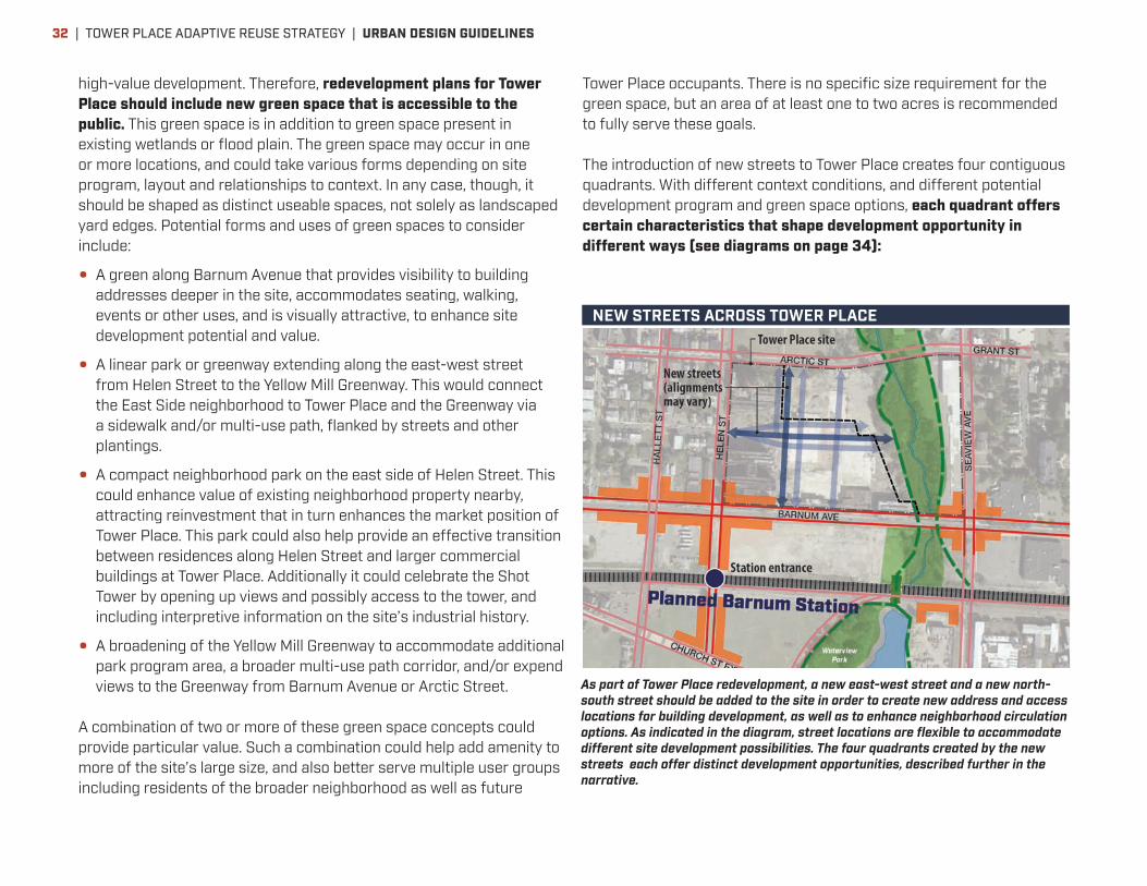
high-value development. Therefore, redevelopment plans for Tower Place should include new green space that is accessible to the public. This green space is in addition to green space present in existing wetlands or flood plain. The green space may occur in one or more locations, and could take various forms depending on site program, layout and relationships to context. In any case, though, it should be shaped as distinct useable spaces, not solely as landscaped yard edges. Potential forms and uses of green spaces to consider include:
• A green along Barnum Avenue that provides visibility to building addresses deeper in the site, accommodates seating, walking, events or other uses, and is visually attractive, to enhance site development potential and value.
• A linear park or greenway extending along the east-west street from Helen Street to the Yellow Mill Greenway. This would connect the East Side neighborhood to Tower Place and the Greenway via a sidewalk and/or multi-use path, flanked by streets and other plantings.
• A compact neighborhood park on the east side of Helen Street. This could enhance value of existing neighborhood property nearby, attracting reinvestment that in turn enhances the market position of Tower Place. This park could also help provide an effective transition between residences along Helen Street and larger commercial buildings at Tower Place. Additionally it could celebrate the Shot Tower by opening up views and possibly access to the tower, and including interpretive information on the site’s industrial history.
• A broadening of the Yellow Mill Greenway to accommodate additional park program area, a broader multi-use path corridor, and/or expend views to the Greenway from Barnum Avenue or Arctic Street.
A combination of two or more of these green space concepts could provide particular value. Such a combination could help add amenity to more of the site’s large size, and also better serve multiple user groups including residents of the broader neighborhood as well as future
Tower Place occupants. There is no specific size requirement for the green space, but an area of at least one to two acres is recommended to fully serve these goals. The introduction of new streets to Tower Place creates four contiguous quadrants. With different context conditions, and different potential development program and green space options, each quadrant offers certain characteristics that shape development opportunity in different ways (see diagrams on page 34):
NEW STREETS ACROSS TOWER PLACE
As part of Tower Place redevelopment, a new east-west street and a new north-south street should be added to the site in order to create new address and access locations for building development, as well as to enhance neighborhood circulation options. As indicated in the diagram, street locations are flexible to accommodate different site development possibilities. The four quadrants created by the new streets each offer distinct development opportunities, described further in the narrative.
| TOWER PLACE ADAPTIVE REUSE STRATEGY | URBAN DESIGN GUIDELINES32
• Northwest—Key characteristics include the Shot Tower in terms of its physical presence and potential reuse, and adjacency to East Side residences. It is also a short walk from Barnum Station. Development here should consider smaller or transitional building scales that fit well with existing neighborhood scale, and maintain views of the Shot Tower. This quadrant may be well-positioned for early-phase redevelopment for several reasons: Buildings of relatively smaller footprint and/or height may match market opportunity as it is still emerging; the adjacent Shot Tower provides a helpful landmark for visibility and branding; and the development could attract reinvestment in the Shot Tower and adjoining neighborhood areas, further improving market position for later phases.
• Southwest—This quadrant offers high value and visibility on Barnum Avenue. It is the closest part of the site to Barnum Station—a two-minute walk away—and offers large scale building opportunities. Whether or not existing Building 330 is rehabilitated or removed, the corner of Barnum Avenue and Helen Street should be occupied by a building that sets a positive tone for development across the rest of the site. The quadrant can also benefit from facing a development opportunity of equal scale and prominence across Barnum Avenue on the station site. Given the high development potential of the southwest quadrant, redevelopment here may be best delayed until market opportunity can fully take advantage of its development opportunity.
• Southeast—This quadrant, like the southwest, also offers high value and visibility along Barnum Avenue. It is close to the station—a three- to five-minute walk away—and also close to Seaview Avenue’s highway accessibility and established business presence. It has direct frontage on the Yellow Mill Greenway as an aesthetic and recreation amenity. It can offer greater development flexibility than the southwest, with greater area and less street frontage. Building heights should be limited across portions of the quadrant to preserve the view of the Shot Tower from trains passing over the Yellow Mill Greenway, but other portions of the quadrant can accommodate significant building height.
• Northeast—This quadrant consists primarily of a separate private parcel; development opportunity varies according to whether parcels are aggregated or not. In either case, the area offers flexible development opportunities. It is within a five- to eight-minute walk of both Barnum Station and Yale New Haven/Bridgeport Hospital. A facing parcel across Arctic Street could offer complementary opportunity for additional development, parking, and/or access to the Boston Avenue Industrial Park. Like the southeast quadrant, direct frontage on the Yellow Mill Greenway provides an aesthetic and recreation amenity. Lower-density near-term uses may be appropriate here if they help position other portions of Tower Place for higher-density, higher-value transit-oriented development.
The Seaview Avenue portion of Tower Place is itself unique. It is less connected to the Barnum Station area, but still within a convenient eight- to ten-minute walk. It is well connected to regional highway access via Seaview Avenue, as well as to Yale New Haven/Bridgeport Hospital and the Seaview Industrial Park. It also adjoins residential blocks of the Mill Hill neighborhood. The area’s adjacency to the Yellow Mill Greenway provides attractive views and recreational path access like the portions of Tower Place facing it on the west. These attributes support a variety of commercial and residential development possibilities. Its relatively long, narrow shape poses some constraints on the size and placement of buildings and parking. A series of smaller buildings, potentially with a variety of uses that share parking, could make best use of the site. This offers opportunities for flexible development phasing and for scaling development to fit well with facing residential context.
TOWER PLACE ADAPTIVE REUSE STRATEGY | URBAN DESIGN GUIDELINES | 33
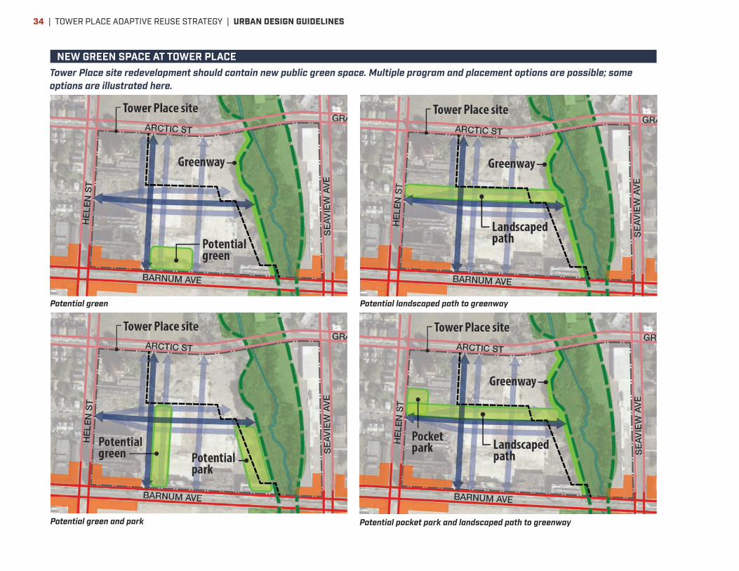
Potential green Potential landscaped path to greenway
Potential green and park Potential pocket park and landscaped path to greenway
NEW GREEN SPACE AT TOWER PLACETower Place site redevelopment should contain new public green space. Multiple program and placement options are possible; some options are illustrated here.
| TOWER PLACE ADAPTIVE REUSE STRATEGY | URBAN DESIGN GUIDELINES34
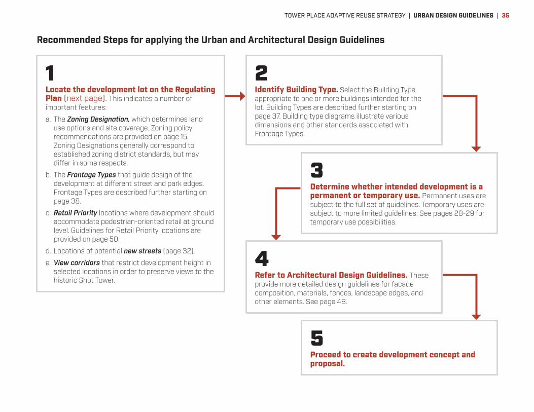
Recommended Steps for applying the Urban and Architectural Design Guidelines
1Locate the development lot on the Regulating Plan (next page). This indicates a number of important features:
a. The Zoning Designation, which determines land use options and site coverage. Zoning policy recommendations are provided on page 15. Zoning Designations generally correspond to established zoning district standards, but may differ in some respects.
b. The Frontage Types that guide design of the development at different street and park edges. Frontage Types are described further starting on page 38.
c. Retail Priority locations where development should accommodate pedestrian-oriented retail at ground level. Guidelines for Retail Priority locations are provided on page 50.
d. Locations of potential new streets (page 32).
e. View corridors that restrict development height in selected locations in order to preserve views to the historic Shot Tower.
2Identify Building Type. Select the Building Type appropriate to one or more buildings intended for the lot. Building Types are described further starting on page 37. Building type diagrams illustrate various dimensions and other standards associated with Frontage Types.
3Determine whether intended development is a permanent or temporary use. Permanent uses are subject to the full set of guidelines. Temporary uses are subject to more limited guidelines. See pages 28-29 for temporary use possibilities.
4Refer to Architectural Design Guidelines. These provide more detailed design guidelines for facade composition, materials, fences, landscape edges, and other elements. See page 48.
5Proceed to create development concept and proposal.
TOWER PLACE ADAPTIVE REUSE STRATEGY | URBAN DESIGN GUIDELINES | 35
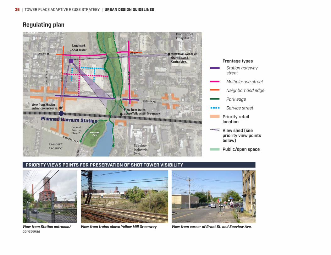
Regulating plan
Frontage typesStation gateway street
Multiple-use street
Neighborhood edge
Park edge
Service street
Priority retail location
View shed (see priority view points below)
Public/open space
View from Station entrance/concourse
View from trains above Yellow Mill Greenway View from corner of Grant St. and Seaview Ave.
PRIORITY VIEWS POINTS FOR PRESERVATION OF SHOT TOWER VISIBILITY
| TOWER PLACE ADAPTIVE REUSE STRATEGY | URBAN DESIGN GUIDELINES36

Building typesBuilding types represent the basic configurations possible for buildings. These illustrations identify critical dimensions and other elements that are subject to Design Standards for each Frontage Type. The Flexible building type, in particular, accommodates most or all uses envisioned for Tower Place, other than structured parking. Parking
structures may be located along public streets if they have an occupied ground level use; otherwise, they must be set back far enough to accommodate a separate occupied building, or band of landscaping. The Regulating Plan indicates priority retail locations where ground-level space must be appropriate for retail use.
Empty lot (landscaped/fenced edge)
Row building
Flexible building (mixed-use)
Parking structure (set back from street)
Flexible building (single-use)
Parking structure (active use at street)
TOWER PLACE ADAPTIVE REUSE STRATEGY | URBAN DESIGN GUIDELINES | 37

Frontage typesStation gateway streetApplies to portions of Barnum Avenue
PURPOSE
Premier address for mixed-use development that benefits from access from Barnum Station. Buildings are highly visible and attractive from trains as well as the street. Building and site design contributes to and benefits from a safe, welcoming walking environment. Priority locations for ground-floor retail or other active uses. Street design is attractive and accommodates driving, buses, walking, biking, street trees, and pedestrian-scaled street lighting in a compatible, balanced setting. No or minimal presence of driveways or on-site parking along street.
URBAN DESIGN STANDARDS
CATEGORY REQUIREMENT
Building types permitted within 40 feet of street
Flexible building (mixed-use or single- use). Other types excluded. A parking structure may be located at least 40 feet back from street as long as an occupied building [or interim landscaped yard] is developed between the parking structure and the street.
Minimum building frontage as a percentage of lot frontage
70%
Vehicular access and loading docks
Not permitted unless lot is accessible from no other frontage type.
Maximum parking/ driveway frontage within building (must be screened by architectural facade)
Not permitted
Building setback from street lot line
0 feet minimum; 10 feet maximum
Minimum building height 2 stories
Step-back of upper floors Maximum base height 65 feet. Floors above should step back at least 15 feet. Up to one third of building frontage exempt from step-back.
Floor to ceiling height of first story
15–18 feet preferred at Priority Retail locations. 12 to 15 feet at other locations.
Ground floor transparent area (fully transparent storefront-style glazing)
Minimum 75%
Maximum length of opaque wall between windows or doors
20 feet
Minimum entrance frequency At least one entrance per 75 feet of building frontage
| TOWER PLACE ADAPTIVE REUSE STRATEGY | URBAN DESIGN GUIDELINES38

DEVELOPMENT PRECEDENTS DEMONSTRATING THE INTENT OF THE STANDARDS
TOWER PLACE ADAPTIVE REUSE STRATEGY | URBAN DESIGN GUIDELINES | 39

Frontage typesMultiple-use streetApplies to portions of Seaview Avenue, Arctic Street, new streets on Tower Place
PURPOSE
Premier address for mixed-use development. Buildings are highly visible and attractive from the street. Building and site design contributes to and benefits from a safe, welcoming walking environment. Ground-floor retail or other active uses are encouraged where feasible. Street design is attractive and accommodates driving, buses, walking, biking, street trees, and pedestrian-scaled street lighting in a compatible, balanced setting. Limited presence of driveways and landscaped on-site parking along street is acceptable.
URBAN DESIGN STANDARDS
CATEGORY REQUIREMENT
Building types permitted within 40 feet of street
Flexible building (mixed-use or single- use), Row Building, Parking Structure
Minimum building frontage as a percentage of lot frontage
50%
Vehicular access and loading docks
Permitted at up to two locations; may not exceed 30% of lot frontage in total
Maximum parking/ driveway frontage within building (must be screened by architectural facade)
Up to 60 feet
Building setback from street lot line
0 feet minimum, 10 feet maximum
Minimum building height 25 feet; at least 2 stories preferred
Step-back of upper floors Maximum base height 45 feet facing R-C district, 65 feet elsewhere. Floors above should step back at least 30 feet facing R-C district, 15 feet elsewhere. Up to one quarter of building frontage exempt from step-back.
Floor to ceiling height of first story
15-18 feet preferred at Priority Retail locations. 12 to 15 feet at other locations.
Ground floor transparent area (fully transparent storefront-style glazing)
Minimum 60%
Maximum length of opaque wall between windows or doors
20 feet; may be extended to 40 feet with installation of art or lighting feature on opaque wall area
Minimum entrance frequency At least one entrance per 75 feet of building frontage
| TOWER PLACE ADAPTIVE REUSE STRATEGY | URBAN DESIGN GUIDELINES40

DEVELOPMENT PRECEDENTS DEMONSTRATING THE INTENT OF THE STANDARDS
TOWER PLACE ADAPTIVE REUSE STRATEGY | URBAN DESIGN GUIDELINES | 41

Frontage typesPark edgeApplies to Yellow Mill Greenway edges
PURPOSE
Development edge benefiting from views to Yellow Mill Greenway and/or Cemetery. Along the greenway edge, building and site design contributes to and benefits from a safe, welcoming, public multi-use path. Along street edge(s), building and site design contributes to and benefits from a safe, welcoming sidewalk environment. Ground-floor retail or other active uses are encouraged where feasible. Mix of occupied building spaces and landscaped on-site parking edges is acceptable.
URBAN DESIGN STANDARDS
CATEGORY REQUIREMENT
Building types permitted within 40 feet of street
Flexible building (mixed-use or single- use), Row Building, Parking Structure
Minimum building frontage as a percentage of lot frontage
30%
Vehicular access and loading docks
Permitted at up to two locations; may not exceed 30% of lot frontage in total
Maximum parking/ driveway frontage within building (must be screened by architectural facade)
Up to 120 feet
Building setback from public greenway edge
0 feet minimum. Public Access Easement, 20’ wide, may be required, per Note 3 on Zoning Ordinance Table 4.B.
Minimum building height 25 feet; at least 2 stories preferred
Step-back of upper floors No step-back required
Floor to ceiling height of first story
12 to 15 feet
Ground floor transparent area (fully transparent storefront-style glazing)
Minimum 60%
Maximum length of opaque wall between windows or doors
20 feet; may be extended to 40 feet with installation of art or lighting feature on opaque wall area
Minimum entrance frequency No minimum
| TOWER PLACE ADAPTIVE REUSE STRATEGY | URBAN DESIGN GUIDELINES42
DEVELOPMENT PRECEDENTS DEMONSTRATING THE INTENT OF THE STANDARDS
TOWER PLACE ADAPTIVE REUSE STRATEGY | URBAN DESIGN GUIDELINES | 43
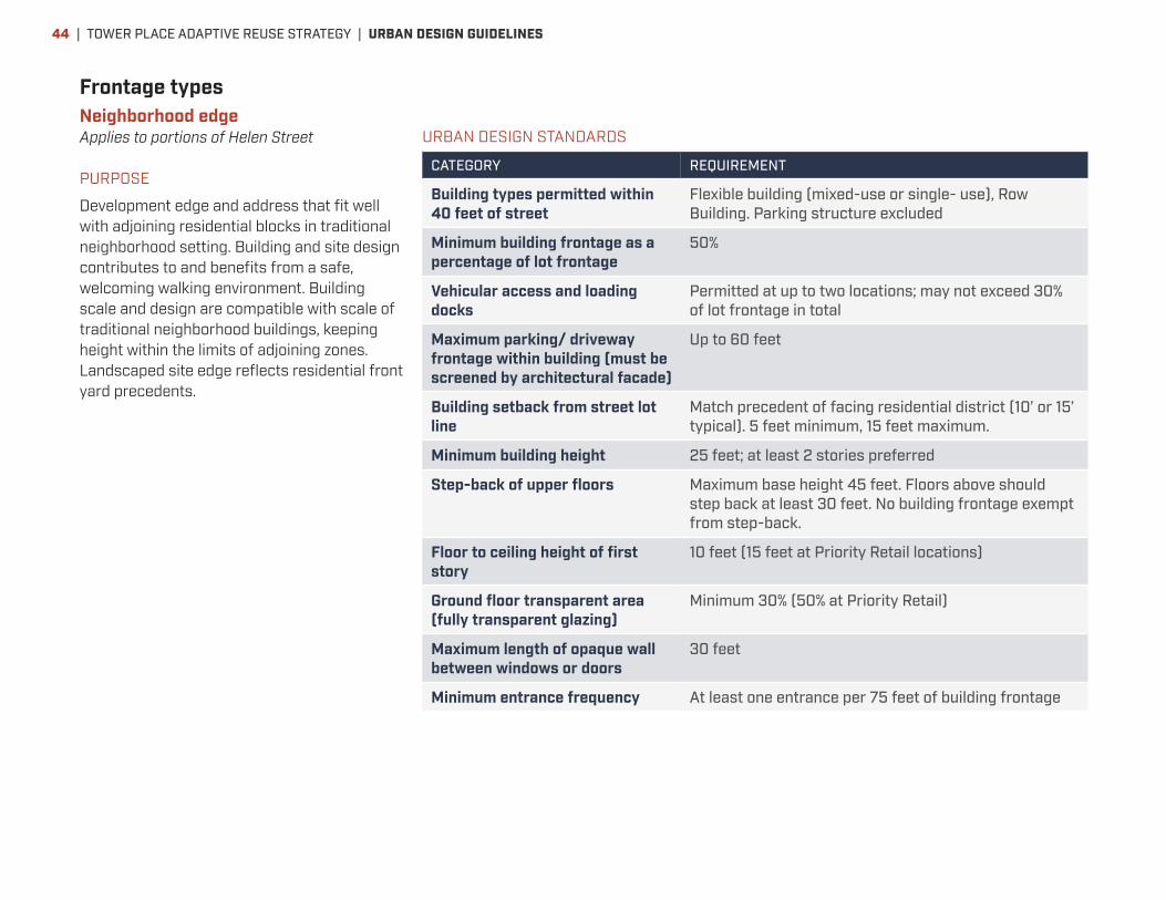
Frontage typesNeighborhood edgeApplies to portions of Helen Street
PURPOSE
Development edge and address that fit well with adjoining residential blocks in traditional neighborhood setting. Building and site design contributes to and benefits from a safe, welcoming walking environment. Building scale and design are compatible with scale of traditional neighborhood buildings, keeping height within the limits of adjoining zones. Landscaped site edge reflects residential front yard precedents.
URBAN DESIGN STANDARDS
CATEGORY REQUIREMENT
Building types permitted within 40 feet of street
Flexible building (mixed-use or single- use), Row Building. Parking structure excluded
Minimum building frontage as a percentage of lot frontage
50%
Vehicular access and loading docks
Permitted at up to two locations; may not exceed 30% of lot frontage in total
Maximum parking/ driveway frontage within building (must be screened by architectural facade)
Up to 60 feet
Building setback from street lot line
Match precedent of facing residential district (10’ or 15’ typical). 5 feet minimum, 15 feet maximum.
Minimum building height 25 feet; at least 2 stories preferred
Step-back of upper floors Maximum base height 45 feet. Floors above should step back at least 30 feet. No building frontage exempt from step-back.
Floor to ceiling height of first story
10 feet (15 feet at Priority Retail locations)
Ground floor transparent area (fully transparent glazing)
Minimum 30% (50% at Priority Retail)
Maximum length of opaque wall between windows or doors
30 feet
Minimum entrance frequency At least one entrance per 75 feet of building frontage
| TOWER PLACE ADAPTIVE REUSE STRATEGY | URBAN DESIGN GUIDELINES44

DEVELOPMENT PRECEDENTS DEMONSTRATING THE INTENT OF THE STANDARDS
TOWER PLACE ADAPTIVE REUSE STRATEGY | URBAN DESIGN GUIDELINES | 45

Frontage typesService street
PURPOSE
Priority development edge for service access, parking and other “back door” functions. Occupied building edges not required. Basic, flexible design standards, offering opportunity for greater investment in building and site design along other more public frontages.
URBAN DESIGN STANDARDS
CATEGORY REQUIREMENT
Building types permitted within 40 feet of street
All building types
Minimum building frontage as a percentage of lot frontage
0%
Vehicular access and loading docks
No limitations
Maximum parking/ driveway frontage within building (must be screened by architectural facade)
No limitations
Building setback from street lot line
None
Minimum building height No minimum
Step-back of upper floors No step-back required
Floor to ceiling height of first story
No minimum
Ground floor transparent area (fully transparent storefront-style glazing)
No minimum
Maximum length of opaque wall between windows or doors
No limitations
Minimum entrance frequency No minimum
| TOWER PLACE ADAPTIVE REUSE STRATEGY | URBAN DESIGN GUIDELINES46
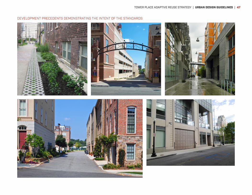
DEVELOPMENT PRECEDENTS DEMONSTRATING THE INTENT OF THE STANDARDS
TOWER PLACE ADAPTIVE REUSE STRATEGY | URBAN DESIGN GUIDELINES | 47

ARCHITECTURAL DESIGN GUIDELINESGuidelines applying across street corridorsDevelopment in the Tower Place Area should meet the standards of the following design guidelines in order to fully leverage the value potential of the new development as well as nearby properties. The guidelines intentionally allow and invite creative design efforts by developers and designers to best meet the spirit of the guidelines in the context of a given project. Development projects being considered for a development incentive should be expected to meet the design guidelines in an exemplary manner.
Building Façade Treatment
GENERAL GUIDELINES
• One of the special qualities of Tower Place is its unique heritage as a major manufacturing site. The historic Shot Tower building, and other historic buildings that may be preserved on the site, provide an important connection to this heritage. Part of this connection is through narrative of the site’s history, people and industrial processes that should be preserved and communicated in writing, images and/or other forms. Another part of this connection is through the architecture of the factory buildings. New buildings developed on or near Tower Place should highlight the historic factory architecture with design that echoes elements of the factory buildings, without replicating them. This can be done by applying design elements that refer to the historic buildings—such as brick color, proportions, shapes, balcony metalwork, or other items matching historic precedents on the site—in ways that create an up-to-date composition that is true to its own era and purpose. Use of salvaged materials from buildings on the site—whether integrated into a new building, or as a landscape element—is also encouraged as one way to meet this intent.
• Façades of multi-story buildings should be composed using a “base/middle/top” format that defines three major zones from base to top of the building façade (see diagram on right). In addition, to prevent a monolithic appearance and promote good scale relationships to a variety of adjacent elements, including buildings, street, trees, and people, façades should incorporate a full range of scale modules. For instance, ground level material and window selections should relate well to human scale; window and bay sizes should represent the scale of interior rooms; and the overall building, as well as any wings or other variations in massing, should be composed as a coherent unit. Where a large new building faces traditional neighborhood homes of smaller scale, the new building should incorporate intermediate elements that approximate the scale of the homes, and their architectural features such as porches and bay windows.
• In general, these scale modules should be used to emphasize vertical proportions in overall building massing. This will prevent
BUILDING “TOP”
BUILDING “MIDDLE”
BUILDING “BASE”
| TOWER PLACE ADAPTIVE REUSE STRATEGY | ARCHITECTURAL DESIGN GUIDELINES48

dominance of long horizontal forms that may feel out of place amidst an urban development pattern, or make a street block appear too long and uninteresting for walking. The unbroken horizontal length of any façade plane should not exceed 1.75 times the façade height (at eave). Intervals of set-back or projected façade area, preferably finished with a contrasting material and shifted at least 3 inches behind or in front of the adjacent façade plane, may be used to permit longer building lengths.
• To help new buildings fit in with others buildings of contrasting age or scale, façades should include horizontal expression lines that correspond to the height of adjacent buildings. Examples of such lines include cornices, brick string courses, window alignments, and upper story step-backs.
• Building tops and other skyline elements that rise above adjoining buildings deserve special design attention due to their prominent visibility from streets or other public spaces.
PRIMARY BAYWINDOW BAY
DETAIL UNIT
SECONDARY BAY
BUILDING BAY
WINDOW BAY
BUILDING BAY
PRIMARY BAY
SECONDARY BAY
DETAIL UNIT
TOWER PLACE ADAPTIVE REUSE STRATEGY | ARCHITECTURAL DESIGN GUIDELINES | 49

RETAIL FAÇADES
Ground floor retail façades should meet these criteria:
• At least 75% of ground-floor façade area in priority retail areas should consist of transparent glazing.
• Locate interior furnishings to accommodate direct views between the exterior and active interior retail areas. Opaque façade areas should extend no more than 20 feet horizontally.
• The façade architecture should incorporate a horizontal break that distinguishes the ground floor from upper floors and accommodates a horizontal signage zone above ground floor glazing.
• Floor-to-floor height should measure 15 to 20 feet.
• Leasable ground floor retail space should average at least 40 feet in depth from the façade where possible, with 60 feet preferable. Spaces as shallow as 20 feet may be permitted where necessary to accommodate constraints.
• The ground floor elevation should be flush with the sidewalk.
• The design of signage, awnings, storefronts, window displays and other elements defining retail presence should reinforce local neighborhood and district character. Signage font, scale, material and other characteristics should primarily reflect cues from the local setting—such as the architectural style of their own and adjacent buildings, themes established among local merchants, and public realm signage and public art reinforcing community identity. Signage should be especially oriented to pedestrians, such as through use of signs suspended over the sidewalk.
• In places where active ground floor use is desired but retail faces marketing challenges, consider these alternate uses, in this priority:
• Community uses open to the public such as daycare center, health services, arts organizations, educational services.
• Work/live or live/work spaces.
• Building lobbies and interior gathering spaces such as meeting rooms.
• Interior power, HVAC and other key services should be zoned to allow convenient sublease of ground floor retail spaces.
Include distinctive, pedestrian-scaled signage identifying retail establishments
| TOWER PLACE ADAPTIVE REUSE STRATEGY | ARCHITECTURAL DESIGN GUIDELINES50

Sidewalks along retail and live/work spaces should include at least 8 feet of clear width available for walking, in addition to street trees, planting strips and paved access to on-street parking.
TOWER PLACE ADAPTIVE REUSE STRATEGY | ARCHITECTURAL DESIGN GUIDELINES | 51

WORKPLACE AND RESIDENTIAL FAÇADES
• Emphasize vertical architectural elements that break up horizontal building volumes to read as individual working, housing and retail spaces. Avoid long horizontal elements that emphasize building length or the appearance of repeated stacked floors.
• Strategies to accommodate variety, suitable for all building types, include differing fenestration from floor to floor, and incorporating bay windows, balconies, porches, subtle massing changes, and changes in material or color.
• Provide large windows at living areas for better daylighting of interior spaces, and informal surveillance of public areas outside.
• Articulate façade details to create shadow lines and reduce apparent “flatness” of building façade. To give façades depth and texture, avoid flush-faced glazing.
• In multifamily residential buildings, ground floor units should have direct entrances from the public street wherever possible.
Materials
• Building design should emphasize use of stone, masonry, unpainted metal, glass, burnished block, cement fiber siding, three-coat cementitious stucco with minimized control joints, concrete and/or other high-quality, durable finishes. Use of materials matching those in historic Tower Place buildings is encouraged. Use durable and sustainable materials that weather well over time and require little maintenance. Durable and long-lasting construction techniques and details should be employed.
• Make generous use of glazing as a functional and expressive means of connecting building occupants to their environment. However, use no reflective or darkly tinted glass.
• Incorporate a variety of materials, in counterpoint to the elements of formal continuity that are defined from block to block, to help break down building scale into element of human scale. Any single material should make up no more than 80% of wall area other than
glazing on each building façade; at least one secondary material must make up the difference. Avoid more than one material in the same plane. Use building volumes and building detail articulation to change materials.
• Secondary façades (those not facing public streets, parks and plazas) may differ in finish materials from primary façades but must adhere to all other provisions and shall be of similar quality to primary façades. At semi-private parcel courtyards, it is encouraged that façade materials match those of the primary façade(s). Exterior wood siding should only be used in protected locations.
• Construction joints, where they do not directly contribute to façade composition, should be obscured by locating them at changes in façade plane or material, such as along projecting string courses or bays, and through use of inconspicuous joint filler material. Minimize expression of stucco control joints as much as possible.
• Use corrugated or standing seam metal, shingle, or other high-quality roofing on sloped roofs. Any asphalt shingles used shall be architectural grade and appropriate to the building type, i.e. used for smaller-scale buildings. Flat or gently sloping roof areas may be appropriate for occupied terraces or green roofs. Consider opportunities to include solar panels and solar shading devices on roof surfaces. Other roofs should be highly reflective, light-colored “cool” roofs and/or green roofs.
• Metal is recommended as material for awnings and shade structures; high strength textilene fabrics may also be considered.
• Locate heavier materials closer to the ground and highest-quality materials and details at pedestrian level. Heavy materials like masonry should always touch the ground.
• Integrate HVAC and other mechanical equipment unobtrusively into the overall building design.
| TOWER PLACE ADAPTIVE REUSE STRATEGY | ARCHITECTURAL DESIGN GUIDELINES52

Environmental performance
• Target LEED Silver or similar standards for all new construction and renovation.
• Use low VOC (Volatile Organic Compound) materials.
Exterior utility and trash items
• Conceal or screen electrical boxes, transformers, utility meters, dumpsters, and other less attractive utility elements from public view as much as possible.
• Dumpsters and other containers for trash and recyclable materials that serve businesses or multiple housing units should be located out of view from public street and park areas and should be enclosed in fencing. Fencing shall be at least 80% opaque and rise high enough to conceal any containers within. Fence materials should match one or more materials used for other fences or building finishes on the site.
Off-street parking
Off-street parking should be located and designed to have minimal presence, if any, along streets and other public spaces.
• Begin by minimizing parking need in the first place by locating and designing development to make walking, biking, transit and car-share options convenient, reducing need for car ownership. Then, make use of existing spaces within easy 1–2 block walking distance to the extent possible, through coordinated parking management and wayfinding.
• Minimize placement of surface or structured parking at grade level along a street edge, except as a temporary condition on blocks to be developed in later phases.
• Upper levels of parking structures should also be screened from streets, parks and other public areas with occupied space (such as housing or office space) wherever possible. Any portions of parking structures visible from the street should be designed to architectural
Parking structures should be screened from view from public streets, such as with housing units as shown here.
Ground floors of parking structures should contain retail or other active uses at ground level. Any upper levels exposed to streets or parks should be designed to architectural standards.
TOWER PLACE ADAPTIVE REUSE STRATEGY | ARCHITECTURAL DESIGN GUIDELINES | 53

standards following the Workplace and Residential Façade Treatment section above.
• Provide clear signage, designed to be visible from moving cars on the street to indicate the presence of off-street parking for retail uses.
• Pedestrian access should be prominent, inviting and convenient, making it easy to park once and reach multiple destinations on foot. Pedestrian entrance lobbies to parking structures should have as much visibility from the exterior as possible to promote security. Stair towers and elevators, where adjacent to the street, should be designed with a high degree of transparency. Consider making use of their potential as a strong vertical design element.
• Place particular emphasis on screening roofs of parking decks from above. Wherever possible, incorporate a significant amount of vegetation in the form of an occupied roof terrace with planters, green roof, trellis or other format to minimize the volume of storm-water run-offs from roofs of parking decks.
• Where off-street parking is gated, gates and fencing should be set back behind the predominant building line, and fencing landscaped to minimize visual impact.
• Consider use of pervious paving in surface parking lots wherever possible, such as use of decomposed granite at parking spaces with concrete or asphalt at drive aisles.
• For every 3,000sf of surface parking lot (including travel aisle and parking spaces) dedicate 300sf fully permeable landscaped surface in the form of tree wells and landscaped parking space separators.
• Redirect stormwater from the parking surfaces to landscaped water infiltration zones.
While parking structures should have minimal physical presence along primary walking streets, clear signage for drivers and pedestrians is important.
| TOWER PLACE ADAPTIVE REUSE STRATEGY | ARCHITECTURAL DESIGN GUIDELINES54

TOWER PLACE ADAPTIVE REUSE STRATEGY | ARCHITECTURAL DESIGN GUIDELINES | 55

www.barnumstation.com
City of Bridgeport, CT Connecticut Department of Economic and Community Development
Connecticut Office of Policy and Management