tulare unit strategic fire plancdfdata.fire.ca.gov/pub/fireplan/fpupload/fpppdf1556.pdf · the...
TRANSCRIPT

Last update: 26 February 2015
Tulare Unit
Strategic Fire Plan

i
Last update: 26 February 2015
UNIT STRATEGIC FIRE PLAN AMENDMENTS
Date Section Updated Page Numbers
Updated Description of Update
Updated By
4/9/14 Entire Plan All Update and modification to entire plan TR
12/31/14 Unit Overview 4 Update dates and Census JP
1/6/15 Entire Plan All Update dates and Statistical Information JP
1/9/15 Kaweah Battalion 2014
Accomplishments 23 Created new category JP
1/21/15 Battalion Program Plans 18 – 43 Updated Battalion Projects JP
2/18/15 Battalion Program 18 – 43 Created Battalion Accomplishments JP
2/18/15 Entire Plan Varied Updated photographs JP
ii
Last update: 26 February 2015
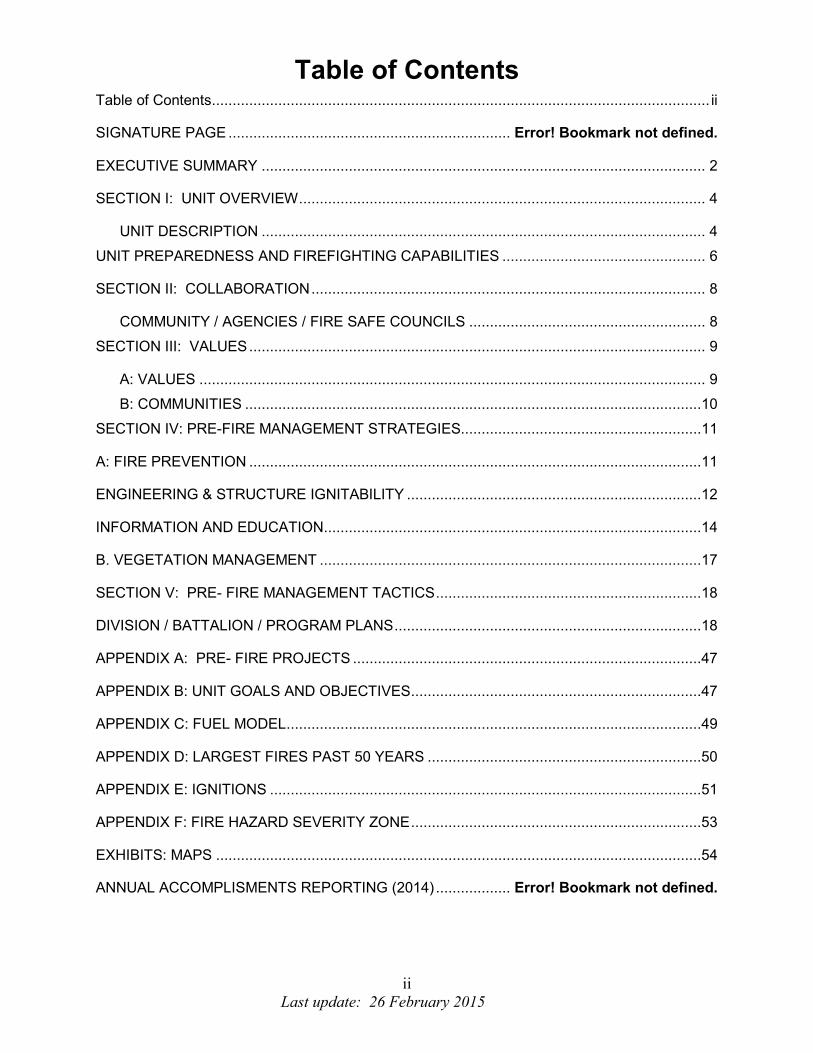
Table of Contents Table of Contents ........................................................................................................................ ii
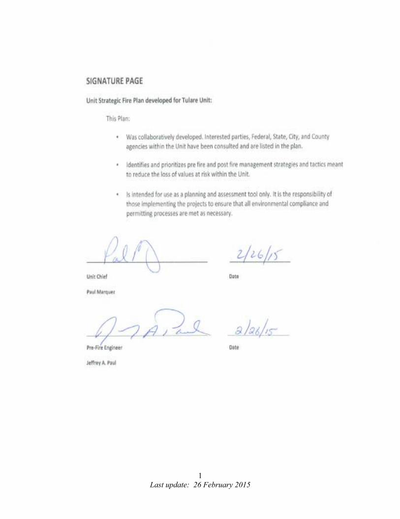
SIGNATURE PAGE .................................................................... Error! Bookmark not defined.
EXECUTIVE SUMMARY ........................................................................................................... 2
SECTION I: UNIT OVERVIEW .................................................................................................. 4
UNIT DESCRIPTION ........................................................................................................... 4
UNIT PREPAREDNESS AND FIREFIGHTING CAPABILITIES ................................................. 6
SECTION II: COLLABORATION ............................................................................................... 8
COMMUNITY / AGENCIES / FIRE SAFE COUNCILS ......................................................... 8
SECTION III: VALUES .............................................................................................................. 9
A: VALUES .......................................................................................................................... 9
B: COMMUNITIES ..............................................................................................................10
SECTION IV: PRE-FIRE MANAGEMENT STRATEGIES..........................................................11
A: FIRE PREVENTION .............................................................................................................11
ENGINEERING & STRUCTURE IGNITABILITY .......................................................................12
INFORMATION AND EDUCATION ...........................................................................................14
B. VEGETATION MANAGEMENT ............................................................................................17
SECTION V: PRE- FIRE MANAGEMENT TACTICS ................................................................18
DIVISION / BATTALION / PROGRAM PLANS ..........................................................................18
APPENDIX A: PRE- FIRE PROJECTS ....................................................................................47
APPENDIX B: UNIT GOALS AND OBJECTIVES ......................................................................47
APPENDIX C: FUEL MODEL ....................................................................................................49
APPENDIX D: LARGEST FIRES PAST 50 YEARS ..................................................................50
APPENDIX E: IGNITIONS ........................................................................................................51
APPENDIX F: FIRE HAZARD SEVERITY ZONE ......................................................................53
EXHIBITS: MAPS .....................................................................................................................54
ANNUAL ACCOMPLISMENTS REPORTING (2014) .................. Error! Bookmark not defined.
1
Last update: 26 February 2015
2
Last update: 26 February 2015
EXECUTIVE SUMMARY
The Tulare Unit (TUU) is one of 21 administrative Units within CAL FIRE. The Tulare
Unit Strategic Fire Plan is a product of the implementation of the California State Fire
Plan. The TUU Strategic Fire Plan was completed by a collaborative effort between the
Unit Chief, Battalion Chiefs, Program Managers, Bureau Managers and various
stakeholders in the Unit. This process provided TUU background information on fuels
and fire data, current and proposed projects, and individual Battalion activities
commonly carried out each year. The TUU Strategic Fire Plan is our local road map to
create and maintain defensible landscapes in order to protect vital assets. The Fire Plan
seeks to reduce firefighting cost and property loss, increase public and firefighter safety,
minimize wildfire risk to communities and contribute to ecosystem health.
This Unit Strategic Fire Plan emphasizes State Responsibility Land within CAL FIRE
jurisdiction. The Fire Plan will be a tool to assist the Unit with pre-suppression projects
which exist within each Battalion. TUU plans, identifies and evaluates priority
landscape, fire hazards, and wildfire risk. Additionally it identifies opportunities for
reducing structural ignitability, and identifies potential fuel reduction projects and
techniques for minimizing those risks.
The TUU Strategic Fire Plan is our dynamic planning tool, and intended to be a living
document. While we plan for and develop new projects, our primary focus will be to
obtain funding for the maintenance of the existing projects and pre-suppression
infrastructure that is in place. This document will be updated each year on the
successes that have been accomplished and new goals and objectives as outlined by
the Unit and the California Strategic Fire Plan.
The Tulare Unit Key Goals and Objectives from the California Strategic Fire Plan:
• Support the implementation and maintenance of defensible space inspections
around structures.
• Analyze trends in fire cause and focus prevention and education efforts to modify
behaviors and effect change to reduce ignitions within Tulare County.
• Continually evaluate the success in achieving the 95% threshold of keeping fires
less than 10 acres in size.
• Identify and evaluate wildland fire hazards and recognize assets at risk,
collecting and analyzing data to determine fuel reduction project, and other
projects.
3
Last update: 26 February 2015
• Support the availability and utilization of CAL FIRE resources, as well as public
and private sector resources for fuels management activities, including ongoing
maintenance.
• Assist landowners and local government in the evaluation of the need to retain
and utilize features (e.g. roads, fire lines, water sources) developed during fire
suppression efforts, taking into consideration those identified in previous planning
efforts.
4
Last update: 26 February 2015
SECTION I: UNIT OVERVIEW
UNIT DESCRIPTION
Tulare Unit is located in Central California and makes up part of the San Joaquin Valley.
It consists of 603,496 acres of State responsibility land, 910,740 acres of Local
responsibility land, and 1,584,183 of Federal responsibility land, a combined total of
3,098,419 acres. CAL FIRE Tulare Unit is bordered on the east by Sequoia and Kings
Canyon National Parks, and the Sequoia National Forest. The counties of Kern, Kings
and Fresno border to the South, West, and North respectively. The elevation of Tulare
Unit land receiving direct protection by CAL FIRE ranges from 200 feet along the
county’s western boundary to a highest point of 9,252 feet on Moses Mountain to the
East. This wide range of elevation supports many areas of vegetation consisting of
grass, oak woodland, brush, and timber including old growth redwood. For the Tulare
County Fuel Models see Appendix C.
Average annual temperatures range from 50 to 75 degrees; however it is not
uncommon to have temperatures in the low 20s during the winter months and highs
exceeding 100 degrees for extended periods during the summer months. The rainy
season is October through April; the average annual rainfall is 11.03 inches. However,
in the last three years we have experienced extreme drought conditions. Summers can
be hot as stated earlier with extremely warm temperatures and dry relative humidity
lasting for weeks. During the North American Monsoonal season thunderstorms are not
uncommon over the higher elevations with some extending out over the Sierra Foothills
and valley floor. Some years a monsoonal push will work from the southwest heading
northeast causing thunderstorms with associated lightning and scattered precipitation
on the valley floor and foothill region.
The United States Census Bureau in 2013 estimates Tulare County’s population at
454,143. The majority of the population in the state responsibility area is located along
two East-West highways. Highway 198 which leads to the Sequoia / Kings Canyon
National Parks and Highway 190 which accesses a significant portion of the Sequoia
National Forest / Giant Sequoia National Monument. Tulare Unit continues to
experience a population growth rate of approximately 1 percent annually. Along with
the population increase, wildland urban intermix has significantly increased where
structures are being built throughout wildland areas. Providing adequate fire protection
to those structures has become a major undertaking. However, the Tulare Unit has a
low frequency of large damaging fires. CAL FIRE strives to extinguish 95% of all
wildland fires at 10 acres or less. For the top ten largest fires over the past 50 years see
Appendix D.
Tulare Unit’s Fire Management Plan is our mechanism to catalog potential hazard areas
and develop prescriptions to begin mitigating them based upon assessed priorities.
5
Last update: 26 February 2015
The Tulare Unit Key Goals and Objectives from the California Strategic Fire Plan:
• Support the implementation and maintenance of defensible space inspections
around structures.
• Analyze trends in fire cause and focus prevention and education efforts to modify
behavior and effect change to reduce ignitions within Tulare County.
• Continually evaluate the success in achieving the 95% threshold of keeping fires
less than 10 acres in size.
• Identify and evaluate wildland fire hazards and recognize assets at risk,
collecting and analyzing data to determine fuel reduction project, and other
projects.
• Support the availability and utilization of CAL FIRE resources, as well as public
and private sector resources for fuels management activities, including ongoing
maintenance.
• Assist landowners and local government in the evaluation of the need to retain
and utilize features (e.g. roads, fire lines, water sources) developed during a fire
suppression effort, taking into consideration those identified in previous planning
efforts.

6
Last update: 26 February 2015
UNIT PREPAREDNESS AND FIREFIGHTING CAPABILITIES
TUU Facilities:
TUU Headquarters is located just off Highway 198 in Visalia. At peak fire season, the
unit staffs 8 fire stations, an air attack base including one fixed wing air attack and two
air tankers, an inmate conservation camp with 5 year-round hand crews, emergency
command center, fire prevention bureau, training bureau, 2 bulldozer / transport
combinations and 3 Registered Professional Foresters.
The following is a list of TUU’s facilities, equipment, and overhead personnel by
battalion.
Badger Battalion
Badger Station 1 – Type III Engine
Woodlake Station 1 – Battalion Chief
1 – Type III Engine
1 – Bulldozer / Transport
Kaweah Battalion
Visalia Station 1 – Type III Engine
Three Rivers Station 1 – Battalion Chief
2 – Type III Engines
Tule Battalion
Porterville Station 1 – Battalion Chief
1 – Type III Engine
1 – Bulldozer / Transport
Bear Creek Station 2 – Type III Engines
Fountain Battalion
Fountain Springs Station 2 – Type III Engines
Tyler Creek Station 1 – Type III Engine

7
Last update: 26 February 2015
Tulare Unit has MUTUAL AID AGREEMENTS with the following Departments:
• Tulare County Fire Department (TCFD)
• United States Forest Service (SQF)
• National Park Service (Sequoia & Kings)
• Kern County Fire Department (KRN)
• Tule Indian Reservation (TIA)
• Visalia City Fire Department (VFD)

8
Last update: 26 February 2015
SECTION II: COLLABORATION
COMMUNITY / AGENCIES / FIRE SAFE COUNCILS
Representatives involved in the development of the Unit Strategic Fire Plan are included in the following table. Their organization and title are indicated below:
Plan Development Team:
Organization Title
CAL FIRE Tulare Unit Unit Chief
The Sequoia Fire Safe Council Council President
Unites States Forest Service FMO / District Manager
Tulare County Resource Conservation District President
National Parks Service District Manager
9
Last update: 26 February 2015
SECTION III: VALUES
A: VALUES
The Unit description contained in this Fire Management Plan provides the background
for identifying TUU’s Assets at Risk. Additionally CAL FIRE’s Fire and Resource
Assessment Program (FRAP) prepared the document entitled California’s Forest and
Rangelands: 2010 Assessment. This assessment identifies the Unit Priority
Landscapes. Priority Landscapes are intended to focus investments and other
programs to address issues such as Fire Threat to Ecosystem Health, Rangeland Fire
Threat, and Post Fire Erosion Threat to Community Water. Each of the programs in
TUU is geared to protect or enhance the assets. The following list provides a summary
of TUU’s Assets at Risk:
Life and Safety The loss of life and disregard for safety is the ultimate price paid. One ounce of
prevention is little compared to any injury or a loss of life. This is based on population
density and makeup of the communities. The fire size, location, and rate of spread could
prove detrimental.
Air Quality
The potential is damage to heath, vegetation, and visibility. This is ranked on vegetation
type and the air movement.
Range Productivity
Agriculture is a big industry in the Unit. Cattle ranches and rangeland encompass
hundreds of thousands of acres in the Unit. The dollar cost to replace feed per acre will
vary depending on the regions, owners, and feed.
Structures
The effect of fire would depend on the housing density and the exposure (potential for
structure loss in a large fire event). The cost would not only be to the average dollar lost
per home but the non-commodity assets as well.
Timber
The average loss per acre burned would depend on the region and owner. The effect of
a wild land fire would affect local, state, national levels.
10
Last update: 26 February 2015
Water and watersheds
The range of economic impacts per acre value is dependent on the location and
potential fire. A fire would increase water yields but could cause significant damage to
the ecosystem and water ways. The cost alone of sediment removal would have a
significant major impact. Vegetation Management Plans are the key to water shed
management. VMP`s planned and coordinated are the best way to avoid major damage
to our water shed.
B: COMMUNITIES
The communities that are at risk and are recognized on both the State and National levels are: Badger Camp Nelson Exeter East Porterville Kennedy Meadows Lindsay Poso Park Pine Flat R Ranch Tule River Wilsonia Tule River Indian Reservation Springville Three Rivers The communities that are not recognized at the state and national levels are: Balance Rock Blue Ridge Elderwood Campbell Creek Fountain Springs Hartland Camp Hammond Jack Ranch California Hot Springs Kaweah Lemon Cove Mehrten Creek Posey Sugar Loaf Village Sierra Glen Woodlake
http://osfm.fire.ca.gov/fireplan/fireplanning.php http://www.preventwildfireca.org/California-Fire-Alliance/
11
Last update: 26 February 2015
SECTION IV: PRE-FIRE MANAGEMENT STRATEGIES
A: FIRE PREVENTION
The Tulare Unit fire prevention program accomplishes fire management goals using four
primary resources. These resources are law enforcement, pre-fire engineering,
education and volunteerism. The law enforcement resources handle fire investigation
and cause determination, as well as enforcing California’s Forestry and Fire Laws
throughout the Unit and/or State. Pre-Fire Engineering takes place with property
owners, stakeholders, fire safe councils, resource conservancy and through local
jurisdictions that assist in planning fire safe projects. Volunteerism is supported through
Volunteer in Prevention (VIP) program, which uses local volunteers to assist with public
information, represent CAL FIRE at public events, and correspond with the public with
CAL FIRE’s mission in mind. Each program area’s goal is to allow the prevention
program to be successful and functional Unit wide. In 2014 arson was our leading cause
of wildland fires in the Tulare Unit. The 2014 ignitions report as well as the five year
ignition summary can be found in Appendix E.
Civil Cost Recovery CAL FIRE’s Civil Cost Recovery program recovers fire suppression costs when a fire
investigation reveals that the responsible party caused the fire negligently or in violation
of law. This benefit’s the State in two ways: it assigns fire suppression costs to culpable
parties rather than the taxpayers at large and it serves as a deterrent to carelessness
that can result in destructive fires. All fires meeting the above criteria are forwarded to
Southern Region Office for review and civil cost collection.
12
Last update: 26 February 2015
ENGINEERING & STRUCTURE IGNITABILITY
The Prevention Bureau, through its Fire Captain / Pre Fire Engineer position supports
and collaborates with a wide variety of agencies and community members in the
planning, organizing, and documentation of fuel reduction projects throughout the Unit.
Starting in 2010 the Pre Fire Engineer began the process of implementing the State
Board of Forestry and Fire Protection’s new 2010 Strategic Fire Plan for California.
Under that document this Unit Fire Plan attempts to record all efforts within the Unit to
mitigate the threat posed by wildland fire. The primary focus is on projects designed to
create fuel breaks adjacent to threatened communities and help private landowners and
organizations reduce the threat within their property boundaries.
In Tulare Unit, the wildland urban interface (WUI) continues to grow. TUU contains a
variety of land uses and types, from agriculture to forest. Commercial and residential
structures are present throughout all of these land use types. The communities within
the confines of the Tulare Unit have always been confronted by the threat posed by
uncontrolled wildland fire. The structures within the Unit reflect well over 100 years of
acceptable building materials and techniques. State law establishes certain
requirements for building in the WUI that effect structure placement and decrease
structure ignitability. Construction types, ignitability of materials and proper engineering
are all critical when wildland fires encounter structures.
It is a fact recognized by all fire control personnel that any ignition can quickly result in a
fire that immediately threatens structures. Whether it’s 1, 100 or 1,000 acres, structures
can be threatened. In the case of small rapidly growing fires, ignition can be from direct
flame impingement and/or radiant heat. In the case of very large landscape scale fires,
a means of ignition could be airborne embers. Recognition of this fact by property
owners should encourage them to take personal responsibility for improving the safety
of their structures by following the steps required and/or recommended to reduce the
threat of structure ignition.
Tulare Unit also enforces the LE- 100 program (Fire Hazard Inspections). All structures in the State Responsibility Area are inspected. Home owners who do not comply with the Public Resource Code (PRC) 4291 are cited. The idea behind the program is not to issue a citation, but prevent the loss of structures when fire is moving through a community. There were approximately 4750 structures inspected with 23 citations issued in 2014.
13
Last update: 26 February 2015
ENGINEERING & STRUCTURE IGNITABILITY CONT8
The California Building Commission (CBC) adopted the Wildland-Urban Interface codes
(Chapter 7A) in late 2005. The majority of the new requirements took effect in 2008.
These new codes include provisions for ignition resistant construction standards
applicable to the WUI, which emphasizes protecting against airborne embers. During
this same time period, CAL FIRE initiated a statewide project to update the Fire Hazard
Severity Zone (FHSZ) designations within the WUI. Starting with the State
Responsibility Areas in 2005 and concluding with Local Responsibility Areas adjacent to
or within the SRA in 2008. Fire Hazard Severity Zones were field validated, updated as
required and adopted by local government (County and City governing and regulatory
entities), before official CAL FIRE maps were produced and released to local
government. For Fire Hazard Severity Zones see Appendix F.
The requirements in Chapter 7A of the CBC and the associated FHSZ’s have been
enacted and are being enforced by local government building officials as new
development plans work their way through the approval process. The updated zones
will also be used by property owners to comply with Natural Hazards Disclosure
requirements at the time of a property sale. Local government is encouraged to
integrate the updated FHSZ’s into the Safety Element of their General Plans. Property
owners, developers, contractors, building materials businesses, and product designers
can find specifics and answers to questions regarding California Building Code Chapter
7A, Fire Code Chapter 47, PRC 4290 and 4291, and Title 14, 19, 24 and other related
information at the following CAL FIRE Office of the State Fire Marshal website:
http://www.fire.ca.gov/fire_prevention/fire_prevention_wildland_codes.php
14
Last update: 26 February 2015
INFORMATION AND EDUCATION
Information & Education is an integral part of the Fire Prevention Program. The focus is
to reach out to the elementary school children with match & lighter safety education. In
addition to the school programs, it is imperative to educate the public on the importance
of Defensible space clearance, the proper method to burn hazard reduction materials,
and the correct times to use power equipment.
The fire safety program that teaches children not to play with matches, lighters, or fire is
the “Team Teaching” program. Team Teaching targets Preschool through second
grade. Team Teaching is a highly professional program developed by teachers, CAL
FIRE personnel, USFS personnel and child psychologists. This program utilizes
Smokey Bear, an internationally recognized fire prevention symbol, to teach children not
to play with matches, lighters, or fire. Pre-planning is the most important factor for a
successful team teaching program. This year Tulare unit participated in 19 first grade
programs.
The first step in planning a fire prevention program is to identify what the Unit’s priorities
are. Review the Unit Fire Plan to determine what fire causes occur in the target areas.
For example, children match caused fires may have dropped in occurrence due to
heavy saturation of schools with “Team Teaching” and other school education programs
over the years, while “equipment use” or “debris burning” caused fires have increased.
This would indicate a change in priorities. The Unit could then choose to develop an
annual maintenance program for “Team Teaching” and redirect emphasis on
“equipment use” and “debris burning” programs or assign additional personnel to assist
with the implementation of programs to meet those needs in targeted areas.
The Tulare County Fair and the Scicon BBQ continue to be an effective method of
conveying the fire prevention messages to the public. TUU personnel educate the public
and allow children to cut a log and brand Smokey the Bear into the piece they cut.
Based on ignitions in the unit our prevention message can change year to year.
15
Last update: 26 February 2015
Defensible Space
The department has instituted an easy-to-use defensible space inspection form known
as the LE-100. It contains detailed explanations of violations and how to correct them.
Used by agency inspectors alike, it’s checkbox format acts as a detailed guide for
inspectors and a prompt for veteran inspectors while minimizing the amount of writing
required, speeding up and standardizing inspections. During inspections we encourage
discussions with property owners about property issues.
Property owners living in State Responsibility Areas (SRA) are required by Public
Resource Code (PRC) 4291 to maintain clearance of flammable vegetation around their
property. A property owner’s responsibility is to clear 100 feet from his or her
structure(s) or to the property line, whichever is closer, and is limited to their lands.
However, coordination with adjacent landowners to achieve maximum defensible space
is encouraged. Short of expensive remodel and retrofit projects for existing structures,
compliance with existing PRC 4291 requirements is the single most effective means by
which property owners can reduce the likelihood of fire damage. PRC 4291 clearance
requirements: a 30’ wide Defensible Space zone immediately adjacent to the structure,
plus an additional 70’ Reduced Fuel zone, for a total of 100 feet of clearance around all
structures. The Prevention Bureau and each Battalion in the Unit is actively engaged in
PRC 4291 education and compliance efforts, including: on-sight inspections, self-
inspection forms, face to face education at the fire stations, participation in community
events, close cooperation with Home/Property Owner Associations, and collaborative
efforts with the local Fire Safe Councils, Local and Federal Government Fire Agencies
and land management agencies.
http://www.fire.ca.gov/communications/downloads/fact_sheets/DefensibleSpaceFlyer.pdf
Volunteer in Prevention Program
The VIP Program utilizes citizens and public service groups to volunteer time in non-
salaried positions to reduce man-caused fires. Each year our VIP’s play a vital role, they
assist with staffing public events and emergency mitigation efforts. Each year VIP’s
assist by participating in fairs, displays, school programs and parades.

16
Last update: 26 February 2015
Fire Prevention Roadside Sign Program
Battalion staff will continue promoting the fire prevention message based on our current
ignition problems via the 4’x8’ roadside signs. Funding is being sought for additional
signs within the unit. The signs are placed in high traffic areas in every battalion. There
are 6 in the Badger Battalion, 5 in the Kaweah Battalion, 5 in the Tule Battalion, and 3 in
the Fountain Springs Battalion. These are primary entry points for commuters, part-time
residents and visitors to Tulare County. These highways and roads experience a very
large volume of traffic, making it an excellent point from which to publicize our fire
prevention messages. This is an annual program in which signs are posted throughout
the fire season.
Fire Prevention sign in the Kaweah Battalion
17
Last update: 26 February 2015
B. VEGETATION MANAGEMENT
Natural Resource Management is supporting the TUU Fire Plan through Forest Practice
activities as well as Vegetation Management Programs and other fuel reducing grants.
Through the Forest Practice Program we are encouraging healthy forest throughout the
Unit. Landowners as well as local Registered Professional Foresters are currently
reducing overcrowded timber stands. This is being implemented by Timber Harvest
Plans (THPs). Reducing the amount of high fire vegetation and providing an opportunity
to fight fire safely and aggressively is the primary goal. These programs also help
increase the water table by reducing the amount of evapotranspiration in the watershed.
Reducing the amount of hazardous brush will also help in the foraging of not only
livestock, but wildlife as well. By doing these projects it helps bring the natural mosaic
back to the landscape.
Several attempts to conduct prescribed burns were initiated on the Mountain Home
Demonstration State Forest (MHDSF). However, fuel moisture conditions were too high
to facilitate effect burning. Therefore, no prescribed fire acres were completed at
MHDSF this year. Approximately 800 roadside piles were burned in the areas of Shake
Camp, Gelena Creek, Coppermine Road, headquarters, and Powerline Road. There
were several Fuel Treatments conducted within the Unit. A fuel reduction project was
also completed in the Ponderosa area under the Prop 40 grant. This project was
completed through the Fire Safe Council. Approximately 100 acres was treated by
hand. Prop 40 also funded a CEQA Management Plan in the Sequoia Crest Area. This
plan was completed; however it has not been implemented or funded.
Tulare Unit did not conduct any VMP’s this year; however preliminary ground work has
begun for a new VMP within the Kaweah Battalion (Mankin).
http://www.fire.ca.gov/resource_mgt/resource_mgt_vegetation.php.
18
Last update: 26 February 2015
SECTION V: PRE- FIRE MANAGEMENT TACTICS
DIVISION / BATTALION / PROGRAM PLANS
BADGER BATTALION - 4111 Fuels: The fuels within the Badger Battalion are typical of those found in the foothill and
mountain regions of the Southern Sierra Mountain Range. Vegetation types range from
annual grasses, near the valley floor, to mixed conifer forest at the higher elevations.
Below 500’ elevation annual grasses, including wild oats, are the pre-dominate fuel
type. Fuel loading in this area change from year to year based on the amount of
precipitation received. Between 500’-3500’, the fuel type becomes more oak woodland
with an inter-mix of brush. The brush is made up of several varieties including:
manzanita, chemise, ceanothus, scrub oak, live oak, and poison oak. The brush
becomes denser with the rise in elevation and on the North and East aspects. Above
3500’ elevation fuels to transition to a Conifer fuel type. At 4500’ elevation and above,
the fuel is dominated by conifer species such as cedar, pine, fir, live oak and black oak
with a mixed brush understory.
Topography: There are a wide range of topographical features that vary in elevation from 400’ to near
5000’. The lower elevations are comprised of rolling foothills, while the upper elevations
contain mountainous terrain with steep drainages, rugged canyons, and a few gentle
valleys. Dry Creek and Cottonwood Creek are the major drainages in the area.
Weather: Being a Mediterranean Climate, the typical summer weather pattern consists of 90 –
105 degrees with humidity’s in the upper teens to low 20’s during the day. At night, the
temperature is in the upper 50’s to near 70 degrees with humidity’s in the high 30’s to
low 50’s. Winds are generally light with upslope, up canyon during the day and
downslope, down canyon at night.
Fire History:
The Badger Battalion averages approximately 5-10 fire starts annually. The majority of
those fires started are due to vehicle and equipment use in the lower grasslands.
Although rare, starts in the upper elevations within the battalion do pose a significant
potential for a large extended attack fire. Large extended attack fires have occurred in
the battalion over the years with several fires in the 500 – 1000 acre range. There is no
known history of major fires.
19
Last update: 26 February 2015
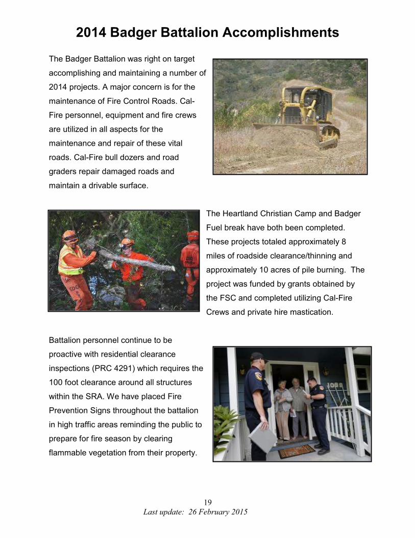
2014 Badger Battalion Accomplishments
The Badger Battalion was right on target
accomplishing and maintaining a number of
2014 projects. A major concern is for the
maintenance of Fire Control Roads. Cal-
Fire personnel, equipment and fire crews
are utilized in all aspects for the
maintenance and repair of these vital
roads. Cal-Fire bull dozers and road
graders repair damaged roads and
maintain a drivable surface.
The Heartland Christian Camp and Badger
Fuel break have both been completed.
These projects totaled approximately 8
miles of roadside clearance/thinning and
approximately 10 acres of pile burning. The
project was funded by grants obtained by
the FSC and completed utilizing Cal-Fire
Crews and private hire mastication.
Battalion personnel continue to be
proactive with residential clearance
inspections (PRC 4291) which requires the
100 foot clearance around all structures
within the SRA. We have placed Fire
Prevention Signs throughout the battalion
in high traffic areas reminding the public to
prepare for fire season by clearing
flammable vegetation from their property.

20
Last update: 26 February 2015
Battalion Priority: Updating and maintaining our fire road system is a top priority in the Badger Battalion.
By ensuring these road systems are well maintained, it allows us to access areas within
the battalion that would otherwise be difficult to access. There are 2 fuels reduction
projects that have been identified. The first is a fuel break along the ridge top west of
Hartland Christian Camp. This project would be done in coordination with USFS and
Hartland Christian Camp. The second project is a fuel break between Miramonte Fire
Control Road and Mountain House. This would provide a fuel break along the ridge
west of the Community of Badger.
Pre-Attack Plans: Develop updated maps utilizing GIS technology to capture all roads, fuel breaks, water
locations, staging locations, and probable control lines. Possible strategies for fire
suppression could be pre-determined utilizing fire history, typical fire weather and fire
behavior models.
Priority #1
Project Name: Fire Control Road maintenance
Description: Maintain the fire control roads in the battalion for fire suppression and quick
access to fires.
Community: Badger, Sierra Glen, Eshom Valley, Heartland Christen Camp, Sand
Creek, Miramonte,
Project Collaborators: CAL FIRE, Tulare County land owners in the State Responsibility
Area, Sequoia Fire Safe Council.
Priority #2 Project Name: Badger Chipping Day Description: Provide a chipping day at Badger FFS for residents of the Badger/Eshom Valley area to be able to dispose of their LE-100 material. Community: Badger and Eshom Valley Project Collaborators: CAL FIRE, Fire Safe Council
Priority #3
Project Name: Heartland Camp
Description: Fuel modification with hand crews
Community: Badger, Sierra Glen, Eshom Valley, Heartland Christen Camp.
Project Collaborators: CAL FIRE, Heartland Christian Camp, USFS, Fire Safe Council.
21
Last update: 26 February 2015
Battalion Priority Cont:
Priority #4
Project Name: Badger Fuel Break
Description: Fuel break on the ridge West of Badger
Community: Badger, Eshom Valley, Sierra Glen
Project Collaborators: CAL FIRE, Badger Ranch and land owners, Fire Safe Council.
Priority #5
Project Name: Battalion Fire Prevention Signs
Description: Public education, Fire Prevention Messages displayed on road side signs.
Community: Elderwood, Cutler, Orosi, Badger, Eshom Valley
Project Collaborators: CAL FIRE and the Sequoia Fire Safe Council.
22
Last update: 26 February 2015
KAWEAH BATTALION – 4112 Fuels: The fuels within the Kaweah Battalion are typical of those found in the Central California
San Joaquin Valley and Sierra Nevada. This area is influenced by a Mediterranean
climate with warm, dry summers and cool moist winters. The climate, topography,
geology and land use patterns within this region determine the vegetation patterns.
Vegetation within the Kaweah Battalion varies from annual grasses and forbs on the
valley floor to mixed conifer forest at the higher elevations. The lower elevations
manifests annual grasses, including wild oats, and loading varies from year to year
based on seasonal rainfall. Between 500’-1000’ elevation this changes to an Oak
Woodland fuel type with brush becoming more prevalent along with pockets of gray/bull
pine starting around the 2000’ level. The brush component is made up of several
species, including, but not limited to; manzanita, chemise, scrub oak, live oak and
poison-oak. The brush is interspersed with black oak and live oak, buckeye trees and
sycamore (in drainages) with higher densities on the north and east aspects. This
vegetation type continues to about 3500’ where it blends into the Conifer Belt with
scattered oaks, brush and conifer trees. At about 4500’ conifers become the dominant
fuel with such species as; cedar, pine, fir, live oak and black oak with a mixed brush
understory which includes bear clover, lotus, chinquapin and whitethorn.
Topography: The Kaweah Battalion is typical of most of the foothill areas in the Southern Sierra
Nevada Range and encompasses a large portion of the Kaweah drainage and the
Cottonwood Creek drainage. The Topography ranges from gentle rolling foothills above
the Central Valley floor at 400’ elevation to steep river drainage along Kaweah River.
Major ridges and mountains are separated by small ravines, rugged canyons, and a few
gentle valleys with elevations within the State Responsibility Area topping out near the
5000’ elevation range.
Weather: Typical summer weather patterns consist of 90 – 105 degree days with humidity’s in the
upper teens to low 20’s and nights in the upper 50’s to near 70 degrees with humidity’s
in the high 30’s to low 50’s. Winds are generally light and diurnal, up slope, up canyon
in the day time and down slope, down canyon at night.

23
Last update: 26 February 2015
Fire History: The Kaweah Battalion averages approximately 8-15 fire starts annually. The majority of
those fires started are due to vehicle and electrical power in the lower grasslands.
Although rare, starts in the upper elevations within the Battalion do pose a significant
potential for a large extended attack fire. Large extended attack fires have occurred in
the Battalion over the years with several fires in the 500 – 1000 acre range.
24
Last update: 26 February 2015
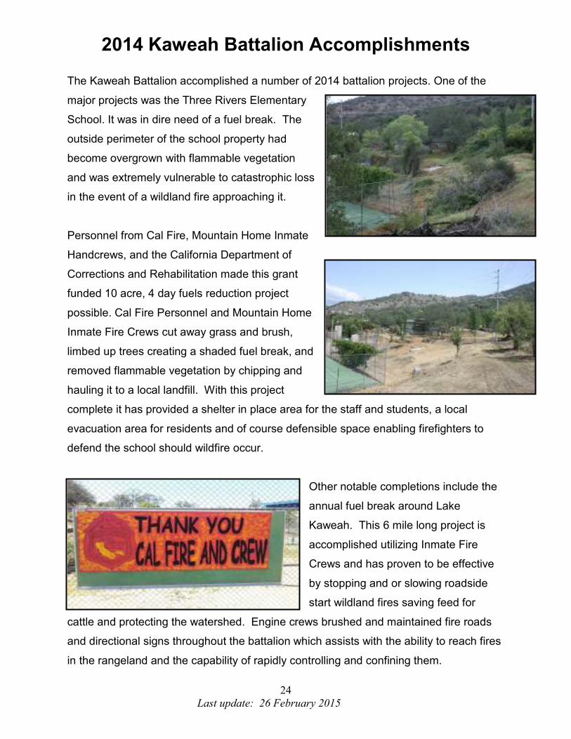
2014 Kaweah Battalion Accomplishments
The Kaweah Battalion accomplished a number of 2014 battalion projects. One of the
major projects was the Three Rivers Elementary
School. It was in dire need of a fuel break. The
outside perimeter of the school property had
become overgrown with flammable vegetation
and was extremely vulnerable to catastrophic loss
in the event of a wildland fire approaching it.
Personnel from Cal Fire, Mountain Home Inmate
Handcrews, and the California Department of
Corrections and Rehabilitation made this grant
funded 10 acre, 4 day fuels reduction project
possible. Cal Fire Personnel and Mountain Home
Inmate Fire Crews cut away grass and brush,
limbed up trees creating a shaded fuel break, and
removed flammable vegetation by chipping and
hauling it to a local landfill. With this project
complete it has provided a shelter in place area for the staff and students, a local
evacuation area for residents and of course defensible space enabling firefighters to
defend the school should wildfire occur.
Other notable completions include the
annual fuel break around Lake
Kaweah. This 6 mile long project is
accomplished utilizing Inmate Fire
Crews and has proven to be effective
by stopping and or slowing roadside
start wildland fires saving feed for
cattle and protecting the watershed. Engine crews brushed and maintained fire roads
and directional signs throughout the battalion which assists with the ability to reach fires
in the rangeland and the capability of rapidly controlling and confining them.
25
Last update: 26 February 2015
Battalion Priority: Updating and maintaining our fire road system is a top priority in the Kaweah Battalion.
By ensuring these road systems are well maintained, it allows us to access areas within
the Battalion that would otherwise be difficult to access.
Proposed fuels reduction projects in the Battalion have been identified. Some are in the
process of nearing completion, while other proposed projects are still waiting for final
approval. Current projects are; updating Pre-attack plans, the Rat Trail projects on the
North Fork Drainage and around Kaweah Lake, Grouse Valley FCR fuel Break, Grouse
Valley VMP, Mankin Flat VMP, Three Rivers FFS demonstration project and the Sheep
Creek Suppression Tank and Pond maintenance.
Pre-Attack Plans: Develop updated maps utilizing GIS technology to capture all roads, fuel breaks, water
locations, staging locations, and plot probable control lines. Possible strategies for fire
suppression could be pre-determined utilizing fire history, typical fire weather and fire
behavior models. Distribute the maps so equipment from other stations / areas can
efficiently function within the Kaweah Battalion.
Priority #1 Project Name: Fire Control Road maintenance Description: Maintain the fire control roads in the battalion for fire suppression and quick access to fires. Community: Badger, Kaweah, Three Rivers, Lemon Cove. Project Collaborators: CAL FIRE, Tulare County land owners in the State Responsibility Area, Sequoia Fire Safe Council. Priority #2 Project Name: Kaweah Lake “Rat Trail”: Description: Fuel reduction with hand crews. Community: Three Rivers, Kaweah, Lemon Cove, Hammond Project Collaborators: CAL FIRE, Tulare County land owners in the State Responsibility Area, Sequoia Fire Safe Council. Priority #3 Project Name: Library / Public playground cleanup 42052 Eggers Dr. Three Rivers, Ca. Description: Fuel modification; utilize CAL FIRE Crews to eliminate heavy fuel from around playground and county library. Community: Three Rivers, Kaweah, Lemon Cove, Project Collaborators: CAL FIRE, Tulare County land owners in the State Responsibility Area, Three Rivers Union School, and Tulare County Library.

26
Last update: 26 February 2015
Pre-Attack Plans Cont: Priority #4 Project Name: Three Rivers FFS Demo Project Description: Fire Safe Landscape, Public Education, Prevention Community: Three Rivers, Kaweah, Lemon Cove, Hammond Project Collaborators: CAL FIRE, Tulare County land owners in the State Responsibility Area, Sequoia Fire Safe Council, and Three Rivers Community Garden club. Priority #5 Project Name: Kaweah River Dr. / Wash Burn Dr. Description: Utilize CAL FIRE Crews to work with the private land owners to eliminate roadside brush. Use Cal Fire Crews to assist the land owners in a chipping day to remove LE-100 material from around the structures in the area. Community: Three Rivers Project Collaborators: CAL FIRE, Tulare County land owners in the State Responsibility Area. Priority #6 Project Name: Blue Ridge Fuel Break Description: Fuel modification with hand crews Community: Three Rivers Project Collaborators: CAL FIRE, Tulare County land owners in the State Responsibility Area, Sequoia Fire Safe Council. Priority #7 Project Name: Battalion Fire Prevention Signs
Description: Public education, Fire Prevention Messages displayed on road side signs.
Community: Three Rivers, Mineral King, Lemon Cove, Woodlake
Project Collaborators: CAL FIRE and the Sequoia Fire Safe Council.
Priority #8
Project Name: Mankin
Description: Fuel reduction around Mankin Flat/Davis Spur Fire control roads
Community: Badger, Dry Creek Rd. Land owners, Lemon Cove
Project Collaborators: CAL FIRE , Kaweah Delta land Conservancy, Sequoia Fire Safe
Council.
27
Last update: 26 February 2015
TULE BATTALION - 4113
Fuels:
The fuels within the Tule Battalion are typical of those found in the Central California
San Joaquin valley and Sierra Nevada. This area is influenced by a Mediterranean
climate with warm, dry summers and cool moist winters. The climate, topography,
geology and land use patterns within this region determine the vegetation patterns.
Vegetation within the Tule Battalion varies from annual grasses and forbs on the valley
floor to old growth sequoia redwood/mixed conifer forest at the higher elevations. The
lower elevations manifest annual grasses, including wild oats, and loading varies from
year to year based on seasonal rainfall. Between 500’-1000’ elevation this changes to
an Oak Woodland fuel type with brush becoming more prevalent. The brush component
is made up of several species, including, but not limited to; manzanita, chemise,
ceanothus, scrub oak, live oak and poison-oak. The brush is interspersed with black oak
and live oak, buckeye trees and sycamore (in drainages) with higher densities on the
north and east aspects. This vegetation type continues to about 3000’ where it blends
into the Conifer Belt with scattered oaks, brush and conifer trees. At about 4000’
conifers become the dominant fuel with such species as; cedar, pine, fir, live oak and
black oak with a mixed brush understory which includes bear clover, lotus, chinquapin
and whitethorn ceanothus. This continues up to about the 5500’ elevation where it
transitions to a Timber fuel type dominated by fir, pine and sequoia. This type generally
manifests areas of heavy downed and dead fuels.
Topography:
The Tule Battalion is typical of most river drainages found in the Southern Sierra
Nevada Range and encompasses a large portion of the Tule river drainage and spills
over into the Deer Creek drainage on its southern border. The Topography ranges from
gentle rolling foothills where it leaves the Central Valley floor at 500’ elevation to sheer
granite monoliths at the 8000’ elevation. The Tule river drainage consists of three major
forks; North, Middle, and South forks and is further made up by numerous feeder creeks
and seasonal streams. Major ridges and mountains are separated by small ravines,
deep rugged canyons, and a few gentle valleys. Due to Glacial activity thousands of
years ago large granite boulders, rocky escarpments and sheer rock faces can be found
on most ridges and mountains.
28
Last update: 26 February 2015
Weather:
The Tule Battalion like Tulare County is influenced by a Mediterranean climate with cool
moist winters and warm dry summers. Average annual temperatures range from 50’s to
70’s however it is not uncommon to have temperatures in the low 20s during the winter
months and highs exceeding 100 for extended periods during the summer months. The
rainy season is October through April and annual rainfall average is 11.03 inches.
Summers can be hot as stated earlier with extremely warm temperatures and dry
relative humidity lasting for weeks. During the North American Monsoonal season
thunderstorms are not uncommon over the higher elevations with some extending out
over the Sierra Foothills and valley floor. Some years a Monsoonal push will work from
the southwest driving northeast causing thunderstorms with associated lightning and
scattered precipitation on the valley floor and foothill region.
Fire History:
The Tule Battalion includes the Hwy 190 corridor which accesses numerous recreation
areas such as; Lake Success, Balch Park, Mountain Home Demonstration State Forest,
Sequoia National Forest, Eagle Mountain Casino and Giant Sequoia National
Monument. The battalion traditionally experiences the majority of the fire activity in the
Tulare Unit. Although recreationists contribute to some of the fire causes, a majority of
the activity is attributable to arson caused fires. The majority of those fires started are
due to arson and equipment use in the lower grasslands. The proximity of the Tule
River Indian Reservation which has a decade’s long arson history contributes heavily to
the battalion’s fire responses. Sometimes these are a single fire to a series of fires
being set on SRA lands adjacent to the reservation. Large fire history has been primarily
in the grass and oak woodland fuel types. There have been a couple fires in the
Brush/Timber fuels that originated in the Middle Fork of the Tule River that burned onto
or threatened SRA lands; these were the “Coffee” and “Deep” fires. Both fires did pose
a threat to Mountain Home Demonstration State Forest.
29
Last update: 26 February 2015
2014 Tule Battalion Accomplishments
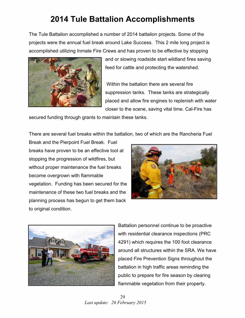
The Tule Battalion accomplished a number of 2014 battalion projects. Some of the
projects were the annual fuel break around Lake Success. This 2 mile long project is
accomplished utilizing Inmate Fire Crews and has proven to be effective by stopping
and or slowing roadside start wildland fires saving
feed for cattle and protecting the watershed.
Within the battalion there are several fire
suppression tanks. These tanks are strategically
placed and allow fire engines to replenish with water
closer to the scene, saving vital time. Cal-Fire has
secured funding through grants to maintain these tanks.
There are several fuel breaks within the battalion, two of which are the Rancheria Fuel
Break and the Pierpoint Fuel Break. Fuel
breaks have proven to be an effective tool at
stopping the progression of wildfires, but
without proper maintenance the fuel breaks
become overgrown with flammable
vegetation. Funding has been secured for the
maintenance of these two fuel breaks and the
planning process has begun to get them back
to original condition.
Battalion personnel continue to be proactive
with residential clearance inspections (PRC
4291) which requires the 100 foot clearance
around all structures within the SRA. We have
placed Fire Prevention Signs throughout the
battalion in high traffic areas reminding the
public to prepare for fire season by clearing
flammable vegetation from their property.

30
Last update: 26 February 2015
Battalion Priority:
Fire roads and their maintenance is a high priority, they provide access and fire control
opportunities to many areas of the Battalion. Many of these fire roads also access ranch
roads that local ranchers have put in, which provide even greater access and fire control
opportunities. Without the fire road maintenance many areas would be inaccessible to
ground equipment and would require time consuming walk in or costly fly in access by
ground resources. Another priority is the PRC 4291 inspection program which provides
defensible space around the numerous structures in the Battalion. This program has a
successful history with improved compliance and the need for citations diminishing each
year.
Fire Defense Projects:
There are currently two major projects underway in the Battalion. The “Happy Camp”
project which started in 2010 is a fuel break below the community of Happy Camp which
resides in the timber belt with extremely high fuel loading, completion of this project was
in December of 2012. The Mountain Home Demonstration State Forest Evacuation Plan
was completed in December 2012. This is a project that involves different cooperators
from different agencies that have a vested interest in the affected area.
Pre-Attack Plans: Develop updated maps utilizing GIS technology to capture all roads, fuel breaks, water
locations, staging locations, and plot probable control lines. Possible strategies for fire
suppression could be pre-determined utilizing fire history, typical fire weather and fire
behavior models. Distribute the maps so equipment from other stations / areas can
efficiently function within the Tule Battalion.
Priority #1
Project Name: Fire Control Road maintenance
Description: Maintain the fire control roads in the battalion for fire suppression and quick
access to fires.
Community: Springville, Triple R Estates, Mountain Home State Forest, Ponderosa,
Camp Nelson, Happy Camp, Tule Indian Reservation.
Project Collaborators: CAL FIRE, Tulare County land owners in the State Responsibility
Area, and Sequoia Fire Safe Council.
Priority #2
Project Name: Lake Success “Rat Trail”:
Description: Fuel reduction with hand crews.
Community: Porterville, Springville
Project Collaborators: CAL FIRE, Tulare County Land owners in the State
Responsibility Area, Sequoia Fire Safe Council
31
Last update: 26 February 2015
Pre-Attack Plans Cont:
Priority #3 Project Name: Springville Chipper Day Description: Location and time frame for the community to dispose of their LE-100 material for chipping. Community: Springville, Montgomery Ranch, Campbell Creek, Triple "R" Project Collaborators: CAL FIRE, Tulare County land owners in the State Responsibility Area, Sequoia Fire Safe Council.
Priority #4
Project Name: Balch Park Assembly
Description: Evacuation meeting area for the Balch Park and Mountain Home
Demonstration State Forest.
Community: Springville
Project Collaborators: CAL FIRE, Tulare County, CDCR
Priority #5
Project Name: Rancheria Suppression Tank
Description: Pre planned for fire suppression
Community: Springville
Project Collaborators: CAL FIRE, Tulare County land owners in the State Responsibility
Area, Sequoia Fire Safe Council.
Priority #6
Project Name: Wishon Suppression Tank
Description: Pre planned for fire suppression
Community: Wishon
Project Collaborators: CAL FIRE, Tulare County land owners in the State Responsibility
Area, Sequoia Fire Safe Council.
Priority #7
Project Name: Rancheria Fuel Break
Description: Fuel reduction done with hand crews
Community: Springville
Project Collaborators: CAL FIRE, Tulare County land owners in the State Responsibility
Area, Sequoia Fire Safe Council.
Priority #8
Project Name: Pierpoint Fuel Break
Description: Fuel reduction done with hand crews
Community: Pierpoint Springs, Camp Nelson
Project Collaborators: CAL FIRE, Tulare County land owners in the State Responsibility
Area, Sequoia Fire Safe Council. United States Forest Service

32
Last update: 26 February 2015
Pre-Attack Plans Cont:
Priority #9
Project Name: Battalion Fire Prevention Signs
Description: Public education, Fire Prevention Messages displayed on road side signs.
Community: Porterville, Springville, Camp Nelson, Pierpoint Springs, Wishon.
Project Collaborators: CAL FIRE and the Sequoia Fire Safe Council.
Priority #10
Project Name: Balch Park Road Suppression Tank
Description: Pre planned for fire suppression
Community: Springville
Project Collaborators: CAL FIRE, Tulare County land owners in the State Responsibility
Area, Sequoia Fire Safe Council.

33
Last update: 26 February 2015
FOUNTAIN SPRINGS BATTALION - 4114 Fuels: The fuels within the Fountain Springs Battalion are typical of those found in the Central
California foothills, San Joaquin valley and Sierra Nevada. This area is influenced by a
Mediterranean climate with warm, dry summers and cool moist winters. The climate,
topography, geology and land use patterns within this region determine the vegetation
patterns. Vegetation within the Fountain Springs Battalion varies from annual grasses
and forbs on the valley floor to mixed conifer forest at the higher elevations. The lower
elevations manifests annual grasses, including wild oats and loading varies from year to
year based on seasonal rainfall. Between 500’-1000’ elevation this changes to a
Woodland Oak fuel type with brush becoming more prevalent along with pockets of
gray/bull pine starting around the 2000’ level. The brush component is made up of
several species, including, but not limited to; manzanita, chemise, ceanothus, scrub
oak, live oak and poison-oak. The brush is interspersed with blue oak and live oak,
buckeye trees and sycamore (in drainages) with higher densities on the north and east
aspects. This vegetation type continues to about 3500’ where it blends into the Conifer
Belt with scattered oaks, brush and conifer trees. At about 4500’ conifers become the
more dominant fuel with such species as; cedar, pine, fir, live oak and black oak with a
mixed brush understory which includes bear clover, lotus, chinquapin and whitethorn
ceanothus.
Topography: The Fountain Springs Battalion is typical of most of the foothill areas in the Southern
Sierra Nevada Range and encompasses a large portion of the Deer creek drainage,
White river drainage and the upper portions of the Poso creek drainage on its
southeastern border. The Topography ranges from gentle rolling foothills above the
Central Valley floor at 400’ elevation to steep river drainages. Major ridges and
mountains are separated by small ravines, deep rugged canyons, and a few gentle
valleys with elevations within the State responsibility area topping out near the 5000’
elevation range.
Weather: Typical summer weather patterns consist of 90 – 105 degree days with humidity’s in the
upper teens to low 20’s and nights in the upper 50’s to near 70 degrees with humidity’s
in the high 30’s to low 50’s. Winds are generally light and diurnal, up slope, up canyon
in the day time and down slope, down canyon at night.

34
Last update: 26 February 2015
Fire History: The Fountain Springs Battalion averages approximately 7-10 fire starts annually. The
majority of those fires started are due to vehicle and equipment use in the lower
grasslands with the occasional lightning series caused fires. Each year however you
can expect a least a couple of starts in the upper elevations within the Battalion where
there is significant potential for a large extended attack fire. Large extended attack fires
have occurred in the Battalion over the years with several fires in the 500 – 1500 acre
range, there is no known history of major fires in the Battalion.
35
Last update: 26 February 2015
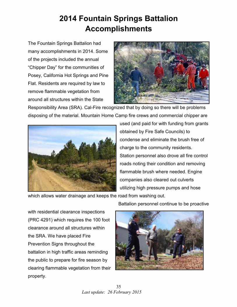
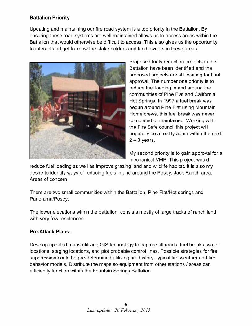
2014 Fountain Springs Battalion
Accomplishments
The Fountain Springs Battalion had
many accomplishments in 2014. Some
of the projects included the annual
“Chipper Day” for the communities of
Posey, California Hot Springs and Pine
Flat. Residents are required by law to
remove flammable vegetation from
around all structures within the State
Responsibility Area (SRA). Cal-Fire recognized that by doing so there will be problems
disposing of the material. Mountain Home Camp fire crews and commercial chipper are
used (and paid for with funding from grants
obtained by Fire Safe Councils) to
condense and eliminate the brush free of
charge to the community residents.
Station personnel also drove all fire control
roads noting their condition and removing
flammable brush where needed. Engine
companies also cleared out culverts
utilizing high pressure pumps and hose
which allows water drainage and keeps the road from washing out.
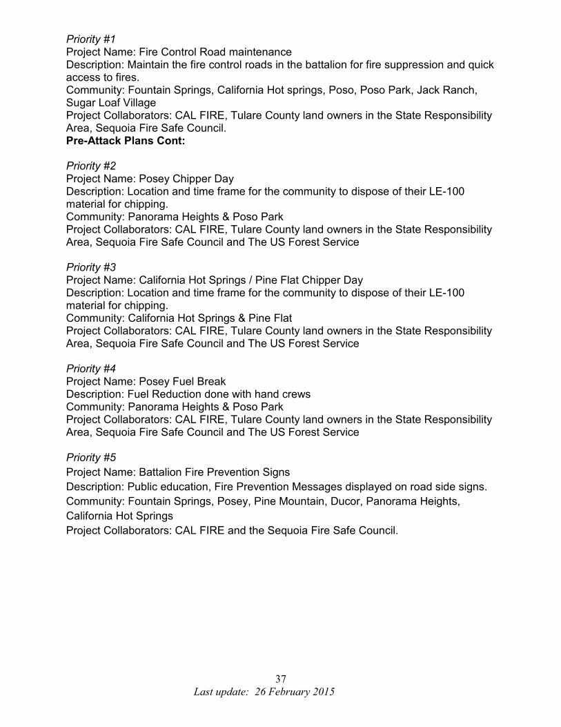
Battalion personnel continue to be proactive
with residential clearance inspections
(PRC 4291) which requires the 100 foot
clearance around all structures within
the SRA. We have placed Fire
Prevention Signs throughout the
battalion in high traffic areas reminding
the public to prepare for fire season by
clearing flammable vegetation from their
property.
36
Last update: 26 February 2015
Battalion Priority Updating and maintaining our fire road system is a top priority in the Battalion. By
ensuring these road systems are well maintained allows us to access areas within the
Battalion that would otherwise be difficult to access. This also gives us the opportunity
to interact and get to know the stake holders and land owners in these areas.
Proposed fuels reduction projects in the
Battalion have been identified and the
proposed projects are still waiting for final
approval. The number one priority is to
reduce fuel loading in and around the
communities of Pine Flat and California
Hot Springs. In 1997 a fuel break was
begun around Pine Flat using Mountain
Home crews, this fuel break was never
completed or maintained. Working with
the Fire Safe council this project will
hopefully be a reality again within the next
2 – 3 years.
My second priority is to gain approval for a
mechanical VMP. This project would
reduce fuel loading as well as improve grazing land and wildlife habitat. It is also my
desire to identify ways of reducing fuels in and around the Posey, Jack Ranch area.
Areas of concern
There are two small communities within the Battalion, Pine Flat/Hot springs and
Panorama/Posey.
The lower elevations within the battalion, consists mostly of large tracks of ranch land
with very few residences.
Pre-Attack Plans:
Develop updated maps utilizing GIS technology to capture all roads, fuel breaks, water
locations, staging locations, and plot probable control lines. Possible strategies for fire
suppression could be pre-determined utilizing fire history, typical fire weather and fire
behavior models. Distribute the maps so equipment from other stations / areas can
efficiently function within the Fountain Springs Battalion.
37
Last update: 26 February 2015
Priority #1 Project Name: Fire Control Road maintenance Description: Maintain the fire control roads in the battalion for fire suppression and quick access to fires. Community: Fountain Springs, California Hot springs, Poso, Poso Park, Jack Ranch, Sugar Loaf Village Project Collaborators: CAL FIRE, Tulare County land owners in the State Responsibility Area, Sequoia Fire Safe Council. Pre-Attack Plans Cont: Priority #2 Project Name: Posey Chipper Day Description: Location and time frame for the community to dispose of their LE-100 material for chipping. Community: Panorama Heights & Poso Park Project Collaborators: CAL FIRE, Tulare County land owners in the State Responsibility Area, Sequoia Fire Safe Council and The US Forest Service Priority #3 Project Name: California Hot Springs / Pine Flat Chipper Day Description: Location and time frame for the community to dispose of their LE-100 material for chipping. Community: California Hot Springs & Pine Flat Project Collaborators: CAL FIRE, Tulare County land owners in the State Responsibility Area, Sequoia Fire Safe Council and The US Forest Service Priority #4 Project Name: Posey Fuel Break Description: Fuel Reduction done with hand crews Community: Panorama Heights & Poso Park Project Collaborators: CAL FIRE, Tulare County land owners in the State Responsibility Area, Sequoia Fire Safe Council and The US Forest Service Priority #5
Project Name: Battalion Fire Prevention Signs
Description: Public education, Fire Prevention Messages displayed on road side signs.
Community: Fountain Springs, Posey, Pine Mountain, Ducor, Panorama Heights,
California Hot Springs
Project Collaborators: CAL FIRE and the Sequoia Fire Safe Council.

38
Last update: 26 February 2015
AIR ATTACK PROGRAM: Porterville Air Attack Base, Battalion 4108
The Porterville Air Attack Base was established in 1959, originally a US Forest Service
Base. In 1966 Cal Fire and the Forest Service signed a cooperative agreement, in the
mid 70’s Bureau of Land Management joined in on the agreement and have augmented
staffing when needed. Originally a three pad base, in 2003 a new base was placed in
service. This base consists of an Operations Building, Warehouse, Hanger, Retardant
Mix Plant and five loading pads.
Staffing at Porterville Air Attack Base consists of one OV-10 Bronco, used as an aerial
supervision platform, and two S2T air tankers. Often times one or more Federal Air
Tankers will be assigned to the base. With the air bases new electric pumps, 70,000
gallons of fire retardant storage, and five pads it has a peak output of 225,000 gallons a
day. On average Porterville Air Attack Base Supplies 775,000 gallons of fire retardant
to incidents each year, supporting 6 counties, 5 forests, as well as, BLM and BIA ground
totaling over 10 million acres of fire protection.
39
Last update: 26 February 2015
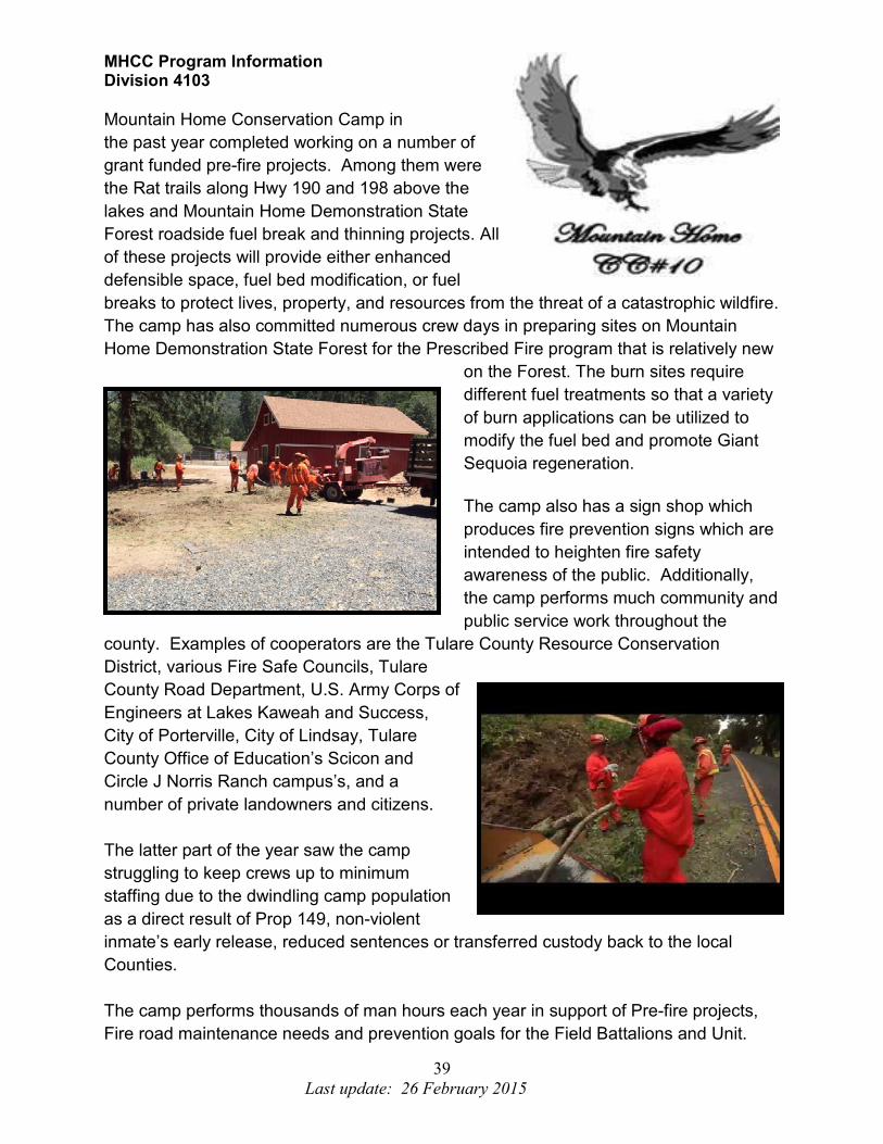
MHCC Program Information Division 4103
Mountain Home Conservation Camp in
the past year completed working on a number of
grant funded pre-fire projects. Among them were
the Rat trails along Hwy 190 and 198 above the
lakes and Mountain Home Demonstration State
Forest roadside fuel break and thinning projects. All
of these projects will provide either enhanced
defensible space, fuel bed modification, or fuel
breaks to protect lives, property, and resources from the threat of a catastrophic wildfire.
The camp has also committed numerous crew days in preparing sites on Mountain
Home Demonstration State Forest for the Prescribed Fire program that is relatively new
on the Forest. The burn sites require
different fuel treatments so that a variety
of burn applications can be utilized to
modify the fuel bed and promote Giant
Sequoia regeneration.
The camp also has a sign shop which
produces fire prevention signs which are
intended to heighten fire safety
awareness of the public. Additionally,
the camp performs much community and
public service work throughout the
county. Examples of cooperators are the Tulare County Resource Conservation
District, various Fire Safe Councils, Tulare
County Road Department, U.S. Army Corps of
Engineers at Lakes Kaweah and Success,
City of Porterville, City of Lindsay, Tulare
County Office of Education’s Scicon and
Circle J Norris Ranch campus’s, and a
number of private landowners and citizens.
The latter part of the year saw the camp
struggling to keep crews up to minimum
staffing due to the dwindling camp population
as a direct result of Prop 149, non-violent
inmate’s early release, reduced sentences or transferred custody back to the local
Counties.
The camp performs thousands of man hours each year in support of Pre-fire projects,
Fire road maintenance needs and prevention goals for the Field Battalions and Unit.
40
Last update: 26 February 2015
Mountain Home Demonstration State Forest
Division 4104
Mountain Home Demonstration State Forest (MHDSF) Fuel Reduction and Restoration Activities
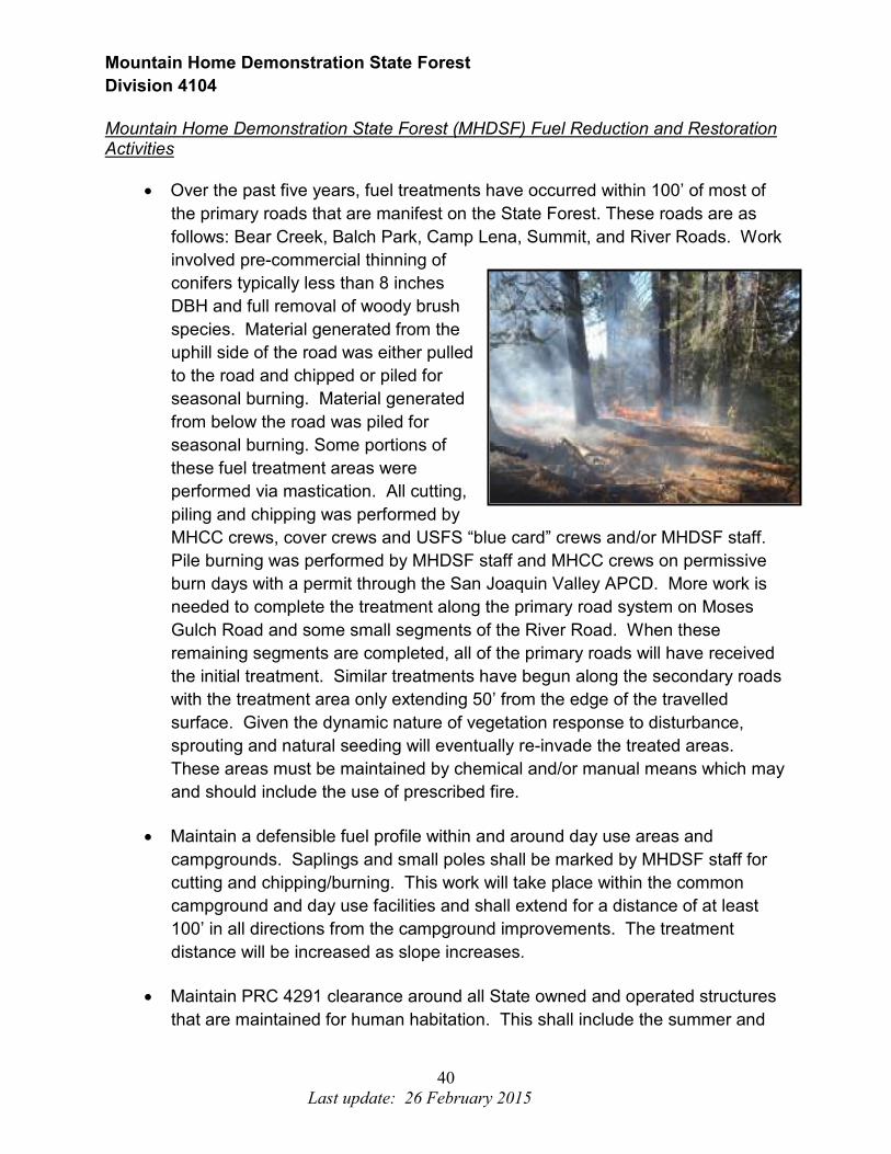
• Over the past five years, fuel treatments have occurred within 100’ of most of
the primary roads that are manifest on the State Forest. These roads are as
follows: Bear Creek, Balch Park, Camp Lena, Summit, and River Roads. Work
involved pre-commercial thinning of
conifers typically less than 8 inches
DBH and full removal of woody brush
species. Material generated from the
uphill side of the road was either pulled
to the road and chipped or piled for
seasonal burning. Material generated
from below the road was piled for
seasonal burning. Some portions of
these fuel treatment areas were
performed via mastication. All cutting,
piling and chipping was performed by
MHCC crews, cover crews and USFS “blue card” crews and/or MHDSF staff.
Pile burning was performed by MHDSF staff and MHCC crews on permissive
burn days with a permit through the San Joaquin Valley APCD. More work is
needed to complete the treatment along the primary road system on Moses
Gulch Road and some small segments of the River Road. When these
remaining segments are completed, all of the primary roads will have received
the initial treatment. Similar treatments have begun along the secondary roads
with the treatment area only extending 50’ from the edge of the travelled
surface. Given the dynamic nature of vegetation response to disturbance,
sprouting and natural seeding will eventually re-invade the treated areas.
These areas must be maintained by chemical and/or manual means which may
and should include the use of prescribed fire.
• Maintain a defensible fuel profile within and around day use areas and
campgrounds. Saplings and small poles shall be marked by MHDSF staff for
cutting and chipping/burning. This work will take place within the common
campground and day use facilities and shall extend for a distance of at least
100’ in all directions from the campground improvements. The treatment
distance will be increased as slope increases.
• Maintain PRC 4291 clearance around all State owned and operated structures
that are maintained for human habitation. This shall include the summer and
41
Last update: 26 February 2015
winter headquarters, barracks, Jack’s house and pack station. Similar
maintenance shall be performed around the fuel tank, and warehouse as well.
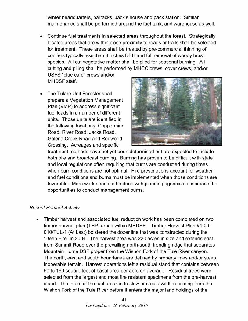
• Continue fuel treatments in selected areas throughout the forest. Strategically
located areas that are within close proximity to roads or trails shall be selected
for treatment. These areas shall be treated by pre-commercial thinning of
conifers typically less than 8 inches DBH and full removal of woody brush
species. All cut vegetative matter shall be piled for seasonal burning. All
cutting and piling shall be performed by MHCC crews, cover crews, and/or
USFS “blue card” crews and/or
MHDSF staff.
• The Tulare Unit Forester shall
prepare a Vegetation Management
Plan (VMP) to address significant
fuel loads in a number of different
units. Those units are identified in
the following locations: Coppermine
Road, River Road, Jacks Road,
Galena Creek Road and Redwood
Crossing. Acreages and specific
treatment methods have not yet been determined but are expected to include
both pile and broadcast burning. Burning has proven to be difficult with state
and local regulations often requiring that burns are conducted during times
when burn conditions are not optimal. Fire prescriptions account for weather
and fuel conditions and burns must be implemented when those conditions are
favorable. More work needs to be done with planning agencies to increase the
opportunities to conduct management burns.
Recent Harvest Activity
• Timber harvest and associated fuel reduction work has been completed on two
timber harvest plan (THP) areas within MHDSF. Timber Harvest Plan #4-09-
010/TUL-1 (At Last) bolstered the dozer line that was constructed during the
“Deep Fire” in 2004. The harvest area was 220 acres in size and extends east
from Summit Road over the prevailing north-south trending ridge that separates
Mountain Home DSF proper from the Wishon Fork of the Tule River canyon.
The north, east and south boundaries are defined by property lines and/or steep,
inoperable terrain. Harvest operations left a residual stand that contains between
50 to 160 square feet of basal area per acre on average. Residual trees were
selected from the largest and most fire resistant specimens from the pre-harvest
stand. The intent of the fuel break is to slow or stop a wildfire coming from the
Wishon Fork of the Tule River before it enters the major land holdings of the

42
Last update: 26 February 2015
State Forest. The harvest focused on disconnecting the horizontal and vertical
fuel ladders creating a more defensible fuel profile. All of the harvesting that
occurred within this timber sale was done conventionally with chainsaws and
tractors. Sub-merchantable trees and brush were treated by tractor piling and
burning, hand piling and burning, and some broadcast burning. This project was
necessary to protect the public, infrastructure, State property and forest
resources, watershed and habitat values, soil, and old-growth giant sequoia.
• Harvest operations on Timber Harvest Plan 4-11-021/TUL-1 (Dynamite Springs)
were conducted conventionally during the fall of 2012 and summer of 2013 when
weather and ground conditions allowed. The harvest area was 353 acres in size
and spread south of the At Last THP boundary to the State Forest boundary;
west from Summit Road to the operational boundary located west of the State
Forest administrative facilities; and north to the common boundary between
Balch County Park and MHDSF. This harvest focused on leaving a residual
stand that contains between 50 to 160 square feet of basal area per acre on
average. Residual trees were from all size and age classes and were distributed
as single trees and groups of trees. The intent of the harvest was to accomplish
a number of desired conditions; one of which was to modify forest fuels. This
modification left the treated stand in a more defensible condition with disrupted
horizontal and vertical continuity of fuels. Slash created and trees knocked down
were removed from within 150 feet of structures and from within 100 feet of
primary roads. Additional fuel treatments were performed with a masticator,
hand piling and burning and broadcast burning. This project was necessary to
protect the public, infrastructure, State property and forest resources, watershed
and habitat values, soil, and old-growth giant sequoia.

43
Last update: 26 February 2015
Additional Fuel Treatments
• Approximately 122 acres of second growth forest was mechanically masticated in
the fall of 2012. This operation took place in Section 34 in the western portion of
the State Forest. This
particular parcel is located
adjacent to a number of
private parcels and USFS
land. The intent of this
operation was to disrupt fuel
connectivity and provide
demonstration opportunities
to private landowners. The
treatment was funded through
Proposition 40. Much of the
treated area in Section 34 is
planned for prescribed
burning. Most of the area to
which the burn shall be applied is bounded by roads or natural fire-lines. Any
remaining line construction will be accomplished by MHCC crews. This burn
shall be done sometime
within the next few years
when climatic and fuel
conditions are favorable.
• Mastication operations
continued on another 510
acres during the summer and
fall of 2013. The 510 acres
were strategically located
within four distinct units. The
treatment involved the
mechanical grinding of
overstocked saplings, poles
and brush. The first area is 200 acres in size and is located on the ridgeline
which extends east and north from Frasier Mill Campground. The unit was
treated to an average width of approximately 350 feet. The unit terminates at the
Camp Lena Road near the intersection with Summit Road. This unit was funded
via a grant through the Sierra Nevada Conservancy. This unit shall be
maintained by a combination of chemical and prescribed fire treatments.
44
Last update: 26 February 2015
Additional Fuel Treatments Cont.
The second unit treated in 2013 was 277 acres in size. This unit essentially
surrounds Balch Park on the north, east and south. This treatment effectively
reduced the probability of a crown fire burning into Balch Park from the State
Forest and vice-versa. It also helps to create a safety zone for users of Balch
Park and MHDSF campers in the event that the evacuation plan is initiated for a
wildfire. This unit ties in to the shaded fuel breaks created with the At Last and
Dynamite Springs THP’s. This treatment was funded in part by both Proposition
40 and the Sierra Nevada Conservancy.
The forth unit that was treated in 2013 was approximately 50 acres in size which
is located on gently sloping and benchy ground east of Summit Road and north
of the At Last timber sale boundary. This unit was not treated as completely as
the others as it was designed to be a pre-fire treatment to facilitate an ecological
burn in the future. Again, this work was funded by Proposition 40.
An additional 35 acres of mastication was performed south of the State Forest
Headquarters in and adjacent to a 25 year old mixed conifer plantation.
Overstocked, suppressed, diseased and damaged trees were selected for
removal, leaving a well-stocked stand of healthy second growth timber. Much of
this area is located on MHDSF that is within open range and it is anticipated that
vegetative sprouting will be controlled by grazing.
Planned harvest operations
• Mountain Home foresters are currently planning a selective harvest on
approximately 300 acres located in the area accessed via Tub Flat Road. This
harvest will focus on the removal of individual large trees that are succumbing to
insects and disease, thinning of smaller trees to create growing space and
improve forest health, and shade tolerant species that have grown into the crown
of old-growth giant sequoia. The methods that are proposed to achieve the
desired outcome include single tree selection and group selection. Residual
forest fuels created during harvesting shall be treated by tractor piling and
burning and hand piling and burning. Broadcast burning opportunities will be
evaluated following harvest.
• The drought conditions that have plagued the forest since 2012 are beginning to
result in substantial tree mortality. Sugar pine, ponderosa pine, incense-cedar
and the true firs are all succumbing to insect attacks from being weakened by
water deficit stress. All harvest efforts will focus on the removal of these dead
and dying trees in order to capture some value before they deteriorate. Pine

45
Last update: 26 February 2015
slash that is suitable as beetle brood material shall be treated at a minimum by
lopping to a length of no more than four feet. Large accumulations of slash shall
be treated by piling and burning.
Planned fuel treatments
• Mountain Home Demonstration State Forest will be applying for another grant
through the Sierra Nevada Conservancy to masticate an additional 300 acres of
land. The treatment area will extend down a narrow “hog-back” ridge west of the
Wishon Fork of the Tule River. It will further extend upslope along the same
ridgeline to Shake Camp and the Pack Station. Should we be awarded the grant,
it is anticipated that the work will commence in late 2015 or early 2016.
Summary
Current management activities at MHDSF focus on the restoration and protection
of a magnificent Southern Sierra mixed conifer forest. This forest contains 4,750
old growth giant sequoia specimens which John Muir referred to as “the finest the
Sierra had to offer”. Given the history of fire suppression activities in the western
states, forest managers must keep fuel loading and resource protection as a top
priority. In the face of impending climate change, managers must consider the
ecological needs of the species contained within the forest and develop
strategies to minimize the potential for long-term negative effects. Wildfires that
occur on the majority of public lands are getting bigger and burning with more
intensity than they have historically. These “mega fires” indiscriminately destroy
habitats and watersheds and set succession back centuries. The management
activities occurring at MHDSF are designed to reverse the trends of overstocking
by creating a forest that more closely resembles the pre-European condition as
was found by the pioneers.
It should be noted that all of the on-the-ground activities that take place at
MHDSF have been thoroughly planned and evaluated and are in compliance with
the California Forest Practice Rules, California Environmental Quality Act,
California Department of Fish and Wildlife Rules, Air Pollution Control District
Rules and Regional Water Quality Control Board Rules and Regulations. If you
should have any questions or comments regarding the management of Mountain
Home Demonstration State Forest, you can contact the Forest Manager at 559-
539-2855.

46
Last update: 26 February 2015
TRAINING
BUREAU -
Battalion 4106
The Tulare Unit Training Bureau has set several goals to improve firefighting
effectiveness, training efficiency and safety of its members.
The Goals include but are not limited to:
1. All Unit personnel attend all or applicable segments of the annual Continued
Professional Training (CPT) academy(s) to maintain firefighting skills and
required recurrence training. The intent is for personnel to meet 4032 and 4036
training requirements.
2. All TUU Fire Control personnel to attend “A” Faller training.
a. Selected personnel will attend “B” Faller Training
b. Selected personnel will attend “C” Faller training
i. Selected individual “C” Faller will be named as the Chain Saw
Program Coordinator (CSP)
3. All TUU Fire Control personnel receive continued training on firefighting tactics
and safety in both wildland and structural firefighting. Two examples of such
training include Firefighter Survival (structural) and Sand Table scenario training.
4. All TUU Battalion Chiefs, Fire Captains and FAE’s attend C-234 Intermediate
Firing Operations course.
5. All TUU Fire Control Personnel assigned to the Porterville Air Attack Base attend
the following training where applicable:
a. Air Base Safety Training
b. Air Tanker Base Manager (ATBM) Training
c. C-378 Aerial Supervision (ATGS) Training
6. All Tulare Unit “Frequent Drivers” comply with department policy regarding
Defensive Driver training by successfully completing the Department of General
Service-ORIM online Defensive Driver Training at least once every four years.
TUU personnel attend applicable training and qualify in Incident Command System (ICS) positions. The intent is to meet the Unit’s obligation to Minimum ICS Qualified Personnel Matrix (7700) located in Handbook 7000 - Fire Operations.
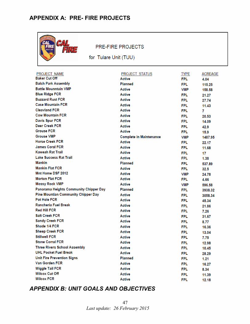
47
Last update: 26 February 2015
APPENDIX A: PRE- FIRE PROJECTS
APPENDIX B: UNIT GOALS AND OBJECTIVES

48
Last update: 26 February 2015
The Tulare Unit Key Goals and Objectives from the California Strategic Fire Plan:
• Support the implementation and maintenance of defensible space inspections
around structures.
• Analyze trends in fire cause and focus prevention and education efforts to modify
behavior and effect change to reduce ignitions within Tulare County.
• Continually evaluate the success in achieving the 95% threshold of keeping fires
less than 10 acres in size.
• Identify and evaluate wildland fire hazards and recognize assets at risk,
collecting and analyzing data to determine fuel reduction project or other
projects.
• Support the availability and utilization of CAL FIRE resources, as well as public
and private sector resources, for fuels management activities, including ongoing
maintenance.
• Assist landowners and local government in the evaluation of the need to retain
and utilize features (e.g. roads, fire lines, water sources) developed during a fire
suppression effort, taking into consideration those identified in previous planning
efforts.
CAL FIRE MISSION STATEMENT:
The California Department of Forestry and Fire Protective serves and safeguards the
people and protects the property and resources of California.
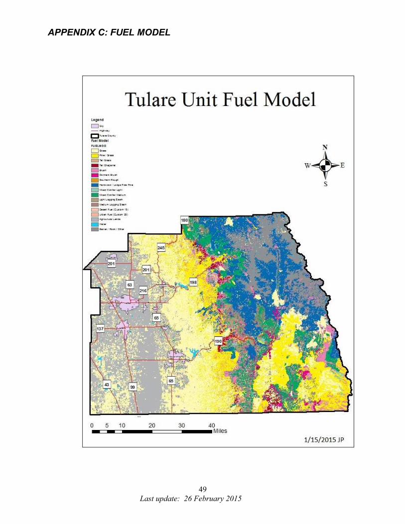
49
Last update: 26 February 2015
APPENDIX C: FUEL MODEL

50
Last update: 26 February 2015
APPENDIX D: LARGEST FIRES PAST 50 YEARS
Fire History

51
Last update: 26 February 2015
APPENDIX E: IGNITIONS

52
Last update: 26 February 2015
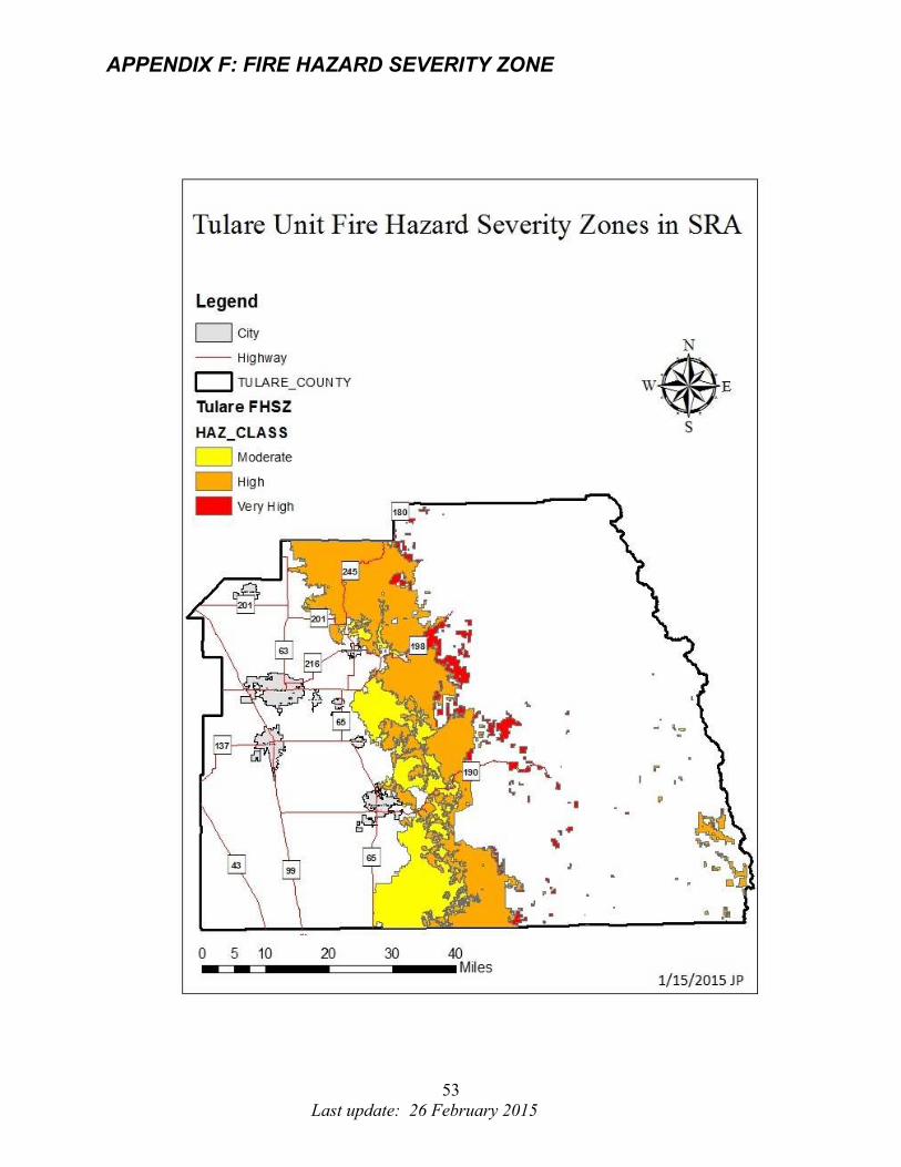
53
Last update: 26 February 2015
APPENDIX F: FIRE HAZARD SEVERITY ZONE
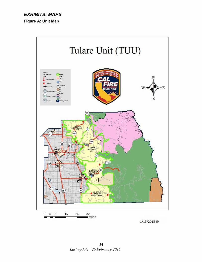
54
Last update: 26 February 2015
EXHIBITS: MAPS
Figure A: Unit Map
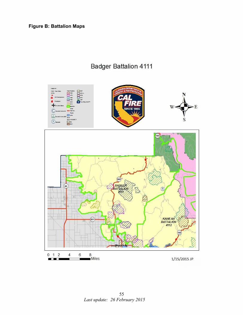
55
Last update: 26 February 2015
Figure B: Battalion Maps
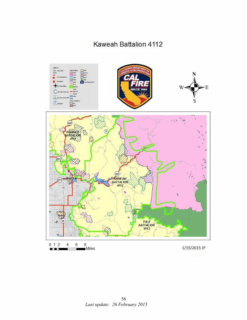
56
Last update: 26 February 2015
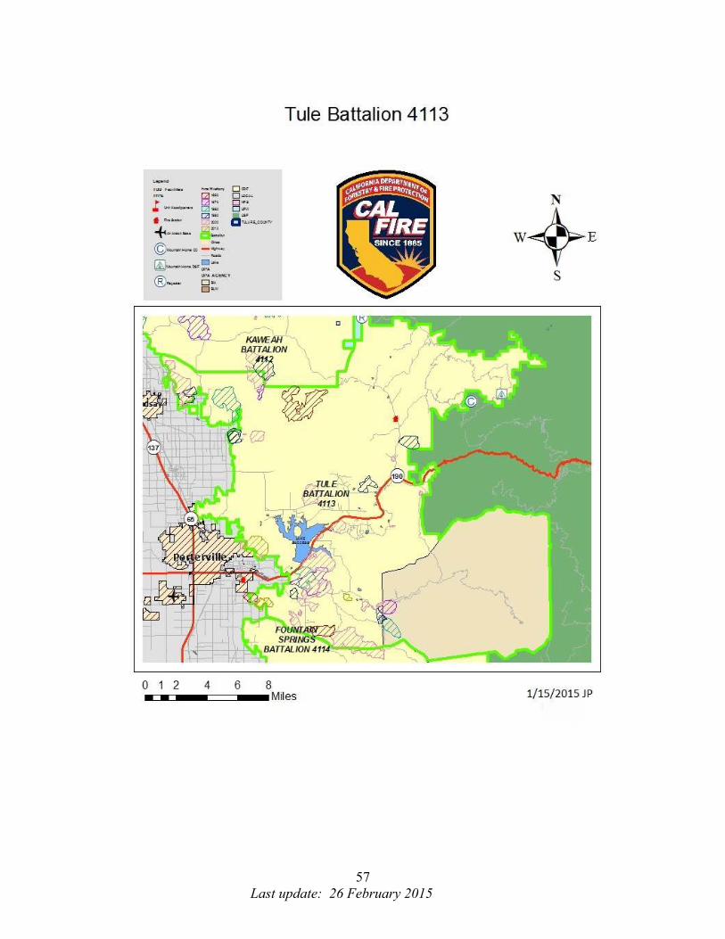
57
Last update: 26 February 2015

58
Last update: 26 February 2015

59
Last update: 26 February 2015