twenty-fourth - unifr.ch science de la... · twenty-fourth meeting of swiss sedimentologists –...
TRANSCRIPT

Twenty-fourth Meeting of Swiss Sedimentologists
Saturday, 27 February 2016
Fribourg
Abstracts

Twenty-fourth Meeting of Swiss Sedimentologists – Fribourg, February 27, 2016 _______________________________________________________________________________________
PROGRAMME
09.15-09.55 Registration, morning coffee and croissant 09:55 Opening 10:00–10:20 Blouet, J-P., Imbert, P. and Foubert, A.: Tracking the biogenic source rock and
plumbing system of a seep carbonate during the early Cretaceous of the Vocontian Basin (SE France)
10:20–10:40 Fabbri, S.C., Herwegh, M., Schlunegger, F., Hilbe, M., Hübscher, C., Weiss,
B.J., Schmelzbach, C., Horstmeyer, H., Buechi, M.W. and Anselmetti, F.S.: Paleoseismology and deglaciation history based on fluviatile and glacio-lacustrine sediments
10:40–11:40 Coffee and posters 11:40–12:00 Homewood, P. and Mettraux, M.: Microbial vs chemical origins of South
Atlantic Pre-salt non-marine carbonates: a sterile debate
12:00–12:20 Camille, L. and Schlunegger, F.: Controls on pebbles size and shape in streams
of the Swiss Alps 12:20–14:00 Lunch 14:00–14:50 Keynote: Schlunegger, F.: Slab rollback orogeny in the Alps inferred from the
stratigraphic evolution of the Swiss Molasse Basin 14:50–15:10 Bellwald, B., Hjelstuen, B.O., Sejrup, H.P. and Haflidason, H.: Postglacial
Mass Movements and Depositional Environments in a High-Latitude Fjord System – Hardangerfjorden, Western Norway
15:10–15:30 Stutenbecker, L. and Schlunegger, F.: Human impact onto the sediment budget
of the upper Rhône River, Central Swiss Alps 15:30–16:30 Tea and posters 16:30–16:50 Slootman, de Boer, P., Castelltort, S., and Simpson, G.: Supercritical tsunami
return flow reshaping the shoreface environment: Insights from the sedimentary record and numerical modelling
16:50–17:10 Ragusa, J. and Kindler, P.: Relation between grain size and modal composition
in deep-sea gravity-flow deposits. Example from the Voirons Flysch (Gurnigel nappe, Chablais Prealps, France)
17:10 Closure and apéro
Twenty-fourth Meeting of Swiss Sedimentologists – Fribourg, February 27, 2016 _______________________________________________________________________________________
2
Posters Barrenechea Angeles, I., Ariztegui, D. and Pawlowsky, J.: Reconstructing North Atlantic circulation combining foraminifera assemblages, eDNA and aDNA Blouet, J.P., Machel, H.G., Samankassou, E. and Imbert, P.: Origin and age of a peculiar breccia at Ragged Point, Barbados, with implications for tectonic uplift De Boever, E. and Foubert, A.: A combined field and experimental lab set-up to address CaCO3 precipitation and lamination at continental hot springs
Eymard, I., Del Pilar Alvarez, M., Bilmes, A., Dobra, M.G., Suarez, F., Vasconcelos, C. and Ariztegui, D.: Living Stromatolites from Northeastern Patagonia (Argentina): In situ and experimental geomicrobiological investigation
Fantasia, A., Föllmi, K.B., Adatte, T., Scasso, R.A. and Spangenberg, J.E.: The Cañadón Asfalto Formation (Chubut Province, Argentina): coeval with the Toarcian Oceanic Anoxic Event?
Feenstra, E., Heindel, K., Birgel, D., Stalder, C., Krause, S., Mäder, U. and Foubert, A.: In-vitro simulation of AOM mediated diagenesis in cold-water coral mound carbonates in a sediment-flow-through system
Haas, M., Baumann, F., Reusch, A., Strasser, M., Eglinton, T.I. and Dubois, N.: Impact and historical evolution of human land-use in the catchment of Lake Murten Jaramillo-Vogel, D., Foubert, A., Schaegis, J-C., Grobety, B., Atnafu, B.and Kidane, T.: Pleistocene fibrous aragonite crusts and spherulites in the Danakil Depression (Afar, Ethiopia) Kindler, P., Godefroid, F. and Vimpere, L.: Elevated coralgal bioherms from Long Island (Bahamas): a testimony of recent tectonic uplift or of a high sea level during the Middle Pleistocene Lauper, B., Jaeggi, D. and Foubert, A.: Detailed facies analysis of the Opalinus Clay (Mont Terri underground rock laboratory, Switzerland) Marchegiano, M., Gliozzi, E., Ceschin, S., Mazzini, I., Adatte, A., Mazza, R. and Ariztegui, D.: Ecology and distribution of living ostracod assemblages of Lake Trasimeno (Umbria, central Italy) Morlock, M., Vogel, H., Nigg, V., Ordoñez, L., Arizteguí, D., Hasberg, A., Melles, M., Russell, J.M., Bijaksana, S. & the TDP science team.: Source to sink element geochemistry and clay mineralogy in Lake Towuti, Indonesia: understanding climate-induced controls on sediment composition during the past 60 kyr BP Nigg, V., Vogel, H., Morlock, M., Anselmetti, F., Russell, J.M. and Bijaksana, S.: Grain-size effects on elemental geochemistry and mineralogy in sediment records from Lake Towuti, Indonesia Ordoñez, L., Chiaradia, M., Arizteguí, D., Morlock, M., Vogel, H., Melles, M., Russell, J.M., Bijaksana, S.
and the TDP scientific team: Geochemical cycles in Lake Towuti (Indonesia): Disentangling the dominant factors ruling Fe isotopes fractionation Rabold, M., Dubois, N., Raman, L. and Wüest, A.: Investigation of the particle dynamics in lake Biel on the basis of sedimentation rate, calcium carbonate and radioactivity Rüggeberg, A., Flögel, S., Dullo, W.-Chr., Raddatz, J. and Liebetrau, V.: Pleistocene seawater density reconstruction in the northeast Atlantic – implications for intermediate water mass circulation and carbonate mound development Schaegis, J-C., Foubert, A., Jaramillo-Vogel, D., Filfilu, E., Perrochet, L., Atnafu, B. and Kidane, T.: Characterization of a hypersaline lake in an active rift setting: Lake Afdera in the Danakil basin (NE Afar, Ethiopia)

Twenty-fourth Meeting of Swiss Sedimentologists – Fribourg, February 27, 2016 _______________________________________________________________________________________
3
Schmid, D., Ariztegui, D., Brenner, M., Correa-Metrio, A., Curtis, J., Hodell, D.A., Kutterolf, S., Schwalb, A., Peréz, L., Anselmetti, F.S. and Cruz. E.S.: The 'old' lacustrine sedimentary succession of Lake Petén Itzá, Guatemala: Paleoenvironmental changes at the scale of multiple glacial-interglacial cycles Schwestermann, T., Brückner, N., Fäh, D., Gilli, a., Wessels, M., Wintersteller, P. and Anselmetti, F.S.: Mass-movement event stratigraphy in Lake Constance: Evidences for paleoseismicity?
Vimpere, L., Godefroid, F. and Kindler, P.: Pleistocene shallowing-upward sequences in Dean’s Blue Hole, Long Island (Bahamas): evidence of differential subsidence or faulting along the SE margin of Great Bahama Bank Weinkauf, M.F.G., Bonitz, F. and Kučera, M.: Stabilization and disruption as indicators of terminal stress in planktonic Foraminifera: An example from the Pleistocene Red Sea

Twenty-fourth Meeting of Swiss Sedimentologists – Fribourg, February 27, 2016 _______________________________________________________________________________________
4
ESPP SwissSed Meeting 2016 - List of participants Adams, Arthur Bern Adatte, Thierry Lausanne Anselmetti, Flavio Bern Ariztegui, Daniel Geneva Barrenechea, Ines Geneva Bellwald, Benjamin Bergen Blasi, Hansruedi Bern Blouet, Jean-Philippe Fribourg Camille, Litty Bern De Boever, Eva Fribourg Dubois, Nathalie EAWAG Eichenberger, Urs ISSKA Eymard, Inès Geneva Fabbri, Stefano Bern Fantasia, Alicia Lausanne Feenstra, Eline Fribourg Fentimen, Robin Fribourg Foubert, Anneleen Fribourg Gaudenz, Deplazes Nagra Grassi, Renata Fribourg Haas, Mischa EAWAG Hischier, Chantal EAWAG Homewood, Peter Geosolutions Immenhauser, Adrian Bochum Jaramillo-Vogel, David Fribourg Kindler, Pascal Geneva Lauper, Bruno Fribourg Lowick, Sally Bern Marchegiano, Marta Geneva Martini, Rossana Geneva Matter, Albert Bern
Mettraux, Monique Geosolutions Morlock, Marina Bern Mosar, Jon Fribourg Nigg, Valentin Bern Ordonez, Luis Geneva Ragusa, Jérémy Geneva Ramseyer, Karl Bern Rüggeberg, Andres Fribourg Samankassou, Elias Geneva Schaegis, Jean-Charles Fribourg Schlunegger, Fritz Bern Schmid, Dominik Bern Schwestermann, Tobias ETHZ Slootman, Arnoud Geneva Spezzaferri, Silvia Fribourg Strasser, Andre Fribourg Stutenbecker, Laura Bern Vimpere, Lucas Geneva Vogel, Hendrik Bern Weinkauf, Manuel Geneva Wetzel, Andreas Basel Wirth, Stefanie Geneva

Twenty-fourth Meeting of Swiss Sedimentologists – Fribourg, February 27, 2016 _______________________________________________________________________________________
5
Reconstructing North Atlantic circulation combining foraminifera assemblages, eDNA and aDNA
Barrenechea Angeles, I.*(1), Ariztegui, D. (2), and Pawlowsky, J. (3)
(1) University of Geneva, Department of Earth Sciences, Rue du Maraîchers 13, CH‐1205 Geneva, Switzerland (2) University of Geneva, Department of Genetics and Evolution, Boulevard d’Ivoy 4, CH‐1205 Geneva, Switzerland
The aim of this study is to reconstruct water masses changes and stratification of the Labrador Sea Water (LSW) since the last interglacial [Figure 1] with the help of foraminifera (fossils and ancient DNA). The combining of biological and micropaleontological methods allow better paleoenvironments and paleoclimatic reconstructions [1]. Thus, we take into account fossilized and non fossilized foraminifera. Our research is based upon marine sedimentary cores retrieved around Newfoundland island by MSM 39 cruise expedition in June 2014 [2]. Recent measurements in the North Atlantic water column indicates a salinity drop similar to the one that followed the drainage of glacial lake Agassiz and Ojibway (8.2 ky).
Figure 1. Location map of samples with main currents influencing the sedimentology and fauna (red and blue arrows). The right image shows the emplacement and approximate water depth of each core. References [1] https://www.marum.de/en/MARIA_S._MERIAN_Expedition_MSM‐39.html [2] Pawlowska, J., Lejzerowicz, F., Esling, P., Szczucinski, W., Zajaczkowki, M., Pawlowski, J. (2014) Ancient DNA
sheds new light on the Svalbard foraminiferal fossil record of the last millennium. Geobiology 12: 277‐288
[3] De Vernal, A., Hillaire‐Marcel C. (2000). Sea‐ice cover, sea surface salinity and halo‐/thermocline structure of the northwest North Atlantic: modern versus full glacial conditions. Quaternary Sciences Reviews 19: 65‐85

Twenty-fourth Meeting of Swiss Sedimentologists – Fribourg, February 27, 2016 _______________________________________________________________________________________
6
[4] Roger, J., Saint‐Ange, F., Lajeunesse, P., Duchesne, M. J., St‐Onge, G. (2013) Late Quaternary glacial history and meltwater discharges along the Northeastern Newfoundland Shelf. Canadian Journal of Earth Sciences, 50(12): 1178‐1194
[5] Kucera, M., 2007. Planktonic foraminifera as tracers of past oceanic environments. In: Hillaire‐Marcel, C. and de Vernal, A.: Developments in Marine Geology, Volume 1, Proxies in late Cenozoic Paleoceanography. Elsevier, pp. 213‐262.
[6] Weber, M. E., Mayer, L. A., Hillaire‐Marcel, C., Bilodeau, G., Rack, F., Hiscott, R. N., Asku, E. (2001) Derivation of ∂18O from sediment core log data: Implica ons for millennial‐scale climate change in Labrador Sea. Paleoceanography 16 (5): 503‐514
[7] Sheldon, C.M., Seidenkrantz M‐S., Pearce, C., Kuijpers, A., Hansen, M. J., Zilmer Christensen, E. (2016) Holocene oceanographic changes in SW Labrador Sea, off Newfoundland. The Holocene 26 (2): 274‐289

Twenty-fourth Meeting of Swiss Sedimentologists – Fribourg, February 27, 2016 _______________________________________________________________________________________
7
Postglacial Mass Movements and Depositional Environments in a High‐Latitude Fjord System – Hardangerfjorden, Western Norway
Bellwald, B.*(1), Hjelstuen, B.O.(1), Sejrup, H.P.(1), and Haflidason, H.(1)
(1) University of Bergen, Department of Earth Science, Allégaten 41, NO‐5007 Bergen, Norway
* [email protected] We used a 15.7 m long sediment core and high resolution seismic data from the Hardangerfjorden system, western Norway, to increase our knowledge on depositional environments, mass movement triggering mechanisms and mass movement frequencies in high latitude fjord systems. The seismic profiles analysed show that an up to 160 m thick glacimarine‐dominated unit, of probably Younger Dryas age, has been deposited above the acoustic basement. A <55 m thick unit comprising stacked mass transport deposits (MTD) has been deposited atop the glacimarine unit. The 19 identified mass failure events comprise sediment volumes of up to 0.4 km3 and initiated turbidity currents resulting in the deposition of up to 13 m thick turbidite layers. The established chronostratigraphical framework of Hardangerfjorden reveals high mass movement activity at 11300‐8200 cal. yrs BP (Early Holocene) and at 4100 cal. yrs BP to present (Late Holocene). 14 MTDs have been dated to the Early Holocene, which is characterized by high sedimentation rates, giving a mass failure recurrence rate of 1/200 yrs. Several of these failure events are suggested to have been triggered by regional mechanisms such as earthquakes linked to glacioisostatic uplift. Some other MTDs of that time could potentially be caused by rockfalls. Furthermore, it seems that an MTD dated to 8200 cal. yrs BP coincides with the age of the Storegga tsunami, suggesting that processes related to this event may have caused sediment failure in Hardangerfjorden. During the mid‐Holocene, a time period characterized by low sedimentation rates and a warmer and wetter climate, subaquatic mass movements were absent in the study area. The renewed slide activity in the Late Holocene, comprising four MTDs, is probably related to climatic processes, earthquakes and rockfalls, resulting in a mass movement recurrence rate of 1/1000 yrs for this time period. This study, thus, underlines the importance of high‐latitude fjords as systems where local, regional and external geological forces interact to impose highly dynamic post‐glacial depositional environments.
References Bellwald, B., Hjelstuen, B.O., Sejrup, H.P.., Haflidason, H. (2016) Postglacial Mass Failures in the Inner
Hardangerfjorden System, Western Norway. In: Lamarche, G. et al., (eds) Submarine Mass Movements and Their Consequences, Advances in Natural and Technological Hazards Research 41: 73‐82.
Bøe, R., Longva, O., Lepland, A., Blikra, L.H., Sønstegaard, E., Haflidason, H., Bryn, P., Lien, R. (2004) Postglacial mass movements and their causes in fjords and lakes in western Norway. Norwegian Journal of Geology 84: 35‐55.
St‐Onge, G., Chapron, E., Muslow, S., Salas, M., Viel, M., Debret, M., Foucher, A., Mulder, T., Winiarski, T., Desmet, M., Costa, P.J.M., Ghaleb, B., Jaouen, A., Locat, J. (2012) Comparison of earthquake‐triggered turbidites from the Saguenay (Eastern Canada) and Reloncavi (Chilean margin) Fjords: Implications for paleoseismicity and sedimentology. Sedimentary Geology 243‐244: 89‐107
Acknowledgements The research leading to these results has received funding from the People Programme (Marie Curie Actions) of the European Union’s Seventh Framework Programme FP7/2007‐2013/ under REA grant agreement n° 317217. The research forms part of the GLANAM (GLAciated North Atlantic Margins) Initial Training Network.

Twenty-fourth Meeting of Swiss Sedimentologists – Fribourg, February 27, 2016 _______________________________________________________________________________________
8
Tracking the biogenic source rock and plumbing system of a seep carbonate during the early Cretaceous of the Vocontian Basin (SE France)
Blouet, J.P.*(1), Imbert, P.(2), and Foubert, A.(1)
(1) University of Fribourg, Department of Geosciences, Chemin du Musée 6, CH‐1700 Fribourg, Switzerland (2) Total CSTJF, Avenue Larribau, 64000 Pau, France *jean‐[email protected]
Hydrocarbon seepage is a phenomenon that frequently occurs in hydrocarbon
provinces. The precipitation of methane derived authigenic carbonates (MDAC) associated with the seepage of methane‐rich fluids is the result of anaerobic oxidation of methane coupled with sulfate reduction. In the fossil record, MDAC are the most obvious evidence of methane dysmigration, and they can be used as a tool to constrain the timing and fluxes of hydrocarbon seepage during basin evolution.
This study focuses on seep carbonates from the Aptian/Albian Marnes Bleues
Formation, well exposed along the eastern edge of the Vocontian Basin (SE France). The Vocontian Basin evolved as a deep‐water embayment that opened onto the NW margin of the Alpine Tethys during the Cretaceous. The distribution of MDAC has been evaluated at regional scale, and they have been mapped in detail over one particular outcrop (150 m vertical and 200 m lateral extension).
Mapping and sampling of the MDAC resulted in the distinction of two main morphologies: 1) sub‐spherical nodules and 2) complex ramified tubes characterized by a central conduit. The carbonate concretions are either concentrated along surfaces cross‐cutting the stratigraphy or clustered in vertically stacked groups up to 30 m thick. Stable isotope analyses evidence δ13C signatures as low as ‐ 41‰ PDB, which points towards the methane as the carbon source of the carbonates.
The carbonate concretions aligned along specific surfaces may indicate a widespread and
relatively short methane burst. Conversely, the subsequent vertically stacked succession of MDAC clusters could be the result of focused migration, probably fed during a substantial amount of time through a fault plane. Turbidite channels located a few hundreds of meters below the seep carbonates suggest they role as leaking gas reservoir while 2D modeling of the basin evidences that channels could have been fed by biogenic gas from the distal part of the turbidite system localized in the central part of the basin where organic‐rich intervals are present in the Marne Bleues Formation. Modern examples of gas seepage from faults cross cutting turbidite channels are common
along passive margin settings (Ho et al., 2012). Reference Ho, S., Cartwright, J. A., Imbert, P. (2012). Vertical evolution of fluid venting structures in relation to gas flux, in the Neogene‐Quaternary of the Lower Congo Basin, Offshore Angola. Marine Geology, 332, 40‐55.

Twenty-fourth Meeting of Swiss Sedimentologists – Fribourg, February 27, 2016 _______________________________________________________________________________________
9
Origin and age of a peculiar breccia at Ragged Point, Barbados, with implications for tectonic uplift
Blouet, J.P. *(1), Machel, H.G. (2), Samankassou, E. (3), and Imbert, P. (4)
(1) University of Fribourg, Department of Geosciences, Chemin du Musée 6, CH‐1700 Fribourg, Switzerland (2)University of Alberta, Department of Earth and Atmospheric Sciences, Edmonton, Alberta, Canada (3)Université de Genève, Département des Sciences de la Terre, Rue des Maraîchers 13, 1211 Genève, Switzerland (4) Total CSTJF, Avenue Larribau, 64000 Pau, France
A peculiar well‐cemented breccia is exposed about 10 m above present‐day sea level at
Ragged Point, Barbados. Clasts range in size from millimeters to several meters in diameter. The breccia is polymict and contains Tertiary sandstones as well as various marine mollusks that currently live in the shallow seas around the island. Many mollusc shells are fully colored and appear as 'fresh' as their modern living counterparts, suggesting that the breccia is sub‐recent in age.
How did this breccia form: is it a transgressive lag deposit, an accumulation of debris at the bottom of the coastline cliff, or an abnormal type of beach rock? How did it get lithified? Could we date it and use it to determine the rate of uplift of this area of the island?
Three specimens of Cittarium pica and one of Fissurella cf. barbadensis, typical gastropod species dwelling in shallow marine, well oxygenated and agitated waters today, were analyzed from the breccia for their δ13C and δ18O values, by XRD, and dated using 14C. The same analyses were performed on one shell of each species found at the base of the cliff at Ragged Point on the modern beach. Additionally, three thin sections of this breccia were analyzed petrographically, and measurements of δ13C, δ18O and XRD were performed of matrix/cement that was mechanically extracted with a needle.
Shells of the modern Cittarium pica and Fissurella cf. barbadensis are composed of about 75 % aragonite and 25 % calcite whereas the proportion of calcite is about 10 % in the fossil specimens, as determined by XRD. Disparities in calcite content between modern and fossils samples are also recorded in the stable isotopes composition: the average δ13C value of the modern shells is 0.7‰ while it is 3.4‰ in the fossil counterparts. The average δ18O value of the modern gastropods is ‐1.3‰ compared to +0.2‰ of the fossil specimens in the breccia.
14C dating of the fossil gastropod samples provided an age of 29.500 ±500 BP while the modern samples yielded an age of younger than 1950 a.D. The stable isotope values of the matrix/cement are 0 ‰ for both δ13C and δ18O.
The 14C data of the fossil gastropods corresponds to the Wisconsin glaciation (Würm of the Alpine region). In concordance with this dating, the δ18O enrichment of the fossil samples can be explained by a slight enrichment in 18O of the seawater at that glacial period. Taking into account the paleosea level 29.5±0.5 ky ago at ‐94 ±4 m and the present‐day elevation of the deposit at +10 m, the calculated uplift rate would be 3.5 ±2 m/ky. This would be in the upper range of the uplift rate of the island provided by Taylor and Mann (1991).
Questions to be investigated further include: (1) do the oxygen isotope differences between the modern and fossil gastropods, and between the gastropods and the matrix/cement, reflect differences between the glacial and post‐glacial periods, or are they

Twenty-fourth Meeting of Swiss Sedimentologists – Fribourg, February 27, 2016 _______________________________________________________________________________________
10
diagenetic; (2) what explains the differences in the carbon isotope ratios of these components; and (3) does the 14C analysis provide a reliable age of cementation or of a diagenetic overprint of the breccia deposit?
Reference
Taylor, F. W., & Mann, P. (1991). Late Quaternary folding of coral reef terraces, Barbados. Geology, 19(2), 103‐106.

Twenty-fourth Meeting of Swiss Sedimentologists – Fribourg, February 27, 2016 _______________________________________________________________________________________
11
Controls on pebbles size and shape in streams of the Swiss Alps
Litty, C.*(1) and Schlunegger, F. (1)
(1) Institute of Geological Sciences, University of Bern, Baltzerstrasse 1+3, CH‐ 3012 Bern
Rivers in the Swiss Alps have been analysed to determine the relationships between fluvial processes and grain size and shape to emphasize the factors controlling the grain characteristics. 18 bars of gravel‐bed rivers have been sampled. At each site the long axis and the intermediate axis of about 500 pebbles have been measured. In addition the morphometric properties of each river basin have been studied. Looking for correlation between grain size and shape and other fluvial properties the study shows that grain size and shape are mainly controlled by the lithology on which the rivers are mainly flowing but not controlled by erosion rate, hydrology or basins metric properties. Deposits of rivers flowing on sedimentary lithology are better sorted and the pebbles are more rounds and have smoother surface than the deposits of rivers flowing on metamorphic lithology. This lack of correlation between grain size and shape and the other studied factors are mainly explained by the fact that the rivers are supply limited. Remarkably for all these different pebbles size and river/basin properties, the ratio of the intermediate axis and the long axis only ranges between 0.63 and 0.72 without any relationships with the lithology. This ratio named the elongation E is not impacted by any of the analysed river processes in the studied rivers.

Twenty-fourth Meeting of Swiss Sedimentologists – Fribourg, February 27, 2016 _______________________________________________________________________________________
12
A combined field and experimental lab set‐up to address CaCO3 precipitation and lamination at continental hot springs
De Boever, E.*(1) and Foubert, A.(1)
(1) University of Fribourg, Department of Geosciences, Chemin du Musée 6, CH‐1700 Fribourg, Switzerland * [email protected]
Continental carbonate (hot) springs often form mound‐shaped deposits of tens to hundreds of meters across. These deposits can be sensitive records of continental environmental changes due to their fast CaCO3 precipitation rates and different scales of banding (‘layering’). Though important observations have emerged from high‐resolution petrographical and geochemical studies, descriptive approaches may overlook mechanisms, processes and quantification of controlling parameters on precipitation. This understanding is vital in order to prevent erroneous environmental interpretations of the preserved CaCO3 fabrics and geochemical signatures. Previous work at two world‐class spring carbonate systems, i.e. the Pleistocene deposits of the Denizli Basin (Turkey) and the active Mammoth Hot Springs (Yellowstone National Park, USA), showed the importance of multiple (micron to meter) scale layering in dendritic crusts of different facies along an up‐to downstream spring outflow path. The main theme in explaining layering has often been to distinguish between the dominance of ‘biotic’ versus ‘abiotic’ processes and their interplay with changes in palaeo‐environmental conditions (flow rate, temperature, water chemistry, organic matter input). The dominant processes may differ for different spring facies, are scale‐dependent and dynamic in time. This study presents a multi‐scaled lab experimental approach that envisages to:
‐ Quantify physico‐chemical and microbial parameters representative for carbonate precipitation in natural spring environments.
‐ Determine the environmental conditions (temperature, flow, chemistry) related to the formation of specific fabrics and their layering.
‐ Use these data to model carbonate precipitation within (hot) spring carbonate systems, with a focus on determining representative rates and masses. This will involve parametrizing rate laws under static and flow conditions that could account for the role of biotic processes on precipitation.
The study involves a detailed documentation of fabrics and chemical‐physical and biological conditions at two modern continental carbonate hot spring systems and their older equivalent deposits. The multi‐scale, experimental approach focuses on batch and flow‐through experiments to study induced precipitation under variable flow, light and chemical conditions with different substrates. Parallel experiments will address very early diagenetic changes of microfabrics that have been observed to enhance or obliterate primary lamination and crystal textures.

Twenty-fourth Meeting of Swiss Sedimentologists – Fribourg, February 27, 2016 _______________________________________________________________________________________
13
Living Stromatolites from Northeastern Patagonia (Argentina): In situ and experimental geomicrobiological investigations
Eymard, I.*1, del Pilar, M.2, Alvarez, B.2, M., Dobra, G.3, Suarez, F.3, Vasconcelos, C.4, and Arizteguí, D.1
1University of Geneva, Department of Earth Sciences, Geneva, Switzerland 2 CENPAT‐CONICET, Puerto Madryn, Chubut, Argentina 3Universidad Nacional de La Plata, La Plata, Buenos Aires, Argentina 4ETH Zürich, Geologisches Institut, Zürich, Switzerland *[email protected]
Fossil and living stromatolites have been identified in the lacustrine environment of the Maquinchao basin in northeastern Patagonia (Argentina) providing an ideal opportunity to fulfill the lack of microbialite studies in the region. Furthermore, it allows monitoring the environmental factors controlling microbialite formation and to use them as proxy for paleoenvironmental conditions. Stromatolites are laminated benthic microbial deposits. They result from the interaction between environmental and microbial factors. One of the main processes leading to the lamination that often characterized these buildups is the trapping and binding of sediment grains along with mineral precipitation. Most of the modern living stromatolites have been described in shallow marine and saline lacustrine setups whereas studies in freshwater environments are scarce. Moreover, in southernmost South America there is a clear paucity of information concerning the development of microbialites. Presently, the Maquinchao basin contains two separate lakes, Cari Laufquen Grande and Cari Laufquen Chica, but there is evidence that this close lacustrine system has had major water level fluctuations during recent times. Today, both lakes are linked through the Maquinchao River and are located at more than 700m above sea level. Fossil stromatolites outcrop along paleoshorelines showing different shapes while living stromatolites are only found in the Maquinchao River. Two field campaign have been lead respectively in Austral summer 2011 and Austral spring 2015. Living stromatolites recovered from the first campaign were set in an aquarium in the laboratory under similar temperature and light conditions as in the natural environment. A substantial growth of the biofilm has been observed in the lab as well as the development of a smooth greenish/transparent layer covering the biofilms previously developed around the rock nucleus. Preliminary observation under SEM shows the presence of a matrix of extracellular polymeric substances (EPS) of diverse thickness. Filamentous bacteria and streptobacilli morphotype are observed in the thickest EPS whereas the areas covered with thinner EPS contain more cococoides bacteria, diatoms, low‐Mg calcite crystals and partially dissolved ostracode shells. The last field campaign (November/December 2015) allowed collecting new physicochemical data as well as sampling both living and fossil stromatolites. Ongoing investigations in the living stromatolites include the identification of microbial communities through DNA sequencing as well as SEM observations. They aim to understand the role of microbes in carbonate precipitation (organomineralisation) using different microscopic, geochemical and microbiological tools that will be compared with detailed petrographic observations and geochemical analyses of the fossils counterparts.

Twenty-fourth Meeting of Swiss Sedimentologists – Fribourg, February 27, 2016 _______________________________________________________________________________________
14
Paleoseismology and deglaciation history based on fluviatile and glacio‐lacustrine sediments
Fabbri, S.C.*(1), Herwegh, M.(1), Schlunegger, F.(1), Hilbe, M.(1), Hübscher, C.(2), Weiss, B.J.(2), Schmelzbach, C.(3), Horstmeyer, H.(3), Buechi, M.W.(4), and Anselmetti, F.S.(4)
(1) Institute of Geological Sciences, University of Bern, Baltzerstr. 1+3, CH‐3012 Bern
(2) Institute of Geophysics, University of Hamburg, Bundesstr. 55, D‐20146 Hamburg
(3) Institute of Geophysics, Dept. of Earth Sciences, ETH Zürich, CH‐8092 Zürich
(4) Institute of Geological Sciences and Oeschger Centre for Climate Change Research, University of
Bern, Baltzerstr. 1+3, CH‐3012 Bern
Perialpine fluviatile and glacio‐lacustrine sediments of late Pleistocene or Holocene age can act as i) paleoseismological archives for ongoing neotectonic activity, and ii) recorders of alpine deglaciation history. Both of these aspects are investigated in the larger Lake Thun area (Bernese Alps). i) Paleoseismology: Switzerland has experienced strong earthquakes with intensities I0 ≥ VI in historic and prehistoric times. This is documented in the earthquake catalogue of Switzerland (ECOS‐09) and by several paleoseismic studies investigating off‐fault evidence, such as earthquake‐triggered subaquatic mass movements, seismoturbidites and small‐scale deformation structures. Although such strong earthquakes are expected to produce significant surface ruptures due to the size and displacement of the rupture surface, to date, such surface displacements were scarcely found as obvious imprinted geomorphologic features. We identified a potentially active fault structure by amphibious geomorphologic data (high‐resolution digital elevation/bathymetric models) and in the sedimentary succession outcropping in a gravel quarry close to Lake Thun. In this quarry, rotated pebbles delineate a fault trace that is further marked by clearly offset horizons. Since the fluviatile gravel deposits have never been glacially overprinted and 14C ages indicate a Holocene age, estimates of apparent deformation can be made. ii) Deglaciation history: The knowledge of the exact timing and behaviour of retreating alpine glaciers is currently rather limited. The recessional phase in the Alpine foreland throughout the deglaciation of the inner‐Alpine ice cap seems to have occurred very quickly though as indicated by wide‐spaced ice‐marginal landforms, such as terminal moraines associated with glacial stabilization or slight re‐advance. A recently conducted multi‐channel reflection seismic survey on Lake Thun revealed the entire sedimentary succession of the overdeepened basin. The stratigraphic sequences contain glacial, glacio‐lacustrine and lacustrine deposits. Moreover, we identified a morphologically distinct subaquatic terminal moraine close to Interlaken, which smoothly transforms basinward into clearly distinguishable fore‐ and bottomsets (see figure 1). These bottomsets represent roughly 30% of the overall sediment volume that fills the basin. The Grimsel area, the accumulation area of the Aare glacier, showed ice‐free conditions around 14‐11.3 ka BP (Wirsig et al, 2016). Late‐glacial Lake Amsoldingen, adjacent to the water outlet of Lake Thun, was radiocarbon‐dated and shows an onset of ice‐free sedimentation at ~16.3 ka BP age (Lotter, 1985). Hence, this Lake Thun sequence was deposited within just a few hundreds of years and has

Twenty-fourth Meeting of Swiss Sedimentologists – Fribourg, February 27, 2016 _______________________________________________________________________________________
15
to fit temporally between these age constraints. We conclude that the subaquatic terminal moraine was deposited during a stagnant or slightly advancing grounded Aare glacier during its overall recessional phase. This gives new insights related to the behavior of the Aare glacier and its high sedimentation rates within this period. References Lotter, A. F., (1985) Amsoldingersee‐Late glacial and Holocene environments of a lake at the southern edge of
the Swiss plateau. Dissertation Botanicae, 87, p. 185‐208. Wirsig, C., Zasadni, J., Ivy‐Ochs, S., Christl, M., Kober, F., Schlüchter, C., (2016) A deglaciation model of the
Oberhasli, Switzerland. Journal of Quaternary Science, 31 (1), p. 46‐59.
Figure 1: Seismic cross section from Interlaken to Krattigen (Lake Thun) revealing strong amplitudes in the East, which are interpreted as terminal moraine. The bottom sets (between green and light blue horizons) take roughly ~30% of the entire sediment volume. Orange line shows interpreted bedrock topography.
W E

Twenty-fourth Meeting of Swiss Sedimentologists – Fribourg, February 27, 2016 _______________________________________________________________________________________
16
The Cañadón Asfalto Formation (Chubut Province, Argentina): coeval with the Toarcian Oceanic Anoxic Event?
Fantasia, A.1, Föllmi, K. B.1, Adatte, T.1, Scasso, R. A.2, and Spangenberg, J. E.3
1 Institute of Earth Sciences, University of Lausanne, 1015 Lausanne, Switzerland 2 IGEBA‐Departamento de Ciencias Geológicas, Universidad de Buenos Aires, Argentina 3 Institute of Earth Surface Dynamics, University of Lausanne, 1015 Lausanne, Switzerland
The Early Toarcian was marked by important environmental changes, marine oxygen deficiency and extensive organic‐rich sediment deposition (T‐OAE; ∼182 Ma, Early Jurassic). The T‐OAE coincides with a marked negative carbon isotope excursion (CIE) recorded in marine carbonate, and marine and terrestrial organic carbon. This is commonly attributed to the massive release of isotopically light carbon to the atmospheric and oceanic reservoirs derived from the destabilization of methane hydrates from marine sediments and/or the emissions of thermogenic methane from the eruption of the Karoo‐Ferrar large igneous province (LIP). Several studies of the T‐OAE have been conducted on marine sediments around the world but no continental archive was studied so far. In this study, we focus on the Cañadón Asfalto Basin situated in central Patagonia (Chubut Province), which comprises thick series of Lower Jurassic sediments interbedded with basaltic flows and accumulated in several depocenters related to the rift development of the basin. These sediments represent terrestrial environments (fluvial to lacustrine), and were deposited in the proximity of the Karoo‐Ferrar large igneous province. A high‐resolution multidisciplinary approach has been chosen and the tools to be used are based on sedimentological observations, mineralogy, phosphorus, carbon isotopes and organic‐matter content. We sampled three sections located at different stratigraphic levels within the sedimentary succession intercalated in the basaltic flows: the Alice Creek section, the Quebrada Barreño section and the Quebrada Subsidaria section. These sections are characterized by silicified carbonate, organic‐rich sediments, mudstone, sandstone, conglomerates and tuffaceous material. Absolute U‐Pb zircon ages of a selection of volcanogenic deposits within these sediments place the Cañadón Asfalto in the early Toarcian (Cúneo et al., 2013). First results of the total organic carbon (TOC) content show values up to 7 wt.% and the HI‐OI crossplots show typical values for terrestrial and lacustrine organic matter. A strong correlation between the preservation, the organic matter type and the carbon‐isotope record is observed. First values of the isotopic composition of carbonates (δ13C and δ18O) seems to indicate a hydrothermal origin of part of them. The clay assemblages show the predominance of smectites resulting from basalt alteration under semi‐arid climate with dry and humid seasons (seasonal precipitations). This study will allow us to characterize the dynamics of the lake (expansion/contraction cycles) and determine if the accumulation of these lacustrine organic‐rich sediments is coeval with the T‐OAE.

Twenty-fourth Meeting of Swiss Sedimentologists – Fribourg, February 27, 2016 _______________________________________________________________________________________
17
In‐vitro simulation of AOM mediated diagenesis in cold‐water coral mound carbonates in a sediment‐flow‐through system
Feenstra, E.*1, Heindel, K.2, Birgel, D.3, Stalder, C.1, Krause, S.4, Mäder, U.5, and Foubert, A.1
1 University of Fribourg, Switzerland 2 Department for Geodynamics and Sedimentology, University of Vienna, Austria 3 Institute of Geology, University of Hamburg, Germany 4Geomar, Helmholtz‐Centre for Ocean, Germany 5University of Bern, Switzerland
Anaerobic oxidation of methane (AOM) by microorganism in marine sediments is a global phenomenon. In response to AOM activity, the formation of authigenic carbonate phases occurs, i.e. dolomite, aragonite and high‐Mg calcite, provoking early stage diagenesis. The aim of this research is to study this process – AOM and early diagenesis – in Sub‐Recent to Recent cold‐water coral (CWC) carbonate mounds. CWC carbonate mounds are carbonate build‐ups on the continental slope at intermediate water depth (below photic zone), composed by framework builders (cold‐water corals), pelagic ooze and detrital material. AOM in CWC carbonate mounds alters the primary environmental record at an early stage. CWC carbonate mounds in the Gulf of Cadiz offer a unique opportunity to study feedback mechanisms between biogeochemical processes and primary mound growth phases. To understand how AOM activity and its associated early diagenesis vary spatially and temporarily through a mound structure and how it affects the mounds petrophysical character, we studied three gravity cores originating from CWC carbonate mounds on the Pen Duick Escarpment in the Gulf of Cadiz, Morocco. The cores have been recovered within the framework of the EuroFLEETS campaign ‘The Mediterranean‐ Atlantic Gateway Code: The Late Pleistocene Carbonate Mound Record’ aboard the R/V Marion Dufresne in 2013. A detailed analysis of lipid biomarker content and isotopic composition reveals a record of past and present AOM activity along the core. Parallel to this field approach, the major focus of this study is to subject carbonate mound sediments originating from the Gulf of Cadiz to an environment representative for CWC carbonate mound systems under constrained laboratory conditions. This will be done by means of an in‐house designed sediment‐flow‐through‐system. Artificial seawater enriched in methane gas will flow continuously through cells of sediment. The sediment will be incubated for AOM and sulfate reduction (SR). Over time the cells will be visualized in 3D for changes in mineralogy, porosity and permeability by means of multi‐scaled nanotomography to assess the nature of early diagenetic processes in response to AOM activity. Microbial activity will be assessed by monitoring methane and sulfate consumption, quantification of living cells of methane consuming Archaea and sulfate reducing bacteria (SRB) and lipid biomarker analysis. This research is supported by the Swiss National Science Foundation (grant no 200021_149247).

Twenty-fourth Meeting of Swiss Sedimentologists – Fribourg, February 27, 2016 _______________________________________________________________________________________
18
Impact and historical evolution of human land‐use in the catchment of Lake Murten
Haas, M.*(1,2), Baumann, F. (2), Reusch, A.(2), Strasser, M.(3), Eglinton, T. I.(2), and Dubois, N.(1)
(1) Eawag, Department of Surface Waters – Research and Management, Überlandstrasse 133, CH‐8600 Dübendorf, Switzerland (2)ETH Zürich, Department of Earth Science, Sonneggstrasse 5, CH‐8006 Zürich, Switzerland (3)University of Innsbruck, Institute of Geology, Innrain 52, A‐6020 Innsbruck, Austria
The influence of human land‐use on the global carbon cycle started thousands of years ago with the development of first agricultural societies. As a consequence of population growth, agricultural and urban areas have replaced natural forests, particularly during the last centuries. Soil erosion, caused by the loss of stabilizing plants, is the most important consequence of this global land cover change. Although it is well known that agriculturally induced soil erosion has a strong influence on the global carbon cycle, the historical evolution of its extent and rate is rather poorly known. This study seeks to address this issue by investigating sediments from Lake Murten to reconstruct past soil loss and soil degradation in the catchment. The sediments of Lake Murten are sensitive and continuous high‐resolution archives, well suited for studying anthropogenically induced environmental disturbances.
We apply a multi proxy approach including several geophysical, geochemical as well as biological methods. Our first paleolimnological data show that the historical evolution of agriculture is well preserved in the sedimentary record. From 2.1 – 1.6 ky BP, decreasing C/N ratios, but raising magnetic susceptibility, grainsizes and amount of detrital elements (Ti) were detected. This is consistent with the development of first large‐scale farming and the strong influence of the Roman city “Aventicum” in the region, which led to increased runoff of terrestrial nutrient rich material. The trend continues from 1.5 ky BP until today due to intensified human land‐use in the Swiss Lowlands.
In the next step, we will test how agricultural practices affected soil carbon dynamics. In a novel approach, we aim to reconstruct a time series of radiocarbon age offsets between pre‐aged, soil derived molecular compounds and the sediment layers in which they were deposited. This will allow an estimation of soil retention time of the molecular components. State‐of‐the‐art compound‐specific radiocarbon dating of terrestrial leaf wax biomarkers using a micro‐scale AMS system (MICADAS, ETH Hönggerberg) will be key to reconstruct soil erosion over time.

Twenty-fourth Meeting of Swiss Sedimentologists – Fribourg, February 27, 2016 _______________________________________________________________________________________
19
Microbial vs chemical origins of South Atlantic Pre‐salt non‐marine carbonates: a sterile debate.
Homewood, P.*(1) and Mettraux, M.(1)
(1) GEOSOLUTIONS TRD, 99bis rue d’Ossau, 64290 Gan, France. * [email protected]
Among the numerous conundrums posed by the remarkable and novel non‐marine carbonates of the South Atlantic Pre‐salt province, perhaps the most hotly debated topic is the interpretation of laminated and vuggy facies in terms of microbialites, cold‐water tufa or hydrothermal travertines. Depending on the bias of available databases, seismic scale features are interpreted alternatively as mounds of hydrothermal vent deposits, as microbial buildups or as resulting of 100m‐scale clinoforms from progradation of in‐situ and reworked deposits. Cores and analytical data from rock samples are invaluable in evaluating these alternatives, and commonly bring other interpretations to light. The comparison of the Pre‐salt carbonates with analogs from modern, recent and older outcrops has proved indispensable for reliable interpretation of depositional processes and environments from subsurface data. Analogs clearly document both littoral facies associations and the facies distributions of lacustrine deposits. In particular, certain case studies demonstrate how sources of highly alkaline waters feed a continuum of proximal cold‐water tufa and more distal microbialites from lake margin springs. The crucial difference between chemical and biological processes is shown to be the result in the length scales, shapes and spacing of facies (linked to external controls such as bedrock heterogeneity, structural and geomorphic features) rather than a notion of biotic vs abiotic depositional systems.

Twenty-fourth Meeting of Swiss Sedimentologists – Fribourg, February 27, 2016 _______________________________________________________________________________________
20
Pleistocene fibrous aragonite crusts and spherulites in the Danakil Depression (Afar, Ethiopia)
Jaramillo‐Vogel, D.1, Foubert, A.1, Schaegis, J.C.1, Grobety, B.1, Atnafu, B.2, and Kidane.,T.2
1Department of Geosciences, University of Fribourg, Switzerland 2School of Earth Sciences, Addis Ababa University, Ethiopia
The Danakil Depression, situated in the northern part of the Afar triple junction (up to
120 m below sea level), is a tectonic depression associated to the rifting of the Afro‐Arabian plateau, which is active since the Oligocene. Although, nowadays this depression is dry, it was flooded by the Red Sea at least twice during the Middle (MIS 7) and Late Pleistocene (MIS 5). These marine incursions led to the deposition of a series of fringing coralgal‐reefs covered by evaporitic deposits.
Twenty‐six marine carbonate outcrops, situated at the western margin of the depression, are presently being studied in order to reconstruct the young flooding history of the Danakil depression. The complete sedimentary succession of MIS 7 is composed of at least 4 reefal units separated by erosional unconformities which are laterally interfingered with bioclastic and ooid‐rich grainstones. Marine units corresponding to MIS 5 are mainly restricted to the occurrence of scattered corals and small coralgal bioherms (less than 2 m high). Laterally, the youngest reef deposits are interfingered with oolitic grainstones characterized by abundant sea urchin remains of Laganum depressum. Both marine sequences are overlain by evaporites mainly deposited in a salina environment.
The transition from normal marine to hypersaline settings as a result of the closure of
the connection to the Red Sea is characterized by the deposition of fibrous aragonite crusts, as well as fibrous aragonite build‐ups and spherules. On top of the oldest reef units (MIS 7), crusts are covering and filling cavities (up to 30 cm thick) within red algal bioherms and bivalve coquinas. The youngest coralgal bioherms (MIS 5) are topped by aragonitic crusts and build‐ups. Bivalves as well as serpulids are often actively involved in the formation of the build‐ups.
SEM‐EDS analyses have revealed the presence of Mg‐silicates associated to the
aragonite fibers. Mg‐silicates occur as inclusions within aragonite fans, forming distinctive laminae, as well as replacing the original mineralogy of serpulid worm‐tubes.
The studied crusts appear in a variety of preservation states, from well preserved to completely recrystallized. Different diagenetic steps can be reconstructed and characterized. The further study of these exceptionally well preserved crusts will give insights into the diagenesis and preservation potential of this type of fabrics and the interaction between carbonates and Mg‐silicates during early diagenesis.
Twenty-fourth Meeting of Swiss Sedimentologists – Fribourg, February 27, 2016 _______________________________________________________________________________________
21
Elevated coralgal bioherms from Long Island (Bahamas): a testimony of recent tectonic uplift or of a high sea level during the Middle Pleistocene
Kindler, P.*(1), Godefroid, F.(1), and Vimpere, L.(1)
(1) University of Geneva, Department of Earth Sciences, 13, rue des Maraîchers, CH‐1205 Geneva, Switzerland * [email protected] Middle Pleistocene coralgal bioherms found on Long Island mark a relative sea‐level datum that either corresponds to a yet unrecorded eustatic highstand in this time period, or provides evidence of unsuspected tectonic uplift in this portion of Great Bahama Bank (GBB).
Located along the subsiding SE margin of GBB, Long Island mostly consists of eolianites of Pleistocene and Holocene age (Hearty, 2010). Fossil marine facies (i.e. beaches and reefs) are scarce on Long Island (Curran et al., 2004). Little Harbour is a protected, km‐size cove along the SE coast of the island. Its central portion forms a low (+2m) terrace consisting of similarly oriented, m‐sized, hard coralgal bioherms, comprising a core of coral framestone (Porites porites, Acropora cervicornis, Agaricia agaricites, Isophyllia sp.) overlain by one thick bindstone cap comprising red algae, vermetid gastropods, encrusting foraminifers (Homotrema, Nubecularia), and microbialite laminae. Interstitial cavities are occupied by oolitic grainstone that locally forms dm‐thick beds set against the bioherms. Ooids are still aragonitic, and occasionally trapped in the tests of the encrusting foraminifers. The intervals between the bioherms are filled with pedogenically altered bioclastic eolianites. The coral core of the bioherms has not been dated yet. 87Sr/86Sr ratios from the bindstone cap range between 0.709121 and 0.709168, suggesting an Early to Middle Pleistocene age. Alloisoleucine/isoleucine ratios obtained from the oolite and the bioclastic eolianites are of 0.56 and 0.40, respectively, indicating a Middle Pleistocene age for the former, and a Late Pleistocene age for the latter.
Based on their geometry, the coralgal bioherms and intervening intervals can be interpreted as shallow spurs and grooves at the frontal part of a reef. Due to the aragonitic composition of several constituents, and because the oolitic matrix is coeval with the coralgal boundstone, we attribute a Middle Pleistocene age (MIS 9 or 7) to this reefal system. The fossil reef from Little Harbour provides a relative sea‐level datum that is at odds with both the known sea‐level history and the tectonic regime in this area.
References Curran, H.A., Mylroie, J.E., Gamble, D.W., Wilson, M.A., Davis, R.L., Sealey, N.E., Voegeli, V.J. (2004) Geology of
Long Island, Bahamas: a field trip guide. Fieldtrip guidebook, 12th Symposium on the Geology of the Bahamas and other carbonate regions, Gerace Research Centre, San Salvador, Bahamas, 24 pp.
Hearty, P.J. (2010) Chronostratigraphy and morphological changes in Cerion land snail shells over the past 130 ka on Long Island, Bahamas. Quaternary Geochronology 5: 50‐64.
This research is supported by the Swiss National Science Foundation (grant no 200020‐140420/1).

Twenty-fourth Meeting of Swiss Sedimentologists – Fribourg, February 27, 2016 _______________________________________________________________________________________
22
Detailed facies analysis of the Opalinus Clay (Mont Terri underground rock laboratory, Switzerland)
Lauper, B.*(1), Jaeggi, D.(2), and Foubert, A.(1) (1) Department of Geosciences, University of Fribourg, Chemin du Musée 6, CH‐1700 Fribourg, Switzerland (2) Mont Terri Consortium, Federal Office of Topography swisstopo, Rue de la Gare 63, CH‐2882 St‐Ursanne, Switzerland * [email protected]
Located in the Jura Mountains (NW of Switzerland), the Mont Terri underground rock
laboratory is a research facility investigating the Opalinus Clay. This argillaceous formation has been selected as preferred host rock for deep geological disposal of radioactive waste in Switzerland. It is characterized by successions of mudstones accumulated in a shallow epicontinental shelf sea during the late Toarcian and early Aalenian. In the Mont Terri area, three distinctive lithofacies of Opalinus Clay have been described in the past: (i) a shaly facies, (ii) a carbonate‐rich sandy facies and (iii) a sandy facies. However, a sedimentological and paleoenvironmental characterization of these lithofacies has never been comprehensively performed.
Within the framework of the SO (Sedimentology of Opalinus Clay) experiment, which is part of the Mont Terri Project, this master thesis investigated a 27.6 m‐long core (BDM‐B2) crossing the three different lithofacies in order to provide a solid, qualitative and quantitative‐based, lithofacies framework. Combined detailed sedimentological descriptions (macro‐ and microscopic petrographic analyses) and quantitative geophysical and geochemical methods (gamma‐ray density, P‐wave velocity, magnetic susceptibility, X‐ray fluorescence and Rock‐Eval pyrolysis) have been used to identify small‐scaled lithological variations within the core. Furthermore, in order to improve the stability of fragmented hard‐rock core sections during logging operations, a methodology consisting in embedding the core sections in transparent polyethylene tubes filled with an epoxy resin has been developed.
The results of the core investigation did not only confirm the existence of three major lithofacies, but identified also the importance of smaller‐scaled lithological variations within each lithofacies. In order to characterize this small‐scaled, intra‐facies, lithological variability; five sub‐facies types (SFT) have been defined on the basis of qualitative and quantitative data (SFT 1, SFT 2, SFT 3, SFT 4 and SFT 5). These sub‐facies types were subsequently used to refine the characterization of the major lithofacies types. The definition of sub‐facies types aims to provide a refined standard model for establishing correlations between quantitative geophysical and geochemical data and lithological parameters within the Opalinus Clay.
Finally, the paleoenvironmental and depositional setting of the Mont Terri Opalinus Clay has been reconstructed. The lithofacies succession is interpreted as an overall shallowing‐upward sequence recorded in a storm‐wave‐dominated shelf regime, offshore of a wave‐dominated shoreline.
Twenty-fourth Meeting of Swiss Sedimentologists – Fribourg, February 27, 2016 _______________________________________________________________________________________
23
Ecology and distribution of living ostracod assemblages of Lake Trasimeno (Umbria, central Italy)
Marchegiano, M.1, Gliozzi, E.2, Ceschin, S.2, Mazzini, I.3, Adatte, T.4, Mazza, R.2, and Ariztegui, D.1
1Earth & Environmental Sciences, University of Geneva, 13 rue de Maraîchers, 1205 Geneva, Switzerland 2Department of Science, University Roma Tre, Largo S. Leonardo Murialdo 1, 00146 Rome, Italy 3CNR, IGAG, Area della Ricerca di Roma1 – Montelibretti, Via Salaria Km 29,300, Monterotondo, Rome, Italy 4Institute of Earth Sciences (ISTE), University of Lausanne, 1015 Lausanne, Switzerland *[email protected]
Multiproxy environmental investigations of Lake Trasimeno (Umbria, Italy; 43°09’ N and 12°06’ E) include for the first time the study of living ostracod assemblages in order to further improve the knowledge about the Italian living ostracod fauna. Moreover, ostracod occurrence, macrophyte vegetation and environmental parameters will form a well‐structured data base for future palaeoenvironmental investigations. Today, the meso‐eutrophic Trasimeno Lake has a maximum depth of about 6 meters and extends over a surface of 120 sq km, encompassing a large variety of ecological niches. It is fed by groundwaters as well as meteoric waters and runoff, and its water level is highly variable. Thirty‐eight samples of the uppermost 4 cm of bottom sediments and one water surface sample among free floating macrophytes (Spirodela polyrrhiza, Lemna minor, Lemna trisulca) were collected for ostracod analyses. Several environmental variables were measured at each site during sampling: water temperature (T, °C), dissolved oxygen content (DO, mg/L), conductivity (C, �S/cm) and pH. The chemical analyses of macro‐elements of two bottom water samples points to Cl, SO4 ‐ Ca, Mg water according to Piper classification. The sediment grain size as well as the presence and type of aquatic macrophytes were recorded. The samples carried 20 living species of ostracods referable to 14 genera: Darwinula stevensoni, Candona (Candona) candida, Candona (Neglecandona) angulata, Fabaeformiscandona fabaeformis, Fabaeformiscandona harmsworthi, Pseudocandona marchica, Cypria ophtalmica, Ilyocypris gibba, Ilyocypris salebrosa, Ilyocypris getica, Cypridopsis vidua, Eucypris virens, Trajancypris clavata, Herpetocypris helenae, Heterocypris salina, Heterocypris incongruens, Isocypris beauchampi, Cyprideis torosa, Limnocythere inopinata, and Limnocythere stationis. C. angulata, C. vidua, C. torosa, and L. inopinata are the most abundant species. Few valves of Potamocypris zschokkei have also been collected but without soft parts thus this species is not considered as living in the lake. It is worth to note some novelties in the frame of the living ostracod fauna of Italy: F. hamsworthi is signalled here for the first time; L. stationis was previously found only from Cà Nuova rice‐field (northern Italy); the recovery of C. torosa represents the first Italian report from an athalassic lake. Multivariate statistical analyses (non‐Metric Dimensional Scaling, Canonical Correspondence Analysis and Spearman rank order correlation) have been applied to the entire dataset to characterize the ecology of the different ostracod assemblages. The occurrence of C. angulata and C. torosa seems to be strictly linked to depth, DO and pH parameters, being this assemblage mainly recovered in the central part of the lake, from 320 to 520 cm of depth, with very fine substrate sediment, without vegetation and slightly

Twenty-fourth Meeting of Swiss Sedimentologists – Fribourg, February 27, 2016 _______________________________________________________________________________________
24
alcaline pH values (7,7‐8,7); L. inopinata and I. salebrosa prefer shallow waters, the warmest temperatures (above 25°C) and the presence of vegetated bottoms; C. vidua, D. stevensoni, H. helenae and I. gibba are always associated with macrophytes. In particular, C. vidua and H. helenae appears to be positively correlated with the presence of Phragmites australis, while I. salebrosa is positively correlated with Potamogeton natans.

Twenty-fourth Meeting of Swiss Sedimentologists – Fribourg, February 27, 2016 _______________________________________________________________________________________
25
Source to sink element geochemistry and clay mineralogy in Lake Towuti, Indonesia: understanding climate‐induced controls on sediment composition
during the past 60 kyr BP
Morlock, M.*(1), Vogel, H.(1), Nigg, V.(1), Ordoñez, L.(2), Arizteguí, D.(2), Hasberg, A.(3), Melles, M.(3), Russell, J. M.(4), Bijaksana, S.(5) and the TDP science team
(1) Institute of Geological Sciences and Oeschger Centre for Climate Change Research, University of Bern, 3012 Bern, Switzerland (2) Department of Earth Sciences, University of Geneva, 1205 Geneva, Switzerland (3) Institute of Mineralogy and Geology, University of Cologne, 50674 Köln, Germany (4) Department of Geological Sciences, Brown University, Providence, RI 02912 (5) Faculty of Mining and Petroleum Engineering, Institut Teknologi Bandung, Bandung 40132, Indonesia
Hosted in the East Sulawesi Ophiolite, Lake Towuti is a large (560 km2 surface area; 198 m max. water depth) ultraoligotrophic lake characterised by high iron and very low sulphur contents. The lake is surrounded by several 10s of metres thick deeply weathered laterite soils and a closed‐canopy rainforest. In May‐July 2015, more than 1000m of sediment core capturing the entire sediment infill to bedrock have been recovered in the course of the ICDP Towuti Drilling Project. In the tropics very little is known about the influence of climatic changes on processes controlling weathering and erosion on glacial‐interglacial time‐scales. It is expected that varying hydroclimatic conditions lead to changes in the weathering and erosion rates and greatly influence terrestrial element cycling. The direction of change and more quantitative estimates of the rates of changes are, however, widely unknown. In order to characterise modern erosional processes and element cycling in the lake and its catchment, we collected catchment‐characteristic bedrock samples with profiles of their overlying laterites, riverine sediments, and 85 samples of surface sediments from the lake. All samples were analysed for their geochemical and clay‐mineralogical composition in order to define the composition of erodible substrates, trace source to sink changes in sediment composition, and assess the spatial variability in Lake Towuti. The relationships found in the modern system were then applied to two sediment cores, dating back 30,000 and 60,000 years BP, respectively. The laterite soils in the catchment show a characteristic zonation with high concentrations of Al, Ti, Fe, and Cr in the uppermost horizon, while Mg is enriched in the saprolite zone directly above bedrock. Weathering intensity increases from bedrock (least weathered) across river bedload of the 15 inlets to the sediments in the deepest basin of the lake (most weathered). The largest inlet to Lake Towuti, the Mahalona River, transports relatively unweathered sediments with low Al and high Mg concentrations and exerts a dominant control on the present‐day sediment composition of Towuti’s northern basin. This indicates that the Mahalona River and its tributaries cut deep into the laterite soils, transporting relatively unweathered material to the lake.

Twenty-fourth Meeting of Swiss Sedimentologists – Fribourg, February 27, 2016 _______________________________________________________________________________________
26
Preliminary results show that in the past 60,000 years the Al/Mg ratio is lowest between 35,000 and 15,000 years BP, while it is comparable to today during most of the Holocene and > 35,000 years BP. This points to a stronger contribution of relatively unweathered sediments sourced from the Mahalona River catchment during dry phases, likely as a result of lake‐level changes and associated changes in shoreline proximity to our coring sites. During wet phases, on the other hand, the influence of the Mahalona River decreases as the distance between coring site and river delta increases and bedrock incision decreases.

Twenty-fourth Meeting of Swiss Sedimentologists – Fribourg, February 27, 2016 _______________________________________________________________________________________
27
Grain‐size effects on elemental geochemistry and mineralogy in sediment records from Lake Towuti, Indonesia
Nigg, V.*(1), Vogel, H.(1), Morlock, M.(1), Anselmetti, F.(1), Russell, J.M.(2), and Bijaksana, S.(3)
(1) Institute of Geological Sciences and Oeschger Centre for Climate Change Research, University of Bern, Switzerland (2) Department of Geological Sciences, Brown University, Providence, RI 02912, USA (3) Faculty of Mining and Petroleum Engineering, Institut Teknologi Bandung, Indonesia *[email protected]
Measurements of grain‐size variability in sedimentary records are commonly used to better understand transport processes and energies prior to deposition. The impact of grain‐size variability and changing depositional modes on elemental and mineralogical proxies used to reconstruct climatic and environmental change over time is, however, commonly neglected. We examined the influence of grain‐size variability on element geochemistry and mineralogy in sedimentary records from Lake Towuti in order to better understand previously suggested proxies for changes in the region’s hydroclimate, erosion, and lake internal redox processes (Russell et al. 2014; Costa et al. 2015; Tamuntuan et al. 2015; Vogel et al. 2015). Lake Towuti (2.5°S, 121°E) is a 560 km2 large and 200 m deep lake at the downstream end of the Malili lake system. A set of five ancients (1‐2 Ma) tectonic lakes located in central Sulawesi, Indonesia. Its location provides a unique opportunity to reconstruct long‐term hydroclimate change in equatorial Indonesia in the centre of the Indo‐Pacific warm pool (IPWP) in a predominantly ultramafic catchment area. Lake Towuti is ultraoligotrophic, hyposulfidic and permanently stratified with anoxic conditions below 140 m depth. The lake is hydrologically open with surface outflow through the Larona River into the Bay of Bone. In order to understand effects of grain‐size variability on element and mineral concentrations in Lake Towuti we performed grain‐size, geochemical, and mineralogical analyses on pelagic sediment samples at a 2000 yr spacing from sediment piston cores recovered from Lake Towuti in 2010, reaching back to ~60 kyr BP. We find two distinct grain‐size distribution end‐members. One is defined by a unimodal grain‐size distribution, with a grain‐size maximum in the 5‐30 μm range, and connected to wet climate conditions of MIS 3 and the Holocene. The second characteristic grain‐size distribution shows a bimodal pattern with two grain‐size maxima in the 5‐30 and 50‐150 μm range, and coincident with drier climates of MIS 2 at Lake Towuti. We interpret these changes in grain‐size distribution as being primarily a result of lake‐level forced changes in shore‐line proximity of our coring site and progradation of the major river delta in the northern lake basin. Hence, we assume lower lake‐levels during the MIS 2 dry phase compared to wetter phases of MIS 3 and the Holocene. Data evaluation and interpretation is still ongoing but one important finding of our analyses with respect to grain‐size effects on element geochemistry in Lake Towuti is that Ti concentration are seemingly not affected by grain‐size variability. This is an important finding because Ti is one of the most important proxy indicators for terrestrial runoff and therefore hydroclimatic changes in sedimentary records from Lake Towuti. In the course of the ICDP Towuti Drilling Project, ~1200 m of sediment drill cores, possibly reaching back 1 million years in time, have been recovered in May‐July 2015. Further

Twenty-fourth Meeting of Swiss Sedimentologists – Fribourg, February 27, 2016 _______________________________________________________________________________________
28
evaluation and refinement of our datasets will help to establish additional proxies not only for the region’s hydroclimate but also for erosion of catchment soils and element cycling. References Costa, K.M., Russell, J.M., Vogel, H., Bijaksana, S. (2015) Hydrological connectivity and mixing of Lake Towuti,
Indonesia in response to paleoclimatic changes over the last 60,000 years. Paleogeography, Paleoclimatology, Palaeoecology, 417, 467‐475.
Russell, J., Vogel, H., Konecky, B.L., Bijaksana, S., Huang, Y., Melles, M. Wattrus, N., Costa, K. & King, J.W. (2014) Glacial forcing of central Indonesian hydroclimate since 60,000 y B.P. PNAS vol. 111 no. 14, 5100‐5105.
Tamuntuan, G., Bijaksana, S., King, J., Russell, J., Fauzi, U., Maryunani, K., Aufa, N. & Safiuddin, L.O. (2015) Variation of magnetic properties in sedimens from Lake Towuti, Indonesia, and its paleoclimatic significance. Paleogeography, Paleoclimatology, Palaeoecology, 420, 163‐177.
Vogel, H., Russell, J. M., Cahyarini, S. Y., Bijaksana, S., Wattrus, N., Rethemeyer, J., & Melles, M. (2015). Depositional modes and lake‐level variability at Lake Towuti, Indonesia, during the past~ 29 kyr BP. Journal of Paleolimnology, 54(4), 359‐377.

Twenty-fourth Meeting of Swiss Sedimentologists – Fribourg, February 27, 2016 _______________________________________________________________________________________
29
Geochemical cycles in Lake Towuti (Indonesia) Disentangling the dominant factors ruling Fe isotopes fractionation
Ordoñez, L.*(1), Chiaradia, M.(1), Arizteguí, D.(1), Morlock, M.(2), Vogel, H.(2), Melles, M.(3), Russell, J.M.(4), Bijaksana, S.(5) and the TDP scientific team
(1) Department of Earth Sciences, University of Geneva, 1205 Geneva, Switzerland (2) Institute of Geological Sciences and Oeschger Centre for Climate Change Research, University of Bern, 3012 Bern, Switzerland (3) Institute of Mineralogy and Geology, University of Cologne, 50674 Köln, Germany (4) Department of Geological Sciences, Brown University, Providence, RI 02912 (5) Faculty of Mining and Petroleum Engineering, Institut Teknologi Bandung, Bandung 40132, Indonesia *[email protected]
Located in the center of the Indo‐Pacific Warm Pool (IPWP) Lake Towuti provides an
excellent archive that records the changes of the region’s hydroclimate on orbital to millennial time‐scales during the Quaternary. Hyposulfidic, ferruginous, partially stratified and anoxic Lake Towuti offers the opportunity to study the (bio‐)geochemical cycling of redox sensitive elements such as iron. Owed to the, in many ways, unique water chemistry of Lake Towuti, the lake may be considered as an analogue of early Earth environments, opening the doors to Archean ocean’s studies and interplanetary sciences. Identifying the main processes that drive isotopic variability and fractionation of iron in Towuti’s sedimentary record is one of the main goals of our research endeavors.
Lake Towuti (2.75°S, 121.5°E; 318 m a.s.l.; 560 km2 surface area; 203 m maximum water depth) is a tectonic lake located on the island of Sulawesi, central Indonesia. Its catchment area is primarily composed of intensely weathered ultramafic rocks from the East Sulawesi Ophiolite belt. Therefore, Lake Towuti is anomalously rich in iron and other redox‐sensitive metals. Today the lake is anoxic below 140 meters depth, hyposulfidic, and is one of the least productive lakes on Earth.
The high contents of iron and other heavy metals in Towuti’s water makes this lake an ideal place to study redox conditions during sediment deposition. The reduction and re‐oxidation of iron is a common process in anoxic environments and iron fractionation occurs during this dynamic cycle. However, it is poorly constrained in lacustrine, low‐sulfur and iron rich environments. Many studies in short cores or lab experiments tried to disentangle Fe‐isotope fractionation in the many phases involved in redox reactions. Our work focusses on a long sedimentary record from the Towuti Drilling Project (TDP) Site 1 that was drilled in May‐July 2015 at Lake Towuti in course of a scientific deep drilling project under the umbrella of the ICDP. Pelagic sedimentation in our sediment record is thought to span several glacial interglacial cycles, possibly reaching back to 600 kyr.
Constraining Fe‐fractionation is challenging due to the many potential abiotic and biotic
drivers of the redox reactions. Fe‐reducing bacteria have been suggested as one of the most important drivers for the Fe‐fractionation which may occur during the dissimilatory iron reduction (DIR). Thus, it is crucial to characterize the bulk nature of the organic matter (OM)

Twenty-fourth Meeting of Swiss Sedimentologists – Fribourg, February 27, 2016 _______________________________________________________________________________________
30
as a main support for microbial development and to determine the dominating microbial communities in the subsurface sediments of the lake. As a first step we performed Rock Eval and CHN (Carbon‐Hydrogen‐Nitrogen) analyses on bulk samples as a means of characterizing OM in our samples. Additionally, qPCR analyses and DNA sequencing will be performed at the Geomicrobiology Laboratory of GFZ‐Potsdam. These data, along with detailed mineralogical analyzes and characterization of the depositional environment, will set the framework in which the DIR bioproducts occurred.
Two approaches will be compared to define the iron isotopic signatures on sediments:
mechanically separated magnetite and iron recovered from chemical sequential extraction. While magnetite is an important biogenic endproduct of DIR, high amounts of detrital magnetite in Lake Towuti sediments may limit its significance to better understand Fe‐fractionation during DIR. A depositional model, which incorporates source to sink element fluxes and cycling, will provide quantitative information on the amount of detrital material reaching our coring site through time. Preliminary SEM and XRD analyses of separate extracts show a mixture of magnetite and serpentine. Our planned sequential acid digestion extraction has the advantage of focusing on particular bioproducts such as siderite. Finally, our results from the sediment cores will be compared with the Fe‐isotope signature of the catchment‐characteristic bedrocks.
Combining the Fe‐isotope datasets with the paleoclimatic reconstruction of Lake Towuti will be critical to define how Fe‐fractionation relates to the dominant redox reactions taking place in this particular environment and further use it as an analogue for Archean oceans.

Twenty-fourth Meeting of Swiss Sedimentologists – Fribourg, February 27, 2016 _______________________________________________________________________________________
31
Investigation of the particle dynamics in lake Biel on the basis of sedimentation rate, calcium carbonate and radioactivity
Rabold, M.*(1,2), Dubois, N.(1), Raman, L.(3,4), and Wüest, A. (3,4)
(1) Eawag, Department of Surface Waters – Research and Management, Überlandstrasse 133, CH‐8600 Dübendorf, Switzerland (2) ETH Zürich, Department of Civil, Environmental and Geomatic Engineering, Stefano‐Franscini‐Platz 5, CH‐8093 Zürich, Switzerland (3) Eawag, Department of Surface Waters – Research and Management, Seestrasse 79, CH‐6047 Kastanienbaum, Switzerland (4) EPF Lausanne, Physics of Aquatic Systems Laboratory (ENAC/IEE/APHYS), Station 2, Bâtiment GR, CH‐1015 Lausanne, Switzerland *[email protected]
Due to the strong influence of the Aare River, lake Biel, situated at the foot of the Jura Mountains in Switzerland, shows a characteristic water current pattern. By means of sediment traps, which were installed in three locations at different water depths, the sedimentation rate was recorded over two years. The evaluation of different parameters, such as the calcium carbonate (CaCO3) content, the radioactivity of different elements, as well as the sedimentation flux provided information about the depositional behaviour and particle dynamics within the lake.
Time series analysis gave indication about temporal dependency and dimensions. Currents in lake Biel influence the dynamics of the particle distribution and sedimentation, whereby they show seasonality and a dependence on inflow, wind and weather regime. Near the river mouth the highest deposition rate was reached with a total of 25.5 kg m‐2 a‐1. The rate is decreasing with distance from the river mouth. In addition, a depth dependence was observed which can be attributed to the seasonal, temperature‐dependent intrusion of the river inflow.
The high content of CaCO3 with an average of 28 to 35 wt‐% (depending on the location) reflect the strong influence of the carbonaceous Jura Mountains. The time series for CaCO3 content is strongly influenced by the proportion of the four different inflows, originating either in the calcareous Jura or the siliceous Alps (Aare). For instance, a higher precipitation and thus higher runoff in the Jura drainage ‐ relative to the Aare River ‐ can be observed as peaks in the CaCO3 time series.
Last but not least, the time series of the activity of the natural radioactive tracer Beryllium‐7 are essential to understand the particle dynamics due to its relatively short half‐life time. (53.2d). The interaction of precipitation, air mass exchange and inflow play an important role in its development.

Twenty-fourth Meeting of Swiss Sedimentologists – Fribourg, February 27, 2016 _______________________________________________________________________________________
32
Relation between grain size and modal composition in deep‐sea gravity‐flow deposits. Example from the Voirons Flysch (Gurnigel nappe,
Chablais Prealps, France)
Ragusa, J.*(1) and Kindler, P.(1)
(1) University of Geneva, Section of Earth and Environmental Sciences, 13 Rue des Maraîchers, CH‐1205 Geneva, Switzerland
A coupled analysis of modal composition, grain size and sedimentary features of gravity‐flow deposits in the Gurnigel nappe shows that the transition from coarse proximal to fine distal deposits is accompanied by a change in composition from siliciclastic to calcareous. Such compositional variation should be taken into account when interpretating deep‐sea deposits if sampling is restricted to a single part of the fan.
The Chablais Prealps (Haute‐Savoie, France) represent a well‐preserved accretionary wedge in the Western Alps. They comprise a stack of northward‐thrusted sedimentary cover nappes originating from the Ultrahelvetic realm (distal part of the European margin) to the southern part of the Piemont Ocean. The present study focuses on the Voirons Flysch, belonging to the Gurnigel nappe, which includes four formations consisting of gravity‐flow deposits (from bottom to top): (1) the Voirons Sandstone Fm., composed of channel to lobe deposits; (2) the Vouan Conglomerate Fm., represented by the proximal part of a channel system; (3) the Boëge Marls Fm., constituted by distal lobe deposits; finally, (4) the Bruant Sandstone Fm., which consists in channel to lobe deposits. Recent biostratigraphic results using planktonic foraminifers attributed a Middle to Late Eocene age to the Voirons Flysch, which was formerly believed to range from the Paleocene to the Middle Eocene (based on calcareous nannofossils).
A total of 270 thin sections with stained feldspars were prepared, representing the four formations of the Voirons Flysch. Circa 300 extrabasinal grains were counted per thin section using the classic Indiana method. In addition, the quantity of intrabasinal grains (i.e. bioclasts, glauconite), cement and porosity was analysed. Cement was stained with alizarine and potassium ferrocyanide. 200 grain‐size measurements on ca. 100 samples were performed using 3D conversion and statistical moment grain‐size analysis. Sedimentary observations for each sampled bed were categorized following Mutti’s turbiditic facies scheme.
Cluster analysis on the composition of major grains discriminated 10 clusters which are merged into seven petrofacies (P1 – P7) following optical observations under the microscope: P1: poorly cemented porous arenite; P2: all porosity are filled by calcitic cement; P3: well‐cemented volcano‐clastic arenite; P4: red algae‐rich highly cemented arenite to calcarenite; P5: highly cemented arenite; P6: globigerina‐rich laminated calcarenite and P7: glauconitic quartzarenite.

Twenty-fourth Meeting of Swiss Sedimentologists – Fribourg, February 27, 2016 _______________________________________________________________________________________
33
Grain‐size distribution is grouped following the petrofacies. They provide a homogeneous distribution within each petrofacies with a gradual fining and progressively increasing sorting from P1 to P7. Moreover, Mutti’s facies distribution indicates a progressive change towards more distal environments: from channel facies (F2 to F5) in P1‐P3 to lobe facies (F8 to F9) in P4‐P6. The washed composition of the P7 petrofacies is interpreted as distal turbidites that were reworked by bottom currents.
The results presented here reveal a link between sand composition, grain size and gravity‐flow facies. They highlight that composition of gravity flows is modified during their basinward transport. Consequently, coarse proximal deposits are more siliciclastic with limited filling of voids due to low carbonate contents. On the contrary, carbonate content increases significantly in the fine‐grained calcarenites of the distal petrofacies. In distal settings, the segregation of light and porous foraminifera from the heavier siliciclastic fraction occurs under the increasing importance of traction currents.

Twenty-fourth Meeting of Swiss Sedimentologists – Fribourg, February 27, 2016 _______________________________________________________________________________________
34
Pleistocene seawater density reconstruction in the northeast Atlantic – implications for intermediate water mass circulation and carbonate mound
development
Rüggeberg, A.*(1), Flögel, S.(2), Dullo, W.‐Chr.(2), Raddatz, J. (2,4), and Liebetrau, V.(2)
(1) University of Fribourg, Department of Geosciences, Chemin du Musée, CH‐1700 Fribourg, Switzerland (2) GEOMAR Helmholtz Centre for Ocean Research Kiel, Wischhofstr. 1‐3, D‐24148 Kiel, Germany (3) Renard Centre of Marine Geology, Ghent University, Krijgslaan 281, S8, B‐9000 Gent, Belgium (4) Present address: Institute of Geosciences, Goethe University Frankfurt, Altenhöferallee 1, D‐60438, Frankfurt am Main, Germany *[email protected]
Carbonate build‐ups and mounds are impressive biogenic structures throughout Earth history. In the recent NE Atlantic, cold‐water coral (CWC) reefs form giant carbonate mounds of up to 300 meters of elevation. The expansion of these coral carbonate mounds is paced by climatic changes during the past 2.7 Million years. Environmental control on their development is directly linked to controls on its main constructors, the reef‐building CWCs. Seawater density has been identified as one of the main controlling parameter of CWC growth in the NE Atlantic [Dullo et al., 2008]. One possibility is the formation of a pycnocline above the carbonate mounds, which is increasing the hydrodynamic regime, supporting elevated food supply and possibly facilitating the distribution of coral larvae.
The aim of this study is 1) to test regionally‐calibrated equations to reconstruct seawater densities following the method of Lynch‐Stieglitz et al. [1999a, b] and based on this 2) to test whether CWC mound growth during the past also occurred in similar seawater densities as today. To answer these questions, we analyzed sediment cores and reconstructed seawater densities from two different and well‐studied carbonate mounds; Propeller Mound of the Hovland mound province, northern Porcupine Seabight and Challenger Mound of the Belgica mound province, eastern Porcupine Seabight.
The potential to reconstruct past seawater densities from stable oxygen isotopes of benthic foraminifera has been further developed: a regional equation gives reliable results for three different settings, peak interglacials (e.g., Holocene), peak glacials (e.g., Last Glacial Maximum), and intermediate setting (between the two extremes). Seawater densities are reconstructed for two different NE Atlantic CWC carbonate mounds in the Porcupine Seabight indicating that the development of carbonate mounds is predominantly found at a seawater density range between 27.27 and 27.67 kg m‐3 (sigma‐theta (σΘ) notation). Comparable to present‐day conditions, we interpret the reconstructed density range as a pycnocline serving as boundary layer, on which currents develop, carrying nutrition and possibly distributing coral larvae. The close correlation of CWC reef growth with reconstructed seawater densities through the Pleistocene highlights the importance of pycnoclines and intermediate water mass dynamics.
Furthermore, CWC reef formation and carbonate mound development in the NE‐Atlantic is triggered by processes and dynamics of ocean gateways: 1) Mediterranean Outflow at the Strait of Gibraltar intensified 3.3–3.5 Ma leading to a gradual increase of bottom water

Twenty-fourth Meeting of Swiss Sedimentologists – Fribourg, February 27, 2016 _______________________________________________________________________________________
35
densities [Hernández‐Molina et al., 2014], and 2) the closure of the Isthmus of Panama around 2.7 Ma [Haug and Tiedemann, 1998] or at least the onset of the meridional overturning circulation resulted in an enhanced subsurface water transport to higher latitudes in the Atlantic lowering the extinction risk of deep‐sea ecosystems [Henry et al., 2014]. The consequences of the gateway‐processes established the necessary density contrast in water masses enabling active CWC reef growth in the Porcupine Seabight around that time [Foubert and Henriet, 2009; Raddatz et al., 2011].
Overall, CWC carbonate mound growth portrays prolific marine benthic ecosystem development and is linked to small changes in ambient bottom water characteristics (i.e. density). These results show that marine benthic ecosystems occupy very narrow and specific ecological niches, which are very sensitive and even at risk to the actual global environmental changes, such as bottom water warming and acidification. As a consequence, our findings have lead to a robust diagnostic key‐tool for the interpretation of basin‐wide sudden onset or shutdown of carbonate mound growth during Earth history [e.g., Wood, 1999].
Acknowledgements The study received funding from the Deutsche Forschungsgemeinschaft (DFG) projects TRISTAN, ISOLDE, and INWADE (Du 129/37, Du 129/45 and Du 129/48). AR additionally received funding from FWO International Coordination Action COCARDE‐ICA (G.0852‐09.N), which he greatly acknowledges. This study is part of ESF Research Network Programme COCARDE‐ERN, a European Research Network on carbonate mound research.
References Dullo, W.‐Chr. et al. (2008) Cold‐water coral growth in relation to the hydrography of the Celtic and Nordic
European Continental Margin. MEPS 371:165–176. Foubert, A., and J.‐P. Henriet (2009), Nature and Significance of the Recent Carbonate Mound Record, p. 298,
Springer‐Verlag, Berlin, Heidelberg. Haug, G.H., and R. Tiedemann (1998), Effect of the formation of the Isthmus of Panama on Atlantic Ocean
thermohaline circulation, Nature 393:673–676. Henry, L.‐A., et al. (2014), Global ocean conveyor lowers extinction risk in the deep sea, Deep‐Sea Research I
88:8–16. Hernández‐Molina, F.J., et al. (2014), Onset of Mediterranean outflow into the North Atlantic, Science
344(6189):1244–1250. Lynch‐Stieglitz, J., et al. (1999a), Weaker Gulf Stream in the Florida Straits during the Last Glacial Maximum,
Nature 402: 644‐648. Lynch‐Stieglitz, J., et al. (1999b), A geostrophic transport estimate for the Florida Current from the oxygen
isotope composition of benthic foraminifera, Paleoceanography 14(3):360–373. Raddatz, J., et al. (2011), Paleoenvironmental reconstruction of Challenger Mound initiation in the Porcupine
Seabight, NE Atlantic, Marine Geology 282:79–90. Wood, R. (1999), Reef Evolution, 414 pp., Oxford University Press, Oxford, New York.

Twenty-fourth Meeting of Swiss Sedimentologists – Fribourg, February 27, 2016 _______________________________________________________________________________________
36
Characterization of a hypersaline lake in an active rift setting: Lake Afdera in the Danakil basin (NE Afar, Ethiopia)
Schaegis, J.C.*1, Foubert, A.1, Jaramillo‐Vogel, D.1, Filfilu, E.2, Perrochet, L.1, Atnafu, B.2
and Kidane, T.2
1Department of Geosciences, University of Fribourg, Fribourg, Switzerland 2School of Earth Sciences, Addis Ababa University, Addis Ababa, Ethiopia *jean‐[email protected]
The Danakil basin is an extensional rift valley constituting the northern part of the Afar triple junction. Since the mid‐Pleistocene, the Danakil basin has been connected at least two times to the Red Sea – during MIS 5 and MIS 7. Today the basin is separated from the Red Sea and gave place to a desert environment considered as one of the hottest on Earth. Several hypersaline lakes characterize the Danakil Depression and remain filled despite intensive pumping from the salt mining industry. Recent field surveys in February 2016 were dedicated to understand the origin of those lakes and to describe the sedimentary processes occurring in an active hypersaline lake setting. Lake Afdera is the largest lake in the Danakil Depression besides two other lakes. The lake is located in the southern part of the basin at 112 meters below sea level and has a surface of 115 square kilometers. Bathymetric mapping evidences that the maximum depth of the lake is at least 73 meters. Preliminary water measurements, CTD profiling and camera footage reveal a high content of green algae in the upper part of the water column and evidences anoxic water conditions in the deeper part of the lake. In the deeper part of the lake, the sediments are mostly composed of flocculated dead algae, volcanoclastic particles and fine silt. Gypsum is actively precipitating along the lakeshore forming gypsum‐crusts and concretions around plant roots. Numerous hot springs surrounds the lake. These springs are often associated with carbonate build‐ups and active spring carbonates. A further study of the hot springs surrounding the lake will give more insights in the controlling parameters impacting both the lake level and the sediment factory in a lacustrine hypersaline system.

Twenty-fourth Meeting of Swiss Sedimentologists – Fribourg, February 27, 2016 _______________________________________________________________________________________
37
Slab rollback orogeny in the Alps inferred from the stratigraphic evolution of the Swiss Molasse Basin
Schlunegger, F.*(1), and Kissling, E.(2)
(1) University of Bern, Institute of Geological Sciences, Baltzerstrasse 1+3, CH‐3012 Bern (2) ETH Zurich, Institute of Geophysics, Sonneggstrasse 5, CH‐8092 Zurich
The stratigraphic development of foreland basins have been related to orogenic processes, where continent– continent collision resulted in the construction of topography and the downwarping of the foreland plate. These mechanisms have been used to explain the Oligocene to Miocene evolution of the Molasse basin, situated on the northern side of the European Alps. Continuous flexural bending of the subducting European lithosphere as a consequence of topographic loads alone would imply that the Alpine topography would have increased at least between 30 Ma and ca. 5–10 Ma when the basin accumulated the erosional detritus. This, however, is neither consistent with observations nor with isostatic mass balancing models. In particular, the use of empirical relationships between the spacing of alluvial megafans, orogen width and morphometric properties of stream channels feeding the fans imply a general trend towards an increasing total fluvial relief in the Alps until 1,900±1,000 m at ca. 20 Ma, followed by a prolonged period of time during which this variable has remained nearly constant. Accordingly, larger topographic loads cannot be invoked to explain the continuous deflection of the foreland plate. Alternatively, a scenario where horizontal forces cause a downward dragging of the foreland plate would offer a valuable explanation for the decoupling between basin depth and topographic loads. However, such a scenario would be associated with the occurrence of compressional forces within the foreland plate, which is not in agreement with observations in the Molasse Basin, at least for the present, where focal mechanisms of current seismic events imply the occurrence of extensional forces at work. We suggest that rollback orogeny, driven by the gravitational pull of the European slab, provides a mechanism to explain the increasing deflection of the foreland in the absence of larger topographic forcing, and it agrees with the geologic record that the subducting European plate did not move south while the overriding Adriatic plate shifted north. In conclusion, a rollback mechanism yields an orogeny/foreland basin ensemble where subsidence and thrusting are partly decoupled at the scale of the orogeny. These mechanisms explain the formation of the Alps through the delamination and accretion of crustal rocks from the subducting plate, yielding in the stacking of Alpine nappes. Such a model is capable of reconciling previously conflicting stratigraphic, palaeotopographic, seismic and plate tectonic observations in the Central Alps and the Molasse Basin (Schlunegger and Kissing, 2015).
References Schlunegger, F., Kissling, E. (2015) Slab rollback orogeny in the Alps and evolution of the Swiss Molasse basin.
Nature Communications, 6, 8605, DOI: 10.1038/ncomms9605

Twenty-fourth Meeting of Swiss Sedimentologists – Fribourg, February 27, 2016 _______________________________________________________________________________________
38
The 'old' lacustrine sedimentary succession of Lake Petén Itzá, Guatemala: Paleoenvironmental changes at the scale of multiple glacial‐interglacial cycles
Schmid, D.(1)*, Ariztegui, D.(2), Brenner, M.(3), Correa‐Metrio, A.(4), Curtis, J.(3), Hodell, D.A.(1), Kutterolf, S.(6), Schwalb, A.(7), Peréz, L.(4), Anselmetti, F.S.(1), and Cruz, E.S.(4)
(1) Institute of Geological Sciences and Oeschger Centre for Climate Change Research, University of Bern, Switzerland (2) Department of Earth Sciences, University of Genev, Switzerland (3)
Department of Geological Science,s University of Florida, USA (4) Institute of Geology, Universidad Nacional Autónoma de México, Mexico (5) Department of Earth Sciences, University of Cambridge, United Kingdom (6) Helmholtz Centre for Ocean Research Kiel, Germany (7) Institut für Geosysteme und Bioindikation, Technische Universität Braunschweig, Germany *dominik‐[email protected]
As part of an International Continental Scientific Drilling Program project, sediment cores up to 133 m long were recovered from Lake Petén‐Itzá, northern Guatemala, along a transect of water depths ranging from 30 to 150 m. The younger part of the sedimentary succession (84 ka BP ‐ present) has been dated and investigated in great detail. Two sites, however, yielded much older sequences that were not detected in seismic images collected prior to drilling, because of limited acoustic penetration. New tephro‐stratigraphic investigations date the base of these sequences to >400 ka, indicating that multiple glacial‐interglacial sequences were recovered in these sedimentary successions. This study presents results of sedimentological, petrophysical and geochemical analyses of these 'old' Lake Petén‐Itzá sediments. Sediment lithology ranges from organic‐rich diatom‐bearing muds to coarse‐graded beds that consist of reworked carbonates from shallow areas of the lake. At the base, coarse gravel layers indicate desiccation phases. There is evidence in the record for temporal shifts in detrital supply, indicating climate and/or lake‐level changes. Prominent changes in the content of organic matter and carbonate, paired with the tephro‐stratigraphic ages, enable interpretation of the lake record in the context of glacial‐interglacial cycles. The Lake Petén‐Itzá cores provide the first long continental paleoenvironmental records from the lowland Neotropics that can be linked to marine isotope stages over the last >400 ka.

Twenty-fourth Meeting of Swiss Sedimentologists – Fribourg, February 27, 2016 _______________________________________________________________________________________
39
Mass‐movement event stratigraphy in Lake Constance: Evidences for paleoseismicity?
Schwestermann, T.*(1), Brückner, N.(2), Fäh, D.(1), Gilli, A.(1), Wessels, M.(3), Wintersteller, P.(2), and Anselmetti, F.S.(4)
(1) Geological Institute, Department of Earth Sciences, ETH Zurich, Sonneggstrasse 5, 8092 Zurich, Switzerland (2) Marum – Center for Marine Environmental Sciences and Department of Geosciences, University of Bremen, Klagenfurter Str., 28359 Bremen, Germany (3) Institute of Lake Research, 88081 Langenargen, Germany (4) Institute of Geological Sciences and Oeschger Centre for Climate Change Research, University of Berne, Baltzerstrasse 1+3, 3012 Berne, Switzerland
Lake sediments of peri‐alpine lakes reveal a very detailed record of paleoclimatic changes and other natural and anthropogenic processes of the past ~20 kyr. While paleoclimatic changes can be detected in broader areas, other more confined processes, such as earthquakes, can only be locally determined on the basis for instance of soft sediment deformation and lacustrine landslides. Since the historic record of earthquakes in Switzerland is rather short and the recurrence rates of the strongest events are relative long, regional geological archives, such as lake sediments, must be investigated to complete the earthquake catalogues with paleoseismic data. This study focuses on northeastern Switzerland, where lacustrine landslides have been explored in Lake Constance by means of seismic stratigraphy on high‐resolution reflection seismic data. Lake Constance is interesting because of its extent, offering probably the best paleoseismic archive in the area. Moreover, its two sub‐basins, Obersee (main basin) and Überlingersee, provide two almost independent lakes, which can be correlated providing further constrains on paleoseismic interpretations.
In the Überlingersee, 4 seismic stratigraphic horizons could be identified, along which several landslides or mass‐transport deposits (MTDs) occurred. In the basin center, the shallowest of these horizons (termed 'pink') occurs in a depth of ~6.5 meters, whereas the deepest one ('blue') occurs in a depth of ~17.5 meters. Some MTDs of the shallowest horizon have their origin in crater‐like structures on the northeastern coast of the Überlingersee, north of the Mainauer Schwelle. These MTDs might not be seismically triggered but could be caused by heavy precipitation events. The most prominent of the MTDs reach along one of the horizons ('orange') thicknesses of up to 3 meter. This orange horizon is characterized by MTDs with textbook architecture, which are distributed basin wide.
Some of the 4 seismic stratigraphic MTD‐horizons can be traced from the Überlinger basin to the main basin. The seismic patterns are slightly changing across the Mainauer Schwelle and towards the southeast into the main basin. Nevertheless, first results of the seismic correlation indicate that some of the horizons are characterized by mutliple MTDs in both basins, suggesting strong earthquakes as common trigger mechanisms. In contrast, the

Twenty-fourth Meeting of Swiss Sedimentologists – Fribourg, February 27, 2016 _______________________________________________________________________________________
40
deepest ('blue') horizon onlaps the acoustic bedrock and only occurs in the Ueberlingersee. Earlier studies (Wessels, 1998; Schröder et al., 1988) suggest that this horizon has an age of ~17 kyr constraining a first temporal framework to the proposed event stratigraphy and deglaciation history.
In addition to this off‐fault paleoseismic analysis of earthquakes effects, newly collected high‐resolution bathymetric data of the lake floor also will be analyzed in terms of MTD classification and distribution. The data will be compared to seismic subsurface data, in order to identify candidates of potential fault surfaces.
References Wessels, M. (1998). Late‐Glacial and postglacial sediments in Lake Constance (Germany) and their
paleolimnological implications. Ergebnisse der Limnologie 53: 411‐450. Schröder, H., Niessen, F. (1988). Strukturelle Sedimentologie des Bodensees: Ergebnisse einer
flächendeckenden 5.5 kHz‐Sedimentechographie. Institut für Seeforschung

Twenty-fourth Meeting of Swiss Sedimentologists – Fribourg, February 27, 2016 _______________________________________________________________________________________
41
Supercritical tsunami return flow reshaping the shoreface environment: Insights from the sedimentary record and numerical modelling
Slootman, A.*(1), De Boer, P.(2), Castelltort, S.(1), and Simpson, G.(1)
(1) Department of Earth and Environmental Sciences, University of Geneva, Rue des Maraîchers 13, Geneva 1205, Switzerland (2) Faculty of Geosciences, Utrecht University, PO Box 80.021, 3508 TA Utrecht, the Netherlands
*[email protected] Tsunami wave impacts ravage coastal areas, causing loss of life and major property damage. This has fuelled the study of tsunamis in many fields of research, including investigations of inferred tsunami deposits. Such studies often focus on anomalous layers in onshore depositional environments, assumed to be created by landward tsunami surges. Associated return flows, however, have received relatively little attention. Yet, their submarine deposits have a higher preservation potential than tsunami beds in onshore environments. Exploring this insufficiently researched domain may contribute to our understanding of the dynamics and recurrence periods of tsunamis in areas afflicted by such events in the (geological) past.
The island of Rhodes (Greece) is known from historical accounts to be prone to tsunami impacts (occurrences in e.g. AD 142, 1481, 1609, 1741, 2002), believed to have characterised this part of the Mediterranean region throughout the recent geological past as a result of tsunamigenic earthquakes related to tectonic activity in the Hellenic Arc. A previously studied (Hansen, 1999) Pleistocene prograding temperate‐carbonate wedge, consisting of cross‐bedded and bioturbated decametre‐scale clinoforms, contains up to several metres deep gravel‐ and coarse sand‐filled scours. Internally such structures display up‐to‐two‐metre‐thick sets of backset‐bedding, passing upwards into upper‐regime plane‐bedding that is vertically transitional into a thick package of climbing dune cross‐bedding (Figures 1 and 2). This tripartite succession of backset‐bedding, upper‐regime plane‐bedding and climbing dune cross‐bedding is overlain by a half‐as‐thick, identical repetition. The carbonate wedge contains more than 20 such cycles, which we here interpret as the sedimentary record of tsunami return flows down the slope of a prograding carbonate platform. Such flows were the result of a seaward retreat of coastal tsunami surges, characterised by the waning of an initially erosive, supercritical flow undergoing a hydraulic jump, which transported large quantities of sediment towards the offshore. Tsunami events are marked by repeated tsunami surges and associated return flows becoming progressively weaker, in accordance with our observations.
Our hypothesis is validated by numerical simulations (cf. Simpson and Castelltort, 2006; Figure 3) coupling water flow and sediment transport dynamics, which enables calculating the changing surface morphology through time and space. The modelling results show that the transition from erosion to deposition coincides with a large hydraulic jump and that much greater erosion and deposition occur offshore in comparison to that observed onshore. Our results provide diagnostic criteria for the recognition of tsunami return flow deposits in a shore face environment.
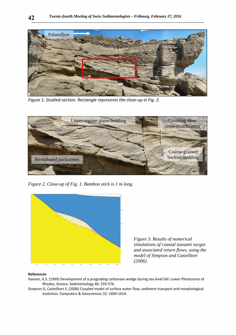
Twenty-fourth Meeting of Swiss Sedimentologists – Fribourg, February 27, 2016 _______________________________________________________________________________________
42
Figure 1. Studied section. Rectangle represents the close‐up in Fig. 2.
Figure 2. Close-up of Fig. 1. Bamboo stick is 1 m long.
Figure 3. Results of numerical simulations of coastal tsunami surges and associated return flows, using the model of Simpson and Castelltort (2006).
References Hansen, K.S. (1999) Development of a prograding carbonate wedge during sea level fall: Lower Pleistocene of
Rhodes, Greece. Sedimentology 46: 559‐576. Simpson G, Castelltort S. (2006) Coupled model of surface water flow, sediment transport and morphological
evolution. Computers & Geosciences 32: 1600‐1614.
Upper-regime plane-bedding Climbing dune cross-stratification
Coarse-grained backset-bedding Bioturbated packstones
Palaeoflow

Twenty-fourth Meeting of Swiss Sedimentologists – Fribourg, February 27, 2016 _______________________________________________________________________________________
43
Human impact onto the sediment budget of the upper Rhône River, Central Swiss Alps
Stutenbecker, L.*(1) and Schlunegger, F.(1)
(1) University of Bern, Institute of Geological Sciences, Baltzerstrasse 1+3, CH‐3007 Bern, Switzerland * [email protected]
Human impact onto our landscapes is widely visible, but yet hard to quantify due to its short time scales and unpredictable feedbacks. In this debate, the world’s river networks are of special concern, because they regulate the transport of sediment between sources and sinks. One of the main human impacts onto the river network is the construction of hydropower dams and connected storage reservoirs, which are believed to retain up to 25% of the global sediment delivery to the ocean (Syvitzki et al., 2005). The upper Rhône basin located in southwestern Switzerland is one of the major sediment factories of the Central Swiss Alps. Sediment is generated in around 50 tributary basins, which join the main Rhône River along its c. 150 km long course from the headwaters in the glaciated Aar massif to the primary sedimentary sink in Lake Geneva. Since the beginning of the last century, hydropower dams have been constructed in many of the largest tributary basins. Today, the total capacity of storage reservoirs connected to the ca. 40 hydropower dams located in the area exceeds 1.35 km3, which amounts to about 20% of the average annual water discharge of the Rhône River (Loizeau & Dominik, 2000). In this study we investigate the role of hydropower dams onto the sediment budget of the upper Rhône basin. The tributary basins are located in mainly three lithological units: carbonates in the North, (meta)oceanic rocks in the South and (meta)granitoid rocks in the East and West. Most of the hydropower dams, and the largest facilities in particular, are located in the southern area. We use different sediment tracing techniques, including bulk geochemistry, heavy and light mineral analysis to trace the sediment that is currently transported in the Rhône River back to its origins. We combine these data with sediment load modelling and cosmogenic nuclide dating to understand the theoretical sediment load of each tributary basin. Result show that the sediment of the southern units, which theoretically should contribute over 50% of the material, is highly under‐represented in the sediment. We therefore conclude that hydropower dams and the connected sediment storage have an impact onto the sediment budget of the Rhône River. References Loizeau, J.L., Dominik, J. (2000)
Evolution of the Upper Rhone River discharge and suspended sediment load during the last 80 years and some implications for Lake Geneva. Aquatic Sciences 62: 54‐67.
Syvitzki, J.P.M, Vörösmarty, C.J., Kettner, A.J., Green, P. (2005) Impact of Humans on the Flux of Terrestrial Sediment to the Global Coastal Ocean. Science 308: 376‐380.

Twenty-fourth Meeting of Swiss Sedimentologists – Fribourg, February 27, 2016 _______________________________________________________________________________________
44
Pleistocene shallowing‐upward sequences in Dean’s Blue Hole, Long Island (Bahamas): evidence of differential subsidence or faulting along the SE
margin of Great Bahama Bank
Vimpere, L.*(1), Godefroid, F.(1), and Kindler, P.(1)
(1) University of Geneva, Department of Earth Sciences, 13 rue des Maraîchers, CH‐1205 Geneva, Switzerland * [email protected]
Stratigraphic investigations down to a depth of 30 m along the wall of Dean’s Blue Hole revealed the presence of three stacked shallowing‐upward sequences of Middle and Late Pleistocene age. These sequences occur at a much greater depth than possible equivalents on the NE margin of Great Bahama Bank, suggesting increased subsidence or faulting in the studied area.
Long Island is a narrow and elongated landmass located in the SE corner of Great Bahama Bank (central part of the Bahamas archipelago). Previous research (Hearty, 2010) showed that it mostly consists of eolianites of Middle Pleistocene to Late Holocene age. Marine facies (e.g. fossil reefs and beaches) have only been observed at two localities (Curran et al., 2004; Kindler and Godefroid, 2015). The depth to the base of the Lucayan limestone (i.e. the Plio‐Pleistocene boundary) indicates a regional subsidence rate of 1.35 m/105 years (Pierson, 1982). Our study area is located in the southern part of Long Island where both the lagoon‐ and the ocean‐facing shorelines take an E to W trend. The main geological feature of this zone is Dean’s Blue Hole (DBH), which is the deepest marine sink hole in the world (202 m).
We investigated and mapped the stratigraphic units exposed in the vicinity of DBH, and also scuba dived down to a depth of 60 m into the latter. The sedimentological characteristics of the identified stratigraphic units were examined in the field. Samples were collected by hand and with a jack hammer at irregular intervals between 5 m above and 30 m below sea level for petrographic analyses, amino‐acid racemization dating, and U‐Th dating. Hereafter, we present the preliminary results of our investigations.
The section logged at DBH (Figure 1; coord.: N 23°06’23”, W 75°00’31”) comprises three vertically stacked shallowing‐upward successions, called hereafter Sequences I to III, in descending order. About 28 m thick (+10 to ‐18 m), Sequence I consists of bioclastic boundstones/rudstones and grainstones deposited, from base to top, in reefal, intertidal, and eolian settings. The eolianite yielded an average DL Ile value of 0.301 (n=2); corals from the reef facies have not been dated yet. Sequence II is ca. 8 m in thickness, and comprises well‐preserved oolitic‐peloidal grainstones deposited in beach (at the base) to dune (at the top) environments. Occurring between 27 and 30 m below sea level, Sequence III is made of much altered bioclastic boundstones/rudstones and grainstones, likely deposited in reefal (base) and intertidal (top) environments.

Twenty-fourth Meeting of Swiss Sedimentologists – Fribourg, February 27, 2016 _______________________________________________________________________________________
45
Based on its morphostratigraphic position, petrographic content (Kindler and Hearty, 1996), and the obtained DL Ile values, Sequence I can be correlated with Marine Isotope Stage (MIS) 5a (i.e. the 80 ka BP sea‐level highstand). The underlying Sequence II is logically assigned to MIS 5e (i.e. the 120 ka BP sea‐level highstand) due to its position, oolitic‐peloidal composition (Kindler and Hearty, 1996), and relatively low diagenetic grade. Finally, Sequence III is tentatively correlated with a Middle Pleistocene interglacial (MIS 9 or 11), due to its high grade of diagenetic alteration. A similar and coeval stack of shallowing‐upward sequences has been described from cores drilled on New Providence Island, on the NE end of Great Bahama Bank (Aurell et al., 1995). In these cores, the boundary between Middle and Upper Pleistocene deposits occurs at ca. 9 m below sea level, whereas it is found at a depth of 27 m in DBH. If our correlation is correct, this difference in elevation could be related to (1) a topographic effect, (2) differential subsidence on Great Bahama Bank, and (3) down warping of the DBH area along a hidden fault plane. The latter hypothesis, which is supported by the abrupt change in the orientation of the Long Island shorelines in this region, could further provide a clue to the anomalous depth of DBH.
Figure 1. Field photograph showing the location of the studied section.
References Aurell, M., McNeill, D.F., Guyomard, T., and Kindler, P. (1995) Pleistocene shallowing‐upward sequences in New
Providence, Bahamas: signature of high‐frequency sea‐level fluctuations in shallow carbonate platforms. Journal of Sedimentary Research, B65, 170‐182.
Curran, H.A., Mylroie, J.E., Gamble, D.W., Wilson, M.A., Davis, R.L., Sealey, N.E., Voegeli, V.J. (2004) Geology of Long Island, Bahamas: a field trip guide. Fieldtrip guidebook, 12th Symposium on the Geology of the Bahamas and other carbonate regions, Gerace Research Centre, San Salvador, Bahamas, 24 pp.
Hearty, P.J. (2010) Chronostratigraphy and morphological changes in Cerion land snail shells over the past 130 ka on Long Island, Bahamas. Quaternary Geochronology 5: 50‐64.
Kindler, P., Godefroid, F. (2015) Elevated bioherms from Long Island (Bahamas): a testimony of recent tectonic uplift or of a high sea level during the Middle Pleistocene. 15th Bathurst Meeting Abstracts, 74.
Kindler, P., Hearty, P.J. (1996) Carbonate petrography as an indicator of climate and sea‐level changes: new data from Bahamian Quaternary units. Sedimentology, 43, 381‐399.
Pierson, B.J. (1982) Cyclic sedimentation, limestone diagenesis and dolomitization in upper Cenozoic carbonates of the southeastern Bahamas. Unpublished PhD thesis, University of Miami, Florida, USA, 286 pp.
This research is supported by the Swiss National Science Foundation (grant no 200020‐140420/1).

Twenty-fourth Meeting of Swiss Sedimentologists – Fribourg, February 27, 2016 _______________________________________________________________________________________
46
Stabilization and disruption as indicators of terminal stress in planktonic Foraminifera: An example from the Pleistocene Red Sea
Weinkauf, M. F. G.*(1,2,a), Bonitz, F. (2,b), and Kučera, M.(1)
(1) University Bremen, Center for Marine Environmental Sciences (MARUM), Leobener Str., 28359 Bremen, Germany (2) Eberhard–Karls University Tübingen, Department of Geosciences, Hölderlinstr. 12, 72074 Tübingen, Germany (a) Current address: University of Geneva, Department of Earth Sciences, 13 rue des Maraîchers, 1205 Genève, Switzerland (b) Current address: Uni Research, Bjerknes Centre for Climate Research, Thormøhlensgt. 55, 5008 Bergen, Norway *[email protected]
The effects of environmental stress, potentially leading to extinction, are remarkably difficult to assess. This is partly because the severity of environmental stress and its potential outcome (i.e. adaptation, extinction) are difficult to quantify in recent environments (Moritz & Agudo 2013). Population dynamics have therefore been invoked to quantify stress levels (Drake & Griffen 2010), but they suffer from the naturally large variability of population sizes (Ludwig 1999). Morphometric approaches, however, have been proven useful as a tool for stress assessment in recent and past communities (MacLeod et al. 1999, Hendrickx et al. 2003, Sánchez‐Chardi et al. 2013). Planktonic Foraminifera are an excellent model group for morphometric analyses amongst protists, because they record their entire ontogeny within their multichambered shells and are found in abundance both in the recent oceans and the sedimentary record. In this study, we therefore use material from a salinity‐induced high‐stress environment from Marine Isotope Stage 12 in the Red Sea (Rohling et al. 2009) which exhibits elevated stress levels on the planktonic Foraminifera community culminating in local extinction (Fenton et al. 2000). We use morphometric approaches to analyze the stress reaction of two planktonic Foraminifera species (Orbulina universa and Trilobatus sacculifer) to gradually rising salinity‐stress levels. Both species are symbiont‐bearing surface dwellers and were thus exposed to comparable environments during this natural experiment, but they nevertheless show large differences in their reactions on several levels. Orbulina universa shows a very unstable abundance pattern culminating in a fast‐paced extinction, and shows morphological changes in shell size and sphericity which are consistent with disruptive selection patterns. Trilobatus sacculifer shows a constant and slow decline in abundance and exhibits multilevel microenvironmental canalization and stabilizing selection of the shell shape when exposed to the same kind of stress. Shell morphology and phenotypic variation seem to reflect environmental stress patterns. In O. universa we observe a decrease in shell symmetry during times of rising stress levels, while T. sacculifer shows decreased morphological disparity as reaction towards the same environmental gradient. Both species exhibit morphological gradients in correlation with salinity, that serve as a better indicator for environmental stress on the community than the species abundance. Our study shows that morphometric analyses in planktonic Foraminifera (despite their unicellular organization level) are a versatile tool to predict past stress levels, but reaction norms are species specific and further complicated by biological integration.

Twenty-fourth Meeting of Swiss Sedimentologists – Fribourg, February 27, 2016 _______________________________________________________________________________________
47
References Drake, J.M., Griffen, B.D. (2010) Early warning signals of extinction in deteriorating environments. Nature 467:
456–459. Fenton, M., Geiselhart, S., Rohling, E.J., Hemleben, C. (2000) Aplanktonic zones in the Red Sea. Marine
Micropaleontology 40: 277–294. Hendrickx, F., Maelfait, J.P., Lens, L. (2003) Relationship between fluctuating asymmetry and fitness within and
between stressed and unstressed populations of the wolf spider Pirata piraticus. Journal of Evolutionary Biology 16: 1270–1279.
Ludwig, D. (1999) Is it meaningful to estimate a probability of extinction? Ecology 80: 298–310. MacLeod, N., Keller, G., Kitchell, J.A. Progenesis in Late Eocene populations of Subbotina linaperta
(Foraminifera) from the western Atlantic. Marine Micropaleontology 16: 219–240. Moritz, C., Agudo, R. (2013) The future of species under climate change: Resilience or decline? Science 341:
504–508. Rohling, E.J., Grant, K., Bolshaw, M., Roberts, A.P., Siddall, M., Hemleben, C., Kučera, M. (2009) Antarctic
temperature and global sea level closely coupled over the past five glacial cycles. Nature Geoscience 2: 500–504.
Sanchéz‐Chardi, A., García, M., López‐Fuster, M.J. (2013) Chronic exposure to environmental stressors induces fluctuating asymmetry in shrews inhabiting protected Mediterranean sites. Chemosphere 93: 916–923.

SwissSed is an informal group of (not only) Swiss sedimentologists. It promotes contacts, exchange of ideas, and information on current developments in sedimentology. Membership is free, but SwissSed lives by the interest and initiative of
its members.
To become a member, please contact:
SwissSed on the Web: http://www.swisssed.ch
Flavio Anselmetti Institute of Geological Sciences University of Bern Baltzerstrasse 1+3 3012 Bern Switzerland
Tel +41 31/ 631 87 06 E-mail: [email protected]
Anneleen Foubert Department of Geosciences – Geology University of Fribourg Chemin du Musée 6 1700 Fribourg Switzerland
Tel +41 26/ 300 89 78 E-mail: [email protected]
Pascal Kindler Section des Sciences de la Terre et de l’environnement Rue des Maraichers 13 1205 Genève Switzerland
Tel +41 22/ 379 66 49 E-mail: [email protected]
Silvia Spezzaferri Department of Geosciences – Geology University of Fribourg Chemin du Musée 6 1700 Fribourg Switzerland
Tel +41 26/ 300 89 77 E-mail: [email protected]