unmanned aircraft systems (uas) program...2017/04/14 · the noaa unmanned aircraft systems (uas)...
TRANSCRIPT

Unmanned Aircraft Systems (UAS) Program
Robbie Hood, Director
17 April 2014
1

The NOAA Unmanned Aircraft Systems (UAS) Program:
Status and Activities
Gary Wick Robbie Hood, Program Director
Sensing Hazards with Operational Unmanned Technology (SHOUT) to
Mitigate the Risk of Satellite Observing Gaps

Synergistic Contributions
Test of UAS technology to
mitigate risk of satellite observing
gaps to high impact weather
prediction
NOAA investments in UAS
demonstrations and personnel
training
NASA leadership in increasing UAS
technology readiness
Congressional funding for the Disaster Relief Appropriations
(DRA) Act
3

Thermodynamic Observations for Tropical Cyclones
Obs TPIO – Validated Requirements
HAMSR Capabilities
(TRL – 7/8)
AVAPS Dropsonde Capabilities
(TRL – 7/8)
VR HR A VR HR A VR HR A
Temp. Profiles
O 500m O 50 km O 1 K 1 km
2 km
0.5 K
5 – 15 m
< 1 km
0.5 K
R 45 m
R 1 km
R 1 K
Pressure Profiles
O - 9 m O 10 km O 1 hPa N/A
N/A
N/A
5 – 15 m
< 1 km
0.1 hPa
R 45 m
R 1 km
R 1 hPa
Humidity Profiles
O 1 km O 20 km O 8% 2 km
2 km
15 – 20%
5 – 15 m
< 1km
5%
R 90 m
R 4 km
R 20%
Obs – Observations Temp - Temperature VR – Vertical Resolution HR – Horizontal Resolution A- Accuracy
O- Operations R – Research

Wind Observations for Tropical Cyclones
Obs TPIO – Validated Requirements
HIWRAP Capabilities (TRL – 7/8)
HIRAD Capabilities (TRL – 6/7)
AVAPS Dropsonde Capabilities (TRL – 7/8)
VR HR A VR HR A VR HR A VR HR A
WS Prof.
O 500 m O 50 km O 1 m/s 500m 1 km 0.5 K N/A N/A N/A 5- 15 m < 1 km 0.5 m/s
R 100 m
R 50 km
R 1 m/s
WD Prof.
O 500 m O 10 km O 10 deg 500m 1 km 15 deg N/A N/A N/A 5- 15 m < 1 km 10 deg
R 100 m
R 1 km
R 10 deg
Sfc. WS
N/A O 1 km O 1m/s N/A 1 km 2 m/s N/A 1-2 km 1 - 5 m/s N/A < 1 km 0.5 m/s
N/A R 12 km
R 2 m/s
Sfc WD
N/A O 2.5km O 10 deg N/A 2 km 15 deg N/A N/A N/A N/A < 1 km 10 deg
N/A
R 12 km
R 20 deg
VR – Vertical Resolution HR – Horizontal Resolution A- Accuracy WS – Wind Speed WD – Wind Direction O- Operations R – Research

Track Error (nm) Intensity: Max. Wind Error (kts)
Intensity: Min. SLP Error (hPa)
Bias (dash)
HS3 drops
No drops HS3 drops
No drops
HS3 drops
No drops
Bias (dash)
• Dropsonde impact experiments performed
for 19-‐28 Sep. (3 flights) -‐ Red: with HS3 drops -‐ Blue: No drops with syntheCcs
• COAMPS-‐TC Intensity and Track skill are improved greatly through assimilaCon of HS3 Drops. Slide courtesy of James Doyle / NRL
Impact of HS3 Dropsondes for Navy COAMPS-TC Hurricane Nadine Predictions
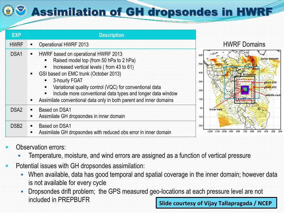
Assimilation of GH dropsondes in HWRF
Observation errors: Temperature, moisture, and wind errors are assigned as a function of vertical pressure
Potential issues with GH dropsondes assimilation: When available, data has good temporal and spatial coverage in the inner domain; however data
is not available for every cycle Dropsondes drift problem; the GPS measured geo-locations at each pressure level are not
included in PREPBUFR
EXP Description
HWRF Operational HWRF 2013
DSA1 HWRF based on operational HWRF 2013 Raised model top (from 50 hPa to 2 hPa) Increased vertical levels ( from 43 to 61)
GSI based on EMC trunk (October 2013) 3-hourly FGAT Variational quality control (VQC) for conventional data Include more conventional data types and longer data window
Assimilate conventional data only in both parent and inner domains
DSA2 Based on DSA1 Assimilate GH dropsondes in inner domain
DSB2 Based on DSA1 Assimilate GH dropsondes with reduced obs error in inner domain
HWRF Domains
Slide courtesy of Vijay Tallapragada / NCEP

Hurricane Nadine 14L 2012
Verification for HWRF forecast from cycles with Global Hawk Dropsondes for H. Nadine (2012):
• Significant improvement in track forecasts compared to control
• Intensity (Vmax) errors improved in the first 36 hrs, degraded afterwards.
• No impact on MSLP forecasts
Slide courtesy of Vijay Tallapragada / NCEP

Humberto 09L 2013
Verification for HWRF forecast for two cycles of TS Humberto (2013) with direct assimilation of Global Hawk Dropsondes:
• Neutral impact on track forecasts • Significant impact on intensity (Vmax)
forecasts • Significant positive impact on MSLP
forecasts
Slide courtesy of Vijay Tallapragada / NCEP

Project Objectives
10
• Demonstrate and test prototype UAS concept of operations that could be used to mitigate the risk of diminished high impact weather forecasts and warnings in the case of polar-orbiting satellite observing gaps
Overall Goal
• Conduct data impact studies • Observing System Experiments (OSE) using data from UAS field missions • Observing System Simulation Experiments (OSSE) using simulated UAS
data
Objective 1
• Evaluate cost and operational benefit through detailed analysis of life-cycle operational costs and constraints
Objective 2
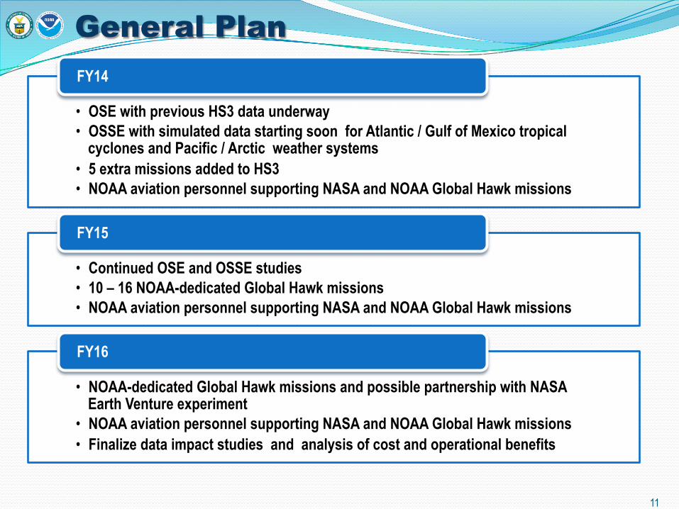
General Plan
11
• OSE with previous HS3 data underway • OSSE with simulated data starting soon for Atlantic / Gulf of Mexico tropical
cyclones and Pacific / Arctic weather systems • 5 extra missions added to HS3 • NOAA aviation personnel supporting NASA and NOAA Global Hawk missions
FY14
• Continued OSE and OSSE studies • 10 – 16 NOAA-dedicated Global Hawk missions • NOAA aviation personnel supporting NASA and NOAA Global Hawk missions
FY15
• NOAA-dedicated Global Hawk missions and possible partnership with NASA Earth Venture experiment
• NOAA aviation personnel supporting NASA and NOAA Global Hawk missions • Finalize data impact studies and analysis of cost and operational benefits
FY16
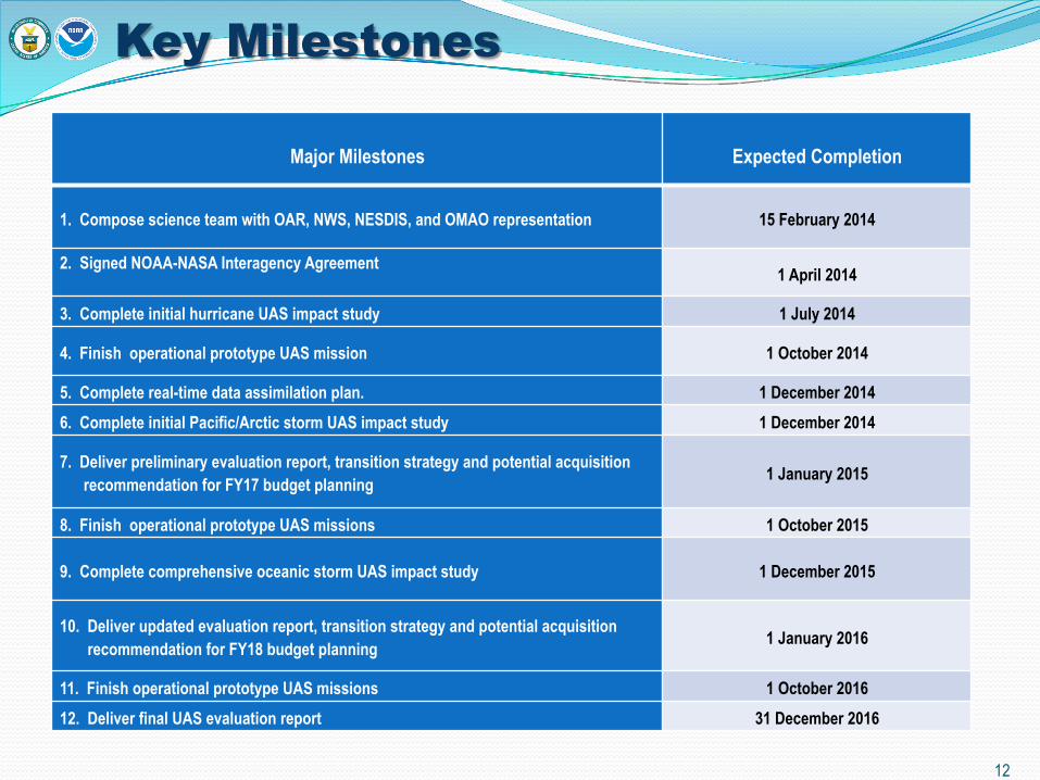
Key Milestones
Major Milestones
Expected Completion
1. Compose science team with OAR, NWS, NESDIS, and OMAO representation 15 February 2014
2. Signed NOAA-NASA Interagency Agreement 1 April 2014
3. Complete initial hurricane UAS impact study 1 July 2014
4. Finish operational prototype UAS mission 1 October 2014
5. Complete real-time data assimilation plan. 1 December 2014
6. Complete initial Pacific/Arctic storm UAS impact study 1 December 2014
7. Deliver preliminary evaluation report, transition strategy and potential acquisition recommendation for FY17 budget planning 1 January 2015
8. Finish operational prototype UAS missions 1 October 2015
9. Complete comprehensive oceanic storm UAS impact study 1 December 2015
10. Deliver updated evaluation report, transition strategy and potential acquisition recommendation for FY18 budget planning 1 January 2016
11. Finish operational prototype UAS missions 1 October 2016
12. Deliver final UAS evaluation report 31 December 2016
12

Management Team
Principal Investigator • Robbie Hood, NOAA UAS Program Director
Project Scientists
• Michael Black, NOAA OAR AOML • Gary Wick, NOAA OAR ESRL
Project Managers
• Philip Kenul, TriVector Services • JC Coffey, Cherokee Nation Technologies
OMAO UAS Manager • Philip Hall, NOAA OMAO Headquarters
13

SHOUT Working Group
14
NOAA Office of Oceanic and
Atmospheric Research
(OAR)
• Alexander MacDonald • John Cortinas • Frank Marks • Robert Atlas • Zoltan Toth • Lidia Cucurull
NOAA Office of Marine and
Aviation Operations
(OMAO)
• Philip Hall
NOAA National Environmental Satellite, Data,
and Information Service
(NESDIS)
• Mitch Goldberg • Steven Goodman
National Weather
Service (NWS)
• William Lapenta • John Murphy • Fred Toepfer • Chris Landsea • Carven Scott • Bill Ward

SHOUT Contact Information
Robbie Hood / [email protected]
Michael Black / [email protected]
Gary Wick / [email protected]
Philip Kenul / [email protected]
JC Coffey / [email protected]
Philip Hall / [email protected]
15