updated mineral resource estimate with substantial
TRANSCRIPT

1
ASX ANNOUNCEMENT 22 May 2018 ASX Code: MYL Board of Directors Mr John Lamb Executive Chairman
Mr Rowan Caren Executive Director
Mr Jeff Moore Non-Executive Director Issued Capital Shares 663m.
Options 184m.
Performance rights 28m.
Current share price A$0.056 (21 May 2018)
Market capitalisation A$37m.
Cash ~ A$3.9m. (31 March 2018)
Debt Nil
ABN: 48 124 943 728 Suite 4, 38 Colin St West Perth 6005 Western Australia Phone: +61 (0)8 6147 8100 [email protected] www.myanmarmetals.com.au
Together with partner Win Myint Mo Industries Co, Myanmar Metals Limited (ASX: MYL) (“MYL” or “the Company”) is pleased to report a revised Indicated and Inferred Mineral Resource estimate for Bawdwin completed by CSA Global and reported under the guidelines of the JORC Code 2012 Edition.
The updated estimate utilises the new data from the 2018 drilling program and updates the previous Inferred Mineral Resource estimate announced in the Company’s release to the ASX on 6th March 2018.
The substantial drill program completed in 2018 brings the total 2017-18 drill metreage to 5,320 metres of diamond core drilling and 2,014 m of Reverse Circulation drilling. The results of the 7,334 metres of recent drilling have supported the results of 56,008 metres of historic channel sampling of underground exploration cross cuts and have allowed classification of most of the shallower part of the Mineral Resource as Indicated.
Myanmar Metals Limited’s Chairman and CEO, John Lamb, commented:
“Bawdwin continues to impress, with the total JORC resource now exceeding 80 million tonnes with improved metal grades when compared to the resource estimate announced to the ASX on 6th March 2018.
The increase in both tonnes and metal content is pleasing, noting that the recent drilling was primarily focused on infilling the resource and no
Highlights
Updated Indicated and Inferred Mineral Resource Estimate of 82.0 Mt at 4.7% Pb, 119g/t Ag, 2.4% Zn and 0.2% Cu, (0.5% Pb cut-off above 750m RL, 2% Pb below 750m RL),
Increase of 5.1Mt over the Mineral Resource estimate announced on the 6th March 2018,
Includes a maiden Indicated Resource component of 20.2Mt at 5.0% Pb, 130g/t Ag, 2.6% Zn and 0.23% Cu (0.5% Pb cut-off above 750m RL, 2% Pb below 750m RL).
At a 2% Pb cut-off for both deep and shallow mineralisation, the resource estimate is 44.5Mt at 7.8% Pb, 180g/t Ag, 3.6% Zn and 0.3% Cu (global 2% Pb Cut-off); this represents the high grade ‘core’ mineralisation that is enveloped by lower grade ‘halo’ mineralisation.
The estimate includes a copper-rich resource of 4.24 Mt at 3.03% Cu, 5.34% Pb, 168g/t Ag and 2.54% (cut-off grade of 0.5% Cu); the copper-rich mineralisation has not yet been targeted by drilling
The new Mineral Resource estimate will be used to complete an updated Scoping Study, expected to be completed by mid-June.
UPDATED MINERAL RESOURCE ESTIMATE WITH SUBSTANTIAL
INDICATED CLASSIFICATION
1914 Rail Wagon Tippler

2
exploration or resource extension drilling has yet been undertaken at Bawdwin.
Most importantly, this estimate includes the first mineral resources at Bawdwin to be classified in the Indicated category under JORC-2012, representing substantial progress towards the planned open pit redevelopment of the mine.”
Bawdwin Mine Background
MYL holds an option over the Bawdwin project with Win Myint Mo Industries Co. (“WMM”), the Myanmar company that holds the 38 km2 Mining Concession at Bawdwin under a production sharing agreement with Mining Enterprise No. 1, a state enterprise under the Ministry of Natural Resources and Environmental Conservation.
The Bawdwin Mine in the northern Shan State in Myanmar was a globally significant lead, zinc and silver mine in the 1920’s and 30’s. Large-scale production ceased during World War 2. Through a combination of political, technical and economic factors, the mine never returned to pre-war levels. It was nationalised in the 1960’s and, while some foreign organisations drilled targets occasionally and sparsely, no modern exploration has been conducted on the site.
Figure 1. Location map for the Bawdwin Project

3
Geology and Mineral Resource Estimates The updated Mineral Resource conducted by CSA Global is provided in Table 1.
Table 1: Bawdwin Indicated and Inferred Global Mineralisation Mineral Resource Estimate
Indicated 989 4.1 2.3 0.19 143 Inferred 539 6.0 2.9 0.22 194 Total 1,528 4.8 2.5 0.20 161 Indicated 9,825 5.2 2.7 0.11 133 Inferred 10,259 4.2 1.9 0.08 121 Total 20,084 4.7 2.3 0.10 127 Indicated 8,397 4.8 2.6 0.09 120 Inferred 38,143 3.8 2.0 0.08 95 Total 46,540 4.0 2.1 0.08 99 Indicated 19,211 5.0 2.6 0.11 128 Inferred 48,941 3.9 2.0 0.08 101
68,152 4.2 2.2 0.09 109
Fresh Inferred 9,543 8.1 3.5 0.05 168 9,543 8.1 3.5 0.05 168
Indicated 30 5.8 2.3 1.80 133 Inferred 17 10.2 1.4 2.48 146 Total 46 7.4 2.0 2.05 138 Indicated 481 5.3 3.2 2.49 183 Inferred 181 6.9 3.8 3.62 210 Total 662 5.7 3.4 2.80 190 Indicated 463 5.8 3.6 2.95 184 Inferred 2,486 6.2 2.7 3.27 184 Total 2,948 6.1 2.8 3.22 184 Indicated 974 5.6 3.3 2.68 182 Inferred 2,683 6.3 2.8 3.29 186
3,657 6.1 2.9 3.13 185
Inferred 4 0.1 0.1 3.33 50 Total 4 0.1 0.1 3.33 50 Inferred 67 0.1 0.1 2.05 50 Total 67 0.1 0.1 2.05 50 Inferred 471 0.1 0.1 2.43 50 Total 471 0.1 0.1 2.43 50
Total Inferred 543 0.1 0.1 2.39 50 543 0.1 0.1 2.39 50
Indicated 1,019 4.1 2.3 0.24 143 Inferred 560 6.1 2.9 0.32 191 Total 1,579 4.8 2.5 0.26 160 Indicated 10,306 5.3 2.7 0.23 135 Inferred 10,506 4.3 1.9 0.15 122 Total 20,813 4.8 2.3 0.19 129 Indicated 8,860 4.8 2.6 0.24 123 Inferred 50,643 4.7 2.3 0.25 113 Total 59,503 4.7 2.4 0.25 114 Indicated 20,185 5.0 2.6 0.23 130 Inferred 61,710 4.7 2.3 0.24 115
81,895 4.7 2.4 0.24 119
Oxide
Transition
Fresh
Total
Total
Total
Oxide
Transition
Fresh
Total
Domain 4: Copper Mineralistion outside of Pb Halo > 0.5% Cu
Oxide
Transition
Fresh
Total
Total
Domain 2: Mineral Resources below 750m RL > 2% Pb
Domain 3: Copper Mineralisation within Pb Halo > 0.5% Cu
Oxide
Transition
Fresh
Total
Total
Total
Cu (%) Ag (ppm)
Domain 1: Mineral Resources above 750m RL > 0.5% Pb
Oxidation ClassTonnage
('000t)Pb (%) Zn (%)

4
Drilling and Sampling Techniques
The Mineral Resource estimate is based on the 7,334 metres of RC and diamond drilling completed in 2017-2018 supported by 56,008 metres of historic channel sampling of underground exploration cross cuts and a 435 sample (1,791 metre) channel sampling program collected in the open cut in 2016. Assays from the final two holes in the 2018 drill program (BWDD005, 223m deep; and BWDD006 173m deep) were not received in time for this new Mineral Resource estimate and will be included in future resource updates
The diamond and RC drill holes completed in 2017 and 2018 are spaced on approximately 50m spaced sections and were designed to provide systematic coverage along the strike/dip of the China Lode. Three diamond drill holes were drilled at the Meingtha Lode on 50m spaced sections and two diamond holes drilled at the Shan Lode on 100m spaced sections.
The open pit sampling was done on accessible berms and ramps. These traverses range from 10m to 30m apart.
The historical underground samples are generally taken from systematic ore development crosscuts. These are typically on 50 to 100 feet spacings – 15m to 30m whilst strike drives along mineralised lodes demonstrated good continuity.
The diamond drilling, RC samples and open pit channel samples were all sent to Intertek Laboratories in Yangon for sample preparation. Sample pulps were sent to the Intertek analytical facility in Manila, Philippines where they were analysed in 2017 using ICP-OES – Ore grade four-acid digestion. Elements analysed were Ag, Fe, Cd, Co, Ni, Pb, Cu, Mn, S and Zn. In 2018, ICP-OES – Ore grade four-acid digestion continued to be employed, along with additional multi-element analysis of 46 elements using four-acid standard ICP-OES and MS. Quality control (QC) samples were submitted with each assay batch (certified reference standards, certified reference standard blanks and duplicate samples). All assay results returned were of acceptable quality based on assessment of the QAQC assays.
Geological Interpretation
The Bawdwin deposit is hosted within an Early Ordovician volcanic and intrusive complex termed the Bawdwin Volcanic Centre, comprised of volcaniclastic tuffs of the Bawdwin Volcanic Formation that interfinger with sediments of the Pangyun Formation, both intruded by co-magmatic rhyolite porphyry bodies. The Bawdwin deposit is a structurally controlled massive to disseminated sulphide deposit hosted largely within the Bawdwin Tuff and to a lesser extent within the Pangyun Formation sediments and rhyolitic porphyry. The main controlling Bawdwin Fault zone comprises a complex northwest-trending, southwest-dipping, array of faults, splays and relays. Massive to semi-massive sulphide mineralisation occurs in dilational structural zones as veins, breccias and large-scale replacement of the Bawdwin Tuff. Semi-massive to disseminated and vein sulphide mineralisation occurs in extensive halo zones in silica-sericite-carbonate altered Bawdwin Tuff.
Sulphide mineralisation at Bawdwin is characterised by argentiferous galena, sphalerite, chalcopyrite, and pyrite together with smaller amounts of covellite, tetrahedite, gersdorffite, cobaltite, and other sulphide minerals. Copper mineralisation occurs with lead and zinc but also separately where it can be associated with nickel and cobalt.
The historically-mined China, Meingtha and Shan lodes lie along 4 kilometres of strike of the Bawdwin Fault zone, with offsets by later faults. The mined lodes were zones of mineralised structures with associated replacement, breccia and stockwork zones. The most extensive ‘halo’

5
mineralisation is up to 150 metres wide in the footwall of the main China Lode and is characterised by high-grade veins, breccias, stockworks and shear zones and extensive zones of replacement and disseminated mineralisation associated with alteration of the lithic breccia host (Bawdwin Tuff). This laterally and vertically extensive mineralised zone is interpreted to reflect a relay zone extending north towards the Shan Lode where it is poorly tested by underground sampling and drilling.
The 3D geology model developed by CSA Global included the Bawdwin Tuff, Pangyun Formation, porphyritic rhyolite and major faults. The previously modelled mineralisation wireframes, based on 2017 drilling, open-pit mapping and historical surface and underground mapping, were updated using the 2018 drilling results. The 2018 drilling results correlated very well with the previous mineralised wireframes that were based largely on historical data.
Resource Model
The estimate is based on separate Pb and Cu wireframes and cut-off grades because of the limited correlation between Pb and Cu. Grades have been interpolated into a block model using the same interpolation parameters and methodology from those reported in March 2018. The cut-off grades were based on the results of a pit optimisation and Scoping Study completed in November 2017 by CSA Global that suggested that the low-grade material has potential for eventual economic extraction via open pit mining methods, and that material above a 2% cut-off grade may be amenable to extraction via underground methods.
The mineralised envelope was based on a 0.5% Pb cut-off grade. Within this envelope, the Mineral Resource estimate is reported in three domains; at a 0.5% Pb and 2% cut-off grade above the 750m RL and a 2% Pb cut-off grade below the 750m RL. The lower cut-off grade above the 750m RL is based on the results of a pit optimisation and Scoping Study completed in November 2017 by CSA Global that suggested that the low-grade material has potential for eventual economic extraction.
The Cu mineralisation envelopes have been modelled above a 0.5% Cu cut-off grade and are included in the global resource totals. This envelope is largely contained within the 0.5% Pb envelope but does extend outside it. Grade has been interpolated separately into the blocks within the Cu envelope.
The new resource is reported separately for four mineralisation domains (Figure 2):
1. Resources above the 750m RL, at a 0.5% Pb cut-off grade. 2. Resources below 750m RL using a 2% Pb cut-off grade. 3. Cu mineralisation within Pb Halo using a 0.5% Cu cut-off grade 4. Cu mineralisation outside Pb Halo using a 0.5% Cu cut-off grade
For mineralised lodes and halo mineralisation, bulk density has been estimated using a formula which assumes Pb is present as galena, Zn is present as sphalerite and Cu is present as chalcopyrite, with the remainder of the rock is gangue. The estimated values were calibrated against the measured densities from drill-core.
Statistical analysis to determine top cut grade values was carried out separately for each element (Pb, Zn, Cu, Ag) and separately for high grade lodes and the “Halo” zone.
Validation of the block model included comparison of the block model volume to the wireframe volume. Grade estimates were validated by statistical comparison with the drill data, visual comparison of grade trends in the model with the drill data trends, and by using a second interpolation technique.
6
The reported Mineral Resource estimate is based on depletion of historically mined stopes. An updated and more accurate stope volume was derived from the scanning and georeferencing of almost 900 historic mining floor and level plans, completed in 2018. Drilling has typically shown very good correlation between digitised stopes and stopes intersected in drill holes.
The topography over the deposit is constrained by a high-resolution DTM derived from satellite data acquired in 2018.
The Mineral Resource estimate has been reported in Fresh, Transitional and Oxide zones modelled using multielement geochemical data. Drill hole logging indicates that the Transitional material is characterised by limited oxidation confined to fractures and preliminary metallurgical test work on a composite of fresh and transitional material has given good recoveries of bulk lead and zinc sulphides and contained silver.
Metallurgical Testing
It is assumed that Pb, Zn, Cu and Ag sulphide mineralisation can all be economically extracted using conventional flotation methods. These were all produced historically at the Bawdwin Mine and Namtu Smelter Complex.
The current metallurgical testing program being managed by CSA Global and Battery Limits is showing encouraging results in achieving acceptable metal recoveries via floatation and Dense Media Separation (DMS) in fresh and transitional material, however further testing is required using additional samples collected during the recent drilling program
Resource Classification
The Inferred Mineral Resource classification is based on the evidence from the available drill hole and channel sampling. This evidence is sufficient to imply but not verify geological and grade continuity. However, the areas with the denser drilling and robust continuation of the mineralised zones were classified as Indicated (where the new 2017 and 2018 drillholes were drilled).
The open pit mapping and diamond drilling all have been carried in accordance with modern industry best practice standards and have QAQC data to support the assay data. Whilst the historical underground sampling has no assay QAQC, the data quality is acceptable for the classification of Indicated in the areas with supporting drilling data. The overall structure of the major lodes is well understood from the underground data and open pit mapping.
The Inferred and Indicated classification has considered all available geological and sampling information, and the classification level is considered appropriate for the current stage of this project.
The sampling and geological data and associated documentation are considered adequate to support reporting of an Indicated and Inferred Mineral Resource. Additional information regarding sampling and analysis is provided in JORC Table 1 which is attached to this ASX release.

7
Figure 2. Bawdwin block-model cross section showing the 750m RL boundary for reporting and the Domains used in the Resource Model.
Resource Model Sections
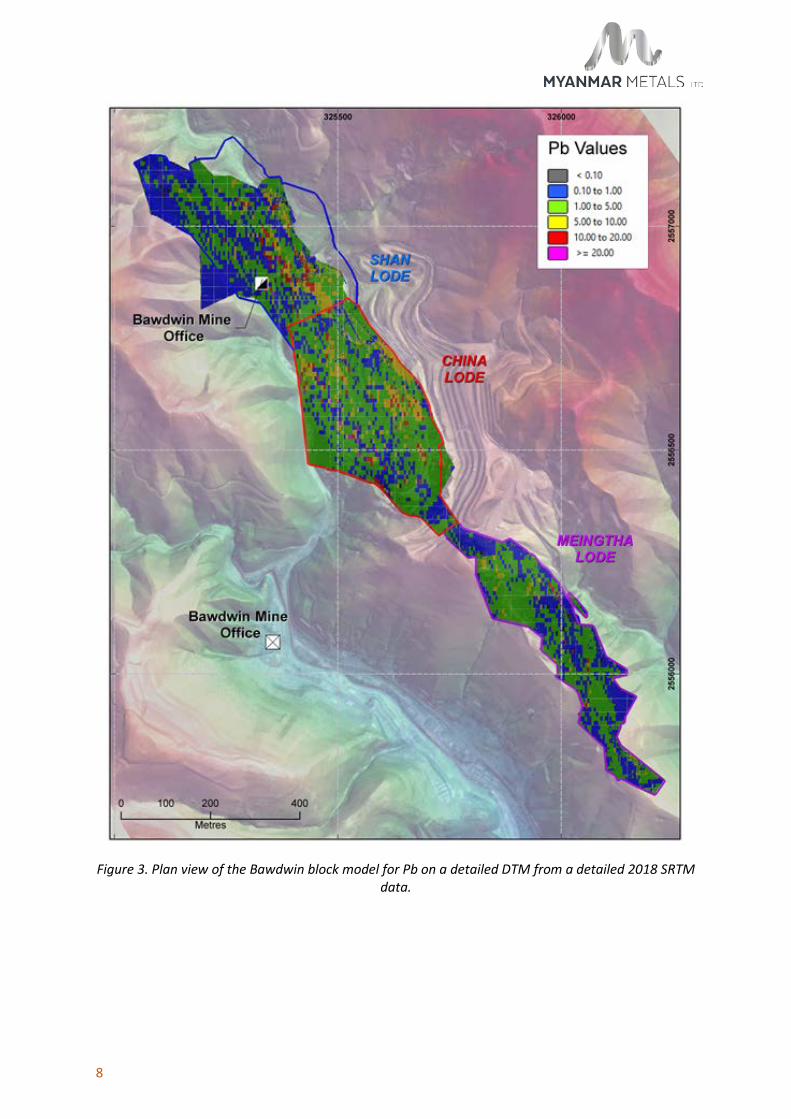
Figure 3 shows a plan view of Bawdwin showing the distribution of lead in the block model.
Figures 4, 5 and 6 show a cross-section through the deposit highlighting lead, silver, zinc and copper block-model grades respectively.
These figures show:
• The large volume of the high-grade material that has not yet been mined,
• The relatively small proportion of the total deposit that has been previously mined;
• The “Halo” lower grade mineralisation is widespread; nearly all material mined will be mineralised.
• The topography (i.e. a valley and historical open cut), which assists development of a pit on this deposit by reducing strip ratio.
8
Figure 3. Plan view of the Bawdwin block model for Pb on a detailed DTM from a detailed 2018 SRTM data.

9
Figure 4. Cross section through the Pb block model at the China Lode. Mined stopes are in black. Note the 750m RL approximating to Level 9.

10
Figure 5. Cross section through the Ag block model at the China Lode. Mined stopes are in black.
Note the 750m RL approximating to Level 9.

11
Figure 6. Cross section through the Zn block model at the China Lode. Mined stopes are in black.
Note the 750m RL approximating to Level 9.
12
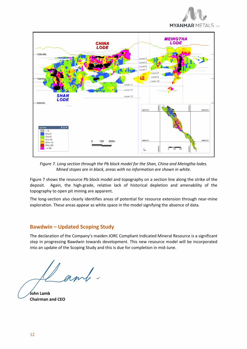
Figure 7. Long section through the Pb block model for the Shan, China and Meingtha lodes. Mined stopes are in black, areas with no information are shown in white.
Figure 7 shows the resource Pb block model and topography on a section line along the strike of the deposit. Again, the high-grade, relative lack of historical depletion and amenability of the topography to open pit mining are apparent.
The long-section also clearly identifies areas of potential for resource extension through near-mine exploration. These areas appear as white space in the model signifying the absence of data.
Bawdwin – Updated Scoping Study The declaration of the Company’s maiden JORC Compliant Indicated Mineral Resource is a significant step in progressing Bawdwin towards development. This new resource model will be incorporated into an update of the Scoping Study and this is due for completion in mid-June.
John Lamb Chairman and CEO

13
For More Information:
Ross Dinsdale, General Manager Investor Relations and Corporate Affairs
Phone: +61 (0)8 6147 8103
Email: [email protected]
About MYL’s Bawdwin Option
In May 2017 MYL, the Company negotiated an exclusive option with WMM to acquire a controlling interest in the Bawdwin concession, hosting the world class polymetallic Bawdwin deposit. Since that time MYL has substantially de-risked the project and successfully progressed through commercial, technical and legal due diligence.
Forward Looking Statements
The announcement contains certain statements, which may constitute “forward–looking statements”. Such statements are only predictions and are subject to inherent risks and uncertainties, which could cause actual values, results, performance achievements to differ materially from those expressed, implied or projected in any forward-looking statements.
Competent Person Statements
The Australasian Code for Reporting of Exploration Results, Mineral Resources and Ore Reserves (the ‘JORC Code’) sets out minimum standards, recommendations and guidelines for Public Reporting in Australasia of Exploration Results, Mineral Resources and Ore Reserves. The Information contained in this announcement has been presented in accordance with the JORC Code.
The information in this report that relates to Geology is based, and fairly reflects, information compiled by Mr Andrew Ford, who is a member of the Australasian Institute of Mining and Metallurgy. Mr Ford is employed by Nicandy Pty Ltd and consults to Myanmar Metals Limited. Mr Ford has sufficient experience which is relevant to the style of mineralisation and type of deposit under consideration and to the activity which he is undertaking to qualify as a Competent Person as defined in the 2012 Edition of the ‘Australasian Code for Reporting of Exploration Results, Mineral Resources and Ore Reserves’. Mr Ford consents to the inclusion in the report of the matters based on his information in the form and context in which it appears.
The information in this report that relates to Mineral Resources is based, and fairly reflects, information compiled by Serikjan Urbisinov, who is a Member of the Australian Institute of Geoscientists. Mr Urbisinov is employed by CSA Global Pty Ltd, independent resource industry consultants. Mr Urbisinov has sufficient experience which is relevant to the style of mineralisation and type of deposit under consideration and to the activity which he is undertaking to qualify as a Competent Person as defined in the 2012 Edition of the ‘Australasian Code for Reporting of Exploration Results, Mineral Resources and Ore Reserves’. Mr Urbisinov consents to the inclusion in the report of the matters based on his information in the form and context in which it appears.
14
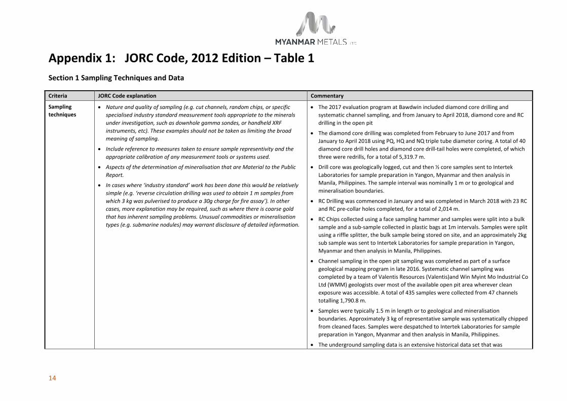
Appendix 1: JORC Code, 2012 Edition – Table 1 Section 1 Sampling Techniques and Data
Criteria JORC Code explanation Commentary
Sampling techniques
• Nature and quality of sampling (e.g. cut channels, random chips, or specific specialised industry standard measurement tools appropriate to the minerals under investigation, such as downhole gamma sondes, or handheld XRF instruments, etc). These examples should not be taken as limiting the broad meaning of sampling.
• Include reference to measures taken to ensure sample representivity and the appropriate calibration of any measurement tools or systems used.
• Aspects of the determination of mineralisation that are Material to the Public Report.
• In cases where ‘industry standard’ work has been done this would be relatively simple (e.g. ‘reverse circulation drilling was used to obtain 1 m samples from which 3 kg was pulverised to produce a 30g charge for fire assay’). In other cases, more explanation may be required, such as where there is coarse gold that has inherent sampling problems. Unusual commodities or mineralisation types (e.g. submarine nodules) may warrant disclosure of detailed information.
• The 2017 evaluation program at Bawdwin included diamond core drilling and systematic channel sampling, and from January to April 2018, diamond core and RC drilling in the open pit
• The diamond core drilling was completed from February to June 2017 and from January to April 2018 using PQ, HQ and NQ triple tube diameter coring. A total of 40 diamond core drill holes and diamond core drill-tail holes were completed, of which three were redrills, for a total of 5,319.7 m.
• Drill core was geologically logged, cut and then ½ core samples sent to Intertek Laboratories for sample preparation in Yangon, Myanmar and then analysis in Manila, Philippines. The sample interval was nominally 1 m or to geological and mineralisation boundaries.
• RC Drilling was commenced in January and was completed in March 2018 with 23 RC and RC pre-collar holes completed, for a total of 2,014 m.
• RC Chips collected using a face sampling hammer and samples were split into a bulk sample and a sub-sample collected in plastic bags at 1m intervals. Samples were split using a riffle splitter, the bulk sample being stored on site, and an approximately 2kg sub sample was sent to Intertek Laboratories for sample preparation in Yangon, Myanmar and then analysis in Manila, Philippines.
• Channel sampling in the open pit sampling was completed as part of a surface geological mapping program in late 2016. Systematic channel sampling was completed by a team of Valentis Resources (Valentis)and Win Myint Mo Industrial Co Ltd (WMM) geologists over most of the available open pit area wherever clean exposure was accessible. A total of 435 samples were collected from 47 channels totalling 1,790.8 m.
• Samples were typically 1.5 m in length or to geological and mineralisation boundaries. Approximately 3 kg of representative sample was systematically chipped from cleaned faces. Samples were despatched to Intertek Laboratories for sample preparation in Yangon, Myanmar and then analysis in Manila, Philippines.
• The underground sampling data is an extensive historical data set that was

15
Criteria JORC Code explanation Commentary completed as part of mine development activities. The data set comprises systematic sampling from development drives, crosscuts, ore drives and exploration drives. This data date largely from the 1930s until the 1980s and utilised consistent sampling and analytical protocols through the mine history. Sampling consisted of 2-inch (5 cm) hammer/chisel cut continuous channels sampled at 5 feet (1.5 m) intervals at waist-height along both walls of across-strike drives and across the backs of strike drives. Sample weights were around 5 pounds (2.3 kg) were analysed at the Bawdwin Mine site laboratory using chemical titration methods. Results were recorded in ledgers. Averaged results from each wall of the exploration cross-cuts were recorded on the level plans.
Drilling techniques
• Drill type (e.g. core, reverse circulation, open-hole hammer, rotary air blast, auger, Bangka, sonic, etc) and details (e.g. core diameter, triple or standard tube, depth of diamond tails, face-sampling bit or other type, whether core is oriented and if so, by what method, etc).
• Drilling in both 2017 and 2018 was completed by Titeline Valentis Drilling Myanmar (TVDM) using two Elton 500 drill rigs. Drilling is a combination of triple tubed PQ, HQ and NQ diameter diamond coring. Holes were typically collared in PQ, then reduced to HQ around 50 m, and later to NQ if drilling conditions dictated. Holes ranged from 63.4 m to 260.1 m depth.
• Attempts were made to orientate the core, but the ground was highly fractured and broken with short drilling runs. Obtaining consistently meaningful orientation data was very difficult.
• Titeline Valentis Drilling Myanmar (‘TVDM’) subcontracted a Hanjin DB30 multi-purpose drill rig for the RC drilling of nominal six-inch diameter holes.
Drill sample recovery
• Method of recording and assessing core and chip sample recoveries and results assessed.
• Measures taken to maximise sample recovery and ensure representative nature of the samples.
• Whether a relationship exists between sample recovery and grade and whether sample bias may have occurred due to preferential loss/gain of fine/coarse material.
• To maximise core recovery, triple tube PQ, HQ and NQ core drilling was used, with the drilling utilising TVDM drillers experienced in drilling difficult ground conditions. Drill penetration rates and water pressure were closely monitored to maximise recovery.
• During the diamond drilling the length of each drill run and the length of sample recovered was recorded by the driller (driller’s recovery). The recovered sample length was cross checked by the geologists logging the drill core and recorded as the final recovery.
• Core recoveries were variable and often poor with a mean of 80% and a median of 87%, with lowest recoveries in the 10% to 30% range. Low recoveries reflect poor ground conditions and previously mined areas. Core recoveries were reviewed, and two intervals were excluded due to very poor recovery.
• At present, no relationships between sample recovery and grade bias due to loss/gain of fines or washing away of clay material has been identified. It is assumed

16
Criteria JORC Code explanation Commentary that the grade of lost material is similar to the grade of the recovered core.
• RC Drilling was conducted to maintain sample recoveries. Where voids or stopes were intersected recoveries were reduced, and such occurrences were recorded by the supervising geologist.
• For channel chip sampling, every effort was made to sample systematically across each sample interval with sampling completed by trained geologists.
Logging • Whether core and chip samples have been geologically and geotechnically logged to a level of detail to support appropriate Mineral Resource estimation, mining studies and metallurgical studies.
• Whether logging is qualitative or quantitative in nature. Core (or costean, channel, etc) photography.
• The total length and percentage of the relevant intersections logged.
• All diamond core samples were geologically logged in a high level of detail down to a centimetre scale. Quantitative logging for lithology, stratigraphy, texture, hardness, RQD and defects was conducted using defined logging codes. Colour and any other additional qualitative comments are also recorded.
• All RC samples were geologically logged for lithology, alteration and weathering by Geologists. A small sub sample was collected for each metre and placed into plastic chip tray for future reference.
• The 2016 open pit channel rock samples were systematically geologically logged and recorded on sample traverse sheets.
• All drill core and open pit sampling locations were digitally photographed.
• The underground sampling data has no geological logging, however geological mapping was completed along the exploration drives and is recorded on level plans. Historical plan and section geological interpretations have been used in these areas to assist in geological model development.

17
Criteria JORC Code explanation Commentary
Subsampling techniques and sample preparation
• If core, whether cut or sawn and whether quarter, half or all core taken.
• If non-core, whether riffled, tube sampled, rotary split, etc and whether sampled wet or dry.
• For all sample types, the nature, quality and appropriateness of the sample preparation technique.
• Quality control procedures adopted for all sub-sampling stages to maximise representivity of samples.
• Measures taken to ensure that the sampling is representative of the in-situ material collected, including for instance results for field duplicate/second-half sampling.
• Whether sample sizes are appropriate to the grain size of the material being sampled.
• All core was half-core sampled. Most core was cut using an electric diamond saw and some more friable intervals were split manually. All core for sampling was pre-marked with the cut line, and only the left-hand side of the core was sent for assay to maintain consistency.
• The core sampling intervals were generally at one metre intervals which were refined to match logged lithology and geological boundaries. A minimum sample length of 0.5 m was used.
• RC samples were collected in plastic bags at 1m intervals from a cyclone located adjacent to the drill rig. Valentis field staff passed the bulk sample through a riffle splitter to produce a nominal 2kg sub sample.
• Given the nature of the RC drilling to pulverise the sample into small chips riffle splitting the sample is an appropriate technique for a sulphide base metal deposit. The 2kg sub-sample was deemed an appropriate sample size for submittal to the laboratory.
• No sub-splitting of the open pit chips samples was undertaken. Sample lengths ranged from 1 m to 2 m (typically 1.5 m). Sample intervals were refined to match geological boundaries.
• The historical underground samples do not appear to have been sub-split.
Quality of assay data and laboratory tests
• The nature, quality and appropriateness of the assaying and laboratory procedures used and whether the technique is considered partial or total.
• For geophysical tools, spectrometers, handheld XRF instruments, etc, the parameters used in determining the analysis including instrument make and model, reading times, calibrations factors applied and their derivation, etc.
• Nature of quality control procedures adopted (e.g. standards, blanks, duplicates, external laboratory checks) and whether acceptable levels of accuracy (i.e. lack of bias) and precision have been established.
• The diamond drilling, RC samples and open pit channel samples were all sent to Intertek Laboratories in Yangon for sample preparation.
• All samples were dried and weighed and crushed to in a Boyd Crusher. A representative split of 1.5 kg was then pulverised in a LM5 pulveriser. A 200 g subsample pulp was then riffle split from the pulverised sample. The crusher residue and pulverised pulp residue were stored at the Yangon laboratory.
• Sample pulps were sent to the Intertek analytical facility in Manila, Philippines where they were analysed in 2017 using ICP-OES – Ore grade four-acid digestion. Elements analysed were Ag, Fe, Cd, Co, Ni, Pb, Cu, Mn, S and Zn. In 2018, ICP-OES – Ore grade four-acid digestion continued to be employed, along with additional multi-element analysis of 46 elements using four-acid standard ICP-OES and MS.
• Quality control (QC) samples were submitted with each assay batch (certified reference standards, certified reference standard blanks and duplicate samples). The Laboratory inserted their own quality assurance/quality control (QAQC) samples as part of their internal QAQC. All assay results returned were of acceptable quality
18
Criteria JORC Code explanation Commentary based on assessment of the QAQC assays.
• The underground data was assayed by the Bawdwin mine laboratory on site. Bulk samples were crushed in a jaw crusher, mixed, coned and quartered. Two 100 g samples were then dried and crushed in a ring mill to approximately 100 mesh. Two 0.5 g homogenised samples were taken for lead and zinc titration using Aqua Regia (Pb) and Nitric acid (Zn). RSG inspected the laboratory in 1996 and noted it to be “clean, and great pride is taken in the conditions and quality of the work”. The laboratory remains operational and CSA Global’s review in 2017 reached similar conclusions to RSG. Results for Zn and Pb were reported to 0.1%.
• There is no QAQC data for the historical underground sampling data.

19
Criteria JORC Code explanation Commentary
Verification of sampling and assaying
• The verification of significant intersections by either independent or alternative company personnel.
• The use of twinned holes.
• Documentation of primary data, data entry procedures, data verification, data storage (physical and electronic) protocols.
• Discuss any adjustment to assay data.
• All diamond drill core samples were checked, measured and marked up before logging in a high level of detail.
• RC Samples were sampled and logged at the drill rig. A small sub-sample from each metre was placed into a plastic ship tray to allow re-logging if required.
• The diamond and RC drilling, sampling and geological data were recorded into standardised templates in Microsoft Excel by the logging/sampling geologists.
• Geological logs and associated data were cross checked by the supervising Project Geologist
• Laboratory assay results were individually reviewed by sample batch and the QAQC data integrity checked before uploading.
• All geological and assay data were uploaded into a Datased database.
• The Datashed database was loaded into Micromine mining software. This data was then validated for integrity visually and by running systematic checks for any errors in sample intervals, out of range values and other important variations.
• All drill core was photographed with corrected depth measurements before sampling.
• No specific twin holes were drilled; however, three daughter holes were inadvertently cut due to challenging drilling conditions during re-entry through collapsed ground. and intersected mineralisation of very similar tenor and grade to the parent hole.
• Historical underground sampling data was captured off hard copy mine assay level plans. These plans show the development drives on the level along with the sampling traverse locations and Ag, Pb, Zn and Cu values. This process involved the systematic digital scanning of the various mine assay level hard copy plans, along with manual data entry of the assay intervals and assay results by Project Geologists and assistants. Coordinates of sampling traverse locations were scaled off the plans (in the local Bawdwin Mine Grid). Data was collated into spreadsheets and then uploaded into Micromine. Sampling traverses were loaded as horizontal drill holes. The channel samples were systematically visually checked in Micromine against the georeferenced mine assay plans. The data was further validated by running systematic checks for any errors in sample intervals, out of range values and other important variations. Any data that was illegible or could not be accurately located was removed from the database. Underground channel sample databases were made for the Shan, China and Meingtha lodes and associated mine development. These were later uploaded into a master Access database.
20
Criteria JORC Code explanation Commentary
Location of data points
• Accuracy and quality of surveys used to locate drill holes (collar and down-hole surveys), trenches, mine workings and other locations used in Mineral Resource estimation.
• Specification of the grid system used.
• Quality and adequacy of topographic control.
• The diamond drilling, RC drilling and pit mapping and channel sampling all utilised UTM WGS84 datum Zone 47 North.
• All diamond drill holes and pit mapping sampling traverse locations were surveyed using a Differential Global Positioning System (DGPS). The DGPS is considered to have better than 0.5 m accuracy.
• All diamond drill holes have downhole surveys. These were taken using a digital single shot camera typically taken every 30 metres.
• The RC Holes were surveyed in the rods every 30m, however because of interference from the steel only dips could be recorded
• Historically the underground and open pit mines operated in a local survey grid, the “Bawdwin Mine Grid”. This grid is measured in feet with the Marmion Shaft as its datum. A plane 2D transformation was developed to transform data between the local Bawdwin Mine Grid and UTM using surveyed reference points.
• Historical mine plans and sections were all georeferenced using the local Bawdwin Mine grid. The outlines of stopes, underground sample locations, basic geology and other useful information was all digitised in the local mine grid. This was later translated to UTM for use in geological and resource modelling.
• The historical underground channel sampling data is scaled off historical A0 paper and velum mine plans which may have some minor distortion due to their age.
• The underground sampling locations were by marked tape from the midpoint of intersecting drives as a reference. They appear to be of acceptable accuracy.
• Historically within the mine each level has a nominal Bawdwin grid elevation (in feet) which was traditionally assumed to be the elevation for the entire level. It is likely that these levels may be inclined for drainage so there is likely to be some minor differences in true elevation (<5 m).
• The topography used for the estimate was based on a GPS drone survey completed by Valentis. This is assumed to have <1 m accuracy and it was calibrated against the Bawdwin Mine UTM survey of the open pit area and surveyed drill-hole collars. This survey is of appropriate accuracy for the stage of the project.
Data spacing and distribution
• Data spacing for reporting of Exploration Results.
• Whether the data spacing and distribution is sufficient to establish the degree of geological and grade continuity appropriate for the Mineral Resource and Ore
• The diamond and RC drill holes completed at the open pit are spaced on approximately 50 m spaced sections and were designed to provide systematic coverage along the strike/dip of the China Lode. Three diamond drill holes were drilled at the Meingtha Lode on 50 m spaced sections and two diamond holes drilled

21
Criteria JORC Code explanation Commentary Reserve estimation procedure(s) and classifications applied.
• Whether sample compositing has been applied.
at the Shan Lode on 100 m spaced sections.
• The open pit sampling was done on accessible berms and ramps. These traverses range from 10 m to 30 m apart.
• The historical underground samples are generally taken from systematic ore development crosscuts. These are typically on 50 to 100 feet spacings – 15 m to 30 m. Strike drives along mineralised lodes demonstrate continuity.
Orientation of data in relation to geological structure
• Whether the orientation of sampling achieves unbiased sampling of possible structures and the extent to which this is known, considering the deposit type.
• If the relationship between the drilling orientation and the orientation of key mineralised structures is considered to have introduced a sampling bias, this should be assessed and reported if material.
• Drill holes were generally drilled on 065 azimuth (true) which is perpendicular to the main north and north-northeast striking lodes. Holes were generally inclined at -50° to horizontal. Some holes were also drilled on 245 azimuth (true) because of access difficulties due to topography and infrastructure.
• The drilling orientation is not believed to have caused any systematic sampling bias. Where drill direction was less than optimal, the geological model will be used to qualify the mineralised intersections.
• The open pit channel sampling sample traverses were orientated perpendicular to the main trend of mineralisation where possible. However, due to the orientation of the pit walls in many areas, sampling traverse are at an oblique angle to the main mineralised trend.
• Underground sampling data consists largely of cross strike drives which are orientated perpendicular to the steeply dipping lodes. The dataset also contains sampling from a number of along-strike ore drives. These drives are generally included within the modelled lodes which have hard boundaries to mitigate any smearing into neighbouring halo domains.
Sample security • The measures taken to ensure sample security. • Drill core was taken twice daily from the drill rig, immediately following completion of day shift and night shift respectively.
• Core was transported to the core facility where it was logged and sampled.
• RC samples were collected from the rig upon hole completion.
• Samples were bagged and periodically sent to the Intertek laboratory in Yangon for preparation. All samples were delivered by a Valentis geologist to Lashio then transported to Yangon on express bus as consigned freight. The samples were secured in the freight hold of the bus by the Valentis geologist. The samples collected on arrival in Yangon by a Valentis driver and delivered to the Intertek laboratory.
Audits or • The results of any audits or reviews of sampling techniques and data. • Integrity of all data (drill hole, geological, assay) was reviewed before being incorporated into the database system.

22
Criteria JORC Code explanation Commentary reviews • No external reviews have been completed.
Section 2 Reporting of Exploration Results (Criteria listed in the preceding section also apply to this section)
Criteria JORC Code explanation Commentary
Mineral tenement and land tenure status
• Type, reference name/number, location and ownership including agreements or material issues with third parties such as joint ventures, partnerships, overriding royalties, native title interests, historical sites, wilderness or national park and environmental settings.
• The security of the tenure held at the time of reporting along with any known impediments to obtaining a licence to operate in the area.
• The Bawdwin Mine is in NE Shan State, Myanmar.
• The project owner is Win Myint Mo Industries Co Ltd (WMM) who hold a Mining Concession which covers some approximately 38 km2.
• WMM has a current Production-sharing Agreement with the Myanmar Government.
• Myanmar Metals Limited (MYL) holds an exclusive six-month option agreement with WMM, which can be extended to 12 months, under which it can acquire an 85% interest in the Project from WMM subject to approval by the Myanmar government.
Exploration done by other parties
• Acknowledgment and appraisal of exploration by other parties. • The Bawdwin Mine was operated as an underground and open pit base metal (Pb, Zn, Ag, Cu) mine from 1914 until 2009.
• The only modern study on the mine was completed by Resource Service Group (RSG) in 1996 for Mandalay Mining. RSG compiled the historical underground data and completed a JORC (1995) Mineral Resource estimate. The digital data for this work was not located and only the hardcopy report exists.
Geology • Deposit type, geological setting and style of mineralisation. • The Bawdwin deposit is hosted in volcanic (Bawdwin Tuff), intrusive (Lo Min Porphyry) and sedimentary (Pangyun Formation) rocks of late Cambrian to early Ordovician age.
• The historical mine was based on three high-grade massive Pb-Zn-Ag-Cu sulphide lodes, the Shan, China and Meingtha lodes. These lodes were considered to be formed as one lode and are now offset by two major faults the Hsenwi and Yunnan faults.
• The major sulphides are galena and sphalerite with lesser amounts of pyrite, chalcopyrite, covellite, gersdorffite, boulangerite, and cobaltite amongst other minerals.
• The lodes are steeply-dipping structurally-controlled zones and each lode incorporated anastomosing segments and footwall splays.
• The lodes occur within highly altered Bawdwin Tuff which hosts extensive stockwork and disseminated mineralisation as well as narrow massive sulphide lodes along structures. This halo mineralisation is best developed in the footwall of the largest China Lode.
• The main central part of the mineralised system is approximately 2 km in length by

23
Criteria JORC Code explanation Commentary 400 m width, while ancient workings occur over a strike length of about 3.5 km.
• The upper portion of the China Lode was originally covered by a large gossan which has been largely mined as part of the earlier open pit. The current pit has a copper oxide zone exposed in the upper parts, transitional sulphide mineralisation in the central areas and fresh sulphide mineralisation near the base of the pit.
• The Bawdwin deposit is interpreted as a structurally-controlled magmatic-hydrothermal replacement deposit emplaced within a rhyolitic volcanic centre.
Drillhole information
• A summary of all information material to the understanding of the exploration results including a tabulation of the following information for all Material drillholes:
o easting and northing of the drillhole collar
o elevation or RL (Reduced Level – elevation above sea level in metres) of the drillhole collar
o dip and azimuth of the hole
o downhole length and interception depth
o hole length.
• If the exclusion of this information is justified on the basis that the information is not Material and this exclusion does not detract from the understanding of the report, the Competent Person should clearly explain why this is the case.
• In Company’s opinion, this material has been adequately reported in previous announcements and the detail is not relevant for reporting of Mineral Resources.
Data aggregation methods
• In reporting Exploration Results, weighting averaging techniques, maximum and/or minimum grade truncations (e.g. cutting of high grades) and cut-off grades are usually Material and should be stated.
• Where aggregate intercepts incorporate short lengths of high grade results and longer lengths of low grade results, the procedure used for such aggregation should be stated and some typical examples of such aggregations should be shown in detail.
• The assumptions used for any reporting of metal equivalent values should be clearly stated.
• Exploration results are not being reported.
Relationship between mineralisation
• These relationships are particularly important in the reporting of Exploration Results.
• If the geometry of the mineralisation with respect to the drillhole angle is
• Exploration results are not being reported.

24
Criteria JORC Code explanation Commentary widths and intercept lengths
known, its nature should be reported.
• If it is not known and only the downhole lengths are reported, there should be a clear statement to this effect (e.g. ‘downhole length, true width not known’).
Diagrams • Appropriate maps and sections (with scales) and tabulations of intercepts should be included for any significant discovery being reported These should include, but not be limited to a plan view of drill hole collar locations and appropriate sectional views.
• Diagrams that are relevant to this release have been included in the main body of the document.
Balanced reporting
• Where comprehensive reporting of all Exploration Results is not practicable, representative reporting of both low and high grades and/or widths should be practiced to avoid misleading reporting of Exploration Results.
• Exploration results are not being reported.
Other substantive exploration data
• Other exploration data, if meaningful and material, should be reported including (but not limited to): geological observations; geophysical survey results; geochemical survey results; bulk samples – size and method of treatment; metallurgical test results; bulk density, groundwater, geotechnical and rock characteristics; potential deleterious or contaminating substances.
• In Company’s opinion, this material has been adequately reported in previous announcements and the detail is not relevant for reporting of Mineral Resources.
Further work • The nature and scale of planned further work (e.g. tests for lateral extensions or depth extensions or large-scale step-out drilling).
• Diagrams clearly highlighting the areas of possible extensions, including the main geological interpretations and future drilling areas, provided this information is not commercially sensitive.
• The details of additional work programmes will be determined by the results of the Scoping Study that is currently underway.
• It is envisaged that a substantial drilling program will be undertaken to improve confidence in the Mineral Resource and to test extension targets, supported by geology, geochemistry and geophysics.
Section 3: Estimation and Reporting of Mineral Resources (Criteria listed in section 1, and where relevant in section 2, also apply to this section)
Criteria JORC Code explanation Commentary
Database integrity
• Measures taken to ensure that data has not been corrupted by, for example, transcription or keying errors, between its initial collection and its use for Mineral Resource estimation purposes.
• Data validation procedures used.
• All historical underground drive sampling data was compiled into a Microsoft Access database.
• Diamond and RC drilling sampling, and open pit sampling data was also compiled into a Datashed database.
• Data was exported as Micromine tables and drilling/underground sampling databases constructed. These were validated in Micromine for inconsistencies, overlapping intervals, out of range values, and other important items.
25
Criteria JORC Code explanation Commentary
• All data was visually checked.
Site visits • Comment on any site visits undertaken by the Competent Person and the outcome of those visits.
• If no site visits have been undertaken indicate why this is the case.
• Dr Neal Reynolds, a director of CSA Global, conducted site visits to the project area in August 2017, October 2017 and May 2018. Although drilling was not underway, drill collars were observed and checked, drill core was examined and mineralisation in the open pit was observed. The historical systematic documentation of mining and exploration development, sampling and assaying was confirmed, and the assay laboratory was visited during 2017 visits.
Geological interpretation
• Confidence in (or conversely, the uncertainty of) the geological interpretation of the mineral deposit.
• Nature of the data used and of any assumptions made.
• The effect, if any, of alternative interpretations on Mineral Resource estimation.
• The use of geology in guiding and controlling Mineral Resource estimation.
• The factors affecting continuity both of grade and geology.
• The Bawdwin Mine has a long underground and open pit mining history. The geological interpretation used for the resource estimate is based on historical sectional and plan underground geology interpretations and recent open pit mapping and new diamond and RC drilling information. Stoped areas were also modelled and these provide a useful guide to the geometry and orientation of the major lodes. This data has been used to create a wireframed 3D model of geology, structure and mineralisation.
• Underground and open pit channel sampling, drill-hole assay results have formed the basis for the geological interpretation.
• The major lodes were modelled in Micromine primarily in plan view and additionally in section view to integrate drill-hole data. 3.5% Pb cut-off grade was applied for interpretation of the major lodes.
• Surrounding the major lodes, a “halo” zone was modelled based on 0.5% Pb cut-off grade and represents an alteration envelope around the high-grade lodes.
• A separate copper resource estimate was completed independently due the low correlation between Pb and Cu. 1% Cu cut-off grade was applied for interpretation of the copper mineralisation
• No alternate interpretations have been considered as the overall geometry of the mineralisation is generally well understood.
• The grade and to a lesser degree lithological interpretation forms the basis for the modelling.
Dimensions • The extent and variability of the Mineral Resource expressed as length (along strike or otherwise), plan width, and depth below surface to the upper and lower limits of the Mineral Resource.
• The currently interpreted mineralisation of the Bawdwin area extends for approximately 1.8 km along a 325° northwest strike. The dip angle of the zone varies from -70° to -90° with most common dip angle at -80°. The zone extends from surface to 475 m below the surface.
Estimation and modelling
• The nature and appropriateness of the estimation technique(s) applied and key assumptions, including treatment of extreme grade values, domaining,
• Grade estimation was by ordinary kriging (OK) using Micromine 2016.1 software. The interpretation was extended perpendicular to the corresponding first and last

26
Criteria JORC Code explanation Commentary techniques interpolation parameters and maximum distance of extrapolation from data
points. If a computer assisted estimation method was chosen include a description of computer software and parameters used.
• The availability of check estimates, previous estimates and/or mine production records and whether the Mineral Resource estimate takes appropriate account of such data.
• The assumptions made regarding recovery of by-products.
• Estimation of deleterious elements or other non-grade variables of economic significance (e.g. Sulphur for acid mine drainage characterisation).
• In the case of block model interpolation, the block size in relation to the average sample spacing and the search employed.
• Any assumptions behind modelling of selective mining units.
interpreted plan levels to the distance equal to a half distance between the adjacent underground levels.
• CSA Global carried out the reported Mineral Resource estimate in April to May 2018.
• The OK estimate was completed concurrently with two check Inverse Distance Weighting (IDW) estimates. The OK estimate used the parameters obtained from the modelled variograms. The results of the check estimates correlate well.
• No deleterious or non-grade variables were estimated.
• The block model was constructed using a 5 m E x 10 m N x 10 m RL parent block size, with sub-celling to 1 m E x 2 m N x 2 m RL for domain volume resolution. The parent cell size was chosen on the basis of the general morphology of mineralised zones and in order to avoid the generation of large block models. The sub-cell size was chosen to maintain the resolution of the mineralised zones. The sub-cells were optimised in the models where possible to form larger cells.
• The search radii were determined by means of the evaluation of the semi-variogram parameters.
• The first search radius was selected to be equal to the block size dimensions to use the grades from the workings that intercepted the block. The second search radius was selected to be equal to two thirds of the semi-variogram long ranges in all directions. Model cells that did not receive a grade estimate from the first interpolation run were used in the next interpolation with greater search radii equal to full long semi-variogram ranges in all directions. The model cells that did not receive grades from the first three runs were then estimated using radii incremented by the full long semi-variogram ranges. When model cells were estimated using radii not exceeding the five full semi-variogram ranges, a restriction of at least three samples from at least two drill holes was applied to increase the reliability of the estimates.
• No selective mining units were assumed in this estimate.
27
Criteria JORC Code explanation Commentary
Estimation and modelling techniques (continued)
• Any assumptions about correlation between variables.
• Description of how the geological interpretation was used to control the resource estimates.
• Discussion of basis for using or not using grade cutting or capping.
• The process of validation, the checking process used, the comparison of model data to drillhole data, and use of reconciliation data if available.
• No strong correlations were found between the grade variables estimated.
• Grade envelopes were defined for Pb based on 3.5% Pb grade to define high grade lodes and 0.5% Pb for the “Halo” zone. Hard boundaries between the grade envelopes were used to select sample populations for grade estimation.
• Grade envelopes were defined for Cu based on 1.0% Cu grade to define copper mineralisation.
• Statistical analysis to determine top cut grade values was carried out separately for each element (Pb, Zn, Cu, Ag) and separately for high grade lodes and the “Halo” zone.
• Validation of the block model included comparison of the block model volume to the wireframe volume. Grade estimates were validated by statistical comparison with the drill data, visual comparison of grade trends in the model with the drill data trends, and by using a second interpolation technique.
• No reconciliation data is available.
Moisture • Whether the tonnages are estimated on a dry basis or with natural moisture, and the method of determination of the moisture content.
• The tonnages are estimated on a dry basis
Cut-off parameters
• The basis of the adopted cut-off grade(s) or quality parameters applied. • The Mineral Resource above 750 m RL was reported at 2.0% Pb (reflecting the high grade core mineralisation and 0.5% Pb reflecting the pit optimisation which demonstrates potential for economic extraction in an open pit to this depth.
• A single cut-off grade of 2% Pb has been applied to the reported Mineral Resource below the 750 m RL that has potential for eventual economic extraction by underground mining.
• Cut-off grade of 0.5% Cu has been applied to the reported Mineral Resource to the copper mineralisation that lie outside of the Pb Halo zones.
Mining factors or assumptions
• Assumptions made regarding possible mining methods, minimum mining dimensions and internal (or, if applicable, external) mining dilution. It is always necessary as part of the process of determining reasonable prospects for eventual economic extraction to consider potential mining methods, but the assumptions made regarding mining methods and parameters when estimating Mineral Resources may not always be rigorous. Where this is the case, this should be reported with an explanation of the basis of the mining assumptions made.
• A Scoping Study including a pit optimisation is currently assessing the open pit development opportunity at Bawdwin. It is expected that deeper parts of the deposit will be amenable to underground mining.

28
Criteria JORC Code explanation Commentary
Metallurgical factors or assumptions
• The basis for assumptions or predictions regarding metallurgical amenability. It is always necessary as part of the process of determining reasonable prospects for eventual economic extraction to consider potential metallurgical methods, but the assumptions regarding metallurgical treatment processes and parameters made when reporting Mineral Resources may not always be rigorous. Where this is the case, this should be reported with an explanation of the basis of the metallurgical assumptions made.
• It is assumed that Pb, Zn, Cu and Ag sulphide mineralisation can all be economically extracted using conventional flotation methods. These were all produced historically at the Bawdwin Mine and Namtu Smelter Complex.
• The current metallurgical testing program being managed by CSA Global and Battery Limits is showing encouraging results in achieving acceptable metal recoveries via floatation and Dense Media Separation (DMS) in fresh and transitional material, however further testing is required using additional samples collected during the recent drilling program
• A modern metallurgical test work program is currently being carried out.
Environmental factors or assumptions
• Assumptions made regarding possible waste and process residue disposal options. It is always necessary as part of the process of determining reasonable prospects for eventual economic extraction to consider the potential environmental impacts of the mining and processing operation. While at this stage the determination of potential environmental impacts, particularly for a greenfields project, may not always be well advanced, the status of early consideration of these potential environmental impacts should be reported. Where these aspects have not been considered this should be reported with an explanation of the environmental assumptions made.
• Suitable sites for waste dumps are located in the neighbouring valleys east and west of the planned open pit area.
• The Pangyun creek that flows on the margins of the deposit will require a diversion for a large open pit.
• Ore processing sites are undergoing further evaluation but there are possible options to pump a slurry to Namtu along a pipeline following the old railway line to a new processing plant.
Bulk density • Whether assumed or determined. If assumed, the basis for the assumptions. If determined, the method used, whether wet or dry, the frequency of the measurements, the nature, size and representativeness of the samples.
• The bulk density for bulk material must have been measured by methods that adequately account for void spaces (vughs, porosity, etc), moisture and differences between rock and alteration zones within the deposit.
• Discuss assumptions for bulk density estimates used in the evaluation process of the different materials.
• A total of 1,073 bulk density measurements were taken from a suite of mineralised and un-mineralised drill core using conventional water immersion techniques.
• The bulk density of mineralisation increases with sulphide content and hence Pb, Zn and Cu metal grade.
• For mineralised lodes and halo mineralisation bulk density has been estimated using a formula which assumes Pb is present as galena, Zn is present as sphalerite and Cu is present as chalcopyrite, with the remainder of the rock is gangue. The estimated values were calibrated against the measured densities from drill-core.
• Based on the bulk density measurements a density of 2.0 was used for oxide ore, 2.2 for transitional ore, 2.40 for un-mineralised Bawdwin Tuff and 2.40 for Lo Min Porphyry.
Classification • The basis for the classification of the Mineral Resources into varying confidence categories.
• Whether appropriate account has been taken of all relevant factors (ie relative confidence in tonnage/grade estimations, reliability of input data, confidence in continuity of geology and metal values, quality, quantity and
• The Inferred Mineral Resource classification is based on the evidence from the available drill hole and channel sampling. This evidence is sufficient to imply but not verify geological and grade continuity. However, the areas with the denser drilling and robust continuation of the mineralised zones were classified as Indicated (where the new 2017 and 2018 drillholes were drilled).
29
Criteria JORC Code explanation Commentary distribution of the data).
• Whether the result appropriately reflects the Competent Person’s view of the deposit.
• The Inferred and Indicated classification has considered all available geological and sampling information, and the classification level is considered appropriate for the current stage of this project.
• The open pit mapping and diamond drilling all have been carried in accordance with modern industry best practice standards and have QAQC data to support the assay data. The historical underground sampling has no assay QAQC. The data quality is acceptable for the classification of Indicated in the areas with supporting drilling data.
• The overall structure of the major lodes is well understood from the underground data and open pit mapping.
• The Mineral Resource estimate appropriately reflects the view of the Competent Person.
Audits or reviews.
• The results of any audits or reviews of Mineral Resource estimates. • Internal audits were completed by CSA Global which verified the technical inputs, methodology, parameters and results of the estimate.
Discussion of relative accuracy/ confidence
• Where appropriate a statement of the relative accuracy and confidence level in the Mineral Resource estimate using an approach or procedure deemed appropriate by the Competent Person. For example, the application of statistical or geostatistical procedures to quantify the relative accuracy of the resource within stated confidence limits, or, if such an approach is not deemed appropriate, a qualitative discussion of the factors that could affect the relative accuracy and confidence of the estimate.
• The statement should specify whether it relates to global or local estimates, and, if local, state the relevant tonnages, which should be relevant to technical and economic evaluation. Documentation should include assumptions made and the procedures used.
• These statements of relative accuracy and confidence of the estimate should be compared with production data, where available.
• The relative accuracy of the Mineral Resource estimate is reflected in the reporting of the Mineral Resource to an Indicated and Inferred classification as per the guidelines of the 2012 JORC Code.
• The statement refers to global estimation of tonnes and grade.