upper cook inlet basin - alaskadoa.alaska.gov/ogc/reports-studies/energyforum/06_ppt_pdfs/25... ·...
TRANSCRIPT
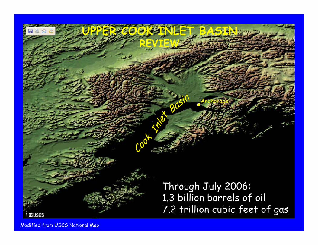
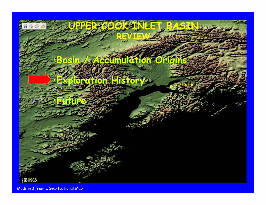
UPPER COOK INLET BASINREVIEW
Anchorage
Cook
Inlet
Basin
Through July 2006: 1.3 billion barrels of oil7.2 trillion cubic feet of gas
Modified from USGS National Map

•Basin / Accumulation Origins
•Exploration History
•Future
•Basin / Accumulation Origins
•Exploration History
•Future
•Basin / Accumulation Origins
•Exploration History
•Future
Anchorage
UPPER COOK INLET BASINREVIEW
Modified from USGS National Map
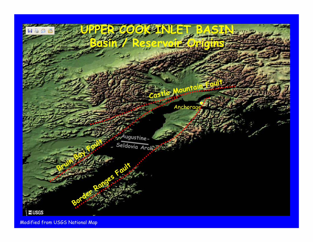
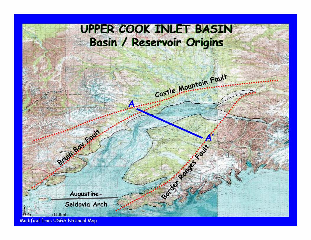
UPPER COOK INLET BASINBasin / Reservoir Origins
Anchorage
Castle Mountain
Fault
Bruin B
ay Fau
lt
Border
Range
s Faul
t
Augustine-Seldovia Arch
Modified from USGS National Map
Anchorage
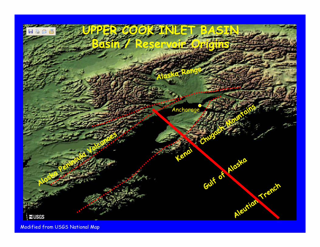
Alaska Range
Alaska
Penin
sula Vo
lcanoe
s
Kenai
- Chugac
h Moun
tains
Aleuti
an Tre
nch
UPPER COOK INLET BASINBasin / Reservoir Origins
Modified from USGS National Map
Gulf o
f Alas
ka

Modified from:Tornqvist, T., 2005, Principles of Sedimentology and Stratigraphy, University of Chicago, http://www.uic.edu/classes/geol/eaes350/
UPPER COOK INLET BASINBasin / Reservoir OriginsNW SE
Forearc Basin
AccretionaryPrism
Volcanic Arc
Trench
Subduction Z
onePacific PlateN.A. Plate
0
50
100
Miles
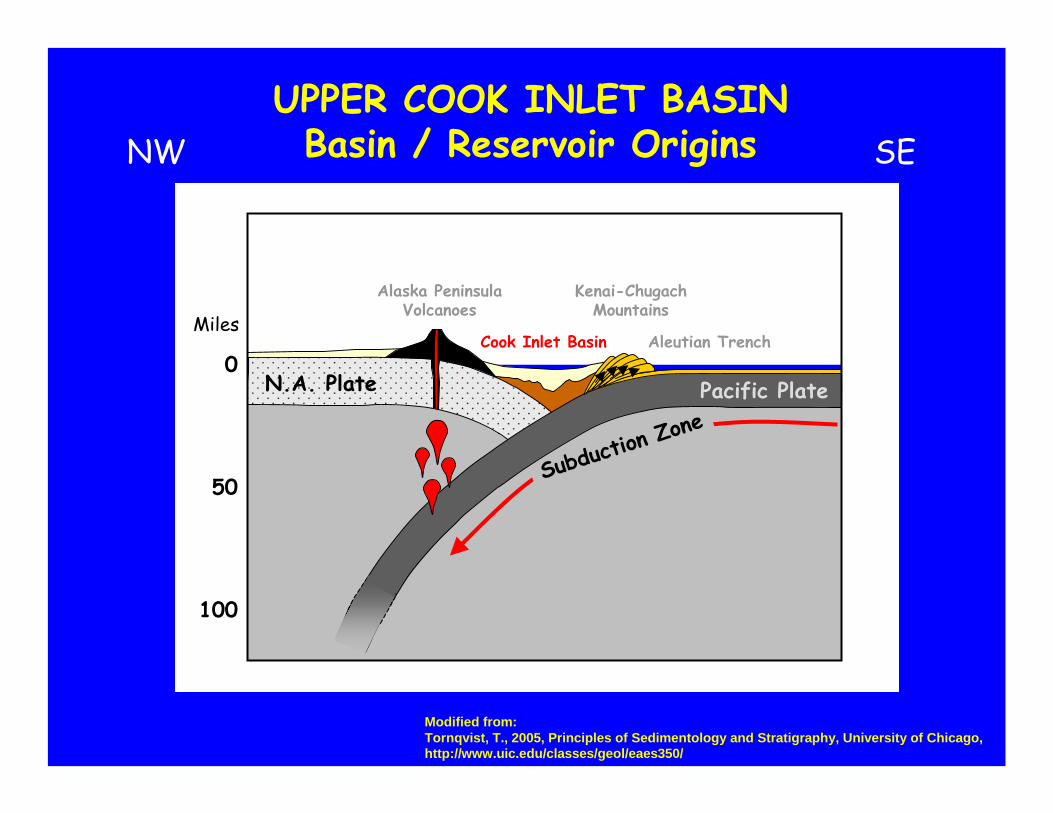
Modified from:Tornqvist, T., 2005, Principles of Sedimentology and Stratigraphy, University of Chicago, http://www.uic.edu/classes/geol/eaes350/
UPPER COOK INLET BASINBasin / Reservoir OriginsNW SE
Subduction Z
onePacific PlateN.A. Plate
0
50
100
MilesCook Inlet Basin
Kenai-ChugachMountains
Alaska PeninsulaVolcanoes
Aleutian Trench
UPPER COOK INLET BASINBasin / Reservoir Origins
UPPER COOK INLET BASINBasin / Reservoir Origins
Castle Mountai
n Fault
Bruin
Bay F
ault
Border Ranges Fa
ultAugustine-
Seldovia Arch
A
A’
Modified from USGS National Map
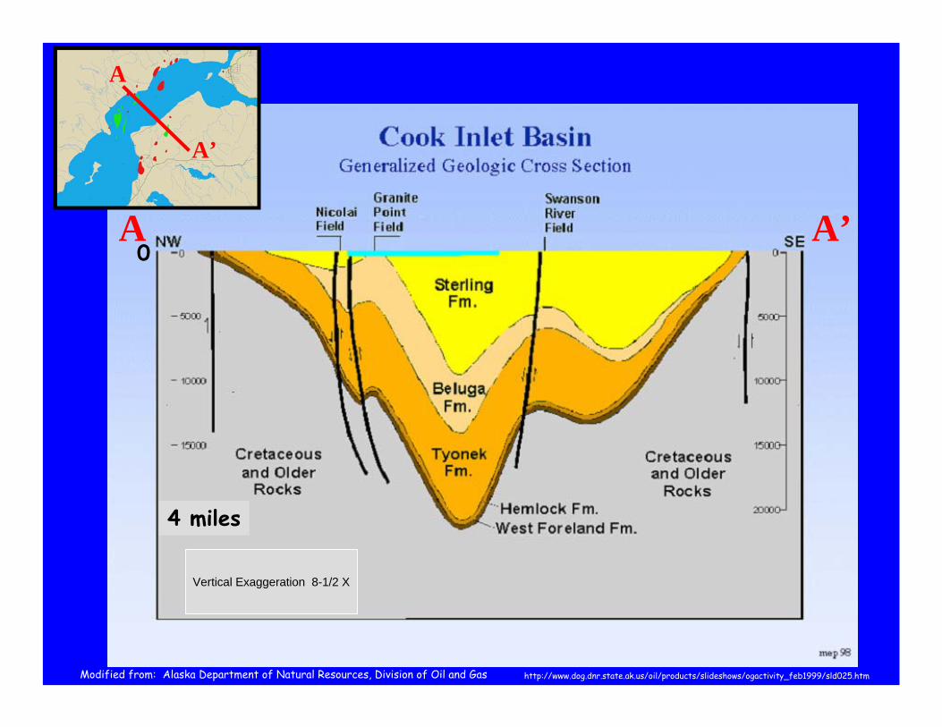
A A’
A
A’
Vertical Exaggeration 8-1/2 X
0
4 miles
http://www.dog.dnr.state.ak.us/oil/products/slideshows/ogactivity_feb1999/sld025.htmModified from: Alaska Department of Natural Resources, Division of Oil and Gas
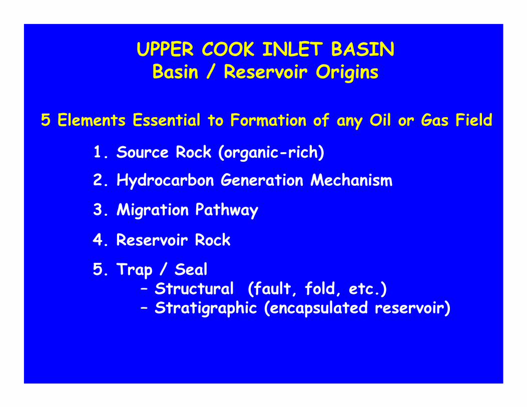
5. Trap / Seal– Structural (fault, fold, etc.)– Stratigraphic (encapsulated reservoir)
UPPER COOK INLET BASINBasin / Reservoir Origins
5 Elements Essential to Formation of any Oil or Gas Field
1. Source Rock (organic-rich)
2. Hydrocarbon Generation Mechanism
3. Migration Pathway
4. Reservoir Rock
UPPER COOK INLET BASINBasin / Reservoir Origins
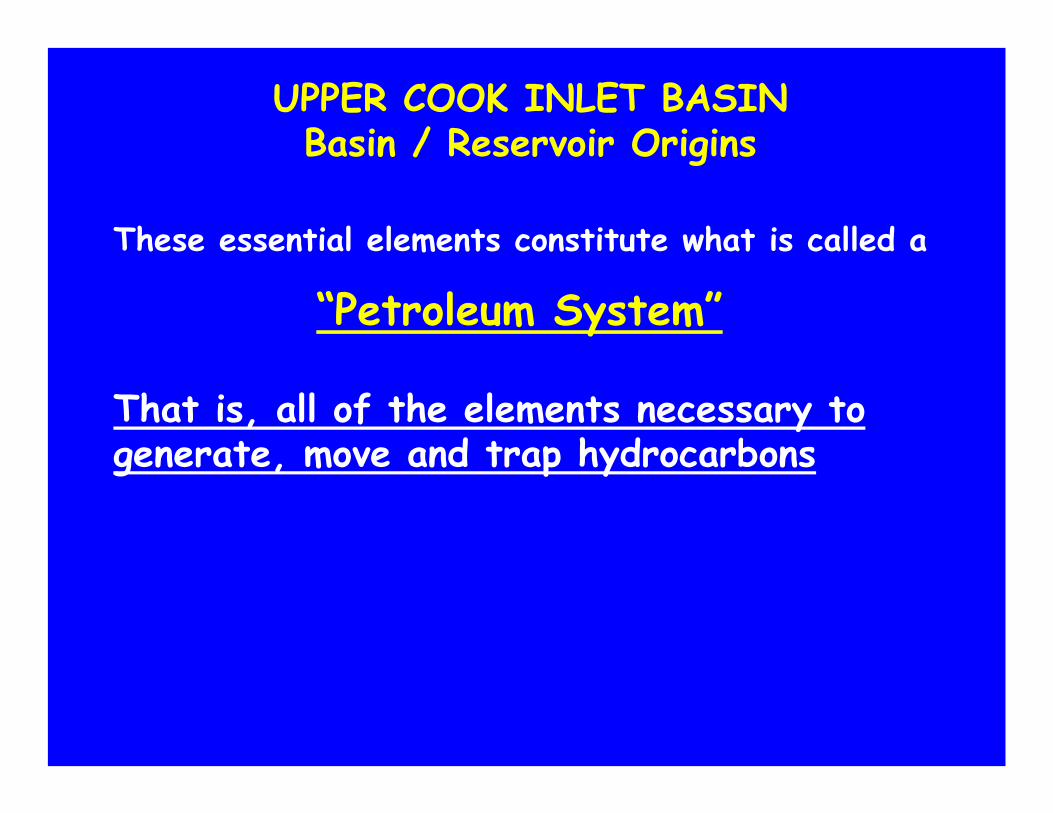
These essential elements constitute what is called a
“Petroleum System”
That is, all of the elements necessary to generate, move and trap hydrocarbons

UPPER COOK INLET BASINBasin / Reservoir Origins
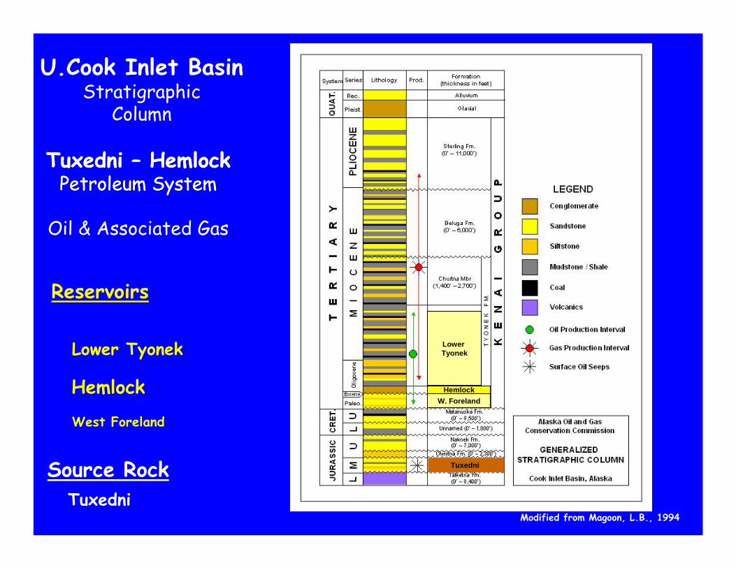
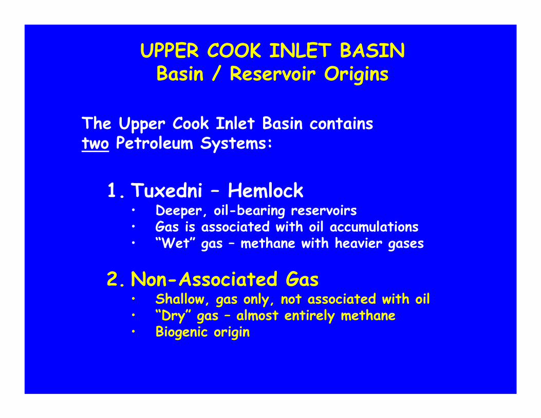
The Upper Cook Inlet Basin contains two Petroleum Systems:
1. Tuxedni – Hemlock • Deeper, oil-bearing reservoirs• Gas is associated with oil accumulations• “Wet” gas – methane with heavier gases
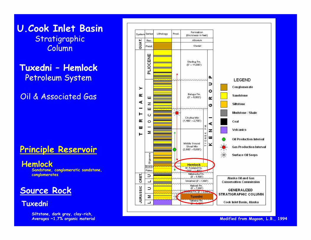
Siltstone, dark gray, clay-rich, Averages ~1.7% organic material
Principle Reservoir
Tuxedni
Hemlock
Tuxedni – HemlockPetroleum System
Tuxedni – HemlockPetroleum System
Oil & Associated Gas
Tuxedni
Tyonek
W ForelandHemlock
U.Cook Inlet BasinStratigraphic
Column
Tuxedni
Sandstone, conglomeratic sandstone,conglomerates
Source Rock
Hemlock
Modified from Magoon, L.B., 1994
TuxedniSiltstone, dark gray, clay-rich, Averages ~1.7% organic material
Hemlock
Conglomerate, sandstone, siltstone
TyonekMassively bedded sandstones with siltstone & thick, continuous coals
Tuxedni – HemlockPetroleum System
Secondary Reservoirs
West Foreland
Tuxedni – HemlockPetroleum System
Oil & Associated Gas
U.Cook Inlet BasinStratigraphic
Column
W. Foreland
LowerTyonek
Source Rock
Modified from Magoon, L.B., 1994
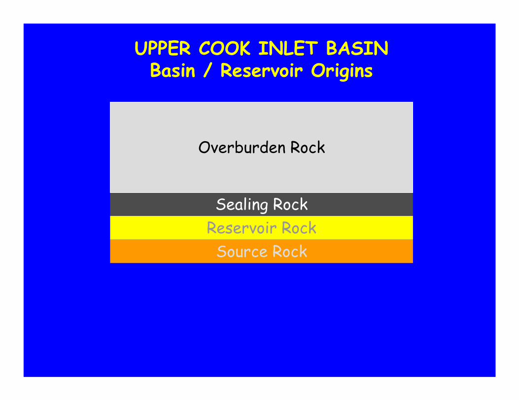
UPPER COOK INLET BASINBasin / Reservoir Origins
Sealing Rock
Source RockReservoir Rock
Overburden Rock
COOK INLET BASINBasin / Reservoir Origins
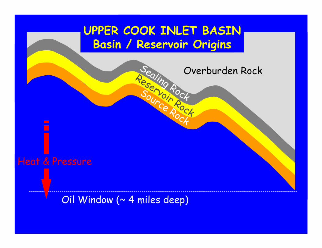
UPPER COOK INLET BASINBasin / Reservoir Origins
Overburden RockSealing Rock
Reservoir Rock
Source Rock
Oil Window (~ 4 miles deep)
Heat & Pressure
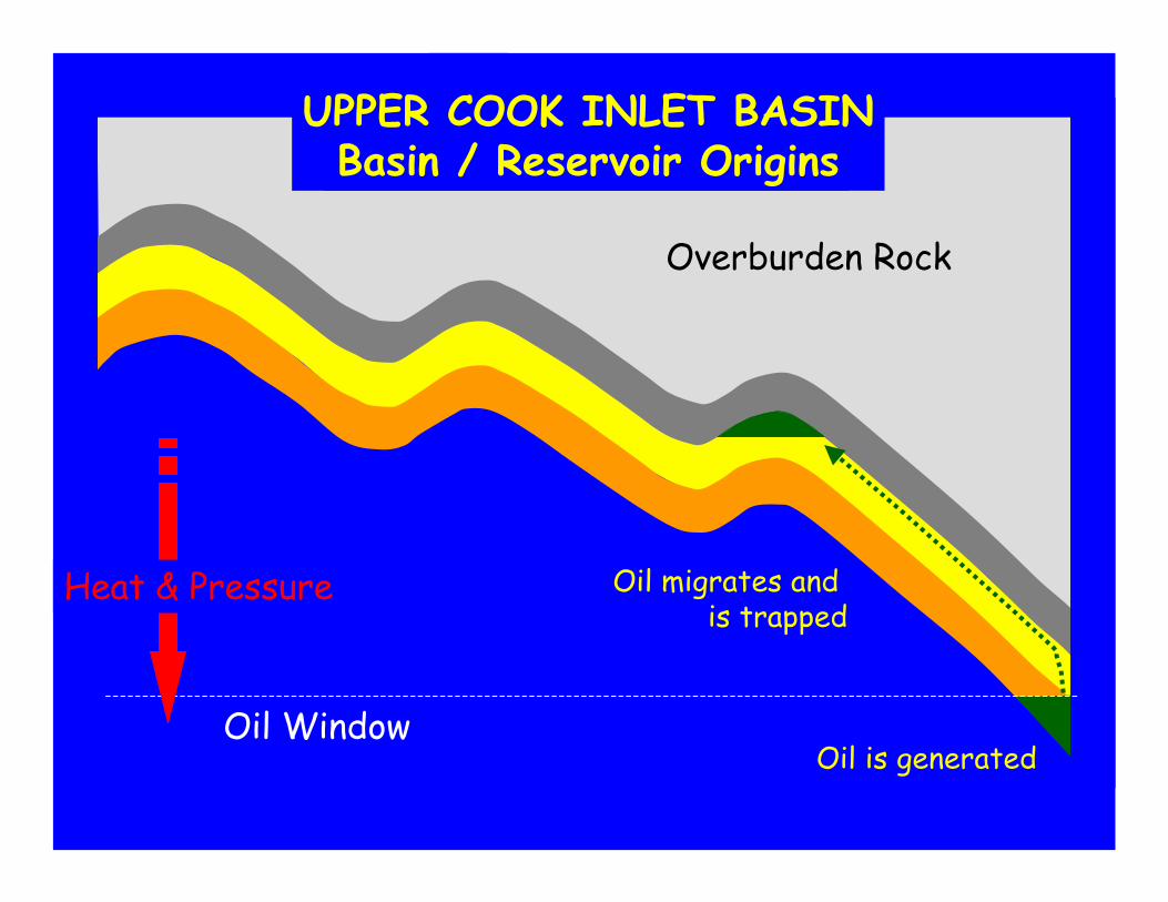
Oil is generated
Oil migrates and is trapped
Oil Window
COOK INLET BASINBasin / Reservoir Origins
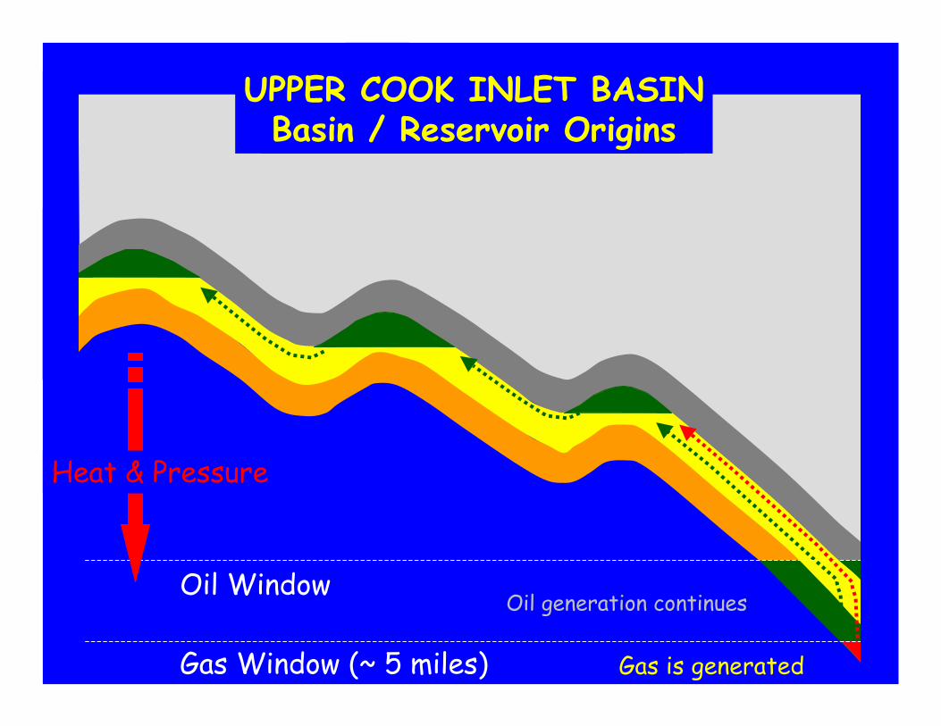
UPPER COOK INLET BASINBasin / Reservoir Origins
Overburden Rock
Heat & Pressure

Oil Window Oil generation continues
COOK INLET BASINBasin / Reservoir Origins
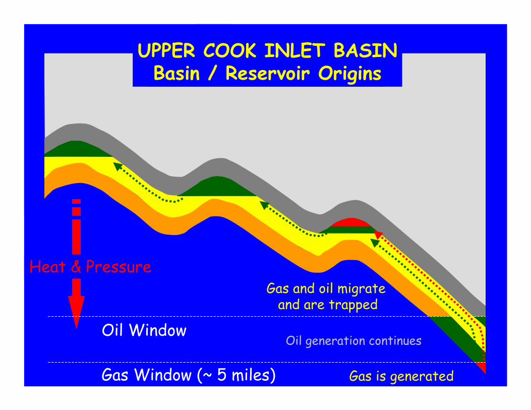
UPPER COOK INLET BASINBasin / Reservoir Origins
Spill point
Spill point
Heat & Pressure
Gas Window (~ 5 miles)
Oil Window
Gas is generated
Oil generation continues
COOK INLET BASINBasin / Reservoir Origins
UPPER COOK INLET BASINBasin / Reservoir Origins
Heat & Pressure
Heat & Pressure
Gas Window (~ 5 miles)
Oil Window
Gas is generated
Gas and oil migrate and are trapped
Oil generation continues
COOK INLET BASINBasin / Reservoir Origins
UPPER COOK INLET BASINBasin / Reservoir Origins
Tuxedni
Hemlock
Lower Tyonek
Tuxedni – HemlockPetroleum System
Reservoirs
West Foreland
Tuxedni – HemlockPetroleum System
Oil & Associated Gas
Tuxedni
Tyonek
W ForelandHemlock
U.Cook Inlet BasinStratigraphic
Column
Hemlock
Tuxedni
W. Foreland
Lower Tyonek
Modified from Magoon, L.B., 1994
Source Rock
A A
A
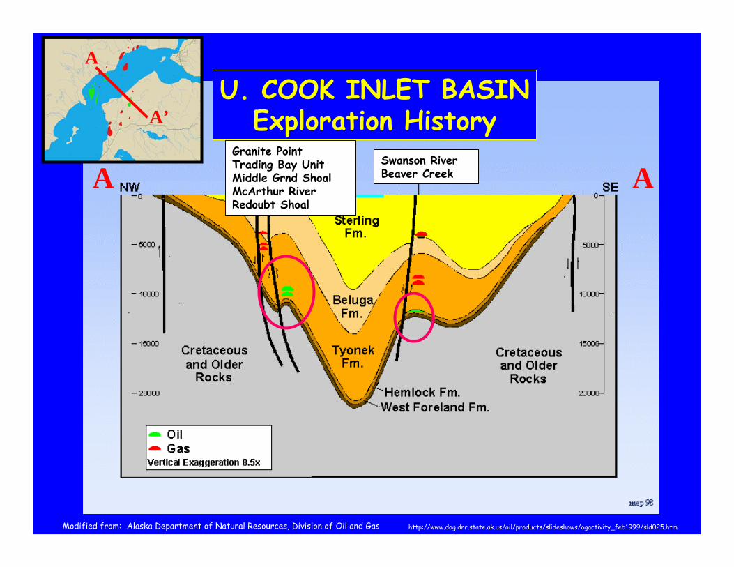
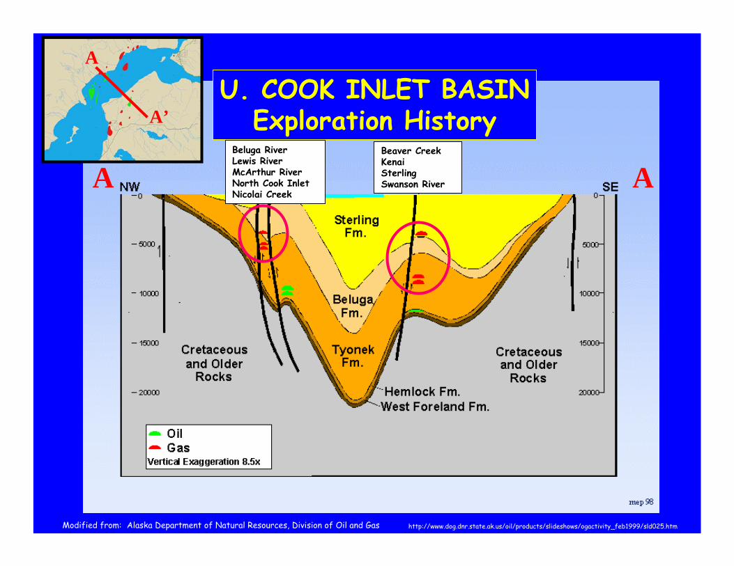
A’U. COOK INLET BASIN
Exploration HistorySwanson RiverBeaver Creek
Granite PointTrading Bay UnitMiddle Grnd ShoalMcArthur RiverRedoubt Shoal
http://www.dog.dnr.state.ak.us/oil/products/slideshows/ogactivity_feb1999/sld025.htmModified from: Alaska Department of Natural Resources, Division of Oil and Gas
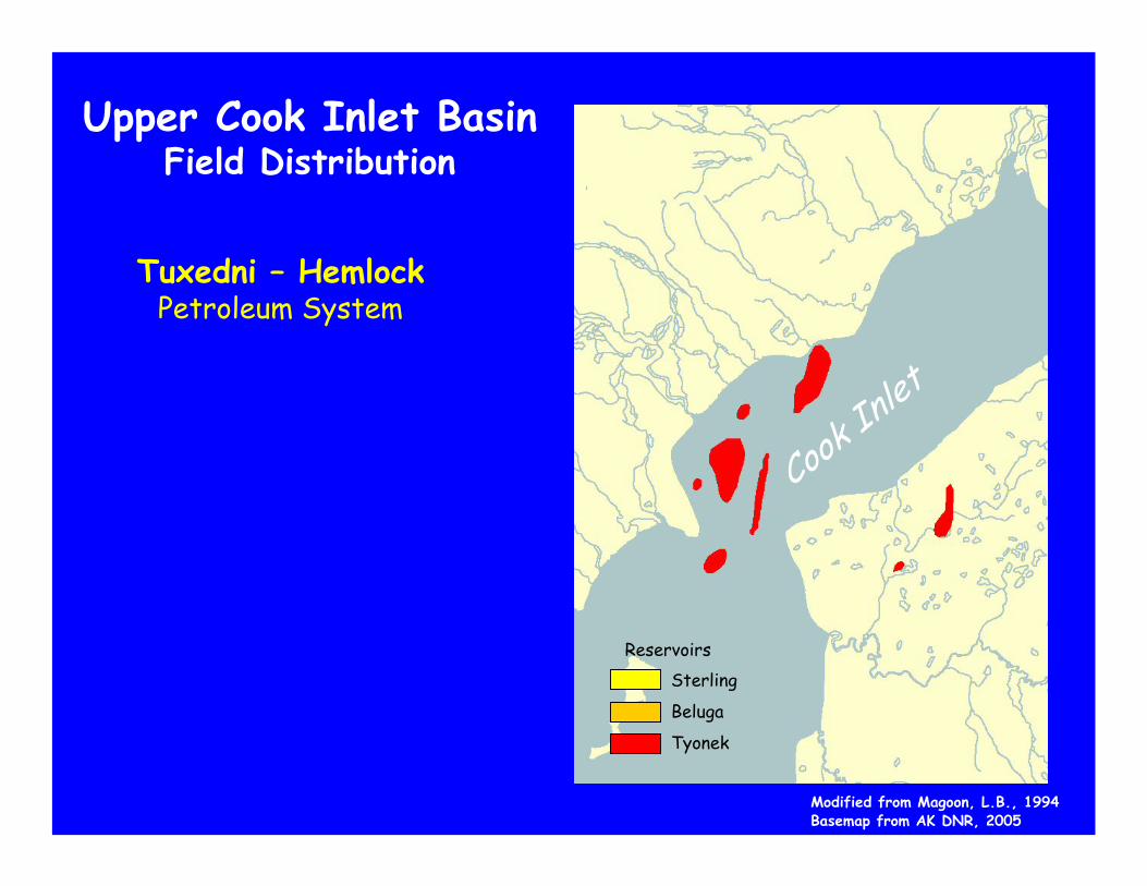
Upper Cook Inlet BasinField Distribution
Tuxedni – HemlockPetroleum System
ReservoirsSterling
Beluga
Tyonek
Cook In
let
ReservoirsSterling
Beluga
Tyonek
Cook In
let
Modified from Magoon, L.B., 1994Basemap from AK DNR, 2005
UPPER COOK INLET BASINBasin / Reservoir Origins
The Upper Cook Inlet Basin contains two Petroleum Systems:
1. Tuxedni – Hemlock • Deeper, oil-bearing reservoirs• Gas is associated with oil accumulations• “Wet” gas – methane with heavier gases
2. Non-Associated Gas• Shallow, gas only, not associated with oil• “Dry” gas – almost entirely methane• Biogenic origin
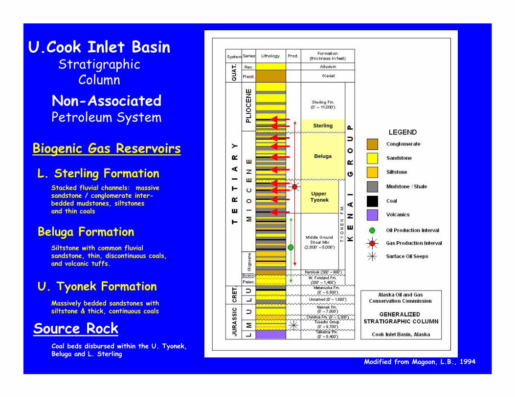
L. Sterling FormationStacked fluvial channels: massive sandstone / conglomerate inter-bedded mudstones, siltstones and thin coals
Non-AssociatedPetroleum System
Biogenic Gas Reservoirs
Beluga FormationSiltstone with common fluvial sandstone, thin, discontinuous coals,and volcanic tuffs.
U.Cook Inlet BasinStratigraphic
Column
U. Tyonek FormationMassively bedded sandstones with siltstone & thick, continuous coals
Modified from Magoon, L.B., 1994
Source Rock Coal beds disbursed within the U. Tyonek,Beluga and L. Sterling
Upper Tyonek
Beluga
Sterling
http://www.dog.dnr.state.ak.us/oil/products/slideshows/ogactivity_feb1999/sld025.htmModified from: Alaska Department of Natural Resources, Division of Oil and Gas
A A
A
A’U. COOK INLET BASIN
Exploration HistoryBeaver CreekKenai Sterling Swanson River
Beluga RiverLewis RiverMcArthur RiverNorth Cook InletNicolai Creek

Upper Cook Inlet BasinField Distribution
Non-AssociatedPetroleum System
Dry Gas Field Distribution
Modified from Magoon, L.B., 1994Basemap from AK DNR, 2005
ReservoirsSterling
Beluga
Tyonek
Cook In
let
•Basin / Accumulation Origins
•Exploration History
•Future
•Basin / Accumulation Origins
•Exploration History
•Future
•Basin / Accumulation Origins
•Exploration History
•Future
Anchorage
UPPER COOK INLET BASINREVIEW
Modified from USGS National Map
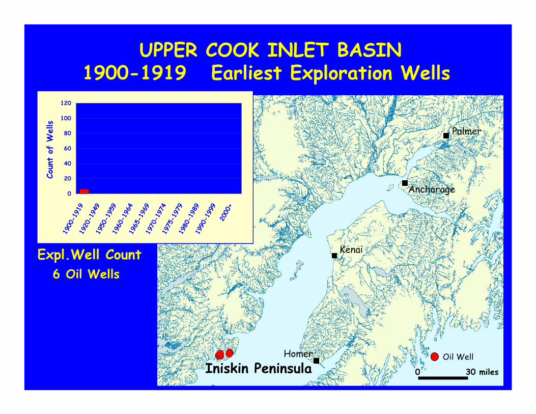
UPPER COOK INLET BASIN1900-1919 Earliest Exploration Wells
Iniskin Peninsula
0
20
40
60
80
100
120
1900
-191
919
20-1
949
1950
-195
919
60-1
964
1965
-196
919
70-1
974
1975
-197
919
80-1
989
1990
-199
920
00+
Coun
t of
Wells
Oil Well
Anchorage
Homer
Kenai
Palmer
0 30 miles
Oil Wells6Expl.Well Count
UPPER COOK INLET BASIN1920-1949 Sporadic Exploration
0
20
40
60
80
100
120
1900
-191
919
20-1
949
1950
-195
919
60-1
964
1965
-196
919
70-1
974
1975
-197
919
80-1
989
1990
-199
920
00+
Coun
t of
Wells
Oil WellWell fromprevious period
Anchorage
Homer
Kenai
Palmer
Old Wildcat No. 1
Chickaloon No. 1
Iniskin Bay Associates No. 1
Oil Wells3Expl.Well Count
Houston / Rosetta
Swanson River Field
Iniskin Area
Kenai Gas Field
Deep Creek
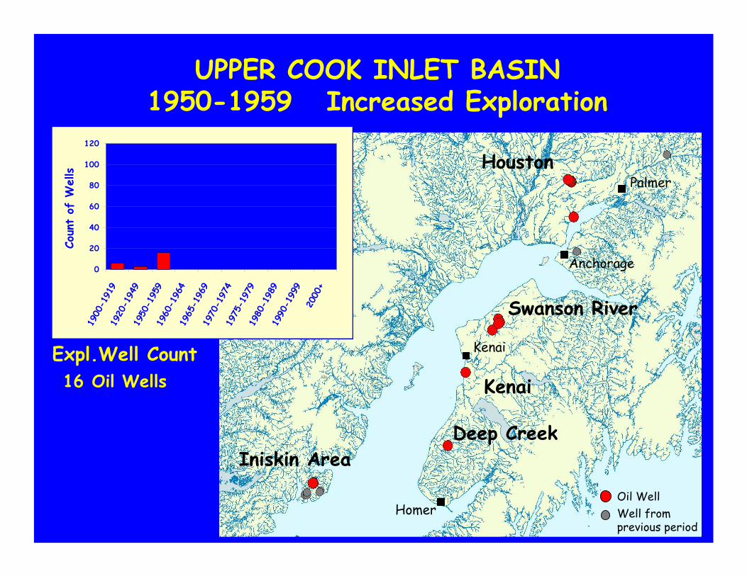
UPPER COOK INLET BASIN1950-1959 Increased Exploration
0
20
40
60
80
100
120
1900
-191
919
20-1
949
1950
-195
919
60-1
964
1965
-196
919
70-1
974
1975
-197
919
80-1
989
1990
-199
920
00+
Coun
t of
Wells
Oil WellWell fromprevious period
Anchorage
Homer
Kenai
PalmerHouston
Oil Wells16Expl.Well Count
Swanson River
Iniskin Area
Kenai
Deep Creek
Houston / Rosetta
Swanson River Field
Iniskin Area
Kenai Gas Field
Deep Creek
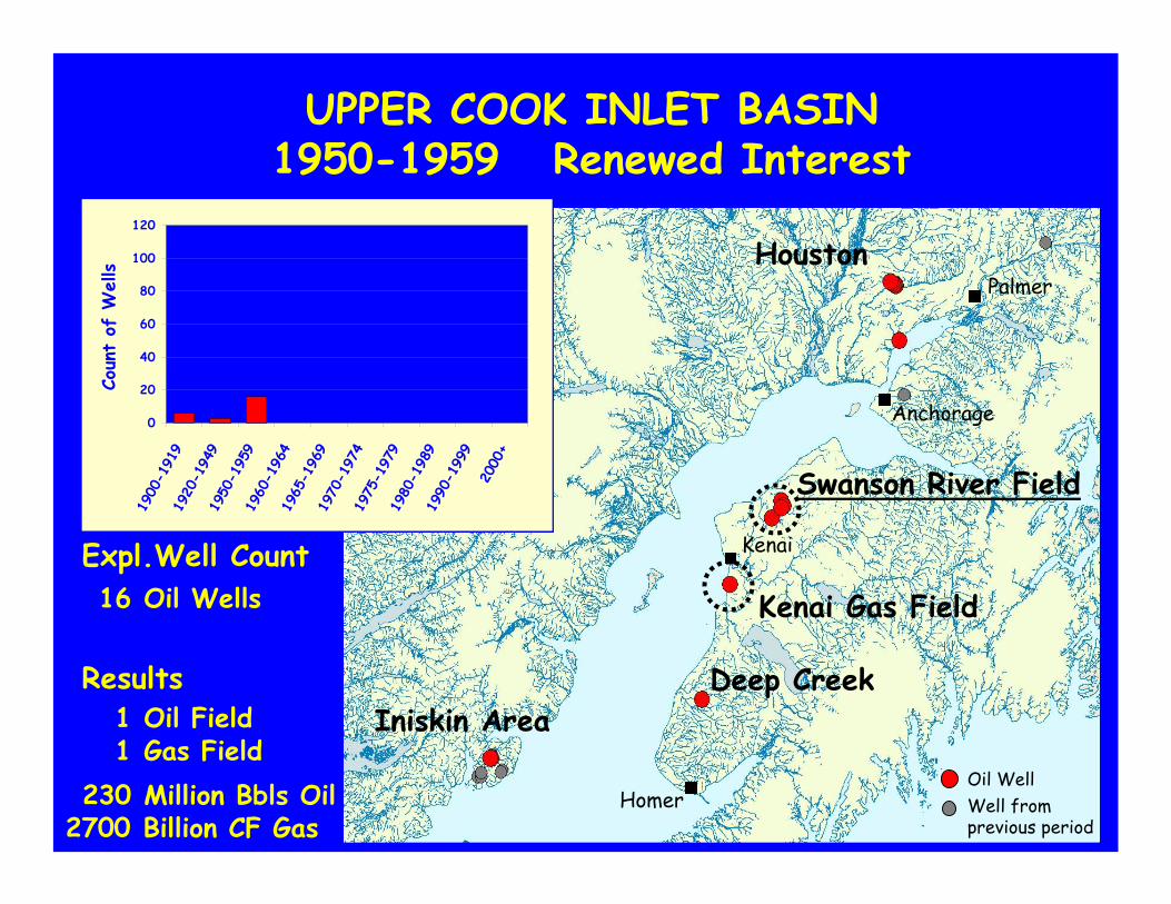
UPPER COOK INLET BASIN1950-1959 Renewed Interest
0
20
40
60
80
100
120
1900
-191
919
20-1
949
1950
-195
919
60-1
964
1965
-196
919
70-1
974
1975
-197
919
80-1
989
1990
-199
920
00+
Coun
t of
Wells
Oil Field1
Million Bbls Oil230Oil WellWell fromprevious period
Anchorage
Homer
Kenai
Palmer
Swanson River Field
Iniskin Area
Kenai Gas Field
Deep Creek
Gas Field1
Billion CF Gas2700
Results
Oil Wells16Expl.Well Count
Houston
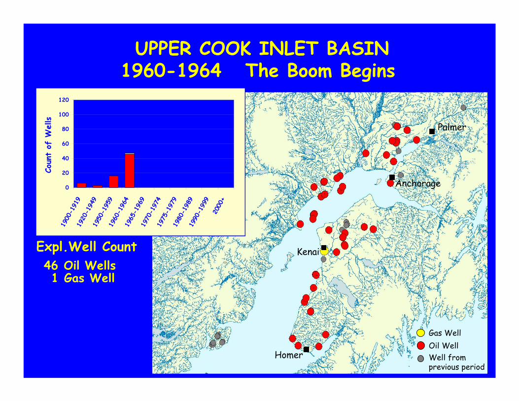
UPPER COOK INLET BASIN1960-1964 The Boom Begins
0
20
40
60
80
100
120
1900
-191
919
20-1
949
1950
-195
919
60-1
964
1965
-196
919
70-1
974
1975
-197
919
80-1
989
1990
-199
920
00+
Coun
t of
Wells
Oil WellGas Well
Well fromprevious period
Homer
Kenai
Palmer
Anchorage
Oil Wells46Expl.Well Count
Gas Well1
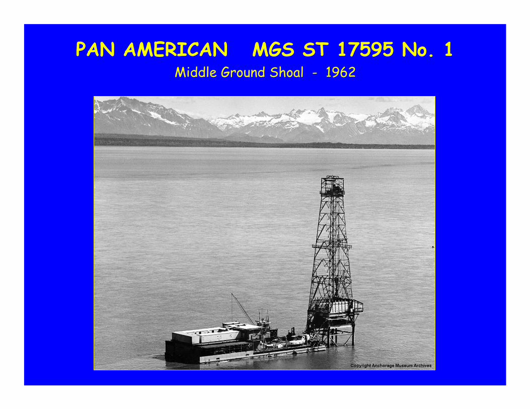
PAN AMERICAN MGS ST 17595 No. 1Middle Ground Shoal - 1962
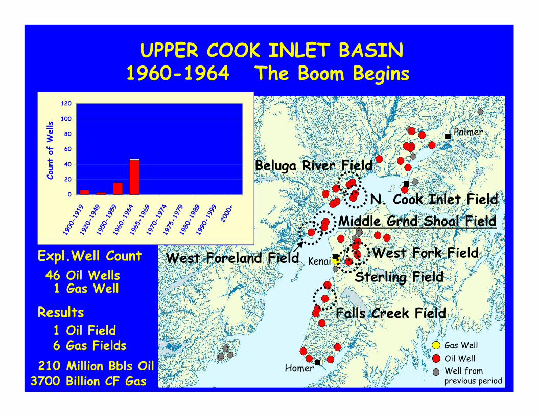
UPPER COOK INLET BASIN1960-1964 The Boom Begins
0
20
40
60
80
100
120
1900
-191
919
20-1
949
1950
-195
919
60-1
964
1965
-196
919
70-1
974
1975
-197
919
80-1
989
1990
-199
920
00+
Coun
t of
Wells
Oil WellGas Well
Well fromprevious period
Homer
Kenai
Palmer
West Fork Field
Beluga River Field
Middle Grnd Shoal FieldN. Cook Inlet Field
West Foreland Field
Falls Creek Field
Sterling Field
Oil Field1
Million Bbls Oil210Gas Fields6
Billion CF Gas3700
Results
Oil Wells46Expl.Well Count
Gas Well1
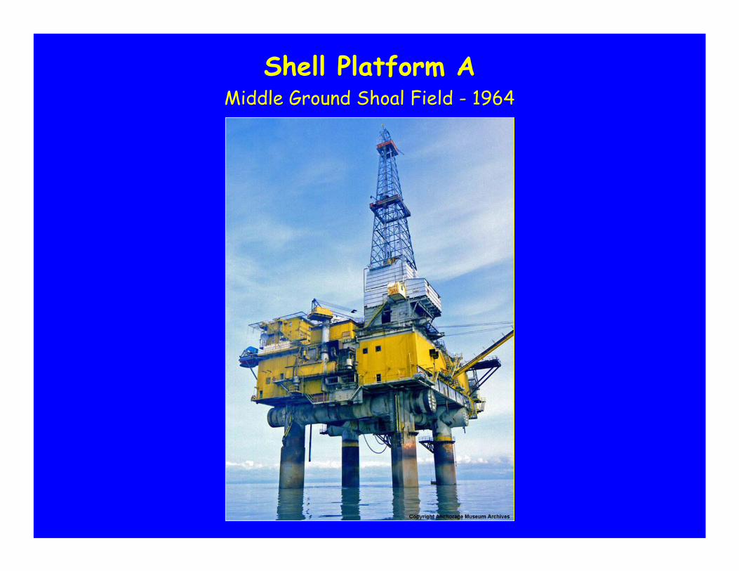
Shell Platform AMiddle Ground Shoal Field - 1964
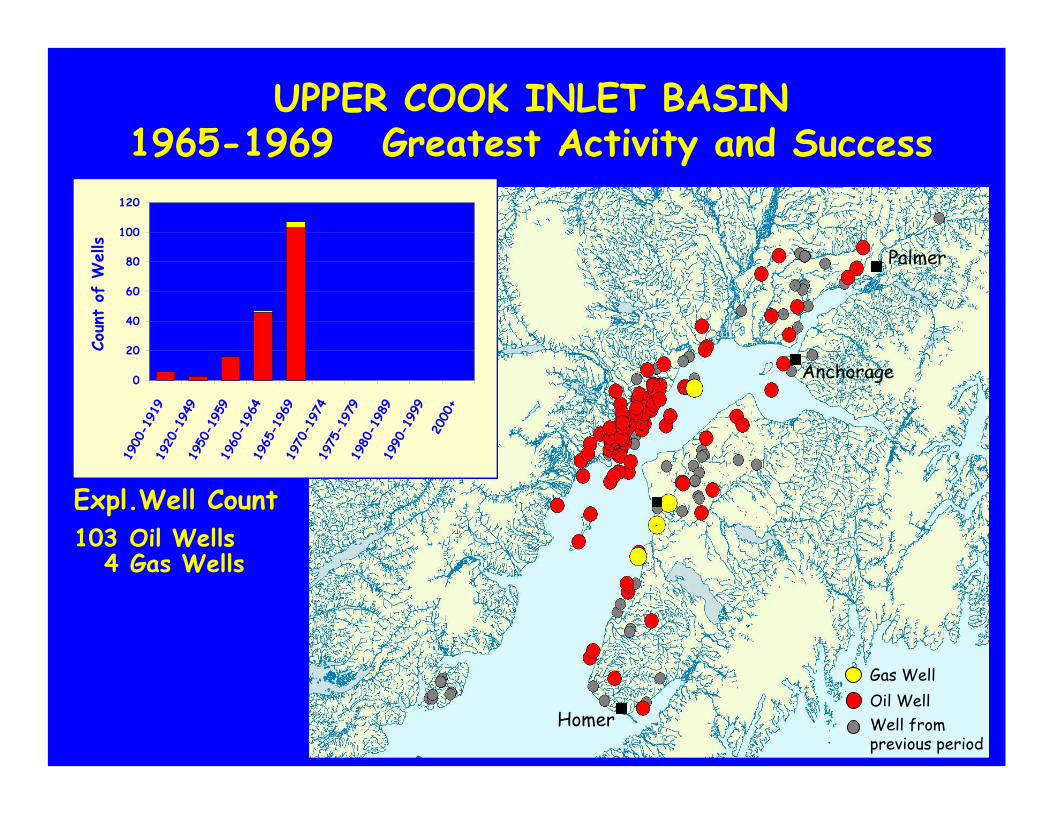
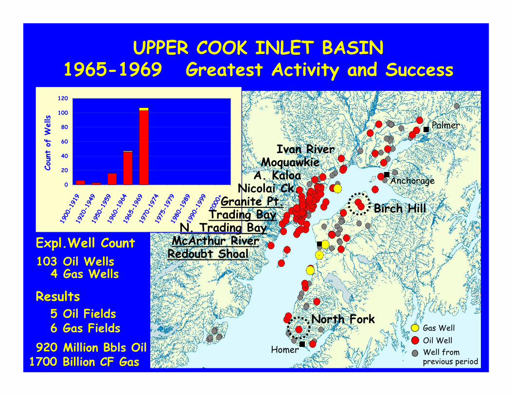
UPPER COOK INLET BASIN1965-1969 Greatest Activity and Success
0
20
40
60
80
100
120
1900
-191
919
20-1
949
1950
-195
919
60-1
964
1965
-196
919
70-1
974
1975
-197
919
80-1
989
1990
-199
920
00+
Coun
t of
Wells
Oil WellGas Well
Well fromprevious period
Homer
Palmer
Anchorage
Oil Wells103Expl.Well Count
Gas Wells4
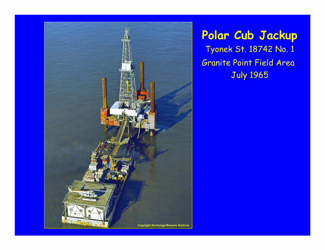
Polar Cub JackupTyonek St. 18742 No. 1
Granite Point Field AreaJuly 1965
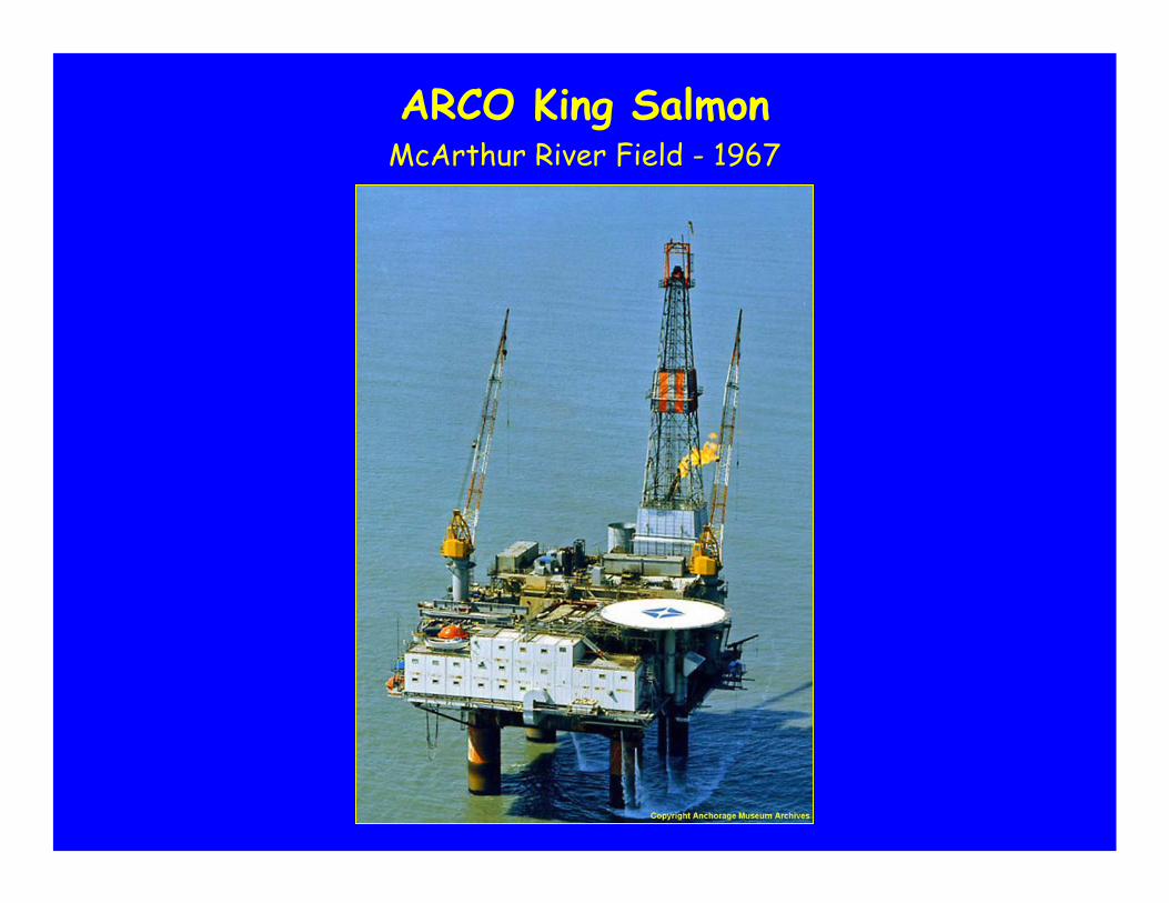
ARCO King SalmonMcArthur River Field - 1967
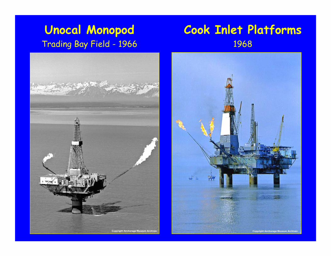
Cook Inlet Platforms1968
Unocal MonopodTrading Bay Field - 1966
UPPER COOK INLET BASIN1965-1969 Greatest Activity and Success
0
20
40
60
80
100
120
1900
-191
919
20-1
949
1950
-195
919
60-1
964
1965
-196
919
70-1
974
1975
-197
919
80-1
989
1990
-199
920
00+
Coun
t of
Wells
Oil WellGas Well
Well fromprevious period
Homer
Palmer
Birch Hill
North Fork
Nicolai Ck.Granite Pt.
Trading BayN. Trading Bay
A. KaloaMoquawkie
Ivan River
McArthur RiverRedoubt Shoal
Anchorage
Oil Fields5
Million Bbls Oil920Gas Fields6
Billion CF Gas1700
Results
Oil Wells103Expl.Well Count
Gas Wells4
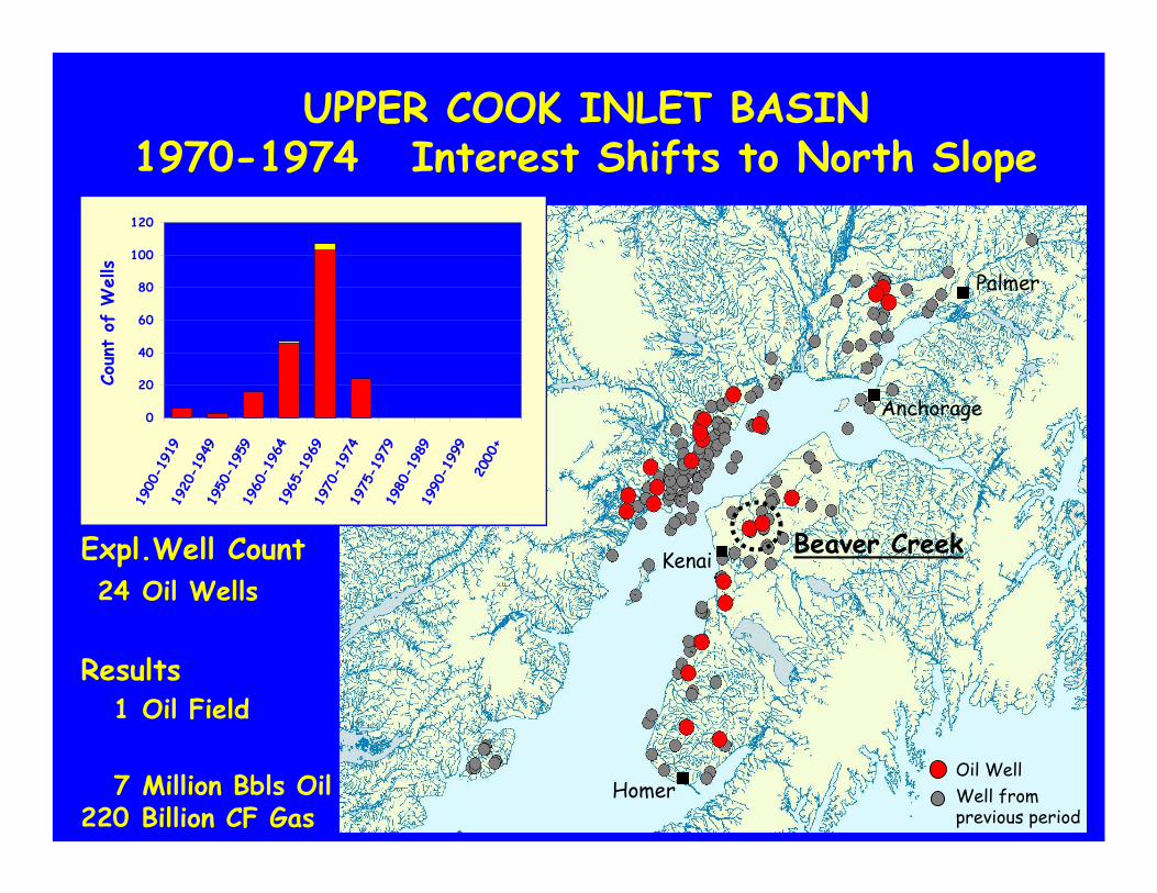
UPPER COOK INLET BASIN1970-1974 Interest Shifts to North Slope
0
20
40
60
80
100
120
1900
-191
919
20-1
949
1950
-195
919
60-1
964
1965
-196
919
70-1
974
1975
-197
919
80-1
989
1990
-199
920
00+
Coun
t of
Wells
Oil WellWell fromprevious period
Anchorage
Homer
Palmer
KenaiBeaver Creek
Oil Field1
Million Bbls Oil7Billion CF Gas220
Results
Oil Wells24Expl.Well Count
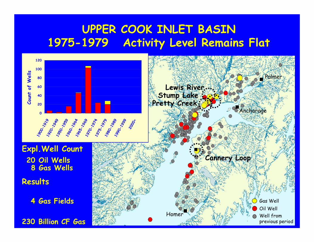
UPPER COOK INLET BASIN1975-1979 Activity Level Remains Flat
0
20
40
60
80
100
120
1900
-191
919
20-1
949
1950
-195
919
60-1
964
1965
-196
919
70-1
974
1975
-197
919
80-1
989
1990
-199
920
00+
Coun
t of
Wells
Oil WellGas Well
Well fromprevious period
Anchorage
Homer
Palmer
Lewis RiverStump Lake
Pretty Creek
Cannery Loop
Billion CF Gas230
Results
Oil Wells20Expl.Well Count
Gas Wells8
Gas Fields4
0
20
40
60
80
100
120
1900
-191
919
20-1
949
1950
-195
919
60-1
964
1965
-196
919
70-1
974
1975
-197
919
80-1
989
1990
-199
920
00+
Coun
t of
Wells
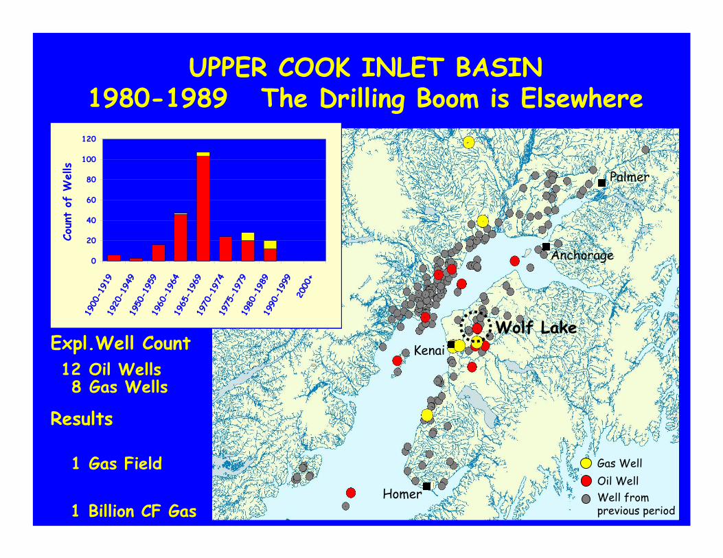
UPPER COOK INLET BASIN1980-1989 The Drilling Boom is Elsewhere
Oil WellGas Well
Well fromprevious period
Anchorage
Homer
Palmer
KenaiWolf Lake
Billion CF Gas1
Results
Oil Wells12Expl.Well Count
Gas Wells8
Gas Field1
0
20
40
60
80
100
120
1900
-191
919
20-1
949
1950
-195
919
60-1
964
1965
-196
919
70-1
974
1975
-197
919
80-1
989
1990
-199
920
00+
Coun
t of
Wells
Oil WellGas Well
Well fromprevious period
Anchorage
Homer
Palmer
Kenai
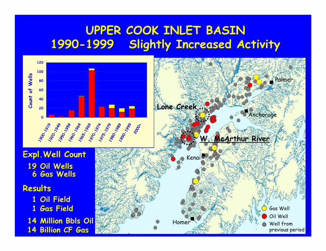
Lone Creek
W. McArthur River
UPPER COOK INLET BASIN1990-1999 Slightly Increased Activity
Billion CF Gas14
Results
Oil Wells19Expl.Well Count
Gas Wells6
Oil Field1Gas Field1Million Bbls Oil14
BCF Gas170+/-(?)
0
20
40
60
80
100
120
1900
-191
919
20-1
949
1950
-195
919
60-1
964
1965
-196
919
70-1
974
1975
-197
919
80-1
989
1990
-199
920
00+
Coun
t of
Wells
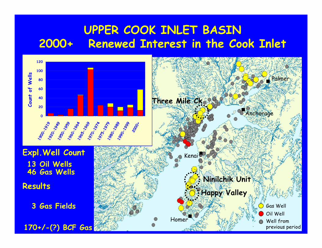
UPPER COOK INLET BASIN2000+ Renewed Interest in the Cook Inlet
Oil WellGas Well
Well fromprevious period
Anchorage
Homer
Palmer
Kenai
Happy Valley
Three Mile Ck
Ninilchik UnitResults
Oil Wells13Expl.Well Count
Gas Wells46
Gas Fields3
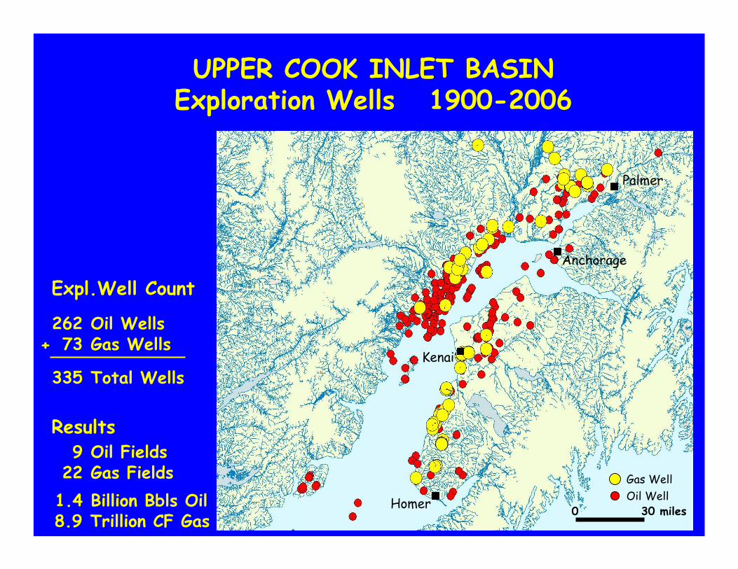
UPPER COOK INLET BASINExploration Wells 1900-2006
Oil WellGas Well
Oil Wells262Gas Wells73
Anchorage
Homer
Palmer
Kenai
0 30 miles
Total Wells335
+
Oil Fields9
Billion Bbls Oil1.4Gas Fields22
Trillion CF Gas8.9
Results
Expl.Well Count
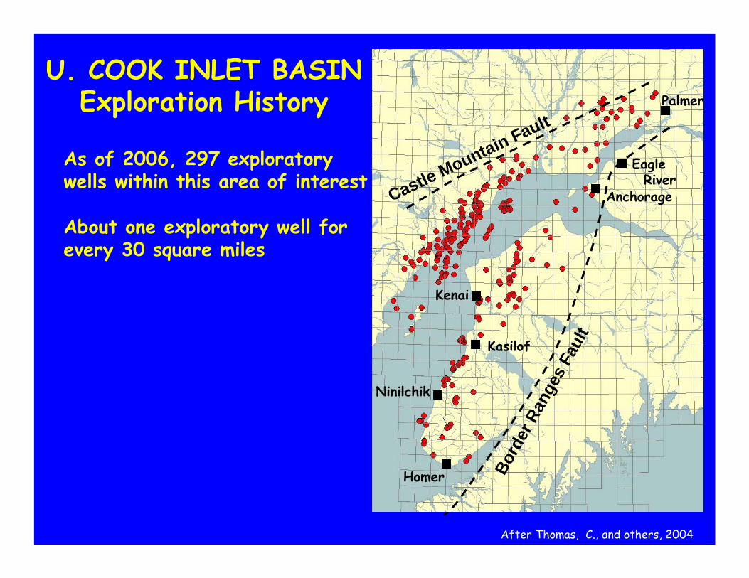
Homer
Ninilchik
Kasilof
Kenai
Anchorage
Palmer
Castle Mountain Fault
Bord
er R
ange
s Fa
ult
EagleRiver
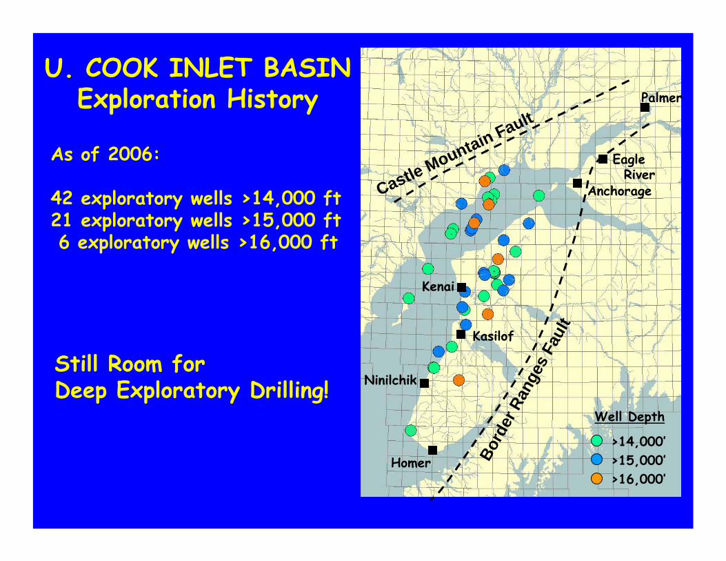
As of 2006, 297 exploratory wells within this area of interest
About one exploratory well for every 30 square miles
U. COOK INLET BASINExploration History
After Thomas, C., and others, 2004
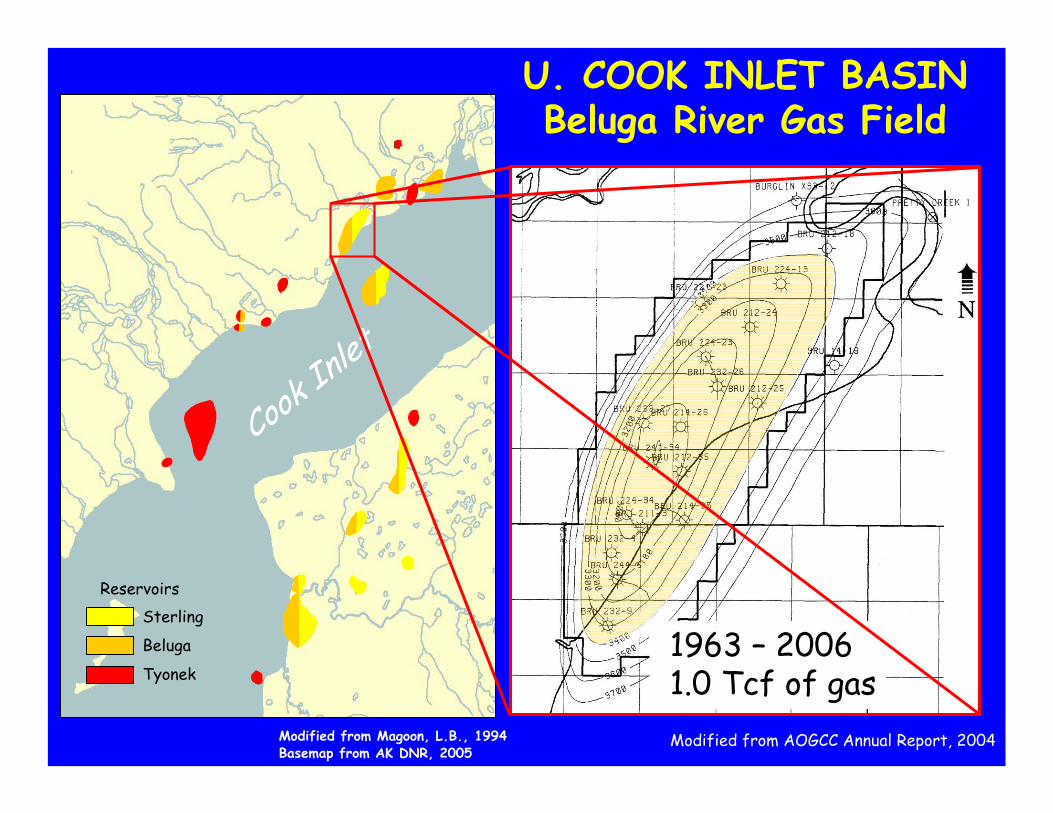
Modified from Magoon, L.B., 1994Basemap from AK DNR, 2005
ReservoirsSterling
Beluga
Tyonek
Cook In
let
U. COOK INLET BASINBeluga River Gas Field
1963 – 20061.0 Tcf of gas1963 – 20061.0 Tcf of gasModified from AOGCC Annual Report, 2004
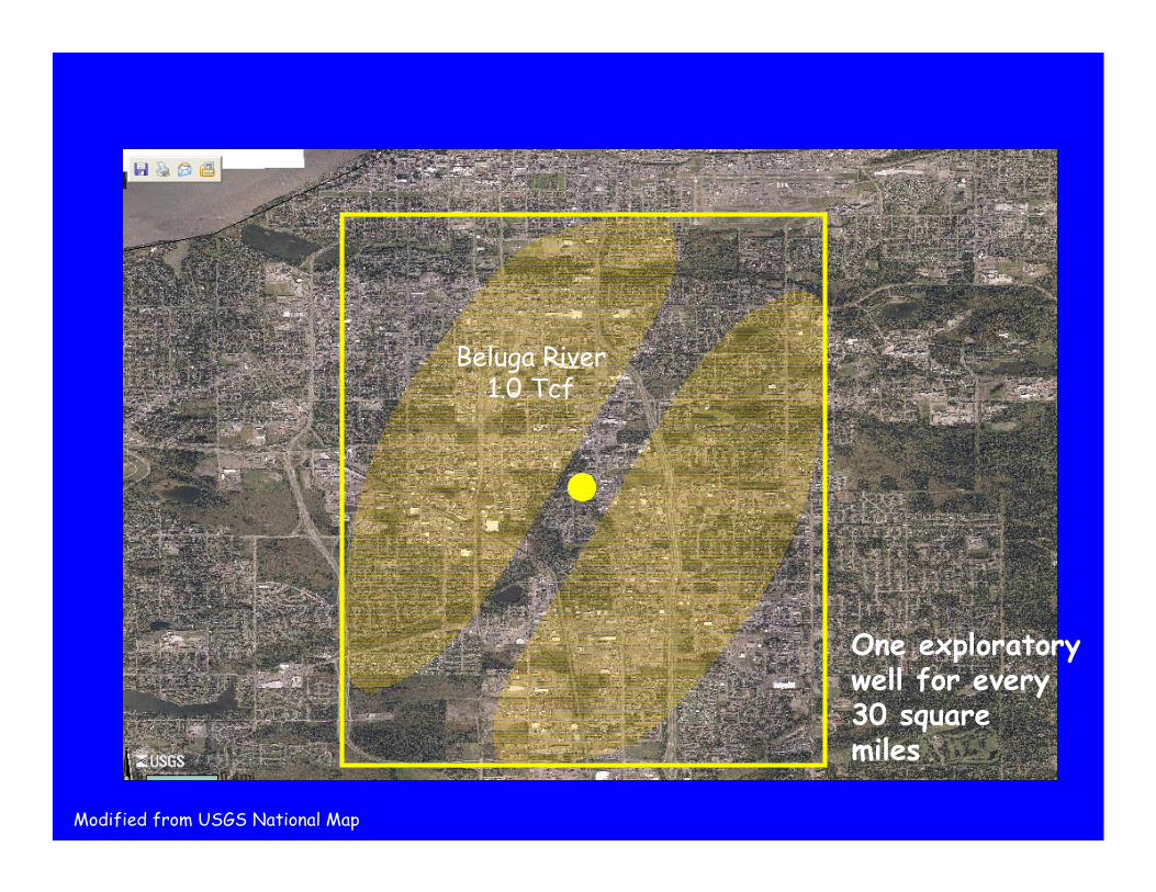
One exploratory well for every 30 squaremiles
Beluga River1.0 Tcf
Modified from USGS National Map
Homer
Ninilchik
Kasilof
Kenai
Anchorage
Palmer
Castle Mountain Fault
Bord
er R
ange
s Fa
ult
EagleRiver
As of 2006:
42 exploratory wells >14,000 ft21 exploratory wells >15,000 ft6 exploratory wells >16,000 ft
U. COOK INLET BASINExploration History
Still Room for Deep Exploratory Drilling!
>14,000’>15,000’>16,000’
Well Depth
•Basin / Accumulation Origins
•Exploration History
•Future
•Basin / Accumulation Origins
•Exploration History
•Future
•Basin / Accumulation Origins
•Exploration History
•Future
Anchorage
UPPER COOK INLET BASINREVIEW
Modified from USGS National Map
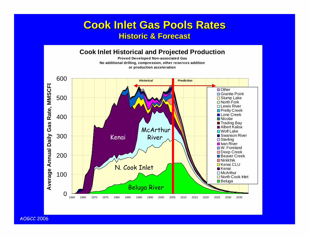
Cook Inlet Historical and Projected ProductionProved Developed Non-associated Gas
No additional drilling, compression, other reserves addition or production acceleration
0
100
200
300
400
500
600
1960 1965 1970 1975 1980 1985 1990 1995 2000 2005 2010 2015 2020 2025 2030 2035
Ave
rage
Ann
ual D
aily
Gas
Rat
e, M
MSC
FD
Other Granite PointStump LakeNorth ForkLewis RiverPretty CreekLone CreekNicolaiTrading BayAlbert KaloaWolf LakeSwanson RiverSterlingIvan RiverW. ForelandDeep CreekBeaver CreekNinilchikKenai CLUKenaiMcArthurNorth Cook InletBeluga
Historical Prediction
Cook Inlet Gas Pools RatesCook Inlet Gas Pools RatesHistoric & ForecastHistoric & Forecast
Beluga River
N. Cook Inlet
McArthurRiverKenai
AOGCC 2006
Cook Inlet Gas Pools RatesCook Inlet Gas Pools RatesHistoric & ForecastHistoric & Forecast
Beluga River
N. Cook Inlet
McArthurRiverKenai
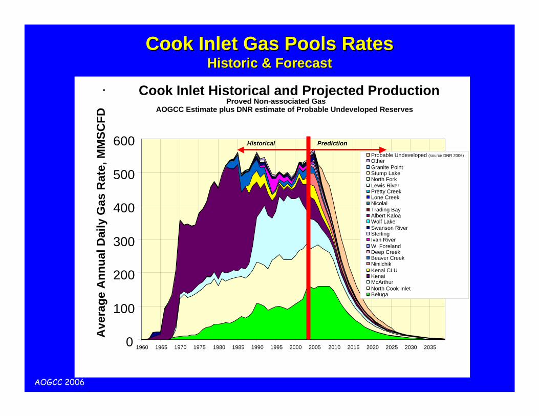
Cook Inlet Historical and Projected ProductionProved Non-associated Gas
AOGCC Estimate plus DNR estimate of Probable Undeveloped Reserves
0
100
200
300
400
500
600
1960 1965 1970 1975 1980 1985 1990 1995 2000 2005 2010 2015 2020 2025 2030 2035
Ave
rage
Ann
ual D
aily
Gas
Rat
e, M
MSC
FD
.
Probable Undeveloped (source DNR 2006)Other Granite PointStump LakeNorth ForkLewis RiverPretty CreekLone CreekNicolaiTrading BayAlbert KaloaWolf LakeSwanson RiverSterlingIvan RiverW. ForelandDeep CreekBeaver CreekNinilchikKenai CLUKenaiMcArthurNorth Cook InletBeluga
Historical Prediction
AOGCC 2006
Non-Associated Gas Fields
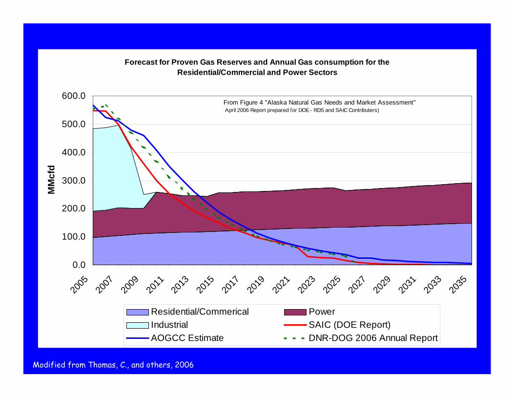
Forecast for Proven Gas Reserves and Annual Gas consumption for the Residential/Commercial and Power Sectors
0.0
100.0
200.0
300.0
400.0
500.0
600.0
2005
2007
2009
2011
2013
2015
2017
2019
2021
2023
2025
2027
2029
2031
2033
2035
MM
cfd
Residential/Commerical PowerIndustrial SAIC (DOE Report)AOGCC Estimate DNR-DOG 2006 Annual Report
From Figure 4 "Alaska Natural Gas Needs and Market Assessment" April 2006 Report prepared for DOE - RDS and SAIC Contributers)
Modified from Thomas, C., and others, 2006
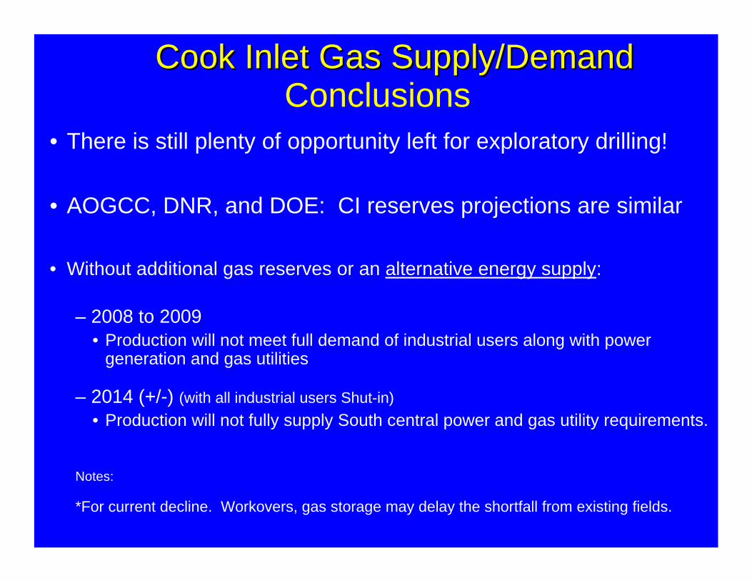
• There is still plenty of opportunity left for exploratory drilling!
• AOGCC, DNR, and DOE: CI reserves projections are similar
• Without additional gas reserves or an alternative energy supply:
– 2008 to 2009 • Production will not meet full demand of industrial users along with power
generation and gas utilities
– 2014 (+/-) (with all industrial users Shut-in)• Production will not fully supply South central power and gas utility requirements.
Notes:
*For current decline. Workovers, gas storage may delay the shortfall from existing fields.
Cook Inlet Gas Supply/DemandCook Inlet Gas Supply/DemandConclusions
Alaska Oil and Gas Conservation Commission (AOGCC)
Contact Information
Phone: (907) 793-1221 Fax: (907) 276-7542
www.aogcc.alaska.govPhoto by Daniel T. Seamount Jr
Solutions are needed!(That’s why we’re here today.)