wegener 2014: measuring and modelling our dynamic planet
TRANSCRIPT

WEGENER 2014:
Measuring and Modelling our
Dynamic Planet
1st – 4th September, 2014
University of Leeds, UK


i
With many thanks to our sponsors…
University of Leeds Vice Chancellor’s Fund
School of Earth and Environment, University of Leeds
Institute for Geophysics and Tectonics, University of Leeds
CGS Climate and Geohazard Services, University of Leeds

Scientific Committee:
Luisa Bastos(University of Porto)
Matthias Becker (TU Darmstadt)
David Bekaert (University of Leeds)
Juliet Biggs (University of Bristol)
Ziyadin Cakir (Istanbul Technical University)
Peter Clarke (University of Newcastle)
Rob Govers (Utrecht University)
Richard Gross (NASA JPL)
Andy Hooper (University of Leeds)
Greg Houseman (University of Leeds)
Jeroen van Hunen (University of Durham)
Zhenhong Li (University of Newcastle)
Mustapha Meghraoui (Université de Strasbourg)
Haluk Ozener (Bogazici University)
Robert Reilinger (Massachusetts Institute of Technology)
Riccardo Riva (Delft University of Technology)
Eleonora Rivalta (GFZ Potsdam)
Isabelle Ryder (University of Liverpool)
Anne Soquet (ISTerre, Grenoble)
Hans Thybo (University of Copenhagen)
Tim Wright (University of Leeds)
Susanna Zerbini (Università di Bologna)

1
Session 1: Continental Faulting and
the Earthquake Cycle
Conveners: Tim Wright, Mustapha Meghraoui, Ziyadin Cakir and Rob Reilinger

Wegener 2014 - Session 1
2
Variations in the structure and rheology of the lithosphere.
J. Jackson (1*)
(1) University of Cambridge, Bullard Laboratories, Madingley Road, Cambridge CB3 0EZ, UK
*Corresponding authorː [email protected]
Differences in the structure, composition and rheology of the lithosphere between the oceans,
young orogenic belts and the ancient Precambrian shields are responsible for first-order variations in
tectonic history seen at the Earth’s surface over geological time. The last decade has seen a number
of developments in the understanding of the lithosphere, some of which have challenged previously
accepted views, and opened up many new directions in research. A coherent picture is now
emerging that reconciles observations from fields as diverse as seismology, gravity, heat flow, rock
mechanics, metamorphic petrology and geochemistry.
The principal points of this new view are as follows:
1) Earthquakes in the mantle are confined to regions colder than about 600oC.
2) With very few exceptions, earthquakes everywhere are confined to a single seismogenic
layer which, in the oceans is limited by the 600oC isotherm, in young orogenic belts is
typically limited to the upper crust (~350oC), and in ancient shields may include the whole
crust (in material as hot as 600oC. An apparent exception is in the Himalaya, where the
seismogenic lower crust of India underthrusts the seismogenic upper crust of Tibet, giving a
bimodal depth distribution, but one that is not in steady-state and has no generic
significance for continental rheology.
3) Where it is well resolved, the elastic thickness is everywhere less than the seismogenic
thickness, and nowhere do the data require it to exceed the seismogenic thickness. This
observation is consistent with long-term strength residing in the seismogenic layer, and
regions of active deformation, the mantle generally plays no role in the long-term support of
loads on the continents.
4) Lateral strength changes in the continents between ancient shields and young orogenic
regions are important and cannot be represented by a laterally uniform continental rheology.
They allow mountains to be supported by their adjacent forelands without requiring the
mantle beneath the forelands to be strong.
5) The great strength of the ancient shields, responsible for lower crustal earthquakes and
larger elastic thickness than in younger continental lithosphere, is related to the composition
of the lower continental crust, which is probably dominated by a dry granulite facies mineral
assemblage.
6) The cause of the granulite metamorphism is likely to be continental collision, resulting in
extreme crustal thickening and internal heat production, causing melting and the removal of
water by the extraction of granite. This was probably common in the Archean, when
radiogenic production was greater, but may be happening today in Tibet.

Wegener 2014 - Session 1
3
7) Many of the ancient shields of the continents are characterized by extreme lithosphere
thicknesses, which may reach 250 or more km. Surface-wave seismic tomography now
allows us to map the distribution of such regions. The stability of the thick lithosphere is
related to its chemical depletion during melting, which occurred prior to its subsequent
thickening.
8) The stability and survival of the ancient shields and cratons over geological time is thus
related to both their strength and buoyancy, neither of which can easily be changed.

Wegener 2014 - Session 1
4
Preliminary Results of 24 May 2014 Gökçeada Earthquake, Ms6.5 as
captured by continuous GPS stations
B. Aktug*(1, 2), H. Ozener (1), B. Turgut (1), A. Dogru (1) and
I. Georgiev (3)
(1) Geodesy Department, KOERI, Bogazici University, İstanbul, Turkey
(2) Universite Montpellier-II, Geosciences Montpellier, CNRS UMR-5243, 34095Montpellier,France
(3) National Institute of Geophysics, Geodesy and Geography
Bulgarian Academy of Sciences, Sofia, Bulgaria
*Corresponding authorː [email protected]
Gökçeada Earthquake, 24 May 2014 occured on the continuation of North Anatolian Fault System in
the Aegean Sea. Both the early analysis of focal mechanism and the distribution of the aftershocks
also confirm its nearly pure strike-slip nature. Large earthquakes that occured in the region (1912
Şarköy Mürefte, M7.2 and 1953 Yenice-Gönen, M=7.2 etc.) makes this relatively small earthquake
more interesting for further examination.
Gökçeada earthquake provides the first example at this magnitude scale captured by the new
Turkish RTK network. We analysed daily repeatabilities at 35 continuous GPS stations, covering a
time period of 15 days before and after the earthquake. Differencing the trends before and after the
earthquakes, up to 4.5 cm displacements were successfully measured at the closest stations to the
epicenter at a few millimeters precision. We provide the preliminary results of the analysis
continuous GPS stations which provide additional constraints for surface rupture and fault geometry.

Wegener 2014 - Session 1
5
Reprocessing of the CEGRN network and its impact on the
geodynamics of Central Europe
M. Barlik (1), M. Becker (2), C. Bruyninx (3), A. Caporali (4), R. Fernandes (5), L. Gerhatova (6),
G. Grenerczy (7), H. Habrich (8), J. Hefty (6), J. Ihde (8), A. Kenyeres (7), S. Krauss (9), M.
Lidberg (10), D. Medak (11), G. Milev (12), M. Mojzes (6), M. Mulic (13), O. Odalovic (14), T.
Rus (15), J. Simek (16), J. Sledzinski (1), G. Stangl (9), B. Stopar (17), K. Szafranek (18), F.
Vespe (19), G. Virag (7) and J. Zurutuza (4*)
(1)Warsaw University of Technology, Poland
(2) Technische Universitaet Darmstadt, Germany
(3) Royal Observatory, Bruxelles Belgium
(4) University of Padova, Italy
(5)University of Corvilha, Portugal
(6) Slovak University of Technology, Slovakia
(7) Institute of Geodesy Cartography and Remote Sensing, Hungary
(8) Bundesamt fuer Kartographie u. Geodaesie, Frankfurt a.M., Germany
(9)Austrian Academy of Sciences and BEV, Austria
(10)Lantmäteriet, Gävle, Sweden
(11) University of Zagreb, Croatia
(12) Bulgarian Academy of Sciences, Bulgaria
(13) University of Sarajevo, Bosnia-Herzegovina
(14) Geodetic Authority of Serbia
(15) National Centre for Geodesy, Cartography Phogrammetry and Remote Sensing, Romania
(16) Research Institute of Geodesy, Topography and Cartography, Czech Republic
(17) University of Ljubljana, Slovenia
(18) Military Institute of Technology, Warsaw, Poland
(19) Agenzia Spaziale Italiana, Italy
*Corresponding authorː [email protected]
The IAG Working Group on “Integration of Dense Velocity Fields in the ITRF”, the EUREF Working
Group on Deformation Models and the project EPOS encourage initiatives aiming at estimating
velocities of GNSS sites in a rigorous manner, both for reference frame applications and 3D tectonic
deformation problems. Thirteen measurement campaigns between 1994 and 2013 with epoch and
permanent GNSS stations make the CEGRN network one of the most regularly and accurately
surveyed networks for scientific applications in Europe. We have reprocessed the CEGRN GNSS
(GPS+GLONASS) data with the Bernese Software 5.2 using consistent IGb08 orbits and antenna
models and aligned the resulting network to ETRF2000 Reference Frame using the position and
velocities of Class A stations of the EUREF Permanent Network (EPN). The intent is to bring down to
regional, i.e. Central European scale the same standard of accuracy as the EPN long-term solution.
This paper presents first results of the CEGRN densification of the EPN: we review the input data, the
processing strategies and the results, in terms of positions, velocities and Helmert parameters.
Possible further combination, in a rigorous geodetic sense, with multiyear regional solutions, for

Wegener 2014 - Session 1
6
example in Greece and Italy, processed with similar standards have an important potential to
quantify the deformation field, for example in the Balkans.

Wegener 2014 - Session 1
7
First GPS results in the Oran area (northwestern Algeria)
A. Bougrine (1*); JM Nocquet (2); A. Yelles-Chaouche (3); K.Lammali (3); W. Bacha (1); T.
Terki (3)
(1) CRAAG, University of Tlemcen, Algeria
(2) Geoazur, University of Nice Sophia-Antipolis, CNRS INSU, IRD, OCA, France
(3) CRAAG, Algeria
*Corresponding authorː [email protected]
Sparse results along northern Algeria are so far available to better understand how Nubia/Eurasia
convergence is accommodated in the western Mediterranean and quantitatively assess seismic
potential in that area. In this study, we show new GNSS results in the Tellian atlas in western Algeria.
The studied area encompasses the Mleta basin bordered in the north by the Murdjadjo range, which
is thought to be the locus of the large 1790 earthquake (estimated magnitude 7.5 Bouhadad, 2001).
This area includes the city of Oran, the second most populated city of Algeria.
The GNSS network includes 18 sites, spanning 180km East-West along the coast of Algeria and 40 km
inland, with inter-site distance of 15 km. It has been observed in 2008 and 2012 for enabling velocity
to be estimated at the 1 mm/yr. GNSS Data have been processed using GAMIT/GLOBK software,
together with 04 permanent sites in Algeria and 87 IGS sites surrounding the area of study.
Uncertainties on campaign results have been rescaled according to the analysis of the nearby CGPS
time series.
The recorded seismicity and the obtained GNSS velocity field from the two campaigns with a four
years span, indicate that this region is tectonically active and subjected to significant horizontal
motions. A regional NW displacement of 2-4mm/yr in the Eurasia stable reference frame is
consistent with the expected Nubia-Eurasia motion. The obtained velocity field in the Nubian fixed
reference frame gives a slow strain rate less than 2mm/yr representing the strain rate
accommodated across the Murdjadjo range and the different features around the Mlena basin.

Wegener 2014 - Session 1
8
InSAR velocity field along the North Anatolian Fault: implications
for the nature of strike-slip deformation
Z. Cakir (1*); S. Ergintav (2); A. Akoğlu (3); R. Çakmak (4); M. Meghraoui (5); O. Tatar (6)
(1) Istanbul Technical University, Faculty of Mines, Turkey,
(2) Boğaziçi University, Kandilli Observatory, Turkey
(3) King Abdullah University of Science and Technology, S. Arabia
(4) TÜBİTAK MRC, Institute of Marine and Earth Sciences, Turkey
(5) University of Strasbourg, IPGS, France
(6) Cumhuriyet University, Department of Geology, Sivas, Turkey
*Corresponding authorː [email protected]
Discontinuities such as step-overs, bends or junctions along strike-slip faults have long been thought
to control the release of interseismic strain by acting as asperities or/and barriers. However, our
knowledge of how the secular strain accumulates along such segmented faults, particularly around
the segment boundaries, remains rather limited. In this study we use, together with the GPS, the
Persistent Scatterer SAR interferometry (PS-InSAR) technique with Envisat and ERS SAR data
acquired on three neighbouring and overlapping descending tracks (T350, T078 and T307) to map
interseismic strain accumulation along a ~225 km-long, NW-SE trending section of the North
Anatolian fault that ruptured during the 1939, 1942 and 1943 earthquakes. PS-InSAR measurements
provide a line-of-sight velocity map of the region with a high spatial resolution and accuracy which,
together with the maps of earthquake surface ruptures, shed light on the style of continental
deformation and the relationship between loading and release of interseismic strain along
segmented continental strike-slip faults. In contrast with the geometric complexities at the ground
surface that appear to control the rupture propagation of the 1939 event, PS-InSAR velocity field
reveals a fairly linear and concentrated trough-going shear zone with an over-all slip rate of 20±3
mm/y below an unexpectedly shallow locking depth of 5-9 km. The results support the thick
lithosphere model in which continental strike-slip faults are thought to extend as discrete narrow
features through the entire crusts. Fault segmentation observed on the surface is therefore likely
inherited from heterogeneities in the upper crust that either pre-exist or/and develop during the
propagation of the fault. They guide dynamic rupture propagation and thus persist over a long
period of time surviving thousands of earthquake cycles.

Wegener 2014 - Session 1
9
An analysis of the Kefalonia seismic sequence of Jan. 26 - Feb. 3,
2014
A. Caporali (1*), C. Bruyninx (2), R. Fernandes (3), A. Ganas (4), A. Kenyeres (5), M. Lidberg
(6), G. Stangl (7), H. Steffen (6), J. Zurutuza (1)
(1) Department of Geosciences, University of Padova, Italy
(2)Royal Astronomical Observatory, Brussels, Belgium
(3)University of Corvilha, Portugal
(4) National Observatory of Athens, Greece
(5)Satellite Geodetic Observatory FOMI, Budapest, Hungary
(6) Lantmateriaet, Gaevle, Sweden
(7) BEV-OeAW, Graz, Austria
*Corresponding authorː [email protected]
The Kefalonia Transform Zone (KTZ) is a major discontinuity zone between the Apulian platform to
the NW and the Hellenic Trench to the SE. KTZ is a seismically active dextral transform fault
decoupling the continental collision along the coasts of NW Greece and the oceanic subduction
along the western part of the Hellenic arc. Between January and February 2014 a seismic sequence
on the KTZ culminated in two major events of very similar magnitude and hypocentral location: the
Mw 6.09 event of Jan 26 and the Mw 6.14 event of Feb. 3 have estimated epicenters within a few km
on the western side or the Kefalonia island, at a hypocentral depth less than 10 km. We report
discontinuities in the time series of the coordinates of the National Observatory of Athens (NOA)
GNSS stations VLSM on the Kefalonia Island and PONT in the Lefkada Island, which fit very well the
expected surface dislocation which can be predicted for an elastic half space using the measured
fault plane solutions as input. We estimate from the mean velocities of the GNSS stations in the area
an average strain rate is 225 ±20 nstrain/year along the KTZ. Based on the regional statistical
seismicity (87 events from 1862 to 2014 in the magnitude range 5.1 to 7.4) , we find that a
maximum magnitude of 7.4 (the event recorded in 1867) implies a relatively low stress drop ∆σ<0.5
MPa, consistently with global estimates of the lateral variation of the stress drop. We also find that
this value of the stress drop is quite sensitive to the a and b values of the regional Gutenberg Richter
relation, rather than the assumed maximum magnitude.

Wegener 2014 - Session 1
10
Modeling surface GPS velocities in the Southern and Eastern Alps
by finite dislocations at crustal depths
A. Caporali (1*), F. Neubauer (2), L. Ostin (i1), G. Stangl (3), D. Zulian (i4)
(1) Department of Geosciences, University of Padova, Italy
(2) Department of Geography and Geology, University of Salzburg, Austria
(3) Austrian Academy of Sciences and BEV, Austria
(4) Istituto Nazionale di Oceanografia e Geofisica Sperimentale, Centro Ricerche Sismologiche,Italy
*Corresponding authorː [email protected]
The indentation of the Adria plate into the Southern and Eastern Alps is an ongoing collisional
process accompanied by seismicity, surface and rock uplift and lateral escape. We present a 3D
quantitative description of the process by combining GPS and structural data with an elastic
dislocation model. Horizontal velocities of 70 Austrian and Italian permanent GPS stations in the
Eastern and Southern Alps serve as boundary condition on the free surface of an elastic half space
containing six rectangular faults, each with an uniform slip rate. The geometry of the rectangular
faults and the slip rate vector are constrained by least squares, taking into account the structural
setting of the area and the geographic distribution of the velocity data. We find that the surface
velocities of the order of some mm/yr require reverse (North side of the Tauern window),
transpressional (Giudicarie, North Adriatic Wrench Corridor, Pustertal, Dinarids) and normal
(Brenner fault) slips at crustal depth ranging from 10 to 30 mm/yr. The regional stress pattern
computed from fault plane solutions agrees with the principal directions of our rectangular fault
planes. The model, although constrained by horizontal velocities only, predicts a pattern of vertical
motion which qualitatively agrees with known phenomena such as the surface uplift in the Tauern
Window area, of the order of up to few mm/yr. Shear heating on a half space is modeled to account
for in-plane rock weakening. Upper limits on the superficial heat flow constrain the time of initiation
of the slip to Pliocene, hence more recent than late Oligocene – Miocene time of collision of the
Adria indenter.

Wegener 2014 - Session 1
11
Postseismic deformation following the Mw 6.4 February 24, 2004 Al
Hoceima (Morocco) earthquake from InSAR time series
E. Cetin (1,2*); Z. Cakir (1); M. Meghraoui (2); A.M. Akoglu (3); A. Tahayt (4)
(1) Dept. of Geology, Istanbul Technical University, Turkey
(2) EOST-Institut de Physique du Globe de Strasbourg, University of Strasbourg, France
(3) Division of Physical Sciences and Engineering, King Abdullah University of Science andTechnology, Saudi Arabia
(4) Scientific Institute, University of Mohammed V Agdal, Morocco
*Corresponding authorː [email protected]
The Al Hoceima region of Northern Morocco is located within the east-west trending imbricated
thrust-and-fold system of the Rif Mountain range that results from collision between the African and
Eurasian plates. The transpressive tectonics and existence of a complex fault network with thrust,
normal and strike-slip faulting in the Rif probably reflect the rapidly changing local tectonic regime
with block rotations during the Neogene and Quaternary (Meghraoui et al., 1996). The Al Hoceima
earthquakes of the May 26, 1994 (Mw=6.0) and February 24, 2004 (Mw=6.4) are the largest seismic
events in the last century that occurred on conjugate strike-slip faults trending approximately NNE-
SSW and NW-SE on the Rif Mountain range (Akoglu et al., 2006). Models of the 2004 earthquake
based on InSAR data suggest different model fault ruptures with mainly NW-SE trending right-lateral
strike-slip fault (Cakir et al., 2006; Biggs et al., 2006; Tahayt et al., 2009).
The postseismic deformation of the 2004 (Mw=6.4) Al Hoceima earthquake is studied and discussed
using Small Baseline (SBAS) technique. InSAR time series calculated from 15 Envisat ASAR images
reveal the subtle ground movements on the Al Hoceima region between 2004 and 2010 where a
remarkable coseismic displacement was observed after the earthquake. Stanford Method of
Persistent Scatterers (Hooper, 2008) is used for analysing the SAR data, which takes the advantage
of spatial correlation between pixels and does not use any temporal deformation model in the
persistent scatterer identification step. SBAS analysis shows up to 4 cm cumulative line-of-sight (LOS)
movement towards and away from the satellite in the region of coseismic surface deformation,
which is in good agreement with right-lateral strike-slip motion. Preliminary analysis suggests that
the postseismic deformation is likely associated with shallow afterslip.
Wegener 2014 - Session 1
12
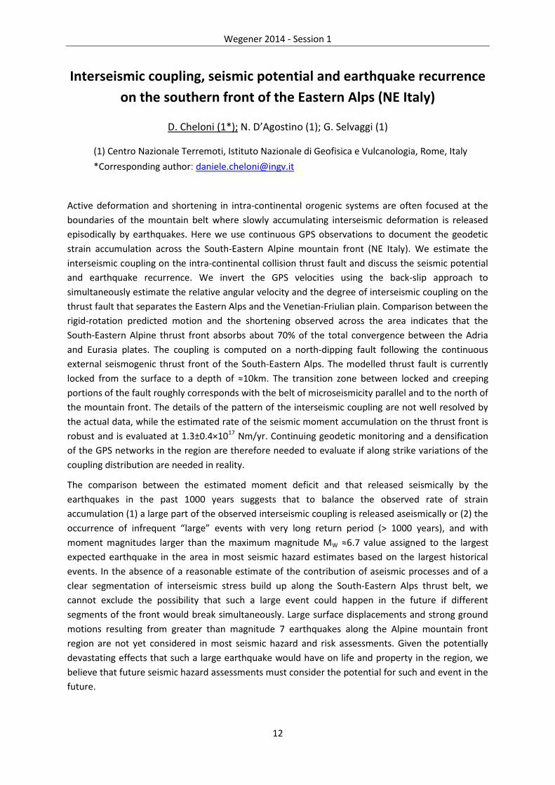
Interseismic coupling, seismic potential and earthquake recurrence
on the southern front of the Eastern Alps (NE Italy)
D. Cheloni (1*); N. D’Agostino (1); G. Selvaggi (1)
(1) Centro Nazionale Terremoti, Istituto Nazionale di Geofisica e Vulcanologia, Rome, Italy
*Corresponding authorː [email protected]
Active deformation and shortening in intra-continental orogenic systems are often focused at the
boundaries of the mountain belt where slowly accumulating interseismic deformation is released
episodically by earthquakes. Here we use continuous GPS observations to document the geodetic
strain accumulation across the South-Eastern Alpine mountain front (NE Italy). We estimate the
interseismic coupling on the intra-continental collision thrust fault and discuss the seismic potential
and earthquake recurrence. We invert the GPS velocities using the back-slip approach to
simultaneously estimate the relative angular velocity and the degree of interseismic coupling on the
thrust fault that separates the Eastern Alps and the Venetian-Friulian plain. Comparison between the
rigid-rotation predicted motion and the shortening observed across the area indicates that the
South-Eastern Alpine thrust front absorbs about 70% of the total convergence between the Adria
and Eurasia plates. The coupling is computed on a north-dipping fault following the continuous
external seismogenic thrust front of the South-Eastern Alps. The modelled thrust fault is currently
locked from the surface to a depth of ≈10km. The transition zone between locked and creeping
portions of the fault roughly corresponds with the belt of microseismicity parallel and to the north of
the mountain front. The details of the pattern of the interseismic coupling are not well resolved by
the actual data, while the estimated rate of the seismic moment accumulation on the thrust front is
robust and is evaluated at 1.3±0.4×10¹⁷ Nm/yr. Continuing geodetic monitoring and a densification
of the GPS networks in the region are therefore needed to evaluate if along strike variations of the
coupling distribution are needed in reality.
The comparison between the estimated moment deficit and that released seismically by the
earthquakes in the past 1000 years suggests that to balance the observed rate of strain
accumulation (1) a large part of the observed interseismic coupling is released aseismically or (2) the
occurrence of infrequent “large” events with very long return period (> 1000 years), and with
moment magnitudes larger than the maximum magnitude MW ≈6.7 value assigned to the largest
expected earthquake in the area in most seismic hazard estimates based on the largest historical
events. In the absence of a reasonable estimate of the contribution of aseismic processes and of a
clear segmentation of interseismic stress build up along the South-Eastern Alps thrust belt, we
cannot exclude the possibility that such a large event could happen in the future if different
segments of the front would break simultaneously. Large surface displacements and strong ground
motions resulting from greater than magnitude 7 earthquakes along the Alpine mountain front
region are not yet considered in most seismic hazard and risk assessments. Given the potentially
devastating effects that such a large earthquake would have on life and property in the region, we
believe that future seismic hazard assessments must consider the potential for such and event in the
future.

Wegener 2014 - Session 1
13
Figure।�/ŶƚĞƌƐĞŝƐŵŝĐ�ĐŽƵƉůŝŶŐ�ĚŝƐƚƌŝďƵƟŽŶ�ĂŶĚ�ďĂĐŬŐƌŽƵŶĚ�ƐĞŝƐŵŝĐŝƚLJ
Wegener 2014 - Session 1
14
Geodetic insights into the growth and evolution of thrust belts:
examples from east Iran
A. Copley (1*); K. Reynolds (1)
(1) COMET, Bullard Labs, Department of Earth Sciences, University of Cambridge, UK
*Corresponding authorː [email protected]
This contribution will discuss the growth and evolution of fold-thrust belts, focussing on two
examples in east Iran. By combining a range of techniques (InSAR, seismology, remote sensing,
geomorphology) it is possible to compare the motions during earthquakes with those in the
following decades, and with the longer-term deformation preserved in the geomorphology and
geological structures. It is therefore possible to examine how repeated seismic cycles result in the
production of geological and topographic structures, and to investigate how such structures can be
used to infer the characteristics of the earthquake cycles that produced them. Such work in two
areas in east Iran (Tabas and Sefidabeh), which experienced large earthquakes in 1978 and 1994, has
provided insights into the nature of the earthquake cycle and the development of the thrust belts in
these locations. The fault slip during the earthquakes was mostly buried at depths of over 5 km.
Aseismic creep on shallow fault zones in the decades following the earthquakes resulted in the
formation of short-wavelength (i.e. < 5 km) topographic and geological structures, of the type that
dominate the surface geology in these regions. The postseismic fault creep has occurred for over 30
years following the Tabas earthquake; an order of magnitude longer than is commonly observed. We
have observed the formation of classic structural geometries, such as ramp-and-flat thrust faults and
hangingwall anticlines, and constrained the properties and behaviours of the different components
of these systems. Our results have implications for the geometry and evolution of thrust belts
worldwide.
References:
[1.] - A. Copley and K. Reynolds, Imaging topographic growth by long-lived postseismic afterslip
at Sefidabeh, east Iran, Tectonics, DOI: 10.1002/2013TC003462, 2014
[2.] - A. Copley, Postseismic afterslip 30 years after the 1978 Tabas-e-Golshan (Iran) earthquake:
observations and implications for the geological evolution of thrust belts, Geophysical
Journal International, doi: 10.1093/gji/ggu023, 2014

Wegener 2014 - Session 1
15
Evaluation of Strain Accumulation in the Western and Central Parts
of Black Sea Region
ɪ. Deniz (1*); N. B. Avsar (2); R. Deniz (3);
(1) Department of Geomatics Engineering, Bulent Ecevit University, Zonguldak, Turkey
(2) Department of Geomatics Engineering, Bulent Ecevit University, Zonguldak, Turkey
(3) Department of Geomatics Engineering, Istanbul Technical University, Istanbul, Turkey
*Corresponding authorː [email protected]
Turkish National Horizontal Control Network (TNHCN) based on the European Datum 1950 (ED50)
was used as the principal geodetic network until 2005 in Turkey. Since 2005, Turkish Large Scale Map
and Map Information Production Regulation have required that that all the densification points have
been produced within the same datum of Turkish National Fundamental GPS Network (TNFGN) put
into practise in 2002 and based on International Terrestrial Reference Frame (ITRF). Hence, the
common points were produced in both European Datum 1950 (ED50), and TNFGN.
It is known that the geological and geophysical information about the network area can be obtained
by the evaluation of the coordinate and scale variations in a geodetic network. For one such
evaluation, the coordinate variations and velocities of network points, and also the strains are
investigated. However, the principal problem in derivation of velocities arises from two different
datums. In this context, the computation of velocities using the coordinate data of the ED50 and
TNFGN is not accurate and reliable. Likewise, the analysis of strain from the coordinate differences is
not reliable. However, due to the fact that the scale of a geodetic network is independent from
datum, the strains can be derived from scale variations accurately and reliably.
In this study, a test area limited 39.5°–42.0° northern latitudes and 31.0°–37.0° eastern longitudes
(the western and central Black Sea region) was chosen. The benchmarks in this test area are
composed of 30 geodetic control points derived with the aim of cadastral and engineering
applications. We used data mining to investigate the common benchmarks in both reference
systems for this area. Accordingly, the ED50 and TNFGN coordinates refer 1954 and 2005,
respectively. Thus, it has been investigated the strain accumulation of 51 years in this region. It
should be also noted that since 1954, the earthquakes have not registered greater than magnitude
6.0 in the test area (Stein et al, 1997). It is a considerable situation for this evaluation.
The finite element analysis is used in order to derive the strain accumulation and its velocities in the
test area. The results have been indicated that the minimum and maximum strains are 17µs and
3041µs, respectively.

Wegener 2014 - Session 1
16
Figureː Strain rates of the test area.
Figure 1 shows that there is systematical distribution of strains in the test area. It also reveals that
there are significant strain formations in the areas with values smaller than ±1µs average. Besides,
some areas have mean strain values of ±15-60µs; these areas approximately cover Eregli-Bolu-
Kizilcahamam-Akyurt and Boyabat-Iskilip-Ugurludag-Yozgat. These results indicate that there are
elastic and less elastic areas within the test area. Additionally, it is clear that the results should be
examined in terms of geological and geophysical. When the accuracy of the scale of TNHCN (±10
ppm) is taken to consideration, the results of this study are regarded as significant.
Wegener 2014 - Session 1
17
The 2013 Mw 6.2 Khaki-Shonbe (Iran) Earthquake: seismic
shortening of the Zagros sedimentary cover
J. R. Elliott (1*), E. A. Bergman (2), A. C. Copley (3), A. R. Ghods (4), E. K. Nissen (5), B. Oveisi
(6), R. J. Walters (7)
(1) COMET+, Department of Earth Sciences, University of Oxford, UK.
(2) Center for Imaging the Earth’s Interior, Department of Physics, University of Colorado, USA.
(3) COMET+, Department of Earth Sciences, Bullard Laboratories, Cambridge, UK.
(4) Department of Earth Sciences, Institute for Advanced Studies in Basic Sciences, Iran.
(5) Department of Geophysics, Colorado School of Mines, Golden, Colorado, USA.
(6) Seismotectonics Department, Geological Survey of Iran, Iran.
(7) COMET+, School of Earth and Environment, University of Leeds, UK
*Corresponding authorː [email protected]
The 2013 Mw 6.2 Khaki-Shonbe earthquake occurred in the Simply Folded Belt of the Zagros
Mountains, Iran. This is the largest earthquake in the Zagros since the November 1990 Mw 6.4 Furg
(Hormozgan) thrust faulting event, and therefore the largest in the period for which dense InSAR
ground displacements are available. It is also the biggest seismic event to have occurred in the
Simply Folded Belt since the March 1977 Mw 6.7 Khurgu earthquake. This earthquake therefore
potentially provides valuable insights into a range of controversies: (1) the preponderance of
earthquake faulting in the crystalline basement versus the sedimentary cover and the potential
importance of lithology in controlling and limiting seismic rupture; (2) the nature of surface folding
and whether or not there is a one-to-one relationship between buried reverse faults and surface
anticlines; and (3) the presence or absence of large pulses of aseismic slip triggered by mainshock
rupture.
We combine seismological solutions and aftershock relocations with satellite interferometric ground
displacements and observations from the field to determine the geometry of faulting and its
relationship with the structure, stratigraphy and tectonics of the Central Zagros. The earthquake
rupture involved reverse slip on two along-strike southwest dipping fault segments, the rupture
initiating at the northern and bottom end of the larger north-west segment. These faults verge away
from the foreland and towards the high range interior, contrary to the fault geometries depicted in
many structural cross-sections of the Zagros. The slip measured on the reverse segments occurred
over two mutually exclusive depth ranges, 10–5 km and 4–2 km, resulting in long (16 km), narrow (7
km) rupture segments. Conversely, aftershocks are found to cluster in the depth range 8–16 km,
beneath the main rupture segment. This indicates only significant reverse slip and coseismic
shortening in the sedimentary cover, with the slip distribution likely to be lithologically controlled in
depth by the Hormuz salt at the base of the sedimentary cover, and the Kazhdumi Formation
mudrocks at upper-levels (5 km), and aftershocks constrained largely beneath the main coseismic
rupture planes.

Wegener 2014 - Session 1
18

Wegener 2014 - Session 1
19
Postseismic ground deformation following the 2010-2011
earthquake sequence in New Zealand, analyzed by high-resolution
InSAR measurements
P. Faegh Lashgary (1), M.i Motagh (3*), J. Townend (1), C. William (2), I. Hamling (2)
(1) Victoria University of Wellington
(2) GNS Science
(3) GFZ German Research Centre for Geosciences, Potsdam
*Corresponding authorː [email protected],
In this paper, we evaluate ground deformation following the 2010-2011 earthquake sequence in
New Zealand by radar satellite interferometry observations. The dataset includes 11 COSMO-
SkyMed (CSK) data in an ascending orbit from October 2010 to February 2011, 19 CSK data in a
descending orbit between February and November 2011, and 66 TerraSAR-X (TSX) data in a
descending orbit between February 2011 and May 2014. The data are analysed to assess postseismic
deformation following the Darfield 2010 earthquake, coseismic deformation related to the
earthquake swarm in December 2010 and approx. 3 yrs. of postseimsic deformation following the
February 2011 Christchurch earthquake. The surface deformation data are analysed using a variety
of geophysical models including afterslip and poroelastic rebound to understand the role of
competing processes in governing the deformation mechanism following the 2010-2011 Canterbury,
New Zealand, earthquakes.
Wegener 2014 - Session 1
20
Non-identical seismogenic depths of three MW 6.3 thrust
earthquakes on the north margin of Qaidam basin: InSAR time-
series analysis and time-dependent modelling
Wanpeng Feng (1*); Zhenhong Li (2); T. Hoey (1)
(1) School of Geographical and Earth Sciences, University of Glasgow, UK
(2) COMET, School of Civil Engineering and Geosciences, Newcastle University, UK
*Corresponding authorː [email protected]
Between 2003 and 2009, three MW 6.3 thrust earthquakes occurred on the northern margin of
Qaidam Basin, NE Tibet. In this study, we use SAR images from 6 tracks of ASAR images to revisit the
coseismic surface displacements and slip models of these three events. The best-fit slip model
suggests that the major slip zone of the 2008 event occurred at a depth of 16 km. The rupture of the
2009 mainshock is nearly coplanar with that from 2008, but at only 5 km depth. The earlier, 2003,
MW 6.3 Delingha earthquake was located ~40 km east of the epicentre of the 2009 event and had a
dominant rupture zone at ~10 km depth. Thus, the seismogenic depths from three MW 6.3
mainshocks are not identical. A depth-segmentation model for the local crustal seismogenic zone
was proposed for the 2008 and 2009 events based on InSAR coseismic modelling analysis (Elliott et
al., 2011).
To examine whether any post-seismic deformation has occurred, an improved network orbit
correction method is proposed to correct orbital errors prior to InSAR time-series analysis. A stacking
interferogram covering the period between the 2008 and 2009 events shows no significant surface
changes. However, another stacking interferogram covering the period of 8 months after the 2009
event suggests a maximum LOS change of ~3 cm. A logarithmic function of the surface deformation
with time is suggested through the small-baseline InSAR analysis. A time-dependent slip inversion
based on the deformation time-series was carried out. The determined accumulative slip model
implies that the accumulative afterslip within 8 months after the 2009 mainshock released a seismic
moment of ~2.1*1019 N.m, equivalent to a single MW 6.8 earthquake. Post-seismic slip was
concentrated in a small zone east of the coseismic rupture region of the 2009 event at nearly the
same depth. Comparing the three slip models in space, fault geometrical structures may play an
important role in the strain energy accumulation and earthquake nucleation of the 2009 mainshock.
Variations in local crustal properties along the depth may contribute to these patterns, but whether
there are such variations remains unanswered.
References:
[1.] Elliott, J.R., Parsons, B., Jackson, J.A., Shan, X., Sloan, R.A., and Walker, R.T., 2011, Depth
segmentation of the seismogenic continental crust: The 2008 and 2009 Qaidam earthquakes:
Geophys. Res. Lett, v. 38.

Wegener 2014 - Session 1
21
Mapping the tectonic motions of the African continent with cGNSS
R. Fernandes (1,2*), M. Bos (1), J. Apolinário (1), M. Meghraoui (3)
(1) SEGAL (UBI/IDL), Covilhã, Portugal
(2) Faculty of Aerospace Engineering, Delft University of Technology, Netherlands
(3) Institut de Physique du Globe, UMR 7516, Strasbourg, France
*Corresponding authorː [email protected]
The African continent is tectonically divided in two main plates, Nubia and Somalia, plus some few
more tectonic blocks in the East African Rift. The majority of the plate boundaries of Africa are well
defined by ridge systems with the exception of the Nubia-Eurasia complex tectonic system. More
uncertainty exists concerning the number and distribution of the afore mentioned tectonic blocks
along the East African Rift region. Nevertheless, this complex sub-plate distribution is nowadays
better constrained with the increasing number of GNSS permanent stations in Africa.
Here, we present work that was prepared in the scope of the IGCP Project 601 – “Seismotectonics
and Seismic Hazards in Africa”. We show the current tectonic relative motions of the African
continent based on the analysis of the estimated velocity field derived using the existing network of
continuous Global Navigation Satellite Systems (cGNSS) stations in Africa and bordering plate
tectonics. For the majority of the plate pairs, we present the most recent estimation of their relative
velocity using a dedicated processing for each pair. The velocity solutions are computed with respect
to the latest global reference frame, ITRF2008, using HECTOR, a versatile software package that
takes into account the existing temporal correlations between the daily solutions of the stations in
order to properly estimate the velocity uncertainties and to detect any artifacts in the time-series.
For some of the plate pairs, we compare our solutions of the angular velocities with other geodetic
and geophysical models.
In addition, we present the sensitivity of the derived angular velocity to changes in the data (longer
data-span for some stations) for tectonic units with few points, namely the Victoria and Rovuma
blocks. This is carried out together with an analysis of the best stochastic model to estimate the
associated uncertainties.

Wegener 2014 - Session 1
22
Rates of convergence and strain accommodation across the
Caucasus region derived from GPS observations
M.A. Floyd (1*); G. Sokhadze (2); F. Kadirov (3); C.C. Trexler (4); E.S. Cowgill (4)
(1) Department of Earth, Atmospheric and Planetary Sciences, Massachusetts Institute ofTechnology, USA
(2) Institute of Earth Sciences, Ilia State University, Tbilisi, Georgia
(3) Geology Institute, Azerbaijan National Academy of Sciences, Baku, Azerbaijan
(4) Department of Earth and Physical Sciences, University of California, Davis, USA
*Corresponding authorː [email protected]
Historical and instrumental seismicity, in addition to geomorphological studies, provide evidence for
the structures on which convergent strain is accommodated across the Caucasus mountains in the
Arabia-Eurasia collision zone. East of 45°E, the Main Caucasus Thrust is conventionally mapped along
the southern topographic front of the Greater Caucasus, up to 80 km north of the southern edge of a
low elevation foreland fold-thrust belt in the Kura Basin. Both range-front topography and surficial
geologic mapping indicate no evidence of late Quaternary surface deformation along the trace of the
Main Caucasus Thrust (Forte et al., 2010; 2013). Here we employ contemporary GPS observations to
constrain the geometry and slip rate of the main structure accommodating strain between the
Greater and Lesser Caucasus. GPS velocities across Georgia and Azerbaijan show that the rate of
convergence between the Lesser and Greater Caucasus ranges from approximately 5 mm/yr in the
west to 12 mm/yr in the east. We present simple one-dimensional elastic dislocation models to
locate and quantify the slip rate on faults accommodating this convergence. At the far eastern end
of the Kura thrust belt (~49°E), where structural geometries are complex, we present plausible
scenarios based on the GPS data using a block model analysis. In Georgia, a shallow north-dipping
thrust outcropping well to the south of the Main Caucasus Thrust is determined to be the principal
accommodating structure. In Azerbaijan, current GPS velocities show a clear velocity gradient across
the Kura Basin but are not yet sufficient to resolve whether the accommodating structures are
simple extensions of mountain-front faults and folds along-strike or due to structures that change
strike as they approach the South Caspian Basin.
References:
[1.] Forte, A. M. et al. (2010), Geological Society of America Bulletin, v. 122, no. 3/4, p. 465-486.
[2.] Forte, A. M. et al. (2013), Tectonics, v. 32, no. 3, p. 688-717.

Wegener 2014 - Session 1
23
Detailed Holocene slip histories of normal faults in Abruzzo, Italy
based on in-situ cosmogenic 36Cl analyses
L.C Gregory (1*); R.J Phillips (1); G. Roberts (2); R.P Shanks (3) K. McCaffrey (4); L. Wedmore
(5); V. Bandugula (4); P. Cowie (6)
(1) School of Earth and Environment, University of Leeds, UK
(2) Dept of Earth and Planetary Sciences, University College London, Birkbeck, UK
(3) Scottish Universities Environmental Research Centre, University of Glasgow, UK
(3) Institute for Risk and Disaster Reduction, University College London, UK
(4) Dept of Earth Sciences, Durham University, UK
(5) Dept of Earth Sciences , University of Bergen, Norway
*Corresponding authorː [email protected]
Cosmogenic exposure dating of exhumed bedrock faults can reveal detailed Quaternary slip histories
spanning multiple earthquake cycles. This method provides unique insight into fault behaviour that
is not easily accessed by typical geodetic, paleoseismic (trenching), and time-averaged Quaternary
slip rate studies, by enabling the characterisation of fault motion beyond a single earthquake cycle,
but with more detail than an average slip rate. Here we present cosmogenic 36Cl analyses collected
from normal faults across Abruzzo, Italy.
NE-SW directed extension in the Italian Apennines since 2-3 Ma is localised on NW-SE trending
normal faults. The driving force of extension is debated, but the elevated topography in the region is
likely supported dynamically by mantle convection, which may also drive extension in the region.
Faulting since the last glacial maximum (LGM) has displaced an erosional surface preserved since the
LGM, creating scarps of exposed bedrock limestone that have throws of several metres. The
exposure history of the faults is reflected in the concentration of 36Cl measured on the fault plane.36Cl is only produced in-situ in the top few metres of the Earth’s surface, primarily due to
interactions between calcium and high energy cosmogenic radiation, and thus accumulates in
bedrock fault scarps as the plane is repeatedly exposed by earthquakes. The geomorphology of
sampling sites must be carefully constrained to ensure that exposure of the fault is only due to
seismic activity and not the result of mass transport or erosional processes. We quantified the
geomorphology of each site using terrestrial LiDAR and ground penetrating radar (GPR).
We demonstrate that on long time scales (>10 kyr), average fault slip rates are comparable to what
would be expected from modern geodetic strain rates. However, on shorter time scales (e.g. over a
few earthquake cycles, or several kyr), slip rates on individual faults vary significantly compared to
the long-term rate. We discuss our observations in Abruzzo in the context of earthquake ‘clustering’
and the migration and distribution of continental strain.

Wegener 2014 - Session 1
24
GPS source solution of the 2004 Parkfield earthquake
N. Houlié (1*); D. Dreger (2); A. Kim (3)
(1) ETH, Zurich
(2) UC Berkeley
(3) Yokohama City University
*Corresponding authorː [email protected]
We compute a series of finite-source parameter inversions of the fault rupture of the 2004 Parkfield
earthquake based on 1 Hz GPS records only. We confirm that some of the co-seismic slip at shallow
depth (<5 km) constrained by InSAR data processing results from early post-seismic deformation. We
also show 1) that if located very close to the rupture, a GPS receiver can saturate while it remains
possible to estimate the ground velocity (~1.2 m/s) near the fault, 2) that GPS waveforms inversions
constrain that the slip distribution at depth even when GPS monuments are not located directly
above the ruptured areas and 3) the slip distribution at depth from our best models agree with that
recovered from strong motion data. The 95th percentile of the slip amplitudes for rupture velocities
ranging from 2 to 5 km/s is ~55 +/-6 cm.
References:
[1.] Houlié, N.; Dreger, D. and Kim, A. (2014) GPS source solution of the 2004 Parkfield
earthquake. Sci. Rep., 4, 10.1038/srep03646 .
Wegener 2014 - Session 1
25
Postseismic deformation after the 1999 Izmit and Düzce
Earthquakes, Turkey
E. Hussain (1*); T. Wright (1); G. Houseman (1); R. Walters (1); D. Bekaert (1)
(1) School of Earth and Environment, University of Leeds, UK
*Corresponding authorː [email protected]
The North Anatolian Fault is a major continental right lateral strike-slip system located in northern
Turkey. This fault system accommodates westward motion of Anatolia with respect to Eurasia at
rates that vary between 18 and 300 mm/yr. There have been 12 large earthquakes on the fault
(M6.7 and above) since 1939 with a dominant westward progression in seismicity culminating in the
M7.4 Izmit and M7.2 Düzce earthquakes in 1999.
Coseismic displacements on faults impart an instantaneous stress change on the adjacent
lithosphere. The redistribution of stress induces postseismic deformation close to and around the
fault that usually decays with time to the background interseismic deformation rates. High
resolution measurements of the spatial and temporal character of the surface deformation following
an earthquake can provide constraints on the mechanical processes involved with the dissipation of
this stress in time and space.
Previous GPS studies have shown postseismic deformation occurring for at least 7 years after the
Izmit earthquake. We use interferometric Synthetic Aperture Radar (InSAR) measurements using
data from Envisat ascending and descending satellite tracks to extend this observation period to
2010 and show that the postseismic deformation is present a decade after the earthquake.
We also show that the Izmit rupture is undergoing aseismic creep at an average rate of ~10mm/yr
during the period 2003-2010. This creep rate remains approximately constant during the
observation period and is a large fraction of the average long-term slip rate on the fault (~25mm/yr).
We present the variation in creep rate along the rupture and show that the creep is limited to the
Izmit rupture segment and does not extend into the Düzce rupture.
Finally, we determine the depth distribution of the aseismic creep using elastic dislocation models
and relate that to the coseismic slip deficit in the Izmit earthquake. We also model the changes in
the creep rate with time using afterslip models and discuss why surface creep as well as long-term
postseismic deformation is observed only on the Izmit rupture and not the Düzce.

Wegener 2014 - Session 1
26
The Dynamic Pattern of the Honghe Fault based on InSAR and GPS
result
Zhang Jingfa(1*);Li Zhenhong (2); Tian Yunfeng (1)
(1) Institute of Crustal Dynamics, CEA, Beijing; China
(2) Newcastle University, UK
*Corresponding authorː [email protected]
Honghe fault is located at the southeast margin of Qinghai-tibet plateau in Sichuan province, is the
southwest boundary of Sichuan-Yunnan region, it plays an important role in the regulating or
conversion of relative movement and deformation between active blocks. The average right-lateral
strike-slip rate of Honghe fault is 2-5mm/a in late Quaternary .It’s structure activity intensity showed
obvious space-time inhomogeneity or segment features: The north section has strong tectonic
activity today, characterized by stretching deformation, earthquake activity is frequent and
happened more than Ms 6.0 earthquake many times; The middle section shows the right-lateral
shearing movement, the south section shows compression deformation, the middle and south
section haven’t happened more than Ms 6.0 earthquake in history, the cause of the mechanism of
the inhomogeneity of seismic activity is the science of a debatable issue. GPS can observe from far
field effectively and determine overall differences movement load conditions of fault, InSAR can
determine near fracture accumulation posture, therefore, the combination of this two means can
help to understand the related issues.
In this paper, the high precision GPS observation combined with D-InSAR technique, obtained fault
zone high resolution crustal deformation observation result. Firstly, more than 60 scenes in 1999-
2013 period of GPS observation data can be conducted, and the depth vector of three dimensional
got, and the difference of far-field horizontal movement and vertical crust movement on both sides
of Honghe fault zone, regional uplift or subsidence characteristics analysed and researched; In
general, high strain rate distributed within the scope of the 10 to 50 km of active fault, PS-InSAR
technique can be used in this aspect. More than 100 Envisat satellite archive data pairs cover
Honghe fault zone area were selected and the high resolution LOS toward deformation rate field of
several tectonic basins such as Eryuan,Dali,Midu were obtained on the basis of elimination of errors
in orbit, the atmosphere and terrain, and the tectonic strain accumulation dynamics of nearly
fracture and the regularity of crustal movement determined.
Characteristics of crustal deformation around the fracture zone are the composite reflection of fault
geometry parameters (atresia depth, dip of fault), the movement parameters (strike-slip rate and
style) and the medium physical parameters.
According to the constraint of geodetic observation data of GPS,InSAR velocity vector and seismic
geological data(strike-slip rate),aided by the active structure geometry features of the Honghe fault
zone, the crustal deformation block model was constructed, and inversed geometry and kinematics
parameters of strike-slip rate of fracture, atresia depth, geometry distribution of deep fracture face
and current three-dimensional movement rate, current 3D structure model researched, the degree
of strain accumulation, the closure state, the relationship between active faults and regional tectonic
activity and seismic risk of Honghe large strike-slip fault were analysed .

Wegener 2014 - Session 1
27
Slip deficit and location of seismic gaps along the Dead Sea Fault
M. Meghraoui (1*), R. Toussaint (1), M. Ferry (2), P. Nguema-Edzang (1)
(1) Institut de Physique du Globe, UMR 7516 Strasbourg, France
(2) Geosciences Montpellier, France
*Corresponding authorː [email protected]
The Dead Sea Fault (DSF), a ~ 1000-km-long North-South trending transform fault presents structural
discontinuities and includes segments that experienced large earthquakes (Mw>7) in historical times.
The Wadi Araba and Jordan Valley, the Lebanese restraining bend, the Missyaf and Ghab fault
segments in Syria and the Ziyaret Fault segment in Turkey display geometrical complexities made of
step overs, restraining and releasing bends that may constitute major obstacles to earthquake
rupture propagation. Using active tectonics, GPS measurements and paleoseismology we investigate
the kinematics and long-term/short-term slip rates along the Dead Sea fault. Tectonic
geomorphology with paleoseismic trenching and archeoseismic investigations indicate repeated
faulting events and left-lateral slip rate ranging from 4 mm/yr in the southern fault section to 6
mm/yr in the northern fault section. Except for the northernmost DSF section, these long-term
estimates of fault slip rate are consistent with GPS measurements that show 4 to 5 mm/yr
deformation rate across the plate boundary. Indeed, recent GPS results showing 3 0.5 mm/yr
velocity rate of the northern DSF appear to be in contradiction with the ~6 mm/yr paleoseismic slip
rate.
The kinematic modeling that combines GPS and seismotectonic results implies a complex
geodynamic pattern with the DSF transforms the Cyprus arc subduction zone into transpressive
tectonics on the East Anatolian fault. The timing of past earthquake ruptures shows the occurrence
of seismic sequences and a southward migration of large earthquakes, with the existence of major
seismic gaps along strike. In this contribution, we present the calculated seismic slip deficit along the
fault segments and discuss the identification of seismic gaps and the role of the DSF in the regional
geodynamics.

Wegener 2014 - Session 1
28
New insights on the seismic hazard in the Balkans inferred from
GPS
M. Métois (1*), N. D'Agostino (1), A. Avallone (1), N. Chamot-Rooke (2), A. Rabaute (3), L.
Duni (4), N. Kuka (4), R. Koci (4), I. Georgiev (5)
(1) Istituto Nazionale di Geofisica e Vulcanologia, Centro Nazionale Terremoti, , Italia
(2) Laboratoire de Géologie, Ecole Normale Supérieure, France
(3) GEOSUBSIGHT - ISTeP - UMR 7193 UPMC-CNRS, Université Pierre et Marie Curie, France
(4) Institute of Geosciences, Tirana, Albania
(5) National Institute of Geophysics, Geodesy and Geography, Sofia, Bulgaria
*Corresponding authorː [email protected]
The Balkans region sits at the transition between stable Eurasia and highly straining continental
Eastern Mediterranean, resulting in a widespread seismicity and high seismic hazard. Because of
intensive human and economic development over the last decades, the vulnerability has increased
in the region faster than the progress in seismic hazard assessments. Opposite to the relatively good
understanding of the seismicity in plate boundaries contexts, the seismic hazard is poorly known in
the regions of distributed continental deformation like the Balkan region and is often
underestimated (England and Jackson, 2011). Current seismic hazard assessments are based on the
historical and instrumental catalogues. However, the completeness interval of the historical data
bases may be below the average recurrence of individual seismogenic structures. In addition,
relatively sparse seismological networks in the region and limited cross-border seismic data
exchanges cast doubts in seismotectonic interpretation and challenge our understanding of seismic
and geodynamic processes. This results in a inhomogeneous knowledge of the seismic hazard of the
region to date. Geodetic measurements can contribute to seismic hazard by mapping the field of
current active deformation and translating it into estimates of the seismogenic potential. GPS
networks in the Balkans have been growing during the last few years mainly for civilian application
(e.g. Cadastral plan, telecommunications), but opening new opportunities to quantify the present-
day rates of crustal deformation.
Here we present the initial results of GEOSAB (Geodetic Estimate of Strain Accumulation over
Balkans), an AXA-Research-Fund supported project devoted to the estimation of crustal deformation
and the associated seismic hazard of the Balkan region. We processed all the currently available data
acquired on these new networks using the precise point positioning strategy of the Gipsy-Oasis
software (Bertiger et al. 2010, version 6) and the daily ITRF2008 transformation parameters (x-files)
from JPL. Daily coordinates are obtained in a Eurasia-fix reference frame created using the strategy
developed by Blewitt et al. (2012). We present this new velocity field combined with previously
published data sets covering the Balkan Peninsula. This unusually dense picture of the current
deformation, in particular in Slovenia, Serbia and northern Greece, is combined together with tensor
moments from RCMT and CMT to derive a continuous map of the strain rate over the region using
the approach of Haines and Holt (1993). These maps bring new insights on areas of significant strain
accumulation over the Balkan Peninsula and are a first step to better assess seismic hazard there. In
particular, we demonstrate that significant strain is accommodated in the Balkans peninsula from

Wegener 2014 - Session 1
29
northern Greece to the Carpathian belt, probably by multiple active structures. The North-East
motion of Adria and Apulia rigid blocs is nearly fully accommodated by compression of the Dinarides
mountain belt, without producing significant compression in the Panonnian Basin. Most of this
compression is compensated by North-South extension in Serbia, Macedonia and western Bulgaria,
with barely any strain accumulating in the rigid Black sea.

Wegener 2014 - Session 1
30
Crustal Deformation of Egypt from Permanent and campaign GPS
Measurements
M. Saleh. (1*); M. Becker (2)
(1) TU-Darmstadt, Physical and Satellite Geodesy (PSGD), Darmstadt, Germany
(2) National Research Institute of Astronomy and Geophysics (NRIAG), Helwan, Cairo, Egypt
*Corresponding authorː [email protected]
The subduction between Nubia and Eurasia and activities along the Red Sea, Gulf of Suez and Gulf of
Aqaba, may control the surface deformation in the north-eastern corner of the African continent.
Using very few GPS stations in the Egyptian region, previous studies indicate north-ward motion of
northern-Africa with respect to Eurasia of about 5mm/yr (McClusky et al., 2000; Reilinger et al., 2006;
Mahmoud et al., 2005). In order to constrain better the movement rate of northern-Africa and
interaction between Nubia, Eurasia and Arabia plates, we are using, for the first time, 16 permanent
GPS stations in combination with 47 non-permanent stations covering Egypt for the period 2006-
2012.
This paper extends the previous studies by processing in addition to the Egyptian stations,
permanent and epoch sites, 86 permanent stations, belonging to three different tectonic plates
using Bernese V. 5.2. This led to a considerably better coverage of the Sinai-Dead-Sea region. We
used CATS software to assess the achieved results and to get a realistic error estimation. This work
intends to be the first comprehensive analysis of the permanent stations in combination with the
various campaign data in selected regions of special interest in Egypt. We present the present state
of absolute horizontal velocities in ITRF2008, the relative motion of Nubia in Eurasia-fixed frame, the
relative motion of Arabian and Sinai in Nubian-fixed frame and the strain field for the north-eastern
corner of African continent. New conclusions on the localization and distribution of the deformation
are presented.
Wegener 2014 - Session 1
31
Postseismic viscoelastic relaxation following the L'Aquila 2009
earthquake: implications for lithospheric rheology of the Apennines
F. Silverii (1*,2); N. D'Agostino (1)
(1) Istituto Nazionale di Geofisica e Vulcanologia, Centro Nazionale Terremoti, Italy.
(2) Dipartimento di Fisica, Settore di Geofisica, University Alma Mater Studiorum, Italy.
*Corresponding authorː [email protected]
In this work we use GPS data to study the postseismic viscoelastic relaxation related to the MW 6.3
normal faulting earthquake that struck the city of L'Aquila (Central Apennines, Italy) on April 6, 2009.
This is interesting first because only a small number of works have focused on the viscoelastic
relaxation related to normal-faulting events. Moreover there are almost no estimates of the
viscosity values of the lower crust/upper mantle in the Central Appennines. This region is currently
experiencing active extension that gives rise to normal-faulting seismicity. The estimation of
boundary values for viscosity (in the limits of the GPS data resolution), and then of the typical
relaxation time of the region, is therefore of great interest for interseismic strain-rate estimations
and to better understand how extension is accommodated in this area beneath the upper
seismogenic crust.
GPS data are processed by using GIPSY/OASIS software. Particular care has been taken to filter out
the interseismic deformation and the seasonal (annual and semi-annual) signal from the GPS time
series. This is particularly difficult for the sites that have been installed shortly before or after the
event, for which we interpolated the interseismic velocity values by means of interpolation codes.
Moreover we tried to isolate the long-term postseismic deformation from the early postseismic
deformation related to afterslip (D’Agostino et al., 2012). Here we compare about 5 years of
postseismic deformation recorded at permanent GPS stations and the surface deformation expected
running different viscoelastic models in order to estimate best-fit rheological parameters. Forward
models are generated by means of the PSCMP/PSGRN code (Wang et al. 2006), that permits to
estimate the time-dependent deformation for a layered viscoelastic-gravitational half-space once
the fault models and the coseismic slip distributions are assigned. We performed some preliminary
test to assess the pattern and magnitude of the viscoelastic deformation expected in the area of
study related to different values of viscosity, thickness of upper crust layer and rheological models
and to evaluate what differences can be detected by GPS data resolution. Preliminary results will be
presented and possible implications for the mechanism of active crustal extension in general and of
the Apennines in particular, will be discussed.
Wegener 2014 - Session 1
32
Continuum deformation explains kinematics of continental
convergence in Iran
R.J. Walters (1*); P.C. England (2); G.A. Houseman (1)
(1) COMET, School of Earth and Environment, University of Leeds, UK
(2) COMET, Department of Earth Sciences, University of Oxford, UK
*Corresponding authorː [email protected]
Iran provides one of the best global examples of an active zone of continental convergence, and a
large and growing population within the country is exposed to high seismic hazard. However, despite
the region’s tectonic importance, the force balance responsible for Iran’s large-scale deformation
field is not well understood. Previous continuum deformation models for Iran suggest that lateral
variations in lithospheric strength are necessary to account for the non-deforming region of Central
Iran, but these studies were undertaken before the availability of an Iranian GPS velocity field with
which to compare such models.
Here we construct a dynamic deformation model that treats the Iranian lithosphere as a thin sheet
of viscous material overlying an inviscid substrate. We find that the GPS deformation field from
recent geodetic studies is well-described by such a continuum model, and in doing so we calculate
that the effective viscosity of the Iranian lithosphere is 5×10²² Pa s for a strain-rate of 60
nanostrains/yr. Contrary to the suggestions of previous studies, we find that a rigid Central Iran is
not required to match the strain-rate field of Iranian deformation. Instead, this pattern can be
replicated by considering buoyancy forces acting in the lithosphere. We also find that overthrusting
of South Caspian oceanic lithosphere by Iranian continental lithosphere in the Talesh mountains
plays an important role in determining local kinematics in NW Iran. Finally, we develop a novel
method of translating the results of our dynamic model into estimates of seismic hazard, by using a
block model type approach applied to the continuum velocity field in order to estimate slip rates
across known fault systems.

Wegener 2014 - Session 1
33
The Earthquake Loading Cycle and the Deep Structure of the North
Anatolian Fault
T.J. Wright (1*), D. Cornwell (2), K. Farrell (1), G.A. Houseman (1), E. Hussain (1), G. Lloyd (1),
R. Phillips (1), D. Thompson (1), S. Rost (1), T. Yamasaki (1), N. Turkelli (3), and L. Gulen (4)
(1) COMET, School of Earth and Environment, University of Leeds, Institute of Geophysics andTectonics, School of Earth and Environment, Leeds, United Kingdom
(2) School of Geosciences, University of Aberdeen, King’s College, Aberdeen, Scotland
(3) Geophysics, Bogazici University, Kandilli Observatory and Earthquake Research Institute,Istanbul, Turkey
(4) Geophysics, University of Sakarya, Sakarya, Turkey
*Corresponding authorː [email protected]
Deformation of the Earth’s upper crust is localised onto narrow fault zones, which may slip suddenly
and catastrophically in earthquakes. Strain in the upper mantle is more broadly distributed and is
typically thought to occur by continuous ductile creep. The transition in the lower crust from broad
shear zone to a narrow structure in the upper crust is poorly understood but the properties of the
lower crust are an important control on the behaviour of the system during the earthquake loading
cycle. The properties of lower crustal rocks, and their spatial variation, cannot be measured directly;
instead inferences are typically made from seismic observations, exhumed geological analogues, and
modelling of surface deformation data. Existing seismic experiments have poor resolution in the
lower crust; and many current geodetic models do not reproduce observations of rapid post-seismic
and focussed inter-seismic strain.
Here we present the preliminary findings of FaultLab, an interdisciplinary experiment using seismic
imaging, geodesy, numerical modelling, and geology to investigate how the earthquake loading cycle
of the North Anatolian Fault Zone is controlled by its deep crustal structure. We present results from
an 18 month deployment of a 73 station network encompassing the northern and southern
branches of the NAFZ in the Sakarya region. The dense array (nominal station spacing of 7 km)
crosses the 1999 Izmit earthquake rupture and is designed to provide high resolution images of the
mid-lower crust. Teleseismic scattering tomography and receiver function analysis suggest that the
two branches of the fault remain as relatively narrow structures to at least 25 km, and that the faults
separate very different terranes.
This portion of the North Anatolian Fault has the best geodetic record for any strike-slip fault, with
deformation well recorded both before and after the 1999 earthquakes. Prior to the earthquake,
strain was focused in a ~50 km region around the fault. Following the earthquake, a rapid post-
seismic transient was observed, which slowly decayed over the subsequent decade. Viscoelastic
modelling requires materials with at least two relaxation time constants to explain these
observations – a strong material to allow focused interseismic strain, and a weak material to give
rapid postseismic deformation. Geological analogues of the mid-lower crust beneath the North
Anatolian Fault are consistent with the idea that strain is focused in relatively narrow shear zones.
We present a shear-zone model for the earthquake deformation cycle that is consistent with these
interdisciplinary observations, and discuss the implications for other fault zones.
Wegener 2014 - Session 1
34
The crustal stress state beneath the western North Anatolian Fault:
inferences from the earthquake cycle model
T. Yamasaki (1*); G.A. Houseman (1)
(1) School of Earth and Environment, University of Leeds, UK
*Corresponding authorː [email protected]
Earthquakes release elastically stored stresses in seismogenic zones. This fundamental concept
requires us to know the state of crustal stress in order to predict the likelihood of earthquakes. We
investigate, using a simplified model of the earthquake cycle, where in the crust, and with what
time-scale, the stress accumulation develops within a seismogenic zone. Seismogenic zones may be
constantly strained by regional (and/or local) tectonic forces, under which the evolution of stress
during the seismic cycle is caused by both co- and post-seismic deformation. Since the co-seismic
deformation occurs as an instantaneous elastic response to a movement of the earthquake source
fault, it is straightforward to estimate a faulting slip distribution and its related stress change from
geodetically and seismologically observable surface deformation. The stress change associated with
post-seismic deformation, however, requires a plausible crustal viscosity structure. In many
previous studies (e.g., Hearn et al., JGR, 114, 114, B08405, doi:10.1029/2008JB006026, 2009; Ryder
et al., GJI, 187, 613-630, 2011; Yamasaki et al., EPSL, 351-352, 105-114, 2012; Hetland and Zhang, GJI,
198, 259-269, 2014), visco-elastic relaxation in the post-seismic period has been predicted without
respect to any cumulative effects of stress over the past cycles. As shown by Yamasaki et al. (JGR,
119, 3678-3699, 2014), ignorance of the past cycles causes no problem if visco-elastic relaxation
time is less than 0.1 times earthquake repeat time, but if visco-elastic relaxation time is greater than
the repeat time then elastic stress is held over succeeding cycles. In this study, using the simplified
3D finite element model of Yamasaki et al. (2014), we describe the crustal stress evolution of the
western North Anatolian Fault (NAF), assuming linear Maxwell visco-elasticity beneath a faulted
elastic layer in which right-lateral strike-slip faulting occurs at a regular interval and far-field
boundary velocities continuously strain the seismogenic zone. We assume a crustal viscosity
structure, which Yamasaki et al. (2014) estimated using constraints from the GPS data collected
before and after the 1999 İzmit and Düzce earthquakes. Our numerical experiments in this study
have found (1) the predicted post-seismic deformation does not constrain the absolute stress
magnitude under the assumption that the fault slips at regular intervals, and (2) the post-seismic
stress transfer following an earthquake causes stress to increase most within the seismogenic zone.
In the context of the 1999 Izmit earthquake, the northern strand of the NAF is more rapidly loaded
relative to the southern strand, which may explain higher tectonic activity along the NAF northern
strand.

Wegener 2014 - Session 1
35
Investigation of lithospheric structure in Mongolia: InSAR
observations and modelling
Jing Zhang (1*), I. Ryder (2)
(1) School of Environmental Sciences, University of Liverpool, UK
(2) School of Environmental Sciences, University of Liverpool, UK
*Corresponding authorː [email protected]
Western Mongolia is a seismically active intercontinental region, with ongoing tectonic activity and
widespread volcanism attributed to the India-Eurasia collision and Pacific plate extrusion. During the
last century, four M > 8 earthquakes occurred in Mongolia. The 1957 Gobi-Altai earthquake is one of
the largest magnitude earthquakes. The rupture pattern associated with this earthquake is complex,
involving left-lateral strike-slip and reverse faulting on several distinct geological structures in a 264 x
40 km wide zone. To understand the relationship between observed postseismic surface
deformation and the rheological structure of the upper lithosphere, we use Interferometric
Synthetic Aperture Radar (InSAR) data to study the 1957 earthquake in southwest of Mongolia and
model the late postseismic deformation. SAR data were acquired from the ERS1/2 and Envisat from
1996 to 2010. Using the Repeat Orbit Interferometry Package (ROI_PAC), 142 postseismic
interferograms have been produced on four adjacent tracks. Stacking these interferograms yields a
maximum deformation rate along the fault at 2mm/yr. The observed motion can be explained by a
model of postseismic relaxation. The VISCO1D software was used to compute the postseismic
response to dislocation sources for various spherical viscoelastic models. We use a two-layer earth
model consisting of an elastic plate overlying a viscoelastic half space to estimate the elastic
thickness of the upper crust and the underlying viscosity. The inferences drawn about rheology in
this study may inform seismic hazard models and interpretations of geophysical data in this area.

36
37
Session 2: Giants of the Deep:
Anatomy and Physiology of a
Megathrust zone
Conveners: Isabelle Ryder, Anne Socquet, Haluk Ozener and David Bekaert

Wegener 2014 - Session 2
38
Causes and consequences of spatial and temporal variability of slip
behavior on the Hikurangi subduction thrust, New Zealand
L.M. Wallace (1*); S. Bannister (2); B. Fry (2); N. Bartlow (3); C. Williams (2); S. Ellis (2); I.
Hamling (2)
(1) University of Texas, Institute for Geophysics, Austin, TX, USA
(2) GNS Science, Lower Hutt, New Zealand
(3) Scripps Inst. of Oceanography, Univ. California San Diego, USA
*Corresponding authorː [email protected]
Campaign and continuous GPS measurements in the North Island of New Zealand reveal marked
along-strike variations in slip behavior of the Hikurangi subduction thrust. The southern Hikurangi
interface undergoes deep interseismic coupling (down to 30 km depth), while much of the interface
at the northern and central Hikurangi margin is dominated by aseismic creep and episodic slow slip
events (SSEs). The character of SSEs at Hikurangi also undergoes strong along-strike variations. At
southern Hikurangi, deep (30-50 km), long-duration (1 year), infrequent (5 year recurrence), large
(Mw 7.0) SSEs occur along the down-dip transition from interseismic coupling to aseismic creep.
Plate boundary slip on the shallow interface (<15 km depth) at northern Hikurangi is dominated by
frequent (1-2 year recurrence), short (1-3 weeks), moderate to large (Mw 6.3-7.0) SSEs. In contrast,
at central Hikurangi, the majority of the megathrust between <10-50 km depth undergoes SSE slip,
indicating that the physical conditions conducive to SSE slip may be inherently broad. At central
Hikurangi, we observe a full spectrum of SSE durations, magnitudes and recurrence characteristics
that appear to vary with depth, including short, shallow (<15 km) SSEs beneath Hawke Bay, long-
duration, deep (30-50 km) large SSEs in the Manawatu region, and newly observed moderate
duration (~3 months) SSEs at 30-40 km depth, directly down-dip of the shallow Hawke Bay SSEs.
Slow slip events also appear to dramatically impact seismicity rates in the North Island: the large
(Mw > 7.0) 2013/2014 Kapiti SSE and many of the east coast, shallow SSEs are excellent examples of
this. We will overview results from some of the most recent SSEs.
Along-strike changes in megathrust behavior at Hikurangi are also accompanied by along-strike
variations in convergence rate, sediment thickness on the incoming plate, degree of accretion vs.
subduction erosion, upper plate stress regime (i.e., a shift from back-arc extension to transpression
in the upper plate), geochemical signature of fluids emerging within the forearc, seismic attributes of
the plate interface and upper plate, among other characteristics. We will discuss some potential
mechanisms to explain these along-strike variations, including the effects of seamount subduction,
and the link between upper plate stress, permeability, fluid flow, and fluid pressure along the
interface. We will also discuss emerging initiatives using seafloor geodesy and scientific drilling to
investigate the physical processes behind shallow (<10 km depth) slow slip at North Hikurangi.

Wegener 2014 - Session 2
39
Figure Perspective view of the Hikurangi margin illustrating the portions of the subduction
interface that undergo stick-slip (red) vs. aseismic slip (blue), in the context of other along-strike
variations in subduction margin characteristics. Green contours show areas of slip in slow slip
events between 2002-2010. Convergence rates at the trench are labeled as red numbers (mm/yr).
Pacific/Australia convergence shown by black arrow. Black dashed line shows location of proposed
IODP drilling transect.

Wegener 2014 - Session 2
40
Reassessing the 2006 Guerrero slow slip event: Implications for
large earthquakes in the Guerrero Gap
D. Bekaert (1*), A. Hooper (1), and T. Wright (1)
(1) COMET, School of Earth and Environment, University of Leeds, UK
*Corresponding authorː [email protected]
In Guerrero, Mexico, slow slip events have been observed in a “seismic Gap”, where no earthquakes
have occurred since 1911. A rupture of the entire Gap today could result in a Mw 8.0-8.4 earthquake.
However, it remains unclear how slow slip events change the stress field in the Guerrero seismic
region, and what their implications are for devastating earthquakes. The limited station distribution
of GNSS restricts its ability to constrain the spatial extent of the slow slip. Here we show that
Interferometric Synthetic Aperture Radar (InSAR) can be used to improve the spatial resolution. We
performed a time-series InSAR analysis of 18 Envisat SAR images, and estimate the atmospheric
noise by assuming a power-law behaviour for the tropospheric delays. We modelled slip on the
subducting interface by performing a Monte Carlo sampling of the rake, rake slip, smoothness, and
InSAR plane; allowing us to obtain a full error distribution of the unknowns. We find slip due to the
2006 slow slip event to enter the seismogenic zone and the Guerrero Gap, with ~6 cm slip reaching
depths as shallow as 12 km. We show slow slip to be correlated with a highly coupled region, and
estimate that the 2006 slow slip event decreased the total accumulated moment since the end of
the 2001 slow slip event (4.7 years duration) by ~50%. Nevertheless, even accounting for slow slip,
the slip deficit in the Guerrero Gap increases each year by an amount that could be released in a Mw
~6.8 earthquake. The Guerrero Gap therefore still has the potential for a large earthquake, with a
slip deficit equivalent to Mw ~8 accumulated over the last century. Correlation between the slow slip
region and non-volcanic tremor, and between slow slip and an ultra slow velocity layer supports the
hypothesis of a common source potentially related to high pore pressures.

Wegener 2014 - Session 2
41
Deep postseismic viscoelastic relaxation excited by an intra-slab
normal faulting earthquake in the Chile subduction zone
L. Bie (1*); Isabelle Ryder (1)
(1) School of Environmental Sciences, University of Liverpool, UK
*Corresponding authorː [email protected]
Geodetic observations of postseismic deformation have been widely modeled to constrain the
rheology of lower crust and/or upper mantle in variable tectonic environments. In subduction zones,
where megathrust earthquakes occur frequently, postseismic deformation is often explained by
afterslip and/or viscoelastic relaxation (VER) processes, and explicitly modeled to infer the viscosity
of the mantle wedge. Besides the megathrust events, large intermediate-depth normal faulting
earthquakes also induce stresses in surrounding lithosphere. Presumably, these stresses will be
gradually released by viscoelastic relaxation in any nearby weak layer(s) and hence provide
opportunities to infer rheological properties.
Here, we investigate the short-term postseismic deformation recorded by the Envisat satellite
following the 2005 Mw 7.8 Tarapaca earthquake in Chile. The earthquake is identified as a result of
pure normal faulting on a west-dipping plane at depths between 90 and 115 km within the
subducting slab of northern Chile (Delouis and Legrand, 2007). We will show preliminary results of
VER modelling, assuming a Maxwell viscoelastic upper mantle, and demonstrate the feasibility of
using normal faulting earthquakes to constrain deep subduction zone rheology. We will also briefly
discuss methodological approaches for dealing with the laterally heterogeneous rheology expected
in subduction zones.
Wegener 2014 - Session 2
42
Silent and not so silent triggering: Crustal faulting induced by
subduction slow slip events in New Zealand
I J Hamling (1*), L.M Wallace (2), C. Williams (1), B. Fry (1).
(1) GNS Science, New Zealand
(2) Institute for Geophysics, University of Austin at Texas, USA
*Corresponding authorː [email protected]
With durations of weeks to months, slow slip events (SSEs) have been observed along subduction
zone plate boundaries around the globe including Cascadia, Japan and New Zealand. SSEs have been
observed geodetically with equivalent seismic moment magnitudes ranging from 6 up to Mw 7,
displacements of a few to tens of centimeters, and have been linked with microseismic and tremor
activity. Here we present data from the 2004 Manawatu and 2013 Kapiti SSEs along the Hikurangi
margin, New Zealand, which are implicated in the triggering of aseismic slip along the Wellington
fault and a Mw 6.3 earthquake respectively. In the first example, we show one of the first examples
of the use of Interferometric Synthetic Aperture Radar (InSAR) data to document slow slip during a
SSE on the Hikurangi subduction interface. Although much of the deformation that we observed is
attributable to slow slip on the subduction interface (as expected), the InSAR data also reveals
surface offsets of up to 1 cm across the northern section of the Wellington fault, a major strike slip
fault running through the North Island and New Zealand’s capital, during the period of the slow slip
event. In order to fit the observations, we find that reverse aseismic slip is required along a portion
of the Wellington fault where the Coulomb Failure Stress changes (ΔCFS), due to the SSE, are in
excess of 0.01~MPa. This is the first-ever documented example of a subduction interface SSE
triggering a transient slip event on a major upper plate fault, and it has wide-ranging implications for
the role that SSEs can play in time-dependent seismic hazard. In the second example, we show that
the stress change induced by the 2013 Kapiti SSE was likely responsible for a Mw 6.3 earthquake in
the south east of New Zealand’s North Island. The Eketahuna earthquake occurred on January 20th
2014 and caused widespread shaking across New Zealand’s North Island. The earthquake occurred
along a normal fault at ~22 km depth, within the subducting Pacific slab. At the time of the
earthquake, modelled stresses along the inferred fault plane, induced by the ongoing Kapiti SSE,
favoured the failure of the fault and exceeded 0.02 MPa.

Wegener 2014 - Session 2
43
Variations in slow slip moment rate associated with tremor
reversals in Cascadia
J.C. Hawthorne (1*); A.A. Royer (2); M.G. Bostock (2); A.M. Thomas (3)
(1) Seismological Laboratory, Division of Geological and Planetary Sciences, Caltech, USA
(2) Department of Earth, Ocean and Amospheric Sciences, University of British Columbia,Canada
(3) Department of Geophysics, Stanford University, USA
*Corresponding authorː [email protected]
We identify changes in the slow slip moment rate associated with rapid tremor reversals (RTRs)
beneath southern Vancouver Island in Cascadia. Tremor reversals are periods a few hours long
during which tremor propagates a few tens of kilometers back through the region that has already
slipped. The reversals considered here were identified by Royer et. al. (in prep.) using their extensive
tremor catalog based on low-frequency earthquakes.
We use PBO borehole strainmeter data to search for variations in the slow slip moment rate during
RTRs in slow slip events between 2007 and 2012. The rate of strain accumulation at a given
strainmeter depends on both the moment rate and the current location of slip. To isolate the
moment rate, we identify intervals when strain accumulates roughly linearly over 2 to 10 days. The
linearity suggests only small changes in the Green’s functions, so we interpret variations in strain
rate during these intervals as variations in the moment rate.
We first examine the change in strain rate at individual strainmeters during individual RTRs. For 70%
of the reversal periods considered, the RTR strain rate is 2 to 4 times the background strain rate
associated with slow slip. This implies that the moment rate during RTRs is usually 2 to 4 times the
moment rate of forward-propagating slow slip. Next, we determine a single change in strain rate
during RTRs, as averaged over multiple reversals, strainmeters, and slow slip events. This approach
gives roughly a factor of 2 increase in moment rate during tremor reversals.
These increases in moment rate imply that the moment typically released by an RTR is 1/8 to 1/2 of
the moment released during one day of forward-propagating slow slip. Coupling this moment with
spatial extent of the reversals, we estimate a mean accumulated slip of order 0.5 cm and stress
drops of order 5 to 10 kPa---within a factor of a few of the main event stress drop. These estimates
could help constrain the mechanisms controlling tremor reversals and slow slip.

Wegener 2014 - Session 2
44
Postseismic deformation associated with the Maule earthquake
and the mechanical properties of the asthenosphere and
subduction interface
E. Klein*(1), L. Fleitout (1), C. Vigny(1), J. Garaud (2)
(1) Ecole Normale Supérieure, UMR CNRS 8538, Paris
(2) Onera, Chatillon
*Corresponding authorː [email protected]
The interseismic and postseismic deformations preceding and following the large subduction
earthquake of Maule (Chile, Mw8.8, 2010) have been closely monitored with GPS. Thanks to several
national agencies and international scientific networks, we dispose of large cGPS datasets in Chile
and Argentina, bringing data from 70 km up to 2000 km away from the trench.
Post-seismic deformations exhibit a behavior generally similar to that already observed after the
Tohoku-Oki earthquake in Japan, with some discrepancies. Alike in Japan, vertical uplift on the
oceanward side of the volcanic arcs, so called mid-field (between 300 and 500 km from the trench) is
observed, along with a large scale subsidence associated with non-negligible horizontal deformation
in the far-field (from 500 to 2000 km from the trench). In addition, thanks to the proximity between
the trench and the Chilean coast (70km at the closest point), valuable near-field data are available,
featuring very complex deformations patterns.
We use a 3D finite element code (Zebulon Zset) to relate these deformations to the mechanical
properties of the mantle in the subduction zone area. The mesh features a spherical shell-portion
from the core-mantle boundary to the earth's surface, extending over more than 60 degrees in
latitude and longitude. The overridding and subducting plates are elastic, and the asthenosphere is
viscoelastic. We test the presence and shape of two low viscosity areas in the mantle : a low viscosity
wedge (LVW) above the subducting plate extending potentially beneath the volcanic arc, and a low
viscosity channel (LVCh) extending along the lower part of the subduction interface, and potentially
deeper. Burgers rheologies have been adopted for all the viscoelastic regions. We invert for the
mechanical properties and geometrical characteristics of the asthenosphere of the LVW and the
LVCh.
Our best fitting models feature, (i) an asthenosphere extending down to 270km, with a 'long-term'
viscosity of the order of 3.1018 Pa.s; (ii) a LVCh along the plate interface extending from depth of 50
to 150 km with viscosities of slightly less than 1018 Pa.s; (iii) a LVW restricted to the base of the
lithosphere below the volcanic arc, with viscosities of a few 1018 Pa.s. Mid-field uplift and increased
horizontal velocities are due to relaxation in both the LVW and the LVCh. Nevertheless, viscoelastic
relaxation is not sufficient to explain the characteristics of the near-field displacements, and some
additional slip on the plate interface at shallow depth is also necessary.
Wegener 2014 - Session 2
45
Morphological and geodynamical features of the East Scotia ridge
E. Kurbatova (1,2*); E. Dubinin (1)
(1) Department of Geomorphology and Palaeogeography , Lomonosov Moscow StateUniversity.
(2) Department of Geosciences and Natural Resource Management, University of Copenhagen.
*Corresponding authorː [email protected]
The study area Scotia Sea locates within the limits of the same name plate, at the turn of three
primary plates: Antarctic, Pacific and South American. In general the whole region is divided into
three different provinces: Western, Central and Eastern.
East Scotia Sea was formed by oceanic crust generated in the active back-arc spreading ridge in the
rear of South Sandwich subduction zone. Relief can be described as a typical back arc oceanic basin.
But it should be noted that eastern province is an example of the most isolated and «long-living» but
active back-arc basin of the World.
East Scotia ridge (ESR) characterizes as an orthogonal spreading ridge with intermediate rate. It
differs markedly from its western «congener» by its less length. It practically does not rise over the
seafloor. Some transform faults cut this ridge.
Such «poor» morphology of the ESR can be explained by the youth of the crust and specific
temperature of the lithosphere. Nearly 17 Ma ESR replaced West Scotia Ridge as the site of fastest
spreading in the Scotia Sea [1].
The ESR has ten segments (E1–E10 from north to south) [1]. Mean length is about 50 km. The
shortest segments are E1, E4, and E5, (lengths of approximately 20, 30, and 40 km, respectively). The
longest segments are E8, E9, and E2, with lengths of about 90, 80, and 60 km, respectively [2].
Full spreading rates are 6.0 cm/year at the north, 7.0 cm/year at 58° S, and 6.8 cm/year at the south
of the ridge [3]. But in spite of the intermediate rate ESR characterizes by the slow spreading
morphology. It may be attributed to upwelling of mantle cooled by the subducted slab. Overall, axes
valleys are not visible for each part of these ridge segments.
However, the existence of this ridge is very important for the whole region. Above all, this spreading
ridge serves as a boundary between the secondary and the tertiary plates (Scotia and Sandwich).
Kinematic and geodynamic features suggest that some segment of this ridge was affected by
significant left-side offset (at the mean near 48 km).
Analogue modeling of the ESR evolution includes two types of experiments: 1) evolutional modeling
of the whole ridge: 2) detailed segments modeling. The main aim of this work is modeling segments
approximate to the natural prototype. The result of this work show that the main parameter in this
system is correlation between the thickness of the weak zone (rift) and normal (oceanic) crust.

Wegener 2014 - Session 2
46
References:
[1.] Livermore R. Back-arc spreading and mantle flow in the East Scotia Sea. From: Larter, R.D.,
Leat, P.T., 2003. Intra-oceanic subduction systems: tectonic and magmatic processes.// Geol
SocLond Spec Publ 219, 2003. p :315–331.
[2.] Nicholson B, Georgen J. Controls on crustal accretion along the back-arc East Scotia Ridge:
constraints from bathymetry and gravity data. // Marine Geophysical Research 34 (1), 2013.
p .45-58.
[3.] Thomas C, Livermore R, Pollitz F. Motion of the Scotia Sea plates.// Geophys J Int 155: 2003,
p. 789–804.
Wegener 2014 - Session 2
47
The postseismic deformation of the 2010 Chile earthquake,
observed by InSAR and GPS
S. Metzger (1*); J. Bedford (1); M. Moreno (1)
(1) Helmholtz Centre Potsdam, German Research Centre for Geosciences, Germany
*Corresponding authorː [email protected]
Each phase of the seismic cycle, namely the inter-seismic, the co-seismic and the post-seismic stage,
reveals other valuable information to improve our understanding of earthquake physics. Whereas
the inter- and co-seismic phase allow to study constant stress build up and the effect of an
immediate stress release, the transient character of the post-seismic phase enables us to learn more
about the time-dependent rheology of the crust and upper mantle. The largest contributor to the
early post-seismic deformation of the crust in the near field is the aseismic slip (or afterslip) along
the plate interface, followed by visco-elastic relaxation and poro-elastic rebound.
We present post-seismic deformation data of the Mw 8.8 2010 Maule (Chile) earthquake that
ruptured a 500 km long segment of the rapidly converging interface between the Nazca and the
South American plate. Using interferometric satellite aperture radar (InSAR) data of the Advanced
Land Observation satellite (ALOS), acquired in ascending (fine beam) and descending (wide beam)
mode we derive the line-of-sight (LOS) deformation maps covering the post-seismic observation of
the first 45 days after the earthquake. From amplitude pixel-offset tracking we further derive an
estimate of the deformation in range and azimuth direction. To model the afterslip we solve for
Green's functions of dislocations in an elastic half-space in a linear least squares minimization
scheme. We update the model parameters derived from an existing data set of continuous GPS data
by complementing the GPS data with the observations obtained from InSAR and pixel-offset tracking.
Thanks to the high spatial resolution of the SAR data we can better constrain the afterslip
distribution while also being able to recognise and separate the surface deformation fields related to
both plate-interface and upper crust faulting.
Wegener 2014 - Session 2
48
GPS Constrains on Modern Movements of Basic tectonic Elements
of the Ossetia Region of the Great Caucasus
V. Milyukov (1*), A. Mironov (1), G. Steblov (3), V. Drobishev (2), H. Hubaev (2), A. Kusraev
(2), V. Shevchenko (3)
(1) Lomonosov Moscow State University, Sternberg Astronomical Institute, Moscow, Russia
(2) Vladikavkaz Scientific Center of Russian Academy of Science, Vladikavkaz, Russia
(3) Institute of Physics of the Earth of Russian Academy of Science, Moscow, Russia
*Corresponding authorː [email protected]
The Ossetia part of the Great Caucasus is located within the Trans-Caucasian uplift. According to
modern understanding this large structure is the northern ending of the planetary-scale structure -
the East-African-Trans-Caucasus rift zone. This region, being one of the most tectonically active
regions of the Caucasus, was not covered by satellite geodetic measurements made in the Caucasus
and surrounding areas since the early 1990s. This work presents results of the development of the
network of survey-mode sites and GPS velocity field of this region, which is also part of the
international project under leadership of R. Reilinger (MIT) for studying geodynamics of the eastern
Mediterranean and Caucasus.
The network established during the campaigns of 2010-2013 crosses from north to south the main
tectonic structures of the Ossetia part of the Great Caucasus: the northern and southern slopes of
the Great Caucasus ridge, the Tibskii thrust fault, the Northern Caucasian step, the Orkhevskii thrust
fault, the Georgian block. The main profile of the network is oriented from north-east to south-west.
The other two profiles are transverse to the main one and are oriented from west to east. The first
of them is located along the southern and northern borders of the Orkhevskii thrust fault, covering
the area of the Racha 1991 earthquake, with release to the Gagra-Dzhava zone. The second of them
passes along the northern slope of Great Caucasus Ridge.
The GPS data included 25 sites were processed using the GAMIT/GLOBK software. Velocity
uncertainties for many sites are less then 1 mm/year. GPS velocities are presented in two reference
systems: ITRF08 and fixed Eurasia.
In terrestrial system of coordinates ITRF08 the horizontal motions of Ossetia region are
characterized by the steady north-east trend with velocities of 25-30 mm/year, that as a whole
coincides with velocities estimation of modern movements of the North Caucasus. With respect to
Eurasia one can note the prevalence of submeridional oriented motions, what is the result of
pressure of the Arabian lithospheric plate on Eurasia. Nevertheless, there is noticeable spreading of
the GPS-derived velocities, in value and direction, which reflects local features of tectonic structure
of the region. The resulting velocities provide the first relatively complete and detailed pattern of
modern horizontal displacements of some elements within the Caucasian mountain structure.
This work is supported by the Russian Foundation for Basic Research under Grant No 12-05-00711.

Wegener 2014 - Session 2
49
Absolute Plate Velocities from Seismic Anisotropy: Importance of
Correlated Errors and the Motion of Trenches Relative to the Deep
Mantle
L. Zheng (1), D.C. Mathews (1), and R. G. Gordon (1*)
Department of Earth Science, Rice University, USA
*Corresponding authorː [email protected]
The errors in plate motion azimuths inferred from shear-wave splitting beneath any one tectonic
plate are shown to be correlated with the errors of other azimuths from the same plate. To account
for these correlations, we adopt a two-tier analysis: First, find the pole of rotation and confidence
limits for each plate individually. Second, solve for the best fit to these poles while constraining
relative plate angular velocities to consistency with the MORVEL relative plate angular velocities
[DeMets et al., 2010]. Our preferred set of angular velocities, SKS-MORVEL, is determined from the
poles from eight plates weighted proportionally to the root-mean-square velocity of each plate. SKS-
MORVEL indicates that eight plates (Amur, Antarctica, Caribbean, Eurasia, Lwandle, Somalia,
Sundaland, and Yangtze) have angular velocities that differ insignificantly from zero. The net rotation
of the lithosphere is 0.25±0.11º Ma-1 (95% confidence limits) right-handed about 57.1ºS, 68.6ºE. The
within-plate dispersion of seismic anisotropy for oceanic lithosphere (σ=19.2°) differs insignificantly
from that for continental lithosphere (σ=21.6°). The between-plate dispersion, however, is
significantly smaller for oceanic lithosphere (σ=7.4°) than for continental lithosphere (σ=14.7°). Two
of the slowest-moving plates, Antarctica (vRMS=4 mm a-1, σ=29°) and Eurasia (vRMS=3 mm a-1,
σ=33°), have two of the largest within-plate dispersions, which may indicate that a plate must move
faster than ≈5 mm a-1 to result in seismic anisotropy useful for estimating plate motion.
We use this set of absolute plate angular velocities along with updated geophysical and geodetic
information on the relative angular velocities of small plates to estimate trench velocities and
uncertainties at 60 globally distributed trench locations. The median trench velocity is 11 mm a-1 of
retreat (i.e. the trench moves seaward towards the plate being subducted) with a 25th percentile of
1 mm/yr of advance and a 75th percentile of 28 mm a-1 of retreat. The trench advances significantly
in only 6 locations (along the Mariana, Izu-Bonin, and Hikurangi trenches), retreats significantly at 28
locations, and differs insignificantly from zero at 26 locations. Trench advance is thus uncommon
and mainly occurs where the Pacific plate is subducted beneath the Philippine Sea plate.

50

51
Session 3: Technical Developments in
Geodetic Observing Systems
Conveners: Pete Clarke, Richard Gross, Andy Hooper and Luisa Bastos
Wegener 2014 - Session 3
52
Geodetic Observations for Rapid Disaster Response
S. Yun (1*); S. Owen (1); H. Hua (1); F. Webb (1); M. Simons (2); P. Rosen (1); E. Fielding (1);
A. Moore (1); Z. Liu (1); P. Agram (1), P. Lundgren (1); T. Farr (1); J.r Cruz (1); L. Dini (3); J.
Polet (2); P. Milillo (4)
(1) Jet Propulsion Laboratory, California Institute of Technology, CA, USA
(2) Seismological Laboratory, California Institute of Technology, CA, USA
(3) Center for Earth Observation, Italian Space Agency, Italy
(4) School of Engineering, University of Basilicata, Italy
*Corresponding authorː [email protected]
ARIA (Advanced Rapid Imaging and Analysis) is a joint JPL/Caltech coordinated project to automate
InSAR and GPS imaging capabilities for scientific understanding, hazard response, and societal
benefit. Geodetic imaging’s unique ability to capture surface deformation in high spatial and
temporal resolution allow us to resolve the fault geometry and distribution of slip associated with
earthquakes in high spatial and temporal detail. In certain cases, it can be complementary to seismic
data, providing constraints on location, geometry, or magnitude that is difficult to determine with
seismic data alone. In addition, remote sensing with SAR provides change detection and damage
assessment capabilities for earthquakes, floods and other disasters that can image even at night or
through clouds.
We have built an end-to-end prototype geodetic imaging data system that forms the foundation for
a hazard response and science analysis capability that integrates InSAR, high-rate GPS, seismology,
and modeling to deliver monitoring, science, and situational awareness products. This prototype
incorporates state-of-the-art InSAR and GPS analysis algorithms from technologists and scientists.
The products have been designed and feasibility study conducted in collaboration with USGS
scientists in the earthquake and volcano science programs. We will present results that show
capabilities of this data system in terms of latency, data processing capacity, quality of automated
products, and feasibility of use for analysis of large SAR and GPS data sets and for earthquake
response activities.
ARIA team has responded to a number of natural disaster events including Christchurch Earthquake,
Tohoku Earthquake and Tsunami, Hurricane Sandy, Khartoum Flood in Sudan, Colorado Flood in the
United States, Super Typhoon Haiyan in the Philippines, and Sardinia Floods in Italy caused by
Cyclone Cleopatra, using X-band, C-band, and L-band radar data from COSMO-SkyMed, Envisat, and
ALOS satellites respectively. The figure below shows one of recent ARIA products – a damage proxy
map (DPM) for Super Typhoon Haiyan. The 40-by-50 kilometer damage proxy map covers a region
near Tacloban City, where the massive storm made landfall. The map was derived from COSMO-
SkyMed radar data. The areas in red color reflect the heaviest damage to cities and towns in the
storm's path. Each pixel in the damage proxy map is about 30 meters across.

Wegener 2014 - Session 3
53
The latency for data discovery, access, and processing combined was 6 days for Hurricane Sandy
response. We were able to reduce this latency down to 11 hours for Super Typhoon Haiyan response.
This difference highlights the importance of a system’s efficiency on data handling. The inter-agency
data license agreement was in place and the processing efficiency was improved. Future automated
ARIA system should achieve further reduction in latency. The distribution of detected pixels was
compared with the European Commission’s Copernicus products and showed high correlation. The
total latency since the landfall of Haiyan in Tacloban City until the production of the damage proxy
map was three days.

Wegener 2014 - Session 3
54
Near-field GNSS for real-time tsunami early warning systems
P. Cowles (1*); P. Clarke (1); N. Penna (1) and Q. Liang (1).
(1) Newcastle University
*Corresponding authorː [email protected]
Earthquake magnitude has traditionally been computed from seismometer data. Incorrect data due
to the equipment’s limitations however, leads to an initial underestimation of the magnitude of the
earthquake, which therefore leads to an underestimation of the height of the resulting tsunami. The
efficiency of a tsunami early warning system relies on the speed and accuracy of computing the
earthquake’s magnitude and resulting tsunami wave height.
Recent advancements in the development of GNSS have made it possible for GNSS observations to
be sampled frequently enough for use in seismic studies. This project looks to provide a method for
rapid fault parameter determination based on real-time GNSS time series, by using sidereal filtering
to mitigate the main GNSS error (multipath) that can mask transient displacement signals.
Sidereal filtering has previously been used to reduce errors in GPS as it relies on the fact that GPS
satellite-receiver geometry exactly repeats every sidereal day. This study demonstrates that
although GLONASS orbits repeat once every eight sidereal days rather than every day as GPS orbits
do, GLONASS observation residuals are also correlated at near sidereal intervals for neighbouring
satellites in each orbital plane (which do experience a sidereal geometry “repeat”). Therefore,
sidereal filtering could be advantageous for transient displacement detection using combined GPS-
GLONASS positioning.
Wegener 2014 - Session 3
55
Detecting Subsidence in Shanghai using USB-Based TCPInSAR
without DEM
Keren Dai (1*); Guoxiang Liu (2); Zhenhong Li (1); Bing Yu(2); Xiaowen Wang(2); Deying Ma(2)
(1) School of Civil Engineering and Geosciences, Newcastle University, UK
(2) Faculty of Geosciences and Environmental Engineering, Southwest Jiaotong University,China
*Corresponding authorː [email protected]
Compared to the conventional methods like leveling or GPS, multi-temporal interferometric
synthetic aperture radar (MT-InSAR) approach such as PSI, SBAS, StaMPS etc. have been successfully
used and been proven a powerful tool for detecting slow subsidence in urban areas. However, one
limitation of using MT-InSAR in urban areas is the additional DEM errors induced by building height.
Shanghai, the largest metropolitan in China, is characterized by a large number of skyscraper. These
high-rise buildings usually give rise to remarkable DEM errors, which cannot be completely removed
by using existing DEMs or be modeled in interferometic process. In this paper, to detect the land
subsidence in Shanghai we used the novel Temporarily Coherent Points InSAR (TCP-InSAR) approach
with ultrashort spatial baseline (USB) interferograms to weaken the DEM errors. Without use of
external DEM, subsidence was detected with a small number of SAR images and without the process
of phase unwrapping. The up to one meter high resolution images from Germanic TerraSAR-X (TSX)
will be used to detect the TCPs and obtain an accurate result of subsidence rate. A big subsidence
funnel located near Shanghai Hongkou Stadium was found with a maximum subsidence rate of
about -35 mm/year. It was found that groundwater pumping would be the main reason for the
dramatic subsidence in Shanghai. The results are closely consistent with the other results presented
in previous papers, verifying the feasibility of USB-TCPInSAR approach.
Wegener 2014 - Session 3
56
Integrating Levelling, InSAR and GNSS to a Multi-technique Surface
Deformation Map of the Upper Rhine Graben
T. Fuhrmann (1*); M. Caro Cuenca (2); F. van Leijen (3); M. Westerhaus (1); R. Hanssen (3); B.
Heck (1)
(1) Geodetic Institute, Karlsruhe Institute of Technology, Germany
(2) Department of Radar Technology, TNO, The Netherlands
(3) Department of Geoscience and Remote Sensing, Delft University of Technology, TheNetherlands
*Corresponding authorː [email protected]
The Upper Rhine Graben (URG), located in the tri-national region between Germany, France and
Switzerland is the most prominent segment of the European Cenozoic rift system. In recent times,
the URG area is characterised by small tectonic movements (less than 1 mm/a) and moderate
seismicity. Active normal faulting occurs particularly in the southern part of the URG inducing large
earthquakes exceeding magnitude 6.0. The small tectonic surface deformations are superimposed
by displacements caused by anthropogenic activities in various locations in the area, such as coal
and potash mining, groundwater usage, oil extraction, geothermal energy and CO2 storage. To
assess the geohazards in the whole URG area, we aim to provide a map of the current 3D surface
displacement rates with high precision and high spatial resolution derived from geodetic
measurement techniques. Our results provide a view on the recent tectonic features as well as on
local anthropogenic activities which are of major importance for the geo-scientific community and
for decision makers.
We use data sets from levelling campaigns, InSAR and permanent GNSS sites to derive single-
technique estimates for surface displacements, at first (see Fig. 1). Precise levellings carried out by
the surveying authorities of Germany, France and Switzerland have been combined to form a
network of levelling lines. The levelling benchmarks have been measured up to 5 times since the end
of the 19th century till nowadays. A kinematic network adjustment is applied on the levelling data,
providing an accurate solution for vertical displacement rates at levelling benchmarks with standard
deviations of 0.2 to 0.4 mm/a. InSAR is used to fill gaps in the interior of the levelling loops and to
significantly increase the number of points. ERS-1/2 and Envisat scenes covering a period from 1992
to 2000 and 2002 to 2010, resp., are processed using StaMPS (Stanford Method for Persistent
Scatterers) in order to obtain line of sight displacement rates at PS points in the URG area. Data from
ascending as well as descending orbits are used in order to separate vertical and horizontal
components. In addition, coordinate time series of the GNSS Upper Rhine Graben Network sites are
analysed primarily to support the derivation of the horizontal velocity field of the URG region.
In a second step, the single-technique deformation estimates are mathematically combined to a 3D
velocity field. As the measurement points of the three techniques do not coincide, appropriate
interpolation methods, such as Kriging, are applied in order to provide the single-technique
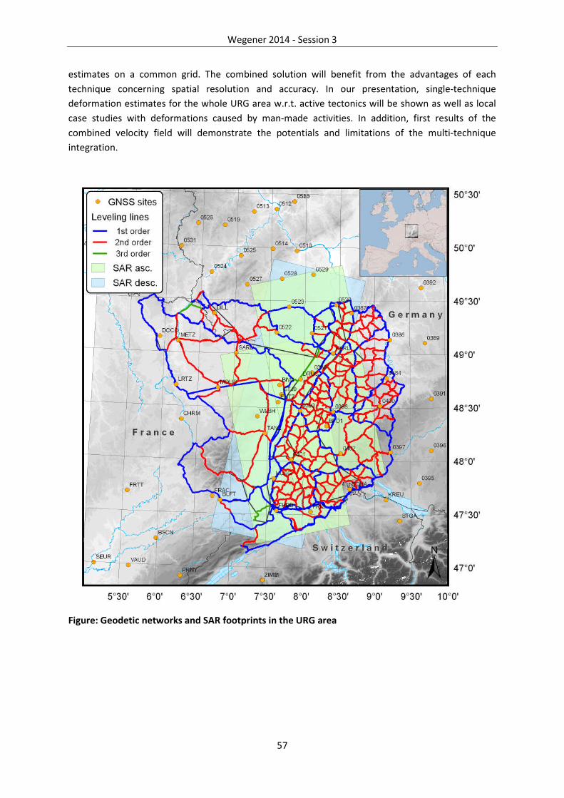
Wegener 2014 - Session 3
57
estimates on a common grid. The combined solution will benefit from the advantages of each
technique concerning spatial resolution and accuracy. In our presentation, single-technique
deformation estimates for the whole URG area w.r.t. active tectonics will be shown as well as local
case studies with deformations caused by man-made activities. In addition, first results of the
combined velocity field will demonstrate the potentials and limitations of the multi-technique
integration.
Figure: Geodetic networks and SAR footprints in the URG area

Wegener 2014 - Session 3
58
A recursive adaptive interferogram phase filtering method
P.J. Gonzalez (1*)
(1) School of Earth and Environment, University of Leeds, UK
*Corresponding authorː [email protected]
I present a recursive adaptive phase filtering algorithm for accurate estimation of differential
interferometric ground deformation and local coherence measurements. The proposed filter is
based upon the modified Goldstein filter [Baran et al., 2003]. This filtering method improves the
quality of the interferograms by performing a recursive iteration using variable (cascade) kernel sizes,
and improving the coherence estimation by defringing the interferometric phase locally. The method
has been tested using simulations and real cases relevant to the characteristics of the Sentinel-1
mission. In this paper, I present two real examples from C-band interferograms with moderate
baselines (~100-200 m) and variable temporal baselines of 70 and 190 days over rainforest
volcanoes (Hawaii and Nyragongo-Nyamulagira). The differential phase of those examples show
intense localized volcano deformation and also vast areas of minor phase variation. The proposed
method outperforms the typical Goldstein and modified Goldstein filters by preserving subtle phase
variations where the deformation fringe rate is high, and effectively suppressing phase noise in
smoothly phase variation regions (Fig. 1). Finally, this method also has the additional advantage of
not requiring input parameters, except for the maximum filtering kernel size.
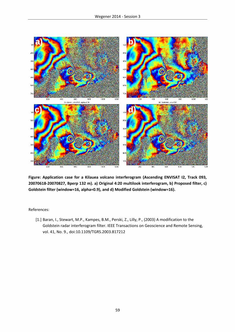
Wegener 2014 - Session 3
59
Figure: Application case for a Kilauea volcano interferogram (Ascending ENVISAT I2, Track 093,
20070618-20070827, Bperp 132 m). a) Original 4:20 multilook interferogram, b) Proposed filter, c)
Goldstein filter (window=16, alpha=0.9), and d) Modified Goldstein (window=16).
References:
[1.] Baran, I., Stewart, M.P., Kampes, B.M., Perski, Z., Lilly, P., (2003) A modification to the
Goldstein radar interferogram filter. IEEE Transactions on Geoscience and Remote Sensing,
vol. 41, No. 9., doi:10.1109/TGRS.2003.817212
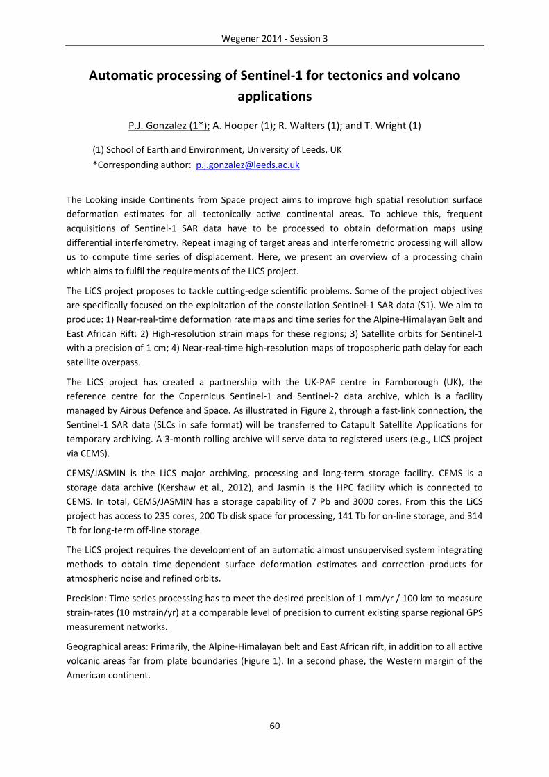
Wegener 2014 - Session 3
60
Automatic processing of Sentinel-1 for tectonics and volcano
applications
P.J. Gonzalez (1*); A. Hooper (1); R. Walters (1); and T. Wright (1)
(1) School of Earth and Environment, University of Leeds, UK
*Corresponding authorː [email protected]
The Looking inside Continents from Space project aims to improve high spatial resolution surface
deformation estimates for all tectonically active continental areas. To achieve this, frequent
acquisitions of Sentinel-1 SAR data have to be processed to obtain deformation maps using
differential interferometry. Repeat imaging of target areas and interferometric processing will allow
us to compute time series of displacement. Here, we present an overview of a processing chain
which aims to fulfil the requirements of the LiCS project.
The LiCS project proposes to tackle cutting-edge scientific problems. Some of the project objectives
are specifically focused on the exploitation of the constellation Sentinel-1 SAR data (S1). We aim to
produce: 1) Near-real-time deformation rate maps and time series for the Alpine-Himalayan Belt and
East African Rift; 2) High-resolution strain maps for these regions; 3) Satellite orbits for Sentinel-1
with a precision of 1 cm; 4) Near-real-time high-resolution maps of tropospheric path delay for each
satellite overpass.
The LiCS project has created a partnership with the UK-PAF centre in Farnborough (UK), the
reference centre for the Copernicus Sentinel-1 and Sentinel-2 data archive, which is a facility
managed by Airbus Defence and Space. As illustrated in Figure 2, through a fast-link connection, the
Sentinel-1 SAR data (SLCs in safe format) will be transferred to Catapult Satellite Applications for
temporary archiving. A 3-month rolling archive will serve data to registered users (e.g., LICS project
via CEMS).
CEMS/JASMIN is the LiCS major archiving, processing and long-term storage facility. CEMS is a
storage data archive (Kershaw et al., 2012), and Jasmin is the HPC facility which is connected to
CEMS. In total, CEMS/JASMIN has a storage capability of 7 Pb and 3000 cores. From this the LiCS
project has access to 235 cores, 200 Tb disk space for processing, 141 Tb for on-line storage, and 314
Tb for long-term off-line storage.
The LiCS project requires the development of an automatic almost unsupervised system integrating
methods to obtain time-dependent surface deformation estimates and correction products for
atmospheric noise and refined orbits.
Precision: Time series processing has to meet the desired precision of 1 mm/yr / 100 km to measure
strain-rates (10 mstrain/yr) at a comparable level of precision to current existing sparse regional GPS
measurement networks.
Geographical areas: Primarily, the Alpine-Himalayan belt and East African rift, in addition to all active
volcanic areas far from plate boundaries (Figure 1). In a second phase, the Western margin of the
American continent.

Wegener 2014 - Session 3
61
InSAR phase unwrapping with Extended Kalman Filtering:
application to the Ismetpasa segment of North Anatolian Fault
Zone
E. Havazli (1*), S. Wdowinski (1), B. Osmanoglu (2)
(1) University of Miami, Rosenstiel School of Marine and Atmospheric Sciences, MarineGeology and Geophysics Department
(2) Universities Space Research Association – Goddard Space Flight Center, BiosphericSciences Laboratory
*Corresponding authorː [email protected]
Time series analysis of Interferometric Synthetic Aperture Radar (InSAR) data is a three-dimensional
operation, where the spatial coverage of the SAR imagery provides two dimensions and the repeat
imagery (time) defines the third dimension. Three-dimensional unwrapping is important as it can
provide further constraints to the solution resulting in a more robust and accurate analysis. Even
though there are efficient algorithms for finding discrete irrotational fields among neighboring pixels
in two-dimensions, an efficient algorithm for the three-dimensional case is proved to be very
difficult.
We developed a 3-D unwrapping algorithm based on an Extended Kalman Filter (EKF) that is capable
of simultaneously filtering, unwrapping and inverting multiple interferograms to obtain a DEM or
deformation map. The algorithm unwraps the data set starting from a reference point and moves to
the next-highest-quality neighboring point. Path-following algorithms carry the risk of propagating
errors to high-quality areas, therefore, it is crucial to implement an appropriate quality metric and
solve for higher quality points first.
In this study we apply our three-dimensional EKF unwrapping algorithm to the Ismetpasa segment of
North Anatolian Fault Zone, which is characterized by shallow creep. We used 121 Envisat scenes
and 83 ERS scene in both ascending and descending tracks. Our previous study of this segment
based on the SBAS technique revealed that the Ismetpasa segment creeps at a rate of 8 mm/yr.
However, low interferometric coherence over vegetated area reduced the quality of our SBAS-based
results. The three-dimensional EKF algorithm allows us to better resolve unwrapping problems,
especially in vegetated areas, and hence obtain more accurate results.

Wegener 2014 - Session 3
62
Sentinel-1 for Geo-Dummies
A. Hooper(1*)
(1) COMET, School of Earth and Environment, University of Leeds, UK
*Corresponding authorː [email protected]
Sentinel-1 data are set to revolutionise geophysical InSAR applications. The operational mode will
make the mission particularly useful for measuring long-term tectonic strain and for the systematic
monitoring of volcanoes, landslides and glaciers. Nevertheless, the interferometric wideswath TOPS
mode, in which the data will be acquired over land, does throw up additional processing challenges.
These arise because the variable squint direction means that azimuth and range are not fully
decoupled, and the amount of coupling varies in azimuth. Hence the interferometric phase includes
a variable component of along-track motion. This means that even a constant offset along track
leads to a variable phase contribution (a ramp) in azimuth.
There are strategies for estimating constant offsets, which can be due, for example, to
misregistration or plate motion. But variable offsets due to local along-track motion will lead to a
variable contribution to the interferometric phase, and cause phase offsets between bursts (Figure
1). While this will make phase-unwrapping more difficult, and modelling will need to account for
local squint angle, a positive effect will be greater sensitivity to N-S displacements in areas of burst
overlap. In this presentation I will demonstrate al of these effects and discuss strategies for
addressing them.
Figure 1. Simulated interferogram for two bursts, demonstrating the phase due to 1 m strike-slip
on a surface-rupturing fault. The ~N-S discontinuity represents the fault, but the E-W discontinuity
occurs between the two bursts.
Wegener 2014 - Session 3
63
Reconstruction of waveforms of 3-D deflections during strong-
motions using 10Hz PPP-GPS: an assessment based on free
oscillation experiments, and perspectives
F. Moschas (1); P. Psimoulis (2*); V. Saltogianni (1); A. Avallone (3); S. Stiros (1)
(1) Laboratory of Geodesy and Geodetic Applications, Department of Civil Engineering,University of Patras, Greece
(2) Nottingham Geospatial Institute, University of Nottingham, UK
(3) Instituto Nationale di Geofisica e Vulcanologica, INGV, Roma, Italy
*Corresponding authorː [email protected]
The Precise Point Positioning (PPP) technique permits the computation of instantaneous coordinates
of a single, isolated GPS station in reference to remote stations, away from the meizoseismal area of
strong earthquakes. For this reason PPP analysis has been used in the reconstruction of the
waveforms of instantaneous deflections of stations during strong motion data using 1Hz and even
10Hz data, as in the case of the 2009 L’Aquila, Italy, Mw 6.3, earthquake. Obtained waveforms are
reasonable but they cannot be validated through comparison with other “reference” or “true”
waveforms (accuracy approach).
In order to validate the PPP results for earthquake studies, we made systematic supervised learning
experiments with a system of collocated sensors including 10Hz GPS, accelerometers and reflectors
of robotic theodolites, simulating earthquake motions. Waveforms computed different PPP software
were compared with reference DGPS waveforms and the recordings of the other sensors; this
permitted to control the noise in PPP data and to produce methods to remove the long-period noise
which contaminates them. It was found that the short-period component of instantaneous PPP
coordinate changes describes well the pattern and spectra of waveforms of dynamic displacements
at least up to 4Hz and with up to 20mm accuracy for any isolated point.
The above analysis confirms the quality of PPP waveforms of various strong earthquakes and
currently the challenge is to study waveforms of small (Mw<5) earthquakes or of earthquake
movement away from the epicenters using an array of GPS sensors collocated with accelerometers
in the Gulf of Corinth Greece; especially to identify the lower threshold of sensitivity of PPP in
recording seismic displacements.
References:
[1.] Avallone et al, 2011, Very high rate (10Hz) GPS seismology for moderate-magnitude
earthquakes: The case of the Mw6.3 L’Aquila (central Italy) event, JGR 116(B2): B02305
[2.] Moschas et al., 2014, Strong-motion displacement waveforms using 10-Hz precise point
positioning GPS: An assessment based on free oscillation experiments, Earthq Eng Str Dyn, in
press
Wegener 2014 - Session 3
64
Deformation Rates in the North Aegean region and inferred fault
kinematics from Enhanced Geodetic Analysis
M. Müller (1,2), A. Geiger (1*), H. Kahle (1)
(1) Institute of Geodesy and Photogrammetry, ETH Zurich, Switzerland
(2) Research Institute EMPA, Switzerland
*Corresponding authorː [email protected]
Greece is located on the Alpine-Mediterranean plate boundary in the seismically most active region
in Europe. This study shall add further geometric evidences for the understanding of the involved
tectonic processes. The paper concentrates on the North Aegean and adjacent regions where a
precise kinematic field of 3D deformation rates has been determined from processing of a 16 year
record of continuous and campaign-type GPS data. Implementation of diverse improvements to the
processing chain led to a better and more interpretable velocity field. A densification of the
horizontal velocity field was achieved as well as information on vertical rates. The application of the
methods of kinematic block modeling and GPS based strain rate calculation reveals interesting new
features of the kinematic and deformation fields. Distinct moving pattern, even slowly moving areas,
can be outlined and structural parameters such as locking depths of the slipping faults are inferred.
Southern Bulgaria, eastern Macedonia and Thrace move slowly, and uniformly southward relative to
Eurasia (1.5–3.5 mm/yr). Western Macedonia, Epirus, Thessaly and Central Greece rotate rather
coherently clockwise. The region comprising the islands of Limnos, Agios Efstratios and Alonnisos
moves like a counterclockwise rotating slowly deforming block. The new GPS rates allow a
quantification of the spatial change of strike-slip motion and locking depth along the North Aegean
trough. Dextral strike-slip motion diminishes from east toward west amounting to 21.2 mm/yr along
the Saros basin and 12.5 mm/yr south of the Chalkidiki peninsula. The locking depth is shallow for
the Ganos fault and the western Saros basin (5.6–8.9 km). It is deeper between the Sporades islands
and Pelion (~17.7 km) corresponding to a more diffuse shear zone. GPS based strain rate analysis
and an elementary finite element model is applied to derive slip rates of the three main dextral
strike-slip faults in the North Aegean and the pronounced large-scale extension (>100 nstrain) in the
North Aegean domain. The methods as well as more detailed results will be presented.

Wegener 2014 - Session 3
65
Borehole Geodetic Monitoring in Marmara Region, Turkey
H. Ozener (1*), B. Aktug (1), H. Karabulut (2), S. Ergintav (1), A. Dogru (1), O. Yilmaz (1), B.
Ahiska (1), D. Mencin (3) and G. Mattioli (3)
(1) Geodesy Department, KOERI, Bogazici University, İstanbul, Turkey
(2) Geophysics Department, KOERI, Bogazici University, İstanbul, Turkey
(3) UNAVCO, Boulder, CO, USA
*Corresponding authorː [email protected]
Precise geodetic monitoring networks can be used to detect various events ranging from Slow Slip
Events (SSEs) which represent the transient release of strain at the duration of days to weeks, to
moderate earthquakes occuring at the transition zone between the locked seismogenic zone and the
slipping zone on the plate interface. While dense continuous GPS networks are well suited to obtain
time-dependent deformation field, as well as postseismic deformation from major earthquakes, the
strainmeters can capture signals with superior precision at local spatial scales, in particular in the
short-period, from minutes to a month.
In the last decade, monitoring relatively small-scale events (e.i. SSEs, creeps) has been quite popular
on many of the world's subduction zones and borehole observatories Marmara Region, having the
North Anatolian Fault (NAF) as the main source of active tectonics in the area, has being monitored
by different observing techniques such as seismic networks and continuous/survey-mode GPS
networks for decades. For better understanding of tectonic processes in the region, it is essential to
observe deformation in a broad range of temporal and spatial scales (from seismology to geodesy
and to geology). Borehole strainmeters are very sensitive to deformation in the range of less than a
month. In this study, we introduce the first deployment of borehole strainmeters in Turkey. With
this project, financially and technically supported by Istanbul Development Agency and UNAVCO,
respectively, two borehole strainmeters are being deployed in European side of Istanbul in Marmara
Region. Since these instruments can also respond to non-tectonic processes, it is necessary to have
more instruments to increase spatial coherence and to have additional sensors to detect and model
noise (such as barometric pressure, tides, or precipitation). Detecting, creeping and SSEs may
provide insights to the understanding of seismic hazards in active zones and possible precursors. Our
long term objective is to build a borehole monitoring system in the region. By integrating various
data obtained from borehole observations, we expect to get a better understanding of dynamics in
the western NAF.

Wegener 2014 - Session 3
66
Geodetic Time Series Analysis: Recent Developments, Community
Resources and Case Studies Using GPS and Strainmeter Data from
UNAVCO
D.A. Phillips (1*); C.M. Meertens (1); K.M. Hodgkinson (1); C.M. Puskas (1); F. Boler (1); G.S.
Mattioli (1)
(1) UNAVCO, Boulder, Colorado, USA
*Corresponding authorː [email protected]
We present an overview of geodetic time series data, tools and services available from UNAVCO
along with two specific and compelling examples of geodetic time series analysis. UNAVCO provides
a diverse suite of geodetic data products and cyberinfrastructure services to support community
research and education. The UNAVCO archive includes data from 2500+ continuous GPS stations,
borehole geophysics instruments (strainmeters, seismometers, tiltmeters, pore pressure sensors),
and long baseline laser strainmeters. These data span temporal scales from seconds to decades and
provide global spatial coverage with regionally focused networks including the EarthScope Plate
Boundary Observatory (PBO) and COCONet. UNAVCO also provides processed data products and
time series from 1800+ continuous GPS stations and 80+ strainmeters. This rich, open access dataset
is a tremendous resource that enables the exploration, identification and analysis of time varying
signals associated with crustal deformation, reference frame determinations, isostatic adjustments,
atmospheric phenomena, hydrologic processes and more. UNAVCO provides a suite of time series
exploration and analysis resources including static plots, dynamic plotting tools, and data products
and services designed to enhance time series analysis.
The PBO GPS network allows for identification of ~1 mm level deformation signals. At some GPS
stations seasonal signals and longer-term trends in both the vertical and horizontal components can
be dominated by effects of hydrological loading from natural and anthropogenic sources. Modeling
of hydrologic deformation using GLDAS and a variety of land surface models (NOAH, MOSAIC, VIC
and CLM) shows promise for independently modeling hydrologic effects and separating them from
tectonic deformation as well as anthropogenic loading sources. A major challenge is to identify
where loading is dominant and corrections from GLDAS can apply and where pumping is the
dominant signal and corrections are not possible without some other data.
In another arena, the PBO strainmeter network was designed to capture small short-term strain
transients that fall between the detection levels of GPS and seismology. PBO strainmeters have
recorded multiple Episodic Tremor and Slip (ETS) events in Cascadia, aseismic creep along the central
San Andreas, post-seismic transients around the San Jacinto fault, tsunamis on the Pacific Northwest
coastline and seiche signals in Yellowstone. But the very sensitivity that makes strainmeters the ideal
tool to record these signals means they also record site, anthropogenic and meteorologically
induced signals that make it difficult to isolate tectonic signals. Examples include borehole
compressional trends, atmospheric pressure response, rainfall induced signals, hydrological pumping,
snowmelt and lake seiches.

Wegener 2014 - Session 3
67
We will 1) provide an overview of geodetic data and time series analysis tools available from
UNAVCO, 2) show new examples and insights from hydrologic loading effects on GPS time series and
3) discuss and identify non-tectonic signals in strainmeter data and outline methods to improve the
signal to noise ratio as much as possible.

Wegener 2014 - Session 3
68
Rapid InSAR processing for the monitoring of volcanoes
K. Spaans (1*); A. Hooper (1)
(1) COMET, School of Earth and Environment, University of Leeds, UK
*Corresponding authorː [email protected]
The availability of SAR images over volcanically active areas has greatly increased over the last few
years. With the successful launch of the Sentinel-1a and ALOS-2 satellites, data availability will
increase even further. InSAR has been used to measure and model deformation resulting from
magma movement beneath volcanoes with great success. However, the time series analysis required
to obtain results with sufficient signal-to-noise ratio are very time consuming, resulting in InSAR
results only being available weeks to months after the event. To monitor volcanoes in near-realtime,
which is already done using GPS over many volcanoes, we need to take advantage of this high data
volume and process it much faster. Here we present results from an algorithm designed to rapidly
process SAR images, producing interferograms with high signal-to-noise ratios within hours. Near-
realtime InSAR measurements will greatly improve coverage over volcanoes, while at the same time
provide measurements over potentially deforming areas not covered by GPS.
We identify for each pixel neighbouring pixels that behave statistically similar throughout the time
series. These pixels are known as statistically homogeneous pixels (SHP), which can then be used to
calculate the complex coherence of the pixel in question. The advantage of this algorithm is that it
allows an estimate of the coherence of every pixel in every interferometric combination possible.
This yields greater flexibility compared to other time series techniques, which select a single set of
pixels for all interferograms. On the assumption that SHP are the same for all interferograms, we can
estimate them on an a priori set of interferograms, and use this information to estimate the
coherence of every pixels in every interferometric combination possible when new images are
obtained. Not having to estimate the SHP greatly speeds up the processing. Also, the fact that each
interferometric combination is processed separately allows for greater flexibility in processing
images in parallel, which further aids in speeding up the algorithm.
Our algorithm is able to produce interferograms with respect to a new image within 10 minutes, and
using 8 processor cores in parallel, is able to estimate the coherence for every pixel in the 15 closest
pairs in approximately 45 minutes for a 5000 by 5000 scene, allowing us to mask out incoherent
pixels from the wrapped interferograms. Phase unwrapping of coherent pixels and estimation of the
deformation since the last acquisition takes a further 45 minutes. The algorithm's individual
coherence estimate is very effective in removing decorrelated areas, although it struggles in times of
changing ground conditions (e.g. Snow cover). Current efforts focus on mitigating the effect of
changing ground condition, and improving unwrapping accuracy. The total processing time of under
2 hours, with intermediate results being available much sooner, allows the results to be used in
analysing magma movements while events are ongoing, directing civil protection and scientific
efforts in times of crisis.

Wegener 2014 - Session 3
69
Data-Adaptive Detection of Transient Deformation in GNSS
Networks
D. Walwer (1), E. Calais (1*), and M. Ghil (1,2)
(1) Ecole Normale Supérieure, Department of Geosciences, Paris, France
(2) University of California, Los Angeles, AOS Dept. and IGPP, USA
*Corresponding authorː [email protected]
Dense Global Navigation Satellite System (GNSS) networks have recently been developed in actively
deforming regions and elsewhere. Their operation is leading to a rapidly increasing amount of data,
and position time series are now routinely provided by several high-quality services. These networks
often capture transient-deformation features of geophysical origin that are difficult to separate from
the background noise or from seasonal residuals in the time series. In addition, because of the very
large number of stations now available, it has become impossible to systematically inspect each time
series and visually compare them at all neighboring sites.
In order to overcome these limitations, we adapt Multichannel Singular Spectrum Analysis (M-SSA),
a method derived from the analysis of dynamical systems, to the spatial and temporal analysis of
GNSS position time series in dense networks. We show that this data-adaptive method — previously
applied to climate, bio-medical and macro-economic indicators — allows us to extract spatio-
temporal features of geophysical interest from GPS time series without a priori knowledge of the
system's dynamics or of the data set’s noise characteristics. We illustrate our results with examples
from seasonal signals in Alaska and from micro-inflation/deflation episodes at an Aleutian-arc
volcano.

70

71
Session 4: Geodynamics, Potential
Fields and Glacial Isostatic Adjustment
Conveners: Rob Govers, Jeroen van Hunen, Greg Houseman, Matthias Becker, Riccardo Riva
and Susanna Zerbini
Wegener 2014 - Session 4
72
Sea Level Rise: Can we Detect Accelerations unrelated to Natural
Variability?
D.P. Chambers (1*)
(1) College of Marine Science, University of South Florida, USA
*Corresponding authorː [email protected]
Sea level rise has been measured with tide gauges since the 1700s in several parts of Northern
Europe, since the late 1800s by a more global network, and since the 1990s by satellite radar
altimeters. The trend in global mean sea level (GMSL) since 1993 is 3.3 ± 0.4 mm/year, which is
significantly higher than the rate over the hundred-year period from 1900 to 2000 of 1.7 ± 0.5
mm/year. While technically an acceleration, the question remains whether this reflects decadal-
scale variability, or is a signal of anthropogenic climate change. It is evident from tide-gauge records
that large, decadal-scale variations related to winds and currents exist, but it is still highly uncertain
how these are reflected in GMSL.
Here, we will review the most recent work on this issue, focusing on the size and timing of multi-
decadal natural variability in tide gauge records, and how this is likely reflected, correctly and
incorrectly, in reconstructions of GMSL from sparse tide gauge records. We will examine how long of
a record is needed from a single tide gauge record and from GMSL to detect an acceleration
comparable to that ongoing from Antarctica and Greenland mass loss.

Wegener 2014 - Session 4
73
Teasing out the signal of Antarctic ice mass change
P. Whitehouse (1*); M. King (2); G. Milne (3); M. Bentley (1); G. Nield (4); W. van der Wal (5)
(1) Department of Geography, Durham University, UK
(2) Geography and Environmental Studies, University of Tasmania, Australia
(3) Department of Earth Sciences, University of Ottawa, Canada
(4) School of Civil Engineering and Geosciences, Newcastle University, UK
(5) Aerospace Engineering, Delft University of Technology, Netherlands
*Corresponding authorː [email protected]
Quantifying the magnitude and spatial distribution of present-day ice mass loss from Antarctica is a
crucial step in understanding the processes that govern the dynamical behaviour of this vast ice
sheet. Satellite geodesy has revolutionised our ability to survey the ice sheet, increasing both the
extent and the resolution of measurements that we can make, but many of these measurements
contain a number of ‘hidden signals’, which must be teased out by combining data sets or by
modelling.
The main process that masks our ability to directly measure present-day ice mass change, for
example using the GRACE satellite data, is glacial isostatic adjustment (GIA). Perturbations to the
shape of the geoid across Antarctica arise due to the redistribution of surface mass (ice and ocean)
and the deformation of the solid Earth. However, this solid Earth deformation occurs in response to
both past and present ice mass change, thus complicating the task of isolating the signal due to the
current ice mass change.
In this talk I will outline a number of approaches that have been adopted to tease out these
competing signals, both via inverse methods and forward modelling. I will highlight the difficulties of
assigning uncertainty to the GIA signal, and will showcase the range of data that can be used to
tackle this problem - from seismic velocity perturbations to satellite altimetry.

Wegener 2014 - Session 4
74
Regional Variation in Near-Surface Mass and Coulomb Stress
inferred by GPS
G. Blewitt (1*); C.B. Amos (2); P. Audet (3); W.C. Hammond (1), R. Bürgmann (4,5), I.A.
Johanson (4)
(1) Nevada Geodetic Laboratory, University of Nevada, Reno, USA
(2) Geology Department, Western Washington University, USA
(3) Department of Earth Sciences, University of Ottawa, Canada
(4) Berkeley Seismological Laboratory, University of California, Berkeley, USA
(5) Department of Earth and Planetary Science, University of California, Berkeley, USA
*Corresponding authorː [email protected]
We present a method using GPS station coordinate time series to infer variation in near-surface
mass and Coulomb stress. The method is applied to investigate the effect of massive groundwater
depletion in the San Joaquin Valley of central California on bedrock uplift and seismicity. We find
that our method provides estimates of mass variation that agree well with direct measurements of
the gravity field using GRACE, and explains well the observed secular and seasonal uplift of the Sierra
Nevada bounding the valley to the east, and of the Coast Ranges to the west. The secular uplift of
the Coast Ranges reduces the Coulomb stress on the San Andreas Fault, bringing it closer to failure.
The inferred seasonal variation at ~1 kPa at seismogenic depths suggests a viable mechanism for
previously-observed peaks in microseismicity at Parkfield during the drier months of late summer
and autumn.
Our method applies a 2-D analytical model using line loads directed along the axis of the San Joaquin
Valley across a 60-km-wide strip over the surface of an elastic half-space. Given a range of elastic
parameters (Poisson's ratio, ν=0.25; shear modulus, G=35±5 GPa) we use a reduced chi-square
criterion to fit the spatial pattern of GPS vertical velocities. The estimated the rate of unloading at
8.8(±1.3) × 107 N m-1 yr -1 agrees well with GRACE measurements, which, from 2003–2010, yield an
average equivalent unloading rate of 7.2(±2.1) × 107 N m-1 yr -1. Predicted secular uplift centered
along the valley axis matches well the observed GPS motion in the adjacent mountain ranges, with
uplift rates decaying away from the valley margins. Observed seasonal variability in the vertical GPS
positions lends support for this model, showing peak uplift for stations surrounding the valley during
the dry summer and fall months. On the other hand, stations in the San Joaquin Valley show larger
seasonal uplift accompanying aquifer recharge during winter months.
From the analytical model, 2-D stress components at any point at depth can then be directly
computed from the fit line load variation, and thus the shear and normal stress components (τs, τn)
can be resolved on any given fault plane. Coulomb stress variation can then be computed as Δσc =
│Δ τs│+ μ Δ τn assuming constant pore-pressure, cohesion, and coefficient of friction, μ. In the case
of the San Andreas Fault in this region, which we assume to be a vertical fault with μ=0.7, we

Wegener 2014 - Session 4
75
estimate a contemporary rate of unclamping at 1–2 kPa per decade, and a seasonal variation at ~1
kPa.
In this regional setting, surface loading signals are assumed to dominate vertical displacements, thus
allowing for separation of tectonic from hydrological effects. Using the resulting loading model to
predict the hydrological component of horizontal displacements, we then correct the GPS horizontal
time series to produce a velocity field that should more clearly reflect tectonic signals. This general
approach could be used to separate tectonic from hydrological signals in other regions where both
can be significant.
Wegener 2014 - Session 4
76
Magnetic study and identification of the deep structures in the NW
of Algeria: 2D and 3D imaging resulting from the continuous
wavelet and ridgelet transforms.
H. Boukerbout (1*); A. Abtout (1); D. Gibert (2)
(1) C.R.A.A.G – Observatoire d’Alger, Algeria
(2) Géosciences Rennes, Université Rennes I, France
*Corresponding authorː [email protected]
The NW of Algeria is known of being one of the most seismically zone of the western Mediterranean
Sea, due to collision between African and European plates. This region constitutes an excellent area
to study neotectonics structures and its geodynamical context. The studied area displays a very
complex geological context. Magnetic data (airborne and marine) are therefore useful for obtaining
a realistic model of the deep tectonic structures. The use of magnetic data combined to new
processing methods developed, allow establishing a structural image of the studied area. The main
objectives of this study are to identify the geometry of the major tectonic contacts bounding the
sedimentary basins, to evaluate the depth of the different identified structures and to define the
nature of their hypothetical basement. Indeed, the use of new developed methods such as the
processing by the continuous wavelet transform and the ridgelet transform, will give information on
structures spatial distribution both superficially and in depth and also about sources that are
submerging and emerging both inshore and offshore. This work leads to 2D and 3D representation
from a set of sections across the geological units and magnetic field anomalies, examines the
geometric relationships existing between the different geological features, based on magnetic data
analysis and modelling, and finally, provides additional information enabling geologists to refine the
structural interpretation of the volcanic domains in the region.
Keywords: Aeromagnetic data, magnetic anomalies offshore, NW of Algeria, wavelet transform, 2D
and 3D imaging, depth.
Wegener 2014 - Session 4
77
Lateral variations in subduction zone rheology from combined
GRACE and GPS Observations
T. Broerse (1*); R. Riva (1); R. Govers (2); W. Simons (1); B. Vermeersen (1,3)
(1) Delft University of Technology, Delft, Netherlands.
(2) Utrecht University, Utrecht, Netherlands.
(3) NIOZ, Royal Netherlands Institute for Sea Research, Den Burg, Texel, Netherlands
*Corresponding authorː [email protected]
More than 8 years of observations of post-seismic relaxation after the 2004 Sumatra-Andaman
earthquake provide an improving view on the deformation in the wide vicinity of the 2004 rupture.
We use both GRACE gravity field data and GPS observations in the back-arc region. With increasing
time GPS and GRACE show contrasting relaxation styles that were not easily discernable using
shorter time series. We investigate whether mantle creep can explain the observations. We
interpret the GPS-GRACE contrasts in terms of lateral variations in rheological properties of the
asthenosphere below and above the slab. Next to mantle creep, we also consider afterslip as an
alternative mechanism for post-seismic deformation. We investigate how the combination of GRACE
and GPS data can better discriminate between different mechanisms of post-seismic relaxation:
distributed deformation (mantle creep) versus localized deformation (afterslip).
Wegener 2014 - Session 4
78
Disentangling surface mass loading, glacial isostatic adjustment and
analysis model uncertainty in global deformation data
P.J Clarke (1*)
(1) School of Civil Engineering and Geosciences, Newcastle University, UK
*Corresponding authorː [email protected]
The changing distribution of surface mass (oceans, atmospheric pressure, continental water storage,
groundwater, lakes, snow and ice) causes detectable changes in the shape of the solid Earth, on time
scales ranging from hours to millennia. Transient changes in the Earth’s shape can, regardless of
cause, be readily separated from steady secular variation in surface mass loading, but other secular
changes due to plate tectonics and Glacial Isostatic Adjustment (GIA) cannot. I investigate the effect
of GIA model choice on estimates of plate Euler vectors and present-day surface mass loading from
geodetic site velocities. Mass loads are estimated using land-masked, mass-conserving,
gravitationally self-consistent basis functions derived from low-degree spherical harmonic functions.
The Euler vectors are found to be insensitive to the a priori GIA model, but different GIA models lead
to significant differences in the estimates of present-day surface mass loading in several regions.
I also demonstrate the variability in estimated surface mass loading arising from different
reprocessed GPS coordinate solutions using a variety of model and reference frame assumptions.
Although the loading estimates are broadly comparable with independent estimates from the
GRACE satellite mission, their range highlights the need for more robust error estimates in global
coordinate solutions from GPS and for better, more realistic GIA models that incorporate 3D Earth
structure and can therefore accurately represent 3-D surface displacements.
Wegener 2014 - Session 4
79
Statistical Evaluation of Sea Level During the Last Interglacial
A. Düsterhus (1); M.E. Tamisiea (1*); S. Jevrejeva (1)
(1) National Oceanography Centre, Liverpool, UK
*Corresponding authorː [email protected]
Sparse, indirect observational data, collectively called sea level indicators, suggest that sea levels
during the Last Interglacial (LIG) were higher than present day. However, the sources, timing, and
uncertainties of these higher levels are not well constrained. We have developed a statistical
framework to compare the sea level indicators to Glacial Isostatic Adjustment (GIA) model
predictions of sea level. These GIA model predictions depend upon an Earth and ice sheet models,
with the later typically developed to satisfy some estimate of the global average sea level variations
with time. Initial comparisons indicated that the a priori model of the total ice sheet volume and
timing had the largest impact on the ability of the GIA model to compare well to the sea level
indicators.
We extended the statistical framework with a data assimilation scheme based upon particle
methods. This allows us to estimate the total ice sheet volume that best fit the observations as well
as evaluating the uncertainties. We completed a series of runs using the sea level indicators from
Kopp et al., 2009, to evaluate the impact of the Earth model and the a priori ice volume history on
the inferred maximum average sea level and duration of the interglacial. We find that the Earth
model makes a relatively small difference in comparison to the a priori ice volume history. In
addition, our technique demonstrates how each data point contributes to the results and clearly
identifies which points contribute to the tails of the distribution, raising questions of their ability to
address this problem. We present the results of this initial comparison, providing a new assessment
of the maximum sea level and associated uncertainties during the LIG using the same sea level
indicators as Kopp et al., 2009.

Wegener 2014 - Session 4
80
Lithospheric Flexure in the Sichuan Basin and Longmen Shan at the
Eastern Edge of Tibet from Gravity and Geodesy
E.J. Fielding (1*); and D. McKenzie (2)
(1) Jet Propulsion Laboratory, California Institute of Technology, Pasadena, California, USA
(2) Bullard Laboratories of the Department of Earth Sciences, University of Cambridge, UK
*Corresponding authorː [email protected]
The Mw 7.9 Wenchuan earthquake in 2008 with oblique thrust and strike-slip motion deformed the
mountain range at the steep eastern edge of the Tibetan Plateau, the Longmen Shan. The tectonic
processes and structure of the lithosphere beneath this range have been controversial. Gravity
measurements reflect the distribution of mass within the Earth, including the large load of rock
above the geoid in mountain ranges, and geodetic methods measure the modern deformation. We
investigated the response of the lithosphere to the load of the Longmen Shan and estimate the
flexural rigidity or effective elastic thickness Te using new gravity data acquired by recent satellites,
including GOCE and GRACE, and the combined GOCO2S and EIGEN-6c datasets. GOCO2S is a
combination of available satellite gravity datasets, while the EIGEN-6C combination also includes
ground observations that provide finer spatial resolution in many areas. The free-air gravity
anomalies over the Longmen Shan show that its mass is supported by flexure of the adjacent
Sichuan Basin lithosphere, similar to the flexural support of the Himalayas. The finer spatial
resolution of GOCE reveals the flexural signals along the edges of the Tibetan plateau that were not
well resolved by earlier satellites. Analysis of a stacked profile of the free-air anomalies shows that
the effective elastic thickness of the basin lithosphere is greater than 10 km, but has a broad
minimum misfit function with no upper limit on the thickness. Two-dimensional admittance analysis
shows the Te of easternmost Tibet is very low, approximately 7 km.
We also analyzed Global Posititioning System (GPS) and interferometric synthetic aperture radar
(InSAR) data to determine a fault rupture model for the Wenchuan earthquake. We find that the
earthquake started with largely thrust motion on an imbricate system of faults beneath the central
Longmen Shan, including the Beichuan Fault and Pengguan Fault, with fault slip at depth extending
up to 50 km northwest of the mountain front. The fault ruptures continued northeast along the
Beichuan Fault with more oblique slip (right-lateral and thrust) and the proportion of lateral motion
increasing in the northern Longmen Shan. The northernmost fault segment has a much steeper dip,
consistent with nearly pure strike-slip motion. The complex fault ruptures caused shortening and
uplift of the extremely steep central Longmen Shan, which supports models where the steep edge of
the plateau is formed by thrusting over the strong crust of the Sichuan Basin. Our results are
consistent with tectonic theories for the formation and maintenance of the Longmen Shan by
thrusting over the edge of the Sichuan Basin lithosphere.

Wegener 2014 - Session 4
81
A consistent geodynamic model for predicting the velocity and
plate-internal deformation of Eurasia
R. Govers (1*); K. Warners-Ruckstuhl (1); C. Garcia-Sancho (1); and R. Wortel (1)
(1) Utrecht University, Utrecht, Netherlands
*Corresponding authorː [email protected]
The motion and deformation of tectonic plates is driven by gravity and resisted by frictional forces.
In principle it should thus be possible to build mechanical models that reproduce plate velocities and
surface deformation. Here we present a new approach that overcomes many of the previous
obstacles to achieving this goal. Our approach to quantify the forces is based on mechanical
equilibrium of the whole Eurasian plate, meaning that an increase in, for instance collision, forces
must be matched by other plate tectonic forces. We first focus on presentday Eurasia.
We include basal tractions from a global convection model, lithospheric body forces, and edge forces
resulting from the interaction of the Eurasian plate with neighboring plates. The resulting force
distribution is constrained by observed plate motion and by stress observations.
Eurasia’s stress field turns out to be most sensitive to the distribution of collision forces on the
plate’s southern margin and, to a lesser extent, to lithospheric density structure and normal
pressure from mantle flow. Stress observations require collision forces on the IndiaEurasia
boundary of 7.0 10.5 TN/m.
A similar analysis is performed for Eurasia at 20 Ma and 40 Ma. Plate geometry is taken from the
global Lausanne (Stampfli) reconstruction, as are plate velocities and oceanic ages. Lithospheric body
forces are accounted for in a simplified way because we lack detailed enough information on the
plate scale topography. For the Miocene, we find ∼1.2 TN/m for the collision force on the
IndiaEurasia boundary. In the Eocene, the collision force we find is ∼0.4 TN/m.
We conclude that the collision force increased significantly after 20 Ma. From 4020Ma, the plate
contact force on the India/Tibet plate boundary segment was of the same order of magnitude as
resistive forces on subduction plate boundaries elsewhere. Our timing of the collision force on
Eurasia, is substantially younger than the often quoted collision age of ∼50Ma.
Forces (and the corresponding stresses) drive permanent deformation on both geological time scales
and short time scales, e.g., earthquakes. Low stress magnitudes may result in strain if the material is
weak, high stresses may give no strain in strong materials. Our next step therefore is to use
geological information on the strength of the lithosphere.
We show first results of our work on using estimates of the mechanical properties of the lithosphere
to predict surface deformation.

Wegener 2014 - Session 4
82
Residual gravity for plate tectonic modelling – from analysis of low
degree EGM2008 components
C.M. Green (1,2*); J.D. Fairhead (1,2,3); S.M. Masterton (1); and P.J. Webb (1)
(1) Getech, Leeds, UK
(2) School of Earth and Environment, University of Leeds, UK
(3) JD GEOconsultancy, Leeds, UK
*Corresponding authorː [email protected]
Gravity data analysis makes various contributions towards plate tectonic modelling including
delineating structures, tracking plate motion along fracture zones and calculating stretching at plate
margins. However, gravity grids do not generally match at reconstructed oceanic plate boundaries –
see figure for original EGM2008 gravity grid. We investigate the suggestion that these mismatches
are related to deep earth heterogeneity and can be rectified on that basis.
Careful inspection of the log power spectrum of the EGM2008 gravity model indicates several linear
sections at low spherical harmonic degrees. These linear sections suggest causative density
anomalies concentrated around specific depths in the Earth – possibly variation in the depth of
density boundaries in the mantle. The sources are modelled statistically at depths of ~2,800 km,
~800 km and ~320 km – which relate to spherical harmonic degrees 2-5, 6-12 and 13-27. These
gravity “slices” show little correlation with predicted thermal gravity effects and are thus considered
to be deep earth features.
We test the effect of progressive removal of the deep gravity “slices” to image lithospheric structure.
The residual gravity anomalies are reconstructed to past epochs to assess continuity of gravity
anomalies on conjugate plates. As the three deep “slices” are removed, the consistency and
continuity of gravity anomalies are observed to improve, although the improvement occurs at
different stages in different areas. In general, a global gravity grid with degrees 2-27 removed is
seen to allow us to better focus on the gravity anomalies related to oceanic spreading and passive
continental margins, thus enhancing the value of gravity data to interpretation in those areas.

Wegener 2014 - Session 4
83
Figure: Free air anomaly for the Southern Ocean reconstructed to 25 Ma: (a) EGM2008, (b)
EGM2008 degrees 6 up, (c) EGM2008 degrees 13 up, (d) EGM2008 degrees 27 up. Red line is
boundary between Australia and Antarctica plates after reconstruction. Note improved continuity
as low degree components are removed.

Wegener 2014 - Session 4
84
A Mode Sum Approach to Modeling the Effects of Earthquakes on
the Earth’s Rotation and Gravitational Field
R.S. Gross (1*)
(1) Jet Propulsion Laboratory, California Institute of Technology, USA
*Corresponding authorː [email protected]
Besides generating seismic waves, which eventually dissipate, an earthquake also generates a static
displacement field everywhere within the Earth, causing the geometrical shape of both the Earth’s
outer surface and of internal boundaries such as the core-mantle boundary to change. By
rearranging the Earth’s mass, earthquakes also cause the Earth’s rotation and gravitational field to
change. Earthquakes therefore affect all three pillars of geodesy, namely, the Earth’s geometrical
shape, rotation, and gravity. These effects of earthquakes are usually modeled separately, with flat
Earth models typically being used to compute earthquake-induced site displacements and spherical
Earth models being used to compute the Earth rotation and gravitational field variations. Here, a
unified approach to computing changes in geometrical shape, rotation, and gravity based upon using
normal modes as basis functions for the displacement field is described. By computing the normal
modes for a realistic Earth model such as PREM this approach automatically accounts for the effects
of sphericity, layering, and self-gravitation. The result of applying this approach to compute the
effect on the Earth’s rotation and gravitational field of selected great earthquakes and of the 39989
largest earthquakes that have occurred during 1976-2013 will be shown.

Wegener 2014 - Session 4
85
Gravity changes associated with recent great earthquakes from a
decade-long observation of GRACE gravity fields: Inversion of the
earthquake source parameters and constraint to the Earth’s
rheological structure
Shin-Chan Han (1*), E. Okal (2), F. Pollitz (3), R. Riva (4), J. Sauber (1)
(1) NASA Goddard Space Flight Center, USA
(2) Northwestern University, USA
(3) United States Geological Survey, USA
(4) Technical University of Delft, The Netherlands
*Corresponding authorː [email protected]
We quantify gravity changes after great earthquakes present within the 11-year-long time-series of
monthly global GRACE gravity fields. Using the normal-mode formulation, we present our estimates
of the source parameters of moment tensor and double-couple for the events of the 2004 Sumatra-
Andaman, 2007 Bengkulu, 2010 Maule, 2011 Tohoku-Oki, 2012 Indian Ocean strike-slip earthquakes.
For the 2012 Indian Ocean earthquake (the first strike-slip event detected by GRACE), the GRACE
gravity data delineate a composite moment of 1.9×10²² N-m regardless of centroid depth, comparing
favorably with the total seismic moment of the main ruptures and aftershocks. The smallest event
we successfully analyzed with GRACE was the 2007 Bengkulu earthquake with M0 ~ 5.0×10²¹ N-m.
We found that the gravity data constrain the focal mechanism with the centroid only within the
upper and lower crustal layers for thrust events. Deeper sources (i.e., in the upper mantle) could
not reproduce the gravity observation as the larger rigidity and bulk modulus at mantle depths
inhibit the interior from changing its volume, thus reducing the negative gravity component. Focal
mechanisms and seismic moments obtained in this study represent the behavior of the sources on
temporal and spatial scales exceeding the seismic and geodetic spectrum.
In addition, the large-scale postseismic gravity changes following the 2004 Sumatra-Andaman, 2010
Maule, and 2011 Tohoku-Oki earthquakes were evident in the GRACE gravity time-series. Our
preferred interpretation of the long-wavelength postseismic gravity change is biviscous viscoelastic
flow. We present our estimates of the Earth viscoelastic structures by delineating a range of
transient and steady-state viscosities. For example, the analysis of GRACE gravity data revealed
postseismic gravity increase by 6 Gal over a 500-km scale within a couple of years after the 2011
Tohoku-Oki earthquake, which is nearly 40–50 % of the coseismic gravity change. The exponential
decay with rapid change in a year and gradual change afterwards is a characteristic temporal pattern.
The postseismic gravity variation is best modeled by the bi-viscous relaxation with a transient and
steady-state viscosity of 1018 and 1019 Pa s, respectively, for the asthenosphere. Both viscoelastic
relaxation and afterslip models produce reasonable agreement with the GRACE free-air gravity
observation, while their Bouguer gravity patterns and seafloor vertical deformations are distinctly
different. The viscoelastic relaxation underlying the partially-ruptured elastic lithosphere yields the

Wegener 2014 - Session 4
86
localized postseismic subsidence above the hypocenter reported from the GPS-acoustic seafloor
surveying.
Figure: Gravity changes after the recent great earthquakes from moment tensor inversion of the
GRACE gravity fields.
Wegener 2014 - Session 4
87
Constraints from GPS observations on the gravitational forces
producing deformation of Anatolia and the Aegean
G.A. Houseman (1*); P.C. England (2); J. Nocquet (3)
(1) School of Earth and Environment, University of Leeds, UK
(2) Department of Earth Sciences, Oxford University, UK
(3) CNRS GeoAzur 250, University of Nice, Valbonne, France
*Corresponding authorː [email protected]
We test the hypothesis that active deformation of the continental lithosphere in the Aegean and
Anatolia is explained by gravity acting on a thin sheet of viscous material. We compare a velocity
field derived from the motions of about 500 GPS sites distributed across the region with velocity
fields calculated for the deformation of a thin viscous sheet. Deformation of the lithospheric sheet is
determined by internal gradients of gravitational potential energy (GPE) and stresses applied to the
boundary of the sheet. We specify the variation of GPE within the sheet from observations of
surface height or using the geoid. We define an external boundary that includes all of Anatolia, the
Aegean Sea and the Hellenic Peninsula and apply boundary tractions to the eastern boundaries of
Anatolia and at the Hellenic Trench plate boundary, assuming other boundaries fixed in a Eurasian
plate reference frame. The constitutive law of the thin viscous sheet is assumed non-Newtonian with
a power-law exponent, n, and we test values of n in the range 1 to 9, assuming that larger values of
n represent the increasing effect of faulting relative to ductile creep within the depth-averaged
constitutive law. By varying the separate normal tractions that are applied to the Hellenic Trench
and Eastern Anatolia, we obtain displacement-rate fields that have an RMS misfit to the GPS velocity
field of just 4.4 mm/yr for n=1 and 3.6–3.4 mm/yr for n=3 to 9. These misfits are to be compared
with an observed RMS velocity, with respect to Eurasia, of 20 mm/yr. The best-fitting boundary
traction exerted by Arabia on eastern Anatolia is consistent with the compressional force per unit
length required to maintain the 2-km elevation of eastern Turkey. The best-fitting traction at the
Hellenic plate boundary is consistent with the contrast in elevation between the Aegean and the
Mediterranean sea-floor south and west of the Hellenic plate boundary; we do not need to invoke
additional tractions resulting from slab motions and/or circulation in the mantle. Scaling arguments
show that the solutions are relatively insensitive to small-scale spatial variation of the boundary
tractions. The velocity field calculated from the thin-sheet model explains the distributions of active
normal and strike-slip faulting across the region. Our best-fit solutions do not include spatial
variation in the constitutive parameters across the region, but spatial variations in apparent viscosity
arise because of the inverse power-law dependence of viscosity on the strain rate. The feedback
between strain rate and viscosity explains first-order features of the active strain of the region, such
as the concentration of deformation in a band running across northern Anatolia and through the
north Aegean and Central Greece. Regions of relatively high viscosity and low strain rate also arise
within the thin sheet; in particular, the Southern Aegean and parts of Anatolia deform so slowly that
their velocities resemble the rotations of rigid micro-plates.

Wegener 2014 - Session 4
88
Density heterogeneity of the lithospheric mantle – testing the
method for Siberia, North America and Europe
M. Herceg (1), I. M. Artemieva (1), H. Thybo (1*)
(1) IGN, University of Copenhagen, Denmark
*Corresponding authorː [email protected]
We present a method for regional lithospheric mantle density structure determination. The residual
mantle gravity anomalies are based on gravity data derived from the GOCE geopotential model with
crustal correction to the gravity field calculated from a number of regional crustal models.
Calculated mantle gravity anomalies are converted to mantle density anomalies. Since the depth
distribution of the gravitational sources is a priori unknown and cannot be uniquely determined
from gravity data alone, independent information from seismic, thermal, and petrological studies
are used to constrain the lithospheric thickness and the depth distribution of anomalous masses [1].
We calculate the lithospheric density distribution after removing the deep mantle contribution to
the gravity field by wavelength filtering and assuming that the contribution of the convecting
asthenosphere to the mantle gravity is insignificant.
Uncertainties in the residual upper (lithospheric) mantle gravity anomalies result from uncertainties
in the crustal structure and the velocity-density conversion. We examine the propagation of these
uncertainties into determinations of lithospheric mantle density [2].
We apply our analysis to three test areas; Siberia and Europe (for which new regional crustal models
have recently become available [3-4]), and for North America.
References:
[1.] Herceg M., I. M. Artemieva, H. Thybo, Yu. Cherepanova: Density heterogeneity of the upper
mantle beneath the Siberian Craton from satellite gravity and a new regional crustal model
(submitted to Geophys. J. Int.)
[2.] Herceg M., I. M. Artemieva, H. Thybo: Error propagation of crustal correction to upper
mantle gravity and density anomalies (in submission to Geophys. Res. Letters)
[3.] Artemieva I.M. and Thybo H., 2013. EUNAseis: a seismic model for Moho and crustal
structure in Europe, Greenland, and the North Atlantic region. Tectonophysics, 609, 97-153
(open access, http://dx.doi.org/10.1016/j.tecto.2013.08.004)
[4.] Cherepanova Yu., Artemieva I.M., Thybo H., Chemia* Z., 2013. Crustal structure of the
Siberian Craton and the West Siberian Basin: An appraisal of existing seismic data.
Tectonophysics, 609, 154-183 (open access, http://dx.doi.org/10.1016/j.tecto.2013.05.004).

Wegener 2014 - Session 4
89
Long-period GPS waveforms. What can GPS bring to Earth seismic
velocity models?
K. Kelevitz (1*), N. Houlié (1), L. Boschi (2), T. Nissen-Meyer (3), D. Giardini (1) and M.
Rothacher (4)
(1) Institute of Geophysics, ETH Zürich, Switzerland
(2) Institute of Earth Sciences, Sorbonne University, Paris, France
(3) Department of Earth Sciences, University of Oxford, United Kingdom
(4) Geodesy and Geodynamics Lab, ETH Zürich, Switzerland
*Corresponding authorː [email protected]
It is now commonly admitted that high rate GPS observations can provide reliable surface
displacement waveforms (Cervelli, et al., 2001; Langbein, et al., 2006; Houlié, et al., 2006; Houlié et
al., 2011). For long-period (T>5s) transients, it was shown that GPS and seismometer (STS-1)
displacements are in agreement at least for vertical component (Houlié, et al., Sci. Rep. 2011). We
propose here to supplement existing long-period seismic networks with high rate (>= 1Hz) GPS data
in order to improve the resolution of global seismic velocity models. GPS measurements are
providing a wide range of frequencies, going beyond the range of STS-1 in the low frequency end.
Nowadays, almost 10.000 GPS receivers would be able to record data at 1 Hz with 3000+ stations
already streaming data in Real-Time (RT). The reasons for this quick expansion are the price of
receivers, their low maintenance, and the wide range of activities they can be used for (transport,
science, public apps, navigation, etc.).
We are presenting work completed on the 1Hz GPS records of the Hokkaido earthquake (25th of
September, 2003, Mw=8.3). 3D Waveforms have been computed with an improved, stabilised
inversion algorithm in order to constrain the ground motion history. Through the better resolution
of inversion of the GPS phase observations, we determine displacement waveforms of frequencies
ranging from 0.77 mHz to 330 mHz for a selection of sites. We compare inverted GPS waveforms
with STS-1 waveforms and synthetic waveforms computed using 3D global wave propagation with
SPECFEM. At co-located sites (STS-1 and GPS located within 10km) the agreement is good for the
vertical component between seismic (both real and synthetic) and GPS waveforms.

Wegener 2014 - Session 4
90
India - Asia collision and the Neogene slowdown of the High Arctic
spreading rate
S. Mazur (1,2*); C. Green (1,2) ; S. Campbell (1)
(1) Getech Group plc, UK
(2) School of Earth and Environment, University of Leeds, UK
*Corresponding authorː [email protected]
When a new ocean is born the Euler pole, describing the relative movement of the divergent plates,
is usually distant from the propagating end of the active oceanic spreading axis and moves away
from it over time - the South Atlantic being the classical example. This trend correlates with the
transition from along-strike propagation of the spreading axis to drift by expansion of the ocean
floor. However, the opening of the Eurasia Basin in the High Arctic by spreading along the oceanic
Gakkel Ridge and non-ocean extension into the Laptev Sea does not follow this rule. The Eurasia
Basin opens by anticlockwise rotation of Eurasia relative to North America about an Euler pole that is
close to the end of the ridge. Although the finite Euler poles modelled for the rifting stage (70-50 Ma)
are indeed moving away from the termination of the future Gakkel Ridge (Fig. 1), the movement of
the Euler pole was reversed some time after the initiation of spreading. From 40 Ma to Present the
North America - Eurasia Euler pole has shifted c. 1500 km northward towards its present-day
position near the Lena Delta moving towards the ending of the Gakkel Ridge.
Figure: Shift of the North America/Eurasia finite Euler pole in time (stars with associated ages).
Position of the present-day Euler pole after Altamimi et al. (2002). Present-day North America -
Eurasia plate boundary depicted as a violet line. OKH - Okhotsk Plate

Wegener 2014 - Session 4
91
The atypical situation with an Euler pole approaching the termination of a spreading centre is
observed in the slowing down of the spreading rate along the Gakkel Ridge over the last 20 Ma and
the widening of a compressional domain onshore East Siberia - best exemplified by recent inversion
of the Moma Rift. We initially considered the possibility that the northward movement of the Euler
pole was related to the nearby Kurile-Kamchatka subduction system. However, this is precluded
because the Okhotsk Sea remained under extension during the Cainozoic owing to the oceanward
retreat of the subduction trench. Instead, we found a good correlation between the migration of the
Euler pole and the India - Asia collision.
Around the transition from the Cretaceous to the Cainozoic (70-60 Ma) the finite and stage Euler
poles for North America - Eurasia were located away from the boundary of the two plates - implying
mostly left-lateral strike slip displacements. Over the next 20-30 m.y. the Euler pole gradually
approached the plate boundary, reaching it at 50 and 40 Ma for the finite and stage pole,
respectively. This shift represents a gradual transition from strike-slip, through left-lateral
transtensional, to an extensional regime across East Siberia. However, starting from 40 Ma, the Euler
pole rapidly relocated to the north, especially between 30 and 20 Ma, significantly reducing the
spreading rate in the Eurasia Basin. This phenomenon coincides with the slowdown of Eurasia
relative to North America and the decrease of the Eurasia drift rate towards the southeast. This
happened c. 5 m.y. after the important slowdown of the India plate relative to Eurasia at 45 Ma. The
5 m.y. time lag between the India indentation and the potential transfer of compressive stress into
Eurasia might be attributed to the accommodation of convergence by crustal thickening along the
collision zone.

Wegener 2014 - Session 4
92
Measurements of paleo sea-level change and present-day vertical
land motion as GIA model constraints on the evolution of the
northern sector of the Laurentide Ice Sheet
K.M. Simon (1*); T.S. James (2); J.A. Henton (3); A.S. Dyke (4)
(1) School of Earth and Ocean Sciences, University of Victoria, Canada
(2) Geological Survey of Canada, Natural Resources Canada, Canada
(3) Canadian Geodetic Survey, Natural Resources Canada, Canada
(4) Department of Geography, Memorial University of Newfoundland, Canada
*Corresponding authorː [email protected]
The fit of glacial isostatic adjustment (GIA) model predictions to Holocene relative sea-level
measurements as well as present-day GPS-measured vertical land motion rates from northern
Canada constrains the thickness and volume history of the central and northern Laurentide Ice Sheet.
The two data sets suggest that in the region west of Hudson Bay the last glacial maximum thickness
of the Laurentide Ice Sheet likely did not exceed ~3.4-3.6 km. Conversely, the GIA predictions
indicate that ice may have been thicker throughout much of Quebec, and may have reached peak
thicknesses there of up to 4 km. The ice model thicknesses inferred for these two regions represent,
respectively, a large decrease, and a moderate increase, to the load thickness relative to the ICE-5G
reconstruction, a result which is generally consistent with other GIA studies focussing on space-
geodetic constraints. The fit of GIA model predictions to relative sea-level data from central and
northern Baffin Island (approximately 500-600 km west of Greenland) indicate peak ice thicknesses
of 1.2-1.3 km, a modest reduction compared to ICE-5G. On Baffin Island, the estimated elastic crustal
response of the Earth to changes in regional present-day ice cover is large. However, addition of the
modelled elastic crustal response from present-day ice mass change to the predicted long-term
viscoelastic GIA response yields generally good agreement between predicted vertical uplift rates
and GPS-measured rates in the Baffin Island region. Overall, the revised reconstruction for the
central and northern Laurentide Ice Sheet provides an improved fit to both the regional RSL data
(the cumulative χ2 misfit is reduced by a factor of >2) and the GPS data (the RMS misfit is reduced by
a factor of 9).

Wegener 2014 - Session 4
93
Sources of long wavelength gravity anomalies isolated through
spectral depth analysis
P.J. Webb (1*); C.M. Green (1,2); S.M. Masterton (1); J.D. Fairhead (1,2,3)
(1) Getech, Leeds, UK
(2) School of Earth and Environment, University of Leeds, UK
(3) JD GEOconsultancy, Leeds, UK
*Corresponding authorː [email protected]
Earth’s lowermost mantle is a complex region of thermal and chemical heterogeneity which can be
explored using seismology, mineral physics and numerical models. Shear wave seismology indicates
two antipodal large low shear velocity provinces (LLSVPs) commonly interpreted to be chemically
distinct piles. Mineral physics experiments reveal a phase transition to post-perovskite in the lower
few hundred kilometres of the mantle. Numerical models simulate convection and have shown a link
between subduction and the lower mantle.
Analysis of the log power spectrum of the EGM2008 gravity model shows the spectrum breaks down
into linear segments. Each segment can be represented by density anomalies concentrated at
specific depths within Earth’s mantle. Statistical modelling suggests linear segments for harmonic
degrees 2-5, 6-12 and 13-27 correspond to density variations at around 2800 km, 800 km and 320
km respectively. At 2800 km depth Earth structure undergoes significant changes, so topography on
density boundaries or regions of chemically distinct material could contribute to long wavelength
density anomalies. 320 km and 800 km do not correlate to obvious, global density boundaries within
the mantle, but the long wavelength signal could represent local or regional mantle anomalies
related to dense subducted slabs or low density mantle upwelling.
We explore correlations between mantle structure and long-wavelength gravity to investigate the
source of the low harmonic degree components of the EGM2008 gravity field. We compare the low
degree gravity anomalies to images of lower mantle structure from S and P wave seismic
tomography; core mantle boundary topography estimates and numerical models of mantle
convection. Initial correlations between long wavelength gravity and the seismic structure of the
mantle show small correlation. Upper and mid mantle slices have small positive correlation with
their respective harmonic components. The lowermost mantle slice has a small negative correlation
with the degree 2-5 gravity anomalies hinting at a different source of the smallest harmonic degree
gravity.

Wegener 2014 - Session 4
94
Figure: Correlations between: (left) degree 6-12 gravity anomaly and S-wave velocity (Becker &
Boschi, 2002) at 900 km. (right) degree 2-5 gravity anomaly and S-wave velocity at 2800 km.
R² = 0.068
-2
-1
0
1
2
3
-50 0 50
Vs
-re
lati
ve%
gravity anomaly (mGal)
Gravity - degrees 6-12
R² = 0.131
-4
-2
0
2
4
-50 0 50
Vs
–re
lati
ve%
gravity anomaly (mGal)
Gravity - degrees 2-5

Wegener 2014 - Session 4
95
Long-term monitoring of crustal deformation and of gravity
variations, an integrated observational approach in the
southeastern Po Plain, Italy
S. Zerbini (1*); S. Bruni (1); M. Errico (1); E. Santi (1); H. Wilmes (2); H. Wziontek (2)
(1) Department of Physics and Astronomy (DIFA), University of Bologna, Italy
(2) Bundesmat fuer Kartographie und Geodaesie (BKG), Frankfurt, Germany
*Corresponding authorː [email protected]
It is of critical importance to design and implement integrated observational approaches for the
systematic and long-term monitoring of the earthquake deformation cycle. At the same time, it is
equally important to progress in understanding the dynamics of the Earth and associated hazards
from integrated and multidisciplinary studies of the Earth System at different spatial and temporal
scales. Available techniques, particularly GNSS systems, SAR satellite observations, satellite gravity
data as well as high-precision terrestrial gravimetry and a wealth of environmental information
provide fundamental data for improving our present understanding of a range of problems that have
critical implications for society, particularly natural hazards and climate change. Crustal deformation
is one of the key informative constraints on the nature of the earthquake deformation cycle. In mid
1996, at the Medicina station, we have started an experiment focused on the comparison between
height and gravity variations derived by GPS and superconducting (SG) and absolute gravity
observations with the aim to contribute to an improved understanding of crustal deformation. These
time series are now 18 years long. The Medicina test case is of particular importance because the
station is equipped with two GPS systems, very close to each other, and both are located in close
proximity to the VLBI antenna. Environmental parameters, among others water table levels, are
recorded continuously. The availability of height and gravity time series spanning almost two
decades allows investigating both long and short period signals and the relevant correlations
between the two measured quantities. Long period signatures are observed, a principal component
is due to subsidence which is well known to occur in the area; however, also non-linear long-period
behaviours are observed. Seasonal effects are also clearly recognizable in the time series and are
mainly associated with the water table seasonal behaviour. The station is characterized by clayey soil
which is subject to consolidation effects when the water table lowers during the summer period.
This effect is particularly recognizable in the SG data since the instrument is installed on a shallow
foundation pillar which may suffer for height decreases in the order of 2,5-3 cm for water table
lowering of 2 m.

96

97
Session 5: Surface Processes
Conveners: Zhenhong Li, Nick Rosser and Roberto Tomás Jover
Wegener 2014 - Session 5
98
Monitoring and modeling very slow landslides: Upper Tena Valley
case study
G. Herrera (1*)
(1) Departamento de Investigación y Prospectiva Geocientófica, Instituto Geológico y Minerode España, Madrid, Spain
*Corresponding author: [email protected]
The development of large deep-seated landslides due to the destabilization of the over steepened
valley walls after the retreat of glaciers, shaped a landscape of gentle slopes and open sides in the
Upper Tena valley (Central Pyrenees, Spain). Nowadays, these landslides are reactivated locally by
the erosive action of River Gállego, the great seasonal variation of soil humidity and the anthropic
modification of the slopes geometry. The most important landslide type corresponds to earth flow
movements in disintegrated slates, mantled by angular boulders supplied by rock falls and
avalanches, which are transported downslope due to the long-sustained slow sliding flow of the
underlying slates. Multi-sensor (C-, X- and L- band SAR) conventional differential interferometry
(DInSAR) and advanced DInSAR methods have been used to detect ground surface displacements on
the valley. The combination of displacement estimates with geomorphological data permitted to
derive the landside activity map. Advantages and limitations of this approach are assessed and the
confidence degree on the generated regional map is evaluated. Locally, adaptive filtering strategies
were implemented for improving DInSAR performance in highly decorrelated environments. For this
purpose artificial corner reflectors and in situ instrumentation was used to calibrate and validate the
procedure. The resulting landslide kinematic field has been modeled using a time dependent hydro-
mechanical finite element formulation that takes into account i) groundwater changes due to daily
rainfall records and ii) viscous behavior and delayed creep deformation through a viscoplastic
constitutive model based on Perzyna’s theory. The model reproduces the nearly constant strain rate
(secondary creep) and the acceleration/deceleration of the moving mass due to hydrological
changes.
Wegener 2014 - Session 5
99
Multi-sensor persistent Scatterer Interferometry land subsidence
monitoring in the Alto Guadalentín Basin (Spain)
R. Bonì (1); G. Herrera (2); C. Meisina (1); D. Notti (1); F. Zucca (1); M. Bejar (2); P. González
(3); M. Palano (4); R. Tomás (5*); J. Fernandez (6); J. Fernández-Merodo (2); J. Mulas (2); R.
Aragón (2); O. Mora (7)
(1) Department of Earth and Environmental Science, University of Pavia, Italy
(2) Geohazards InSAR laboratory group. Instituto Geológico y Minero de España, Spain
(3) School of Earth and Environment, University of Leeds, UK
(4) INGV Sezione di Catania, Italy
(5) Department of Civil Engineering, Universidad de Alicante, Spain
(6) Instituto de Geociencias, UCM-CSIC, Spain
(7) Altamira Information, Spain
*Corresponding author: [email protected]
In this work SAR data obtained from ERS-1/2 & ENVISAT (1992-2007), ALOS PALSAR (2007-2010) and
COSMO-SkyMed (2011-2012) sensors have been processed using the Stable Point Network (SPN)
technique for monitoring the Alto Guadalentín Basin (southern Spain). This area is affected by the
highest subsidence rate measured in Europe (>10 cm/yr-1) related to long-term exploitation of the
aquifer system. The PSI data obtained from the different satellites from 1992 to 2012 have been
validated with two available GPS time-series located in the study area and compared with some
predisposing and triggering factors as geological units, isobaths of Plio-Quaternary filling, soft soil
thickness and piezometric level. The main conclusions derived from the performed analysis are next:
a) subsidence processes are directly related to soft soil thickness distribution; b) land subsidence
distribution is the same over the monitored period, although a deceleration has been recorded
during the period 2011-2012; c) deformation rates are not correlated with piezometric level trend,
probably due to a delay time between piezometric level variations and ground deformations.
Wegener 2014 - Session 5
100
Monitoring land subsidence due to water withdrawal by
Differential SAR Interferometry in Madrid (Spain)
P. Ezquerro (1,2); G. Herrera (1); M. Bejar (1); M. Marchamalo (2); R. Martínez (2); R. Tomás
(3*)
(1) Instituto Geológico y Minero de España, Geohazards InSAR laboratory and modeling group,Madrid, Spain
(2) Escuela de Ingenieros de Caminos, Universidad Politécnica de Madrid
(3) Departamento de Ingeniería Civil, Universidad de Alicante
*Corresponding author: [email protected]
In this paper land subsidence induced by groundwater withdrawal in the North area of Madrid City
(Spain) is analysed by means of the Persistent Scatterers Interferometry technique (PSI) named PSP-
IFSAR. This technique allows the estimation of deformation ground surface displacements rates (i.e.
velocity) and displacement time-series from Synthetic Aperture Radar (SAR) images. Two datasets
acquired between April 1992 and November 2000 from ERS-1 and ERS-2 and between August 2002
and September 2010 from ENVISAT sensors have been processed, showing maximum displacements
up to 80 mm. The analysis of the PSI time-series shows a close relationship between subsidence and
piezometric level evolution and a quasi-perfectly elastic behaviour of the aquifer system in which
negative displacements (subsidence) accumulated during extraction periods is practically recovered
during those periods in which water extraction ceases. Furthermore displacements and piezometer
time-series corresponding to the 1998–2000 period have been used to calibrate an elastic one-
dimensional model. This model has been used to predict the ground surface movements during the
1997–2010 period. Despite the simplicity of the model, it shows a great accuracy with an average
error of 13%.
Wegener 2014 - Session 5
101
Terrestrial Radar Interferometry: simultaneous digital elevation
and slope stability measurements
R. Holley (1*); A. Thomas (1); M. Wooster (1); B. Lowry (1)
(1) NPA Satellite Mapping, CGG, Crockham Park, Edenbridge, Kent TN8 6SR, UK.
*Corresponding author: [email protected]
Natural terrain hazards are typically mapped and monitored using established geodetic, geotechnical
and remote sensing (satellite and airborne) techniques; however such techniques can pose
challenges related to health and safety, cost and the accuracy, density and frequency of
measurements.
Terrestrial Radar Interferometry (TRI) systems offer users enhanced capabilities in the mapping and
monitoring of ground displacements, and more specifically, slope stability. Use of portable radar
systems that facilitate quick deployment and data acquisition, rapid and long distance scanning, and
the ability to function and operate in most weather conditions, are revolutionising the terrestrial
survey industry.
This work presents a summary of the capabilities, limitations and applications of a state-of-the-art
TRI system. The system is quick to deploy, allowing data acquisition within tens of minutes of arrival
on site and requiring little or no permanent site infrastructure. Imaging scans are typically completed
in less than 1 minute for a field of view of up to 360°, with repeat scans possible at up to 1-2 minute
intervals. The system gives an azimuth resolution of around 8 m at distances of 1 km, with the
capability to image slopes at distances of between 50 m and 10 km from the sensor with a
deformation accuracy of less than 1 mm. These capabilities represent a significant advance over
more traditional stability monitoring methods.
The GPRI2 equipment used by NPA also has the capability to utilise a dual antenna deployment to
make simultaneous measurements of elevation, alongside slope stability. This can be used to
produce or update elevation maps for analysis of slope morphology, mine extraction volumes or
monitoring of higher magnitude slope motion.
The benefits and challenges of the TRI technology will be demonstrated through various natural and
artificial slope stability case studies. Measurements on artificial slopes in environments such as
quarries and open-cast mines allow benchmarking of capabilities across a variety of surface
characteristics and failure mechanisms. These results allow an informed consideration of the
applicability in various natural slope stability applications, and enable discussion on how TRI can
meet the additional challenges encountered in natural environments.

Wegener 2014 - Session 5
102
A velocity field of the Upper Rhine Graben from a combination of
two regional GNSS networks
S. Leinen (1); M. Becker (1*); M. Mayer (2); A. Knöpfler (2); B. Heck (2); R. Lehné(3); F.
Masson (4)
(1) Institute of Geodesy, Technische Universität Darmstadt, Germany
(2) Geodetic Institute, Karlsruhe Institute of Technology, Germany
(3) Institute of Applied Geosciences, Technische Universität Darmstadt, Germany
(4) Institut de Physique du Globe de Strasbourg, CNRS Strasbourg University, France
*Corresponding author: [email protected]
The Upper Rhine Graben (URG) between Frankfurt am Main in the North and Basel in the South is an
active rift zone and forms a part of the European Cenozoic Rift System. Activity shows up in small-
scale recent crustal motions (mm … sub-mm level) and moderate seismicity with earthquakes of
magnitudes up to V of MSK scale.
In the recent years, two projects, namely GURN and RESAH, have been independently setup in order
to derive recent crustal motion from permanent GNSS networks. GURN (GNSS Upper Rhine Graben
Network) was established in 2008 and aims at the detection of recent crustal motion in the URG.
GURN includes permanent GNSS sites in France, Switzerland and South-West Germany excluding the
northern URG area. GNSS carrier-phase data from 2002 to 2010 has been processed within GURN.
The main objective of project RESAH (Reprocessing of SAPOS® Hessen) is the investigation of the
long term stability and relative site motion within the permanent GNSS network in the Federal State
of Hessen and neighbouring sites. Among others, the network covers the area of the northern part
of the URG. The reprocessed data period spans from October 2002 to December 2012.
Within our presentation the combination of both projects will be shown in order to deduce a reliable
velocity field covering the whole URG and adjacent areas in a consistent geodetic datum. From the
combined velocity field the relative motion across the graben area and within the Eurasian plate is
analyzed. The combination is achieved by use of the normal equation stacking technique included in
the Bernese GNSS software. The combination strategy as well as the combined network will be
presented. The stochastic properties of coordinate time series along with an investigation of the
significance of the intra-plate motion results will be analyzed. In addition, the relation between
detected significant site displacements and the geological setting will be discussed.
Wegener 2014 - Session 5
103
Limits of tectonic geomorphology techniques in slowly deforming
intracontinental regions
E. Schürmann (1); C. Grützner* (2); J. Hürtgen (1); K. Reicherter (1)
(1) Institute of Neotectonics and Natural Hazards, RWTH Aachen University, Germany
(2) Bullard Laboratories, University of Cambridge, UK
*Corresponding author: [email protected]
Tectonic geomorphology techniques allow evaluating the contribution of tectonic movements on the
landscape morphology. These techniques work best where tectonic activity is high and/or
sedimentation and erosion rates are low. In intracontinental regions faults often have very low slip
rates and their imprint on the landscape can easily be overlooked. It is therefore important to
investigate which morphological indices can be used in such regions and what DEM resolution is
required for them to work. We chose the Lower Rhine Graben (LRG) in W Germany as test area. This
area is an intracontinental rift with numerous normal faults in a horst and graben geometry.
Seismicity is low, but damaging earthquakes have occurred in historical times with magnitudes <6.3.
Convincing evidence for surface rupturing events in the Holocene is lacking. Faults in the LRG are
moving slow and slip rates do not exceed 0.1 mm/yr. Moderate climate and a thick cover with Upper
Cretaceous-Quaternary lead to high sedimentation and erosion rates. The study area is intensely
modified by lignite mining, farming, and amelioration. All these factors make the LRG a perfect area
for studying tectonic geomorphology under challenging conditions.
ESRI ArcGIS 10.1 was used for our study. We produced DEMs based on various data sources and with
different horizontal resolutions: SRTM 3 (90 m), ASTER (30 m), airborne LiDAR (50 m, 25 m, 10 m,
and 1 m). The stream network was automatically calculated. Then, we applied basic procedures such
as hillshade analyses, shaded relief, slope angle, slope aspect, curvature, and re-classified elevation
to identify lineaments with possible tectonic origin. For these lineaments we then calculated
geomorphic indices, most of them based on drainage pattern analyses. Indices used were: stream
length gradient index (SL), concavity index (Ac), valley floor width to valley floor height ratio (Vf),
asymmetric factor (Af), basin shape index (Bs), basin hypsometry (HI), mountain front sinuosity (Smf),
and terrain ruggedness index (TRI).
Our results show that ASTER and SRTM3 data do not allow conducting detailed analyses and can
only be used for general overview maps. It's interesting to note that SRTM3 data produced smoother
and more realistic river profiles than the ASTER data in our study area. We found that the
differences between the LiDAR DEMs of 1 m, 5 m, and 10 m resolution are negligible for our
purposes and used the 10 m DEM for index calculations. Especially for calculating the stream
network the 1 m and 5 m DEMs significantly increased the computing time. We show that some of
the indices still work under the challenging circumstances while others fail to reveal any tectonic
imprint on the landscape. Indices Ac, HI, Af, TRI and Bs pointed to an active tectonic landscape even
though all calculated values were typical for very low activity. Indices Vf and Smf failed to recognize
the landscape as active. The varying lithology (Paleozoic carbonates and shales, Upper Cretaceous-
Neogene sediments and Quaternary loess) and the inherited tectonic structures seem to influence
the activity indices in the LRG.

Wegener 2014 - Session 5
104
Monitoring Land Subsidence by InSAR in Shanghai, China
Beichuan Shang (1*); I. Ryder (1)
(1) School of Environmental Sciences, University of Liverpool, UK
*Corresponding author: [email protected]
Shanghai, located in the eastern coastal region of China, is one of the biggest and the most
developed cities in this country. With sustained rapid development, land subsidence caused by over-
pumping of groundwater, construction of high-rise buildings and other human activities is gradually
becoming more pronounced in this area. In this study, InSAR is applied to monitoring land
subsidence with higher resolution and wider coverage than previous leveling and GPS studies. We
process Envisat ASAR data acquired from 2006 to 2010 to produce a deformation rate map of
Shanghai. In order to obtain a robust deformation rate estimation, multiple methods are used to
reduce orbital error and atmospheric delay (Biggs et al. 2007; Fialko. 2007). The deformation rate
map reveals the spatial characteristics of subsidence in Shanghai, and helps to identify areas of rapid
surface change. Additionally, time-series analysis focused on these areas will be performed to find
the interrelationship between subsidence and human activities, such as population growth and
urban construction.

Wegener 2014 - Session 5
105
Utilizing high resolution radar interferometry to examine the
influence of flood water on subsidence in the vicinity of the Dead
Sea sinkholes
M. Shviro (1,2*); G. Baer (2); I. Haviv (1); R. N. Nof (3)
(1) Department of Geological and Environmental Sciences, Ben Gurion University of the Negev,Beer Sheva 84105, Israel
(2) Geological Survey of Israel, 30 Malkhe Israel, Jerusalem 95501, Israel
(3) Geophysical Institute of Israel, P.O.Box 182, Lod 71100, Israel
*Corresponding author: [email protected]
Sinkholes and sinkhole-related subsidence constitute major geo-hazards along the Dead Sea shores
challenging both existing infrastructure and future development plans. Subsidence sites range from
100 m to 1000 m in length and width, and can encompass from a few sinkholes to more than 500
sinkholes. The diameter of a single sinkhole ranges from less than a meter to ~40 meters and its
maximum measured depth is about 25 m. We use high resolution radar interferometry integrated
with stream gauge and rain data to quantify the effect of flood water on subsidence in the vicinity of
sinkholes and examine its spatial and temporal variability. The analysis combines COSMO SkyMed
data with resolution of 3x3 m per pixel and wavelength of 3.1 cm, with airborne LiDAR topographic
data with resolution of 0.5x0.5 m per pixel.
Subsidence measurements were made across several sinkhole sites during the course of 3 years. The
sites include the outlets of Darga-Hazazon, Arugot, Hever, Zeelim and Rahaf river valleys. For each
site, a time series of interferogram-derived subsidence was constructed, bracketing major flood
events and intra-flood periods. Subsidence rates in active sinkhole sites show immediate increase by
a factor of 2-5, from rates of ~0.03-0.1 cm/day in the dry season to above ~0.2 cm/day following
flood events and subsequent decay during a period of ~2-5 months. In Zeelim, Hever and Hazazon
fans, subsidence sites that were inactive during the dry season, became active following the flood
events. Subsiding volumes at specific sites vary from ~0-15 m3/day in the dry season to ~4-23 m3/day
following flow events, with a maximal increase of ~12 m3/day in the post-flood interferogram. The
major mechanism for flood-dependent subsidence acceleration is a dramatic increase in the
dissolution rate of a subsurface salt layer, which is also expressed by short-lived, large-volume
seepage of saline water during and immediately after flood events. Additional subsidence
acceleration mechanism includes increase in the inter-granular sediment mobility due to both pore-
pressure effects and seepage forces. The effect of the depth of the salt layer, the sediment
characteristics (gravel vs. mud), and the estimated volume of dissolved salt during each flood event
are currently being examined.

Wegener 2014 - Session 5
106
The response of the Shuping landslide to the rapid lowering of the
Three Gorges reservoir
A. Singleton (1*); Z. Li (2); T. Hoey (1); S. Wheeler (3); J.-P. Muller (4); R. Tomás Jover (5)
(1) School of Geographical and Earth Sciences, University of Glasgow
(2) School of Civil Engineering and Geosciences, Newcastle University
(3) School of Engineering, University of Glasgow
(4) Mullard Space Science Laboratory, University College London
(5) Department of Civil Engineering, University of Alicante
*Corresponding author: [email protected]
The Three Gorges region in China is well-known to have many active landslides, with some large
landslides reactivated over the last decade by the fluctuating Three Gorges reservoir. InSAR
techniques have often been employed to provide a regional assessment of surface movements
(including landslides), although there are significant limitations in the Three Gorges region. The very
dense orange-tree vegetation and steep slopes pose a challenge for applying InSAR techniques
beyond the most populated (i.e. more urban) areas and when non-linear slope movements exceed
the maximum displacement gradient of InSAR, the technique becomes incapable of providing
accurate estimates of the displacement magnitude.
Corner reflectors located within some landslide boundaries provide a very consistent radar return
allowing precise sub-pixel offset measurements to be obtained. The range/azimuth offsets for one
particular landslide demonstrate how a period of fast (cm/day) movements could only be measured
using sub-pixel offset measurements with high resolution SAR imagery since they exceed the spatial
displacement gradient for reliable InSAR analysis.
With sub-pixel offset techniques also capable of measuring displacements for the 2-dimensions of
the SAR imagery (in range and azimuth directions), it is possible to estimate vertical and horizontal
movements to characterise the likely landslide failure mode. Displacement time-series curves from
sub-pixel offset techniques can also be compared with potential triggering factors such as rainfall,
reservoir drawdown and seismic activity to help interpret landslide failure mechanisms.
Using only the SAR pixel-offset time-series data, we model the dominant landslide mechanism with a
2D limit equilibrium method to establish the likely failure geometry and depth. The landslide is
shown to be most susceptible to movement in a scenario of rapid reservoir drawdown and
sensitivity/probabilistic analyses show the landslide is most influenced by water table fluctuations
rather than other factors (namely cohesion, internal friction angle and the unit weight of subsurface
materials).
Wegener 2014 - Session 5
107
Is Glacio-Isostatic Adjustment continuing in Scotland? Insights from
InSAR and GPS observations
J. Stockamp (1*); Zhenhong Li (2); P. Bishop (1); J. Hansom (1); A. Rennie (3)
(1) School of Geographical and Earth Sciences, University of Glasgow, UK
(2) School of Civil Engineering and Geosciences, Newcastle University, UK
(3) Scottish Natural Heritage, UK
*Corresponding author: [email protected]
The crustal motion of Great Britain is fundamentally influenced by the process of Glacio-Isostatic
Adjustment (GIA), which is the mainly vertical response of the solid Earth to the weight loss of the
last large-scale British-Irish ice-sheet. The melting of the ice load resulted in uplift of the formerly
depressed lithosphere in the glaciated areas, mainly northern Britain, accompanied by subsidence in
southern Britain.
Analysing GIA in Scotland is critical for understanding the dynamics of relative sea-level (RSL) change
at the coast. RSL is determined by two combined factors: crustal uplift caused by GIA and changes in
eustatic sea-levels due to changes in ocean volume. Both contribute to significant temporal and
spatial variability of the RSL change in Scotland. Against the backdrop of climate change and the
global rise of sea-levels caused by the ocean’s thermal expansion and global melt-water influx, the
question arises as to what are the modern rate and spatial distribution of GIA. This is especially
important, since the process of GIA has generally slowed throughout the Holocene. Also, recent
measurements of rising RSL at tide gauges around northern Britain suggest that GIA might well be
being outpaced by eustatic sea-level change, which causes new concern about the impact on
Scottish coasts. This contradicts the belief that sea-level rise in Scotland is “automatically” mitigated
by GIA-driven land uplift.
Applying an Interferometric SAR (InSAR) time-series technique allows determination of modern GIA
rates for the past 20 years with a high accuracy (in the mm/yr level) and on a broader spatial scale
than conventional geodetic techniques. InSAR thus helps to locate the centre of maximum present
uplift in Scotland, thereby addressing a current apparent discrepancy between its location derived
from GPS measurements on the one hand and GIA modelling results on the other.
SAR data sets covering the land mass of Scotland from different sensors, including ESA ERS-1/2, ESA
Envisat, JAXA ALOS PALSAR, and possibly DLR TerraSAR-X, are being used to establish time-series of
surface movements over the past two decades with the Small Baseline InSAR technique. Continuous
GPS measurements of the long-term 3D-displacement of the Earth’s surface add to the GIA analysis
in this study as an independent data set for comparison and validation. Results of this study will
eventually inform stakeholders such as environmental agencies, namely Scottish Natural Heritage,
for future coastal planning purposes.

Wegener 2014 - Session 5
108
Terrestrial Laser Scanner monitoring on urban areas: application to
a gypsiferous slope at Finestrat, SE Spain
R. Tomás (1*); A. Abellán (2); M. Cano (1); A. Riquelme (1)
(1) Department of Civil Engineering, Universidad de Alicante, Spain
(2) Institut des sciences de la Terre, Université de Lausanne, Switzerland
*Corresponding author: [email protected]
This work summarizes the main findings obtained from the 3D monitoring of a slope instability
affecting several buildings of the town of Finestrat (SE Spain). Previously available data showed the
progressive development of several cracks on the buildings located above a ductile-behaviour
gypsiferous cliff. Nevertheless, neither the spatial extension nor the deformation rate of the slope
instability was known in advance. In order to monitor the landslide instability, we utilised a
terrestrial LiDAR, obtaining as a result, the accurate XYZ positioning of millions of points (i.e. 3D
point cloud) of the slope surface. The data acquisitions were carried out in February 2011, August
2012 and July 2014. Their analysis has allowed identifying several rock fall events on the area, with
volumes ranging between 1 and 100 m3. The processing of the 3D datasets has also revealed the
existence of a centimetre scale displacements on the buildings located at the crown of the slope,
which ultimately caused the above mentioned cracks. The interpretation of this remote sensing
information jointly with field data (i.e. inclinometers, boreholes information, detailed geological
maps and damage inventory) seems to indicate that this whole area of the slope is affected by a
general landslide, which ultimately affects the buildings located on its crown and triggers the rock
falls occurred at the front of the scarp.

Wegener 2014 - Session 5
109
Permanent GNSS Network of the Canary Islands
J. Zurutuza (1*); A. Caporali (1); M. Bertocco (1); R. Corso (1)
(1) Department of Geosciences, University of Padova, Italy
*Corresponding author: [email protected]
The GNSS Network of the Canary Islands (Canarian archipelago) is used, among other
surveying/geodetic activities, to monitor the crustal deformations mainly due to the volcanic activity.
The Canarian archipelago is the emerged part of an important volcanic formation located on the
oceanic-continental limit of the African plate, at nearly 100 Km of the northwest coast of Africa, at
about 28:30' latitude.
Since 2001 to 2009, several local GNSS and geodetic campaigns were carried out using both:
permanent and non-permanent GNSS stations, mainly to monitor the Lanzarote Island, which was in
the scope of that first research stage. Since no remarkable local deformations were observed in that
period of time, the next stage of the research was the monitoring of the whole Archipielago in
search of local deformations.
28 Permanent GNSS sites from different Agencies/Class types are considered in this study and the
data covers from 2009 to 2014 for most of the stations. Other stations started providing GNSS data
in 2012, so the first years are not thus covered.
The GNSS Permanent Network and the computing strategy have proven (from local to regional)
deformations to be reliably detected and the station located in "El Hierro" (called FRON) is being
monitored due to its volcanic/seismic activity: since mid 2012, it has shifted its position in some 20-
25 cm.
In this study, the results of this GNSS Network are shown.
Keywords: Canarian Archipelago, GNSS, Local Deformations, Velocities.

110

111
Session 6: Volcanic/Magmatic
Processes and Rift Zones
Conveners: Juliet Biggs, Eleonora Rivalta and Hans Thybo

Wegener 2014 - Session 6
112
Innovative uses of geodetic data to track magma supply, storage
and eruption at Kīlauea Volcano, Hawai‘i
M.P. Poland (1*)
(1) Hawaiian Volcano Observatory, U.S. Geological Survey
*Corresponding author: [email protected]
In volcano monitoring and research, geodetic data are typically used to investigate the locations,
geometries, and magnitudes of subsurface sources of pressure change. While these parameters
provide critical input to models of magmatic systems, the characteristics of magma supply, storage,
and eruption can be further elucidated by novel applications of geodesy. At Kīlauea Volcano, Hawai‘i,
such innovative uses involve Interferometric Synthetic Aperture Radar (InSAR) and gravity.
InSAR is justifiably touted for its ability to map subsurface magma storage, and it can provide
insights into dynamic behaviour when combined with other measurement types. For example, a
more than doubling in magma supply from the mantle to Kīlauea in 2003–07 was indicated by the
combined volumes of subsurface magma accumulation (from InSAR) and lava effusion (from gas
emissions). Since 2008, however, changes in degassing style at Kīlauea have negated the use of gas
emissions to infer lava discharge rates. Fortunately, InSAR can detect surface change associated
with eruptions, including subaerial lava accumulation over time. Lava discharge rates from Kīlauea’s
East Rift Zone during mid-2011 to mid-2013, determined by differencing digital elevation models
derived from InSAR data, were about half the 1983–2003 average. There was no deformation that
would indicate large volumes of subsurface magma storage, so the decrease in lava effusion rate
may indicate a lull in magma supply—perhaps an equalization in the volcano’s feeder system
following the 2003–07 surge.
Unfortunately, InSAR and other techniques, like GPS and tilt, are blind to subsurface magmatic
activity that is not associated with changes in pressure that can be observed at the surface—magma
filling void space, for example. Gravity surveys provide a means of mapping such changes, since
gravity measures subsurface mass. During 1975–2008, the maximum gravity change at Kīlauea was
displaced from the locus of maximum surface deformation. This pattern was interpreted as due to
magma accumulation not only in a known reservoir, but also in cracks and other void spaces away
from that reservoir. Continued gravity increase without significant uplift during 2009–12 may
indicate densification of shallow magma due to degassing through the 2008–present summit
eruptive vent. Campaign gravity is complemented by continuous measurements, which can assess
the physical properties of magma. In March 2011, continuous gravity and camera images tracked
draining of the lava lake at Kīlauea’s summit. The combination of mass change (from gravity) and
volume change (from camera observations) indicated a remarkably low bulk density of about 1
g/cm3 for the upper 150 meters of the lava lake.

Wegener 2014 - Session 6
113
Ultimately, the power of geodetic data lies with their integration into physical models of volcanic
systems. Knowledge of deformation and effusion rates at Kīlauea, combined with gas emission
measurements, can constrain such fundamental parameters as the CO2 content of the magma that is
supplied to the volcano. Geodetic measurements, especially when combined with other data types,
thus offer a wealth of information that extends far beyond the location and strength of buried
pressure sources.

Wegener 2014 - Session 6
114
Measuring topographic change at Soufrière Hills Volcano,
Montserrat using InSAR
D. Arnold (1*); J. Biggs (1); G. Wadge (2)
(1) School of Earth Sciences, University of Bristol, UK
(2) Department of Meteorology, University of Reading, UK
*Corresponding author: [email protected]
Active volcanoes can be areas of rapid topographic change. Knowledge of the extent and amplitude
of topographic change provides insights into the rate and behaviour of extrusive products.
Differential InSAR phase delays can be used to measure topographic changes between a digital
elevation model (DEM) and InSAR acquisitions (e.g. Ebmeier et al. 2012). We apply this technique to
Soufrière Hills Volcano (SHV), Montserrat using 6 ALOS scenes between Feb – Oct 2010. We detect
over 200 m of dome growth between 2005 and 2010 and over 100 m of valley infilling by pyroclastic
density currents. The upper bound for extruded volume estimated by this approach is 430 ± 270 M
m3, which is consistent with estimates from ground based techniques
A simple inundation flow model is used to estimate predicted PDC deposit volumes based on MVO
observations of flow runout length. The InSAR measurements provide an independent constraint on
the modelled inundation area, which are routinely used for hazard assessment by volcano
observatories.

Wegener 2014 - Session 6
115
Magma supply to the Galápagos volcanoes inferred from InSAR and
GPS time-series (1992-2011)
M. Bagnardi (1,2*); F. Amelung (2); S. Baker (3)
(1) School of Earth and Environment, University of Leeds, UK
(2) RSMAS, University of Miami, USA
(3) UNAVCO, USA
*Corresponding author: [email protected]
The western Galápagos Islands (Ecuador) host some of the most rapidly deforming and frequently
erupting volcanoes on Earth. Determining the amount of magma coming from the mantle and
supplied to the crustal reservoirs beneath the volcanoes becomes fundamental to any attempt to
understand their past evolution or to anticipate their future behaviour. In this study we use space–
geodetic measurements of the surface displacement at the six active volcanoes on the westernmost
islands of Isabela and Fernandina to estimate volumes and rates of magma supply to the archipelago
during 1992–2011. Surface deformation is measured using interferometric synthetic aperture radar
(InSAR) and global positioning system (GPS) data. The storage system of each deforming volcano is
characterized through the non–linear inversion of the InSAR data, and vertical displacement time
series are used to track volume changes within the magma reservoirs through time. We calculate
that a cumulative volume of 0.350±0.100 km3 was supplied at an average rate of ~0.02±0.005 km3
yr–1 during 1992–2011 to the Galápagos volcanoes and that more than half of it was directed
towards Sierra Negra, the most actively deforming volcano in the archipelago. The rate at which
magma is supplied, however, varied through time in correlation with eruptive and intrusive activity
at the volcanoes. Our results provide the first archipelago–wide magma supply rate estimate in the
Galápagos on a time–scale of interest to humans.
Wegener 2014 - Session 6
116
Global link between deformation and volcanic eruption quantified
by satellite imagery
J. Biggs, ( 1*); S. K. Ebmeier (1); W.P. Aspinall (1); Z. Lu (2); M.E. Pritchard (3); R.S.J. Sparks
(1); T.A. Mather (4)
(1) School of Earth Sciences, University of Bristol, UK
(2) Department of Earth Sciences, Southern Methodist University
(3) Department of Earth and Atmospheric Sciences, Cornell University
(4) Department of Earth Sciences, University of Oxford
*Corresponding author: [email protected]
A key challenge for volcanological science and hazard management is that few of the world’s
volcanoes are effectively monitored. Satellite imagery covers volcanoes globally throughout their
eruptive cycles, independent of ground-based monitoring. Here we provide a summary of global
observations of volcano deformation and carry out a probabilistic analysis of the link between
deformation and eruption. We show that, of the 198 volcanoes systematically observed for the past
18 years, 54 deformed, of which 25 also erupted. For assessing eruption potential, this high
proportion of deforming volcanoes that also erupted (46%), together with the proportion of non-
deforming volcanoes that did not erupt (94%), jointly represent indicators with ‘strong’ evidential
worth. Using a larger catalogue of 540 volcanoes observed for 3 years, we demonstrate how this
eruption–deformation relationship is influenced by tectonic, petrological and volcanic factors.
Satellite technology is rapidly evolving and routine monitoring of the deformation status of all
volcanoes from space is anticipated, meaning probabilistic approaches will increasingly inform
hazard decisions and strategic development.
Wegener 2014 - Session 6
117
Terrestrial Laser Scanning (TLS) of the Láscar summit: volcano
structure and geomorphology of nested summit craters
E. de Zeeuw-van Dalfsen (1*); N. Richter (1); M. Nikkhoo (1); T. R. Walter (1)
(1) Section 2.1.: Physics of Earthquakes and Volcanoes, GFZ German Research Centre forGeosciences, 14473 Potsdam, Germany
*Corresponding author: [email protected]
Láscar volcano is the most active volcano of the Central Volcanic Zone in the Chilean Andes. The
~5600 m high composite stratocone hosts five NNE-SSW trending summit craters that are partially
overlapping (nested). The two craters of the western edifice are considered dormant, whereas the three
craters of the eastern edifice are historically active, such as in 1993 and 2013. Details on the evolution
of the different craters are unclear, and also the structural control that explains the crater alignment
remains debated. Understanding the structural development of these nested craters is relevant for
assessing potential future eruption sites, thus making Láscar a dynamic target for a detailed
morphology study.
To create a robust dataset, Terrestrial Laser Scanner (TLS) data were collected during a field
campaign in November/December 2013, using a RIEGL LMS-Z620 terrestrial laser scanner. Almost
the complete eastern edifice as well as part of the easterly crater of the western edifice are visible
from two viewpoints on the crater rim. The two point-clouds from each view point were merged and
3D affine transformation applied to create a topographic data set, consisting of more than 15 million
data points with a RMSE of ~1 cm.
Here, we describe the technical realisation of crater mapping, in order to detail morphological features
and structural lineaments determined in the slope map and quantify crater dimensions and slip vectors.
We associate structural lineaments on different scales and compare our data to other field data
acquired. Results allow us to propose a model for the alignment of the craters and for the activity of
the nested craters which may be applicable to other nested craters worldwide.

Wegener 2014 - Session 6
118
Automation Techniques for Developing and Evaluating 3D
Heterogeneous Elastic Volcano Deformation FEMs
T. Donovan (1*); T. Masterlark (1); S. Tung (1)
Geology and Geological Engineering, South Dakota School of Mines, USA
*Corresponding author: [email protected]
We use InSAR-observed surface displacement data from the 1997 eruption of Okmok volcano to
resolve the position of the deformation source. A computationally-efficient metaheuristic that uses
Monte Carlo simulated annealing (MCSA) is developed to automate finite element model-based
(FEM-based) non-linear and linear inverse analyses that incorporate material property zones.
Specifically, batches of models are automatically drawn, seeded, meshed, and executed from
variable CAD commands. The batches of model-predicted nodal surface deformation are
interpolated to and evaluated against InSAR through a linear inverse method (LIM) within the MCSA
method used to efficiently locate a good source position. The FEM-based optimization technique
(FEM-BOT) surface meshing was initially adjusted to reduce interpolation error between nodes and
InSAR quad pixels to an acceptable level. This was accomplished by replacing the homogenous FEM
with a Mogi model in the MCSA algorithm and comparing predicted deformation interpolated from
FEM surface nodes to InSAR quads to deformation calculated at the exact position of InSAR quads.
Following surface meshing adjustment, this FEM-BOT predicted a mean source position (for a
homogenous case) within 25 meters of the Mogi-predicted 3.1 kilometer source depth. Unlike
analytical methods and the existing PMP method [Masterlark et al., 2012], FEM-BOT allows (1) an
arbitrarily-positioned deformation source (magma chamber) to intersect material property zones
without deforming those zones as the chamber position is modified and (2) modification of the
volume and shape of the deformation source. Both of these advancements exceed the state-of-the-
art in volcano modeling. FEM-BOT is demonstrated for homogenous and layered models. A
significant difference in source depth was predicted between layered and homogenous models.
Estimated depth to source for the layered models was 3568 +96/-118 m, compared to 3118 +86/-67
m for the homogenous models. Estimated horizontal position for layered models [x, y] was [10
+91/76, -127 +84/-104] m, compared to [107 +70/-89, -29 +67/-78] m for homogenous models.
Estimated pressure for the layered model was -524 +25/-20 MPa, compared to -378 +11/-15 MPa for
homogenous models. Future research will (1) incorporate topography, and tomographically-sourced
material property estimates into FEM-BOT architecture, and (2) deform the shape of the magma
chamber according to arbitrary spherical harmonic coefficients. Statistical analyses will determine
the highest order of spherical harmonic coefficient based on comparison to estimates of total model
uncertainties. This process will result in the ability to resolve the shape of deformation sources at
depth with a clarity determined by the resolution and uncertainty of observed data.
Wegener 2014 - Session 6
119
The (in)stability of a young stratovolcano: rockfalls and shallow
landslides
S. K. Ebmeier (1*); J. Biggs (1); C. Muller (1,2); G. Avard (2)
1) COMET, School of Earth Sciences, University of Bristol, UK
(2) Observatorio Vulcanológico y Sismológico de Costa Rica, Universidad Nacional, Heredia,Costa Rica.
*Corresponding author: [email protected]
Volcanic edifices are built rapidly from poorly consolidated material at rates far exceeding those of
erosion. The resulting mechanical failure of the edifices of both active and quiescent volcanoes can
result in hazards on a range of scales, from rockfall to sector collapse. The stability of a volcanic
edifice depends on the ratio of its exogenous growth to mass loss due to erosion, deformation and
mass wasting. Geodetic measurements of edifice spreading have mostly been associated with local
zones of extension at island volcanoes. However, there have been few observations at continental
stratovolcanoes, especially after extended eruption and growth when deformation and mass wasting
rates are expected to change rapidly.
We present measurements of displacement and surface property changes at Arenal, Costa Rica, a
continental stratovolcano that stopped erupting in 2010 after almost 42 years of activity. High
resolution TerraSAR-X data (2011-2013) have increased the area covered geodetically by ~40%,
allowing us to make measurements of displacements close to Arenal’s summit for the first time.
InSAR and intensity change observations provides evidence of frequent rockfalls and of shallow
landslides (5-11 m thick, total volume = 1.9×10⁷ m3 DRE). Rockfall and shallow translational
landsliding have a stabilizing effect on Volcán Arenal’s edifice that reduces the potential for external
triggering of slope failure. We map 16 shallow landslides (5-11 m depth, 4% of post-1968 deposits)
and expect failure planes to be associated with layers of blocky debris and lava crust. Unstable
material on Arenal's upper slopes is removed steadily, reducing sensitivity to external triggers: the
2012 Nicoya Earthquake (Mw 7.6) had no measurable impact on the velocities of sliding units, but did
result in an elevated area of rockfall. This demonstrates the importance of mass wasting for the
stability of young volcanic edifices.

Wegener 2014 - Session 6
120
The ups and downs of the TVZ: Geodetic observations of ground
deformation along the Taupo Volcanic Zone
I. J. Hamling (1*); N. Fournier (1); S. Hreinsdottir (1)
(1) GNS Science, New Zealand
*Corresponding author: [email protected]
The 300-km-long Taupo Volcanic Zone (TVZ) formed as a result of backarc rifting associated with
subduction of the Pacific plate beneath the Australian plate, with current extension rates of 8–15
mm/yr. The TVZ is known as one of the most productive rhyolitic (silica-rich) volcanic system on
earth. Previous observations have shown ground deformation signals related to volcanic processes,
geothermal activity and due to volcano–tectonic interactions, but little is known about the
dimensions or magnitudes of such sources. Here we will present observations from InSAR and GPS
data which show broad subsidence extending along the length of the TVZ. Subsidence at rates of up
to 3 cm/yr are observed south of Rotorua and to the north of Lake Taupo. In addition, subsidence at
rates of ~5 cm/yr is observed over a number of regions associated with geothermal power
generation. Between 2003 and 2008 uplift around the northern end of Lake Taupo is also observed
consistent with Lake levelling data over the same period. The origin of the subsidence, which is
significantly larger than observed at other volcanic centers, is likely to be complex. Deformation
observed at rift zones around the globe has been explained by models ranging from purely tectonic
to purely magmatic, including the cooling of magma at depth and the migration of magma between
different reservoirs. Using these observations we will investigate the source of the subsidence and
its implications for volcanic hazard along the TVZ.

Wegener 2014 - Session 6
121
Seismicity and subsidence following the 2011 Nabro eruption,
Eritrea: Insights into the plumbing system of an off-rift volcano
J. E. Hamlyn (1*); D. Keir (2); T. J. Wright (1); J. W. Neuberg (1); B. Goitom (3); J. O. S.
Hammond (4); C. Oppenheimer (5); J.-M. Kendall (3)
(1) School of Earth and Environment, University of Leeds, UK
(2)National Oceanography Centre, University of Southampton, Southampton, UK
(3)Department of Earth Sciences, University of Bristol, Bristol, UK.
(4)Department of Earth Science and Engineering, Imperial College London, London UK
(5)Department of Geography, University of Cambridge, Cambridge, UK.
*Corresponding author: [email protected]
Nabro volcano, situated to the east of the Afar Rift Zone, erupted on 12 June 2011. Eruptions at
such off-rift volcanoes are infrequent, and consequently the plumbing systems are poorly
understood. We present post-eruption SAR images from the TerraSAR-X satellite and post-eruption
continuous seismic activity from a local seismic array. Interferometric analysis of SAR data, reveals a
circular, 12 km wide, signal subsiding at ~200 mm/yr. We inverted for the best fit Mogi source
finding a 4 ± 1x 10⁷ m3/yr volume decrease at 7 ± 1 km depth. Between the 31 August and 7 October
2011, we located 658 and relocated 456 earthquakes with local magnitudes between -0.4 and 4.5.
Seismicity beneath the SE edge of Nabro at 11 km depth is likely associated with high strain rates
from deep magma flow into the modelled reservoir. This suggests magma is supplied through a
narrow conduit and then stored at ~7 km depth. We interpret seismicity at 4-6 km depth as brittle
fracturing above the inferred magma reservoir. Focal mechanisms delineate a thrust fault striking
NE-SW, and dipping 45° to the SE across the caldera floor. We propose the crustal response is to
`snap' across the caldera floor, rather than deform on ring faults. The NE-SW fault plane is not
associated with measurable surface deformation, indicating that it does not contribute much to the
caldera deformation. We show that subsidence of the caldera is controlled by magma chamber
processes, rather than fault slip.

Wegener 2014 - Session 6
122
Imaging dyke-induced faulting with InSAR and differential airborne
LiDAR at the Dabbahu rift, Afar, Ethiopia
B. Hofmann (1*); T. Wright (1); D. Paton (1); J. Rowland (2); C. Vye-Brown
(1) School of Earth and Environment, University of Leeds, UK
(2) University of Auckland, NZ
(3) British Geological Survey, UK
*Corresponding author: [email protected]
It has long been recognized that faults develop as a result of a series of successive slip events, but
direct observations of growth are few and far between. Published fault growth models are therefore
commonly based on statistical properties of cumulative fault displacement patterns. Here we use
observations of fault slip during the 2005-2010 Dabbahu (Afar) rifting episode derived from InSAR
and differential LiDAR data to test fault growth models directly.
The recent Dabbahu rifting episode, which commenced in 2005 within the Afar Depression, has
provided a unique opportunity to study progressive fault growth. The initial dike intrusion caused
deformation along the entire length (60 km) of the segment comprising horizontal opening of up to
8 m, subsidence of up to 3 m in a 2-3 km wide graben and uplift on the flanks of up to 1 m.
Displacements during the initial event and the subsequent 13 smaller dike intrusions have been
observed with InSAR.
The first high-resolution airborne LiDAR survey was carried out in October 2009 by the NERC
Airborne Research and Survey Facility, covering the central section of the Dabbahu segment. The
resulting DEM covers 800 km2 with, on average, one return every 4 m2, but including areas with 1
return per 0.25 m2. The height accuracy of the DEM is ~10 cm. Our second airborne LiDAR survey
was acquired in November 2012. In the meantime only one dyke intrusion occurred, in May 2010.
We apply the ICP method to both LiDAR data sets to derive vertical as well as horizontal
displacement induced by this intrusion.
We are able to identify the slipped structures on the InSAR as well as the differential LiDAR data.
Once the structures have been identified and roughly picked we apply our new algorithm to pick
hanging and footwall cutoffs along the surface faults and extract their displacement-length profiles
from the LiDAR DEM. At the same time we automatically extract the incremental fault offsets from
the InSAR and differential LiDAR data. By comparing these two measurements we can directly
measure how faults are growing, and test models of fault growth and linkage. During each event we
observe reactivation of faults along the entire length of the dike with several 10s of fault segments
involved in each case. We can further see that the deformation is not just located along the obvious
surface faults but that a considerable amount is located on buried structures and splays.

Wegener 2014 - Session 6
123
Effects of Sub-Surface Fracturing on Surface Displacement and the
Interpretation of Volcano Deformation Sources
E. P. Holohan (1); H. Sudhaus (2*); M. Schöpfer (3); T. R. Walter (1); J. J. Walsh (4)
(1) German Centre of Geosciences - GFZ, Potsdam, Germany
(2) Inst. of Earth and Environmental Sciences, University of Potsdam, Germany
(3) Department for Geodynamics and Sedimentology, University of Vienna, Austria
(4) UCD School of Geological Sciences, University College Dublin, Ireland
*Corresponding author: [email protected]
Volcano deformation is commonly interpreted by elastic dislocation models. Such continuum-based
analytical models allow to constrain the shape, size and orientation of sub-surface deformation
sources responsible for geodetically-observed surface displacements. However, this sometimes leads
to the inference of deformation sources with finite geometries and positions of uncertain geological
meaning. For example, deformation sources in the literature may temporally be unstable, migrating
vertically during individual episodes volcano unrest. In addition, deformation sources may change
their shape or orientation within such episodes. One possibility is that such temporal complexities of
the source positions and geometries may represent not only a deflating magma body, but also
associated discontinuous (i.e. fracture-related) deformation in the surrounding host rock. To test this
hypothesis, we extracted surface displacement data from Distinct Element Method (DEM) models of
a sill-like magma body deflation that simulate a transition from continuous to discontinuous
deformation and the localization of fractures. We then performed continuum-based analytical
modelling of the DEM surface data to retrieve the apparent sub-surface deformation source at
different stages of the collapse evolution. Our results show that the upward propagation of
discontinuous deformation in the host rock leads to an increasing underestimation of the true
magma body depth. Also, the path-dependent accumulation of discontinuous deformation at depth
may induce asymmetries in the free surface displacement profile. This deformation-induced
asymmetry in surface displacement gives rise to inclined deformation source geometries, even if the
original magma body itself was not inclined.
Wegener 2014 - Session 6
124
The magmatic system beneath Torfajökull volcano, Iceland, through
radar and seismic interferometric analysis
J. Martins (1*); A.Hooper (2); E. Ruigrok (1); D. Draganov (1); R. Hanssen (1); B. White (3); H.
Soosalu (4)
(1) Department of Geoscience and Remote Sensing, Delft University of Technology, NL
(2) School of Earth and Environment, University of Leeds, UK
(2) Department of Earth Sciences, University of Cambrige, UK
(3) Department of Mining, Tallinn University, Estonia
*Corresponding author: [email protected]
Torfajökull is the largest silicic volcanic centre in Iceland lying at the intersection of the rift zone (Mid
Atlantic Ridge) and the transform zone that connects to Reykjanes peninsula. It erupts infrequently,
with only two eruptions in the last 1200 years, the latest of which was over 5 centuries ago. Yet, its
active tectonic setting, persistent high and low frequency seismicity, deformation and geothermal
activity within its large caldera (18x12 km diameter) indicate the continued presence of a long-
lasting magma chamber. Here we speculate on possible geometry, size and depth of the Torfajökull
magma chamber by using radar interferometry (InSAR) and seismic interferometry (SI).
Using InSAR time series analysis we detect a surface subsidence pattern at rates of up to ~13 mm yr-1
in the SW region of Torfajökull´s caldera, on-going since at least 1993. The subsidence rate is
constant in time, and perhaps due to a cooling magma chamber. The data can be fit reasonably well
using a model of a NE-SW oriented spheroidal body at ~5 km depth. As the deflating area correlates
spatially with the area of geothermal activity, deflation may also be the surface response due to an
active hydrothermal circulation.
To gain more insight into the geometry of Torfajökull’s magmatic system and rock properties of the
subsurface, we apply ambient noise seismic interferometry (SI) by cross-correlation of ambient noise.
With this technique we can detect velocity variations, which can correspond to the edges of dikes or
molten magma bodies. Our tomographic results give reliable results of velocity variations within a
depth range of 2 km to 7.5 km. We find high velocity zones that we interpret as old dike intrusions.
Low velocity anomalies (>5%), which usually indicate the presence of warmer material, are located
on the southeast and southwest part of the volcano, outside the volcano caldera.
Finally we compare both InSAR and SI results. The hypothesis of a magma chamber under the
subsidence area detected by InSAR does not seem to fit the tomographic results, as the expected
edges of a magma body modelled by InSAR are not clearly identified by the SI results. If there is an
established magma chamber within Torfajökull caldera this is likely to be bellow 7km depth.
Wegener 2014 - Session 6
125
FEM-based nonlinear inverse analyses of volcano deformation:
Sensitivities to uncertainties in seismic tomography and non-
spherical chambers
T. Masterlark (1*); T. Donovan (1); S. Tung (1)
(1) Geology and Geological Engineering, South Dakota School of Mines, USA
*Corresponding author: [email protected]
Forward models of a given pressurized magma chamber can predict surface deformation. In practice,
we are faced with the much more challenging inverse problem of using observed surface
deformation to estimate strategic controlling parameters that describe the deformation source, such
as the position, shape, and pressurization of a magma chamber embedded in an elastic domain.
However, the specific distribution of material properties controls how a deformation source –with
its given position, shape, and pressurization– translates to surface deformation in a forward model,
or alternatively, how observed surface deformation translates to source parameters in an inverse
model. Seismic tomography models can describe the specific distributions of material properties
that are necessary for accurate forward and inverse models of volcano deformation. The aim of this
project is to investigate how uncertainties in seismic tomography models propagate into variations
in the estimates of volcano deformation source parameters inverted from geodetic data. To do so,
we combine FEM-based nonlinear inverse analyses of InSAR data for Okmok volcano, Alaska, as an
example. We use a Simulated Annealing (SA) algorithm and Pinned Mesh Perturbation method to
conduct the FEM-based nonlinear inverse analyses. We then analyse the posteriori results to
quantify source parameters. This analysis is performed separately for FEMs simulating a pressurized
spherical chamber embedded in a homogeneous domain, as well as for a domain having a
distribution of material properties according to seismic tomography (heterogeneous domain). The
estimated depth of the source is particularly sensitive to the distribution of material properties. In
this case, the estimated depths for the homogeneous and heterogeneous domains are 2689
+211/248 and 3494 +212/-338 meters b.s.l., respectively (uncertainties are 95% confidence). Then,
we test the following hypothesis: Uncertainties in the seismic tomography model account for this
discrepancy between source depth estimates. We modify the inverse analysis to construct an
assembly of FEMs that simulate an extended realization of source parameters: three-component
magma chamber position, a material property distribution that samples the seismic tomography
model with a normal velocity perturbation of +/-10% (the reported uncertainty of the seismic
tomography model), and a corresponding linear pressure estimate. We then analyse the posteriori
results to quantify source parameters. Results (source depth is 3063 +128/-549 meters b.s.l.,
uncertainties are 95% confidence) indicate that uncertainties in the seismic tomography do not
significantly influence the estimated source parameters at a 95% confidence level for the
heterogeneous domain. That is, the uncertainties in seismic tomography do not account for the
discrepancy between source depth parameters estimated for homogeneous versus heterogeneous
domains. Finally, we extend the FEM-based inverse analyses to explore how deviations from the
spherical source shape (i.e., differential ellipsoid axes) influence the estimated source depth.
Preliminary results indicate that the distribution of material properties is substantially more
influential on the estimated source depth, compared to deviations from a spherical source.

Wegener 2014 - Session 6
126
Investigating the long-term geodetic response to magmatic
intrusion at volcanoes in northern California
A. L. Parker (1*); J. Biggs (1); C. Annen (1); T. J. Wright (2); G. A. Houseman (2); T. Yamasaki
(2); R. J. Walters (2); Z. Lu (3)
(1) School of Earth Sciences, University of Bristol, UK
(2) School of Earth and Environment, University of Leeds, UK
(3) Roy M. Huffington Department of Earth Sciences, Southern Methodist University, USA
*Corresponding author: [email protected]
Global ratios of intrusive to extrusive activity at volcanoes are thought to be high, with estimates
ranging between 1:5 – 1:30. It is therefore important to develop simple modeling approaches to
provide first order constraints upon the magnitude and timescales of deformation that may occur
due to processes associated with magmatic intrusion.
An ideal place to develop such methods is northern California, where both Medicine Lake Volcano
(MLV) and Lassen Volcanic Center (LaVC) show long-term (multi-decadal) subsidence at rates of ~1
cm/yr. We first summarise and build upon the existing geodetic records at MLV and LaVC using
InSAR, multi-temporal analysis methods and global atmospheric models. By fully investigating the
spatial extent of the deformation fields, we provide new constraints upon analytical models of
ground deformation. We then test the hypothesis that subsidence results from magmatic intrusion.
The first approach we develop couples analytical geodetic models to a finite-difference model of
volume loss due to cooling and crystallization. This model uses temperature-melt fraction
relationships from petrological experiments to describe the change from a liquid to solid phase that
occurs during heat loss by conduction. Using this setup, plus constraints from the 60+ year geodetic
history, we demonstrate evidence that magmatic intrusion at MLV has occurred more recently than
the last eruption ~1 ka. The second model we test simulates the time-dependent viscoelastic
response of the crust to magmatic intrusion. In both cases, we consider wider application of the
model by exploring the parameter space, before applying it to InSAR observations of subsidence in
northern California. We finish by summarising additional factors that may be contributing to ground
deformation in this tectonically and hydrothermally active region of the Cascade Volcanic Arc.

Wegener 2014 - Session 6
127
A volcano crater in high resolution: Terrestrial Laser Scanner data
and TerraSAR-X SpotLight InSAR measurements reveal structural
complexity at Láscar Volcano, Chile
N. Richter (1*); E. de Zeeuw – van Dalfsen (1); M. Nikkhoo (1); T. R. Walter (1)
(1) GFZ Potsdam and University Potsdam, Germany
*Corresponding author: [email protected]
Láscar Volcano (23°22'S; 67°44'W) is a 5592 m high composite stratocone in the North Chilean Andes.
Since the last major (VEI 4) eruption in 1993, Láscar Volcano has erupted 9 times, most recently in
April 2013. The summit hosts five craters, featuring diameters between ~500 m to ~900 m, which are
partially overlapping and align along 3 km in an east-westerly direction. While the western two
craters are believed to be dormant, the eastern three craters show recent hydrothermal activity,
magma extrusion and possible deformation. Because of the multistage history of the summit of
Láscar Volcano, complex structural and morphological features developed that have to be
investigated in high resolution.
Therefore, we analyze detailed elevation data and compare the results to TerraSAR-X InSAR
observations at Láscar’s eastern edifice. From Terrestrial Laser Scanner (TLS) data we created a high-
resolution Digital Elevation Model (DEM) of the summit area with a spatial resolution of 1 m.
TerraSAR-X SpotLight images of 4 different tracks were used to create interferograms covering the
May 2012 - May 2014 period, with a spatial resolution of ~2 m. With the availability of the very high-
resolution TLS DEM of Láscar’s summit to correct for topography, we are able to make use of the
satellite’s high spatial resolution in SpotLight mode. First results provide a detailed view into a
nested crater structure that had a period of unrest in early 2013. Localized occurrences of
deformation are compared to traces of local fractures and lineaments as seen in the TLS DEM and
photography data. Small-scale deformations are traceable using InSAR, whilst large scale
morphology changes can now be monitored by repeated campaign TLS acquisitions. With our study
we may be able to better understand the morphology and small-scale deformation of the nested
summit craters of the volcano, and therefore improve the understanding of their evolution.

Wegener 2014 - Session 6
128
Magma chamber shape and volume estimate from crustal
deformation data
E. Rivalta (1*); T. Wright (2)
(1) GFZ Potsdam, DE
(2) School of Earth and Environment, University of Leeds, UK
*Corresponding author: [email protected]
A significant portion of the magma ascending from sources of melt accumulates in magma reservoirs.
A variety of techniques may be used to investigate the volume and shape of such reservoirs. At well-
monitored volcanoes, results from different disciplines may be compared. General characteristics
such as the location of magma accumulation volumes and propagation conduits can generally be
imaged by crustal deformation and seismicity studies. However, it is generally difficult to reach a
consensus on the detailed shape and volume of magma chambers, even for well-monitored
volcanoes such as Kilauea (Hawai'i) or Etna (Italy), with estimates from petrology and geophysics
differing sometimes by orders of magnitude. Here we tackle this problem from a crustal deformation
modelling perspective. We calculate the surface deformation expected for some possible fine
structures of magma reservoirs, such as stacked sills or networks of sheeted intrusions intersecting
each other. We find the pattern of surface deformation from complicated structures may match well
that of spheres or ellipsoids. For example, a plexus of dikes and sills a spherical source may look
indistinguishable from crustal deformation data alone, which explains the success of the Mogi model
in fitting the pattern of deformation at possibly diversely shaped magma chambers around the world.
An incorrect interpretation of observed patterns of crustal deformation can bias estimates of volume
change significantly, by a factor of 1.8 or more. Deformation data alone may not be sufficient to
discriminate between interconnected sheeted intrusions and equi-dimensional magma reservoirs,
unless they are very close to the Earth's surface and small scale details are considered. Integrating
evidence from other disciplines, and developing new methods aimed specifically at addressing fine-
scale structures, may be necessary to reach a holistic view of magma storage volumes at volcanoes.