wildlife monitoring plan for the jonah … monitoring plan for the jonah infill drilling project...
TRANSCRIPT

WILDLIFE MONITORING PLAN
FOR THE
JONAH INFILL DRILLING PROJECT
Prepared for the Bureau of Land Management, Pinedale
Field Office
Prepared by the Jonah Interagency Mitigation and
Reclamation Office
March 2014

Table of Contents 1.0 Introduction ................................................................................................................................. 1
2.0 Implementation Protocol .............................................................................................................. 2
2.1 Annual Reports and Meetings ....................................................................................................... 2
2.1.1 Reports and Meetings ...................................................................................................................... 2
2.2 Wildlife Inventory and Monitoring Methods ................................................................................. 3
2.2.1 Raptors ............................................................................................................................................. 4
2.2.2 Threatened, Endangered, Proposed, Candidate Species; BLM Wyoming Sensitive Species; and
Species of Greatest Conservation Need .......................................................................................... 4
2.2.2.1 Bald Eagle, Ferruginous Hawk and Golden Eagle...................................................................... 4
2.2.2.2 Western Burrowing Owl............................................................................................................ 4
2.2.2.3 Mountain Plover ....................................................................................................................... 5
2.2.2.4 White-tailed Prairie Dog ........................................................................................................... 5
2.2.2.5 Pygmy Rabbits ........................................................................................................................... 5
2.2.2.6 Greater Sage-grouse ................................................................................................................. 5
2.2.2.7 Black-footed ferret .................................................................................................................... 5
2.2.2.8 Landbirds ................................................................................................................................... 6
2.2.2.9 Other TEPC, WSS & SGCN Species ............................................................................................ 6
2.2.3 Fence Inventory Survey .................................................................................................................... 6
2.2.4 General Wildlife ............................................................................................................................... 7
Literature Cited .................................................................................................................................. 8
Appendix 1: Maps ............................................................................................................................... i
Map 1: Jonah Infill and 3-mile Buffer ........................................................................................................ ii
Map 2: Jonah Infill and Modified 3-mile Buffer ....................................................................................... iii
Map 3: Jonah Fence Monitoring 2011 ..................................................................................................... iv
Map 4: Jonah Fence Inventory 2011 ......................................................................................................... v
Appendix 2: Jonah Field Fence Inventory Protocol ............................................................................. vi

1
1.0 INTRODUCTION
This wildlife monitoring and protection plan (WMPP) serves as a revision of the previous wildlife
monitoring plan (2013) and was prepared by the Jonah Interagency Office (JIO) in coordination with
the Bureau of Land Management (BLM) as directed by the Record of Decision (ROD) for the Jonah
Infill Drilling Project Area (JIDPA), 2006 (Map 1). The ROD provided guidance that this wildlife
monitoring/inventory would be specific to the JIDPA; however, it has been the recommendation of
this office that operators responsible for the monitoring consider the need for added monitoring
adjacent to the field (e.g. 3-mile buffer). This data would fulfill various needs including 1)
identification of wildlife populations which exhibit increases due to emigration from existing
disturbance, 2) information may suggest disturbances associated with the existing field, 3) potential
information may provide for or identify potential mitigation needs directly adjacent to the field, and
4) as a potential “control” area to compare trends within and outside of the field.
The goals of this WMPP are to: 1) determine the effects of the JIDPA on wildlife resources; 2)
determine the effectiveness of wildlife mitigation measures contained in the ROD; 3) modify the
mitigation measures as deemed appropriate to achieve the stated goal/objective; 4) assure non-oil–
and-gas BLM wildlife decisions (such as grazing, recreation, etc.) regarding the JIDPA are
coordinated with gas-related development; 5) provide a rapid response to unnecessary/undue
environmental change; 6) collect data in a manner compatible with larger landscape level monitoring
efforts; 7) assure that monitoring efforts are not resulting in added disturbance or stresses to wildlife;
8) provide for monitoring associated with mitigation projects which are essential and assess whether
mitigation objectives are attained through pre and post – treatment studies and ongoing monitoring of
control sites; 9) validate environmental impact statement (EIS) wildlife models and revise the
models/projections as necessary based on field observations and monitoring; 10) accurately monitor
and predict cumulative impacts through BLM maintenance of a Geographic Information System
(GIS) for the JIDPA including all activities (natural gas, agricultural, etc.) on federal and non-federal
lands and how they are affecting resources; 11) allow for stakeholder participation in future decision-
making; and 12) provide guidance for monitoring (surveys) upon which the need to initiate
Endangered Species Act of 1973, as amended (ESA) Section 7 consultation with the U.S. Fish and
Wildlife Service (USFWS) will be determined.
Implementation of the plan will assist land managers and project personnel in efforts to achieve and
maintain desired levels of wildlife populations in the JIDPA. Continued inventory and monitoring,
and comparing with previous data will aid in the establishment of any added mitigation/protection
measures which may minimize and/or avoid potential adverse impacts to wildlife species/habitats as
per the adaptive management protocol established with the infill direction.
Implementation of the WMPP began in 2007, replacing previous wildlife monitoring efforts. This
document describes revised and previous wildlife inventory/monitoring/mitigation measures and
seeks to compile existing needs from the ROD, as well as enact potential monitoring which may not
have been done in the past, or modify existing protocol as needed to provide for future
standardization of data to be collected within field development areas and outside of those areas
where the monitoring/inventory work is feasible. Annual reviews of this monitoring and mitigation
protocol will be conducted to determine the need for continued implementation of these measures
and/or the need to implement new measures.

2
2.0 IMPLEMENTATION PROTOCOL
This section provides wildlife inventory, monitoring, and protection protocol that will be used for the
life of these efforts, unless modified in future years as added needs are identified and changes are
made. Specific monitoring methodologies and protocol are provided for each wildlife species or
category. Methodologies have been identified which may be used inside and outside of field level
development areas; in hopes of standardizing methodologies between agencies, and for future use in
other areas. Primary consultation for these methods was from BLM, WGFD and USFWS.
2.1 ANNUAL REPORTS AND MEETINGS
2.1.1 Reports and Meetings Operators will provide an annual report detailing the results from annual inventory and monitoring
efforts throughout the life of project development or as otherwise directed by the JIO and/or BLM.
These reports will be prepared by an Operator-financed, BLM-approved biologist. In addition, data
associated with these efforts will be provided and due as collected as per the next section of this
report. All data collected will follow the protocols and data standards found in the most recent
version of the “Wildlife Survey Protocols Pinedale Field Office” unless otherwise instructed by a
BLM biologist. This document can be found online at the Pinedale Field Office website
http://www.blm.gov/wy/st/en/field_offices/Pinedale/wildlife.html or by contacting a BLM biologist.
In order to allow for BLM use of data in a timely fashion, time frames for the submission of certain
data will be dependent upon the season and type/nature of the survey/inventory data collected. These
“reports” only involve submission of data collected to the BLM, and do not require an analysis. Data
will be submitted to the BLM as follows:
Data pertaining to raptor nesting and productivity data (including burrowing owl) will be
submitted on a monthly basis no less than 2 weeks after the final survey for that round of
surveys.
Data pertaining to mountain plover surveys will be submitted on a monthly basis no less than
2 weeks after the final survey for that round of surveys.
All other data will be submitted October 1 with the draft report (see below).
A draft report and draft data set for all inventories/surveys will be issued by the Operator biologist to
the BLM and JIO by October 1 of each year. The BLM and JIO will provide comments and
feedback on the draft report and data to the Operator biologist by November 1 of each year. A final
detailed annual report will be issued by the Operator biologist to the BLM, JIO, WGFD, USFWS,
and Operators by November 15 of each year.
A minimum of 2 hard copies of the final report will be submitted to each agency, unless additional
copies are needed. In addition, an electronic copy of the report will also accompany the hard copy
with one going to each agency and/or attached to the copies which are distributed. A specific
distribution list will be included in the prefix of the report.
Annual reports will detail the following:
A summary of previous years’ wildlife inventory and monitoring results illustrating trend
information across all years’ data collection efforts (since 1998).

3
Identification and assessment of protection measures implemented during past years, and
recommendations of their application for future years.
Methodologies utilized in data collection and/or inventory efforts.
Maps illustrating areas where sampling occurred.
Sources of potential wildlife disturbance (e.g. development activities, weather conditions).
Recommendations for adaptive management needs and/or added mitigation needs, based on
identification and assessments of ongoing protection and other measures.
All data that is of a sensitive nature which could be detrimental to wildlife (maps, specific locations,
etc.) will be included in the appendices of the annual report. Annual reports (excluding appendices)
will be posted on-line for public viewing on the JIO website.
Meetings related to data collection efforts will be held at a minimum of once per year, or on an as-
needed basis. One meeting per year should be held in the winter (mid- to late February) after
submission of the annual report to discuss the report and future monitoring efforts for the upcoming
season. All wildlife-related monitoring/inventory/mitigation needs may be discussed at the annual
meeting, for the intent of identifying any additional monitoring needs, adaptive management needs
and/or unneeded monitoring that can be eliminated. Any additional meetings which may be needed
can be recommended by any of the wildlife proponents involved with the monitoring efforts.
Raw data collected each year will also be provided to management agencies (e.g., BLM, WGFD,
JIO, USFWS, Wyoming Natural Diversity Database [WYNDD]) at the request of those agencies.
Any/all wildlife observations will be recorded on the Wyoming Game and Fish Wildlife Observation
System. Information and forms will be provided as needed from any Wyoming Game and Fish
Department Office.
Additional reports may be prepared in any year, as necessary, to comply with other relevant wildlife
laws, rules, and regulations (e.g. black-footed ferret survey reports).
2.2 WILDLIFE INVENTORY AND MONITORING METHODS The wildlife species/categories for which specific inventory and monitoring procedures were
developed based on concerns identified during the preparation of the EIS for the Jonah Field II
project (BLM, 1998), the EA for the Modified Jonah Field II Project (BLM 2000), modified due to
added concerns and needs from the Jonah Infill Drilling Project ROD (BLM, 2006), and added needs
identified in the WGFD Comprehensive Wildlife Strategy for Wyoming (WGFD 2005). Specific
inventory and monitoring techniques and data standards will follow the methods presented in the
most recent version of the “Wildlife Survey Protocols Pinedale Field Office” unless otherwise
instructed by a BLM biologist. This document can be found online at the Pinedale Field Office
website http://www.blm.gov/wy/st/en/field_offices/Pinedale/wildlife.html or by contacting a BLM
biologist.
According to the ROD for the Jonah Infill Drilling Project (BLM 2006) specific monitoring can only
be required within existing field development areas. After discussion during the initial monitoring
meeting in 2006, operators agreed to gather monitoring data in a 3-mile buffer area surrounding the
JIDPA. This will potentially identify other impacts which may be occurring; as well as identifying
areas for off-site mitigation and/or other projects.

4
2.2.1 Raptors Raptor nest inventories of the JIDPA will be conducted annually by a BLM-approved biologist
following survey procedures outlined in the most recent version of the “Wildlife Survey Protocols
Pinedale Field Office - Raptor Survey Procedures and Data Standards” (available on the BLM
website or by contacting a BLM biologist). Two surveys will be conducted on all nest locations
provided by the BLM (including historic nests) during the period April 15-June 15, three weeks to 1
month apart. Any nests which are deemed occupied or active during the surveys will be
subsequently monitored until sufficient data is obtained to make productivity determinations. In the
case of nest failure or abandonment, an attempt to identify the causative factor(s) will be made. In
2014, the area surveyed will include the entire JIDPA and 3-mile buffer; where the JIDPA is adjacent
to the Anticline in the north and east, the survey buffer will be decreased to 1-mile (Map 2). Prior to
conducting raptor surveys, the Operator biologist will contact the BLM for guidance on nest
locations and the perimeter of the survey area.
2.2.2 Threatened, Endangered, Proposed, Candidate Species; BLM Wyoming Sensitive
Species; and Species of Greatest Conservation Need Federally listed, proposed or candidate species, BLM Wyoming Sensitive Species, and those species
identified as species of greatest conservation need by the WGFD will be monitored and or
documented within the JIDPA and a 3-mile buffer excluding that portion that overlaps the Anticline
(Map 3). Some of these “sensitive” species will be monitored following specific survey protocols as
identified in the following section while others will be recorded incidentally. Lists for these
“sensitive” species can be found at the following websites:
USFWS Federally listed, Proposed and Candidate Species by County, Wyoming
http://www.fws.gov/wyominges/Pages/Species/Species_Endangered.html
BLM Wyoming Sensitive Species Policy and List
http://www.blm.gov/wy/st/en/programs/Wildlife.html
WGFD “Comprehensive Wildlife Conservation Strategy for Wyoming”
http://gf.state.wy.us/wildlife/CompConvStrategy/Introduction.pdf
2.2.2.1 Bald Eagle, Ferruginous Hawk and Golden Eagle Inventory and monitoring protocols for bald eagle, ferruginous hawks, and golden eagles will follow
protocols and be done simultaneously with the raptor surveys as described above in Section 2.2.1.
2.2.2.2 Western Burrowing Owl Western burrowing owl nest inventories of the JIDPA will be conducted annually by a BLM-
approved biologist following survey procedures outlined in the most recent version of the “Wildlife
Survey Protocols Pinedale Field Office – Burrowing Owl Survey Protocol” (available on the BLM
Website or by contacting a BLM biologist). Three surveys will be conducted on all nest locations
provided by the BLM (including historic nests) during the period May 1- October 31, three weeks to
1 month apart. Surveys will be conducted in the early morning (0.5 hours before sunrise until 2
hours after sunrise) and early evening (2 hours before sunset until 0.5 hours after sunset). Any nests
which are deemed occupied or active during the surveys will be subsequently monitored until
sufficient data is obtained to make productivity determinations. In the case of nest failure or
abandonment, an attempt to identify the causative factor(s) will be made. In 2014, the area surveyed
will include the entire JIDPA and 3-mile buffer; where the JIDPA is adjacent to the Anticline the
survey buffer will be decreased to 1-mile (Map 2). Prior to conducting burrowing owl surveys, the

5
Operator biologist will contact the BLM for guidance on nest locations and the perimeter of the
survey area.
2.2.2.3 Mountain Plover Mountain plover habitat will be assessed every three years in order to document the condition and
occurrence of suitable plover habitat within the JIDPA and a 3-mile buffer excluding that portion that
overlaps with the Anticline (Map 3). Previously mapped habitats will be assessed for condition per
the Survey for Mountain Plover (Charadrius montanus) on Federal Lands in the Powder River
Basin, prepared by Douglas A. Keinath and Donna Ehle for the Cheyenne, WY BLM 2001. Any new
suitable habitats found during searches will be mapped and assessed for condition using the
previously mentioned protocol. Prior to conducting mountain plover mapping and habitat assessment,
the Operator biologist will contact the BLM for guidance. Mapping and assessment of suitable
mountain plover habitat occurred in 2013 and will be required every three years (2016).
In addition, mountain plover surveys will be conducted annually in accordance with 2002 USFWS
guidelines (USFWS 2002) within previously identified habitats having the potential for serving as
breeding habitat (refer to most recent mapping effort (2013) where these habitats have been
documented) within the JIDPA and a 3-mile buffer excluding that portion that overlaps the Anticline
(Map 3). For 2014, all medium quality habitats, low quality habitats that have had plover
observations in the past (habitat patch 6), and low quality habitats adjacent to medium quality
habitats will be surveyed. A shape file of habitat patches that are required to be surveyed will be
provided to the Operator biologist by the BLM. If incidental observations of mountain plovers are
found in areas outside of the required survey areas then further survey efforts may be necessary.
2.2.2.4 White-tailed Prairie Dog
To document occurrence and distribution of white-tailed prairie dogs, suitable habitat will be mapped
and surveyed every 3 years within the JIDPA and a 3-mile buffer excluding that portion that overlaps
with the Anticline (Map 3). This survey effort includes mapping the perimeter of the towns with GPS
units. Previously identified prairie dog towns were remapped in 2007, 2010 and 2013. Mapping and
surveys will occur in 2016 and will be required every 3 years.
2.2.2.5 Pygmy Rabbits Pygmy rabbit habitat will be surveyed every three years within the JIDPA (Map 1). Occupancy
surveys were conducted in 2013 and followed techniques used in the 2010 monitoring surveys which
were similar to monitoring occurring in the other areas (NPL, PAPA). Surveys included seventy
eight randomized 400 x 400 meter plots distributed throughout the JIDPA. In addition, five survey
plots occupied in 2010 were re-surveyed to document occupancy in 2013 for a total of 83 survey
plots. Prior to conducting pygmy rabbit surveys the Operator biologist will contact the BLM for
guidance on randomized point locations and protocols. Pygmy rabbit monitoring will occur in 2016
and is required every three years.
2.2.2.6 Greater Sage-grouse
Annual lek counts and inventories will be conducted by WGFD and BLM personnel on existing
known lek locations within the JIDPA and a 3-mile buffer.
2.2.2.7 Black-footed Ferret Specific requirements for black-footed ferret surveys are no longer specified since the entire JIDPA

6
is included within an area identified by the USFWS as no longer requiring surveys (BLM 2006). The
Operator biologist will contact the BLM if a black-footed ferret is observed within the JIDPA or
associated buffers.
2.2.2.8 Landbirds
Landbird surveys will be conducted annually to document species diversity and relative abundance
within the JIDPA (Map 1). Species of particular importance are sagebrush obligate songbirds that
include the following: sage thrasher, Brewer’s sparrow, and sage sparrow. The Handbook of Field
Methods for Monitoring Landbirds (Ralph 1993) along with the RMBO protocol (Hanni et al, 2009)
has been used to design point count surveys throughout the JIDPA. Point count surveys will continue
annually following the design described in the 2010 Jonah Field Wildlife Inventory and Monitoring
Report (Aster Canyon 2010).
2.2.2.9 Other TEPC, WSS & SGCN Species Other species considered as being of a “sensitive” nature that were not addressed in the previous
sections should also be recorded. Past efforts involving species under this heading have primarily
involved documentation of observations and/or habitat characteristics of sensitive species in
conjunction with other monitoring surveys for the JIDPA. All observations found within the JIDPA
survey areas should be recorded using the WGFD Wildlife Observation System (WOS) and include
GPS locations.
2.2.3 Fence Inventory/Survey
A fence inventory was conducted in 2010 documenting all non-industrial fences within the JIDPA
and the 3-mile buffer (excluding that portion that overlaps the anticline). Information gathered during
the surveys included fence characteristics (length, height, fence type, etc.), gates, cattle guards,
wildlife collisions with the fence, wildlife crossings and entanglements. In 2010, several locations
were observed where sage-grouse fence strikes occurred near the leks in the northeastern section of
the JIDPA (Aster Canyon 2010).
In the spring of 2011, fence markers were placed on a portion of fence along the northern border of
the JIDPA where sage-grouse strikes were documented in 2010. Fence monitoring for wildlife strikes
was conducted in 2011 by the Operator biologist following the Jonah Field Fence Inventory Protocol
(Appendix 2). Monitoring surveys to document fence strikes were conducted in April once per week
between the hours of 9am to 7pm on the entire designated fence line (8.2 miles). In May, two
monitoring surveys were conducted (at least 14 days apart) for this same fence line between the
hours of 9am to 7pm. In addition, a fence inventory of non-industrial fences was conducted in 2011
in the remaining portions of the 3-mile buffer (the area that overlaps the anticline) that was not
inventoried in 2010 (approximately 20.5 miles of non-industrial fence). Fence inventories for the
JIDPA and a 3-mile buffer are now complete.
In 2012, monitoring surveys to document fence strikes were conducted on 9.3 miles of designated
fence line in the northern portion of the JIDPA. Monitoring surveys were conducted once per week
during the last two weeks of March, once per week in April, and two surveys were conducted in May
(at least 14 days apart). In addition, all inventoried fences located within the 3-mile buffer of the
JIPDA were monitored once in July and once in August to document fence strikes throughout the
JIDPA and a 3-mile buffer.

7
In 2013, monitoring surveys to document fence strikes were conducted on 9.3 miles of designated
fence line in the northern portion of the JIDPA. Monitoring surveys were conducted once per week
during the last two weeks of March, once per week in April, and two surveys were conducted in May
(at least 14 days apart). In addition, all inventoried fences located within the 3-mile buffer of the
JIPDA were monitored once in April and once in May (at least one month apart) to document fence
strikes throughout the JIDPA and a 3-mile buffer.
In 2014, monitoring surveys to document fence strikes will be conducted on 9.3 miles of designated
fence line in the northern portion of the JIDPA (Map 4). Monitoring surveys will be conducted once
per week during the last two weeks of March, once per week in April, and two surveys will be
conducted in May (at least 14 days apart). All surveys will be conducted between the hours of 9am
and 7pm following the Jonah Field Fence Inventory protocol (Appendix 2).
2.2.4 General Wildlife Observation information for wildlife is desirable for future reference on “presence/occurrence” of
species in varying locales. This, however, should be tempered with a realization that some common
species could be documented daily. This is not the overall intent. Common species which may be
present in uncommon numbers would be a desirable need; and/or their occurrence during uncommon
seasons. It’s difficult to develop a comprehensive list of those species common enough to ignore for
these efforts, but the following should be considered as those common enough not to document,
unless it is under uncommon circumstances:
Pronghorn antelope
Magpies and Ravens
Jackrabbits
Cottontails
Ground squirrels
BLM, WGFD, Operator personnel (including the Operator-funded biologist and associated staff), and
other BLM-approved parties will keep records, on a voluntary basis, of the wildlife species observed
during the course of their activities within and adjacent to the JIDPA. Observations of big game
(excluding pronghorn) within the Jonah Infill and general area should also be recorded. All
observations should be recorded using the WGFD Wildlife Observation System and include GPS
locations.

8
Literature Cited
Aster Canyon Consulting, LLC. 2006. Wildlife Utilization of Reclaimed Lands in the Jonah Infill
Drilling Project Area. Prepared for Encana Oil & Gas (USA) Inc.
Aster Canyon Consulting, Inc. 2010. Wildlife Inventory and Monitoring, Jonah Field Natural Gas
Development Project Annual Report. Jonah Field, Sublette County, Wyoming.
Bureau of Land Management. 1998. Final Environmental Impact Statement, Jonah Field II Natural
Gas Project. Bureau of Land Management, Pinedale and Green River Resource Area, Rock
Springs District, Rock Springs, Wyoming.
Bureau of Land Management. 2000. Environmental Assessment and Finding of No Significant
Impact for the Modified Jonah Field II Natural Gas Project, Sublette County, Wyoming.
Bureau of Land Management, Pinedale Field Office, Pinedale, Wyoming, and Rock Springs
Field Office, Rock Springs, Wyoming.
Bureau of Land Management. 2006. Record of Decision, Jonah Infill Drilling Project, Sublette,
County, Wyoming. Bureau of Land Management, Pinedale Field Office, Pinedale,
Wyoming.
Bureau of Land Management. 2010. Wyoming BLM Sensitive Species Policy and List.
http://www.blm.gov/wy/st/en/programs/Wildlife.html
Bureau of Land Management. 2011 Wildlife Survey Protocols Version. Bureau of Land
Management, Pinedale Field Office, Pinedale, Wyoming.
http://www.blm.gov/wy/st/en/field_offices/Pinedale/wildlife.html
Connelly, J.W., M.A. Schroeder, A.R. Sands, and C.E. Brown. 2000. Guidelines to manage sage
grouse populations and their habitats. Wildlife Society Bulletin 2000, 28(4):967-985.
Hanni, D. J., C. M. White, J. A. Blakesley, G. J. Levandoski, and J. J. Birek. 2009. Point Transect
Protocol. Unpublished report. Rocky Mountain Bird Observatory, Brighton, CO.
Ralph, C.J., G.R. Geupel, P. Pyle, T.E. Martin, and D.F. DeSante. 1993. Handbook of field methods
for monitoring landbirds. U.S.D.A. Pacific Southwest Research Station, Albany, CA.
TRC Mariah Associates, Inc. 2000. 1999-2000 Wildlife Studies Jonah Field II Natural Gas
Development Project. Prepared for U.S. Bureau of Land Management, Pinedale Field Office,
Pinedale, Wyoming, and Rock Springs Field Office, Rock Springs, Wyoming, by TRC
Mariah Associates, Inc., Laramie, Wyoming.
Ulmschneider, H., D. Hays, H. Roberts, J. Rachlow, T. Forbes, J. Himes, E. Sequin, M. Haworth, T.
Katzner, A. Kozlowski, R. Rauscher, and P. Laruidson. 2004. Surveying for Pygmy Rabbits
(Brachylagus idahoensis). Fourth Draft – June 3, 2004.

9
U.S. Fish and Wildlife Service. 2002. Mountain Plover Survey Guidelines. U.S. Fish and Wildlife
Service, March 2002.
Wyoming Game and Fish Department. 2005. A Comprehensive Wildlife Conservation Strategy for
Wyoming. Wyoming Game and Fish Department, Cheyenne, Wyoming.
Wyoming Game and Fish Department. 2006. Lek Monitoring Techniques. Updated in Wyoming
Game and Fish Department’s Techniques Manual, March 7, 2006.
Wyoming Game and Fish Department. 2006. Wildlife Observation System Manual. Wyoming
Game and Fish Department, Cheyenne, Wyoming.

i
Appendix 1

ii
Map 1:

iii
Map 2:

iv
Map 3:

v
Map 4:

vi
Appendix 2

Jonah Field Fence Inventory Protocol
All non-industrial fences (allotment, pasture, and range or habitat treatment exclosure
fences) within the boundaries of the Jonah Infill and a 3 mile buffer of the Jonah Infill will be
inventoried and will be surveyed for wildlife collision, crossings and entanglement locations.
METHODS
- All surveying should be done on foot or from a vehicle travelling slow enough to
identify fence strike and fence crossing locations and any change in fence
construction (vehicles must remain on existing roads).
- Fence lines, cattle guards, gates, wildlife fence strike and fence crossing, and any
notable areas of concern along surveyed fences will be recorded spatially. Attribute
data for these spatial records will also be gathered in adherence with the Jonah Field
Fence Inventory Survey Key and Codes provided in this protocol.
- Any change in fence construction that stretches beyond 50 feet in length will be
recorded as a separate spatial record (line feature). Any stretch of fence in which
there is a fence construction change or a fence condition area of concern that is less
than 50 feet in length will be recorded as a “Notable Area” (point feature) as
discussed in the Jonah Field Fence Inventory Survey Key and Codes provided in this
protocol.
- All identified wildlife strike locations should be cleared of carcasses, feathers or hair
so that subsequent fence surveys do not re-record those areas as strikes.
- If sage-grouse fence strike areas are indentified, those problem areas of fence will be
subsequently equipped with strike deterrents in accordance with the methods
developed by Sutton Avian Research Center in Oklahoma. Undersill strips of vinyl
house siding cut into 3- 4 inch pieces will be clipped onto the top strand of problem
fence; spacing and distance from strikes in which the fence is marked will be
determined by the BLM biologists with consultation from other BLM specialists and
Wyoming Game and Fish Department personnel on an individual problem area basis.
Certain unique conditions (topography, fence location, lek location, visual concerns,
functionality of the fence etc.) may determine the placement of strike deterrents for
each problem area. Strike deterrents will be placed by the contractor once spacing and
distance from fence strikes is determined.
- Fences will be monitored for fence strikes annually. Fences that have been equipped
with strike deterrents will be monitored for their effectiveness in deterring sage-
grouse. Monitoring of certain fences may be required at various times of year in an
attempt to detect further fence collision during or directly after the season in which
the collision may occur (i.e. fence lines within 0.6 mile of occupied leks will be
surveyed during the first 2 weeks of May; after peak lek attendance but before
carcasses are eaten or removed by scavengers).
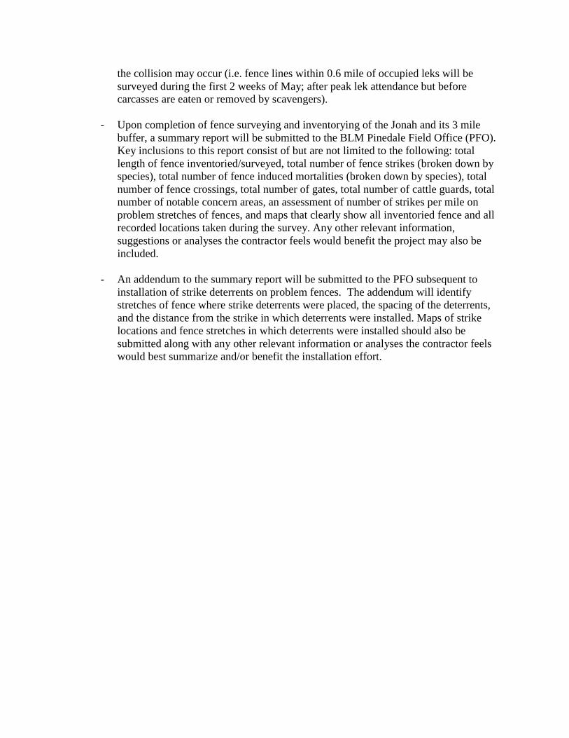
- Upon completion of fence surveying and inventorying of the Jonah and its 3 mile
buffer, a summary report will be submitted to the BLM Pinedale Field Office (PFO).
Key inclusions to this report consist of but are not limited to the following: total
length of fence inventoried/surveyed, total number of fence strikes (broken down by
species), total number of fence induced mortalities (broken down by species), total
number of fence crossings, total number of gates, total number of cattle guards, total
number of notable concern areas, an assessment of number of strikes per mile on
problem stretches of fences, and maps that clearly show all inventoried fence and all
recorded locations taken during the survey. Any other relevant information,
suggestions or analyses the contractor feels would benefit the project may also be
included.
- An addendum to the summary report will be submitted to the PFO subsequent to
installation of strike deterrents on problem fences. The addendum will identify
stretches of fence where strike deterrents were placed, the spacing of the deterrents,
and the distance from the strike in which deterrents were installed. Maps of strike
locations and fence stretches in which deterrents were installed should also be
submitted along with any other relevant information or analyses the contractor feels
would best summarize and/or benefit the installation effort.

Jonah Field Fence Inventory Data Standards
Jonah Field Fence Inventory data meant for incorporation into the BLM PFO corporate
Geographic Information System (GIS) data must follow these data standards.
Jonah Field Fence Inventory data will be broken into 6 separate data features categories:
Fence Line (Line Feature and associated attributes) and Fence Strike, Fence Crossings,
Notable Areas, Cattle guard and Gate (Point Features and associated attributes).
All spatial data will be collected using NAD83 datum zone 12 and will be submitted in 6
separate shapefiles (1 for each of the aforementioned data features collected).
All Jonah Field Fence Inventory data submitted to BLM PFO will use the exact data field
headers in the order they appear in the Jonah Field Fence Inventory Survey Key and
Codes and will use the data and codes supplied therein. Do not leave data fields blank,
empty or unpopulated! Data field headers are indicated by bracketed text
[FIELDHEADER] for each piece of data and data codes are supplied in the data pick lists
supplied under those data headers.
All data will be entered in capital letters. For all qualitative data in which more than one
word is used within a data field, each word should be followed by a single space and then
the subsequent word should be entered. For example: A surveyor discovers that a stretch
of fence has been damaged by migrating elk. An acceptable comment in the proper
format would be: FENCE DOWN. DAMAGED BY MIGRATING ELK.

Jonah Field Fence Inventory Survey Key and Codes
Note: Data for all data fields in this protocol will be required to be procured and submitted by the
surveyor unless otherwise not required by the authorized officer on a project by project basis.
Fence-line Data. (Line Feature)
Attribute Data
Type
Pick List Description
[TYPE]
Fence Type
Text ALL WOOD All Wood construction (i.e. buck and rail etc.).
WOOD-WIRE Wood posts with wire strands.
STEEL-WIRE Steel posts (T-posts etc.) with wire strands.
WOOD_STEEL-
WIRE
Wood and steel posts with wire strands.
OTHER Any other type of fence.
[NUM_STR] Number of
Strands
Numeric Numeric Value
Entered
Total number of strands will be recorded.
If more than 6 strands exist, enter the number of
strands and supply spacing measurements of
additional strands in the comments field.
Woven wire or net fencing should be considered as 2
strands of wire (strand 1-the bottom strand of the
woven wire panel, strand 2 – the top strand of the
woven wire panel)
[FEN_HEIGHT] Fence
Height
Numeric Numeric Value
Entered
Measurement (in) to the top strand of the fence
(average height that is representative of the stretch of
fence being inventoried)
[POST_DIST]
Distance between posts
Numeric Numeric Value
Entered
Measurement (ft) representing most common distance
between posts.
[STR1_TYPE]
Strand 1 Type
Text SMOOTH Type of fence strand 1 (strand closest to ground)
For woven wire or net fencing, the bottom of the
woven wire panel should be considered as strand 1. BARBED
WOOD
WOVEN WIRE
[STR1_SPACE]
Strand 1 Spacing
Numeric Numeric Value
Entered
Measurement (in) from ground to the bottom strand;
taken at center of fence panel (average height that is
representative of the stretch of fence being
inventoried).
[STR2_TYPE]
Strand 2 Type
Text SMOOTH Type of fence strand 2 (2nd
strand up from the ground)
For woven wire or net fencing, the top of the woven
wire panel should be considered as a strand 2. BARBED
WOOD
WOVEN WIRE
[STR2_SPACE]
Strand 2 Spacing
Numeric Numeric Value
Entered
Measurement (in) from ground to the 2nd strand;
taken at center of fence panel (average height that is
representative of the stretch of fence being
inventoried).
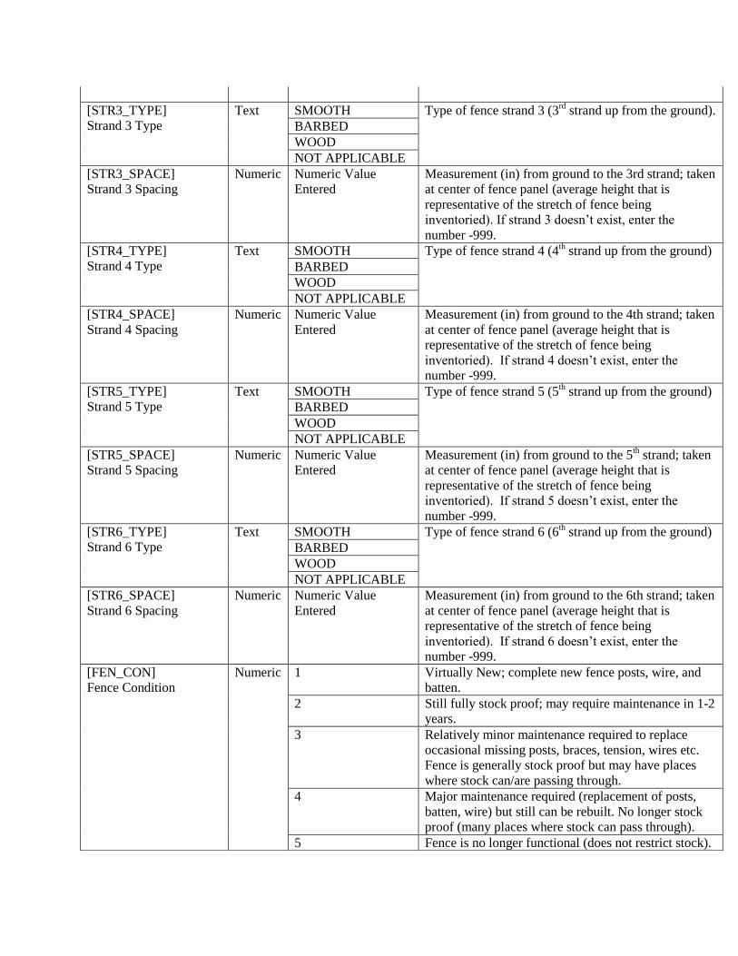
[STR3_TYPE]
Strand 3 Type
Text SMOOTH Type of fence strand 3 (3rd
strand up from the ground).
BARBED
WOOD
NOT APPLICABLE
[STR3_SPACE]
Strand 3 Spacing
Numeric Numeric Value
Entered
Measurement (in) from ground to the 3rd strand; taken
at center of fence panel (average height that is
representative of the stretch of fence being
inventoried). If strand 3 doesn’t exist, enter the
number -999.
[STR4_TYPE]
Strand 4 Type
Text SMOOTH Type of fence strand 4 (4th strand up from the ground)
BARBED
WOOD
NOT APPLICABLE
[STR4_SPACE]
Strand 4 Spacing
Numeric Numeric Value
Entered
Measurement (in) from ground to the 4th strand; taken
at center of fence panel (average height that is
representative of the stretch of fence being
inventoried). If strand 4 doesn’t exist, enter the
number -999.
[STR5_TYPE]
Strand 5 Type
Text SMOOTH Type of fence strand 5 (5th strand up from the ground)
BARBED
WOOD
NOT APPLICABLE
[STR5_SPACE]
Strand 5 Spacing
Numeric Numeric Value
Entered
Measurement (in) from ground to the 5th strand; taken
at center of fence panel (average height that is
representative of the stretch of fence being
inventoried). If strand 5 doesn’t exist, enter the
number -999.
[STR6_TYPE]
Strand 6 Type
Text SMOOTH Type of fence strand 6 (6th strand up from the ground)
BARBED
WOOD
NOT APPLICABLE
[STR6_SPACE]
Strand 6 Spacing
Numeric Numeric Value
Entered
Measurement (in) from ground to the 6th strand; taken
at center of fence panel (average height that is
representative of the stretch of fence being
inventoried). If strand 6 doesn’t exist, enter the
number -999.
[FEN_CON]
Fence Condition
Numeric 1 Virtually New; complete new fence posts, wire, and
batten.
2 Still fully stock proof; may require maintenance in 1-2
years.
3 Relatively minor maintenance required to replace
occasional missing posts, braces, tension, wires etc.
Fence is generally stock proof but may have places
where stock can/are passing through.
4 Major maintenance required (replacement of posts,
batten, wire) but still can be rebuilt. No longer stock
proof (many places where stock can pass through).
5 Fence is no longer functional (does not restrict stock).

Has missing sections and areas of collapse (requires
complete replacement or removal).
[COMMENT]
Fence Comments
Text Text entered Any relevant comment. TEXT SHOULD BE UPPER
CASE WITH SINGLE SPACE BETWEEN WORDS
AND PHRASE SHOULD END WITH A PERIOD.
[DATE]
Date of Collection
Date Date Entered mm/dd/yyyy
[SOURCE]
Data Source
Text Text entered The agency name or an abbreviation or acronym of
the agency name (BLM, WGFD, RONS SURVEYS
INC, etc.) that conducted the survey. Be consistent in
how you represent your department/establishment in
all data submissions.
[OBSRVER]
Observer
Text Text entered The first initial followed by a single space and then
the last name of the individual that conducted the
survey. For example: R MCWILLIAMS.

Fence Strike Data (Point Feature)
Attribute Data
Type
Pick List Description
[FS_TYPE]
Fence Strike Type
Text SIMPLE STRIKE Feathers or hair on/in or immediately surrounding
fence.
FENCE
MORTALLITY
Carcass (at a minimum bones identifiable of the
species) present on/in or immediately surrounding
fence.
[FS_SPECIES]
Fence Strike Species
Text SAGE-GROUSE Sage-grouse
RAPTOR If discernable enter species in comments.
PASSERINE If discernable enter species in comments.
PRONGHORN Pronghorn Antelope
DEER Mule or White-tailed
ELK Elk
MOOSE Moose
DOMESTIC Any Domestic Species.
Enter species into comments.
OTHER Any other species.
Enter species in comments.
UNKNOWN Species is indiscernible.
[NUM_INDVL]
Number of Individuals
Numeric Numeric Value
Entered
Number of carcasses or strikes represented by data
point.
[DECMP_ST]
Decomposition State
Text NO
DECOMPOSISTION
Carcass is intact with no or few signs of
decomposition.
MODERATE
DECOMPOSISTION
Carcass is nearly intact or slightly dispersed with
some desiccation.
HIGH
DECOMPOSISTION
Carcass is dispersed by heavy decomposition (Bone
piles).
NO CARCASS Hair or feathers but no carcass (simple strikes).
[FS_COMMENT]
Fence Strike Comment
Text Text entered Any relevant fence strike comments.
[FS_DATE]
Fence Strike Date
Date Date entered Date that fence strike data was gathered.
mm/dd/yyyy.
[FS_SOURCE]
Fence Strike Data
Source
Text Text entered See discussion in fence attribute table above.
[FS_OBSRVER]
Fence Strike Observer
Text Text entered See discussion in fence attribute table above.
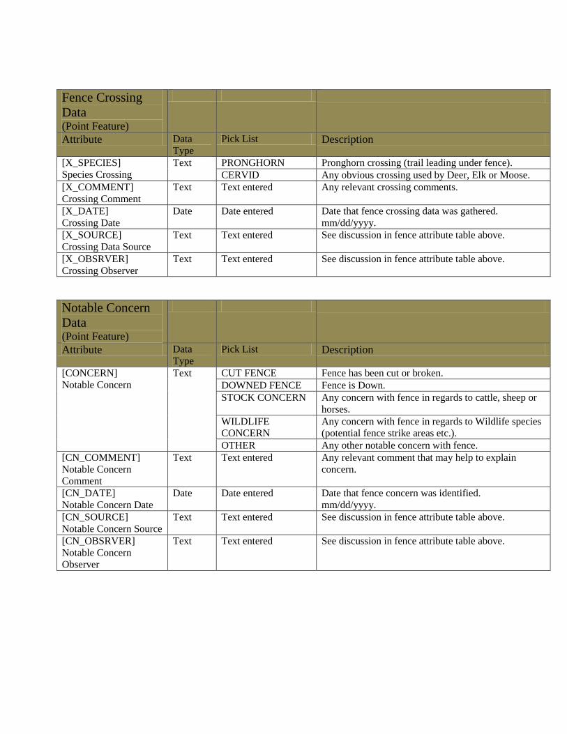
Fence Crossing
Data (Point Feature)
Attribute Data
Type
Pick List Description
[X_SPECIES]
Species Crossing
Text PRONGHORN Pronghorn crossing (trail leading under fence).
CERVID Any obvious crossing used by Deer, Elk or Moose.
[X_COMMENT]
Crossing Comment
Text Text entered Any relevant crossing comments.
[X_DATE]
Crossing Date
Date Date entered Date that fence crossing data was gathered.
mm/dd/yyyy.
[X_SOURCE]
Crossing Data Source
Text Text entered See discussion in fence attribute table above.
[X_OBSRVER]
Crossing Observer
Text Text entered See discussion in fence attribute table above.
Notable Concern
Data (Point Feature)
Attribute Data
Type
Pick List Description
[CONCERN]
Notable Concern
Text CUT FENCE Fence has been cut or broken.
DOWNED FENCE Fence is Down.
STOCK CONCERN Any concern with fence in regards to cattle, sheep or
horses.
WILDLIFE
CONCERN
Any concern with fence in regards to Wildlife species
(potential fence strike areas etc.).
OTHER Any other notable concern with fence.
[CN_COMMENT]
Notable Concern
Comment
Text Text entered Any relevant comment that may help to explain
concern.
[CN_DATE]
Notable Concern Date
Date Date entered Date that fence concern was identified.
mm/dd/yyyy.
[CN_SOURCE]
Notable Concern Source
Text Text entered See discussion in fence attribute table above.
[CN_OBSRVER]
Notable Concern
Observer
Text Text entered See discussion in fence attribute table above.

Gate Data (Point Feature)
Attribute Data
Type
Pick List Description
[GATE_TYPE]
Type of gate
Text ALL WOOD Gate construction type.
WOOD-WIRE
STEEL-WIRE
STEEL PANEL
WOOD_STEEL-
WIRE
OTHER
[GATE_HT]
Height of Gate
Numeric Numeric Value
Entered
Height of gate (in).
[GATE_WDTH]
Width of Gate
Numeric Numeric Value
Entered
Measurement (ft) of the width of the travelling lane in
which a vehicle would pass through the gate.
[GATE_CON]
Condition of Gate
Numeric 1 Excellent; new construction with no visible
weathering. Gate appears to carry its own weight and
swings freely.
2 Good; nearly new construction with some light
weathering. Gate appears to have some sag and
swings freely.
3 Fair; older construction with moderate weathering.
Gate appears to have considerable sag and does not
swing freely.
4 Poor; old construction with heavy weathering. Gate is
falling down and does not swing freely.
[G_COMMENT]
Gate Comments
Text Text entered Any relevant comments related to the gate.
[G_DATE]
Date
Date Date entered Date that gate data was gathered.
mm/dd/yyyy.
[G_SOURCE]
Data Source
Text Text entered See discussion in fence attribute table above.
[G_OBSRVER]
Observer
Text Text entered See discussion in fence attribute table above.

Cattle-guard Data (Point Feature)
Attribute Data
Type
Pick List Description
[CG_WIDTH]
Cattle guard Width
Numeric Numeric Value
Entered
Measurement (ft) of the width of the travelling lane in
which a vehicle would pass over the cattle guard
(length of the long axis of a cattle guard).
[CG_CON]
Cattle guard Condition
Numeric 1 Excellent; new to nearly new with no damage and/or
silting in of cattle guard.
2 Good; little to no damage and/or only moderate silting
in.
3 Fair; damaged and/or nearly silted in but fully
functional.
4 Poor; major damage and/or completely silted in and
no longer functioning.
[CG_COMMENT]
Cattle guard Comment
Text Text entered Any relevant comment regarding the cattle guard.
[CG_DATE]
Cattle guard Date
Date Date entered Date that cattle guard data was gathered.
mm/dd/yyyy.
[CG_SOURCE]
Cattle guard Data
Source
Text Text entered See discussion in fence attribute table above.
[CG_OBSRVER]
Cattle guard Observer
Text Text entered See discussion in fence attribute table above.