wisconsin forest management guidelines
TRANSCRIPT

Wisconsin Department of Natural ResourcesDivision of Forestry
PO Box 7921Madison, Wisconsin 53707
For additional information, call 608-267-7494 or visit our web site at:www.dnr.state.wi.us/org/land/forestry/
October, 2003
This document is intended solely as guidance, and does not include any mandatory requirements except where requirements found in statute or administrative rule are referenced. This guidance does not establish
or affect legal rights or obligations, and is not finally determinative of any of the issues addressed. This guidance does not create any rights enforceable by any party in litigation with the State of Wisconsin or
the Department of Natural Resources. Any regulatory decisions made by the Department of Natural Resources in any manner addressed by this guidance will be made by applying the governing statutes and
administrative rules to the relevant facts.
The Wisconsin Department of Natural Resources provides equal opportunities in its employment, programs, services, and functions under an Affirmative Action Plan. If you have any questions, please write to
Equal Employment Opportunity Office, Department of Interior, Washington, D.C. 20240. This publication is available in alternative format upon request.
Please call 608-267-7494 for more information.
WISCONSIN FOREST MANAGEMENT GUIDELINESPUB-FR-226 2003
A

11

Integrated Resource Management Considerations ................................................................................140
UPLAND FOREST ROADS .........................................................142BMPs: Planning, Location and Design .....................................................................................................142
STREAM CROSSING DESIGN AND CONSTRUCTION..................143BMPs: Fords ...................................................................................................................................................143BMPs: Stream Crossings .............................................................................................................................144BMPs: Pipe Culverts for Stream Crossings..............................................................................................145
ROAD CONSTRUCTION AND DRAINAGE...................................147BMPs: Road Construction and Drainage ..................................................................................................147
DRAINAGE STRUCTURES .........................................................149BMPs: Drainage Structures ........................................................................................................................149BMPs: Pipe Culverts for Cross-drains.......................................................................................................150BMPs: Open-top Culverts ............................................................................................................................150BMPs: Broad-based Dips ............................................................................................................................151BMP: Waterbars ............................................................................................................................................151
SOIL STABILIZATION ................................................................152Mulch and Seeding .......................................................................................................................................152BMP: Mulch and Seeding............................................................................................................................152BMP: Diversion Structures..........................................................................................................................152BMP: Sediment-control Structures ...........................................................................................................153
WETLAND FOREST ROADS .......................................................154BMPs: Wetland Roads, Skid Trails and Landings ..................................................................................154
15 FEDERAL REQUIREMENTS...................................................155BMPs: Forest Roads in Wetlands...............................................................................................................155
ROAD MAINTENANCE ..............................................................156BMPs: Road Maintenance...........................................................................................................................156
139
CHAPTER 11 — FOREST ROAD CONSTRUCTION AND MAINTENANCE

Roads, skid trails and landings are all part of a foresttransportation system (skid trail and landing BMPs are covered in Chapter 12: Timber Harvesting). Roadsconnect the forestland to existing public roads. Theyprovide forest access for such activities as managingtimber, improving fish and wildlife habitat, fighting fires,and recreation.
Forest roads located, constructed or maintained poorlyare the largest source of nonpoint source pollution fromforest management activities. Roads over steep slopes,erodible soils, or stream crossings hold the greatestpotential for degrading water quality.
There are three types of forest roads: temporary roads,permanent seasonal roads, and permanent all-seasonforest roads. Make sure to identify the type of roadsystem you need during your planning phase.
• Temporary Roads: These are the most common type of forest road. They are designed and constructed for short-term use during a specific project such astimber harvesting. These roads are used only whenthe ground is frozen or firm. When the project iscomplete, the temporary road is closed, all streamcrossing structures are removed, and the road isnaturally or artificially revegetated.
• Permanent Seasonal Roads: Maintained as part of thepermanent road system, seasonal roads are designedfor use only when the ground is frozen or firm. Theseroads are generally narrower than all-season roads,built to lower engineering standards, and haveminimal surface gravel.
• Permanent All-season Forest Roads: These roadsusually have gravel surfaces and are designed for year-round use. However, there may be somerestrictions on use at various times of the year.
Integrated Resource Management Considerations A well-planned access system is a sound method ofreducing erosion and sedimentation in areas requiringfrequent or temporary access. Proper location andconstruction of roads will provide for safety, longeroperating periods, lower maintenance and operatingcosts, and minimal impacts to forest resources.
Servicing as many acres of forest with as few roads as possible is a sound method of reducing impacts toforest resources from road construction.
FACTORS IN DECISION-MAKING• The number, size and design of forest access roads
will be influenced by the frequency of access, amountof anticipated traffic, seasons during which access isrequired, and safety concerns.
• Distribution of necessary management activities willaffect the number and location of access roads.
• Choices regarding road construction standards andmaintenance activities will be influenced by sitecharacteristics, and the value of the resources served.Culverts and ditches may be necessary with any roadconstruction technique.
• Surfacing can be the major cost of low-volumeroad construction. Alternatives should be evaluatedaccording to expected use and potential impact onsediment load. Where grades make the potential for surface erosion significant, the road should be surfaced with materials such as crushed rock,compacted gravel, sod, or asphalt that will minimizepotential water quality and soil productivity impacts.
Chapter 11 — Forest Road Construction and Maintenance
140
Figure 11-1: Seeding can be as easy as spreading grass seed by hand as this landowner is doing on hisfreshly-graded woods road. Use non-invasive speciesand certified weed-free seed.
MINIMIZING THE IMPACTS OF ROADS• Visual impacts and excessive noise can result
from poor design, construction and maintenance offorest access roads. Take into account the followingconsiderations when planning to reduce noise andvisual impacts associated with the design and use of forest access roads:- Noise from traffic, especially large trucks, buses and
heavy equipment.- Potential increased costs of building forest access
roads to accommodate visual quality concerns, andpotential increased costs of using existing roadsthat require traveling greater distances.
- The limited road construction season that generallycoincides with the tourist season.
- Traffic during wet periods that can increasemaintenance needs, and create unsightly rutsand mudholes.
• Visual impacts and noise impacts created by gravelpits are not compatible with recreational usersensitivities. Take into account the followingconsiderations when planning to reduce noiseand unsightliness related to gravel pits:- Local sources of gravel are necessary for efficient,
cost-effective road building and maintenance.- Recreational use of gravel pits may cause conflicts.
• Site-specific soil, topographic and forest inventoryinformation will assist resource managers orlandowners in planning road location and layout. For more information, see the Resource Directory.
• Because roads take soils out of production, effortshould be made to keep the length and width of roadsto a minimum without sacrificing safety.
• To minimize road mileage and reduce costs,coordination with adjacent landowners may be desirable.
• The greatest potential for soil erosion occursimmediately after construction. Disturbed areasshould be shaped and stabilized as soon as possibleto minimize erosion potential.
• Seed disturbed areas (landings and skidroads) as soon as feasible in order to re-establish desirablespecies, and retard possible invasion by non-nativeinvasive species.
MAINTENANCE NEEDS• The purpose of maintenance procedures is to ensure
measures taken to minimize impacts on forestresources are working, and continue to work into the future. Surfacing materials and the amount of usedetermine the level of maintenance required.
• Roads that are open for use require more maintenancethan roads that are closed to vehicular traffic. Inactiveroads (roads currently not in use) whether closedtemporarily or permanently, require occasional workto reduce potential impacts on streams, lakes,wetlands, and seasonal ponds.
• Road layout, construction methods and erosion, andaccess control all contribute to the longevity, utility,safety, and maintenance cost of roads.
• Monitor for non-native invasive species, control theirspread, and eradicate them if possible. Cleanequipment as needed.
PROTECTING WATER QUALITY AND WATER FLOW• Incorporating guidelines to protect water quality into
overall road project design can minimize the potentialimpact of wetland roads on water quality, as well asalterations to normal water flow patterns.
• Effective road construction techniques minimize thedisturbance to the natural flow of water over thelandscape, and ensure the structural integrity of theroad embankment.
The goals are to provide a simple road structure ofadequate strength to support heavy vehicle traffic, andprovide drainage structures to pass water at its normallevel through the road corridor.
Chapter 11 — Forest Road Construction and Maintenance
141

Chapter 11 — Forest Road Construction and Maintenance
142
UPLAND FOREST ROADS
BMPs: Planning, Location and Design
Decisions made at the planning stage will affect aroad’s construction costs, long-term maintenanceneeds, service life, and the amount of nonpoint sourcepollution it causes. Loggers and landowners shouldplan, locate and design the road system together.
� Plan road systems that minimize the number, widthand length of roads to limit the total area of the sitedisturbed. Remember to:- Consider future uses of the road system- Coordinate development with adjoining
landowners when possible; and- use temporary roads where practical
� Use existing roads when they provide the bestlong-term access. Consider relocating existingroads if doing so improves access and reducesenvironmental impacts. Reconstruct existing roadsto provide adequate drainage and safety. Do notdisturb stable road surfaces.
� Select road locations that allow for drainage awayfrom the road.
� Minimize the number of stream crossings.
� Identify optimum stream crossing locations beforelocating the rest of the road. Optimum locations
include straight and narrow stream channels with low banks and firm rocky soil. Roads shouldapproach streams with the least gradient possible.
� Where possible, locate roads on well-drained soils.
� Locate roads outside riparian management zonesexcept at stream crossings. For more information,see Chapter 5: Riparian Areas and Wetlands.
� Road grades should not exceed 10 percent. If roadgrades greater than 10 percent are necessary, limitgrade length to minimize erosion, or break thegrade using drainage structures (see “DrainageStructures” on page 149). Graveling the roadsurface on steep grades can also help maintainstability. Note: Optimum road grades should be lessthan five percent (see Figure 11-2).
� Locate roads to follow natural contours andminimize cut-and-fills. Balance cut-and-fills tominimize the need for fill or removing excessmaterials (see Figure 11-3).
Figure 11-2: Road Grade % = Rise ÷ Run x 100.Figure 11-3: A side-hill cross-section illustrating howcut materials (A) equals fill materials (B).
AB
REDUCING VISUAL IMPACTS DUE TO ALIGNMENT AND LOCATION OF ROADS
• Minimize the number of roads approaching travelroutes or recreation areas.
• Locate roads and trails to minimize visibility fromnearby vantage points such as scenic overlooks,streams and lakes.
• Minimize total road mileage and ground disturbancerequired to meet landowner objectives andanticipated traffic loads.
• Avoid tracking mud onto highways by usingappropriate road surface material.
• Reduce visual penetration with appropriate curves in the road alignment.
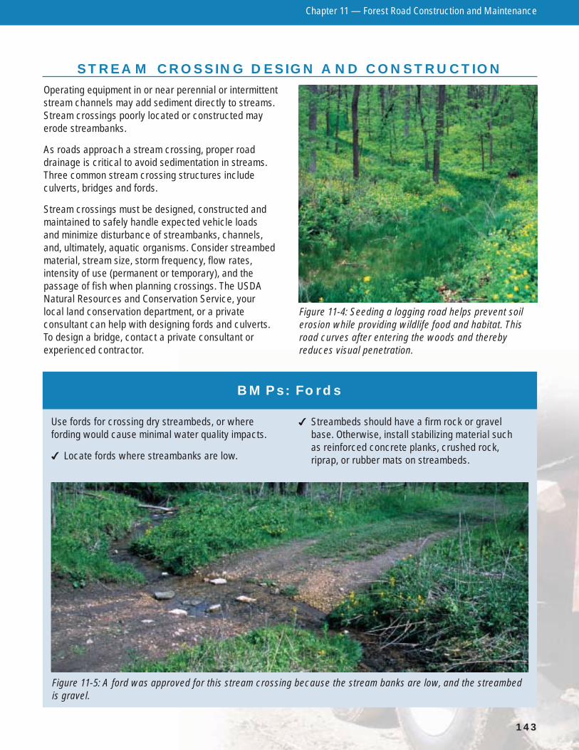
Operating equipment in or near perennial or intermittentstream channels may add sediment directly to streams.Stream crossings poorly located or constructed mayerode streambanks.
As roads approach a stream crossing, proper roaddrainage is critical to avoid sedimentation in streams.Three common stream crossing structures includeculverts, bridges and fords.
Stream crossings must be designed, constructed andmaintained to safely handle expected vehicle loads and minimize disturbance of streambanks, channels,and, ultimately, aquatic organisms. Consider streambedmaterial, stream size, storm frequency, flow rates,intensity of use (permanent or temporary), and thepassage of fish when planning crossings. The USDANatural Resources and Conservation Service, your local land conservation department, or a privateconsultant can help with designing fords and culverts.To design a bridge, contact a private consultant orexperienced contractor.
Chapter 11 — Forest Road Construction and Maintenance
143
STREAM CROSSING DESIGN AND CONSTRUCTION
Figure 11-4: Seeding a logging road helps prevent soilerosion while providing wildlife food and habitat. Thisroad curves after entering the woods and therebyreduces visual penetration.
BMPs: Fords
Use fords for crossing dry streambeds, or wherefording would cause minimal water quality impacts.
� Locate fords where streambanks are low.
� Streambeds should have a firm rock or gravelbase. Otherwise, install stabilizing material suchas reinforced concrete planks, crushed rock,riprap, or rubber mats on streambeds.
Figure 11-5: A ford was approved for this stream crossing because the stream banks are low, and the streambedis gravel.

Chapter 11 — Forest Road Construction and Maintenance
144
BMPs: Stream Crossings
� A permit is required to construct a ford or install aculvert/bridge across any navigable intermittent orperennial stream. A stream is navigable if it has bedand banks, and it is possible to float a canoe or othersmall craft in the waterway on a regular reoccurringbasis – even if only during spring runoff. Streamsidentified on current U.S. Geological Survey (USGS)topographical maps (7.5 minute/1:24,000 scale)should be considered navigable. Other lakes and streams may be considered navigable by aWisconsin DNR water management specialist. Ifyou have a question about navigability, contact aWisconsin DNR water management specialist.
� For temporary stream crossings for skid trails, see the Stream Crossings for Skidding section inChapter 12: Timber Harvesting.
� Use soil stabilization practices on exposed soil atstream crossings. Use seed and mulch, and installtemporary sediment control structures such asstraw bales or silt fences immediately followingconstruction to minimize erosion into streams.Maintain these practices until the soil ispermanently stabilized (see Soil Stabilization, page 152).
� Design, construct and maintain stream crossingsto avoid disrupting the migration or movement offish and other aquatic life. Bridges or arch culvertsthat retain the natural stream bottom and slope arepreferred for this reason.
� Install stream crossings using materials that areclean, non-erodible and non-toxic.
� Install stream crossing structures at right anglesto the stream channel.
� Minimize channel changes and the amount ofexcavation or fill needed at the crossing.
� Limit construction activity in the water to periodsof low or normal flow. Keep use of equipment inthe stream to a minimum.
� Construct a bridge or place fill directly over aculvert higher than the road approach to preventsurface runoff from draining onto the crossingstructure and into the stream (see Figure 11-6).
� Divert road drainage into undisturbed vegetation,preferably outside the RMZ, so the drainage doesnot directly enter the stream (see Figure 11-7 andDiversion Structures on page 149).
� Stabilize approaches to bridge, culvert and fordcrossings with aggregate or other suitable materialto reduce sediment entering the stream.
� Anchor temporary structures on one end with acable or other device so they do not float awayduring high water. Install them so they can beeasily removed when no longer used, regardlessof the season.
Figure 11-6: Use of fill when placing a culvert.
Figure 11-7: Example of a diversion ditch.
RUNOFF

Chapter 11 — Forest Road Construction and Maintenance
145
BMPs: Pipe Culverts for Stream Crossings
� Install pipe culverts long enough so that road filldoes not extend beyond the ends of a culvert.
� Install permanent culverts that are large enough topass flood flows, and are a minimum of 12 inches indiameter. Culverts that are too small can plug upwith debris and result in the road washing out, or inflooding upstream. Wisconsin law states that thelandowner and/or contractor are responsible toobtain a flood easement from any affected propertyowners upstream of culvert crossings that are notdesigned to pass the 100-year flood. The USDANatural Resources and Conservation Service, your local land conservation department or aprivate consultant (i.e., engineer or registered land surveyor) can help with sizing culverts.
� Install culverts so there is no change in the streambottom elevation. Culverts should not cause dammingor pooling (see Figure 11-8).
� Firmly compact fill material around culverts,particularly around the bottom half. Cover the top of culverts with fill to a depth of one-third of thepipe diameter or at least 12 inches, whichever isgreater, to prevent crushing (see Figure 11-9).
� Use riprap around the inlet of culverts to preventwater from eroding and undercutting the culvert.For permanent installations, use filter fabric underthe riprap. In addition, consider using flared-endculvert sections for inlets (see Figure 11-10).
� Keep culverts clear and free of debris so that watercan pass unimpeded at all times. This is especiallyimportant in areas where beaver are present.
Figure 11-9: Installation of culverts.
Figure 11-10: Use riprap around the inlet of culverts. Also use geotextile filter fabric forpermanent installations.
Culvert
Road SurfaceAt least one foot of cover or one-third of
diameter for larger culverts.
Tamp backfill materialat regular intervals.
Base and sidewallfill material should be compacted.
Rock-freeCulvert Bed (gravel or soil)
Levelof natural
streambedExistingGround
Geotextile Filter Fabric
1 ft.
Figure 11-8: Install culverts so there is no change inthe stream bottom elevation.
Road Surface
1 ft. Minimum 12
SlopeMulch
1 ft.
Chapter 11 — Forest Road Construction and Maintenance
146
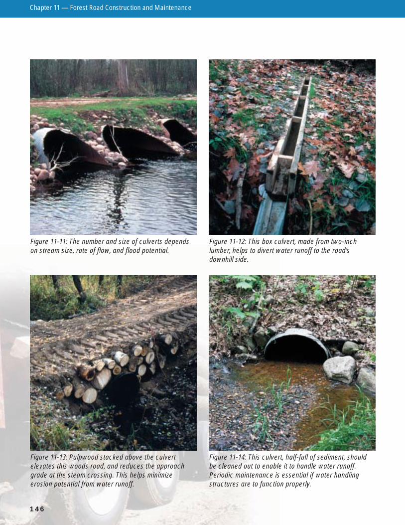
Figure 11-13: Pulpwood stacked above the culvertelevates this woods road, and reduces the approachgrade at the steam crossing. This helps minimizeerosion potential from water runoff.
Figure 11-14: This culvert, half-full of sediment, shouldbe cleaned out to enable it to handle water runoff.Periodic maintenance is essential if water handlingstructures are to function properly.
Figure 11-11: The number and size of culverts dependson stream size, rate of flow, and flood potential.
Figure 11-12: This box culvert, made from two-inchlumber, helps to divert water runoff to the road’sdownhill side.
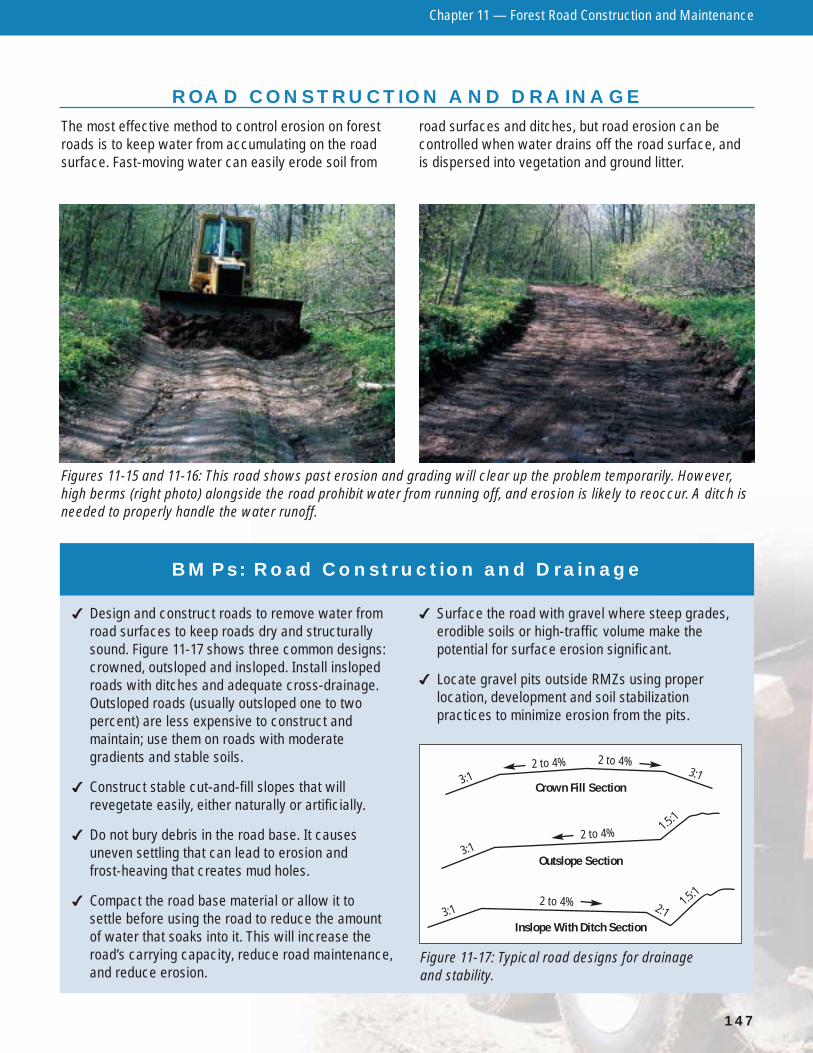
The most effective method to control erosion on forestroads is to keep water from accumulating on the roadsurface. Fast-moving water can easily erode soil from
road surfaces and ditches, but road erosion can becontrolled when water drains off the road surface, and is dispersed into vegetation and ground litter.
Chapter 11 — Forest Road Construction and Maintenance
147
ROAD CONSTRUCTION AND DRAINAGE
Figures 11-15 and 11-16: This road shows past erosion and grading will clear up the problem temporarily. However,high berms (right photo) alongside the road prohibit water from running off, and erosion is likely to reoccur. A ditch isneeded to properly handle the water runoff.
BMPs: Road Construction and Drainage
� Design and construct roads to remove water fromroad surfaces to keep roads dry and structurallysound. Figure 11-17 shows three common designs:crowned, outsloped and insloped. Install inslopedroads with ditches and adequate cross-drainage.Outsloped roads (usually outsloped one to twopercent) are less expensive to construct andmaintain; use them on roads with moderategradients and stable soils.
� Construct stable cut-and-fill slopes that willrevegetate easily, either naturally or artificially.
� Do not bury debris in the road base. It causesuneven settling that can lead to erosion andfrost-heaving that creates mud holes.
� Compact the road base material or allow it tosettle before using the road to reduce the amountof water that soaks into it. This will increase theroad’s carrying capacity, reduce road maintenance,and reduce erosion.
� Surface the road with gravel where steep grades,erodible soils or high-traffic volume make thepotential for surface erosion significant.
� Locate gravel pits outside RMZs using properlocation, development and soil stabilizationpractices to minimize erosion from the pits.
Figure 11-17: Typical road designs for drainage and stability.
Inslope With Ditch Section
Outslope Section
Crown Fill Section3:1 3:1
2 to 4% 2 to 4%
3:1
2:1
2 to 4% 1.5:1
3:12 to 4% 1.5:1

Chapter 11 — Forest Road Construction and Maintenance
148
REDUCING VISUAL IMPACTS OFROAD CLEARINGS
• Utilize merchantable timber within road clearings.
• Burn, screen or bury road-clearing debris such asstumps, rocks and boulders, so it is not visiblefrom travel routes or recreation areas.
• Move cleared debris outside of the travel routeright-of-way so it is minimally apparent.
• Avoid creating a corridor of debris.
• Do not leave jackstrawed or overturned stumps inthe immediate foreground.
• Reduce the height of dozed clearing debris duringroad construction.
REDUCING NOISE AND VISUAL IMPACTS OFGRAVEL PITS AND BORROW AREAS
• Locate borrow pits and crushing operations out ofthe visible corridor as much as possible.
• Screen pits from travel routes or recreation areasusing existing vegetation or landscape berms.
• Reduce noise in early morning, late evening andother appropriate times whenever possible.
• Develop gravel or borrow pits from the back to thefront of pits (moving toward the predominant viewor vantage point).
• Rehabilitate pits upon completion of use.
Figure 11-18: This waterbar, placed at the proper angle to the road, will intercept runoff water and direct it into theadjoining vegetation.

Chapter 11 — Forest Road Construction and Maintenance
149
DRAINAGE STRUCTURES
Figure 11-19: This truck haul road has just been graded at the close of timber harvesting activities.Water diversions, seed and gate closures will becompleted next.
Figure 11-20: A seeded logging road with a properlylocated gate to limit motorized access mark the end ofthis timber sale.
BMPs: Drainage Structures
Road-drainage structures include cross-drains (pipe culverts, open-top culverts, broad-based dips,and waterbars) and water-diversion structures. Cross-drains allow water from roadside ditches to move from one side of the road to the other.
� Where necessary to protect water quality, installroad-drainage structures to remove storm water orseepage from the road surface and ditches. Spacethese structures at intervals close enough to
minimize waterflow volume and speed, avoidingditch erosion. As road grades increase, usedrainage structures more often (see Table 11-1).
� Where necessary, provide erosion protection foroutflows from road-drainage structures to minimizeerosion and disperse the water, allowing it to soakinto the soil. Riprap, mulch and/or seeding may benecessary (see Soil Stabilization, page 152).
Table 11-1: Recommended distances between drainage structures on forest roads and skid trails.
ROAD GRADE DISTANCE BETWEEN WATERBARS DISTANCE BETWEEN BROAD-BASEDDIPS AND CROSS-DRAIN CULVERTS
1% 400 Feet 500 Feet
2% 250 Feet 300 Feet
5% 130 Feet 180 Feet
10% 80 Feet 150 Feet
15% 50 Feet 130 Feet
25% + 40 Feet 110 Feet
Chapter 11 — Forest Road Construction and Maintenance
150
BMPs: Pipe Culverts for Cross-drains
� Install pipe culverts to provide cross-drainage onroad grades at regular intervals immediately abovesteep grades, below bank seepages, and wherewater will run onto log landings or forest roads.
� Install pipe culverts long enough so that road filldoes not extend beyond the end of a culvert.
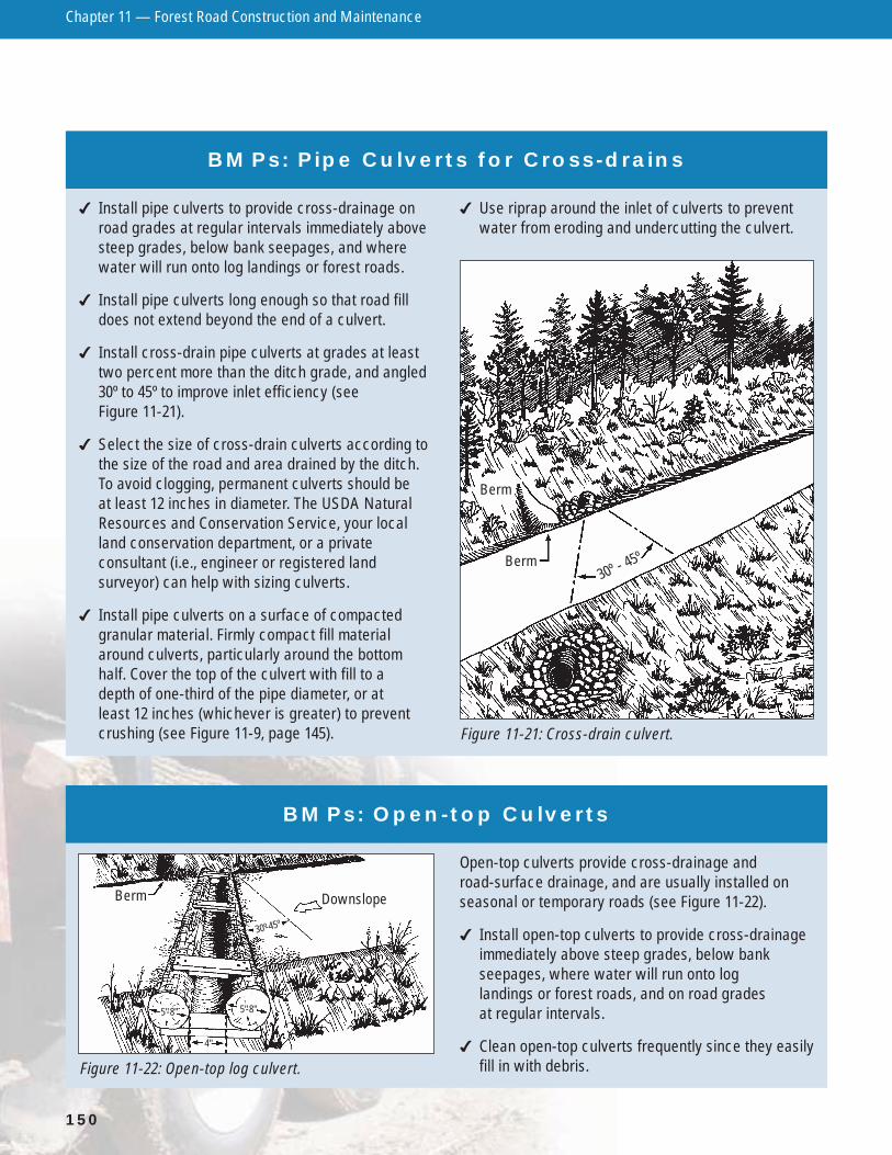
� Install cross-drain pipe culverts at grades at leasttwo percent more than the ditch grade, and angled30º to 45º to improve inlet efficiency (seeFigure 11-21).
� Select the size of cross-drain culverts according tothe size of the road and area drained by the ditch.To avoid clogging, permanent culverts should be at least 12 inches in diameter. The USDA NaturalResources and Conservation Service, your localland conservation department, or a privateconsultant (i.e., engineer or registered landsurveyor) can help with sizing culverts.
� Install pipe culverts on a surface of compactedgranular material. Firmly compact fill materialaround culverts, particularly around the bottomhalf. Cover the top of the culvert with fill to a depth of one-third of the pipe diameter, or at least 12 inches (whichever is greater) to preventcrushing (see Figure 11-9, page 145).
� Use riprap around the inlet of culverts to preventwater from eroding and undercutting the culvert.
Figure 11-21: Cross-drain culvert.
Berm
Berm30º - 4
5º
BMPs: Open-top Culverts
Open-top culverts provide cross-drainage and road-surface drainage, and are usually installed onseasonal or temporary roads (see Figure 11-22).
� Install open-top culverts to provide cross-drainageimmediately above steep grades, below bankseepages, where water will run onto log landings or forest roads, and on road grades at regular intervals.
� Clean open-top culverts frequently since they easilyfill in with debris.Figure 11-22: Open-top log culvert.
Berm Downslope
4"
5"-8" 5"-8"
30º-45º

Chapter 11 — Forest Road Construction and Maintenance
151
BMPs: Broad-based Dips
Broad-based dips can provide cross-drainage androad-surface drainage for roads and skid trails with agradient of 15 percent or less. Broad-based dips canbe used instead of culverts, usually at lower cost andwith lower maintenance. Dips are not used for drainingseeps, or for intermittent or permanent streams (seeFigure 11-23).
� Construct broad-based dips deep enough to provideadequate drainage and wide enough to allow trucksand equipment to pass safely.
� Place a surface of crushed stone or gravel on thedip, and mound for soils and conditions whererutting may occur.
Figure 11-23: Broad-based dip (and cross-section).
Berm
30º
Final GradeConstructionOriginal Grade
BMP: Waterbars
A waterbar is a shallow trench with a mound (or berm)which provides cross-drainage and intercepts runofffrom skid trails, recreational trails, firebreaks, orinactive or closed roads. Constructing a waterbar
will minimize erosion and provide conditions fornatural or artificial revegetation (see Figure 11-24).
� Place waterbars at a 30º to 45º angle with across-drainage grade of two percent.
Figure 11-24: Waterbar.
CROSS-SECTION
Berm tied intoembankment
30º - 45º
3'- 4'3'- 4' 3'- 4'
1'

Soil stabilization practices are used where soil isexposed, and natural revegetation is inadequate toprevent soil erosion and subsequent sedimentation into streams, lakes and wetlands. This occurs duringroad construction, and when the road system is beingused (active) or is closed (inactive). Practices includemulching, seeding, and installing sediment controlstructures. References include the Wisconsin DNR’sWisconsin Construction Site Erosion Control Handbookand Chapter 10 in the Wisconsin Department ofTransportation’s Erosion and Sediment Control FacilitiesDevelopment Manual. To obtain these references, see the Resource Directory. Contact a Wisconsin DNR forester or the USDA Natural Resources andConservation Service for more information.
It is always more efficient and cost-effective to preventerosion than to repair damage after the fact.
Mulch and SeedingMulch such as straw, woodchips or bark, retains soilmoisture important for seed germination, and protectsthe soil surface from erosion due to runoff and raindropimpact. Mulch can be used to: 1) promote naturalrevegetation or 2) protect seeds spread over an area. If you seed, apply mulch immediately afterward. Nettingmay be necessary to hold mulch in place on steepslopes or on areas where water flow concentrates.
Seed mixtures should include fast-growing species forquick soil protection, plus perennial species for longersoil protection until native vegetation returns to the site.Do not use mixtures that contain aggressive or non-nativeinvasive species like reed canary grass, birds-foot trefoil,crown/hairy vetch, or tall fescue; use certified weed-freeseed. Recommendations for seed mixes that are best for specific regions in Wisconsin are available from yourlocal Wisconsin DNR Wildlife Management Specialist,and USDA Natural Resources and Conservation Service(NRCS) office. However, a suggested generic seedmixture, applied at the rate of 31 lbs./acre, is as follows:
White Dutch Clover ..............................8 lbs./acrePerennial Rye Grass.............................5 lbs./acreAnnual Rye Grass ................................8 lbs./acreCreeping Red Fescue.........................10 lbs./acreTotal ......................................................31 lbs./acre(Note: One acre equals 43,560 square feet.)
A list of seed mixtures based on physical sitecharacteristics is contained within the technical guide critical area planting standard 342. This technicalguide is available from USDA NRCS offices, or on-line at www.wi.nrcs.usda.gov/fotg/standards4.asp
Chapter 11 — Forest Road Construction and Maintenance
152
SOIL STABILIZATION
BMP: Diversion Structures
Diversion ditches, or berms, divert water away from roads and side ditches, and channel it intovegetation. These structures are often used beforestream crossings to ensure that water will bediverted into vegetation, and not directly into astream, lake or wetland (see Figure 11-7, page 144).
� Construct diversion ditches so they intersect the roadside ditch at the same depth, and areoutsloped one to three percent.
BMP: Mulch and Seeding
� Use mulch and/or seed where necessary tominimize soil erosion into streams, lakes and wetlands.
Figure 11-25: Once recommended as a wildlife planting, multiflora rose has become quite invasive in many locations.
Chapter 11 — Forest Road Construction and Maintenance
153
BMP: Sediment-control Structures
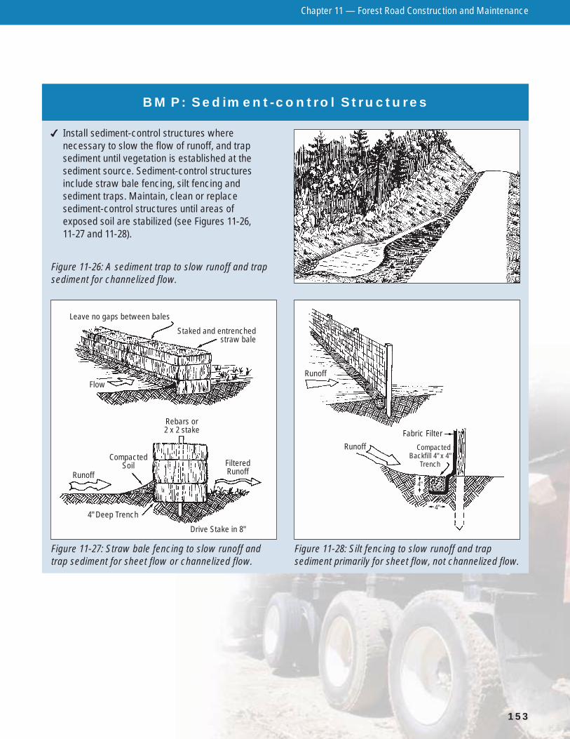
� Install sediment-control structures wherenecessary to slow the flow of runoff, and trapsediment until vegetation is established at thesediment source. Sediment-control structuresinclude straw bale fencing, silt fencing andsediment traps. Maintain, clean or replacesediment-control structures until areas of exposed soil are stabilized (see Figures 11-26, 11-27 and 11-28).
Figure 11-27: Straw bale fencing to slow runoff andtrap sediment for sheet flow or channelized flow.
Figure 11-28: Silt fencing to slow runoff and trapsediment primarily for sheet flow, not channelized flow.
Leave no gaps between bales
Rebars or 2 x 2 stake
Staked and entrenched straw bale
Flow
CompactedSoil
RunoffFilteredRunoff
4" Deep Trench
Drive Stake in 8"
Runoff
Fabric Filter
Runoff CompactedBackfill 4" x 4"
Trench
4"
4"
Figure 11-26: A sediment trap to slow runoff and trapsediment for channelized flow.
Chapter 11 — Forest Road Construction and Maintenance
154
WETLAND FOREST ROADS
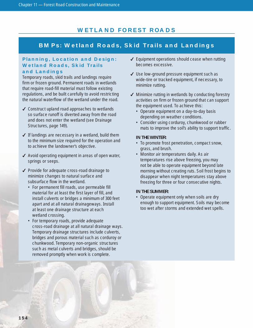
BMPs: Wetland Roads, Skid Trails and Landings
Planning, Location and Design:Wetland Roads, Skid Trails and LandingsTemporary roads, skid trails and landings require firm or frozen ground. Permanent roads in wetlandsthat require road-fill material must follow existingregulations, and be built carefully to avoid restrictingthe natural waterflow of the wetland under the road.
� Construct upland road approaches to wetlands so surface runoff is diverted away from the roadand does not enter the wetland (see DrainageStructures, page 149).
� If landings are necessary in a wetland, build themto the minimum size required for the operation andto achieve the landowner’s objective.
� Avoid operating equipment in areas of open water,springs or seeps.
� Provide for adequate cross-road drainage tominimize changes to natural surface andsubsurface flow in the wetland.• For permanent fill roads, use permeable fill
material for at least the first layer of fill, andinstall culverts or bridges a minimum of 300 feetapart and at all natural drainageways. Install at least one drainage structure at each wetland crossing.
• For temporary roads, provide adequate cross-road drainage at all natural drainage ways.Temporary drainage structures include culverts,bridges and porous material such as corduroy orchunkwood. Temporary non-organic structuressuch as metal culverts and bridges, should beremoved promptly when work is complete.
� Equipment operations should cease when ruttingbecomes excessive.
� Use low-ground pressure equipment such aswide-tire or tracked equipment, if necessary, tominimize rutting.
� Minimize rutting in wetlands by conducting forestryactivities on firm or frozen ground that can supportthe equipment used. To achieve this:• Operate equipment on a day-to-day basis
depending on weather conditions.• Consider using corduroy, chunkwood or rubber
mats to improve the soil’s ability to support traffic.
IN THE WINTER:• To promote frost penetration, compact snow,
grass, and brush.• Monitor air temperatures daily. As air
temperatures rise above freezing, you may not be able to operate equipment beyond latemorning without creating ruts. Soil frost begins todisappear when night temperatures stay abovefreezing for three or four consecutive nights.
IN THE SUMMER:• Operate equipment only when soils are dry
enough to support equipment. Soils may becometoo wet after storms and extended wet spells.
Chapter 11 — Forest Road Construction and Maintenance
155
15 FEDERAL REQUIREMENTS
BMPs: Forest Roads in Wetlands
The following 15 BMPs must be implemented in orderto qualify for the silvicultural exemption from a federalsection 404 permit when building a temporary orpermanent road or skid trail in a wetland (33 CFR Part323.4). The silvicultural exemption is only applicablewhen the primary purpose of the road is for normalsilvicultural purposes. This listing is an attempt toexplain the 15 BMPs in layman’s language. The exactlanguage of the law may be obtained by contacting the Army Corps of Engineers.
� Limit the number, length and width of roads andskid trails to the minimum necessary to accomplishthe landowner’s objective.
� Locate roads outside riparian management zonesexcept at stream crossings.
� Road fill must be bridged, culverted or otherwisedesigned to prevent restriction of expected flood flows.
� Properly stabilize and maintain road fill during andafter road construction to prevent erosion.
� While building a road with fill material, minimize theuse of road construction equipment in the wetlandarea that lies outside the boundaries of the road fill.
� Minimize disturbance of vegetation while designing,constructing and maintaining roads.
� Correctly design, construct and maintain wetlandroad crossings to avoid disrupting the migration ormovement of fish and other aquatic life.
� Use fill from upland sources whenever feasible.
� Place fill in a way that does not take or jeopardizethe continued existence of a threatened orendangered species (as defined under theEndangered Species Act) or adversely modify or destroy the critical habitat of such species.
� Avoid placing fill in breeding and nesting areas formigratory waterfowl, spawning areas, and wetlandsif practical alternatives exist.
� Fill shall not be placed near a public water supply intake.
� Fill shall not be placed in areas of concentratedshellfish production.
� Fill shall not be placed in waterbodies or on landregarded as part of the National Wild and ScenicRiver System.
� Use fill free from toxic pollutants in toxic amounts.
� Completely remove all temporary fills and restorethe area to its original elevation.

Chapter 11 — Forest Road Construction and Maintenance
156
ROAD MAINTENANCE
BMPs: Road Maintenance
Roads must be well-maintained or water qualityprotection structures may quickly degrade. For both active and inactive roads, follow BMPs in SoilStabilization, page 152).
ACTIVE ROADS� Inspect the road system at regular intervals,
especially after heavy rainfall, to detect problemsand schedule repairs.
� Clear debris from culverts, ditches, dips, and otherdrainage structures to decrease clogging that canlead to washouts. Place the debris where it cannotbe washed back into these structures or into open water.
� Keep traffic to a minimum during wet periods andspring breakup, to help reduce maintenance needs.
� Shape road surfaces periodically to maintainproper surface drainage. Fill in ruts and holes withgravel or compacted fill as soon as possible toreduce erosion potential.
� Remove berms along the edge of the road if theywill trap water on the road.
� When dust control agents are used, apply them in a manner that will keep these compounds fromentering lakes, streams and groundwater. Consult a qualified road engineer from the County HighwayCommissioner’s Office or Wisconsin Department of Transportation for assistance in selecting theappropriate chemicals and amounts. Note: It isillegal to spread oil on roads, land or water in Wisconsin.
INACTIVE ROADSWhen forest roads are inactive for extended periods,closing the system will help to protect the road surfaceand the water quality protection structures. Considererecting a barrier to traffic such as a gate or berm,
and post “Closed” signs at the entrance of temporarilyclosed roads. Stating the length of time and/or reasonfor closure, and inviting acceptable uses may behelpful to assure compliance.
� Remove all temporary drainage and streamcrossing structures.
� Shape all road system surfaces to maintain propersurface drainage, if necessary.
� Install waterbars where necessary (see page 151and follow the recommendations in Table 11-1 onpage 149).
� Inspect and maintain road surfaces, permanentdrainage and stream crossing structures (ditches,culverts, bridges, etc.) to minimize erosion.
Figure 11-29: Maintaining woods roads helps preventerosion. This grader is shaping the road surface sothat water runs off properly.