wri forest note
TRANSCRIPT
www.wri.orgPrinted on recycled paper.
WRI FOREST NOTE
10 G Street, NE Washington, DC 20002Tel: 202-729-7600 Fax: 202-729-7610
OCTOBER 2009
F O R E S T G O V E R N A N C E I N S O U T H E A S T A S I A
Bridging the Information Gap: Combating Illegal Logging in Indonesia
DAVID W. BROWN AND FRED STOLLE
Executive SummarySpanning around 100 million hectares, the forests of Indonesia constitute 10 percent of the world’s remaining tropical forests and provide people with a variety of benefi ts or “ecosystem services.”1 For instance, local communities rely on the forests for food, medicine, fresh water, and building material. The global community relies on them for carbon sequestration, timber, and tourism. In addition, the forests of Indonesia are a biodiversity “hotspot,” with new species discovered every year.
In view of the importance of its forests, Indonesia—both on its own and in partnership with donor countries and world experts—has incorporated themes of “sustainable forest management” and “combating illegal logging” into its forest governance since the mid-1990s. Despite these efforts, during the fi rst half decade of the new millennium, deforestation rates increased year on year (from 0.2 million hectares in 2000/2001 to 1.2 million hectares in 2004/2005, the last year such data were reported2).
The causes of Indonesia’s forest loss are diverse, but it is widely recognized that illegal logging is a major contributor. Estimates of the scale of this illegal activity vary widely. One study found that three quarters or 40 million out of the 53 million cubic meters of logs consumed by Indonesia’s mills (and mostly exported in the form of moldings, sawn timber, plywood, pulp, and paper) in 2003, came from unknown and/or illegal sources. This equated to $1.4 billion in lost revenue to the government in 2003 alone.3 Moreover, this estimate did not include the additional volume of logs illegally exported from Indonesia, which another study estimated at 10 million cubic meters per year.4
In order to pinpoint the identity of the actors perpetrating these crimes, and thereby reduce illegal trade, better infor-mation is needed in areas such as: changes in forest cover; timber concession and plantation boundaries; administrative boundaries; and sources of raw material for timber mills. Many stakeholders have recognized the importance of such information5 and several experts and policymakers have tried to develop such databases. However, forest data continues to be scattered throughout the archipelago and across different government departments and non-government organizations. Where information exists, much of it needs to be updated and improved.
Closing the Information Gap The core purpose of this Forest Note is to put forward a sys-tematic approach to analyzing the Indonesian forestry sector in order to identify which forest laws and regulations are being disobeyed and where. We introduce a matrix that provides simple step-by-step guidance on how to use existing data to understand the physical status of and changes in the nation’s forests, in the forest production (logging) sector, and in the forest products manufacturing (milling) sector. Armed with this information, experts, policymakers, and citizens can have a more informed dialogue on the precise sources of threats to Indonesia’s forests and what can be done to remove them.
This note builds on a gap analysis of forest information carried out in 2006 by WRI as part of the East Asia and Pacifi c Forest Law Enforcement and Governance6 (EAP-FLEG) initiative led by the World Bank and the Indonesian Ministry of Forestry. At the end of this note is an extended glossary, which explains the important terms and concepts utilized in the matrix and their importance for law enforcement.
2
FOREST NOTE: Bridging the Information Gap
O c t o b e r 2 0 0 9W O R L D R E S O U R C E S I N S T I T U T E
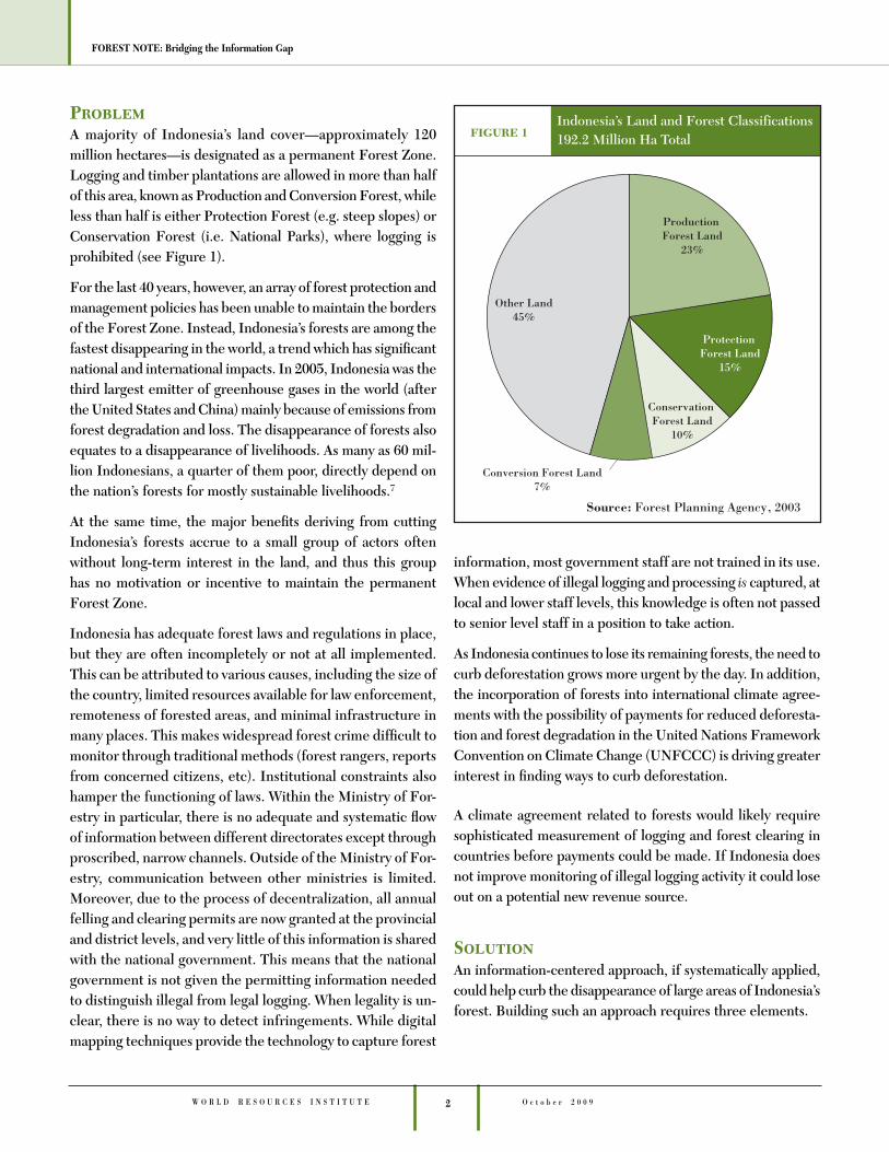
ProblemA majority of Indonesia’s land cover—approximately 120 million hectares—is designated as a permanent Forest Zone. Logging and timber plantations are allowed in more than half of this area, known as Production and Conversion Forest, while less than half is either Protection Forest (e.g. steep slopes) or Conservation Forest (i.e. National Parks), where logging is prohibited (see Figure 1).
For the last 40 years, however, an array of forest protection and management policies has been unable to maintain the borders of the Forest Zone. Instead, Indonesia’s forests are among the fastest disappearing in the world, a trend which has signifi cant national and international impacts. In 2005, Indonesia was the third largest emitter of greenhouse gases in the world (after the United States and China) mainly because of emissions from forest degradation and loss. The disappearance of forests also equates to a disappearance of livelihoods. As many as 60 mil-lion Indonesians, a quarter of them poor, directly depend on the nation’s forests for mostly sustainable livelihoods.7
At the same time, the major benefi ts deriving from cutting Indonesia’s forests accrue to a small group of actors often without long-term interest in the land, and thus this group has no motivation or incentive to maintain the permanent Forest Zone.
Indonesia has adequate forest laws and regulations in place, but they are often incompletely or not at all implemented. This can be attributed to various causes, including the size of the country, limited resources available for law enforcement, remoteness of forested areas, and minimal infrastructure in many places. This makes widespread forest crime diffi cult to monitor through traditional methods (forest rangers, reports from concerned citizens, etc). Institutional constraints also hamper the functioning of laws. Within the Ministry of For-estry in particular, there is no adequate and systematic fl ow of information between different directorates except through proscribed, narrow channels. Outside of the Ministry of For-estry, communication between other ministries is limited. Moreover, due to the process of decentralization, all annual felling and clearing permits are now granted at the provincial and district levels, and very little of this information is shared with the national government. This means that the national government is not given the permitting information needed to distinguish illegal from legal logging. When legality is un-clear, there is no way to detect infringements. While digital mapping techniques provide the technology to capture forest
information, most government staff are not trained in its use. When evidence of illegal logging and processing is captured, at local and lower staff levels, this knowledge is often not passed to senior level staff in a position to take action.
As Indonesia continues to lose its remaining forests, the need to curb deforestation grows more urgent by the day. In addition, the incorporation of forests into international climate agree-ments with the possibility of payments for reduced deforesta-tion and forest degradation in the United Nations Framework Convention on Climate Change (UNFCCC) is driving greater interest in fi nding ways to curb deforestation.
A climate agreement related to forests would likely require sophisticated measurement of logging and forest clearing in countries before payments could be made. If Indonesia does not improve monitoring of illegal logging activity it could lose out on a potential new revenue source.
SolutionAn information-centered approach, if systematically applied, could help curb the disappearance of large areas of Indonesia’s forest. Building such an approach requires three elements.
3 W O R L D R E S O U R C E S I N S T I T U T EO c t o b e r 2 0 0 9
FOREST NOTE: Bridging the Information Gap
A. Focus on enforcing forest regulations most important for maintaining the permanent Forest Zone.
There are hundreds of rules and regulations governing Indonesia’s forests. However, not all are equally useful for maintaining forest cover. The most important include:
• A prohibition of the new issuance or extension of district licensed permits anywhere inside the Forest Zone.8 Such permits comprised as much as 44 percent of reported timber mill intake in 2002, the last year for which reliable data were available.9 Indications are that this trend has continued into the present.10
• The prohibition of overlapping concessions.11 When concessions overlap it is not clear how much wood is allowed to be extracted from the overlapping area, to whom the revenues will have to be paid, and who is responsible for the management plans. In short, no ac-countability exists, which can easily lead to a free-for-all situation. Many district licensed units are illegally located inside of nationally granted units.12
• The prohibition of the redrawing of boundaries of forest management units.13 It is a widespread prac-tice for managers of timber concessions bordering or sometimes containing conservation areas or protection forests to illegally redraw production maps to gradu-ally shift further into these protected areas.
• The outlawing of logging outside of annually-assigned timber harvesting or timber felling blocks.14
• The prohibition of the use of fi re to clear organic material from land for planting.15 This practice is a key cause of Indonesia’s seasonal fi re epidemics, triggering massive forest loss and release of greenhouse gases.
• The outlawing of the consumption of illegal timber by large forest mills.16 An analysis of the 2002 intake of 135 of Indonesia’s largest reporting timber mills showed that the legality of 44 percent of the fi rms sell-ing timber to these mills could not be ascertained by the Ministry of Forestry.17
If the above regulations were better enforced, Indonesia could make signifi cant progress toward ensuring the maintenance of the Forest Zone. The abuses that these regulations are in-tended to prevent are outlined in the matrix for planning and law enforcement detailed in the next pages.
B. Use information systems to ensure that key regula-tions are followed.
In a country the size of Indonesia, it is impossible to en-sure compliance with regulations without comprehensive information systems. These systems could include:
• an annual nationwide analysis of satellite imagery—to identify new forest areas that were cleared;
• a compilation of accurate boundaries of all forest con-cessions and plantations—outside of which no forest clearing should take place;
• a compilation of accurate boundaries of all conserva-tion areas and protection forests—inside of which no forests should be cleared; and
• an analysis of the sources of timber consumed by the largest mills—to identify those mills that are most de-pendent upon sources of timber whose legality cannot be verifi ed.
In short, two types of detailed, nationwide information are required: data on current allocations of forest and industrial assets (stock information), and information on changes or proposed changes in the use of those assets (fl ow information). Both need to be thoroughly analyzed to check whether forest management companies or mills are disobeying, or likely to disobey, those regulations (above) which are most important for perpetuation of the Forest Zone.
If these information systems were put in place, good planning and effective law enforcement could be achieved. If informa-tion were available, planners could avoid placing new forest management units inside prohibited forest areas. The system could also pinpoint existing forest management units that are located inside prohibited forest areas, illegally overlap with other units, illegally expand their boundaries, log in protected areas, or illegally use fi re. With this information, law enforce-ment offi cials could prosecute or close down these units. Mills with raw material intake that is not recognizably legal could also be identifi ed and law enforcement agencies and buyers could take appropriate action.
C. Put transparency measures in place.
There is a real danger that forest stock and fl ow infor-mation will never be used by the government to make improved planning and law enforcement decisions unless accountability mechanisms are also put into place. It is therefore crucial that forest information be widely shared, not only within and between ministries, but also
4
FOREST NOTE: Bridging the Information Gap
O c t o b e r 2 0 0 9W O R L D R E S O U R C E S I N S T I T U T E
with the public at large. With information in hand, civil society can hold the government accountable for spe-cifi c forest governance decisions. Discriminating timber buyers can identify producers and manufacturers of ques-tionable legality and stop buying from them. The possibil-ity to hold companies and government accountable has received an extra push with the adoption of the freedom of information act in April 2008. All the information listed in the matrix should be made publicly available.
Matrix for Planning and Law Enforcement A. UsesThe matrix outlined later in this section explains for planners, forest managers, and citizens how to gather information on the physical status of, and changes to, the forests and forest products manufacturing sector. It also shows how to analyze the informa-tion in order to fi nd out whether crucial forest regulations are being broken. Although the matrix has other possible uses, its
main purpose is to help ensure that new forest management units are only issued if they comply with forest laws and to identify whether existing forest concessions are breaking the law. With respect to proper planning, the matrix can help ensure that units are not granted in forbidden areas of forest, are not located inside and/or do not overlap with other units, or permanently destroy productive areas of forest. In terms of law enforce-ment, the matrix would ensure that forest management units that expand their boundaries without proper authorization, log in adjacent protected areas, or illegally use fi re are identifi ed. Figure 2 (next page) demonstrates how the matrix works.
The matrix addresses more than forest management units, however. It also looks at the raw material sourcing practices of large mills (probably the single biggest driver of illegal logging in Indonesia), the granting of illegal transportation permits by forestry offi cials, and other dimensions of poor planning and law breaking.
BOX 1 Information Base
In preparing for the matrix to be put to use, the World Resources Institute and its partners (SEKALA and Forest Watch Indonesia) have for the last four years assisted the Ministry of Forestry with data gathering and information processing. Three types of informa-tion have been gathered and analyzed:
A. Digital maps of all nationally granted timber concessions and plantations. As part of a joint project with the Indonesian Min-istry of Forestry’s Directorate of Development of Planning for Use of Production Forests and World Resources Institute, Forest Watch Indonesia and Sekala (both Indonesian NGOs) have un-dertaken work to digitally reproduce three types of existing maps: originating maps (SK), twenty year production maps (RKU), and fi ve year production maps (RKT). Once digitization is complete, it will be possible to overlay these maps on top of one another, as well as on top of the offi cial boundaries between different forest types. This will enable users to determine the extent to which individual timber concessions or plantations have redrawn their boundaries to expand the size of their units and/or shifted their felling operations into conservation and protection forests. It will also be possible to overlay the concession and plantation maps with satellite images or forest cover interpretation maps to identify individual timber concessions or plantations that can be presumed to be logging outside their permitted areas.
B. National map of deforestation from 2000 to 2006. This map has recently been created by the Indonesian Ministry of Forestry’s Center of Forest Inventory and Mapping, in cooperation with the
South Dakota State University and World Resources Institute. When overlaid with administrative and forest management unit boundaries, it will allow the Ministry to make better planning decisions and identify and prioritize targets for law enforcement actions. This map is referred to in the Matrix as the “National Forest Cover Change Map.”
C. Sources of raw material consumed by the nation’s largest report-ing factories. The Indonesian Ministry of Forestry’s Directorate for Forest Products Processing and Marketing houses documents of the precise sources of raw material consumed by the na-tion’s largest reporting factories. By analyzing these documents, it is possible to quantify the relative extent to which any mill consumes timber of uncertain legal origin. This may be the single most crucial set of information for identifying the major actors driving illegal logging. The raw data from which this determi-nation can be made are contained in Plans for the Fulfi llment of Industrial Raw Material (RPBBI), which are submitted by reporting factories to the Directorate each year. Such analysis has practical applications for combating illegal logging and the trade in illegal processed timber products. In 2003, Forest Watch Indo-nesia in collaboration with the UK Department for International Development’s Multistakeholder Forestry Programme, the EU’s Forest Liaison Bureau, and the USAID’s NRM II program built a database which analyzed the raw material intake of large factories between 2000 and 2002, and differentiated between those facto-ries which consumed known and unknown raw material.
5 W O R L D R E S O U R C E S I N S T I T U T EO c t o b e r 2 0 0 9
FOREST NOTE: Bridging the Information Gap
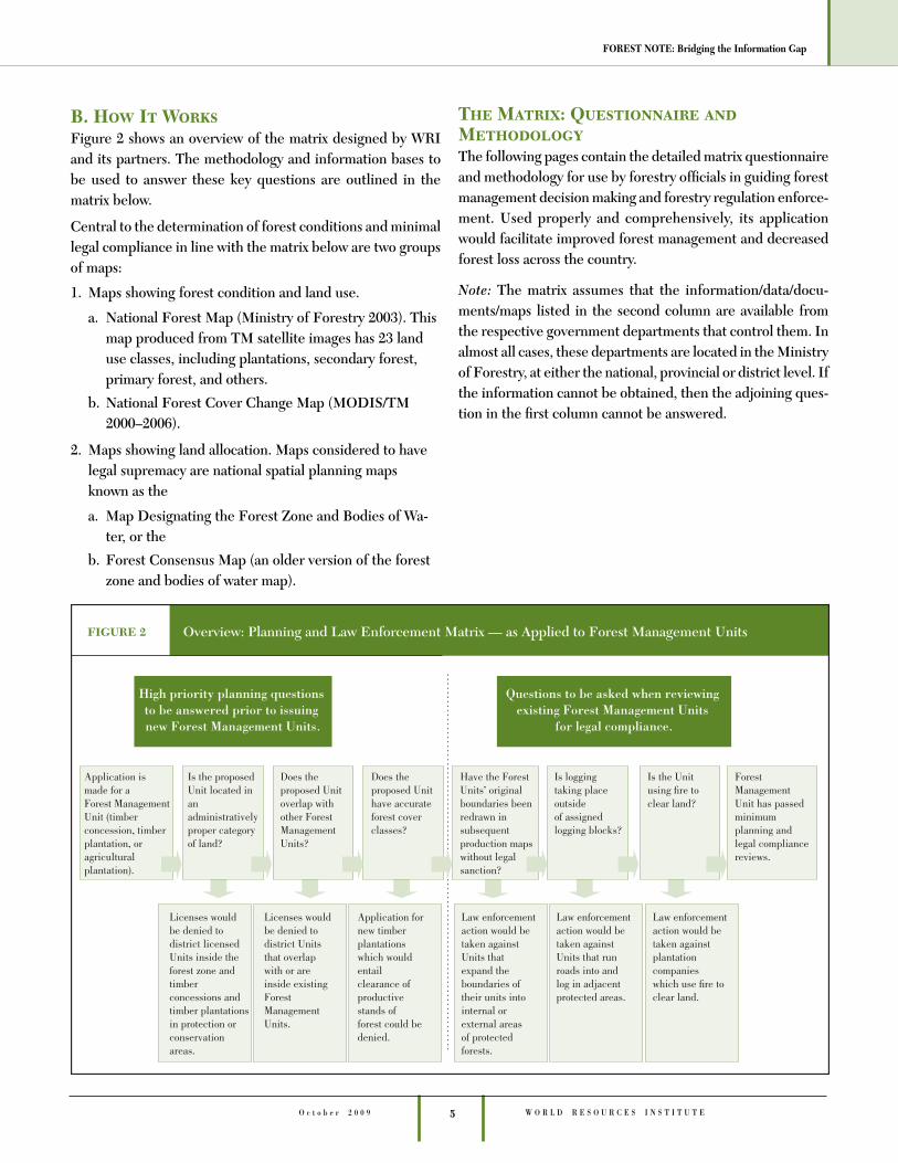
B. How It WorksFigure 2 shows an overview of the matrix designed by WRI and its partners. The methodology and information bases to be used to answer these key questions are outlined in the matrix below.
Central to the determination of forest conditions and minimal legal compliance in line with the matrix below are two groups of maps:
1. Maps showing forest condition and land use.
a. National Forest Map (Ministry of Forestry 2003). This map produced from TM satellite images has 23 land use classes, including plantations, secondary forest, primary forest, and others.
b. National Forest Cover Change Map (MODIS/TM 2000–2006).
2. Maps showing land allocation. Maps considered to have legal supremacy are national spatial planning maps known as the
a. Map Designating the Forest Zone and Bodies of Wa-ter, or the
b. Forest Consensus Map (an older version of the forest zone and bodies of water map).
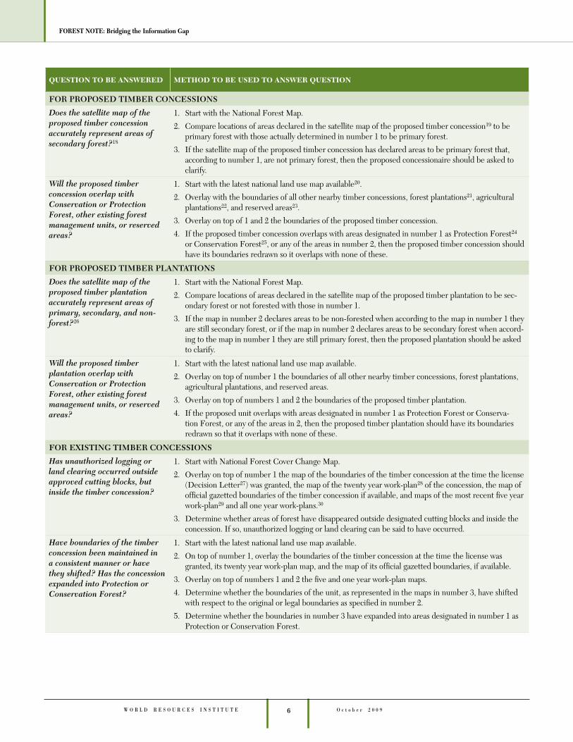
The Matrix: Questionnaire and MethodologyThe following pages contain the detailed matrix questionnaire and methodology for use by forestry offi cials in guiding forest management decision making and forestry regulation enforce-ment. Used properly and comprehensively, its application would facilitate improved forest management and decreased forest loss across the country.
Note: The matrix assumes that the information/data/docu-ments/maps listed in the second column are available from the respective government departments that control them. In almost all cases, these departments are located in the Ministry of Forestry, at either the national, provincial or district level. If the information cannot be obtained, then the adjoining ques-tion in the fi rst column cannot be answered.
6
FOREST NOTE: Bridging the Information Gap
O c t o b e r 2 0 0 9W O R L D R E S O U R C E S I N S T I T U T E
QUESTION TO BE ANSWERED METHOD TO BE USED TO ANSWER QUESTION
FOR PROPOSED TIMBER CONCESSIONS
Does the satellite map of the proposed timber concession accurately represent areas of secondary forest?18
1. Start with the National Forest Map.
2. Compare locations of areas declared in the satellite map of the proposed timber concession19 to be primary forest with those actually determined in number 1 to be primary forest.
3. If the satellite map of the proposed timber concession has declared areas to be primary forest that, according to number 1, are not primary forest, then the proposed concessionaire should be asked to clarify.
Will the proposed timber concession overlap with Conservation or Protection Forest, other existing forest management units, or reserved areas?
1. Start with the latest national land use map available20.
2. Overlay with the boundaries of all other nearby timber concessions, forest plantations21, agricultural plantations22, and reserved areas23.
3. Overlay on top of 1 and 2 the boundaries of the proposed timber concession.
4. If the proposed timber concession overlaps with areas designated in number 1 as Protection Forest24 or Conservation Forest25, or any of the areas in number 2, then the proposed timber concession should have its boundaries redrawn so it overlaps with none of these.
FOR PROPOSED TIMBER PLANTATIONS
Does the satellite map of the proposed timber plantation accurately represent areas of primary, secondary, and non-forest?26
1. Start with the National Forest Map.
2. Compare locations of areas declared in the satellite map of the proposed timber plantation to be sec-ondary forest or not forested with those in number 1.
3. If the map in number 2 declares areas to be non-forested when according to the map in number 1 they are still secondary forest, or if the map in number 2 declares areas to be secondary forest when accord-ing to the map in number 1 they are still primary forest, then the proposed plantation should be asked to clarify.
Will the proposed timber plantation overlap with Conservation or Protection Forest, other existing forest management units, or reserved areas?
1. Start with the latest national land use map available.
2. Overlay on top of number 1 the boundaries of all other nearby timber concessions, forest plantations, agricultural plantations, and reserved areas.
3. Overlay on top of numbers 1 and 2 the boundaries of the proposed timber plantation.
4. If the proposed unit overlaps with areas designated in number 1 as Protection Forest or Conserva-tion Forest, or any of the areas in 2, then the proposed timber plantation should have its boundaries redrawn so that it overlaps with none of these.
FOR EXISTING TIMBER CONCESSIONS
Has unauthorized logging or land clearing occurred outside approved cutting blocks, but inside the timber concession?
1. Start with National Forest Cover Change Map.
2. Overlay on top of number 1 the map of the boundaries of the timber concession at the time the license (Decision Letter27) was granted, the map of the twenty year work-plan28 of the concession, the map of offi cial gazetted boundaries of the timber concession if available, and maps of the most recent fi ve year work-plan29 and all one year work-plans.30
3. Determine whether areas of forest have disappeared outside designated cutting blocks and inside the concession. If so, unauthorized logging or land clearing can be said to have occurred.
Have boundaries of the timber concession been maintained in a consistent manner or have they shifted? Has the concession expanded into Protection or Conservation Forest?
1. Start with the latest national land use map available.
2. On top of number 1, overlay the boundaries of the timber concession at the time the license was granted, its twenty year work-plan map, and the map of its offi cial gazetted boundaries, if available.
3. Overlay on top of numbers 1 and 2 the fi ve and one year work-plan maps.
4. Determine whether the boundaries of the unit, as represented in the maps in number 3, have shifted with respect to the original or legal boundaries as specifi ed in number 2.
5. Determine whether the boundaries in number 3 have expanded into areas designated in number 1 as Protection or Conservation Forest.
7 W O R L D R E S O U R C E S I N S T I T U T EO c t o b e r 2 0 0 9
FOREST NOTE: Bridging the Information Gap
Can the timber concession be suspected of logging in adjacent or interior Protection or Conservation forest?
1. Start with the National Forest Cover Change Map.
2. Overlay on top of that the latest national land use map available.
3. Overlay on top of numbers 1 and 2 the boundaries of the timber concession at the time the license was granted, those from its twenty year work-plan map, the map of its offi cial gazetted boundaries if avail-able, and those from its fi ve and one year work-plan maps.
4. Determine whether areas of forest have disappeared in areas of Protection or Conservation Forest adjacent to or inside the unit and whether those areas can reasonably be said to be accessible only through the concession. If so, then the concessionaire may be suspected of logging illegally in Protec-tion or Conservation forests, and investigated.
Is the inventory of forest potential of the timber concession (Inventarisasi Hutan Menyeluruh Berkala or IHMB) accurate?31
1. Start with the National Forest Map.
2. Compare areas designated in the IHMB as primary forest with those said in number 1 to be primary forest.
3. If the IHMB declares areas to be primary forest, but these areas are not primary forest according to number 1, the concessionaire should clarify.
Is the timber concession building main logging roads where it said it would?
1. Overlay the road network designated in the one year work-plan map on top of fi ve year work-plan map.
2. If the location of the main logging road on the one year work plan map differs signifi cantly from the location of the logging roads on the fi ve year work plan map, then the concession is building logging roads in areas different from where it said it would.
Is the timber concessionaire fulfi lling its plans/obligations to plant deforested lands?32
1. Start with the National Forest Cover Change Map.
2. Overlay on top of number 1 all fi ve year work plan maps.
3. If areas designated in fi ve year work plan map(s) as deforested but intended for replanting are in fact now forested, then the concessionaire has fulfi lled its plans. If not, then the concessionaire may not have fulfi lled its plans, and this may warrant investigation.
Did the volume of timber felled in any timber concession exceed the legally allowed felling limit?
1. Obtain from all provincial forestry offi ces the volume felling limits set in the one year work plans for all timber concessions in the most recent calendar year.
2. From the Timber Industry Revitalization Body, obtain copies of all timber transportation documents delivered to all member mills in the most recent calendar year.
3. Total the volume of natural forest timber received by all mills in number 2 from all concessions in number 1.
4. If the total volume of timber delivered by an individual timber concession to mills in number 3 exceeds the volume permitted to have been felled by that unit in number 1, then that timber concession can be said to have exceeded its legal felling limit.
FOR EXISTING TIMBER PLANTATIONS
Has unauthorized logging or land clearing occurred outside the approved cutting block, but inside the timber plantation?
1. Start with the National Forest Cover Change Map.
2. Overlay on top of number 1 the boundaries of the timber plantation at the time the license was granted, the map of the twenty year work plan, the map of offi cial gazetted boundaries of the timber plantation if available, plus the maps of any annual clear cutting permits33.
3. Determine whether areas of forest identifi ed in number 1 as having disappeared have done so inside the boundaries of the unit but outside the clear cutting blocks. If so, then unauthorized logging or land clearing may be said to have occurred outside the approved clear cutting blocks, but inside the unit.
QUESTION TO BE ANSWERED METHOD TO BE USED TO ANSWER QUESTION
8
FOREST NOTE: Bridging the Information Gap
O c t o b e r 2 0 0 9W O R L D R E S O U R C E S I N S T I T U T E
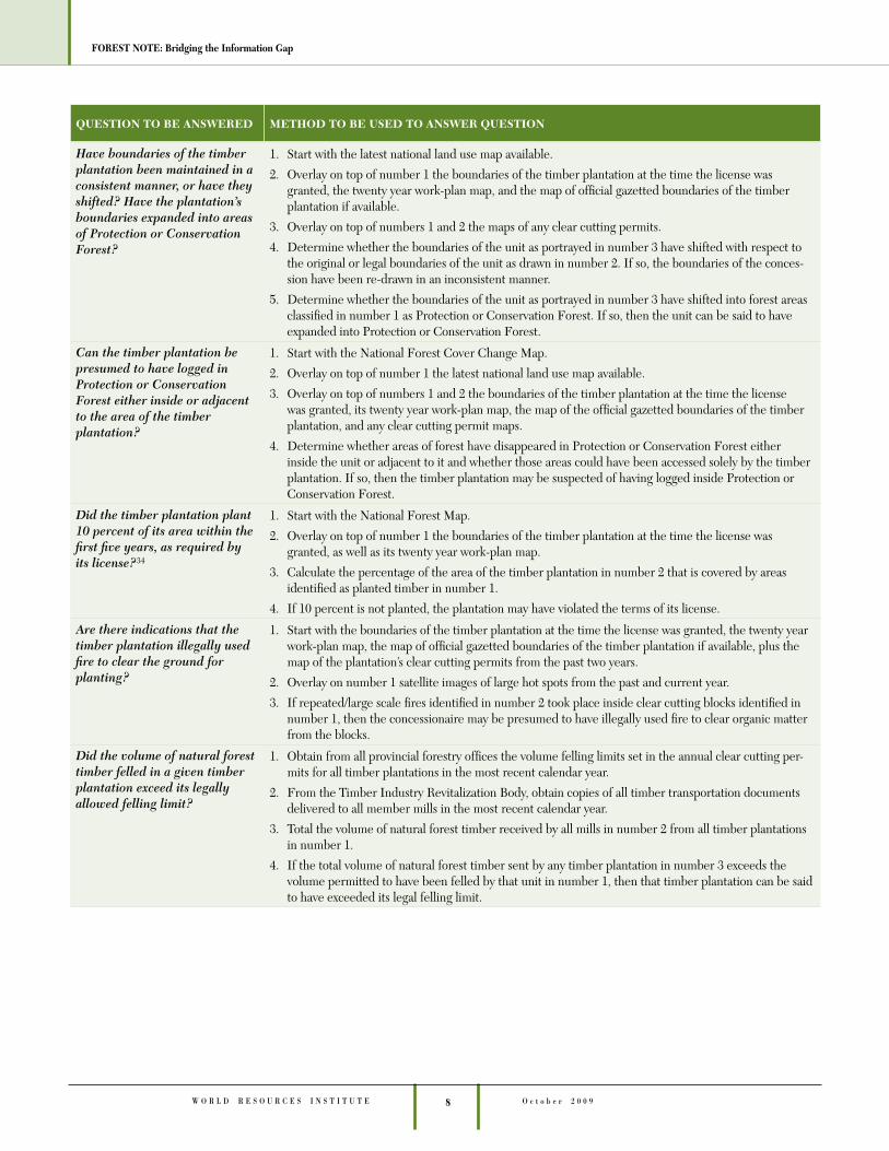
Have boundaries of the timber plantation been maintained in a consistent manner, or have they shifted? Have the plantation’s boundaries expanded into areas of Protection or Conservation Forest?
1. Start with the latest national land use map available.
2. Overlay on top of number 1 the boundaries of the timber plantation at the time the license was granted, the twenty year work-plan map, and the map of offi cial gazetted boundaries of the timber plantation if available.
3. Overlay on top of numbers 1 and 2 the maps of any clear cutting permits.
4. Determine whether the boundaries of the unit as portrayed in number 3 have shifted with respect to the original or legal boundaries of the unit as drawn in number 2. If so, the boundaries of the conces-sion have been re-drawn in an inconsistent manner.
5. Determine whether the boundaries of the unit as portrayed in number 3 have shifted into forest areas classifi ed in number 1 as Protection or Conservation Forest. If so, then the unit can be said to have expanded into Protection or Conservation Forest.
Can the timber plantation be presumed to have logged in Protection or Conservation Forest either inside or adjacent to the area of the timber plantation?
1. Start with the National Forest Cover Change Map.
2. Overlay on top of number 1 the latest national land use map available.
3. Overlay on top of numbers 1 and 2 the boundaries of the timber plantation at the time the license was granted, its twenty year work-plan map, the map of the offi cial gazetted boundaries of the timber plantation, and any clear cutting permit maps.
4. Determine whether areas of forest have disappeared in Protection or Conservation Forest either inside the unit or adjacent to it and whether those areas could have been accessed solely by the timber plantation. If so, then the timber plantation may be suspected of having logged inside Protection or Conservation Forest.
Did the timber plantation plant 10 percent of its area within the fi rst fi ve years, as required by its license?34
1. Start with the National Forest Map.
2. Overlay on top of number 1 the boundaries of the timber plantation at the time the license was granted, as well as its twenty year work-plan map.
3. Calculate the percentage of the area of the timber plantation in number 2 that is covered by areas identifi ed as planted timber in number 1.
4. If 10 percent is not planted, the plantation may have violated the terms of its license.
Are there indications that the timber plantation illegally used fi re to clear the ground for planting?
1. Start with the boundaries of the timber plantation at the time the license was granted, the twenty year work-plan map, the map of offi cial gazetted boundaries of the timber plantation if available, plus the map of the plantation’s clear cutting permits from the past two years.
2. Overlay on number 1 satellite images of large hot spots from the past and current year.
3. If repeated/large scale fi res identifi ed in number 2 took place inside clear cutting blocks identifi ed in number 1, then the concessionaire may be presumed to have illegally used fi re to clear organic matter from the blocks.
Did the volume of natural forest timber felled in a given timber plantation exceed its legally allowed felling limit?
1. Obtain from all provincial forestry offi ces the volume felling limits set in the annual clear cutting per-mits for all timber plantations in the most recent calendar year.
2. From the Timber Industry Revitalization Body, obtain copies of all timber transportation documents delivered to all member mills in the most recent calendar year.
3. Total the volume of natural forest timber received by all mills in number 2 from all timber plantations in number 1.
4. If the total volume of natural forest timber sent by any timber plantation in number 3 exceeds the volume permitted to have been felled by that unit in number 1, then that timber plantation can be said to have exceeded its legal felling limit.
QUESTION TO BE ANSWERED METHOD TO BE USED TO ANSWER QUESTION

9 W O R L D R E S O U R C E S I N S T I T U T EO c t o b e r 2 0 0 9
FOREST NOTE: Bridging the Information Gap
FOR DISTRICT LICENSED FOREST MANAGEMENT UNITS LOCATED IN THE FOREST ZONE REQUESTING NATIONAL RECOGNITION35
Is the forest management unit at least nominally legal?
1. Is there a valid Decision Letter36 issued by the District Head which either granted or extended the tenure of the unit prior to 7 June 2002 (for selective felling permits) or 4 February 2003 (for clear cutting permits)? Is there a geo-referenced map of the unit appended to the Decision Letter? If the answer to either of these questions is no, then the unit is illegal and should be closed. If the answer to both questions is yes, go to number 2.
2. Obtain the latest national land use map available.
3. Overlay the map of the unit in number 1 on top of the land use map in number 2.
4. So long as the unit is located entirely37 in Production Forest38, then the unit is at least nominally legal.
5. If the unit is located inside of a Protection or Conservation Forest, then the unit is illegal and should be closed.
FOR AREAS WITHIN THE PRODUCTION FOREST THAT ARE UNASSIGNED
What unassigned areas of the Production Forest are suitable to be auctioned as new timber concessions?
1. Start with the National Forest Map.
2. Overlay on top of this the forest type boundaries designated in the latest national land use map avail-able.
3. Identify all areas inside of the Production Forest that are either primary or high quality secondary forest, whether these areas exist in a large geographically contiguous block, and whether these areas appear to be clear of human settlement.
4. If all the conditions in number 3 are met, then such areas may be suitable to be auctioned as new timber concessions.
What unassigned areas of the Production Forest are suitable to be auctioned as new timber plantations?
1. Start with the National Forest Map.
2. Overlay on top of this the forest type boundaries designated in the latest national land use map avail-able.
3. Identify all areas that are inside of the Production Forest, that constitute a suffi ciently large geographi-cally contiguous block as to be of commercial interest to a plantation fi rm, that contain no areas of productive forest larger than 25 hectares, and that appear to be clear of human settlement.
4. If all the conditions in number 3 are met, then such areas may be suitable to be auctioned as new timber plantations.
What unassigned areas of the Production Forest are suitable to be auctioned or granted as People’s Forest (Hutan Kemasyarakatan or HKm)?
1. Start with the National Forest Map.
2. Overlay on top of this the forest type boundaries designated in the latest national land use map avail-able.
3. Identify all areas that are inside of the Production Forest, that are degraded, and that appear to be adjacent to areas of human settlement.
4. If the conditions in number 3 are met, then such areas may be suitable to be auctioned or granted as People’s Forest.
FOR PROPOSED AGRICULTURAL PLANTATIONS (INCLUDING OIL PALM)
Will the proposed unit clear areas of forest that are still productive?
1. Start with the National Forest Map.
2. Overlay on top of this the boundaries of the proposed area to be excised from the Forest Zone39 for the proposed plantation.
3. If areas defi ned as primary or secondary forest in 1 are located inside the boundaries of the proposed unit in 2, then the proposed unit is destined to clear areas of forest that are still productive.
FOR EXISTING AGRICULTURAL PLANTATIONS
Has the licensee planted the assigned area in a crop and if so how much of it?
1. Start with the National Forest Map.
2. Overlay on top of this the boundaries of the plantation according to the map affi xed to its license at the time it was granted.
3. Calculate the percentage of the area in number 2 that is covered by an agricultural crop, as determined in number 1.
QUESTION TO BE ANSWERED METHOD TO BE USED TO ANSWER QUESTION

10
FOREST NOTE: Bridging the Information Gap
O c t o b e r 2 0 0 9W O R L D R E S O U R C E S I N S T I T U T E
Have boundaries of the agricultural plantation been maintained in a consistent manner, or have they shifted? Has the plantation illegally expanded into Production, Protection or Conservation Forest?
1. Start with the latest national land use map available.
2. Overlay on top of this the boundaries of the plantation according to the map affi xed to the license at the time it was granted.
3. Overlay on top of numbers 1 and 2 the plantation’s most recent clear cutting maps.
4. Determine whether the boundaries of the unit as portrayed in number 3 have shifted with respect to the original boundaries of the unit as portrayed in number 2. If so, then the boundaries of the conces-sion are being re-drawn in an inconsistent manner.
5. Determine whether the boundaries of the unit as portrayed in number 3 have shifted inside forest areas classifi ed in number 1 as Production Forest, Protection Forest, or Conservation Forest. If so, then the unit can be said to have expanded into Production Forest, Protection Forest or Conservation Forest, which is illegal.
Can the agricultural plantation be presumed to have logged in areas of Production Forest, Protection Forest or Conservation Forest adjacent to it?
1. Start with the National Forest Cover Change Map.
2. Overlay on top of that the latest national land use map available.
3. Overlay on top of numbers 1 and 2 the boundaries of the plantation according to the map affi xed to its license at the time it was granted, as well as any of the plantation’s recent clear-cutting maps.
4. Determine whether areas of forest have disappeared inside Production, Protection, or Conservation Forest adjacent to the unit and whether those areas could only have been accessed by the owners of the plantation itself. If so, then the plantation may be suspected of having illegally logged inside of Production, Protection or Conservation Forest.
Did the volume of natural forest timber felled in a given agricultural plantation exceed the legally allowed felling limit?
1. Obtain from all provincial forestry offi ces the volume felling limits set in the annual clear cutting per-mits for all agricultural plantations in the most recent calendar year.
2. From the Timber Industry Revitalization Body, obtain copies of all timber transportation documents delivered to all member mills in the most recent calendar year.
3. Total the volume of natural forest timber received by all mills in number 2 from all agricultural planta-tions in number 1.
4. If the total volume of timber for any agricultural plantation in number 3 exceeds the volume permitted to be felled by that unit in number 1, then that plantation can be said to have exceeded its legal felling limit.
FOR MILLS
What percentage of a large saw, plywood or pulp mill’s raw material intake in 2008 originated from sources whose legality is uncertain?40
1. Total the volume of raw materials purchased in the previous year according to the Source of Raw Ma-terial41 section of the 2009 Plan for the Fulfi llment of Raw Materials of Industry42.
2. Determine all raw material sources which are not from nationally known timber concessions, timber plantations, agricultural plantations, district licensed units approved by the Directorate for Develop-ment of the Use of Production Forests43 or timber claimed to have been grown on private small scale timber plantations44 on Java.
3. Divide the total volume of timber that does not belong to one of the categories specifi ed in number 2 by the total volume of timber purchased by the mill in number 1. The resulting number is the fraction of the mill’s raw material intake in 2008 that originated from sources whose legality is uncertain.
QUESTION TO BE ANSWERED METHOD TO BE USED TO ANSWER QUESTION
11 W O R L D R E S O U R C E S I N S T I T U T EO c t o b e r 2 0 0 9
FOREST NOTE: Bridging the Information Gap
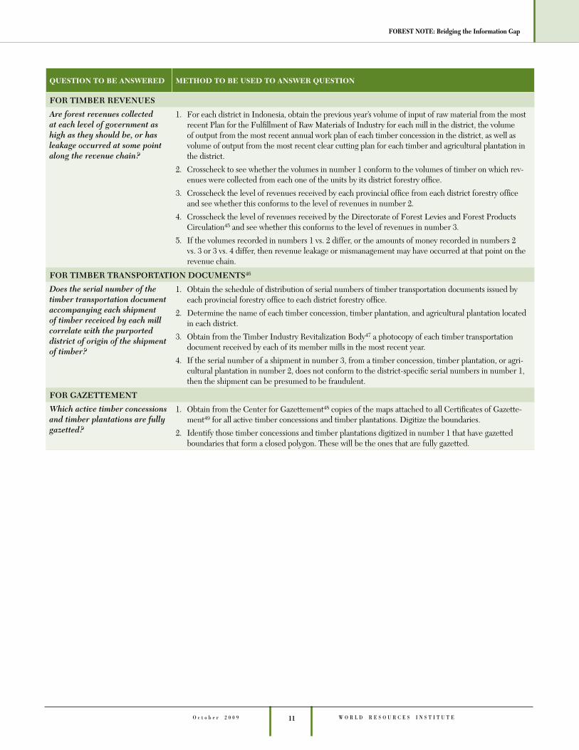
FOR TIMBER REVENUES
Are forest revenues collected at each level of government as high as they should be, or has leakage occurred at some point along the revenue chain?
1. For each district in Indonesia, obtain the previous year’s volume of input of raw material from the most recent Plan for the Fulfi llment of Raw Materials of Industry for each mill in the district, the volume of output from the most recent annual work plan of each timber concession in the district, as well as volume of output from the most recent clear cutting plan for each timber and agricultural plantation in the district.
2. Crosscheck to see whether the volumes in number 1 conform to the volumes of timber on which rev-enues were collected from each one of the units by its district forestry offi ce.
3. Crosscheck the level of revenues received by each provincial offi ce from each district forestry offi ce and see whether this conforms to the level of revenues in number 2.
4. Crosscheck the level of revenues received by the Directorate of Forest Levies and Forest Products Circulation45 and see whether this conforms to the level of revenues in number 3.
5. If the volumes recorded in numbers 1 vs. 2 differ, or the amounts of money recorded in numbers 2 vs. 3 or 3 vs. 4 differ, then revenue leakage or mismanagement may have occurred at that point on the revenue chain.
FOR TIMBER TRANSPORTATION DOCUMENTS46
Does the serial number of the timber transportation document accompanying each shipment of timber received by each mill correlate with the purported district of origin of the shipment of timber?
1. Obtain the schedule of distribution of serial numbers of timber transportation documents issued by each provincial forestry offi ce to each district forestry offi ce.
2. Determine the name of each timber concession, timber plantation, and agricultural plantation located in each district.
3. Obtain from the Timber Industry Revitalization Body47 a photocopy of each timber transportation document received by each of its member mills in the most recent year.
4. If the serial number of a shipment in number 3, from a timber concession, timber plantation, or agri-cultural plantation in number 2, does not conform to the district-specifi c serial numbers in number 1, then the shipment can be presumed to be fraudulent.
FOR GAZETTEMENT
Which active timber concessions and timber plantations are fully gazetted?
1. Obtain from the Center for Gazettement48 copies of the maps attached to all Certifi cates of Gazette-ment49 for all active timber concessions and timber plantations. Digitize the boundaries.
2. Identify those timber concessions and timber plantations digitized in number 1 that have gazetted boundaries that form a closed polygon. These will be the ones that are fully gazetted.
QUESTION TO BE ANSWERED METHOD TO BE USED TO ANSWER QUESTION
12
FOREST NOTE: Bridging the Information Gap
O c t o b e r 2 0 0 9W O R L D R E S O U R C E S I N S T I T U T E
Putting the Matrix into Practice How much of the matrix is the Ministry of Forestry already implementing? For over fi ve years, the Ministry has pursued autonomous efforts to ensure that timber concessions, timber plantations, and timber mills operate sustainably and within the law. Pre-selected private companies have served under the rubric of Independent Evaluation Bodies (Lembaga Penilian Independen or LPI). These fi rms have paid visits to many of the major concessions, plantations, and mills in the country. This effort has been ambitious in scope, but limited in impact. Many concessions, plantations, and mills found to be in violation of regulations are still operational. It is not known what, if any, measures have been taken to sanction these units.
In addition to the Independent Evaluation Bodies are the Ministry’s own Evaluation and Inspection Teams (Tim Evalu-asi dan Pemeriksaan or Tim Evrik) sent out by the Directorate General for the Development of Forest Production. These teams are more effective given their inspection mandate and their closeness to the core of the Ministry’s regulatory and enforcement apparatus. An example of their success was their shutting down of two Kalimantan mills found to be processing illegal logs, Wana Rimba Kencana and Benua Indah. Although such teams are sometimes quite effective, their fi ndings and follow-up actions tend to be secret.
The matrix presented here would complement and strengthen these efforts by the Ministry of Forestry, in several ways:
• Ministry efforts have focused on enforcement in exist-ing forest management units. The matrix puts an equal emphasis on planning and granting of new units.
• The matrix considers data sources not used by Inde-pendent Evaluation Bodies or Ministry Evaluation and
Inspection Teams. The matrix focuses not only on the behavior of concessions, plantations, and mills, but also looks at district and provincial forest units and felling permits, agricultural plantations in forested areas, and timber transportation permits, all areas where abuses are thought to occur.
• Ministry-affi liated evaluators and inspectors tend to proceed on a case-by-case basis. In contrast, the matrix would produce comprehensive, industry-wide fi ndings. These comprehensive fi ndings would allow the Minis-try (or other users of the matrix) to identify the largest lawbreakers—that is to say, groups with the largest areas of concessions or plantations, or the largest volumes of mill output, which exhibit potentially unlawful behavior.
• The methods outlined in the matrix are simple and objec-tive. The criteria and indicators guiding Independent Evaluation Bodies are often vague and produce inconclu-sive fi ndings.
• The methods used in the matrix are more effi cient, economical, and safe because no site visits are required. Work can be carried out in a single data processing cen-ter. The only travel entailed would be to collect maps and other relevant documents from district and provincial for-estry offi ces. The savings from not paying travel costs of inspection teams to production sites would be signifi cant.
• Assuming it was able to successfully use the matrix, the Ministry of Forestry would be able to solve data collec-tion problems it has been unable to overcome for nearly a decade, namely, its inability to persuade district and provincial governments to share maps and details of most locally licensed units and felling permits issued locally for nationally licensed units.
13 W O R L D R E S O U R C E S I N S T I T U T EO c t o b e r 2 0 0 9
FOREST NOTE: Bridging the Information Gap
Recommendations/ConclusionThis paper recommends that the Indonesian Ministry of For-estry and other government actors take three steps in order to implement the Matrix for Planning and Law Enforcement, and to ensure that the Forest Zone is maintained.
A. Prioritize laws and regulations that focus on sustain-able forest management. Indonesia has more than 900 laws and regulations pertaining to forest management, but some are more relevant to achieving forest sustain-ability than others. One example of a sustainability-oriented regulation would be Decision Letter 3/2005, which retroactively outlawed the extension or issuance of district-licensed selective felling or clear cutting permits in the Forest Zone after June 2002 and February 2003 respectively. However, many such units remain in opera-tion. In Riau province, police recently discontinued law enforcement proceedings against 13 district licensed fi rms that were in violation of this regulation, based on the reasoning that the companies were licensed (in spite of the fact that these licenses were in violation of Decision Letter 3/2005). Until Indonesia can come to a national consensus on which regulations should be priori-tized and upheld, there is little hope for its forests. The matrix indicates which regulations could be prioritized, but ultimately the government will have to take such a decision.
B. Gather and analyze information pointing to which public and private actors are the largest violators of these laws and regulations. If the Ministry of Forestry and provincial and district forestry offi ces undertake the gathering and analysis of information laid out in the matrix, better planning decisions could be made, and it would be less likely that new forest management units would be granted that break crucial laws and regula-tions. Ministry of Forestry and other law enforcement agencies (such as the Coordinating Ministry for Political, Security and Legal Affairs, which is in charge of inter-agency action on combating illegal logging, the National Police, and the Financial Intelligence Unit) should gain greater familiarity with the maps of change in each forest management unit, as well as the consumption patterns of each of the nation’s large mills. This will enable them to ascertain which forest units break the law and which mills consume illegal raw material. Appropriate action could be taken, targeting the largest offenders fi rst.
C. Be transparent. In order to facilitate horizontal and vertical fl ows of information within government and also to ensure the availability of such information to the Indonesian public, a central information repository could be established where anyone could, for example, request maps of forest management units or reports on raw mate-rial consumption of individual mills. Objections will be raised that the creation of such a center will lead to the leaking of confi dential or even secret information. Such concerns should be evaluated according to international best practice which dictates that information should only be considered confi dential if it is being used as a part of an active law enforcement operation and secret only if it reveals the commercial inner workings of fi rms.
14
FOREST NOTE: Bridging the Information Gap
O c t o b e r 2 0 0 9W O R L D R E S O U R C E S I N S T I T U T E
Notes 1. From a profi le of Indonesia, available at: http://rainforests.mong-
abay.com/deforestation/2000/Indonesia.htm 2. Article in press: Quantifying changes in the rates of forest clearing
in Indonesia from 1990 to 2005 using remotely sensed data sets by: Matthew C. Hansen, Stephen V. Stehman, Peter V. Potapov, Belinda Arunarwati and Fred Stolle.
3. Spreadsheets produced for David W. Brown, “Policy Brief: Timber Industry Revitalization in Indonesia in the First Quarter of the 21st Century,” UK DFID Multistakeholder Forestry Programme, 2006.
4. David W. Brown, “Analysis of Timber Supply and Demand in Indo-nesia,” WWF/World Bank Alliance, 2002.
5. Two efforts worth noting are the pioneering work of the Indonesian NGO Forest Watch Indonesia and the subsequent multi-stakehold-er Forest Monitoring and Assessment System (FOMAS) initiative.
6. http://web.worldbank.org/WBSITE/EXTERNAL/TOPICS/EX-TARD/EXTFORESTS/0,,contentMDK:20636563~pagePK:148956~piPK:216618~theSitePK:985785,00.html
7. Timothy Brown, “Policy Brief: Contribution to National Economic Growth of Community Based Economic Activity in the Forest Zone,” UK DFID Multistakeholder Forestry Programme, 2006.
8. Decentralization in Indonesia resulted in the issuance of an ava-lanche of district licensed permits in the late 1990s and early 2000s, where little if any planning or forest management took place. To curb these abuses, the Ministry of Forestry issued Government Regulation 34/2002, further elucidated by Decision Letter 3/2005 which retroactively banned the issuance or extension of district licensed selective felling permits inside the Forest Zone after June 2002, and district licensed clear felling permits inside the Forest Zone after February 2003.
9. David W. Brown, “From Darkness Into Light: The Consumption of Timber of Uncertain Origin by the Indonesian Forest Products Primary Processing Sector.” This unpublished manuscript is an extensive analysis of industrial raw material reports (RPBBI) which Indonesia’s reporting primary timber processing industries submit to the Ministry of Forestry on an annual basis. RPBBI reports are not public documents, and complete sets have not been made avail-able since 2002.
10. Many District Heads continue to issue and extend selective and clear cutting permits inside the Forest Zone long after this practice was outlawed, and these still constitute a large and important source of timber for the nation’s primary timber processing plants (saw mills, plywood mills, and pulp mills). For example, Indonesia’s most visible illegal logging cases of 2007 and 2008 concerned the nation’s two largest pulp mills’ purchases of timber from district permits issued inside the Forest Zone after this practice was outlawed. The licenses of many of these units were controlled by the parent com-panies of the mills themselves (Jakarta Post, “Firm paid billions for illegal logs: Witness,” 14 June 2008).
11. Article 89(a), Government Regulation 34/2002 12. To give just one example from a single island, a massive anti-illegal
logging operation on the island of Papua in 2005 targeted more than 500 district-licensed permits, many of which were illegally located within the boundaries of pre-existing nationally-granted timber concessions.
13. Article 89(a), Government Regulation 34/2002 14. Article 91(b. iv), Government Regulation 34/2002 15. Article 50(3d), Law 41/1999 16. Article 97(5d), Government Regulation 34/2002 17. See Brown, “From Darkness Into Light.”
18. In order to allow logged-over forests an opportunity to regenerate, Indonesian forestry regulations prohibit the re-logging of second-ary forests for a period of 35 years. Applicants for new timber concessions sometimes submit to the Ministry of Forestry doctored satellite imagery which fraudulently portrays logged-over areas of secondary forest as areas of primary forest, with the objective of obtaining permission to illegally re-log the areas of secondary forest that are still recovering.
19. Permission for Use by Forest Products Businesses — Natural For-est or Ijin Usaha Pemanfaatan Hasil Hutan Kayu — Hutan Alam or IUPHHK- HA
20. Use the newer Map Designating the Forest Zone and Bodies of Water (or Peta Penunjukan Kawasan Hutan dan Perairan Propinsi or Peta Penunjukan for short), but if that is not available, use the older Forest Consensus Map or Tata Guna Hutan Kesepakatan or TGHK.
21. Permission for Use by Forest Products Businesses — Plantation Forest or Ijin Usaha Pemanfaatan Hasil Hutan Kayu — Hutan Tanaman or IUPHHK- HT.
15 W O R L D R E S O U R C E S I N S T I T U T EO c t o b e r 2 0 0 9
FOREST NOTE: Bridging the Information Gap
22. Kebun
23. Kawasan Cadangan
24. Hutan Lindung
25. Hutan Konservasi
26. In order to avoid the permanent clearing of still-productive forests, Indonesian timber regulations discourage the granting of permis-sion for the establishment of timber plantations in areas of primary and productive secondary forests. To mask their intention to clear productive areas of forest, applicants for new timber plantations sometimes submit to the Ministry of Forestry doctored satellite imagery which fraudulently portrays areas of primary forest to be already-logged-over secondary forest, and areas of still-productive secondary forest to be non-forest.
27. Surat Keputusan or SK
28. Rencana Kerja Umum or RKU
29. Rencana Kerja Lima or RKL. Government Regulation 6/2007 no longer requires the issuance of RKLs, but the maps attached to RKL’s remain useful for evaluating concessionaire behavior.
30. Rencana Kerja Tahunan or RKT
31. Indonesian forestry regulations prohibit the re-logging of secondary forests for a period of 35 years. Recipients of new timber conces-sions sometimes submit IHMB to the Ministry of Forestry which fraudulently portray logged over areas of secondary forest as still primary forest, with the objective of obtaining permission to il-legally re-log areas of secondary forest that are recovering.
32. Indonesian forest regulations require concession holders to rehabil-itate areas of non-forest, and to specify in their fi ve year plan maps which areas of non-forest they will replant. These commitments are not always honored.
33. Permission for the Utilization of Wood or Izin Pemanfaaatan Kayu or IPK
34. Licenses granted to all timber plantations contain the requirement that each plant 10 percent of its area within fi ve years.
35. District-licensed selective felling or clear felling units must register with the Ministry of Forestry‘s Directorate of Development of Plan-ning for Use of Production Forests, but only 25 out of an unknown hundreds or possibly thousands of such units had done so as of 2006.
36. Surat Keputusan Bupati or SK Bupati
37. Kawasan Budidaya Non Kehutanan or KBNK
38. Hutan Produksi or HP
39. Kawasan Hutan
40. Timber originating from district licensed units will be found to make up the majority of sources of timber whose legality is uncer-tain. Such sources accounted for 44 percent of large mill intake nationally in 2002, the last year for which information was available, and this trend is believed to have continued into the present. Most timber mills take few if any steps to ensure that the district licensed units located in the Forest Zone from which they purchase timber are even nominally legal, that is to say, sanctioned by permits granted or extended prior to or on 7 June 2002 (for selective fell-ing permits) or 4 February 2003 (for clear felling permits), clearly mapped, and not located in Protection or Conservation Forests. Similarly, the Directorate for Forest Products Processing and Mar-keting, which approves annual operating plans for the large mills that report to it, makes little if any effort to ensure that the district licensed units from which mills have purchased timber are legal, and instead simply classifi es all such sources as Ijin Lain Sah (Other Legal Sources), although in most cases the Directorate has no basis for making such a determination.
41. Sumber Bahan Baku
42. Rencana Pemenuhan Bahan Baku Industri or RPBBI
43. Direktorat Bina Rencana Pemanfaatan Hutan Produksi, in the Ministry of Forestry.
44. Hutan Rakyat
45. Direktorat Iuran dan Perederan Hasil Hutan, in the Ministry of Forestry.
46. Letter of Authorization for Forest Products or Surat Keterangan Sahnya Hasil Hutan or SKSHH. Government Regulation 6/2007 decreed that the SKSHH be replaced with the SKSKB (Surat Keterangan Sahnya Kayu Bulat) or Letter of Authorization for Roundwood, but the SKSHH is still more widely used.
47. Badan Revitalisasi Industri Kayu or BRIK. The agency lost its offi -cial sanction on 29 July 2008, but its data remains potentially useful.
48. Pusat Pengukuhan dan Penatagunaan Kawasan Hutan or PPKH, in the Ministry of Forestry.
49. SK Pengukuhan
16
FOREST NOTE: Bridging the Information Gap
O c t o b e r 2 0 0 9W O R L D R E S O U R C E S I N S T I T U T E
Extended glossaryAgricultural plantationKebun
An area excised from the Forest Zone and licensed to a company to be planted with an agricultural crop (usually oil palm). The area excised from the Forest Zone may still contain productive forest areas. Some areas of productive forests are cut down and never replanted in agricultural crops. In the late 1990s, only one in nine hectares given out to agricultural plantation companies were replanted in the crops for which they were intended. Whether such failure to replant was illegal is unknown.
Center for GazettementPusat Pengukuhan dan Penatagunaan Kawasan Hutan (PPKH)
A directorate within the Ministry of Forestry’s Planning Agency which collects maps of the gazetted boundaries of timber concessions and timber plantations.
Clear cut The removal of all trees of commercial value from a given area of forest, sometimes with the intention of replanting that area as a timber or agricultural plantation. Clear cutting is authorized through permits known as Izin Pemanfaatan Kayu and granted by provincial forestry offi ces.
Conservation ForestHutan Konservasi
The part of the Forest Zone set aside for national parks, nature reserves, etc. Logging is strictly forbidden in such areas.
Decision LetterSurat Keputusan (SK)
A regulation issued by a Director General or Minister. The licensing of timber concessions and timber plantations is done through a Decision Letter by the Minister of Forestry.
Directorate of Development of Planning for Use of Production ForestsDirektorat Bina Rencana Pemanfaatan Hutan Produksi
Located within the Directorate General for the Development of Production Forests, this is the directorate that hands out all licenses for timber plantations and timber concessions. It also has the authority to recognize the legitimacy of selected district licensed timber concessions and plantations, but had only done so for 25 such units nationwide as of 2006.
Directorate of Forest Products Levies and CirculationDirektorat Iuran dan Perederan Hasil Hutan
A directorate within the Directorate General for the Development of Production Forests which takes in all forest fees collected by provincial forestry offi ces and also hands out sequentially numbered bundles of timber transportation documents to provincial forestry offi ces.
Directorate of Forest Products Processing and MarketingDirektorat Pengolahan dan Pemasaran Hasil Hutan
Located within the Directorate General for the Development of Production Forests, this is the directorate that approves Plans for the Fulfi llment of Industrial Raw Material for mills with installed processing capacities above 6,000 cubic meters per year.
District HeadBupati
Decentralization in Indonesia has resulted in a major accrual of power to District Heads and in the issuance by them in the late 1990s and early 2000s of an avalanche of tree felling permits characterized by little if any proper planning and forest management. To curb this abuse, the Ministry of Forestry issued a Government Regulation, further elucidated by a Ministerial Regulation, which banned the issuance or extension of district licensed selective felling permits inside the Forest Zone after June 2002 and clear cutting permits after February 2003. Notwithstanding this prohibition, many District Heads continue to issue and extend selective and clear cutting permits inside the Forest Zone, and these are thought to constitute the second largest source of timber consumed by the nation’s primary timber processing plants (sawmills, plywood mills, and pulp mills).
Inventory of Forest PotentialInventarisasi Hutan Menyeluruh Berkala (IHMB)
An inventory which timber concessionaires are required to perform which identifi es those parts of their concession that have primary, secondary or no forest.
17 W O R L D R E S O U R C E S I N S T I T U T EO c t o b e r 2 0 0 9
FOREST NOTE: Bridging the Information Gap
Five Year Work PlanRencana Kerja Lima Tahunan (RKL)
Until recently, twice each decade, timber concessions and timber plantations were required to submit fi ve year work plans. These contained maps of the entire area of the concession, including the fi ve timber areas the concessionaire proposed to log over fi ve years. Although Government Regulation 6/2007 no longer requires the issuance of fi ve year plans, the maps appended to such plans remain useful for monitoring relatively recent behavior by timber concessionaires.
Forest Consensus MapTata Guna Hutan Kesepakatan (TGHK)
A map drawn in the early 1990s by the Ministry of Forestry which divides the Forest Zone into Conservation, Protection, and Production Forests. This has now been superseded by the Map Designating the Forest Zone and Bodies of Water, except for in two provinces (Central Kalimantan and Riau) whose Maps Designating the Forest Zone and Bodies of Water have not yet been approved by provincial parliaments.
Forest Management Unit A global reference to agricultural plantations, timber concessions, and timber plantations.
Forest ZoneKawasan Hutan
More than half of Indonesia’s land area is designated as the Forest Zone and is under the authority of the Indonesian Ministry of Forestry.
Gazetted Boundaries Gazetted boundaries mean those boundaries which have been marked in the fi eld, been signed off on by a team made up of offi cials from multiple levels of government including local village heads, and approved by the Ministry of Forestry’s Planning Agency. National regulations require that all timber concessions and timber plantations fully gazette their boundaries within fi ve years of issuance. In reality, however, only about 15 percent of concessions and plantations are gazetted. This lack of gazettement contributes to land confl ict.
Gazettement Certifi cateSK Pengukuhan
A certifi cate which shows that some part of the boundaries of a forest concession or forest plantation has been gazetted. See “Gazetted Boundaries.”
Kawasan Budidaya Non Kehutanan (KBNK)
How the Ministry of Forestry refers to the minority of Indonesia’s land area which does not fall under the Ministry’s jurisdiction. Most KBNK is public land under control of district governments, while a small part is private land.
Letter of Authorization for Forest ProductsSurat Keterangan Sahnya Hasil Hutan (SKSHH)
Indonesian forest regulations require every forest-to-mill shipment of timber (whether by land or water) be accompanied by such a letter. In practice, there are many irregularities associated with the use of these letters. Government Regulation 6/2007 decreed that the SKSHH be replaced with the SKSKB (Surat Keterangan Sahnya Kayu Bulat) or Letter of Authorization for Roundwood, but the SKSHH is still widely used in the fi eld.
Map Designating the Forest Zone and Bodies of Water Peta Penunjukan Kawasan Hutan dan Perairan Propinsi
This is the current authorized version of the precise boundaries between Conservation, Protection, and Production Forest. These maps were established on a province-by-province basis and sanctioned by provincial legislatures. All but two provinces in Indonesia (Central Kalimantan and Riau) have approved these maps.
MODIS Up to date public domain satellite images which can be interpreted by experts in order to identify areas of primary, secondary, and no forest, as well as plantations.
National forest cover change map
A map produced by Ministry of Forestry in cooperation with South Dakota State University and the World Resources Institute which compares interpretations of MODIS satellite data from 2000 and 2006 to identify large scale changes (such as areas clear cut) over that period.
National Forest Map A map produced in 2003 by the Ministry of Forestry from LandSat satellite data, which identifi es 23 land use classes, including plantations, secondary forest, and primary forest.
National Land Use Map The map that specifi es which areas of land within the Forest Zone may be used for what purposes. The name of the newest version of this map is the Map Designating the Forest Zone and Bodies of Water, while the older version was known as the Forest Consensus Map.
18
FOREST NOTE: Bridging the Information Gap
O c t o b e r 2 0 0 9W O R L D R E S O U R C E S I N S T I T U T E
One Year Work PlanRencana Kerja Tahunan (RKT)
Every year, timber concessions are required to submit one year work plans to a provincial forestry offi ce. These contain a map of the area within the concession which is proposed to be logged over the next year. Some timber concessions deliberately re-draw the boundaries of their areas in their one year plan, relative to those in their fi ve or twenty year plans, to provide a pretext for logging in previously unassigned adjacent or interior areas of Production, Protection or Conservation Forest.
People’s ForestHutan Kemasyarakatan (HKm)
A recent Government Regulation now allows District Heads to designate areas inside the Forest Zone and near communities to be set aside for legitimate agro-forestry activities. It is hoped this will be a tool for genuine community development and will avoid past abuses associated with district licensed forestry units. The concept remains untested.
Permission for the Use of WoodIzin Pemanfaatan Kayu (IPK)
Permits granted for the clear cutting of areas of forest so they may be replanted in timber or agricultural plantations. Starting in the late 1990s and until today, such permits have provided the highest volume of timber consumed by the nation’s primary processing sector (lumber, plywood, and pulp mills). Such permits were granted by the Ministry of Forestry until the early 2000s, but are now granted by provincial forestry offi ces. Four forest regulations issued over the course of the 1990s and early 2000s prohibited the issuance of such permits in areas of productive forest, but these regulations have all been overridden by a series of temporary decrees which permit IPK licensed to pulp mills to clear cut productive areas of forest until the end of 2007, then until 2009, and now until 2014.
Permission for Forest Products Business Activities – Natural ForestIzin Usaha Pemanfaatan Hasil Hutan Kayu – Hutan Alam (IUPHHK – HA)
The offi cial name now given to Indonesian timber concessions that employ methods of selective felling. Formally known and still widely referred to as “Hak Pengusaan Hutan” or HPH. Before the mid-1990s, timber concessions constituted the largest source of raw material for the nation’s primary processing sector (lumber mills, plywood mills, and pulp mills). In the mid-1990s, they were then surpassed by clear-cutting permits. Then in the early 2000s, they were also surpassed by quasi-legal district licensed timber felling permits.
Permission for Forest Products Business Activities – Planted ForestIzin Usaha Pemanfaatan Hasil Hutan Kayu – Hutan Tanaman (IUPHHK – HT)
The offi cial name now given to Indonesian timber plantations which not only plant trees, but also clear cut natural forests. Formally known and still widely referred to as “Hutan Tanaman Industri” or HTI. From the mid-1990s until today, natural forest clear cut from timber plantations has constituted the largest source of raw material for the nation’s primary processing sector (lumber mills, plywood mills, and pulp mills).
Plan for the Fulfi llment of Industrial Raw MaterialRencana Pemenuhan Bahan Baku Industri (RPBBI)
All primary processing mills (lumber mills, plywood mills, and pulp mills) with installed primary processing capacity in excess of 6,000 m3 per year are required to submit this plan in May of each year to the Directorate for Forest Products Processing and Marketing in the Ministry of Forestry. This plan contains a section which lists the actual sources and volumes of timber acquired by the mill in the previous two years. See “Source of Raw Material.”
Private Small Scale Timber PlantationsHutan Rakyat
On the island of Java, farmers plant teak and other commercially valuable species on private land. Such plantations are known as hutan rakyat. In the outer islands (for example, in Maluku), timber factories sometimes claim that a substantial portion of the timber they purchase originates from such sources, whereas in fact only on Java is land titling well developed enough to ascertain genuine private ownership of a forest.
Production ForestHutan Produksi
Constituting over half of the Forest Zone, Production Forest is set aside mostly for the purpose of logging and establishing timber plantations. About a half of this area is still primary forest, another quarter is secondary forest, and the fi nal quarter is no longer forested.1
Protection ForestHutan Lindung
Constituting about a quarter of the Forest Zone, Protection Forest is set aside mostly to maintain watershed values. Logging is prohibited in such areas. The Ministry of Forestry can reclassify areas of Protection Forest into “Limited Production Forest” which is eligible for logging.
Reserved AreaKawasan Cadang
A portion of the Forest Zone set aside for a specifi ed future purpose, sometimes a conservation area, but more typically a timber concession or timber plantation.
19 W O R L D R E S O U R C E S I N S T I T U T EO c t o b e r 2 0 0 9
FOREST NOTE: Bridging the Information Gap
About the AuthorsDavid W. Brown is the Senior Extractive Industries Trans-parency Initiative (EITI) Advisor in Indonesia. His research focuses on resource sectors in emerging markets, and deriving methods for ranking fi rms within those sectors according to the sustainability of their operations and adherence to law.
Fred Stolle is a program manager in the People and Eco-systems Program at the World Resources Institute (WRI) in Washington, DC. His research focuses on forests in Southeast Asia.
AcknowledgmentsThe authors gratefully thank the Indonesian Ministry of For-estry for its cooperation, and would also like to acknowledge our WRI Internal Reviewers: Heather McGray, Pierre Methot, Susan Minnemeyer, Smita Nakhooda, and Jake Werksman. In addition, we wish to thank our External Reviewers: Anne Casson (formerly of the World Bank), Ben Jarvis (TNC Indo-nesia), and Emile Jurgens. Finally, we extend special thanks to our WRI Program Reviewer, Karen Bennett, as well as to the Dutch government and the Citigroup Foundation for their funding of this project.
Source of Raw MaterialsSumber Bahan Baku
The title of the section within each RPBBI report which lists the actual sources and volumes of timber acquired by a timber mill in the previous two years.
Timber Concession See “Permission for Forest Products Business Activities – Natural Forest.”
Timber Industry Revitalization Body Badan Revitalisasi Industry Kayu
A body formed in late 2003 for the purpose of revitalizing the nation’s lumber and plywood sectors and known by its Indonesian acronym BRIK. From its inception, BRIK authorization was needed by mills which wanted to export processed timber. BRIK claimed to be able to guarantee the legality of mill exports, though few found that guarantee to be credible. In 2005, the Indonesian Ministry of Trade rescinded the requirement that mills obtain BRIK authorization to export. On 29 July 2008 the Body lost its government sanction, though it still exists in some form. BRIK claimed to have collected from all lumber mills and plywood mills copies of Timber Transportation Documents accompanying all shipments of timber purchased by those mills. If true, this would remain a potentially valuable source of data for exploring irregularities in the use of these documents. But whether the vestiges of the BRIK organization would be willing to make these documents available remains in doubt.
Timber Plantation See “Permission for Forest Products Business Activities – Plantation Forest.”
Timber Transportation Document
See “Letter for Authorization of Forest Products.”
Twenty Year Work-PlanRencana Kerja Utama (RKU)
After the issuance of a Decision Letter, timber concessions and timber plantations are required to submit twenty year work plans. These contain maps of the entire area of the unit, including the areas within the unit proposed to be logged over the next twenty years.
Note 1. Spreadsheets produced for David W. Brown, “Policy Brief: Timber Industry Revitalizaton in Indonesia in the First Quarter of the 21st Cen-
tury,” UK DFID Multistakeholder Forestry Programme, 2006.
20
FOREST NOTE: Bridging the Information Gap
O c t o b e r 2 0 0 9W O R L D R E S O U R C E S I N S T I T U T E
ISBN: 978-1-56973-724-8
Each World Resources Institute policy brief represents a timely, scholarly treatment of a subject of public concern.WRI takes responsibility for choosing the study topics and guar-anteeing its authors and researchers freedom of inquiry. It also solicits and responds to the guidance of advisory panels and expert reviewers. Unless otherwise stated, however, all the interpretations and fi ndings set forth in WRI publications are those of the authors.
About WRIThe World Resources Institute is an environmental think tank that goes beyond research to create practical ways to protect the Earth and improve people’s lives. Our mission is to move human society to live in ways that protect Earth’s environ-ment for current and future generations.
Our programs meet global challenges by using knowledge to catalyze public and private action:
• To reverse damage to ecosystems. We protect the capacity of ecosystems to sustain life and prosperity.
• To expand participation in environmental decisions. We collaborate with part-ners worldwide to increase people’s access to information and infl uence over decisions about natural resources.
• To avert dangerous climate change. We promote public and private action to ensure a safe climate and sound world economy.
• To increase prosperity while improving the environment. We challenge the private sector to grow by improving environmental and community well-being.
In all of our policy research and work with institutions, WRI tries to build bridges between ideas and actions, meshing the insights of scientifi c research, economic and institutional analyses, and practical experiences with the need for open and participatory decision-making.
For more information, visit WRI’s website at http://www.wri.org.