wyoming’s 2004 305(b) state water quality …deq.state.wy.us/wqd/watershed/program documents/5....
TRANSCRIPT

Wyoming’s 2004 305(b) State Water Quality Assessment Report
and
2004 303(d) List of Waters Requiring TMDLs
June, 2004

Wyoming 2004 305(b) Report
Table of Contents
Executive Summary . . . . . . . . . . . . . . . . . . . . . . . . . . . . . . . . . . . . . . . . . . . . . . . . . . . . . . . . . . . . . . . . . . 1
Monitoring and Assessment . . . . . . . . . . . . . . . . . . . . . . . . . . . . . . . . . . . . . . . . . . . . . . . . . . . . . . . . . . . . 2
Progress Toward Monitoring . . . . . . . . . . . . . . . . . . . . . . . . . . . . . . . . . . . . . . . . . . . . . . . . . . . . . 2
Wyoming’s Method for Determining Water Quality Condition of Surface Water . . . . . . . . . . . . 4
Discussion of “Habitat Degradation” . . . . . . . . . . . . . . . . . . . . . . . . . . . . . . . . . . . . . . . . . . . . . . 4
E. Coli as an Indicator of Fecal Contamination . . . . . . . . . . . . . . . . . . . . . . . . . . . . . . . . . . . . . . . 5
Coal Bed Methane Development . . . . . . . . . . . . . . . . . . . . . . . . . . . . . . . . . . . . . . . . . . . . . . . . . . . . . . . . 7
River Basin Descriptions and Summaries of Water Quality Conditions . . . . . . . . . . . . . . . . . . . . 9
Bear River Basin . . . . . . . . . . . . . . . . . . . . . . . . . . . . . . . . . . . . . . . . . . . . . . . . . . . . . . . . . . . . . 11
Belle Fourche River Basin . . . . . . . . . . . . . . . . . . . . . . . . . . . . . . . . . . . . . . . . . . . . . . . . . . . . . . 15
Big Horn River Basin . . . . . . . . . . . . . . . . . . . . . . . . . . . . . . . . . . . . . . . . . . . . . . . . . . . 18
Cheyenne River Basin . . . . . . . . . . . . . . . . . . . . . . . . . . . . . . . . . . . . . . . . . . . . . . . . . . . . . . . . . 29
Green River Basin . . . . . . . . . . . . . . . . . . . . . . . . . . . . . . . . . . . . . . . . . . . . . . . . . . . . . . 32
Little Missouri River Basin . . . . . . . . . . . . . . . . . . . . . . . . . . . . . . . . . . . . . . . . . . . . . . . . . . . . . 39
Little Snake River Basin . . . . . . . . . . . . . . . . . . . . . . . . . . . . . . . . . . . . . . . . . . . . . . . . . . . . . . . 41
Niobrara River Basin . . . . . . . . . . . . . . . . . . . . . . . . . . . . . . . . . . . . . . . . . . . . . . . . . . . . . . . . . . 44
North Platte River Basin . . . . . . . . . . . . . . . . . . . . . . . . . . . . . . . . . . . . . . . . . . . . . . . . . . . . . . . 46
Powder River Basin . . . . . . . . . . . . . . . . . . . . . . . . . . . . . . . . . . . . . . . . . . . . . . . . . . . . . . . . . . . 55
Snake River Basin . . . . . . . . . . . . . . . . . . . . . . . . . . . . . . . . . . . . . . . . . . . . . . . . . . . . . . . . . . . . 60
South Platte River Basin . . . . . . . . . . . . . . . . . . . . . . . . . . . . . . . . . . . . . . . . . . . . . . . . . . . . . . . 63

Wyoming 2004 305(b) Report
Tongue River Basin . . . . . . . . . . . . . . . . . . . . . . . . . . . . . . . . . . . . . . . . . . . . . . . . . . . . . . . . . . . 66
Yellowstone River Basin . . . . . . . . . . . . . . . . . . . . . . . . . . . . . . . . . . . . . . . . . . . . . . . . . . . . . . . . . . . . . 69
Categorization of all the Waters of Wyoming . . . . . . . . . . . . . . . . . . . . . . . . . . . . . . . . . . . . . . . . . . . . . 71
Table 1. Category 2 Waters: Some Designated Uses Supported . . . . . . . . . . . . . . . . . . . . . . . . 72
Designated Use Support Summary Tables . . . . . . . . . . . . . . . . . . . . . . . . . . . . . . . . . . . . . . . . . . . . . . . 74
Table 2a. Individual Use Support Summary for Assessed Wyoming Streams and Rivers . . . . 74
Table 2b. Individual Use Support Summary for Assessed Wyoming Lakes . . . . . . . . . . . . . . . 74
Table 3. Summary of Fully Supporting, Threatened, and Impaired Waters in Wyoming . . . . . 75
Table 4. Summary of Causes Impairing Wyoming’s Assessed Waters . . . . . . . . . . . . . . . . . . . 75
Table 5. Summary of Sources Impairing Wyoming’s Assessed Waters . . . . . . . . . . . . . . . . . . 76
References . . . . . . . . . . . . . . . . . . . . . . . . . . . . . . . . . . . . . . . . . . . . . . . . . . . . . . . . . . . . . . . . . . . . . . . . 77
2004 303(d) List of Waters Requiring TMDLs . . . . . . . . . . . . . . . . . . . . . . . . . . . . . . . . . . . . . . . . . . . . 80
Table A: 2004 303(d) Waterbodies with Water Quality Impairments . . . . . . . . . . . . . . . . . . . . 81
Table B: 2004 303(d) Waterbodies with NPDES Discharge Permits containing WLAs Expiring. . . . . . . . . . . . . . . . . . . . . . . . . . . . . . . . . . . . . . . . . . . . . . . . . . . . . . . . . . . . . . . . . . . . . 86
Table C: 2004 303(d) Waterbodies with Water Quality Threats . . . . . . . . . . . . . . . . . . . . . . . . . 87
Table D: Waterbodies Delisted from Wyoming’s 2002 303(d) List . . . . . . . . . . . . . . . . . . . . . 90

1 Wyoming 2004 305(b) Report
Executive Summary
Wyoming’s 2004 305(b) Water Quality Assessment Report [305(b) Report] presents a summaryof water quality conditions in the state, as required by Section 305(b) of the Clean Water Act.Included in this report is Wyoming’s 2004 303(d) List of Waters Requiring TMDLs [303(d)List].
EPA’s guidance for the 2004 305(b) Report asks that the same assessment methodology be usedfor both the 305(b) Report and the 303(d) List, and that the methodology used is developed withopportunity for public comment. Wyoming began using the same methodology for both the305(b) and 303(d) processes in 2000, using publicly reviewed methodology, which meets allrequirements of Wyoming’s “credible data” law. This methodology was updated and was madeavailable for public comment along with the 2002 305(b) report and 303(d) List. Thismethodology was used to develop the 2004 305(b) Report and the 2004 303(d) List.
In addition, the guidance asks that all waters of the state be placed into one of five categories ofuse attainment, based on all available data.
1. All designated uses are met.2. Some designated uses met, but unknown on others.3. Insufficient data to determine if any designated uses are met.4. Water is impaired or threatened but a TMDL is not needed.5. TMDLs are needed. The 303(d) List.
The federal section 305(b) guidance also requests that this report contain updates onprogrammatic changes and water quality issues in the state. Since the last 305(b) Report,Wyoming Department of Environmental Quality - Water Quality Division (DEQ) has continuedto monitor ambient water quality as part of its comprehensive monitoring effort. Assessments onan additional 2141 miles of streams are included in this report. The booming coal bed methane(CBM) industry in Wyoming has generated a number of concerns regarding potential waterquality impacts which are being addressed by DEQ. Wyoming has also entered into anagreement with Montana to ensure that discharges from CBM production in Wyoming does notimpact designated uses in Montana’s waters.
The 2004 303(d) List is incorporated into three tables (Tables A, B & C). Table A is a list of waters with water quality impairments requiring a TMDL. DEQ is adding six new segments toTable A. One segment is for aquatic life use impairments, and the other five for contactrecreation use impairments. Twenty-seven new segments were added to Table B, which arewaters with waste load allocation discharge permits expiring, due to review of the Waste LoadAllocations/TMDLs for the discharge permits. No new segments were added to Table C, andtwo were removed because monitoring data indicated the streams were meeting their designatedaquatic life uses. In addition to the two waters removed from Table C, another twenty sixwaterbody segments are delisted from Table B of the 2002 303(d) list due to EPA approval (orexpected approval) of Waste Load Allocations/TMDLs on permitted discharges. The delistedwaters can be found on Table D.

2 Wyoming 2004 305(b) Report
Monitoring and Assessment
Progress Toward Monitoring
2002 Statewide Biomonitoring
Monitoring efforts in 2002 were intended to complete the 1998-2002 comprehensive monitoringplan by focusing on mainstem segments of the North Platte River, the Bighorn River, the GreenRiver, and the Belle Fourche River, as well as on lakes, ponds, and reservoirs. In addition,stream segments not monitored as scheduled in previous years were slated for monitoring in thisfinal year, as were reference sites. In 2002, DEQ conducted monitoring on 32 of the stream/riversegments and nine lakes/ponds/reservoirs of the 1998-2002 comprehensive monitoring plan, one“Table C” threatened segment, two segments with “Table B” NPDES permits expiring, and 21reference sites.
2003 Statewide Biomonitoring
In 2003, DEQ initiated implementation of a new comprehensive monitoring plan. The 2003effort focused on follow-up monitoring on stream/river segments of the previous monitoring planthat were not adequately assessed by one monitoring event alone. Also included is monitoring ofreference sites, impaired waters, threatened waters, and monitoring in support of NPDESpermitting and as follow up to watershed improvement projects. In 2003, follow-up monitoringwas conducted on 22 stream/river segments of the 1998-2002 monitoring plan, four impairedwaters, one threatened water, nine waters with past watershed improvement projects, fiveadditional waters, and 23 reference sites.
Environmental Monitoring and Assessment Program
EPA is conducting the Environmental Monitoring and Assessment Program (EMAP) across thewestern United States, including Wyoming. The objectives of this project are to develop themonitoring tools (biological indicators, stream survey design, estimates of reference condition)necessary to produce unbiased estimates of the ecological condition of surface waters acrosslarge geographic areas of the west, and demonstrate those tools in a large scale assessment. Unbiased estimates require either a complete census of the ecological resource of interest (whichis not practical) or a probability survey design that allows for extrapolation of monitoring resultsto the entire resource of interest. Such an approach will enhance the ability of the State to makeunbiased statements about water quality and ecological condition at a much larger scale than ispossible with the current design.
WDEQ has contracted the Wyoming district of the United States Geological Survey (USGS) tocarry out this program in Wyoming. The USGS has recently completed the fourth and final yearof data collection, which will be followed by data analysis and report writing, expected to becompleted by 2005. It is possible that EMAP monitoring will continue beyond next year in alimited amount, most likely in the way of smaller scale focus projects. Such projects aredependent upon funding availability, as well as the prioritization of State and Federal monitoringneeds.

3 Wyoming 2004 305(b) Report
Statewide Water Quality Network
WDEQ sponsors USGS water quality sampling at 25 strategically located fixed stations acrossWyoming. Sampling is conducted quarterly in most cases, with sampled parameters dependentupon suspected pollutants. Sites are used to identify problem areas, trends in water qualitycondition, and for NPDES permitting and compliance uses.
Monitoring in Area of Coal Bed Methane Development
In addition to the statewide water quality network, WDEQ has sponsored USGS water qualitymonitoring at 20 fixed stations in the coal bed methane (CBM) region of northeast Wyomingsince 2001. Monitoring is funded by a combination of State, federal, and USGS matching funds. Federal grants were also utilized to expand the suite of parameters sampled and to increase thefrequency of sampling at some locations, conduct biological monitoring at a subset of thoselocations, and conduct bed sediment and fish tissue contaminant sampling at two locations. Objectives of this monitoring program were to determine baseline water quality and biologicalcondition at locations presently unaffected by CBM discharges and to determine water qualityand biological conditions at stream stations currently receiving CBM effluent.
2004-2008 Comprehensive Monitoring Plan
The WDEQ comprehensive monitoring plan for 2004-2008 (currently in draft form) builds uponthe past monitoring plan by continuing to collect the data required to make defensibledeterminations of designated use support on the specific waters listed in the 1998-2002monitoring plan. The past plan largely entailed a targeted-station design, where assessmentstation locations were selected based upon known or suspected influences on water quality (bothnatural and anthropogenic) within the stream segment or water body of interest, includingtributaries, different geological strata, point-source discharges, urban areas, land uses, etc. Thegoal of this approach was to define water quality in a specific segment or region and at the sametime partition out potential sources and causes of impairment. As stated previously, the initialmonitoring effort on these waters, in many cases, did not provide conclusive evidence ofdesignated use support.
The new plan differs from the past plan in many ways, but foremost it describes the multipleapproaches that will be used to address WDEQ monitoring objectives and the approximaterelative weight each will be given within each year of the five year period. It does not listspecific water bodies to be monitored. The following approaches are integrated into the 2004-2008 plan:
1. Continued monitoring of stream reference stations;2. Targeted stream station design using both screening and intensive-level monitoring toassess designated use support using a rotating basin approach; 3. Randomized stream station selection design;4. Lakes/wetlands monitoring;5. Monitoring in support of NPDES permitting;6. Evaluation of projects funded through CWA Section 319 grants;7. Special studies;8. Contractual agreements (synoptic studies, fixed stations).

4 Wyoming 2004 305(b) Report
Monitoring by Conservation Districts
Conservation Districts have taken an active role in water quality monitoring. WyomingAssociation of Conservation Districts (WACD) sponsors a four week watershed trainingcurriculum. After undergoing this training, conservation district personnel are considered byWACD as qualified to develop Sampling and Analysis Plans, conduct monitoring, and interpretthe results. Conservation Districts in Wyoming have spent approximately14.7 million dollars onmonitoring and BMP implementation on 84 waters since the early 1990's (WACD, 2002). Conservation districts have provided data which meets “credible data” requirements andprovides information that DEQ did not already have on approximately 19 of those waterbodiessince 1996. Due, in part, to implementation activities by conservation districts, portions of 5waters have been removed from the 303(d) List since 1998.
Wyoming’s Method for Determining Water Quality Condition of Surface Water
Section 305(b) of the Clean Water Act requires the state to describe the condition of all waters ofthe State. In addition, Section 303(d) requires that the state develop a listing of all waters whichare impaired and do not fully support existing or designated uses. Essentially, a water is deemedto be “impaired” or “non-supporting” if any narrative or numeric criteria are exceeded ordesignated uses are shown to be adversely affected by man’s activities. Along with the 2002 305(b) Report and the 303(d) List, DEQ released “Wyoming’s Method for Determining WaterQuality Condition of Surface Water” as a separate document for public comment. The purposeof this methodology document is to outline the criteria and decision-making processes employedby the department for the purpose of making determinations about the quality of surface watersof the state. This methodology was used to develop the 2004 305(b) Report and the 303(d) List. “Wyoming’s Method for Determining Water Quality Condition of Surface Waters” is availableat the DEQ-WQD Website http://deq.state.wy.us/wqd.htm.
Discussion of “Habitat Degradation”
Watershed assessment involves looking at the combination of chemical, physical, and biologicalconditions to determine stream “health.” The endpoint for aquatic or stream health is thebiological community, which is controlled by both chemical and physical processes. Most of thenumeric criteria in Wyoming are based on chemistry, while most narrative criterias addressphysical and biological integrity. Chemical health is usually fairly easy to understand: too much(or in some cases, such as dissolved oxygen, too little) of a substance dissolved in the water canhave deleterious effects on the biological community. Therefore, a healthy biologicalcommunity thrives best in water with certain chemical characteristics. But how do physicalattributes affect the stream and its biological community?
As healthy streams flow through different types of terrain, they exhibit certain characteristicswhich can generally be predicted based on climate, flow regimes, substrate, valley shape,gradient, and other landscape features. Perhaps the most important attribute common to healthystreams in any environment is stream stability. Although streams are always changingsomewhat, a healthy stream is relatively stable from one year to the next, in all flow regimes,from floods to low flows or even no flows. Stable streams have the ability to transport sediment

5 Wyoming 2004 305(b) Report
loads under bankfull conditions without significant erosion or instream sediment deposition. Because of this stability, aquatic organisms can establish themselves without being eradicated bysevere scouring from floods and/or without being smothered by excessive sediment deposition. A stable stream also has a variety of habitats and physical features which provide living spacefor more age groups of fish and diverse communities of aquatic organisms. From a water qualitystandpoint, it will trap and remove sediment and nutrients in the flood plain and riparian areaduring high flows, which improves instream water quality for aquatic life, while benefittingriparian plants, which in turn benefit livestock and wildlife.
Not only does a stream in good physical condition benefit aquatic life, but it also reduces flooddamage to adjacent property, and provides better sub-irrigation and production in valuablebottom lands. Because of the moisture holding capability of a healthy riparian system, peakflows are reduced and stream flow continues longer in the season, which is good for both aquaticlife as well as users of the stream water.
Because these processes and effects are so interlinked, a physically degraded stream will nearlyalways exhibit more than one physical problem. For example, a stream with severely erodingbanks will also usually be wider and shallower than a stream in good condition. Depending onthe flow regime, it will also probably have areas of excessive instream sediment deposition aswell as areas of high sediment transport which do not allow many stable areas for aquatic life tolive. Generally, there will also be less variety of aquatic habitat. These physical and habitatproblems are often compounded because the stream can be more prone to developing anchor icein the winter and can also have higher summer temperatures. Obviously the end result has alarge impact on the biological community.
When DEQ conducts stream assessments, chemical, physical, and biological conditions areexamined and compared with the ranges of conditions expected, based on a suite of referencestreams with similar geology, flow regimes, substrate, valley shape, gradient, and otherlandscape features. If, using a weight of evidence approach, a stream without chemical problemshas substantially degraded physical and habitat features, with a resulting degraded biologicalcommunity, it is considered impaired for aquatic life due to physical degradation of the aquatichabitat. For the purposes of 305(b) reporting and the 303(d) listing process, the combination ofthose degraded physical and habitat conditions is summed up in the broad term “HabitatDegradation.”
Although habitat degradation is not a pollutant, EPA feels that most habitat degradation that isseen in western streams is due to unbalanced sediment loading, and that sediment is a pollutant.Therefore, those waters impaired or threatened by habitat degradation need to be listed on the303(d) list, and not placed in Category 4C. Habitat degradation caused only by low flows isconsidered pollution and those waters could be placed in Category 4C, however, none of thewaters on the current 303(d) List identified as threatened or impaired for habitat degradationhave been identified as due solely to low flows or flow alteration. Additionally, no waters wereadded to the 2004 303(d) List for habitat degradation.
E. Coli as an Indicator of Fecal Contamination
Fecal coliform are a group of different coliform bacteria which live in fecal material of warm-blooded animals, including humans. Traditionally, counting fecal coliform colony forming units

6 Wyoming 2004 305(b) Report
(CFUs) has been the primary method to detect and quantify fecal contamination in water. However, counts of E. coli, one of the bacteria that make the fecal coliform group, has beenfound to better indicate risk of illness to people exposed to contaminated water. EPA isrecommending that states use criteria based on E. coli, rather than fecal coliform, in theirstandards for contact recreation uses. Wyoming expects to transition to E. coli criteria in thenext revision of its Water Quality Rules and Regulations for surface water standards.
Consequently, DEQ and several other entities in the state, have been sampling primarily for E.coli to quantify fecal contamination. Because E. coli is a subset of fecal coliform, counts of E.coli are compared with the current fecal coliform criterion to determine contact recreation usesupport, when fecal coliform data are not available.

7 Wyoming 2004 305(b) Report
Coal Bed Methane Development
The structural unit of the Powder River Basin, consisting of the hydrologic units of the UpperCheyenne River, Upper Belle Fourche River, and most of the Little Powder River, PowderRiver, and Tongue River continues to experience increased Coal Bed Methane (CBM) activity. In addition, there continues to be expansion of coal mining operations in the structural unit of thePowder River Basin. The proposed CBM activities include 50,000 water and gas extractionwells and associated roads, pipelines, pumping stations, power lines, and other infrastructure tobe constructed over a 20 to 30 year period.
CBM development is expanding into other areas of the state. Currently there is also CBMactivity in the North Platte, Little Snake, and Green River basins.
To produce the gas, operators must partially de-water the coal seam. The produced water isoften of high enough water quality that it can be discharged to surface waters, and in some caseshas been successfully used for irrigation, or for pond and wetland development. However, thereare some water quality issues associated with these discharges:
1. The discharges are often to stream channels that are ephemeral. These discharges, if notcontrolled, can potentially result in accelerated erosion and sedimentation.
2. In some parts of the basin, the discharge water may be elevated in sodium to the point that itis not suitable for irrigation. If not managed carefully, it could result in sodic soils.
3. Downstream states have raised concerns about how the chemistry of this discharge water mayaffect their designated uses of the main stem water.
4. Long-term chronic effects of CBM water discharges on fisheries, aquatic life, and otherdesignated uses are not well known.
Wyoming and Montana continue to cooperate in the development of Coal Bed Methane (CBM)activities and to monitor the effects of these activities on the Powder River drainage. Thecooperation between the two state DEQs provides assurance that Montana’s downstream wateruses will be protected while coal bed methane develops in the upper reaches of the drainage.
The cooperative effort recognizes that Wyoming can proceed with permitting additional CBMoperations, but will do so in a cautious manner to protect Montana’s downstream users of thePowder River. The effort includes a comprehensive monitoring network, collection of real timemonitoring data at the border, and periodic analysis of trends. It sets reaction levels, basedprimarily on salinity and the sodium absorption ratio (SAR), should unexplained changes beobserved in the recorded history of the system. If reaction levels are reached at the border, thecomprehensive monitoring network is used to reassess the system to determine if the upsets maybe associated with CBM operations or some other source or anomaly. This comprehensivewatershed monitoring and analysis program also helps the two states develop a betterunderstanding of the Powder River system and how it responds to the new CBM activity.

8 Wyoming 2004 305(b) Report
Wyoming continues to work cooperatively with Montana as they develop downstream TMDLsfor the Powder and Tongue Rivers. These tools, along with the comprehensive monitoring data,will help shape continued cooperative understanding between the two states. The process allowsWyoming to issue additional permits and to renew existing permits in a manner that accounts forprojected cumulative impacts to the Powder River system which can be verified with monitoringdata. Wyoming encourages permittees to employ discharge management practices that willreduce potential adverse water quality impacts to the main stem Powder River, including suchpractices as consumptive use, storage, reinjection, etc.
All discharges to surface waters of the state from CBM operations require a state NPDES permit. These permits set effluent limits that assure protection of designated uses of the water, whichinclude the basic uses for livestock, aquatic life and wildlife, and in many cases, higher uses forfish and public drinking water.

9 Wyoming 2004 305(b) Report
River Basin Descriptions and Summaries of Water Quality Conditions
The following sections describe the major river basins in Wyoming and summarize water qualityconditions in each basin. Each basin section is preceded with a map that shows the major waterbodies and eight digit Hydrologic Units (HUCs), and highlights the approximate location of theimpaired and threatened waters on the 2004 303(d) List. Each basin section is then subdividedinto HUCs, referred to as sub-basins in this report. Water quality conditions, based on existingdata and information, are discussed in each of these sub-basin sections.
Please note that only “credible data”, as defined by Wyoming Law, has been used to makedesignated use support decisions. However, in much of this report, probable water qualityconditions or concerns may be described, based on valid data and information, because DEQ hasa responsibility to the public to describe what is known about water quality in Wyoming. Wehave attempted to clearly distinguish between the designated use decisions and probable waterquality conditions in this report. Both use attainment and water quality conditions can changeover time and this report was written based on the best available knowledge at this time. If youknow of available data or information which can be used to better describe water qualityconditions, please notify our 305(b) Coordinator, Mark Conrad, in writing at DEQ-WQD, 122West 25th Street, Herschler Building 4-W, Cheyenne, WY 82002, fax (307) 777-5973 or emailto [email protected].
Also, please note that the maps and highlighted 303(d) waters are not necessarily drawn to scale,and the beginning and end points of the water quality limited reaches may not be accurate. Thehighlighted reaches are only shown to give an approximate location within a river basin. Pleaserefer to the location description in the 303(d) List to determine the extent of the reach, as well asexisting data allows. Additionally, because streams are dynamic entities, and because the extentof water quality limitations varies over time, the exact location of water quality limitations oftencan only be approximated. As further sampling is conducted, the extent of water qualitylimitations can be better described. If you know of available data which can be used to betterdelineate these stream reaches, please let us know.

10 Wyoming 2004 305(b) Report
20 0 2010 Miles
Hydrologic Unit
Towns
Lakes
Stream Reach
303(d) Listed Streams
.
Bear River Basin
Cokeville
Evanston
16010101
16010102
16020101
Bridger Creek
Bear Rive r

11 Wyoming 2004 305(b) Report
Bear River Basin
The Bear River originates in the Uinta Mountains of Utah and flows north into Wyoming. Below Evanston it is dammed at Woodruff Narrows, flows back into Utah, then re-entersWyoming near Sage. It flows toward the north through Cokeville and then crosses into Idaho,near the town of Border. Water from the Bear River is diverted into Bear Lake to increasestorage capacity. Eventually the Bear River reaches the Great Salt Lake in Utah, making it thelargest river in the western hemisphere without an ocean outlet.
Below Woodruff Narrows Reservoir the valley widens and water is extensively diverted andutilized for irrigation of alfalfa, pasture land and small grains. Bear River Basin streams aremostly perennial at higher elevations, but at lower elevations, stream flow in smaller streams isoften intermittent or ephemeral. The basin contains many large reservoirs and hundreds of smallstock ponds and reservoirs as well as extensive networks of irrigation canals.
The Bear River is apportioned among Idaho, Utah and Wyoming, under the interstate compactagreement of 1958 and amended in 1978. Many streams which were reportedly perennial in thepast, now do not flow during some months (ERI, 1992; NRCS, 2001). This may be due in partto irrigation diversions, but channel down cutting, loss of riparian vegetation and damming ofdrainages are also possible causes. Many studies associated with the Bear River and itstributaries in Wyoming and Bear Lake in Utah have been completed and published.
In the Bear River Basin in Wyoming, much of the geology consists of fine-grain sedimentaryformations which have been thrust faulted into steep, geologically young mountains which areeasily eroded. As a result, surface waters have a high natural load of fine sediment, and oftensalts, carbonates, sulfates, and/or phosphate, which are found in the parent geologic material.Streams in much of the basin are highly dependent on vegetation for physical stabilization andare usually very sensitive to disturbance.
Two of the major water quality concerns in this basin are centered around the Bear River(Bonneville) cutthroat trout and the water quality of Bear Lake in Idaho and Utah. Historically,Bear River cutthroat trout were found throughout the Bear River Basin, but competition fromnon-native species, loss of aquatic habitat, and water quality changes have impacted thepopulations of these fish. The Bear River cutthroat trout was petitioned for listing under theEndangered Species Act as a threatened species throughout its range in 1998. In 2001, the U.S.Fish and Wildlife Service (USFWS) determined that listing was not warranted. It is the view ofthe Wyoming Game and Fish Department (WGFD) and of DEQ that the best and mosteconomical ways to protect this species are through education, protecting and rehabilitatingstream habitat, and reducing competition from unwanted introduced species.
Naturally high levels of calcium carbonate and historically crystal clear water in Bear Lake giveit a very blue color. However, studies have shown that nutrient enrichment, and subsequent algalgrowth, has decreased the clarity of the water. In order to increase the range of Bear Rivercutthroat trout and improve the water quality in Bear Lake, numerous water quality studies andimprovement projects have been conducted in the watershed, including Wyoming.
The Upper Bear River Sub-basin (HUC 16010101)In Wyoming this sub-basin includes those areas from the Twin Creek drainage upstream. Primary land uses are grazing in the uplands, irrigated hay and small grain production along

12 Wyoming 2004 305(b) Report
valley bottoms, oil and gas production (including gas processing), and areas of historicphosphate and coal mining.
Water quality assessments conducted by DEQ on the Bear River in 1995, 1996, and 1998indicate it is supporting its designated use as a cold water fishery above Sulphur Creek. DEQalso conducted monitoring on the Bear River below Sulphur Creek in 1998. Analysis of thatdata indicates that the Bear River, between Sulphur Creek and Woodruff Narrows Reservoir, isonly partially supporting its aquatic life uses due to instream sediment deposition. Much of thisreach is channelized, which has resulted in a significant loss of trout habitat. This reach wasadded to Table A of the 303(d) List in 2002. Uinta County Conservation District has formed awatershed steering committee and expects to have a watershed plan completed in 2006 (UCCD,2004). The Bear River in and near Evanston is the site of a cooperative WGFD Riparianimprovement project.
Assessments were also conducted by DEQ in 1998 and 1999 on Sulphur Creek, both above andbelow Sulphur Creek Reservoir. The data and information gathered as part of the assessmenteffort identified several stressors, including bank erosion, rapidly fluctuating flows below thereservoir, heavy riparian grazing, and seasonal low flows in the upper stream channel. Theassessments confirm that Sulphur Creek is properly classified as a cold water fishery (Class2AB), however, the data was insufficient to determine whether the physical and biotic conditionwas due to anthropogenic or natural stressors. Both segments were monitored again in 2003.
Oil has been produced in the Yellow Creek/Thief Creek drainage since the early 1900s andcontinues today. More recently, natural gas has been produced and processed, and grazingoccurs throughout the drainage. Only the upper part of Thief Creek and some reaches of YellowCreek are perennial. Soils in this drainage are highly susceptible to erosion and contain naturallyhigh levels of calcium, magnesium, chloride, and sulfate. Streams are reported to be incised inthese highly erodible and unstable geologic materials (ARE, 1983; ERI, 1985). The relativeinfluence of natural and man caused activities cannot be determined at this time.
Streams in the Twin Creek drainage lie in highly erodible shales which contribute carbonates,salts, and metals to the streams. Rock Creek and many of its tributaries are perennial, but TwinCreek itself is non-perennial above the Rock Creek tributary confluence. In the upper TwinCreek drainage, the only perennial tributary reach is in Clear Creek below a spring. Loss ofperennial flows in upper Twin Creek since the 1970s is a reported resource concern (NRCS,2001). Both the road and the railroad line, built along the Twin Creek main stem in the late1800's, have encroached on the stream channel. Phosphate was mined in the drainage between1910 and 1977. In addition, a phosphate mill (crushing, pulverizing and bagging) operated untilabout 1985, with ore imported from Idaho. An unstable tailings pile and many eroding spoilspiles are associated with the mining area. AML completed reclamation on 140 acres in 2002-2003, and the final 225 acres are expected to be reclaimed by 2008. DEQ has conductedmonitoring in the Twin Creek drainage, and initial data review indicates concerns with bankerosion and sediment loading. Further data will be collected in 2004.
Studies in the 1980s and early 1990s identified the Bridger Creek drainage as a significantcontributor of both sediment and phosphates into the Bear River (ERI, 1992). In 1996, a 319watershed improvement project was completed in Wyoming and Utah, which significantlyreduced this loading to the river. In Wyoming, seven small detention reservoirs were rebuilt toreduce head cutting and a large gravel pit was incorporated into a sedimentation basin at theborder. Additionally, grazing practices in the watershed were modified to improve ripariancover and vigor to stabilize stream banks. According to the BLM, these practices have also

13 Wyoming 2004 305(b) Report
increased stream flows. Bridger Creek is on Table C of the 303(d) List due to threats of aquaticlife use support within the drainage. Recent monitoring suggests that the changes in grazingmanagement have resulted in full aquatic life use support (Class 3B), however a complete reportand data analysis were not available at the time of this report.
Central Bear River Sub-basin (HUC 16010102)This sub-basin contains those drainages in Wyoming below Twin Creek, including the SmithsFork and upper Salt Creek/Thomas Fork drainages. Land uses include historic phosphatemining, grazing, irrigated agriculture, and a number of recreational activities on the Bridger-Teton National Forest and BLM lands. Irrigated agriculture occurs at lower elevations, primarilyalong the main river and creek drainages throughout the sub-basin. Primary land use along the main stem Smiths Fork is irrigated pasture and hayland, with year-round recreation, seasonal grazing, and some logging in the upper drainage. Channelstraightening and willow removal, intended to increase productive acreage during the mid 1900s,are reported to have caused accelerated bank erosion and stream widening along much of thelower Smiths Fork. Steps are being taken to mitigate these impacts in places. A Smiths ForkSteering Committee has been formed to improve water quality, bank stability, and wildlifehabitat by modifying grazing practices and controlled burns (WGFD, 2004). Water qualityassessments conducted by DEQ in the Hobble Creek drainage, and the Smiths Fork drainageabove North Smiths Fork indicate they are fully supporting their aquatic life uses.
Extremely low flows in the Bear River during the past several years of drought, apparently havecontributed to elevated water temperatures near Cokeville.
Land ownership in the Salt Creek drainage, which flows into Idaho, where it is called theThomas Fork, is primarily public with scattered small private holdings. Public lands aremanaged for multiple use, including recreation and grazing. Sediment and nutrients have beenidentified as possible water quality concerns in parts of this drainage, both in Idaho andWyoming (ERI, 1992). Salt Creek has places with some unstable banks; much of this stemsfrom the stream adjusting to the physical restrictions due to construction of the highway withinthe valley and from slumps and landslides in the unstable geology which have encroached on thestream. Results of monitoring conducted by DEQ on Salt Creek, indicate stabilizing riparianconditions, and the macroinvertebrate community is fairly healthy, however it is unclear whetherthe stream will support its cold water fisheries use during the summer months.
Giraffe Creek is a tributary to Salt Creek which originates in Idaho, then flows into Wyoming fora few miles before it joins with Salt Creek. DEQ assessment of Giraffe Creek indicates it is fullysupporting its aquatic life uses in Wyoming.

14 Wyoming 2004 305(b) Report
6 0 6 12 183 Miles
303(d) Listed Lakes
Hydrologic Unit
Towns
Lakes
Stream Reach
303(d) Listed Streams
Hulett
Wright
Gillette
Sundance
Moorcroft
Pine Haven
Belle Fourche River
Donkey Creek
Stonepile Creek
Gillette Fishing Lake
10120201
10120203
10120202
#
Belle Fourch e River
#
.
Belle Fourche River Basin

15 Wyoming 2004 305(b) Report
Belle Fourche River BasinThe Belle Fourche River headwaters are in the plains south of Gillette. The river flows north-east, around the Bearlodge Mountains, then swings to the south-east and enters South Dakota. There are two distinct topographic regions: the rolling plains of the Powder River geologic basinin the west, and the Black Hills uplift in the east. Most streams originating in the plains arenaturally intermittent, but discharges from coal mines, coal bed methane production, and the Cityof Gillette provide perennial flow in Donkey Creek, the Belle Fourche River and several otherplains streams. Below Keyhole Reservoir, the Belle Fourche River has perennial flow due toreservoir releases as well as influences of perennial streams originating in the Black Hills. TheBelle Fourche River Compact of 1943 regulates water rights in the Belle Fourche River Basin. Primary land uses in the basin are livestock grazing, hay production, and mineral extraction,including bentonite and coal mining, and oil, gas, and coal bed methane development.
Upper Belle Fourche Sub-basin (HUC 10120201)The Upper Belle Fourche Sub-basin includes the drainages from Beaver Creek, north of Alva,upstream. Livestock grazing and hay production are the primary agricultural land uses. Coalmining and coal bed methane development are important land uses in the western portion of thesub-basin, and logging and recreation are other important land uses in the Black Hills.
Analysis of macroinvertebrate, chemical and physical data collected by DEQ indicates that theBelle Fourche River, from Keyhole Reservoir up to Raven Creek, is fully supporting its aquaticlife and warm water fishery uses. However, two reaches of the Belle Fourche River are listed onTable A of the 303(d) List due to exceedences of the criteria for fecal coliform bacteria,indicating the contact recreation use is not supported. Monitoring by DEQ identified the extentof those reaches as between Keyhole Reservoir to above Rush Creek, and between Hulett andArch Creek. Crook County Conservation District conducted a 319 watershed project todetermine the sources of fecal contamination in these watersheds (including Donkey Creek,discussed below), begin locally led efforts to mitigate those sources, as well as conduct moremonitoring to determine use support further downstream in the Belle Fourche River. Data fromthat sampling effort did not meet the QA/QC requirements to be used for use support decisions,but can be used for watershed planning efforts (DEQ, 2004b). Three animal feeding operationprojects are currently being implemented in Crook County, with one additional project in thepreliminary phases (WACD, 2002). Preliminary results of monitoring conducted by CampbellCounty Conservation District (Campbell CCD), indicate high fecal bacteria levels in the BelleFourche River between Wagensen Road and Gillette (Campbell CCD, 2004). Final QA/QCchecks on this data were not available in time to make a listing decision for this report.
Gillette is the fourth largest community in Wyoming and lies at the upper end of the DonkeyCreek drainage. Results of monitoring conducted by DEQ in 1998 indicate that Donkey Creekbelow Stonepile Creek is impaired for human contact recreation by fecal coliform. DonkeyCreek is listed on Table A of the 303(d) List. Fecal coliform samples were collectedoccasionally on Stonepile Creek in 2000 and 2001. The results varied over time with extremelyhigh counts of fecal coliform bacteria at times, and low counts at others. Stonepile Creek hasbeen listed as threatened for its contact recreation use on Table C of the 2002 303(d) List.Campbell CCD monitored 13 sites on Donkey Creek and Stonepile Creek in 2002 and 2003(WACD, 2002). Results from that monitoring were not available for this report, but are expectedin October, 2004 (WACD, 2004).
Assessment of Gillette Fishing Lake, conducted by Campbell CCD under a 205j grant, indicatedimpairments due to high amounts of sediment and phosphate coming from stormwater runoff.

16 Wyoming 2004 305(b) Report
Gillette Fishing Lake is listed on Table A. Campbell CCD submitted a final report to DEQ on anInformation and Education Program funded in part by 319 funds. The district, in cooperationwith the city, is currently developing a watershed plan and anticipates completion and submittalto DEQ by July 2004 (WACD, 2004). The City of Gillette is installing two stormceptors andconstructing a wetland to trap sediment and phosphorus from runoff before it reaches the lake. There are additional plans by the City to dredge Gillette Fishing Lake to remove sediment, aswell as plans to install bank stabilization (WACD, 2002).
Lower Belle Fourche Sub-basin (HUC 10120202)The Lower Belle Fourche Sub-basin includes the drainages entering the Belle Fourche Riverbelow Beaver Creek and above Redwater Creek. Logging, grazing, irrigated hay, and smallgrain production, recreation and bentonite mining are the primary land uses.
Approximately 1,500 acres of abandoned bentonite mine lands on both sides of the BelleFourche River in the Colony area have been reclaimed by DEQ’s Abandoned Mine LandsDivision (AML). Many of the reclaimed sites were in direct contact with the Belle FourcheRiver. In addition, reclamation conducted under active mining permits has resulted in vastlyimproved, stable grassland landscapes revegetated with native grasses.
Crook County Conservation District has conducted monitoring in the lower Belle Fourche Riveras part of their 319 funded project. Data from that sampling effort did not meet the QA/QCrequirements to be used for use support decisions, but can be used for watershed planning efforts(DEQ, 2004a).
Redwater Sub-basin (HUC 10120203)The Redwater Sub-basin drains the eastern slope of the Bear Lodge Mountains before it joins theBelle Fourche in South Dakota. Logging, recreation, hay and livestock production are theprimary land uses.
Sand Creek is protected as a Class 1 water. At Ranch A, springs discharge thousands of gallonsof water per minute, and the stream below is considered a trophy trout fishery. DEQ hasconducted monitoring on Sand Creek. Although a final report is not complete, the reach of SandCreek extending a few miles below the springs appears to be supporting its aquatic life andfisheries uses.

17 Wyoming 2004 305(b) Report
30 0 30 6 015 Miles
303(d) Listed Lakes
Hydrologic Unit
Towns
Lakes
Stream Reach
303(d) Listed Streams
Big Horn Basin
.
#
Ocean Lake
Cody
Dubois
Lander
Powell
Worland
Greybull
Riverton
Meeteetse
Pavillion
Thermopolis
Whistle Creek
Dry Creek
Polecat Creek
Slick Creek
Muddy Creek
Nowater Creek
Shell Creek
Middle Popo Agie River
Beaver Creek
Sage Creek
Paint Rock Creek
Poison Creek
Fifteenmile Creek
Bighorn River
Shoshone River
Owl Creek
Granite Creek
Nowood River
Foster Gulch
Greybull River
Sage Creek
Big Wash
Frannie
Lovell
Arapahoe CDP
Fort Washakie CDP
10080007
10080001
10080008
10080005
1008001010080014
10080009
10080002
10080012
10080006
10080003
10080004
10080013
10080011
10080016
Bitter Creek
Cottonwood Creek

18 Wyoming 2004 305(b) Report
Big Horn River Basin
The Big Horn River Basin takes up a large portion of north-central Wyoming. For this report,the Basin includes the Wind River and all the other drainages into the Big Horn River inWyoming, as well as the Little Big Horn River sub-basin. The basin is bounded by the AbsorokaRange on the west, the Wind River Mountains, Beaver Rim and Bridger Mountains on thesouthwest, south and southeast respectively, and the Big Horn Mountains on the east. As withany river basin, water quality is strongly influenced by geology and terrain. Natural waterquality characteristics in streams coming off the Wind River Range and Big Horn Mountains arefairly similar due to relatively similar terrain, geology and climate. Water quality is generallygood in these mountain ranges, but water quality gradually changes as streams flow across thebasin to the Big Horn River due to natural erosion and stream processes increasing sediment andtotal dissolved solid (TDS) loads. Accelerated erosion, irrigated agriculture runoff, dischargefrom oil and gas development and other dischargers, and other human activities have thepotential to degrade the water quality further (USGS, 1956; USGS, 1995).
Streams draining the Absoroka Range naturally carry very high sediment loads due to the easilyeroded volcanic geology and relatively young mountains. Most of the lower portions of the BigHorn Basin have thin soils derived from easily erodible saline, alkaline and/or phosphate-richgeologic materials. Additionally, much of the precipitation in the lower elevation portions of thebasin (which typically receive less than 9 inches per year) emanates from thunderstorms, whichtend to cause flash flooding and severe erosion of normally dry soils. Therefore, the Big HornRiver naturally carries high sediment loads, but it is thought that human influences haveincreased the sediment loads. Man’s influence on sediment transport in some of the lowerelevation portions of the basin is believed to date to the 1880s, when a combination of oldgrazing practices (primarily long term with high densities of stock) removed the existing grassesand began a cycle of intense runoff and gullying which added to the impacts of naturallyoccurring existing conditions (Marston and Anderson, 1991). Construction of dams and otheractivities that modify the natural flow regime of the basin have also played a part (USGS, 1956;Bray, 1996). Recovery has been slow and difficult in the lower elevation, more arid parts of thebasin.
Livestock grazing and irrigated hay production are the primary land uses in the basin. Largeareas of the lower basin are irrigated to produce a variety of crops and small grains. Oil andnatural gas are the basin’s primary mineral resources, but bentonite, gypsum, and sand andgravel are mined in certain areas as well. Recreation is an important land use in most of thebasin, and some logging occurs in the higher elevations.
Portions of the Upper Wind River and Little Wind River Sub-basins (HUCs 10080001 and10080002) are within the Wind River Indian Reservation boundary. The reservation boundaryused by DEQ conforms to the 1904 McLaughlin Agreement as ratified by the Congressional Actof March 3, 1905. DEQ does not include any assessment of the surface water conditions withinthe diminished reservation boundaries, but is working cooperatively with the tribal council todevelop an assessment of surface waters.
Upper Wind Sub-basin (HUC 10080001)The Upper Wind Sub-basin is the headwaters area for the Wind River, which flows into BoysenReservoir. Land uses in the upper watersheds are primarily recreation, grazing, and timberproduction. Grazing, oil and gas production, and irrigated agriculture are primary land uses inthe lower watersheds.

19 Wyoming 2004 305(b) Report
Limited E. coli sampling along the Wind River above the reservation boundary indicates thatpathogens are a concern, so further monitoring will be conducted. The Dubois-CrowheartConservation District has been sampling for water chemistry, as well as biological and physicalparameters at several sites along the Upper Wind River and will be completing a final report in2004 (DCCD, 2004).
Also of concern, is the habitat degradation documented by the Shoshone National Forest along asmall unnamed tributary to Brooks Lake, on the west side of the lake. Further monitoring willbe conducted to determine the use support of this stream.
Both Shoshone National Forest (SNF) and DEQ have conducted monitoring in several areas ofthe Upper Wind Sub-basin, including: the Wind River; the East Fork of the Wind River abovethe Wiggins Fork and a tributary, Bear Creek, and; Warm Springs Creek and a tributary,Trappers Creek. Results of that monitoring are inconclusive about support of aquatic life usesin the entire watersheds, so further monitoring is being scheduled.
Stabilization and revegetation work to control erosion and improve fish habitat in the HorseCreek drainage continues as a successful cooperative effort between SNF and WGFD. Monitoring conducted by DEQ and SNF indicate that portions of Horse Creek are in goodphysical condition, but further monitoring is needed to determine use support.
Little Wind Sub-basin (HUC 10080002)The Little Wind sub-basin includes those watersheds, other than the Popo Agie Sub-basin,which drain into the Little Wind River. Waters within the diminished reservation boundariesare not discussed or included in the report. Primary land uses are grazing, irrigated agriculture,and oil and gas production.
Many concerns have been identified with possible physical degradation along Beaver Creek,but BLM data shows physical conditions are generally improving. DEQ has conductedmonitoring in this drainage, but a final assessment report has not been completed.
Popo Agie Sub-basin (HUC 10080003)Headwaters of the Popo Agie Sub-basin are within the Shoshone National Forest. In the upperwatersheds, recreation and livestock grazing are the primary land uses. Irrigated agriculture andresidential development are the primary land uses in the Lander area.
The Middle Fork of the Popo Agie River near Lander is listed on Table A of the 303(d) Listbecause of contact recreation impairment indicated by exceedences of the criteria for fecalcoliform. The Popo Agie Conservation District (PACD) is working on a watershed plan toconduct further monitoring to identify sources of fecal contamination and voluntarily remediatethem. As a consequence, the Middle Fork of the Popo Agie River is listed as a low priority forTMDL development. PACD has also worked with an individual to remedy a faulty septicsystem (WACD, 2004).
A 319 watershed improvement project sponsored by PACD in the Squaw and Baldwin Creekdrainages was reportedly very successful in rehabilitating physical degradation of the streams.Reports from that project suggest the streams in these drainages are supporting their aquatic lifeuses.
PACD has been conducting monitoring at 20 sites in the sub-basin since 1999. Use supportdeterminations from that monitoring have not been conducted, but a final report is expected in

20 Wyoming 2004 305(b) Report
September, 2004 (PACD, 2001; WACD, 2004).
Muskrat Creek Sub-basin (HUC 10080004)The Muskrat Creek Sub-basin is in the Gas Hills area east of Riverton. Primary land uses arelivestock grazing, oil and gas production and uranium production. Since 1990, AML hascompleted remediation of five former uranium mine sites; two additional sites had ongoingwork in 1996-97. Data which could be used for an assessment are not available at this time.
Lower Wind Sub-basin (HUC 10080005)The Lower Wind Sub-basin is wing shaped - it includes the Muddy and Fivemile Creekdrainages on the west side of Boysen Reservoir and the Poison Creek drainage on the east side.Primary land uses are grazing, irrigated agriculture, and oil and gas production. Flow from boththe eastern and western drainages empties into Boysen Reservoir.
Ocean Lake is on Table C as threatened for supporting its aquatic life uses, due to physicaldegradation from irrigation return flows carrying sediment into the lake, which reduces aquaticlife production. A watershed improvement project has been completed by the Lower WindRiver Conservation District (LWRCD), which dramatically reduced the sediment loading to thelake. However, WGFD data show that other areas in the watershed contribute high sedimentloads. Ocean Lake was monitored by DEQ and WGFD in 2003, but the results are not availableat the time of this report.
Poison and Muddy Creeks, tributaries to Boysen Reservoir, are on Table C of the 303(d) List,because analysis of USGS data indicate the contact recreation use on these streams is threateneddue to occasional high counts of fecal coliform bacteria. The LWRCD has collected E. colidata, but they were not available for this report.
Badwater Creek Sub-basin (HUC 10080006)The Badwater Creek Sub-basin is on the northeast side of Boysen Reservoir. Land uses areprimarily livestock grazing and oil and gas production in the Lysite/Lost Cabin area. AMLcompleted remediation of a mine site in the Hoodoo Creek drainage.
Upper Big Horn Sub-basin (HUC 10080007)Headwaters of the Upper Big Horn Sub-basin are in the southern end of the Absoroka range andthe Owl Creek and Bridger Mountains. Grazing and oil and gas extraction are the basic landuses, along with irrigated agriculture in the lower elevations. Several hundred acres in the OwlCreek and Kirby Creek drainages are also currently mined for bentonite. Thermopolis HotSprings contributes a naturally high TDS load to the Big Horn River, and is also the source of anatural temperature increase (Darton, 1906). Numerous watershed studies have been completedin the Fifteen Mile Creek drainage since the 1960's. These studies help provide information onpotential natural vegetation, and responses of vegetation and stream morphology to differentgrazing strategies, that can be applied to much of the Big Horn Basin.
DEQ conducted monitoring on the Big Horn River and many other streams in 2001 todetermine support of aquatic life uses, however, reports have not yet been completed. Thesestreams include Owl, Kirby, Red Canyon, Lake, Buffalo, and Alkali Creeks.
The Big Horn River near Basin was listed on the 303(d) List in 2000 for impairment due toexceedences of the criteria for fecal coliform bacteria. WDEQ conducted monitoring in 2000,which showed that the impaired reach extends from below the Greybull River (in HUC10080010) upstream to the Nowood River. A number of homes and businesses in Manderson

21 Wyoming 2004 305(b) Report
were found to be discharging largely untreated wastewater into the Nowood River, just abovethe Big Horn River. The Town of Manderson, working with the point source complianceprogram is developing a plan to remedy the situation. The plan is currently under review. Under the guidance of a local watershed steering committee formed in March 2001, the SouthBig Horn Conservation District (SBHCD) is scheduled to complete a watershed plan in 2006,and has collected fecal bacteria samples in the Big Horn River (WACD, 2004). Data from thatmonitoring are not available for this report.
Above the Nowood River, the Big Horn River is listed as threatened on Table C of the 303(d)List for contact recreation uses due to high levels of fecal coliform bacteria. Washakie CountyConservation District (Washakie CCD) held a citizens meeting in 2002, and is pursuingwatershed planning and assessment efforts within its district (WACD, 2002).
Owl Creek flows through fine grained sandstone, siltstone, and shales. Sodium and sulfate saltsfrom these shales together with silt and clay naturally impact water quality ( Ogle, 1992). In1995, AML reclaimed a long-abandoned sulfur mine, which had been affecting water quality inthe Owl Creek watershed. Owl Creek is listed on Table C of the 303(d) List because analysis ofUSGS data indicate the contact recreation use is threatened due to occasional individual countsof fecal coliform more than twice the geometric mean criterion. Hot Springs ConservationDistrict (HSCD) began monitoring for fecal coliform in July 2003. The district will evaluatethe need to pursue further watershed planning based on the results of that data, which were notavailable for this report (WACD, 2004).
Red Canyon Creek drains a watershed of easily eroded red soils developed from fine-grainedred sandstone, siltstone, and shale. When the creek does flow, it delivers a distinctively coloredsediment load to the Big Horn River. The relative influence of natural causes and developmentactivities cannot be determined with available information.
Nowater, Sage, Fifteen Mile, and Slick Creeks, tributaries to the Big Horn River, are listed onTable C of the 303(d) List because analysis of USGS data indicate the contact recreation use onthese streams is threatened due to occasional high counts of fecal coliform bacteria. WashakieCounty Conservation District (Washakie CCD) has received a 319 grant to conduct fecalbacteria monitoring and anticipates completion of a watershed plan in 2006 (WACD, 2004).
Extensive erosion has occurred in the Kirby Creek drainage due to a combination of channelmanipulation, historic overgrazing, and responses to flow regime changes in the Big Horn River(Hurley, 2003; Bray, 1996). A 205j water quality assessment of the drainage, sponsored byHSCD, was completed and submitted to DEQ. The report identifies fecal bacteria as a problemin Kirby Creek. Because QA/QC checks have not been completed on the data, use supportdeterminations cannot be made at this time. A Coordinated Resource Management (CRM)group is addressing these problems in the Kirby Creek drainage.
Cottonwood Creek receives discharges from the Hamilton Dome Oil Field. Data collected inCottonwood Creek below the discharges show exceedences of the water quality criteria for bothchloride and selenium. Therefore, Cottonwood Creek, below the discharges, has been added toTable A of the 303(d) List. Because the discharge water is used for irrigation and the oil field isan important part of the local economy, a Use Attainability Analysis (UAA) has been conductedon Cottonwood Creek. Site specific criteria of 43 ug/L of selenium and 860 mg/L of chloridehave been proposed. Because of these proposed criteria changes, Cottonwood Creek is a lowpriority for TMDL development.

22 Wyoming 2004 305(b) Report
Grass Creek is a tributary to Cottonwood Creek. Assessment of DEQ monitoring data indicatethat aquatic life uses are supported in the upper watershed, however, use support is unclear inthe lower reach. Therefore, further monitoring was conducted in 2003, but the results of thatmonitoring are not yet available.
Washakie CCD conducted monitoring in 1999 to determine aquatic life use support of NowaterCreek, Gooseberry Creek, Cottonwood Creek, and Fifteen Mile Creek. Data from thatmonitoring was submitted to DEQ, but was not sufficient to make use support determinations.
Nowood Sub-basin (HUC 10080008)Headwaters of the Nowood Sub-basin are on the southwestern side of the Big Horn Mountains.Livestock grazing and oil and gas extraction are the major land uses in upper elevations. Inlower elevations, irrigated agriculture is the primary land use and the largest consumptive wateruser. Bentonite is mined in Wild Horse Draw.
Samples collected by DEQ near the mouth of the Nowood River, and analyzed for fecalcoliform bacteria, indicate an exceedence of that criteria, hence the Nowood River is notsupporting its use for contact recreation. The impaired reach is listed on Table A of the 303(d)List as extending from the confluence with the Big Horn River upstream an undetermineddistance. A number of homes and businesses in Manderson were found to be discharginguntreated sewage into the Nowood River, just above the Big Horn River. A Notice of Violationhas been issued by DEQ, and a plan to remedy the problem is under review. Washakie CCDheld a citizens meeting in 2002, and is pursuing watershed planning and assessment efforts.WCCD conducted monitoring in 1999 on the Nowood River, Buffalo Creek, and Otter Creek todetermine aquatic life use support, and submitted the data to DEQ. However, the data was notsufficient to make use support determinations.
Paintrock Creek, a tributary to the Nowood River, has been added to Table C of the 303(d) Listbecause analysis of DEQ data indicate the contact recreation use is threatened due to occasionalhigh counts of fecal coliform bacteria. SBHCD has a 319 grant and has collected samples onPaintrock Creek, however, data were not available for this report (WACD, 2004).
Greybull Sub-basin (HUC 10080009)Headwaters of the Greybull Sub-basin are in the Absaroka Range within the Shoshone NationalForest. The foothills portions of the sub-basin are a mix of BLM, state, and private lands, andthe basin portions are primarily BLM, with private lands adjacent to streams. The sub-basin hasthree major irrigation reservoir projects. Summer flows in the Greybull River at the confluencewith the Big Horn River are reportedly almost entirely irrigation return water and at some timesthere may be minimal to no flow, due to appropriations on the river (RPO, 1979). Livestockgrazing and areas of oil and gas extraction are major land uses, with irrigated agriculture nearbyand adjacent to the major tributary streams.
The Greybull River is on Table A of the 303(d) list because exceedences of the criteria for fecalcoliform bacteria at Greybull indicate it is not meeting its use for contact recreation. Althoughhigh fecal bacteria counts have been occasionally recorded as far upstream as Meteetse, sampleswere collected too infrequently to develop a valid geometric mean to compare with criteriaupstream of Greybull. Meeteetse and South Big Horn Conservation Districts have monitoredon the Greybull River. Analysis of their data sets indicate that the impairment may not extendabove the Sheets Flat bridge, below Meeteetse. High water temperatures recorded during therecent drought raise concerns about the river’s ability to support its use as a cold water fisheryduring low flows in summer. Future monitoring is required to better understand the temperature

23 Wyoming 2004 305(b) Report
regime and to determine sources of fecal bacteria.
Big Horn Lake Sub-basin (HUC 10080010)The Big Horn Lake Sub-basin includes those areas, other than the Dry Creek and ShoshoneRiver Sub-basins, which drain into the Big Horn River or Big Horn Lake below the GreybullRiver. Shell Creek is the largest watershed in the Big Horn Lake Sub-basin. Its upper reachesare sited on the western slope of the Big Horn Mountains within the Big Horn National Forest. It flows across National Forest, BLM, and private lands before it confluences with the Big HornRiver. In lower elevations, the tributaries drain large areas of marine shales and other fine-grained geology, which produce naturally high TDS loading to the Big Horn River.
Bighorn Reservoir was created by Yellowtail Dam in Montana in 1963-67 for irrigation, powergeneration, and flood control. The upper third is in Wyoming; the lower two-thirds of the lakeare in Montana. Livestock grazing and logging are the primary land uses, with bentonitemining on both sides of Shell Creek east of Greybull and also northeast of Spence. Gypsum isalso mined in the area. The Porcupine Falls area in the Porcupine Creek Drainage is the site ofa historic late 1800s-early 1900s placer and lode gold mining operation. Both mercury basedamalgamation and potassium cyanide were used for gold extraction. In 1993, the Forest Serviceand Bureau of Reclamation began investigating reports that mercury from the historic mine waspresent in Porcupine Creek. However, sampling showed no mercury levels of concern. DEQhas also monitored Porcupine Creek, but an assessment report has not been completed.
Both WGFD and the Montana Department of Health and Human Services have conducted fishtissue analysis of walleyes from Bighorn Reservoir, caught in their respective states. Mercuryconcentration in the very largest walleyes from Montana caused them to post a fishconsumption advisory. However, mercury concentrations in the Wyoming walleyes and thesmaller walleyes from Montana were much lower. Wyoming does not have a fish consumptionadvisory for Bighorn Reservoir.
Results of fecal coliform sampling on the Big Horn River below its confluence with theGreybull River indicate it is not supporting its contact recreation use there, however, samplescollected just upstream from Big Horn Lake did not exceed the criteria. Therefore, a segmentof the Big Horn River, from the Greybull River downstream to an undetermined distance aboveBig Horn Lake (a continuation of the segment listed upstream in HUC (10080007), is listed onthe 303(d) List. Further monitoring will be scheduled to better delineate the impaired reach aswell as to identify other sources of fecal coliform bacteria.
Fecal coliform samples collected near the mouth of Shell Creek indicate that it does not meet itscontact recreation use from its confluence with the Big Horn River upstream an undetermineddistance. Granite Creek, a tributary to Shell Creek, was monitored for aquatic life use supportand sampled for fecal coliform bacteria in 2001. The results of that monitoring indicated that itis not meeting its contact recreation uses from its confluence with Shell Creek upstreamapproximately 4 miles to the vicinity of Antelope Butte Ski Area. Both Shell and GraniteCreeks are on Table A of the 303(d) List. The aquatic life use assessment report has not yetbeen completed. WGFD suggests impacted riparian area and flow diversions may havedegraded water quality from Shell Canyon to the Big Horn River.
Beaver Creek is listed on Table C (Threatened Waterbodies) of the 303(d) List due to high fecalcoliform counts recorded by USGS indicating it is threatened for its contact recreation use.
SBHCD has conducted monitoring on Shell Creek and Beaver Creek under a 319 grant

24 Wyoming 2004 305(b) Report
(WACD, 2004). Results from that monitoring were not available for this report.
Crooked Creek and Battle Creek have also been monitored by DEQ, however, the assessmentreports have not been completed.
Dry Creek Sub-basin (HUC 10080011)Land uses in the Dry Creek Sub-basin are primarily livestock grazing, recreation, and oil andgas development. Much of this sub-basin has high erosion rates due to fragile soils and historiclivestock use (RPO, 1979). In many areas of the Dry Creek sub-basin, as well as other areas ofthe Big Horn Basin, the uplands are dominated by blue grama. Plant community modificationslike this usually result in higher peak flows and reduced base flows, (i.e., more precipitationruns off and erosion is elevated on those areas that have been converted to blue gramadominance). Forage production is also reduced as a result of the change in plant speciescomposition and reduced effective precipitation. Perennial native bunchgrasses have respondedfavorably to livestock grazing management changes that have been implemented in the area.The western half of the Dry Creek Sub-basin has been identified by the BLM as a high priorityfor watershed improvement.
Concerns have been expressed about precipitates in Oregon Coulee and Coalmine Gulch belowthe Oregon Basin Oil Field. According to the BLM, cattle and wild horses may avoid drinkingthe water in portions of Dry Creek below these areas.
BLM data indicate that livestock grazing practices may be preventing woody vegetationrecruitment in the lower portion of the North Fork Dry Creek drainage, and this area is thoughtto be contributing excessive sediment to the Dry Creek system.
Lower Dry Creek is on Table C of the 303(d) List due to high fecal coliform counts recorded byUSGS indicating it is threatened for its contact recreation use. SBHCD has conductedmonitoring on Dry Creek under a 319 grant (WACD, 2004). Results from that monitoring werenot available for this report. Dry Creek has been monitored by DEQ to determine support of aquatic life uses, however, theassessment report has not been completed.
North Fork Shoshone River Sub-basin (HUC 10080012)The headwaters of the North Fork Shoshone River Sub-basin are sited in the volcanic geologicmaterials of the northern Absaroka Range. Primary land uses are recreation, livestock grazing,timber production, and irrigated hayland in the lower watersheds. Soils are formed fromAbsaroka volcanic geologic materials, and are highly erodible. Mass wasting and landslides arecommon, and one landslide event in the spring of 1997 contributed hundreds of thousands ofcubic yards of sediment to Middle Creek. Portions of this watershed burned in 1988, which isthought to have increased the sediment loading. This increased sediment loading has raisedconcerns about the amount of sediment being deposited in Buffalo Bill Reservoir. However,numerous watershed assessments indicate that despite these conditions, streams are meetingtheir aquatic life uses above the Shoshone National Forest boundary.
South Fork Shoshone River Sub-basin (HUC 10080013)Most of the South Fork Shoshone River Sub-basin is within roadless or wilderness areas in theShoshone National Forest, so human impact to water quality is minimal in much of the sub-basin. The dominant geology within the higher elevations is of volcanic origin and veryunstable, so natural sediment loading is very high.

25 Wyoming 2004 305(b) Report
Parts of the mainstem South Fork of the Shoshone River have experienced considerable bankerosion, due to attempts to control the river through bank modifications, which did notadequately consider natural hydrologic processes. As a result, when a “fix” was attempted inone stretch, it often caused the river to erode banks in adjoining stretches as the river adjusted. However, landowners have now implemented measures to allow flows to disperse energy on thefloodplain and reduce erosion (WACD, 2004). BLM data show watershed degradation in theupper drainages of Timber and Deer Creeks, on the flank of Sheep Mountain. This is thought tobe due to past livestock grazing practices, combined with atypical high flow events.
Shoshone River Sub-basin (HUC 10080014)The Shoshone River receives water from Buffalo Bill Reservoir and flows into Big Horn Lake.The settling pond effect of Buffalo Bill Reservoir removes sediment and many other potentialwater quality impairments. However, fine sediment deposited on the reservoir bottom becomesan air quality issue when the reservoir is low and the sediments are exposed to the high windsthat frequent the area. The Bureau of Reclamation built dust abatement dikes to address thisproblem (WACD, 2004).
Irrigation development began in the early 1900's and included the first federal reclamationproject. Buffalo Bill Dam and Reservoir (originally called Shoshone Dam), was built to containrunoff from the North and South Forks of the Shoshone River, and store water, primarily forirrigation. The reservoir is also used for recreation, as well as generating electricity.
Bottomlands and flat benches along the Shoshone River are extensively irrigated and farmed.Most of the other uplands are BLM land and are primarily grazed by livestock. Portions of thesub-basin have extensive oil and gas development, and bentonite and gypsum are presentlybeing mined.
Most of the BLM land lying south of the river and north and east of Corbett Dam has beenidentified by the BLM as a high priority for watershed improvement. Much of this area haselevated erosion rates due to historic livestock impacts and subsequent conversion of nativebunchgrasses to blue grama. A higher proportion of the precipitation runs off, which reduceseffective soil moisture and further reduces forage production. The area contains significantamounts of badlands geology, which naturally produce high runoff and erosion rates. BLMdata also indicates roads and grazing may be causing excessive erosion in parts of the Deer,Coon, and Whistle Creek watersheds.
Sage Creek, which flows into the Shoshone River, a little east of Cody, may be a possiblecontributor of excessive sediment and nutrients to the Shoshone River due primarily toirrigation return flows into Sage Creek, and areas of poor riparian condition along portions ofSage Creek and upper Hoodoo Creek (SCS, 1994).
The BLM portion of Sulphur Creek (about 1.25 miles) is very wide and shallow and BLM dataindicates riparian vegetation in poor condition. This part of the stream has been grazedhistorically by cattle season-long. A deferred rotation livestock grazing strategy will beimplemented on the majority of the BLM portion of this stream in 2004, which should improvethe condition of the riparian vegetation. Produced water discharges from oil and/or gasdevelopment in the upper watershed have been permitted for the discharge of TDS and otherpollutants at concentrations protective of existing designated uses.
BLM data indicate portions of Cottonwood Creek, north of Cody, are incised and activelyeroding, probably in response to historic land uses such as mining, livestock grazing, and

26 Wyoming 2004 305(b) Report
development of several springs for a fish hatchery and livestock waters. There is also a failedand abandoned irrigation structure that has possibly initiated headcutting of the drainage justnorth of agricultural land on the outskirts of Cody. Current BLM management is addressingwater quality concerns associated with livestock grazing on the BLM sections.
Excessive sediment has been identified as a possible water quality problem in Alkali Creek,which heads on Heart Mountain and drains Ralston Flats (SCS, 1994).
Samples which exceed the fecal coliform criteria for primary contact recreation have beencollected by DEQ from Bitter Creek near Garland, and this stream is on Table A of the 303(d)List. The Powell Clarks Fork Conservation District has monitored water quality at five sites inthe drainage and is completing a watershed plan (WACD, 2002). Data from that monitoring isnot available at this time (WACD, 2004).
Discharge from the Garland Oil Field is a concern of the BLM, due to reported precipitates andimpacts to vegetation below a discharge point. There are only two active NPDES permits in theGarland Field. WY-0001759 is the discharge from the Garland Tank Battery (OT) and WY-0036421 is the discharge from the Garland Gas Plant. There is no indication in either file ofconcerns with vegetation. Information from BLM also indicates bentonite and gypsum miningand roads may be creating some water quality problems around Little Sheep Mountain in theeastern part of the Shoshone River Sub-basin. Excessive alkalinity in soils in the Lovell Lakesarea south of Lovell may be due to flood irrigation and poor drainage of these naturally alkalinesoils.
Salinity, excessive sediment, nutrients, and pathogens have been identified by BLM, DEQ,WGFD, and the SCS (now the NRCS) as possibly impacting water quality in the ShoshoneRiver. Extensive pesticide sampling by the USGS indicates pesticides are rarely measuredabove detection levels in the river. Shoshone Conservation District has monitored the ShoshoneRiver for two years (WACD, 2004). That data was not available for this report. In 2000 and 2001, DEQ conducted fecal coliform bacteria monitoring in several of the lowerdrainages in the lower Shoshone River watershed to better delineate the extent of impairment. This was done in response to concerns by an area physician who treated several cases of severegastro-intestinal illness in patients who had been swimming in area waters. Results of themonitoring indicate several of the waterbodies had exceedences of the fecal coliform criteriaand are impaired for contact recreation use. The following waterbodies in the Lower ShoshoneRiver watershed are on the 303(d) List:
The Shoshone River, from its confluence with Big Horn Lake upstream an undetermineddistance.
Bitter Creek, from its confluence with the Shoshone River upstream an undetermineddistance above Powell.
Sage Creek, from its confluence with the Shoshone River upstream an undetermineddistance above Big Wash.
Polecat Creek, from its confluence with Sage Creek upstream an undetermined distance.
Big Wash, from its confluence with Sage Creek upstream to Sidon Canal.

27 Wyoming 2004 305(b) Report
Whistle Creek, from its confluence with the Shoshone River upstream an undetermineddistance.
Additionally, the lower reach of Foster Gulch, is on Table C of the 303(d) List due to high fecalcoliform counts recorded by USGS indicating it is threatened for its contact recreation use.
The sources of fecal coliform contamination in the streams listed above have not beendetermined, although a 1978 section 208 study identified many cases of poorly operating septicsystems in the watershed. County commissioners and conservation districts are investigatingestablishing a Clean Water Act - State Revolving Loan funding program to provide low interestloans for septic system rehabilitation. The Shoshone Conservation District (SCD) has alsoinitiated monitoring at 16 sites and has received 319 funding to conduct additional watershedassessment. The SCD will pursue watershed plan development by 2006 (WACD, 2002). Datafrom that monitoring were not available for this report.
Information from SCD, WGFD, and Cooperative River Basin Study (SCS, 1994) suggest thatsalinity, oil, nutrients, and streambank degradation may be problems in Sage Creek in northwestBig Horn County. The BLM also identified these concerns in one of its tributaries, PolecatCreek. Possible sources may be bentonite mining, roads, farming, or oil production. SCD hasconducted monitoring on these streams, but the data were not available for this report (WACD,2004).
Monitoring was conducted by DEQ on Sage, Alkali, Polecat, and Whistle Creeks, as well as theShoshone River, in 2001. Final data assessment and monitoring reports have not beencompleted.
Little Big Horn River Sub-basin (HUC 10080016)The upper portion of the Little Big Horn River Sub-basin headwaters is in Wyoming beforedraining into Montana. Except for a few main stem miles near the border, most reaches in thissub-basin are within the Big Horn National Forest. Grazing, recreation, logging, and somerecreational gold mining are the primary land uses. Stream habitat inventories were collectedby the Big Horn National Forest. Fish habitat enhancement and changes in grazingmanagement practices have addressed some past concerns about the effects of increasingsedimentation on water quality. DEQ conducted monitoring on the Little Big Horn River in2000, but an assessment report has not been completed.

28 Wyoming 2004 305(b) Report
Hydrologic Unit
Towns
Lakes
Stream Reach
303(d) Listed Streams
10 0 105 Miles.
Cheyenne River Basin
Upton
Newcastle
10120101
10120102
10120105 10120104
10120108
10120106
10120103
10120107
Poison Creek

29 Wyoming 2004 305(b) Report
Cheyenne River Basin
The Cheyenne River Basin lies in eastern Wyoming and drains areas of the Powder Rivergeologic basin as well as the southern portion of the Black Hills uplift. Other than the southernBlack Hills and some breaks and escarpments, most of the basin consists of rolling plains. TheThunder Basin National Grasslands occupies a large portion of the central part of this basin.Streams originating in lowland areas are usually intermittent or ephemeral, and most perennialstreams originate in the Black Hills or Pine Ridge escarpment. Because the sedimentary rocksin the Powder River geologic basin contribute significant levels of iron, manganese, and sulfateto surface waters, several streams in that portion of the basin are not protected by aestheticcriteria for iron and manganese. Primary land uses are grazing, with areas of hay production,coal mining, and oil and gas production.
Antelope Creek Sub-basin (HUC 10120101)The headwaters of the Antelope Creek Sub-basin are east of Edgerton. Land uses are primarilygrazing and oil production, with coal mining in the northeastern third of the sub-basin. A reachof Antelope Creek has been nominated as a possible plains reference stream.
Dry Fork Cheyenne Sub-basin (HUC 10120102)Land uses in the Dry Fork Cheyenne Sub-basin are primarily grazing and oil and gasdevelopment. Uranium exploration and mining occurred from the 1950s through the 1980s inthe southern portion of this sub-basin, an area where all reaches are non-perennial.
Upper Cheyenne Sub-basin (HUC 10120103)Coal mining occurs in the Upper Cheyenne Sub-basin east of Wright. Other land uses includegrazing and oil and gas development.
Niobrara County Conservation District (Niobrara CCD) has conducted monitoring on both theCheyenne River and Snyder Creek. Their data show that Snyder Creek does not flow duringperiods of drought.
Lance Creek Sub-basin (HUC 10120104)Land uses in the Lance Creek Sub-basin include grazing, and oil and gas development. Niobrara CCD has conducted monitoring on Lance Creek.
Lightning Creek Sub-basin (HUC 10120105)Land uses in the Lightning Creek Sub-basin are chiefly grazing, with some oil and gasdevelopment.
Angostura Reservoir Sub-basin (HUC 10120106)Land uses in the Angostura Reservoir Sub-basin are primarily grazing, with some oil and gasdevelopment. The Cheyenne River in South Dakota is listed as impaired on their 303(d) list dueto sediment and high total dissolved solids, and TMDLs are being developed. Existing data andinformation do not suggest water quality problems currently exist in Wyoming. However,Niobrara CCD has raised concerns about coal bed methane produced water discharges into theCheyenne River basin. Niobrara CCD has conducted monitoring on the Cheyenne River since1999. DEQ conducted monitoring on the Cheyenne River in 2003, but the complete results arenot yet available.

30 Wyoming 2004 305(b) Report
Beaver Creek Sub-basin ( HUC 10120107)Land uses in the Beaver Creek Sub-basin include grazing, hay production, and oil and gasdevelopment. Many of the streams in this sub-basin originate in the Black Hills and areperennial.
Poison Creek flows through the Osage Oil Field into Beaver Creek near Osage. Numeroussmall oil seeps, some of which reach Poison Creek, have been identified in sections 16 &17, T46 N, R 63 W. Because of the considerable exploration and production of both oil andbentonite, it is difficult to determine whether the seeps are natural, human induced, or acombination of the two. The Wyoming Oil and Gas Conservation Commission determined itwould be more efficient to mitigate the problems than to attempt to identify all causes, andconducted a cleanup effort to prevent the contamination of Poison Creek and to protect aquaticlife and wildlife. Those portions of Poison Creek in Sections 16 and 17 are on Table C of the303(d) List, and are scheduled for monitoring in 2004.
Salt Creek, a tributary to Stockade Beaver Creek, was named for the natural brine springs whichcontribute a large salt load to Stockade Beaver Creek and the Cheyenne River basin. DEQconducted monitoring on Beaver Creek and Stockade Beaver Creek in 2001, however,assessment reports have not yet been completed.
Hat Creek Sub-basin (HUC 10120108)Primary land use in the Hat Creek Sub-basin is grazing. DEQ conducted a bioassessment of theSage Creek watershed which indicates full aquatic life use support. Existing data andinformation also suggest that no significant water quality problems exist on Sage Creek.

31 Wyoming 2004 305(b) Report
30 0 3015 Miles
Hydrologic Unit
Towns
Lakes
Stream Reach
303(d) Listed Streams
.
Green River Basin
La Barge
Pinedale
B ig Piney
Kemmerer
Mountain V iew
Rock Springs
Bitter CreekWest Fork Smiths Fork
Blacks Fork
Smiths Fork
Kil lpecker Creek
14040101
14040107 14040105
14040104
14040103
14040102
14040106
14040108
14040109
Reardon Draw
East Fork Smiths ForkWillow Creek
Hams Fork

32 Wyoming 2004 305(b) Report
Green River Basin
The Green River Basin is in the southern part of Wyoming. Snowpack and snow melt runofffrom higher elevations are the major water sources for the Green River and most of its tributarysystems. Almost all of these headwaters are in granitic or metamorphic rock and have some ofthe best quality water in the basin. Lower elevations have the least precipitation, and moststreams originating there are intermittent or ephemeral. As streams flow through more aridlower elevations and the easily eroded sedimentary geologic materials found there, TDS valuesand sediment loads generally increase. Peak flows usually occur in May and June as snowmeltwater moves through the basin, and sudden severe summer thunderstorms occasionally add toJuly and August flows. There are spring fed perennial reaches throughout the river basin.
Because the Green River is part of the Colorado River Compact of 1922, its waters areapportioned among the participating states. The Green River has the largest amount ofunappropriated water in the state. It is the largest tributary of the Colorado River, and its watersare subject to salinity control through the Colorado River Basin Salinity Control Program.Although there are few salinity problems in Wyoming compared with the lower Colorado RiverBasin, it is often more economically feasible to reduce salinity in upper parts of the ColoradoBasin. Because irrigated agriculture can contribute to salinity by percolation, evaporation, andreturn flows through shallow soils developed on saline geologic materials, major salinitycontrol measures to reduce irrigation related salinity input to the Green River have beenimplemented in the Big Sandy and Flaming Gorge Sub-basins.
Extensive natural salt deposits of trona (a sodium carbonate) were inferred from late 1890's wellwater quality. Trona deposits were investigated in the late 1930s. Mining began in the late1940s and mining and prospecting continue today. Trona typically occurs with halite andgypsum. These Wyoming deposits are the world’s largest natural source of trona. Coaldeposits have also been mined in parts of the basin. Oil development began around 1920, andboth oil and natural gas are produced throughout much of the basin. The primary agriculturalland uses are grazing and irrigated hay production.
Upper Green Sub-basin (HUC 14040101)The Upper Green Sub-basin includes all tributaries into the Green River above Fontenelle Dam,except the New Fork Sub-basin. Fontenelle Reservoir is in the southern part of this sub-basinbelow LaBarge, Wyoming. It was constructed from 1961-64 and modified in 1984-86. Headwaters are in the Bridger-Teton National Forest, primarily in well indurated igneous andmetamorphic geology. Lower elevation areas of the sub-basin lie in primarily fine grainedsedimentary rocks which are a natural source of fine sediment and TDS in surface waters. Primary land uses are grazing, recreation, irrigated hay production, and oil and gasdevelopment.
Kendall Warm Spring is the only known habitat of the Kendall Warm Springs dace, a uniquefish subspecies which is the only Wyoming fish listed (in 1980) under the Endangered SpeciesAct. Its listing is not due to any water quality problems, but due to the naturally limited area itis found.
Dry Piney Creek is perennial in its headwaters and part of the main stem, but becomes non-perennial before its confluence with the Green River (WGFD, 2002). Results from DEQmonitoring conducted on Dry Piney Creek were inconclusive, so further monitoring will beconducted to determine use support. A gas processing facility, and oil and gas wells are locatedin the upper portions of the LaBarge Creek-Dry Piney Creek-South Piney Creek drainages. Concerns with oil seeps and ponds associated with oil wells, and physical degradation of the

33 Wyoming 2004 305(b) Report
stream have been identified by DEQ. Seasonal dewatering of North Piney, Middle, and SouthPiney Creeks may limit potential aquatic life (WGFD, 2002; WGFD, 2004).Extensive monitoring by DEQ in the watershed between Highway 191 and the Green RiverLakes indicate that streams in this portion of the watershed are supporting their aquatic lifeuses.
Bioassessments conducted by DEQ on LaBarge and Fontenelle Creeks indicate that aquatic lifeuses are supported in the upper drainages within the Bridger-Teton National Forest, and in thelower mainstem of Fontenelle Creek, just above Fontenelle Reservoir. However, concerns havebeen identified by DEQ with physical degradation in parts of the lower La Barge Creekdrainage, as well as seasonal dewatering due to irrigation withdrawal (WGFD, 2002). DEQdata collected on Rock Creek, a tributary to LaBarge Creek, indicate it is fully supporting itsaquatic life uses.
Sublette County CD sponsored a watershed improvement project on Reardon Draw to correctphysical degradation of the stream channel, which reportedly was threatening aquatic life usesupport and impacting the Green River. Implementation measures included development of astock water system and livestock herding for grazing management. At this time it isundetermined if there have been water quality improvements. The lower three miles of ReardonDraw is on Table C of the 303(d) List and the Green River below Reardon Draw has beenscheduled for monitoring.
New Fork Sub-basin (HUC 14040102)Headwaters of the New Fork Sub-basin are in granitic and metamorphic geologic materials inthe Wind River Mountains. The headwaters area contains hundreds of lakes, a remnant of pastglaciation. Water quality is reported as good in most of the upper watersheds, however full useattainment monitoring has not been conducted. Geologic materials in the lower sub-basininclude fine to coarse grained sedimentary rocks and are a natural source of fine sediment andTDS. Land uses in the sub-basin include recreation, forestry, grazing, irrigated hay production,and oil and gas development. Limited uranium exploration was carried out in the Pinedale area.
Bioassessments conducted by DEQ in the watershed between Highway 191 and the New ForkLakes indicate that this portion of the watershed is supporting its aquatic life uses.
Pine Creek below the Pinedale WWTP has been removed from the 303(d) List, due to approvalof the TMDLs for ammonia, fecal coliform, and TRC associated with routine renewal of thedischarge permit, and recalculation/verification of the TMDL.
Slate Creek Sub-basin (HUC 14040103)Slate Creek Sub-basin includes the Green River and its tributaries, other than the Big SandyRiver, below Fontenelle Reservoir and above Bitter Creek, near Rock Springs. Geologicmaterials include sandstone, mudstone, limestone, oil shale, and conglomerate. Soils developedin these materials tend to be saline and alkaline, erode easily, and can be very difficult tostabilize after being disturbed. Many streams are intermittent or ephemeral and water quality isusually similar to basin streams derived in this type of geology. The Seedskadee NationalWildlife Refuge lies along the Green River below Fontenelle Reservoir. This refuge supports aunique population of waterfowl and is an important recreational fishery. Land uses includegrazing, oil and gas development, and trona mining and processing. Oil and gas productionbegan in the early 1900s and continues today.

34 Wyoming 2004 305(b) Report
Big Sandy Sub-basin (HUC 14040104)Headwaters of the Big Sandy Sub-basin are in the granitic rocks of the southern Wind RiverRange. Because of this geology, much of the substrate in the streams is coarse sand derivedfrom decomposed granite. Land uses in the Big Sandy Sub-basin are primarily grazing,irrigated hay production, recreation, oil and gas development.
Water is diverted from the Big Sandy River, below Big Sandy Reservoir, to irrigate lands in theEden Project. Irrigation seepage into shallow aquifers has created saline seeps and springsbelow the Eden Project, which contributed about 116,000 tons of salt annually into the GreenRiver. The USDA Big Sandy River Unit Plan, published in1988, consists of converting 15,700acres of surface irrigation to low-pressure sprinkler irrigation to reduce salt loading byapproximately 52,900 tons per year (CRBSCF, 2002). This program is being managed throughthe NRCS, and has converted 10,790 acres of irrigated lands to date, which has resulted in a saltload reduction of 42,319 tons per year. Effects of the salinity reduction on streams in the BigSandy and Green River drainages have not been determined, however crop production andwater savings have reportedly increased where irrigation conversion has occurred (SWCCD,2004).
Several riparian exclosures were created in the 1980s to protect parts of the riparian area alongthe Big Sandy River, between Little Sandy Creek and the Green River, and to enhance fishhabitat. Rock sill structures have been built in Big Sandy River and in Bone Draw with thegoals of raising the water table, increasing riparian vegetation, providing habitat for juvenilefish, and improving channel conditions. Erosion, unstable banks, and lack of woody riparianvegetation have been identified as problems in this reach of the Big Sandy River. The primarysources of these problems are thought to be due to changes in flow regime since theconstruction of Big Sandy Reservoir, and to the partial conversion from sheep grazing to cattlegrazing, which changes the utilization of vegetation. The Big Sandy Working Group (BSWG),comprised of the BLM, grazing permittees, WGFD, Trout Unlimited, Sweetwater CountyConservation District (then Big Sandy CD), other stakeholders, and a facilitator, was formed in1996 to address these problems. BSWG developed a 10 year goal and a 50 year visionstatement that identified some of the trends the river corridor should follow. In order to meetthese goals, the allotment management plans for the four allotments that use this reach of theBig Sandy River have been changed. Some of these changes include: modification of grazingrotation, allotment boundaries and season of use; installation of electric fencing; development ofupland water sources, and; implementing the monitoring plan developed by BSWG (BLM-RS,2003).
Despite the riparian and bank stability problems, assessments conducted by DEQ in 1998indicate that aquatic life uses are supported on the Big Sandy River, between the Green Riverand the confluence with Little Sandy Creek.
Monitoring conducted by DEQ on Little Sandy Creek has identified areas of habitat degradationand streambank instability, as has BLM data. Complete results of all data are not yet availableto determine aquatic life use support. The BLM and grazing permittees are cooperativelyworking to modify grazing practices along portions of Little Sandy Creek to improve theriparian and stream habitat. These modifications include installation of electric fencing androtation of stock through the allotment so riparian areas are only grazed once per season (BLM-GR, 2002). DEQ and BLM will cooperatively monitor in 2004 and future years to trackimprovements in habitat quality and bank stability.

35 Wyoming 2004 305(b) Report
Bitter Creek Sub-basin (HUC 14040105)The Bitter Creek Sub-basin lies entirely within sedimentary basin geology, composed of mostlyfine grained sedimentary rocks containing salts and other evaporite minerals. Because of thearid climate and relatively low elevation and basin terrain, most reaches in this drainage arenon-perennial. Snowmelt and occasional rainstorm events often transport high loads ofsediment and dissolved salts. Land uses include grazing, coal mining, phosphate mining,uranium exploration, and oil and gas development.
Bitter Creek, a tributary to the Green River, drains a large arid area (an outlying part of the RedDesert) in the eastern portion of the sub-basin, including a western fringe area of the Red Desertbasin. Monitoring conducted by DEQ in 1998 on Bitter Creek near Rock Springs and atributary, Killpecker Creek, indicates that both these streams are impaired for recreational usedue to elevated fecal coliform bacteria counts. Bitter Creek is classified as a non-game fishery(Class 2C). A fish kill was noted on Bitter Creek during sampling in 1998. Chloride samplescollected by DEQ indicate that Bitter Creek below Killpecker Creek is partially impaired for itsnon-game fishery use due to chloride concentrations above the criteria of 230 mg/L. Chloridehas been added as a cause of impairment on the 303(d) List. Diurnal oxygen fluctuations andhabitat degradation are also concerns on these streams. A current 319 watershed improvementproject, administered by the Sweetwater County Conservation District (SWCCD) isinvestigating the problems and concerns on these waters. As part of this project, a historicalreview of Bitter and Killpecker Creek is being conducted. Depending on the outcome of theassessment, SWCCD will develop a watershed plan by 2006. No implementation is planneduntil assessment provides additional information on extent of impairment. (SWCCD, 2004).
Flaming Gorge Sub-basin (HUC 14040106)The Flaming Gorge Sub-basin includes all the tributaries to the Green River and Flaming GorgeReservoir below Bitter Creek and above the confluence with Vermillion Creek (in Colorado),except the Blacks Fork. Flaming Gorge Reservoir, built in 1958-64 and modified in 1978 and1984, and the Flaming Gorge National Recreation Area are within this sub-basin although thedam itself is in Utah. Green River and the Black’s Fork flow directly into the upper part of thereservoir; the Henry’s Fork flows into the lower part of the reservoir in Utah. Most of the sub-basin consists of fine grained sedimentary rocks, many of which are easily eroded and containlarge amounts of evaporite minerals. Land uses include grazing, irrigated agriculture (mostly inthe Henry’s Fork drainage), recreation, and oil and gas production.
The Little Mountain Watershed Enhancement project was initiated in 1990 because of concernswith declining Colorado River Cutthroat trout populations due to deteriorated stream habitatconditions, and concerns with the mule deer population. This project is sponsored by WGFD,BLM, landowners, and a number of organizations, and is designed to restore watershed functionand decrease eutrophication of Flaming Gorge Reservoir via modification of grazingmanagement, prescribed burns, re-introduction of beaver, and other measures. The projectcurrently includes Currant Creek and parts of the Trout, Sage, and Red Creek watersheds, andhas shown marked improvement of both riparian and upland areas, and increases in perennialflows.
Blacks Fork Sub-basin (HUC 14040107)Headwaters of the Blacks Fork Sub-basin are in the Uinta Mountains in northeastern Utah, andthe Tunp and Wyoming Ranges in Wyoming. The Black’s Fork flows in a loop through theBridger Basin before flowing into the upper part of Flaming Gorge Reservoir. Major tributariesinclude the Smiths Fork which also headwaters in Utah, and the Hams Fork, which drains fromthe north. Muddy Creek is another tributary, but its sub-basin (HUC 14040108, discussed

36 Wyoming 2004 305(b) Report
below) is not included in the Black’s Fork Sub-basin. Land uses in this sub-basin includegrazing, irrigated hay production, trona and coal mining, and oil and gas production.
The Hams Fork near Diamondville is listed on Table A of the 1998 303(d) list due to high pH(above the criteria of 9.0 standard units) measurements indicating it is partially impaired for itsaquatic life uses. Lincoln County Conservation District used 205j moneys to conduct additionalmonitoring (Lincoln CCD, 2002). Although the data did not meet “credible data” requirements,it also showed high pH levels. The elevated pH is thought to be due, at least in part, toexcessive photosynthetic activity, which can result from nutrient enrichment problems, and canalso result in very low dissolved oxygen concentrations when photosynthesis is not occurring.Further monitoring will be needed to better understand the factors leading to high pH, andwhether or not they are natural or are attributed to human activities.
The Blacks Fork, from its confluence with the Hams Fork upstream to an undetermined pointabove the Smiths Fork, is on Table A of the 303(d) List for impairment of contact recreationuses due to exceedences of the criteria for fecal coliform bacteria. The source of fecalcontamination and the extent of contamination above and below the sample point is unknown atthis time. The Black’s Fork below the Hams Fork has been monitored, but the results areinconclusive regarding aquatic life use support. Further monitoring will be needed in the future.
The Smiths Fork of the Green River is on Table A of the 303(d) List after DEQ monitoringdetermined the stream was only partially supporting its aquatic life uses as a Class 2 water dueto loss of biological integrity and physical degradation of the stream. Smiths Fork from theconfluence with the Black’s Fork upstream an undetermined distance was added to Table A ofthe 303(d) List after fecal coliform monitoring, conducted by DEQ, showed the stream was notmeeting its use for contact recreation.
Uinta County Conservation District (UCCD) has conducted monitoring at 22 sites on the Blackand Smiths Forks in 2002 and 2003, funded in part by DEQ (UCCD, 2004; WACD,2004). However, data from that monitoring were not available for this report. UCCD expects tocomplete a watershed plan in 2006 (UCCD, 2004).
The East and West Fork of Smiths Fork, and Willow Creek above the Black’s Fork, were placedon Table C of the 1998 303(d) List due to threats of aquatic life use support due to physicaldegradation of the stream channels. UCCD completed a 319h watershed improvement projectin 1999 to improve the physical condition of the stream channels and riparian areas. Datasubmitted by UCCD were not sufficient to determine use support, but indicate improvement ofthe habitat in these streams (UCCD, 2001). DEQ monitored these streams in 2003, but resultsare not yet available.
Muddy Creek Sub-basin (HUC 14040108)Muddy Creek Sub-basin drains the east slope of the Bear River Divide, north of Evanston, and Oyster Ridge, south of Kemmerer, and then flows into the Black’s Fork of the Green River. Soils in this sub-basin were developed from shale and sandstone geologic materials, with addedwindblown sand. These arid soils tend to have high carbonate content and are usually easilyeroded by wind or water. The Oyster Ridge area has been mined for coal at least since the early1900's and is the site of the historic Cumberland Mining District. Land uses include grazing,some irrigated hay production, oil and gas development and production, and historic coalmining.

37 Wyoming 2004 305(b) Report
Vermillion Sub-basin (HUC 14040109)The Vermillion Sub-basin drains a portion of the southern Red Desert before flowing intoColorado and the Green River. The primary land uses are grazing, and oil and gasdevelopment. Perennial reaches in this sub-basin include portions of the main stem ofVermillion Creek, the main stems of Coyote Creek and Canyon Creek. Vermillion Creek drainsinto the Green River in Colorado and contributes a TDS load of mostly sulfate and sodium fromthe area’s geologic materials. In the Vermillion Creek and Coyote Creek watershed, BLM,WGFD, landowners, permittees, and the National and Wyoming Wildlife Federation arecooperating in an allotment management plan, which is reducing sediment loads and improvingriparian areas.

38 Wyoming 2004 305(b) Report
8 0 84 Miles
Hydrologic Unit
Lakes
Stream Reach
.
Little Missouri River Basin
10110201

39 Wyoming 2004 305(b) Report
Little Missouri River Basin
The Little Missouri Basin in Wyoming includes only one defined sub-basin (HUC 10110201).Land uses include grazing, farming (both dryland and irrigated), bentonite mining in the lowerdrainages, and oil production in the upper drainages. Concerns with siltation and flowalteration in the Little Missouri and the North Fork of the Little Missouri were identified byDevils Tower Conservation District (now Crook County Resource District). However,bentonitic clays often remain suspended in water, and a certain degree of turbidity is natural. Stream flow is often intermittent, however, water generally remains in pools, even during dryperiods. Many of the ephemeral tributaries in this sub-basin have been dammed by earth bermdams. Approximately 500 acres of abandoned bentonite mine lands have been reclaimed byAML in the sub-basin. Bentonite companies continue to mine and reclaim land in this area.
A large wetland complex is being developed on the North Fork of the Little Missouri River, atthe site of a large breached earthen dam. This project is expected to improve both wildlife andaquatic habitat.
DEQ collected monitoring data in the basin in 2002, with complete results not yet available.

40
7.5 0 7.5 15 22.5 303.75 Miles
Hydrologic Unit
Towns
Lakes
Stream Reach
303(d) Listed Streams
Little Snake Basin
.
Baggs Dixon
Muddy CreekMcKinney Creek
Muddy Creek
Savery Creek
West Fork Loco Creek
Battle Creek
Haggarty Creek
14050004
14050003
14050003
40

41 Wyoming 2004 305(b) Report
Little Snake River Basin
The Little Snake River Basin is bordered on the east by the Continental Divide along the SierraMadre Mountains, the north by the Great Divide Basin, and to the west by the Green RiverBasin. The Little Snake River is a tributary to the Yampa River, in the Green and ColoradoRiver System. The Sierra Madre mountains are primarily composed of Precambrian igneousand metamorphic rocks which are relatively resistant to erosion. However, in the lowerelevations the geology consists of mostly fine grained sedimentary rocks, most of which areeasily eroded and often contain high levels of various salts.
Little Snake Sub-basin (HUC 14050003)Haggarty Creek is the site of an inactive copper mine, the Ferris-Haggarty/Osceola Tunnel,which dates from 1898. Haggarty Creek originates near the Continental Divide and confluenceswith Lost Creek to form West Fork Battle Creek. Monitoring on Lost Creek by DEQ indicatesit fully supports its aquatic life uses. Haggarty Creek has been on past 303(d) lists due to metalexceedences (primarily copper with less toxic amounts of silver and cadmium) discharging fromthe Ferris-Haggarty Mine. The Department of Environmental Quality - Abandoned Mine LandsProgram has funded a remediation project to treat the effluent and a proposed TMDL has beensent to EPA. However, because it is not economically feasible to remove 100% of the copperfrom the effluent, and because there is natural loading of copper in the watershed, some portionsof the stream will probably not meet all criteria after treatment, although water quality tosupport fish should dramatically improve in much of the stream. AML is presently working ona proposal to plug the upper shaft above the mine tunnel. This could potentially reduce thevolume of discharge from the mine. Therefore, EPA has not fully accepted the TMDL. Additional information on background (natural) concentrations of metals in tributaries andabove the mine effluent is needed. Review of data during the TMDL process on HaggartyCreek revealed that copper criteria are also exceeded on the West Fork of Battle Creek,downstream of Haggarty Creek, so this stream was added to Table A of the 303(d) List. Thetreatment of the Ferris-Haggarty/Osceola Tunnel effluent is thought to be more than adequate toallow the West Fork of Battle Creek to meet standards.
DEQ has monitored water quality in the Little Snake watershed which indicates that aquatic lifeuses are fully supported on the portions of Savery Creek and North Fork Little Snake drainageswithin the National Forest and much of the upper watershed of Little Savery Creek. However,physical degradation of lower Savery Creek and West Loco Creek is threatening full aquatic lifeuse support, and these streams are on Table C of the 303(d) List. Currently, a 319 watershedimprovement project, implemented by Little Snake River Conservation District (LSRCD) is inplace to address those threats.
Muddy Creek Sub-basin (HUC 14050004)The Muddy Creek Sub-basin includes all the tributaries to Muddy Creek, which flows into theLittle Snake River at Baggs. Unstable stream channels and loss of riparian function have been aproblem in much of the sub-basin. Muddy Creek below Littlefield Creek, and McKinney Creekbelow Eagle Creek are listed on Table C of the 303(d) List because physical degradation of thestream channels and riparian areas are considered threats to aquatic life uses. LSRCD has beenworking in a Coordinated Resource Management (CRM) process with the BLM, landowners,grazing permittees, WGFD, and other stakeholders, since 1992, to address these water qualityand riparian habitat problems. As part of the CRM process, LSRCD has managed several 319watershed improvement projects in the Upper Muddy Creek drainage. Implementationmeasures include upland water development, cross fencing, vegetation management and grazingmanagement, while maintaining livestock numbers. Other watershed function restoration has

42 Wyoming 2004 305(b) Report
been implemented in the Grizzly Wildlife Habitat Management Area (WHMA), which includesthe upper Littlefield Creek drainage and other portions of the upper Muddy Creek drainage. Inthe Grizzly WHMA,WGFD has been working with the BLM, the grazing permittee, andLSRCD to implement similar measures, however, the grazing strategy is to defer grazing forseveral years to allow better willow re-establishment. Data collected by LSRCD and WGFDindicate that implementation measures and management changes in both these projects haveresulted in considerable improvement to stream stability, aquatic habitat, and riparian areas,especially in the upper Muddy Creek tributaries. Data collected by LSRCD show that MuddyCreek and Littlefield Creek above their confluence, and McKinney Creek above Eagle Creekare meeting their aquatic life uses, and these reaches were removed from Table C of the 303(d)List in 2000. Colorado River Cutthroat trout have been re-introduced into their former habitatin Littlefield Creek, and are planned to be re-introduced into Muddy Creek, above McKinneyCreek.
Another project was implemented by LSRCD and other stakeholders on the reach of MuddyCreek, lying west of Highway 789, to address physical degradation of the stream channel,which threatens its aquatic life use support. This reach of Muddy Creek is also on Table C ofthe 303(d) List. Implementation measures include wetland development, re-establishment ofthe floodplain and irrigation water management. Results of this project show an improvingtrend in riparian condition and bank stability above Red Wash. However, habitat degradationhas been identified by the BLM and LSRCD as a serious water quality concern on MuddyCreek, from Red Wash downstream to the Little Snake River. The habitat degradation is likelycaused by season long riparian grazing, exacerbated by accelerated erosion associated with oiland gas activities. Several grazing management BMPs are being implemented in much of thislower watershed, including changes in length, timing and duration of grazing, and cross fencing. However, projected increases in coal bed methane development have the potential to lead toincreased surface disturbance and possible increased erosion and sediment loading.

43 Wyoming 2004 305(b) Report
Hydrologic Unit
Towns
Lakes
Stream Reach
4 0 4 82 Miles.
Niobrara Basin
Lusk
Manvi lle
Van Tasse ll
101 50002

44 Wyoming 2004 305(b) Report
Niobrara River Basin
The Niobrara Headwaters Sub-basin is the only sub-basin in the Niobrara River Basin inWyoming. Land uses are primarily grazing, with dryland and sprinkler irrigated crop and hayproduction. Sandy soils essentially prohibit flood irrigation and limit surface flow in streams.
Niobrara Headwaters Sub-basin (HUC 10150002)Flows in a large stretch of the Niobrara River below Lusk apparently never flow above ground,even during recent catastrophic flooding upstream. The river channel is an undefined grassyswale. Further downstream flows surface and form an extremely slow moving, swamp-likestream, choked with bull rushes and cattails. Historical reports by local residents indicate thatin the 1930s the lower stream channel was more defined and supported a population of trout.However, at that time, it appears that the Niobrara River had higher flows than today.
Niobrara CCD has conducted monitoring on Silver Springs Creek, however results of thatmonitoring were not available for this report (WACD, 2004).

30 0 30 6015 Miles
303(d) Listed Lakes
Hydrologic Unit
Towns
Lakes
Stream Reach
303(d) Listed Streams
.
North Platte River Basin
#
Poison Spider Creek
Casper
Rawlins
Laramie
Wheatland
Douglas
10180007
10180006
10180002
10180011
10180008
10180010
10180012
10180009
10180004
10180005
10180003
Thirtythree Mile Reservoir
Oregon Trail Drain
North Platte River
Illco Pond
Casper Creek
Wheatland CreekRock Creek
Sage Creek
Crooks Creek
Poison Spring
Rasmus Lee L ake
Goose Lake
Chugwater Creek
45

46 Wyoming 2004 305(b) Report
North Platte River Basin
The North Platte River originates in North Park in Colorado and flows into Wyoming from thesouth. Major tributaries in Wyoming include the Encampment, Medicine Bow, Sweetwater,and Laramie Rivers. Because it is dammed seven times before it enters Nebraska, both its flowregime and water quality characteristics have been significantly changed from its natural state.
All available water (under a US Supreme Court decree governing water use) within the NorthPlatte drainage in Wyoming is allocated for beneficial use. Like the other rivers in the state,most of the allocated water is used for irrigation.
Trout never existed in the North Platte drainage until they were first stocked in the middle1800's and now many areas in the basin are famous for their trout fishing opportunities. Walleye, the other principal game fish in the basin, have been stocked in Glendo Reservoir andseveral other smaller reservoirs. They are now abundant in all the mainstem reservoirs andmany other off- mainstem reservoirs within the basin.
Upper North Platte Sub-basin (HUC 10180002)The Upper North Platte Sub-basin is that area upstream of Seminoe Reservoir to the ColoradoLine. Like most of the high elevation basins in Wyoming, most of the bottom lands areprivately owned and irrigated for hay production. Generally, the uplands are grazed at lowerelevations primarily early and late in the year, and the higher elevations are grazed in thesummer.
Logging occurs mostly on Medicine Bow National Forest lands, and much of the forested areawas historically harvested for railroad ties. Many of the larger mountain streams werestraightened and had logs and boulders removed to facilitate tie driving.
There is some oil and gas production in the sub-basin, and Sinclair has an oil refinery. Thereare no large scale mining operations, but historically there has been considerable gold andcopper mining in both the Sierra Madre and Medicine Bow mountains. DEQ’s AbandonedMine Lands Division (AML) has funded restoration projects in many of the mining areas withinthe sub-basin. Iron oxide was mined near Rawlins for use primarily as a paint pigment and hasbeen applied on barns across the country. There has also been some limited coal mining in thisbasin, and gravel mines are scattered throughout.
Stream bank modification within the town limits of Saratoga, intended to reduce flooding,resulted in increased erosion in several other places as the river adjusted its channel. However,recent stabilization has been conducted with natural river processes in mind, which shouldreduce erosion. Natural hot springs in and near Saratoga slightly increase the temperature anddissolved solids content of the river. DEQ has conducted extensive monitoring on the mainstemof the North Platte River above Sage Creek and data indicates full support of aquatic life uses. However, there are reports that nutrient and sediment loads from Colorado may be increasing(WGFD, 2002). Monitoring of the reach above Seminoe Reservoir was conducted in 2002.
Tie driving probably occurred for a longer period of time on Douglas Creek than any stream inthe state, continuing from the late 1860s until 1940, when the Union Pacific stopped the use ofhand hewn, river driven ties. Devils Gate Creek was too steep and rocky to drive ties, so anextensive flume was built to carry ties and logs to Douglas Creek. Another impact in theDouglas Creek drainage was mining. Placer gold was first discovered near Keystone in 1868and by 1870 hardrock ore bodies were also discovered and mined. Most gold production ceased

47 Wyoming 2004 305(b) Report
by the 1890s, but copper was mined between 1900 and 1918. Today, a number of gold dredgersstill operate in the watershed above the Platte River Wilderness boundary. Rob Roy Reservoirwas completed in 1965 to regulate flows in Douglas Creek, where water is diverted via apipeline to Lake Owen in the Upper Laramie River Sub-basin before it is piped further east tobe used for a portion of Cheyenne’s water supply. Since all the water is allocated in thedrainage, water is simultaneously diverted from the Little Snake drainage into the EncampmentRiver drainage to replenish water taken from the North Platte Drainage. Fish habitat structures,primarily tree revetments, have been installed in Douglas Creek to improve aquatic habitat.Because of past mining, heavy metals were of concern in Rob Roy Reservoir, but monitoringconducted by United States Geological Survey (USGS) and the Cheyenne Board of PublicUtilities as part of a 205j grant did not detect any high metal levels of concern for drinkingwater. Much of the lower watershed is in the Platte River Wilderness area, designated in 1984. Despite historic impacts to Douglas Creek, the reach within the wilderness has been monitoredand assessed by DEQ as fully supporting its aquatic life uses as a cold water fishery and Class 1water. Dredging and roads have been identified by the Forest Service as water quality concernson Douglas Creek below Rob Roy Reservoir and above the wilderness boundary (MBRNF,2003).
The watershed of Pelton Creek, which flows into Douglas Creek near the wilderness boundary,has been used as an example by the Forest Service of how good grazing management canimprove water quality.
Based on Forest Service reports, roads and dredging were identified as water quality concernson Smith North Creek and impacts from historic mining are a concern on Bear Creek. DEQ hasmonitored both these streams, but reports have not been completed.
Much of the Muddy Creek drainage was cut for ties in the 1930s and remnants of an old splashdam for driving ties are still evident in the upper meadow. A road along most of the drainagewas of concern and DEQ monitored and assessed the stream in 1998. Although a couple ofroad crossings contribute some sediment to the stream, their impacts are minimal and isolated,and the data indicates the stream meets its designated aquatic life uses as a Class 2AB water.
Much of the Cottonwood, Savage Run, and Mullen Creek Drainages lie within the Savage RunWilderness Area. Although considerable timber harvesting has occurred in the drainages (bothoutside the wilderness and inside the present boundary prior to its designation in 1978) much ofthese drainages exhibit good riparian and streambank condition, based on observations by aDEQ biologist. Existing data and information do not suggest any water quality problems.
French Creek, Brush Creek, and Pass Creek were all modified to some extent for tie driving inthe 1800s, and timber has also been recently harvested in these drainages, creating a fairly largenetwork of roads. Much of the lower watersheds are irrigated via diversions from the streams.However, based on monitoring DEQ has conducted in the French Creek drainage, impacts fromthese sources, as well as historical placer and hard rock mining, do not appear to be affectingwater quality. According to the Forest Service, streambank condition on Fish Creek, a tributaryto North Brush Creek, is thought to have been impacted somewhat by season-long grazing, buta new grazing plan to reduce time of use intends to correct those impacts (MBRNF, 2004).
A large stakeholder driven watershed project was recently completed in the Cedar Creekdrainage to address erosion problems from prior irrigation water delivery. North Brush Creek,Cedar Creek, and the South Fork of Cedar Creek are in a monitoring program conducted by theSaratoga-Encampment-Rawlins Conservation District (SERCD) associated with the project. An

48 Wyoming 2004 305(b) Report
assessment report is expected in 2006.
Streams in the Big Creek Drainage are fully supporting aquatic life uses on most of the forest,based on DEQ and Forest Service assessments. Problems with sediment loading from forestroads has been recently addressed (MBRNF, 2003).
The Encampment River originates in the Mt. Zirkel Wilderness area in Colorado before it flowsinto Wyoming. Within a couple miles it flows into the Encampment River Wilderness Area.Flows are augmented in this drainage due to a trans-basin diversion of water from the LittleSnake drainage into Hog Park Reservoir for replenishing the North Platte water that Cheyennediverts out of Douglas Creek. The increased flows in Hog Park Creek did cause some initialchannel adjustment after the reservoir was completed in 1965, but the stream appears to bestabilizing. South Hog Park Creek was tie driven and carried a large sediment load and wasunstable, so tree revetments were installed to help the stream establish a more natural shape andto improve the fishery. But the revetments were being removed by beaver for dam buildingbecause dams built with the small available willows could not withstand high spring runoff. Aspens are now being cut and hauled to the beaver so they will utilize the aspens instead of therevetments, so both can work to trap the sediment and restore the stream. A diversion ditch inthe Billie Creek drainage breached in the late 1990s, which eroded a gully and depositedapproximately 3300 tons of sediment in Billie Creek and its flood plain. Restoration work onthe gully was completed in 2001 to curtail erosion, however, recovery from the impacts to thestream and its aquatic life will likely take several years. Billie Creek was monitored in 2003,but the results are not yet available.
A 1984-86 AML remediation project removed a large (approximately 65,000 cubic yards)tailings pile generated by the mill and smelter in Encampment during the early 1900s, whichreportedly resulted in considerable water quality improvement in the river. DEQ has conductedextensive monitoring in the drainage, and the majority of the stream miles are fully supportingtheir aquatic life uses.
Assessments conducted by DEQ in the upper Jack Creek drainage indicate it is supporting itsaquatic life uses, as is upper Spring Creek. The BLM recently changed grazing management onportions of Centennial Creek to improve riparian condition. SERCD has conducted monitoringon Jack Creek, below the National Forest, and the data indicate it is also fully supporting itsaquatic life uses.
Sage Creek has a naturally high sediment load due to the highly erosive soils and arid climate inmuch of the watershed. It has been identified by several studies as the most significantcontributor of sediment to the Upper North Platte River and is on Table C of the 303(d) List(WGFD, 1969; SCS, 1980; SERCD, 1998). Additionally, dam failures, road building, and pastgrazing practices have resulted in increased erosion and sediment loading, especially from thelower portion of the watershed. In 1997, SERCD, in cooperation with land owners, BLM,NRCS, and WGFD, began the Sage Creek Watershed 319 project. The project is using acombination of short duration grazing, riparian and drift fencing, off channel waterdevelopment, improved road management, grade control structures and water diversion andvegetation filtering to reduce sediment loading from Sage Creek to the North Platte, as well as to improve water quality within Sage Creek. Data collected as part of the project already showreduced sediment loading to the North Platte River and improved riparian and range condition.
Hugus and Iron Springs Draw drainages are Class 3B waters, with intermittent to ephemeralstream channels. According to the BLM, new and developing AMPs are expected to result in

49 Wyoming 2004 305(b) Report
improved watershed condition. Sugar Creek flows through Rawlins and enters the North Plattejust upstream of Seminoe Reservoir. Rawlins’ waste water treatment plant discharges to SugarCreek, but the stream rarely flows all the way to its confluence with the North Platte River.
Pathfinder-Seminoe Sub-basin (HUC 10180003)In the Pathfinder-Seminoe Sub-basin, North Platte River flow is regulated by Seminoe, Kortes,and Pathfinder Reservoirs. The sub-basin includes those areas, other than the Sweetwater andMedicine Bow Rivers, which drain into the North Platte River, or its reservoirs, betweenPathfinder dam and the head of Seminoe Reservoir. Primary land uses in this sub-basin aregrazing, irrigated hay production, coal mining and recreation. Underground coal mining beganin the Hanna-Elmo area in the late 1860s to supply fuel for the transcontinental railroad, andresulted in extensive underground coal workings created over a period of years. AMLcompleted three remediation projects in the Hanna area, which corrected the erosion andstanding water impacts associated with coal slag piles and almost 200 coal mine relatedsubsidence holes. Current coal mining activities are thought to have little impact on the waterquality in this sub-basin or the Medicine Bow Sub-basin (HUC 10180004).
Pathfinder dam was completed in 1909, and provided the first regulation of flows on the river. Reservoirs also trap sediment and lower average water temperature, so the natural flowcharacteristics of the North Platte have not existed since then. An extremely productivetailwater fishery resulted after Seminoe Dam was completed in 1939, and was given the nameMiracle Mile. Completion of Kortes Reservoir below Seminoe dam shortened the Miracle Milearea, but with the establishment of instream flow releases, it is still considered a premiere blueribbon fishery.
Deweese Creek, which flows into Pathfinder Reservoir, is one of the few perennial streams inthis sub-basin and is considered by DEQ as a reference stream for sand bottom streams in theWyoming Basin Ecoregion.
Medicine Bow Sub-basin (HUC 10180004) The headwaters of the Medicine Bow Sub-basin are on the north slope of the Snowy Range.Water quality characteristics change drastically as the streams flow from the metamorphicgeology of the mountains through the easily erodible, fine grained sedimentary geology of thebasin. This sub-basin drains into Seminoe Reservoir. Land uses include logging in themountains, grazing, irrigated hay production, recreation, coal mining, and oil and gasdevelopment. Irrigation in the Medicine Bow River drainage (including Rock Creek) dates to atleast 1870-1880, the time of railroad construction. The transcontinental railroad reached thisarea in 1868 and coal production began in 1869 near Carbon to supply fuel for the railroad.AML has completed ten site investigations in this sub-basin, most related to coal and gravelproduction, and completed remediation of one early 1900s coal mine.
Water quality assessments conducted in the upper Medicine Bow River drainage above thetown of Elk Mountain indicate full support of aquatic life uses. Extensive monitoring by DEQ,as well as several agencies and universities, also indicate full aquatic life use support in theRock Creek drainage above McFadden. The Medicine Bow Conservation District hasconducted considerable monitoring in the lower portion of this sub-basin as part of a 205jmonitoring study, however, data did not meet QA/QC requirements to be used for use supportdetermination.

50 Wyoming 2004 305(b) Report
Little Medicine Bow Sub-basin (HUC 10180005)The Little Medicine Bow Sub-basin drains the northwestern edge of the Laramie Mountains andthe Shirley Basin. Land uses are primarily grazing and oil and gas development, together withhistoric uranium mining (1955 to the early 1980s). AML completed reclamation of about 1,650acres of open pit uranium mines in Shirley Basin. The Little Medicine Bow River originallyflowed through the uranium ore location. During mining operations in 1972, the river wasdiverted to the east and shortened. The unstable new channel had down cut as much as fifty feetand drastically increased the sediment input to the drainage system. During reclamation theriver channel was restored to its former location and pre-mining condition, with stabilized,revegetated banks and a revegetated riparian area. Eroding radioactive mine waste piles whichalso contained elevated levels of selenium and heavy metals were removed. Leaching andrunoff water from these waste piles had been impacting surface and ground water quality. Reclamation improved water quality and reduced off-site sediment transport. The MedicineBow Conservation District has monitored the Little Medicine Bow River as part of a 205jmonitoring study, however, data did not meet QA/QC requirements to be used for use supportdetermination.
Sweetwater Sub-basin (HUC 10180006) The Sweetwater Sub-basin headwaters are in the South Pass area of the southern Wind RiverMountains. The Sweetwater River is designated as a Class 1 water above Alkali Creek. Landuses in this sub-basin include grazing, irrigated hay production, historic gold and iron mining inthe South Pass area, uranium mining in the Jeffrey City area, recreation, and oil and gasdevelopment.
At the western end of the sub-basin, AML has remediated and/or stabilized over 100 sites in theold Atlantic City - South Pass mining districts. The Clarissa Mine site, a gold mine whichoperated from the late 1860s to the early 1970s, included a tailings pond and pile in a perennialtributary to Willow Creek near South Pass City. The tailings appear to have caused elevatedlevels of arsenic, cyanide, and mercury in local waters and soils. Approximately 7,000 cubicyards of tailings and contaminated subsoil were removed from the drainage, including clearing1,200 feet of stream channel.
Ambient monitoring of Crooks Creek, a tributary to the Sweetwater River near Jeffrey City,revealed a significant amount of oil in the sediments, in violation of water quality standards. The source of the oil is unknown at this time, but this stream is a high priority targeted water onTable A of the 303(d) List, and is scheduled for monitoring in 2004.
Middle North Platte Sub-basin (HUC10180007)The Kendrick Reclamation Project takes water out of Seminoe and Alcova Reservoirs forirrigation northwest of Casper. However, much of the irrigated soil contains naturally highlevels of selenium, which is readily dissolved and transported by the irrigation water. Extensivestudies by the U.S. Geological Survey (USGS), US Fish and Wildlife Service (USFWS), andthe Bureau of Reclamation (BR) have determined the irrigation return flows contain high levelsof selenium which result in selenium loading into the North Platte River and several streams,wetlands, and reservoirs within the project area. These loadings have resulted in numerouswater quality criteria exceedences in the higher class waters (North Platte River, Casper Creek,and lower Poison Spider Creek) as well as documented impairments to wildlife in these andother waters within Kendrick (Oregon Trail Drain, Poison Spring Creek, Goose Lake, RasmusLee Lake, Thirtythree Mile Reservoir, and Illco Pond). These waters have all been listed onTable A of the 303(d) List since 2000. An infrastructure repair project has been designed toimprove the water quality in Goose Lake, Rasmus Lee Lake, Thirtythree Mile Reservoir, and

51 Wyoming 2004 305(b) Report
Illco Pond to protect migratory birds, and these waters have been given a low priority forTMDL development. The Casper-Alcova Irrigation District (CAID), in partnership with theNatrona County Conservation District (Natrona CCD) and the NRCS, are in the process ofsecuring funding for the purpose of eliminating seepage in the irrigation water conveyancesystem (WACD, 2004). However, additional mitigation will be required to provide waterquality improvement in the creeks or the North Platte River. The Natrona CCD received a 319grant, and is conducting quarterly monitoring at 20 sites and implementing managementpractices to reduce selenium levels. These practices include: increasing irrigation efficiency;enhanced irrigation water efficiency through canal and lateral lining; piping; and, growing cropsthat capture selenium. Currently one phase of the project is complete with 6069 feet of pipeinstalled for irrigation water delivery. Water quality data are not available at this time, howevera final report is expected in 2004, and a watershed plan is expected to be completed in 2005. Natrona CCD’s second 319 project, expected to begin in 2004, proposes to enclose aconveyance system and conduct monitoring of water, soil, and vegetation to illustrate theenvironmental and financial benefits of conversion to efficient irrigation systems (WACD,2004).
Glendo Sub-basin (HUC 10180008)The Laramie Mountains border the Glendo Sub-basin on the southwest. This sub-basinincludes all the drainages entering the North Platte River below LaPrele Creek (above Douglas)and above the Fort Laramie Canal (below Guernsey). North Platte water flow is regulated byGlendo and Guernsey Reservoirs. Primary land uses are grazing, irrigated agriculture, oil andgas development, and scattered gravel and limestone quarries.
Sunrise Mining District is located east of Hartville Canyon in a tributary drainage of the NorthPlatte River. Copper mining began in the 1870s; long term iron mining in the district began inthe 1890s. An AML reclamation and remediation project in the Sunrise Mining Districtremediated multiple water quality impacts from the mining.
Guernsey Reservoir is the site of the annual Guernsey silt run, an exception to the state turbiditycriteria. After Guernsey Reservoir was completed in 1927, water released from the reservoirwas described as practically sediment-free and is believed to have removed years of siltaccumulation which had acted as a water seal in irrigation canals, and led to seepage and bankcollapses which in turn impeded water flow. The practice known as the annual silt run was firsttried in 1936 as an attempt to deliberately remove accumulated sediment from GuernseyReservoir and put enough silt and sediment into irrigation canals to seal them and preventfurther erosion. The silt run took place approximately once each year from 1936-1957 by aplanned flow reduction from Pathfinder and subsequent drawdown of Guernsey. GlendoReservoir, built between Pathfinder and Guernsey, was completed in 1958. Glendo functionedas a second sediment settling area for water entering Guernsey, with the result that waterreleases from Guernsey were referred to as “crystal clear.” The 1958 irrigation season wascarried out without a silt run, but the practice was reinstated in 1959 and has been implementedeach year since. The annual complete drawdown of Guernsey Reservoir, usually after July 4,takes about ten days and moves a significant amount of sediment out of the reservoir and intothe downstream irrigation canals with return flow into the North Platte River. As a result ofactions begun in 1983, the annual Guernsey silt run has been authorized in Wyoming turbiditystandards.

52 Wyoming 2004 305(b) Report
Lower North Platte Sub-basin (HUC 10180009)In Wyoming, this sub-basin includes the drainages, other than the Laramie River, which enterthe North Platte River from the Fort Laramie Canal diversion downstream to above theconfluence with Horse Creek (in Nebraska). Primary land uses are irrigated agriculture,dryland farming, and grazing.
Upper Laramie Sub-basin (HUC10180010)This sub-basin includes all the drainages above Wheatland Reservoir #2. Major drainages inthe Upper Laramie Sub-basin are the Laramie and Little Laramie Rivers whose headwaters arein the Medicine Bow Mountains. Land uses are logging, recreation, and grazing at higherelevations; grazing, irrigated hay production, and some oil and gas development in the lowerelevations. The City of Laramie (third largest in Wyoming) lies in this sub-basin.
Extensive water quality assessments by universities, the Forest Service, and DEQ in the LittleLaramie Drainage above Millbrook indicate that the majority of the streams and lakes aremeeting their aquatic life uses.
Water quality monitoring on the Big Laramie River also indicates full aquatic life use supportabove Jelm.
Lower Laramie Sub-basin (HUC10180011)This sub-basin runs from Wheatland Reservoir #2 downstream to the confluence with the NorthPlatte River. Land uses include irrigated agriculture, grazing, dryland farming, and somelogging in the Laramie Range.
Ammonia levels in Wheatland Creek often exceed water quality criteria in the winter andspring, indicating that aquatic life uses are not fully attained. Monitoring indicates Wheatland’swaste water treatment facility is a primary source of ammonia and a TMDL has been approvedby EPA. Although still partially impaired, Wheatland Creek is not listed on the 303(d) list forammonia because of the approved TMDL. The City of Wheatland is working with DEQ/WQDon the installation of a non-discharging treatment system to address this issue.
Concerns expressed by several residents prompted DEQ to begin monitoring fecal coliform inthe Wheatland/Rock Creek drainage. Results of this monitoring indicate that Rock Creek and aportion of Wheatland Creek for an undetermined distance above and below Highway 320, arenot meeting their uses for contact recreation. Therefore, they have been listed on the 303(d)List. The Platte County Natural Resource District is beginning the watershed planning processto identify and address sources of fecal contamination, and is expecting to have a watershedplan completed in 2006. However, implementation of projects aimed at reducing fecalcontamination will occur concurrently with the planning process. Four animal feedingoperation projects and three septic rehabilitation projects are being planned in the Rock Creekdrainage (WACD, 2004).
Assessments conducted by DEQ along the length of Chugwater Creek indicate the streamappears to meet its designated aquatic life uses as a class 2AB water above Antelope Gap Roadwest of Wheatland, although nutrients are a concern. However, the character of the streamdramatically changes in a reach below the road. The stream bed changes to a mobile sand bedwhich supports very little aquatic life, compared with upstream reaches and other similar

53 Wyoming 2004 305(b) Report
streams, and threatens use support. All the reasons for this change are not immediatelyapparent, but cooperative efforts with landowners, sponsored by WGFD and Pheasants Forever,to improve riparian condition to benefit wildlife have been implemented along this portion ofthe creek. Additionally, the irrigation district is proposing a small reservoir on the bench abovethe creek to improve irrigation efficiency. While both these projects were not specificallydesigned to benefit water quality, DEQ believes that they will dramatically reduce sedimentloading and bed transport. Data collected by Platte County Resource District (PCRD), concurswith DEQ’s findings above Antelope Gap Road and indicates that the sediment problem doesnot extend below a diversion dam, below the site where DEQ identified the problem. PRCD didnot conduct monitoring in the vicinity of that DEQ monitoring site, so it is unknown whetherthe sediment problem has improved. The reach of Chugwater Creek is listed on Table C of the303(d) List, but has been given a low priority for TMDL development, to allow these measurestime to improve water quality. PCRD data also show very high nitrate levels in ChugwaterCreek, approximately 10 times higher than recommended concentrations for streams whichultimately flow into reservoirs. Affects of this nutrient loading on Gray Rocks Reservoir,downstream of Chugwater Creek on the Laramie River, are unknown.
The Tunnel Reservoir on the Laramie River dams up water so it can be diverted through atunnel into Bluegrass Creek to supply irrigation water in the Sybille Creek drainage. Thereservoir is drained in the fall to prevent damage of the gates at the head of the tunnel. Becausethe reservoir was designed to release water from the bottom, the annual fall drawdown oftendischarged anoxic sediment from the bottom of the reservoir which resulted in fish killsdownstream in the Laramie River. In 1997 reservoir modifications were made which allow thewater to be released without disturbing the accumulated sediment.
Horse Creek Sub-basin (HUC 10180012)Head waters of the Horse Creek Sub-basin are in the Laramie Mountains. Land uses areprimarily grazing and irrigated hay production, with considerable dryland and irrigatedcropping at lower elevations.
Watershed assessments on upper Horse Creek show that aquatic life uses are fully supported.Watershed assessments were conducted by DEQ on Bear Creek in 1999, which indicate thestream is meeting its aquatic life uses, however, elevated temperature is a concern in the lowerwatershed since the stream is protected as a cold water fishery. WGFD manages lower HorseCreek as a warm water fishery.

54 Wyoming 2004 305(b) Report
25 0 2512.5 Miles
Hydrologic Unit
Towns
Lakes
Stream Reach
303(d) Listed Streams
.
Powder River Basin
#
#
Little Po wder R iver
Salt C ree k
Po wde r R iver
#
Crazy W oman C re ek
Kaycee
Buffalo
Midwest
Clearmont
10090 207
10090 208
10 09020 2
10 09020 5
10090 206
10 09020 3
100 90201
10 09020 4
No rth Pron g Shell Creek
South Fork Shell Creek
North Fork C razy Wom an Creek

55 Wyoming 2004 305(b) Report
Powder River Basin
The Powder River flows north from Central Wyoming into Montana. Nearly all of the naturallyperennial streams which reach the Powder River originate in the Bighorn Mountains. The coreof the Bighorn mountains is composed of igneous and metamorphic rocks flanked by mostlywell-indurated sedimentary rocks. The water quality of mountain streams is generally highquality, except in isolated areas where land use practices have led to excessive erosion andsediment loading. In the Powder River geologic basin away from the mountains, the geologyconsists of primarily fine grained sedimentary strata which are often high in dissolvedconstituents and most formations are easily eroded. Streams originating in the basin terrain,unless receiving discharge water, are generally ephemeral, flowing only in response tosnowmelt and rainfall events. These streams are generally high in dissolved solids picked upfrom the soils and are often turbid due to the nature of the geology and thin soils. Because ofthese natural conditions, the numeric human health criteria for manganese and iron do not applyin most Class 2 waters originating in the Powder River geologic basin. The Powder River Basincontains aquatic communities and certain fishes, such as the sturgeon chub - a former candidatefor listing under the Endangered Species Act, which are adapted to living in naturally turbidconditions. Although effects of CBM development on these aquatic biota are unknown at thistime, DEQ, WGFD, and USFWS have concerns that these aquatic communities may beaffected.
Middle Fork Powder Sub-basin (HUC 10090201)The upper Middle Fork of the Powder River flows through a steep canyon with little potentialfor disturbance. Watershed assessments conducted by DEQ indicate that the Middle ForkPowder River above Buffalo Creek, and Rock Creek, an upper tributary, are fully supportingtheir aquatic life uses. Near Barnum, Blue Creek, and upper Beaver Creek (above the BlueCreek confluence) have been assessed by DEQ and have been determined to be fully supportingtheir aquatic life uses.
Beartrap Creek is a spring fed tributary of Red Fork, and historically, the upper Beartrap Creekdrainage has been used as a stock driveway and holding ground. Management practices havechanged over the past twenty years. Today, stock have controlled access to creek water, aremoved through relatively quickly, and are only in the drainage for a short time in spring andfall. In a cooperative effort between BLM and WGFD, log spill structures were installed in1989 to create additional pool and riffle habitat. Bioassessments conducted by DEQ show thatboth upper Beartrap Creek and Sawmill Creek are fully supporting their aquatic life uses.
Upper Powder River Sub-basin (HUC 10090202)The Upper Powder Sub-basin encompasses most of the drainages into the Powder River mainstem from the confluence of the North and Middle Forks downstream to the confluence of thePowder River and Clear Creek. Except for the main stem, most reaches in this semi-arid sub-basin are non-perennial. The Powder River got its name from the large amounts of very finesediment it naturally carries. Sturgeon chub, a native fish considered rare by WGFD and nowfound only in the Powder River, are believed to be adapted to, and require, turbid water.Primary land uses are grazing, coal bed methane, and oil and gas production.
The Powder River below Salt Creek was listed on the 1998 303(d) List for exceedences of thechloride criteria. Analysis of data show that the majority of the chloride load in the PowderRiver in this reach comes from Salt Creek. Data collected at Sussex also shows exceedences of

56 Wyoming 2004 305(b) Report
the selenium criteria, so selenium was added as an impairment on Table A of the 303(d) List in2000. Historic USGS data indicates the likely source of the selenium is the South Fork of thePowder River, however, it is undetermined whether the selenium loading is natural or humaninduced. The Powder River Conservation District (PRCD) has received a 319 grant to conductfurther water quality assessment and begin implementation once sources are discerned. Datafrom that monitoring were not available for this report. PRCD has requested additional fundingto implement a second year of monitoring, and is expected to complete a watershed plan by2006 (WACD, 2002; WACD, 2004).
South Fork Powder Sub-basin (HUC 10090203)The South Fork Powder Sub-basin lies mostly in Natrona County, extending into the Waltmanarea. The few perennial reach miles in this sub-basin are primarily in the Rattlesnake Hillsheadwaters area of Wallace Creek, the lower portions of Willow and Cottonwood Creeks andthe lower portion of the South Fork main stem. Grazing and oil and gas development are theprimary land uses.
Review of decade old water quality data on the South Fork of the Powder River shows that itwas the primary contributor of selenium to the Powder River. Because land use practicesappear to have changed little in the sub-basin, it is presumed that the South Fork is still theprimary source, but more study is needed to determine whether the high selenium load is anatural occurrence or whether it has increased due to some type of human activity.
Salt Creek Sub-basin (HUC 10090204)Midwest and Edgerton lie almost in the center of the Salt Creek Sub-basin. Land uses areprimarily grazing and oil and gas production. Several natural oil seeps have been documentedalong Salt Creek in the Midwest area, which led to development of the oil fields beginning in1908. Most reaches in this semi-arid sub-basin are non-perennial. Salt Creek now hasperennial flow due to discharge water from oil treaters, but reportedly is naturally non-perennial. Soils developed from fine grained sandstone and calcareous shales, are dry andeasily eroded by wind or water.
The WGFD database, as well as field observations by DEQ personnel, shows that there areseveral species of non-game fish which live in Salt Creek, which is classified as class 2C, a non-game fishery. However, because of the high chloride concentrations in the creek, it exceeds thecriteria for protection of aquatic life. Salt Creek naturally carries a high load of salts, hence itsname. Several reports indicate that the majority of the stream flow is due to effluent from oiltreaters in the sub-basin, with a component from flowing artesian wells (WACD, 2004). Further study is being planned to calculate the chloride loads from both natural and humansources to determine whether Salt Creek has unnaturally high loads that are impacting both SaltCreek and the Powder River. The Powder River Conservation District (PRCD) received a 319grant and began water quality monitoring in 2003, but data were not available for this report. PRCD has also requested additional funding for more monitoring (WACD, 2004). PRCD isexpected to complete a watershed plan by 2006 (WACD, 2002).
Salt Creek also remains on the 303(d) List of threatened waters due to a high number of oilspills in the watershed, perhaps due to the age of the oil handling facilities. Although most ofthose spills usually do not make it to live water, some do. At the request of DEQ, the currentoperator of the field has developed a long term upgrade and maintenance plan for the field toreduce the potential for large spills that may affect the water.

57 Wyoming 2004 305(b) Report
Crazy Woman Sub-basin (HUC 10090205)Headwaters of the Crazy Woman Sub-basin are on the east side of the Big Horn Mountains. Land uses are primarily oil and gas development, recreation, grazing, and irrigated agriculture.
The North Fork of Crazy Woman Creek is listed on Table C of the 303(d) list due to waterquality threats from physical degradation of the stream channel. Several 319 watershedimprovement projects have been conducted in this watershed which changed both irrigation andgrazing practices in large portions of the watershed. Considerable water quality data has beengathered in this watershed, however, it is inconclusive whether these practices have benefittedwater quality due to inconsistent sampling and implementation of best management practiceswithin the watershed (BIO-WEST, 2001). DEQ conducted monitoring in the North Forkwatershed in 2003, however, results are not yet available to determine the effects the 319projects had on improving water quality.
USGS data collected near the mouth of Crazy Woman Creek indicate it is exceeding theaesthetic drinking water criteria for manganese, and the creek has been added to Table A of the303(d) List. The manganese concentrations in Crazy Woman Creek do not appear to be highenough to present a health threat but can cause discoloration of the water, so Crazy WomanCreek has been given a low priority for TMDL development. It is likely that the highmanganese concentrations are due to the natural geology of the area, and a site specific criteriais being considered. DEQ collected dissolved manganese samples from Crazy Woman Creekduring high and low flow periods in 2003. The complete data set is not yet available.
Many of the streams in this watershed have been monitored by DEQ, and assessment of the dataindicate that the following streams are fully supporting their aquatic life uses:
Crazy Woman Creek (from confluence of North and Middle Crazy Woman down toapproximately 2 miles below Wallows Creek)Little North Fork Crazy Woman CreekPole Creek (tributary to North Fork Crazy Woman Creek)Middle Fork Crazy Woman CreekDoyle Creek (above Taylor Creek)Poison CreekSouth Fork Crazy Woman CreekBeaver CreekPole Creek (tributary to Beaver Creek)
Clear Creek Sub-basin (HUC 10090206)Clear Creek, Piney Creek, and Rock Creek headwaters in the Clear Creek Sub-basin are ingranitic geologic materials in the Cloud Peak Wilderness area within the Bighorn NationalForest. Recreation, grazing, and logging are land uses within the higher elevations. Below theForest boundary, the main stems of Rock Creek, Piney Creek, and Clear Creek are perennial buttributary reaches are generally non-perennial. Grazing, oil and gas development, irrigatedagriculture and residential development are the primary land uses. Clear Creek is the last majortributary to join the Powder River before the Wyoming-Montana state line.
A 205j water quality assessment project in the Rock Creek and North and South Fork ShellCreek drainages indicated that these watersheds are threatened by physical degradation of thestream channel. The primary degradation to Rock Creek has been identified as heavy grazing in

58 Wyoming 2004 305(b) Report
small horse pastures. Data collected and analyzed by DEQ indicate that aquatic life uses aresupported in Rock Creek, however, there are areas where intensive land uses threaten usesupport. Impacts to the North and South Fork Shell Creek drainages are primarily due toirrigation diversions and conveyance. Lake DeSmet Conservation District recently completed a319 grant which addressed these problems primarily through installation of more efficientirrigation and irrigation delivery systems. North and South Fork Shell Creeks are listed onTable C of the 303(d) List.
A short reach of Hunter Creek was impacted from excessive sediment which washed off anadjacent road and was listed as threatened on the 1998 303(d) List. Road modifications andchanges in maintenance have been implemented to reduce this impact, and data indicates thatHunter Creek is now fully supporting all its aquatic life uses. Hunter Creek has been delisted(Table D) from the 303(d) List.
Based on DEQ assessment data, Little Piney Creek fully supports its aquatic life uses.
DEQ data also shows that Boxelder Creek supports its aquatic life uses as a class 3B stream.Because many non-game fish were noted during the assessment, Boxelder Creek may not beproperly classified. However, even if Boxelder Creek was classified as a 2C non-game fishery,it appears that it would be fully supporting that use in the lower reach.
Clear Creek was monitored by DEQ in 1999, however, a final assessment report has not beencompleted.
Middle Powder Sub-basin (HUC 10090207)Middle Powder Sub-basin includes the lower portion of the Powder River in Wyoming beforethe Powder River flows into Montana. Historically, land uses have been primarily related tograzing with some oil and gas development. However, coal bed methane development isbecoming a major land use in much of the sub-basin. Except for the Powder River main stem,reaches in this sub-basin are generally non-perennial. However, many of these stream beds arereceiving discharge of coal bed methane produced water.
Monitoring was conducted on the Powder River by DEQ in 2000, but due to the very low to noflow conditions prior to sampling, it is expected that more biological sampling will need to becompleted. The DEQ ambient data will need to be combined with the other available data (bothfrom DEQ and other entities) to formulate an assessment of the Powder River.
Little Powder Sub-basin (HUC 10090208)The Little Powder River originates near Gillette and flows north into Montana, east of thePowder River in Wyoming. Primary land uses in the Little Powder Sub-basin include coalmining, coal bed methane development, and grazing. Moyer Spring is fed by water accumulatedin scoria beds.
USGS data collected from the Little Powder River, near the Montana line, shows occasionalexceedences of the fecal coliform criteria, indicating the contact recreation use is threatened. The Little Powder River is on Table C of the 303(d) List. The Campbell County ConservationDistrict has received a 319 grant to initiate a water quality assessment effort in the LittlePowder River Drainage and a final report interpreting current and historical data is expected inOctober 2004. The district also plans to use additional 319 funds to implement BMPs foranimal feeding operations and to continue monitoring (WACD, 2004).

59 Wyoming 2004 305(b) Report
5 0 5 10 15 202.5 Miles
Hydrologic Unit
Towns
Lakes
Stream Reach
303(d) Listed Streams
Snake River Basin
.
Afton
Alpine
Thayne
Jackson
Salt River
17040101
17040103
17040102
17040105
17040203
17040204
17040104
17040202
17040202
North Fork Spread Creek
Flat Creek

60 Wyoming 2004 305(b) Report
Snake River Basin
Headwaters of the Snake River are in the Western Wyoming Mountains. Several tributariesjoin at Palisades Reservoir which straddles the Idaho border. The Snake River crosses Idahoand joins with the Columbia River. In Wyoming the Snake River moves a lot of sedimentduring high flow because of the relatively young, erosive geology in much of the basin. Thebasin in Wyoming consists mostly of steep mountains with several intermontane valleys. Outdoor recreation is the primary land use and drives the economy in the basin.
Snake Headwaters Sub-basin (HUC 17040101)Waters of the Snake Headwaters Sub-basin originate in southern Yellowstone National Park,Grand Teton National Park, and the Bridger-Teton Wilderness area. This sub-basin extendsfrom just above the Gros Ventre River confluence upstream. Buffalo Fork, Pacific Creek, andthe Lewis River are the major tributaries in this sub-basin. Land use is primarily recreation,with areas of residential development, grazing and irrigated hay production.
A watershed improvement project, sponsored by the Bridger-Teton National Forest, on theNorth Fork of Spread Creek has rehabilitated the stream channel and improved the stream’sability to support aquatic life. This stream was thought to be meeting its aquatic life uses, butwas considered threatened until the riparian vegetation is better established, so it is listed onTable C of the 303(d) List. Monitoring was conducted in 2003, but the data is not available yet.
Gros Ventre Sub-basin (HUC 17040102)Waters of the Gros Ventre Sub-basin originate in the Bridger-Teton National Forest. Recreation, grazing, irrigated hay production, and logging are primary land uses.
Greys-Hoback Sub-basin (HUC 17040103)Waters of the Greys-Hoback Sub-basin originate in the Bridger-Teton National Forest. Muchof the southern part of this sub-basin is in the overthrust belt, which has naturally high rates oferosion due to a combination of poorly indurated, sedimentary geology, and geologically youngmountains. Principal land uses are recreation, grazing, hay production, and considerableresidential development.
Residential development and the rapidly growing population is a concern from a water qualitystandpoint. Water quality assessments conducted on Flat Creek by Teton Conservation Districtclearly indicate that its ability to meet its aquatic life use support is threatened, primarily byurban runoff. Flat Creek is on Table C of the 303(d) List, and a watershed improvement projectis underway to reduce sediment loading to the stream from urban sources. This project includeseducation and monitoring efforts, and installation of stormwater filtration systems to filterstormwater from the rodeo grounds as well as five urban sites. The Town of Jackson also has acommercial stormwater code, has initiated full time summer street sweeping, and has modifiedthe type of salts it uses for ice control on town streets.
Geologic investigations along the Hoback River indicate heavy sediment loadings as a result ofmass wasting, mudflows, slumping, snow and rock avalanches and landslides, but it is unknownhow much this natural process has been accelerated by human activity (Ryan et al, 2003).
Palisades Sub-basin (HUC 17040104)Waters of Palisades Sub-basin originate on the west side of the Teton Range in the Targhee

61 Wyoming 2004 305(b) Report
National Forest. Land uses are primarily recreation and residential development.
Salt River Sub-basin (HUC 17040105)The Salt River Sub-basin lies in an area of Wyoming known as Star Valley. Historically, landuses in the Valley have been predominantly associated with agriculture - irrigated small grainand hay production, dairy farming and beef production. However, today much of Star Valley isundergoing residential development. Recreation, grazing, and logging are primary land uses inthe mountains surrounding the valley.
Studies have indicated that nutrient enrichment may be causing problems in some of thestreams, but it has not been determined if the sources are due to agricultural activities,residential development, or both. The Star Valley Conservation District (SVCD) recentlyutilized a 319 project to provide public education and implement best management practices foragricultural nutrient management to reduce nutrient and fecal bacteria loading to streams in thewatershed.
The lower Salt River is listed on Table C of the 303(d) List as threatened, because USGS fecalcoliform data indicates that contact recreation uses are threatened. Water quality data collectedby SVCD in the watershed indicate fecal coliform bacteria may be a problem in much of theSalt River and in Stump Creek. However, the data collected by SVCD did not meet QA/QCrequirements for a use support decision, but is helpful for watershed planning (DEQ, 2004a). SVCD is initiating a watershed planning effort in Star Valley.

62
7 0 7 14 213.5 Miles
Hydrologic Unit
Towns
Lakes
Stream Reach
303(d) Listed Streams
.
South Platte River Basin
BurnsPine Bluffs
Cheyenne
Alb in
10190016
10190015
1019000910190008
10190007
Crow Creek
North Crow Creek
Midd le Crow Creek
62

63 Wyoming 2004 305(b) Report
South Platte River Basin
The South Platte River Basin in Wyoming is only about 2000 square miles, or 2% of the state’stotal land area. Most sub-basins (except the Lower Lodgepole Sub-basin) in the basin havetheir headwaters in the granitic Sherman mountains of the Laramie range. These sub-basinsgenerally drain toward the east and south into Nebraska and Colorado. Stream flows aregenerally perennial in the mountains and become intermittent on the plains. Native, non-gamefish are adapted to these intermittent flows, and can even benefit from them because the flowregime limits colonization by many non-native fish species. Because of the sandy soils and lowstream flows in much of the basin, most irrigation uses groundwater via sprinklers.
Cache La Poudre Sub-basin (HUC 10190007)A small portion of the Cache La Poudre Sub-basin is in Wyoming in the Laramie Mountains,before it drains south into Colorado. Land use is primarily grazing, with limited hayproduction.
Lone Tree Sub-basin (HUC 10190008)Headwaters of the Lone Tree Sub-basin are in the Laramie Mountains, and the sub-basin drainsto the east. Grazing is the primary land use, with limited irrigated and non-irrigated agriculturein the lower elevations.
Crow Creek Sub-basin (HUC 10190009)The Crow Creek Sub-basin originates in the Vedauwoo area between Laramie and Cheyenne. Its flows are supplemented by water from the Cheyenne Stage II Project which pipes water fromthe Douglas Creek drainage in the Upper North Platte Sub-basin to Crow Creek for a portion ofCheyenne’s municipal water supply. Crystal, Granite, and Middle Crow reservoirs all lie in thissub-basin. Primary land uses are grazing, residential development, irrigated hay production,and both irrigated and dryland cropping in the lower sub-basin.
The city of Cheyenne appears to have a major impact on the water quality of Crow Creek (King,1995; BRW/Noblitt & Wright-McLaughlin, 1978). Fecal coliform contamination is a constantproblem in Crow Creek, from Dry Creek upstream through Warren Air Force Base, andexceedences of the criteria for ammonia have also been recorded. Crow Creek is listed onTable A of the 303(d) List for these two pollutants. Cadmium was listed as an impairment onCrow Creek, but after no cadmium was detected in any samples collected over four years byDEQ and the Laramie County Conservation District (Laramie CCD), cadmium was delisted as acause of impairment from the 303(d) List in 2002. Although Wyoming does not have numericcriteria for nitrates and phosphates for protection of aquatic life, high levels of these nutrientsare another concern, since DEQ data show they increase more than ten-fold as Crow Creekflows through Cheyenne, to levels well above any EPA proposed criteria. Currently, LaramieCCD is conducting monitoring, working to provide education about water quality, and with theCity of Cheyenne, is beginning implementation of management practices to reduce pollutantloading in Crow Creek. These practices include construction of wetlands to trap pollutants,buffer strips and riparian fencing, irrigation system improvements, animal feeding operationprojects, small acreage grazing projects, and drain stenciling. The district has also initiated awatershed planning effort and a watershed plan has been completed. Additionally, the greaterCheyenne metropolitan area will be developing plans to address stormwater over the next threeto ten years, and both of Cheyenne’s waste water treatment plants will be using tertiarytreatment by 2007 to nearly eliminate the ammonia loading to Crow Creek.

64 Wyoming 2004 305(b) Report
Fecal coliform and E. coli samples collected by DEQ in the North Branch of North Fork CrowCreek and Middle Crow Creek exceed the fecal coliform criteria, which indicates these streamsare not meeting their contact recreation uses. Based on field observations, it is suspected thatgrazing practices play a role in the high fecal bacteria counts, however, other sources may alsocontribute. Because the Crow Creek Watershed Steering Committee has agreed to address thisissue, these streams have been given a low priority for TMDL development.
Sloans Lake in Cheyenne is frequented by a large number of ducks and geese, and also receivesrunoff from parks and streets. As a consequence, fecal coliform levels occasionally exceed thelevel of concern for primary contact recreation for a short period nearly every year. LaramieCounty Environmental Health Officials routinely monitor those levels and close the lake toswimming when fecal coliform levels exceed the criteria for primary contact recreation.Although there are these occasional high counts, the state water criteria, which is based on ageometric mean, is not exceeded.
Although Dry Creek has intermittent flows near its confluence with Crow Creek, because ofvarious water sources within Cheyenne, it is now a perennial stream within the city limits andsupports a population of non-game fish, based on observations by DEQ biologists.
Upper Lodgepole Sub-basin (HUC 10190015)The Upper Lodgepole Sub-basin originates in the Laramie Range, north of the Crow Creek Sub-basin and flows east through Pine Bluffs. Much of the stream is intermittent in the lowerelevations with only isolated pools of standing water during the summer. The primary land useis agriculture - grazing in the upper sub-basin and irrigated and dryland crop production in thelower sub-basin. However, there has been considerable residential growth in the sub-basin inrecent years, but effects of this growth on water quality are unknown.
Lower Lodgepole Sub-basin (HUC 10190016)A small portion of the Lower Lodgepole Sub-basin is in eastern Laramie County, and it drainseast into Nebraska. The sub-basin is small, with no perennial streams, and land uses areprimarily dryland and sprinkler irrigated crop production and grazing.

6 0 6 12 18 243 Miles
Hydrologic Unit
Towns
Lakes
Stream Reach
303(d) Listed Streams
.
Tongue River Basin
#
#
#
Dayton
Sheridan
Ranchester
Prair ie Dog Creek
Columbus Creek
Big Goose Creek
Fivemile Creek
Jackson Creek
Tongue River
Smith Creek
Wolf Creek
Little Goose Creek
Rapid Creek
Park Creek
Sackett Creek
Kruse C reek
Beaver Creek
Soldier Creek
Little Tongue River
Goose Creek
#
10090101
North Tongue Rive r
McCo rmick Creek
65

66 Wyoming 2004 305(b) Report
Tongue River BasinThe Tongue River Basin in Wyoming consists of a single sub-basin (HUC 10090101),originating in the Big Horn Mountains west of Sheridan. Land uses in the National Forest arerecreation, grazing and logging. In the lower sub-basin, primary land uses are irrigatedagriculture and grazing, with increasing residential development and coal bed methane activity.
Tongue Sub-basin (HUC 10090101) Big Goose and Little Goose Creeks were placed on the 1998 303(d) List due to exceedences ofthe criteria for fecal coliform bacteria. Subsequent monitoring by DEQ in 1998 and 1999revealed exceedences in several other locations in these watersheds (Kruse Creek, SacketCreek, and Jackson Creek irrigation canal - tributaries of Little Goose Creek; Beaver Creek,Park Creek, and Rapid Creek - tributaries of Big Goose Creek), as well as in Goose Creek and atributary, Soldier Creek. All these streams are on Table A of the 303(d) List. SCCD, under theguidance of a local watershed steering committee, will be developing a watershed plan, which isexpected to be completed by the end of 2004. Implementation projects have already begun,including four animal feeding operations, riparian buffer development, streambank stabilization,reservoir development and changes in grazing management.
SCCD conducted fecal coliform monitoring in the Goose Creek Watershed in 2001 and 2002,which generally confirm the findings from the 1998-1999 DEQ study. Their findings alsoextend the reach of Goose Creek that is not meeting its contact recreation uses from theconfluence of Big and Little Goose Creeks downstream to the Highway 339 bridge crossing,and indicate that McCormick Creek is not meeting its contact recreation uses from theconfluence of Little Goose Creek upstream an undetermined distance. McCormick Creek hasbeen added to Table A of the 303(d) List and the impaired reach description of Goose Creek hasbeen modified. SCCD data also show exceedences of the temperature criteria for cold waterfisheries in lower parts of the drainage, and less than optimal biotic condition close to Sheridan. However, the data was collected during near record low flows, which can mimic pollutioneffects on both water temperature and biotic condition. Therefore, the data must be analyzedmore thoroughly before aquatic life use support decisions can be made. According to SCCD,the watershed steering committee has committed to investigate the temperature issues andconcerns with dewatering in the drainage, as part of the watershed plan. Additionally, DEQ hasbegun a study of stormwater runoff effects within Sheridan and will be sampling stormwaterand will conduct further biological assessment of the streams in town.
Beaver Creek is classified as 3B, however SCCD reports it to have perennial flow, even duringdrought conditions, and suggests that it be reclassified to class 2AB (SCCD, 2000; SCCD,2002).
DEQ has conducted assessments and completed an assessment report on the Tongue Riverwhich concludes that the lower Tongue River is impaired as a cold water fishery due to hightemperatures. Additionally, the USGS recently began continuous monitoring of temperaturewhich shows that the temperature criteria was exceeded every day for a 30 day period in 2001,and it was only met during portions of 4 of those 30 days. It has not been determined whetherhigh temperature is a natural occurrence, but the reports cite loss of riparian cover and irrigationdiversion as possible contributing factors. Because of the chronic high temperatures, theTongue River, below Goose Creek, is on Table A of the 303(d) list. DEQ conducted continuoustemperature monitoring in the Tongue River at several sites in 2003. The results of thatmonitoring have not yet been completely analyzed.
67 Wyoming 2004 305(b) Report
Assessments conducted by SCCD (SCCD, 2000) indicate that the lower reach of the LittleTongue River from its mouth up to an undetermined distance above the town of Dayton is notmeeting its contact recreation use due to exceedences of the criteria for fecal coliform bacteria. This reach has been listed on Table A of the 303(d) List. Additionally, SCCD analysis of“credible data” identified concerns about effects of habitat degradation on the biologicalcommunity in and near Dayton, although further evidence or assessment clarification is requiredto determine whether it is impaired for its aquatic life uses. Other fecal coliform data collectedin Dayton by SCCD indicate that Smith Creek also does not meet is contact recreation use,therefore it has been listed on Table A of the 303(d) List.
SCCD also conducted assessments on Columbus Creek which indicate that its contactrecreation use is impaired (SCCD, 2000), and the stream has been listed on Table A of the303(d) List due to high fecal coliform counts near the Highway 14 crossing. Occasional highfecal coliform counts (over 400 cfu/100 mL) on Wolf Creek indicate that its contact recreationuse is threatened and it has been listed on Table C of the 303(d) List.
In Ranchester, a monitoring site on Five Mile Creek has recorded fecal coliform counts whosegeometric mean exceeds the criterion, indicating it does not meet its recreational contact use(SCCD, 2000). Five Mile Creek is listed Table A of the 303(d) List).
SCCD developed and finalized a watershed plan for the Tongue River watershed from the townof Ranchester upstream to the Bighorn National Forest boundary. The District has received a319 grant to address these issues. Implementation measures include animal feeding operationprojects, riparian buffer development, streambank stabilization, reservoir development, andgrazing management changes.
Prairie Dog Creek, a tributary to the Tongue River, receives water from a trans basin diversion,and that added flow is thought to have contributed to habitat degradation of the stream channel(EnTech, Inc., 2001). A joint riparian improvement project between the WGFD and alandowner has rehabilitated part of the stream channel with a marked improvement in thehabitat in the stream and riparian area.
E. coli is a fecal coliform bacterium, and, therefore, is a subset of the fecal coliform group, forwhich Wyoming has criteria to protect human health. High E. coli counts in Prairie Dog Creekexceed the criteria for fecal coliform bacteria, indicating that it does not support its contactrecreation use, so Prairie Dog Creek is listed on Table A of the 303(d) List. Because there hasnot been a commitment to develop a watershed plan to address the fecal pollution issue, PrairieDog Creek has been listed as high priority for TMDL development for fecal bacteria. PrairieDog Creek is also on the 303(d) List due to exceedences of the water quality criteria formanganese which indicates it is partially impaired for its aesthetic drinking water use. Themanganese concentrations in Prairie Dog Creek are much below the human health criteria, butcan cause discoloration of the water. It is likely that the high manganese concentrations are dueto the natural geology of the area, which is similar to much of the Powder River geologic basin(Rice et al, 2002). A site specific criteria is being considered and the manganese impairmenthas a low priority for TMDL development.
E. coli (a fecal coliform bacterium) counts above the fecal coliform criteria in the North TongueRiver indicate it is not supporting its contact recreation use. A diverse stakeholder groupalready works together in this watershed to manage this resource, so the North Tongue Riverhas been given a low priority for TMDL development.

20 0 201 0 Miles
Hydrologic Unit
Towns
Lakes
Stream Reach
303(d) Listed Streams
Yellowstone River Basin
.
10070001
10070006
10020007
10020008
Clarks ForkYellowstone River
68

69 Wyoming 2004 305(b) Report
Yellowstone River Basin
The headwaters of the Yellowstone River originate in the Teton Wilderness Area south ofYellowstone National Park (YNP). The river flows north into YNP and then into a large caldera,where it forms Yellowstone Lake. After leaving the lake, the river flows north through the parkand enters Montana and confluences with the Missouri River.
Yellowstone Headwaters Sub-basin (HUC 10070001)In Wyoming, this sub-basin lies entirely within the Teton Wilderness Area or YellowstoneNational Park; subsequently all its waters are designated Class 1. More than half of YNP lies inthis sub-basin. Recreation is the primary land use in the sub-basin, and millions of people visitYNP each year, however, most of the sub-basin is wilderness and sees very few people.
Concerns about contamination by pathogens have been expressed after several recent sewagespills in YNP. However, major overhaul of some sewage infrastructures has begun, which shouldgreatly reduce the risk of future spills.
Large portions of this sub-basin were involved in the 1988 Yellowstone fires, however, any waterquality impacts from the fires are considered natural, so would not be considered an impairmentfor the purposes of this report or the 303(d) List. Likewise, water quality criteria exceedencesassociated with the many geothermal features in this sub-basin are not considered an impairment.
Many areas within YNP have been heavily grazed by elk and/or bison and many concerns ofwater quality impacts have been reported (Houston, 1982; Singer, 1996; YNP 1997). Forexample, historical photos of the lower Lamar River Valley show thick stands of willows whichare very important for stabilizing this type of stream. However, most of the willows have beeneradicated by long duration grazing and browsing by wildlife, and, as a consequence,considerable bank erosion is occurring along the river. With the reintroduction of wolves toYNP, riparian areas are making a dramatic recovery (Ripple and Beschta, 2003).
Slough Creek, a tributary to the Lamar River, originates in Montana in an area of historicalmining disturbance, including the McLaren mill tailings and defunct Republic Smelter. As aresult of these impacts, Slough Creek is on the Montana 303(d) list, but impacts in Wyoming havenot yet been determined.
Clarks Fork Yellowstone Sub-basin (HUC 10070006)The Clarks Fork headwaters are in Montana, and it flows southeast into Wyoming. Near theconfluence with Sunlight Creek, it swings to the northeast, then flows back into Montana where itconfluences with the Yellowstone River. The section of the Clarks Fork in Shoshone NationalForest is Wyoming’s only designated Wild and Scenic River. The upper two-thirds of the sub-basin in Wyoming is primarily Shoshone National Forest land, with small private in-holdings.Land uses in the upper sub-basin are primarily recreation, with some logging, grazing, irrigatedhay production, and historic mining. Portions of the upper sub-basin were involved in the 1988Yellowstone fires and subsequently salvage logged. Land uses in the lower sub-basin areprimarily grazing, irrigated agriculture, and areas of oil and gas production.
The Clarks Fork of the Yellowstone is on Table A of the 303(d) List due to exceedences of thecriteria for copper, silver, and cadmium, indicating partial impairment of its aquatic life uses. Thesource of these metals is most likely from past mining activities in the New World Mine area inMontana, where remediation is currently taking place. This remediation in Montana is expected

70 Wyoming 2004 305(b) Report
to fully address the metal impairment in Wyoming in a reasonable period of time. Therefore,TMDL development on the Clarks Fork has been given a low priority in Wyoming.
A 319 watershed improvement project on Squaw Creek moved a stretch of the road out of theriparian area to reduce sediment loading and degradation of the stream. The final report from thisproject shows that the water quality threat has been removed and that the stream is supporting itsaquatic life and cold water fishery uses (Page & Zubik, 2001).
A Shoshone National Forest stream bank stabilization project completed in 1997 on Pilot Creeksuccessfully stabilized about 150 feet of stream bank and has reduced sediment transport fromthis drainage into the Clarks Fork.

71 Wyoming 2004 305(b) Report
Categorization of all the Waters of Wyoming
EPA guidance asks that all waters of the state get placed into one of five categories of designateduse attainment, based on all available data. Because of the data requirements to make a usesupport determination in Wyoming, only the 4575 miles of waters assessed (approximately 4% ofthe total waters in Wyoming) can be in a category other than #3. Following is the list of thecategories these waters will be placed in.
1. All designated uses are met. (Wyoming does not have any waters in this category because theintensive, long-term sampling data does not exist to determine if contact recreation and drinkingwater uses are always supported.)
2. Some designated uses supported, but unknown on others. (All of the waters assessed as fullysupporting all designated aquatic life uses are in this category, because the intensive, long-termsampling data does not exist to determine if drinking water and contact recreation uses arealways supported. It is assumed that agricultural, industrial, scenic value, and wildlife uses arealso supported, if the aquatic life uses are supported.)
3. Insufficient data to determine if any designated uses are met. [All waters in Wyoming that arenot identified in Table 1 (Category 2 Waters) or on the 303(d) List are in this category. Thesewaters will not be listed individually.]
4. Water is impaired or threatened but TMDL is not needed.
4A. TMDLs approved by EPA. (All former Table B waters - Waters with NPDESDischarge Permits Containing WLAs/TMDLs.)
4B. Other required pollution control requirements are expected to address all water-pollutant combinations and attain WQS in reasonable period of time. (Wyoming does nothave any other pollution control regulations.)
4C. Pollution, not pollutants, are the sole source of impairment. (Wyoming does not haveany waters identified as such.)
5. TMDLs needed. The 303(d) List. (Wyoming splits the 303(d) List into three tables, listedbelow.)
Table A: 303(d) Waterbodies with Water Quality Impairments
Table B: 303(d) Waterbodies with NPDES Discharge Permits Containing WLAs/TMDLsExpiring
Table C: 303(d) Waterbodies with Water Quality Threats

72 Wyoming 2004 305(b) Report
Table 1. Category 2 Waters: Some Designated Uses Supported, but unknown on others. (Fisheries and aquatic life uses are supported. It is assumed that agricultural, industrial,scenic value, and wildlife uses are also supported.)
Basin HUC Name SizeBH 10080003 Baldwin Creek 44.2BH 10080003 Squaw Creek 22.5BH 10080007 Upper Grass Creek 65.6BH 10080012 North Fork Shoshone River above National Forest boundary 754.3BR 16010101 Bear River Upper 51.4BR 16010101 Mill Creek 20.9BR 16010101 Pleasant Valley Creek above Crompton Reservoir 35.9BR 16010102 Coantag Creek 55.3BR 16010102 Smiths Fork Upper 203.3GR 14040101 Green River above Hwy 191 135.1GR 14040101 Lower Fontenelle Creek 13.3GR 14040101 Rock Creek 8.4GR 14040101 Upper Fontenelle Creek Drainage 127.7GR 14040101 Upper Green River below Green River Lakes 320.4GR 14040101 Upper LaBarge Creek Drainage 93.6GR 14040102 New Fork River between Hwy 191 & New Fork Lakes 136.0GR 14040104 Big Sandy River below Little Sandy 31.2LS 14050003 Little Savery Creek - Grizzly 4.0LS 14050003 Loco Creek 8.4LS 14050003 Lost Creek 4.9LS 14050003 North Fork/ Roaring Fork Little Snake River 30.6LS 14050003 Upper Savery drainage 82.7LS 14050004 Littlefield Creek 10.4LS 14050004 McKinney Creek above Eagle Creek 23.1LS 14050004 Muddy Creek above Littlefield Creek 21.1NP 10180002 Big Creek Upper 28.3NP 10180002 French Creek 56.6NP 10180002 Hog Park Creek, South Fork 2.2NP 10180002 Jack Creek Drainage 147.0NP 10180002 Lower Douglas Creek 39.4NP 10180002 Muddy Creek 9.2NP 10180002 N Platte River above Sage Creek 108.0NP 10180002 Upper Encampment 117.8NP 10180002 Upper Spring Creek 68.5

73 Wyoming 2004 305(b) Report
NP 10180004 Upper Medicine Bow River Drainage 63.8NP 10180004 Upper Rock Creek Drainage 127.2NP 10180010 Little Laramie River South Fork Upper 6.0NP 10180010 Little Laramie River Upper Drainage 153.3NP 10180010 Mill Creek Middle Fork Upper 2.9NP 10180010 Upper Big Laramie 81.4NP 10180011 Upper Chugwater Mainstem 100.7NP 10180012 Bear Creek Drainage 313.5NP 10180012 Upper Horse Creek 45.7PR 10090201 Beaver Creek above Blue Creek 58.2PR 10090201 Blue Creek 17.6PR 10090201 Middle Fork Powder above Buffalo Creek 69.7PR 10090201 Upper Beartrap/Sawmill Creek 13.1PR 10090202 Pumpkin Creek 200.7PR 10090205 Beaver Creek; Pole Creek 46.7PR 10090205 Crazy Woman Creek 24.5PR 10090205 Doyle Creek Upper 8.6PR 10090205 Little North Fork Crazy Woman Creek 19.3PR 10090205 Middle Fork Crazy Woman Creek 53.0PR 10090205 Poison Creek 22.8PR 10090205 Pole Creek 8.3PR 10090206 Boxelder Creek 42.1PR 10090206 Hunter Creek 1.9PR 10090206 Little Piney Creek 13.6PR 10090206 Piney Creek 211.4PR 10090206 Rock Creek Lower 22.9PR 10090206 South Piney Creek 22.9TR 10090101 Coney Creek 14.1TR 10090101 Prune Creek 5.4YR 10070006 Squaw Creek 2.2

74 Wyoming 2004 305(b) Report
Designated Use Support Summary Tables
Miles are based on the National Hydrography Dataset (NHD). According to the NHD, Wyominghas 116,398 miles of perennial, intermittent, and ephemeral rivers and streams. Numbers arerounded to the nearest mile.
Table 2a. Individual Use Support Summary for Assessed Wyoming Streams and Rivers
Designated Use Miles Assessed Miles FullySupporting
Miles FullySupporting and
Threatened
Miles NotSupporting
Aquatic Life 5263 4654 284 325
Fisheries 4888 4376 202 310
Wildlife 5263 5196 2 65
Contact Recreation 614 0.00 113 501
Drinking Water 16 0.00 0.00 16
Agriculture 5263 5231 0.00 32
Table 2b. Individual Use Support Summary for Assessed Wyoming Lakes
Designated Use Acres Assessed Acres FullySupporting
Acres FullySupporting and
Threatened
Acres NotSupporting
Aquatic Life 6249 0 6076 162
Fisheries 6103 0 6076 15
Wildlife 6249 6103 0 146
Agriculture 6249 6103 0 146

75 Wyoming 2004 305(b) Report
Table 3. Summary of Fully Supporting, Threatened, and Impaired Waters in Wyoming
Degree of Designated Use Support River MilesAssessed
Percentage ofRiver Miles
Assessed
LakeAcres
Assessed
Percentage ofLake Acres
Assessed
Fully Supporting All Assessed Uses 4654 79.2 0 0
Fully Supporting All Assessed Uses butThreatened for At Least One Use
398 6.8 6076 97.4
Impaired for One or More Uses 826 14.0 162 2.6
Total Assessed 5877 100.0 6238 100.0
Table 4. Summary of Causes Impairing Wyoming’s Assessed Waters
Cause River Miles Lake Acres
Metals (Includes individual metals listed below) 193
Cadmium 13
Copper 17
Manganese 16
Selenium 160 146
Silver 13
Ammonia 7
pH 23
Phosphorus 15
Siltation 48 6091
Chlorides 87
Temperature 55
Physical/Habitat Degradation 286
Pathogens (Fecal Coliform, E. coli) 620
Oil 29

76 Wyoming 2004 305(b) Report
Table 5. Summary of Sources Impairing Wyoming’s Assessed Waters
Source River Miles Lake Acres
Municipal Point Sources 7
Agriculture - Irrigated Crop Production 99 6222
Agriculture -Grazing in Riparian or Shoreline Zones 248
Habitat Alterations - Loss of Riparian Habitat 16
Urban Runoff/ Storm Sewers 34 15
Resource Extraction - Petroleum Activities 75
Resource Extraction - Abandoned Mining 7
Resource Extraction - Subsurface hardrock mining 11
Natural Sources 83
Sources Unknown 825
Sources outside State Jurisdiction or Borders 12

77 Wyoming 2004 305(b) Report
References
ARE, 1983. Industrial Siting Permit Application for Anshutz Ranch East.
BIO-WEST, 2001. North Fork Crazy Woman Creek Final Water Quality Report. BIO-WEST,Inc., October, 2001.
BLM, 1998. A User Guide to Assessing Proper Functioning Condition and the SupportingScience for Lotic Areas, Bureau of Land Management, Technical Reference 1737-15.
BLM-GR, 2002. Environmental Assessment WY-040-EA02-106, Bureau of LandManagement, Green River Resource Area, December, 2002.
BLM-GR, 2003. Environmental Assessment WY-040-EA02-207, with attachments, Bureau ofLand Management, Green River Resource Area, February, 2003.
Bray, TJ 1996. Changes in Channel Morphology and Riparian Mosaics on the Big Horn River,Wyoming, MS Thesis, University of Wyoming, December 1996.
BRW/Noblitt and Wright-McLaughlin Engineers 1978. Cheyenne Downtown Storm sewerWater Quality, City of Cheyenne Water Quality Management Study.
Campbell CCD, 2004. Personal Communication with Michelle Cook and emails, March 11,2004.
CRBSCF, 2002. 2002 Review of Water Quality Standards for Salinity Colorado River System,Colorado River Basin Salinity Control Forum, October 2002.
Darton, LH 1906. The Hot Springs at Thermopolis, Wyoming. Journal of Geology, 14(3):194-200, 1906.
DCCD, 2004. 305(b) Comment Letter and attached Sampling and Analysis Plan, Dubois-Crowheart Conservation District, February 2, 2004.
DEQ, 2004a. Final Report Technical Review of Self -Directed Evaluation and Planning forImproved Animal Waste and Nutrient Management in The Salt River Watershed (RevisedDate: December 2003) Star Valley Conservation District. March 11, 2004.
DEQ, 2004b. Final Report Technical Review of Belle Fourche River Watershed Assessment(Date: April 1, 2003) Crook County Natural Resource District. March 15, 2004.
EnTech, Inc., 2001. Final Report for Prairie Dog Creek Watershed Level I Study, Prepared forWyoming Water Development Commission, November, 2001.
ERI, 1985. Yellow Creek Study Final Report, Ecosystem Research Institute for the Bear LakeRegional Commission, Logan, Utah, 1985.
ERI, 1992. Water Quality in the Upper Bear River, Problems and Mitigation, EcosystemResearch Institute, Logan, Utah, 1992.
Houston, DB 1982. The northern Yellowstone Elk: ecology and management. Macmillan Publ.Co., New York, N.Y.
King, KW 1995. Crow Creek Monitoring Project, Stream Macroinvertebrate Bioassessments,

78 Wyoming 2004 305(b) Report
Wyoming Department of Environmental Quality, Water Quality Division.
Knight, DH 1994. Mountains and Plains - The Ecology of Wyoming Landscapes. YaleUniversity Press.
Lambing, JH 1986. Surface-Water Quality, in Slagle, SE, et al, Hydrology of Area 48,Northern Great Plains and Rocky Mountain Coal Provinces, Wyoming and Montana. USGeological Survey Water Resources Investigations Open-File Report 84-141.
Leopold, LB and Maddock, T, Jr. 1953. The Hydraulic Geometry of Stream Channels andsome Physiographic Implications. US Geological Survey Professional Paper 252.
Marston, RA, and JE Anderson 1991. Watersheds and Vegetation of the Greater YellowstoneEcosystem. Conservation Biology, Vol.5:338-346.
MBRNF, 2003. North Zone Aquatics, Monitoring and Accomplishment Report FY 2002,Medicine Bow-Routt National Forests, Thunder Basin Grassland, May 2003.
MBRNF, 2004. North Brush Creek Cattle and Horse Allotment, Amendment to AnimalManagement Plan, Medicine Bow-Routt National Forests, March, 2004.
NRCS, 2001. Twin Creek Initial Investigation Report, Natural Resources ConservationService in cooperation with the Lincoln County Conservation District, October, 2001.
Ogle, KM 1992. Surface- and Ground-water Quality in the Owl Creek Basin, North-CentralWyoming. US Geological Survey Water Resources Investigations Report 91-4108, 1992.
PACD, 2002. Popo Agie Watershed Water Quality Monitoring Project 1999-2000 FinalReport, Popo Agie Conservation District, August, 2001.
Page, F & R Zubik 2001. Squaw Creek Watershed Project Final Report. Park County,Shoshone National Forest, US Fish and Wildlife Foundation and Wyoming Game and FishDepartment. January 2001.
Patton, TM 1997. Distribution and Status of Fishes in the Missouri River Drainage inWyoming: Implications for Identifying Conservation Areas, PhD Thesis, University ofWyoming May 1997.
Rice, CA, MS Ellis, TT Bartos & RM Flores 2002. Chemical and Isotopic Composition ofWater Co-produced with Coalbed Methane in the Powder River Basin, Wyoming and Montana,in Proceedings of Geological Society of America 2002 Annual Meeting, Denver, Colorado,October 27-30, 2002.
Ripple WJ and RL Beschta 2003. Wolf Reintroduction, Predation Risk, and CottonwoodRecovery in Yellowstone National Park. Forest Ecology and Management, 184:299-313.
RPO, 1979. Big Horn Basin 208 Water Quality Management Plan. Regional Planning Office,Hot Springs, Washakie, Park, & Big Horn Counties, August 1979.Ryan, SE, MK Dixon, KA Dwire & WW Emmet 2003. Historical and On-Going Hydrologicand Sediment Transport Research at Little Granite Creek near Bondurant, Wyoming, in FirstInteragency Conference on Research in the Watersheds, October 27-30, 2003, Benson,Arizona.
SCS, 1994. Big Horn Basin Surface Water Quality Study, Final Report and Recommendations,

79 Wyoming 2004 305(b) Report
Wyoming Cooperative River Basin Study, Project No. 4376. USDA Soil ConservationService.
SWCCD, 2004. 305(b) and 303(d) Comment Letter, Sweetwater County Conservation District,February 10, 2004.
SCCD, 2000. Tongue River Watershed Assessment Final Report 1996-1999, Sheridan CountyConservation District, September 2000.
SCCD, 2002. Letter from Sheridan County Conservation District to TMDL Coordinator - Department of Environmental Quality, February 26, 2002.
SCCD, 2003. Goose Creek Watershed Assessment Final Report 2001-2002, Sheridan CountyConservation District.
SCS, 1980. Watershed Investigation Report, Sage Creek Basin, Carbon County Wyoming,USDA Soil Conservation Service.
SERCD, 1998. North Platte Water Quality Assessment Final Report., Saratoga-Encampment-Rawlins Conservation District.
Singer, F.J., ed. 1996. Effects of grazing by wild ungulates in Yellowstone National Park.USDI, National Park Service, NPS/NRYELL/NRTR/96-01.
UCCD, 2001. Willow Creek 319 Watershed Project Data Review & Analysis Report, UintaCounty Conservation District, October, 2001.
UCCD, 2004. 305(b) and 303(d) Comment Letter, Uinta County Conservation District,February 13, 2004.
USGS, 1999. Environmental Setting of the Yellowstone River Basin, Montana, North Dakota,and Wyoming. US Geological Survey Water Resources Investigation Report 98-4269.
USGS, 1956. Sedimentation and Chemical Quality of Surface Waters in the Wind River Basin,Wyoming. US Geological Survey Water-Supply Paper 1373.
WACD, 2002. Status of Conservation District Water Quality Management Activities onImpaired/Threatened Waters, October, 2002.
WACD, 2004. 305(b) and 303(d) Comment Letter, Wyoming Association of ConservationDistricts, February 20, 2004.
WGFD, 1969. An evaluation of the effects of Teton Reservoir on silt levels in the North PlatteRiver, Wyoming Game and Fish Department, Project #0569-07-6101.
WGFD, 2002. 305(b) and 303(d) Comment Letter, Wyoming Game and Fish Department,February 15, 2002.
WGFD, 2004. 305(b) and 303(d) Comment Letter, Wyoming Game and Fish Department,February 12, 2004.
Winward, AH 2000. Monitoring the Vegetation Resources in Riparian Areas, USDA ForestService Rocky Mountain Research Station, General Technical Report RMRS-GTR-47.
YNP, 1997. Yellowstone's Northern Range: Complexity and Change in Wildland Ecosystems.Yellowstone National Park.

80 Wyoming 2004 305(b) Report
2004 303(d) List of Waters Requiring TMDLs
The 2004 303(d) List is incorporated into three tables (Tables A, B & C). Table Ais a list of waters with water quality impairments requiring a TMDL. DEQ isadding six new segments to Table A. One segment is for aquatic life useimpairments, and the other five for contact recreation use impairments. Twenty-seven new segments were added to Table B, which are waters with waste loadallocation discharge permits expiring, due to review of the Waste LoadAllocations/TMDLs for the discharge permits. No new segments were added toTable C, and two were removed because monitoring data indicated the streams weremeeting their designated aquatic life uses. In addition to the two waters removedfrom Table C, another twenty six waterbody segments are delisted from Table B ofthe 2002 303(d) list due to EPA approval (or expected approval) of Waste LoadAllocations/TMDLs on permitted discharges. The delisted waters can be found onTable D.
Wyoming’s “Method for Determining Water Quality Condition for Surface Waters”(available on the DEQ-WQD website) outlines how waters on the 303(d) List are tobe prioritized for TMDL development. Most waters on Tables A and C of the303(d) List have been given low priorities for TMDL development because localwatershed stakeholder groups have established, or have committed to establish,watershed management plans. These plans must identify the problems and developan implementation strategy to ensure designated uses will be restored in areasonable amount of time. All waters on Table B have a high priority for TMDLdevelopment since Waste Load Allocations/TMDLs must be developed within twoyears.

81 Wyoming 2004 305(b) Report
Table A: 2004 303(d) Waterbodies with Water Quality Impairments
Basin HUC Name Class Location Cause ofImpairment
Sources Data Sources UsesImpaired
DateListed
Priority
BF 10120201 BELLE FOURCHERIVER
2ABWW Exceedences measured between ArchCk and Hulett.
Fecal Coliform Undeterm. DEQ ContactRecreation
1996 L
BF 10120201 BELLE FOURCHERIVER
2ABWW From Keyhole Reservoir upstream anundetermined distance above Rush Ck.
Fecal Coliform Undeterm. DEQ ContactRecreation
1996 L
BF 10120201 DONKEY CREEK 3B From confluence with Belle Fourche Rupstream to Stonepile Ck.
Fecal Coliform Point,Undeterm.
DEQ ContactRecreation
2000 L
BF 10120201 GILLETTE FISHINGLAKE
2AB Gillette Fishing Lake. Phosphate Non-point Intermountain CD Warm Fish,Aquatic Life
1996 L
BF 10120201 GILLETTE FISHINGLAKE
2AB Gillette Fishing Lake. Siltation Non-point Intermountain CD Warm Fish,Aquatic Life
1996 L
BR 16010101 BEAR RIVER 2AB From Woodruff Narrows Res up toSulphur Ck.
Sediment Undeterm. DEQ Aquatic Life 2002 L
BH 10080003 MIDDLE FORK POPOAGIE RIVER
2AB Undetermined distances upstream anddownstream of City of Lander.
Fecal Coliform PointUndeterm.
DEQ ContactRecreation
2002 L
BH 10080007 BIG HORN RIVER 2AB From Greybull R upstream to NowoodR.
Fecal Coliform Undeterm. DEQ ContactRecreation
2000 L
BH 10080007 COTTONWOODCREEK
2AB From Bighorn River up to HamiltonDome Oil Field.
Chloride Point Merit Energy, DEQ Cold Fish,Aquatic Life
2004 L
BH 10080007 COTTONWOODCREEK
2AB From Bighorn River up to HamiltonDome Oil Field.
Selenium Point Merit Energy Cold Fish,Aquatic Life,Wildlife
2004 L
BH 10080008 NOWOOD RIVER 2AB From confluence with Bighorn Rupstream an undetermined distance.
Fecal Coliform Undeterm. DEQ ContactRecreation
2002 L
BH 10080009 GREYBULL RIVER 2AB From confluence with Bighorn Rupstream to the Highway bridge.
Fecal Coliform Undeterm. DEQ ContactRecreation
2002 L
BH 10080010 BIG HORN RIVER 2AB From Greybull R downstreamundetermined distance above Big HornLake.
Fecal Coliform Undeterm. DEQ ContactRecreation
2002 L
BH 10080010 GRANITE CREEK 2AB From confluence with Shell Ckupstream approximately 4 miles to anundetermined point near Antelope ButteSki Area.
Fecal Coliform Undeterm. DEQ ContactRecreation
2002 L
BH 10080010 SHELL CREEK 2AB From confluence with Bighorn Rupstream an undetermined distance.
Fecal Coliform Undeterm. DEQ ContactRecreation
2002 L

Basin HUC Name Class Location Cause ofImpairment
Sources Data Sources UsesImpaired
DateListed
Priority
82 Wyoming 2004 305(b) Report
BH 10080014 BIG WASH 3B From confluence with Sage Ck upstreamto Sidon Canal.
Fecal Coliform Undeterm. DEQ ContactRecreation
2002 L
BH 10080014 BITTER CREEK 2AB From Shoshone R up an undetermineddistance above Powell.
Fecal Coliform Undeterm. DEQ ContactRecreation
2000 L
BH 10080014 POLECAT CREEK 2AB From confluence with Sage Ck upstreaman undetermined distance.
Fecal Coliform Undeterm. DEQ ContactRecreation
2002 L
BH 10080014 SAGE CREEK 2AB From confluence with Shoshone Rupstream an undetermined distanceabove Big Wash.
Fecal Coliform Undeterm. DEQ ContactRecreation
2002 L
BH 10080014 SHOSHONE RIVER 2AB From confluence with Bighorn Lakeupstream an undetermined distance.
Fecal Coliform Undeterm. DEQ ContactRecreation
2002 L
BH 10080014 WHISTLE CREEK 3B From confluence with Shoshone Rupstream an undetermined distance.
Fecal Coliform Undeterm. DEQ ContactRecreation
2002 L
GR 14040105 BITTER CREEK 2C From Green R up to Killpecker Ck. Fecal Coliform Undeterm. DEQ ContactRecreation
2000 L
GR 14040105 BITTER CREEK 2C From Green R up to Killpecker Ck. Chloride Undeterm. DEQ Non-gameFish, AquaticLife
2002 L
GR 14040105 KILLPECKERCREEK
3B Near Rock Springs, tributary to Bitter Ck.
Fecal Coliform Undeterm. DEQ ContactRecreation
2000 L
GR 14040107 BLACKS FK GREENRIVER
2AB From confluence w/ Ham's Fk upstreamto an undetermined distance aboveSmiths Fork.
Fecal Coliform Undeterm. DEQ, USGS9222000
ContactRecreation
2000* L
GR 14040107 HAMS FORK GREENRIVER
2AB Exceedences measured at Diamondville. High pH>9 Undeterm. USGS 9224050,LCCD
Cold Fish,Aquatic Life
1996 L
GR 14040107 SMITHS FORKGREEN RIVER
2AB From confluence with Blacks Fork pastCottonwood Ck.
HabitatDegradation
Non-pointUndeterm.
DEQ Cold Fish,Aquatic Life
2000 L
GR 14040107 SMITHS FORKGREEN RIVER
2AB From confluence with Blacks Fork anundetermined distance upstream.
Fecal Coliform Undeterm. DEQ ContactRecreation
2002 L
LS 14050003 BATTLE CREEKWEST FORK
2AB From Battle Cr to Haggarty Ck. Copper Point,Natural
USGS 9253465,DEQ
Cold Fish,Aquatic Life
2000 L
LS 14050003 HAGGARTY CREEK 2AB From Ferris-Haggarty Mine to W. Fk.Battle Ck.
Silver Point USGS 9253455,DEQ
Cold Fish,Aquatic Life
1996 L
LS 14050003 HAGGARTY CREEK 2AB From Ferris-Haggarty Mine to W. Fk.Battle Ck.
Copper Point,Natural
USGS 9253455,DEQ
Cold Fish,Aquatic Life
1996 L
LS 14050003 HAGGARTY CREEK 2AB From Ferris-Haggarty Mine to W. Fk.Battle Ck.
Cadmium Point USGS 9253455,DEQ
Cold Fish,Aquatic Life
1996 L

Basin HUC Name Class Location Cause ofImpairment
Sources Data Sources UsesImpaired
DateListed
Priority
83 Wyoming 2004 305(b) Report
NP 10180006 CROOKS CREEK 2AB From SW NE S18 T28N R92Wundetermined distance downstream.
Oil Deposits Undeterm. DEQ-WQD Cold Fish,Aquatic Life
1998 H
NP 10180007 CASPER CREEK 2AB In Kendrick Reclamation Project belowCasper Canal.
Selenium Non-pointNatural
USFWS, USGS Cold fish,Aquatic Life,Wildlife
2000 L
NP 10180007 GOOSE LAKE 3B In Kendrick Reclamation Project. Selenium Non-pointNatural
USFWS, USGS Aquatic Life,Wildlife
2000 L
NP 10180007 ILLCO POND 3B S13 T35N R81W Selenium Non-pointNatural
USFWS, USGS Non-gameFish, AquaticLife, Wildlife
2000 L
NP 10180007 NORTH PLATTERIVER
2AB Exceedences measured at Casper. Impairment extends undetermineddistance upstream and downstream.
Selenium Non-pointNaturalUndeterm.
DEQ, USFWS,USGS 6645000
Cold fish,Aquatic Life,Wildlife
1998 L
NP 10180007 OREGON TRAILDRAIN
3B In Kendrick Reclamation Project. Selenium Non-pointNatural
USFWS, USGS Aquatic Life,Wildlife
2000 L
NP 10180007 POISON SPIDERCREEK
2AB,2C,3B
In and above Kendrick ReclamationProject.
Selenium Non-pointNatural
USFWS, USGS Aquatic Life,Fish, Wildlife
2000 L
NP 10180007 POISON SPRINGCREEK
3B In Kendrick Reclamation Project belowCasper Canal.
Selenium Non-pointNatural
USFWS, USGS Aquatic Life,Wildlife
2000 L
NP 10180007 RASMUS LEE LAKE 3B In Kendrick Reclamation Project. Selenium Non-pointNatural
USFWS, USGS Aquatic Life,Wildlife
2000 L
NP 10180007 THIRTYTHREE MILERESERVOIR
3B On South Fork Casper Ck in KendrickReclamation Project.
Selenium Non-pointNatural
USFWS, USGS Aquatic Life,Wildlife
2000 L
NP 10180011 ROCK CREEK 2C Above Town of Wheatland. Fecal Coliform Undeterm. DEQ ContactRecreation
2002 L
NP 10180011 WHEATLANDCREEK
2C Impairment undetermined distanceabove and below Hwy 320.
Fecal Coliform Undeterm. DEQ ContactRecreation
2002 L
PR 10090202 POWDER RIVER 2ABWW From S Fk Powder R to anundetermined distance downstreambelow Sussex.
Selenium Undeterm. DEQ, USGS6313500
Warm Fish,Aquatic Life,Wildlife
2000 L
PR 10090202 POWDER RIVER 2ABWW From Salt Ck to an undetermineddistance downstream.
Chloride Undeterm. DEQ, USGS6313500
Warm Fish,Aquatic Life
1998 L
PR 10090204 SALT CREEK 2C From Powder R to an undetermineddistance upstream.
Chloride Undeterm. USGS Non-gameFish, AquaticLife
2002 L
PR 10090205 CRAZY WOMANCREEK
2ABWW From Powder R to an undetermineddistance upstream.
Manganese Undeterm. USGS 6316400 DrinkingWater
2002 L

Basin HUC Name Class Location Cause ofImpairment
Sources Data Sources UsesImpaired
DateListed
Priority
84 Wyoming 2004 305(b) Report
SP 10190009 CROW CREEK 2AB, 2C Impairment undetermined distanceabove and below Cheyenne.
Ammonia Point,Undeterm.
USGS 6756060 Fisheries,Aquatic Life
1996 L
SP 10190009 CROW CREEK 2AB, 2C Impairment undetermined distanceabove and below Cheyenne.
Fecal Coliform Non-pointUndeterm.
DEQ ContactRecreation
1996 L
SP 10190009 MIDDLE CROWCREEK
2AB Exceedences measured at FS Road 700. Fecal Coliform Non-pointUndeterm.
DEQ ContactRecreation
2004 L
SP 10190009 NORTH BRANCHNORTH FORK CROWCREEK
2AB Exceedences measured at FS Road 701. Fecal Coliform Non-pointUndeterm.
DEQ ContactRecreation
2004 L
TR 10090101 BEAVER CREEK 2AB From Big Goose Ck to an undetermineddistance upstream.
Fecal Coliform Undeterm. DEQ ContactRecreation
2000 L
TR 10090101 BIG GOOSE CREEK 2AB From Sheridan to above Beckton. Fecal Coliform Undeterm. DEQ ContactRecreation
1996 L
TR 10090101 COLUMBUS CREEK 2AB From confluence with Tongue River anundetermined distance above Highway14.
Fecal Coliform Undeterm. Sheridan County CD ContactRecreation
2002 L
TR 10090101 FIVE MILE CREEK 3B From confluence with Tongue River anundetermined distance aboveRanchester.
Fecal Coliform Undeterm. Sheridan County CD ContactRecreation
2002 L
TR 10090101 GOOSE CREEK 2AB From confluence of Big and LittleGoose Creeks an undetermined distancedownstream.
Fecal Coliform Undeterm. DEQ ContactRecreation
2000 L
TR 10090101 JACKSON CREEK 2AB From Little Goose Ck to anundetermined distance upstream.
Fecal Coliform Undeterm. DEQ ContactRecreation
2000 L
TR 10090101 KRUSE CREEK 2AB From Little Goose Ck to anundetermined distance upstream.
Fecal Coliform Undeterm. DEQ ContactRecreation
2000 L
TR 10090101 LITTLE GOOSECREEK
2AB From Sheridan upstream to above BigHorn.
Fecal Coliform Undeterm. DEQ ContactRecreation
1996 L
TR 10090101 LITTLE TONGUERIVER
2AB From confluence with Tongue River anundetermined distance above Dayton.
Fecal Coliform Undeterm. Sheridan County CD ContactRecreation
2002 L
TR 10090101 McCORMICK CREEK 2AB From Little Goose Ck to anundetermined distance upstream.
Fecal Coliform Undeterm. DEQ ContactRecreation
2004 L
TR 10090101 NORTH TONGUERIVER
1 From confluence of Bull Creekupstream an undetermined distanceabove Hwy 14A.
Fecal Coliform Non-pointUndeterm.
DEQ ContactRecreation
2004 L
TR 10090101 PARK CREEK 2AB From Big Goose Ck to an undetermineddistance upstream.
Fecal Coliform Undeterm. DEQ ContactRecreation
2000 L

Basin HUC Name Class Location Cause ofImpairment
Sources Data Sources UsesImpaired
DateListed
Priority
85 Wyoming 2004 305(b) Report
TR 10090101 PRAIRIE DOGCREEK
2AB Entire Prairie Dog Creek Drainage. Fecal Coliform Undeterm. DEQ ContactRecreation
2004 H
TR 10090101 PRAIRIE DOGCREEK
2AB From Tongue R to an undetermineddistance upstream.
Manganese Undeterm. USGS 06306250 DrinkingWater
2002 L
TR 10090101 RAPID CREEK 2AB From Big Goose Ck to an undetermineddistance upstream.
Fecal Coliform Undeterm. DEQ ContactRecreation
2000 L
TR 10090101 SACKET CREEK 2AB From Little Goose Ck to anundetermined distance upstream.
Fecal Coliform Undeterm. DEQ ContactRecreation
2000 L
TR 10090101 SMITH CREEK 2AB From confluence with Tongue River anundetermined distance above Dayton.
Fecal Coliform Undeterm. Sheridan County CD ContactRecreation
2002 L
TR 10090101 SOLDIER CREEK 2AB From Goose Ck to an undetermineddistance upstream.
Fecal Coliform Undeterm. DEQ ContactRecreation
2000 L
TR 10090101 TONGUE RIVER 2AB From Goose Ck downstream. Temperature Undeterm. DEQ, SheridanCounty CD USGS06306300
Cold Fish 2002 L
YR 10070006 CLARKS FORKYELLOWSTONERIVER
1 Exceedences measured at Montanaborder. Impairment undetermineddistance below.
Cadmium Undeterm. USGS 06205450 Cold Fish,Aquatic Life
2000 L
YR 10070006 CLARKS FORKYELLOWSTONERIVER
1 Exceedences measured at Montanaborder. Impairment undetermineddistance below.
Silver Undeterm. USGS 06205450 Cold Fish,Aquatic Life
2000 L
YR 10070006 CLARKS FORKYELLOWSTONERIVER
1 Exceedences measured at Montanaborder. Impairment undetermineddistance below.
Copper Undeterm. USGS 06205450 Cold Fish,Aquatic Life
1998 L

86 Wyoming 2004 305(b) Report
Table B: 2004 303(d) Waterbodies with NPDES Discharge Permits containing WLAs Expiring
Basin & HUC Water Name Facility Name Permit TMDLs ExpiresBF10120201 Belle Fourche River Hulett WY0020214 Ammonia, Chlorine, Fecal Coliform 11/30/04BF10120201 Donkey Creek Pacificorp WY0001384 Copper, Iron 9/30/05BH10080001 Wind River Dubois WY0020834 Ammonia, Chlorine, Fecal Coliform 4/30/04BH10080003 Popo Agie River Lander WY0020389 Ammonia, Chlorine, Fecal Coliform 6/30/05BH10080008 East Tensleep Creek Big Horn Mtn. Resort WY0042218 Ammonia, Chlorine, Fecal Coliform 10/31/04BH10080008 Tensleep Creek Tensleep WY0020168 Ammonia, Chlorine, Fecal Coliform 5/31/05BH10080014 Shoshone River Byron WY0020281 Ammonia, Chlorine, Fecal Coliform 3/31/04BH10080014 Shoshone River Lovell WY0020061 Ammonia, Chlorine, Fecal Coliform 6/30/05BH10090009 Beck-Allen Canal Burlington WY0034606 Ammonia, Chlorine, Fecal Coliform 10/31/04BR16010101 Bear River and Yellow Creek Evanston WY0020095 Ammonia, Chlorine, Fecal Coliform 8/31/04GR14040101 N. Piney Creek Big Piney WY0020133 Ammonia, Chlorine, Fecal Coliform 9/30/05LS14050003 Ledford Slough Baggs WY0022888 Ammonia, Chlorine, Fecal Coliform 9/30/05LS14050003 Little Snake River Dixon WY0021938 Ammonia, Chlorine, Fecal Coliform 1/31/05NP10180002 Hot Slough Creek Saratoga WY0020214 Total Residual Chlorine 11/30/04NP10180002 Hot Slough Creek Saratoga WY0021491 Ammonia, Chlorine, Fecal Coliform 11/30/04NP10180007 North Platte River Glenrock WY0020630 Ammonia, Chlorine, Fecal Coliform 6/30/05NP10180009 Rawhide Creek Lingle WY0021849 Ammonia, Chlorine, Fecal Coliform 3/31/04NP10180010 Laramie River Laramie WY0022209 Ammonia, Chlorine, Fecal Coliform 7/31/04NP10180011 Wheatland Creek Wheatland WY0020150 Ammonia, Chlorine, Fecal Coliform 4/30/04PR10090201 Middle Fork Powder R. Kaycee WY0021733 Ammonia, Chlorine, Fecal Coliform 6/30/05PR10090206 Clear Creek Clearmont WY0022063 Ammonia, Chlorine, Fecal Coliform 9/30/05TR10090101 North Fork Tongue River US Forest Service WY0020931 Ammonia, Chlorine, Fecal Coliform 6/30/04TR10090101 Piney Creek J.M. Huber Corp. WY0038903 Chlorides, Total Radium 226 4/30/04TR10090101 Piney Creek J.M. Huber Corp. WY0038911 Chlorides, Total Radium 226 4/30/04TR10090101 Piney Creek J.M. Huber Corp. WY0038920 Chlorides, Total Radium 226 4/30/04TR10090101 Prairie Dog Creek J.M. Huber Corp. WY0038857 Chlorides, Total Radium 226 4/30/04TR10090101 Tongue River Ranchester WY0022161 Ammonia, Chlorine, Fecal Coliform 8/31/05

87 Wyoming 2004 305(b) Report
Table C: 2004 303(d) Waterbodies with Water Quality Threats
Basin HUC Name Class Location Cause of WQThreat
Sources Data sources ThreatenedUses
DateListed
Priority
BR 16010101 BRIDGER CREEK 3B Utah Line Upstream HabitatDegradation
Non-point Bear Lake RegionalCommission
Aquatic Life 1998 L
BF 10120201 STONEPILE CREEK 3B Confluence with Donkey Creekupstream an undetermined distance
Fecal Coliform Undeterm. DEQ ContactRecreation
2002 L
BH 10080005 OCEAN LAKE 2ABWW Ocean Lake HabitatDegradation
Non-point Lower Wind RiverNRD
Warm Fish,Aquatic Life
1996 L
BH 10080005 POISON CREEK 2AB From Boysen Reservoir upstream anundetermined distance
Fecal Coliform Undeterm. USGS 06255500 ContactRecreation
2002 L
BH 10080005 MUDDY CREEK 2AB From Boysen Reservoir upstream anundetermined distance
Fecal Coliform Undeterm. USGS 06258000 ContactRecreation
2002 L
BH 10080007 BIGHORN RIVER 2AB Confluence with Nowood Riverupstream an undetermined distanceabove the City of Worland
Fecal Coliform Undeterm. USGS 06268600,441138107545501,06269500, DEQ
ContactRecreation
2002 L
BH 10080007 FIFTEEN MILECREEK
3B Confluence with Bighorn Riverupstream an undetermined distance
Fecal Coliform Undeterm. USGS440044107584301
ContactRecreation
2002 L
BH 10080007 NOWATER CREEK 3B Confluence with Bighorn Riverupstream an undetermined distance
Fecal Coliform Undeterm. USGS 06267420 ContactRecreation
2002 L
BH 10080007 OWL CREEK 2AB Confluence with Bighorn Riverupstream an undetermined distance
Fecal Coliform Undeterm. USGS 06264500 DEQ
ContactRecreation
2002 L
BH 10080007 SAGE CREEK 3B Confluence with Bighorn Riverupstream an undetermined distance
Fecal Coliform Undeterm. USGS440045107581401
ContactRecreation
2002 L
BH 10080007 SLICK CREEK 3B Confluence with Bighorn Riverupstream an undetermined distance
Fecal Coliform Undeterm. USGS 062686600 ContactRecreation
2002 L
BH 10080008 PAINTROCK CREEK 2AB Confluence with Nowood Riverupstream an undetermined distance
Fecal Coliform Undeterm. DEQ ContactRecreation
2002 L
BH 10080010 BEAVER CREEK 2AB Confluence with Shell Creek Upstreaman undetermined distance
Fecal Coliform Undeterm. USGS443229107503501
ContactRecreation
2002 L
BH 10080011 DRY CREEK 2ABWW Confluence with Bighorn Riverupstream an undetermined distance
Fecal Coliform Undeterm. USGS443055108252101, 06278000
ContactRecreation
2002 L
BH 10080014 FOSTER GULCH 2C Confluence with Shoshone Riverupstream an undetermined distance
Fecal Coliform Undeterm. USGS444932108254201
ContactRecreation
2002 L
CR 10120107 POISON CREEK 3B S16-17 T46N R63W Oil Seeps Point,Undeterm.
DEQ, WOGCC Wildlife,Aquatic Life
2000 L

Basin HUC Name Class Location Cause of WQThreat
Sources Data sources ThreatenedUses
DateListed
Priority
88 Wyoming 2004 305(b) Report
GR 14040101 REARDON DRAW 3B Lower 3 miles from confluence withGreen River.
HabitatDegradation
Non-point Sublette County CD Aquatic Life 1998 L
GR 14040107 EAST FK SMITHS FK 2AB From confluence with West Forkupstream to Utah Line.
HabitatDegradation
Non-point Uinta County CD Cold Fish,Aquatic Life
1998 L
GR 14040107 WEST FK SMITHSFK
2AB From confluence with East Forkupstream to Utah Line.
HabitatDegradation
Non-point Uinta County CD Cold Fish,Aquatic Life
1998 L
GR 14040107 WILLOW CREEK 2AB From confluence with Black's Forkupstream to Utah Line
HabitatDegradation
Non-point Uinta County CD Cold Fish,Aquatic Life
1998 L
LS 14050003 LOCO CREEK W FK 2AB All of West Fork Watershed above LocoCreek.
HabitatDegradation,Nutrients,Temperature
Non-point Little Snake RiverCD
Cold Fish,Aquatic Life
1996 L
LS 14050003 SAVERY CREEK 2AB Below Little Sandstone Creek to LittleSnake River
HabitatDegradation
Non-point Little Snake RiverCD
Cold Fish,Aquatic Life
1998 L
LS 14050004 MCKINNEY CREEK 2AB Above Muddy Creek to Eagle Creek. HabitatDegradation
Non-point Little Snake RiverCD
Cold Fish,Aquatic Life
1996 L
LS 14050004 MUDDY CREEK 2C West of State Hwy 789. HabitatDegradation
Non-point Little Snake RiverCD
Non-gameFish, AquaticLife
1996 L
LS 14050004 MUDDY CREEK 2AB Above Alamosa Gulch to LittlefieldCreek.
HabitatDegradation
Non-point Little Snake RiverCD
Cold Fish,Aquatic Life
1996 L
NP 10180002 SAGE CREEK 2AB From confluence with North PlatteRiver to State Hwy 71.
HabitatDegradation
Non-point Saratoga-Encampment-Rawlins CD
Cold Fish,Aquatic Life
1996 L
NP 10180011 CHUGWATERCREEK
2AB Between Laramie River and AntelopeGap Road
HabitatDegradation
Undeterm. DEQ Cold Fish,Aquatic Life
2000 L
PR 10090204 SALT CREEK 2C Downstream of Oil Fields Oil Spills Undeterm. DEQ Non-gameFish, AquaticLife
1996 M
PR 10090205 CRAZY WOMANCREEK NORTH FK
2AB Reaches within T49N R82W. HabitatDegradation,Nutrients
Non-point Crazy WomanWatershedimprovement District
Cold Fish,Aquatic Life
1996 L
PR 10090206 SHELL CREEK N FK 3B Above Shell Creek Reservoir HabitatDegradation
Non-point Lake DeSmet CD Aquatic Life 2000 L
PR 10090206 SHELL CREEK S FK 3B Above Shell Creek Reservoir HabitatDegradation
Non-point Lake DeSmet CD Aquatic Life 2000 L
PR 10090208 LITTLE POWDERRIVER
2AB Wyoming/Montana state line upstreaman undetermined distance
Fecal Coliform Undeterm. USGS 06324970 ContactRecreation
2002 L
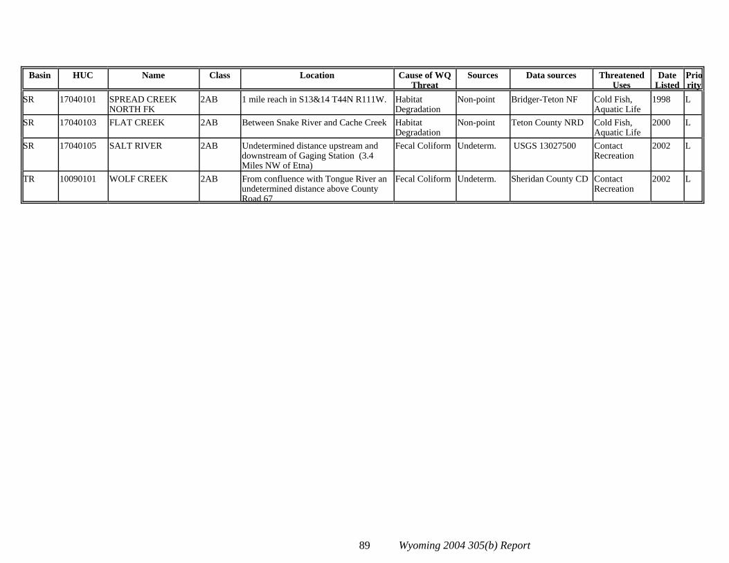
Basin HUC Name Class Location Cause of WQThreat
Sources Data sources ThreatenedUses
DateListed
Priority
89 Wyoming 2004 305(b) Report
SR 17040101 SPREAD CREEKNORTH FK
2AB 1 mile reach in S13&14 T44N R111W. HabitatDegradation
Non-point Bridger-Teton NF Cold Fish,Aquatic Life
1998 L
SR 17040103 FLAT CREEK 2AB Between Snake River and Cache Creek HabitatDegradation
Non-point Teton County NRD Cold Fish,Aquatic Life
2000 L
SR 17040105 SALT RIVER 2AB Undetermined distance upstream anddownstream of Gaging Station (3.4Miles NW of Etna)
Fecal Coliform Undeterm. USGS 13027500 ContactRecreation
2002 L
TR 10090101 WOLF CREEK 2AB From confluence with Tongue River anundetermined distance above CountyRoad 67
Fecal Coliform Undeterm. Sheridan County CD ContactRecreation
2002 L

90 Wyoming 2004 305(b) Report
Table D: Waterbodies Delisted from Wyoming’s 2002 303(d) List
Basin HUC Name Class Location FormerImpairments/Threats
Listing Reason Delisting Reason
BF 10120201 BELLE FOURCHERIVER
2ABWW Undetermined distance belowHulett WWTP
Ammonia, Fecal Coliform,Chlorine
WY0020214 WLARe-evaluation
EPA Approved TMDL
BF 10120201 RUSH CREEK 3B Undetermined distance belowMoorcroft WWTP
Ammonia, Fecal Coliform,Chlorine
WY0021741 WLARe-evaluation
EPA Approved TMDL
BH 10080001 WIND RIVER 2AB Undetermined distance belowRiverton WWTP
Ammonia, Fecal Coliform,Chlorine
WY0020672 WLARe-evaluation
EPA Approved TMDL
BH 10080003 POPO AGIE RIVER 2AB Undetermined distance belowHudson WWTP
Ammonia, Fecal Coliform,Chlorine
WY0020664 WLARe-evaluation
EPA Approved TMDL
BH 10080007 BIGHORN RIVER 2AB Undetermined distance belowWorland WWTP
Ammonia, Fecal Coliform,Chlorine
WY0020176 WLARe-evaluation
EPA Approved TMDL
BH 10080007 BIGHORN RIVER 2AB Undetermined distance belowThermopolis WWTP
Ammonia, Fecal Coliform,Chlorine
WY0020192 WLARe-evaluation
EPA Approved TMDL
BH 10080010 BIGHORN RIVER 2AB Undetermined distance belowGreybull WWTP
Ammonia, Fecal Coliform,Chlorine
WY0020583 WLARe-evaluation
EPA Approved TMDL
BH 10080014 BITTER CREEK 2AB Undetermined distance belowPowell WWTP
Ammonia, Fecal Coliform,Chlorine
WY0020648 WLARe-evaluation
EPA Approved TMDL
BH 10080014 SHOSHONE RIVER 2AB Undetermined distance belowByron WWTP
Ammonia, Fecal Coliform,Chlorine
WY0020281 WLARe-evaluation
EPA Approved TMDL
BH 10080014 SHOSHONE RIVER 2AB Undetermined distance belowCody WWTP
Ammonia, Fecal Coliform,Chlorine
WY0020451 WLARe-evaluation
EPA Approved TMDL
BR 16010101 BEAR RIVER 2AB Undetermined distance belowNorth Uinta County W&SDistrict WWTP
Ammonia, Fecal Coliform,Chlorine
WY0031712 WLARe-evaluation
EPA Approved TMDL
GR 14040101 MUDDY CREEK 2AB Undetermined distance belowMarbleton WWTP
Ammonia, Fecal Coliform,Chlorine
WY0021997 WLARe-evaluation
EPA Approved TMDL
GR 14040107 BLACKS FORKGREEN RIVER
2AB Undetermined distance belowGranger WWTP
Ammonia, Fecal Coliform,Chlorine
WY0022373 WLARe-evaluation
EPA Approved TMDL
GR 14040107 HAMS FORKGREEN RIVER
2AB Undetermined distance belowKemmerer-DiamondvilleWWTP
Ammonia, Fecal Coliform,Chlorine
WY0020320 WLARe-evaluation
EPA Approved TMDL
GR 14040107 SMITHS FORGREEN RIVER
2AB Undetermined distance belowMountain View WWTP
Ammonia, Fecal Coliform,Chlorine
WY0022896 WLARe-evaluation
EPA Approved TMDL
NP 10180004 MEDICINE BOWRIVER
2AB Undetermined distance belowMedicine Bow WWTP
Ammonia, Fecal Coliform,Chlorine
WY0020257 WLARe-evaluation
EPA Approved TMDL

Basin HUC Name Class Location FormerImpairments/Threats
Listing Reason Delisting Reason
91 Wyoming 2004 305(b) Report
NP 10180007 NORTH PLATTERIVER
2AB Undetermined distance belowCasper WWTP
Ammonia, Fecal Coliform,Chlorine
WY0021920 WLARe-evaluation
EPA Approved TMDL
NP 10180008 NORTH PLATTERIVER
2AB Undetermined distance belowGuernsey WWTP
Ammonia, Fecal Coliform,Chlorine
WY0021831 WLARe-evaluation
EPA Approved TMDL
NP 10180008 NORTH PLATTERIVER
2AB Undetermined distance belowDouglas WWTP
Ammonia, Fecal Coliform,Chlorine
WY0020109 WLARe-evaluation
EPA Approved TMDL
NP 10180009 NORTH PLATTERIVER
2AB Undetermined distance belowTorrington WWTP
Ammonia, Fecal Coliform,Chlorine
WY0020231 WLARe-evaluation
EPA Approved TMDL
NP 10180009 RAWHIDE CREEK 2AB Undetermined distance belowLingle WWTP
Ammonia, Fecal Coliform,Chlorine
WY0021849 WLARe-evaluation
EPA Approved TMDL
NP 10180011 CHUGWATERCREEK
2AB Undetermined distance belowChugwater WWTP
Ammonia, Fecal Coliform,Chlorine
WY0021431 WLARe-evaluation
EPA Approved TMDL
PR 10090206 HUNTER CREEK 2AB S10 T50N R84W-11 mi. W. ofBuffalo
Heavy Siltation Heavy Siltation fromroad
Road design changed. Meets AquaticLife Uses
PR 10090206 ROCK CREEK 2AB Watershed below ForestBoundary, Tributary to ClearCreek.
Habitat Degradation Habitat Degradationthreatened aquatic fileuses
DEQ data show full Aquatic Life Usesare supported
SR 17040105 FLAT CREEK 2AB Undetermined distance belowThayne WWTP
Ammonia, Fecal Coliform,Chlorine
WY0025895 WLARe-evaluation
EPA Approved TMDL
SR 17040105 SNAKE RIVER 2AB Undetermined distance belowAlpine WWTP
Ammonia, Fecal Coliform,Chlorine
WY0035611 WLARe-evaluation
EPA Approved TMDL
TR 10090101 BIG GOOSECREEK
2AB Undetermined distance belowSheridan WWTP
Ammonia, Fecal Coliform,Chlorine
WY0020010 WLARe-evaluation
EPA Approved TMDL
TR 10090101 TONGUE RIVER 2AB Undetermined distance belowDayton WWTP
Ammonia, Fecal Coliform,Chlorine
WY0020435 WLARe-evaluation
EPA Approved TMDL
MAC/bb/4-0539.DOC