10104 info session boards 20110609
TRANSCRIPT
WELCOME
PUBLIC INFORMATION SESSION
MONDAY, JUNE 13, 2011
4:00 P.M. - 8:00 P.M.
PTH 59N - PTH 101 INTERCHANGEFUNCTIONAL DESIGN STUDY
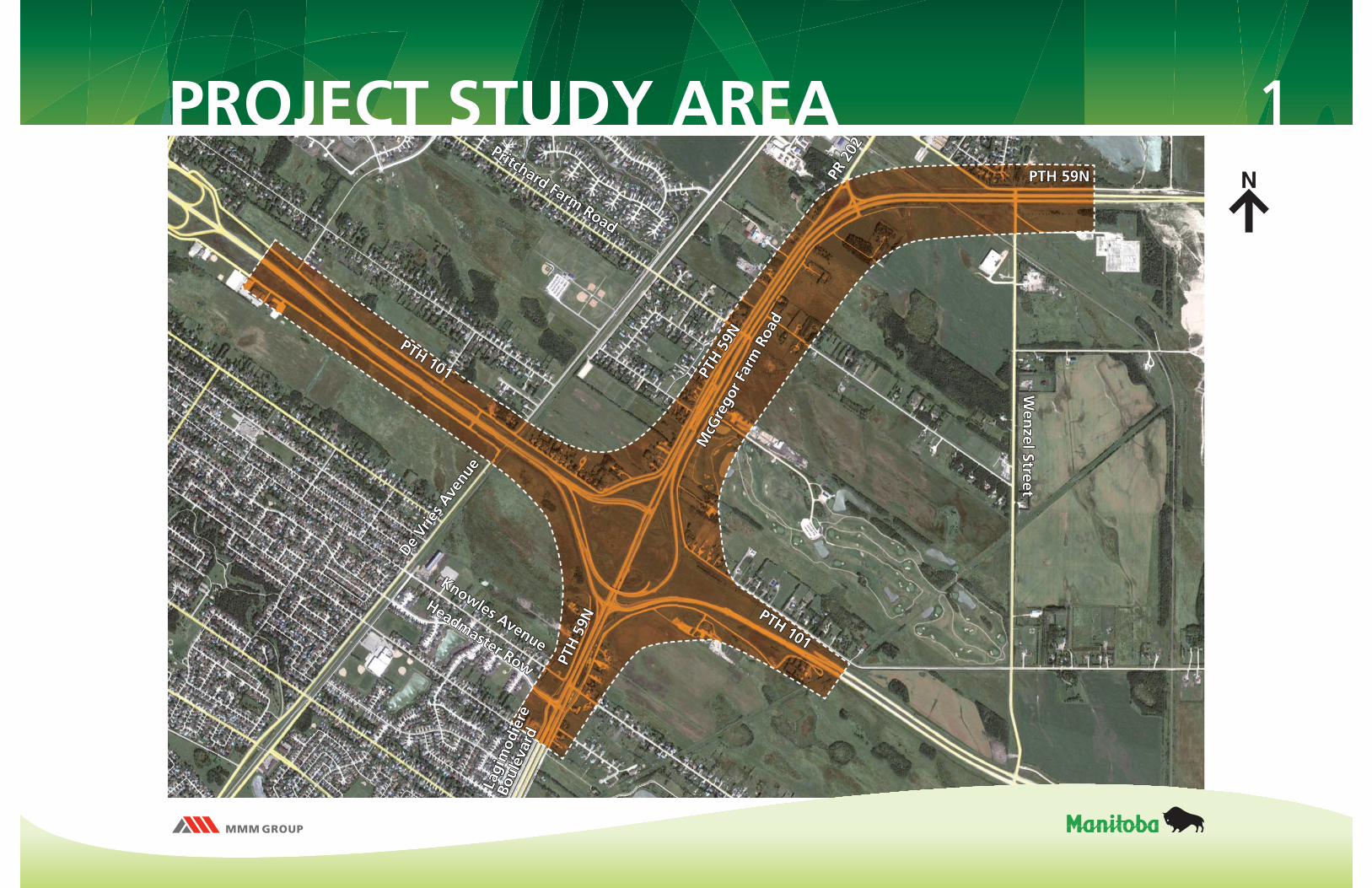
1PROJECT STUDY AREA
PTH
59N
PTH
59N PTH 101
PTH 101
PTH
59N
PTH
59N
PTH 101
PTH 101
Wen
zel StreetW
enzel Street
PR 2
02PR
202
PTH 59N PTH 59N
Pritchard Farm Road
Pritchard Farm Road
Headmaster Row
Headmaster Row
Knowles Avenue
Knowles Avenue
McG
rego
r Far
m R
oad
McG
rego
r Far
m R
oad
De Vr
ies A
venu
e
De Vr
ies A
venu
eLa
gim
odie
re
Lagi
mod
iere
Boul
evar
d
Boul
evar
d
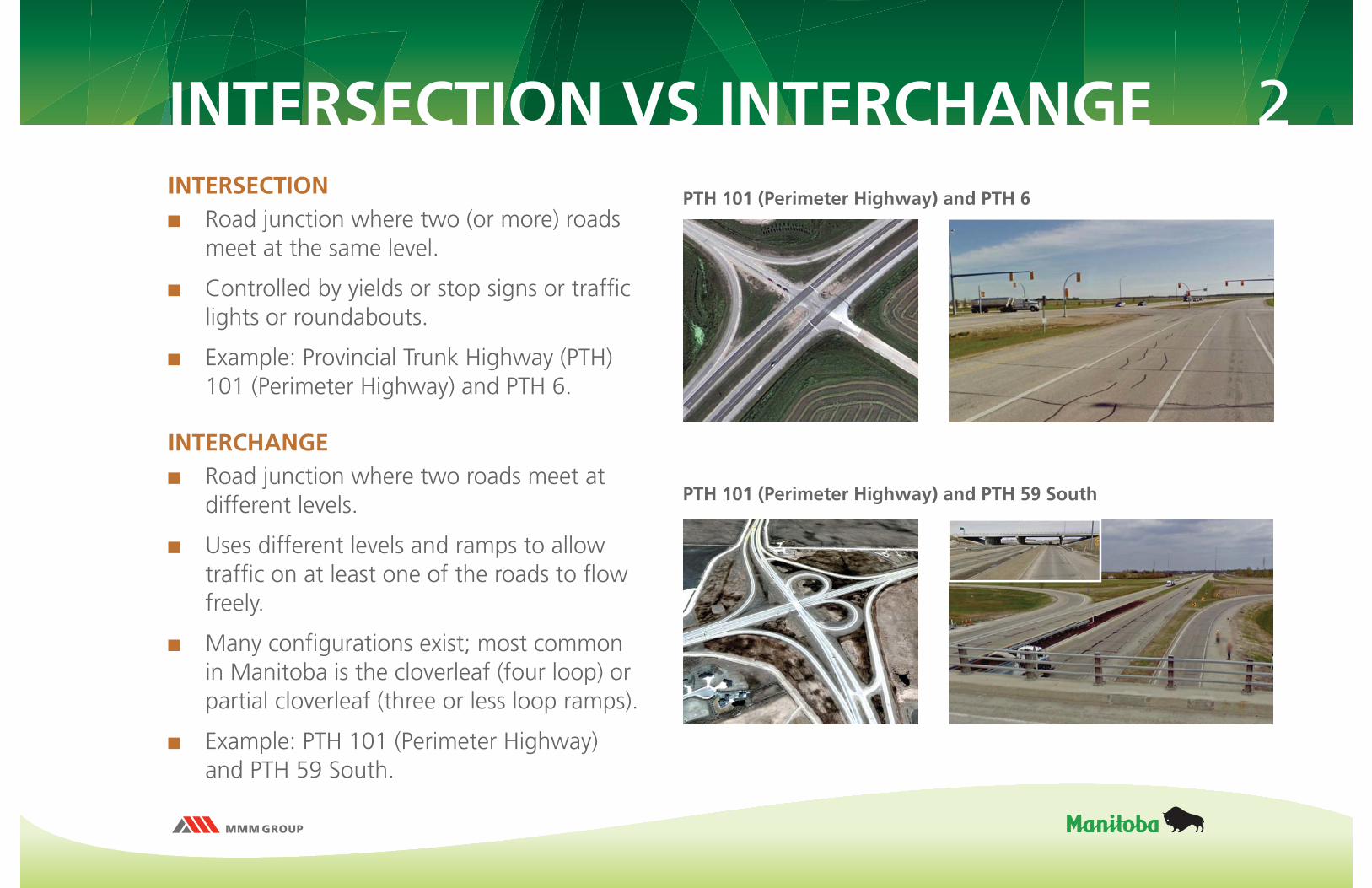
2INTERSECTION VS INTERCHANGEINTERSECTION Road junction where two (or more) roads
meet at the same level.
Controlled by yields or stop signs or traffi c lights or roundabouts.
Example: Provincial Trunk Highway (PTH) 101 (Perimeter Highway) and PTH 6.
INTERCHANGE Road junction where two roads meet at
different levels.
Uses different levels and ramps to allow traffi c on at least one of the roads to fl ow freely.
Many confi gurations exist; most common in Manitoba is the cloverleaf (four loop) or partial cloverleaf (three or less loop ramps).
Example: PTH 101 (Perimeter Highway) and PTH 59 South.
PTH 101 (Perimeter Highway) and PTH 6
PTH 101 (Perimeter Highway) and PTH 59 South
3
The original design for the PTH 59N and PTH 101 interchange was completed in the mid 1990’s.
The current confi guration, which includes two traffi c signal controlled intersections, is the 1996 construction detour that was designed to be in place on an interim basis to allow future construction of the interchange.
The existing layout is unusual, and operational and safety issues have arisen at the two intersections since their construction, and conditions continue to deteriorate.
As traffi c volumes have increased, the intersection layout has reached the end of its effective service life.
PROJECT BACKGROUND
4
The government has approved the full interchange project at PTH 59N and PTH 101 in the current fi ve-year Highway Capital program.
An update to the design is required to incorporate changes to Manitoba Infrastructure and Transportation (MIT) design standards and practices, as well as to accommodate development that has occurred in the area since the original design.
The purpose of this project is to ensure the functional design of the interchange meets today’s standards and future operating requirements.
This project will also include the preliminary design of all associated structures.
PROJECT BACKGROUND
5
Geotechnical / Groundwater – Geotechnical site investigations will be completed and foundation recommendations provided.
Drainage – Drainage requirements will be recommended and incorporated into the functional design.
Road Safety Audit – An independent road safety audit of the functional design will be conducted.
Noise / Vibration – Noise and vibration levels will be monitored; noise forecasts and mitigation strategies will be identifi ed as required.
SUPPLEMENTAL STUDIES
6
Key stakeholders within the study area were identifi ed and contacted:
Government Departments and Agencies: City of Winnipeg, Rural Municipality (RM) of East St. Paul, RM of Springfi eld, emergency services, Canada Post, and local school divisions.
Special Interest Stakeholders: River East Neighbourhood Network-Trail Committee, and Brokenhead Ojibway Nation (BON).
Property Owners: Property owners and individuals directly affected by land acquisitions were consulted individually.
General Public: Information is being provided to the general public through this Public Information Session.
PUBLIC CONSULTATION
7
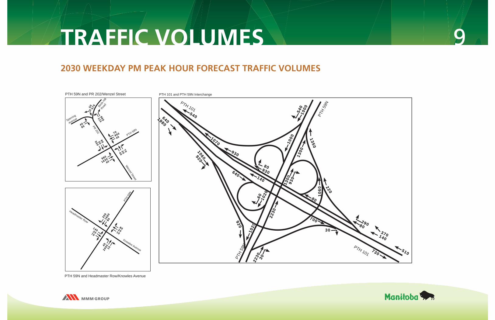
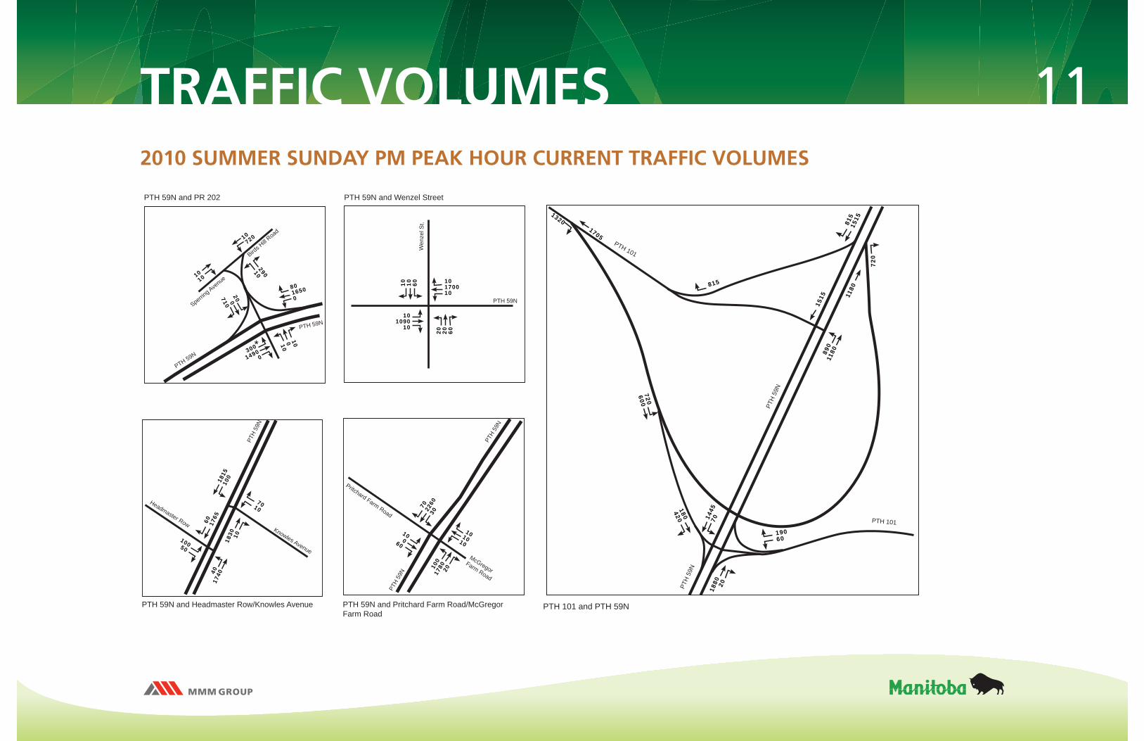
Traffi c volumes were examined for current (2010) and forecast conditions (2030) for weekday peak traffi c and summer recreational peak traffi c fl ows.
Movements through the proposed PTH 59N and PTH 101 interchange are forecast to experience little delay during peak periods.
Some congestion is anticipated to occur at the intersections of Lagimodiere Boulevard at Headmaster Row and at PTH 59N at Provincial Road (PR) 202, primarily due to high through volumes on PTH 59N.
TRAFFIC ANALYSIS
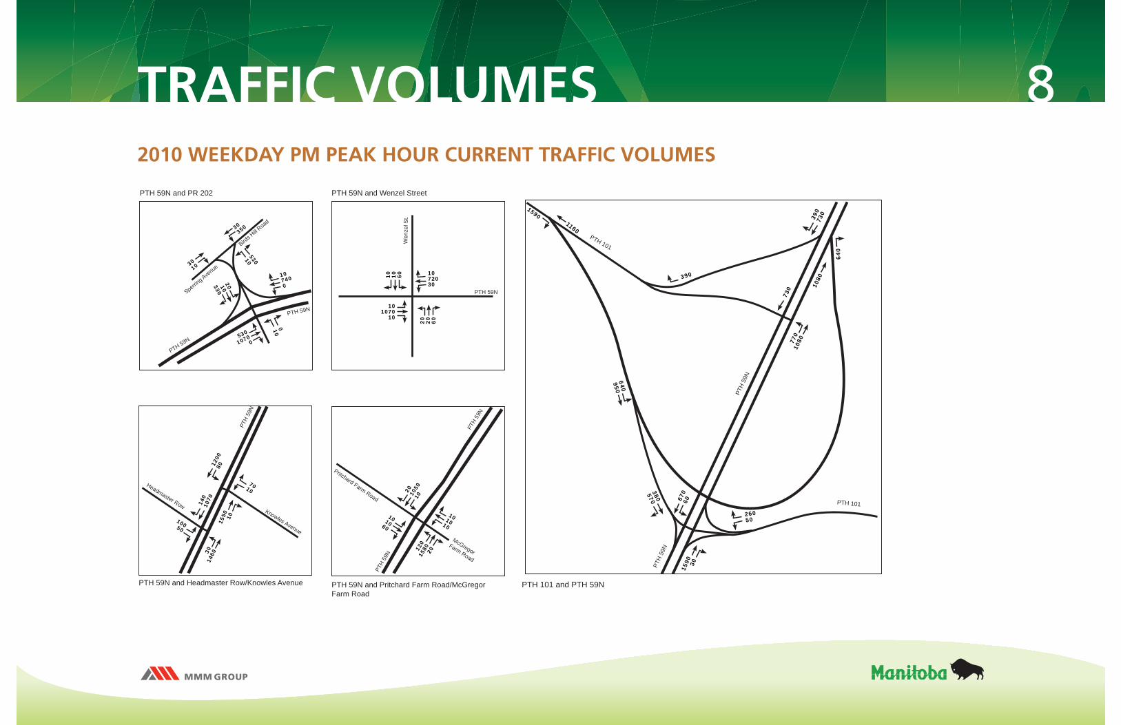
8TRAFFIC VOLUMES
PTH 59N and PR 202
PTH 59N
PTH 59N
Pritchard Farm Road
PTH
59N
PTH
59N
PTH 59N and Pritchard Farm Road/McGregor Farm Road
PTH 59N and Wenzel Street
McGregor Farm Road
PTH 59N and Headmaster Row/Knowles Avenue
PTH
59N
Knowles Avenue
Headmaster Row
PTH 59N
Wen
zel S
t.
Sperring Ave
nue
Birds H
ill Road
101010
101060
120
1580 20
20 1050
10
107400
2010330
530
10700
010
1200
8015
50 10
140
1070
3014
60
10050
7010
1072030
101070
10
20 20 60
10 10 60
3010
30350
53010
2010 WEEKDAY PM PEAK HOUR CURRENT TRAFFIC VOLUMES
PTH 101 and PTH 59N
PTH
59N
PTH
59N
PTH 101
PTH 101
390
730
730
26050
1590 30
380570 670
60
1080
1160
390
640950
770
1080
1590
640
9TRAFFIC VOLUMES
PTH 59N and Headmaster Row/Knowles Avenue
Knowles Avenue
Headmaster Row
PTH 59N and PR 202/Wenzel Street
Wenzel Street
PR 202
PTH
59N
PTH 59N
Sperring
Avenue
Birds H
ill Roa
d
802010
1402070
4020
50 10
200
1660
80
703040
9030550
980
163040
7095040
965115
4095
50 575
2030 WEEKDAY PM PEAK HOUR FORECAST TRAFFIC VOLUMES
PTH 101
PTH 101
PTH
59N
PTH
59N
92022
30 30
1020
2230
60 1020
30
29080370140
730510
80
1060
1070
6401980
1060920
930
640 140
1000
540
1000
1300
1350
220
1300
930
93080
540
700
PTH 101 and PTH 59N Interchange

10
PTH
59N
Knowles Avenue
Headmaster Row
PTH 59N
PTH 59N
Pritchard Farm Road
PTH
59N
PTH
59N
PTH 59N and Pritchard Farm Road/McGregor Farm Road
PTH 59N and Headmaster Row/Knowles Avenue
McGregor Farm Road
PTH 59N and PR 202 PTH 59N and Wenzel Street
PTH 59N
Wen
zel S
t.
Sperring Ave
nue
Birds H
ill Road
101010
101060
220
2520 40
30 1230
10
1440
100
2430 20
170
1270
6023
50
10050
7010
108600
200400
860
16800
0010
5084040
101670
20
20 20 60
10 10 60
3010
30420
86010
PTH 101 and PTH 59N
PTH
59N
PTH
59N
PTH 101
PTH 101
460
840
840
34060
2490 20
500710 770
70
1950
1340
460
8301210
880
1950
2040
830
TRAFFIC VOLUMES2010 SUMMER FRIDAY PM PEAK HOUR CURRENT TRAFFIC VOLUMES
11
PTH
59N
Knowles Avenue
Headmaster Row
PTH 59N
PTH 59N
Pritchard Farm Road
PTH
59N
PTH
59N
PTH 59N and Pritchard Farm Road/McGregor Farm Road
PTH 59N and Headmaster Row/Knowles Avenue
McGregor Farm Road
PTH 59N and PR 202 PTH 59N and Wenzel Street
PTH 59N
Wen
zel S
t.
Sperring Ave
nue
Birds H
ill Road
8016500
200710
300
14900
10010
101010
10060
100
1780 20
70 2260
30
1815
100
1830 10
60 1765
4017
40
10050
7010
10170010
101090
10
20 20 60
10 10 60
1010
10720
29010
PTH 101 and PTH 59N
PTH
59N
PTH
59N
PTH 101
PTH 101
815
1515
1515
19060
1880 20
180420 1445
70
1180
1705
815
720600
890
1180
720
1320
TRAFFIC VOLUMES2010 SUMMER SUNDAY PM PEAK HOUR CURRENT TRAFFIC VOLUMES
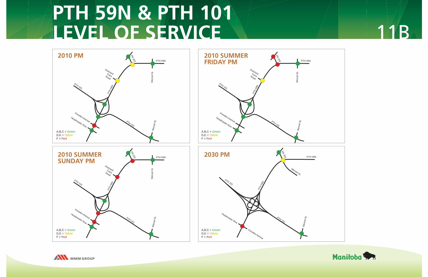
11BPTH 59N & PTH 101LEVEL OF SERVICE
PTH 101
PTH 101
Knowles AvenueHeadmaster Row
PTH
59N
Wen
zel S
t.W
enze
l St.
PR 202 PTH 59N
Pritchard Farm Road
PTH 101
PTH 101
Knowles Avenue
Headmaster Row
PTH
59N
Wen
zel S
t.
Wenzel St.
PR 202 PTH 59N
PTH 101
PTH 101
Knowles AvenueHeadmaster Row
PTH
59N
Wen
zel S
t.W
enze
l St.
PR 202 PTH 59N
Pritchard Farm Road
PTH 101
PTH 101
Knowles AvenueHeadmaster Row
PTH
59N
Wen
zel S
t.W
enze
l St.
PR 202 PTH 59N
Pritchard Farm Road
2010 PM 2010 SUMMERFRIDAY PM
2010 SUMMERSUNDAY PM
2030 PM
A,B,C = GreenD,E = YellowYellowF = Red
A,B,C = GreenD,E = YellowYellowF = Red
A,B,C = GreenD,E = YellowYellowF = Red
A,B,C = GreenD,E = YellowYellowF = Red

12
Northeast Pioneer Greenway is located southwest of the proposed PTH 59N and PTH 101 interchange.
Ultimate plan is to extend the Greenway to Birds Hill Park.
An overpass over PTH 101 would link North Kildonan with the RM of East St. Paul along the Gateway/Raleigh corridor.
The proposed roadway plans include shoulders similar to those existing elsewhere on PTH 59N and PTH 101 within the study area.
PEDESTRIAN/CYCLIST AMENITIES
13 Collision analysis involves a review of the collision history to establish
collision rates and identify possible relationships between collisions and the geometric features and operational conditions of the road facility.
Collision rate is a measure of the risk faced by the road user and is based on the number of collisions that occurred and the volume of traffi c during a specifi ed period.
Collision rates for road links exceeding 1.5 incidents per MVKT (million vehicle-kilometres of travel) warrant further review. There are no locations within the study area that had a collision rate greater than 0.81 incidents per MVKT.
Collision rates for intersections exceeding 1.5 incidents per MEV (million entering vehicles) warrant further review. All intersections within the study area had a collision rate at or below 0.25 incidents per MEV.
COLLISION ANALYSIS
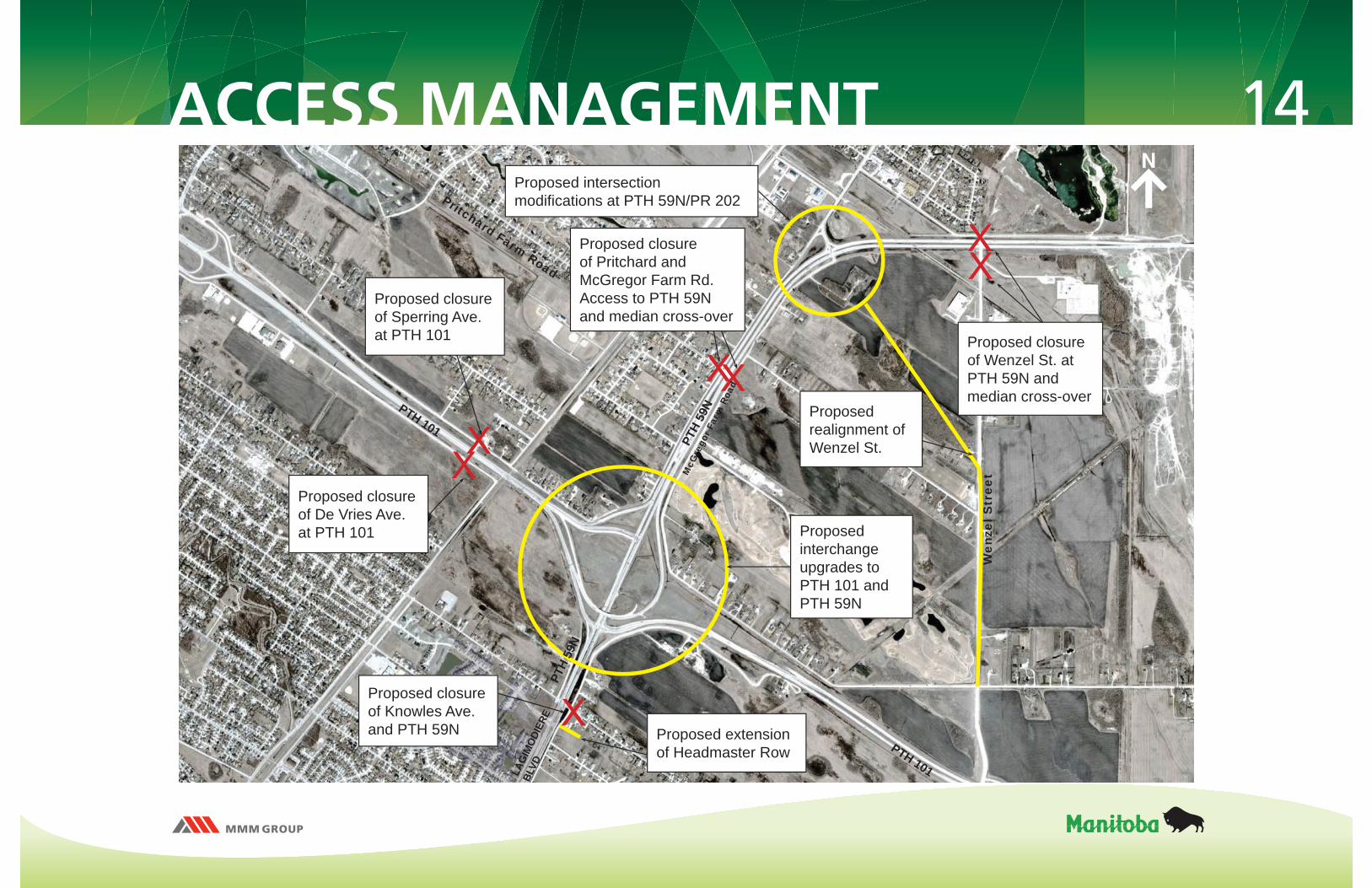
14ACCESS MANAGEMENT
Proposed interchange upgrades to PTH 101 and PTH 59N
Pritchard Farm Road
Wen
zel S
tree
tMcG
rego
r Far
m R
oad
Proposed closure of De Vries Ave. at PTH 101
Proposed extension of Headmaster Row
Proposed closure of Pritchard and McGregor Farm Rd. Access to PTH 59N and median cross-over
Proposed closure of Knowles Ave. and PTH 59N
PTH 101
PTH 101
PTH
59N Proposed
realignment of Wenzel St.
Proposed intersection modifi cations at PTH 59N/PR 202
Proposed closure of Wenzel St. at PTH 59N and median cross-over
Proposed closure of Sperring Ave. at PTH 101
PTH
59N
LAG
IMO
DIER
E
BLVD

15PROPOSEDINTERCHANGE DESIGN
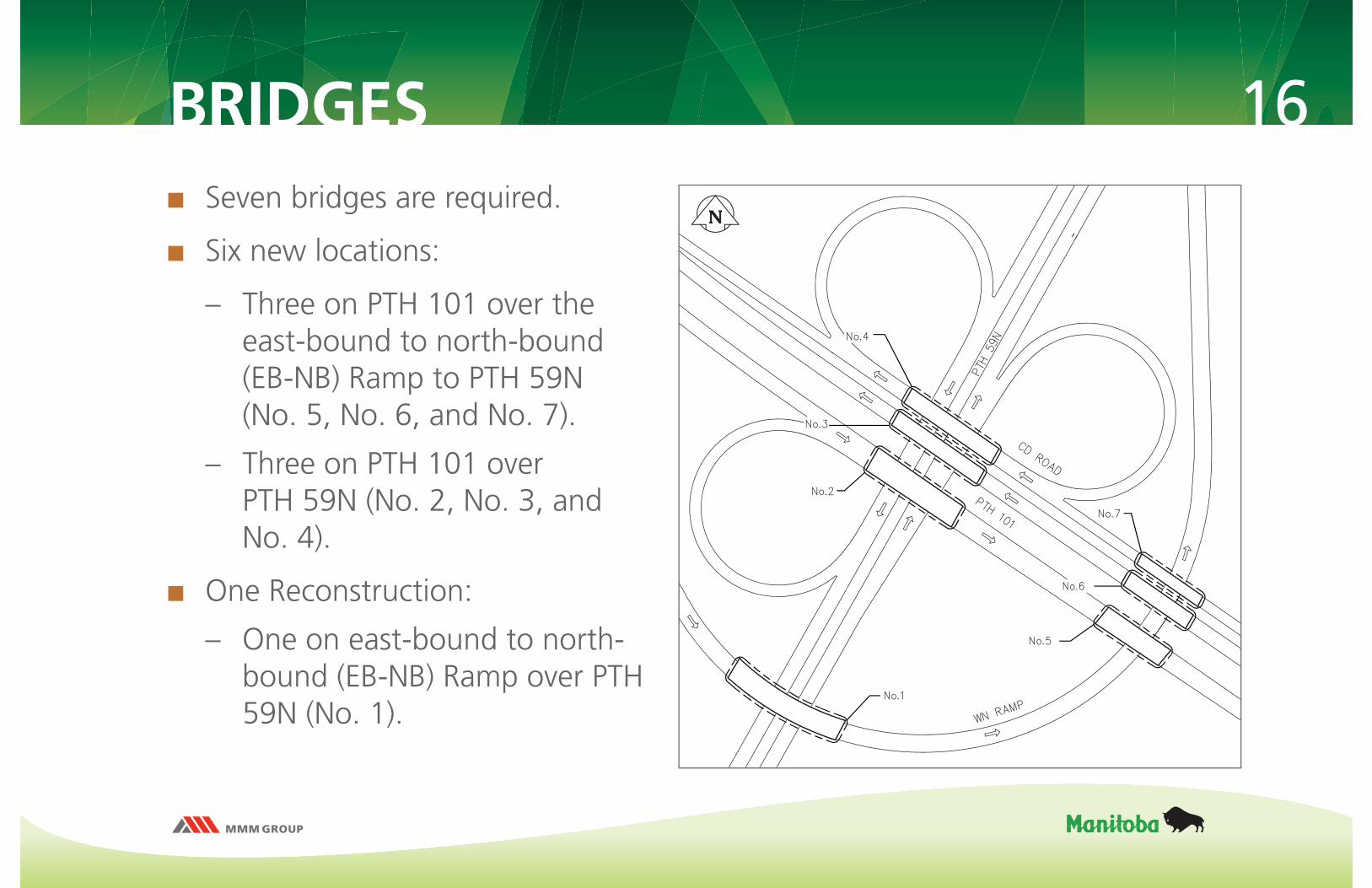
16BRIDGES Seven bridges are required.
Six new locations:
– Three on PTH 101 over the east-bound to north-bound (EB-NB) Ramp to PTH 59N(No. 5, No. 6, and No. 7).
– Three on PTH 101 over PTH 59N (No. 2, No. 3, and No. 4).
One Reconstruction:
– One on east-bound to north-bound (EB-NB) Ramp over PTH 59N (No. 1).
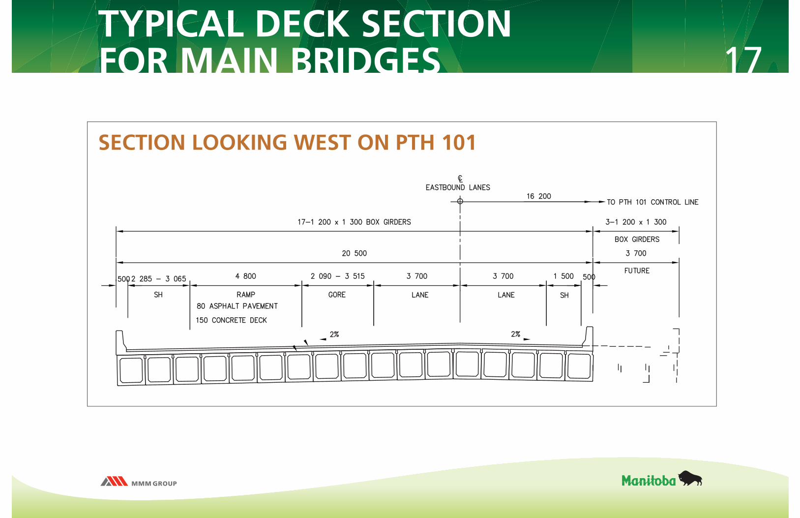
17TYPICAL DECK SECTIONFOR MAIN BRIDGES
SECTION LOOKING WEST ON PTH 101
18DRAINAGE DESIGN FEATURES
Ditch slopes shall be as steep as possible to adequately convey the fl ow and prevent unwanted ponding
Culverts have been sized to control the fl ow of water downstream at a rate compatible with the ditch section
No long-term retention ponds shall be incorporated into the design
19DRAINAGE - KEY POINTS Flows from areas outside of the proposed interchange are a signifi cant portion of the
total fl ow that is eventually discharged into the Red River
The proposed interchange will improve the performance of the overall drainage basin by slowing down and reducing the peak fl ows into the Red River
The proposed drainage system:
– Optimizes the use of culverts, ditches and local depression areas in order to reduce peak fl ows
– Adequately conveys up to a one-in-50 year 24-hour City of Winnipeg storm event
– Incorporates emergency spillways to prevent water levels from rising higher than the roadway surface
The current outfall at the Red River, although adequate in size to discharge the design fl ow, should undergo a complete condition assessment.
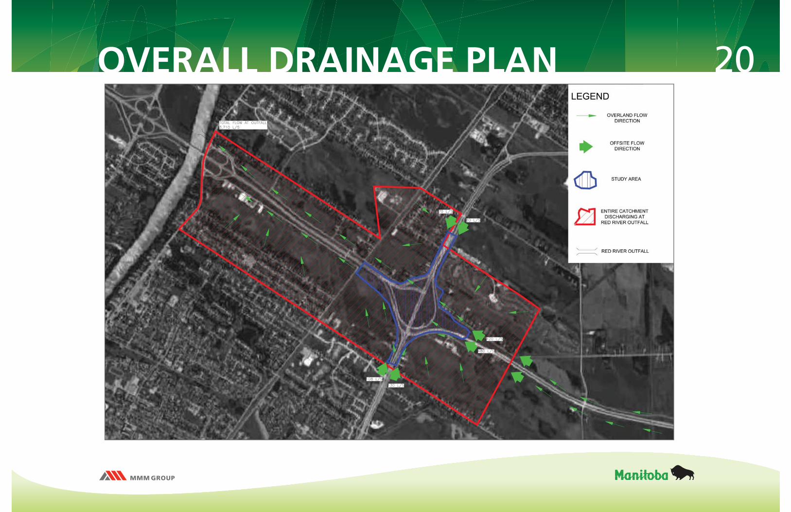
20OVERALL DRAINAGE PLAN
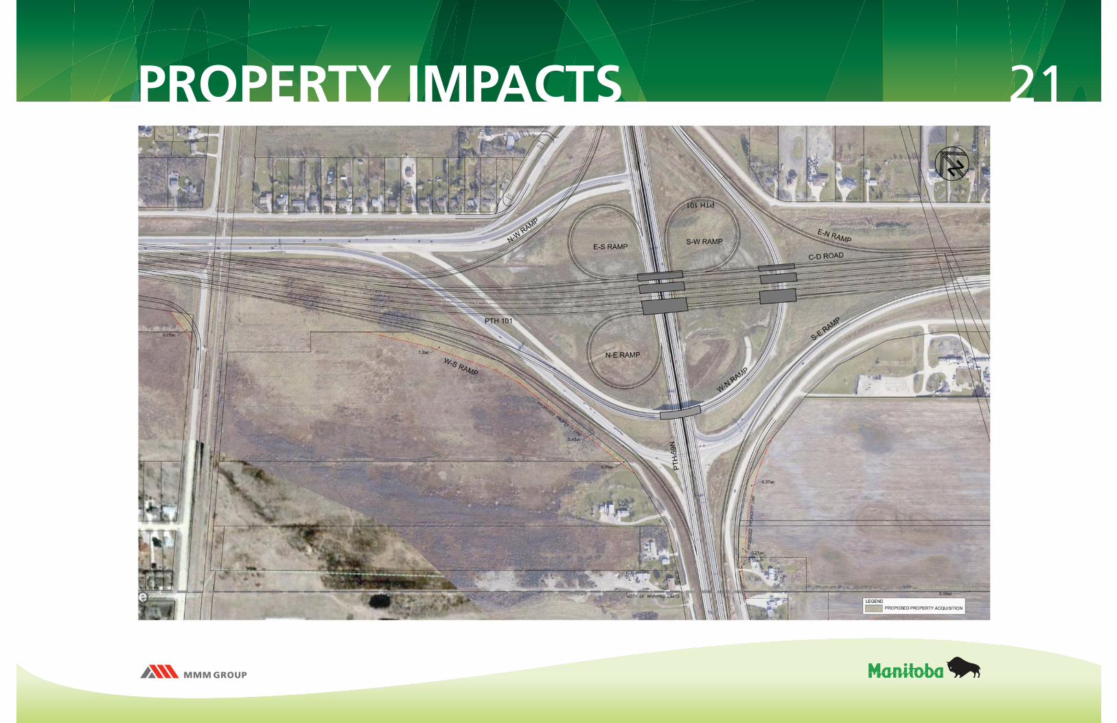
21PROPERTY IMPACTS
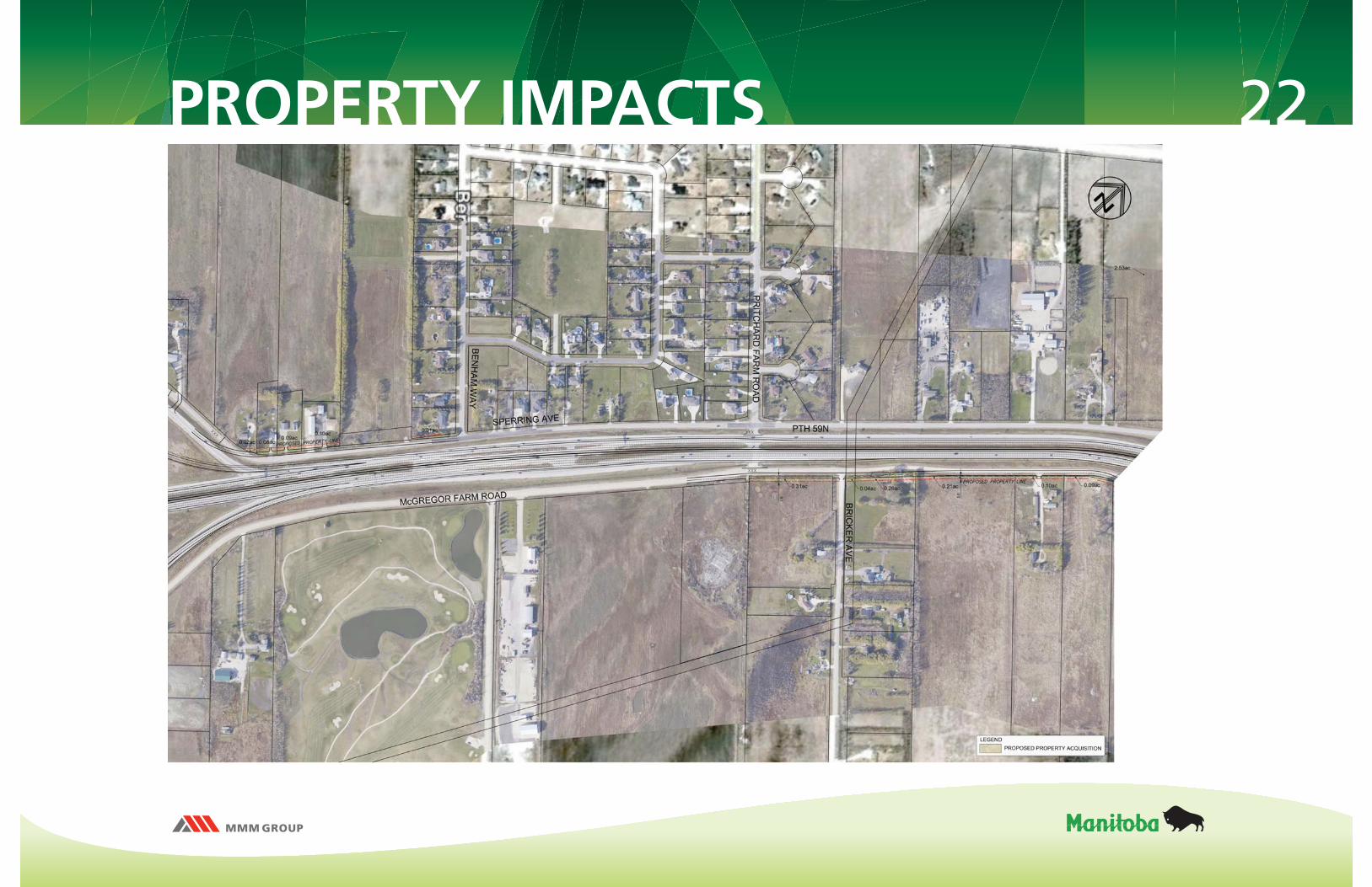
22PROPERTY IMPACTS
23
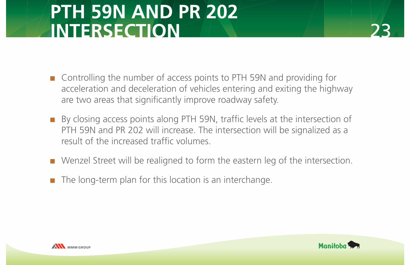
Controlling the number of access points to PTH 59N and providing for acceleration and deceleration of vehicles entering and exiting the highway are two areas that signifi cantly improve roadway safety.
By closing access points along PTH 59N, traffi c levels at the intersection of PTH 59N and PR 202 will increase. The intersection will be signalized as a result of the increased traffi c volumes.
Wenzel Street will be realigned to form the eastern leg of the intersection.
The long-term plan for this location is an interchange.
PTH 59N AND PR 202INTERSECTION

24PTH 59N AND PR 202 INTERSECTIONUPGRADES AND PROPERTY IMPACTS
PR 202
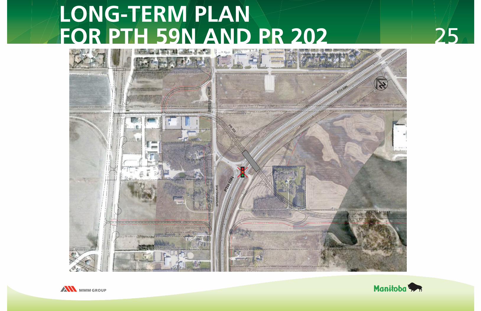
25LONG-TERM PLANFOR PTH 59N AND PR 202
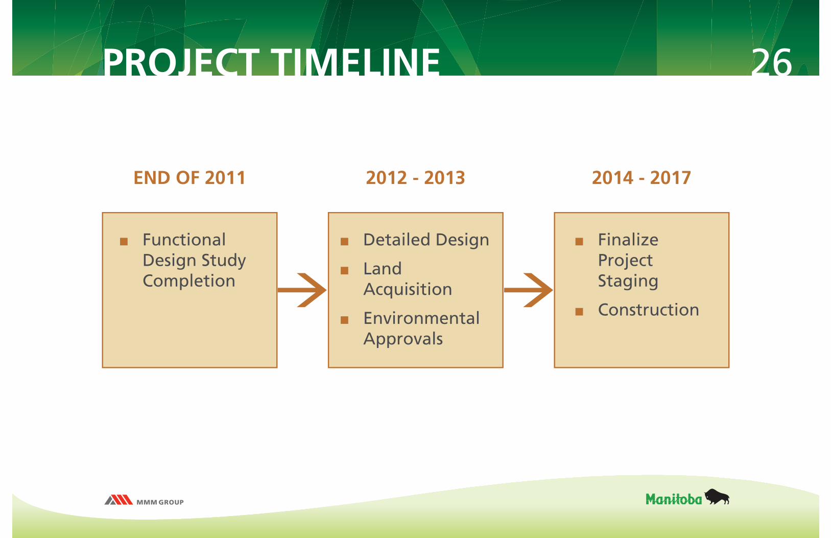
26PROJECT TIMELINE
Functional Design Study Completion
END OF 2011 2012 - 2013 2014 - 2017
Detailed Design
Land Acquisition
Environmental Approvals
Finalize Project Staging
Construction

THANK YOU
PLEASE FILL OUT AN EXIT SURVEY BEFORE LEAVING AND DROP OFFIN THE BOX PROVIDED.