2015 desert tortoise monitoring data management plan...may 20, 2015 · data management plan 20 may...
TRANSCRIPT

2015
Desert Tortoise Monitoring
Data Management Plan
20 May 2015
Linda Allison Desert Tortoise Monitoring Coordinator US Fish and Wildlife Service 1340 Financial Blvd, Ste. 234 Reno, NV 89502 Melissa Brenneman TopoWorks 110 Dry Run Drive Noblesville, IN 46060 Rohit Patil University of Nevada, Reno Department of Geography/Mailstop 154 Reno, NV 89557 Doug Zeliff Mojave Desert Ecosystem Program 2701 Barstow Road Barstow, CA. 92311

2015 DESERT TORTOISE MONITORING DATA QA/QC PLAN 20 MAY 2015
2
Table of Contents INTRODUCTION ........................................................................................................................................................ 3
TYPES OF QA/QC CHECKS .................................................................................................................................... 5
DESIGN PHASE: COLLECTION SYSTEM AND CENTRALLY MAINTAINED INFORMATION ...... 6
ELECTRONIC DATA COLLECTION SYSTEM .............................................................................................................. 6 PHOTO COLLECTION SYSTEM ................................................................................................................................... 6 PAPER DATA COLLECTION SYSTEM .......................................................................................................................... 7
PHASE I: DATA COLLECTION AND CORRECTION ..................................................................................... 7
PREPARE LAPTOP SYSTEMS AND SOFTWARE ........................................................................................................... 8 JUNO PREPARATION AND RECOVERY FROM SYSTEM FAILURE ......................................................................... 8 ...................................................................................................................................................................................... 9 TRANSFER OF DATA FROM FIELD CREWS TO DATA SPECIALISTS - INITIATING FIRST LEVEL QA/QC ............ 10 IMPORTING COLLECTION DATABASES INTO CORRECTION DATABASES ............................................................ 10 SPECIFIC, AUTOMATED QA/QC CHECKS FOR ERRORS AND INCONSISTENCIES ................................................ 11 PROCEDURES FOR ADDRESSING ERRORS ............................................................................................................... 15 NON-AUTOMATED PROCESSING STEPS AND CHECKS FOR ERRORS AND INCONSISTENCIES ............................. 18 MAINTAINING SEPARATE VERSIONS OF THE COLLECTION AND CORRECTION DATABASES, AND MOVING
RECORDS BETWEEN VERSIONS ................................................................................................................................ 22 FINAL PROCESSING STEPS: DATA BACKUP AND DELIVERY .................................................................................. 22 DATA MANAGEMENT CHECKLIST (DEVELOPED FOR WORKING USE BASED ON ABOVE PROCEDURES) ......... 26
PHASE II: DATA INTEGRATION AND FIELD COMPLETION .................................................................. 27
ROLES OF THE MDEP WEBMASTER ..................................................................................................................... 27 CREATION OF WORKING DATABASES ................................................................................................................... 27 STEPS FOR PROCESSING THE TRANSECTS DATABASE (SEASON AND PRESEASON) .......................................... 28 G0 DATABASE ........................................................................................................................................................... 30 FORMATS TO APPLY ................................................................................................................................................ 31 SPECIFIC QA/QC CHECKS FOR ERRORS AND INCONSISTENCIES ........................................................................ 34 NON-AUTOMATED CHECKS FOR ERRORS .............................................................................................................. 37 PROCEDURES FOR ADDRESSING ERRORS ............................................................................................................... 37 FINAL DATA SUBMISSION ........................................................................................................................................ 37
PHASE III: DATA FINALIZATION ...................................................................................................................... 39
INITIAL PROCESSING STEPS ..................................................................................................................................... 39 SPECIFIC QA/QC CHECKS FOR ERRORS AND INCONSISTENCIES ........................................................................ 41 PROCEDURES FOR ADDRESSING ERRORS ............................................................................................................... 47 NON-AUTOMATED OVERALL DATABASE CHECKS ................................................................................................. 47 FINAL PROCESSING STEPS ....................................................................................................................................... 47
MAINTENANCE PHASE: DATA DISSEMINATION AND LONG-TERM STORAGE ........................... 48
DATA DISSEMINATION ............................................................................................................................................. 48
APPENDIX A. QAQC II SCRIPTS ......................................................................................................................... 50
APPENDIX B: DATA DICTIONARIES ................................................................................................................ 54

2015 DESERT TORTOISE MONITORING DATA QA/QC PLAN 20 MAY 2015
3
Introduction
Desert Tortoise Monitoring data are organized into two periods of time when data are collected: Preseason (before actual tortoise monitoring begins) and Season (during tortoise monitoring). The preseason data include two core databases: Training Lines and Practice Transects. The season data include two core databases: Transects and G0 Observations.
Data are collected by multiple survey organizations then combined and processed in a series of phases to create final database products. Data are collected in both electronic and hardcopy format. Collection data forms, sheets, applications and databases are designed. Data quality assurance and quality control (data QA/QC, also known as verification and validation) is performed during the data collection, data integration and data finalization phases. In addition, during the second phase of data processing, after combining data from separate groups, some attribute fields are added and all fields are formatted for final processing. Data finalization occurs in phases, with consolidation and resolution of data inconsistencies representing the first phase. Data are subsequently subject to preliminary analysis to confirm that the results and outputs are consistent with the field season narrative. Once this test and the annual reporting have been completed, the data bases and paper sheets are stored and maintained for ready access during the course of the long-term (25+ years) project. Electronic data are actively hosted and put in a format available for download from the internet. The following diagram describes the overall data flow.

2015 DESERT TORTOISE MONITORING DATA QA/QC PLAN 20 MAY 2015
4
Following describes the general roles and responsibilities for each phase. The 2013 database was used without modification for the 2015 field season. As a result, the starred (*) steps below were not completed separately in 2015.
Phase Responsible Parties
Design Phase: Collection System
*University of Nevada, Reno; UNR) – Development of Collection database schemas for each database and their associated forms and checks according to U.S. Fish and Wildlife Service (USFWS) specifications. Includes creation of database dictionaries that describe fields, field formats, acceptable values, etc.
*USFWS – Development of database dictionary for use of UNR in design phase. Design of paper data sheets for hard copy version to parallel electronic field data.
*TopoWorks (TW) – Development of Transect Tracking and Planning application according to USFWS specifications.
*Mojave Desert Ecosystem Program (MDEP) – Hosting of data exchange site for delivery of products and discussion boards and for hosting centralized data for use by Survey Organizations for planning purposes.
Phase I: Data Collection and Correction
*UNR – Development of scripts to import the populated Collection databases into their corresponding Correction databases and for developing scripts to automate some of the first level QA/QC checks.
Survey Organizations – Responsible for
o collecting data in the field on paper and electronic data collection devices (Trimble© Juno PDAs – “Junos”).
o running the synchronization operations to integrate data collected on each individual Juno into its appropriate single, populated Collection database ((Preseason and Season)).
o *using the Transect Tracking and Planning application to document when transects are walked or replaced.
o running the import script to bring records from the Collection databases into their Correction databases, running first level QA/QC checks on their Correction databases, correcting errors, and delivering a weekly set of complete Collection and Correction databases, along with their completed and scanned paper datasheets and extracted photos. The electronic data are submitted on a weekly basis for interim assessments (below) and storage prior to final Correction database delivery. Includes addressing and correcting items in the interim assessments.
USFWS – Performing an interim (usually weekly) assessment of each survey organization’s populated Correction database.
MDEP – Verification of delivery of Phase I products. There are separate deadlines for delivery of Preseason and Field season products to MDEP.
Phase II: Data Integration and Field Completion
MDEP – Compilation of electronic data submitted by Survey Organizations into a combined, well-organized set of (Preseason and Season) databases and associated photos and scanned data sheets. Includes review of surveyor products, combination, consolidation, formatting, generating additional data fields, performing second level QA/QC checks and corrections, and delivering Phase II products for data finalization.
Phase III: TW – Creation of final Preseason and Season spatial and non-spatial

2015 DESERT TORTOISE MONITORING DATA QA/QC PLAN 20 MAY 2015
5
Data Finalization
products. Includes any additional processing steps beyond the Data Integration and Field Completion phase for standardization across all databases and supporting data sheets, creation of FGDC-compliant metadata, independent review of Integrated Data products from previous phases, generating the final set of data fields, performing third level QA/QC checks and corrections, identifying and resolving data integrity issues with USFWS, and finalizing spatial and non-spatial electronic data. The Preseason practice transects databases are only minimally reviewed and included as non-spatial products.
Types of QA/QC checks
As outlined in the following sections, each phase of data collection and processing involves performing QA/QC checks and corrections. Errors can enter the process at data collection, but also during later steps such as data editing and during processing steps. For this reason, many checks are performed in more than one phase of data processing. Following are the main types of QA/QC checks that will be performed.
Type Description Examples of Errors
Database relationships
Identifies orphans or deviations in the expected number of features related to another feature
Waypoints with no transect.
More than 22 waypoints related to a transect
Field domains Identifies values that are not within a specified range or set
Tortoise mcl > 400
Duplicate records
Identifies duplicate records Duplicate transects
Multi-field attribute conditions
Identifies records that do not meet specific conditions for attribute values
Observer does not match the lead or follow for the last waypoint
“Gsub0 = Visible” but no behavior recorded
Spatial conditions
Identifies records that do not satisfy a spatial relationship
Transects that do not intersect their monitoring strata
Observations that are more than 50 meters away from their related transect
Data are collected simultaneously by the two different members of each transect crew, and sequentially by the single telemetry technician working at G0 sites. The two sets of data, paper and electronic are used to verify and correct one another. During each step of data processing, the electronic data are systematically reviewed (often using automated procedures). If a discrepancy is found in the electronic form, and a different entry is available on the paper form, the paper data take precedence. If an error is suspected on the paper data sheet, the crew recording the data is questioned and other evidence is considered to determine whether there was an on the paper data sheet. If a discrepancy between the paper and electronic data forms cannot be corroborated one way or the other, the paper data sheet stands as the definitive data entry.

2015 DESERT TORTOISE MONITORING DATA QA/QC PLAN 20 MAY 2015
6
Design Phase: Collection System and Centrally Maintained Information
Electronic data collection system UNR is responsible for developing the collection database schemas for each type of database (training lines, transects, and G0) and their associated forms and checks according to USFWS specifications, which includes creation of database dictionaries that describe fields, field formats, acceptable values, etc.
Pendragon Collection database forms are built for Junos based on database dictionaries for training lines, transects, and G0. The forms constrain data entry for some fields and require data entry for others (see Appendix A: Database Dictionaries for fields describing required entry and Pendragon physical domains for constraining entry).
Photo collection system The electronic data collection system is integrated with digital photo collection. To minimize data entry errors from individually naming then copying file names to the electronic and paper data systems, these photos are integrated into the database.
There is also less chance of a photo getting disassociated from its record if the images are maintained in the database throughout Phase I. However, the images will not be processed after that phase and will encumber further QA/QC processing. For this reason, photos will be removed, named using an automated procedure, and stored in an associated folder where database records can link with images using relative references. Any photos taken on a transect but not as part of the database must be carefully named, and this name must be described on the paper datasheets and in the electronic database for the transect. The following naming conventions are in place for images associated with database records:
Table Name Field name Naming convention Example Waypoints photo_to_wp_xminus1 Tranxxx.x_wpww_to_minus
1_yyyy Tran234.0_wp03_to_minus1_2015.jpg
Waypoints photo_to_wp_xplus1 Tranxxx.x_wpww_to_plus1_yyyy
Tran234.1_wp21_to_plus1_2015.jpg
TranLiveObs photo_tort1 Tranxxx.x_TLzz_1_yyyy Tran012.0_TL02_1_2015.jpg TranLiveObs photo_tort2 Tranxxx.x_TLzz_2_yyyy Tran012.0_TL02_2_2015.jpg TranCarcObs photo_carc Tranxxx.x_TCzz_yyyy Tran245.0_TC12_2015.jpg OppLiveObs photo_tort Tranxxx.x_OLzz_yyyy Tran967.0_OL05_2015.jpg OppCarcObs photo_carc Tranxxx.x_OCzz_yyyy Tran009.0_OC01_2015.jpg G0_Start photo1 G0_site_yyyymmdd_FL_ph
oto1 G0_SC_20150310_PF_photo1.jpg
G0_Start photo2 G0_site_ yyyymmdd _FL_photo2
G0_GB_20150421_ZS_photo2.jpg
G0_Start photo3 G0_site_ yyyymmdd _FL_photo3
G0_IV_20150323_DK_photo3.jpg
G0_Start photo4 G0_site_ yyyymmdd _FL_photo4
G0_CK_20150513_AD_photo4.jpg
G0_Start photo_carc G0_site_ yyyymmdd _FL_photo_carc
G0_SC_20150513_AD_photo_carc.jpg
G0_OppLiveObs photo_tort G0_site_ yyyymmdd _FL_OLzz
G0_IV_20150513_TK_OL1.jpg
xxx.x: transect number

2015 DESERT TORTOISE MONITORING DATA QA/QC PLAN 20 MAY 2015
7
ww: waypoint number for current photo zz: observation number FL: first and last initials for the observer (as named in the database drop-down lists) yyyy: 4-digit year; mm: 2-digit month; dd: 2-digit day Paper data collection system
Paper datasheets are created by USFWS after completion of and in order to match the electronic data collection system.
Phase I: Data Collection and Correction
Survey organizations are responsible for collecting data in the field on paper and in Junos. In addition to QA/QC steps associated with collected data, specialists prepare and maintain data collection hardware. The ability of others to evaluate and use the data also depends on the timing and format of databases and scanned paper datasheets that are delivered from Phase I. Much of this section details QAQC procedures, but their teams and the project rely on the specialists for many other associated activities.
Phase I includes implementing the synchronization operation to integrate data collected on each individual Juno into the appropriate single, populated Collection database (training lines, transects, or G0) for each organization. In addition, they are responsible for correcting errors.
UNR is responsible for developing scripts to import the populated collection databases into Correction databases and developing scripts to automate some of the first-level QA/QC checks.
Survey organization responsibilities include the following QA/QC steps: Importing the data from the populated Collection databases into the Correction databases. Running scripts to perform the required automated checks designed to identify common errors that can
be best corrected by the survey organization. It is the survey organization’s responsibility to perform an initial level of QA/QC and correct these errors (see specific checks below).
Performing final, non-automated visual checks for errors. Examples of errors include odd times, incomplete fields, fields missing data, etc.
Making and documenting corrections in an Errors table. Corrections to records should be clearly stated and include the fields and values that were changed. For example, instead of “corrected time”, use “changed time from 6:00PM to 6:00AM to match datasheet.” Unusual entries that are not corrected should also be documented in the violations table with a resolution field value explaining why the entry could not be corrected. For example, in a case where a live tortoise was found, but its MCL was not recorded, for the resolution field use “MCL could not be recorded because tortoise retreated into burrow.” It would also be helpful to include this comment in the “comments” field on the observations table. Time and date fields may be edited to reflect the correct time, but the TimeStamp fields populated by the Juno should not be changed. Instead, in the Violations table, describe the origin of any anomalies in the TimeStamp fields, and indicate “exception allowed.”
Responding to and making corrections identified in the USFWS interim assessments of their data. The interim assessments are not automated and it is difficult to identify in advance all the possible corrections that may be required. However, examples from previous years include: incorrect times; sex record M or F, but comment field indicating uncertainty; mixing observers between teams; inconsistency in recording of tag numbers; G0 tortoises that are scored “not visible” but behavior is not “unknown”,; incorrect numeric entries into text fields that cannot therefore limit numeric entry errors (e.g. waypoint “21” recorded as waypoint “21.”); duplicate waypoints; etc.
Delivering complete Phase I products, Collection and Correction databases (training lines, transects, and G0), for the next phase of data processing. Data collection and correction must be completed by survey organizations and delivered to USFWS and MDEP by 22 May 2015.

2015 DESERT TORTOISE MONITORING DATA QA/QC PLAN 20 MAY 2015
8
In 2015, the training lines, transect, and G0 databases will be packaged in two parts. The first part includes only data collected preseason during training and practice. Data will be collected in two of the databases – training lines and transects – during the preseason. Survey organizations will initiate a new set of Pendragon Collection databases at the start of the monitoring season. After this point in time, only the transect and G0 databases will be populated. The following first level processes and QA/QC checks are described for each database (training lines, transect, and/or G0), irrespective of whether the final product will be a preseason or monitoring season database.
Prepare laptop systems and software At least 2 weeks before the beginning of training, QA/QC specialists should have the following system in place, prepared to install software provided by USFWS and the database developer:
Hardware: Intel Pentium Dual Core processor (2.0 GHz+) or newer
at least 3GB of RAM
at least 10 GB of free hard drive space
Software: Windows 7/ 32 bit with all updates installed
Microsoft Access 2010
ArcGIS Desktop 10 (ArcView level license) (for machines involved in transect
planning)
JUNO Preparation and Recovery from System Failure The recovery procedure should only be performed by QA/QC personnel if soft reset as well as hard reset with system restore does not work. This method clears all the data from the Juno and PC and then does a fresh install of all software. Data specialists are responsible for checking and conditioning Junos, then configuring Junos with the season’s software and forms and linking each Juno to its associated laptop. Conditioning procedures include replacing the screen covers, replacing and attaching styluses as needed, recharging the Junos, and identifying any units from the outset that do not hold charge well or have faulty accessories, such as charging cables. Initial preparations on all team Junos can take several days, so leave sufficient time. Preparation of Junos with the season’s software and forms mirrors procedures used later to recover individual Junos from system failure. Juno set-up and recovery procedures involve interaction between the Juno and PC so that software on both can remove or distribute files (forms) that we use for monitoring work. “Sync” operations, used frequently below, refer to this interaction between the two devices and their shared software.

2015 DESERT TORTOISE MONITORING DATA QA/QC PLAN 20 MAY 2015
9
Setting up Junos at the start of the season, also used for recovery from system failure
This procedure will delete all the data on the Juno.
1. Hard Reset Perform a hard reset on the Juno to erase all existing data. Do not perform a hard reset unless a soft reset does not solve the problem. To perform a hard reset, press and hold the power button at the same time you lightly press the reset button with your stylus. After this, hold the Power button and both Soft Keys to turn the device back on. You will briefly see a message "Hive Clean" before the device resets to factory defaults. Hard and soft resets are described for field personnel in Chapter 4 of the Handbook.
2. Restore Juno firmware
Connect the Juno to the PC using the USB data cable. Wait until the windows mobile device connection (or Microsoft ActiveSync) pops up and shows Juno connected. Open My Computer, then browse to the Juno microSD-Card and create a folder named “firmware” if it is not already present. Copy the Trimble firmware file (Trimble_ Vx_mm_dd_yy.exe) to the “firmware” folder on the SD Card if it is not present already. On the Juno, browse to this firmware file and double click to restore. When it prompts for "Merge Level" you should select "Level 1" and continue. The Juno will restart multiple times before the message "Restore completed" is displayed.
3. Setup date/time and Juno name Check the date and time and set to the current date/time if needed. The Device ID name will also need to be changed back to “JunoTestx”. (While configuring the devices for data collection you will name them Juno1, Juno2,… etc. UNR will specify what number ranges are used by each group)
4. Load the collection database forms In Pendragon forms on PC, add the Juno device ID in “Users” list and then into the Users column in “Default Group”. On the Juno, open Forms 5.1, click on Sync button and then Sync now button. You should now see the data collection forms. If not, open the Pendragon forms access database on the PC and make sure that the Juno username exists in the "Users List" and as a member in the "Default Group" within "Groups".
5. Test Juno Setup On the Forms 5.1 main screen you should now see the Pendragon parent forms “Transects_13, G0_Start_13 and Train_Tran_13” The associated subforms should also be accessible. Test the device to confirm that the perpendicular distance calculation and GPS grabs are working and whether the crew names belong to your group. You will have to collect sample records to do this. Make sure you delete these sample records on the Juno before you hand it over to the crews. The device is now ready for field data collection.

2015 DESERT TORTOISE MONITORING DATA QA/QC PLAN 20 MAY 2015
10
Updating the Collection database on Juno During training or early in the field season, small updates are often made to the collection database. Use the following procedure to replace the older version of the Pendragon database on the Juno with the updated Pendragon database version.
1. Material to have at-hand The Juno and USB data cable Your machine should be loaded with Windows Mobile and Pendragon 5.1 software.
2. Erase all existing versions of Pendragon forms from your Juno Remove the current user from the Default Group list for the Pendragon database. Sync the Juno to remove all current forms from the Forms 5.1 on the Juno Verify that there are no old forms left on Juno. Open Forms 5.1 on the Juno and click on
“Pendragon forms” on the top left of the screen. From the menu, select "Delete Form Designs". It the list is not empty select each form and click "Delete" until the list is empty.
3. Install the newest version of the Pendragon forms. On your PC, copy the new database into the c:\Program Files\Forms3 folder. Rename any
existing copies with an appropriate trailer, then rename the new version to FORMS32K.mdb. In Pendragon, open the database and add the user under “Users” and “Groups” (default
group). Sync the Juno and you should have all the forms from the new database.
If necessary to work with the existing and newer records, see the “Maintaining separate versions of the collection and correction databases, and moving records between versions,” below. Transfer of data from field crews to data specialists - Initiating first level QA/QC
Whenever data are transferred to the QA/QC specialist (also during training), the following procedures are applied: QAQC specialists accept paper and electronic sheets from field crews. While crews are present, they :
Evaluate legibility of handwriting Confirm that the Juno is functioning correctly Review paper sheets for any blank fields Check whether drawing of transect indicates standard or non-standard
o If standard, check that this matches the associated field o If non-standard, check that this matches the associated field, and that at least one of the 3
“obstacles” fields has been used to indicate the reason for using a non-standard transect For transects with interruptions
o Check that transect was marked as non-standard o Check that interruption points and new transect records are marked on datasheets If any tortoises are indicated as “mcl_ greater_180=unknown”, question the crew for any further, potentially discriminating information, and remind them that every effort should be made to collect information indicating “yes” or “no” for this field.
Importing Collection databases into Correction databases Before running the QA/QC scripts for the first time make sure that the Correction database (Import_QAQC.mde) exists in the same folder as the Collection database (C:\Program Files\Forms3). If not, copy the latest version of the Correction database in this folder.
Open the QA/QC scripts database by double clicking “Import_Correction.mde” file.
Under “Forms” on the left-hand list of objects, double click on “2012_LDS_Import_QAQC” to open it. Click on “Import Raw Data” at the bottom of the form to import the Collection database into the Correction database. If the training database also needs to be imported, check the "Import Training

2015 DESERT TORTOISE MONITORING DATA QA/QC PLAN 20 MAY 2015
11
Data" checkbox before clicking "Import Raw Data". The following automatic functions are executed as part of the import process without further user input:
Operations performed throughout all tables in all databases
Null string values in the Pendragon Collection database are assigned “null“ in the Correction database
Null numeric values in the Pendragon Collection database are assigned -99 in the Correction database
Null date and time values in the Pendragon Collection database are assigned 1:00AM in the Correction database
Training database (polystyrene tortoise model transects and observations)
Populate trial_number, team_number, training_line_color, transect, training_date, tran_bearing fields in the child form from transect form.
Transect databases
Populate transect number, stratum, team_num, group_, date_ fields in all child forms from transect form. For practice transects at the Large Scale Translocation Site, the stratum should be LSTS.
Populate duplicate_tran in the Transects table Initiate with the value “N”. (QAQC specialists will subsequently run the duplicate check, then the duplicate_tran field would be changed to Y. Any transects that are duplicates will not be processed like the interrupted transects even though they have a decimal (.9) in their tran_num.
Populate latitude and longitude values from gps grab in all forms Populate transect start and end time from Wpt 1 and 99. Populate drop off time and return time from Wpt 0 and 100.
G0 database
Populate start_time and end_time fields for G0 table from first and last G0
observations. Populate latitude and longitude values from gps grab in all forms Populate date, time_, G0_site, and group_ in all child forms from G0 forms.
All errors encountered during the import process are logged into the file “LDS_Import_Log.txt” located in “C:\Program Files\Forms3”. Check this file after each import to see if any errors were encountered during the import process.
If the database cannot be imported, one identified issue is the presence of single- or double-quotes in the photo file or comments fields. These characters must be edited in the Collection database before it can be imported.
Specific, automated QA/QC checks for errors and inconsistencies The following describes the specific required scripts that will be executed during first level QA/QC. At a minimum these scripts should be run and errors addressed on a weekly basis.
After executing the QA/QC checks all errors encountered are logged into the Error tables. For subsequent QA/QC checks, all uncorrected errors will be logged again into the Errors table unless the error status field is marked as “exception allowed”, “unresolved” or is blank.. All errors from Transect database tables (Transects, Waypoints, OppLiveObs, OppCarcObs, TranLiveObs and TranCarcObs) are logged into "Errors_Transects" table, all errors from G0 database tables (G0_start, G0_Obs and G0_OppLiveObs) are logged into "Errors_G0" table and all errors from Training database tables (Tran_Train and Tran_Obs) are logged into "Errors_Training" table.

2015 DESERT TORTOISE MONITORING DATA QA/QC PLAN 20 MAY 2015
12
Training Database Checks
Training transects (training) Tables included in check: Train_Tran.
• Checks for duplicate transects for the same team on the same day with the same trial_number and same line color. Error description: duplicate training transect.
Tortoise ID (training) Tables included in check: Train_Obs.
• Checks for duplicate tortoise_id in same day, same team, same line_color. Error description: contains duplicate tortoise_id, trial_number, team_number, and training_line_color values
Observer name and position (training) Tables included in check: Train_Tran, Train_Obs.
• Checks for observer_name and observer_position not matching lead and follow fields in the Train_Tran table. Error description: observer_name and observer_position do not match lead or follow in Train_Tran table.
Transect segment number (training) Tables included in check: Train_Obs.
• Checks for transect_seg_num not matching calculated value from tran_bearing and start_post. Error description: transect_seg_num does not match tran bearing and start post.
Time (training) Tables included in check: Train_Tran, Train_Obs.
• Checks for training_start_time not before training_end_time. Error description: training_start_time is after training_end_time
• Checks for observation_time not between training_start_time and training_end_time. Error description: observation_time is not between training_start_time and training_end_time
Radial Distance (training) Tables included in check: Train_Obs.
• Checks for radial_distance_m with more than one decimal place. Error description: radial_distance_m has more than one decimal place
Bearing (training) Tables included in check: Train_Obs.
• Checks for local_bearing not within 40 degrees of tran_bearing. Error description: local_bearing is not within 40 degrees of tran_bearing
Perpendicular distance (training) Tables included in check: Train_Obs.
• Checks for perp_distance_m greater than radial_distance_m. Error description: perp_dist_m is greater than radial_distance_m.
• Checks for perp_distance_m greater than 25 m. Error description: perp_distance_m is greater than 25 m.

2015 DESERT TORTOISE MONITORING DATA QA/QC PLAN 20 MAY 2015
13
Transects and G0 Database checks Database relationship checks
Missing waypoints (transects) Tables included in check: Waypoints
For non-interrupted transects, identify transects that are missing drop off, start, end, or return waypoints. The Error record should be recorded for the Transects table, giving the tran_prime_key for the transect with the missing waypoint. Error description: missing waypoint xxx.
For interrupted transects (those with end_tran_part = Y, note: do not base this on the xxx.x format as that format is also used for duplicate walks of a transect), identify main transect (xxx) with missing drop off and start waypoint and for the last part (xxx.x) identify missing end and return waypoints. The Error record should be recorded for the Transects table, giving the tran_prime_key for the transect with the missing waypoint. Error description: missing waypoint xxx.
Orphan records (transects and G0) Tables included in check: Waypoints, OppCarcObs, OppLiveObs, TranCarcObs, TranLiveObs, g0_Obs, g0_OppLiveObs
Check for orphan records created in sub-forms when the transect from the transects table has been deleted, G0_start record has been deleted, or training transect record has been deleted. Error description: missing parent record.
Duplicate record checks Duplicate transects (transects)
Tables included in check: Transects check for duplicate transect numbers.
Error description: duplicate tran_num. Duplicate transects should be numbered by concatenating the original tran_num with “.9”. If more than one duplicate is walked, continue by added extra decimal values of 9 (.99, .999, etc.). Duplicate transects that also have interruptions should be numbered first with the .9 for the duplicate transect, then a following decimal to describe the portion of the transect the record represents (e.g. 341.9, 341.91, 341.92).
Duplicate waypoints (transects) Tables included in check: Waypoints
check for duplicate waypoints in the same transect. Error description: duplicate waypoint.
Multi-field attribute condition checks Lead and Follow (transects)
Tables included in check: Transects Check for transects that have the same observer name for ‘observer1’ and ‘observer2’
fields. Error description: observer1 and observer2 are the same.
Check for null ‘observer1’ and ‘observer2’ values; Error description 1: observer 1 is Null Error description 2: observer2 is Null.
Time (transects, and G0) Tables included in check: Transects, Waypoints, TranCarcObs, TranLiveObs, g0_Start, g0_Obs
Check all time values against these logical domains from database dictionary:

2015 DESERT TORTOISE MONITORING DATA QA/QC PLAN 20 MAY 2015
14
Table time_field Begin domain End domain Transects do_time 4:00am 10:00am Transects tran_start_time 5:00am 10:00am Transects tran_end_time 8:00am 6:30pm Transects ret_do_time 8:00am 6:30pm Waypoints time_ 5:00am 6:30pm G0_Obs time_ 5:00am 6:30pm TranCarcObs time_ 5:00am 6:00pm TranLiveObs time_ 5:00am 6:00pm G0_Start tran_start_time 5:00am 10:00am G0_Start tran_end_time 8:00am 6:30pm
Error description: [time_field] is not within domain [beg] to [end]. (Substitute the field name and domain values, Example: do_time is not within domain 4:00:00 AM to 10:00:00 AM.
For interrupted transect segments other than the first main transect record, do not apply start_time and end_time checks.
Date (transects, and G0)
Tables included in check: Transects, Waypoints, TranCarcObs, TranLiveObs, g0_Start, Check all date values against logical domain from database dictionary
Error description: [date_field] is not within domain [beg] to [end]. (Substitute the field name and domain values, Example: date is not within domain 3/22/2015 to 5/10/2015.
MCL (transects and G0) Tables included in check: OppCarcObs, OppLiveObs, TranCarcObs, TranLiveObs, g0_OppLiveObs
Check for mcl_mm greater than 180, but mcl_greater_180 not yes Error description: inconsistency between mcl_mm and mcl_greater_180.
Check for mcl_mm less than 180, but mcl_greater_180 not no Error description: inconsistency between mcl_mm and mcl_greater_180.
Check for mcl_mm greater than 0, but mcl_greater_180 is unknown. Error description: inconsistency between mcl_mm and mcl_greater_180.
Check for mcl_mm equal to 0 if temperature is less than 36°C. Error description: Mcl_mm is 0.
Check for carc_condition intact, but mcl_mm is Null. Error description: inconsistency between carc_condition and mcl_mm.
Check for carc_condition disarticulated, but mcl_mm is not Null. Error description: inconsistency between carc_condition and mcl_mm.
Check for tortoise location is not burrow and temperature is less than 36°C, but mcl_mm is null. Error description: inconsistency between tort_location and mcl_mm.
Temperature (transects and G0) Tables included in check: OppLiveObs, TranLiveObs
Check for inconsistency between temp_C and temp_greater_35C, Error Description: inconsistency between temp_C and temp_greater_35C
Visibility (G0) Tables included in check: g0_Obs
If visibility is “no” then behavior must be “unknown” (G0). Error description: Inconsistency between visibility and behavior.
Burned (G0) Tables included in check: g0_Obs

2015 DESERT TORTOISE MONITORING DATA QA/QC PLAN 20 MAY 2015
15
Check for G0 observations where G0_site is not HW, but burned is not null or where G0_site is HW, but burned is null. Error description 1: site is HW, but burned is null. Error Description2: site is not HW, but burned is not null.
Spatial condition checks
UTM zone Tables included in check: Waypoints, OppCarcObs, OppLiveObs, TranCarcObs, TranLiveObs, g0_Obs, g0_OppLiveObs
Check for strata other than “BD” and “GB” having zone 12 or if gps zone and manual zone are missing. Error description1: gps_zone or manual_zone are 12, but stratum is not BD or GB. Error Description2: missing gps zone or manual zone.
Easting and northing Tables included in check: Waypoints, TranCarcObs, TranLiveObs, G0_Obs
Check for easting or northing coordinates that fall outside of the assigned monitoring stratum. Coordinates for this check are in the Stratum_Info table of the database and should match coordinates in this plan (see Spatial condition checks for Phase II in this Plan for stratum and G0 coordinates). Error description1: easting or northing are not within stratum boundary. Error description2: easting or northing are not within G0 site boundaries.
Missing location data Tables included in check: Waypoints, OppCarcObs, OppLiveObs, TranCarcObs, TranLiveObs, g0_Obs
Check records with missing automatic and manual gps coordinates (transects, G0 observations). Error description: missing gps or manual easting or northing.
Procedures for addressing errors Whether an error was identified automatically or by visual examination, at least one and possibly more error records must be created to document these inconsistencies and any resulting changes to the database. It is common to change a database only to later discover that the original data were unusual but not incorrect, or that a different correction is required. In these cases, revisions are straightforward if you have documented your edits, and are a headache if you have not. Error tables and error records All errors encountered are logged into either Errors_Transects, Errors_G0, or Errors_Training tables in the Correction database. Following are the fields in each of the error tables. All the error tables share "Common fields for all error tables," but also have specific fields (d1, d2, etc.) depending on the error table. Fields (a)-(f) and all specific fields are automatically populated by the scripts, whereas the (g)-(j) fields are manually entered by QA/QC specialists as they address each error.
Common fields for all error tables a. ID – auto-number used to identify record b. date – the date when the QA/QC scripts were run c. table_name – table name of the error record. d. fields specific to error table. e. prime_key – primary key of the table with error record f. error_desc – short description on type of error found g. old_value – old incorrect value of the field h. new_value – null, new correct value entered by QA/QC specialist i. resolution – null, steps taken by QA/QC specialist to resolve the error j. resolver – null, name of agency correcting the errors k. error_status – null, status of error after correction

2015 DESERT TORTOISE MONITORING DATA QA/QC PLAN 20 MAY 2015
16
Specific fields in Transects Error table
d1. tran_date – date when the transect was walked d2. tran_num – transect number for error record d3. stratum – stratum for the error record d4. team_num – team number for the error record d5. wp_obs_num – waypoint or observation number depending on error table
Specific fields in G0 Error Table
d1. G0_date – date when the G0 observation was recorded d2. G0_site– G0 site for the error record, null if not applicable d3. group_ – group for the error record, null if not applicable d4. tort_obs_num - tortoise ID or observation number depending on error table
Specific fields in Training Error table
d1. training_date – date when the training record was collected d2. trial_num – trail number for error record d3. team_num – team number for the error record d4. training_line_color– training line color for the error record, null if not applicable d5. transect - transect number for the error record. d6. tortoise_id – tortoise_id for the error record, null if not applicable
Records with errors in the data tables can be identified using the information in table_name, prime_key, tran_num, stratum team_num, wp_obs_num and tran_date fields of the Errors table. If information is not available, the associated fields will be either null (text field), -99 (numeric field), or 1:00AM (time fields). As also described in the sequence of procedures below, if one of the above identifier fields such as date, tran_num, or stratum was part of the identified error, you will ultimately also edit these identifier fields in both the data table and the error table so they both reflect the correct information; these edits allow the error record to continue to match its associated and repaired record in the data tables. Add error records for errors not identified by QA/QC scripts For errors that were identified during systematic visual inspection of tables (see Non-automated checks for errors and inconsistencies, below), the error records are obviously not generated automatically in the Errors table; a manual error record will need to be created. The QAQC specialist will have to populate fields (b)-(k) and fields specific to the associated Error table for each record that is manually created. Care should be taken to enter the information accurately as these fields are critical for identifying the correct record. Decide whether the identified error is correctable To determine whether an identified error can be corrected, review the paper datasheets or contact crew members, if necessary. The two sets of data, paper and electronic, are used to verify and correct one another. During each step of QA/QC, the electronic data are systematically reviewed (often using automated procedures). If a discrepancy is found in the electronic form, and a different entry is available on the paper form the paper data take precedence. If an error is suspected on the paper data sheet, the crew recording the data should be questioned and any other evidence considered to determine whether an error was committed on the paper data sheet. If a discrepancy between the paper and electronic data forms cannot be corroborated one way or the other, the paper data sheet stands as the definitive data entry. Correct errors in the QA/QC Database If the error can be corrected, correct the erroneous record in the data table and prepare to use the new information to update the associated error record.

2015 DESERT TORTOISE MONITORING DATA QA/QC PLAN 20 MAY 2015
17
Update the error table resolution fields and the record’s error_status field to explain action taken After the error has been fixed or determined that it cannot be fixed, the old_value, new_value, resolution, resolver and status fields in the appropriate Errors table (Training, Transects, or G0 Error table) must be manually completed for the error record. Note that if one of the identifier fields such as date, tran_num, or stratum was part of the identified error (it is now reported as an “old_value”), you must edit these identifier fields in both the data and error tables to reflect the correct new_value; these edits allow the error record to continue to match its associated and repaired record in the data tables. Whenever you make a determination on the error_status, you are a “resolver”, and this field should contain the name of the person/agency addressing the error. The “resolution” column should clearly mention steps taken to correct the error or should explain why the error could not be corrected.
Error_status = Resolved Any changes to data records should be represented by error records with an error_status value of “resolved”. If you need to make a correction to a record for which there is no error record, then you must manually add the error record and use the resolution field to describe the correction, as described above. If you have thoroughly reviewed the database records and paper datasheets, as well as consulted the field monitors, and a correction is still not possible, you should mark the record as “exception allowed” or “unresolved” and use the resolution field to explain why the exception is being allowed or why the record cannot be resolved during QAQC I. The “old_value” columns, if automatically populated, should contain the original incorrect value of the field and “new_value” column should contain the correct value replaced. For example if the time field is corrected, the resolution should be “changed time to match the datasheet” and the “old_value” field should contain 6:00PM and “new_value” should contain 6:00AM. Error_status = Unresolved If the error cannot be corrected during QAQC I, but needs further evaluation during QAQC II or III, its error_status is “unresolved.” You are still the “resolver” for QAQC I because you addressed the error, so the resolver field should contain your name or initials. Marking the status to “unresolved” will skip the error (and not log it again in error tables) in subsequent QA/QC checks. The resolution field should describe why the error_status is unresolved and provide any information that might help evaluation during QAQC II or III. Error_status = Exception allowed An exception may be allowed because a correction could not be made (i.e. the paper datasheet matched the electronic data or the field monitors could not explain the discrepancy) or because the record did not represent an error (i.e. the perpendicular distance really was greater than 25m, the tortoise retreated into a burrow, the tortoise was too small to tag). It is especially important to describe why error records are being left as exceptions. For example, if an mcl_mm field is blank, it matches the paper datasheet, and could not be resolved by consulting with the field monitors, the resolution field should be “mcl_mm not measured, matched datasheet, team could not explain”. Another example might be that one of the Juno units failed and the data had to be entered into the electronic units later in the day. When this happens, there will be error records generated because the TimeStamp when the data was entered will not match the times entered from the paper datasheets. In these cases, the error records should be marked as “exception allowed” and the resolution field should note the device failure such as “Juno failed, data was entered manually later in the day”. If a crew forgets their RDA and only records the data on the paper datasheets while walking the transect, these errors would also be marked as “exception allowed” but the resolution would be “team forgot Juno, data was entered manually later in the day”. All records marked as “exception allowed” should have an explanation in the resolution field. Ideally, the associated records in the database table (Transects, Waypoints, etc.) would also have an explanation in the comments field. Make any explanations in database table comments fields as clear and

2015 DESERT TORTOISE MONITORING DATA QA/QC PLAN 20 MAY 2015
18
concise as possible. They do not need to include all of the details that you might include in the error table resolution field. If you changed any part of a record, the associated error record should not be marked as “exception allowed”. Marking the status to “exception allowed” will skip the error (and not log it again in error tables) in subsequent QA/QC checks. Error_status = Script error In this case, an error record has been generated due to overly restrictive rules in an automated check. No edit to the original record is required, and if possible a revised version of the QAQC database will be created to avoid this mistake. If that happens, the error records can be removed from the Error table; the error records will not be regenerated the next time error scripts are run. The QAQC database has been revised in the past when interrupted transects are documented with new electronic records for each segment; the start time for the segments may be later than scripted, although the transect was started in the correct window of time. Alternatively, if the QAQC database is not revised, these resolutions are equivalent to “exception allowed,” signaling that no further review of this case is required. For this reason, it is important to use this resolution deliberately and to alert all other data management cooperators to this original issue. The QAQC database may not be revised simply to address a transmittered animal that has wandered beyond the scripted UTM polygon that was anticipated before the field season.
Update the paper data sheets to reflect changes and match the electronic database If an error on the paper data sheet is corroborated, the QA/QC specialist identifying and determining the data error draws a single line through the erroneous data on the paper sheet, neatly prints in ink the correct data above the erroneous data, then initials and dates the correct data entry. This data correction is then input into the errors table of the digital database to maintain a record of the correction.
After the paper sheet has been scanned, it should no longer be edited by hand. Instead, all further corrections will be made electronically as Adobe “sticky notes.” These notes are anchored to the point where they are inserted, and automatically indicate the creation date. Although an identifier is added for the commenter, care should also be taken to type in the commenter’s initials at the start of the note. Necessary edits are documented by using language like, "Change field "zzzzz" from xxxx to yyyy." If multiple related changes need to be made, a general explanation is provided first: "Crew confirmed verbally that the tortoise was in a pallet, not a burrow. Change "tortoise_location" field from pallet to burrow. Change field "burrow_visibility" from high to null. Change field "tortoise_in_burrow_visibility" from high to null." The edited version should be given the same name as the original file so that it will automatically replace earlier versions of the scanned file (see “Deliver Paper Datasheets,” below)..
Non-automated processing steps and checks for errors and inconsistencies The following lists describe checks for common errors that may not be identified by the automated checks, or that may have appeared in the process of making corrections for the automated checks. The lists are not exhaustive, but illustrate ways to methodically examine data tables for missing or inconsistent values. When an error or inconsistency is found, it should be manually entered into the appropriate Error table, taking care to correctly identify the record by its TableName and TableRecord_ID fields. The error description should follow a similar format as the automated checks, and due to the types of checks that are possible manually, will often be of the form: Invalid [field name] (for instance, “Invalid team_num”, “Invalid observer_name”). Many of the non-automated checks are purposefully redundant of the automated checks above. This provides a last review of the data to catch errors or inconsistencies that might have been introduced earlier in the QA/QC I process. Redundant checks are in italic below.

2015 DESERT TORTOISE MONITORING DATA QA/QC PLAN 20 MAY 2015
19
Checks based on format type and common to all tables Check that timestamps are valid by sorting them in ascending and descending order. The
TimeStamp fields are never edited, but descriptions of the cause for invalid times should be provided in the Violations table and the violation status should be ‘exception allowed’. Error description: Invalid TimeStamp
Check numeric fields for errors (e.g. decimals after numbers, zero preceding number). Sort by field. These errors can occur where the field type is text, such as tortoise IDs (Transects and G0 forms), and Easting/Northing fields. Error description; Invalid number format
Use the dropdown arrow for each text or categorical field to view unique entries looking for typos or values that are not consistent, such as observer names with typos, entries with extra punctuation, values that are abbreviations, etc. Error description; Invalid text entry
Sort to view records with any comments, looking for indications that there are questions about field values.
Train_Tran Table
Sort by total_time, look for unusually high or low numbers Sort by team_number, look for unusually high or low numbers Sort start_post descending, look for letters higher than ”L” Sort transect_seg_num descending, look for numbers higher than 8 Sort training_date ascending and descending, look for dates outside of training sessions View unique values for lead and follow, look for misspellings of observer names
Train_Obs Table
View unique values for observer_name, look for misspellings of observer names Sort tortoise_id in descending order, look for ID#s larger than the known highest ID#(288)
Train_Teams Table
Populate the Train_Teams table. Because teams may be reconstituted for each Trial, new records identifying teams should be created for each trial. To populate the new table, write a query based on Train_Tran to create a single record of Observer1 and Observer2 for each team
Transects Table
Check if do_time, tran_start_time, tran_end_time and ret_do_time are null (1:00AM). Sort by time.
Sort by the combination of tran_standard, unplanned_modification, terrain_obstacles, subst_obstacles, and other_obstacles.
Check if tran_standard if null. If tran_standard = N, confirm there are listed obstacles. All unplanned_modification = Y records should also indicate tran_standard=N and
obstacles should be indicated. For interrupted transects, the Correction database should indicate tran_standard=N
and should aggregate all listed obstacles from each segment of an interrupted transect in the main transect record (first segment) for that transect. The main record should also have the do_time, tran_start_time, tran_end_time, and ret_do_time as it applies to the entire transect. (Note that the Collection database differs from the Correction database in that each segment of an interrupted transect should list obstacles encountered on that segment.
Make sure observer names are spelled consistently. View unique values for observer1 and observer2 fields.
Check for invalid entries in the date field. Sort dates ascending then descending.

2015 DESERT TORTOISE MONITORING DATA QA/QC PLAN 20 MAY 2015
20
Check do_time, tran_start_time, tran_end_time and ret_do_time for accuracy. For example, do_time should be earlier than tran_start_time, etc.
Compare date and time fields with Juno date/time stamp. Do not edit the TimeStamp fields, but if necessary, corrections can be made to the individual date and time fields.
Waypoints Table
Lead or Follow fields should be null only for waypoints 0, 99 and 100, or when a waypoint is taken at an interruption (end_part=Yes).
Check for waypoint numbers that are missing or invalid (duplicate, or with decimal places).
OppCarcObs Table Check for the accuracy of detection numbers. Sort by transect number, then detection number. mcl_mm should be null for disarticulated carcass and mcl_mm should be > 0 for intact carcass. Sex should be unknown for mcl_mm <180.
OppLiveObs Table Check for the accuracy of detection numbers. Sort by transect number, then detection number. Sort by neighboring fields location, burrow_visibility, tortoise_in_burrow_visiblity,
tortoise_visibility. If tortoise location is burrow, burrow_visibility and tortoise_in_burrow_visibility should not be null. For other locations the tortoise_visibility field should not be null.
If tortoise location is burrow, dist_to_burrow_m should be 0. Because distances here are rounded to the nearest meter, dist_to_burrow_m field should otherwise only be 0 if the tortoise is within half a meter of the burrow entrance.
Dist_to_burrow_m cannot be null (-99); check to see whether 100 (none seen within 15 m of the tortoise) is appropriate instead.
The mcl_mm field should be null if the temperature is greater than 35°C. Sort descending on mcl_mm and look for unrealistically large values (check with crews for
values over 320).) Sex should be unknown for mcl_mm <180. If new tag attached is “Yes” then new tag number should not be null and if existing tag is yes
then existing tag number should not be null If the tortoise is in the “Open” and temperature is less than 36°C then the mcl_mm,
body_condition_score, nares_appearance, nares_discharge, and ticks should not be null. Check for New tag number format. “FWxxxx” is correct. “FW-xxxx” is not. Sort on tort_not_handled, tort_not_handled_other, existing_tag, tag_attached, MCL, sex, and
BCS fields and for null entries of the latter 4 fields, confirm that a reasonable explanation exists in the tort_not_handled or existing_tag fields.
If tag_attached is “no” then either existing_tag is “yes”, or tort_not_handled is not null. tag_attached, MCL, sex, BCS, nares_appearance, nares_discharge are not null if tag_attached, MCL, sex, BCS, nares_appearance, or nares_discharge are Unknown,
tort_not_handled or tort_not_handled_other are not null Error description: inconsistency between conditions and data collection on tortoise
Check whether the observation was made between tran_start_time and tran_end_time. If so, check with crew about why it was not correct to collect distance information.
TranCarcObs Table
Check for the accuracy of detection numbers. Sort by transect number, then detection number. Look for radial distances with more than one decimal places. Radial distance should only be
recorded to one decimal place. If the carcass condition is Disarticulated then mcl_mm should be null. If the carcass condition is Intact then mcl_mm should not be null. If existing tag is “Yes” then existing tag number should not be null.

2015 DESERT TORTOISE MONITORING DATA QA/QC PLAN 20 MAY 2015
21
Sort descending on mcl_mm and look for unrealistically large values (check with crews for values over 320.)
Sex should be unknown for mcl_mm <180. TranLiveObs Table
Check for the accuracy of detection numbers. Sort by transect number, then detection number. Radial distance should only be recorded to one decimal place. Sort by neighboring fields visible, location, burrow_visibility, tortoise_in_burrow_visiblity,
tortoise_visibility. If tortoise location is burrow, burrow_visibility and tortoise_in_burrow_visibility should not be null. For other locations the tortoise_visibility field should not be null.
If tortoise location is burrow, dist_to_burrow_m should be 0. Because distances here are rounded to the nearest meter, dist_to_burrow_m field should otherwise only be 0 if the tortoise is within half a meter of the burrow entrance.
Dist_to_burrow_m cannot be null (-99); check to see whether 100 (none seen within 15 m of the tortoise) is appropriate instead.
If tortoise location is burrow, then tortoise_heading entries must include Profile, FacingIntoBurrow, or FacingOutOfBurrow. Other entries may be added, too, but one of these is required.
Dist_to_burrow_m cannot be null (-99); check to see whether 100 (none seen within 15 m of the tortoise) is appropriate instead.
The mcl_mm field should be null if the temperature is greater than 95°F. If the tortoise is in the “Open” and temperature is less than 36°C then the mcl_mm,
body_condition_score, nares_appearance, nares_discharge, and ticks should not be null. Sort descending on mcl_mm and look for unrealistically large values (check with crews for
values over 320.) Sex should be unknown for mcl_mm <180. Check for New tag number format. Should be “FWxxxx”. Should not be “FW-xxxx”. Sort on tort_not_handled, tort_not_handled_other, existing_tag, tag_attached, MCL, sex, and
BCS fields and for null entries of the latter 4 fields, confirm that a reasonable explanation exists in the tort_not_handled or existing_tag fields.
If tag_attached is “no” then either existing_tag is “yes”, or tort_not_handled is not null. tag_attached, MCL, sex, BCS, nares_appearance, nares_discharge are not null if tag_attached, MCL, sex, BCS, nares_appearance, or nares_discharge are Unknown,
tort_not_handled or tort_not_handled_other are not null Error description: inconsistency between conditions and data collection on tortoise
G0_Start Table
Check for start_time or end_time null values (1:00AM). Sort ascending and descending.
G0_OppLiveObs Table Check for the accuracy of detection numbers. Sort by transect number, then detection number. The mcl_mm field should be null if the temperature is greater than 35°C. Sort descending on mcl_mm and look for unrealistically large values (check with crews for
values over 320.) If new tag attached is “Yes” then new tag number should not be null and if existing tag is “Yes”
then existing tag number should not be null. Sort on tort_not_handled, tort_not_handled_other, existing_tag, tag_attached, MCL, sex, and
BCS fields and for null entries of the latter 4 fields, confirm that a reasonable explanation exists in the tort_not_handled or existing_tag fields.
If tag_attached is “no” then either existing_tag is “yes”, or tort_not_handled is not null. tag_attached, MCL, sex, BCS, nares_appearance, nares_discharge are not null if tag_attached, MCL, sex, BCS, nares_appearance, or nares_discharge are Unknown,
tort_not_handled or tort_not_handled_other are not null

2015 DESERT TORTOISE MONITORING DATA QA/QC PLAN 20 MAY 2015
22
Error description: inconsistency between conditions and data collection on tortoise
G0_Obs Table The burned field should be null for all sites except HW. Sort by neighboring fields visible, location, burrow_visibility, tortoise_in_burrow_visiblity,
tortoise_visibility. If tortoise location is burrow, burrow_visibility and tortoise_in_burrow_visibility should not be null. For other locations the tortoise_visibility field should not be null. Be alert for any indication that the tortoise was visible when first observed, but fled to a burrow. Frequently, the observer will collect data consistent with both locations instead of sticking the original setting.
If more than one transmittered tortoise is in a burrow, the visibility of the inner tortoise(s) should reflect that they were blocked by the foremost one. There should not be 2 high visibility tortoises in one burrow, for instance.
If visible=No and location is not burrow, it will usually be vegetation. Confirm that tortoise_visibility= Not Visible
If visible=No, behavior should be Unknown or rarely Digging or Moving. If visible=Yes, pay attention to any records for which behavior is Unknown. Did the crew explain this in the comment? The comment should indicate the tortoise was responding to the observer before it was detected.
USFWS will perform interim assessments of each Survey organization’s populated Correction database. This is a non-automated review of the data and is intended to provide timely feedback to reduce errors in future weeks of data collection. Because survey organizations submit appended correction databases each week, there is also opportunity to remedy errors identified by USFWS in the interim assessments. The interim assessments will focus on identification of non-script errors and inconsistencies (see above). It will also summarize start-, end-, and total time on transect, as well as changes in the shape of the detection curve over the field season.
Maintaining separate versions of the collection and correction databases, and moving records between versions
Although the collection and correction databases are developed and tested ahead of the field season, it is typical to find correctable problems before the field season gets underway. In the interest of improved data entry, these changes are made, but there are associated skills required of data specialists in order to work with different versions, sometimes transferring records between versions.
Final processing steps: data backup and delivery Each data specialist will work with two Collection and two Correction databases. After all training is completed, QA/QC I is finalized on that database and the Collection and Correction databases are delivered. A new collection database is started for the field season only. Both the training and field season databases have the same forms, so there is no difference in the Juno version of the database. There is also no difference in the Correction version of the database, but a new one is created from the master database.
The Correction Database appends only new records each time the Collection Database is imported. The steps below ensure that 1) each iteration of the Collection and Correction databases are saved in a separate location from the active versions, 2) all saved databases are identified by the last date of information they contain (associated Collection and Correction databases will have the same date information), 3) the current Collection database to be uploaded always has the same name for recognition by the scripts in the Correction database.

2015 DESERT TORTOISE MONITORING DATA QA/QC PLAN 20 MAY 2015
23
The following steps describe the process of finalizing each updated version of a database after the data have been downloaded from Junos and have gone through QA/QC procedures. After these steps, you are ready to repeat the process again with new data!
1. Backup and deliver the Collection database The Collection database should be backed up after any new data have been imported (Synced). Create a folder on external storage and rename it to “FORMS32K_SurveyOrganization_MMDDYY “. Copy the “FORMS32K.MDB” file and manual photos folder (“manual_photos”) from the “C:\Program Files\Forms3” folder on the machine used for syncing Junos onto the new folder created on the external storage device and then rename the MDB file to “FORMS32K_SurveyOrganization_MMDDYY.MDB”. Create a zip file from “FORMS32K_SurveyOrganization_MMDDYY “folder on external drive and rename the zip to “FORMS32K_SurveyOrganization_MMDDYY.zip”. The date should correspond to the last instance of collected data. Do not rename the source file found in “C:\Program Files\Forms3”. The zip version of the Collection database is delivered via Google Drive.
2. Backup and deliver the Correction Database The Correction databases should be backed up after each QA/QC session consisting of importing new data from the Collection database, running QA/QC checks and correcting all the errors found in the Errors table. To back up the database, copy the “Import_Correction.mde” file onto the external storage device and then rename the copy “Import_Correction_SurveyOrganization_MMDDYY.MDE”. Create a zip file from this renamed MDE file, store it in the same location and rename it to “Import_Correction_SurveyOrganization_MMDDYY.zip”. The date used for naming should match the date of the corresponding “FORMS…..mde” file. Do not rename the source file found in “C:\Program Files\Forms3”. The zip version of the Correction database should be delivered via Google Drive.
Note: All dates in file names should correspond to the date of the last instance of data collected in the “FORMS…MDB” file. For each set of collection data, two files should be sent to MDEP and USFWS. Example: The FORMS32K.MDB file is appended to after transects are walked on 05/01/2015. When the QAQC session is complete on 05/04/2015 (checks have been run and errors corrected), the following two files would be sent to MDEP and USFWS. They are all dated with 05/01/2013 even though they are not created on that date because the date represents the date of the data collected, not the date that the QAQC processes were completed.
o FORMS32K_SurveyOrganization_050115.zip o Import_Correction_SurveyOrganization_050115.zip
At the time they deliver the final Preseason databases, the data specialist should designate the final correction version using the naming convention above, suffixed by “_FinalTraining” Although other versions with this date may exist (covering the same time period), this version may have undergone subsequent editing and is the final submission by the survey team. At the end of the field season, a final Correction database will also be delivered, with the suffix “_FinalSeason” to distinguish it from any earlier versions of the same data records and to designate the final submission.

2015 DESERT TORTOISE MONITORING DATA QA/QC PLAN 20 MAY 2015
24
Phase I QA/QC for Preseason databases will be completed and delivered with scanned paper datasheets (see below; originals can be delivered with final Field Season datasheets) to USFWS and MDEP by 16 April 2015.
3. Deliver Paper Datasheets
Each week, QA/QC specialists send scanned versions of that week’s paper datasheets to USFWS. The DPI Rate should be 150 with the setting of halftone black and white to pick up lightly hand written images. Copies of these scanned versions are kept by the QA/QC specialist to add necessary annotations when data errors and inconsistencies are addressed. The original paper datasheets themselves should be sent to USFWS as part of the final delivery of QAQC I products. Until final delivery of QAQC I products, electronic edits can be made to the scanned datasheets that were retained for QA/QC I. Datasheets that have been annotated after the initial scanned version should have the same name as the original so that the later version completely replaces any other version that has been shared with USFWS. Final data delivery should also include upload of any final edits to scanned data sheets. Digital scanned datasheet filenames and folder organization should follow the guidelines below.
Training Data: Training scanned datasheets should be organized into the following folders: ‘TrainingLines_datasheets’, ‘PracticeTransects_datasheets’, and ‘PracticeG0_datasheets’.
TrainingLines_datasheets: This folder should contain scanned datasheet PDF files for the practice training lines. All sheets associated with a single date for a team in a specific trial should be grouped into one PDF file. Filenames should be composed of the Team number, Trial number, and Date (examples: Team21_Trial1_20150325.pdf, Team6_Trial2_20150402.pdf).
PracticeTransects_datasheets: This folder should contain scanned datasheet PDF files for the practice transects at the Large Scale Translocation Site (LSTS). All sheets associated with a single practice transect for a team should be grouped into one PDF file. Filenames should be composed of the Transect number, Stratum (LSTS), and Year (examples: 10_LSTS_2015.pdf, 14.1_LSTS_2015.pdf). For practice transects there are often duplicate walks of the same transect. Duplicate transects should be numbered with a concatenation of the main transect number plus “.9”. If more than one duplicate is walked, concatenate “.99”. The scanned datasheet PDF files should contain the .9, .99, etc. suffixes.
Transect Data: Transect scanned datasheets should be organized into a folder named “Transects_datasheets”. This folder should contain subfolders for each stratum abbreviation. Each subfolder should contain scanned datasheet PDF files for the transects walked in that stratum. All sheets associated with a single transect for a team should be grouped into one PDF file. Filenames should be composed of the Transect number, Stratum, and Year (examples for the ‘AG’ subfolder: 119_AG_2015.pdf, 1860_AG_2015.pdf; examples for the ‘OR’ subfolder: 188_OR_2015.pdf, 2399_OR_2015.pdf).

2015 DESERT TORTOISE MONITORING DATA QA/QC PLAN 20 MAY 2015
25
G0 Data: G0 scanned datasheets should be organized into a folder named “G0_datasheets”. This folder should contain subfolders for each G0 site abbreviation. Each subfolder should contain scanned datasheet PDF files for the G0 iterations in that G0 site. All sheets associated with a single G0 iteration for an observer should be grouped into one PDF file. Filenames should be composed of the G0 site and the Date of the iteration. If more than one observer performed iterations on the same day in the same G0 site, the files should be suffixed with the initials of the observer. (examples for the ”CK”’ subfolder: CK_20150412_PA.pdf, CK_20150412_KH.pdf, CK_20150423.pdf; examples for the “SC” subfolder: SC_20150405_PA.pdf, SC_20150425_KS.pdf, SC_20150416.pdf). G0 site abbreviations for 2015 are as follows:
G0_site G0_site_desc
CK Chuckwalla IV Ivanpah JT Joshua Tree SC Superior-Cronese
Phase I QA/QC for Preseason databases will be completed and delivered with scanned paper datasheets to USFWS and MDEP by 16 April 2015. Phase I QA/QC for Season databases will be completed and delivered with scanned paper datasheets to USFWS and MDEP by 22 May 2015. Original paper datasheets should be delivered to USFWS by this date as well.

2015 DESERT TORTOISE MONITORING DATA QA/QC PLAN 20 MAY 2015
26
Data Management Checklist (developed for working use based on above procedures)
Accept data from crews
Paper datasheets: legibility, initials, names, blanks, standard/non-standard, interrupts, mcl_greater_180
Download/synchronize electronic data from Juno
Move and rename manual photos from Juno onto PC
Backup the Collection (Pendragon) database and photos folder
Import the Collection (Pendragon) database into the Correction (QAQC I) database
Import manual photos into Correction database
Perform automated QAQC checks
Execute QAQC scripts
When possible, correct the record in the corresponding table
Update the error record
Old_value, new_value, resolution, resolver, error_status
Update the paper datasheet, if needed
Perform non-automated QAQC checks
Visually examine tables for missing or inconsistent values
Create error record, if necessary
When possible, correct the record in the corresponding table
Update the error record
Old_value, new_value, resolution, resolver, error_status
Update the paper datasheet, if needed
Implement any remaining corrections from USFWS interim assessment
Backup the Correction (QAQC I) database after each QAQC session
Scan paper datasheets (follow naming conventions in Data Management Plan)
Use Transect Tracking database to assign the date that transects were walked
Deliver data weekly
Upload Collection, Correction (QAQC I), and scanned datasheets
Prepare hardcopy paper datasheets for delivery by 22 May 2015 to MDEP
Inform USFWS before any delay in weekly data delivery
Review and respond to USFWS interim assessment
Implement all corrections for next delivery
Discuss recurring issues with crews
Reference documents:
Data Management Plan (DMP)
QAQC Specialist Training Materials
Monitoring Handbook (for crew protocols only)

2015 DESERT TORTOISE MONITORING DATA QA/QC PLAN 20 MAY 2015
27
Phase II: Data Integration and Field Completion
MDEP is responsible for compiling electronic and paper hardcopy data submitted by Survey Organizations into a combined, well-organized set of Preseason and Season databases and data sheets. Includes review of surveyor products, combination, consolidation, formatting, generating additional data fields, second level QA/QC (QA/QC II), and delivering Phase II products for data finalization. The following section describes not only standards as above, but also the internal workflow which is implemented by the single responsible organization.
Roles of the MDEP Webmaster During Phase I:
Verify Training/regular season data have been delivered by vendors on time – Checked on assigned due dates
Process incoming paper datasheets into the following folders/sequences (Sorting should be done by vendors prior to delivery): - 1 week
Training datasheets –Transects, Training Lines -sorted by date, transect, and team
Transect datasheets – sorted by strata and then transect # G0 datasheets – sorted by site, date, observer
o Create office folders for each group of paper datasheets o File paper datasheets away
During Phase 2:
Verify that each paper datasheet is scanned and uploaded o Before Phase 2 begins, move subfolders from each surveyor into integrated folders as
follows: Training datasheets will be packaged in 2 different folders named
PracticeTransects_datasheets and TrainingLines_datasheets Transects _datasheets – subfolders named with stratum abbreviations G0_datasheets – subfolders named with site abbreviations
o Verify that scanned datasheet files and file names are organized according to the specifications for the Data Collection and Correction phase.
Check with MDEP GIS Analyst to ensure data delivery deadlines are being met for Phase 2 data handoff – weekly up until assigned delivery date
Creation of Working Databases 1. Receive final QAQC I databases with Kiva data.
a. Preseason Data: i. Training Lines ii. Practice Transects
b. Monitoring Season i. Transects ii. Gₒ
2. Create working folders to hold a. the version of each of above QAQC I Correction databases that are final and used for
Phase 2, and b. the corresponding version of the Collection databases (expect these to be named with
the same date as the Correction databases). These are 2 of the final Phase 2 products.
3. Create empty folders to hold photos after they are extracted from the databases. Use the following folder structure: a. G0 photos
i. (G0_Start photos will all be together under the “G0 photos” root)

2015 DESERT TORTOISE MONITORING DATA QA/QC PLAN 20 MAY 2015
28
ii. G0_OppLiveObs_YY b. Transect photos
i. OppCarcObs_YY ii. OppLiveObs_YY iii. TranCarcObs_YY iv. TranLiveObs_YY v. Waypoints_YY
1. xminus1 2. xplus1
4. Separate the databases further by packaging appropriate tables into databases for a. Preseason Training lines b. Preseason Practice transects c. Season Transects d. Season G0
5. For each database in step 3, import only records from the associated Error tables with a status of “exception allowed”, “unresolved” or “blank” (the latter is not anticipated but must be addressed if present).
6. Verify no records were lost during steps 3 and 4, no cell values were truncated and no field names were truncated.
7. Using the list of checks for each existing script, check previous-year requirements against current year requirements in the Data Management Plan and make any updates as needed. For instance, check that table names, field names and values are updated, and that domain constraints are current. Also, start time checks for transects should only be performed on uninterrupted transects or the first part of an interrupted transect. Ensure that automated naming conventions for extracted photos and for datasheets match current conventions.
Steps for Processing the Transects Database (Season and Preseason) Initial processing steps
1. Verify that the field names and cell format in each table match the tables of formats below under “Formats to Apply”.
2. Create a Teams Lookup table. Using this lookup table, standardize observer names and case throughout all tables. Names are recorded as “First Last” with leading capitals. Remove any apostrophes.
3. In the Transects table add a text field called datasheet. Then run the data_sheet script to populate with the relative location and name of the associated scanned datasheet.
4. Add elev_m, final_easting, final_northing, final_zone, z12_easting, z12_northing fields to the obs and waypoints tables.
5. To each of the Waypoints and observation tables, add a field for gps_grab_success with values of Yes or No describing whether the GPS grab in the field was successful (if the team recorded manual coordinates or if the coordinates are changed during Phase I or Phase II, then the gps_grab_success should be No)
6. Remove null and -99 values and replace them using an Update query with true <Null> values, not zero length strings.
7. Replace Y and N with Yes and No, and U with Unknown. 8. Run the extractpic script for each table that contains photos. Specify the table in SQL, file
name and location of the exports in the script. (Photos will be extracted and the *_file field will be populated. Filenames should follow the specifications outlined in Phase I.)
a. Since some tables have multiple photo fields you will need to specify and extract each field in the script SQL.
9. Verify photos have been extracted properly and the file name is correct, then delete the photo Long Binary fields from the tables.
10. Run the Pop_values script to populate the final easting and northing coordinates. Fields for z12_easting and z12_northing should be created and populated for any records collected in zone 12. Only records collected in zone 12 should have values in the z12 fields. When present, manual coordinates should be used in preference to downloaded GPS coordinates.

2015 DESERT TORTOISE MONITORING DATA QA/QC PLAN 20 MAY 2015
29
11. Make the access database size more manageable by compressing the database after the photos have been removed. (Selecting “Compact on Close” in Access Options will ensure the database is kept at a reasonable size)
Address duplicate records
12. Perform duplicate record checks for the following criteria: a. Duplicate transect numbers within the same stratum (Duplicate Records Query in
Access). b. Duplicate waypoint numbers on the same transect (Duplicate Records Query in
Access). c. Duplicate transect observations (Duplicate Records Query in Access).
Error checking, correction, and documentation 13. Perform automated checks:
a. Update scripts as needed to match error descriptions in QAQC I to avoid duplicate error records.
b. Run the Preseason database scripts - PRE_Stratum_checks,PRE_ transect_checks, PRE_transect_time_check, PRE_waypoint_checks,PRE_ waypoints0199100_check, PRE_observer_checks, PRE_oppcarcobs_checks, PRE_oppliveobs_checks
c. Run the Season database scripts - Stratum_checks, transect_checks, transect_time_check, waypoint_checks, waypoints0199100_check, observer_checks, oppcarcobs_checks, oppliveobs_checks
(See “Appendix: QAQC II Scripts” for a detailed list of checks performed by each script) 14. Perform non-automated checks
a. Visually inspect database in design view to ensure field settings comply with specifications in the Data Management Plan.
b. Scan all tables and fields for visually unusual patterns or breaks in patterns that may reflect unexpected inconsistencies in the data.
c. Sort ascending and descending number, date and time fields from all tables looking for values that are out of given ranges.
d. Any inconsistencies from non-automated checks should be recorded in the associated Error table.
15. Compare error records from Phase 1 with those identified in Phase 2. Delete any Phase 2 records that have been noted and appropriately addressed in Phase 1.
16. Review the error table and mark “Error Status” as resolved if the error can be fixed by verifying the record with the datasheet.
a. Identify and edit the appropriate record. Although a script may identify an inconsistency in an observation record, the edit may be required to the associated parent record. Because of this, also verify that the table and prime_key are correctly identified in the error record.
b. Verify the “old_value” field and update the “new_value” field with what was replaced in the database.
c. The “resolution” field must contain a description on what was done. There is standardized wording for these resolutions (see Phase I: Procedures for addressing errors) to facilitate review of these tables and identification of duplicate errors.
17. If the error cannot be fixed by comparing the entries on the paper datasheet; “Error Status” should be marked exception allowed.
d. The “resolution” field should be filled out with a reason why the record could not be updated.
18. Remove any queries, modules, visual basic code or other working products from the database.
GIS processing 19. For records collected in Zone 12, convert coordinates to Zone 11 to populate final_easting and
final_northing fields. All records should have values for zone 11 coordinates in final_easting and final_northing fields.
20. Set up an OLE DB connection in ArcCatalog to the Transects database so ArcMap can access it. 21. Add the obs and waypoints tables to ArcMap using the OLE DB connection.

2015 DESERT TORTOISE MONITORING DATA QA/QC PLAN 20 MAY 2015
30
22. Perform the “Add X/Y” function for each table using the final_ easting and final_northing as your XY values. Specify the coordinate system as UTM Zone 11, WGS84
23. Run the “Extract Values to Points” tool in the Spatial Analyst toolbox for each event layer created in the previous step to assign elevation values from the DEM.
24. Export the resulting attribute tables as a text files. 25. Import the text files into the access database. 26. Perform an update query using “elev_m” in the obs or waypoint table. “RASTERVALU” contains
the elevation data from the imported files. 27. After elev_m has been populated remove the imported tables.
G0 Database
Initial processing steps 1. Check for null prime keys, resolve issues (delete; assign unique prime key, etc.) 2. Verify that the field names and cell formats in each table match the tables of formats below
under “Formats to Apply”. 3. Create a Teams Lookup table. Using this lookup table, standardize observer names and case
throughout all tables. Names are recorded as “First Last” with leading capitals. Remove any apostrophes.
4. Add a text field to the G0_Start table called “datasheet” and run the G0_datasheet script. 5. Add elev_m, final_easting, final_northing, and final_zone fields to the Obs tables. 6. To the observation tables, add a field for gps_grab_success with values of Yes or No
describing whether the GPS grab in the field was successful (if the team recorded manual coordinates or if the coordinates are changed during Phase I or Phase II, then the gps_grab_success should be No)
7. Remove “null” and “-99” values and replace with true <Null> values not zero length strings (use an Update Query to change to “Null” in Access)
8. Replace Y and N with Yes and No, and U with Unknown. 9. Run the extractpic script for each table that contains photos. Specify the table in SQL, file
name and location of the exports in the script. (Photos will be extracted and the *_file field will be populated. Filenames should follow the specifications in Phase I.)
10. Run the G0_PopValues script to populate final_easting and final_northing fields. When present, manual coordinates should be used in preference to downloaded GPS coordinates..
11. Verify photos have been extracted properly and the file paths in the database then delete the photo Long Binary fields from the tables.
12. Make the access database size more manageable by compressing the database after the photos have been removed.
Address duplicate records 13. Perform duplicate record checks for the following criteria:
Duplicate G0 Start records and observations (Duplicate Records Query in Access). Error checking, correction, and documentation
14. Perform automated checks: a. Update scripts as needed to match error descriptions in QAQC I to avoid duplicate error
records. b. Run the Season G0 database scripts - G0_ObsChecks, G0_OppLiveChecks,
G0_StartChecks, G0_StratumChecks (See “Appendix: QAQC II Scripts” for a detailed list of checks performed by each script)
15. Perform non-automated checks

2015 DESERT TORTOISE MONITORING DATA QA/QC PLAN 20 MAY 2015
31
a. Visually inspect database in design view to ensure field settings comply with specifications in the Data Management Plan
b. Scan all tables and fields for visually unusual patterns or breaks in patterns that may reflect unexpected inconsistencies in the data
c. Sort ascending and descending number, date and time fields from all tables looking for values that are out of given ranges.
d. Any inconsistencies from non-automated checks should be recorded in the associated Error table.
16. Compare error records from Phase 1 with those identified in Phase 2. Delete any Phase 2 records that have been noted and appropriately addressed in Phase 1.
17. Review the error table and mark “Error Status” as resolved if the error can be fixed by verifying the record with the datasheet. a. Identify and edit the appropriate record. Although a script may identify an inconsistency in
an observation record, the edit may be required to the associated parent record. Because of this, also verify that the table and prime_key are correctly identified in the error record.
b. Verify the “old_value” field and update the “new_value” field with what was replaced in the database.
c. The “resolution” field must contain a description on what was done. 18. If the error cannot be fixed by comparing the entries on the paper datasheet; “Error Status”
should be marked exception allowed. a. The “resolution” field should be filled out with a reason why the record could not be
updated. 19. Remove any queries, modules, visual basic code or other working products from the
database.
GIS processing 20. Set up an OLE DB connection in ArcCatalog to the G0 database 21. Add the obs tables to ArcMap using the OLE DB connection. 22. Perform the “Add X/Y” function for each table using the final_ easting and final_northing as
your XY values. Specify the coordinate system as UTM Zone 11, WGS84 23. Run the “Extract Values to Points” tool in the Spatial Analyst toolbox for each event layer
created in the previous step to assign elevation values from the DEM. 24. Export the resulting attribute tables as a text files. Import the text files into the Gₒ access
database. 25. Perform an update query using “elev_m” in the obs tables. “RASTERVALU” contains the
elevation data from the imported files. 26. After elev_m has been populated remove the imported tables.
Formats to Apply Ensure that fields have the appropriate storage format and decimal places. All data have Collection and Correction database formats, as indicated in the data dictionaries. The following fields are standardized to the indicated formats and decimal places in preparation for the final databases. The complete data dictionaries for those data are part of metadata for the final product. Fields not listed below can be whatever works best for the Data Integration phase. For photo file naming conventions, see “Photo Collection System” on page 7 in the Design Phase section of this document.

2015 DESERT TORTOISE MONITORING DATA QA/QC PLAN 20 MAY 2015
32
Training Line tables:
Table Field Format Dec Notes Train_Tran TimeStamp_ Date
trial_number Short int 0 team_num Short int 0 transect_seg_num Short int 0 calc_transect_seg_num Short int 0 tran_bearing Short int 0 training_date Date training_start_time Date training_end_time Date total_time Double 2
Train_Obs, TimeStamp_ Date trial_number Short int 0 team_num Short int 0 training_date Date observation_time Date tortoise_id Short int 0 local_bearing Short int 0 azimuth Short int 0 radial_distance_m Double 1 one decimal place bearing_radians Double azimuth_radians Double perp_distance_m Double 1 full calculated value
G0 tables:
Table Field Format Dec Notes G0_Start, date_ date
start_time date end_time date
Table Field Format Dec Notes G0_Obs, G0_OppLiveObs
date_ date time_ date final_easting Long int 0 See above final_northing Long int 0 See above gps_easting Double gps_northing Double manual _easting Long int 0 manual _northing Long int 0 elev_m Short int 0 mcl_mm Short int 0

2015 DESERT TORTOISE MONITORING DATA QA/QC PLAN 20 MAY 2015
33
Transect tables (Preseason and Season):
Table Field Format Dec Notes Transects tran_num Double 1 one decimal place
TimeStamp_ Date date_ Date do_time Date tran_start_time Date tran_end_time Date ret_do_time Date team_num Short int 0 trn_length_m Long int 0
Waypoints, TranCarcObs, TranLiveObs, OppCarcObs, OppLiveObs,
tran_num Double 1 one decimal place wp_num Short int 0 detection_number Short int 0 opp_live/_carc, tran_live/_carc team_num Short int 0 last_wp Short int 0 TimeStamp_ Date time_ Date
final_easting Long int 0 Rounded integer UTM zone 11 values for all records
final_northing Long int 0 Rounded integer UTM zone 11 values for all records
z12_easting Long int 0
Rounded integer UTM zone 12 values for records collected in zone 12, others should be null
z12_northing Long int 0
Rounded integer UTM zone 12 values for records collected in zone 12, others should be null
gps_easting Double gps_northing Double manual _easting Long int 0 manual _northing Long int 0 elev_m Short int 0
tran_bearing Short int 0 First, include values from tran_bearing_other field
local_bearing Short int 0 azimuth Short int 0 radial_distance_m Double 1 one decimal place perp_distance_m Double full calculated value dist_to_burrow_m Double 1 one decimal place temp_c Short int 0 mcl_mm Short int 0

2015 DESERT TORTOISE MONITORING DATA QA/QC PLAN 20 MAY 2015
34
Specific QA/QC checks for errors and inconsistencies The previous sections step through the workflow of processing each database. The following sections describe checks to apply for types of fields that may occur in multiple databases and tables. This is a reference section for scripts applied above.
The following describes the specific checks that will be performed during Second Level QA/QC. Note: Where checks are similar to QAQC I checks, the same Error Description values should be used. If an error was addressed during Phase I, it should not be duplicated in Phase II. If an error was recorded during Phase I, but not fully addressed, Phase II should update the resolution field and update the “Resolver” field. There should not be any duplicate Error records for conditions that were already addressed during the Surveyor corrections.
Database relationship checks Check for transects that are missing a drop off, start, end, or return waypoint. The Error record
should be recorded for the Transects table, giving the tran_prime_key for the transect with the missing waypoint. Error description should be: missing waypoint xxx.
Check for values that do not match values in the lookup tables. Check for transects, waypoints, and observations that do not have related records in the other
tables . Check for G0 observations that do not have related records in the other (G0) tables. Check for polystyrene model observations that do not have related training transect records Evaluate the relational integrity of the lead and follow values for a given transect or training
transect across all tables in the database where lead/follow input was required.
Field domain checks The following describes tables and fields for which records are checked against their logical domain. Specific logical domains for each field are located in Appendix A: Database Dictionaries. Error description should be: [field_name] is not within domain or [field_name] is not within domain [low_value] to [high_value]. (Substitute the field name and domain values, Example: do_time is not within domain 4:00AM to 10:00AM.) The field value before correction should be written to the ‘old_value’ field on the Errors table. Domain
Type Table and fields applied to
Stratum Code Transects: stratum Transect Range Transects: tran_num Date Range Transects: date;
G0_Start, G0_Obs, G0_OppLiveObs: date Utm_zone Code OppCarcObs, OppLiveObs, TranCarcObs, TranLiveObs,
Waypoints: gps_zone, manual_zone ; G0_Obs, G0_OppLiveObs : gps_zone, manual_zone
Team_num Range Transects : team_num; Train_Tran: team_number
Group Code Transects : group_; Train_Tran: group_
Do_time Range Transects: do_time Start_time Range Transects: start_time, G0_Start: start_time; Train_Tran:
training_start_time. End_time Range Transects: end_time, G0_Start: end_time; Train_Tran:
training_end_time. Ret_do_time Range Transects: ret_do_time Live_detection_number Range OppLiveObs, TranLiveObs: opp_live_number,

2015 DESERT TORTOISE MONITORING DATA QA/QC PLAN 20 MAY 2015
35
Domain
Type Table and fields applied to
tran_live_number Carc_detection_number Range OppCarcObs, TranCarcObs: opp_carc_number,
tran_carc_number Wp_num Range Waypoints: wp_num Time Range Waypoints, OppLiveObs, OppCarcObs, TranCarcObs,
TranLiveObs: time_; G0_Obs: time_; Train_Obs: observation_time
Obs_position Code TranLiveObs, TranCarcObs: observer_position; Train_Obs: observer_position
Lead_Follow Range Waypoints: lead, follow Local_bearing Range TranLiveObs, TranCarcObs: local_bearing;
Train_Obs: local_bearing Tran_bearing Range TranLiveObs, TranCarcObs: tran_bearing Azimuth Range TranLiveObs, TranCarcObs: azimuth;
Train_Obs: azimuth Radial_distance Range TranLiveObs, TranCarcObs: radial_distance_m;
Train_Obs: radial_dist Bearing_radians Range TranLiveObs, TranCarcObs: bearing_radians;
Train_Obs: bearing_radians Azimuth_radians Range TranLiveObs, TranCarcObs: azimuth_radians;
Train_Obs, azimuth_radians Perp_distance Range TranLiveObs, TranCarcObs: perp_distance_m;
Train_Obs: perp_distance_m Carc_condition Code OppCarcObs, TranCarcObs: carc_condition MCL_mm Range TranLiveObs, TranCarcObs, OppCarcObs, OppLiveObs:
mcl_mm; G0_OppLiveObs: mcl_mm
MCL_greater_180m Code OppLiveObs, TranLiveObs: mcl_greater_180mm; G0_OppLiveObs: mcl_greater_180mm
MCL_greater_180m Code OppCarcObs, TranCarcObs: mcl_greater_180mm Voided Code TranLiveObs, OppLiveObs: tort_void;
G0_OppLiveObs: tort_void G0_site Code G0_Start, G0_Obs: G0_site Visibility Code TranLiveObs, OppLiveObs: burrow_visibility,
tort_in_burrow_visibility, tort_visibility; G0_Obs: burrow_visibility, tort_in_burrow_visibility, tort_visibility
Location Code TranLiveObs, OppLiveObs: tort_location G0_Obs: tort_location
Behavior Code G0_Obs: behavior Visible Code G0_Obs: visible Training_Line_Color Code Train_Tran, Train_Obs: training_line_color Training_Start_Post Code Train_Tran: start_post Training_Seg_Num Range Train_Tran: transect_seg_num Training_Transect Code Train_Tran, Train_Obs: transect Training_Total_Time Range Train_Tran; total_time Training_Tran_bearing Code Train_Tran: tran_bearing Tortoise_Size Code Train_Obs: tortoise_size Original_Observation Code Train_Obs: original_observation
Duplicate record checks

2015 DESERT TORTOISE MONITORING DATA QA/QC PLAN 20 MAY 2015
36
Check for duplicate transect numbers within the same monitoring stratum and across all strata. Check for duplicate waypoints within a transect. Check for duplicate Transect observations. Check for duplicate G0 Start records, Observations, OppLiveObs Check for duplicate training transects for the same team on the same day with the same
trial_number and same line color. Multi-field attribute condition checks
Check for waypoints with the same observer for lead and follow. Check for waypoints 0, 99, and 100 that do not have null lead and follow. Check for waypoints other than 0, 99, and 100 that are not interrupted_tran=”Y” and have null
lead or follow values. Check for observations where mcl_mm does not correspond with mcl_greater_180. Check for carc_condition intact, but mcl_mm is Null. Check for waypoints and observations that did not occur sequentially. Check appropriate fields for zero, blank or Null values. Check for more than the number of transects provided for strata by USFWS. Check for waypoint time before transect start_time or after transect end_time. Check for observation time before transect start_time or after transect end_time. Check for do_time before transect start_time. Check for ret_do_time after transect end_time. Check for perp_distance_m greater than radial_distance_m. Check for transect observations (carcass and live) where the date from the TimeStamp field
does not match the date in the transect table. Do not edit the TimeStamp field, but check to see if there are errors in the date field. If there are not any errors, then the violation can remain as an exception allowed. The TimeStamp field should never be edited.
Check for G0 observations where the date from the TimeStamp field does not match the date in the start table. Do not edit the TimeStamp field, but check to see if there are errors in the date field. If there are not any errors, then the violation can remain as an exception allowed. The TimeStamp field should never be edited.
Check for G0 records where G0_site and date are not consistent with Transect stratum & date. Check for G0 observations where time_ is not within 30 minutes of the start and end times for
the associated Start record. Check for G0 observations where G0_site is not HW, but burned is not null or where G0_site is
HW, but burned is null. Check for waypoints where waypoint time is not within 30 minutes of the corresponding
transect time field for the following: wp1 and tran_start_time, wp99 and tran_end_time. Check for observations where existing_tag is Yes and existing_tag_num or tag_color are null. Check for observations where new_tag_attached is Yes and new_tag_num is null. Convert local_bearing to radians; compare to bearing_radians (accuracy to 3 decimal places). Convert azimuth to radians and compare to azimuth_radians (accuracy to 3 decimal places). Check TranLiveObs, OppLiveObs, G0_obs, G0_OppLiveObs for tort_location is burrow, but
tort_visibility is not null Check TranLiveObs, OppLiveObs, G0_obs, G0_OppLiveObs for tort_location not burrow, but
burrow_visibility and tort_in_burrow_visibility are not null Check for transect_seg_num not matching calculated value in the calc_transect_seg_num field Check for training_start_time not before training_end_time Check for transect_seg_num not matching calculated value from tran_bearing and start_post Check for radial_dist with more than one decimal place Check for duplicate tortoise_id in same day, same team, same line color Check for local_bearing should be within 40 degrees of tran_bearing Check for observation_time not between training_start_time and training_end_time Check for perp_distance greater than radial_dist

2015 DESERT TORTOISE MONITORING DATA QA/QC PLAN 20 MAY 2015
37
Check for perp_distance greater than 25 m Spatial condition checks
Check for records in California that do not have a zone field value of ‘11’. Check for waypoint and observation coordinates that are more than 100 meters outside of their
monitoring stratum boundary Check for G0 observations that are not within their G0_site. Check for waypoints and observations that aren’t associated with the correct transect or strata Check for transect lines that are unusually short or long or that overlap themselves Check for transect polygons with unusually small or large areas (identifies the bowtie like effect
that occurs when waypoints are out of order or have bad UTM coordinates) Check for transect observations that are not within 50 m of their related transect Check easting and northing values against the following tables of values, which include a 3km
buffer. Zone 12 minimum and maximum values were derived by re-projecting polygons for the 2 affected strata into Zone 12, not by converting the Zone 11 coordinates. Values in this table are appropriate for QA/QC I, but should be narrowed to use a 1km buffer for subsequent checks.
Stratum MinX MaxX MinY MaxY MinX_z12 MaxX_z12 MinY_z12 MaxY_z12
AG 622378 694425 3666698 3715744
FK 409848 478341 3835816 3925343
IV 590016 664952 3853419 3948899
LSTS 636500 653400 3944400 3966500
SC 456658 563646 3851097 3921485
G0 Site G0 Site Desc Min_easting Max_easting Min_northing Max_northing CK Chuckwalla 630761 634577 3711032 3714592IV Ivanpah 641624 645502 3906089 3909689JT Joshua Tree 566987 618983 3726964 3775889SC Superior-Cronese 491634 495366 3873244 3876724 Non-automated checks for errors
Overall Database Checks Visually inspect database in design view to ensure field settings comply with specifications
in the QAQC Plan. Scan all tables and fields for visually unusual patterns or breaks in patterns that may
reflect unexpected inconsistencies in the data. Sort ascending and descending number, date and time fields from all tables looking for
values that are out of given ranges. Procedures for addressing errors
See Phase I version of this section on page 17. Final Data Submission
Deliver the following Phase II products for data finalization: 1. Corrected MS Access databases. Preseason submissions will consist of 2 Phase II
databases, Monitoring Season will consist of 2 Phase II databases as shown below with associated tables.

2015 DESERT TORTOISE MONITORING DATA QA/QC PLAN 20 MAY 2015
38
Collection Effort Database Tables Preseason Training Lines
(polystyrene models) Train_Tran
Train_Obs
Train_Teams
Errors Practice Transects Transects
Waypoints
TranLiveObs
TranCarcObs
OppLiveObs
OppCarcObs Errors Site_Info Teams
Monitoring Season
Transects Transects
Waypoints
TranLiveObs
TranCarcObs
OppLiveObs
OppCarcObs
Errors Site_Info Teams
G0 G0_Start
G0_Obs
Errors
G0_Site_Info
2. Final QAQC I Collection Databases . 3. Final QAQC I Correction Databases used by MDEP as the basis for their processes. 4. Extracted photos. 5. Documentation of Phase II processes including processing steps involved during Phase II
data integration, field completion, and QA/QC, should describe where steps followed or deviated from the Data Management Plan.
6. Generate the Error Summary Report detailing general types of errors found in each of the Error tables, the most common errors, categories of unusual values (times, etc.) that were not adequately documented in QA/QC Errors table, and fields that were most involved in “missing data” errors.
Phase II Data Integration, Field Completion, and QA/QC will be completed by MDEP and delivered to USFWS and TopoWorks by 10 July 2015.

2015 DESERT TORTOISE MONITORING DATA QA/QC PLAN 20 MAY 2015
39
Phase III: Data Finalization
TopoWorks is responsible for creating final Season products, which includes any additional processing steps beyond the Data Integration phase for standardization across all databases and supporting data sheets and photos, creation of FGDC-compliant metadata, independent review of integrated data products from previous phases, generating the final set of data fields, performing third level QA/QC checks and corrections, identifying and resolving data integrity issues with USFWS, and finalizing spatial and non-spatial electronic data according to USFWS specifications. Initial processing steps
Review the MDEP Phase II Data products. Includes reviewing Phase II Data products for errors, missing tables, missing fields, truncated
fields, non-ideal field formats, incorrect file names and other inconsistencies. Includes reviewing the MDEP Phase II Error tables for duplicate error records (multiple error
records identifying the same underlying condition and resolution, possible repeats of Phase I errors), invalid error records (records generated during Phase II which don’t check for valid conditions, records from Phase I that represent corrections that were incorrectly categorized as exceptions), matching associated records in the core database tables, incorrect key field values, and other inconsistencies.
Add a unique identifier for QA/QC. Categorize error records to aid in error summary reporting. Create lookup tables. Rename database fields for consistency across all tables, if necessary. Delete fields that are no longer necessary (UnitID, calculated, exported). Standardize interrupted transect records making sure that appropriate times, obstacles, and
comments from all parts of a single transect will be included in the final products. In the transects database, add and populate fields for waypoints describing the length of the
segment between the last waypoint and the current waypoint, along with the total length of the transect at that waypoint. Add a field for each of the transect observations tables for transect length at the last waypoint.
Update the transect datasheet field so that each datasheet filename is prefaced with its relative location to aid in hyperlinking to the datasheets. Verify that the electronic datasheet exists and matches the filename in the datasheet field.
Update the photo fields so that each photo filename is prefaced with its relative location to aid in hyperlinking to the photos. Verify that the electronic photo exists and matches the filename in the photo field.
Make sure that any xxx_other field values (e.g. tran_bearing_other, existing_tag_color_other, tort_not_handled_other) are incorporated into their main field (e.g. tran_bearing, existing_tag_color, tort_not_handled). For observations where new tags were attached, populate color field with the 2015 tag color, then combine the other_color field with the color field.
For non-standard transects, replace Null values for terr_obstacles, subs_obstacles, and other_obstacles with ‘None’ for more clarity.
Standardize data values for terr_obstacles and subs_obstacles to remove extra semicolons (;;). Standardize interrupted transects (transects collected with multiple parts where teams stopped the
transect, moved a distance, and restarted it) by associating all waypoints and observations with a single main transect record, ensuring that waypoints have consecutive numbers, ensuring that last_wp values for observations are correct, and ensuring that the main transect record represents the correct drop off, start, end, and return times for the entire transect. Add summary information for transects including: transect length, total transect live and carcass observations, total opportunistic live and carcass observations.

2015 DESERT TORTOISE MONITORING DATA QA/QC PLAN 20 MAY 2015
40
Integrate each survey vendor’s applicable transect tracking data fields (walked_xx, replaced_xx, reason_replaced_xx, replaced_by, replacement_for, and date_walked) into the PlannedTransects_all master table.
Assign walk_desc_xx, substrat_obs_xx, substrat_rpt_xx, and reduction_obs_xx to walked Transects and Planned Transects (and submit for approval and updates from USFWS).
Import and update StrataBnd spatial data from previous years. Ensure that fields have the appropriate storage format and decimal places as follows:
Training Line tables:
Table Field Format Dec Notes Train_Tran TimeStamp_ Date
trial_number Short int 0 team_num Short int 0 transect_seg_num Short int 0 calc_transect_seg_num Short int 0 tran_bearing Short int 0 training_date Date training_start_time Date training_end_time Date total_time Double 2
Train_Obs, TimeStamp_ Date trial_number Short int 0 team_num Short int 0 training_date Date tran_bearing Short int 0 observation_time Date tortoise_id Short int 0 local_bearing Short int 0 azimuth Short int 0 radial_distance_m Double 1 one decimal place bearing_radians Double azimuth_radians Double perp_distance_m Double 1 one decimal place
G0 tables:
Table Field Format Dec Notes G0_Start, G0_Obs, G0_OppLiveObs
date_ date start_time date end_time date time_ date final_easting Long int 0 See above final_northing Long int 0 See above gps_easting Double gps_northing Double manual _easting Long int 0 manual _northing Long int 0 elev_m Short int 0 mcl_mm Short int 0

2015 DESERT TORTOISE MONITORING DATA QA/QC PLAN 20 MAY 2015
41
Transect tables:
Table Field Format Dec Notes Transects tran_num Double 1 one decimal place
TimeStamp_ Date date_ Date do_time Date tran_start_time Date tran_end_time Date ret_do_time Date team_num Short int 0 trn_length_m Long int 0
Waypoints, TranCarcObs, TranLiveObs, OppCarcObs, OppLiveObs,
tran_num Double 1 one decimal place wp_num Short int 0 detection_number Short int 0 team_num Short int 0 last_wp Short int 0 TimeStamp_ Date time_ Date
final_easting Long int 0 Rounded integer UTM zone 11 values for all records
final_northing Long int 0 Rounded integer UTM zone 11 values for all records
z12_easting Long int 0
Rounded integer UTM zone 12 values for records collected in zone 12, others should be null
z12_northing Long int 0
Rounded integer UTM zone 12 values for records collected in zone 12, others should be null
gps_easting Double gps_northing Double manual _easting Long int 0 manual _northing Long int 0 elev_m Short int 0 tran_bearing Short int 0 local_bearing Short int 0 azimuth Short int 0 radial_distance_m Double 1 one decimal place perp_distance_m Double 2 two decimal places temp_c Short int 0 mcl_mm Short int 0
Specific QA/QC checks for errors and inconsistencies The following describes the specific checks that will be performed during Final QA/QC.
Database relationship checks Check for transects with less than 10 or more than 30 waypoints. Check for transects, waypoints, and observations that do not have related records in the other
tables. Check for transects.observer1 and transects.observer2 without a related observer in the
observer lookup table. Check for transects, waypoints, and observations without a related stratum in the strata
boundary dataset. Check for G0 Start records, Obs, and OppLiveObs that do not have related records in other
tables.

2015 DESERT TORTOISE MONITORING DATA QA/QC PLAN 20 MAY 2015
42
Check for training observations that do not have related training transect records.
Field domain checks The following describes tables and fields for which records are checked against their logical domain. Specific logical domains for each field are located in Appendix A: Database Dictionaries. Error description should be: [field_name] is not within domain or [field_name] is not within domain [low_value] to [high_value]. (Substitute the field name and domain values, Example: do_time is not within domain 4:00AM to 10:00AM.) The field value before correction should be written to the ‘old_value’ field on the Errors table. Domain Type Table and fields applied to Stratum Coded Transects, Waypoints, OppCarcObs, OppLiveObs,
TranCarcObs, TranLiveObs: stratum
Tran_num (short) Range Transects, Waypoints, OppCarcObs, OppLiveObs, TranCarcObs, TranLiveObs: tran_num
Date Range Transects: date_; Transects, Waypoints, OppCarcObs, OppLiveObs, TranCarcObs, TranLiveObs: TimeStamp_; G0_Start, G0_Obs: date_
Group Coded Transects, G0_Start: group_; Train_Tran: group
Team_num (dbl) Range Transects: team_num; Train_Tran: team_number
Drop_Start_time Range Transects: do_time; Transects: tran_start_time; Train_Tran: training_start_time
End_Ret_time Range Transects: tran_end_time; Transects: ret_do_time; Train_Tran: training_end_time
Time Range Waypoints, OppCarcObs, OppLiveObs, TranCarcObs, TranLiveObs: time_; G0_Obs: time_; Train_Obs: observation_time
Observer_position Coded TranCarcObs, TranLiveObs: observer_position; Train_Obs: observer_position
Lead_Follow Coded Waypoints: lead; Waypoints: follow; TranLiveObs, TranCarcObs:observer
Wp_num (short) Range Waypoints: wp_num Last_wp (short) Range TranCarcObs, TranLiveObs: last_wp UTM_zone Coded Waypoints, OppCarcObs, OppLiveObs, TranCarcObs,
TranLiveObs: zone_gps, zone_man ; G0_Obs: zone_gps, zone_man
Easting (long) Range Waypoints, OppCarcObs, OppLiveObs, TranCarcObs, TranLiveObs: final_easting; G0_Obs: final_easting
Northing (long) Range Waypoints, OppCarcObs, OppLiveObs, TranCarcObs, TranLiveObs: final_northing; G0_Obs: final_northing
Elevation (long) Range Waypoints, OppCarcObs, OppLiveObs, TranCarcObs, TranLiveObs: elev_m; G0_Obs: elev_m
Num_live_obs (short) Range OppLiveObs, TranLiveObs: detection_number Num_carc_obs (short) Range OppCarcObs, TranCarcObs: detection_number

2015 DESERT TORTOISE MONITORING DATA QA/QC PLAN 20 MAY 2015
43
Domain Type Table and fields applied to Bearing (short) Range TranCarcObs, TranLiveObs: tran_bearing, local_bearing;
Train_Obs: local_bearing Azimuth (short) Range TranCarcObs, TranLiveObs: azimuth;
Train_Obs: azimuth Radial_distance (dbl) Range TranCarcObs, TranLiveObs: radial_distance_m;
Train_Obs: radial_dist Perp_distance (dbl) Range TranCarcObs, TranLiveObs: perp_distance_m;
Train_Obs: perp_distance_m Yes_No Coded Waypoints, OppCarcObs, OppLiveObs, TranCarcObs,
TranLiveObs: gps_grab_succes; G0_OppLiveObs: gps_grab_success; OppLiveObs: new_tag_attached, tort_void; TranLiveObs: new_tag_attached, tort_void
Yes_No_Unknown Coded OppCarcObs, OppLiveObs, TranCarcObs, TranLiveObs: mcl_greater_180
Existing_tag_live Coded OppLiveObs, TranLiveObs: existing_tag
Existing_tag_carc Coded OppCarcObs, TranCarcObs:existing_tag Carc_condition Coded OppCarcObs, TranCarcObs: carc_condition Mcl_mm (short) Range OppCarcObs, OppLiveObs, TranCarcObs, TranLiveObs:
mcl_mm Sex Coded OppCarcObs, OppLiveObs, TranCarcObs,
TranLiveObs:sex G0_site Code G0_Start, G0_Obs: G0_site
Visibility Code TranLiveObs, OppLiveObs: burrow_visibility, tort_in_burrow_visibility, tort_visibility; G0_Obs: burrow_visibility, tort_in_burrow_visibility, tort_visibility
Location Code TranLiveObs, OppLiveObs: tort_location; G0_Obs: tort_location
Behavior Code G0_Obs: behavior
Visible Code G0_Obs: visible Tort_num Range G0_Obs: tort_num Training_Line_Color Code Train_Tran, Train_Obs: training_line_color
Training_Start_Post Code Train_Tran: start_post Training_Seg_Num Range Train_Tran: transect_seg_num
Training_Transect Code Train_Tran, Train_Obs: transect Training_Total_Time Range Train_Tran; total_time Training_Tran_bearing Code Train_Tran: tran_bearing Tortoise_Size Code Train_Obs: tortoise_size Original_Observation Code Train_Obs: original_observation

2015 DESERT TORTOISE MONITORING DATA QA/QC PLAN 20 MAY 2015
44
Duplicate record checks Table Check Transects contains duplicate tran_num values Transects contains duplicate tran_prime_key values Waypoints contains duplicate tran_num and wp_num values Waypoints contains duplicate wp_prime_key values OppCarcObs contains duplicate tran_num and detection_number values OppCarcObs contains duplicate obs_key values OppLiveObs contains duplicate tran_num and detection_number values OppLiveObs contains duplicate obs_key values TranCarcObs contains duplicate tran_num and detection_number values TranCarcObs contains duplicate obs_key values TranLiveObs contains duplicate tran_num and detection_number values TranLiveObs contains duplicate obs_key values G0_Start contains duplicate G0_prime_key values G0_Start contains duplicate G0_site, date_, observer G0_Obs contains duplicate G0_obs_prime_key values G0_Obs contains duplicate G0_site, date_, time_, tort_num Train_Tran Contains duplicate transect, team_number, training_date, trial_number Train_Obs Contains duplicate tortoise_id, transect, team_number, training_date,
trial_number Multi-field attribute condition checks across multiple tables
Check for waypoint or observation stratum values that do not match the associated transect stratum value.
Check for waypoint or observation tran_num values that do not match the associated transect tran_num value.
Check for transects, practice transects, or training transects where observer1 or observer2 and group do not match the observer and group in the observers lookup table.
Check for transects, practice transects, or training transects where team_num, group, observer1 and observer2 do match the teams lookup table.
Check for transect observations where the tran_prime_key and last_wp do not match an existing waypoint.
Check for waypoint or observations where the date from the TimeStamp field does not match the associated transect date (Transect) or G0_Obs where the date from the TimeStamp field does not match the associated Start date (G0). Do not edit the TimeStamp field, but check to see if there are errors in the date field. If there are not any errors, then the violation can remain as an exception allowed. The TimeStamp field should never be edited.
Check for waypoints or observations where time is before transect start_time or after transect end_time (Transect) or G0_Obs where time_ is before Start record start_time or after Start record end_time (G0).
Check for observations where time is before waypoint time for the last_wp or after time for next waypoint.
Check for observations where observer_position does not match the associated last waypoint lead or follow.
Check for waypoints 1 and 99 not within 30 minutes of transect do_time, tran_start_time, tran_end_time, and ret_do_time (respectively).
Check for G0_Obs where G0_site does not match G0_site in G0_Start. Check for G0_Obs where date does not match date in G0_Start. Check for G0 observations where time_ is not within 30 minutes of the start and end times for
the associated start record.

2015 DESERT TORTOISE MONITORING DATA QA/QC PLAN 20 MAY 2015
45
Check across all tables for null values in the following fields: TimeStamp, tran_num, date, team_num, do_time, tran_start_time, tran_end_time, ret_do_time, wp_num, final_easting, final_northing, time, elev_m, detection_number, last_wp, perp_distance_meters; G0 - start_time, end_time, tort_num, Training -transect_seg_num, tran_bearing, training_date, training_start_time, training_end_time, total_time, tortoise_id, local_bearing, azimuth, radial_dist, perp_distance_m.
Check across all tables for blank or null prime key values. Check across all tables for blank or null values in the following fields: stratum, group, observer1,
observer2, carc_condition, carc_fate, sex, new_tag_attached, tort_void, observer, observer_position, G0 - G0_site, burrow_visibility, tort_in_burrow_visibility, tort_visibility, tort_location, behavior, visible, in_burrow, tort_num, Training – training_line_color, start_post, transect, lead, follow, observer_name, observer_position, tortoise_size, original_observation.
Check across all tables for blank values in comments field (need to be changed to null instead of blank).
Check across waypoints and observations tables for gps_bluetooth is null but gps_grab_success is not No and gps_bluetooth is not null but gps_grab_success is not Yes.
Check across waypoints and observations tables for gps_grab failed and easting_man, northing_man, or zone_man are blank.
Check for training observations where observer_position does not match the lead or follow from the training transect.
Check for training observation local_bearing not within 40 degrees of tran_bearing. Check for training observation_time not between training_start_time and training_end_time.
Multi-field transect attribute condition checks
date_ does not match date from TimeStamp_ group_ is Kiva and date is before or after logical domain group_ is Kiva and team_num is not within logical domain Observer1 and Observer2 are the same do_time is after tran_start_time tran_start_time is after tran_end_time tran_end_time is after ret_do_time Shape_Length is greater than 16,000
Multi-field Waypoint attribute condition checks lead and follow are the same wp_num is 0, 99, or 100 but lead and follow are not null segment_length is 0 and wp_num is not 1
Multi-field OppCarcObs attribute condition checks
existing_tag is yes, but existing_tag_num or tag_color is null existing_tag is no, but existing_tag_num and tag_color are not null carc_condition is intact, but mcl_mm is Null mcl_mm is 180 or greater but mcl_greater_180 is not yes mcl_mm is less than 180 but mcl_greater_180 is not no
Multi-field OppLiveObs attribute condition checks
new_tag_attached is Yes but new_tag_num is null new_tag_attached is No but new_tag_num is not null existing_tag is yes, but existing_tag_num or tag_color is null existing_tag is no, but existing_tag_num and tag_color are not null existing_tag is Yes, but new_tag_attached is not No existing_tag is no and new_tag_attached is null, should be Yes or No mcl_mm is 180 or greater but mcl_greater_180 is not yes

2015 DESERT TORTOISE MONITORING DATA QA/QC PLAN 20 MAY 2015
46
mcl_mm is less than 180 but mcl_greater_180 is not no in_burrow is no and mcl_mm is null in_burrow is no and mass_g is null in_burrow is yes, but tort_location or tort_visibility are not null in_burrow is no, but burrow_visibility and tort_in_burrow_visibility are not null mcl_mm is null, but mass_g is not null
Multi-field TranCarcObs attribute condition checks
perp_distance_m is greater than radial_distance_m perp_distance_m does not equal radial_distance_m * (Sin(bearing_radians - azimuth_radians)) existing_tag is yes, but existing_tag_num or tag_color is null existing_tag is no, but existing_tag_num and tag_color are not null carc_condition is intact, but mcl_mm is Null mcl_mm is 180 or greater but mcl_greater_180 is not yes mcl_mm is less than 180 but mcl_greater_180 is not no
Multi-field TranLiveObs attribute condition checks perp_distance_m is greater than radial_distance_m perp_distance_m does not equal radial_distance_m * (Sin(bearing_radians - azimuth_radians)) tag_attached is blank or null new_tag_attached is Yes but new_tag_num is null new_tag_attached is No but new_tag_num is not null existing_tag is yes, but existing_tag_num or tag_color is null existing_tag is no, but existing_tag_num and tag_color are not null existing_tag is Yes, but new_tag_attached is not No existing_tag is no and new_tag_attached is null, should be Yes or No mcl_mm is 180 or greater but mcl_greater_180 is not yes mcl_mm is less than 180 but mcl_greater_180 is not no in_burrow is no and mcl_mm is null in_burrow is no and mass_g is null in_burrow is yes, but tort_location or tort_visibility are not null in_burrow is no, but burrow_visibility and tort_in_burrow_visibility are not null

2015 DESERT TORTOISE MONITORING DATA QA/QC PLAN 20 MAY 2015
47
Multi-field G0_Start attribute condition checks group_ is Kiva and date is before or after logical domain start_time is after end_time
Multi-field G0_Obs attribute condition checks
Check for G0 observations where G0_site is not HW, but burned is not null or where G0_site is HW, but burned is null
in_burrow is no and mcl_mm is null in_burrow is no and mass_g is null in_burrow is yes, but tort_location or tort_visibility are not null in_burrow is no, but burrow_visibility and tort_in_burrow_visibility are not null
Multi-field G0_OppLiveObs attribute condition checks new_tag_attached is Yes but new_tag_num is null new_tag_attached is No but new_tag_num is not null existing_tag is yes, but existing_tag_num or tag_color is null existing_tag is no, but existing_tag_num and tag_color are not null existing_tag is Yes, but new_tag_attached is not No existing_tag is no and new_tag_attached is null, should be Yes or No mcl_mm is 180 or greater but mcl_greater_180 is not yes mcl_mm is less than 180 but mcl_greater_180 is not no in_burrow is no and mcl_mm is null in_burrow is no and mass_g is null in_burrow is yes, but tort_location or tort_visibility are not null in_burrow is no, but burrow_visibility and tort_in_burrow_visibility are not null
Spatial condition checks
Check for transect observations not within 50 meters of their related transect line. Check for opportunistic observations not within 600 meters of their related transect line. Check for transects that do not intersect their related stratum.
Procedures for addressing errors
Please see the corresponding section under Phase II procedures.
Non-automated overall database checks Visually inspect database in design view to ensure field settings comply with specifications. Scan all tables and fields for visually unusual patterns or breaks in patterns that may reflect
unexpected inconsistencies in the data. Sort ascending and descending number, date and time fields from all tables looking for values that
are out of given ranges. View unique entries in each field looking for typos or values that are not consistent.
Final processing steps
For the Season Transects and G0 databases, generate a final unique ID number for each record (transects, waypoints, observations, start records, G0 observations) that will be unique between all years of Season data. The ID is generated by prefixing a sequential ID number with the year of data collection and the type. For example, transects ID will be generated by concatenating “2015trn” with a sequential ID number.
Verify and update summary information on the strata boundary feature class for transects selected, transects walked, km walked, group, sampling start date, sampling end date, total transect live and carcass observations, total opportunistic live and carcass observations, and other summary information to comply with USFWS specifications.

2015 DESERT TORTOISE MONITORING DATA QA/QC PLAN 20 MAY 2015
48
Create metadata for preseason training lines, monitoring season transects, and monitoring season G0 databases.
Add the final ID from the G0_Start record to its associated observations to act as a single-field unique identifier in place of the G0_prime_key identifier created by the Juno units.
Generate summary report of general types of errors found, indicating the most common errors and those most important from the tortoise monitoring perspective. Some topics on which to report:
Categories of common/important errors in Violations table Categories of unusual values (times, etc.) that were not adequately documented in Violations
table Fields that were most involved in “missing data” errors
Create and deliver the following final internal user products (for possible later dissemination) and internal management products (for monitoring coordinator use) to USFWS (and others as specified by USFWS). Internal user products should not include any fields for photos, datasheets, comments, eastings or northings.
Preseason: Training Lines database, Practice Transects database, scanned datasheets, photos, and QA/QC documentation
Transect database, scanned datasheets, photos, and QA/QC documentation G0 database, scanned datasheets, photos, and QA/QC documentation Error summary report Additional content, as needed, resulting from Desert Tortoise Monitoring efforts
The Preseason and Season database products will be provided in a variety of formats, where applicable, including:
ArcGIS File Geodatabase (Season Transects and G0) Stand alone Microsoft Access Database (not a geodatabase) Microsoft Excel
Data Finalization must be completed by 30 September 2015 to enable timely analysis of data for final reporting.
Maintenance Phase: Data Dissemination and Long-Term Storage
Mojave Desert Ecosystem Program is responsible for formatting data for public request. The internet request site allows for request of data by year and geographic area. In a related function, MDEP also keeps back-up copies of each year’s electronic data. The USFWS stores all copies of paper datasheets. Once databases are finalized for release by the USFWS, create zip files for download and split into separate databases as indicated in tables below. Add files to website database, and modify data request page to reflect new data available. Data dissemination
Based on the requestor’s year and regional requirements, spatial information will be provided for monitoring strata, transects, and specific tortoise locations. The following attributes will be provided. Non-spatial data will be provided for telemetry (G0) sites as indicated.

2015 DESERT TORTOISE MONITORING DATA QA/QC PLAN 20 MAY 2015
49
Season Database Table Field/Attribute Transects Transects year_ tran_num stratum date_ trn_length_m num_tranliveobs num_trancarcobs Waypoints [none] TranLiveObs year_ tran_num easting northing z12_easting z12_northing Perp_distance_m sex mcl_mm TranCarcObs year_ tran_num easting northing z12_easting z12_northing perp_distance_m sex mcl_mm OppLiveObs [none] OppCarcObs [none] Stratum_Info stratum stratum_desc transects_walked km_walked total_tran_live total_tran_carc group_ sampling_start_date sampling_end_date area_sqkm area_acres G0 G0_Start [none] G0_Obs date_ G0_site Tort_num time_ visible G0_Site_Info G0_site_desc

2015 DESERT TORTOISE MONITORING DATA QA/QC PLAN 20 MAY 2015
50
Appendix A. QAQC II Scripts
(EDIT SCRIPTS AS NECESSARY TO MATCH ERROR LOGS CREATED IN QAQC I) Data_Sheet(All)
Populates the PDF file name into the datasheet column for each Transect table record. PhotoFile (All)
Extracts photos from LDS tables, names the files and populates the file name in the appropriate photo name column.
Pop_Values(All)
Populates final easting, final northing and final zone columns Stratum_Checks
Cross-references the final easting and northing coordinates for each waypoint record with the site_info table to ensure the values fall within specified bounding box.
Trancarcobs_Checks
Timestamp within specified date range Transect number within specified range Stratum has a valid value Team Number is a valid team number Tran_Carc_number has a valid number Observer must equal either “Observer1” or “Observer2” Observer Position must equal either “Lead” or “Follow” Observation time must be within the specified time range Transect bearing must equal 0, 90, 180, 270 or Other If transect bearing equals “other” tran_bearing_other must have a valid value Local Bearing must be within 0-360 Azimuth must be between 0-360 Radial_distance_m must be between 0-60 Bearing_radians must match the calculated radians (Calculated radian math done in script) Bearing_radians value must be between 0-6.3 Azimuth_radians must equal calculated azimuth radians (Calculated math done in script) Azimuth_radians must be between 0-6.3 Perp_distance_m must equal calculated perp_distance (Calculated math done in script) Perp_distance_m must be between 0-50 Carc_condition must equal “INTACT” or “DISARTICULATED” If carc_condition equals a value of “DISARTICUALTED” then mcl_mm must not contain a value If carc_condition equals a value of “INTACT” then mcl_mm must contain a value between 0-400 Mcl_greater_180 value must equal “YES”, “NO” or “UNKNOWN” Sex must equal a value of “MALE”, “FEMALE” or “UNKNOWN” Existing_tag value must equal “YES”, “NO” or “UNREADABLE” If existing_tag value equals “YES” then existing_tag_number must have a value If existing_tag value equals “YES” then then existing_tag_color must equal “BLUE”, “GREEN”, “WHITE” or
“OTHER” If existing_tag_color equals “OTHER” then existing_tag_color_other must contain a value If mcl_greater_180 equals “YES” then mcl_mm value must be greater than 180 If mcl_greater_180 equals “NO” then mcl_mm value must be less than 180 If manual_zone contains a value then it must equal “11” or “12”

2015 DESERT TORTOISE MONITORING DATA QA/QC PLAN 20 MAY 2015
51
Tranliveobs_Checks Timestamp_ value is within specified date range Tran_num within specified range Stratum has a valid value Team_num is a valid team number Tran_live_number must be within valid range Observer must equal either “Observer1” or “Observer2” Observer_position must equal either “Lead” or “Follow” Observation time must be within the specified time range Tran_bearing must equal 0, 90, 180, 270 or Other If transect bearing equals “other” tran_bearing_other must have a valid value Local Bearing must be within 0-360 Azimuth must be between 0-360 Radial_distance_m must be between 0-60 Bearing_radians must match the calculated radians (Calculated radian math done in script) Bearing_radians value must be between 0-6.3 Azimuth_radians must equal calculated azimuth radians (Calculated math done in script) Azimuth_radians must be between 0-6.3 Perp_distance_m must equal calculated perp_distance (Calculated math done in script) Perp_distance_m must be between 0-50 Tort_location must equal “Burrow”, “Pallet”, “Open”, “Vegetation” or “Rock” If tort_location equals “Burrow” then tort_visibility must equal “High”, “Medium” or “Low Mcl_greater_180 must equal “Yes”, “No” or “Unknown” Mcl_mm must be between 0-400 Mass_g must be between 0-7000 Sex must equal “Male”, “Female” or “Unknown” Tort_voided must equal “Yes” or “No” Existing_tag value must equal “Yes”, “No”, “Unknown” or “Unreadable” If existing_tag value equals “YES” then existing_tag_number must have a value If existing_tag value equals “YES” then then existing_tag_color must equal “BLUE”, “GREEN”, “WHITE” or
“OTHER” If existing_tag_color equals “OTHER” then existing_tag_color_other must contain a value If existing_tag equals “No” then existing_tag_number must be NULL If existing_tag equals “No” then existing_tag_color must be NULL If existing_tag equals “No” then new_tag_attached must equal “Yes” If new_tag_attached equals “Yes” new_tag_number must contain a valid value Gps_zone must equal “11S” or “12S” If manual_zone contains a value it must equal “11” or “12”
Transect_Checks
Timestamp value must fall within the valid range Tran_num must fall within the valid range Stratum must equal the one of the two letter designations for the individual stratums Team_num must fall within the valid range Date_ must fall within the valid range Do_time must fall withing the valid range Tran_start_time must fall within the valid range Tran_end_time must fall within the valid range Ret_do_time must fall within the valid range Tran_standard must equal “Yes” or “No” If tran_standard equals “No” then terr_obstacles, subs_obstacles or other_obstacles must contain a value
Transect_time_check
Checks timestamp, date_, tran_start_time, tran_end_time, ret_do_time and do_time to ensure that those value are in sequence.

2015 DESERT TORTOISE MONITORING DATA QA/QC PLAN 20 MAY 2015
52
Waypoint_Checks Timestamp value must fall within the valid range Tran_num must fall within the valid range Stratum must equal the one of the two letter designations for the individual stratums Team_num must fall within the valid range Time_ must be within the valid range If wp_num equals 0, 99 or 100 then lead and follow must be NULL Given wp_num is not 0, 99 or 100 lead must equal “Observer1” or “Observer2” Given wp_num is not 0, 99 or 100 follow must equal “Observer1” or “Observer2” Wp_num must be between 0-24, 99 or 100 Gps_zone must equal “11S” or “12S” If manual_zone contains a value it must equal “11” or “12”
Waypoints0199100_check
Check to ensure each transect’s waypoints are not missing waypoint # 0, 1, 99 and 100 G0_Obs_checks
Timestamp_ must be within the valid range Date_ must be within the valid range G0_site must equal one of the 2 letter values of the available stratums Visible must equal “Yes” or “No” Tort_location must equal “Burrow”, “Pallet”, “Open”, “Vegetation” or “Rock” Given visible equals “Yes” and location is not “Burrow” tort_visibility must equal “High”, “Medium” or “Low” If tort_location equals “Burrow” then burrow_visibility must equal “High”, “Medium” or “Low” If visible equals “No” then behavior must equal “Unknown” Given visible equals “Yes” behavior must equal “Basking”, “Unknown”, “at Rest-Active”, “Moving”, “Eating”,
“Mating”, “Agnostic” or “Digging” G0_OppLiveChecks
Timestamp must be within the valid range G0_Site must equal one for the 2 letter values of the available stratums G0_opp_live_number must be within the valid range Tort_location must equal “Burrow”, “Pallet”, “Open”, “Vegetation” or “Rock” Tort_location must equal “Burrow”, “Pallet”, “Open”, “Vegetation” or “Rock” Given visible equals “Yes” and location is not “Burrow” tort_visibility must equal “High”, “Medium” or “Low” If tort_location equals “Burrow” then burrow_visibility must equal “High”, “Medium” or “Low” If visible equals “No” then behavior must equal “Unknown” Given visible equals “Yes” behavior must equal “Basking”, “Unknown”, “at Rest-Active”, “Moving”, “Eating”,
“Mating”, “Agnostic” or “Digging” Mcl_greater_180 must be “Yes”, “No” or “Unknown” Mcl_mm must be between 0-400 Sex must equal “Yes”, “No” or “Unknown” Tort_voided must equal “Yes” or “No” Existing_tag value must equal “Yes”, “No”, “Unknown” or “Unreadable” If existing_tag value equals “YES” then existing_tag_number must have a value If existing_tag value equals “YES” then then existing_tag_color must equal “BLUE”, “GREEN”, “WHITE” or
“OTHER” If existing_tag_color equals “OTHER” then existing_tag_color_other must contain a value If existing_tag equals “No” then existing_tag_number must be NULL If existing_tag equals “No” then existing_tag_color must be NULL If existing_tag equals “No” then new_tag_attached must equal “Yes” If new_tag_attached equals “Yes” new_tag_number must contain a valid value Gps_zone must equal “11S” or “12S” If manual_zone contains a value then it must equal “11” or “12”
G0_start_Checks
Timestamp_ must be within the valid range

2015 DESERT TORTOISE MONITORING DATA QA/QC PLAN 20 MAY 2015
53
Date_ must be within the valid range G0_site must equal one of the 2 letter values of the available stratums Start_time must be within the valid range End_time must be within the valid range
G0_stratum_checks
Verifies that g0_site is a valid value and that the final_easting and final_northing coordinates are within the constraints of the stratum bounding box.
Train_obs_check
Timestamp_must be within valid range Trail_number must equal 1, 2 or 3 Team_num must be within valid range Training_line_color must equal “Red”, “Yellow”, “Magenta”, “White”, “Orange” or “Green” Training_date must be within valid range Tran_bearing must equal 35 or 215 Observation_time must be within valid range Observer_position must equal “Lead” or “Follow” Tortoise_size must equal “Adult” or “Immature” Tortoise_id must be between 0-288 Local_bearing must be between 0-360 Azimuth must be between 0-360 Radial_distance_m must be between 0-100 Original_observation must equal “from line” or “while at another model” Perp_dist_m must be less than radial_distance_m Perp_dist_m must be less than 25 Difference between tran_bearing and local_bearing must be less than 30
Train_observer_checks
The observer_position value in the Observation table must correspond with the lead and follow values in the training transects table
Observer_name in observation table must match value of either observer1 or observer2 in the train_teams table
Observation_time in observation table must be within the training_start_time and training_end_time in the train_tran table
Train_tran_checks
Timestamp must be within valid range Trial_number value must be 1, 2 or 3 Team_num must be within valid range Training_line_color must equal “Red”, “Yellow”, “Magenta”, “White”, “Orange” or “Green” Start_post value must contain a character value A-L Tran_bearing must be 35 or 215 Transect_seg_num must be between 1-8 Transect value must match the combined values of training_line_color and transect_seg_num (ie. transect
=”Red_2”; training_line_color =”Red”; transect_seg_num=”2”) Training_date must be within valid range Training_start_time must be within valid range Group_ must equal “Kiva”, “IWS” or “GBI” Training_end_time must be within valid range Total_time must be between 0-10 Training_date value must be equal to the timestamp value Training_end_time value must be greater than training_start_time value

2015 DESERT TORTOISE MONITORING DATA QA/QC PLAN 20 MAY 2015
54
Appendix B: Data dictionaries

Subform (RDA)/ Table (QAQC) Field # Field name Creation Description Pendragon (physical) domain QAQC (Logical) domain Type
TRAIN_TRAN
Train_Tran_13 1 RecordID Autogenerated Field used by Pendragon 0 0 Numeric
Train_Tran_13 2 UnitID Autogenerated Field used by Pendragon [0,10] [0,10] Numeric
Train_Tran_13 3 UserName Autogenerated Field used by Pendragon - Name of the RDA {username} {username} Text
Train_Tran_13 4 TimeStamp_ Autogenerated Field used by Pendragon - time stamp when the record was created Jan 01, 1904-Dec 31, 2031 Between start and end dates of training Time
Train_Tran_13 5 train_prime_key AutogeneratedPrimary Key - Combination of PDA user name and a time stamp for when the record was created {username}-{date_time_key} {username}-{date_time_key} Text
Train_Tran_13 6 trial_number Crew entry required Number assigned to represent the pair of days in this styrotort trial. [1,3] [1,3] Numeric
Train_Tran_13 7 team_num Crew entry required Number assigned to team [01,99] [1,10] (for Kiva), [11,20] (for GBI)Two-digit, leading zero integer
Train_Tran_13 8 training_line_color Crew entry required
The training course is built on 12 lines, each marked every 100m with painted pvc posts, and spaced 25 m apart, perpendicular to the center line.
{Red, Yellow, Magenta, White, Orange, Green} {Red, Yellow, Magenta, White, Orange, Green} Text (Popup list)
Train_Tran_13 9 start_post Crew entry requiredStarting posts are 10-ft pvc posts placed at the beginning of each kilometer. {A,B,C,D,E,F,G,H,I,J,K,L} {A,B,C,D,E,F,G,H,I,J,K,L} Text (Popup list)
Train_Tran_13 10 tran_bearing Crew entry required
Transect Bearing is the direction you are heading while moving forward on the transect. Because crews navigate a premeasured course, there are only 2 options, depending on direction. {35, 215} {35, 215} Text (Popup list)
Train_Tran_13 11 transect_seg_num Autogenerated
Number of transect (1-km) segments, calculated from the starting post letter and transect bearing. If start_post is A and transect_bearing is 215 or start_post is B and transect_bearing is 35, then transect_seg_num is 1. If ...B and 215 or C and 35 then...2. If D and 215 or E and 35, then3. If E and 215 or F and 35, then 4. If G and 215 or H and 35, then 5. If H and 215 or I and 35, then 6. If J and 215 or K and 35, then 7. If K and 215 or L and 35, then 8. [1,8] [1,8] Text
Train_Tran_13 12 transect Autogenerated Reports transect identifier using training_line_color and tran_seg_num
{Red_1, Red_2, Red_5, Red_6, Yellow_1, Yellow_2, Yellow_5, Yellow_6, Magenta_1, Magenta_2, Magenta_5, Magenta_6, White_3, White_4, White_7, White_8, Orange_3, Orange_4, Orange_7, Orange_8, Green_3, Green_4, Green_7, Green_8}
{Red_1, Red_2, Red_5, Red_6, Yellow_1, Yellow_2, Yellow_5, Yellow_6, Magenta_1, Magenta_2, Magenta_5, Magenta_6, White_3, White_4, White_7, White_8, Orange_3, Orange_4, Orange_7, Orange_8, Green_3, Green_4, Green_7, Green_8} Text
Train_Tran_13 13 training_date Crew entry required Date transect is sampledfirst training date to first field season date: 3/1/12 through 4/15/12 Between start and end dates of training Date
Train_Tran_13 14 training_start_time Crew entry required 24-hour time at beginning of segment 12:00 AM-11:59 PM 5:00 AM-6:00 PM Time
Train_Tran_13 15 group Crew entry requiredOrganization of team. Current values are KIVA or GBI (chosen from list) {GBI, Kiva} {GBI, Kiva} Text (Popup list)
Train_Tran_13 16 lead Crew entry required Name of one observer { -- all observer names -- } { -- all observer names -- } Text (Lookup List)
Train_Tran_13 17 follow Crew entry required Name of other observer { -- all observer names -- } { -- all observer names -- } Text (Lookup List)
Train_Tran_13 18 training_end_time Crew entry conditional 24-hour time at end of segment 12:00 AM-11:59 PM 5:00 AM-6:00 PM Time
Train_Tran_13 19 total_time AutogeneratedCalculated field. Total time on the transect, in hours. Calculated as training_end_time minus training_start_time. [0,10] [0,10] Numeric
Train_Tran_13 20 comments Crew entry conditional Additional notes or questions. 255 characters of unconstrained text 255 characters of unconstrained text Text
Train_Tran_13 21 exported Autogenerated
Identifies fields that have been exported to the QA/QC database from the Pendragon database. This is the only field edited in the Pendragon database { 0, 1} { 0, 1} Numeric
TRAIN_OBSTrain_Obs_13 1 RecordId Autogenerated Field used by Pendragon 0 0 NumericTrain_Obs_13 2 UnitID Autogenerated Field used by Pendragon [0,10] [0,10] NumericTrain_Obs_13 3 UserName Autogenerated Field used by Pendragon - Name of the RDA {username} {username} Text
Train_Obs_13 4 TimeStamp AutogeneratedField used by Pendragon - time stamp when the record was created Jan 01, 1904-Dec 31, 2031 Between start and end dates of training Time
Train_Obs_13 5 train_prime_key Autogenerated same as on transect record form {username}-{date_time_key} {username}-{date_time_key} Text
Train_Obs_13 6 train_obs_key Autogeneratedadditional primary key, combination of PDA user name and time stamp for when the record was created {username}-{date_time_key} {username}-{date_time_key} Text
Train_Obs_13 7 trial_numberCalculated during QAQC import imported from transect form [1,3] [1,3] Numeric
Train_Obs_13 8 team_numberCalculated during QAQC import imported from transect form [01,99] same as Train_Tran_13 form Numeric
Train_Obs_13 9 training_line_colorCalculated during QAQC import
The training course is built on 12 lines, each marked every 100m with painted pvc posts, and spaced 25 m apart, perpendicular to the center line. same as Train_Tran_13 form same as Train_Tran_13 form Text
2015 Training Database 55

Subform (RDA)/ Table (QAQC) Field # Field name Creation Description Pendragon (physical) domain QAQC (Logical) domain Type
Train_Obs_13 10 transectCalculated during QAQC import imported from transect form same as Train_Tran_13 form same as Train_Tran_13 form Text
Train_Obs_13 11 training_dateCalculated during QAQC import imported from transect form
first training date to first field season date: 3/1/12 through 4/15/12 same as Train_Tran_13 form Date
Train_Obs_13 12 tran_bearingCalculated during QAQC import imported from transect form {35, 215} {35, 215} Numeric
Train_Obs_13 13 observation_time Crew entry required 24-hour time of observation 12:00 AM-11:59 PM 5:00 AM-6:00 PM TimeTrain_Obs_13 14 observer_name Crew entry required Name of observer who located the tortoise model { -- all observer names -- } { -- all observer names -- } Text (Lookup List)
Train_Obs_13 15 observer_position Crew entry requiredLead or Follow. Transect search position of the observer who located the model. {Lead, Follow} {Lead, Follow} Text (Popup list)
Train_Obs_13 16 local_bearing Crew entry required
Actual bearing of the transect reach being walked when observation was made. This is identified by the 25-m line on the ground between the lead and following obserrvers. [0,360] [0,360] Numeric
Train_Obs_13 17 azimuth Crew entry required Bearing (to nearest degree) from transect line to tortoise model [0,360] [0,360] Numeric
Train_Obs_13 18 radial_distance_m Crew entry required Distance (to nearest 0.1 m) from transect line to tortoise model. [0,100] [0,100] NumericTrain_Obs_13 19 bearing_radians Autogenerated Calculated field. Hidden free numeric free numeric NumericTrain_Obs_13 20 azimuth_radians Autogenerated Calculated field. Hidden. free numeric free numeric NumericTrain_Obs_13 21 perp_distance_m Autogenerated/Crew check reqCalculated field free numeric free numeric Numeric
Train_Obs_13 22 original_observation Crew entry requiredlocation at which the model was first observed, either "from line" or "while at another model" {from line, while at another model} {from line, while at another model} Text (Popup list)
Train_Obs_13 23 tortoise_size Crew entry requiredAdult or Immature. Indicates size of tortoise model (adult = 290 mm; immature = 180 mm) {Adult, Immature} {Adult, Immature} Text (Popup list)
Train_Obs_13 24 tortoise_id Crew entry required Unique number painted on each tortoise model [0,288] [0,288] Numeric - IntegerTrain_Obs_13 25 comments Crew entry conditional Additional notes or questions. 255 characters of unconstrained text 255 characters of unconstrained text Text
Train_Obs_13 26 exported Autogenerated
Identifies fields that have been exported to the QA/QC database from the Pendragon database. This is the only field edited in the Pendragon database { 0, 1} { 0, 1} Numeric
TRAIN_TEAMS (table is created prior to training in a separate Access DB, then imported by the QAQC specialists into the QAQC I database before delivery)
Train_Teams_13 1 group Crew entry requiredOrganization of team. Current values are KIVA or GBI (chosen from list) TBD Text (Popup list)
Train_Teams_13 trial_number Crew entry requiredNumber assigned to represent the pair of days in this styrotort trial. [1,3] Numeric
Train_Teams_13 2 team_number Crew entry required number assigned to team TBD NumericTrain_Teams_13 3 observer1 Crew entry required name of observer 1 on specified team {first name} {last name} Text (Lookup List)Train_Teams_13 4 observer2 Crew entry required name of observer 2 on specified team {first name} {last name} Text (Lookup List)
TortoiseLookUp (table is only used in analysis db, after import by FWS)TortoiseLookUp 1 ID Predetermined Unique ID number assigned to tortoise lookup record. TBD NumericTortoiseLookUp 2 tortoise_id Predetermined Unique number painted on each tortoise model. TBD Numeric
TortoiseLookUp 3 size PredeterminedAdult or Immature. Indicates size of tortoise model (adult = 290 mm; immature = 180 mm) {Adult, Immature} Text
TortoiseLookUp 4 training_line_color PredeterminedThe training course is built on 12 lines, each marked every 100m with painted pvc posts, centerlines spaced 25 m apart.
{Red, Yellow, Magenta, White, Orange, Green} Text (Popup list)
TortoiseLookUp 5 transect PredeterminedReports transect identifier using training_line_color and tran_seg_num
{Red_1, Red_2, Red_5, Red_6, Yellow_1, Yellow_2, Yellow_5, Yellow_6, Magenta_1, Magenta_2, Magenta_5, Magenta_6, White_3, White_4, White_7, White_8, Orange_3, Orange_4, Orange_7, Orange_8, Green_3, Green_4, Green_7, Green_8} Text
TortoiseLookUp 6 location PredeterminedPosition of the tortoise model relative to visual obstruction (vegetation) {Open, Vegetation} Text
TortoiseLookUp 7 expected_distance PredeterminedPerpendicular distance used to lay out the course. This distance is the standard for crew measurements reported during training [0,25] Numeric (Double)
2015 Training Database 56

Subform (RDA)/ Table (QAQC) Field# Field name Creation Description Pendragon (physical) domain QAQC (Logical) domain Field TypeTRANSECTS
Transects_13 1 RecordID Autogenerated
Unique ID number assigned during QA/QC. This ID number is used to link violations with their corresponding record." 0 0 Numeric
Transects_13 2 UnitID Autogenerated Field used by Pendragon Free numeric [0,10] NumericTransects_13 3 UserName Autogenerated Identifies the RDA {username} {username} TextTransects_13 4 TimeStamp_ Autogenerated Date when the record was generated Jan 01, 1904-Dec 31, 2031 Jan 01, 1904-Dec 31, 2031 Time
Transects_13 5 tran_prime_key Autogenerated
Primary Key for the Transects table - Combination of "UserName" and "TimeStamp". Unique identifier for transect used to link transects with their selected start points, waypoints, and observations. {username}-{date_time_key} {username}{date_time_key} Text
Transects_13 6 tran_num Crew entry required
4-digit number assigned to transect by MDEP, with decimal places populated for each segment of interrupted transects [1, 6700]
Valid transect number (always less than 6701) Numeric
Transects_13 7 tran_root Autogenerated
4-digit number assigned to transect by MDEP. This number is the same for all segments of a single walked transect [1, 6700]
Valid transect number (always less than 6701) Numeric
Transects_13 8 duplicate_tran Autogenerated {Yes, No} {Yes, No} Text (Popup list)
Transects_13 9 stratum Crew entry requiredTwo- to four character code for monitoring strata {AG, BD, GB} {AG, BD, GB} Text (Lookup List)
Transects_13 10 team_num Crew entry requiredUnique number assigned to each team of observers [1,99] [1,10] (for Kiva), [11,20] (for GBI) Numeric
Transects_13 11 date_ Autogenerated/Crew check required Date that transect was walked Jan 01, 1904-Dec 31, 2031first training date through final sample date: 3/1/13 through 6/6/13 Date (MM/DD/ YYYY)
Transects_13 12 group_ Crew entry required agency collecting the data {GBI, Kiva} {GBI, Kiva} Text (Popup List)Transects_13 13 do_time Calculated during QAQC import time the crew was dropped in field 12:00 AM-11:59 PM 4:00 AM-10:00 AM TimeTransects_13 14 tran_start_time Calculated during QAQC import time the transect was begun 12:00 AM-11:59 PM 5:00 AM-10:00 AM TimeTransects_13 15 tran_end_time Calculated during QAQC import time the transect was ended 12:00 AM-11:59 PM 8:00 AM-6:30 PM TimeTransects_13 16 ret_do_time Calculated during QAQC import time the crew was back in field vehicle 12:00 AM-11:59 PM 8:00 AM-6:30 PM Time
Transects_13 17 observer1 Crew entry requiredName of observer 1 on specified team. This will not change all season. { -- all observer names -- } {first name} {last name} Text (Lookup List)
Transects_13 18 observer2 Crew entry requiredName of observer 2 on specified team. This will not change all season.
{ -- all observer names, "LSTS" as placeholder for 1-person transects in that stratum -- } {first name} {last name} Text (Lookup List)
Transects_13 19 tran_standard Crew entry conditional
Was the completed transect "standard" with 12km length and 6 waypoints on each of 4 sides? {Yes, No} {Yes, No} Text (Popup List)
Transects_13 20 unplanned_mod Crew entry conditional
Was the completed transect modified (shortened, reflected, interrupted) differently than any anticipated option? This is asking about obstacles that were not captured by existing GIS information {Yes, No} {Yes, No} Text(Popup list)
Transects_13 21 terr_obstacles Crew entry conditionalTerrain obstacles - only identified if they resulted in a non-standard transect
{Mountainous, Cliff, Deep Washes, Prohibited Access, Major Road, Boundary}
{Mountainous, Cliff, Deep Washes, Prohibited Access, Major Road, Boundary} Text (Multiselect list)
Transects_13 22 subs_obstacles Crew entry conditionalSubstrate obstacles - only identified if these resulted in a non-standard transect {Rock, Gravel, Tallus, Sand} {Rock, Gravel, Tallus, Sand} Text (Multiselect list)
Transects_13 23 other_obstacles Crew entry conditional
Obstacles not well-described by the limited entries for above 2 fields, including explanation of "prohibited access"
255 characters of unconstrained text
255 characters of unconstrained text Text
Transects_13 24 duplicate_tran Calculated during QAQC importIdentifies transects that represent a duplicate walk of another transect. {Yes, No} {Yes, No} Text(Popup list)
Transects_13 25 comments Crew entry conditional comments about the transect 255 characters of unconstrained text 255 characters of unconstrained text Text
Transects_13 26 exported Autogenerated
Identifies fields that have been exported to the QA/QC database from the Pendragon database. This is the only field edited in the Pendragon database { 0, 1} { 0, 1} Numeric
WAYPOINTSWaypoints_13 1 RecordID Autogenerated Field used by Pendragon 0 0 NumericWaypoints_13 2 UnitID Autogenerated Field used by Pendragon Free numeric [0,10] Numeric
Waypoints_13 3 UserName Autogenerated Field used by Pendragon - Name of the RDA {username} {username} Text
2015 Transect Database 57

Subform (RDA)/ Table (QAQC) Field# Field name Creation Description Pendragon (physical) domain QAQC (Logical) domain Field Type
Waypoints_13 4 TimeStamp_ AutogeneratedField used by Pendragon - time stamp when the record was created Jan 01, 1904-Dec 31, 2031 Jan 01, 1904-Dec 31, 2031 Time
Waypoints_13 5 tran_prime_key Autogenerated same as on transect record form {username}-{date_time_key} {username}{date_time_key} Text
Waypoints_13 6 tran_num Calculated during QAQC import 5-digit number assigned to transect by MDEP [1, 6700]Valid transect number (always less than 6701) Numeric
Waypoints_13 7 stratum Calculated during QAQC importTwo- to four-character code for monitoring strata {AG, BD, GB} {AG, BD, GB} Text (Lookup List)
Waypoints_13 8 group_ Calculated during QAQC import agency collecting the data {GBI, Kiva} {GBI, Kiva} Text (Popup List)Waypoints_13 9 team_num Calculated during QAQC import number assigned to team [1,99] [1,10] (for Kiva), [11,20] (for GBI) Numeric
Waypoints_13 10 date_ Calculated during QAQC import Date that transect was walked Jan 01, 1904-Dec 31, 2031first training date through final sample date: 3/1/13 through 6/6/13 Date (MM/DD/ YYYY)
Waypoints_13 11 wp_key Autogenerated
Additional Primary Key - Combination of PDA user name and a time stamp for when the record was created {username}-{date_time_key} {username}{date_time_key} Text
Waypoints_13 12 wp_num Crew entry requiredWaypoint number describing sequence along the transect {[0-40], 99, 100} {[0-40], 99, 100} Text (Lookup List)
Waypoints_13 13 time_ Autogenerated/Crew check required current time 12:00 AM-11:59 PM 5:00 AM-6:30 PM Time
Waypoints_13 14 burrow_ct Crew entry required
Number of burrows checked since past waypoint. Includes any that could have or did hold a tortoise > 180mm [1,200] [1,200] Integer
Waypoints_13 15 end_tran_part Crew entry requiredIdentifies if a transect was interrupted at this waypoint before resuming after an obstacle. {No, Yes} {No, Yes} Text (Popup List)
Waypoints_13 16 observer1 Copied from Transects form Observer1 entered in Transects form { -- all observer names -- } {first name} {last name} Text
Waypoints_13 17 observer2 Copied from Transects form Observer2 entered in Transects form { -- all observer names -- } {first name} {last name} Text
Waypoints_13 18 lead Crew entry conditionalp y
waypoint to the next one {Observer1, Observer2} {Observer1, Observer2} Text (Popup list)
Waypoints_13 19 follow AutogeneratedThe person who will follow from this waypoint to the next one {Observer1, Observer2} {Observer1, Observer2} Text (Popup list)
Waypoints_13 20 gps_bluetooth Autogeneratedstring downloaded from GPS unit for coordinates and time 255 characters of unconstrained text 57 characters long Text
Waypoints_13 21 gps_easting Autogenerated
Easting coordinate of waypoint in UTM WGS84 Zone 11, calculated from gps grab taken in latitude/longitude. 255 characters of unconstrained text
6 digits long (must fall inside monitoring strata boundaries, whether UTM Zone 11 or 12) Text
Waypoints_13 22 gps_northing Autogenerated
Northing coordinate of waypoint in UTM WGS84 Zone 11, calculated from gps grab taken in latitude/longitude. 255 characters of unconstrained text
7 digits long (must fall inside monitoring strata boundaries, whether UTM Zone 11 or 12) Text
Waypoints_13 23 gps_zone AutogeneratedUTM Zone of waypoint, calculated from gps grab 255 characters of unconstrained text {11, 12} Text
Waypoints_13 24 gps_latitude Calculated during QAQC import Latitude of location, calculated from gps grab 255 characters of unconstrained text [32.95,37.32] Text
Waypoints_13 25 gps_longitude Calculated during QAQC import Longitude of location, calculated from gps grab 255 characters of unconstrained text [113.29,117.91] TextWaypoints_13 26 gps_grab_valid Crew entry required whether GPS grab was successful {Yes, No} {Yes, No} Text (Popup list)
Waypoints_13 27 manual_easting Crew entry conditionalEasting coordinate of waypoint, entered by hand. Field only visible if grab fails [100000 - 999999]
6 digits long (must fall inside monitoring strata boundaries, whether UTM Zone 11 or 12) Numeric
Waypoints_13 28 manual_northing Crew entry conditionalNorthing of waypoint, entered by hand. Field only visible if gps grab fails. [1000000 - 9999999]
7 digits long (must fall inside monitoring strata boundaries, whether UTM Zone 11 or 12) Numeric
Waypoints_13 29 manual_zone Crew entry conditionalUTM Zone for waypoint, entered by hand. Field only visible if gps grab fails {11,12} {11,12} Text (Popup list)
Waypoints_13 30 photo_to_wp_xminus1 Crew entry conditional
This enables the camera and inserts photo taken facing in original direction of travel into database image stored in binary format image stored in binary format OLE Object
Waypoints_13 31 photo_to_wp_xminus1_file Manual by QAQC I specialist
QAQC specialists are responsible for renaming any manual photos from the Juno and recording these correct names here. 255 characters of unconstrained text 255 characters of unconstrained text Text
Waypoints_13 32 photo_to_wp_xminus1_comments Crew entry conditionalCrews can record the Juno name for any photo taken manually, and/or photo subject 255 characters of unconstrained text 255 characters of unconstrained text Text
Waypoints_13 33 photo_to_wp_xplus1 Crew entry conditional
This enables the camera and inserts photo taken facing new direction of travel into database image stored in binary format image stored in binary format OLE Object
Waypoints_13 34 photo_to_wp_xplus1_file Manual by QAQC I specialist
QAQC specialists are responsible for renaming any manual photos from the Juno and recording these correct names here. 255 characters of unconstrained text 255 characters of unconstrained text Text
2015 Transect Database 58

Subform (RDA)/ Table (QAQC) Field# Field name Creation Description Pendragon (physical) domain QAQC (Logical) domain Field Type
Waypoints_13 35 photo_to_wp_xplus1_comments Crew entry conditionalCrews can record the Juno name for any photo taken manually, and/or photo subject 255 characters of unconstrained text 255 characters of unconstrained text Text
Waypoints_13 36 comments Crew entry conditional comments about waypoint 255 characters of unconstrained text 255 characters of unconstrained text Text
Waypoints_13 37 exported Autogenerated
Identifies fields that have been exported to the QA/QC database from the Pendragon database. This is the only field edited in the Pendragon database { 0, 1} { 0, 1} Numeric
OPPLIVEOBSOppLiveObs_13 1 RecordID Autogenerated Field used by Pendragon 0 0 NumericOppLiveObs_13 2 UnitID Autogenerated Field used by Pendragon Free Numeric [0,10] Numeric
OppLiveObs_13 3 UserName Autogenerated Field used by Pendragon - Name of the RDA {username} {username} Text
OppLiveObs_13 4 TimeStamp_ AutogeneratedField used by Pendragon - time stamp when the record was created Jan 01, 1904-Dec 31, 2031 Jan 01, 1904-Dec 31, 2031 Time
OppLiveObs_13 5 tran_prime_key Autogenerated same as on transect record form {username}-{date_time_key} {username}{date_time_key} Text
OppLiveObs_13 6 tran_num Calculated during QAQC import 5-digit number assigned to transect by MDEP [1, 6700]Valid transect number (always less than 6701) Numeric
OppLiveObs_13 7 stratum Calculated during QAQC importTwo- to four character code for monitoring strata {AG, BD, GB} {AG, BD, GB} Text (Lookup List)
OppLiveObs_13 8 group_ Calculated during QAQC import agency collecting the data {GBI, Kiva} {GBI, Kiva} Text (Popup List)OppLiveObs_13 9 team_num Calculated during QAQC import number assigned to team [1,99] [1,10] (for Kiva), [11,20] (for GBI) Numeric
OppLiveObs_13 10 date_ Calculated during QAQC import Date that transect was walked Jan 01, 1904-Dec 31, 2031first training date through final sample date: 3/1/13 through 6/6/13 Date (MM/DD/ YYYY)
OppLiveObs_13 11 opp_live_obs_key Autogenerated
additional primary key, combination of PDA user name and time stamp for when the record was created {username}-{date_time_key} {username}{date_time_key} Text
OppLiveObs_13 12 opp_live_number Crew entry required
Unique number reflecting the order in which this OppLive observation was seen on the transect. Starting again at 1 for each transect. For QAQC check against actual number and time of observations. [1,15] [1,15] Numeric
OppLiveObs_13 13 time_ Crew entry required current time 12:00 AM-11:59 PM 5:00 AM-6:00 PM Time
OppLiveObs_13 14 tort_location Crew entry required Where the tortoise is when detected{Burrow, Pallet, Open, Vegetation, Rock}
{Burrow, Pallet, Open, Vegetation, Rock} Text (Popup list)
OppLiveObs_13 15 burrow_visibility Crew entry conditionalIf "burrow" to "tortoise_location", rate the visibility/detectability of the burrow. {High, Medium, Low} {High, Medium, Low} Text (Popup list)
OppLiveObs_13 16 tort_in_burrow_visibility Crew entry conditional
If Yes to in_burrow, rate the visibility/detectability of the tortoise given that the burrow is detected. {High, Medium, Low} {High, Medium, Low} Text (Popup list)
OppLiveObs_13 17 tort_visibility Crew entry conditionalIf other than "burrow" to "tortoise_location", rate the visibility/detectability of the tortoise. {High, Medium, Low} {High, Medium, Low} Text (Popup list)
OppLiveObs_13 18 dist_to_burrow_m Crew entry requiredClosest measured distance to a burrow. Use "100" for no burrow seen within 15m. Free Numeric [0-100] Numeric
OppLiveObs_13 19 temp_c Crew entry conditional [0, 50] [0, 50] NumericOppLiveObs_13 20 temp_greater_35C Crew entry conditional {Yes, No} {Yes, No} Text (Popup list)
OppLiveObs_13 21 mcl_greater_180 Crew entry requiredwhether carapace of tortoise is greater than 180mm {Yes, No, Unknown} {Yes, No, Unknown} Text (Popup list)
OppLiveObs_13 22 mcl_mm Crew entry conditional measurement of carapace [0,400] [0,400] Numeric
OppLiveObs_13 23 sex Crew entry conditional sex of tortoise {Male, Female, Unknown} {Male, Female, Unknown} Text (Popup list)
OppLiveObs_13 24 body_condition_score Crew entry conditionalOrdered category based on muscle mass and fat deposition {1, 2, 3, 4, 5, 6, 7, 8, 9, Unk} {1, 2, 3, 4, 5, 6, 7, 8, 9, Unk} Text (Popup list)
OppLiveObs_13 25 nares_appearance Crew entry conditionalDescriptive category based on appearance of nares
{normal, asymmetrical, eroded, occluded, unknown}
{normal, asymmetrical, eroded, occluded, unknown} Text (Multiselect list)
OppLiveObs_13 26 nares_discharge Crew entry conditionalDescriptive category based on muscle mass and fat deposition
{None, Serous1, Serous2, Serous3, Mucous1, Mucous2, Mucous3, Unknown}
{None, Serous1, Serous2, Serous3, Mucous1, Mucous2, Mucous3, Unknown} Text (Popup list)
OppLiveObs_13 27 ticks Crew entry conditionalOrdered category based on number of attached ticks {0, 1-10, >10, Unknown} {0, 1-10, >10, Unknown} Text (Popup list)
OppLiveObs_13 28 existing_tag Crew entry required existing tag status on tortoise {Yes, No, Unreadable, Unknown} {Yes, No, Unreadable, Unknown} Text (Popup list)OppLiveObs_13 29 existing_tag_number Crew entry conditional tag number if existing tag exists 10 characters of unconstrained text 10 characters of unconstrained text TextOppLiveObs_13 30 existing_tag_color Crew entry conditional Color of existing tortoise tag {White, Blue, Green, Other} {White, Blue, Green, Other} Text (Popup list)
2015 Transect Database 59

Subform (RDA)/ Table (QAQC) Field# Field name Creation Description Pendragon (physical) domain QAQC (Logical) domain Field Type
OppLiveObs_13 31 existing_tag_color_other Crew entry conditional Color name if other is selected from color field 255 characters of unconstrained text 255 characters of unconstrained text TextOppLiveObs_13 32 new_tag_attached Crew entry conditional New Tag attached {Yes, No} {Yes, No} Text (Popup list)
OppLiveObs_13 33 new_tag_number Crew entry conditional Tag number if new tag attached 10 characters of unconstrained text 10 characters of unconstrained text Text
OppLiveObs_13 34 tort_void Crew entry required Tortoise releases its bladder or defecates {None,Urine,Feces,Both} {None,Urine,Feces,Both} Text (Popup list)
OppLiveObs_13 35 tort_not_handled Crew entry conditional
If mcl_mm, sex not entered, or if tag not present and not attached, crew should indicate the reason
{deep in burrow, scutes too small, social interaction, research area, temperature, voided, no permit, other}
{deep in burrow, scutes too small, social interaction, research area, temperature, voided, no permit, other} Text (Popup List)
OppLiveObs_13 36 tort_not_handled_other Crew entry conditional
If mcl_mm, sex will not be entered, or if tag not present and not attached, if reason not in drop down list, they should enter free-hand 255 characters of unconstrained text 255 characters of unconstrained text Text
OppLiveObs_13 37 gps_bluetooth Autogeneratedstring downloaded from GPS unit for coordinates and time 255 characters of unconstrained text 57 characters long Text
OppLiveObs_13 38 gps_easting AutogeneratedEasting coordinate of waypoint, calculated from gps grab. 255 characters of unconstrained text
6 digits long (must fall inside monitoring strata boundaries, whether UTM Zone 11 or 12) Text
OppLiveObs_13 39 gps_northing Autogenerated Northing of waypoint, calculated from gps grab. 255 characters of unconstrained text
7 digits long (must fall inside monitoring strata boundaries, whether UTM Zone 11 or 12) Text
OppLiveObs_13 40 gps_zone AutogeneratedUTM Zone of waypoint, calculated from gps grab 255 characters of unconstrained text {11, 12} Text
OppLiveObs_13 41 gps_latitude Calculated during QAQC import Latitude of location, calculated from gps grab 255 characters of unconstrained text [32.95,37.32] Text
OppLiveObs_13 42 gps_longitude Calculated during QAQC import Longitude of location, calculated from gps grab 255 characters of unconstrained text [113.29,117.91] TextOppLiveObs_13 43 gps_grab_valid Crew entry required whether GPS grab was successful {Yes, No} {Yes, No} Text (Popup list)
OppLiveObs_13 44 manual_easting Crew entry conditionalEasting coordinate of waypoint, entered by hand. Field only visible if grab fails [100000 - 999999]
6 digits long (must fall inside monitoring strata boundaries, whether UTM Zone 11 or 12) Numeric
OppLiveObs_13 45 manual_northing Crew entry conditionalNorthing of waypoint, entered by hand. Field only visible if gps grab fails. [1000000 - 9999999]
7 digits long (must fall inside monitoring strata boundaries, whether UTM Zone 11 or 12) Numeric
OppLiveObs_13 46 manual_zone Crew entry conditionalUTM Zone for waypoint, entered by hand. Field only visible if gps grab fails {11,12} {11,12} Text (Popup list)
OppLiveObs_13 47 photo_tort Crew entry conditional
This enables the camera and inserts photo of the tortoise into database. At least one photo should be taken looking down on the tortoise's head, capturing the head and possibly upper half of the forelimbs. image stored in binary format image stored in binary format OLE object
OppLiveObs_13 48 photo_tort_file Manual by QAQC I specialist
QAQC specialists are responsible for renaming any manual photos from the Juno and recording these correct names here. 255 characters of unconstrained text 255 characters of unconstrained text Text
OppLiveObs_13 49 photo_tort_comments Crew entry conditionalCrews can record the Juno name for any photo taken manually, and/or photo subject 255 characters of unconstrained text 255 characters of unconstrained text Text
OppLiveObs_13 50 comments Crew entry conditional comments about observation 255 characters of unconstrained text 255 characters of unconstrained text Text
OppLiveObs_13 51 exported Autogenerated
Identifies fields that have been exported to the QA/QC database from the Pendragon database. This is the only field edited in the Pendragon database { 0, 1} { 0, 1} Numeric
OPPCARCOBS
OppCarcObs_13 1 RecordID Autogenerated Field used by Pendragon 0 0 Numeric
OppCarcObs_13 2 UnitID Autogenerated Field used by Pendragon Free Numeric [0,10] Numeric
OppCarcObs_13 3 UserName Autogenerated Field used by Pendragon - Name of the RDA {username} {username} Text
OppCarcObs_13 4 TimeStamp_ AutogeneratedField used by Pendragon - time stamp when the record was created Jan 01, 1904-Dec 31, 2031 Jan 01, 1904-Dec 31, 2031 Time
OppCarcObs_13 5 tran_prime_key Autogenerated same as on transect record form {username}-{date_time_key} {username}{date_time_key} Text
OppCarcObs_13 6 tran_num Calculated during QAQC import 5-digit number assigned to transect by MDEP [1, 6700]Valid transect number (always less than 6701) Numeric
OppCarcObs_13 7 stratum Calculated during QAQC importTwo- to four character code for monitoring strata {AG, BD, GB} {AG, BD, GB} Text (Lookup List)
OppCarcObs_13 8 group_ Calculated during QAQC import agency collecting the data {GBI, Kiva} {GBI, Kiva} Text (Popup List)
2015 Transect Database 60
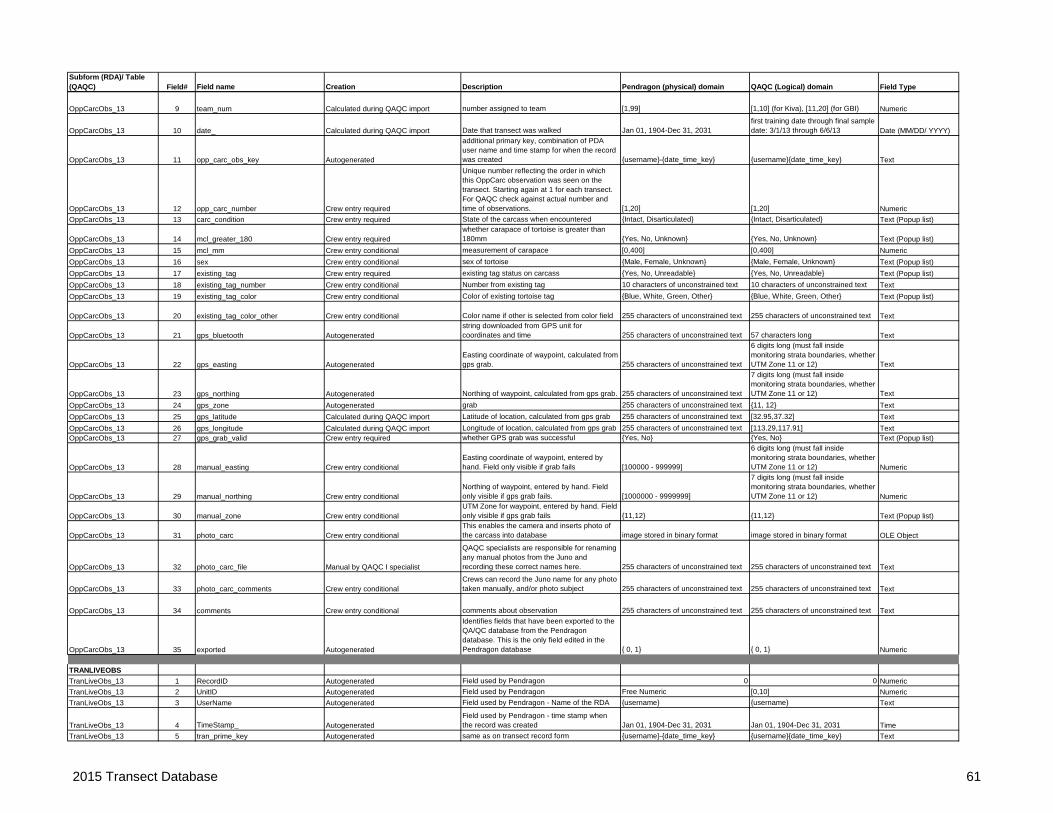
Subform (RDA)/ Table (QAQC) Field# Field name Creation Description Pendragon (physical) domain QAQC (Logical) domain Field Type
OppCarcObs_13 9 team_num Calculated during QAQC import number assigned to team [1,99] [1,10] (for Kiva), [11,20] (for GBI) Numeric
OppCarcObs_13 10 date_ Calculated during QAQC import Date that transect was walked Jan 01, 1904-Dec 31, 2031first training date through final sample date: 3/1/13 through 6/6/13 Date (MM/DD/ YYYY)
OppCarcObs_13 11 opp_carc_obs_key Autogenerated
additional primary key, combination of PDA user name and time stamp for when the record was created {username}-{date_time_key} {username}{date_time_key} Text
OppCarcObs_13 12 opp_carc_number Crew entry required
Unique number reflecting the order in which this OppCarc observation was seen on the transect. Starting again at 1 for each transect. For QAQC check against actual number and time of observations. [1,20] [1,20] Numeric
OppCarcObs_13 13 carc_condition Crew entry required State of the carcass when encountered {Intact, Disarticulated} {Intact, Disarticulated} Text (Popup list)
OppCarcObs_13 14 mcl_greater_180 Crew entry requiredwhether carapace of tortoise is greater than 180mm {Yes, No, Unknown} {Yes, No, Unknown} Text (Popup list)
OppCarcObs_13 15 mcl_mm Crew entry conditional measurement of carapace [0,400] [0,400] Numeric
OppCarcObs_13 16 sex Crew entry conditional sex of tortoise {Male, Female, Unknown} {Male, Female, Unknown} Text (Popup list)
OppCarcObs_13 17 existing_tag Crew entry required existing tag status on carcass {Yes, No, Unreadable} {Yes, No, Unreadable} Text (Popup list)
OppCarcObs_13 18 existing_tag_number Crew entry conditional Number from existing tag 10 characters of unconstrained text 10 characters of unconstrained text Text
OppCarcObs_13 19 existing_tag_color Crew entry conditional Color of existing tortoise tag {Blue, White, Green, Other} {Blue, White, Green, Other} Text (Popup list)
OppCarcObs_13 20 existing_tag_color_other Crew entry conditional Color name if other is selected from color field 255 characters of unconstrained text 255 characters of unconstrained text Text
OppCarcObs_13 21 gps_bluetooth Autogeneratedstring downloaded from GPS unit for coordinates and time 255 characters of unconstrained text 57 characters long Text
OppCarcObs_13 22 gps_easting AutogeneratedEasting coordinate of waypoint, calculated from gps grab. 255 characters of unconstrained text
6 digits long (must fall inside monitoring strata boundaries, whether UTM Zone 11 or 12) Text
OppCarcObs_13 23 gps_northing Autogenerated Northing of waypoint, calculated from gps grab. 255 characters of unconstrained text
7 digits long (must fall inside monitoring strata boundaries, whether UTM Zone 11 or 12) Text
OppCarcObs_13 24 gps_zone Autogeneratedyp , gp
grab 255 characters of unconstrained text {11, 12} Text
OppCarcObs_13 25 gps_latitude Calculated during QAQC import Latitude of location, calculated from gps grab 255 characters of unconstrained text [32.95,37.32] Text
OppCarcObs_13 26 gps_longitude Calculated during QAQC import Longitude of location, calculated from gps grab 255 characters of unconstrained text [113.29,117.91] TextOppCarcObs_13 27 gps_grab_valid Crew entry required whether GPS grab was successful {Yes, No} {Yes, No} Text (Popup list)
OppCarcObs_13 28 manual_easting Crew entry conditionalEasting coordinate of waypoint, entered by hand. Field only visible if grab fails [100000 - 999999]
6 digits long (must fall inside monitoring strata boundaries, whether UTM Zone 11 or 12) Numeric
OppCarcObs_13 29 manual_northing Crew entry conditionalNorthing of waypoint, entered by hand. Field only visible if gps grab fails. [1000000 - 9999999]
7 digits long (must fall inside monitoring strata boundaries, whether UTM Zone 11 or 12) Numeric
OppCarcObs_13 30 manual_zone Crew entry conditionalUTM Zone for waypoint, entered by hand. Field only visible if gps grab fails {11,12} {11,12} Text (Popup list)
OppCarcObs_13 31 photo_carc Crew entry conditionalThis enables the camera and inserts photo of the carcass into database image stored in binary format image stored in binary format OLE Object
OppCarcObs_13 32 photo_carc_file Manual by QAQC I specialist
QAQC specialists are responsible for renaming any manual photos from the Juno and recording these correct names here. 255 characters of unconstrained text 255 characters of unconstrained text Text
OppCarcObs_13 33 photo_carc_comments Crew entry conditionalCrews can record the Juno name for any photo taken manually, and/or photo subject 255 characters of unconstrained text 255 characters of unconstrained text Text
OppCarcObs_13 34 comments Crew entry conditional comments about observation 255 characters of unconstrained text 255 characters of unconstrained text Text
OppCarcObs_13 35 exported Autogenerated
Identifies fields that have been exported to the QA/QC database from the Pendragon database. This is the only field edited in the Pendragon database { 0, 1} { 0, 1} Numeric
TRANLIVEOBS
TranLiveObs_13 1 RecordID Autogenerated Field used by Pendragon 0 0 Numeric
TranLiveObs_13 2 UnitID Autogenerated Field used by Pendragon Free Numeric [0,10] Numeric
TranLiveObs_13 3 UserName Autogenerated Field used by Pendragon - Name of the RDA {username} {username} Text
TranLiveObs_13 4 TimeStamp_ AutogeneratedField used by Pendragon - time stamp when the record was created Jan 01, 1904-Dec 31, 2031 Jan 01, 1904-Dec 31, 2031 Time
TranLiveObs_13 5 tran_prime_key Autogenerated same as on transect record form {username}-{date_time_key} {username}{date_time_key} Text
2015 Transect Database 61

Subform (RDA)/ Table (QAQC) Field# Field name Creation Description Pendragon (physical) domain QAQC (Logical) domain Field Type
TranLiveObs_13 6 tran_num Calculated during QAQC import 5-digit number assigned to transect by MDEP [1, 6700]Valid transect number (always less than 6701) Numeric
TranLiveObs_13 7 stratum Calculated during QAQC importTwo- to four character code for monitoring strata {AG, BD, GB} {AG, BD, GB} Text (Lookup List)
TranLiveObs_13 8 group_ Calculated during QAQC import agency collecting the data {GBI, Kiva} {GBI, Kiva} Text (Popup List)
TranLiveObs_13 9 team_num Calculated during QAQC import number assigned to team [1,99] [1,10] (for Kiva), [11,20] (for GBI) Numeric
TranLiveObs_13 10 date_ Calculated during QAQC import Date that transect was walked Jan 01, 1904-Dec 31, 2031first training date through final sample date: 3/1/13 through 6/6/13 Date (MM/DD/ YYYY)
TranLiveObs_13 11 tran_live_obs_key Autogenerated
additional primary key, combination of PDA user name and time stamp for when the record was created {username}-{date_time_key} {username}{date_time_key} Text
TranLiveObs_13 12 tran_live_number Crew entry required
Unique number reflecting the order in which this TranLive observation was seen on the transect. Starting again at 1 for each transect. For QAQC check against actual number and time of observations. [1,15] [1,15] Numeric
TranLiveObs_13 13 observer Crew entry conditional which of the two observers saw the tortoise {Observer1, Observer2} {Observer1, Observer2} Text (Popup list)
TranLiveObs_13 14 observer_position Crew entry requiredwas the observer the leader or the follower when the tortoise was observed {Lead, Follow} {Lead, Follow} Text (Popup list)
TranLiveObs_13 15 last_wp Crew entry requiredWaypoint number of the last waypoint recorded before observation. {[1-40]} {[1-40]} Text (Lookup List)
TranLiveObs_13 16 time_ Crew entry required current time 12:00 AM-11:59 PM 5:00 AM-6:00 PM Time
TranLiveObs_13 17 tran_bearing Crew entry requiredthe bearing they intended to walk, 0, 90, 180, or 269 {0, 90, 180, 270, Other} {0, 90, 180, 270, Other} Text (Lookup List)
TranLiveObs_13 18 tran_bearing_other Crew entry conditionalIntended transect bearing other value (only if a non-right-angle turn was preplanned) [0-360] [0-360] Numeric
TranLiveObs_13 19 local_bearing Crew entry required
The bearing actually being walked at the time of the observation. Measured along the line between observers at the time observation was made. [0-360] [0-360] Numeric
TranLiveObs_13 20 azimuth Crew entry required
The angle of the tortoise observation from the actual transect line (as described by the local bearing). [0-360] [0-360] Numeric
TranLiveObs_13 21 radial_distance_m Crew entry required
Straight-line distance from the point of observation to the tortoise. Measured to one decimal place. [0-100] [0-60] Numeric
TranLiveObs_13 22 bearing_radians AutogeneratedLocal Bearing in radians. Hidden, Used to calculate Perp_Distance_m Free Numeric [0-6.3] Numeric
TranLiveObs_13 23 azimuth_radians AutogeneratedAzimuth in radians. Hidden, Used to calculate Perp_Distance_m Free Numeric [0-6.3] Numeric
TranLiveObs_13 24 perp_distance_m Autogenerated/Crew check requiredThe calculated perpendicular distance of the tortoise from the transect line Free Numeric [0-50] Numeric
TranLiveObs_13 25 cue_to_tortoise Crew entry requiredWhat intial signal led the observer to the tortoise?
{SearchedVeg, BodyPart, Movement, Burrow, BurrowApron, Audible}
{SearchedVeg, BodyPart, Movement, Burrow, BurrowApron, Audible} Text (Popup list)
TranLiveObs_13 26 tort_heading Crew entry requiredDirection tortoise is facing when it was seen relative to the observer's path of movement
{Profile, HeadOn, TailOn, PulledIntoShell, HeadIntoBurrow,HeadOutOfBurrow}
{Profile, HeadOn, TailOn, PulledIntoShell, HeadIntoBurrow,HeadOutOfBurrow} Text (Multiselect list)
TranLiveObs_13 27 tort_location Crew entry required Where the tortoise is when detected{Burrow, Pallet, Open, Vegetation, Rock}
{Burrow, Pallet, Open, Vegetation, Rock} Text (Popup list)
TranLiveObs_13 28 burrow_visibility Crew entry conditionalIf "burrow" to "tortoise_location", rate the visibility/detectability of the burrow. {High, Medium, Low} {High, Medium, Low} Text (Popup list)
TranLiveObs_13 29 tort_in_burrow_visibility Crew entry conditional
If Yes to in_burrow, rate the visibility/detectability of the tortoise given that the burrow is detected. {High, Medium, Low} {High, Medium, Low} Text (Popup list)
TranLiveObs_13 30 tort_visibility Crew entry conditionalIf other than "burrow" to "tortoise_location", rate the visibility/detectability of the tortoise. {High, Medium, Low} {High, Medium, Low} Text (Popup list)
TranLiveObs_13 31 dist_to_burrow_m Crew entry requiredClosest measured distance to a burrow. Use "100" for no burrow seen within 15m. Free Numeric [0-100] Numeric
TranLiveObs_13 32 temp_c Crew entry required [0, 50] [0, 50] NumericTranLiveObs_13 33 temp_greater_35C Crew entry required {Yes, No} {Yes, No} Text (Popup list)
2015 Transect Database 62

Subform (RDA)/ Table (QAQC) Field# Field name Creation Description Pendragon (physical) domain QAQC (Logical) domain Field Type
TranLiveObs_13 34 mcl_greater_180 Crew entry required
Whether the midline of the carapace is greater than 180mm. This field identifies tortoises that will be included in density estimation {Yes, No, Unknown} {Yes, No, Unknown} Text (Popup list)
TranLiveObs_13 35 mcl_mm Crew entry conditional Midline measurement of carapace in mm [0,400] [0,400] Numeric
TranLiveObs_13 36 sex Crew entry conditional Sex of tortoise {Male, Female, Unknown} {Male, Female, Unknown} Text (Popup list)
TranLiveObs_13 37 body_condition_score Crew entry conditionalOrdered category based on muscle mass and fat deposition {1, 2, 3, 4, 5, 6, 7, 8, 9, Unk} {1, 2, 3, 4, 5, 6, 7, 8, 9, Unk} Text (Popup list)
TranLiveObs_13 38 nares_appearance Crew entry conditionalDescriptive category based on appearance of nares
{normal, asymmetrical, eroded, occluded, unknown}
{normal, asymmetrical, eroded, occluded, unknown} Text (Multiselect list)
TranLiveObs_13 39 nares_discharge Crew entry conditionalDescriptive category based on muscle mass and fat deposition
{None, Serous1, Serous2, Serous3, Mucous1, Mucous2, Mucous3, Unknown}
{None, Serous1, Serous2, Serous3, Mucous1, Mucous2, Mucous3, Unknown} Text (Popup list)
TranLiveObs_13 40 ticks Crew entry conditionalOrdered category based on number of attached ticks {0, 1-10, >10, Unknown} {0, 1-10, >10, Unknown} Text (Popup list)
TranLiveObs_13 41 existing_tag Crew entry required existing tag status on tortoise {Yes, No, Unreadable, Unknown} {Yes, No, Unreadable, Unknown} Text (Popup list)TranLiveObs_13 42 existing_tag_number Crew entry conditional tag number if existing tag exists 10 characters of unconstrained text 10 characters of unconstrained text TextTranLiveObs_13 43 existing_tag_color Crew entry conditional Color of existing tortoise tag {Blue, White, Green, Other} {Blue, White, Green, Other} Text (Popup list)
TranLiveObs_13 44 existing_tag_color_other Crew entry conditional Color name if other is selected from color field Free Text Free Text TextTranLiveObs_13 45 new_tag_attached Crew entry conditional Was a new tag attached? {Yes, No} {Yes, No} Text (Popup list)TranLiveObs_13 46 new_tag_number Crew entry conditional Tag number if new tag attached 10 characters of unconstrained text 10 characters of unconstrained text TextTranLiveObs_13 47 tort_void Crew entry required Tortoise releases its bladder or defecates {None,Urine,Feces,Both} {None,Urine,Feces,Both} Text (Popup list)
TranLiveObs_13 48 tort_not_handled Crew entry conditional
If mcl_mm, sex not entered, or if tag not present and not attached, crew should indicate the reason
{deep in burrow, scutes too small, social interaction, research area, temperature, voided, no permit, other}
{deep in burrow, scutes too small, social interaction, research area, temperature, voided, no permit, other} Text (Popup List)
TranLiveObs_13 49 tort_not_handled_other Crew entry conditional
If mcl_mm, sex will not be entered, or if tag not present and not attached, if reason not in drop down list, they should enter free-hand 255 characters of unconstrained text 255 characters of unconstrained text Text
TranLiveObs_13 50 gps_bluetooth Autogeneratedstring downloaded from GPS unit for coordinates and time 255 characters of unconstrained text 57 characters long Text
TranLiveObs_13 51 gps_easting AutogeneratedEasting coordinate of waypoint, calculated from gps grab. 255 characters of unconstrained text
6 digits long (must fall inside monitoring strata boundaries, whether UTM Zone 11 or 12) Text
TranLiveObs_13 52 gps_northing Autogenerated Northing of waypoint, calculated from gps grab. 255 characters of unconstrained text
7 digits long (must fall inside monitoring strata boundaries, whether UTM Zone 11 or 12) Text
TranLiveObs_13 53 gps_zone AutogeneratedUTM Zone of waypoint, calculated from gps grab 255 characters of unconstrained text {11, 12} Text
TranLiveObs_13 54 gps_latitude Calculated during QAQC import Latitude of location, calculated from gps grab 255 characters of unconstrained text [32.95,37.32] Text
TranLiveObs_13 55 gps_longitude Calculated during QAQC import Longitude of location, calculated from gps grab 255 characters of unconstrained text [113.29,117.91] TextTranLiveObs_13 56 gps_grab_valid Crew entry required whether GPS grab was successful {Yes, No} {Yes, No} Text (Popup list)
TranLiveObs_13 57 manual_easting Crew entry conditionalEasting coordinate of waypoint, entered by hand. Field only visible if grab fails [100000 - 999999]
6 digits long (must fall inside monitoring strata boundaries, whether UTM Zone 11 or 12) Numeric
TranLiveObs_13 58 manual_northing Crew entry conditionalNorthing of waypoint, entered by hand. Field only visible if gps grab fails. [1000000 - 9999999]
7 digits long (must fall inside monitoring strata boundaries, whether UTM Zone 11 or 12) Numeric
TranLiveObs_13 59 manual_zone Crew entry conditionalUTM Zone for waypoint, entered by hand. Field only visible if gps grab fails {11,12} {11,12} Text (Popup list)
TranLiveObs_13 60 photo_tort1 Crew entry conditional
This enables the camera and inserts photo of the tortoise into database. At least one photo should be taken looking down on the tortoise's head, capturing the head and possibly upper half of the forelimbs. image stored in binary format image stored in binary format OLE object
TranLiveObs_13 61 photo_tort1_file Manual by QAQC I specialist
QAQC specialists are responsible for renaming any manual photos from the Juno and recording these correct names here. 255 characters of unconstrained text 255 characters of unconstrained text Text
TranLiveObs_13 62 photo_tort1_comments Crew entry conditionalCrews can record the Juno name for any photo taken manually, and/or photo subject 255 characters of unconstrained text 255 characters of unconstrained text Text
2015 Transect Database 63

Subform (RDA)/ Table (QAQC) Field# Field name Creation Description Pendragon (physical) domain QAQC (Logical) domain Field Type
TranLiveObs_13 63 photo_tort2 Crew entry conditional
This enables the camera and inserts photo of the tortoise into database. At least one photo should be taken looking down on the tortoise's head, capturing the head and possibly upper half of the forelimbs. image stored in binary format image stored in binary format OLE object
TranLiveObs_13 64 photo_tort2_file Manual by QAQC I specialist
QAQC specialists are responsible for renaming any manual photos from the Juno and recording these correct names here. 255 characters of unconstrained text 255 characters of unconstrained text Text
TranLiveObs_13 65 photo_tort2_comments Crew entry conditionalCrews can record the Juno name for any photo taken manually, and/or photo subject 255 characters of unconstrained text 255 characters of unconstrained text Text
TranLiveObs_13 66 comments Crew entry conditional comments about observation 255 characters of unconstrained text 255 characters of unconstrained text Text
TranLiveObs_13 67 exported Autogenerated
Identifies fields that have been exported to the QA/QC database from the Pendragon database. This is the only field edited in the Pendragon database { 0, 1} { 0, 1} Numeric
TRANCARCOBS
TranCarcObs_13 1 RecordID Autogenerated Field used by Pendragon 0 0 Numeric
TranCarcObs_13 2 UnitID Autogenerated Field used by Pendragon Free Numeric [0,10] Numeric
TranCarcObs_13 3 UserName Autogenerated Field used by Pendragon - Name of the RDA {username} {username} Text
TranCarcObs_13 4 TimeStamp_ Autogenerated the record was created Jan 01, 1904-Dec 31, 2031 Jan 01, 1904-Dec 31, 2031 Time
TranCarcObs_13 5 tran_prime_key Autogenerated same as on transect record form {username}-{date_time_key} {username}{date_time_key} Text
TranCarcObs_13 6 tran_num Calculated during QAQC import 5-digit number assigned to transect by MDEP [1, 6700]Valid transect number (always less than 6701) Numeric
TranCarcObs_13 7 stratum Calculated during QAQC importTwo- to four character code for monitoring strata {AG, BD, GB} {AG, BD, GB} Text (Lookup List)
TranCarcObs_13 8 group_ Calculated during QAQC import agency collecting the data {GBI, Kiva} {GBI, Kiva} Text (Popup List)
TranCarcObs_13 9 team_num Calculated during QAQC import number assigned to team [1,99] [1,10] (for Kiva), [11,20] (for GBI) Numeric
TranCarcObs_13 10 date_ Calculated during QAQC import Date that transect was walked Jan 01, 1904-Dec 31, 2031first training date through final sample date: 3/1/13 through 6/6/13 Date (MM/DD/ YYYY)
TranCarcObs_13 11 tran_carc_obs_key Autogenerated
additional primary key, combination of PDA user name and time stamp for when the record was created {username}-{date_time_key} {username}{date_time_key} Text
TranCarcObs_13 12 tran_carc_number Crew entry required
Unique number reflecting the order in which this TranCarc observation was seen on the transect. Starting again at 1 for each transect. For QAQC check against actual number and time of observations. [1,40] [1,40] Numeric
TranCarcObs_13 13 observer Crew entry conditional which of the two observers saw the tortoise {Observer1, Observer2} {Observer1, Observer2} Text (Popup list)
TranCarcObs_13 14 observer_position Crew entry requiredwas the observer the leader or the follower when the tortoise was observed {Lead, Follow} {Lead, Follow} Text (Popup list)
TranCarcObs_13 15 last_wp Crew entry required last waypoint recorded in transect {[1-40]} {[1-40]} Text (Lookup List)TranCarcObs_13 16 time_ Crew entry required current time 12:00 AM-11:59 PM 5:00 AM-6:00 PM Time
TranCarcObs_13 17 tran_bearing Crew entry requiredthe bearing they intended to walk, 0, 90, 180, or 269 {0, 90, 180, 270, Other} {0, 90, 180, 270, Other} Text (Lookup List)
TranCarcObs_13 18 tran_bearing_other Crew entry conditional transect bearing other value [0-360] [0-360] Numeric
TranCarcObs_13 19 local_bearing Crew entry requiredthe bearing actually being walked at the time of the observation [0-360] [0-360] Numeric
TranCarcObs_13 20 azimuth Crew entry required Azimuth to the tortoise [0-360] [0-360] NumericTranCarcObs_13 21 radial_distance_m Crew entry required distance to tortoise [0-60] [0-60] Numeric
TranCarcObs_13 22 bearing_radians AutogeneratedLocal Bearing in radians. Hidden, Used to calculate Perp_Distance_m Free Numeric [0-6.3] Numeric
TranCarcObs_13 23 azimuth_radians AutogeneratedAzimuth in radians. Hidden, Used to calculate Perp_Distance_m Free Numeric 0-6.3 Numeric
TranCarcObs_13 24 perp_distance_m Autogenerated/Crew check requiredPerpendicular distance calculated to the tortoise Free Numeric [0-50] Numeric
TranCarcObs_13 25 carc_condition Crew entry required State of the carcass when encountered {Intact, Disarticulated} {Intact, Disarticulated} Text (Popup list)
TranCarcObs_13 26 mcl_greater_180 Crew entry required measurement of carapace {Yes, No, Unknown} {Yes, No, Unknown} Text (Popup list)TranCarcObs_13 27 mcl_mm Crew entry conditional measurement of carapace [0,400] [0,400] NumericTranCarcObs_13 28 sex Crew entry conditional sex of tortoise {Male, Female, unknown} {Male, Female, unknown} Text (Popup list)TranCarcObs_13 29 existing_tag Crew entry required existing tag status on carcass {Yes, No, Unreadable} {Yes, No, Unreadable} Text (Popup list)
2015 Transect Database 64

Subform (RDA)/ Table (QAQC) Field# Field name Creation Description Pendragon (physical) domain QAQC (Logical) domain Field TypeTranCarcObs_13 30 existing_tag_number Crew entry conditional Number from existing tag 10 characters of unconstrained text 10 characters of unconstrained text TextTranCarcObs_13 31 existing_tag_color Crew entry conditional Color of existing tortoise tag {Blue, White, Green, Other} {Blue, White, Green, Other} Text (Popup list)
TranCarcObs_13 32 existing_tag_color_other Crew entry conditional Color name if other is selected from color field 255 characters of unconstrained text 255 characters of unconstrained text Text
TranCarcObs_13 33 gps_bluetooth Autogeneratedstring downloaded from GPS unit for coordinates and time 255 characters of unconstrained text 57 characters long Text
TranCarcObs_13 34 gps_easting AutogeneratedEasting coordinate of waypoint, calculated from gps grab. 255 characters of unconstrained text
6 digits long (must fall inside monitoring strata boundaries, whether UTM Zone 11 or 12) Text
TranCarcObs_13 35 gps_northing Autogenerated Northing of waypoint, calculated from gps grab. 255 characters of unconstrained text
7 digits long (must fall inside monitoring strata boundaries, whether UTM Zone 11 or 12) Text
TranCarcObs_13 36 gps_zone AutogeneratedUTM Zone of waypoint, calculated from gps grab 255 characters of unconstrained text {11, 12} Text
TranCarcObs_13 37 gps_latitude Calculated during QAQC import Latitude of location, calculated from gps grab 255 characters of unconstrained text [32.95,37.32] Text
TranCarcObs_13 38 gps_longitude Calculated during QAQC import Longitude of location, calculated from gps grab 255 characters of unconstrained text [113.29,117.91] TextTranCarcObs_13 39 gps_grab_valid Crew entry required whether GPS grab was successful {Yes, No} {Yes, No} Text (Popup list)
TranCarcObs_13 40 manual_easting Crew entry conditionalEasting coordinate of waypoint, entered by hand. Field only visible if grab fails [100000 - 999999]
6 digits long (must fall inside monitoring strata boundaries, whether UTM Zone 11 or 12) Numeric
TranCarcObs_13 41 manual_northing Crew entry conditionalNorthing of waypoint, entered by hand. Field only visible if gps grab fails. [1000000 - 9999999]
7 digits long (must fall inside monitoring strata boundaries, whether UTM Zone 11 or 12) Numeric
TranCarcObs_13 42 manual_zone Crew entry conditionalUTM Zone for waypoint, entered by hand. Field only visible if gps grab fails {11,12} {11,12} Text (Popup list)
TranCarcObs_13 43 photo_carc Crew entry conditionalThis enables the camera and inserts photo of the carcass into database image stored in binary format image stored in binary format OLE Object
TranCarcObs_13 44 photo_carc_file Manual by QAQC I specialist
QAQC specialists are responsible for renaming any manual photos from the Juno and recording these correct names here. 255 characters of unconstrained text 255 characters of unconstrained text Text
TranCarcObs_13 45 photo_carc_comments Crew entry conditionalCrews can record the Juno name for any photo taken manually, and/or photo subject 255 characters of unconstrained text 255 characters of unconstrained text Text
TranCarcObs_13 46 comments Crew entry conditional comments about observation 255 characters of unconstrained text 255 characters of unconstrained text Text
TranCarcObs_13 47 exported Autogenerated
Identifies fields that have been exported to the QA/QC database from the Pendragon database. This is the only field edited in the Pendragon database { 0, 1} { 0, 1} Numeric
2015 Transect Database 65

Subform (RDA)/ Table (QAQC) Field # Field name Creation Description Pendragon (physical) domain QAQC (Logical) domain TypeG0_STARTG0_Start_13 1 RecordID Autogenerated Field used by Pendragon 0 0 NumericG0_Start_13 2 UnitID Autogenerated Field used by Pendragon Free Numeric [0,10] NumericG0_Start_13 3 UserName Autogenerated Field used by Pendragon - Name of the RDA {username} {username} Text
G0_Start_13 4 TimeStamp_ AutogeneratedField used by Pendragon - time stamp when the record was created Jan 01, 1904-Dec 31, 2031 Jan 01, 1904-Dec 31, 2031 Time
G0_Start_13 5 G0_prime_key AutogeneratedPrimary Key - Combination of PDA user name and a time stamp for when the record was created {username}-{date_time_key} {username}{date_time_key} Text
G0_Start_13 6 date_Autogenerated/Crew check required Date on which tortoises were located Jan 01, 1904-Dec 31, 2031
first training date through final sample date: 3/1/13 through 6/6/13 Date
G0_Start_13 7 G0_site Crew entry required Name of GSub0 (telemetry) site
{Chemehuevi, Chuckwalla, Coyote Springs, Gold Butte, Halfway, Ivanpah, Joshua Tree, LSTS, Piute Mid, Ord Rodman, River Mtns, Superior Cronese}
{Chemehuevi, Chuckwalla, Coyote Springs, Gold Butte, Halfway, Ivanpah, Joshua Tree, LSTS, Piute Mid, Ord Rodman, River Mtns, Superior Cronese} Text (Lookup List)
G0_Start_13 8 group_ Crew entry required agency collecting the data {GBI, IWS, Kiva, JOTR} {GBI, IWS, Kiva, JOTR} Text (Popup List)G0_Start_13 9 observer Crew entry required Name of observer { -- all observer names -- } {first name} {last name} Text (Lookup List)
G0_Start_13 10 start_time Calculated during QAQC importTime the observer(s) first observed telemetered tortoises on this date 12:00 AM-11:59 PM 5:00 AM-10:00 AM Time
G0_Start_13 11 photo1 Crew entry conditional Initial pictures of the site image stored in binary format image stored in binary format OLE Object
G0_Start_13 12 photo1_file Manual by QAQC I specialist
QAQC specialists are responsible for renaming any manual photos from the Juno and recording these correct names here. 255 characters of unconstrained text 255 characters of unconstrained text Text
G0_Start_13 13 photo1_comments Crew entry conditionalCrews can record the Juno name for any photo taken manually, and/or photo subject 255 characters of unconstrained text 255 characters of unconstrained text Text
G0_Start_13 14 photo2 Crew entry conditional Initial pictures of the site image stored in binary format image stored in binary format OLE Object
G0_Start_13 15 photo2_file Manual by QAQC I specialist
QAQC specialists are responsible for renaming any manual photos from the Juno and recording these correct names here. 255 characters of unconstrained text 255 characters of unconstrained text Text
G0_Start_13 16 photo2_comments Crew entry conditionalCrews can record the Juno name for any photo taken manually, and/or photo subject 255 characters of unconstrained text 255 characters of unconstrained text Text
G0_Start_13 17 photo3 Crew entry conditional Initial pictures of the site image stored in binary format image stored in binary format OLE Object
G0_Start_13 18 photo3_file Manual by QAQC I specialist
QAQC specialists are responsible for renaming any manual photos from the Juno and recording these correct names here. 255 characters of unconstrained text 255 characters of unconstrained text Text
G0_Start_13 19 photo3_comments Crew entry conditionalCrews can record the Juno name for any photo taken manually, and/or photo subject 255 characters of unconstrained text 255 characters of unconstrained text Text
G0_Start_13 20 photo4 Crew entry conditional Initial pictures of the site image stored in binary format image stored in binary format OLE Object
G0_Start_13 21 photo4_file Manual by QAQC I specialist
QAQC specialists are responsible for renaming any manual photos from the Juno and recording these correct names here. 255 characters of unconstrained text 255 characters of unconstrained text Text
G0_Start_13 22 photo4_comments Crew entry conditionalCrews can record the Juno name for any photo taken manually, and/or photo subject 255 characters of unconstrained text 255 characters of unconstrained text Text
G0_Start_13 23 end_time Calculated during QAQC importTime the observer(s) last observed telemetered tortoises on this date 12:00 AM-11:59 PM 8:00 AM-6:30 PM Time
G0_Start_13 24 comments Crew entry conditionalNotes from the observer about the g0 site and/or conditions 255 characters of unconstrained text 255 characters of unconstrained text Text
G0_Start_13 25 exported Autogenerated
Identifies fields that have been exported to the QA/QC database from the Pendragon database. This is the only field edited in the Pendragon database { 0, 1} { 0, 1} Numeric
2015 G0 Database 66

Subform (RDA)/ Table (QAQC) Field # Field name Creation Description Pendragon (physical) domain QAQC (Logical) domain TypeG0_OBSG0_Obs_13 1 RecordID Autogenerated Field used by Pendragon 0 0 NumericG0_Obs_13 2 UnitID Autogenerated Field used by Pendragon Free Numeric [0,10] NumericG0_Obs_13 3 UserName Autogenerated Field used by Pendragon - Name of the RDA {username} {username} Text
G0_Obs_13 4 TimeStamp_ AutogeneratedField used by Pendragon - time stamp when the record was created Jan 01, 1904-Dec 31, 2031 Jan 01, 1904-Dec 31, 2031 Time
G0_Obs_13 5 G0_prime_key Autogenerated same as on Gsub0 Start form {username}-{date_time_key} {username}{date_time_key} Text
G0_Obs_13 6 G0_obs_key AutogeneratedPrimary Key - Combination of PDA user name and a time stamp for when the record was created {username}-{date_time_key} {username}{date_time_key} Text
G0_Obs_13 7 date_ Calculated during QAQC import Date on which tortoises were located Jan 01, 1904-Dec 31, 2031first training date through final sample date: 3/1/13 through 6/6/13 Date
G0_Obs_13 8 G0_site Calculated during QAQC import same as on Gsub0 Start form
{Chemehuevi, Chuckwalla, Coyote Springs, Gold Butte, Halfway, Ivanpah, Joshua Tree, LSTS, Piute Mid, Ord Rodman, River Mtns, Superior Cronese}
{Chemehuevi, Chuckwalla, Coyote Springs, Gold Butte, Halfway, Ivanpah, Joshua Tree, LSTS, Piute Mid, Ord Rodman, River Mtns, Superior Cronese} Text
G0_Obs_13 9 group_ Calculated during QAQC import Entity collecting the data {GBI, IWS, Kiva} {GBI, IWS, Kiva} Text (Popup List)
G0_Obs_13 10 observer Calculated during QAQC import Name of observer { -- all observer names -- } {first name} {last name} Text (Lookup List)
G0_Obs_13 11 tort_numAutogenerated/Crew check required Number on the observed tortoise 8 characters of unconstrained text 8 characters of unconstrained text Text
G0_Obs_13 12 time_ Crew entry required time of observation 12:00 AM-11:59 PM 5:00 AM-6:30 PM Time
G0_Obs_13 13 burned If this is a burned location - Coyote Springs and Halfway Wash sites only {Not Applicable, Yes, No} {Not Applicable, Yes, No} Text (Popup list)
G0_Obs_13 14 visible Crew entry required
Whether or not the tortoise is visible. Even if not, these fields should be available: burrow_visibility, tort_in_burrow_visibility, and tort_visibility. {Yes,No} {Yes,No} Text (Popup list)
G0_Obs_13 15 tort_location Crew entry required Where the tortoise is when detected {Burrow, Pallet, Open, Vegetation, Rock} {Burrow, Pallet, Open, Vegetation, Rock} Text (Popup list)
G0_Obs_13 16 burrow_visibility Crew entry conditionalIf "burrow" to "tortoise_location", rate the visibility/detectability of the burrow. {High, Medium, Low, NotVisible} {High, Medium, Low, NotVisible} Text (Popup list)
G0_Obs_13 17 tort_in_burrow_visibility Crew entry conditional
If "burrow" to "tortoise_location", rate the visibility/detectability of the tortoise given that the burrow is detected. {High, Medium, Low, NotVisible} {High, Medium, Low, NotVisible} Text (Popup list)
G0_Obs_13 18 tort_visibility Crew entry conditionalIf other than "burrow" to "tortoise_location", rate the visibility/detectability of the tortoise. {High, Medium, Low, NotVisible} {High, Medium, Low, NotVisible} Text (Popup list)
G0_Obs_13 19 dist_to_burrow_m Crew entry requiredClosest measured distance to a burrow. Use "100" for no burrow seen within 15m. Free Numeric [0-100] Numeric
G0_Obs_13 20 behavior Crew entry required tortoise's behavior{Unknown, at Rest-active, Moving, Basking, Eating, Mating, Agonistic, Digging}
{Unknown, at Rest-active, Moving, Basking, Eating, Mating, Agonistic, Digging} Text (Popup list)
G0_Obs_13 21 gps_bluetooth Autogeneratedstring downloaded from GPS unit for coordinates and time 255 characters of unconstrained text 57 characters long Text
G0_Obs_13 22 gps_easting AutogeneratedEasting coordinate of waypoint, calculated from gps grab. 255 characters of unconstrained text
6 digits long (must fall inside monitoring strata boundaries, whether UTM Zone 11 or 12) Text
G0_Obs_13 23 gps_northing Autogenerated Northing of waypoint, calculated from gps grab. 255 characters of unconstrained text7 digits long (must fall inside monitoring strata boundaries, whether UTM Zone 11 or 12) Text
G0_Obs_13 24 gps_zone Autogenerated UTM Zone of waypoint, calculated from gps grab 255 characters of unconstrained text {11, 12} Text
G0_Obs_13 25 gps_latitude Calculated during QAQC import Latitude of location, calculated from gps grab 255 characters of unconstrained text [32.95,37.32] Text
G0_Obs_13 26 gps_longitude Calculated during QAQC import Longitude of location, calculated from gps grab 255 characters of unconstrained text [113.29,117.91] TextG0_Obs_13 27 gps_grab_valid Crew entry required whether GPS grab was successful {Yes, No} {Yes, No} Text (Popup list)
G0_Obs_13 28 manual_easting Crew entry conditionalEasting coordinate of waypoint, entered by hand. Field only visible if grab fails [100000 - 999999]
6 digits long (must fall inside monitoring strata boundaries, whether UTM Zone 11 or 12) Numeric
G0_Obs_13 29 manual_northing Crew entry conditionalNorthing of waypoint, entered by hand. Field only visible if gps grab fails. [1000000 - 9999999]
7 digits long (must fall inside monitoring strata boundaries, whether UTM Zone 11 or 12) Numeric
G0_Obs_13 30 comments Crew entry conditional Comments about this observation 255 characters of unconstrained text 255 characters of unconstrained text Text
G0_Obs_13 31 exported Autogenerated
Identifies fields that have been exported to the QA/QC database from the Pendragon database. This is the only field edited in the Pendragon database { 0, 1} { 0, 1} Numeric
2015 G0 Database 67

Table (QAQC)Field# Field name Creation Description QAQC (Logical) domain Field Type
ERRORS_TRAINING
Errors_Training_13 1 ID Autogenerated Auto-number used to identify record Free Numeric Numeric
Errors_Training_13 2 date_ Autogenerated The date when the QA/QC scripts were run first training date through final sample date: 3/1/13 through 6/6/13 Date
Errors_Training_13 3 table_name Autogenerated Table name of the erroneous record {Train_Tran_13, Train_Obs_13} Text
Errors_Training_13 4 training_date Autogenerated training date for erroneous recordfirst training date through final sample date: 3/1/13 through 6/6/13 Date
Errors_Training_13 5 trial_number Autogenerated trail number for erroneous record [1,3] NumericErrors_Training_13 6 team_num Autogenerated team number for erroneous record [01,99] NumericErrors_Training_13 7 training_line_color Autogenerated training line color of the erroneous record {username}-{date_time_key} Text
Errors_Training_13 8 transect Autogenerated transect segment number for the erroneous record
{Red_1, Red_2, Red_5, Red_6, Yellow_1, Yellow_2, Yellow_5, Yellow_6, Magenta_1, Magenta_2, Magenta_5, Magenta_6, White_3, White_4, White_7, White_8, Orange_3, Orange_4, Orange_7, Orange_8, Green_3, Green_4, Green_7, Green_8} Numeric
Errors_Training_13 9 prime_key Autogenerated Primary key of the erroneous record Primary key of the erroreous record TextErrors_Training_13 10 tortoise_id Autogenerated tortoise_id for the erroneous record [0,288] NumericErrors_Training_13 11 error_desc Autogenerated Short description on type of error found { -- values in Data Mgt Plan ---} TextErrors_Training_13 12 old_value Autogenerated Old incorrect value of the field Free Text Text
Errors_Training_13 13 new_valueQAQC Specialist Entry required New correct value entered by QA/QC specialist Free Text Text
Errors_Training_13 14 resolutionQAQC Specialist Entry required Resolution steps taken by QA/QC specialist
{ -- Free Text following patterns in Data Mgt Plan ---} Text
Errors_Training_13 15 resolverQAQC Specialist Entry required Name of agency correcting the errors { QAQC specialist initials} Text
Errors_Training_13 16 error_statusQAQC Specialist Entry required Status of error after correction
{ exception allowed, resolved, scripts error, additional comments, unresolved} Text
ERROR_TRANSECTSErrors_Transects_13 1 ID Autogenerated Auto-number used to identify record Free Numeric Numeric
Errors_Transects_13 2 date_ Autogenerated The date when the QA/QC scripts were run first training date through final sample date: 3/1/13 through 6/6/13 Date
Errors_Transects_13 3 table_name Autogenerated Table name of the erroneous record
{Transects_13, Waypoints_13, OppLive_13, OppCarc_13, TranLive_13, TranCarc_13} Text
Errors_Transects_13 4 tran_date Autogenerated Transect date of erroneous recordfirst training date through final sample date: 3/1/13 through 6/6/13 Date
Errors_Transects_13 5 tran_num Autogenerated Transect number of erroneous recordValid transect number (always less than 6701) Numeric
2015 Database Error Tables 68

Table (QAQC)Field# Field name Creation Description QAQC (Logical) domain Field Type
Errors_Transects_13 6 stratum Autogenerated stratum for erroneous record {AG, BD, GB} TextErrors_Transects_13 7 team_num Autogenerated Agency collecting the erroneous record {GBI, Kiva} TextErrors_Transects_13 8 prime_key Autogenerated Primary key of the erroneous record {username}-{date_time_key} TextErrors_Transects_13 9 wp_obs_num Autogenerated Waypoint or observation number of the erroneous record {[0-40], 99, 100} NumericErrors_Transects_13 10 error_desc Autogenerated Short description on type of error found { -- values in Data Mgt Plan ---} TextErrors_Transects_13 11 old_value Autogenerated Old incorrect value of the field Free Text TextErrors_Transects_13 12 new_value QAQC Specialist EntrNew correct value entered by QA/QC specialist Free Text Text
Errors_Transects_13 13 resolution QAQC Specialist EntrResolution steps taken by QA/QC specialist{ -- Free Text following patterns in Data Mgt Plan ---} Text
Errors_Transects_13 14 resolver QAQC Specialist EntrName of agency correcting the errors { QAQC specialist initials} Text
Errors_Transects_13 15 error_status QAQC Specialist EntrStatus of error after correction { exception allowed, resolved, scripts error, additional comments, unresolved} Text
ERRORS_G0
Errors_G0_13 1 ID Autogenerated Auto-number used to identify record Free Numeric Numeric
Errors_G0_13 2 date_ Autogenerated The date when the QA/QC scripts were run first training date through final sample date: 3/1/13 through 6/6/13 Date
Errors_G0_13 3 table_name Autogenerated Table name of the erroneous record { --- list of all tables in the database --} Text
Errors_G0_13 4 G0_date Autogenerated G0 Date value for the erroneous recordfirst training date through final sample date: 3/1/13 through 6/6/13 Date
Errors_G0_13 5 G0_site Autogenerated G0 site for the erroneous record
{Chemehuevi, Chuckwalla, Coyote Springs, Gold Butte, Halfway, Ivanpah, Joshua Tree, LSTS, Piute Mid, Ord Rodman, River Mtns, Superior Cronese} Text
Errors_G0_13 6 observer Autogenerated Name of observer {first name} {last name} TextErrors_G0_13 7 group_ Autogenerated Agency collecting the erroneous record {GBI, Kiva} TextErrors_G0_13 8 prime_key Autogenerated Primary key of the erroneous record {username}-{date_time_key} Text
Errors_G0_13 9 tort_obs_num Autogenerated Tortoise ID or observation number of the erroneous record[1,15] OR 8 characters of unconstrained text Text
Errors_G0_13 10 error_desc Autogenerated Short description on type of error found { -- values in Data Mgt Plan ---} TextErrors_G0_13 11 old_value Autogenerated Old incorrect value of the field Free Text TextErrors_G0_13 12 new_value QAQC Specialist EntrNew correct value entered by QA/QC specialist Free Text Text
Errors_G0_13 13 resolution QAQC Specialist EntrResolution steps taken by QA/QC specialist{ -- Free Text following patterns in Data Mgt Plan ---} Text
Errors_G0_13 14 resolver QAQC Specialist EntrName of agency correcting the errors { QAQC specialist name} Text
Errors_G0_13 15 error_status QAQC Specialist EntrStatus of error after correction { exception allowed, resolved, scripts error, additional comments, unresolved} Text
2015 Database Error Tables 69

Tables Field ValuesError_Training_13 error_desc missing waypoint xxxError_Transects_13 missing parent recordError_G0_13 duplicate tran_num
duplicate waypointobserver1 and observer2 are the sameobserver 1 is Nullobserver2 is Nullinconsistency between existing tag and new tag attached[time_field] is not within domain [beg] to [end][date_field] is not within domain [beg] to [end]inconsistency between mcl_mm and mcl_greater_180mcl_mm is 0inconsistency between carc_condition and mcl_mminconsistency between tort_location and mcl_mminconsistency between temp_C and temp_greater_35CInconsistency between visibility and behaviorsite is HW, but burned is nullsite is not HW, but burned is not nullduplicate training transectcontains duplicate tortoise_id, trial_number, team_number, and training_line_color valuesobserver_name and observer_position do not match lead or follow in Train_Tran tabletransect_seg_num does not match transect bearing and start posttraining_start_time is after training_end_timeradial_distance_m has more than one decimal placelocal_bearing is not within 40 degrees of tran_bearingobservation_time is not between training_start_time and training_end_timeperp_dist_m is greater than radial_distance_mperp_distance_m is greater than 25 mgps_zone or manual_zone are 12, but stratum is not BD or GBmissing gps zone or manual zoneeasting or northing are not within stratum boundarymissing gps or manual easting or northing
2015 Error Lookups 70