7 september 2012 - nile basin initiative...7 september 2012 nile basin initiative - nile equatorial...
TRANSCRIPT
NILE BASIN INITIATIVE Nile Equatorial Lakes Subsidiary Action Program
GUIDELINES FOR CLIMATE ADAPTATION MAINSTREAMING IN WATER INFRASTRUCTURE DEVELOPMENT
77 SSeepptteemmbbeerr 22001122

Nile Basin Initiative - Nile Equatorial Lakes Subsidiary Action Program
p:\chazot\800250_nelsap_guide_cc\40_rapports\4.2_task1\nelsap_cc_guidelines_v3.doc / Nhamel
Guidelines for Climate Adaptation Mainstreaming in Water Infrastructure Development
1
GUIDELINES FOR CLIMATE ADAPTATION
MAINSTREAMING IN WATER INFRASTRUCTURE
DEVELOPMENT
EXECUTIVE SUMMARY......................................................................................... 5
GLOSSARY OF TERMS ................................. ...................................................... 12
ABBREVIATIONS AND ACRONYMS ........................ .......................................... 15
1. INTRODUCTION ............................................................................................ 17
1.1 Background 17
1.2 Context 19
1.3 The Guidelines 19
1.3.1 Need for the Guidelines 19
1.3.2 Role and purpose of the guidelines 19
1.3.3 Elements 19
1.3.4 Audience 20
1.3.5 Scope 20
2. UNDERSTANDING THE CLIMATE ADAPTATION MAINSTREAMING CONCEPT ...................................................................................................... 21
2.1 What is climate adaptation mainstreaming? 21
2.2 Conceptual framework for climate adaptation mainstr eaming for water resources investments 21
2.3 Some advantages and benefits of climate adaptation mainstreaming 22
2.4 Limitations of climate adaptation mainstreaming 22
3. MAINSTREAMING CLIMATE ADAPTATION INTO THE PROJECT CYCLE FOR WATER RESOURCES INVESTMENTS ............. ...................... 24
3.1 Key Parameters 24
Nile Basin Initiative - Nile Equatorial Lakes Subsidiary Action Program
p:\chazot\800250_nelsap_guide_cc\40_rapports\4.2_task1\nelsap_cc_guidelines_v3.doc / Nhamel
Guidelines for Climate Adaptation Mainstreaming in Water Infrastructure Development |
3.2 Integrating Climate adaptation into the Project Dev elopment Cycle 24
3.3 Guiding Principles 25
3.4 Guiding Questions 27
3.4.1 Is the Project Concerned by Climate Change? 27
3.4.2 What are the present concerns in the area of the project? 28
3.4.3 How could the area of the project be impacted by climate change? 28
3.4.4 What will be the impacts of climate change on the project? 29
3.4.5 How to mainstream climate change into project design? 29
3.4.6 How to mainstream Climate Change into Environmental Studies? 33
3.4.7 How the project will be managed? 34
3.4.8 How to measure the modification of climatic parameters? 35
3.5 Integrating Climate adaptation into Water sector in vestment sectors 35
3.5.1 Hydropower management 35
3.5.2 Municipal water development 39
3.5.3 Agriculture water management and development (rainfed and irrigated agriculture) 40
3.5.4 Environmental and Social Management 42
3.5.5 Water Resource Assessment 44
3.5.6 Infrastructure development (dams, reservoirs, urban water supply etc) 54
4. TOOLS ........................................................................................................... 56
4.1 « Component 1 » tool 56
4.2 Irrigation demand tool 58
5. CHECKLISTS FOR MAINSTREAMING CLIMATE ADAPTATION INT O INVESTMENT PLANNING ............................... .............................................. 59
5.1 Program Development 59
5.2 Project Identification/ Planning 59
5.3 Project Design 61
5.4 Project Implementation Erreur ! Signet non défini.
5.5 Project operation Erreur ! Signet non défini.
6. REFERENCES ............................................................................................... 62
6.1 Studies related to climate change in the NELSAP reg ion 62
6.2 Existing Reflexions to Mainstream Climate Change in to Water Infrastructure 67
6.2.1 The World Bank 67
6.2.2 UNDP 70
6.2.3 Asian Development Bank Guidelines 71
6.2.4 Bureau of Reclamation and U.S. Army Corps of Engineers (USACE) works 74

Nile Basin Initiative - Nile Equatorial Lakes Subsidiary Action Program
p:\chazot\800250_nelsap_guide_cc\40_rapports\4.2_task1\nelsap_cc_guidelines_v3.doc / Nhamel
Guidelines for Climate Adaptation Mainstreaming in Water Infrastructure Development
3
ANNEXES ............................................................................................................. 76
Annex A: Regional Precipitations 77
Annex B: Bibliography 81
ILLUSTRATIONS
TABLES Table 3.1: Guidelines for Climate Change Mainstreaming in Project Cycle ..................................................... 25
Table 3.2: Possible impact of climate change on criteria considered for water infrastructure .......................... 26
Table 3.3: Monthly distribution of annual rainfall (% of annual rainfall) ............................................................ 50
Table 3.4: Temperature projections by quarters (Average models - °C – 2100 / 1961-1990) ............... ........... 52
Table 3.5: Combined change in Runoff ............................................................................................................ 52
Table 3.6: Monthly distribution of flow (% of annual runoff) ............................................................................. 53
Table 4.1: Future Monthly precipitation (2021-2050) – Angolola Dam Site ...................................................... 56
Table 4.2: Difference between future and reference period(%) – Angolola Dam Site ...................................... 57
Table 5.1: Elements of criteria for study level of detail .............................................. Erreur ! Signet non défini.
Table 6.1: Main climate change studies hypothesis and models ..................................................................... 64
FIGURES Figure 1.1: The NEL Region ............................................................................................................................ 18
Figure 3.1 : Key parameters for water infrastructure development in relation with climate change ................. 24
Figure 3.2: Schematic load duration curve ....................................................................................................... 37
Figure 3.3: Plant / soil / water cycle ................................................................................................................. 40
Figure 3.4 : Schematic illustration of a catchment area ................................................................................... 44
Figure 3.5 : Principle of the approach to simulate the possible impact of climate change on runoff ................ 45
Figure 3.6 : Stages in the modelling of climate change impacts on runoff ....................................................... 45
Figure 3.7 : The Hydrological modelling stage in a study to model the impacts of climate change on runoff ......................................................................................................................................... 48
Figure 3.8 : Hydrometric stations – NEL region ............................................................................................... 51
Figure 3.9: Recent trends in the annual suspended sediment loads and annual runoff ................................... 55
Figure 4.1: Average Monthly Precipitation - Reference and Future- Angolola Dam Site .................................. 57
Figure 4.2: Differences between Future and Reference Monthly Precipitation- Angolola Dam Site ................ 58
Figure 6.1: Geographical areas covered by the existing studies ...................................................................... 65
Figure 6.2: Projected per cent change in hydrologic indicators for 2030 from 1961-1990 baseline – Source: World Bank................................................................................................................... 68
Figure 6.3: Projected Exposure Map by Hydrologic Drivers (2030) – Source: World Bank .............................. 69
Figure 6.4: UNDP Key Mainstreaming Entry Points and Components in the Policy and Project Cycle ........... 71
Figure 6.5: ADB Framework for Adaptation Mainstreaming and Implementation in the Pacific Department ................................................................................................................................ 72
Figure 6.6: ADB Framework for Mainstreaming Climate Adaptation into Project Preparatory Technical Assistance ................................................................................................................................. 73
Figure 6.7 : Regional Assessment of the Monthly Precipitation ....................................................................... 78

Nile Basin Initiative - Nile Equatorial Lakes Subsidiary Action Program
p:\chazot\800250_nelsap_guide_cc\40_rapports\4.2_task1\nelsap_cc_guidelines_v3.doc / Nhamel
Guidelines for Climate Adaptation Mainstreaming in Water Infrastructure Development |

Nile Basin Initiative - Nile Equatorial Lakes Subsidiary Action Program
p:\chazot\800250_nelsap_guide_cc\40_rapports\4.2_task1\nelsap_cc_guidelines_v3.doc / Nhamel
Guidelines for Climate Adaptation Mainstreaming in Water Infrastructure Development
5
EEXXEECCUUTTIIVVEE SSUUMMMMAARRYY
Water resources are already affected by climate change and variability with wide ranging consequences for society, health, economies and the natural environment. Many countries, Nile Basin countries included, have already experienced severe impacts from extreme climatic events and disasters.
The large-scale development programs promoted by the Nile Equatorial Lakes Subsidiary Action Program (NELSAP) will be confronted with climate change impacts and investment programs must be adapted to future conditions.
The evolution of climatic parameters interferes indirectly with water resources investments and infrastructure designs.
The guidelines have been established to be used by NBI and NELSAP technical staff and decision makers, but also by public officials and program and project managers, private sector interests and development agencies. They aim to provide the principles and steps to mainstream climate change into water resources programmes and water infrastructure selection and implementation.
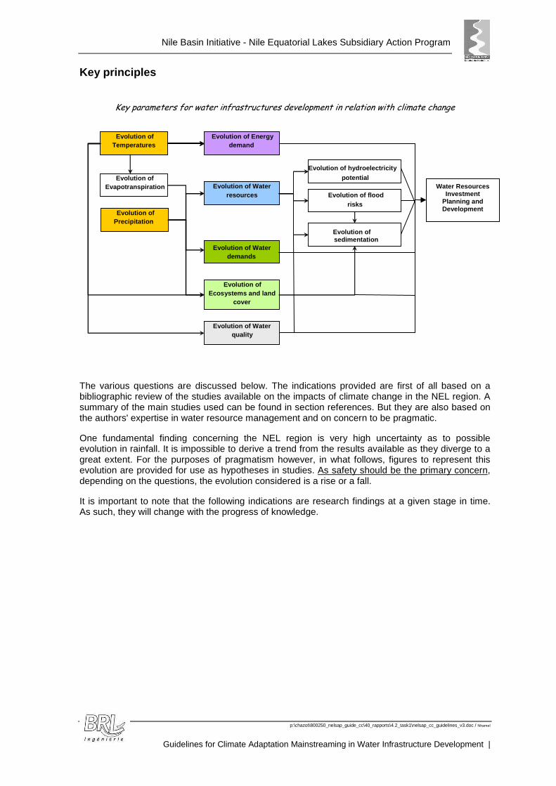
Evolution of climatic parameters
Evolution of water resources Evolution of water needs
Modification of water resources investments
Modification of infrastruc ture design and management
Nile Basin Initiative - Nile Equatorial Lakes Subsidiary Action Program
p:\chazot\800250_nelsap_guide_cc\40_rapports\4.2_task1\nelsap_cc_guidelines_v3.doc / Nhamel
Guidelines for Climate Adaptation Mainstreaming in Water Infrastructure Development |
Key principles
Key parameters for water infrastructures development in relation with climate change
The various questions are discussed below. The indications provided are first of all based on a bibliographic review of the studies available on the impacts of climate change in the NEL region. A summary of the main studies used can be found in section references. But they are also based on the authors' expertise in water resource management and on concern to be pragmatic.
One fundamental finding concerning the NEL region is very high uncertainty as to possible evolution in rainfall. It is impossible to derive a trend from the results available as they diverge to a great extent. For the purposes of pragmatism however, in what follows, figures to represent this evolution are provided for use as hypotheses in studies. As safety should be the primary concern, depending on the questions, the evolution considered is a rise or a fall.
It is important to note that the following indications are research findings at a given stage in time. As such, they will change with the progress of knowledge.
Evolution of Temperatures
Evolution of Precipitation
Evolution of Evapotranspiration Evolution of Water
resources
Evolution of Water demands
Evolution of hydroelectricity potential
Evolution of Energy demand
Evolution of Ecosystems and land
cover
Evolution of flood risks
Evolution of Water quality
Evolution of sedimentation
Water Resources Investment
Planning and Development

Nile Basin Initiative - Nile Equatorial Lakes Subsidiary Action Program
p:\chazot\800250_nelsap_guide_cc\40_rapports\4.2_task1\nelsap_cc_guidelines_v3.doc / Nhamel
Guidelines for Climate Adaptation Mainstreaming in Water Infrastructure Development
7
Possible impact of climate change on criteria considered for water infrastructures
Indicator category Criteria
Possible Impact of
Climate Change
Economic Hydropower potential;
Agricultural water demand;
Municipal water supply;
Drought mitigation;
Flood control;
Poverty reduction;
Lower or increase hydropower production;
Increase agricultural water demand;
Increase treatment needs;
Increase drought mitigation needs (?);
Increase flood control needs (?)
Increase adaptation capacity
Technical aspects
Cost per unit of water;
Reservoir or transfer capacity / hydrology;
Reservoir or transfer capacity / water uses;
Might increase the cost to take into account uncertainties
Lower reservoir capacity (sedimentation problems)
Environmental aspects
Environmentally endangered/threatened species and sensitive ecosystems;
Land use in the proposed project areas;
Add constraints to ecosystems;
Accentuate land degradation
Social aspects Government commitment;
Health benefits / risks;
Add pressure to water sharing;
Add need to reduce water borne deceases auspicious backgrounds
Transboundary Benefits
Transboundary benefits Increase the importance of transboundary management of water uses
Climate change must be integrated for each indicato r category. The range of possibilities for future climatic parameters must be considered f or each project.
Guiding Questions � Is the Project Concerned by Climate Change?
For NELSAP infrastructure, nearly all water infrastructures can be seen as potentially affected by climate change:
Dams, water transfers (for irrigation or water supply), flood protection infrastructure (dykes) and run-of-river HPP will be potentially affected by climate change. Irrigated areas will also be affected by the modification of the climate.
Nevertheless, some kinds of infrastructure will not be affected by climate change or are easily adaptable:
Distribution networks for water supply and water treatment plants (drinking and waste water) can be considered as not affected by climate change as the part affected by climate change will be treated in the water transfer infrastructure.
Water treatment plants (for domestic uses) are relatively upgraded to face declining water quality.
Nile Basin Initiative - Nile Equatorial Lakes Subsidiary Action Program
p:\chazot\800250_nelsap_guide_cc\40_rapports\4.2_task1\nelsap_cc_guidelines_v3.doc / Nhamel
Guidelines for Climate Adaptation Mainstreaming in Water Infrastructure Development |
� What are the present concerns in the area of the pr oject?
This question must focus on the present problems for the area concerned and establish a clear statement of the area characteristics in terms of:
� Water resources and water needs (risks of droughts, shortage of water for some usages) ;
� Natural risks (erosion, floods) ;
� Health ;
� Food security ;
� The economy.
� How could the area of the project be impacted by cl imate change?
Estimation of the possible change of climatic parameters:
� The evolution of temperatures ;
� The evolution of evapotranspiration ;
� The evolution of annual and monthly precipitation
The assessment of possible impact on water resources must consider:
� Annual and monthly flows ;
� Floods (peak flows) ;
� Droughts (duration and intensity)
� What will be the impacts of climate change on the p roject?
The assessment must list impacts on:
� domestic demand ;
� irrigation ;
� hydropower production ;
� the environment (specific to the area)
� How to mainstream climate change into the project d esign?
Climate change mainstreaming into infrastructure design is based on the following main lines of thought:
� identifying external action-effects that are likely to evolve due to climate change ;
� determination of the dam design parameters considered to be affected by those action-effects ;
� flood design and management…
� How to mainstream Climate Change into Environmental Studies?
Environmental impacts of the infrastructure must thus include the potential modification due to climatic changes:
� the risk of loss/reduction of wetlands (due to the infrastructure and climate change) ;
� the risk of eutrophication (due to the increase of the temperatures) ;
� the possible deterioration of water quality (requiring a special care for pollution points).

Nile Basin Initiative - Nile Equatorial Lakes Subsidiary Action Program
p:\chazot\800250_nelsap_guide_cc\40_rapports\4.2_task1\nelsap_cc_guidelines_v3.doc / Nhamel
Guidelines for Climate Adaptation Mainstreaming in Water Infrastructure Development
9
� How the project will be managed?
Dam/reservoir operation rules must be clearly established alongside the technical studies. They must determine critical levels/circumstances beyond which:
� electricity production must be slowed down;
� electricity production must be stopped;
� agricultural water use must be restricted.
They must also determine the levels/circumstances beyond which water must be released from the dam (and allow flood storage).
� How to measure the modification of climatic paramet ers?
It is important to be able to monitor climatic and hydrologic conditions, and obtain long term series, to detect hydrologic changes and establish baseline conditions that will serve for calibrating and validating models. Monitoring networks need to be placed in locations relevant to water managers, to be useful for climate change studies, for example upstream and downstream from major water-management infrastructure.
Integrating Climate adaptation into Water sector in vestment sectors � Hydropower management
The effects of climate change in the additional rise in the demand can at first be considered as virtually nil compared to the rises induced on other demands. It will be accentuated by the increased demand for air-conditioning due to the higher temperatures, but probably not in any significant manner.
� Assessment of the hydropower energy
To integrate the possible long-term impact of climate change, we can assume that hydroelectric production will roughly follow the evolution of runoff in a linear manner.
Runoff can be estimated using the previously described method, with the two extremes of rainfall change being between -15% and +30%, i.e. a change in runoff situated between -42% and +80%.
In the event of hydroelectric production from a dam reservoir, evaporation from the reservoir must, however, also be taken into account (roughly +10% compared to the present situation).
� Municipal water development
In the NEL region, the impact of climate change on a rise in the domestic water demand will theoretically be virtually nil compared to other factors affecting it (population increase, increased comfort requirements...).
But, the possible greater variability of the climate, in particular intense rains and droughts, will probably increase pollution levels in lakes, reservoirs and watercourses. This means a need for more water treatment when a domestic water treatment plant is built. It will also lead to a more pronounced need for waste water treatment before it is discharged into the natural environment.
� Agriculture water management and development (rainf ed and irrigated agriculture) As a very first approach, the assessment of crop water requirements can be done supposing an annual ETP rise of 10% and an annual rainfall values reduced by -15%. Assessment of crop yields?
For a first rough estimate, without carrying out more detailed studies, it can be assumed that the reduction in crop yield will probably be around -10% for C3 plants and -30% for C4 plants (supposing that 50 years is sufficient for irrigation scheme sizing).
Nile Basin Initiative - Nile Equatorial Lakes Subsidiary Action Program
p:\chazot\800250_nelsap_guide_cc\40_rapports\4.2_task1\nelsap_cc_guidelines_v3.doc / Nhamel
Guidelines for Climate Adaptation Mainstreaming in Water Infrastructure Development |
� Environmental and Social Management
The sensitivity of the natural environment and especially aquatic biodiversity will be accentuated due to the effects of climate change. Every measure should be taken to reduce the adverse effects of the facilities built on the natural environment, especially on wetlands.
� Social impacts
Climate change could lead to an increase of water related diseases, with warmer temperatures, possibly more precipitation and more extreme events. Water infrastructure can be indirectly linked with favourable conditions to water-borne disease, by for instance increasing or reducing the conditions for mosquito development.
Climate change will also probably lead to a higher need of adaptation for the population. Water infrastructure is part of the adaptation means that will allow the inhabitants to face the possible variability and change of climate. The mainstreaming of climate change into the selection and implementation of water infrastructure will ensure the appropriateness of the infrastructure to future conditions and the fact that it will help the population to adapt.
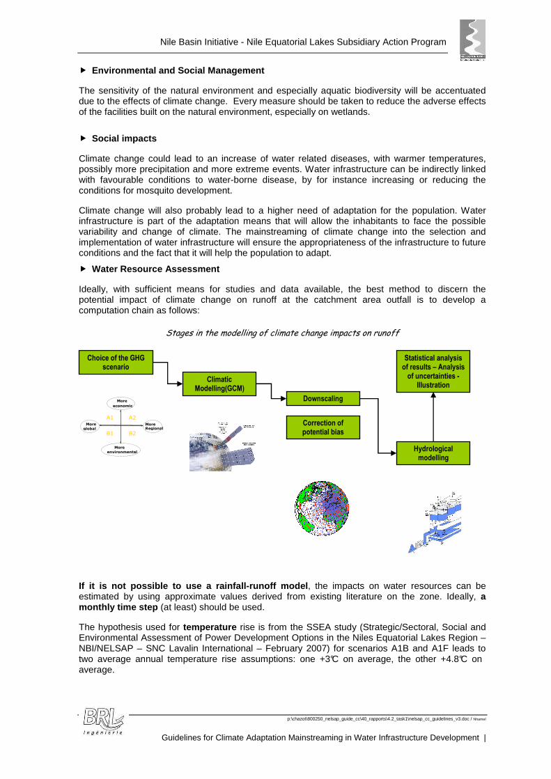
� Water Resource Assessment
Ideally, with sufficient means for studies and data available, the best method to discern the potential impact of climate change on runoff at the catchment area outfall is to develop a computation chain as follows:
Stages in the modelling of climate change impacts on runoff
If it is not possible to use a rainfall-runoff mode l, the impacts on water resources can be estimated by using approximate values derived from existing literature on the zone. Ideally, a monthly time step (at least) should be used.
The hypothesis used for temperature rise is from the SSEA study (Strategic/Sectoral, Social and Environmental Assessment of Power Development Options in the Niles Equatorial Lakes Region – NBI/NELSAP – SNC Lavalin International – February 2007) for scenarios A1B and A1F leads to two average annual temperature rise assumptions: one +3°C on average, the other +4.8°C on average.
Choice of the GHG scenario
Climatic Modelling(GCM)
Downscaling
Correction of potential bias
Hydrological modelling
Statistical analysis of results – Analysis
of uncertainties - Illustration
B2
A2 A1
B1 More global
More economic
More Regional
More environmental
Nile Basin Initiative - Nile Equatorial Lakes Subsidiary Action Program
p:\chazot\800250_nelsap_guide_cc\40_rapports\4.2_task1\nelsap_cc_guidelines_v3.doc / Nhamel
Guidelines for Climate Adaptation Mainstreaming in Water Infrastructure Development
11
The variation in annual rainfall is considered to be be tween -15% and +30% compared to the present period. This lead to changes in runoff situated between -40% and +80% .
Considering the objectives of the study, the worst case must be taken.
For a first rough estimate, it is possible to assume that the peaks in flood flows will increase in approximately the same proportions as the mean flows, i.e. by about +80%.
� Assessment of erosion / sedimentation?
We can assume, in a first approach, that sediment loads will follow the evolution of stream flow, in the same proportions, i.e. we can suppose that the change will be situated between -40% and +80%. These two extremes need to be analyzed when selecting and designing the reservoirs.

Nile Basin Initiative - Nile Equatorial Lakes Subsidiary Action Program
p:\chazot\800250_nelsap_guide_cc\40_rapports\4.2_task1\nelsap_cc_guidelines_v3.doc / Nhamel
Guidelines for Climate Adaptation Mainstreaming in Water Infrastructure Development |
GGLLOOSSSSAARRYY OOFF TTEERRMMSS
Source: IPCC except when specified
Adaptation
Adjustment in natural or human systems in response to actual or expected climatic stimuli or their effects, which moderates harm or exploits beneficial opportunities. Various types of adaptation can be distinguished, including anticipatory, autonomous and planned adaptation:
Anticipatory adaptation – Adaptation that takes place before impacts of climate change are observed. Also referred to as proactive adaptation.
Autonomous adaptation – Adaptation that does not constitute a conscious response to climatic stimuli but is triggered by ecological changes in natural systems and by market or welfare changes in human systems. Also referred to as spontaneous adaptation.
Planned adaptation – Adaptation that is the result of a deliberate policy decision, based on an awareness that conditions have changed or are about to change and that action is required to return to, maintain, or achieve a desired state.
C3 and C4 plants
C3 plants, accounting for more than 95% of earth's plant species, use rubisco to make a three-carbon compound as the first stable product of carbon fixation. C3 plants flourish in cool, wet, and cloudy climates, where light levels may be low, because the metabolic pathway is more energy efficient, and if water is plentiful, the stomata can stay open and let in more carbon dioxide. However, carbon losses through photorespiration are high.
C4 plants possess biochemical and anatomical mechanisms to raise the intercellular carbon dioxide concentration at the site of fixation, and this reduces, and sometimes eliminates, carbon losses by photorespiration. C4 plants, which inhabit hot, dry environments, have very high water-use efficiency, so that there can be up to twice as much photosynthesis per gram of water as in C3 plants, but C4 metabolism is inefficient in shady or cool environments. Less than 1% of earth's plant species can be classified as C4. (source: Oxford Dictionary of Geography)
Climate
Climate is usually defined as the "average weather", or more rigorously, as the statistical description of the weather in terms of the mean and variability of relevant quantities over periods of several decades (typically three decades as defined by WMO). These quantities are most often surface variables such as temperature, precipitation, and wind, but in a wider sense the "climate" is the description of the state of the climate system.
Nile Basin Initiative - Nile Equatorial Lakes Subsidiary Action Program
p:\chazot\800250_nelsap_guide_cc\40_rapports\4.2_task1\nelsap_cc_guidelines_v3.doc / Nhamel
Guidelines for Climate Adaptation Mainstreaming in Water Infrastructure Development
13
Climate change (IPCC usage)
Climate change as referred to in the observational record of climate occurs because of internal changes within the climate system or in the interaction between its components, or because of changes in external forcing either for natural reasons or because of human activities. It is generally not possible clearly to make attribution between these causes. Projections of future climate change reported by IPCC generally consider only the influence on climate of anthropogenic increases in greenhouse gases and other human-related factors.
Climate model (spectrum or hierarchy)
A numerical representation of the climate system based on the physical, chemical and biological properties of its components, their interactions and feedback processes, and accounting for all or some of its known properties. The climate system can be represented by models of varying complexity, that is, for any one component or combination of components a spectrum or hierarchy of models can be identified, differing in such aspects as the number of spatial dimensions, the extent to which physical, chemical or biological processes are explicitly represented, or the level at which empirical parameterizations are involved. Coupled Atmosphere-Ocean General Circulation Models (AOGCMs) provide a representation of the climate system that is near the most comprehensive end of the spectrum currently available. Climate models are applied as a research tool to study and simulate the climate, and for operational purposes, including monthly, seasonal and interannual climate predictions.
Downscaling (dynamic or statistical)
Downscaling is a method that derives local- to regional-scale (10 to 100 km) information from larger-scale models or data analyses. Two main methods are distinguished: dynamical downscaling and empirical/statistical downscaling. The dynamical method uses the output of regional climate models, global models with variable spatial resolution or high-resolution global models. The empirical/statistical methods develop statistical relationships that link the large-scale atmospheric variables with local/regional climate variables. In all cases, the quality of the downscaled product depends on the quality of the driving model.
GCM
General Circulation Model, sometimes referred to as Global Climate Model - See Climate model
Greenhouse gas
A gas that absorbs radiation at specific wavelengths within the spectrum of radiation (infrared radiation) emitted by the Earth’s surface and by clouds. The gas in turn emits infrared radiation from a level where the temperature is colder than the surface. The net effect is a local trapping of part of the absorbed energy and a tendency to warm the planetary surface. Water vapour (H2O), carbon dioxide (CO2), nitrous oxide (N2O), methane (CH4) and ozone (O3) are the primary greenhouse gases in the Earth’s atmosphere.
Mitigation
Structural and non-structural measures undertaken to limit the adverse impact of natural hazards, environmental degradation and technological hazards. (source: FAO)
No Regrets
Measures whose benefits—such as improved performance or reduced emissions of local/regional pollutants, but excluding the benefits of climate change mitigation—equal or exceed their costs. They are sometimes known as "measures worth doing anyway."
Nile Basin Initiative - Nile Equatorial Lakes Subsidiary Action Program
p:\chazot\800250_nelsap_guide_cc\40_rapports\4.2_task1\nelsap_cc_guidelines_v3.doc / Nhamel
Guidelines for Climate Adaptation Mainstreaming in Water Infrastructure Development |
Resilience
The capacity of a system, community or society potentially exposed to hazards to adapt, by resisting or changing in order to reach and maintain an acceptable level of functioning and structure. This is determined by the degree to which the social system is capable of organizing itself to increase its capacity for learning from past disasters for better future protection and to improve risk reduction measures.
Scenario
A plausible description of how the future may develop, based on a coherent and internally consistent set of assumptions about key relationships and driving forces (e.g., rate of technology changes, prices). Note that scenarios are neither predictions nor forecasts.
Vulnerability
A set of conditions and processes resulting from physical, social, economic and environmental factors, which increase the susceptibility of a community to the impact of hazards. (Source: UN/ISDR Geneva 2004)
Nile Basin Initiative - Nile Equatorial Lakes Subsidiary Action Program
p:\chazot\800250_nelsap_guide_cc\40_rapports\4.2_task1\nelsap_cc_guidelines_v3.doc / Nhamel
Guidelines for Climate Adaptation Mainstreaming in Water Infrastructure Development
15
AABBBBRREEVVIIAATTIIOONNSS AANNDD AACCRROONNYYMMSS
ADB Asian Development Bank CCAWWG Climate Change and Water Working Group CMI Climate Moisture Index CSPCP Country Strategy and Program Climate Profile DJF December January February ENSAP Eastern Nile Subsidiary Action Program ETP Evapotranspiration FAO Food and Agriculture Organization GCM Global Circulation Model GHG Greenhouse Gas HEP Hydroelectric Power IPCC Intergovernmental Panel on Climate Change IWRM Integrated Water Resources Management JJA June July August MAM March April May NBI Nile Basin Initiative NEL-COM Nile Equatorial Lakes Council of Ministers NELSAP Nile Equatorial Lakes Subsidiary Action Programme NELSAP-CU NELSAP Coordination Unit NELTAC Nile Equatorial Lakes Technical Advisory Committee NILE SEC NBI Secretariat Nile-COM Nile Council of Ministers of Water Resources NOAA National Oceanic and Atmospheric Administration PAB Project Adaptation Brief SAP Subsidiary Action Program SMM Sio-Malaba-Malakisi SON September October November SRES Special Report on Emissions Scenarios SSEA Strategic/Sectoral, Social and Environmental Assessment of Power Development
Options in the NEL Region SVP Shared Vision Program TOR Terms of Reference UNDP United Nations Development Programme UNFCCC United Nations Framework Convention on Climate Change USGS United States Geological Survey USAGE United States Army Corps of Engineers

Nile Basin Initiative - Nile Equatorial Lakes Subsidiary Action Program
p:\chazot\800250_nelsap_guide_cc\40_rapports\4.2_task1\nelsap_cc_guidelines_v3.doc / Nhamel
Guidelines for Climate Adaptation Mainstreaming in Water Infrastructure Development |
Nile Basin Initiative - Nile Equatorial Lakes Subsidiary Action Program
p:\chazot\800250_nelsap_guide_cc\40_rapports\4.2_task1\nelsap_cc_guidelines_v3.doc / Nhamel
Guidelines for Climate Adaptation Mainstreaming in Water Infrastructure Development
17
1. INTRODUCTION
1.1 BACKGROUND
The Nile Basin Initiative (NBI), established in 1999 is an inter-governmental organization dedicated to equitable and sustainable management and development of the shared water resources of the Nile Basin. NBI Member States include Burundi, Democratic Republic of Congo, Egypt, Ethiopia, Kenya, Rwanda, Sudan, Tanzania and Uganda. Eritrea is as an observer.
The Nile Council of Ministers (Nile-COM) agreed on a Shared Vision which states: ‘to achieve sustainable socio-economic development through the equitable utilization of and benefit from the common Nile Basin water resources’, and a ‘Strategic Action Program’ (SAP) comprising two complementary programs, the ‘Shared Vision Program’ (SVP) and the ‘Subsidiary Action Program’ (SAP) to guide Nile cooperation.
The SAP, the investment arm of NBI, focuses on the preparation of investment projects that are trans-boundary in nature. The overriding goal of the investment agenda is to contribute to poverty alleviation, reverse environmental degradation and promote socio-economic growth in the riparian countries. This program is managed by two sub-basin offices, one in the Eastern Nile region for the Eastern Nile Subsidiary Action Program (ENSAP) and the other in the Nile Equatorial Lakes region for the Nile Equatorial Lakes Subsidiary Action Program (NE LSAP) , the latter located in Kigali, Rwanda.
The Nile Equatorial Lakes region (see Figure 1.1: The NEL Region) includes the seven States in the southern portion of the Nile Basin, namely Burundi, Democratic Republic of Congo, Kenya, Rwanda, South Sudan, Tanzania and Uganda. In the context of the Nile, NELSAP also includes the two downstream riparians, Egypt and Sudan.
The Nile Equatorial Lakes SAP is governed by the Nile Equatorial Lakes Council of Ministers (NEL-COM), supervised by the Nile Equatorial Lakes Technical Advisory Committee (NELTAC) and is managed by its Coordination Unit (NELSAP-CU) located in Kigali, Rwanda.

Nile Basin Initiative - Nile Equatorial Lakes Subsidiary Action Program
p:\chazot\800250_nelsap_guide_cc\40_rapports\4.2_task1\nelsap_cc_guidelines_v3.doc / Nhamel
Guidelines for Climate Adaptation Mainstreaming in Water Infrastructure Development |
Figure 1.1: The NEL Region
This map was produced before the creation of the new Nile Basin country South Sudan.
Nile Basin Initiative - Nile Equatorial Lakes Subsidiary Action Program
p:\chazot\800250_nelsap_guide_cc\40_rapports\4.2_task1\nelsap_cc_guidelines_v3.doc / Nhamel
Guidelines for Climate Adaptation Mainstreaming in Water Infrastructure Development
19
1.2 CONTEXT
The Nile Basin water resources have vast natural endowments and immense potential for promoting regional cooperation and social and economic development. Advances in environmental conservation, food production, power production, water supply and transportation are a challenge in the Nile Basin, which is notably characterized by poverty, political instability, rapid population growth, environmental degradation and change in climatic conditions.
The mitigation of climate change as well as adaptation to climate change has fundamental implications for the concept of sustainable development and its implementation.
Water resources are vulnerable and are already affected by climate change and variability with wide ranging consequences for society, health, economies and the natural environment. Many countries, Nile Basin countries included, have already experienced severe impacts from extreme climatic events and disasters.
Adverse effects of climate change on water might also aggravate the impacts of other stresses and pressures, such as changing consumption and production patterns, land use change, urbanization and population growth. Responses to climate change may also have irreversible long-term impacts e.g. land degradation caused by inappropriate long term irrigation.
1.3 THE GUIDELINES
1.3.1 Need for the Guidelines
The large-scale development programs promoted by NELSAP will be confronted with climate change impacts and investment programs must be adapted to future conditions.
Current water management practices, based on historical climatic conditions, may therefore not be robust enough to cope with the future impacts of climate change on water supply reliability, flood risk, health, agriculture, energy and aquatic ecosystems.
Hence, there is a real need to develop tools and guidelines for climate adaptation mainstreaming in water infrastructure development.
The present guidelines aim to provide guidelines usable by NELSAP for its water resources programmes and water infrastructure selection and implementation.
1.3.2 Role and purpose of the guidelines
The purpose of the Guidelines is to provide direction to users to help them mainstream climate adaptation in investment planning and projects concerning water resources management.
The adoption of the Guidelines by the Nile Equatorial lakes Council of Ministers will enable them to operationalize their commitment to assessing and reducing climate related risks in water resources investments.
1.3.3 Elements
The guidelines are provided in the form of a document, the guidelines themselves, and a set of tools.
Apart from the introduction, the Guidelines document contains five main sections:
Nile Basin Initiative - Nile Equatorial Lakes Subsidiary Action Program
p:\chazot\800250_nelsap_guide_cc\40_rapports\4.2_task1\nelsap_cc_guidelines_v3.doc / Nhamel
Guidelines for Climate Adaptation Mainstreaming in Water Infrastructure Development |
� The general concept of mainstreaming climate change into water infrastructure (see section 2: Understanding the Climate Adaptation Mainstreaming Concept) ;
� A section dedicated to the mainstreaming of climate change into the project cycle, with key principles, and a set of guiding principles and guiding questions meant to direct users to identify and explore key issues that need to be addressed in mainstreaming climate adaptation into investment planning (see section 3: Mainstreaming Climate Adaptation into the Project Cycle for Water Resources Investments);
� A description of the tools elaborated with the guidelines (see section 4: Tools) ;
� A checklist of how to integrate climate change at each stage of program and project development (see section 5: Checklists for Mainstreaming Climate Adaptation into Investment Planning) ;
� A detail of reference studies used in the elaboration of the guidelines (see section 6: References).
The tools are composed of two computerized programs:
� An Excel file, using the free program R, allowing assessment of the present and future precipitation at a given site;
� An Excel file calculating the irrigation requirements at the infrastructure site.
Annexes are composed of:
� the regional precipitations resulting from the component 1 study (Regional Downscaling of Precipitation and Temperature Data for Climate Change Impact Assessment in the Nile Equatorial Lakes (NEL) Region – NELSAP / NBI – University of Stuttgart - 2011), realized prior to this study to allow an assessment of the possible climatic trends in the area of NELSAP Region and
� The bibliography.
1.3.4 Audience
The intended users of the Guidelines include NBI and NELSAP technical staff and decision makers, but they can also be used by public officials and program and project managers, private sector interests or development agencies.
Individuals, community groups and other non-state entities seeking information on mainstreaming climate change into investment planning might also find these Guidelines useful.
1.3.5 Scope
The Guidelines provide an overall view of issues to consider in regional water resources investment projects and programmes. Consequently, the Guidelines are broad and generic.
They are dedicated to large water infrastructure, such as dams and water transfers, but also deal with the infrastructure directly associated (irrigation schemes, urban water infrastructure...) and with minor detail, they deal with the implications on social and environmental constraints.
Nile Basin Initiative - Nile Equatorial Lakes Subsidiary Action Program
p:\chazot\800250_nelsap_guide_cc\40_rapports\4.2_task1\nelsap_cc_guidelines_v3.doc / Nhamel
Guidelines for Climate Adaptation Mainstreaming in Water Infrastructure Development
21
2. UNDERSTANDING THE CLIMATE ADAPTATION MAINSTREAMING CONCEPT
Climate adaptation mainstreaming is an integral development function. In water resources development, it will guarantee the long term benefits of the water infrastructure developed to face current and/or projected needs.
Climate adaptation mainstreaming in development projects will also help the population to face potential future climatic variability and increase their capacity to adapt to climate change.
2.1 WHAT IS CLIMATE ADAPTATION MAINSTREAMING ?
Many factors impact water resources management, such as water resources and quality, land cover and land use, water consumption or water resources infrastructures. Climate change can affect all these factors.
Water infrastructures are generally designed using the past climate as a reference for climatic conditions during infrastructure life; and past conditions for other parameters as trends for future conditions.
With climate change induced by human activities, past climate characteristics and trends can’t be directly used to predict future climate, and the design characteristics of the infrastructure can’t be based on the projection of historical data or measurements. A degree of uncertainty and a possible deviation of past evolution must be integrated into water resources management.
In particular, the assessment of flood risks and / or drought intensity and/or duration, necessary for flood risk reduction structures, but also safety bodies for water infrastructures must be realized so that they are coherent with present climate and possible future changes.
Climate changes could modify infrastructure design, but could also induce a modification of the prioritization of investments at the NELSAP reg ion scale. This requires taking the possible future effects into account in present stu dies concerning water infrastructure development.
2.2 CONCEPTUAL FRAMEWORK FOR CLIMATE ADAPTATION MAINSTREAMING FOR WATER RESOURCES INVESTMENTS
The assessment of the possible effects of climate change on water resources and water needs is directly linked with the trend of climatic parameters.
The evolution of climatic parameters interferes indirectly with water resources investments and infrastructure designs.

Nile Basin Initiative - Nile Equatorial Lakes Subsidiary Action Program
p:\chazot\800250_nelsap_guide_cc\40_rapports\4.2_task1\nelsap_cc_guidelines_v3.doc / Nhamel
Guidelines for Climate Adaptation Mainstreaming in Water Infrastructure Development |
Future modifications of climatic parameters will thus involve modification of the service of the infrastructure.
2.3 SOME ADVANTAGES AND BENEFITS OF CLIMATE ADAPTATION MAINSTREAMING
Climate adaptation mainstreaming into water infrastructure development is to ascertain a longer duration of service of the infrastructures, with the aim to increase or at least, not decrease, the benefits of the infrastructure over time and possible changes in climatic conditions.
It will help not to create infrastructure that might be less useful in the future.
Taking into account climate change while designing infrastructures will prevent potential future adaptation needs to be done to the infrastructure to adapt it to modified conditions, it should thus save maintenance and modification costs.
2.4 LIMITATIONS OF CLIMATE ADAPTATION MAINSTREAMING
The guidelines are aimed and constructed to be applied for water infrastructure development.
The main difficulty is due to the very high uncertainty in predicting future climatic parameters . This is due to the uncertainty of the GES productions, the complexity to model the future climate at world scale (by the use of GCM models) and the difficulty to link the worldwide predictions to a more local scale (regional scale).
Other factors will modify water resources , some, possibly much more than climate change, such as the economic development and the demography that will tend to increase the water uses and the use of water resources.
The guidelines do not deal with other parameters that could modify project prioritization or implementation.
Evolution of climatic parameters
Evolution of water resources Evolution of water needs
Modification of water resources investments
Modification of in frastructure design and management

Nile Basin Initiative - Nile Equatorial Lakes Subsidiary Action Program
p:\chazot\800250_nelsap_guide_cc\40_rapports\4.2_task1\nelsap_cc_guidelines_v3.doc / Nhamel
Guidelines for Climate Adaptation Mainstreaming in Water Infrastructure Development
23
The guidelines provide tools and basic steps for including climate change in the implementation of water infrastructure projects. However, as for the basic (without mainstreaming climate change) studies of water infrastructure, a minimum level of knowledge must be available for the project. This includes for instance historical data for the river discharge, either based on a gauging station at the site location or estimated from a similar (in terms of geography and hydrography) gauging station.
Also, the guidelines have been established with the information available at the time of formulation. Regular up-dating, in particular integrating the trend noted for future climatic and hydrologic parameters (temperatures, precipitation, runoff,) will have to be done to improve or correct the estimations and tools provided in the guidelines.
Nile Basin Initiative - Nile Equatorial Lakes Subsidiary Action Program
p:\chazot\800250_nelsap_guide_cc\40_rapports\4.2_task1\nelsap_cc_guidelines_v3.doc / Nhamel
Guidelines for Climate Adaptation Mainstreaming in Water Infrastructure Development |
3. MAINSTREAMING CLIMATE ADAPTATION INTO THE PROJECT CYCLE FOR WATER RESOURCES INVESTMENTS
Climate adaptation mainstreaming into the project cycle for water resources investments leads to the analysis of two main items:
The key parameters that have to be taken into account for water infrastructure projects that might be impacted by climate change,
The steps of the project development during which the study of the climate change effects has to be taken into consideration.
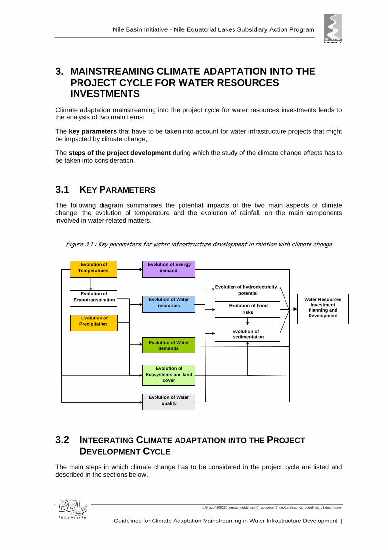
3.1 KEY PARAMETERS
The following diagram summarises the potential impacts of the two main aspects of climate change, the evolution of temperature and the evolution of rainfall, on the main components involved in water-related matters.
Figure 3.1 : Key parameters for water infrastructure development in relation with climate change
3.2 INTEGRATING CLIMATE ADAPTATION INTO THE PROJECT DEVELOPMENT CYCLE
The main steps in which climate change has to be considered in the project cycle are listed and described in the sections below.
Evolution of Temperatures
Evolution of Precipitation
Evolution of Evapotranspiration Evolution of Water
resources
Evolution of Water demands
Evolution of hydroelectricity potential
Evolution of Energy demand
Evolution of Ecosystems and land
cover
Evolution of flood risks
Evolution of Water quality
Evolution of sedimentation
Water Resources Investment
Planning and Development

Nile Basin Initiative - Nile Equatorial Lakes Subsidiary Action Program
p:\chazot\800250_nelsap_guide_cc\40_rapports\4.2_task1\nelsap_cc_guidelines_v3.doc / Nhamel
Guidelines for Climate Adaptation Mainstreaming in Water Infrastructure Development
25
Table 3.1: Guidelines for Climate Change Mainstreaming in Project Cycle
Project Cycle Step Guidelines for Climate Change Mainstreaming
Program Development
Program Establishment Integration of climate change in the reflexion on opportunity of the different works and priorities between water uses. Integrate uncertainties and the "no-regret" dimension
Integration of climate change in all the sub-programs TOR for water resources / water demands studies
Project Identification
Project Brief Preparation Identify if the project might be climate change impacted, if the issues of the project are concerned by climate change
Project Screening
Project Selection
Identify the natural risks, actual concerns and actual adaptation measures for the project area
Preliminary assessment of the impact of climate change on the project area and on the project
Project site identification and pre-feasibility studies
Integration of climate change aspects and no-regret options in project selection
Analyses of the constraint of climate change on the project design and management
Integration of climate change in environmental studies
Project Management
Associate technical project preparation with the organisation of the institutional management of the project
Analysis of the management procedures for the project, especially in anticipation of extreme events – Plan the adjustment of the project to changes in climate parameters
Ensure monitoring and analysis of climatic and hydrological variables
Analysis of the need of a early warning system
3.3 GUIDING PRINCIPLES
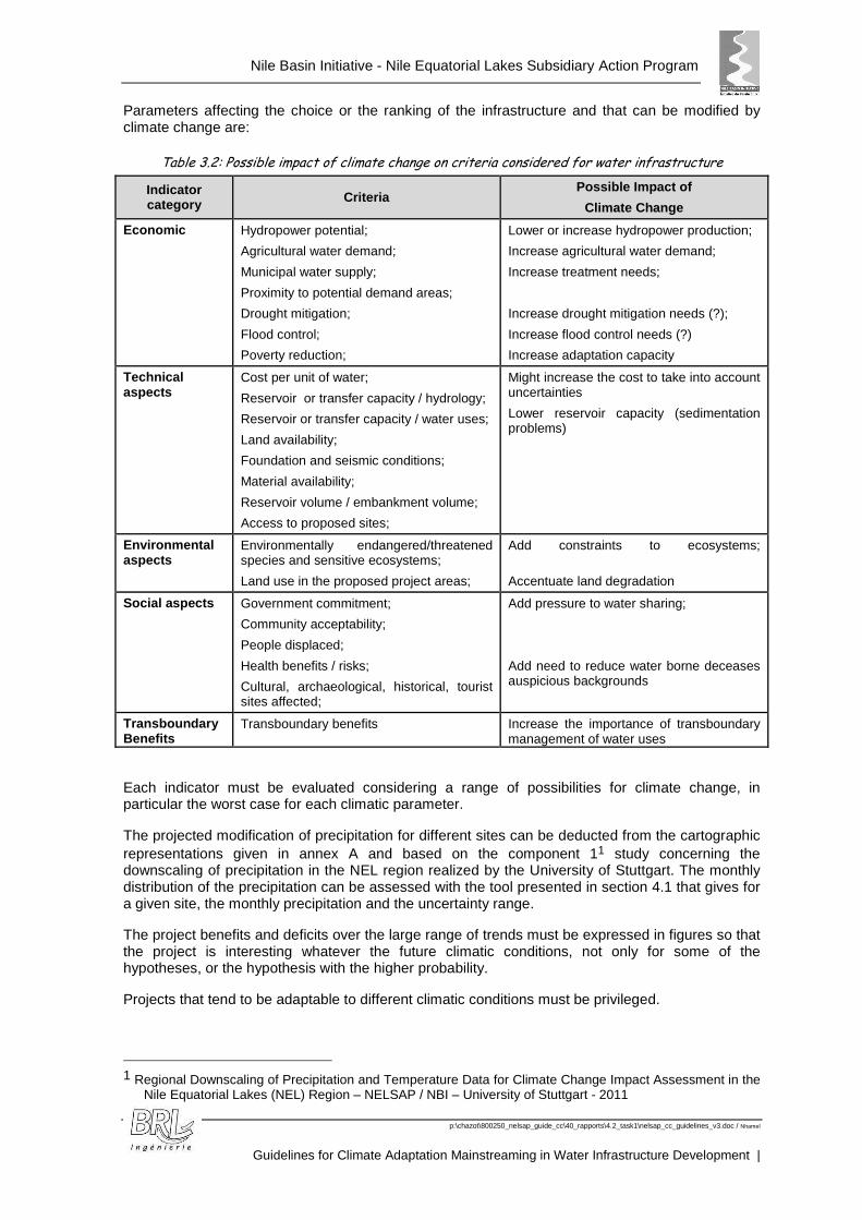
Water Infrastructures are usually studied through several components as described in Table 3.2: Possible impact of climate change on criteria considered for water infrastructure (economics, environment, technical aspects, transboundary effects,).
Climate change will affect each one of the above components, to a degree that won’t be easy to quantify in each case.
The infrastructure is to resolve an actual problem and to supplement water for existing needs. Its life expectancy is several decades. Selecting the best infrastructure needs to be based on its whole lifespan.
Nile Basin Initiative - Nile Equatorial Lakes Subsidiary Action Program
p:\chazot\800250_nelsap_guide_cc\40_rapports\4.2_task1\nelsap_cc_guidelines_v3.doc / Nhamel
Guidelines for Climate Adaptation Mainstreaming in Water Infrastructure Development |
Parameters affecting the choice or the ranking of the infrastructure and that can be modified by climate change are:
Table 3.2: Possible impact of climate change on criteria considered for water infrastructure
Indicator category Criteria
Possible Impact of
Climate Change
Economic Hydropower potential;
Agricultural water demand;
Municipal water supply;
Proximity to potential demand areas;
Drought mitigation;
Flood control;
Poverty reduction;
Lower or increase hydropower production;
Increase agricultural water demand;
Increase treatment needs;
Increase drought mitigation needs (?);
Increase flood control needs (?)
Increase adaptation capacity
Technical aspects
Cost per unit of water;
Reservoir or transfer capacity / hydrology;
Reservoir or transfer capacity / water uses;
Land availability;
Foundation and seismic conditions;
Material availability;
Reservoir volume / embankment volume;
Access to proposed sites;
Might increase the cost to take into account uncertainties
Lower reservoir capacity (sedimentation problems)
Environmental aspects
Environmentally endangered/threatened species and sensitive ecosystems;
Land use in the proposed project areas;
Add constraints to ecosystems;
Accentuate land degradation
Social aspects Government commitment;
Community acceptability;
People displaced;
Health benefits / risks;
Cultural, archaeological, historical, tourist sites affected;
Add pressure to water sharing;
Add need to reduce water borne deceases auspicious backgrounds
Transboundary Benefits
Transboundary benefits Increase the importance of transboundary management of water uses
Each indicator must be evaluated considering a range of possibilities for climate change, in particular the worst case for each climatic parameter.
The projected modification of precipitation for different sites can be deducted from the cartographic representations given in annex A and based on the component 11 study concerning the downscaling of precipitation in the NEL region realized by the University of Stuttgart. The monthly distribution of the precipitation can be assessed with the tool presented in section 4.1 that gives for a given site, the monthly precipitation and the uncertainty range.
The project benefits and deficits over the large range of trends must be expressed in figures so that the project is interesting whatever the future climatic conditions, not only for some of the hypotheses, or the hypothesis with the higher probability.
Projects that tend to be adaptable to different climatic conditions must be privileged.
1 Regional Downscaling of Precipitation and Temperature Data for Climate Change Impact Assessment in the
Nile Equatorial Lakes (NEL) Region – NELSAP / NBI – University of Stuttgart - 2011
Nile Basin Initiative - Nile Equatorial Lakes Subsidiary Action Program
p:\chazot\800250_nelsap_guide_cc\40_rapports\4.2_task1\nelsap_cc_guidelines_v3.doc / Nhamel
Guidelines for Climate Adaptation Mainstreaming in Water Infrastructure Development
27
Climate change must be integrated for each indicato r category. The range of possibilities for future climatic parameters must be considered f or each project.
Projects implying no-regret solutions (solutions th at will be useful whatever the modifications of the parameters) must be privileged .
3.4 GUIDING QUESTIONS
The guidelines for the mainstreaming of climate cha nge are proposed to be brought as a set of questions, to be raised at each step of the proj ect cycle. The level of detail of the answer to a question depends on the step of the project (i dentification, preliminary studies,).
The various questions are discussed below. The indications provided are first of all based on a bibliographic review of the studies available on the impacts of climate change in the NEL region (a summary of the main studies used can be found in section 6: References). But they are also based on the authors' expertise in water resource management and on concern to be pragmatic.
One fundamental finding concerning the NEL region i s very high uncertainty as to possible evolution in rainfall. It is impossible to derive a trend from the results available as they diverge to a great extent. For the purposes of pragmatism however, in what follows, figures to represent this evolution are provided for use as hypotheses in studies. As safety should be the primary concern, depending on the questions, the evolution considered might be a rise or a fall, depending on what could be the worst case for each parameter.
It is important to note that the following indications are research findings at a given stage in time. As such, they will change with the progress of knowledge.
3.4.1 Is the Project Concerned by Climate Change?
Prior to the decision to integrate climate change in a water infrastructure project, it must first be estimated whether the project might be concerned by climate change issues.
Three categories may be defined:
� The performance of the infrastructure is not expect ed to be significantly affected by climate change (based on the present knowledge);
� The infrastructure might be impacted by climate change but adaptation measures can easily be added, after construction, to the infrastructure if climate change impacts are encountered (for instance water treatment plants can be relatively easily modified if the river quality requires a stronger treatment);
� The infrastructure might be or will be affected by climate change, and climate change adaptation measures have to be thought before the realization of the project as adaptation options might be impossible to add later.
Projects can be defined as not significantly affected by climate change for different reasons:
� The results of the studies concerning climate modifications show that they should not alter water resources of the concerned area;
� The impact or the uncertainty associated with other issues, such as the strong increase of water demand (for hydropower for instance), will predominate for the decision; climate change impacts can be considered as minor impacts compared to other issues;
� The infrastructure, by its importance or type, is not affected by climate related parameters.
Nile Basin Initiative - Nile Equatorial Lakes Subsidiary Action Program
p:\chazot\800250_nelsap_guide_cc\40_rapports\4.2_task1\nelsap_cc_guidelines_v3.doc / Nhamel
Guidelines for Climate Adaptation Mainstreaming in Water Infrastructure Development |
For NELSAP infrastructure, nearly all water infrastructure can be seen as potentially affected by climate change:
Dams, water transfers (for irrigation or water supply), flood protection infrastructure (dykes) and run-of-river HPP will be potentially affected by climate change. Irrigated areas will also be affected by the modification of the climate.
Nevertheless, some kinds of infrastructure will not be affected by climate change or are easily adaptable:
Distribution networks for water supply and water treatment plants (drinking and waste water) can be considered as not affected by climate change as the part affected by climate change will be treated in the water transfer infrastructure.
Water treatment plants (for domestic uses) can be relatively easily upgraded to face declining water quality.
3.4.2 What are the present concerns in the area of the project?
This question must focus on the present problems for the area concerned and establish a clear statement of the area characteristics in terms of:
� Water resources and water needs (risks of droughts, shortage of water for some usages);
� Natural risks (erosion, floods);
� Health;
� Food security;
� The economy.
The main related questions can be considered to be as follows:
� Water resources: what are the water resources used for different uses? Are they sufficient in terms of quantity and quality to face short term and long term demand? Is there period of drought implying water shortages for important uses (environment, domestic water irrigation)?
� Floods – is the area impacted by floods? Is human infrastructure (settlements) concerned? Are the inundated natural areas to be preserved? Is there existing erosion in the watershed concerned?
� What are the health problems (climate related such as cholera (linked with floods), malaria (linked with wetlands) …)? Is the area potentially concerned by food problems?
� Are there any particular economy-related concerns?
3.4.3 How could the area of the project be impacted by climate change?
This step is to assess the possible change of climatic parameters and the possible impact on water resources, including extreme events. The methods for basic assessment and in depth estimations are given in section 3.5.5: Water Resource Assessment.
Nile Basin Initiative - Nile Equatorial Lakes Subsidiary Action Program
p:\chazot\800250_nelsap_guide_cc\40_rapports\4.2_task1\nelsap_cc_guidelines_v3.doc / Nhamel
Guidelines for Climate Adaptation Mainstreaming in Water Infrastructure Development
29
Estimation of the possible change of climatic parameters:
� The evolution of temperatures;
� The evolution of evapotranspiration;
� The evolution of annual and monthly precipitation
The assessment of possible impact on water resources must consider:
� Annual and monthly flows;
� Floods (peak flows);
� Droughts (duration and intensity)
3.4.4 What will be the impacts of climate change on the project?
The projected water demands for each category of water use have to be estimated considering climate change impacts.
The assessment must list impacts on:
� domestic demand;
� irrigation;
� hydropower production;
� the environment (specific to the area)
For irrigation, the possible future demand has to be established in order to design the main distribution networks.
For other demands (environment, water supply, hydropower), the impacts of climate change can be estimated in a first rough approach during the preliminary stage, knowing that they can be addressed, if needed, through a future modification of reservoir and/or pumping plant management rules.
The project must also be analyzed with extreme conditions due to climate change, conditions that may be unpredictable for the moment.
3.4.5 How to mainstream climate change into project design?
Climate change mainstreaming into infrastructure design is based on the following main lines of thought:
� Identifying external action-effects that are likely to evolve due to climate change;
� Determination of the infrastructure design parameters considered to be affected by those action-effects;
� Determination of the design parameters for the safety components of the infrastructure;
� Identification of the management rules for the infrastructure and associated works design (such as gauging station).
Nile Basin Initiative - Nile Equatorial Lakes Subsidiary Action Program
p:\chazot\800250_nelsap_guide_cc\40_rapports\4.2_task1\nelsap_cc_guidelines_v3.doc / Nhamel
Guidelines for Climate Adaptation Mainstreaming in Water Infrastructure Development |
3.4.5.1 Identifying External Action-Effects Affected by Climate Change and Involved in Dam Design
The external action-effects that are involved in dam design or in the management of risk to ensure dam safety are:
� natural hazards: floods, earthquakes, landslide in the reservoir (and the propagation of the resulting wave), winds, etc.
� reservoir management parameters: hydrological inflows (water filling the reservoir), solid inflows, etc.
The effects of climate change are currently ill-known, but it is generally accepted that climate change impacts hydrological cycles:
� variability of interannual inflow with a risk of not reaching the planned reservoir filling level. This is important for the use of water resources but does not directly affect dam safety;
� variability in flood flows. It is assumed that climate change can produce more acute events more frequently. It is therefore likely that there will be a change in flood frequency or in flood flow values.
� greater evapotranspiration and an impact on soil moisture content: climate change is often associated with a rise in average temperatures. This evolution would produce more pronounced evaporation of reservoir water, thus affecting the available storage, but also a change in construction material behaviour, including the materials in earthfill dams, due to desiccation.
The impact on a hydraulic regime can also take the form of modified sediment flows. The combination of "extreme rainfall and desiccation in a watershed" implies potentially more sediment flows, which will sooner or later affect the use of the water resources.
As regards earthquake hazards, it has been stated that climate change has no effect.
Regarding wind hazards, considering that climate change can mean more violent storm phenomena, storm winds are likely to cause more pronounced waves. This must be considered when estimating the freeboard necessary to reduce the risks of overtopping and even dam breakage in the case of earthfill dams.
As for "slide in the reservoir", as climate change could potentially modify the drought / heavy rain cycle, there could be an increase in the probability of occurrence of the factors that trigger off the slide. But it is hardly likely that climate change will cause the occurrence of any large-scale slide. There will always be a doubt as to the effects of the desiccation / wetting cycle on the clayey materials found around the edges of a reservoir.
Similarly, the effect of climate change on the rate of weathering and degradation of the materials being very slow, it has not been retained here.
3.4.5.2 Determination of the Design Parameters Affected
Considering that the most important impacts of climate change are related to:
� flood regime modification,
� temperature range and rainfall range modification leading to more severe drought periods; and
� the probable increase in sediment flows;
we shall proceed to determine which dam design parameters are affected.
Nile Basin Initiative - Nile Equatorial Lakes Subsidiary Action Program
p:\chazot\800250_nelsap_guide_cc\40_rapports\4.2_task1\nelsap_cc_guidelines_v3.doc / Nhamel
Guidelines for Climate Adaptation Mainstreaming in Water Infrastructure Development
31
-a- Modification of the flood regime can lead to ev olution in flood hydrographs . When designing a dam, this affects the determination of the Highest Water Level in the reservoir. This hypothesis interacts with the main body sizing calculations to establish crest height, and with the estimation of ancillary structure flood evacuation capacity.
Two approaches are possible vis-à-vis climate change-related evolution:
• oversizing the structures. But as it is difficult to evaluate the modifications, this option can be somewhat haphazard and costly. The uncertainty can be avoided by adopting an upgradeable design concept for the dam: a dam that can be raised, with a possibility of modifying the flood spillway or adding a second one;
• evaluating the evolution of the risks affecting dam safety over time. It will only be possible to judge the recurrent impacts of climate change on dam safety by observing effective evolution. Once the risk is no longer acceptable, dam operation and dam design features must be modified. Here again, the upgradeable design of the dam and its ancillary structures can be one solution to enable the real evolution to be taken into account.
Hydrological regime evolution also interacts in the following:
• inflow variability: this affects water resource management with a risk of insufficient filling. In terms of design, to reduce the probability of occurrence, the storage volume could be optimised and the specific characteristics of the catchment area studied.
-b- Modification of climate cycles likely to result in more pronounced periods of drought associated with higher average temperatures .
Such evolution leads the dam designer to check that the materials used to build the dam are not affected. For example, the low permeability clayey materials used in earthfill dam watertightness must not become more permeable due to desiccation and shrinkage cracks. This would affect dam safety as it would modify internal flow conditions and jeopardise earthfill stability also bringing a risk of internal erosion. In this case, judicious placing of the clayey materials in the standard dam profile and a protective layer to prevent cracking can be an answer. It will therefore be necessary to assess the availability of such protection materials.
Another effect related to the increase in average temperatures would be an increase in reservoir water temperature. This could create favourable conditions for eutrophication and bacterial development. It could lead to more aggressive attacks on parts of the dam: metal corrosion, especially on gates and pipes. This can be answered by selecting the materials used and their protection, but also by monitoring their evolution.
-c- Predictable increase in sediment flows .
The risks associated with sediment flows in the reservoir are:
• less storage, which affects water resource management but can also reduce flood control (height of the wave) effects;
• loss of serviceability in dewatering and flood management facilities.
Action to reduce the impact of sedimentation:
• Restrict inflows by action at catchment area level. This can be done using watershed management techniques, such as reforestation. It must be addressed in a socio-economic approach;
• Manage the inflows to limit the impact on dam safety by taking action at the level of the dam and reservoir: - Construction of a weir to trap the materials upstream. Depending on the type of sediment,
the materials accumulating in the trap could be reused. - Management of dam operation by opening the gates to limit the amount of deposit in the
vicinity. This is of limited scope in terms of space but usually protects gate serviceability. - Dredging in the reservoir: this solution is only economically viable at the end of a dam's
life cycle.
Nile Basin Initiative - Nile Equatorial Lakes Subsidiary Action Program
p:\chazot\800250_nelsap_guide_cc\40_rapports\4.2_task1\nelsap_cc_guidelines_v3.doc / Nhamel
Guidelines for Climate Adaptation Mainstreaming in Water Infrastructure Development |
- Flood management action by flushing away trapped materials. If done regularly, this limits the accumulation of sediment. It also preserves the operation of the emptying circuit, which is part of the dam safety system.
To sum up, the following table shows the different design aspects affected by climate change per part of the dam structure:
-A- Standard profile of the dam (earthfill embankment):
Modification of risk Design aspects affected
Flood Highest water level and watertightness level
Possibility of raising the dam
Heavy rain Protection of the downstream slope and crest against gullying
Drought Position of watertight materials
Protection of clayey materials against desiccation: Shrink protection layer
Wind Upstream slope: adjustment of riprap
Assessment of freeboard
It can be seen that the design can include the possibility of raising the dam, which would affect the original standard profile but allow the dam to improve over time to cater for:
� higher flood flows translating into higher reservoir water levels during floods;
� the possibility of increasing storage in order to:
• cover the loss of space in the reservoir due to sedimentation;
• make up for interannual variations in rainfall.
-B- Flood spillways (prevention of overtopping)
Considering the probable increase in flood flows, the following are affected:
• Choice of the type of spillway: an overflow section made of RCC can be evaluated. This can also affect the choice of the type of dam built;
• Sizing taking into account the potential evolution of the design flow and/or spillway: sill, discharge structure and stilling pool
• Identification of potential for building a secondary spillway: on the banks, in the closing saddle or saddle dike basin breaching section.
-C- Dewatering outlet (safety structure)
There is a risk of clogging in the safety structure due to sedimentation. The options for limiting this risk are:
• Selecting a "high" level for emptying with a possible "loss" of residual space in the reservoir;
• Building a toe wall (that can be used as a stop-log) to store sediment upstream of the dam itself
• Construction of a sediment trap at the tail end of the reservoir with the possibility of reusing the sediment;
-D- Intake structures:
Nile Basin Initiative - Nile Equatorial Lakes Subsidiary Action Program
p:\chazot\800250_nelsap_guide_cc\40_rapports\4.2_task1\nelsap_cc_guidelines_v3.doc / Nhamel
Guidelines for Climate Adaptation Mainstreaming in Water Infrastructure Development
33
These are mainly affected by risks of clogging that should be integrated in structure design.
3.4.5.3 Flood design and management
For the design of dams regarding floods (spillway design) the methods of calculation and the security levels vary from one country to another and depending on the size of the dam and the exposure of populations downstream (1 000, 5 000, 10 000 year return period, Probable Maximum Flood….).
Applying the principle of precaution, it would be recommended to choose a major design period (10 000 years in place of 5 000 years for instance) or to adopt the following approach.
As the capacity of the spillway increases by the power 3/2 of the head on the sill, a weak change in the head (3,50 m in place of 3,00 m for example) leads to a significant increase (+26 % in our example) in discharge capacity. In such conditions, it would be recommended to over-design it for a higher spillway discharge capacity through length or discharging head.
Applying the principle of precaution in this case, the following would be recommended:
� Choose a major design period (10 000 years in place of 5 000 years for instance for large dams with high risks in the downstream valley, with a minimum of 500 years in all other cases),
� For small dams with weak storage capacity, do not take into account the reduction of peak flow due to flood routing in the reservoir (outflow = inflow) as the reduction can depend on the form of the design hydrograph and the duration of the design storm,
� Take into account the possibility of a larger human occupation of the downstream valley as a result of a new urban and rural development due to the advantages of the dam, to choose the best adapted class of the future dam conditions,
� Clearly separate the major functions of the dams (hydropower, storage for water-supply, flood protection). For small dams built for flood protection, we recommend designing dams with a single function and without having to move gates. The only case where the flood protection could be associated with another purpose (storage, which needs handling of gates) is if strong organisation (technical, administrative) is established.
� Absolutely prohibit gated spillways or spillways with flashboards,
� Over-design the freeboard (with a minimum value of 3 feet - or 1 m – in normal case and a larger value – 1,5 to 3,0 m – in the case of a large dam exposed to occasional overtopping by waves under extreme conditions for wind-wave action,
� Over-design the capacity of the spillway by over-designing its length or its head load. It can be noted, for example, that the discharge increases by the power 3/2 of the head on the sill, and a weak change in head (3, 5 m in place of 3, 0 m, for example) leads to a 26 % increase in discharge capacity. The cost of the outflow structure (surface ungated spillway in the present case) is only a small part of the total cost of the dam, and a slight change in the discharging head will only be a very marginal cost in the entire cost of the dam for a much greater advantage in terms of safety.
3.4.6 How to mainstream Climate Change into Environ mental Studies?
The development of water resources may alter the flow regimes of rivers, affect ecosystems and contribute to the decline of many species and result in adverse impacts on communities downstream of the development.
Abstractions of water for irrigation, water supply, or interbasin transfers for any type of use reduce the total volume of flows, dams and other barriers also change the pattern of flows.
Nile Basin Initiative - Nile Equatorial Lakes Subsidiary Action Program
p:\chazot\800250_nelsap_guide_cc\40_rapports\4.2_task1\nelsap_cc_guidelines_v3.doc / Nhamel
Guidelines for Climate Adaptation Mainstreaming in Water Infrastructure Development |
Change in climatic parameters will lead to more pressure on the present ecosystems and biodiversity, especially aquatic biodiversity that may be the most affected by climate change.
The change in the pattern of flows (shifts in the seasonality of flows, increase in the duration of the low flow period, potential increase of high flows ...) can be as disruptive to downstream ecosystems as are changes in the total volume of flows.
Storage in ponds, tanks and reservoirs may also be reduced more rapidly as a consequence of increased evaporation and/or greater sediment inflows.
Water quality may deteriorate due to the possible accentuation of low flows.
Both large and small dams as well as ponds and tanks may be at increased risk of both eutrophication and flood damage. Natural wetlands also face a range of climate change related threats arising from changes in hydrological fluxes (i.e., surface water and groundwater flows, evaporation, etc.) as well as increased anthropogenic pressures resulting directly and indirectly from climate change.
Environmental impacts of the infrastructure must th us include the potential modification due to climatic changes:
� the risk of loss/reduction of wetlands (due to the infrastructure and climate change)
� the risk of eutrophication (due to the increase of the temperatures),
� the possible deterioration of water quality (requir ing a special care for pollution points).
3.4.7 How the project will be managed?
The management of the water infrastructure is of prior importance in the context of climate change, in particular in the case of multipurpose dams.
Reservoir operation and management must therefore be planned well in advance.
In case of water shortage (due or not to climate change) implying the impossibility to satisfy all of the water demands, the management of the reservoir must by adapted to ensure that the priority needs are met. If there is a water shortage, domestic water must be the priority, the same as agricultural water, upon which the area’s food security is highly dependent.
Hydropower requirements can be considered not to be met in some cases when there is a shortage of water.
Shortages need to be forecasted soon enough (for example thanks to a critical reservoir water level system or depending on the amount of rainfall recorded during previous months) so that the rules for using the reservoir can be changed and a given amount of water kept for the priority uses.
The same is true for extreme rainfall events that are predicted when the reservoir water level is already high; partial emptying of the reservoir can relieve it so that it can store the flood waters and prevent flooding further downstream (if there are such risks downstream).
The rules for reservoir functioning, especially during emergencies (predicted shortages or probable flooding) must be established and approved by all the players involved and reservoir operation must abide by them.
Dam/reservoir operation rules must be clearly established alongside the technical studies. They must determine critical levels/circumstances beyond which:
� electricity production must be slowed down;
� electricity production must be stopped;
� agricultural water use must be restricted.
Nile Basin Initiative - Nile Equatorial Lakes Subsidiary Action Program
p:\chazot\800250_nelsap_guide_cc\40_rapports\4.2_task1\nelsap_cc_guidelines_v3.doc / Nhamel
Guidelines for Climate Adaptation Mainstreaming in Water Infrastructure Development
35
They must also determine the levels/circumstances beyond which water must be released from the dam (and allow flood storage).
These management rules must be regularly updated to match the observed evolution of climate parameters.
3.4.8 How to measure the modification of climatic p arameters?
Results of current models used to assess the impact of climate change, particularly for precipitation, do not seem to converge for the NEL region. It is important to be able to monitor climatic and hydrologic conditions, and obtain long term series, to detect hydrologic changes and establish baseline conditions that will serve for calibrating and validating models.
Observed data may also help to keep closer watch over the effective evolution of the climate.
Monitoring networks are of two kinds:
� In situ methods,
� Remote sensing technologies, such as radar and satellites.
A Monitoring Strategy has been established and a comprehensive suite of river basin monitoring programs is in place to support decision makers2. The strategy is based on the use of the two methods.
Monitoring networks need to be placed in locations relevant to water managers, to be useful for climate change studies, for example upstream and downstream from major water-management infrastructure.
3.5 INTEGRATING CLIMATE ADAPTATION INTO WATER SECTOR INVESTMENT SECTORS
3.5.1 Hydropower management
3.5.1.1 Assessment of the energy demand
The energy demand will increase due to demographic and economic growth. The estimated evolution is approximately 5% per year.
The effects of climate change in the additional rise in the demand can at first be considered as virtually nil compared to the rises induced on other demands.
It will be accentuated by the increased demand for air-conditioning due to the higher temperatures, but probably not in any significant manner.
However, for a more precise analysis of the impact of climate change on the rise in the energy demand, several methods can be used to mainstream the effects of climate change into the assessment process. Some of the most commonly used methods for demand forecasting includes econometric regression analysis, appliance saturation methods, end use energy methods, time series / trend analysis etc. The usefulness of each method depends on data availability, customer segmentation, and degree of detail required.
2 Monitoring Strategy for the Nile River Basin – NELSAP 2010
Nile Basin Initiative - Nile Equatorial Lakes Subsidiary Action Program
p:\chazot\800250_nelsap_guide_cc\40_rapports\4.2_task1\nelsap_cc_guidelines_v3.doc / Nhamel
Guidelines for Climate Adaptation Mainstreaming in Water Infrastructure Development |
ECONOMETRIC REGRESSION ANALYSIS
Econometric regression analysis uses historical annual energy and economic data to determine customer elasticity, a measure of how a customer will change a purchasing pattern in response to a change in price, convenience, reliability and other factors. Forecasting is based on customer elasticity and assumes that this elasticity does not change through time.
Econometric analysis combines economic theory with statistical methods to produce a system of equations for forecasting energy demand. In this method of forecasting the functional relationships are established between the electricity demand (energy as well as peak) and explanatory variables like GDP, energy price, energy efficient technologies etc. The advantage of this method is that socio economic factors like population, income, tariffs, technology diffusion etc. are taken in to account while forecasting the values of the dependent variable (total energy demand or peak demand). The disadvantage is that econometric methods require consistent data for a reasonably long period of time.
The economics literature has favoured so far the statistics-based econometric approach to climate change impacts estimation. It is therefore a methodology that is suitable to i nclude the impact of climate change on electricity demand forecasting .
APPLIANCE SATURATION METHOD / END USE ENERGY METHOD
In the appliance saturation method, load research surveys are made to determine the number of customers with a certain appliance (for example, a domestic air conditioner) and the typical annual energy used by the appliance. Then, on the basis of a forecast of the number of appliances expected in the future, together with the forecast of how the annual energy usage per appliance will change, the energy demand forecast is made.
The end use energy method is similar to the appliance saturation method, except that instead of using an appliance as a forecasting basis, the basis is the end use process. The floor space and kilowatt-hour energy consumption of the principle electric devices per square meter (space cooling) are determined on the basis of load research survey. Based on a forecast of the floor space, the energy sales forecast is developed.
The end use approach attempts to capture the impact of energy usage patterns of various devices and systems. This method focuses on the end use of electricity. The energy usage by various appliances is calculated from energy consumption of an appliance, number of appliances per customer, number of customers, power requirement of the appliance and number of hours the appliance will be used.
The advantage of both methods is that the socio-eco nomic factors can be taken into account and the methods are also suitable to includ e the impact of climate change on the demand.
Other methods commonly used for demand forecasting such as the Time Series Analysis (that involves the fitting of a trend line to the historical data of a certain variable, using a method of least squares) or the Trend Analysis (the variable to be predicted is expressed only as a function of time, rather than by relating it to other economic, demographic, policy and technology variables) are not suitable to take into account the impact of climate change on load growth.
3.5.1.2 Assessment of the hydropower energy
IMPACT OF CLIMATE CHANGE ON INDIVIDUAL HYDROPOWER PROJECTS
Generally, when determining generation from a hydropower scheme, two values of energy are important, these are firm or guaranteed energy and average energy. Firm energy is the energy production that is available at a given probability level. Average energy is the average production over the long term. The impact of climate change will be to affect both firm and average energy production.
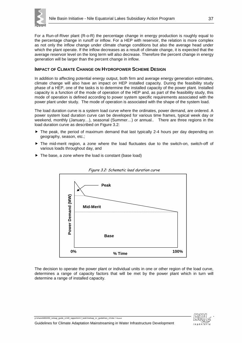
Nile Basin Initiative - Nile Equatorial Lakes Subsidiary Action Program
p:\chazot\800250_nelsap_guide_cc\40_rapports\4.2_task1\nelsap_cc_guidelines_v3.doc / Nhamel
Guidelines for Climate Adaptation Mainstreaming in Water Infrastructure Development
37
For a Run-of-River plant (R-o-R) the percentage change in energy production is roughly equal to the percentage change in runoff or inflow. For a HEP with reservoir, the relation is more complex as not only the inflow change under climate change conditions but also the average head under which the plant operate. If the inflow decreases as a result of climate change, it is expected that the average reservoir level on the long term will also decrease. Therefore the percent change in energy generation will be larger than the percent change in inflow.
IMPACT OF CLIMATE CHANGE ON HYDROPOWER SCHEME DESIGN
In addition to affecting potential energy output, both firm and average energy generation estimates, climate change will also have an impact on HEP installed capacity. During the feasibility study phase of a HEP, one of the tasks is to determine the installed capacity of the power plant. Installed capacity is a function of the mode of operation of the HEP and, as part of the feasibility study, this mode of operation is defined according to power system specific requirements associated with the power plant under study. The mode of operation is associated with the shape of the system load.
The load duration curve is a system load curve where the ordinates, power demand, are ordered. A power system load duration curve can be developed for various time frames, typical week day or weekend, monthly (January…), seasonal (Summer…) or annual.. There are three regions in the load duration curve as described on Figure 3.2:
� The peak, the period of maximum demand that last typically 2-4 hours per day depending on geography, season, etc.;
� The mid-merit region, a zone where the load fluctuates due to the switch-on, switch-off of various loads throughout day, and
� The base, a zone where the load is constant (base load)
Figure 3.2: Schematic load duration curve
The decision to operate the power plant or individual units in one or other region of the load curve, determines a range of capacity factors that will be met by the power plant which in turn will determine a range of installed capacity.
100% 0%
Pow
er D
eman
d (M
W)
Mid-Merit
Peak
% Time
Base
Nile Basin Initiative - Nile Equatorial Lakes Subsidiary Action Program
p:\chazot\800250_nelsap_guide_cc\40_rapports\4.2_task1\nelsap_cc_guidelines_v3.doc / Nhamel
Guidelines for Climate Adaptation Mainstreaming in Water Infrastructure Development |
The net capacity factor or load factor of a power plant is the ratio of the actual output of a power plant over a period of time and its potential output if it had operated at full nameplate capacity the entire time. The capacity factor is calculated by taking the total amount of energy the plant produces during a period of time and divide by the amount of energy the plant would have produced at full capacity. The impact of climate change will be to change the estimated energy production hence the capacity factor. In order for a HEP to operate in peak mode, it will operate for typically 3-4 hours per day and in order to maintain the same capacity factor i.e. produce the same amount of energy, the installed capacity will have to be modified. Therefore, climate change may have an impact on installed capacity if the HEP has been designed to generate at a pre-set capacity factor.
Another aspect that may be impacted by climate change is erosion and sedimentation. One impact will be to shorten the useful life of reservoirs but, directly related to hydropower production, the major impact will be caused by abrasive material that will grind turbines and deteriorate their efficiency. This generally occurs on run-of-river HEPs (R-o-R), i.e. HEPs without reservoirs. When a reservoir is present, water velocity drops in the reservoir and coarse material is deposited before it reaches plant intake, only suspended sediment will go eventually through the turbines and these suspended sediments are generally silty, non-erosive material.
IMPACT OF CLIMATE CHANGE ON PROJECT PRIORITIZATION
Although the generation plan may span a relatively long period, the prime purpose of conventional generation planning is to identify the best project or projects for immediate development . The longer term plant scheduling in any plan is only indicative, for use by energy planners.
Therefore the concern over changes in hydro project performance due to changes in runoff has to be viewed in the context of short or midterm recommended projects only. The long term aspect would only come into focus if a short term and long term project in a single portfolio were mutually dependant (e.g. where an upstream storage project forms part of a cascade). However even in such a scenario, a decision on a short term project is never dependant on later downstream development (although the benefits from the upstream project will increase with downstream development).
The focus of the assessment of potential climate change on river flows has to relate to recommendations on short and midterm projects.
The methodology to determine the impact of climate change on power generation pl anning and project prioritization consists in sensitivity analysis if the effect of climate change is to reduce expected energy production. Such sensitivity analysis is not necessary if the net effect is to increase energy production unless the increase is of a magnitude such that it affects the timing of additions and hence overall cost to the system.
If there is a large uncertainty on the impact of climate change on runoff and hydropower production, there is also a rather large if not larger uncertainty on load forecast.
To integrate the possible long-term impact of climate change, we can assume that hydroelectric production will roughly follow the evolution of runoff in a linear manner.
Runoff can be estimated using the previously described method, with the two extremes of rainfall change being between -15% and +30%, i.e. a change in runoff situated between -42% and +80%.
In the event of hydroelectric production from a dam reservoir, evaporation from the reservoir must, however, also be taken into account (roughly +10% compared to the present situation).
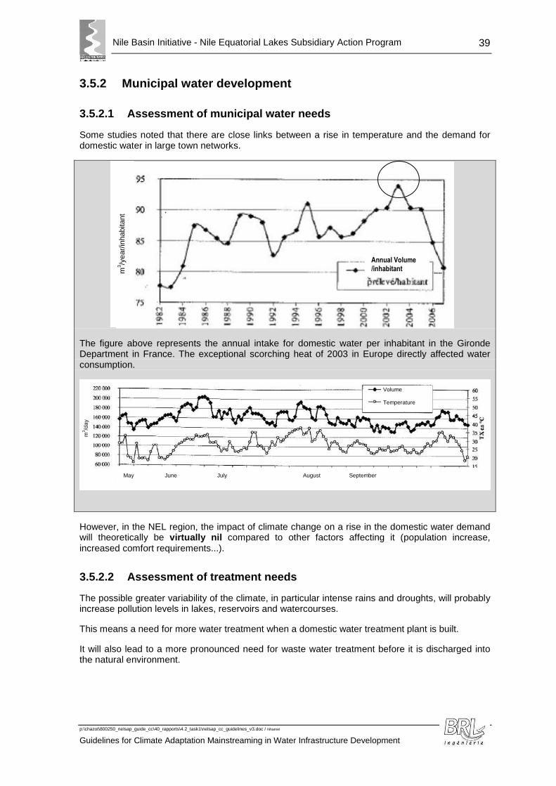
Nile Basin Initiative - Nile Equatorial Lakes Subsidiary Action Program
p:\chazot\800250_nelsap_guide_cc\40_rapports\4.2_task1\nelsap_cc_guidelines_v3.doc / Nhamel
Guidelines for Climate Adaptation Mainstreaming in Water Infrastructure Development
39
3.5.2 Municipal water development
3.5.2.1 Assessment of municipal water needs
Some studies noted that there are close links between a rise in temperature and the demand for domestic water in large town networks.
The figure above represents the annual intake for domestic water per inhabitant in the Gironde Department in France. The exceptional scorching heat of 2003 in Europe directly affected water consumption.
However, in the NEL region, the impact of climate change on a rise in the domestic water demand will theoretically be virtually nil compared to other factors affecting it (population increase, increased comfort requirements...).
3.5.2.2 Assessment of treatment needs
The possible greater variability of the climate, in particular intense rains and droughts, will probably increase pollution levels in lakes, reservoirs and watercourses.
This means a need for more water treatment when a domestic water treatment plant is built.
It will also lead to a more pronounced need for waste water treatment before it is discharged into the natural environment.
Annual Volume /inhabitant m
3 /yea
r/in
habi
tant
May June July August September
Volume Temperature
m3 /d
ay
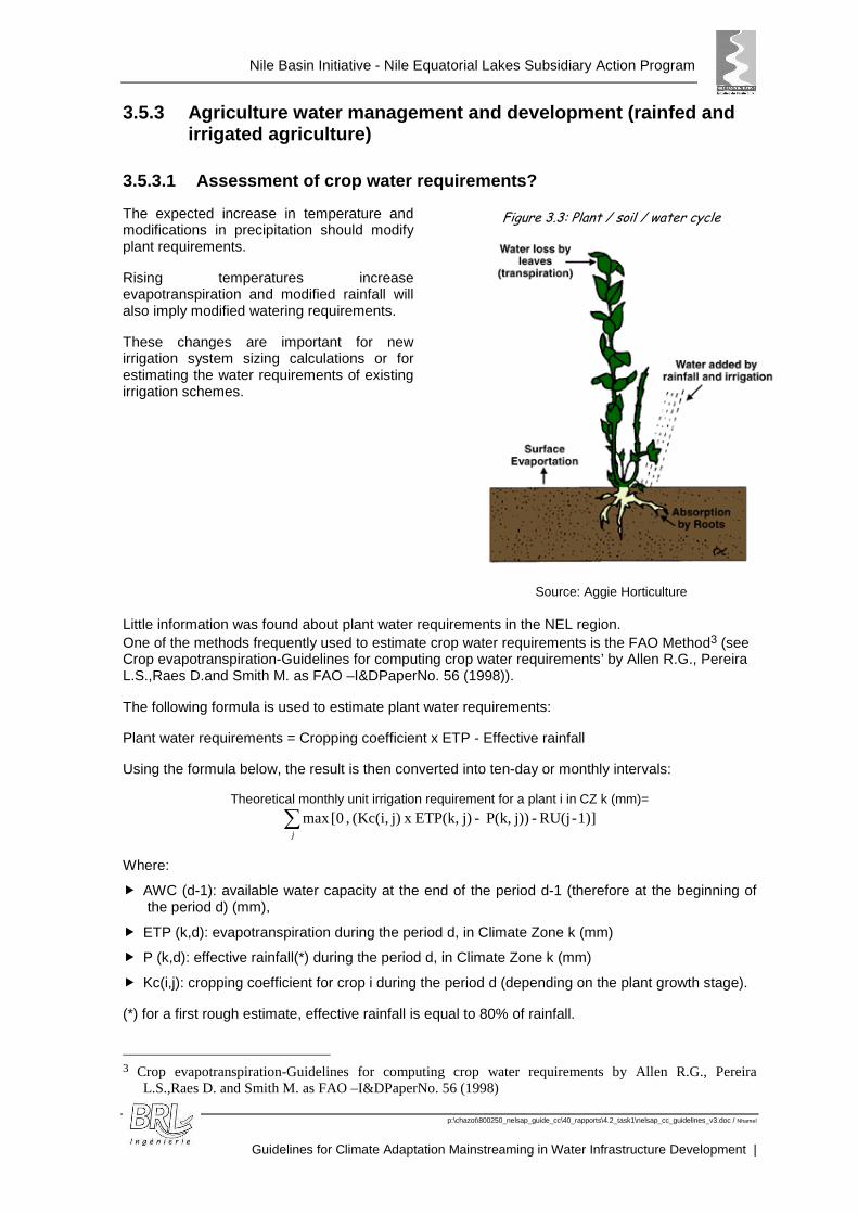
Nile Basin Initiative - Nile Equatorial Lakes Subsidiary Action Program
p:\chazot\800250_nelsap_guide_cc\40_rapports\4.2_task1\nelsap_cc_guidelines_v3.doc / Nhamel
Guidelines for Climate Adaptation Mainstreaming in Water Infrastructure Development |
3.5.3 Agriculture water management and development (rainfed and irrigated agriculture)
3.5.3.1 Assessment of crop water requirements?
The expected increase in temperature and modifications in precipitation should modify plant requirements.
Rising temperatures increase evapotranspiration and modified rainfall will also imply modified watering requirements.
These changes are important for new irrigation system sizing calculations or for estimating the water requirements of existing irrigation schemes.
Figure 3.3: Plant / soil / water cycle
Source: Aggie Horticulture Little information was found about plant water requirements in the NEL region. One of the methods frequently used to estimate crop water requirements is the FAO Method3 (see Crop evapotranspiration-Guidelines for computing crop water requirements’ by Allen R.G., Pereira L.S.,Raes D.and Smith M. as FAO –I&DPaperNo. 56 (1998)).
The following formula is used to estimate plant water requirements:
Plant water requirements = Cropping coefficient x ETP - Effective rainfall
Using the formula below, the result is then converted into ten-day or monthly intervals:
Theoretical monthly unit irrigation requirement for a plant i in CZ k (mm)=
∑j
1)]-RU(j - j))P(k, -j)ETP(k, x j)(Kc(i, , [0max
Where:
� AWC (d-1): available water capacity at the end of the period d-1 (therefore at the beginning of the period d) (mm),
� ETP (k,d): evapotranspiration during the period d, in Climate Zone k (mm)
� P (k,d): effective rainfall(*) during the period d, in Climate Zone k (mm)
� Kc(i,j): cropping coefficient for crop i during the period d (depending on the plant growth stage).
(*) for a first rough estimate, effective rainfall is equal to 80% of rainfall.
3 Crop evapotranspiration-Guidelines for computing crop water requirements by Allen R.G., Pereira
L.S.,Raes D. and Smith M. as FAO –I&DPaperNo. 56 (1998)
Nile Basin Initiative - Nile Equatorial Lakes Subsidiary Action Program
p:\chazot\800250_nelsap_guide_cc\40_rapports\4.2_task1\nelsap_cc_guidelines_v3.doc / Nhamel
Guidelines for Climate Adaptation Mainstreaming in Water Infrastructure Development
41
For each time step, the value of AWC (mm) at the end of the period is obtained:
AWC (d) = max [0 ; AWC(d-1)+P(d)-Kc(i,d)xETP(d))]
The available water capacity at the end of a year n is carried forward to the beginning of year n+1 (continuous model).
The theoretical requirements per irrigation scheme are obtained by adding together to the unit requirements of each crop and the total area cultivated with each type of crop:
Theoretical requirements for an irrigation scheme in CZk (m3)=
∑ ×i
ki in ZC i cropfor t requiremen irrigation lTheoretica S
The net requirements (m3) are then calculated by multiplying the theoretical requirements by a coefficient that takes into account the losses occurring due to the type of irrigation used.
This method can be used with present climate data or possible future climate data. Comparison can be done to calculate the impact on water requirements.
For instance, in the Niger Basin, the expected +2°C increase by 2050 could well lead to a rise in evapotranspiration corresponding to a 5% increase in crop water requirements (World Bank, Sustainable Development Department for Africa, 2010).
As a very first approach, the assumptions used can be that annual ETP rises by 10% and the annual rainfall values fall by -15%. The monthl y distribution of the fall in precipitation can be determined using the breakdown from componen t 1 (computed again for the site concerned or according to the average estimated dis tribution near Lake Victoria).
This method can be used for new network sizing calc ulations or to work out the water requirements on existing schemes.
3.5.3.2 Assessment of crop yields?
The evaluation of crop yields is involved in irrigation area cost-benefit analysis.
In addition to its effects on crop water requirements, climate change will probably also modify crop yields, particularly due to the effect of temperature change and the amount of CO2 in the atmosphere, factors that amplify photosynthesis and thus plant biomass production. Nevertheless, the consequences for yields will probably be extremely variable depending on the species and their physiology. For example, while C34 plants (such as rice, wheat, beetroot and peas, etc.) show strong responses to an increase in atmospheric carbon within the range considered, the response of C4 plants (such as maize, sorghum and sugar cane, etc.) is very low beyond 400 ppm, close to the present atmospheric content.
Studies on the consequences of climate change in sub-Saharan Africa illustrate the differences in such effects.
In Egypt, climate change could reduce numerous crop yields: -11% for rice and -28% for soya by 2050 (Eid and El-Marsafway, 2002, quoted by Hallegate, Somot, Nassopoulos, 2008).
4 C3 photosynthesis, called C3 because the CO2 is first incorporated into a 3-carbon compound is the typical photosynthesis that most plants use. C4 photosynthesis, called C4 because the CO2 is first incorporated into a 4-carbon compound, is an adaptation to arid conditions because they result in better water use efficiency.
Nile Basin Initiative - Nile Equatorial Lakes Subsidiary Action Program
p:\chazot\800250_nelsap_guide_cc\40_rapports\4.2_task1\nelsap_cc_guidelines_v3.doc / Nhamel
Guidelines for Climate Adaptation Mainstreaming in Water Infrastructure Development |
For a first rough estimate, without carrying out mo re detailed studies, we can assume that the reduction in crop yield will probably be around -10% for C3 plants and -30% for C4 plants (supposing that 50 years is sufficient for i rrigation scheme sizing).
3.5.4 Environmental and Social Management
The sensitivity of the natural environment and especially aquatic biodiversity will be accentuated due to the effects of climate change. Every measure should be taken to reduce the adverse effects of the facilities built on the natural environment, especially on wetlands.
3.5.4.1 Watershed management and land use planning
Land use in the catchment area of the water infrastructure has direct impacts on water resources and can modify the use of the infrastructure and its design (for instance practices increasing erosion can lead to a quick filling of a reservoir).
The modification of climatic conditions will certainly change the land cover of the catchment but it is difficult to predict the importance and the possible trends that could be observed for land uses.
The importance of good watershed management will be at all events increased, notably with the possible rise of extreme events and variability of climate.
3.5.4.2 Impact of water infrastructure
HYDROPOWER DAMS/MULTIPURPOSE FACILITIES
Impacts of dams on downstream river flows may be exacerbated by climate change resulting in the need to release a greater proportion of water stored in reservoirs to maintain the riverine environment and ecosystem services.
Climate change is likely to affect adversely the aquatic flora and fauna that inhabit the dam reservoirs in the NEL region and this will lead to loss of the biodiversity as well as impact on livelihoods especially those that depend on for example the fish resources in the dam reservoirs. For instance reduction in reservoir capacity as a result of drought will adversely affect the inherent flora and fauna in the reservoirs as well as downstream biodiversity.
Reservoirs also provide beneficial impacts: they provides habitat for wetland species, especially water birds fisheries and other flora and fauna. The reservoir can also be a source of water to animals and plants in the adjoining areas and, where such areas have become unnaturally dry, this can be a significant environmental benefit.
Dams will on the other hand probably have benefits in regard to drought mitigation in the sense that dams and their reservoirs will store and retain water that can be used in times of extreme drought for irrigation, domestic water provision and other uses. The reservoirs will also act as vital habitats for aquatic flora and fauna as well as other mammals.
Effective dam management can help limit adverse climate change impacts including ensuring minimum environmental flows among others as described below.

Nile Basin Initiative - Nile Equatorial Lakes Subsidiary Action Program
p:\chazot\800250_nelsap_guide_cc\40_rapports\4.2_task1\nelsap_cc_guidelines_v3.doc / Nhamel
Guidelines for Climate Adaptation Mainstreaming in Water Infrastructure Development
43
EARTH LINED CANALS
The impacts of climate change on canals are likely to be linked to increased weed growth and sediment accumulation due to water quality changes and increased heavy rainfall-induced sediment mobilization respectively. Canal sediment and weed growth for schemes is generally addressed as a single operation and finance item, as cleaning generally removes both at the same time. Minor effects have been identified as increased slips, seepage as a result of canal liner cracking, and subsequent canal over-flows in the event of excess capacity inflows from rainfall events and the damage this induces.
3.5.4.3 Environmental Flows
Environmental flows are the flow regimes needed to maintain important aquatic ecosystem services. They are a core element of good practice in water resources planning and management. While there are numerous definitions of environmental flows, they are defined here as “the quality, quantity, and timing of water flows required to maintain the components, functions, processes, and resilience of aquatic ecosystems which provide goods and services to people” (Nature Conservancy 2006).
Environmental flows have become identified, at least within development assistance organizations, with mitigation of the impacts of dams and other water resources infrastructure. Environmental assessment of proposals to build new dams or other infrastructure or to rehabilitate existing infrastructure should include an assessment of the potential downstream environmental and social impacts.
Environmental flows can lead to more efficient water use and benefit both environmental and consumptive water users.
Climate change is likely to make environmental flows both more important and more difficult to maintain. The annual average inflows of water to surface water and recharge to groundwater systems will be affected by climate change, with consequent impacts on aquatic ecosystems and the ecosystem services that they provide. The frequency of extreme events might also be affected by global warming, causing changes in the frequency of floods and droughts, on which some riverine ecosystems rely. Warmer temperatures will alter ecosystem processes and patterns of demand. The water requirements of crops for rainfed and irrigated agriculture will change, and this, in turn, will affect the water allocated to the environment. In particular, climate change will force governments to make explicit choices in the ecosystems that are to be protected when the availability of water changes in contested catchments and groundwater systems.
Environmental Flows and IWRM Linkages
The environment is linked to IWRM in three fundamental ways. First, the aquatic (and related terrestrial) ecosystem provides habitat for fish, invertebrates, and other fauna and flora. The aquatic ecosystem is thus a water consuming sector just like agriculture, energy, and domestic and industrial supply. Second, the design and operation of hydraulic infrastructure for water supply, sewerage, irrigation, hydropower, and flood control often affect ecosystems, both upstream and downstream of the infrastructure, and communities—farming, pastoral, and fishing—dependent on those ecosystems. Conversely, the reoperation and rehabilitation of existing infrastructure have been used to support the successful restoration of degraded riverine ecosystems. Third, integrated water resources planning and management are facilitated by policies, laws, strategies, and plans that are multisectoral, based on the allocation of water for all uses; protection of water quality and control of pollution; protection and restoration of lake basins, watersheds, groundwater aquifers, and wetlands; and control and management of invasive species.

Nile Basin Initiative - Nile Equatorial Lakes Subsidiary Action Program
p:\chazot\800250_nelsap_guide_cc\40_rapports\4.2_task1\nelsap_cc_guidelines_v3.doc / Nhamel
Guidelines for Climate Adaptation Mainstreaming in Water Infrastructure Development |
3.5.4.4 Social impacts
Climate change could lead to an increase of water related diseases, with warmer temperatures, possibly more precipitation and more extreme events. Water infrastructure can be indirectly linked with favourable conditions to water-borne disease, by for instance increasing or reducing the conditions for mosquito development.
For municipal water infrastructure, it can be expected that the infrastructure will tend to reduce water-related disease, but for other infrastructure, such as irrigated areas, or reservoirs, the infrastructure could increase the surface of stagnant water and so increase water-related disease.
This possible impact is generally seen in environmental studies, and climate change has to be integrated in such studies.
Climate change will also probably lead to a higher need of adaptation for the population. Water infrastructure is part of the adaptation means that will allow the inhabitants to face the possible variability and change of climate. The mainstreaming of climate change into the selection and implementation of water infrastructure will ensure the appropriateness of the infrastructure to future conditions and the fact that it will help the population to adapt.
3.5.5 Water Resource Assessment
3.5.5.1 The issues
Figure 3.4 : Schematic illustration of a catchment area
A catchment area is an open system that transforms "solid and liquid precipitation" and "potential evapotranspiration" signals into an output signal, "runoff" after incorporation of the surface conditions, exchanges with groundwater, abstractions, discharge and the management of water transfer and/or control facilities.
The key question in water infrastructure development is: How do changes in the input signals (precipitation and potential evapotranspiration) due to climate change affect the output signal, runoff?
3.5.5.2 The ideal solution
Ideally, with sufficient means for studies and data available, the best method to discern the potential impact of climate change on runoff at the catchment area outfall is to develop a computation chain as follows (cf. Figure 3.5):
� Climate models can simulate present and future climate at specific calculation points, in the form of precipitation, temperature and potential evapotranspiration (ETP).
� The output from the climate models is used as input data for hydrological models (models that convert rain and ETP into runoff) in order to simulate present and possible future runoff at catchment area outfalls, hence to determine the possible hydrological changes in thos e places .
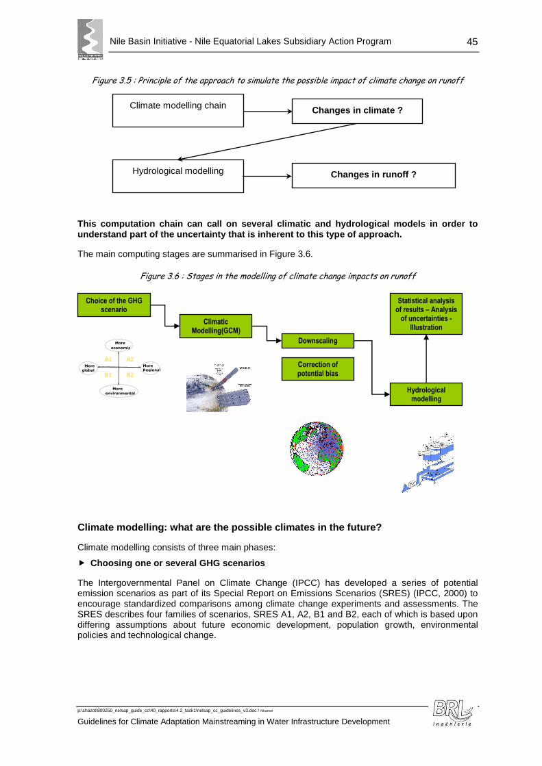
Nile Basin Initiative - Nile Equatorial Lakes Subsidiary Action Program
p:\chazot\800250_nelsap_guide_cc\40_rapports\4.2_task1\nelsap_cc_guidelines_v3.doc / Nhamel
Guidelines for Climate Adaptation Mainstreaming in Water Infrastructure Development
45
Figure 3.5 : Principle of the approach to simulate the possible impact of climate change on runoff
Changes in climate ?
Hydrological modelling Changes in runoff ?
Climate modelling chain
This computation chain can call on several climatic and hydrological models in order to understand part of the uncertainty that is inherent to this type of approach.
The main computing stages are summarised in Figure 3.6.
Figure 3.6 : Stages in the modelling of climate change impacts on runoff
Climate modelling: what are the possible climates in the future?
Climate modelling consists of three main phases:
� Choosing one or several GHG scenarios
The Intergovernmental Panel on Climate Change (IPCC) has developed a series of potential emission scenarios as part of its Special Report on Emissions Scenarios (SRES) (IPCC, 2000) to encourage standardized comparisons among climate change experiments and assessments. The SRES describes four families of scenarios, SRES A1, A2, B1 and B2, each of which is based upon differing assumptions about future economic development, population growth, environmental policies and technological change.
Choice of the GHG scenario
Climatic Modelling(GCM)
Downscaling
Correction of potential bias
Hydrological modelling
Statistical analysis of results – Analysis
of uncertainties - Illustration
B2
A2 A1
B1 More global
More economic
More Regional
More environmental
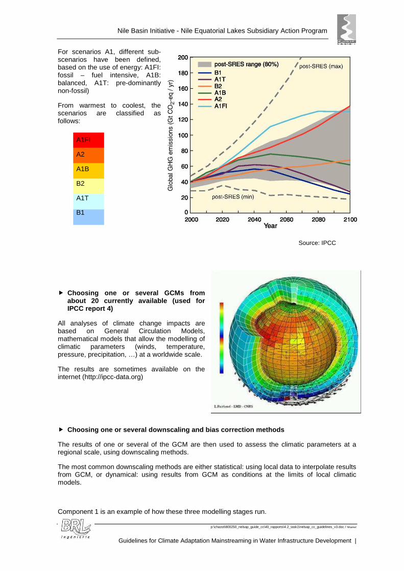
Nile Basin Initiative - Nile Equatorial Lakes Subsidiary Action Program
p:\chazot\800250_nelsap_guide_cc\40_rapports\4.2_task1\nelsap_cc_guidelines_v3.doc / Nhamel
Guidelines for Climate Adaptation Mainstreaming in Water Infrastructure Development |
A1FI
A2
A1B
B2
A1T
B1
For scenarios A1, different sub-scenarios have been defined, based on the use of energy: A1FI: fossil – fuel intensive, A1B: balanced, A1T: pre-dominantly non-fossil)
From warmest to coolest, the scenarios are classified as follows:
Source: IPCC
� Choosing one or several GCMs from about 20 currently available (used for IPCC report 4)
All analyses of climate change impacts are based on General Circulation Models, mathematical models that allow the modelling of climatic parameters (winds, temperature, pressure, precipitation, …) at a worldwide scale.
The results are sometimes available on the internet (http://ipcc-data.org)
� Choosing one or several downscaling and bias correc tion methods
The results of one or several of the GCM are then used to assess the climatic parameters at a regional scale, using downscaling methods.
The most common downscaling methods are either statistical: using local data to interpolate results from GCM, or dynamical: using results from GCM as conditions at the limits of local climatic models.
Component 1 is an example of how these three modelling stages run.
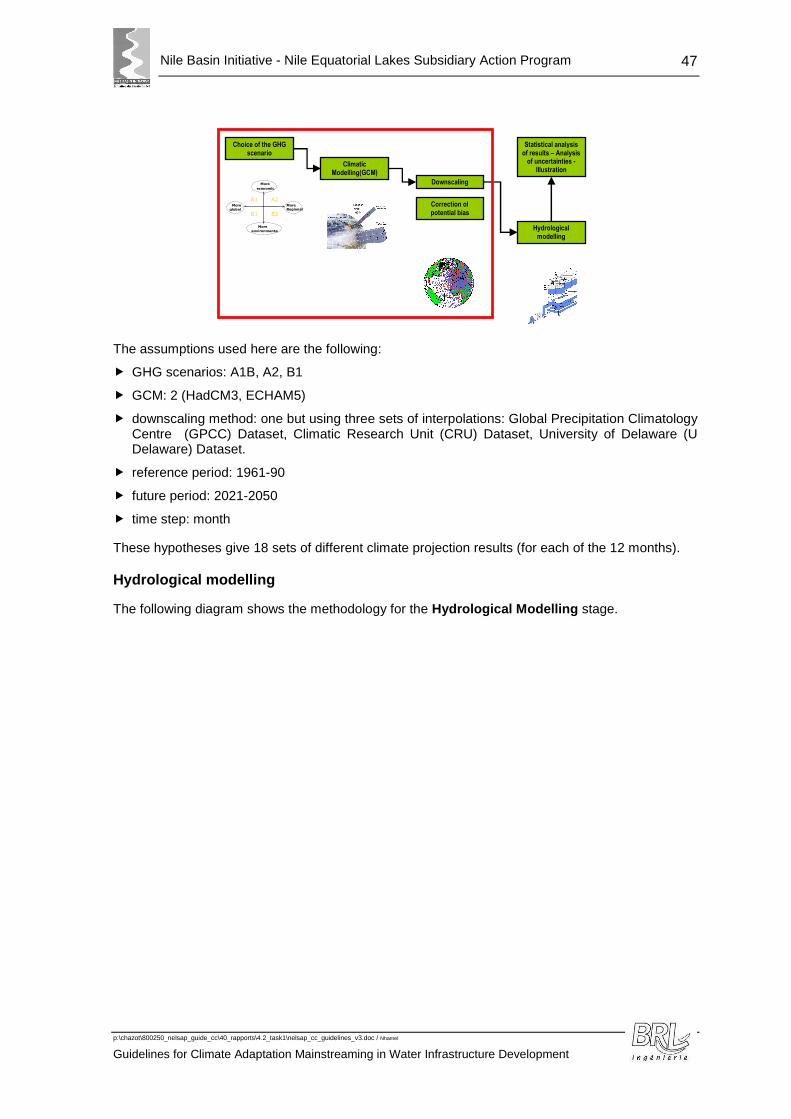
Nile Basin Initiative - Nile Equatorial Lakes Subsidiary Action Program
p:\chazot\800250_nelsap_guide_cc\40_rapports\4.2_task1\nelsap_cc_guidelines_v3.doc / Nhamel
Guidelines for Climate Adaptation Mainstreaming in Water Infrastructure Development
47
The assumptions used here are the following:
� GHG scenarios: A1B, A2, B1
� GCM: 2 (HadCM3, ECHAM5)
� downscaling method: one but using three sets of interpolations: Global Precipitation Climatology Centre (GPCC) Dataset, Climatic Research Unit (CRU) Dataset, University of Delaware (U Delaware) Dataset.
� reference period: 1961-90
� future period: 2021-2050
� time step: month
These hypotheses give 18 sets of different climate projection results (for each of the 12 months).
Hydrological modelling
The following diagram shows the methodology for the Hydrological Modelling stage.
Choice of the GHG scenario
Climatic Modelling(GCM)
Downscaling
Correction of potential bias
Hydrological modelling
Statistical analysis of results – Analysis
of uncertainties - Illustration
B2
A2 A1
B1 More global
More economic
More Regional
More environmental
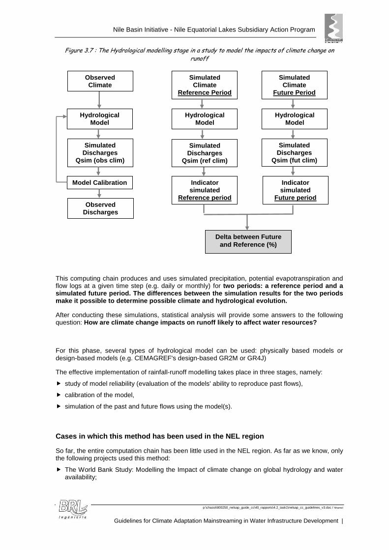
Nile Basin Initiative - Nile Equatorial Lakes Subsidiary Action Program
p:\chazot\800250_nelsap_guide_cc\40_rapports\4.2_task1\nelsap_cc_guidelines_v3.doc / Nhamel
Guidelines for Climate Adaptation Mainstreaming in Water Infrastructure Development |
Figure 3.7 : The Hydrological modelling stage in a study to model the impacts of climate change on runoff
This computing chain produces and uses simulated precipitation, potential evapotranspiration and flow logs at a given time step (e.g. daily or monthly) for two periods: a reference period and a simulated future period. The differences between the simulation results for the two periods make it possible to determine possible climate and hydrological evolution.
After conducting these simulations, statistical analysis will provide some answers to the following question: How are climate change impacts on runoff likely to affect water resources?
For this phase, several types of hydrological model can be used: physically based models or design-based models (e.g. CEMAGREF's design-based GR2M or GR4J)
The effective implementation of rainfall-runoff modelling takes place in three stages, namely:
� study of model reliability (evaluation of the models' ability to reproduce past flows),
� calibration of the model,
� simulation of the past and future flows using the model(s).
Cases in which this method has been used in the NEL region
So far, the entire computation chain has been little used in the NEL region. As far as we know, only the following projects used this method:
� The World Bank Study: Modelling the Impact of climate change on global hydrology and water availability;
Observed Climate
Simul ated Discharges
Qsim (obs clim)
Model Calibration
Simulated Climate
Reference Period
Hydrological Model
Indicator simulated
Reference period Observed
Discharges
Delta between Future and Reference (%)
Simulated Climate
Future Period
Hydrological Model
Hydrological Model
Simulated Discharges
Qsim (ref clim)
Simulated Discharges
Qsim (fut clim)
Indicator simulated
Future period

Nile Basin Initiative - Nile Equatorial Lakes Subsidiary Action Program
p:\chazot\800250_nelsap_guide_cc\40_rapports\4.2_task1\nelsap_cc_guidelines_v3.doc / Nhamel
Guidelines for Climate Adaptation Mainstreaming in Water Infrastructure Development
49
� The study concerning the Power Development Options in the Nile Equatorial Lakes Region: (SSEA), with a water balance model;
� The assessment of climate change impact on hydrological extremes in two source regions of the Nile River Basin – Hydrology and Earth System Sciences Discussion;
� The assessment of climate change impact on runoff – River Nzoia catchment, Kenya
Use of this method in practice
It is still possible to apply this method to other basins in the study area. It is a relatively complex method implying that historical data exists so that a reference period can be defined to calibrate the model. But it has the advantage of providing relatively refine d analyses on how water resources are affected and establishing a range of uncertainty.
An example of the results obtained with this method is shown below:
Range of future runoff obtained from the simulations
Reference period runoff
What climate data should be used?
Reference climate data: Rainfall
Rainfall must be deduced from representative rain gauging stations in the catchment area studied. It is possible to use one of the rainfall datasets from component 15 (e.g. the interpolation products in the University of Delaware Dataset (U Delaware) (http://www.esrl.noaa.gov/psd/data/gridded/data.UDel_AirT_Precip.html).
Reference climate data: Temperature and/or ETP
Component 1 does not include any broken down temperature data. It is possible to use broad scale temperatures obtained from the interpolation products (for example or http://www.ipcc-data.org/obs/index.html).
Results of climate simulations that have already been broken down
5 Regional Downscaling of Precipitation and Temperature Data for Climate Change Impact Assessment in the Nile Equatorial Lakes (NEL) Region – NELSAP / NBI – University of Stuttgart - 2011
Evolution possible du débit du Rhône à Beaucaire à l'horizon 2060
-
500
1 000
1 500
2 000
2 500
3 000
janv févr mars avr mai juin juil août sept oct nov déc
m3/
s
Possible evolution of the Rhône River Discharge by 2060
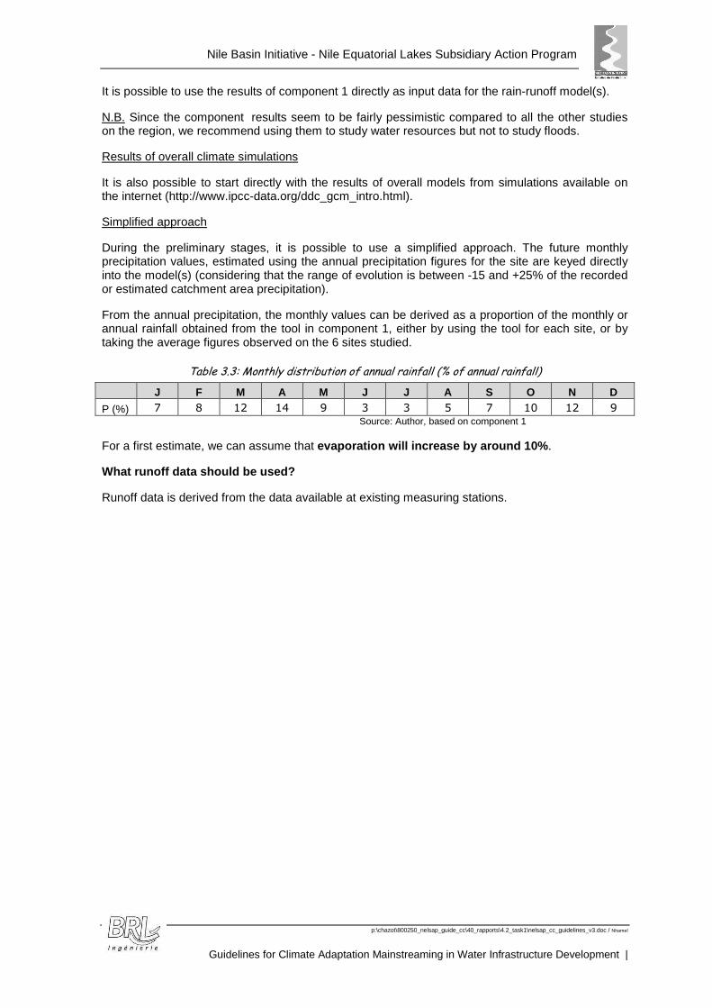
Nile Basin Initiative - Nile Equatorial Lakes Subsidiary Action Program
p:\chazot\800250_nelsap_guide_cc\40_rapports\4.2_task1\nelsap_cc_guidelines_v3.doc / Nhamel
Guidelines for Climate Adaptation Mainstreaming in Water Infrastructure Development |
It is possible to use the results of component 1 directly as input data for the rain-runoff model(s).
N.B. Since the component results seem to be fairly pessimistic compared to all the other studies on the region, we recommend using them to study water resources but not to study floods.
Results of overall climate simulations
It is also possible to start directly with the results of overall models from simulations available on the internet (http://www.ipcc-data.org/ddc_gcm_intro.html).
Simplified approach
During the preliminary stages, it is possible to use a simplified approach. The future monthly precipitation values, estimated using the annual precipitation figures for the site are keyed directly into the model(s) (considering that the range of evolution is between -15 and +25% of the recorded or estimated catchment area precipitation).
From the annual precipitation, the monthly values can be derived as a proportion of the monthly or annual rainfall obtained from the tool in component 1, either by using the tool for each site, or by taking the average figures observed on the 6 sites studied.
Table 3.3: Monthly distribution of annual rainfall (% of annual rainfall)
J F M A M J J A S O N D
P (%) 7 8 12 14 9 3 3 5 7 10 12 9 Source: Author, based on component 1
For a first estimate, we can assume that evaporation will increase by around 10% .
What runoff data should be used?
Runoff data is derived from the data available at existing measuring stations.

Nile Basin Initiative - Nile Equatorial Lakes Subsidiary Action Program
p:\chazot\800250_nelsap_guide_cc\40_rapports\4.2_task1\nelsap_cc_guidelines_v3.doc / Nhamel
Guidelines for Climate Adaptation Mainstreaming in Water Infrastructure Development
51
Figure 3.8 : Hydrometric stations – NEL region
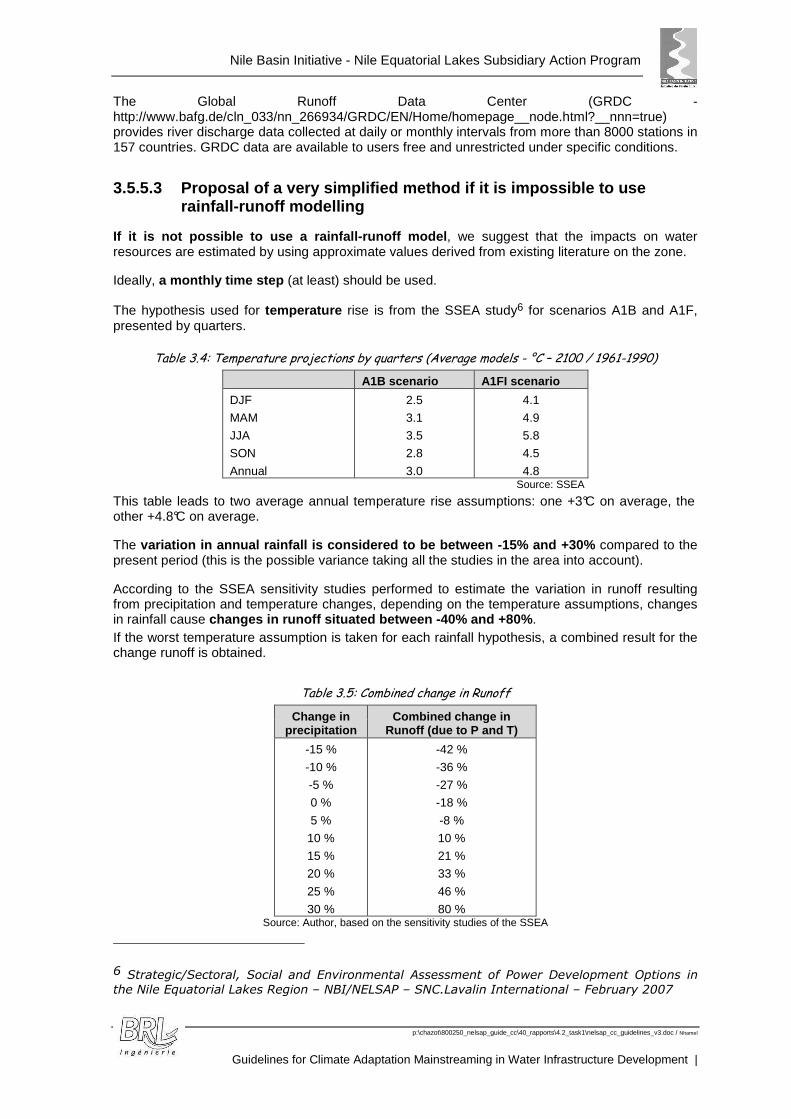
Nile Basin Initiative - Nile Equatorial Lakes Subsidiary Action Program
p:\chazot\800250_nelsap_guide_cc\40_rapports\4.2_task1\nelsap_cc_guidelines_v3.doc / Nhamel
Guidelines for Climate Adaptation Mainstreaming in Water Infrastructure Development |
The Global Runoff Data Center (GRDC - http://www.bafg.de/cln_033/nn_266934/GRDC/EN/Home/homepage__node.html?__nnn=true) provides river discharge data collected at daily or monthly intervals from more than 8000 stations in 157 countries. GRDC data are available to users free and unrestricted under specific conditions.
3.5.5.3 Proposal of a very simplified method if it is impossible to use rainfall-runoff modelling
If it is not possible to use a rainfall-runoff mode l, we suggest that the impacts on water resources are estimated by using approximate values derived from existing literature on the zone.
Ideally, a monthly time step (at least) should be used.
The hypothesis used for temperature rise is from the SSEA study6 for scenarios A1B and A1F, presented by quarters.
Table 3.4: Temperature projections by quarters (Average models - °C – 2100 / 1961-1990)
A1B scenario A1FI scenario
DJF
MAM
JJA
SON
Annual
2.5
3.1
3.5
2.8
3.0
4.1
4.9
5.8
4.5
4.8 Source: SSEA
This table leads to two average annual temperature rise assumptions: one +3°C on average, the other +4.8°C on average.
The variation in annual rainfall is considered to be be tween -15% and +30% compared to the present period (this is the possible variance taking all the studies in the area into account).
According to the SSEA sensitivity studies performed to estimate the variation in runoff resulting from precipitation and temperature changes, depending on the temperature assumptions, changes in rainfall cause changes in runoff situated between -40% and +80% . If the worst temperature assumption is taken for each rainfall hypothesis, a combined result for the change runoff is obtained.
Table 3.5: Combined change in Runoff
Change in precipitation
Combined change in Runoff (due to P and T)
-15 %
-10 %
-5 %
0 %
5 %
10 %
15 %
20 %
25 %
30 %
-42 %
-36 %
-27 %
-18 %
-8 %
10 %
21 %
33 %
46 %
80 % Source: Author, based on the sensitivity studies of the SSEA
6 Strategic/Sectoral, Social and Environmental Assessment of Power Development Options in the Nile Equatorial Lakes Region – NBI/NELSAP – SNC.Lavalin International – February 2007
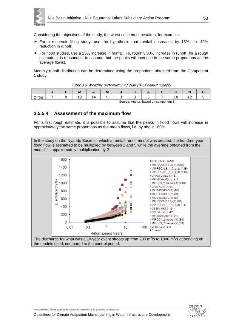
Nile Basin Initiative - Nile Equatorial Lakes Subsidiary Action Program
p:\chazot\800250_nelsap_guide_cc\40_rapports\4.2_task1\nelsap_cc_guidelines_v3.doc / Nhamel
Guidelines for Climate Adaptation Mainstreaming in Water Infrastructure Development
53
Considering the objectives of the study, the worst case must be taken, for example:
� For a reservoir filling study: use the hypothesis that rainfall decreases by 15%, i.e. 42% reduction in runoff;
� For flood studies, use a 25% increase in rainfall, i.e. roughly 80% increase in runoff (for a rough estimate, it is reasonable to assume that the peaks will increase in the same proportions as the average flows).
Monthly runoff distribution can be determined using the proportions obtained from the Component 1 study:
Table 3.6: Monthly distribution of flow (% of annual runoff)
J F M A M J J A S O N D
Q (%) 7 8 12 14 9 3 3 5 7 10 12 9
Source: Author, based on component 1
3.5.5.4 Assessment of the maximum flow
For a first rough estimate, it is possible to assume that the peaks in flood flows will increase in approximately the same proportions as the mean flows, i.e. by about +80%.
In the study on the Nyando Basin for which a rainfall-runoff model was created, the hundred-year flood flow is estimated to be multiplied by between 1 and 5 while the average obtained from the models is approximately multiplication by 2.
The discharge for what was a 10-year event shoots up from 200 m3/s to 1000 m3/s depending on the models used, compared to the control period.
Nile Basin Initiative - Nile Equatorial Lakes Subsidiary Action Program
p:\chazot\800250_nelsap_guide_cc\40_rapports\4.2_task1\nelsap_cc_guidelines_v3.doc / Nhamel
Guidelines for Climate Adaptation Mainstreaming in Water Infrastructure Development |
3.5.6 Infrastructure development (dams, reservoirs, urban water supply etc)
3.5.6.1 Assessment of erosion / sedimentation?
Climate change will affect runoff but also land cover. There has been relatively little research on the subject and it is currently difficult to forecast land cover evolution as a result of climate change. The evolution of runoff and extreme events will definitely affect sediment load in watercourses. Sediment load will change reservoir capacity in the long run as well as reservoir management.
This is an important concern for reservoir management as it has been estimated that sedimentation is currently reducing the storage capacity of the world’s major reservoirs by about 0.8% per year7.
The impact of climate change will add to the impact of other human impacts, such as catchment cover modifications and water infrastructure.
7 The Impact of Global Change on Erosion and Sediment Transport by Rivers : Current Progress and Future Challenges –
The United Nations World Water Assessment Programme – UNESCO-IHP International Sediment Initiative

Nile Basin Initiative - Nile Equatorial Lakes Subsidiary Action Program
p:\chazot\800250_nelsap_guide_cc\40_rapports\4.2_task1\nelsap_cc_guidelines_v3.doc / Nhamel
Guidelines for Climate Adaptation Mainstreaming in Water Infrastructure Development
55
A study on 3 rivers in China, Thailand and Siberia (UNESCO-ISI) shows that the sediment evolves on a linear trend with runoff. Climate change impact is difficult to disentangle from changes resulting from other human impacts. Existing evidence suggests that in most cases, these human impacts are at present likely to be more significant.
Figure 3.9: Recent trends in the annual suspended sediment loads and annual runoff
Source: UNESCO-IHP
We can assume, in a first approach, that sediment loads will follow the evolution of stream flow, in the same proportions, i.e. we can suppose that the change will be situated between -40% and +80%. These two extremes need to be analyzed when selecting and designing the reservoirs.

Nile Basin Initiative - Nile Equatorial Lakes Subsidiary Action Program
p:\chazot\800250_nelsap_guide_cc\40_rapports\4.2_task1\nelsap_cc_guidelines_v3.doc / Nhamel
Guidelines for Climate Adaptation Mainstreaming in Water Infrastructure Development |
4. TOOLS
Several tools have been developed to facilitate the analysis required in the guidelines. The two main ones are described below.
4.1 « COMPONENT 1 » TOOL
An Excel program has been developed by BRLi to exploit the program developed by Stuttgart University.
A tool allowing the impact of climate change for an entire catchment, followed by a rainfall-runoff model would be useful for decision making, but is not part of this study.
The tool produced by BRLI allows the user to produce for a given location (X and Y):
� the present and future monthly precipitation for each of the 18 possible scenarios, and the average monthly and annual precipitation;
� the difference, in percentage, between future and reference period;
The results are given in terms of tables and graphs, in an Excel file. The representation of differences between present and future precipitation uses a tool developed on free software called R.
An example of the results obtained from the tool is presented below, for Angolola Dam Site.
The coordinates selected here are the exact coordinates of the dam site. The river catchment of the site (and all selected sites for the task 2 study) is limited: about 540 km² for Angolola dam site (from 109 m² for Kabuyanda to 570km² for Kakanja Dam site. The estimate of the rainfall at the dam site can be seen as representative of the catchment rainfall. For larger river catchments, the coordinates entered in the tool can be the gravity centre of the catchment.
Table 4.1: Future Monthly precipitation (2021-2050) – Angolola Dam Site
GCM ScenarioDownscaling
ProductJan. Feb. Mar. Apr. May June July Aug. Sep. Oct. Nov. Dec. Annual
mpeh5 sra1b gpcc 55 83 132 209 166 69 80 102 123 167 143 96 1 425
mpeh5 sra1b cru 48 78 126 195 145 62 67 84 103 163 135 89 1 296mpeh5 sra1b udela 54 80 126 201 156 69 73 97 117 161 136 93 1 362
hadcm sra1b gpcc 72 121 180 203 141 55 64 90 105 114 162 91 1 396
hadcm sra1b cru 67 114 174 187 120 51 55 73 83 91 154 88 1 257
hadcm sra1b udela 70 120 174 194 137 59 61 88 104 111 157 92 1 367mpeh5 sra2 gpcc 66 74 132 215 169 65 80 108 136 168 139 100 1 450
mpeh5 sra2 cru 58 68 125 202 152 61 66 89 115 164 127 92 1 318
mpeh5 sra2 udela 65 73 126 205 160 66 71 102 128 162 131 97 1 384
hadcm sra2 gpcc 88 98 211 211 146 74 70 106 113 116 153 81 1 467hadcm sra2 cru 80 93 214 200 127 66 59 87 91 95 147 76 1 333
hadcm sra2 udela 85 94 206 203 138 73 64 100 107 108 145 79 1 401
mpeh5 srb1 gpcc 62 80 122 200 175 80 90 99 127 162 132 108 1 438
mpeh5 srb1 cru 55 74 114 186 157 71 76 81 107 153 121 104 1 299mpeh5 srb1 udela 61 78 117 191 166 79 84 94 121 155 125 105 1 375
hadcm srb1 gpcc 93 110 159 216 165 60 66 102 106 125 141 80 1 423
hadcm srb1 cru 87 103 155 206 147 57 55 84 84 107 127 77 1 289
hadcm srb1 udela 89 107 153 206 156 63 60 98 100 118 132 79 1 361
70 92 153 202 151 66 69 94 109 135 139 90 1 369
Futur Monthly Precipitation - 2021-2050 (mm)
Average Annual Precipitation
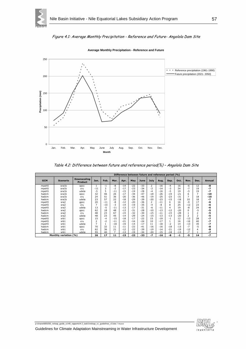
Nile Basin Initiative - Nile Equatorial Lakes Subsidiary Action Program
p:\chazot\800250_nelsap_guide_cc\40_rapports\4.2_task1\nelsap_cc_guidelines_v3.doc / Nhamel
Guidelines for Climate Adaptation Mainstreaming in Water Infrastructure Development
57
Figure 4.1: Average Monthly Precipitation - Reference and Future- Angolola Dam Site
Average Monthly Precipitation - Reference and Future
0
50
100
150
200
250
Jan. Feb. Mar. Apr. May June July Aug. Sep. Oct. Nov. Dec.
Month
Pre
cipi
tatio
n (m
m)
Reference precipitation (1961-1990)
Future precipitation (2021- 2050)
Table 4.2: Difference between future and reference period(%) – Angolola Dam Site
GCM ScenarioDownscaling
ProductJan. Feb. Mar. Apr. May June July Aug. Sep. Oct. Nov. Dec. Annual
mpeh5 sra1b gpcc 1 -1 -8 -14 -22 -33 2 -16 -4 16 -6 12 -8
mpeh5 sra1b cru -11 3 -2 -17 -23 -34 -2 -14 -3 24 -7 19 -7mpeh5 sra1b udela -5 5 -11 -15 -19 -28 -4 -16 -5 19 -5 19 -7
hadcm sra1b gpcc 32 46 26 -17 -34 -47 -18 -26 -19 -21 6 7 -10
hadcm sra1b cru 24 51 36 -20 -36 -46 -19 -25 -23 -31 7 18 -10
hadcm sra1b udela 23 57 22 -18 -29 -39 -20 -23 -15 -18 10 18 -7mpeh5 sra2 gpcc 20 -11 -8 -12 -20 -36 2 -11 6 16 -9 17 -6
mpeh5 sra2 cru 7 -10 -3 -14 -19 -35 -4 -8 8 25 -12 23 -6
mpeh5 sra2 udela 13 -5 -11 -13 -17 -31 -6 -11 4 19 -8 24 -6
hadcm sra2 gpcc 62 18 48 -13 -31 -28 -10 -13 -12 -20 0 -5 -5hadcm sra2 cru 48 23 67 -15 -32 -30 -15 -11 -15 -28 1 2 -5
hadcm sra2 udela 48 23 45 -14 -29 -24 -15 -13 -13 -20 2 2 -5
mpeh5 srb1 gpcc 15 -4 -15 -18 -17 -22 15 -19 -1 12 -13 28 -7
mpeh5 srb1 cru 2 -2 -11 -21 -16 -24 10 -17 1 16 -16 40 -7mpeh5 srb1 udela 7 1 -18 -19 -14 -17 11 -18 -2 14 -13 35 -7
hadcm srb1 gpcc 70 32 11 -11 -22 -41 -16 -16 -18 -13 -7 -5 -8
hadcm srb1 cru 62 36 21 -12 -22 -39 -19 -14 -21 -19 -12 4 -8
hadcm srb1 udela 55 40 7 -13 -19 -34 -20 -15 -18 -13 -7 1 -7
26 17 11 -15 -23 -33 -7 -16 -8 -1 -5 14 -7
Difference between future and reference period (%)
Monthly variation (%)
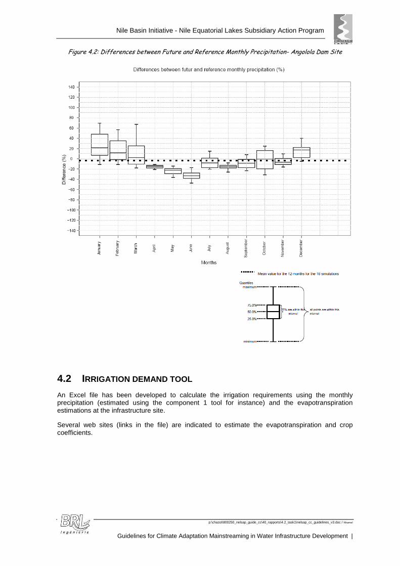
Nile Basin Initiative - Nile Equatorial Lakes Subsidiary Action Program
p:\chazot\800250_nelsap_guide_cc\40_rapports\4.2_task1\nelsap_cc_guidelines_v3.doc / Nhamel
Guidelines for Climate Adaptation Mainstreaming in Water Infrastructure Development |
Figure 4.2: Differences between Future and Reference Monthly Precipitation- Angolola Dam Site
4.2 IRRIGATION DEMAND TOOL
An Excel file has been developed to calculate the irrigation requirements using the monthly precipitation (estimated using the component 1 tool for instance) and the evapotranspiration estimations at the infrastructure site.
Several web sites (links in the file) are indicated to estimate the evapotranspiration and crop coefficients.
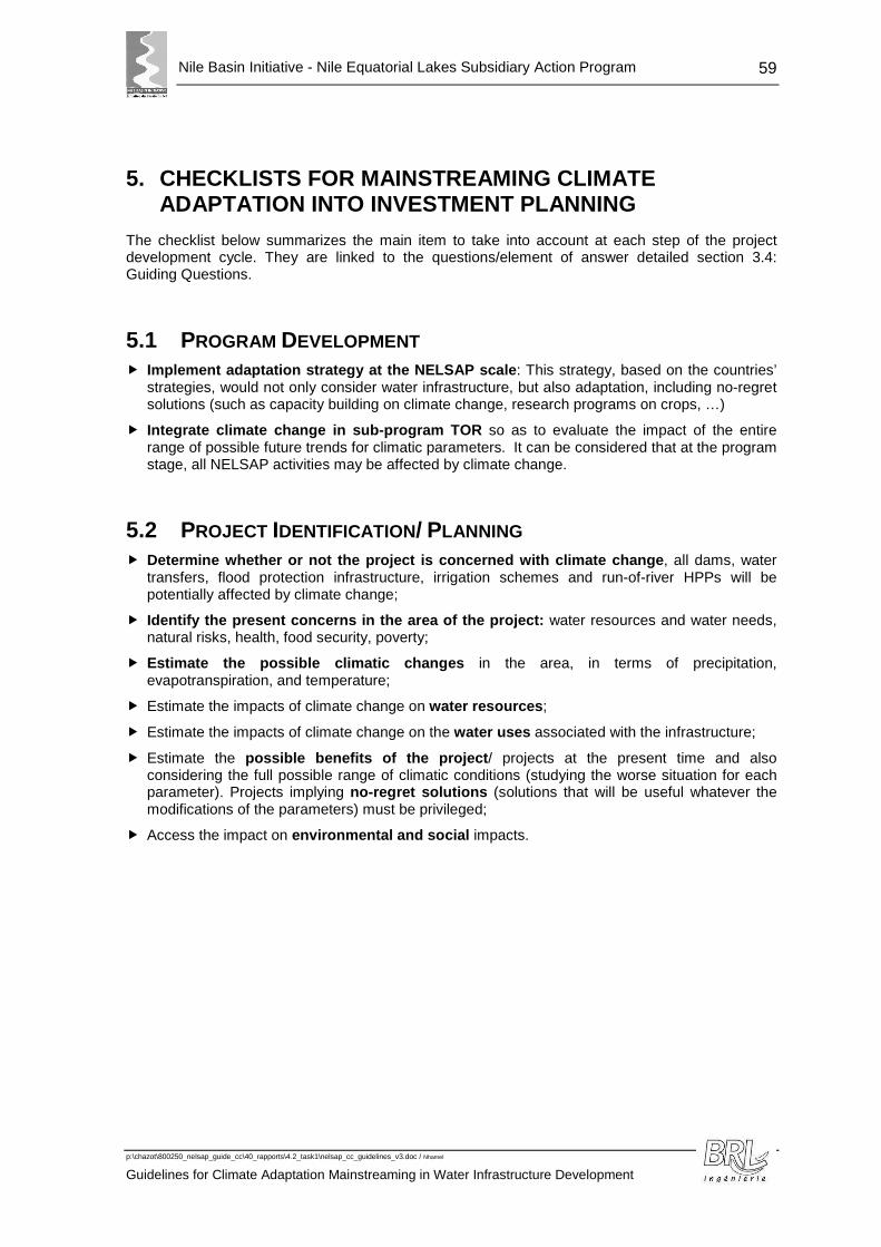
Nile Basin Initiative - Nile Equatorial Lakes Subsidiary Action Program
p:\chazot\800250_nelsap_guide_cc\40_rapports\4.2_task1\nelsap_cc_guidelines_v3.doc / Nhamel
Guidelines for Climate Adaptation Mainstreaming in Water Infrastructure Development
59
5. CHECKLISTS FOR MAINSTREAMING CLIMATE ADAPTATION INTO INVESTMENT PLANNING
The checklist below summarizes the main item to take into account at each step of the project development cycle. They are linked to the questions/element of answer detailed section 3.4: Guiding Questions.
5.1 PROGRAM DEVELOPMENT � Implement adaptation strategy at the NELSAP scale : This strategy, based on the countries’
strategies, would not only consider water infrastructure, but also adaptation, including no-regret solutions (such as capacity building on climate change, research programs on crops, …)
� Integrate climate change in sub-program TOR so as to evaluate the impact of the entire range of possible future trends for climatic parameters. It can be considered that at the program stage, all NELSAP activities may be affected by climate change.
5.2 PROJECT IDENTIFICATION/ PLANNING � Determine whether or not the project is concerned w ith climate change , all dams, water
transfers, flood protection infrastructure, irrigation schemes and run-of-river HPPs will be potentially affected by climate change;
� Identify the present concerns in the area of the pr oject: water resources and water needs, natural risks, health, food security, poverty;
� Estimate the possible climatic changes in the area, in terms of precipitation, evapotranspiration, and temperature;
� Estimate the impacts of climate change on water resources ;
� Estimate the impacts of climate change on the water uses associated with the infrastructure;
� Estimate the possible benefits of the project / projects at the present time and also considering the full possible range of climatic conditions (studying the worse situation for each parameter). Projects implying no-regret solutions (solutions that will be useful whatever the modifications of the parameters) must be privileged;
� Access the impact on environmental and social impacts.
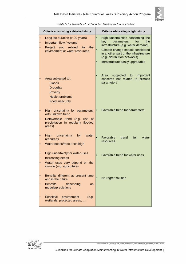
Nile Basin Initiative - Nile Equatorial Lakes Subsidiary Action Program
p:\chazot\800250_nelsap_guide_cc\40_rapports\4.2_task1\nelsap_cc_guidelines_v3.doc / Nhamel
Guidelines for Climate Adaptation Mainstreaming in Water Infrastructure Development |
Table 5.1: Elements of criteria for level of detail in studies
Criteria advocating a detailed study Criteria advocating a light study
• Long life duration (> 20 years)
• Important flow / volume
• Project not related to the environment or water resources
• Area subjected to :
Floods
Droughts
Poverty
Health problems
Food insecurity
• High uncertainty for parameters, with unkown trend
• Defavorable trend (e.g. rise of precipitation in regularly flooded areas)
• High uncertainty for water resources
• Water needs/resources high
• High uncertainty for water uses
• Increasing needs
• Water uses very depend on the climate (e.g. agriculture)
• Benefits different at present time and in the future
• Benefits depending on models/predictions
• Sensitive environment (e.g. wetlands, protected areas, …
• High uncertainties concerning the key parameters for the infrastructure (e.g. water demand);
• Climate change impact considered in another part of the infrastructure (e.g. distribution networks)
• Infrastructure easily upgradable
• Area subjected to important concerns not related to climatic parameters
• Favorable trend for parameters
• Favorable trend for water resources
• Favorable trend for water uses
• No-regret solution
Nile Basin Initiative - Nile Equatorial Lakes Subsidiary Action Program
p:\chazot\800250_nelsap_guide_cc\40_rapports\4.2_task1\nelsap_cc_guidelines_v3.doc / Nhamel
Guidelines for Climate Adaptation Mainstreaming in Water Infrastructure Development
61
5.3 PROJECT DESIGN � Review the design parameters depending on climate (floods);
� Estimate the modifications to be brought to the project design, to take into account the impacts of climate change (including environmental and social effects);
� Integrate climate change in the social and environmental studies;
� Associate the technical design with institutional studies to ensure good management of the infrastructure.
5.4 PROJECT IMPLEMENTATION � Associate the infrastructure implementation with a measuring network (precipitation, flows, ..)
and an early warning system (for droughts and/or floods), adapted to the issues in the area and the infrastructure.
5.5 PROJECT OPERATION � Link measuring network and early warning system with the management of the infrastructure.

Nile Basin Initiative - Nile Equatorial Lakes Subsidiary Action Program
p:\chazot\800250_nelsap_guide_cc\40_rapports\4.2_task1\nelsap_cc_guidelines_v3.doc / Nhamel
Guidelines for Climate Adaptation Mainstreaming in Water Infrastructure Development |
6. REFERENCES
The guidelines are based on the analysis of existing studies on climate change possible trends in the NEL region, and world while reflexions on the integration of climate change in water infrastructures.
The synthesis of the main studies is given below.
6.1 STUDIES RELATED TO CLIMATE CHANGE IN THE NELSAP REGION
A large number of studies exists in NEL region about the impact of climate change . A synthesis of the main studies is described below.
IPCC assessment reports and documents 8, the report on impacts, adaptation and vulnerability indicates a global reduction of water stress in eastern Africa, but a large uncertainty about rainfall patterns in the Nile Basin. The impacts expected are a significant decrease in suitable rain-fed land extent and production potential for cereals, and negative impacts on agriculture and livestock, ecosystems and fisheries.
UNDP Climate Change Country Profiles 9 - Climate Change Country Profiles have been established by the UNDP for 52 countries in Africa, Asia, the Caribbean and Central America, including Kenya, Burundi and Tanzania, based on 15 GCMs among the 22 most commonly used. Several downscaling sets of data have been used for downscaling temperature, precipitations and daily extreme indices.
An analysis of the impact of climate change on the runoff, basin yield and extreme events 10 by the World Bank , achieved by the downscaling of the 22 IPCC GCMs for 3 GHG scenarios. The results are classified in terms of Climate Moisture Index (CMI). The results given for Africa are highly dependent on the location, the range of variation for all areas being in itself relatively large and showing no clear tendency between a decrease or an increase for runoff. The range of results for runoff is equally distributed between a reduction of runoff (up to -20% reduction) and an increase of runoff (up to +23%). For floods, flood excedence shows a very slight increase, with again a large range of variation and an almost equally distributed trend. The water deficit index shows a clearer tendency to increase for all scenarios and GCMs.
A study on Climate change impact assessment for Lak e Victoria 11: This study concentrated on the Lake Victoria balance. The tendency for precipitations is not clear, but the reduction of runoff is expected not to exceed 5 to 10 % by the end of the century. The net lake basin supply (rainfall + runoff – evaporation) exhibits a clear and very significant downward trend, with a deficit of up to 50% (up to 20 billion cubic meters par year). The results also show an increase in inter-annual flow variability.
An investigation of the potential impact of climate ch ange on the hydrological extremes of Nyando River and Lake Tana catchments 12, located in two source regions of the Niles River
8 Climate Change 2007: Working Group II: Impacts, Adaptation and Vulnerability – IPCC 2007 9 UNDP Country Climate Change Profiles – Burundi, Kenya, Tanzania - UNDP National Communication Support
Programme (NSCP) and the UK government Department for International Development (DfiD)
10 Modelling the impact of climate change on Global Hydrology and Water Availability – The World Bank - Kenneth M. Strzepeck and Alyssa L. Mccluskey - University of Colorado and Joint Program on the Science and Policy of Global Change - Massachusetts Institute of Technology - September 2010
11 Study on water Management of Lake Victoria - Technical report 10 - Climate Change Impact Assessment - Uganda Ministry of Energy and Mineral Development -Water Resources and Energy Management International Inc. - September 2005
12 Assessment of climate change impact on hydrological extremes in two source regions of the Niles River Basin – Hydrology an Earth System Sciences – January 2011
Nile Basin Initiative - Nile Equatorial Lakes Subsidiary Action Program
p:\chazot\800250_nelsap_guide_cc\40_rapports\4.2_task1\nelsap_cc_guidelines_v3.doc / Nhamel
Guidelines for Climate Adaptation Mainstreaming in Water Infrastructure Development
63
basin. Nyando catchment is located in the Lake Victoria basin in Western Kenya, Lake Tana, source of the Blue Nile River, outside the NEL region, in North-Western Ethiopia. Hydrological modelling has been carried out using two precipitation-runoff models, using the results of 17 GCM for 2 GHG scenarios. The results for Nyando catchment shows variation of the mean annual rainfall ranging from -10% to +31%, while the change in evapotranspiration ranges from -6% to +9%. The projected mean annual flow range is between -34% and +149%. This large impact range on the river flow is explained mainly by the considerable uncertainty in the rainfall projections. The projected changes in low flows show both increases and decreases of the flow values from the control period. The peak flow is projected to increase, indicating a possibility of increased number and extent of flooding events in the catchment. For Lake Tana, half of the GCM runs project increased flow and the other half project decreases.
An analysis of climate change impact on the Upper B lue Nile hydrology and water resources 13: although outside the NEL region, the study gives interesting results, based on a selection of 6 GCM for the scenario A2: the changes in mean annual precipitation range from -11% to 44% with a change of 11% from the weighted average scenario. The change of temperature ranges from 1.4°C to 2.6°C (2.3°C on average). The changes in potential evapotranspiration are from 9% to 19% (16% average). For runoff, the range is from -32% to 80%, with an average change of 4%. The study showed geographically variable results depending on the sub-basin studied. Severe drought event frequency should significantly decrease, with an increased reliability and resiliency of flows, beneficial to both the area and downstream countries.
An assessment of impacts of climate change on runof f for the River Nzoia, in Kenya14: the River catchment is located North-East of Lake Victoria, the study indicates an increased surface runoff and base flow (11% to 115% depending on the scenario and GCM for surface runoff for 2050, -28% to 50% for base flow for 2050, 5 GCM out of 6 showing a positive trend). The rainfall is maintained for MAM and DJF, but shifts for JJA and SON.
A research paper assessing the hydrologic impacts o f climate change on the Nile River Basin based on the IPCC results15: the document indicates an increase of precipitation early in the century (2010-2039), followed by a decrease later in the century (2040-2069 and 2070-2099), except for the eastern-most Ethiopian highlands which are expected to experience increases in summer precipitation by 2080-2100.
Component 1 of the NELSAP climate change study 16: precipitation has been downscaled for the NEL region and the resulting precipitation estimated at several potential reservoir sites. The simulations were carried out with 2 GCMs for 3 Scenarios (A1B, A2, B1), and with 3 climatic references for the downscaling. Tendencies for precipitations depend on the GCM and downscaling products used. A tool is provided and allows estimation of the monthly precipitation for each month and year of the period 2021-2050 compared to the period 1961-1990.
13 Climate Change Impacts on Hydrology and Water Resources of the Upper Blue Niles River Basin, Ethiopia, Research paper 126 – International Water Management Institute – Utah State University - 2008
14 Assessment of impacts of climate change on runoff: River Nzoia catchment, Kenya
15 Hydrologic Impacts of Climate Change on the Nile River Basin: Implications of the 2007 IPCC Climate Scenarios – Tazebe Beyene, Dennis P. Lettenmaier – Pavel Kabat
16 Regional Downscaling of Precipitation and Temperature Data for Climate Change Impact Assessment in the Nile Equatorial Lakes (NEL) Region – NELSAP / NBI – University of Stuttgart - 2011
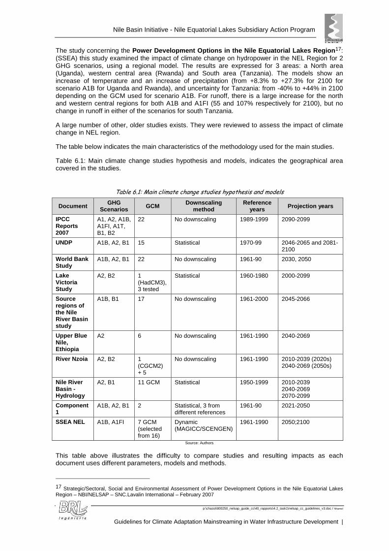
Nile Basin Initiative - Nile Equatorial Lakes Subsidiary Action Program
p:\chazot\800250_nelsap_guide_cc\40_rapports\4.2_task1\nelsap_cc_guidelines_v3.doc / Nhamel
Guidelines for Climate Adaptation Mainstreaming in Water Infrastructure Development |
The study concerning the Power Development Options in the Nile Equatorial La kes Region 17: (SSEA) this study examined the impact of climate change on hydropower in the NEL Region for 2 GHG scenarios, using a regional model. The results are expressed for 3 areas: a North area (Uganda), western central area (Rwanda) and South area (Tanzania). The models show an increase of temperature and an increase of precipitation (from +8.3% to +27.3% for 2100 for scenario A1B for Uganda and Rwanda), and uncertainty for Tanzania: from -40% to +44% in 2100 depending on the GCM used for scenario A1B. For runoff, there is a large increase for the north and western central regions for both A1B and A1FI (55 and 107% respectively for 2100), but no change in runoff in either of the scenarios for south Tanzania.
A large number of other, older studies exists. They were reviewed to assess the impact of climate change in NEL region.
The table below indicates the main characteristics of the methodology used for the main studies.
Table 6.1: Main climate change studies hypothesis and models, indicates the geographical area covered in the studies.
Table 6.1: Main climate change studies hypothesis and models
Document GHG Scenarios GCM Downscaling
method Reference
years Projection years
IPCC Reports 2007
A1, A2, A1B, A1FI, A1T, B1, B2
22 No downscaling 1989-1999 2090-2099
UNDP A1B, A2, B1 15 Statistical 1970-99 2046-2065 and 2081-2100
World Bank Study
A1B, A2, B1 22 No downscaling 1961-90 2030, 2050
Lake Victoria Study
A2, B2 1 (HadCM3), 3 tested
Statistical 1960-1980 2000-2099
Source regions of the Nile River Basin study
A1B, B1 17 No downscaling 1961-2000 2045-2066
Upper Blue Nile, Ethiopia
A2 6 No downscaling 1961-1990 2040-2069
River Nzoia A2, B2 1 (CGCM2) + 5
No downscaling 1961-1990 2010-2039 (2020s) 2040-2069 (2050s)
Nile River Basin - Hydrology
A2, B1 11 GCM Statistical 1950-1999 2010-2039 2040-2069 2070-2099
Component 1
A1B, A2, B1 2 Statistical, 3 from different references
1961-90 2021-2050
SSEA NEL A1B, A1FI 7 GCM (selected from 16)
Dynamic (MAGICC/SCENGEN)
1961-1990 2050;2100
Source: Authors
This table above illustrates the difficulty to compare studies and resulting impacts as each document uses different parameters, models and methods.
17 Strategic/Sectoral, Social and Environmental Assessment of Power Development Options in the Nile Equatorial Lakes Region – NBI/NELSAP – SNC.Lavalin International – February 2007
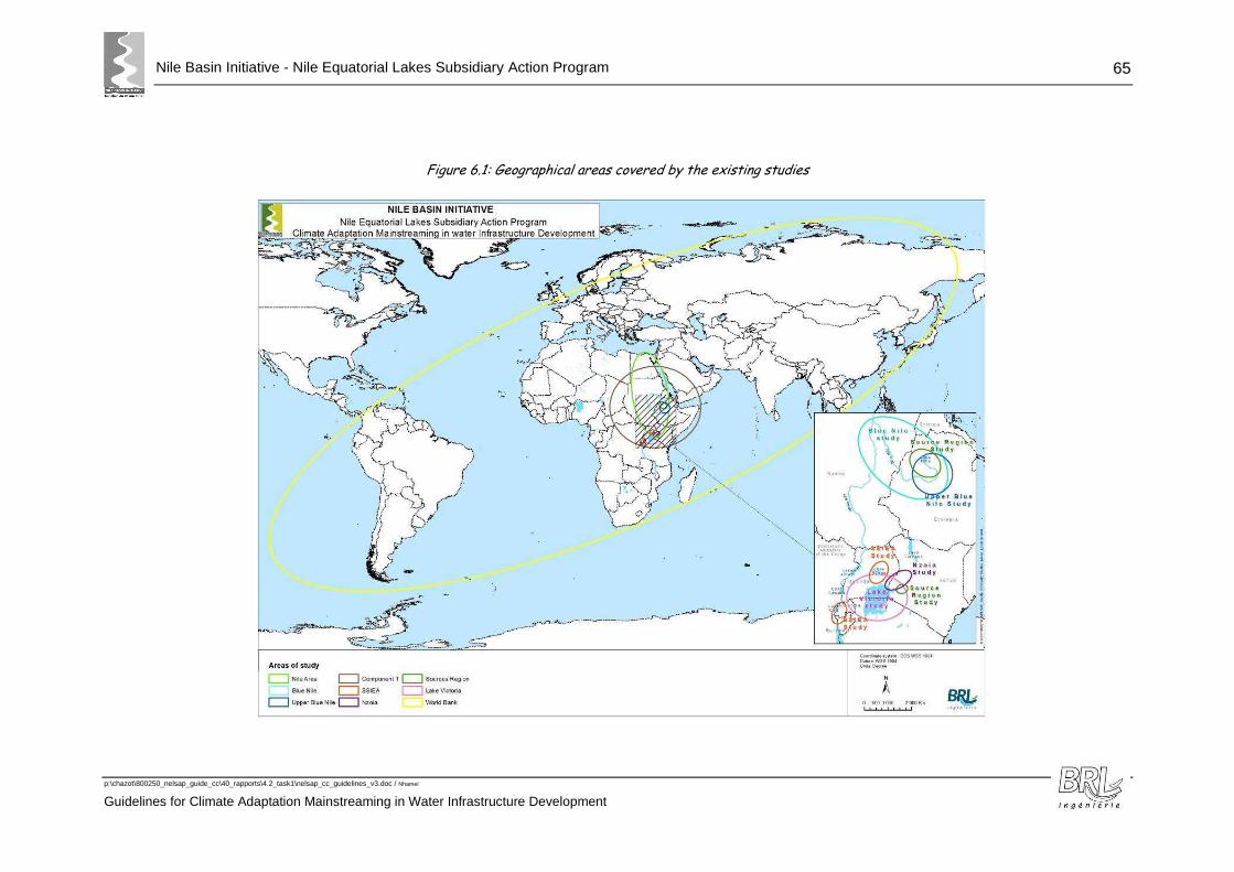
Nile Basin Initiative - Nile Equatorial Lakes Subsidiary Action Program
p:\chazot\800250_nelsap_guide_cc\40_rapports\4.2_task1\nelsap_cc_guidelines_v3.doc / Nhamel
Guidelines for Climate Adaptation Mainstreaming in Water Infrastructure Development
65
Figure 6.1: Geographical areas covered by the existing studies

Nile Basin Initiative - Nile Equatorial Lakes Subsidiary Action Program
p:\chazot\800250_nelsap_guide_cc\40_rapports\4.2_task1\nelsap_cc_guidelines_v3.doc / Nhamel
Guidelines for Climate Adaptation Mainstreaming in Water Infrastructure Development
67
6.2 EXISTING REFLEXIONS TO MAINSTREAM CLIMATE CHANGE INTO WATER INFRASTRUCTURE
Mainstreaming climate change into water infrastructure is a recent preoccupation for financers and planners. The existing international guidelines focus on the integration of climate change in development programs and project cycles. Some of them are described in the sections below.
No guidance or protocol has been found concerning the modification of conceptual design or design parameters for water infrastructure due to the expected impact of climate change. Dams for instance are still built on the basis of the statistical analysis of historical data.
Some of the documents detailed below and produced by water infrastructure practitioners provide some useful examples of how to integrate climate change into project development.
6.2.1 The World Bank
The World Bank has been producing documents to help identify climate change effects on water management and investment planning.
In particular, “Water and Climate Change: Understanding the Risks and Making Climate-Smart Investment Decisions – 2009” presents, at world scale, the implications of climate change on hydrologic indicators for water planning and the way investments must adapt to modified conditions.
The investment planning is recommended to be based on:
Projections of key hydrologic indicators for water planning
The World Bank projected a set of hydrologic indicators for 2030 and 2050: runoff, basin yield, high and low flows (floods and droughts), minimum base flow (a proxy for shallow groundwater movement), and net irrigation demand. These indicators are projected at the catchment level, for 22 GCMs, and 3 emissions scenarios (B1, A1B, A2), for the years 2030 and 2050 from historical values in 1961–1990. GCM output is used as input to a hydrologic model CLIRUN -II (Strzepek, et al, 2008), developed specifically to assess the impact of climate change on runoff and to address extreme events at the annual level by modelling low and high flows.
These indicators can be useful for planning investments at world level.
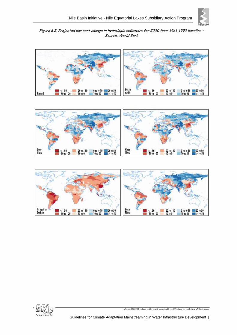
Nile Basin Initiative - Nile Equatorial Lakes Subsidiary Action Program
p:\chazot\800250_nelsap_guide_cc\40_rapports\4.2_task1\nelsap_cc_guidelines_v3.doc / Nhamel
Guidelines for Climate Adaptation Mainstreaming in Water Infrastructure Development |
Figure 6.2: Projected per cent change in hydrologic indicators for 2030 from 1961-1990 baseline – Source: World Bank

Nile Basin Initiative - Nile Equatorial Lakes Subsidiary Action Program
p:\chazot\800250_nelsap_guide_cc\40_rapports\4.2_task1\nelsap_cc_guidelines_v3.doc / Nhamel
Guidelines for Climate Adaptation Mainstreaming in Water Infrastructure Development
69
Figure 6.3: Projected Exposure Map by Hydrologic Drivers (2030) – Source: World Bank
Consideration of the risk for climate-smart investm ents
Climate change projections contain a great deal of uncertainty and there are still significant unknowns. The assumption of a stationary hydrologic pattern: the mean, variance and standard deviation of hydrologic time series fixed over time, is no longer valid and decision-makers have to estimate hydrologic risks to water systems under even more uncertain conditions.
Water investments require a formal risk-based analysis in all aspects of the project/program cycle. Water systems are subject to both climate and non-climate related stresses, but there are certain types of water investments where uncertainties related to climate change could have a significant impact, and so particular care needs to be taken in undertaking a detailed, rigorous risk assessment. These include highly capitalized or unique projects, irreversible investments, engineering structures with long lifetimes, long-lived benefits and costs, etc. Examples include: multi-purpose hydraulic infrastructure, interbasin water transfer schemes, water conveyer systems for irrigated agriculture, regional/transboundary investments.
Nile Basin Initiative - Nile Equatorial Lakes Subsidiary Action Program
p:\chazot\800250_nelsap_guide_cc\40_rapports\4.2_task1\nelsap_cc_guidelines_v3.doc / Nhamel
Guidelines for Climate Adaptation Mainstreaming in Water Infrastructure Development |
Potential adaptation options can be categorized into those that carry ‘no regrets’ (Water management measures to increase water use efficiency and productivity, early warning systems and risk-spreading; ...) and those that are ‘climate justified’ (constructing new infrastructure, water transfers,...).
‘No regrets’ options generate net social and/ or economic benefits irrespective of whether or not anthropogenic climate change occurs.
For “no regrets” options, uncertainties in projections are to a large extent immaterial. By definition, these actions should be taken in order to meet current economic, social and environmental objectives, but they also serve the dual purpose of reducing vulnerabilities to future climatic conditions.
6.2.2 UNDP
The UNDP provides guidance on how governments and other national actors can mainstream climate change adaptation into national development planning18
The framework proposed consists of three components, each of which involves a set of activities or modules for which a range of tactics, methodologies and tools can be used:
� Finding the entry points and making the case: this component involves understanding the linkages between climate change and national development priorities.
� Mainstreaming adaptation into policy processes: it focuses on integrating climate change adaptation issues into an ongoing policy process.
� Meeting the implementation challenge: it aims at ensuring mainstreaming of climate change adaptation into budgeting and financing, implementation and monitoring, and the establishment of mainstreaming as standard practice.
The first step recommended is the need to understand the Climate-Development-Poverty Linkages and the Governmental, Institutional and Political Contexts (component 1).
It then proposes to assess the vulnerability and climate risks:
� Current climatic trends and/or projected future climate change in specific geographical areas
� Vulnerabilities of local natural systems and/or communities to current or projected climate-related impacts
� Climate-related risks in specific sectors
� Possible adaptation measures.
The guide provides useful guidance for development planning that may be translated into water infrastructure planning in terms of methodology.
The UNDP also provides useful guidance for mainstreaming climate change adaptation into development assistance19.
18 Mainstreaming Climate Change Adaptation into Development Planning: A guide for Practitioners – UNDP-UNEP
Poverty-Environment Initiative - 2011 19 Support the Mainstreaming of Climate Change Adaptation into Development Assistance – A Stocktaking Report
(UNDP 2010)
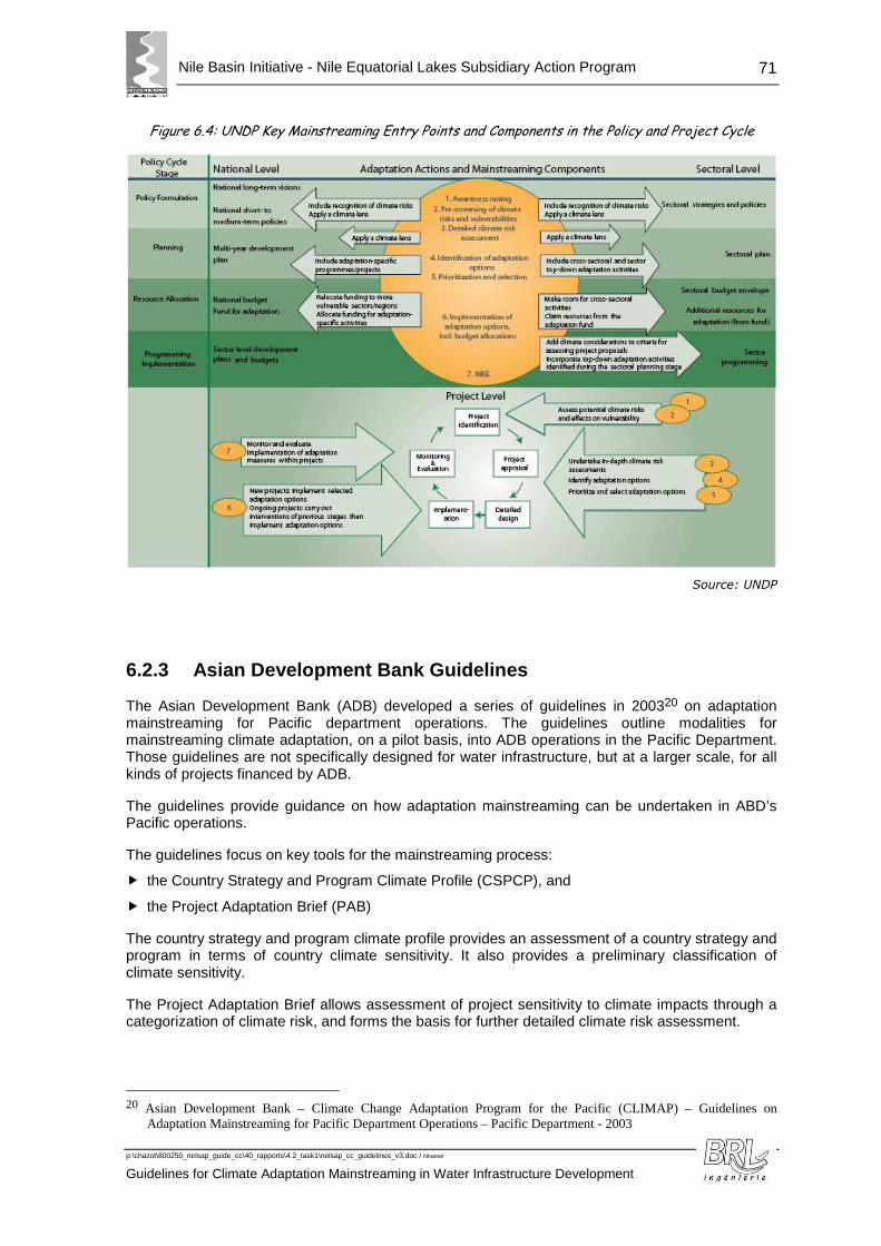
Nile Basin Initiative - Nile Equatorial Lakes Subsidiary Action Program
p:\chazot\800250_nelsap_guide_cc\40_rapports\4.2_task1\nelsap_cc_guidelines_v3.doc / Nhamel
Guidelines for Climate Adaptation Mainstreaming in Water Infrastructure Development
71
Figure 6.4: UNDP Key Mainstreaming Entry Points and Components in the Policy and Project Cycle
Source: UNDP
6.2.3 Asian Development Bank Guidelines
The Asian Development Bank (ADB) developed a series of guidelines in 200320 on adaptation mainstreaming for Pacific department operations. The guidelines outline modalities for mainstreaming climate adaptation, on a pilot basis, into ADB operations in the Pacific Department. Those guidelines are not specifically designed for water infrastructure, but at a larger scale, for all kinds of projects financed by ADB.
The guidelines provide guidance on how adaptation mainstreaming can be undertaken in ABD’s Pacific operations.
The guidelines focus on key tools for the mainstreaming process:
� the Country Strategy and Program Climate Profile (CSPCP), and
� the Project Adaptation Brief (PAB)
The country strategy and program climate profile provides an assessment of a country strategy and program in terms of country climate sensitivity. It also provides a preliminary classification of climate sensitivity.
The Project Adaptation Brief allows assessment of project sensitivity to climate impacts through a categorization of climate risk, and forms the basis for further detailed climate risk assessment.
20 Asian Development Bank – Climate Change Adaptation Program for the Pacific (CLIMAP) – Guidelines on
Adaptation Mainstreaming for Pacific Department Operations – Pacific Department - 2003
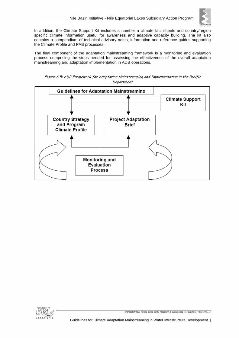
Nile Basin Initiative - Nile Equatorial Lakes Subsidiary Action Program
p:\chazot\800250_nelsap_guide_cc\40_rapports\4.2_task1\nelsap_cc_guidelines_v3.doc / Nhamel
Guidelines for Climate Adaptation Mainstreaming in Water Infrastructure Development |
In addition, the Climate Support Kit includes a number a climate fact sheets and country/region specific climate information useful for awareness and adaptive capacity building. The kit also contains a compendium of technical advisory notes, information and reference guides supporting the Climate Profile and PAB processes.
The final component of the adaptation mainstreaming framework is a monitoring and evaluation process comprising the steps needed for assessing the effectiveness of the overall adaptation mainstreaming and adaptation implementation in ADB operations.
Figure 6.5: ADB Framework for Adaptation Mainstreaming and Implementation in the Pacific Department
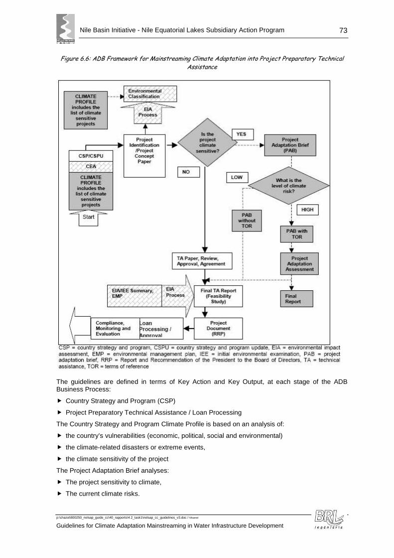
Nile Basin Initiative - Nile Equatorial Lakes Subsidiary Action Program
p:\chazot\800250_nelsap_guide_cc\40_rapports\4.2_task1\nelsap_cc_guidelines_v3.doc / Nhamel
Guidelines for Climate Adaptation Mainstreaming in Water Infrastructure Development
73
Figure 6.6: ADB Framework for Mainstreaming Climate Adaptation into Project Preparatory Technical Assistance
The guidelines are defined in terms of Key Action and Key Output, at each stage of the ADB Business Process:
� Country Strategy and Program (CSP)
� Project Preparatory Technical Assistance / Loan Processing
The Country Strategy and Program Climate Profile is based on an analysis of:
� the country’s vulnerabilities (economic, political, social and environmental)
� the climate-related disasters or extreme events,
� the climate sensitivity of the project
The Project Adaptation Brief analyses:
� The project sensitivity to climate,
� The current climate risks.
Nile Basin Initiative - Nile Equatorial Lakes Subsidiary Action Program
p:\chazot\800250_nelsap_guide_cc\40_rapports\4.2_task1\nelsap_cc_guidelines_v3.doc / Nhamel
Guidelines for Climate Adaptation Mainstreaming in Water Infrastructure Development |
6.2.4 Bureau of Reclamation and U.S. Army Corps of Engineers (USACE) works
The Bureau of Reclamation (Reclamation) and the United States Army Corps of Engineers (USACE) , together with the United States Geological Survey (USGS) and National Oceanic and Atmospheric Administration (NOAA), formed an interagency working group called the Climate Change and Water Working Group (CCAWWG) in 2007 to provide scientific collaborations in support of water management and climate changes.
The four agencies produced an interagency report, USGS Circular 1331, Climate Change and Water Resources Management: A Federal Perspective, which provides a foundation to guide future policies, methods and technologies, and to incorporate climate change science into the design, construction, and operations of water resources management infrastructure.
The circular identifies keys points related to anticipating climate change and responding to it, among them:
� The suggestion to use of paleoclimatic information (in particular for floods), to develop climate scenarios that include a wide range of potential hydroclimatic conditions, beyond those implied by the instrumental record (this assumes that paleoflood magnitudes are relevant to the future) ;
� Alternatives that perform well over a wide range of future scenarios can improve system flexibility;
� The approach of adaptative management, where decisions are made sequentially over time and allow adjustments to be made as more information is known, can be useful in dealing with the additional uncertainty introduced by climate change;
� Adaptation options include operational (in particular, anticipation of a flood by evacuation of reservoirs), demand management and infrastructure changes (alternative strategies may need to be evaluated depending on the potential risk).
The work has been completed in 2011 by a document related to Long-Term needs (> 5 years) for water managers’ needs for climate change information21 to support water resources planning.
Eight technical steps have been used to categorize tools and information needs to incorporate:
� 1. Summarize Relevant Literature: For a given planning study, this step involves identifying, synthesizing, and summarizing previous research on global to regional climate change and what it means for the region’s water resources.
� 2. Obtain Climate Change Information: This step involves obtaining contemporary climate projections and associated uncertainties that may have been spatially downscaled to finer resolution desired for water resources planning at the regional to local scale. This step also involves consideration of paleoclimate proxies that may imply climate conditions different from those of the observed record.
� 3. Make Decisions About How To Use the Climate Change Information: From the body of climate projections surveyed, decisions must be made on which projections to use and which aspects of these projections to relate to planning assumptions on water supplies, water demands, and operating constraints.
� 4. Assess Natural Systems Response: Based on the preceding step’s decisions, this step involves assessing the natural systems response under projected climate conditions. Results from these analyses will be used to set assumptions about future water supplies, water demands, and operating constraints. Types of natural systems responses include watershed hydrology, ecosystems, land cover, water quality, consumptive use requirements of irrigated lands, sedimentation and river hydraulics, and sea level rise.
21 Addressing Climate Change in Long-Term Water Resources Planning and Management
Nile Basin Initiative - Nile Equatorial Lakes Subsidiary Action Program
p:\chazot\800250_nelsap_guide_cc\40_rapports\4.2_task1\nelsap_cc_guidelines_v3.doc / Nhamel
Guidelines for Climate Adaptation Mainstreaming in Water Infrastructure Development
75
� 5. Assess Socioeconomic and Institutional Response: This step involves assessing social, economic, and institutional responses to climate change that could influence planning assumptions concerning water demands and operating constraints (e.g., constraints that determine source of supply preference and/or expected level of operating performance relative to objectives such as flood risk reduction, environmental management, water quality management, water allocation for agricultural and municipal use, energy production, recreation, and navigation).
� 6. Assess System Risks and Evaluate Alternatives: This step involves assessing system risks based on future planning assumptions (informed by Steps 4 and 5); and, as necessary, evaluating long-term management alternatives to address climate change risks. For example, many water resources management studies focus on operations risk and assumptions about future water supplies, demands, and operating constraints. In contrast, infrastructure safety or flood risk reduction studies focus on human safety and economic and environmental damages under assumptions about future extreme hydrologic event probabilities; and water quality studies focus on the interaction between the human activities, landscape hydrology, and aquatic systems.
� 7. Assess and Characterize Uncertainties: This step involves assessing and characterizing uncertainties accumulated during preceding steps (e.g., uncertainties of projecting future factors forcing climate, simulating climate, downscaling climate, assessing natural and social system responses, etc.).
� 8. Communicating Results and Uncertainties to Decision-makers: This step involves aggregating information from previous steps and then communicating this distilled information to decision-makers to support planning decisions.
The steps have been prioritized in the document. The document does not detail the decisions and changes to be made to projects considering the available climate change information.

Nile Basin Initiative - Nile Equatorial Lakes Subsidiary Action Program
p:\chazot\800250_nelsap_guide_cc\40_rapports\4.2_task1\nelsap_cc_guidelines_v3.doc / Nhamel
Guidelines for Climate Adaptation Mainstreaming in Water Infrastructure Development |
ANNEXES
Nile Basin Initiative - Nile Equatorial Lakes Subsidiary Action Program
p:\chazot\800250_nelsap_guide_cc\40_rapports\4.2_task1\nelsap_cc_guidelines_v3.doc / Nhamel
Guidelines for Climate Adaptation Mainstreaming in Water Infrastructure Development
77
AAnnnneexx AA:: RReeggiioonnaall PPrreecciippiittaattiioonnss
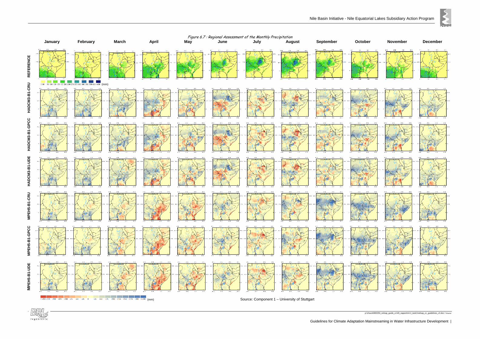
Nile Basin Initiative - Nile Equatorial Lakes Subsidiary Action Program
p:\chazot\800250_nelsap_guide_cc\40_rapports\4.2_task1\nelsap_cc_guidelines_v3.doc / Nhamel
Guidelines for Climate Adaptation Mainstreaming in Water Infrastructure Development |
Figure 6.7 : Regional Assessment of the Monthly Precipitation January February March April May June July August September October November December
(mm)
&
(mm) Source: Component 1 – University of Stuttgart
MP
EH
5-B
1-U
DE
MP
EH
5-B
1-G
PC
C
M
PE
H5-
B1-
CR
U
H
AD
CM
3-B
1-U
DE
H
AD
CM
3-B
1-G
PC
C
HA
DC
M3-
B1-
CR
U
RE
FE
RE
NC
E
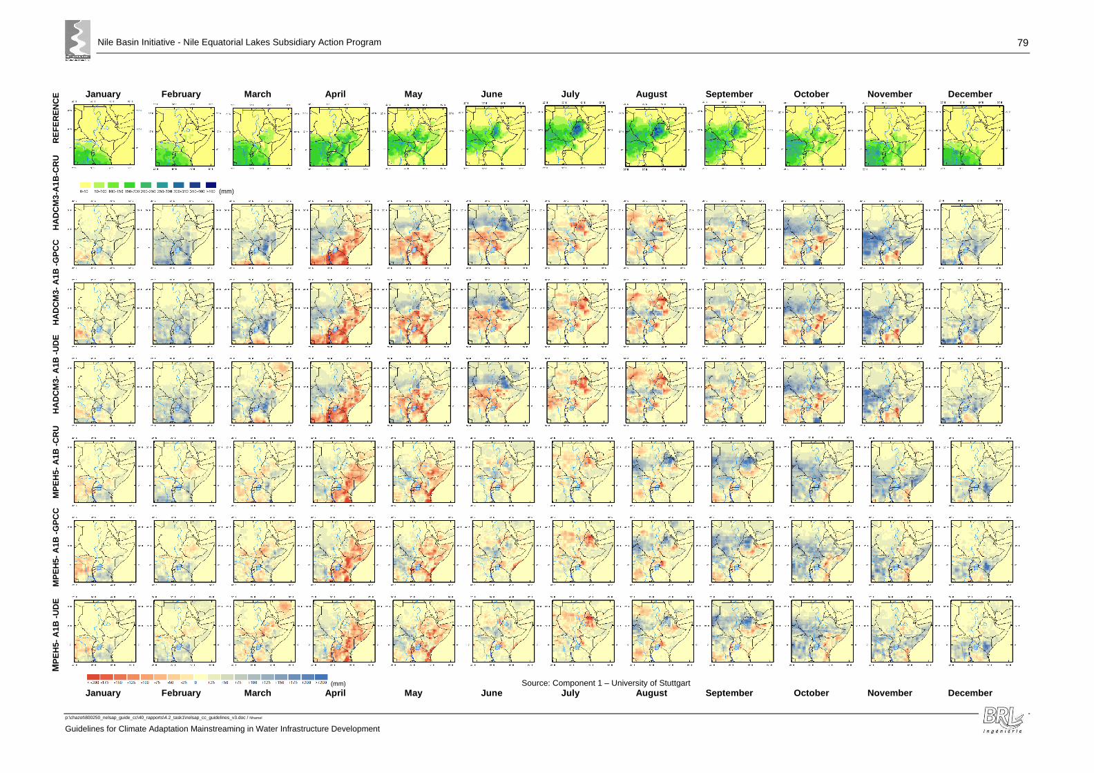
Nile Basin Initiative - Nile Equatorial Lakes Subsidiary Action Program
p:\chazot\800250_nelsap_guide_cc\40_rapports\4.2_task1\nelsap_cc_guidelines_v3.doc / Nhamel
Guidelines for Climate Adaptation Mainstreaming in Water Infrastructure Development
79
January February March April May June July August September October November December
(mm)
(mm) Source: Component 1 – University of Stuttgart January February March April May June July August September October November December
MP
EH
5- A
1B -
UD
E
MP
EH
5- A
1B -
GP
CC
M
PE
H5-
A1B
-C
RU
H
AD
CM
3- A
1B -
UD
E
HA
DC
M3-
A1B
-G
PC
C
HA
DC
M3-
A1B
-CR
U
RE
FE
RE
NC
E
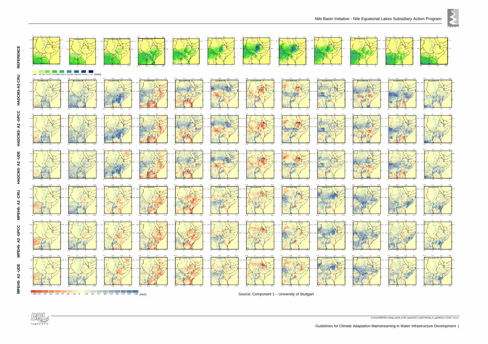
Nile Basin Initiative - Nile Equatorial Lakes Subsidiary Action Program
p:\chazot\800250_nelsap_guide_cc\40_rapports\4.2_task1\nelsap_cc_guidelines_v3.doc / Nhamel
Guidelines for Climate Adaptation Mainstreaming in Water Infrastructure Development |
(mm)
(mm) Source: Component 1 – University of Stuttgart MP
EH
5- A
2 -U
DE
MP
EH
5- A
2 -G
PC
C
MP
EH
5- A
2 -C
RU
HA
DC
M3-
A2
-UD
E
HA
DC
M3-
A2
-GP
CC
H
AD
CM
3-A
2-C
RU
RE
FE
RE
NC
E

Nile Basin Initiative - Nile Equatorial Lakes Subsidiary Action Program
p:\chazot\800250_nelsap_guide_cc\40_rapports\4.2_task1\nelsap_cc_guidelines_v3.doc / Nhamel
Guidelines for Climate Adaptation Mainstreaming in Water Infrastructure Development
81
AAnnnneexx BB:: BBiibblliiooggrraapphhyy
Nile Basin Initiative - Nile Equatorial Lakes Subsidiary Action Program
p:\chazot\800250_nelsap_guide_cc\40_rapports\4.2_task1\nelsap_cc_guidelines_v3.doc / Nhamel
Guidelines for Climate Adaptation Mainstreaming in Water Infrastructure Development |
NBI/NELSAP INTERNAL DOCUMENTS
Nile Basin Initiative - Nile Equatorial Lakes Subsidiary Action Program (NELSAP) –Project Identification Document – May 2001
Nile Basin Initiative - Nile Basin Data and Information Sharing and Exchange Interim Procedures – July 2009
Nile Basin Initiative - Shared Vision Program - Water Resources Planning and Management Project - Baseline and Needs Assessment of National Water Policies or the Nile Basin Countries - A Regional Synthesis -Water Policy Component - December 2006
Nile Basin Initiative - Shared Vision Program - Water Resources Planning and Management Project - Water Policy Guidelines and Compendium of Good Practice - November 2006
Nile Basin Initiative - Nile Equatorial Lakes Subsidiary Action Program (NELSAP) - Strategy for Scaling up NELSAP Investments Projects - Endorsed by NEL-COM - 16 March 2005 - NELSAP-CU
Criteria for selection projects for scaling up NELSAP - Activities as identified during first scaling up workshop on 7-8 - November 2006
Nile Basin Initiative - Nile Equatorial Lakes Subsidiary Action Program (NELSAP) – Environmental and Social Impact Assessment Procedures and Guidelines – November 2010
The Nile Basin Sustainability Framework - The Nile Basin Initiative's approach to basin sustainability - October 2010
Nile Basin Initiative - Nile Equatorial Lakes Subsidiary Action Program (NELSAP) - Strategy for Scaling up NELSAP Investments Projects - Endorsed by NEL-COM - 16 March 2005 - NELSAP-CU
Nile Basin Initiative - Nile Equatorial Lakes subsidiary Action Program - Environmental and Social Management Framework for project preparation and implementation
Nile Basin initiative - Nile equatorial lakes subsidiary action program- -Environmental and social impact assessment procedures and guidelines - November 2010
IMPACT OF CLIMATE CHANGE
Climate Change 2007: Working Group II: Impacts, Adaptation and Vulnerability – IPCC 2007
Regional Downscaling of Precipitation and Temperature Data for Climate Chang Impact Assessment in the Nile Equatorial Lakes (NEL) Region – NELSAP / NBI – University of Stuttgart - 2011
Modeling the impact of climate change on Global Hydrology and Water Availability – The World Bank - Kenneth M. Strzepeck and Alyssa L. Mccluskey - University of Colorado and Joint Program on the Science and Policy of Global Change - Massachusetts Institute of Technology - September 2010
Study on water Management of Lake Victoria - Technical report 10 - Climate Change Impact Assessment - Uganda Ministry of Energy and Mineral Development -Water Resources and Energy Management International Inc. - September 2005
Assessment of climate change impact on hydrological extremes in two source regions of the Niles River Basin – Hydrology an Earth System Sciences – January 2011
Climate Change Impacts on Hydrology and Water Resources of the Upper Blue Niles River Basin, Ethiopia, Research paper 126 – International Water Management Institute – Utah State University - 2008
Assessment of impacts of climate change on runoff: River Nzoia catchment, Kenya
Nile Basin Initiative - Nile Equatorial Lakes Subsidiary Action Program
p:\chazot\800250_nelsap_guide_cc\40_rapports\4.2_task1\nelsap_cc_guidelines_v3.doc / Nhamel
Guidelines for Climate Adaptation Mainstreaming in Water Infrastructure Development
83
Hydrologic Impacts of Climate Change on the Nile River Basin: Implications of the 2007 IPCC Climate Scenarios – Tazebe Beyene, Dennis P. Lettenmaier – Pavel Kabat
Impacts of climate change on Blue Nile flows using bias-corrected GCM scenarios – Hydrology and Earth System Sciences - 2009
Strategic/Sectoral, Social and Environmental Assessment of Power Development Options in the Nile Equatorial Lakes Region – NBI/NELSAP – SNC.Lavalin International – February 2007
Draft - Strategic/sectoral, social and environmental assessment of power development options in the Nile Equatorial Lakes region - Supplemental analysis-Climate change and potential impacts on hydro generation - Interim report-Climate change and impacts on runoff - August 16,2006 - SNC-Lavalin International Inc. Stratus Consulting Inc
Development and climate change - Modeling the impact of climate change on Global Hydrology and Water Availability - Kenneth M. Strzepeck and Alyssa L. Mccluskey - University of Colorado and Joint Program on the Science and Policy of Global Change - Massachusetts Institute of Technology - September 2010
Climate variability and water resources degradation in Kenya - Improving water resources development and management - Hezron Mogaka -Samuel Gichere - Richard Davis - Rafik Hirji
Study on water Management of Lake Victoria - Technical report 10 - Climate Change Impact Assessment - Uganda Ministry of Energy and Mineral Development - Water Resources and Energy Management International Inc. - September 2005
The Federal Democratic Republic of Ethiopia - Ministry of Water Resources - National Meteorological Agency - Climate Change National Adaptation Programme Of Action (NAPA) of Ethiopia - June 2007 - Addis Ababa
Draft report on - Kenya's climate change technology needs and needs assessment - Report under the United Nations - Framework convention on climate change - National Environment Management Authority - Ministry of Environment and Natural Resources – Nairobi
Draft Strategic/sectoral, social and environmental assessment of power development options in the Nile Equatorial Lakes region - Supplemental analysis - Climate change and potential impacts on hydro generation - Interim report - Climate change and impacts on runoff - August 16 2006 - SNC Lavalin International
UNDP Climate Change Country Profiles – Tanzania, Uganda, Kenya - UNDP National Communication Support Programme (NSCP) and the UK government Department for International Development (DfiD)
GUIDELINES FOR CLIMATE CHANGE MAINSTREAMING IN WATER INFRASTRUCTURES
Addressing Climate Change in Long-Term Water Resources Planning and Management -User Needs for Improving Tools and Information (developed by the United States Bureau of Reclamation – January 2011)
Climate Change and Water – IPCC Technical Paper VI – WMO / UNEP – June 2008
The Asian Development Bank guidelines on adaptation mainstreaming for pacific department operations - Draft (2003)
Mainstreaming Climate Change in ADB Operations – Climate Change Implementation Plan for the Pacific (Asian Development Bank – 2009)
Water and climate change: understanding the risks and making climate smart investment decisions (2009)
Nile Basin Initiative - Nile Equatorial Lakes Subsidiary Action Program
p:\chazot\800250_nelsap_guide_cc\40_rapports\4.2_task1\nelsap_cc_guidelines_v3.doc / Nhamel
Guidelines for Climate Adaptation Mainstreaming in Water Infrastructure Development |
Mainstreaming Climate Change Adaptation into Development Planning: A Guide to Practitioners (UNDP 2011)
Support the Mainstreaming of Climate Change Adaptation into Development Assistance – A Stocktaking Report (UNDP 2010)
Adapting to climate Variability and Change – A Guidance Manual for Development Planning – August 2007 – USAID
Integrating Climate Change Adaptation into Development Co-operation – Policy Guidance – OECD 2009
Lempert, R.J., S.W. Popper, and S.C. Bankes. 2003. Shaping the next one hundred years—New methods for quantitative long-term policy analysis. Santa Monica, CA: Rand Corporation. Brekke, L.D., J.E. Kiang, J.R. Olsen, R.S. Pulwarty, D.A. Raff, D.P. Turnipseed, R.S. Webb, and K.D. White. 2009a. Climate change and water resources management—A Federal perspective. U.S. Geological Survey Circular 1331. Reston, VA: U.S. Geological Survey
Water and Climate Change: Understanding the Risks and Making Climate-Smart Investment Decisions – The World Bank - 2009
Brekke, L.D., E.P. Maurer, J.D. Anderson, M.D. Dettinger, E.S. Townsley, A. Harrison, and T. Pruitt. 2009b. “Assessing reservoir operations risk under climate change.” Water Resources Research 45: W04411.
OTHERS DATA
Adger, W.N., S. Agrawala, M.M.Q. Mirza, C. Conde, K. O’Brien, J. Pulhin, R. Pulwarty, B. Smit and K. Takahashi (2007) Assessment of adaptation practices, options, constraints and capacity. Climate Change 2007: Impacts, Adaptation and Vulnerability. Contribution ofWorking Group II to the Fourth Assessment Report of the Intergovernmental Panel on Climate Change, M.L. Parry, O.F. Canziani, J.P. Palutikof, P.J. van der Linden and C.E. Hanson, Eds., Cambridge University Press, Cambridge, UK, 717-743.
Agoumi, A., 2003: Vulnerability of North African Countries to Climatic Changes: Adaptation and Implementation Strategies for Climatic Change, IISD. .
Angermeier, P.L. (2000). The natural imperative for biological conservation. Conservation Biology, 14(2), 373-381.
Arnell, N.W., 2004: Climate change and global water resources: SRES emissions and socio economic scenarios. Global Environmental Change., 14, 31–52.
Arnell, N.W., 2006b: Climate change and water resources: a global perspective. Avoiding Dangerous Climate Change, H.J. Schellnhuber, W. Cramer, N. Nakićenović, T. Wigley and G. Yohe, Eds., Cambridge University Press, Cambridge, 167-175.
Burton, I. and B. Lim (2005) Achieving Adequate Adaptation in Agriculture. Climate Change 70, 191-200.
California Climate Change Centre (2009), “Impacts Of Climate Change On Residential Electricity Consumption: Evidence From Billing Data”, March 2009
Canziani, J.P. Palutikof, P.J. van der Linden and C.E. Hanson, Eds., Cambridge University Press, Cambridge, 976 pp.
Nile Basin Initiative - Nile Equatorial Lakes Subsidiary Action Program
p:\chazot\800250_nelsap_guide_cc\40_rapports\4.2_task1\nelsap_cc_guidelines_v3.doc / Nhamel
Guidelines for Climate Adaptation Mainstreaming in Water Infrastructure Development
85
Centre for Ecology and Hydrology – Impacts of Climate Change on Erosion, Sediment Transport and Soil Carbon in UK & Europe
Climate Change and Agriculture Threats and Opportunities;- Mark W. Rosegrant, Mandy Ewing, Gary Yohe, Ian Burton, Saleemul Huq, Rowena Valmonte-Santos
Climate Change and Dams: An Analysis of the Linkages Between the UNFCCC Legal Regime and Dams; UNEP, Kenya Prepared for Thematic Review II.2: Dams and global change
Crop evapotranspiration-Guidelines for computing crop water requirements’ by Allen R.G., Pereira L.S.,RaesD.andSmith M. as FAO –I&DPaperNo. 56 (1998)).
Döll, P., 2002: Impact of climate change and variability on irrigation requirements: a global perspective. Climatic Change, 54, 269–293.
Easterling, W.E., 2003: Observed impact of climate change in agriculture and forestry. IPCC Workshop on the Detection and Attribution of the Effects of Climate Change, GISS, New York, 54-55.
Eid, H.M., S.M. El-Marsafawy and S.A. Ouda, 2006: Assessing the Impacts of Climate Change on Agriculture in Egypt: a Ricardian Approach. Centre for Environmental Economics and Policy in Africa (CEEPA) Discussion Paper No. 16, Special Series on Climate Change and Agriculture in Africa, University of Pretoria, Pretoria, 1-33.
Fischer, G., F.N. Tubiello, H. van Velthuizen and D. Wiberg, 2006: Climate change impacts on irrigation water requirements: global and regional effects of mitigation, 1990–2080. Tech. Forecasting Soc. Ch., 74, doi:10.1016/j.techfore.2006.05.021.
Fischer, G., M. Shah, F.N. Tubiello, and H.van Velhuizen (2005) Socio-economic and climate change impacts on agriculture: an integrated assessment, 1990-2080. Phil. Trans. R. Soc. B 360, 2067-2083.
Fischer, G., van Velthuizen, M. Shah and F.O. Nachtergaele (2002) Global agro-ecological assessment for agriculture in the 21st century: methodology and results. Research Report RR-02-02, International Institute for Applied Systems Analysis, Laxenburg, Austria.
Fischer, G., van Velthuizen, M. Shah and F.O. Nachtergaele (2002) Global agro-ecological assessment for agriculture in the 21st century: methodology and results.
Gaston, K.J. (1996). What is biodiversity? In K.J. Gaston (Ed.), Biodiversity: a biology of numbers and difference. (pp. 1-9). Oxford, U.K.: Blackwell Science Ltd.
Gitay, H., A. Suárez, R.T. Watson and D.J. Dokken, Eds., 2002: Climate Change and Biodiversity. IPCC Technical Paper V, IPCC, Geneva, 85 pp.
Gitay, H., S. Brown, W. Easterling and B. Jallow, 2001: Ecosystems and their goods and services. Climate Change 2001: Impacts, Adaptation, and Vulnerability. Contribution of Working Group II to the Third Assessment Report of the Intergovernmental Panel on Climate Change, J.J. McCarthy, O.F. Canziani, N.A. Leary, D.J. Dokken and K.S. White, Eds., Cambridge University Press, Cambridge, 237-342.
Global Climate Adaptation Partnership and partners (2011), “The Economics of Climate Change in the United Republic of Tanzania”, January 2011
Government of Uganda - Ministry of Water Lands and Environment - Directorate of Water Development - Rural Water and Sanitation Strategic Investment plan 200-2015
Hunter, M. Jnr. (1996). Benchmarks for managing ecosystems: are human activities natural? Conservation Biology, 10(3), 695-697.
Nile Basin Initiative - Nile Equatorial Lakes Subsidiary Action Program
p:\chazot\800250_nelsap_guide_cc\40_rapports\4.2_task1\nelsap_cc_guidelines_v3.doc / Nhamel
Guidelines for Climate Adaptation Mainstreaming in Water Infrastructure Development |
Interim report :The development study on water resources development and management for lake Kyoga Basin in The republic of Uganda - July 2010 - Oyo International corporation in association with Tokyo engineering consultants Co. Ltd and Oriental Consultants Co. Ltd
IPCC (Intergovernmental Panel on Climate Change), 2000: Land Use, Land-Use Change and Forestry, R. T. Watson, I. R. Noble, B. Bolin, N. H. Ravindranath, D. J. Verardo and D. J. Dokken, Eds., Cambridge University Press, Cambridge, 375 pp.
IPCC (Intergovernmental Panel on Climate Change), 2001a: Climate Change 2001: The Scientific Basis. Contribution of Working Group I to the Third Assessment Report of the Intergovernmental Panel on Climate Change, J.T. Houghton, Y. Ding, D.J. Griggs, M. Noguer, P.J. van der Linden, X. Dai, K. Maskell and C.A. Johnson, Eds., Cambridge University Press, Cambridge, 881 pp.
IPCC (Intergovernmental Panel on Climate Change), 2001b: Climate Change 2001: Impacts, Adaptation, and Vulnerability. Contribution of Working Group II to the Third Assessment Report of the Intergovernmental Panel on Climate Change, J.J. McCarthy,
IPCC (Intergovernmental Panel on Climate Change), 2001c: Climate Change 2001: Mitigation. Contribution of Working Group III to the Third Assessment Report of the Intergovernmental Panel on Climate Change, B. Metz, O. Davidson, R. Swart and J. Pan, Eds., Cambridge University Press, Cambridge, 760 pp.
IPCC (Intergovernmental Panel on Climate Change), 2007a: Climate Change 2007: The Physical Science Basis. Contribution of Working Group I to the Fourth Assessment Report of the Intergovernmental Panel on Climate Change, S. Solomon, D. Qin, M. Manning, Z. Chen, M. Marquis, K. B. Averyt, M. Tignor and H. L. Miller, Eds., Cambridge University Press, Cambridge, 996 pp.
IPCC (Intergovernmental Panel on Climate Change), 2007b: Climate Change 2007: Impacts, Adaptation and Vulnerability. Contribution of Working Group II to the Fourth Assessment Report of the Intergovernmental Panel on Climate Change, M.L. Parry, O.F.
IPCC (Intergovernmental Panel on Climate Change), 2007c: Climate Change 2007: Mitigation. Contribution of Working Group III to the Fourth Assessment Report of the Intergovernmental Panel on Climate Change, B. Metz, O. Davidson, P.Bosch, R. Dave and L. Meyer, Eds., Cambridge University Press, Cambridge, 851 pp.
IPCC (Intergovernmental Panel on Climate Change), 2007d: Climate Change 2007: Synthesis Report. Contribution of Working Groups I, II and III to the Fourth Assessment Report of the Intergovernmental Panel on Climate Change, Core Writing Team, R.K Pachauri and Reisinger, Eds., IPCC, Geneva, 102 pp.
IPCC, 2008, Technical Paper on Climate Change and Water, I PCC Secretariat,G eneva,
Kenya vision 2030 - Vision 2030 - A competitive and prosperous nation - July-august 2007
Kharkina, M.A., 2004: Natural resources in towns. Energia, 2, 44–50. Kirschbaum, M. and A. Fischlin, 1996: Climate change impacts on forests. Climate Change 1995: Impacts; Adaptations and Mitigation of Climate Change. Scientific-Technical Analysis. Contribution of Working Group II to the Second Assessment Report of the Intergovernmental Panel of Climate Change., R. Watson, M.C. Zinyowera and R.H. Moss, Eds., Cambridge University Press, Cambridge, 95-129.
Kumar, A., T et al. (2011), “Hydropower”, in IPCC Special Report on Renewable Energy Sources and Climate Change Mitigation,[Edenhofer et al., Cambridge University Press, Cambridge, United Kingdom and New York, NY, USA.
Kurukulasuriya, P. and S. Rosenthal (2003) Climate Change and Agriculture: A Review of Impacts and Adaptations. Agriculture and Rural Development Department Paper No. 91, World Bank, Washington DC, USA. 96 pp
Nile Basin Initiative - Nile Equatorial Lakes Subsidiary Action Program
p:\chazot\800250_nelsap_guide_cc\40_rapports\4.2_task1\nelsap_cc_guidelines_v3.doc / Nhamel
Guidelines for Climate Adaptation Mainstreaming in Water Infrastructure Development
87
LSI Nile Basin Country Irrigation Report - Draft report - July 2008
National Water Policy - The United Republic of Tanzania - Ministry of Water and Livestock Development - July 2002
NELSAP - Kagera river basin management project - Rapid identification and assessment of potential sites for multipurpose storage reservoirs - Draft final assessment report - prepared by Eng. Dr. Henry K. Ntale - November 2010
Nile Basin Initiative - Efficient Water Use for Agricultural Production (EWUAP) - Agricultural water in the Nile Basin - an overview - Final Report - Ian McAllister Anderson - April 2008
Nile Basin Initiative - Efficient Water Use for Agricultural Production (EWUAP) - Large Scale Irrigation Practices in the Nile Basin - Best practices, weaknesses and opportunities - Final Report (draft) - Wim Bastiaanssen, Wageningen, NL -Chris Perry, London, UK - January 2009
Nile Basin Initiative - Nile Equatorial Lakes Subsidiary Action Program - Sio-Malaba-Malakisi (SMM) Transboundary Integrated Water -Resources management and Development Project - Uganda Consultative Workshop on Project Outputs - Workshop proceedings report Water resources and energy management (WREM) International Inc. - 18 February 2008 Mukono, Uganda
Nile Basin Initiative - Nile Equatorial Lakes Subsidiary Action Program - Sio-Malaba-Malakisi (SMM) Transboundary Integrated Water - Resources management and Development Project - SMM Policy, Legal and Institutional Cooperative Framework - Final report - Water Resources and Energy Management (WREM) International Inc. - January 2008 (Revised July 2008)
Nile Basin Initiative - Nile Equatorial Lakes Subsidiary Action Program - Sio-Malaba-Malakisi (SMM) Transboundary Integrated Water - Resources management and Development Project - SMM River Basin Monograph - Draft final report - Water Resources and Energy Management (WREM) International Inc. - January 2008
Nile Basin Initiative - Nile Equatorial Lakes Subsidiary Action Program - Sio-Malaba-Malakisi (SMM) Transboundary Integrated Water - Resources management and Development Project - SMM Investment Strategy - Final report - Water Resources and Energy Management (WREM) International Inc. - January 2008 (Revised July 2008 and October 2008)
Nile Basin Initiative - Nile Equatorial Lakes Subsidiary Action Program - Kagera river basin monograph - Basin Development report - Final report July 2008
Nile Basin Initiative - Nile Equatorial Lakes Subsidiary Action Program - Mara River Basin Transboundary Integrated Water Resources Management and Development Project - Mara River Basin Monograph - Final Report - Water Resources and Energy Management (WREM) International inc. - December 2008
Nile Basin Initiative - Nile Equatorial Lakes Subsidiary Action Program - SMM River Basin Monograph - Draft Final Report - Water Resources and Energy Management (WREM) International inc. - January 2008
Nile Basin Initiative - Nile Equatorial Lakes subsidiary action program Sio-Malaba-Malakisi river Basin management project (Uganda/Kenya) - Angolola multipurpose water storage reservoir development project
Nile Basin Initiative - Nile Equatorial Lakes Subsidiary Action Program NELSAP - Initial environmental and social impact assessment report draft - Regional Rusumo Falls Hydro-electric and multipurpose project - Feasibility study - English version - Contrat N° : NELSAP/180/07 - May 2008 -SNC LAVALIN International
O.F. Canziani, N.A. Leary, D.J. Dokken and K.S. White, Eds., Cambridge University Press, Cambridge, 1032 pp.
Nile Basin Initiative - Nile Equatorial Lakes Subsidiary Action Program
p:\chazot\800250_nelsap_guide_cc\40_rapports\4.2_task1\nelsap_cc_guidelines_v3.doc / Nhamel
Guidelines for Climate Adaptation Mainstreaming in Water Infrastructure Development |
Oki, T., Y. Agata, S. Kanae, T. Saruhashi and K. Musiake, 2003: Global water resources assessment under climatic change in 2050 using TRIP. Water Resources: Systems Water Availability and Global Change, S.W. Franks, G. Böschl, M. Kumagai, K. Musiake and D. Rosbjerg, Eds., IAHS Publication, 124–133.
Redford, K.H. and B.D. Richter. (1999). Conservation of biodiversity in a world of use. Conservation Biology, 13(6), 1246-1256.
Republic of Kenya - First medium term plan, 2008-2012 - Kenya vision 2030 - A globally competitive and prosperous Kenya - Office of the Prime Minister, - Ministry of State for planning, National Development and vision 2030
Republic of Kenya - Ministry of Water and Irrigation -The National transboundary water policy implementation strategy - Final Report
Republic of Kenya/Ministry of Water Development - The study on the national water master plan - Sectoral report (H) - DAM Development Plan - July 1992 - Japan International Cooperation Agency
Republic of Rwanda - Ministry of environment and lands to Kigali - Draft National policy and strategy for water resources management - Kigali June 2010
Republic of Rwanda - Ministry of infrastructure - National Policy and Strategy for Water Supply and Sanitation Services - Policy Final Draft - Strategic Action Plan Draft - January 2010
Republic of Uganda - Ministry of Water Lands and environment - Directorate of Water Development - Draft - Water for production strategy and investment plan 2005-2015 - April 2005
Research Report RR-02-02, International Institute for Applied Systems Analysis, Laxenburg, Austria.
RSW, Fichtner & PB, (2010), Comprehensive Basin-Wide Study`of Power Development Options and Trade Opportunities`, Final Report, November 2011
Salewicz, A., 1995: Impact of climate change on the operation of Lake Kariba hydropower scheme on the Zambezi River. Water Resources Management in the Face of Climatic and Hydrologic Uncertainties, Z. Kaczmarek, Ed., Kluwer Academic Publishers, Dordrecht, 395 pp
Sanderson, E.W., M. Jaiteh, M.A. Levy, K.H. Redford, A.V. Wannebo, and G. Woolmer. (2002). The human footprint and the last of the wild. BioScience, 52(10), 891-904.
Shukla, P.R., M. Kapshe and A. Garg, 2005: Development and climate: impacts and adaptation for infrastructure assets in India. Proc. OECD Global Forum on Sustainable Development: Development and Climate Change, Organisation for Economic Co-operation and Development, Paris, 38 pp.
Silander, J., B. Vehviläinen, J. Niemi, A. Arosilta, T. Dubrovin, J. Jormola, V. Keskisarja, A. Keto, A. Lepistö, R. Mäkinen, M. Ollila, H. Pajula, H. Pitkänen, I. Sammalkorpi, M. Suomalainen and N. Veijalainen, 2006: Climate Change Adaptation for Hydrology and Water Resources. FINADAPT Working Paper 6, Finnish Environment Institute Mimeographs 336, Helsinki, 54 pp.
Simonovic, S.P. and L.H. Li, 2003: Methodology for assessment of climate change impacts on large-scale flood protection system. J. Water Res. Pl.-ASCE, 129(5), 361–371.
SNC-Lavalin and Parsons Brinckherhoff, (2011), “East Africa Power Pool (EAPP) and East African community (EAC) Regional Power System Master Plan And Grid Code Study”, Final Master Plan Report, May 2011
Tao, F., M. Yokozawa, Y. Hayashi and E. Lin, 2003b: Future climate change, the agricultural water cycle, and agricultural production in China. Agri. Eco. Environ., 95, 203–215.
Nile Basin Initiative - Nile Equatorial Lakes Subsidiary Action Program
p:\chazot\800250_nelsap_guide_cc\40_rapports\4.2_task1\nelsap_cc_guidelines_v3.doc / Nhamel
Guidelines for Climate Adaptation Mainstreaming in Water Infrastructure Development
89
The Republic of Uganda - Ministry of Water, Lands and Environment Directoration of Water Development, Water Resources management department - Water Resources Management Sub-Sector Reform Study - Final report - January 2005
The Republic of Uganda - Uganda Strategic Investment Framework for sustainable land management 2010-2020 - March 2010
The United Republic of Tanzania - Ministry of Water - Water Sector - Development Programme - 2006-2025 - November 2006
The United Republic of Tanzania - Ministry of Water - Water Sector - National Water Sector Development Strategy - 2006 to 2015
Uganda Ministry of Energy and Mineral Development - The Development of a Power Sector Investment Plan for Uganda - Generation Plan Draft Report – October 2009
The United Nations World Water Assessment Programme – The Impact of Global Change on Erosion and Sediment Transport by Rivers: Current Progress and Future Challenges – 2009 – UNESCO-IHP International Sediment Initiative
US Global Change Research Program, 2000: Water: the Potential Consequences of Climate Variability and Change for the Water Resources of the United States. National Water Assessment Group, U.S. Global Change Research Program, 160 pp. . Org/National Assessment/water/water.pdf.
Water Watch - Irrigation Potential Lake Victoria - Tanzania - Mara Valley, Bugwema, Isanga, Manonga, Ngono - October 2008
Whittington, H. and S.W. Gundry, 1998: Global climate change and hydroelectric resources. Eng. Sci. Ed. J., 7, 29-34.
Williams, P. H. and C. J. Humphries. (1996). Comparing character diversity among biotas. In K.J. Gaston (Ed.), Biodiversity: a biology of numbers and difference. (pp. 54-76). Oxford, U.K.: Blackwell Science Ltd.
WREM (2005),”Study on Water Management of Lake Victoria - Technical Report 10 - Climate Change Impact Assessment” Report for Uganda Ministry of Energy and Mineral Development by Water Resources and Energy Management International Inc., September 2005

Nile Basin Initiative - Nile Equatorial Lakes Subsidiary Action Program
p:\chazot\800250_nelsap_guide_cc\40_rapports\4.2_task1\nelsap_cc_guidelines_v3.doc / Nhamel
Guidelines for Climate Adaptation Mainstreaming in Water Infrastructure Development |