active transportation plan - cphp
TRANSCRIPT

ACTIVE TRANSPORTATION PLAN
Denver Borough, Lancaster County
Denver Borough, 501 Main Street, Denver, PA 17517
RETTEW Project No. 051102009
A D O P T E D O C T O B E R 1 2 , 2 0 2 0
Prepared by: RETTEW Associates, Inc. 3020 Columbia Avenue
Lancaster, PA 17603 800.738.8395
rettew.com
Denver Borough, Lancaster County Active Transportation Plan
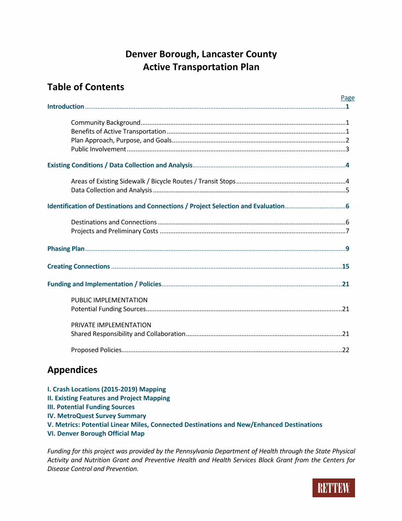
Table of Contents Page
Introduction ...................................................................................................................................................... 1
Community Background ...................................................................................................................... 1 Benefits of Active Transportation ....................................................................................................... 1 Plan Approach, Purpose, and Goals .................................................................................................... 2 Public Involvement .............................................................................................................................. 3
Existing Conditions / Data Collection and Analysis ........................................................................................ 4
Areas of Existing Sidewalk / Bicycle Routes / Transit Stops ............................................................... 4 Data Collection and Analysis ............................................................................................................... 5
Identification of Destinations and Connections / Project Selection and Evaluation ................................... 6
Destinations and Connections ............................................................................................................ 6 Projects and Preliminary Costs ........................................................................................................... 7 Phasing Plan ...................................................................................................................................................... 9 Creating Connections .....................................................................................................................................15 Funding and Implementation / Policies ........................................................................................................21
PUBLIC IMPLEMENTATION Potential Funding Sources .................................................................................................................21
PRIVATE IMPLEMENTATION Shared Responsibility and Collaboration ..........................................................................................21
Proposed Policies ...............................................................................................................................22
Appendices
I. Crash Locations (2015-2019) Mapping II. Existing Features and Project Mapping III. Potential Funding Sources IV. MetroQuest Survey Summary V. Metrics: Potential Linear Miles, Connected Destinations and New/Enhanced Destinations VI. Denver Borough Official Map Funding for this project was provided by the Pennsylvania Department of Health through the State Physical Activity and Nutrition Grant and Preventive Health and Health Services Block Grant from the Centers for Disease Control and Prevention.
1 | P a g e
Introduction
Community Background
Denver Borough is situated in northeastern Lancaster County, approximately 15 miles north-northeast of
the City of Lancaster. The Borough contains a total land area of 1.1 square miles and adjoins West Cocalico
Township to the north and west, and East Cocalico Township to the south and east. The Cocalico School
District has its administrative offices and three of the five schools (Cocalico Senior High School, Cocalico
Middle School, Denver Elementary School) located in the borough. The regional transportation corridors
of the Pennsylvania Turnpike (Interstate 76), PA-272, and US-222 are located near the borough, and the
Pennsylvania Turnpike runs directly west to east through the borough limits. Primary roadway access to
Denver Borough is via West Church Street, Denver Road, Reinholds Road, and South Ridge Road (from
East Cocalico Township), and North Line Road and Steinmetz Road (from West Cocalico Township). Except
for Denver Road, all these roadways are owned and maintained by the Pennsylvania Department of
Transportation (PennDOT).
The land use is primarily suburban, and the vast majority of the land in the borough has been developed;
however, the Cocalico Creek and the Little Cocalico Creek flow through the borough largely from north to
south and join near the borough boundary just southeast of the Main Street/Weaver Road intersection.
As a result, there are notable areas of riparian forest corridor that protect the water quality of these
streams but also present an opportunity for greenway development. Along the Little Cocalico Creek, the
Borough owns multiple parcels of adjacent land and the Bon View Estates Linear Park, which includes a
walking trail loop.
Most commercial and industrial uses are located in the central part of the borough, with the three arterial
roads of Main Street, North 6th Street and South 4th Street/Lancaster Avenue serving as the primary
thoroughfares providing access to the Cocalico School District complex, the central business district, and major
industrial facilities. These roadways are owned and maintained by PennDOT and experience annual average
daily traffic volumes between 3,900 and 7,300 but are less suited to non-motorized modes of transportation.
Benefits of Active Transportation
The following are benefits of active transportation:
• Increased public health benefits through recreational use and physical activity
• Reduced automobile use, as short trips can be made by non-motorized travel
• Improvements to local air quality through reduction of automobile use
• Enhanced quality of life through increased alternative transportation opportunities
• Increased property values near active transportation modes and trails
• Increased economic activity through spending at local businesses
• Increased access to cultural and historical resources
• When combined with additional or enhanced facilities, improved safety and accessibility for
vulnerable populations, especially for the children, elderly, low-income, or disabled.

2 | P a g e
For the purposes of this plan, active transportation is any self-propelled, human-powered mode of
transportation that promotes physical activity, including walking, running, bicycling, skateboarding,
rollerblading, and accessing public transportation since many people reach transit stops using active travel
modes. Also considered are users of mobility devices and stroller users. These modes may be used for
recreational purposes, to reach a destination, or to commute to work. As people look to improve their
own health and the health of the environment, the number of people opting for active transportation is
only expected to increase. In Lancaster County, recreational bicycling and walking is increasing in
popularity, and new and existing rail-to-trail facilities are either being constructed or extended.
Per the Centers for Disease Control and Prevention, regular physical activity is one of the most important
things people can do for their health. It can help individuals control weight, reduce risk of cardiovascular
disease, reduce risk for type 2 diabetes and metabolic syndrome, reduce risk of some cancers, strengthen
bones and muscles, and improve mental health and mood. Further, the Community Preventive Services
Task Force, an independent, nonfederal, voluntary panel of public health and prevention experts, found
that physical activity increased among individuals in communities with new or improved projects or
policies combining transportation (e.g., pedestrian or cycling paths) with land use and design components
(e.g., access to public parks).
Plan Approach, Purpose, and Goals
Denver Borough’s vision of an active transportation system is to provide opportunities for people to be
more physically active, for children to walk or bike to school, for people to commute to work without their
cars, and to connect local communities and destinations. Quality of life can be improved by creating
additional opportunities for social interaction, and active transportation promotes and enables social
interaction and engagement, which can lead to a happier and more connected community. The Borough
understands the vision of a connected, safe, pedestrian and bicycle friendly community is a long-term goal
requiring continued commitment toward achievement.
Denver Borough recognizes the public health crisis of obesity and inactivity both in Pennsylvania and
across the nation which is caused in part by dependence on motorized transportation. The Borough
acknowledges the primary mode of transit for most residents and visitors is by automobile and that active
transportation is a secondary consideration. To that end, the Borough has determined that it is necessary
to plan for and implement safe and appropriate transportation facilities to accommodate pedestrians and
bicyclists. This Plan:
• Serves as a supplement to the existing Strategic Comprehensive Plan for the Cocalico Region and
will lay the foundation for a network of active transportation facilities within the borough that
provides safe, accessible connections between destinations within and surrounding Denver
Borough.
• Gathers relevant active transportation data, identifies current and future needs and
opportunities, and incorporates key stakeholder and public input.
3 | P a g e
• Discusses private and public implementation methods for initiating design, construction and
installation of active transportation facilities and signage, identifies the key stakeholders, and lays
out a phasing plan to prioritize short- and long-term improvements.
This Plan is meant to be used and referenced often as the Borough implements the identified projects.
The phasing plan and implementation methods are meant to be used as a checklist to “get work done.”
The top priority projects are detailed to thoroughly describe the project and provide information for
reference and consideration during the design phase of these and similar improvement projects. As key
projects are implemented, the Borough will review and update the Plan to define new short-term
improvements.
Public Involvement
Denver Borough formed a steering committee led by the Borough Manager including elected and
appointed Borough officials from Council, the Planning Commission, and the Recreation Board; Borough
residents; representatives from businesses and community organizations, the Cocalico School District, the
Lancaster County Planning Commission, Penn Medicine, and the consulting team. The Steering Committee
participated in the planning process throughout the development of this Plan and conducted two
meetings during the project. Since the Borough launched the process to develop an Official Map in
February 2020, it was beneficial to hold a joint public meeting at a regularly scheduled Borough Planning
Commission meeting to discuss roads, bridges, trails, and active transportation. Approximately 30 people
attended this meeting, and key observations and suggestions were received from Planning Commission
members, Borough residents, and business representatives.
While a second public meeting was planned from the start of the project, the COVID-19 pandemic required
the Borough to adjust that plan, and with the assistance of Lancaster County Planning Commission staff
members, the Borough conducted an online survey using MetroQuest to solicit input from members of
the public. The survey was publicized in the Borough’s newsletter and website and ran from July 28 to
August 28, 2020. Included as Appendix IV to this Plan is the survey summary data received and processed
by MetroQuest and the Lancaster County Planning Commission staff.
The survey responses and the respondents’ assigned priorities were largely consistent with the feedback
received through the Steering Committee and the public meeting of the Borough Planning Commission.
Ultimately, this Plan should be community-driven and should reflect the community vision and goals. It is
also the intent for this Plan to be consistent with PennDOT’s 6 themes for Active Transportation:
1. Enhance Safety
2. Provide Transportation Equity
3. Connect Walking & Bicycling Networks
4. Leverage Partnerships
5. Improve Public Health
6. Increase Economic Mobility
4 | P a g e
Existing Conditions / Data Collection and Analysis
Areas of Existing Sidewalk / Bicycle Routes / Transit Stops
Since the vast majority of the borough’s roadways have parallel sidewalks on one or both sides, this Plan
does not focus on connecting identified destinations with new sidewalk construction and does not focus
on areas of sidewalk in need of repair or replacement. Denver Borough has taken a proactive approach
and does the following with regard to sidewalks:
• Adopted and enforces a Borough Sidewalk Ordinance
• Conducts a Borough-wide sidewalk inventory and assessment every 7 years
• Inspects sidewalks and curbs before repaving a roadway
• Inspects sidewalks during the course of a residential property sale between owners
However, this Plan identifies connections to destinations where sidewalk is not present and provides
recommendations on the appropriate type of facility to make the connection. With sidewalk nearly
ubiquitous, the Borough has the makings of an interconnected pedestrian network and intends to
continue working to allow all users to safely and conveniently navigate to their destination.
Currently within the borough there are no designated or dedicated bicycle facilities or routes. There are
trails within the Bon View Estates Linear Park and the Denver Memorial Park; otherwise, there are only
on-road connections to designated bicycle routes or trails outside the borough, which include the Warwick
to Ephrata Rail-Trail (WERT) in Ephrata Borough and a designated primarily on-road bicycle route into
Lancaster City using PA-272.
The Northern Lancaster Hub, a partnership of service organizations in the Northern Lancaster County
region, has one location in Denver and one in Ephrata and operates a free shuttle service on weekdays
between the Declaration House, located at 240 Main Street in Denver Borough, and the Ephrata
Community Commons at 560 South Reading Road in Ephrata Borough. This shuttle service connects
Denver Borough residents to a Red Rose Transit Authority (RRTA) bus stop, the Ephrata Public Library, and
various other community services. While this is an excellent option for those who opt for or have need of
public transportation, the current operating schedule may prevent those employees without a flexible
work schedule from using the service. The Declaration House has also been identified, through the
Steering Committee and the Official Map process, as the most appropriate location for a designated bus
stop or shelter that could include parking, bicycle racks, and other amenities.
5 | P a g e
Data Collection and Analysis
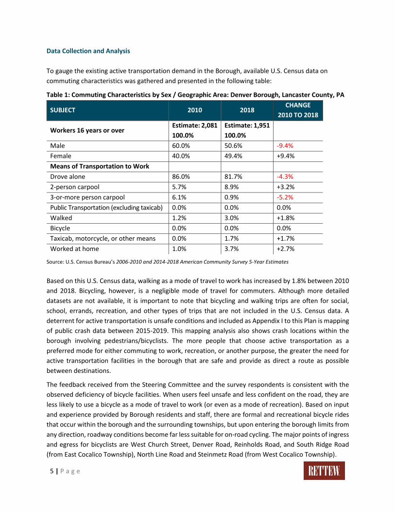
To gauge the existing active transportation demand in the Borough, available U.S. Census data on
commuting characteristics was gathered and presented in the following table:
Table 1: Commuting Characteristics by Sex / Geographic Area: Denver Borough, Lancaster County, PA
SUBJECT 2010 2018 CHANGE
2010 TO 2018
Workers 16 years or over Estimate: 2,081
100.0%
Estimate: 1,951
100.0%
Male 60.0% 50.6% -9.4%
Female 40.0% 49.4% +9.4%
Means of Transportation to Work
Drove alone 86.0% 81.7% -4.3%
2-person carpool 5.7% 8.9% +3.2%
3-or-more person carpool 6.1% 0.9% -5.2%
Public Transportation (excluding taxicab) 0.0% 0.0% 0.0%
Walked 1.2% 3.0% +1.8%
Bicycle 0.0% 0.0% 0.0%
Taxicab, motorcycle, or other means 0.0% 1.7% +1.7%
Worked at home 1.0% 3.7% +2.7%
Source: U.S. Census Bureau’s 2006-2010 and 2014-2018 American Community Survey 5-Year Estimates
Based on this U.S. Census data, walking as a mode of travel to work has increased by 1.8% between 2010
and 2018. Bicycling, however, is a negligible mode of travel for commuters. Although more detailed
datasets are not available, it is important to note that bicycling and walking trips are often for social,
school, errands, recreation, and other types of trips that are not included in the U.S. Census data. A
deterrent for active transportation is unsafe conditions and included as Appendix I to this Plan is mapping
of public crash data between 2015-2019. This mapping analysis also shows crash locations within the
borough involving pedestrians/bicyclists. The more people that choose active transportation as a
preferred mode for either commuting to work, recreation, or another purpose, the greater the need for
active transportation facilities in the borough that are safe and provide as direct a route as possible
between destinations.
The feedback received from the Steering Committee and the survey respondents is consistent with the
observed deficiency of bicycle facilities. When users feel unsafe and less confident on the road, they are
less likely to use a bicycle as a mode of travel to work (or even as a mode of recreation). Based on input
and experience provided by Borough residents and staff, there are formal and recreational bicycle rides
that occur within the borough and the surrounding townships, but upon entering the borough limits from
any direction, roadway conditions become far less suitable for on-road cycling. The major points of ingress
and egress for bicyclists are West Church Street, Denver Road, Reinholds Road, and South Ridge Road
(from East Cocalico Township), North Line Road and Steinmetz Road (from West Cocalico Township).
6 | P a g e
Identification of Destinations and Connections / Project Selection and
Evaluation
Destinations and Connections
Pedestrians and bicyclists who are not outside for recreational purposes are ultimately trying to reach a
predetermined destination, whether it is to their place of residence, school, work, park, bus stop,
commercial area, or other community facility. Through this planning process, key destination types
identified included schools, businesses, parks, existing regional trails, community facilities, and mass
transit stops. Because of the geographic layout of identified destinations, the top priority locations were
determined to be either adjacent to or nearby what has been referred to as the Borough Loop Trail. In
2000, the identification and alignment of this trail initially was proposed in a Comprehensive Park,
Recreation & Open Space planning effort conducted by Borough staff, the Borough Recreation Board, and
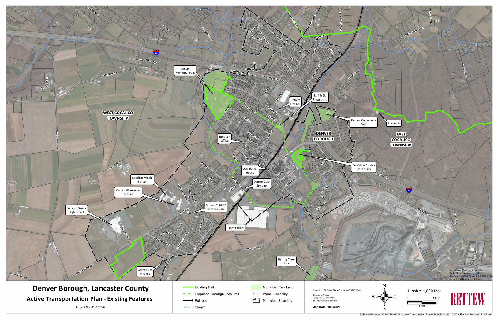
a Steering Committee. Included as Appendix II to this Plan is mapping of Existing Features that shows the
potential for a Borough Loop Trail, the identified destinations and where existing trails are located
(primarily in the Bon View Estates Linear Park and the Denver Memorial Park). These locations are
considered to be key destinations of significant importance and those that promote a high level of human
activity.
The three major industrial facilities in the Borough (Denver Cold Storage, Henry Schein, and Weaver
Industries) employ nearly 500 people, which is approximately 29% of the overall workforce in the
Borough. With Henry Schein developing plans for future building additions totaling approximately 360,000
square feet, this will create opportunities for employment within the facility but also require additional
trucking service. These three industries, on average, generate roughly 75 trucks per day and roughly 110
trucks during peak season. Access to these facilities is very limited, causing many trucks to travel though
the Borough’s central business district, in close proximity to facilities of the Cocalico School District, and
adjacent residential areas. The Borough has observed that these trucks encounter difficult
maneuverability, contribute to traffic congestion, and create conflicts and unsafe situations for motor
vehicles, pedestrians, bicyclists, school buses and students walking to school.
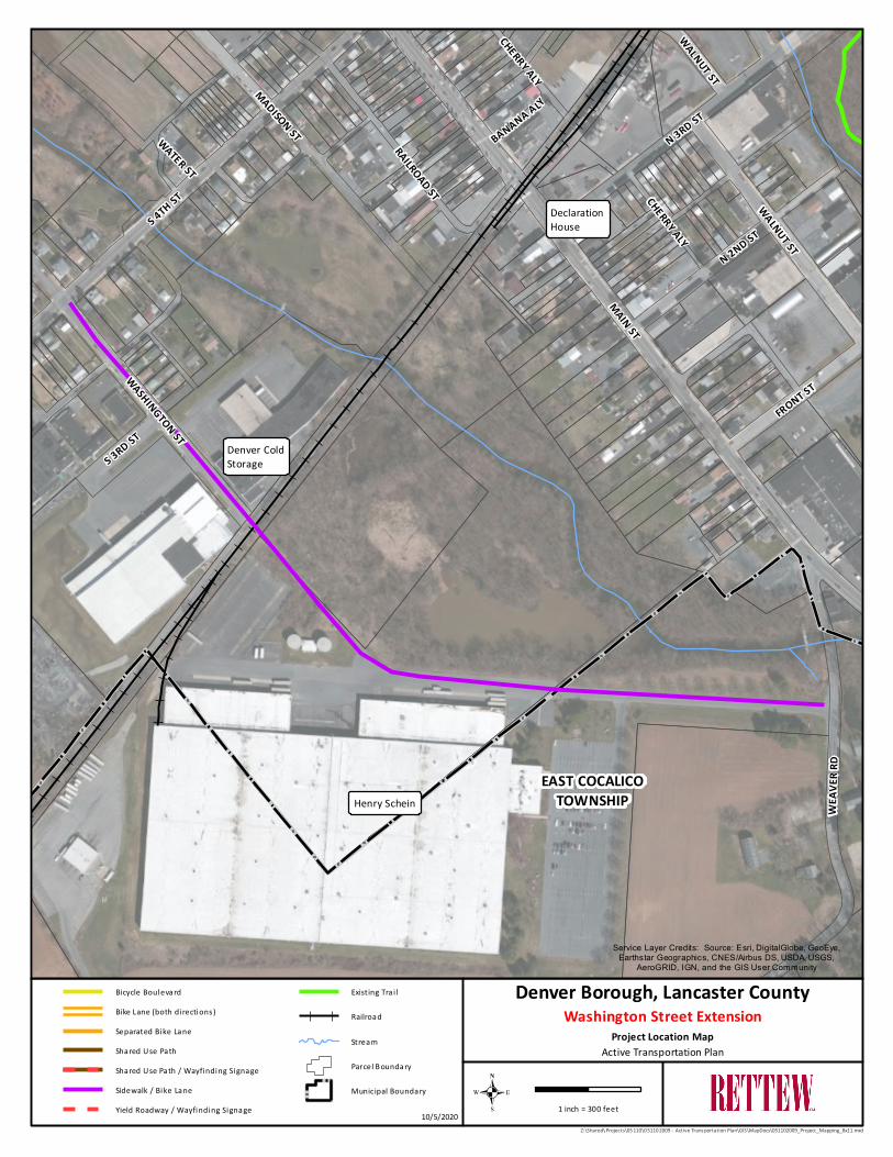
Therefore, on a section of the proposed Loop Trail between South 4th Street and Weaver Road, Denver
Borough is proposing to construct an extension of Washington Street that will connect to a new alignment
of the Weaver Road bridge over the Cocalico Creek. The Weaver Road Bridge replacement is a TIP-funded
project scheduled for construction in 2024. This connection would provide an alternate route and direct
access to the Borough’s industrial center, avoiding the necessity to route trucks through the center of the
Borough and onto residential streets. This extension is proposed to incorporate 5’-wide sidewalks,
crosswalks, and 4’-wide shoulders to ensure that pedestrians, industrial workers, and bicyclists have a
safe means to navigate Washington Street.
7 | P a g e
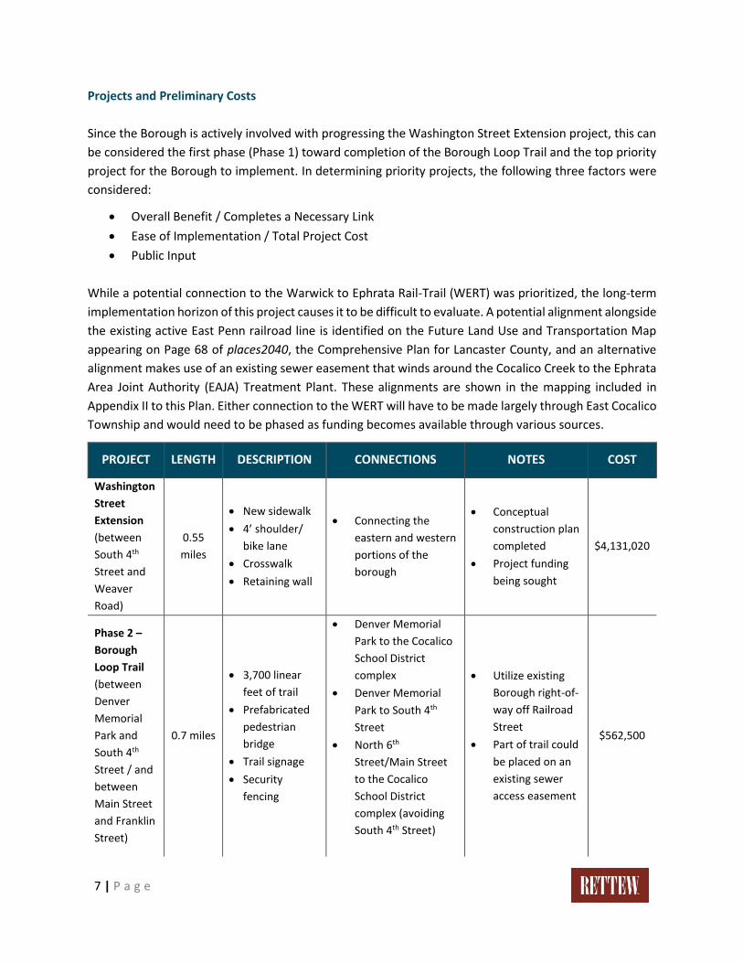
Projects and Preliminary Costs
Since the Borough is actively involved with progressing the Washington Street Extension project, this can
be considered the first phase (Phase 1) toward completion of the Borough Loop Trail and the top priority
project for the Borough to implement. In determining priority projects, the following three factors were
considered:
• Overall Benefit / Completes a Necessary Link
• Ease of Implementation / Total Project Cost
• Public Input
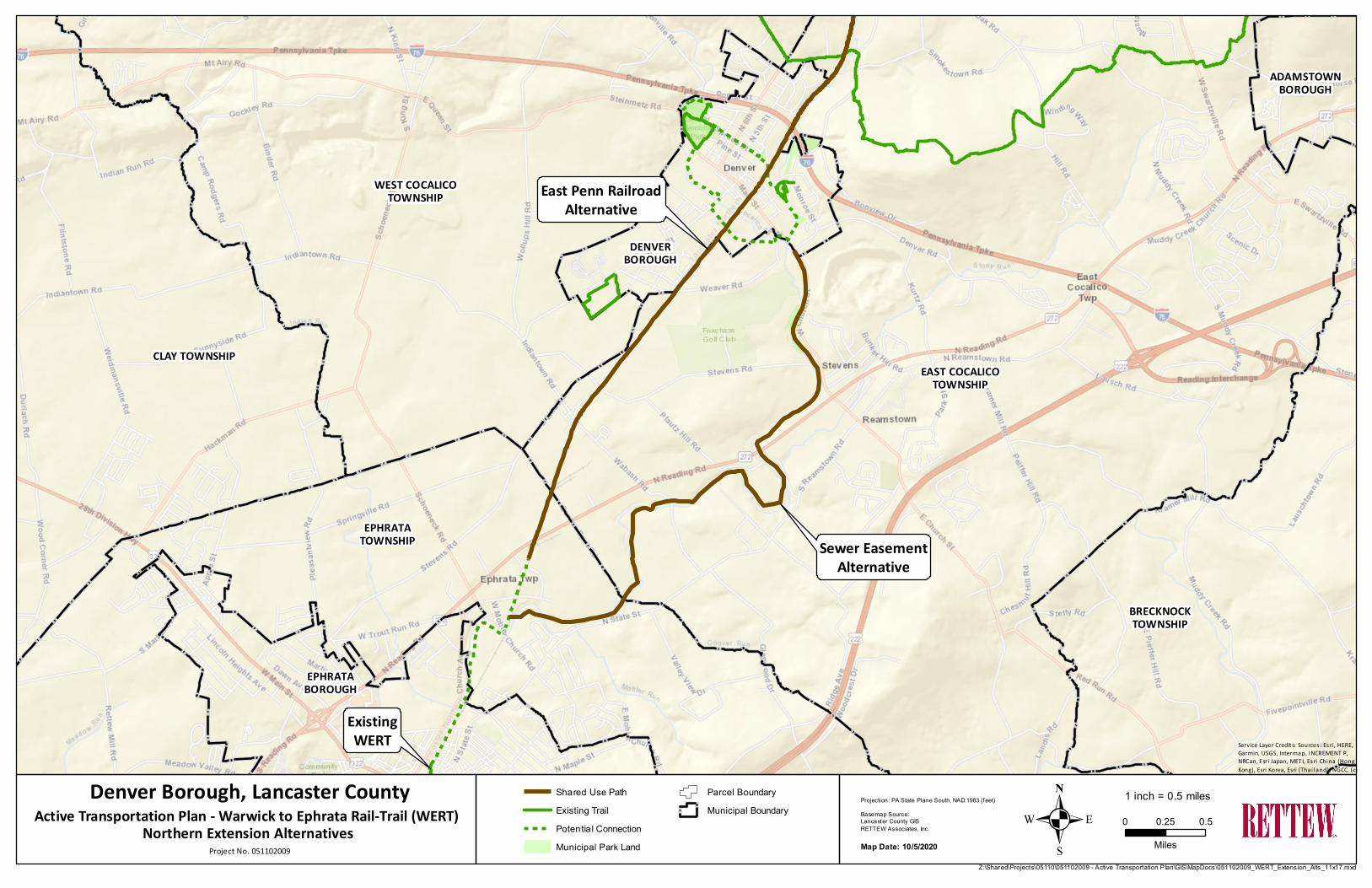
While a potential connection to the Warwick to Ephrata Rail-Trail (WERT) was prioritized, the long-term
implementation horizon of this project causes it to be difficult to evaluate. A potential alignment alongside
the existing active East Penn railroad line is identified on the Future Land Use and Transportation Map
appearing on Page 68 of places2040, the Comprehensive Plan for Lancaster County, and an alternative
alignment makes use of an existing sewer easement that winds around the Cocalico Creek to the Ephrata
Area Joint Authority (EAJA) Treatment Plant. These alignments are shown in the mapping included in
Appendix II to this Plan. Either connection to the WERT will have to be made largely through East Cocalico
Township and would need to be phased as funding becomes available through various sources.
PROJECT LENGTH DESCRIPTION CONNECTIONS NOTES COST
Washington
Street
Extension
(between
South 4th
Street and
Weaver
Road)
0.55
miles
• New sidewalk
• 4’ shoulder/
bike lane
• Crosswalk
• Retaining wall
• Connecting the
eastern and western
portions of the
borough
• Conceptual
construction plan
completed
• Project funding
being sought
$4,131,020
Phase 2 –
Borough
Loop Trail
(between
Denver
Memorial
Park and
South 4th
Street / and
between
Main Street
and Franklin
Street)
0.7 miles
• 3,700 linear
feet of trail
• Prefabricated
pedestrian
bridge
• Trail signage
• Security
fencing
• Denver Memorial
Park to the Cocalico
School District
complex
• Denver Memorial
Park to South 4th
Street
• North 6th
Street/Main Street
to the Cocalico
School District
complex (avoiding
South 4th Street)
• Utilize existing
Borough right-of-
way off Railroad
Street
• Part of trail could
be placed on an
existing sewer
access easement
$562,500
8 | P a g e
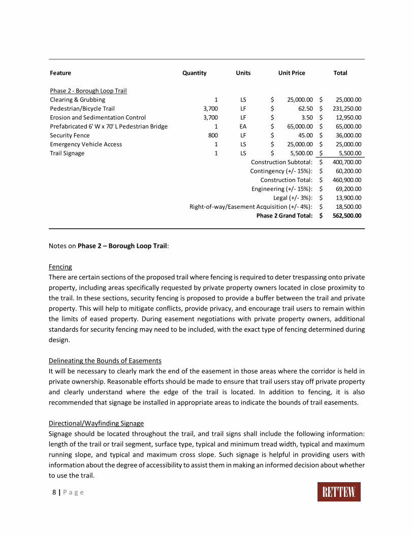
Notes on Phase 2 – Borough Loop Trail:
Fencing
There are certain sections of the proposed trail where fencing is required to deter trespassing onto private
property, including areas specifically requested by private property owners located in close proximity to
the trail. In these sections, security fencing is proposed to provide a buffer between the trail and private
property. This will help to mitigate conflicts, provide privacy, and encourage trail users to remain within
the limits of eased property. During easement negotiations with private property owners, additional
standards for security fencing may need to be included, with the exact type of fencing determined during
design.
Delineating the Bounds of Easements
It will be necessary to clearly mark the end of the easement in those areas where the corridor is held in
private ownership. Reasonable efforts should be made to ensure that trail users stay off private property
and clearly understand where the edge of the trail is located. In addition to fencing, it is also
recommended that signage be installed in appropriate areas to indicate the bounds of trail easements.
Directional/Wayfinding Signage
Signage should be located throughout the trail, and trail signs shall include the following information:
length of the trail or trail segment, surface type, typical and minimum tread width, typical and maximum
running slope, and typical and maximum cross slope. Such signage is helpful in providing users with
information about the degree of accessibility to assist them in making an informed decision about whether
to use the trail.
Feature Quantity Units Unit Price Total
Phase 2 - Borough Loop Trail
Clearing & Grubbing 1 LS 25,000.00$ 25,000.00$
Pedestrian/Bicycle Trail 3,700 LF 62.50$ 231,250.00$
Erosion and Sedimentation Control 3,700 LF 3.50$ 12,950.00$
Prefabricated 6' W x 70' L Pedestrian Bridge 1 EA 65,000.00$ 65,000.00$
Security Fence 800 LF 45.00$ 36,000.00$
Emergency Vehicle Access 1 LS 25,000.00$ 25,000.00$
Trail Signage 1 LS 5,500.00$ 5,500.00$
Construction Subtotal: 400,700.00$
Contingency (+/- 15%): 60,200.00$
Construction Total: 460,900.00$
Engineering (+/- 15%): 69,200.00$
Legal (+/- 3%): 13,900.00$
Right-of-way/Easement Acquisition (+/- 4%): 18,500.00$
Phase 2 Grand Total: 562,500.00$
9 | P a g e
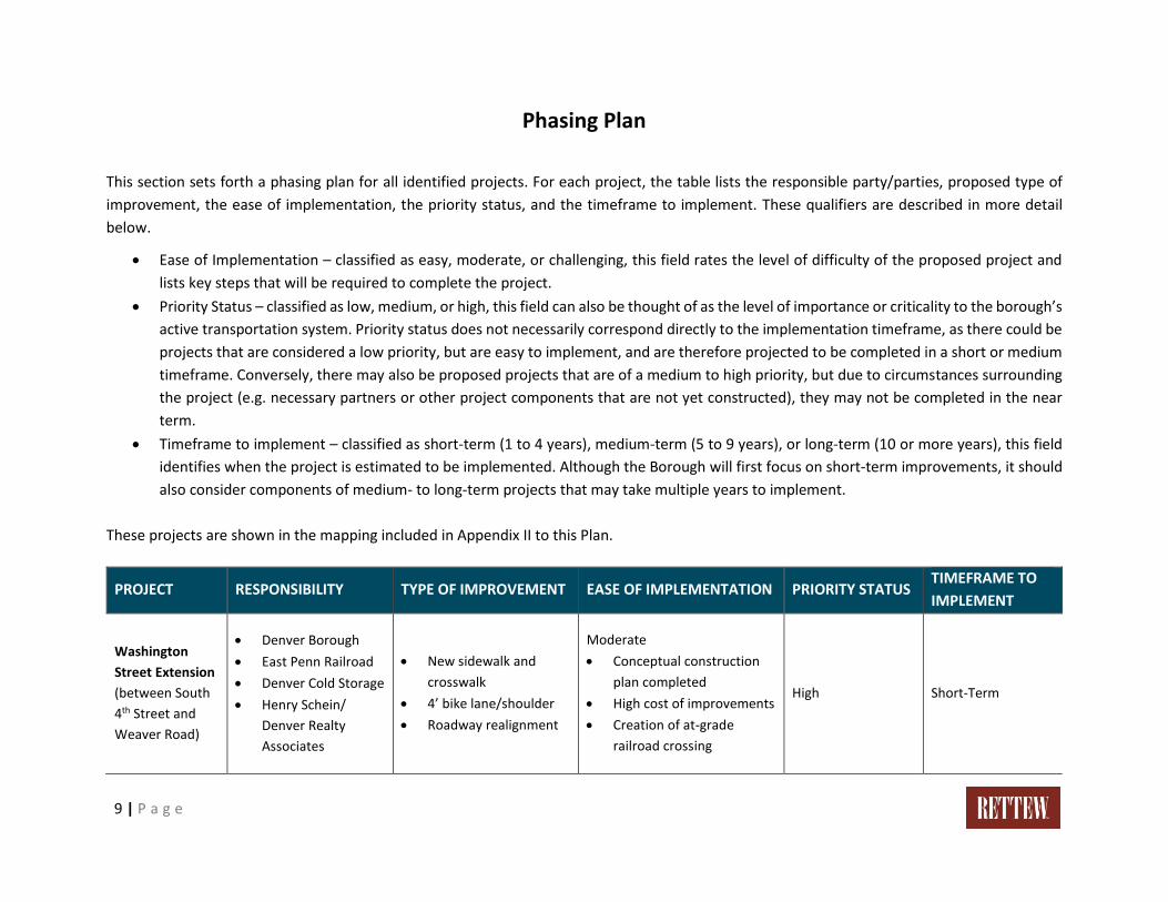
Phasing Plan
This section sets forth a phasing plan for all identified projects. For each project, the table lists the responsible party/parties, proposed type of
improvement, the ease of implementation, the priority status, and the timeframe to implement. These qualifiers are described in more detail
below.
• Ease of Implementation – classified as easy, moderate, or challenging, this field rates the level of difficulty of the proposed project and
lists key steps that will be required to complete the project.
• Priority Status – classified as low, medium, or high, this field can also be thought of as the level of importance or criticality to the borough’s
active transportation system. Priority status does not necessarily correspond directly to the implementation timeframe, as there could be
projects that are considered a low priority, but are easy to implement, and are therefore projected to be completed in a short or medium
timeframe. Conversely, there may also be proposed projects that are of a medium to high priority, but due to circumstances surrounding
the project (e.g. necessary partners or other project components that are not yet constructed), they may not be completed in the near
term.
• Timeframe to implement – classified as short-term (1 to 4 years), medium-term (5 to 9 years), or long-term (10 or more years), this field
identifies when the project is estimated to be implemented. Although the Borough will first focus on short-term improvements, it should
also consider components of medium- to long-term projects that may take multiple years to implement.
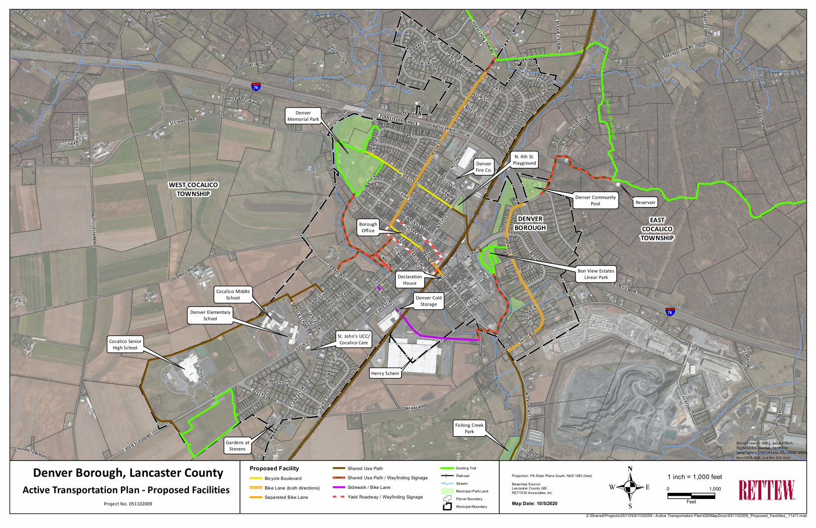
These projects are shown in the mapping included in Appendix II to this Plan.
PROJECT RESPONSIBILITY TYPE OF IMPROVEMENT EASE OF IMPLEMENTATION PRIORITY STATUS TIMEFRAME TO
IMPLEMENT
Washington
Street Extension
(between South
4th Street and
Weaver Road)
• Denver Borough
• East Penn Railroad
• Denver Cold Storage
• Henry Schein/
Denver Realty
Associates
• New sidewalk and
crosswalk
• 4’ bike lane/shoulder
• Roadway realignment
Moderate
• Conceptual construction
plan completed
• High cost of improvements
• Creation of at-grade
railroad crossing
High Short-Term
10 | P a g e
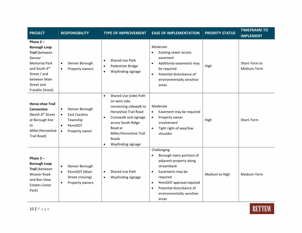
PROJECT RESPONSIBILITY TYPE OF IMPROVEMENT EASE OF IMPLEMENTATION PRIORITY STATUS TIMEFRAME TO
IMPLEMENT
Phase 2 –
Borough Loop
Trail (between
Denver
Memorial Park
and South 4th
Street / and
between Main
Street and
Franklin Street)
• Denver Borough
• Property owners
• Shared Use Path
• Pedestrian Bridge
• Wayfinding signage
Moderate
• Existing sewer access
easement
• Additional easements may
be required
• Potential disturbance of
environmentally sensitive
areas
High Short-Term to
Medium-Term
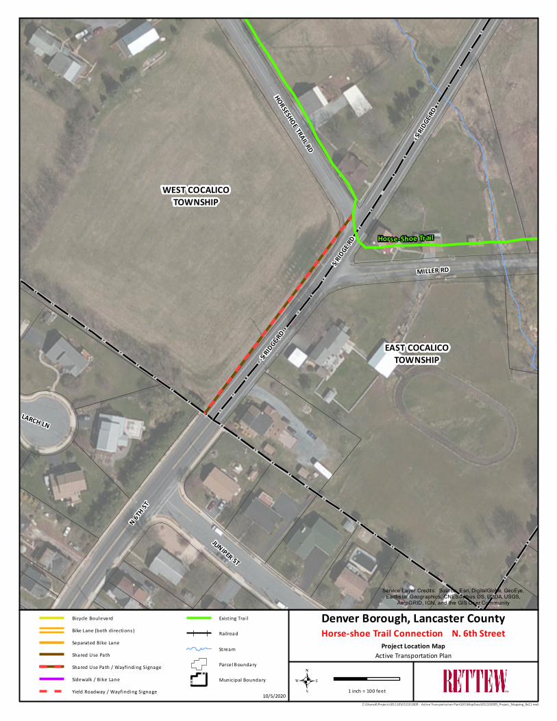
Horse-shoe Trail
Connection
(North 6th Street
at Borough line
to
Miller/Horseshoe
Trail Road)
• Denver Borough
• East Cocalico
Township
• PennDOT
• Property owner
• Shared Use (side) Path
on west side,
connecting sidewalk to
Horseshoe Trail Road
• Crosswalk and signage
across South Ridge
Road at
Miller/Horseshoe Trail
Roads
• Wayfinding signage
Moderate
• Easement may be required
• Property owner
involvement
• Tight right-of-way/low
shoulder
High Short-Term
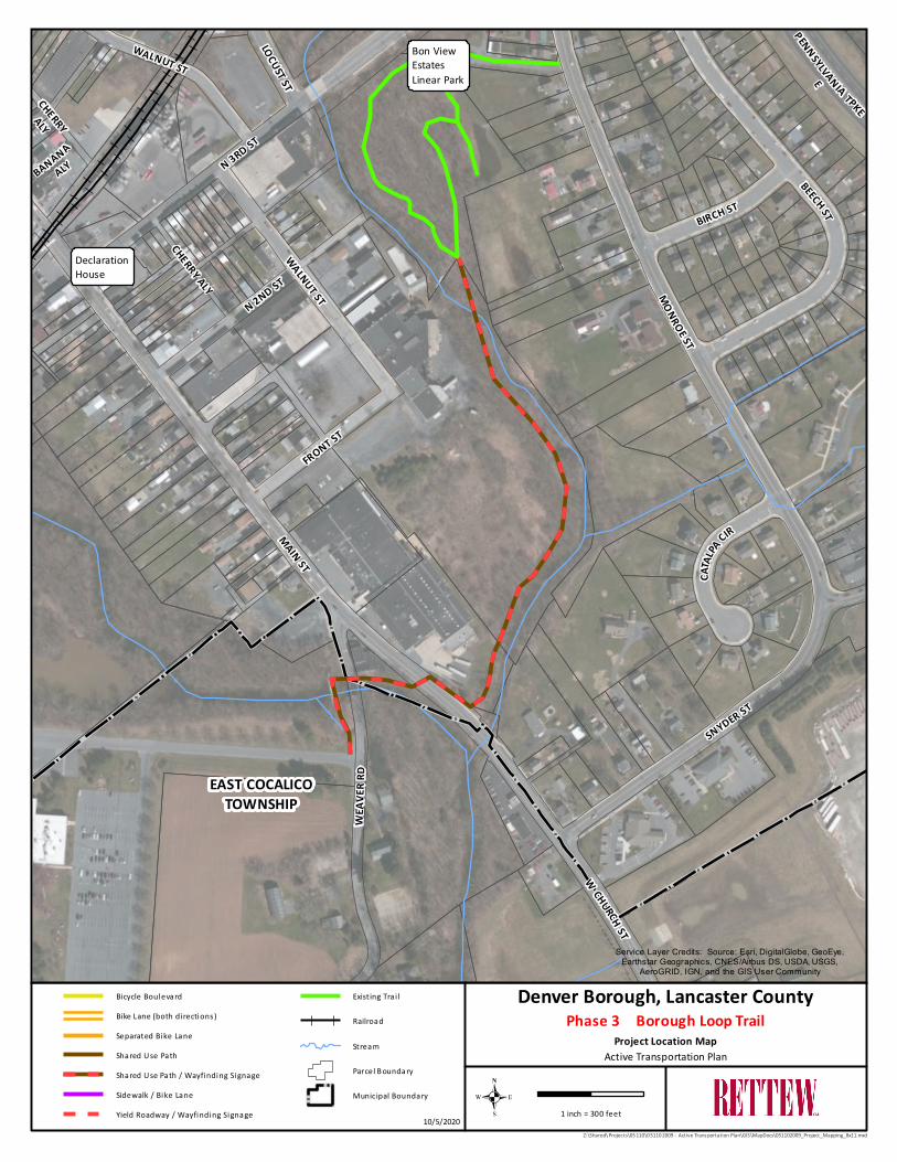
Phase 3 –
Borough Loop
Trail (between
Weaver Road
and Bon View
Estates Linear
Park)
• Denver Borough
• PennDOT (Main
Street crossing)
• Property owners
• Shared Use Path
• Wayfinding signage
Challenging
• Borough owns portions of
adjacent property along
streambank
• Easements may be
required
• PennDOT approval required
• Potential disturbance of
environmentally sensitive
areas
Medium to High Medium-Term

11 | P a g e
PROJECT RESPONSIBILITY TYPE OF IMPROVEMENT EASE OF IMPLEMENTATION PRIORITY STATUS TIMEFRAME TO
IMPLEMENT
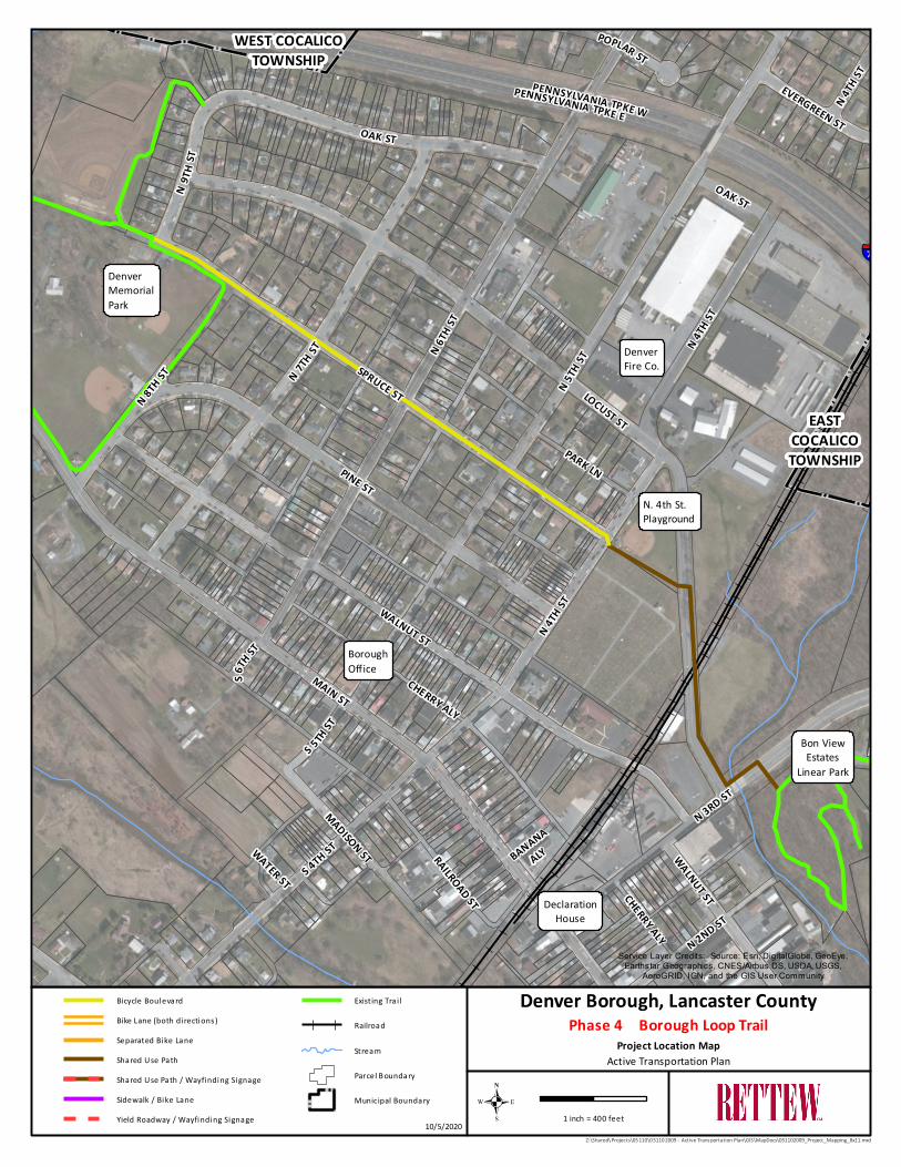
Phase 4 –
Borough Loop
Trail (between
Bon View Estates
Linear Park and
Denver
Memorial Park)
• Denver Borough
• Shared Use (side) Path
(between Bon View
Estates Linear Park and
North 4th St./Spruce St.)
• Bicycle boulevard on
Spruce St. (entire
length)
Easy
• Most if not all area owned
by the Borough
• At-grade crossing on
Locust Street
Medium to High Short-Term to
Medium-Term
Connection to
the Warwick to
Ephrata Rail-
Trail (via East
Penn Railroad)
• Denver Borough
• East Cocalico
Township
• Ephrata Township
• East Penn Railroad
• Property owners
• Shared Use Path
(alongside active
railroad)
Challenging
• Easements required, and
negotiations between
municipalities and East
Penn Railroad
Medium to High Long-Term
Connection to
the Warwick to
Ephrata Rail-
Trail (via sewer
easement)
• Denver Borough
• East Cocalico
Township
• Ephrata Township
• PennDOT
• Property owners
• Shared Use Path
• Bicycle boulevard/bike
lane may be a
situational
consideration
• Wayfinding signage
Challenging
• PennDOT/Township
roadway crossings
• Numerous Cocalico Creek
crossings
• Intermunicipal
cooperation
Medium to High Long-Term
12 | P a g e
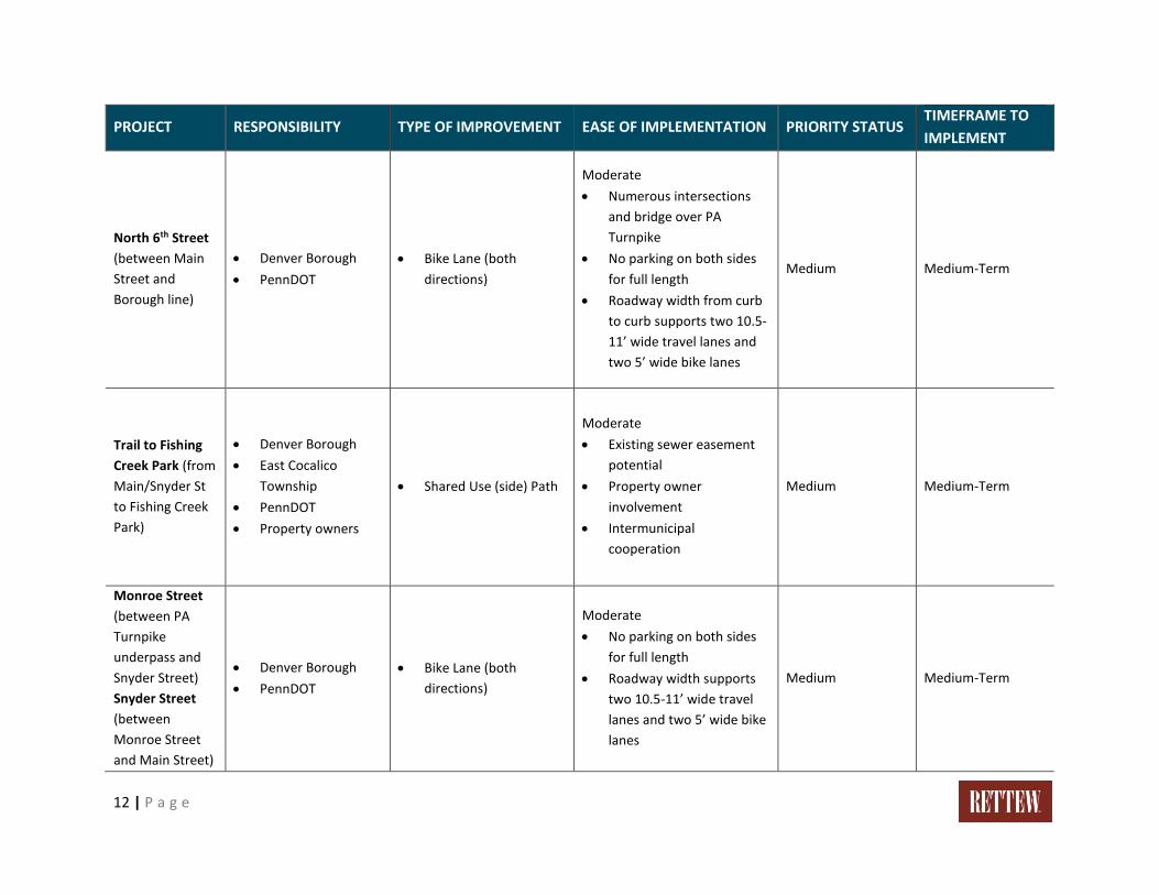
PROJECT RESPONSIBILITY TYPE OF IMPROVEMENT EASE OF IMPLEMENTATION PRIORITY STATUS TIMEFRAME TO
IMPLEMENT
North 6th Street
(between Main
Street and
Borough line)
• Denver Borough
• PennDOT
• Bike Lane (both
directions)
Moderate
• Numerous intersections
and bridge over PA
Turnpike
• No parking on both sides
for full length
• Roadway width from curb
to curb supports two 10.5-
11’ wide travel lanes and
two 5’ wide bike lanes
Medium Medium-Term
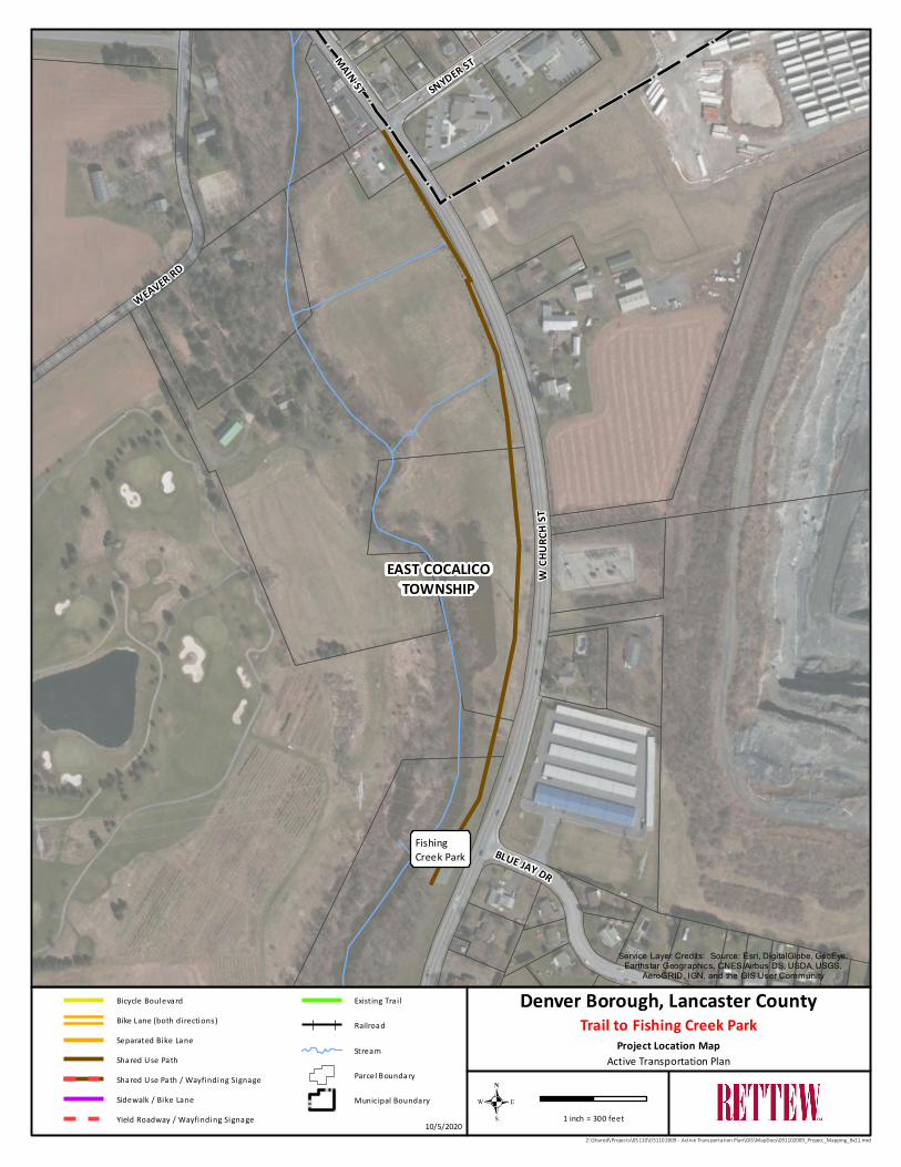
Trail to Fishing
Creek Park (from
Main/Snyder St
to Fishing Creek
Park)
• Denver Borough
• East Cocalico
Township
• PennDOT
• Property owners
• Shared Use (side) Path
Moderate
• Existing sewer easement
potential
• Property owner
involvement
• Intermunicipal
cooperation
Medium Medium-Term
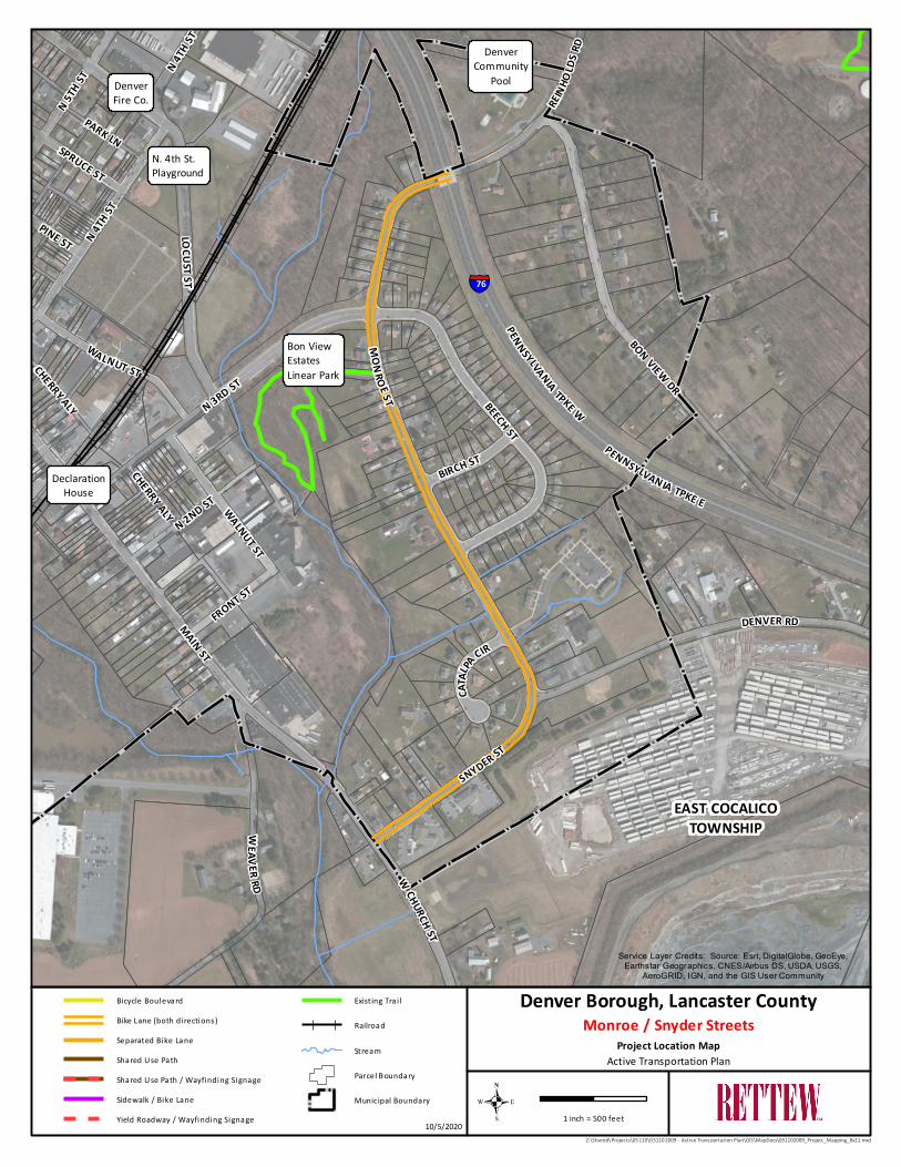
Monroe Street
(between PA
Turnpike
underpass and
Snyder Street)
Snyder Street
(between
Monroe Street
and Main Street)
• Denver Borough
• PennDOT
• Bike Lane (both
directions)
Moderate
• No parking on both sides
for full length
• Roadway width supports
two 10.5-11’ wide travel
lanes and two 5’ wide bike
lanes
Medium Medium-Term
13 | P a g e
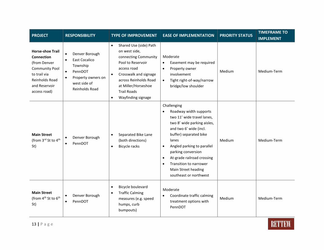
PROJECT RESPONSIBILITY TYPE OF IMPROVEMENT EASE OF IMPLEMENTATION PRIORITY STATUS TIMEFRAME TO
IMPLEMENT
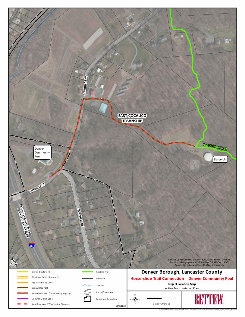
Horse-shoe Trail
Connection
(from Denver
Community Pool
to trail via
Reinholds Road
and Reservoir
access road)
• Denver Borough
• East Cocalico
Township
• PennDOT
• Property owners on
west side of
Reinholds Road
• Shared Use (side) Path
on west side,
connecting Community
Pool to Reservoir
access road
• Crosswalk and signage
across Reinholds Road
at Miller/Horseshoe
Trail Roads
• Wayfinding signage
Moderate
• Easement may be required
• Property owner
involvement
• Tight right-of-way/narrow
bridge/low shoulder
Medium Medium-Term
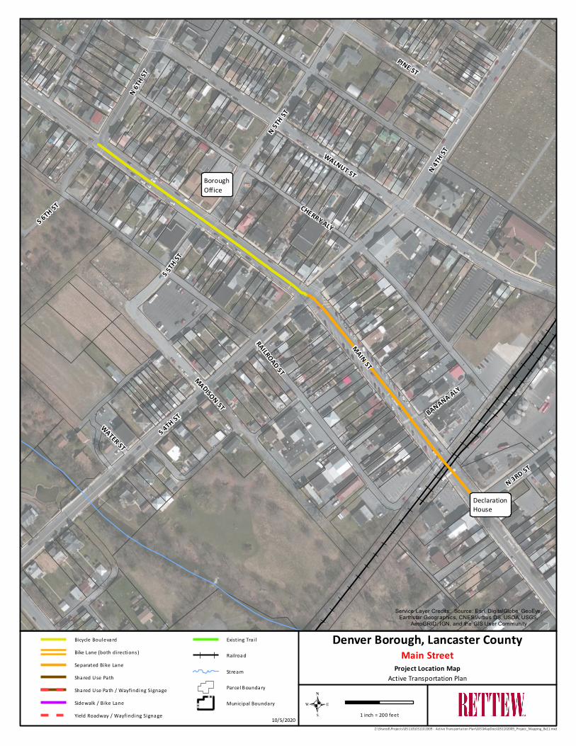
Main Street
(from 3rd St to 4th
St)
• Denver Borough
• PennDOT
• Separated Bike Lane
(both directions)
• Bicycle racks
Challenging
• Roadway width supports
two 11’ wide travel lanes,
two 8’ wide parking aisles,
and two 6’ wide (incl.
buffer) separated bike
lanes
• Angled parking to parallel
parking conversion
• At-grade railroad crossing
• Transition to narrower
Main Street heading
southeast or northwest
Medium Medium-Term
Main Street
(from 4th St to 6th
St)
• Denver Borough
• PennDOT
• Bicycle boulevard
• Traffic Calming
measures (e.g. speed
humps, curb
bumpouts)
Moderate
• Coordinate traffic calming
treatment options with
PennDOT
Medium Medium-Term
14 | P a g e
PROJECT RESPONSIBILITY TYPE OF IMPROVEMENT EASE OF IMPLEMENTATION PRIORITY STATUS TIMEFRAME TO
IMPLEMENT
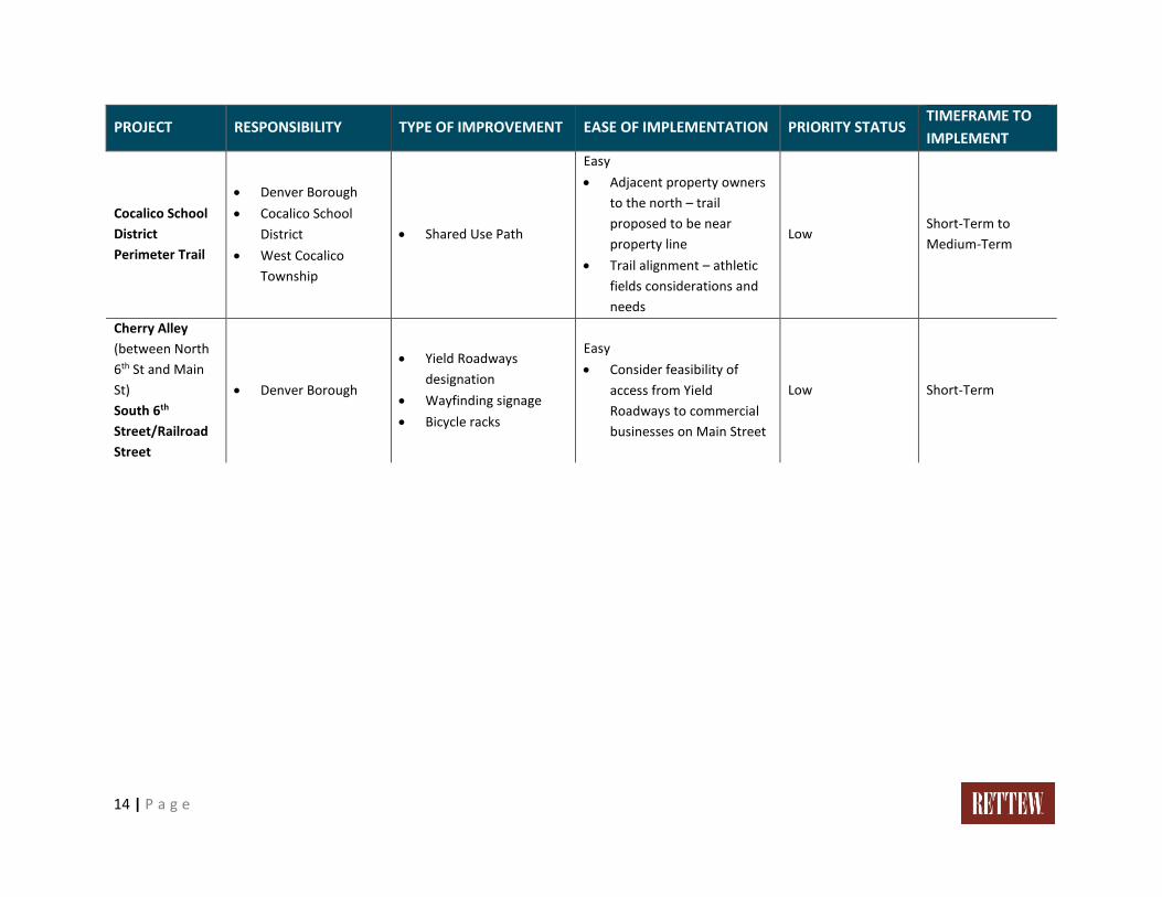
Cocalico School
District
Perimeter Trail
• Denver Borough
• Cocalico School
District
• West Cocalico
Township
• Shared Use Path
Easy
• Adjacent property owners
to the north – trail
proposed to be near
property line
• Trail alignment – athletic
fields considerations and
needs
Low Short-Term to
Medium-Term
Cherry Alley
(between North
6th St and Main
St)
South 6th
Street/Railroad
Street
• Denver Borough
• Yield Roadways
designation
• Wayfinding signage
• Bicycle racks
Easy
• Consider feasibility of
access from Yield
Roadways to commercial
businesses on Main Street
Low Short-Term
15 | P a g e
Creating Connections
The following images and descriptions of the types of facilities referenced are extracted from the PennDOT
LTAP Active Transportation Handbook, dated February 7, 2020.
These facilities are described in detail in order to match the recommended type of improvement (or
improvements) in the Phasing Plan.
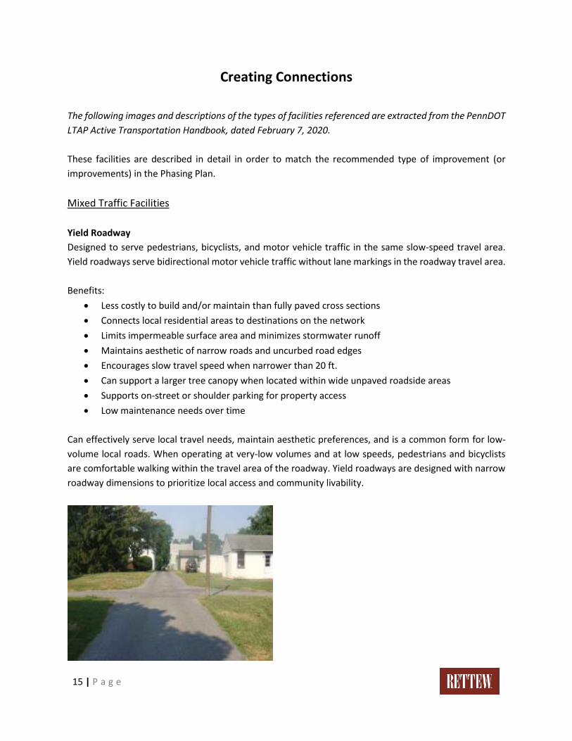
Mixed Traffic Facilities
Yield Roadway
Designed to serve pedestrians, bicyclists, and motor vehicle traffic in the same slow-speed travel area.
Yield roadways serve bidirectional motor vehicle traffic without lane markings in the roadway travel area.
Benefits:
• Less costly to build and/or maintain than fully paved cross sections
• Connects local residential areas to destinations on the network
• Limits impermeable surface area and minimizes stormwater runoff
• Maintains aesthetic of narrow roads and uncurbed road edges
• Encourages slow travel speed when narrower than 20 ft.
• Can support a larger tree canopy when located within wide unpaved roadside areas
• Supports on-street or shoulder parking for property access
• Low maintenance needs over time
Can effectively serve local travel needs, maintain aesthetic preferences, and is a common form for low-
volume local roads. When operating at very-low volumes and at low speeds, pedestrians and bicyclists
are comfortable walking within the travel area of the roadway. Yield roadways are designed with narrow
roadway dimensions to prioritize local access and community livability.
16 | P a g e
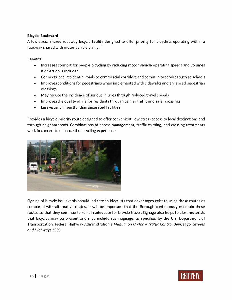
Bicycle Boulevard
A low-stress shared roadway bicycle facility designed to offer priority for bicyclists operating within a
roadway shared with motor vehicle traffic.
Benefits:
• Increases comfort for people bicycling by reducing motor vehicle operating speeds and volumes
if diversion is included
• Connects local residential roads to commercial corridors and community services such as schools
• Improves conditions for pedestrians when implemented with sidewalks and enhanced pedestrian
crossings
• May reduce the incidence of serious injuries through reduced travel speeds
• Improves the quality of life for residents through calmer traffic and safer crossings
• Less visually impactful than separated facilities
Provides a bicycle-priority route designed to offer convenient, low-stress access to local destinations and
through neighborhoods. Combinations of access management, traffic calming, and crossing treatments
work in concert to enhance the bicycling experience.
Signing of bicycle boulevards should indicate to bicyclists that advantages exist to using these routes as
compared with alternative routes. It will be important that the Borough continuously maintain these
routes so that they continue to remain adequate for bicycle travel. Signage also helps to alert motorists
that bicycles may be present and may include such signage, as specified by the U.S. Department of
Transportation, Federal Highway Administration’s Manual on Uniform Traffic Control Devices for Streets
and Highways 2009.
17 | P a g e
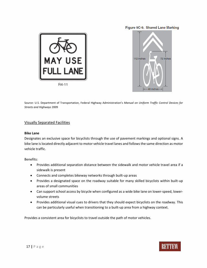
Source: U.S. Department of Transportation, Federal Highway Administration’s Manual on Uniform Traffic Control Devices for
Streets and Highways 2009
Visually Separated Facilities
Bike Lane
Designates an exclusive space for bicyclists through the use of pavement markings and optional signs. A
bike lane is located directly adjacent to motor vehicle travel lanes and follows the same direction as motor
vehicle traffic.
Benefits:
• Provides additional separation distance between the sidewalk and motor vehicle travel area if a
sidewalk is present
• Connects and completes bikeway networks through built-up areas
• Provides a designated space on the roadway suitable for many skilled bicyclists within built-up
areas of small communities
• Can support school access by bicycle when configured as a wide bike lane on lower-speed, lower-
volume streets
• Provides additional visual cues to drivers that they should expect bicyclists on the roadway. This
can be particularly useful when transitioning to a built-up area from a highway context.
Provides a consistent area for bicyclists to travel outside the path of motor vehicles.

18 | P a g e
Physically Separated Facilities
Shared Use Path
Provides a travel area separate from motorized traffic for bicyclists, pedestrians, skaters, wheelchair users,
joggers, and other users. Shared used paths can provide a low-stress experience for a variety of users
using the network for transportation or recreation. While situational considerations will dictate an
appropriate width, the minimum width is 5 feet, but the recommended width (especially where multiple
modes of transportation are expected) is at least 8 feet.
Benefits:
• Provides a dedicated facility for users of all ages and abilities
• Provides, in some cases, a short-cut between cities or neighborhoods
• Provides, in some cases, access to areas that are otherwise served only by limited-access
roadways
• Supports tourism through convenient access to natural areas or as an enjoyable recreational
opportunity itself
• Provides nonmotorized transportation access to natural and recreational areas, which can
especially help low-income people obtain access to recreation
• Paths have a small footprint and can display a distinctly rural character
Offers network connectivity opportunities beyond that of the roadway network. These facilities are often
located in parks, along rivers, beaches, and in greenbelts or utility corridors where there are few conflicts
with motorized vehicles.
19 | P a g e
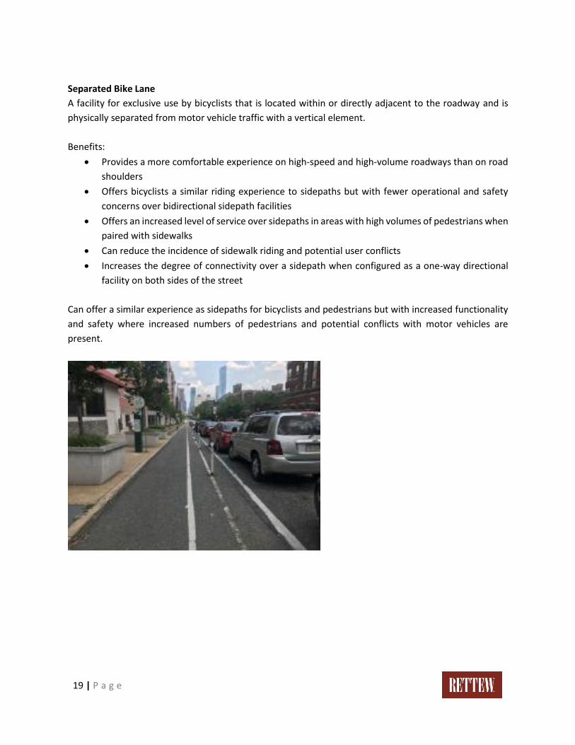
Separated Bike Lane
A facility for exclusive use by bicyclists that is located within or directly adjacent to the roadway and is
physically separated from motor vehicle traffic with a vertical element.
Benefits:
• Provides a more comfortable experience on high-speed and high-volume roadways than on road
shoulders
• Offers bicyclists a similar riding experience to sidepaths but with fewer operational and safety
concerns over bidirectional sidepath facilities
• Offers an increased level of service over sidepaths in areas with high volumes of pedestrians when
paired with sidewalks
• Can reduce the incidence of sidewalk riding and potential user conflicts
• Increases the degree of connectivity over a sidepath when configured as a one-way directional
facility on both sides of the street
Can offer a similar experience as sidepaths for bicyclists and pedestrians but with increased functionality
and safety where increased numbers of pedestrians and potential conflicts with motor vehicles are
present.
20 | P a g e
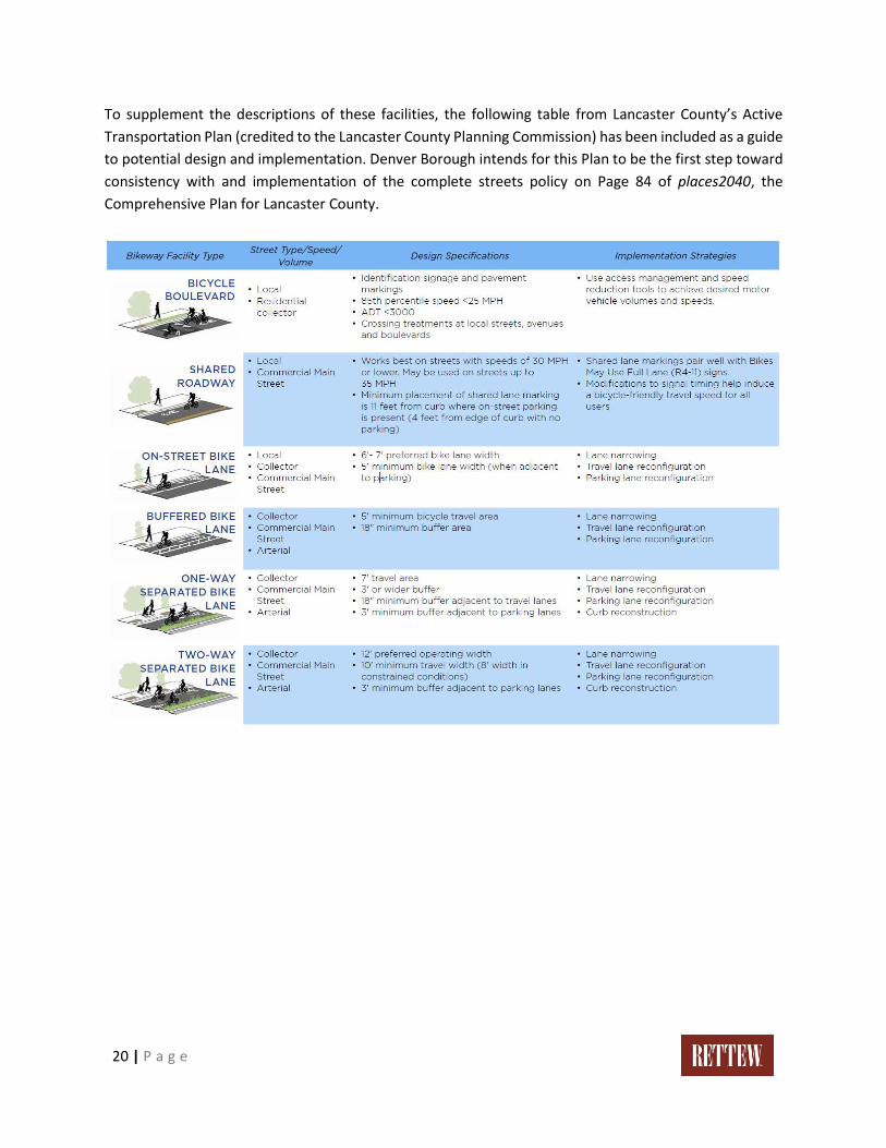
To supplement the descriptions of these facilities, the following table from Lancaster County’s Active
Transportation Plan (credited to the Lancaster County Planning Commission) has been included as a guide
to potential design and implementation. Denver Borough intends for this Plan to be the first step toward
consistency with and implementation of the complete streets policy on Page 84 of places2040, the
Comprehensive Plan for Lancaster County.
21 | P a g e
Funding and Implementation / Policies
It is important to establish a framework for implementation so the Borough’s effort can be focused. Since
the Borough will take on the responsibility for constructing and maintaining the Washington Street
extension, that priority project is where public funding options are most feasible.
The Borough identified the following key stakeholders involved with active transportation improvements:
• Developers
• Property owners
• Cocalico School District
• Municipal government of Denver Borough
• Municipal governments of West Cocalico and East Cocalico Townships
• The Northern Lancaster Hub
• East Penn Railroad
• Pennsylvania Department of Transportation (PennDOT)
PUBLIC IMPLEMENTATION
Potential Funding Sources
Public funding resources include federal, state, regional, and local government and quasi-government
grant and loan programs. These programs may be offered on an annual basis, or may be a one-time
funding opportunity, and they may or may not require matching funds. The Borough may wish to consider
requiring affected residents and businesses to contribute to any match.
There are a multitude of funding programs that could be used to help fund active transportation
improvements. A table of potential funding sources and related details is included as Appendix III to this
Plan.
PRIVATE IMPLEMENTATION
Shared Responsibility and Collaboration
Denver Borough views the implementation of this Plan as a shared initiative, and will pursue necessary
collaboration with private property owners, businesses, and developers. Using the active East Penn
Railroad line as an alignment for a shared use path connecting to the Warwick to Ephrata Rail-Trail will
require a large degree of cooperation and coordination. If this alternative is ultimately selected, the
Borough may wish to consider investigating the design and construction process of existing rail-trails that
run parallel to an active railroad (such as the York County Heritage Rail-Trail).
22 | P a g e
The Borough will also need to work closely with East Cocalico and West Cocalico Townships to coordinate
any proposed active transportation improvements planned to take place outside the borough limits. Since
the major corridors through the borough are owned and maintained by PennDOT, the Borough should
make sure the proposed roadway improvements in the Phasing Plan are fully vetted by the necessary
PennDOT staff.
It is recommended that the Borough establish a contact at the Northern Lancaster Hub with whom future
discussion can occur about the possibility of expanding and/or increasing service.
Proposed Policies
• The Borough launched the process to develop an Official Map in February 2020, and the
development of the Official Map will carry over into 2021. Therefore, this Plan and the
recommendations for active transportation improvements can be memorialized on an Official
Map which is a document, when duly adopted, has the force of law under the provisions of the
Municipalities Planning Code (MPC).
• Provide for shared bicycle use with pedestrian or motor vehicle traffic, typically on lower volume
roadways with signage (“Bicycles May Use Full Lane”) with bike lanes/sharrows where
appropriate.
• Accept right-of-way dedication in the remaining rural areas of the borough through the plan
submission process in order to make accommodations for future pedestrian and bicycle facilities.
• Utilize the PennDOT Connects Program to identify priority transportation areas and communicate
them to PennDOT.
Appendix I
APPENDIX I.
CRASH LOCATIONS
(2015-2019) MAPPING

!(!(
!(
!!(
!(
!(
!(
!(
!(
!(
!(
!(
!(
!(!(
!(
!(
!(
!(
!(
!(
!(
!(
!(
!(
!(
!(
!(
!(
!!(
!(
!(
!(
!(
!!(
!(!(!(
!(
!(
!(
!(
!(
!(
!(
!(
!(
!(
!(
!(
!(
!(
!(
!(
!(
!(
!(
!(
!(
!(
!(!(
!(
!(
!(
!(
!(
!(
!(
!(
!(
!(
!(
!(
!(
!(
!(
!(
!(
!(
!(
!(
!(
!(
!(
!(
!(
!(
!(
!(
!(
!!(
!(!(
!!(
!(
!(
!(
!(
!(!(
!(
!(
!(
!(
!(
!(!(
!(
!(
!(
!(
!(
!(
!(!(
!(
!(
!(
!(
§̈¦76
§̈¦76
WEST COCALICOTOWNSHIP
DENVERBOROUGH
EAST COCALICOTOWNSHIP
Active Transportation Plan - Crash Locations (2015-2019) 0 1,000
Feet
Z:\Shared\Projects\05110\051102009 - Active Transportation Plan\GIS\MapDocs\051102009_Crash_Locations_11x17.mxd
!( Crash Location!!( Crash Location (Bike/Ped Involvement)
Railroad
Municipal Park LandParcel BoundaryMunicipal Boundary
Projection: PA State Plane South, NAD 1983 (feet)Basemap Source:Lancaster County GISRETTEW Associates, Inc.
Map Date: 9/14/2020
Denver Borough, Lancaster County
.Project No. 051102009
1 inch = 1,000 feet
Service Layer Credits: Sources: Esri, HERE,Garmin, USGS, Intermap, INCREMENT P, NRCan,Esri Japan, METI, Esri China (Hong Kong), EsriKorea, Esri (Thailand), NGCC, (c) OpenStreetMapcontributors, and the GIS User Community
Cocalico MiddleSchool
Cocalico SeniorHigh School
DenverMemorial Park
Reservoir
Gardens atStevens
Denver ElementarySchool
St. John's UCC/Cocalico Care
Denver CommunityPool
Bon View EstatesLinear Park
N. 4th St.Playground
BoroughOffice
DenverFire Co.
Fishing CreekPark
Henry Schein
Denver ColdStorage
DeclarationHouse

Appendix II
APPENDIX II.
EXISTING FEATURES AND
PROJECT MAPPING
§̈¦76
§̈¦76
WEST COCALICOTOWNSHIP
DENVERBOROUGH
EASTCOCALICOTOWNSHIP
SNYDER ST
MAIN ST
WCH URCHST
S RIDGE R
D
HORSESHOE TRAIL RD
MILL ER RD
HOL LY
L N
PENNSYLVANIA TPKE W
PENNSYLVANIA TPKE E
N 5TH ST
MONROE S T
N 6TH ST
KLINE RD
WOL LU PSH ILLR D
SPRUCE ST
L EISEY RD
STEINMETZ RD
N 3RD ST
REINHOLDS RD
TAMARACK DR
LOCUST ST
BON VIEW DR
AS PE NCT
CEDAR LN
H AWTHO RNE DR
LA RCH LN
S 5THST
WATER ST
JUNIPER ST
N 4TH ST
S 4TH ST
POPLAR ST
N 8TH ST
FRANKLIN ST
WEAVER RD
5TH AVE
S 6TH STN 2ND ST
N LINE R
D
HIGH SCHOOL RD
EVERG
RE EN ST
ADAMS ST
S 2ND ST
N 9 TH S
T
S 3RD ST
GREENVILLE RD
MIDDLE SCHOOL DR
E LANCASTE
R AVE
WLANCASTER
AVE
N 7THST
WALNUT ST
MADISON STRAILROAD ST
FAUSNACHT DR
WASHINGTON ST
CHERRY ALY
SCHOOL CT
BLUEJAY DR
PINE ST
MAZZOTTA RD
PARK LN
OAK ST
BIRCH ST
ELM STMAP LE ST
CATALPA
C IRFRONT ST
OA K RIDGE
CT
SM OKESTOWN RD
JEFFERSON AVE
HILL DR
DEN VER RD H ICKORYCT
W IL LO W D R
BRID LE PATH WAYMARTZALL RD
BEECH ST
BUENA VISTA LN
INDIAN TOW N RD
HIG H S CHOOL DR
INDUSTRIA L
W AY
SYCAMOREDR
FIREHOUS E LN
KURTZ RD
L ONG L ANE RD
SUNR
ISECIR
Horse-Shoe Trail
Active Transportation Plan - Existing Features 0 1,000
Feet
Z:\Shared\Projects\05110\051102009 - Active Transportation Plan\GIS\MapDocs\051102009_Existing_Features_11x17.mxd
Existing TrailProposed Borough Loop TrailRailroadStream
Municipal Park LandParcel BoundaryMunicipal Boundary
Projection: PA State Plane South, NAD 1983 (feet)Basemap Source:Lancaster County GISRETTEW Associates, Inc.
Map Date: 10/5/2020
Denver Borough, Lancaster County.Project No. 051102009
1 inch = 1,000 feet
Service Layer Credits: Source: Esri ,DigitalGlobe, GeoEye, EarthstarGeographics, CNES/Airbus DS, USDA, USGS,AeroGRID, IGN, and the GIS User
Cocalico MiddleSchool
Cocalico SeniorHigh School
DenverMemorial Park
Reservoir
Gardens atStevens
Denver ElementarySchool
St. John's UCC/Cocalico Care
Denver CommunityPool
Bon View EstatesLinear Park
N. 4th St.Playground
BoroughOffice
DenverFire Co.
Fishing CreekPark
Henry Schein
Denver ColdStorage
DeclarationHouse
ADAMSTOWNBOROUGH
BRECKNOCKTOWNSHIP
CLAY TOWNSHIP
EPHRATABOROUGH
EPHRATATOWNSHIP
WEST COCALICOTOWNSHIP
DENVERBOROUGH
EAST COCALICOTOWNSHIP
Active Transportation Plan - Warwick to Ephrata Rail-Trail (WERT) Northern Extension Alternatives
Z:\Shared\Projects\05110\051102009 - Active Transportation Plan\GIS\MapDocs\051102009_WERT_Extension_Alts_11x17.mxd
Shared Use PathExisting TrailPotential ConnectionMunicipal Park Land
Parcel BoundaryMunicipal Boundary
Projection: PA State Plane South, NAD 1983 (feet)Basemap Source:Lancaster County GISRETTEW Associates, Inc.
Map Date: 10/5/2020
Denver Borough, Lancaster County
.Project No. 051102009
1 inch = 0.5 miles
Service Layer Credits: Sources : Esri , HERE,Garmin, USGS, Intermap, INCREMENT P,NRCan, Esri Japan, METI, Esri China (HongKong), Esri Korea, Esri (Thai land), NGCC, (c)
0 0.50.25Miles
East Penn RailroadAlternative
Sewer EasementAlternative
ExistingWERT
§̈¦76
§̈¦76
WEST COCALICOTOWNSHIP
DENVERBOROUGH
EASTCOCALICOTOWNSHIP
SNYDER ST
MAIN ST
WCH URCHST
S RIDGE R
D
HORSESHOE TRAIL RD
MILL ER RD
HOL LY
L N
PENNSYLVANIA TPKE W
PENNSYLVANIA TPKE E
N 5TH ST
MONROE S T
N 6TH ST
KLINE RD
WOL LU PSH ILLR D
SPRUCE ST
L EISEY RD
STEINMETZ RD
N 3RD ST
REINHOLDS RD
TAMARACK DR
LOCUST ST
BON VIEW DR
AS PE NCT
CEDAR LN
H AWTHO RNE DR
LA RCH LN
S 5THST
WATER ST
JUNIPER ST
N 4TH ST
S 4TH ST
POPLAR ST
N 8TH ST
FRANKLIN ST
WEAVER RD
5TH AVE
S 6TH STN 2ND ST
N LINE R
D
HIGH SCHOOL RD
EVERG
RE EN ST
ADAMS ST
S 2ND ST
N 9 TH S
T
S 3RD ST
GREENVILLE RD
MIDDLE SCHOOL DR
E LANCASTE
R AVE
WLANCASTER
AVE
N 7THST
WALNUT ST
MADISON STRAILROAD ST
FAUSNACHT DR
WASHINGTON ST
CHERRY ALY
SCHOOL CT
BLUEJAY DR
PINE ST
MAZZOTTA RD
PARK LN
OAK ST
BIRCH ST
ELM STMAP LE ST
CATALPA
C IRFRONT ST
OA K RIDGE
CT
SM OKESTOWN RD
JEFFERSON AVE
HILL DR
DEN VER RD H ICKORYCT
W IL LO W D R
BRID LE PATH WAYMARTZALL RD
BEECH ST
BUENA VISTA LN
INDIAN TOW N RD
HIG H S CHOOL DR
INDUSTRIA L
W AY
SYCAMOREDR
FIREHOUS E LN
KURTZ RD
L ONG L ANE RD
SUNR
ISECIR
Horse-Shoe Trail
Active Transportation Plan - Proposed Facilities 0 1,000
Feet
Z:\Shared\Projects\05110\051102009 - Active Transportation Plan\GIS\MapDocs\051102009_Proposed_Facilities_11x17.mxd
Proposed FacilityBicycle BoulevardBike Lane (both directions)Separated Bike Lane
Shared Use PathShared Use Path / Wayfinding SignageSidewalk / Bike LaneYield Roadway / Wayfinding Signage
Existing TrailRailroadStreamMunicipal Park LandParcel BoundaryMunicipal Boundary
Projection: PA State Plane South, NAD 1983 (feet)Basemap Source:Lancaster County GISRETTEW Associates, Inc.
Map Date: 10/5/2020
Denver Borough, Lancaster County.Project No. 051102009
1 inch = 1,000 feet
Service Layer Credits: Source: Esri ,DigitalGlobe, GeoEye, EarthstarGeographics, CNES/Airbus DS, USDA, USGS,AeroGRID, IGN, and the GIS User
Cocalico MiddleSchool
Cocalico SeniorHigh School
DenverMemorial Park
Reservoir
Gardens atStevens
Denver ElementarySchool
St. John's UCC/Cocalico Care
Denver CommunityPool
Bon View EstatesLinear Park
N. 4th St.Playground
BoroughOffice
DenverFire Co.
Fishing CreekPark
Henry Schein
Denver ColdStorage
DeclarationHouse
EAST COCALICOTOWNSHIP
N 3RD ST
MAIN ST
S 4TH ST
RAILROAD ST
WATER ST
BANANA ALY
WEAV
ER RD
N 2ND ST
CHERRY ALY
WALNUT ST
S 3RD ST
MADISON ST
CHERRY ALY
WALNUT ST
WASHINGTON ST
FRONT ST
Henry Schein
Denver ColdStorage
DeclarationHouse
.10/5/2020Z:\Shared\ Projects\05 110\0 5110 2009 - Active Transportation Plan\GIS\MapDocs\051102009_Project_Mapping_8x11.mxd
Service Layer Credits: Source: Esri, DigitalGlobe, GeoEye,Earthstar Geographics, CNES/Airbus DS, USDA, USGS,
AeroGRID, IGN, and the GIS User Community
Denver Borough, Lancaster CountyProject Location Map
Washington Street ExtensionActive Transportation Plan
Bicycle BoulevardBike Lane (both di rections)Separated Bike LaneShared Use PathShared Use Path / Wayfinding SignageSidewalk / Bike LaneYield Roadway / Wayfinding Signage
Existing Tra i l
Railroad
Stream
Parcel B oundary
Municipal Boundary1 inch = 300 feet

WESTCOCALICOTOWNSHIP
S 4TH ST
MAIN ST
FRANKLIN ST
N 7TH ST
ADAMS ST
S 6TH ST
SPRUCE ST
S5THST
N 6TH ST
WALNUTST
WATER ST
N 5TH ST
S 6TH ST
N8THST
CHERRY ALY
WASHINGTON ST
RAILROAD ST
MADISONST
PINE ST
5TH AVE
BoroughOffice
DenverMemorialPark
.10/5/2020Z:\Shared\ Projects\05 110\0 5110 2009 - Active Transportation Plan\GIS\MapDocs\051102009_Project_Mapping_8x11.mxd
Service Layer Credits: Source: Esri, DigitalGlobe, GeoEye,Earthstar Geographics, CNES/Airbus DS, USDA, USGS,
AeroGRID, IGN, and the GIS User Community
Denver Borough, Lancaster CountyProjec t Location Map
Phase 2 – Borough Loop TrailActive Transportation Plan
Bicycle BoulevardBike Lane (both di rections)Separated Bike LaneShared Use PathShared Use Path / Wayfinding SignageSidewalk / Bike LaneYield Roadway / Wayfinding Signage
Existing Tra i l
Railroad
Stream
Parcel B oundary
Municipal Boundary1 inch = 300 feet
WEST COCALICOTOWNSHIP
EAST COCALICOTOWNSHIP
Horse-ShoeTrail
S RIDGE RD
S RIDGE RD
HORSESHOE TRAIL RDS RIDGE RD
MILLER RD
LARCH LN
N 6TH ST
JUNIPERST
.10/5/2020Z:\Shared\ Projects\05 110\0 5110 2009 - Active Transportation Plan\GIS\MapDocs\051102009_Project_Mapping_8x11.mxd
Service Layer Credits: Source: Esri, DigitalGlobe, GeoEye,Earthstar Geographics, CNES/Airbus DS, USDA, USGS,
AeroGRID, IGN, and the GIS User Community
Denver Borough, Lancaster CountyProject Location Map
Horse-shoe Trail Connection – N. 6th StreetActive Transportation Plan
Bicycle BoulevardBike Lane (both di rections)Separated Bike LaneShared Use PathShared Use Path / Wayfinding SignageSidewalk / Bike LaneYield Roadway / Wayfinding Signage
Existing Tra i l
Railroad
Stream
Parcel B oundary
Municipal Boundary1 inch = 100 feet
EAST COCALICOTOWNSHIP
SNYDERST
MAIN ST
WCHURCHST
N 3RD ST
BANANA
ALY
CHERRYALY
WEAVER RD
N 2ND ST
LOCUST ST
WALNUTST
MONROEST
PENNSYLVANIATPKE
E
CHERRY ALY
WALNUT ST
BEECHSTBIRCH ST
CATALPACIR
FRONT ST
DeclarationHouse
Bon ViewEstatesLinear Park
.10/5/2020Z:\Shared\ Projects\05 110\0 5110 2009 - Active Transportation Plan\GIS\MapDocs\051102009_Project_Mapping_8x11.mxd
Service Layer Credits: Source: Esri, DigitalGlobe, GeoEye,Earthstar Geographics, CNES/Airbus DS, USDA, USGS,
AeroGRID, IGN, and the GIS User Community
Denver Borough, Lancaster CountyProject Location Map
Phase 3 – Borough Loop TrailActive Transportation Plan
Bicycle BoulevardBike Lane (both di rections)Separated Bike LaneShared Use PathShared Use Path / Wayfinding SignageSidewalk / Bike LaneYield Roadway / Wayfinding Signage
Existing Tra i l
Railroad
Stream
Parcel B oundary
Municipal Boundary1 inch = 300 feet
§̈¦76
WEST COCALICOTOWNSHIP
EASTCOCALICOTOWNSHIP
N 5TH STN 6
TH ST
S 4TH ST
SPRUCE ST
N 3RD ST
LOCUST ST
MAIN ST
S5THST
WATER ST
EVERGREEN ST
N 4TH ST
N 2ND ST
S6THST
POPLARST
N 8TH ST
BANANAALY
PENNSYLVANIATPKEW
N9THST
N 4TH ST
N7THST
WALNUT ST
WALNUT ST
PENNSYLVANIATPKEE
OAKST
MADISON ST RAILROAD ST CHERRY ALY
CHERRY ALY
PINE ST
PARK LN
OAKST
N 4TH ST
DeclarationHouse
BoroughOffice
DenverMemorialPark
DenverFire Co.
N. 4th St.Playground
Bon ViewEstates
Linear Park
.10/5/2020Z:\Shared\ Projects\05 110\0 5110 2009 - Active Transportation Plan\GIS\MapDocs\051102009_Project_Mapping_8x11.mxd
Service Layer Credits: Source: Esri, DigitalGlobe, GeoEye,Earthstar Geographics, CNES/Airbus DS, USDA, USGS,
AeroGRID, IGN, and the GIS User Community
Denver Borough, La nca ster CountyProject Loca tion Ma p
Pha se 4 – Borough Loop Tra ilActive Transportation Plan
Bicycle BoulevardBike Lane (both di rections)Separated Bike LaneShared Use PathShared Use Path / Wayfinding SignageSidewalk / Bike LaneYield Roadway / Wayfinding Signage
Existing Tra i l
Railroad
Stream
Parcel B oundary
Municipal Boundary1 inch = 400 feet

§̈¦76
§̈¦76
WESTCOCALICOTOWNSHIP
EASTCOCALICOTOWNSHIP
N 8TH ST
N 5TH ST
N 6TH ST
S6TH
ST
SPRUCE ST
LOCUST ST
PENNSYLVANIA TPKE WPENNSYLVANIA TPKE E
ASP EN CT
CEDAR LN
LARCH LN
JUNIPER ST
N 4TH ST
MAIN ST
POPLAR ST
CHERRY ALY
HOLLYLN
TAMARACK DR
S RIDGE
RD
EVERGREEN ST
N 9THS
T
N 7THST
OAK ST
WALNUT ST
GREENV
ILLERD
PINE ST
PARK LN
OAK ST
HAWTHORNE DR
ELM ST
MAPLE ST
MONR
O EST
N 4TH ST
N 4TH ST
Borough Office
DenverFire Co.
N. 4th St.Playground
.10/5/2020Z:\Shared\ Projects\05 110\0 5110 2009 - Active Transportation Plan\GIS\MapDocs\051102009_Project_Mapping_8x11.mxd
Service Layer Credits: Source: Esri, DigitalGlobe, GeoEye,Earthstar Geographics, CNES/Airbus DS, USDA, USGS,
AeroGRID, IGN, and the GIS User Community
Denver Borough, Lancaster CountyProject Location Map
North 6th StreetActive Transportation Plan
Bicycle BoulevardBike Lane (both di rections)Separated Bike LaneShared Use PathShared Use Path / Wayfinding SignageSidewalk / Bike LaneYield Roadway / Wayfinding Signage
Existing Tra i l
Railroad
Stream
Parcel B oundary
Municipal Boundary1 inch = 400 feet
EAST COCALICOTOWNSHIP
SNYDER STMAIN STW
CHUR
CHST
BLUE JAY DR
WEAVER RD
FishingCreek Park
.10/5/2020Z:\Shared\ Projects\05 110\0 5110 2009 - Active Transportation Plan\GIS\MapDocs\051102009_Project_Mapping_8x11.mxd
Service Layer Credits: Source: Esri, DigitalGlobe, GeoEye,Earthstar Geographics, CNES/Airbus DS, USDA, USGS,
AeroGRID, IGN, and the GIS User Community
Denver Borough, Lancaster CountyProject Location Map
Trail to Fishing Creek ParkActive Transportation Plan
Bicycle BoulevardBike Lane (both di rections)Separated Bike LaneShared Use PathShared Use Path / Wayfinding SignageSidewalk / Bike LaneYield Roadway / Wayfinding Signage
Existing Tra i l
Railroad
Stream
Parcel B oundary
Municipal Boundary1 inch = 300 feet
§̈¦76
EAST COCALICOTOWNSHIP
SNYDER ST
MAIN ST
WCHURCH ST
PENNSYLVANIA TPKE W
PENNSYLVANIA TPKE E
WALNUT ST
MONROE ST
N 4TH ST
SPRUCE ST
N 3RD ST
LOCUST ST
N 5TH ST
REINH
O LDS
RD
BON VIEW DR
WEAV ER RD
N 2ND ST
PINE ST
CHERRY ALY
CHERRY ALY WALNUT ST
PARK LNN 4T
H ST
BIRCH STCAT
ALPA CIR
FRONT ST
BEECH ST
DENVER RD
DeclarationHouse
DenverFire Co.
N. 4th St.Playground
Bon ViewEstatesLinear Park
DenverCommunity
Pool
.10/5/2020Z:\Shared\ Projects\05 110\0 5110 2009 - Active Transportation Plan\GIS\MapDocs\051102009_Project_Mapping_8x11.mxd
Service Layer Credits: Source: Esri, DigitalGlobe, GeoEye,Earthstar Geographics, CNES/Airbus DS, USDA, USGS,
AeroGRID, IGN, and the GIS User Community
Denver Borough, Lancaster CountyProject Location Map
Monroe / Snyder StreetsActive Transportation Plan
Bicycle BoulevardBike Lane (both di rections)Separated Bike LaneShared Use PathShared Use Path / Wayfinding SignageSidewalk / Bike LaneYield Roadway / Wayfinding Signage
Existing Tra i l
Railroad
Stream
Parcel B oundary
Municipal Boundary1 inch = 500 feet
§̈¦76
EAST COCALICOTOWNSHIP
Horse-ShoeTrail
PENNSYLVANIATPKEW
PENNSYLVANIATPKEE
MONROEST
BEECHST
REINHOLDSRD
BON VIEW DR
DenverCommunityPool Reservoir
.10/5/2020Z:\Shared\ Projects\05 110\0 5110 2009 - Active Transportation Plan\GIS\MapDocs\051102009_Project_Mapping_8x11.mxd
Service Layer Credits: Source: Esri, DigitalGlobe, GeoEye,Earthstar Geographics, CNES/Airbus DS, USDA, USGS,
AeroGRID, IGN, and the GIS User Community
Denver Borough, Lancaster CountyProject Location Map
Horse-shoe Trail Connection – Denver Community PoolActive Transportation Plan
Bicycle BoulevardBike Lane (both di rections)Separated Bike LaneShared Use PathShared Use Path / Wayfinding SignageSidewalk / Bike LaneYield Roadway / Wayfinding Signage
Existing Tra i l
Railroad
Stream
Parcel B oundary
Municipal Boundary1 inch = 300 feet
MAIN ST
N 5TH ST
N 3RD ST
PINE ST
N 6TH ST
S 5THST
WATER ST
N 4TH STWALNUT ST
S 4TH ST
S 6TH ST
BANANA ALYMADISON ST
RAILROAD ST
CHERRY ALY
DeclarationHouse
BoroughOffice
.10/5/2020Z:\Shared\ Projects\05 110\0 5110 2009 - Active Transportation Plan\GIS\MapDocs\051102009_Project_Mapping_8x11.mxd
Service Layer Credits: Source: Esri, DigitalGlobe, GeoEye,Earthstar Geographics, CNES/Airbus DS, USDA, USGS,
AeroGRID, IGN, and the GIS User Community
Denver Borough, Lancaster CountyProject Location Map
Main StreetActive Transportation Plan
Bicycle BoulevardBike Lane (both di rections)Separated Bike LaneShared Use PathShared Use Path / Wayfinding SignageSidewalk / Bike LaneYield Roadway / Wayfinding Signage
Existing Tra i l
Railroad
Stream
Parcel B oundary
Municipal Boundary1 inch = 200 feet

WEST COCALICOTOWNSHIP
EASTCOCALICOTOWNSHIP
FRANKLIN ST
W EAVER RD
SUNRISECIR
SUNR
ISEC IR
S 4TH ST
5TH AVE
S 6TH ST
N LINE
RD
HIGH SCHOOL RD
ADAMS ST
S 2ND ST
MIDDLE SCHOOL DR
E LANCAS
TER AV
E
W LANCASTER AVE
FAUSNACHT DR
SCHOOL CT
JEFFERSON AVE
HIGHSCH OOL DR
LONG LANE RD
CocalicoSenior High
School
DenverElementary
School
CocalicoMiddleSchool
St. John'sUCC/CocalicoCare
Gardens atStevens
.10/5/2020Z:\Shared\ Projects\05 110\0 5110 2009 - Active Transportation Plan\GIS\MapDocs\051102009_Project_Mapping_8x11.mxd
Service Layer Credits: Source: Esri, DigitalGlobe, GeoEye,Earthstar Geographics, CNES/Airbus DS, USDA, USGS,
AeroGRID, IGN, and the GIS User Community
Denver Borough, Lancaster CountyProject Location Map
Cocalico School District Perimeter TrailActive Transportation Plan
Bicycle BoulevardBike Lane (both di rections)Separated Bike LaneShared Use PathShared Use Path / Wayfinding SignageSidewalk / Bike LaneYield Roadway / Wayfinding Signage
Existing Tra i l
Railroad
Stream
Parcel B oundary
Municipal Boundary1 inch = 600 feet

S 4TH ST
N 5TH ST
MAIN ST
S 5THST
N 6THST PINE ST
WATER STN 4T
H ST
S 6TH ST
N 3RD ST
BANANA ALY
WALNUT ST
MADISON ST
RAILROAD ST
CHERRY ALY
DeclarationHouse
BoroughOffice
.10/5/2020Z:\Shared\ Projects\05 110\0 5110 2009 - Active Transportation Plan\GIS\MapDocs\051102009_Project_Mapping_8x11.mxd
Service Layer Credits: Source: Esri, DigitalGlobe, GeoEye,Earthstar Geographics, CNES/Airbus DS, USDA, USGS,
AeroGRID, IGN, and the GIS User Community
Denver Borough, Lancaster CountyProject Location Map
Cherry Alley / S. 6th St. / Railroad St.Active Transportation Plan
Bicycle BoulevardBike Lane (both di rections)Separated Bike LaneShared Use PathShared Use Path / Wayfinding SignageSidewalk / Bike LaneYield Roadway / Wayfinding Signage
Existing Tra i l
Railroad
Stream
Parcel B oundary
Municipal Boundary1 inch = 200 feet
Appendix III
APPENDIX III.
POTENTIAL FUNDING
SOURCES
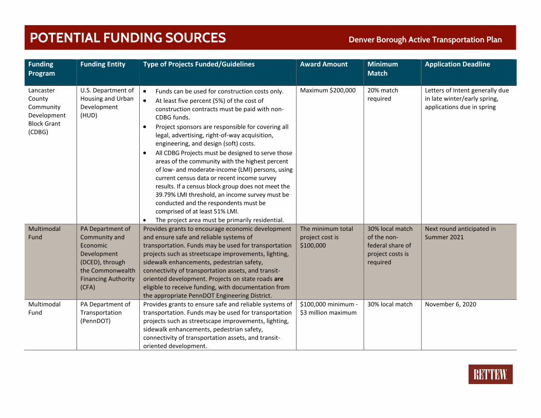
Funding Program
Funding Entity Type of Projects Funded/Guidelines Award Amount Minimum Match
Application Deadline
Lancaster County Community Development Block Grant (CDBG)
U.S. Department of Housing and Urban Development (HUD)
• Funds can be used for construction costs only.
• At least five percent (5%) of the cost of construction contracts must be paid with non-CDBG funds.
• Project sponsors are responsible for covering all legal, advertising, right-of-way acquisition, engineering, and design (soft) costs.
• All CDBG Projects must be designed to serve those areas of the community with the highest percent of low- and moderate-income (LMI) persons, using current census data or recent income survey results. If a census block group does not meet the 39.79% LMI threshold, an income survey must be conducted and the respondents must be comprised of at least 51% LMI.
• The project area must be primarily residential.
Maximum $200,000 20% match required
Letters of Intent generally due in late winter/early spring, applications due in spring
Multimodal Fund
PA Department of Community and Economic Development (DCED), through the Commonwealth Financing Authority (CFA)
Provides grants to encourage economic development and ensure safe and reliable systems of transportation. Funds may be used for transportation projects such as streetscape improvements, lighting, sidewalk enhancements, pedestrian safety, connectivity of transportation assets, and transit-oriented development. Projects on state roads are eligible to receive funding, with documentation from the appropriate PennDOT Engineering District.
The minimum total project cost is $100,000
30% local match of the non-federal share of project costs is required
Next round anticipated in Summer 2021
Multimodal Fund
PA Department of Transportation (PennDOT)
Provides grants to ensure safe and reliable systems of transportation. Funds may be used for transportation projects such as streetscape improvements, lighting, sidewalk enhancements, pedestrian safety, connectivity of transportation assets, and transit-oriented development.
$100,000 minimum - $3 million maximum
30% local match
November 6, 2020
POTENTIAL FUNDING SOURCES Denver Borough Active Transportation Plan
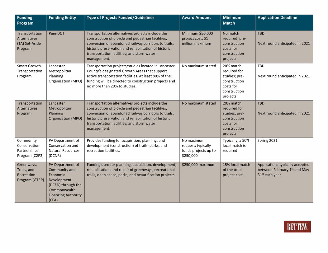
Funding Program
Funding Entity Type of Projects Funded/Guidelines Award Amount Minimum Match
Application Deadline
Transportation Alternatives (TA) Set-Aside Program
PennDOT Transportation alternatives projects include the construction of bicycle and pedestrian facilities; conversion of abandoned railway corridors to trails; historic preservation and rehabilitation of historic transportation facilities; and stormwater management.
Minimum $50,000 project cost; $1 million maximum
No match required; pre-construction costs for construction projects
TBD Next round anticipated in 2021
Smart Growth Transportation Program
Lancaster Metropolitan Planning Organization (MPO)
Transportation projects/studies located in Lancaster County’s designated Growth Areas that support active transportation facilities. At least 80% of the funding will be directed to construction projects and no more than 20% to studies.
No maximum stated 20% match required for studies; pre-construction costs for construction projects
TBD Next round anticipated in 2021
Transportation Alternatives Program
Lancaster Metropolitan Planning Organization (MPO)
Transportation alternatives projects include the construction of bicycle and pedestrian facilities; conversion of abandoned railway corridors to trails; historic preservation and rehabilitation of historic transportation facilities; and stormwater management.
No maximum stated 20% match required for studies; pre-construction costs for construction projects
TBD Next round anticipated in 2021
Community Conservation Partnerships Program (C2P2)
PA Department of Conservation and Natural Resources (DCNR)
Provides funding for acquisition, planning, and development (construction) of trails, parks, and recreation facilities.
No maximum request; typically funds projects up to $250,000
Typically, a 50% local match is required
Spring 2021
Greenways, Trails, and Recreation Program (GTRP)
PA Department of Community and Economic Development (DCED) through the Commonwealth Financing Authority (CFA)
Funding used for planning, acquisition, development, rehabilitation, and repair of greenways, recreational trails, open space, parks, and beautification projects.
$250,000 maximum 15% local match of the total project cost
Applications typically accepted between February 1st and May 31st each year

Funding Program
Funding Entity Type of Projects Funded/Guidelines Award Amount Minimum Match
Application Deadline
Automated Red Light Enforcement (ARLE) Grant Program
PennDOT Provides grants to local governments for transportation enhancement projects that focus on highway safety or mobility, and which can be completed at relatively low cost. Eligible projects vary widely from traffic signal improvements and roadway improvements at signalized intersections, to projects involving school zones, guide rail, and roadside safety.
No maximum stated Match encouraged but not required
June 30th each year
Pennsylvania’s Municipal Signal Partnership Program (Green Light-Go)
PennDOT Provides funding for projects that improve the efficiency and operation of existing traffic signals (e.g., traffic signal retiming, LED replacement, asset management, adaptive signals, and other traffic signal improvements).
No maximum stated 20% match required
Due to revenue shortfalls in the Motor License Fund resulting from COVID-19, there is no timetable for when future funding rounds will be open
AARP Community Challenge Grant Program
American Association of Retired Persons (AARP)
Funding is intended to help communities make immediate improvements and jump-start long-term progress in support of residents of all ages. Projects can include permanent physical improvements in the community, temporary demonstrations that lead to long-term change, and new, innovative programming or services.
None stated None stated Spring each year, awards in late summer, projects to be completed by the end of the year
Lancaster Bicycle Club Grant Program
Lancaster Bicycle Club
Provides funds to support bicycle-related activities and initiatives in Lancaster County. Projects include but not be limited to bicycle racks/parking areas, bicycle repair stations, bicycle lane markings, and signs promoting bicycle rights/safety on roadways.
None stated None stated Application period starts in December

Appendix IV
APPENDIX IV.
METROQUEST SURVEY
SUMMARY
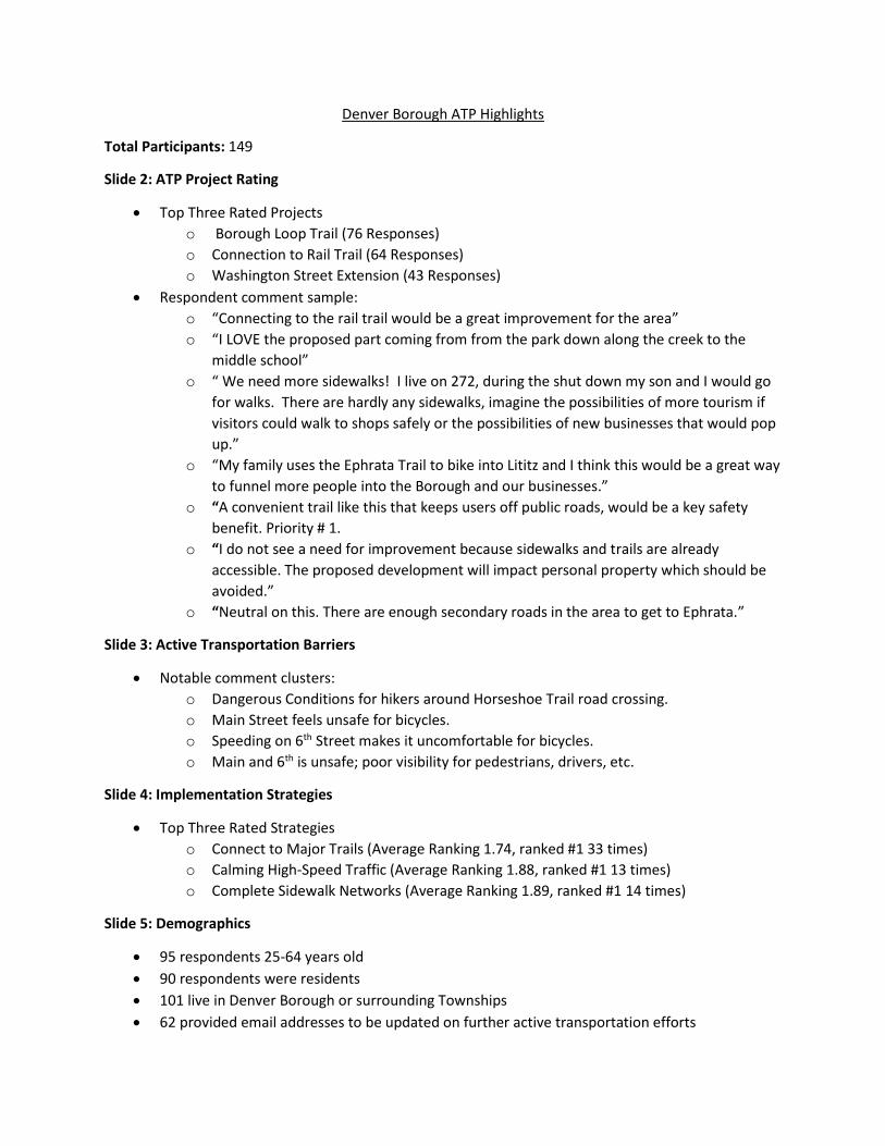
Denver Borough ATP Highlights
Total Participants: 149
Slide 2: ATP Project Rating
• Top Three Rated Projects
o Borough Loop Trail (76 Responses)
o Connection to Rail Trail (64 Responses)
o Washington Street Extension (43 Responses)
• Respondent comment sample:
o “Connecting to the rail trail would be a great improvement for the area”
o “I LOVE the proposed part coming from from the park down along the creek to the
middle school”
o “ We need more sidewalks! I live on 272, during the shut down my son and I would go
for walks. There are hardly any sidewalks, imagine the possibilities of more tourism if
visitors could walk to shops safely or the possibilities of new businesses that would pop
up.”
o “My family uses the Ephrata Trail to bike into Lititz and I think this would be a great way
to funnel more people into the Borough and our businesses.”
o “A convenient trail like this that keeps users off public roads, would be a key safety
benefit. Priority # 1.
o “I do not see a need for improvement because sidewalks and trails are already
accessible. The proposed development will impact personal property which should be
avoided.”
o “Neutral on this. There are enough secondary roads in the area to get to Ephrata.”
Slide 3: Active Transportation Barriers
• Notable comment clusters:
o Dangerous Conditions for hikers around Horseshoe Trail road crossing.
o Main Street feels unsafe for bicycles.
o Speeding on 6th Street makes it uncomfortable for bicycles.
o Main and 6th is unsafe; poor visibility for pedestrians, drivers, etc.
Slide 4: Implementation Strategies
• Top Three Rated Strategies
o Connect to Major Trails (Average Ranking 1.74, ranked #1 33 times)
o Calming High-Speed Traffic (Average Ranking 1.88, ranked #1 13 times)
o Complete Sidewalk Networks (Average Ranking 1.89, ranked #1 14 times)
Slide 5: Demographics
• 95 respondents 25-64 years old
• 90 respondents were residents
• 101 live in Denver Borough or surrounding Townships
• 62 provided email addresses to be updated on further active transportation efforts

Slide 1 - Total Site Visits
VisitTime SiteVisited Visitors Participants
7/28/2020 denveratp.metroquest.com 51 25
7/29/2020 denveratp.metroquest.com 59 25
7/30/2020 denveratp.metroquest.com 13 7
7/31/2020 denveratp.metroquest.com 33 15
8/1/2020 denveratp.metroquest.com 16 6
8/2/2020 denveratp.metroquest.com 9 5
8/3/2020 denveratp.metroquest.com 15 8
8/4/2020 denveratp.metroquest.com 18 9
8/5/2020 denveratp.metroquest.com 15 9
8/6/2020 denveratp.metroquest.com 3 3
8/7/2020 denveratp.metroquest.com 4 3
8/8/2020 denveratp.metroquest.com 12 6
8/9/2020 denveratp.metroquest.com 1 0
8/11/2020 denveratp.metroquest.com 4 1
8/12/2020 denveratp.metroquest.com 11 4
8/13/2020 denveratp.metroquest.com 18 8
8/14/2020 denveratp.metroquest.com 10 7
8/15/2020 denveratp.metroquest.com 2 1
8/16/2020 denveratp.metroquest.com 2 1
8/17/2020 denveratp.metroquest.com 2 1
8/18/2020 denveratp.metroquest.com 1 1
8/19/2020 denveratp.metroquest.com 1 0
8/21/2020 denveratp.metroquest.com 1 0
8/23/2020 denveratp.metroquest.com 1 0
8/25/2020 denveratp.metroquest.com 1 1
8/27/2020 denveratp.metroquest.com 3 2
8/28/2020 denveratp.metroquest.com 1 1
8/31/2020 denveratp.metroquest.com 2 0
Totals: 309 149
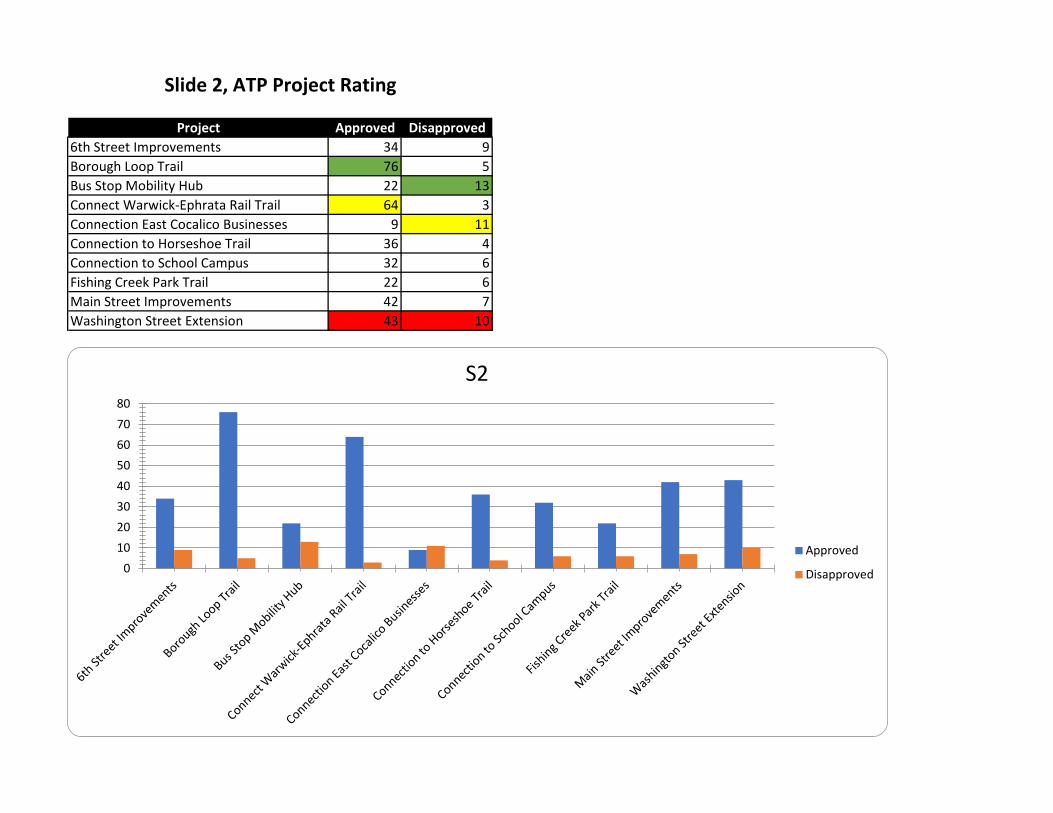
Project Approved Disapproved
6th Street Improvements 34 9
Borough Loop Trail 76 5
Bus Stop Mobility Hub 22 13
Connect Warwick-Ephrata Rail Trail 64 3
Connection East Cocalico Businesses 9 11
Connection to Horseshoe Trail 36 4
Connection to School Campus 32 6
Fishing Creek Park Trail 22 6
Main Street Improvements 42 7
Washington Street Extension 43 10
Slide 2, ATP Project Rating
0
10
20
30
40
50
60
70
80
S2
Approved
Disapproved

Slide 2, ATP Project Rating**Please see online map for potential project locations: https://arcg.is/1PDW98
VisitID Item Feedback
4098625 Screen 2 Comment Connecting to the rail trail would be a great improvement for the area
4098888 Screen 2 Comment Most important is the path to school. Then the rail to trail connection, because riding my bike from Cocalico to Ephrata by line road( by Stevens post office) is dangerous. Even for me at 62 who is fairly healthy.
4100475 Screen 2 Comment Thank you for your hard work.
4105068 Screen 2 Comment Additional walking trails. Possibly along Locust Street.
4110524 Screen 2 Comment We need more sidewalks! I live on 272, during the shut down my son and I would go for walks. There are hardly any sidewalks, imagine the possibilities of more tourism if visitors could walk to shops safely or the possibilities of new businesses that would pop up.
4125336 Screen 2 Comment I LOVE the proposed part coming from from the park down along the creek to the middle school
4098942 Connection to Horseshoe Trail a bike /walking trail along the rail road track next to little cocalico creek would be great!
4125336 Washington Street Extension Can't wait!!!this is such a good idea!
4128467 Washington Street Extension I do not see a need for improvement because sidewalks and trails are already accessible. The proposed development will impact personal property which should be avoided.
4128467 Washington Street Extension This would provide a valuable connection since weaver rd is unsafe for walking or biking and it does not impact personal property.
4136591 Washington Street Extension closer to the creek the better.
4128467 Connect WarwickEphrata Rail Trail I value this concept, but believe that it will be challenging to carry out. Some of the other items seem like better investments.
4125336 Connect WarwickEphrata Rail Trail This would be huge!!!I go to the WERT to ride bike a lot because I feel it is safer. It great to see all the different ages of people using that trail
4100936 Connect WarwickEphrata Rail Trail Neutral on this. There are enough secondary roads in the area to get to Ephrata.
4107567 Connect WarwickEphrata Rail Trail My family uses the Ephrata Trail to bike into Lititz and I think this would be a great way to funnel more people into the Borough and our businesses
4111085 Connect WarwickEphrata Rail Trail A convenient trail like this that keeps users off public roads, would be a key safety benefit. Priority # 1.
4125336 Fishing Creek Park Trail This is such a good idea too!!
4128467 Fishing Creek Park Trail These sections of main street and west church streets already have wide shoulders and are very safe for all types of active travel.
4107016 Connection to School Campus used by many children and adults and safety needs to be a priority
4128467 Connection to School Campus I do not expect this to be too difficult to accomplish since it already exists in the form of sidewalks, but improvements should be a priority.
4100936 Connection to School Campus There are sidewalks for those who walk, and 4th St. is wide enough for safe biking for those students old enough to understand and follow traffic rules.
4125336 Main Street Improvements Maybe paint a silhouette of a person on Main Street on both sides of the crosswalk to bring it to the drivers attention to yield to pedestrians. I seen this done in Ephrata. Also in Lancaster City I noticed they are painting some crosswalks in green which I think is eye catching.
4136591 Main Street Improvements Better crossing by the Memorial Park. Beepers on traffic light. Better crossing at turkey hill
4128467 6th Street Improvements The public sidewalks already provide a safe place to walk, run, skate & bicycle for kids.
4125336 6th Street Improvements This would be a yes too but I was only allowed to do 3
4116773 6th Street Improvements A safer way to cross at the intersection of Main Street and 6th Street is needed. Many kids on bikes, scooters and skateboards cross here.
4107016 6th Street Improvements makes sense because it leads to the park
4107016 Borough Loop Trail yes, because it's already an established park
4136591 Borough Loop Trail Would like it along the creek. Loop along east of bridge.
4107843 S2_P03_T0_Connect_WarwickEphrata_Rail_Trail_txt This should be a very high priority as it will grant access to the rest of WERT
4117373 S2_P02_T0_Washington_Street_Extension_txt Weaver Road is such a dangerous road to travel by foot or bike. This is such a direct route to the high school but much too dangerous for students to travel. PLEASE, I implore you to add a sidewalk. This is so necessary!

Slide 3, Active Transportation Barriers**Please see online map for barrier locations: https://arcg.is/1Pe58j0
VisitId MarkerType Barrier Type Comment
4098579 Bike_Barrier ----- -----
4098578 Walk_Barrier Unsafe intersection conditions Speeding vehicles make it unsafe to cross safely for school students, pedestrians, and bicyclists. Suggest a light up ped crossing sign to alert motorists of someone wanting to cross.
4098578 Walk_Barrier ----- Speeding vehicles make it unsafe to cross safely for school students, pedestrians, and bicyclists. Suggest a light up ped crossing sign to alert motorists of someone wanting to cross.
4098604 Walk_Barrier ----- Speeding vehicles make it unsafe to cross safely for school students, pedestrians, and bicyclists. Suggest a light up ped crossing sign to alert motorists of someone wanting to cross.
4098604 Walk_Barrier ----- Speeding vehicles make it unsafe to cross safely for school students, pedestrians, and bicyclists. Suggest a light up ped crossing sign to alert motorists of someone wanting to cross.
4098619 Walk_Barrier ----- -----
4098619 Walk_Barrier ----- -----
4098635 Bike_Barrier ----- -----
4098635 Walk_Barrier ----- -----
4098635 Bike_Barrier ----- -----
4098706 Walk_Barrier Unsafe intersection conditions -----
4098706 Walk_Barrier Unsafe intersection conditions -----
4098713 Bike_Barrier ----- Parking on street and narrow driving lanes - no room for bicycles.
4098713 Walk_Barrier ----- No sidewalks when you leave the Borough.
4098713 Walk_Barrier ----- No sidewalk connection from Washington Street to Weaver Road/Main Street.
4098744 Walk_Barrier ----- -----
4098795 Walk_Barrier ----- need trail
4098795 Walk_Barrier ----- need trail
4098880 Walk_Barrier ----- Too much traffic. With Schein and the wat people drive there. Maybe if there was a little more pedestrian bridge next to the bridge? It’s a beautiful area to walk though
4098922 Transit_Barrier ----- -----
4098958 Walk_Barrier ----- nice walk from 4th street to main st. No off road trail.
4098958 Bike_Barrier ----- There are no bike friendly trails and few friendly roads in Denver and the surrounding area.
4098958 Walk_Barrier ----- -----
4098958 Bike_Barrier ----- This has always been a nasty road for kids to get to the pool.
4100255 Walk_Barrier ----- Traffic, no shoulder
4100255 Walk_Barrier ----- no shoulder
4100255 Walk_Barrier ----- no access/path
4100306 Walk_Barrier ----- It would be nice to have a sidewalk/path to run or bike without being in the way of cars/trucks
4100306 Walk_Barrier ----- There’s no sidewalk and it’s a busy street to cross and people drive fast
4100342 Walk_Barrier ----- The trees on the one property will make it hard to see left when pulling out of the stop sign once they grow. Traffic goes too fast here.
4100342 Bike_Barrier ----- -----
4100330 Bike_Barrier ----- I'd propose a walking / biking bridge at this location to reroute traffic away from South 4th Street. It could be a real community asset, particularly with some design touches, as this bridge in Redding, CA exemplifies...https://en.wikipedia.org/wiki/Sundial_Bridge_at_Turtle_Bay
4100330 Walk_Barrier ----- Same principle as with the bike barrier. A bridge could be a great resource for walkers as well, perhaps in lieu of trails along the creeks, should land-owner resistance prove too strong.
4100330 Transit_Barrier ----- Increase connections to Red Rose Transit in Ephrata with the vehicle being enabled to transport bicycles. In the future, should the rail trail connection be built, people could walk / bike from Ephrata and take the bus home if (senior citizens?) didn't want to schlep the 5 miles back to Ephrata.
4100553 Walk_Barrier ----- 6th and Main is a bad intersection with no safety for pedestrians
4100553 Bike_Barrier ----- Main Street Denver is not safe for bikes
4100553 Bike_Barrier ----- 6th street is not safe for bikes
4100592 Walk_Barrier ----- No sidewalks. Cars traveling too fast
4100948 Walk_Barrier ----- Nasty blind spot going around bend No shoulder to walk along. No shoulder.
4100948 Bike_Barrier ----- -----
4100948 Walk_Barrier ----- Sidewalk should extend at least past the pool on both sides.
4101114 Walk_Barrier ----- -----
4101114 Bike_Barrier ----- -----
4101114 Bike_Barrier ----- -----
4101256 Walk_Barrier ----- -----
4101378 Walk_Barrier ----- -----
4101405 Bike_Barrier ----- -----
4101557 Walk_Barrier ----- It is very difficult to see where cars are here to cross.
4101901 Bike_Barrier ----- Bridge surface not bike friendly
4103029 Bike_Barrier Speeding motor vehicles -----
4103029 Bike_Barrier ----- -----
4103029 Bike_Barrier No offstreet pathtrail -----
4104615 Walk_Barrier ----- -----
4104615 Bike_Barrier ----- Main street needs to have a safer bike route
4104615 Walk_Barrier ----- Stop sign where 6th street meets main street can be busy and crossing can be sometime difficult
4104654 Walk_Barrier No sidewalk No sidewalks from here on to the pool and back through to 6th St.
4104654 Transit_Barrier Poor service frequency -----

Slide 3, Active Transportation Barriers**Please see online map for barrier locations: https://arcg.is/1Pe58j0
VisitId MarkerType Barrier Type Comment
4104654 Walk_Barrier No sidewalk -----
4104655 Walk_Barrier ----- -----
4104655 Walk_Barrier ----- -----
4104655 Bike_Barrier ----- -----
4104655 Walk_Barrier ----- -----
4104655 Bike_Barrier ----- -----
4104675 Walk_Barrier ----- No Sidewalk from Horseshoe Trail Road back to Borough.
4104675 Bike_Barrier ----- The car traffic needs to slow down due to short sight lines and no shoulder for walkers or bikers making the loop from Denver Pool to 6th street via Miller Road. Speed enforcement is sporatic on Reinholds Rd (but is set up for monitoring).
4104675 Transit_Barrier ----- regular early am and later pm public transit is non existent for low income persons to get out of Denver to work in Ephrata and Lancaster.
4104903 Walk_Barrier ----- only one crosswalk on main street
4104903 Bike_Barrier ----- no bike lanes
4104903 Transit_Barrier ----- limited transportation
4105080 Bike_Barrier ----- -----
4105080 Bike_Barrier Speeding motor vehicles -----
4105080 Walk_Barrier No sidewalk no walking link to fish park
4105080 Bike_Barrier Speeding motor vehicles speed of cars in this area if biking around town
4105154 Transit_Barrier ----- -----
4104402 Bike_Barrier High volume of motor vehicles With on street parking it makes it difficult to ride bike between traffic and parked cars
4104402 Walk_Barrier Poor condition of offstreet pathtrail no lighting in the Linear Park
4104402 Bike_Barrier Lack of dedicated bicycle facilitieslanes walking trails in the park are not wide enough for bikes to ride along with pedestrians.
4105695 Walk_Barrier ----- Alot of broken uneven sidewalk
4105857 Walk_Barrier Unsafe intersection conditions -----
4105857 Walk_Barrier Unsafe intersection conditions -----
4105857 Walk_Barrier No sidewalk -----
4105857 Walk_Barrier ----- -----
4106281 Walk_Barrier ----- -----
4106281 Bike_Barrier ----- tight areas and a lot of traffic
4107016 Walk_Barrier ----- -----
4107567 Bike_Barrier ----- Main Street is difficult to bike on because of the restrictions of using the sidewalks. The on street diagonal parking also makes it uneasy.
4107567 Walk_Barrier ----- The lack of sidewalks and the higher speed limit makes this area dangerous to walk.
4107567 Bike_Barrier ----- The high speed limit and lack of awareness to cyclists. Maybe adding a sign could easily help this
4107843 Bike_Barrier High volume of motor vehicles High volume of MV traffic plus it is hard to pull out and see if a bike is coming due to angle parking. This can creat a serious hazard if bikes are riding as far right as possible
4107843 Bike_Barrier ----- There seems to be a lot of bikes on the sidewalks but I believe this is younger kids and they may not use bike lanes if put in place
4107843 Walk_Barrier ----- There could be a traffic calming raised cross walk at this location to slow cars and allow access to the park.
4107843 Walk_Barrier ----- There could be a traffic calming raised cross walk at this location to slow cars and allow access to the park.
4107843 Walk_Barrier ----- There could be a traffic calming raised cross walk at this location to slow cars
4107962 Walk_Barrier ----- no sidewalks on Weaver Road. Trucks and cars go very fast along with lots of traffic from schools and Henry Schein
4107962 Walk_Barrier ----- no sidewalks on Horseshoe trail or turning fro Horseshoe onto 6th street for a section. Miller Road is missing sidewalk for a short section too
4107962 Walk_Barrier ----- would love for more walking paths around the park
4108392 Bike_Barrier ----- -----
4108392 Bike_Barrier ----- Lack of wide should on roads outside of Denver to walk or ride bike.
4108392 Bike_Barrier ----- Very difficult to cross main street at 4th street intersection walking and biking
4109861 Walk_Barrier No sidewalk -----
4109861 Walk_Barrier No sidewalk -----
4109861 Walk_Barrier No sidewalk -----
4109874 Bike_Barrier Speeding motor vehicles -----
4109874 Bike_Barrier Lack of dedicated bicycle facilitieslanes -----
4109874 Bike_Barrier Lack of dedicated bicycle facilitieslanes -----
4110550 Walk_Barrier No sidewalk -----
4111106 Walk_Barrier ----- No sidewalks
4111085 Bike_Barrier ----- Railroad tracks at bridge not safe for bikes.
4111085 Walk_Barrier ----- No shoulder on road.
4111085 Bike_Barrier Poor road maintenance -----
4111823 Walk_Barrier ----- -----
4111964 Walk_Barrier ----- -----
4112050 Bike_Barrier Poor road maintenance Railroad tracks dangerous to bikes.
4112050 Bike_Barrier Speeding motor vehicles -----
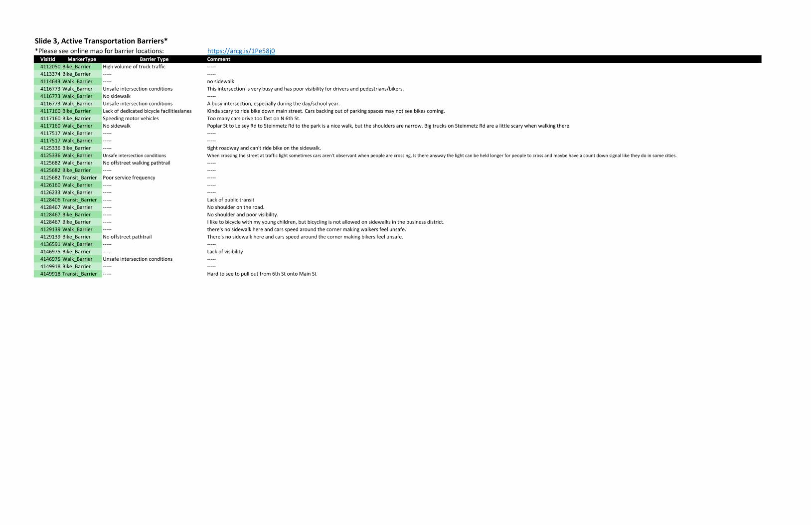
Slide 3, Active Transportation Barriers**Please see online map for barrier locations: https://arcg.is/1Pe58j0
VisitId MarkerType Barrier Type Comment
4112050 Bike_Barrier High volume of truck traffic -----
4113374 Bike_Barrier ----- -----
4114643 Walk_Barrier ----- no sidewalk
4116773 Walk_Barrier Unsafe intersection conditions This intersection is very busy and has poor visibility for drivers and pedestrians/bikers.
4116773 Walk_Barrier No sidewalk -----
4116773 Walk_Barrier Unsafe intersection conditions A busy intersection, especially during the day/school year.
4117160 Bike_Barrier Lack of dedicated bicycle facilitieslanes Kinda scary to ride bike down main street. Cars backing out of parking spaces may not see bikes coming.
4117160 Bike_Barrier Speeding motor vehicles Too many cars drive too fast on N 6th St.
4117160 Walk_Barrier No sidewalk Poplar St to Leisey Rd to Steinmetz Rd to the park is a nice walk, but the shoulders are narrow. Big trucks on Steinmetz Rd are a little scary when walking there.
4117517 Walk_Barrier ----- -----
4117517 Walk_Barrier ----- -----
4125336 Bike_Barrier ----- tight roadway and can't ride bike on the sidewalk.
4125336 Walk_Barrier Unsafe intersection conditions When crossing the street at traffic light sometimes cars aren't observant when people are crossing. Is there anyway the light can be held longer for people to cross and maybe have a count down signal like they do in some cities.
4125682 Walk_Barrier No offstreet walking pathtrail -----
4125682 Bike_Barrier ----- -----
4125682 Transit_Barrier Poor service frequency -----
4126160 Walk_Barrier ----- -----
4126233 Walk_Barrier ----- -----
4128406 Transit_Barrier ----- Lack of public transit
4128467 Walk_Barrier ----- No shoulder on the road.
4128467 Bike_Barrier ----- No shoulder and poor visibility.
4128467 Bike_Barrier ----- I like to bicycle with my young children, but bicycling is not allowed on sidewalks in the business district.
4129139 Walk_Barrier ----- there's no sidewalk here and cars speed around the corner making walkers feel unsafe.
4129139 Bike_Barrier No offstreet pathtrail There's no sidewalk here and cars speed around the corner making bikers feel unsafe.
4136591 Walk_Barrier ----- -----
4146975 Bike_Barrier ----- Lack of visibility
4146975 Walk_Barrier Unsafe intersection conditions -----
4149918 Bike_Barrier ----- -----
4149918 Transit_Barrier ----- Hard to see to pull out from 6th St onto Main St
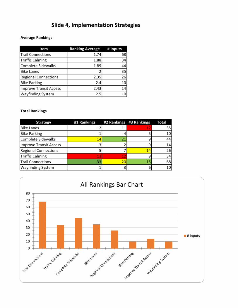
Average Rankings
Item Ranking Average # Inputs
Trail Connections 1.74 68
Traffic Calming 1.88 34
Complete Sidewalks 1.89 44
Bike Lanes 2 35
Regional Connections 2.35 26
Bike Parking 2.4 10
Improve Transit Access 2.43 14
Wayfinding System 2.5 10
Total Rankings
Strategy #1 Rankings #2 Rankings #3 Rankings Total
Bike Lanes 12 11 12 35
Bike Parking 1 4 5 10
Complete Sidewalks 14 21 9 44
Improve Transit Access 3 2 9 14
Regional Connections 5 7 14 26
Traffic Calming 13 12 9 34
Trail Connections 33 20 15 68
Wayfinding System 1 3 6 10
Slide 4, Implementation Strategies
0
10
20
30
40
50
60
70
80
All Rankings Bar Chart
# Inputs
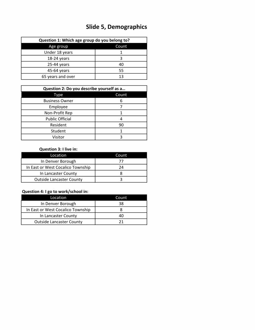
Age group Count
Under 18 years 1
18-24 years 3
25-44 years 40
45-64 years 55
65 years and over 13
Type Count
Business Owner 6
Employee 7
Non-Profit Rep 1
Public Official 4
Resident 90
Student 1
Visitor 3
Question 3: I live in:
Location Count
In Denver Borough 77
In East or West Cocalico Township 24
In Lancaster County 8
Outside Lancaster County 3
Question 4: I go to work/school in:
Location Count
In Denver Borough 38
In East or West Cocalico Township 8
In Lancaster County 40
Outside Lancaster County 21
Slide 5, Demographics
Question 1: Which age group do you belong to?
Question 2: Do you describe yourself as a…
Appendix V
APPENDIX V.
METRICS: POTENTIAL LINEAR MILES,
CONNECTED DESTINATIONS AND
NEW/ENHANCED DESTINATIONS

Metrics: Potential Linear Miles, Connected Destinations and New/Enhanced Destinations
This document has been prepared to assist you with providing specific metrics that, in accordance with
the original Funding Opportunity Announcement and subsequent discussion, WalkWorks expects to be
included as part of or an appendix to your final active transportation policies and plans. These metrics
have been developed by the Centers for Disease Control and Prevention from which our funding
originates. Briefly, we are asking that you specify the potential new/improved linear miles of
new/improved routes or means of transportation, potential destinations that will be connected due to
the new or improved routes, and potential new and/or enhanced sites as prioritized. We are beginning
to gather the same information from previous grant recipients, including actual miles, actual
destinations connected, and actual enhance destinations – based on implementation.
The forms, which follow, are templates on which you may log the information. You may elect to use
another format, as long as the requested information is provided. Similar reporting will be requested for
the two-years, post grant award.
Number of potential linear miles: For each location, please indicate: a) whether the planned/potential
new/improved routes are bicycle, pedestrian (sidewalks) or otherwise; and b) the corresponding
number of proposed miles. If the plan proposes two new or improved routes at the same location, the
location will be listed twice; see examples, below. Add more rows as needed.
Potential Linear Miles
Description of Location Type of New/Improved Routes # of Miles
Washington Street Extension (between
South 4th Street and Weaver Road) ☒Bicycle
☐Public Transit
☐Pedestrian
☐Multi-use path (enhancement)
☐Other
0.55
Washington Street Extension (between
South 4th Street and Weaver Road) ☐Bicycle
☐Public Transit
☒Pedestrian
☐Multi-use path (enhancement)
☐Other
0.55
Phase 2 – Borough Loop Trail (between
Denver Memorial Park and South 4th
Street / and between Main Street and
Franklin Street)
☐Bicycle
☐Public Transit 0.7

☐Pedestrian
☒Multi-use path (enhancement)
☐Other
Phase 3 – Borough Loop Trail (between
Weaver Road and Bon View Estates
Linear Park)
☐Bicycle
☐Public Transit
☐Pedestrian
☒Multi-use path (enhancement)
☐Other
0.42
Phase 4 – Borough Loop Trail (between
Bon View Estates Linear Park and Denver
Memorial Park)
☒Bicycle
☐Public Transit
☐Pedestrian
☐Multi-use path (enhancement)
☐Other
0.43
Phase 4 – Borough Loop Trail (between
Bon View Estates Linear Park and N. 4th
St. Playground)
☐Bicycle
☐Public Transit
☐Pedestrian
☒Multi-use path (enhancement)
☐Other
0.27
North 6th Street (between Main Street
and Borough line)
☒Bicycle
☐Public Transit
☐Pedestrian
☐Multi-use path (enhancement)
☐Other
0.73
Trail to Fishing Creek Park (from
Main/Snyder St to Fishing Creek Park)
☐Bicycle
☐Public Transit
☐Pedestrian
☒Multi-use path (enhancement)
☐Other
0.43
Monroe Street (between PA Turnpike
underpass and Snyder Street)
Snyder Street (between Monroe Street
and Main Street)
☒Bicycle
☐Public Transit
☐Pedestrian
0.72

☐Multi-use path (enhancement)
☐Other
Horse-shoe Trail Connection (from North
6th Street at Borough line to
Miller/Horseshoe Trail Road)
☐Bicycle
☐Public Transit
☐Pedestrian
☒Multi-use path (enhancement)
☐Other
0.07
Horse-shoe Trail Connection (from
Denver Community Pool to trail via
Reinholds Road and Reservoir access
road)
☐Bicycle
☐Public Transit
☐Pedestrian
☒Multi-use path (enhancement)
☐Other
0.44
Main Street (from 3rd St to 4th St) ☒Bicycle
☐Public Transit
☐Pedestrian
☐Multi-use path (enhancement)
☐Other
0.15
Main Street (from 4th St to 6th St) ☒Bicycle
☐Public Transit
☐Pedestrian
☐Multi-use path (enhancement)
☐Other
0.15
Main Street (from 4th St to 6th St) ☐Bicycle
☐Public Transit
☒Pedestrian
☐Multi-use path (enhancement)
☐Other
0.15
Cocalico School District Perimeter Trail ☐Bicycle
☐Public Transit
☐Pedestrian
☒Multi-use path (enhancement)
1.1

☐Other
Cherry Alley (between North 6th St and
Main St)
South 6th Street/Railroad Street
☒Bicycle
☐Public Transit
☐Pedestrian
☐Multi-use path (enhancement)
☐Other
0.59
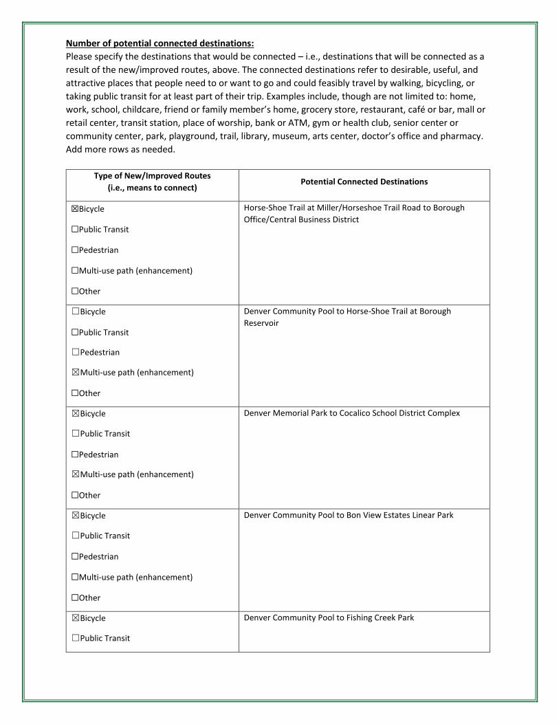
Number of potential connected destinations:
Please specify the destinations that would be connected – i.e., destinations that will be connected as a
result of the new/improved routes, above. The connected destinations refer to desirable, useful, and
attractive places that people need to or want to go and could feasibly travel by walking, bicycling, or
taking public transit for at least part of their trip. Examples include, though are not limited to: home,
work, school, childcare, friend or family member’s home, grocery store, restaurant, café or bar, mall or
retail center, transit station, place of worship, bank or ATM, gym or health club, senior center or
community center, park, playground, trail, library, museum, arts center, doctor’s office and pharmacy.
Add more rows as needed.
Type of New/Improved Routes
(i.e., means to connect) Potential Connected Destinations
☒Bicycle
☐Public Transit
☐Pedestrian
☐Multi-use path (enhancement)
☐Other
Horse-Shoe Trail at Miller/Horseshoe Trail Road to Borough
Office/Central Business District
☐Bicycle
☐Public Transit
☐Pedestrian
☒Multi-use path (enhancement)
☐Other
Denver Community Pool to Horse-Shoe Trail at Borough
Reservoir
☒Bicycle
☐Public Transit
☐Pedestrian
☒Multi-use path (enhancement)
☐Other
Denver Memorial Park to Cocalico School District Complex
☒Bicycle
☐Public Transit
☐Pedestrian
☐Multi-use path (enhancement)
☐Other
Denver Community Pool to Bon View Estates Linear Park
☒Bicycle
☐Public Transit
Denver Community Pool to Fishing Creek Park

☐Pedestrian
☐Multi-use path (enhancement)
☐Other
☒Bicycle
☐Public Transit
☐Pedestrian
☒Multi-use path (enhancement)
☐Other
Bon View Estates Linear Park to Denver Memorial Park
☐Bicycle
☐Public Transit
☐Pedestrian
☒Multi-use path (enhancement)
☐Other
Bon View Estates Linear Park to N. 4th St. Playground
Number of potential new or enhanced sites: For each location, grant recipients will be expected to
indicate what type of site is being created or enhanced. Sites include, though are not limited to: parks,
playgrounds, commercial centers, mixed-use buildings, farmers’ markets, and community centers.
Again, Appendix B provides definitions of all terms. Add more rows as needed.
Description of Location Potential New/Enhanced Sites
Cocalico School District (Cocalico Senior
High School, Cocalico Middle School,
Denver Elementary School)
New perimeter trail
Denver Memorial Park New trail segment with proposed stream access / Enhanced trail
system – creation of perimeter trail
Henry Schein/Denver Cold Storage New sidewalks, crosswalk, shoulders/bike lanes and traffic
congestion relief route
Denver Community Pool New bicycle connection / Enhanced (additional) parking to be
available for Horse-Shoe Trail users
N. 4th St. Playground New trail connecting Locust St. to Spruce St.
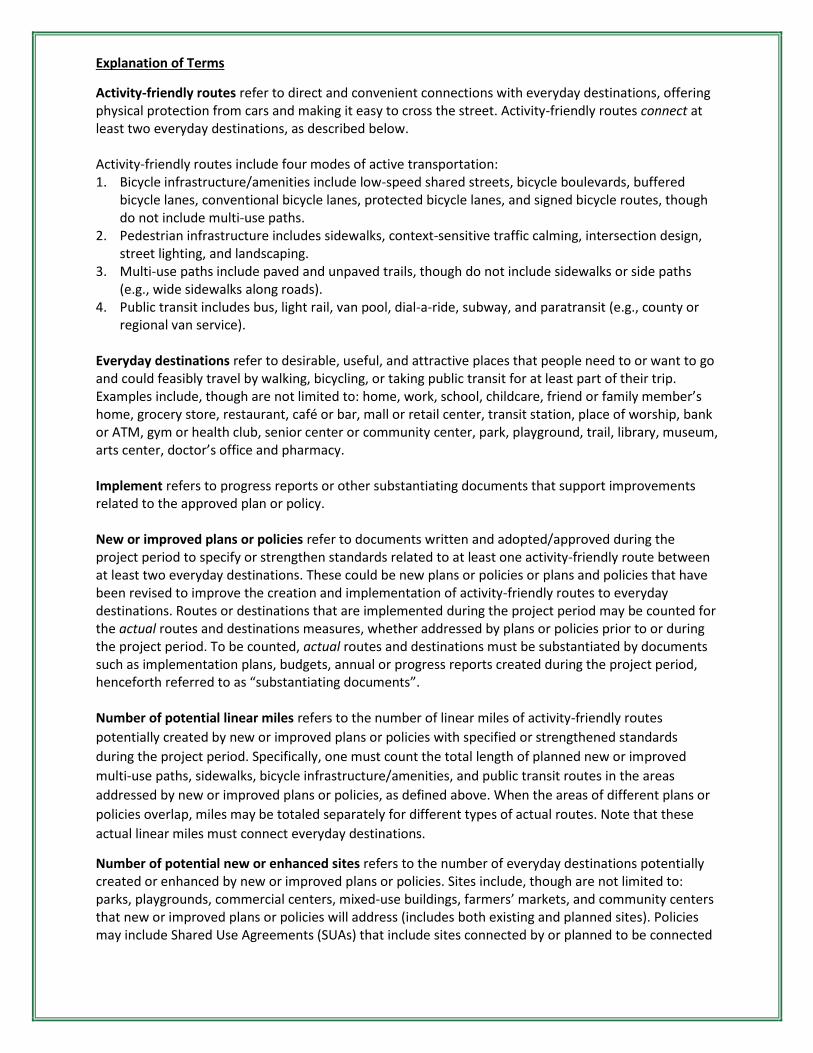
Explanation of Terms
Activity-friendly routes refer to direct and convenient connections with everyday destinations, offering physical protection from cars and making it easy to cross the street. Activity-friendly routes connect at least two everyday destinations, as described below. Activity-friendly routes include four modes of active transportation: 1. Bicycle infrastructure/amenities include low-speed shared streets, bicycle boulevards, buffered
bicycle lanes, conventional bicycle lanes, protected bicycle lanes, and signed bicycle routes, though do not include multi-use paths.
2. Pedestrian infrastructure includes sidewalks, context-sensitive traffic calming, intersection design, street lighting, and landscaping.
3. Multi-use paths include paved and unpaved trails, though do not include sidewalks or side paths (e.g., wide sidewalks along roads).
4. Public transit includes bus, light rail, van pool, dial-a-ride, subway, and paratransit (e.g., county or regional van service).
Everyday destinations refer to desirable, useful, and attractive places that people need to or want to go and could feasibly travel by walking, bicycling, or taking public transit for at least part of their trip. Examples include, though are not limited to: home, work, school, childcare, friend or family member’s home, grocery store, restaurant, café or bar, mall or retail center, transit station, place of worship, bank or ATM, gym or health club, senior center or community center, park, playground, trail, library, museum, arts center, doctor’s office and pharmacy. Implement refers to progress reports or other substantiating documents that support improvements related to the approved plan or policy. New or improved plans or policies refer to documents written and adopted/approved during the project period to specify or strengthen standards related to at least one activity-friendly route between at least two everyday destinations. These could be new plans or policies or plans and policies that have been revised to improve the creation and implementation of activity-friendly routes to everyday destinations. Routes or destinations that are implemented during the project period may be counted for the actual routes and destinations measures, whether addressed by plans or policies prior to or during the project period. To be counted, actual routes and destinations must be substantiated by documents such as implementation plans, budgets, annual or progress reports created during the project period, henceforth referred to as “substantiating documents”. Number of potential linear miles refers to the number of linear miles of activity-friendly routes
potentially created by new or improved plans or policies with specified or strengthened standards
during the project period. Specifically, one must count the total length of planned new or improved
multi-use paths, sidewalks, bicycle infrastructure/amenities, and public transit routes in the areas
addressed by new or improved plans or policies, as defined above. When the areas of different plans or
policies overlap, miles may be totaled separately for different types of actual routes. Note that these
actual linear miles must connect everyday destinations.
Number of potential new or enhanced sites refers to the number of everyday destinations potentially created or enhanced by new or improved plans or policies. Sites include, though are not limited to: parks, playgrounds, commercial centers, mixed-use buildings, farmers’ markets, and community centers that new or improved plans or policies will address (includes both existing and planned sites). Policies may include Shared Use Agreements (SUAs) that include sites connected by or planned to be connected
by, activity-friendly routes. Potential sites may not be counted nor reported for any plans or policies passed prior to the project period. Number of people potentially impacted by new or improved plans or policies refers to the number of people currently living in the areas within the community or area for which the grant covers (as described by one or more GEOIDs) that are addressed by new or improved plans or policies. When the areas addressed by different plans or policies overlap, people must be counted only once. Number of actual linear miles refers to the number of linear miles of activity-friendly routes that have been completely built or installed as the result of new or improved plans or policies. If the plan or policy was passed during the project period, the actual miles may be counted upon completion of the route. If the plan or policy was passed prior to the project period, the actual miles are only counted if there are substantiating documents created during the project period that support the building or installation of the route. When the areas of different plans or policies overlap, miles may be totaled separately for different types of actual routes. Note that these actual linear miles must connect everyday destinations. Number of actual new or enhanced sites refers to the number of everyday destinations that have been completely built, installed or enhanced as the result of new or improved plans or policies. If the plan or policy was passed during the project period, the actual sites may be counted upon completion. If the plan or policy was passed prior to the project period, the actual sites are only counted if there are substantiating documents created during the project period that support the building, installation or enhancement of the site. Policies may include Shared Use Agreements (SUAs) that are connected by or have plans to be connected by activity-friendly routes. Project period, in the case of this grant, runs from the date the grant is awarded through September
2023. The expectation is that all grant recipients will agree to complete a brief data request, semi-
annually, from the date of adoption of the plan or policy through September 2023. The requested data
will pertain to the previously referenced linear miles, enhanced sites and the impacted population.
Substantiating documents refer to formal documents created and adopted or approved during the
project period that facilitate the building, installation or enhancement of actual routes or destinations.
These documents include budgets, implementation plans, annual or progress reports.
March 2020
Appendix VI
APPENDIX VI.
DENVER BOROUGH
OFFICIAL MAP