appendix b boring logs and well construction logs investigations/parcel 153... · boring logs and...
TRANSCRIPT
APPENDIX B
BORING LOGS AND WELL CONSTRUCTION LOGS
KN\4040\SI\P153\153 SI Report\06/04/01(9 :44 AM)

BORING LOGS
KN\4040\SI\P153\153 SI Report\06/04/01(9 :44 AM)
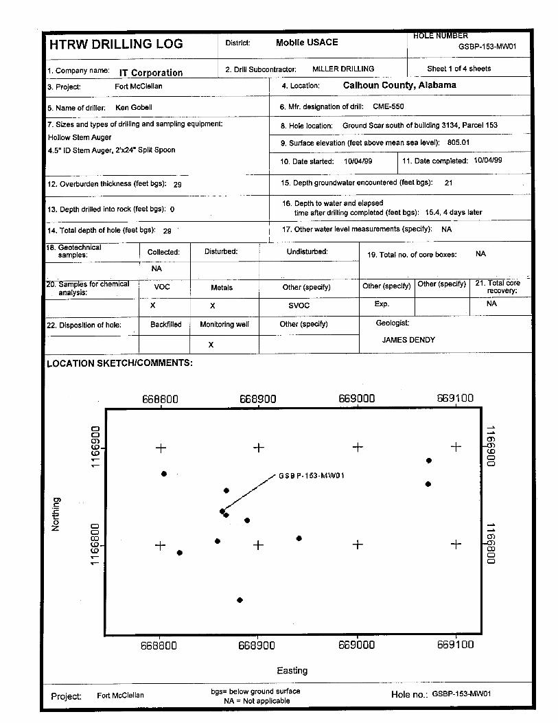
L RHTRW DRILLING LOG District: Mobile USAGE GSBP-153-MWO1
1 . Company name: IT Corporation 2. Drill Subco ntractor : MILLER DRILLING Sheet 1 of 4 sheets
3. Project: Fort McClellan 4. Location : Calhoun County , Alabama
5. Name of driller : Ken Gobell 6. Mfr. designation of drill : CME-550
7. Sizes and types of drilling and sampling equipment : 8 . Hole location : Ground Scar south of building 3134 , Parcel 153
Hollow Stem Auger9 . Surface elevation (feet above mean sea level) : 805 .01
2'x24" Split Spoon5" ID Stem Auger4 ,.10 . Date started : 10/04/99 11 . Date completed : 10/04/99
12. Overburden thickness ( feet bgs): 29 15. Depth groundwater encountered ( feet bgs): 21
16. Depth to water and elapsed13. Depth drilled into rock (feet bgs ) : 0 time after drilling completed (feet bgs) : 15 .4, 4 days later
14. Total depth of hole (feet bgs): 29 17. Other water level measurements (specify): NA
18. Geotechnicalsamples : Collected : Disturbed : Undisturbed : 19. Total no . of core boxes: NA
NA
Samples for chemical VOC Metals Other (specify) Other ( specify) Other (specify ) 21 . Total coreanalysis : recovery:
X X SVOC Exp. NA
22. Disposition of hole : Backfilled Monitoring well Other (specify) Geologist:
X JAMES DENDY
LOCATION SKETCH /COMMENTS :
668800 668900 669000 669100
M -O
W + +
_~s
+ +V J
(0 WOr V)
'~ GS8 P - 133-MWOI
tmc
0 O -sO
OD•
+
-mn
* + +1 WI]
r~ M
668800 668900 669000 669100
Easting
Project: Fort McClellan bgs= below ground surface Hole no . : GSBP -153-MWO1NA = Not applicable
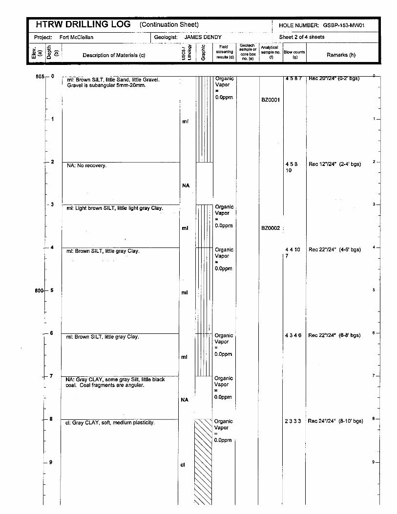
HTRW DRILLING LOG (Continuation Sheet) HOLE NUMBER: GSBP-153-MWOI
Project : Fort McClellan Geologist: JAMES DENDY Sheet 2 of 4 sheets
ta
qo3
2n
Field Geotechsample or Analytical
w -- o - Description of Material s ( c)V o screening
results (d)core box sample no.
MBlow counts(g) Remarks (h)
805- 0
- 1
--2
-{- 3
-~- 4
800- 5
-~ -6
-1- 7
~- 8
-4- 9
ml: Brown SILT, little Sand, little Gravel .Gravel is subangular 5mm-20mm.
ml
NA: No recovery .
NA
ml: Light brown SILT, little light gray Clay .
ml
ml: Brown SILT, little gray Clay .
ml
ml : Brown SILT, little gray Clay .
ml
NA: Gray CLAY, some gray Silt, little blackcoal . Coal fragments are angular.
NA
ci : Gray CLAY, soft, medium plasticity .
cl
rganicVapor
O.Oppm
OrganicVapor
O.Oppm
OrganicVapor
O.Oppm
OrganicVapor
O.Oppm
OrganicVapor
O.Oppm
OrganicVapor
O.Oppm
4-587
BZ0001
45810
Rec gs 0
1-a
Rec 12"/24" (2-4' bgs) 2 -
BZ0002
44107
Rec 22"/24" (4-6' bgs) 4
4346
2333
5-
Rec 22 "/24" (6-8' bgs) 6 -
7-a
Rec 24"/24" (8-10' bgs) 6
9-
HTRW DRILLING LOG (Continuation Sheet) HOLE NUMBER: GSBP-153-MWO1
Project : Fort McClellan Geologist: JAMES DENDY Sheet 3 of 4 sheets
y r Field sample~or Analytical.- .
w ~°-ao Description of Materials (c) c . screening
lt doco box sample no.
MBlow counts
( ) Remarks (h)s ( )resu n (a) p
795,-10
--- 12
.a- 13
-~-- 14
7904-15
-16
-~-- 17
-18
-!- 19
785- 20
cl: Gray CLAY, little brown Silt . CLAY ismedium plasticity and soft.
cI : Gray CLAY, little brown Silt.
sh : Gray , weathered SHALE, some Clay .SHALE is fissile and friable .
sh: Gray fissile SHALE .
sh: Gray fissile SHALE . SHALE is fissile andfriable .
cI: Gray CLAY.
ci
sh
sh
2222
46812
50/0 .5'
Rec 20"/24" (10-12' bgs) 101
Description from augercuttings 16-19'
11-
12-
13-
14-J
15-I
16-I
17-4
18-I
Rec 8'724" (19-19.5 ' bgs) 19-
Descriptions from augercuttings 19 .5'-29' .
20-~
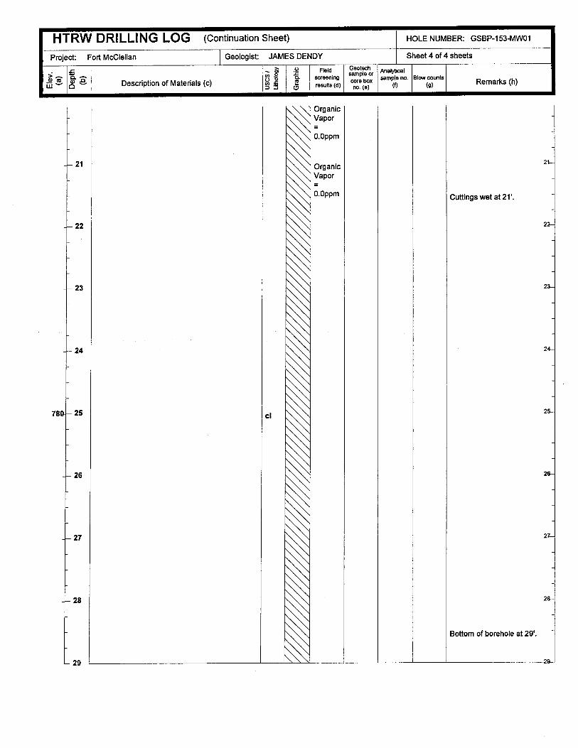
HTRW DRILLING LOG (Continuation Sheet) HOLE NUMBER: GSBP-153-MW01
Project: Fort McClellan Geologist: JAMES DENDY Sheet 4 of 4 sheets
L g2
Fieldsale Analytical
>w 1°
n .-
o ° Description of Materials (c)- . screenin
results (d) core eoxsample no.Pt) Blow counts
(g) Remarks (h)(
-
-
- 21
- 22
OrganicVapor
O.Oppm
OrganicVapor
O.Oppm
1-
Cuttings wet at 21' .
22--1
~--- 23 23-I
-~- 24 24-I
780
-I
- 25
-- 26
cl 25-J
26--I
~- 27 27--I
4--28
Bottom of borehole at 29' .
28-I
L29I I 1 11"v I I I 1 29
~,T- 13Boring Log Report Form Boring No. Page _ of 2
Client USACE ESE Project FTMC-SISite Location SZ \ 22 G't -~ S V \ ESE Project No . 3196314GESE Field Crew Leader:Rich Hill ESE Project Manager William ElliottDate Start Finish 15 - l \ ` c( t Drill Type Geo robeContractor : Graves Services Driller t____ ~Boring Depth 15 - 1 L " Diameter 2 Geologist : Rich HillBoring Location S< ~~
SC
om
«'G
m
EN
aEN
ad
3 cm CD
U
in=
cmN
DESCRIPTION
c
vviH= WU
REMARKS
' c )C L CLZ` >a,,.~ ~, AI (
z tv.cAC'~hZ~zy ~? ' -t1L i (ZjVA R ST ~
7-7
1
New -p kz-tkc ,fir`s ; ` aay kuDT
1 L ~i~SG rytucti i5` :- L. a
~~ ~ ~vr~-( u IS-((5 \/g 5/
z,
i
Its
F.001 EnvironmentalScience & Engineering, Inc .
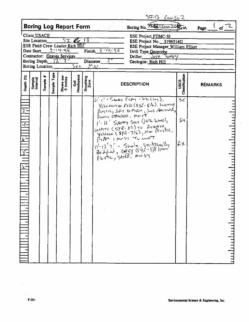
Sz-~3 Z;>~ S > 2
Boring Log Report Form Boring No . :Page
Client USACE ESE Project FTMC-SISite Location 5~ 1 ESE Project No . 3196314GESE Field Crew Leader :Rich Mil' ESE Project Manager William ElliottDate Start 5- \,-A- `l" Finish S -I \-`- 5» Drill Type Geo robeContractor : Graves Services Driller byk~ IBoring Depth l2 7 ` Diameter Geologist : Rich HillBoring Location S e -F- r'^ y
CL
to
da
CL
C-a ct°n N
DESCRIPTION REMARKSW
d ~ ydS m
y
SC
SM
F.oo1 EnvironmentalScience & Engineering, inc .

Boring Log Report Form Boring No, 5'` 13 S SC~2l. 5L3
Page ( of -Client USACE ESE Project FTMC-S1Site Location_ $ L \ 3 -5S572- &-' L• 3 ESE Project No . 3196314GESE Field Crew Leader :Rich Hill ESE Project Manager William ElliottDate Start 5-- L'V3 Finish S -11_ct Drill Type GeoprobeContractor: Graves Services Driller C 'L Crzxloc1NBoring Depth
5 MAP 2 "Geologist : Rich Hill
Boring Location_ 5T.~ AP
Lo
°f -aE
Cn c
sc
acn
$'>
-CL~
a H
omiO
io°"ch 0=
co~ N
mDESCRIPTION
co
vm .EmU
EMARKS
l5-2
tr,Fr• 4 % 4A~ti~~ .1 ffoZA
rR-~
/t\L &LE /OII
,- C VLlu -C l •5--~ - N 3 /~ " Ly 'CIL ~I'.M
C LV 1 I ,
5T ,-,' 1 Gc tc~
ti ~f3 rt ~ q L LC1 (V--wCl ft-r tL -s 1 ~5) ,
I
F.oo1 Environmental Science & Engineering, Inc .

WELL CONSTRUCTION LOGS
KN\4040\SI\P153\153 SI Report\06/04/01(9 :44 AM)
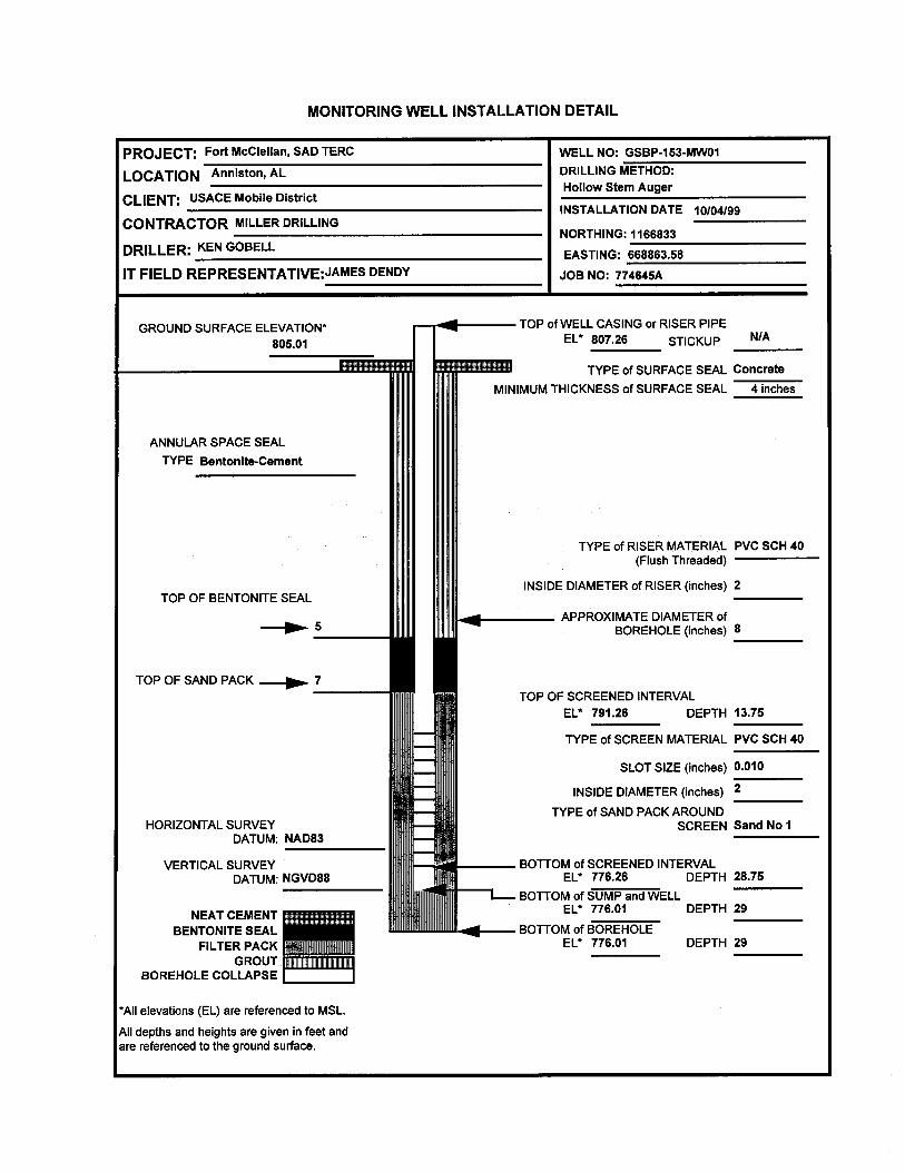
MONITORING WELL INSTALLATION DETAIL
PROJECT: Fort McClellan , SAD TERC WELL NO: GSBP-153-MWOI
LOCATION Anniston, AL DRILLING METHOD :Hollow Stem Auger
CLIENT: USACE Mobile D istrictINSTALLATION DATE 10/04/99
CONTRACTOR MILLER DRILLINGNORTHING : 1166833
DRILLER: KEN GOBELL EASTING : 668863.58
IT FIELD REPRESENTATIVE:JAMES DENDY JOB NO: 774645A
GROUND SURFACE ELEVATION*805.01
TOP of WELL CASING or RISER PIPEEL* 807.26 STICKUP N/A
S
ANNULAR SPACE SEALTYPE Bentonite -Cement
TYPE of SURFACE SEAL ConcreteMINIMUM THICKNESS of SURFACE SEAL 4 inches
TYPE of RISER MATERIAL PVC SCH 40(Flush Threaded)
INSIDE DIAMETER of RISER (inches) 2TOP OF BENTONITE SEAL
APPROXIMATE DIAMETER of-00- 5 BOREHOLE (inches) 8
TOP OF SAND PACK --- p.. 7TOP OF SCREENED INTERVAL
EL* 791 .26 DEPTH 13.75
TYPE of SCREEN MATERIAL PVC SCH 40
SLOT SIZE (inches) 0.010
INSIDE DIAMETER ( inches) 2
f SAND PACK AROUNDTYPEHORIZONTAL SURVEY
oSCREEN Sand No I
DATUM: NAD83 I
VERTICAL SURVEY BOTTOM of SCREENED INTERVALDATUM : NGVD88 EL* 776.26 DEPTH 28.75
L- BOTTOM of SUMP and WELLEL* 776.01 DEPTH 29NEAT CEMENT
BENTONITE SEAL BOTTOM of BOREHOLEFILTER PACK EL* 776.01 DEPTH 29
GROUT .BOREHOLE COLLAPSE
*All elevations (EL) are referenced to MSL.
All depths and heights are given in feet andare referenced to the ground surface .
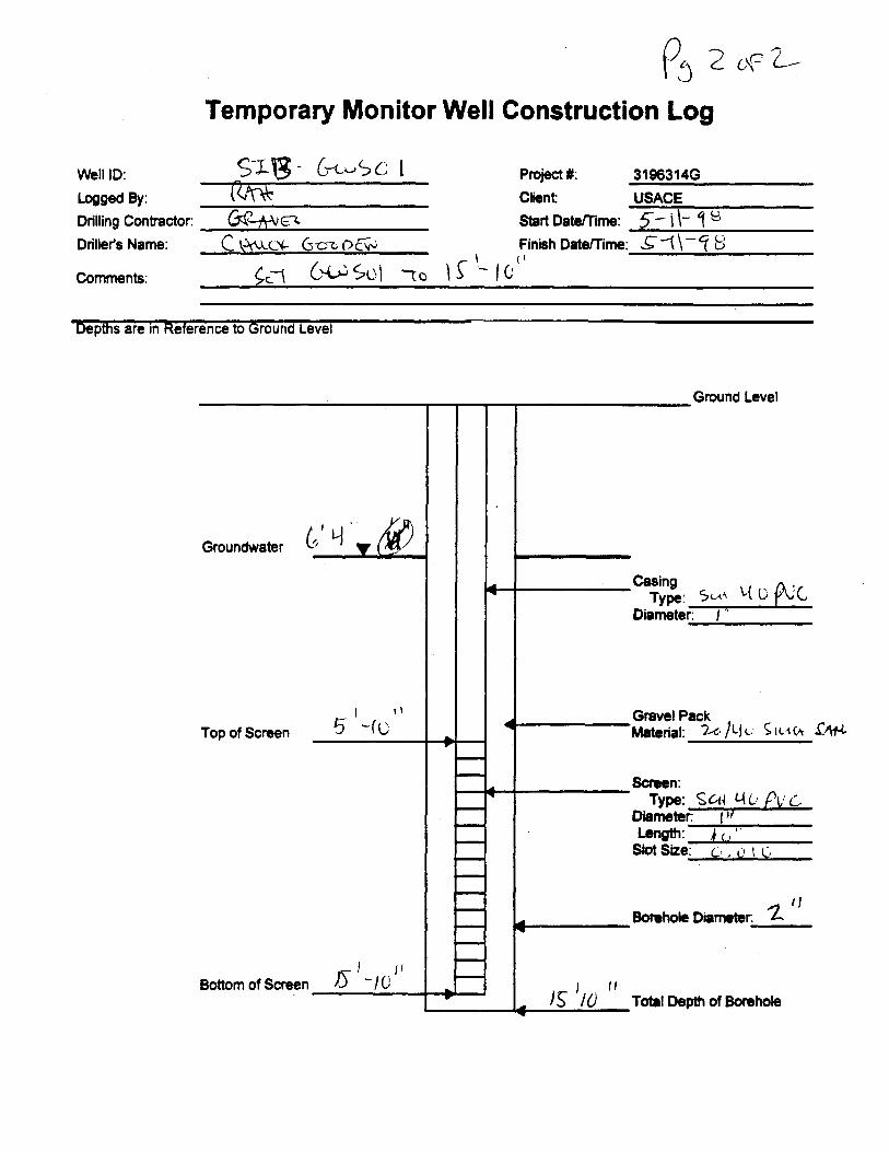
Temporary Monitor Well Construction Log
Well ID: S ' C"~ C I Project #: 3196314GLogged By: Client USACEDrilling Contractor: & - J Start Date rrime : 5-0- 9 8Drillers Name: C ~ (-'* G crt f? Finish Date/rime:--g--1( - ( B
Comments: S I C, St)I -70 1 S '-10
pths are in Reference to Ground Leve
Ground Level
Groundwater
CasingType :
Diameter: I
Top of ScreenGravel PackMaterial: 20)L1L ; S IL4(h • 4f-t
Screen :Type: Sc 4_ L AC, PV &
Diameter Length: ,{ c
Slot Size: C: , t) t C,
- / LBottom of Screen 5
'IBorehole Diameter I
I ll1 Total Depth of Borehole
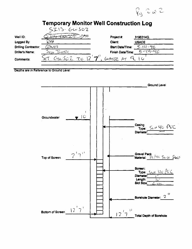
Temporary Monitor Well Construction Logs- `S- 6-- c -S C) 2
Well ID : Qq_ v ' Project # : 3196314GLogged By : ~w Client USACEDrilling Contractor: 0?A.;1 5 Start DateTme : 5-1 LI tiDriller's Name : ws~~ T~U=y Finish DateTme: 51~
Comments : C U Sc: L <<, 2 7' (~I~T A-7 f V
Depths are in Reference to Ground eve
Ground Level
Groundwater
CasingType : SL. t1 14(; PVC
Diameter :
Top of Screen
N
Gravel PackMaterial: Zc I y ( SK ( :4 ~NC
Screen :Type : S L U G !~ L' L
Diamete r:Length :Slot Size :
cfBorehole Diameter. 2
Bottom of Screen 1 2 r 7 1 112 1 Total Depth of Borehole

Temporary Monitor Well Construction Log
Well ID: >---13- C'W .̀-~'
Logged By : romDrilling Contractor: G;z'Nt3
Driller's Name : C-;) tY"
Project #: 3196314GClient USACEStart Date/Time : 5-I fr 1SFinish Date/Time :
Comments : L7C\
Depths are in Reference to Ground eve
Ground Level
Groundwater y f li
CasingType: 5 CAA y u ' (.
Diameter :
Top of ScreenGravel Pack
SAABMaterial : ZQ f L(D St "CA
Screen :Type : S,--t4 C, /IV
Diameter :Length : L(-.'Slot Size : , r, i C
Borehole Diameter.
Bottom of Screen 15 S ,Total Depth of Borehole