assessment of mitigation alternatives for cheekeye fan
TRANSCRIPT

Assessment of Mitigation Alternatives for Cheekeye Fan Final Report April 2016 KWL Project No. 463.311
Prepared for:

1
DISTRICT OF SQUAMISH Assessment of Mitigation Alternatives for Cheekeye Fan
Final Report April 2016
463.311-300
Contents Introduction .............................................................................................................. 1-1 1.
1.1 Project Purpose ..................................................................................................................................... 1-1 1.2 Study Area ............................................................................................................................................. 1-2 1.3 Work Program ........................................................................................................................................ 1-4 1.4 Project Team and Acknowledgements ............................................................................................... 1-6 1.5 Limitations ............................................................................................................................................. 1-6
Background Information ......................................................................................... 2-1 2.2.1 Previous Reports ................................................................................................................................... 2-1 2.2 Debris Flow Frequency and Magnitude .............................................................................................. 2-2 2.3 Other Hazards ........................................................................................................................................ 2-3 2.4 Status of Debris Flow Modelling .......................................................................................................... 2-3 2.5 Commentary on Debris Flow Modelling .............................................................................................. 2-4 2.6 Potential Debris Flow Effects ............................................................................................................... 2-7 2.7 Risk Assessment ................................................................................................................................... 2-8
Identification of Alternative Approaches to Risk Mitigation ................................ 3-1 3.3.1 Priorities for Mitigation ......................................................................................................................... 3-1 3.2 Objectives for Hazard/Risk Mitigation ................................................................................................. 3-1 3.3 Mitigation Strategies for Debris Flow Risk ......................................................................................... 3-7 3.4 Typical Mitigation Measures to Mitigate Debris Flow Risk ............................................................... 3-8 3.5 Primary Debris Flow Mitigation Alternatives for Cheekeye Fan..................................................... 3-10
Discussion of Local Issues ..................................................................................... 4-1 4.4.1 Engineering Issues ............................................................................................................................... 4-1 4.2 Land and Infrastructure Development Issues .................................................................................... 4-2 4.3 Existing Infrastructure Issues .............................................................................................................. 4-3 4.4 Environmental and Community Issues ............................................................................................... 4-4 4.5 Operational Issues ................................................................................................................................ 4-5
Evaluation of Primary Debris Flow Mitigation Alternatives ................................. 5-1 5.5.1 Development of Evaluation Matrix ...................................................................................................... 5-1 5.2 Evaluation of Primary Debris Flow Mitigation Alternatives .............................................................. 5-2 5.3 Comparison of Most Promising Primary Mitigation Alternatives .................................................... 5-4 5.4 Commentary on Large-Scale Retreat .................................................................................................. 5-6
Future Considerations ............................................................................................. 6-1 6.6.1 Response to Proposed New Development ......................................................................................... 6-1 6.2 Considerations if Proposed New Development Proceeds ................................................................ 6-3 6.3 Considerations if Proposed New Development Does Not Proceed ................................................. 6-6 6.4 Operation and Maintenance Considerations ...................................................................................... 6-6
Summary .................................................................................................................. 7-1 7.Report Submission References

2
DISTRICT OF SQUAMISH Assessment of Mitigation Alternatives for Cheekeye Fan
Final Report April 2016
463.311-300
Figures Figure 1-1: Cheekeye River Watershed ............................................................................................................ 1-7 Figure 1-2: Cheekeye Fan .................................................................................................................................. 1-8 Figure 3-1: F-N Diagram From 2012 APEGBC Flood Guidelines................................................................... 3-3 Figure 3-2: QRA Example to Illustrate the Importance of Selecting a Hazard Probability Option ............ 3-6 Figure 3-3: Debris Barrier Alternatives Above Highway 99 ......................................................................... 3-11 Figure 3-4: Debris Barrier Alternatives 4, 5, and 6 ........................................................................................ 3-12 Figure 3-5: Berm and Channelization Alternatives ....................................................................................... 3-13
Tables Table 1-1: Existing Development and Infrastructure On Cheekeye Fan ...................................................... 1-3 Table 1-2: Work Program ................................................................................................................................... 1-4 Table 2-1: Cheekeye River Debris Flow Magnitude ........................................................................................ 2-3 Table 2-2: Limitations of FLO-2D Modelling of Debris Flows ........................................................................ 2-4 Table 2-3: Potential Effect of 2500-Year Return Period Debris Flow on Cheekeye Fan ............................. 2-7 Table 3-1: Categorization of Existing Development for Purpose of Debris Flow Mitigation ...................... 3-1 Table 3-2: Summary of Cave Approach Used by FVRD for Debris Flows .................................................... 3-2 Table 3-3: Debris Flow Risk Mitigation Strategies .......................................................................................... 3-7 Table 3-4: Typical Mitigation Measures to Mitigate Debris Flow Risk .......................................................... 3-8 Table 3-5: Primary Debris Flow Mitigation Alternatives for Cheekeye Fan ................................................ 3-14 Table 5-1: Commentary on Evaluation Matrix Results ................................................................................... 5-3 Table 5-2: Advantages for Mid Fan Berm and Upper Canyon Debris Barrier .............................................. 5-4
Appendices Appendix A: Blank Evaluation Matrix for Cheekeye Fan Debris Flow Mitigation Alternatives Appendix B: Completed Evaluation Matrix for Cheekeye Fan Debris Flow Mitigation Alternatives Appendix C: Cheekeye River Sediment Management Considerations (2014 Technical Memorandum)

1-1
DISTRICT OF SQUAMISH Assessment of Mitigation Alternatives for Cheekeye Fan
Final Report April 2016
463.311-300
Introduction 1.
1.1 Project Purpose The Cheekeye Fan is a significant topographic feature near Brackendale, BC within the District of Squamish. The fan was formed over geologic time by debris flows originating on the flanks of Mount Garibaldi and propagating down the Cheekeye River. Over the past several decades, development has encroached onto the margins of the Cheekeye Fan. Two expert panels have concluded that the risk posed to existing development by debris flows on the Cheekeye Fan is unacceptable.
Kerr Wood Leidal Associates Ltd. (KWL) has been retained by the District of Squamish to review mitigation alternatives that could be considered to protect development and infrastructure on the Cheekeye Fan.
This report provides the following content:
• summary of relevant background information; • identification of a broad range of mitigation alternatives that could be considered; • discussion of local issues that may be important in selecting a mitigation alternative; • development of a framework for evaluating mitigation alternatives; • application of the framework to evaluate the identified mitigation alternatives; • identification of the most promising mitigation alternatives (based on the evaluation); and • future considerations for the District in moving forward.
The primary purpose of this report is to identify the most promising mitigation alternatives that could provide an appropriate level of protection to existing development and infrastructure, and comprise the primary components of a comprehensive mitigation plan.
Any promising mitigation alternatives identified in this report should be subjected to a greater level of investigation to confirm technical feasibility, define project components, provide construction cost estimates, develop a suitable implementation plan, and address long-term operation and maintenance issues. Subsequent investigation would also be appropriate to support a final decision to proceed with a preferred mitigation alternative.
At the time of this report, a large tract of land on the Cheekeye Fan, immediately north of Brackendale, is proposed for a major new development (“the proposed new development”) by BMS Cheekeye One Projects. This report is prepared with some knowledge that the proposed new development is contemplated, but does not constitute a “review” of the proposed new development or its associated proposal for debris flow risk mitigation.
This report does outline some future considerations for the District in moving forward with measures to appropriately mitigate the Cheekeye Fan debris flow hazard, under the scenarios of the land development project both proceeding and not proceeding.
While this assessment is focussed on debris flow hazards, some parts of the hazard area may also be affected by other natural hazards such as clear-water or debris floods on the Cheekeye River, Cheekeye River avulsion caused by sedimentation, groundwater flooding (caused by sub-surface hydraulic connectivity), and/or flooding from adjacent rivers. To be “acceptable” in the context of safe land use for communities, the total risk from all sources of hazard should be combined and considered together.

1-2
DISTRICT OF SQUAMISH Assessment of Mitigation Alternatives for Cheekeye Fan
Final Report April 2016
463.311-300
As a comprehensive mitigation plan for the Cheekeye Fan is developed, there will also be a need to ensure that any debris flow mitigation initiatives are compatible and consistent with the Squamish Integrated Flood Hazard Management Plan that is underway as of the time of this report.
1.2 Study Area This report uses the spelling “Cheekeye” which is the traditional spelling used by the Squamish Nation. Other documents use the spelling “Cheekye”.
The Cheekeye River watershed is shown by Figure 1-1. The Cheekeye River drains a steep watershed that is approximately 64 km2 in area.
The Cheekeye River headwaters include Mount Garibaldi and Atwell Peak. Steep slopes in the upper watershed produce periodic landslides and rock avalanches. In prolonged wet weather periods, such events may trigger large debris flows that discharge down the river to the fan. The Cheekeye River also produces debris floods and floods, and has a high rate of sediment transport.
On the fan, the Cheekeye River flows under the Highway 99 Bridge, and discharges to the Cheakamus River upstream of the Squamish Valley Road bridge. The Cheakamus River discharges to the Squamish River, which in turn discharges to Howe Sound.
The Cheekeye Fan is shown by Figure 1-2. The fan is approximately 7 km2 in area.
Brohm River is a key tributary river, entering Cheekeye River a short distance above Highway 99. Brohm River is understood to be the most important fisheries resource area on the fan.
Dryden Creek also crosses the fan, flowing north from Alice Lake, west toward Highway 99, then south along Highway 99 to Brackendale. Outflow from Dryden Creek reaches the Squamish River at Dryden Creek pump station / floodbox.
The community of Brackendale is located at the south perimeter of the fan. The fan also transitions into the Garibaldi Estates area of the Mamquam River fan. Diking and drainage works associated with Squamish River and Mamquam River may affect the runout of Cheekeye River debris flows as well as the discharge of any debris-flow related avulsion (rapid change) of the river channel.
The fan is within the traditional territory of the Squamish Nation, which has land holdings in the area. The fan is also within the consultation area for the Tsleil-Waututh Nation.
The Cheekeye fan has been extensively studied. A partial list of references is attached.
A partial list of development and infrastructure that may be affected by Cheekeye River debris flows is provided in Table 1-1.

1-3
DISTRICT OF SQUAMISH Assessment of Mitigation Alternatives for Cheekeye Fan
Final Report April 2016
463.311-300
Table 1-1: Existing Development and Infrastructure On Cheekeye Fan Category Description
Residential Development
Brackendale Cheakamus I.R. No. 11 Waiwakum I.R. No. 14 Seaichem I.R. No. 16
Institutional Brackendale Schools (2)
Regional Infrastructure
Highway 99 CN Railway Cheekeye River Bridges (Road and Rail) BC Hydro Power Lines and Substation
Municipal Infrastructure Squamish Landfill Squamish Airport Alice Lake Reservoir
Local Roads
Squamish Valley Road Paradise Valley Road Cheakamus River (Fergie’s) Bridge Depot Road (Brackendale Access) Government Road Other Local Roads
Recreational Development Sunwolf Resort Alice Lake Park access road Various Bicycling Trails
Undeveloped IR Land Aikwucks I.R. No. 15 Poquiosin and Skamain I.R. No. 13
Industrial Gravel Pits and Forest Operations Sites Tree Farm Licence

1-4
DISTRICT OF SQUAMISH Assessment of Mitigation Alternatives for Cheekeye Fan
Final Report April 2016
463.311-300
1.3 Work Program The work program undertaken in preparing this report is summarized in Table 1-2.
Table 1-2: Work Program Task Task Description Identification of Sub-Tasks 1. Project Initiation
1.1 Initial Project Scoping Work with District of Squamish to develop initial work program Consider need for subsequent peer review activities
1.2 Pre-Project Meeting with District, Cornerstone and BGC
Develop understanding of each party's objectives and activities Confirm what information is available from BGC Agree on extent to which BGC work can be used by KWL and the District Discuss key elements of work program
1.3 Update Work Program Update initial work program 2. Review and Assess Baseline Information
2.1 Compile Comprehensive Reference List
Compile paper and/or digital library of key reports for purpose of project Produce reference list in consultation with District and BGC
2.2 Consider Hazard Scenarios and Modelling Parameters
Consider hazard scenarios from previous reports for purpose of this project Review modelling parameters used in BGC modelling work Determine whether previous hazard scenarios and modelling parameters provide an appropriate and representative description of hazard for purpose of this project
2.3 Review Current Level of Risk
Summarize current level of risk based on existing information Consider implications to existing development and identify key consequence areas Determine whether previous risk analysis provides an appropriate and representative representation of risk
2.4 Document Status of Baseline Assessments
Prepare technical memorandum to document relevance of existing information (primarily BGC reports) for this project Submit technical memorandum to District in draft
3. Identify and Evaluate Mitigation Alternatives
3.1 Preliminary Identification of Structural Mitigation Alternatives
Develop a comprehensive list of all mitigation measures that have been documented by various parties in the past Prepare base map using 2013 LiDAR Identify other potential mitigation measures that have not been documented in the past, but may have merit for consideration Endeavour to include alternatives that have a possibility of achieving ‘As Low As Reasonably Practicable’ (ALARP) for the Cheekeye Fan, recognizing that this will not be confirmed until further modelling and QRA work is done Consider mitigation implications of ongoing fill at landfill Prepare sketch plans and tabular notes to document alternatives Prepare technical memorandum to document identification of the alternative mitigation measures Submit technical memorandum to District in draft

1-5
DISTRICT OF SQUAMISH Assessment of Mitigation Alternatives for Cheekeye Fan
Final Report April 2016
463.311-300
Task Task Description Identification of Sub-Tasks
3.2 Develop Evaluation Matrix Identify potential evaluation criteria for alternatives Consult with District regarding evaluation criteria and weightings Work with District to create a qualitative evaluation matrix
3.3 KWL/District Workshop
Discuss priorities for protection and standard of protection Review preliminary compilation of alternatives Review proposed evaluation matrix Obtain feedback for completion of project
3.4 Meet with District, Cornerstone and BGC
Review KWL technical memoranda Discuss evaluation matrix and mitigation alternatives Obtain feedback for completion of project
3.5 Alternative Evaluation
Perform three independent initial evaluations the alternatives using the evaluation matrix (one each by Mike Currie, Gary Buxton and David Roulston) Meet with District to compare the three independent evaluations and resolve significant differences Develop a final evaluation matrix using average scores from the three independent evaluations Work with District to identify the most promising alternatives Consider combinations and permutations of alternatives Consider areas where retreat and avoid may be obvious alternatives to structural mitigation
4. Report on Mitigation Alternatives
4.1 Report
Compile technical memoranda and alternative evaluation into a short-form report Identify preferred structural alternative(s) Discuss future considerations in the event that the proposed Cheekeye Fan development project does and does not move forward in the short term Comment on the subject of retreat from the highest hazard areas Submit report to District in draft Obtain District feedback, finalize report
In order to meet the District’s budget constraints, several elements from the work program as originally developed were removed. This included cost estimation, council presentation, consultation with Squamish Nation, and public consultation. Discussion of future considerations was added to the original work program. Table 1-2 reflects the modified work program.

1-6
DISTRICT OF SQUAMISH Assessment of Mitigation Alternatives for Cheekeye Fan
Final Report April 2016
463.311-300
1.4 Project Team and Acknowledgements This report was prepared by Mike V. Currie, M.Eng., P.Eng., FEC with technical review by David Roche, M.A.Sc., P.Eng.
Assistance and input on behalf of the District of Squamish was led and co-ordinated by David Roulston, P.Eng., Municipal Engineer and Gary Buxton, General Manager of Development Services & Public Works.
The authors also acknowledge the contributions of BGC Engineering, BMS Cheekeye One Projects and Squamish Nation who provided relevant background information for this project.
1.5 Limitations This report is based on the available reports as noted and the experience and judgment of the project team. No new information was collected.
This document represents KWL’s professional judgement based on the information available at the time of its completion and as appropriate for the project scope of work. Services performed in developing the content of this document have been conducted in a manner consistent with that level and skill ordinarily exercised by members of the engineering profession currently practising under similar conditions. No warranty, express or implied, is made.
This report is provided for the exclusive use and benefit of the District of Squamish. No other party is entitled to rely on any of the conclusions, data, opinions, or any other information contained in this document.
Any use that a third party makes of this report is the sole responsibility of that third party. KWL accepts no responsibility for any such use.

Cheekeye River Watershed
Assessment of Mitigation Alternatives for Cheekeye Fan
Path: O:\0400-0499\463-311\430-GIS\MXD-Rp\463311_Figure_1-1_CheekeyeRiverWatershed.mxd Date Saved: 15/04/2016 1:31:29 PMAuthor: RTaylor
© 2016 Kerr Wood Leidal Associates Ltd.
463-311
1,000 1,0000
(m)
April, 2016
Figure 1-1
Service Layer Credits: Sources: Esri, HERE, DeLorme, TomTom, Intermap, increment P Corp.,GEBCO, USGS, FAO, NPS, NRCAN, GeoBase, IGN, Kadaster NL, Ordnance Survey, Esri Japan, METI,Esri China (Hong Kong), swisstopo, MapmyIndia, © OpenStreetMap contributors, and the GIS UserCommunity
Copyright Notice: These materials are copyright of Kerr Wood Leidal Associates Ltd. (KWL). District ofSquamish is permitted to reproduce the materials for archiving and for distribution to third parties only asrequired to conduct business specifically relating to the Assessment of Mitigation Alternatives forCheekeye Fan. Any other use of these materials without the written permission of KWL is prohibited.
Project No. Date
LegendCheekeye River Watershed

ÏÎ
ÏÎ
ÏÎÏÎ
Government Rd
Depot Rd
Ross
Rd
Squamish Valley R
d
Highway 99
Highway 99
Highway 99
Cheakamus River
Cheekeye River
StumpLake
AliceLake
Squamish River
Mamquam River
GaribaldiEstates
GaribaldiHighlands
Brackendale
SquamishAirport
SquamishLandfill
BC HydroSubstation
Distri
ct of
Squa
mish
Squa
mish
-Lillo
oet
Regio
nal D
istric
t
Brohm R iverHo
p Ran
ch C
reek
Meighan Creek
HarrisSl ou
ghJudd Slough
Dryd
en Cr
eek Alice LakeProvincial Park
CN Railway
Cheakamus River(Fergie's) Bridge
Cheakamus River"Dogleg"
CHEA KAM US 11CHEA KAM US 11
KOWTAINKOWTAIN1717
POQU IOS IN &POQU IOS IN &SKAM AI N 13SKAM AI N 13
WAI WAKUM 14WAI WAKUM 14
SEAI C HEM 16SEAI C HEM 16
SEAI C HEM 16SEAI C HEM 16
YEKWAUPS UM 18YEKWAUPS UM 18
YEKWAUPS UM 19YEKWAUPS UM 19
AIKWU CKS 15AIKWU CKS 15
YOOKWI T Z 12YOOKWI T Z 12
440
400
360280
20016014012010080
420380
340320300
240
360 320 280
240 200 160 120 100 80 60
220
180 140 40 20
300
280 240
200 120 80 60 40
20
320
260 220
160
180
140
200
160120
10080
6040
240220
180
320
280
240
200
180
160140
120100
80
220
60
400380
360
340
320300
280
240
160140
120100
80
60
180
40
160120
80
100 60
40
20
380360320280
340
300
360
340320
300
280
260240
340320
280260
340320
300
260
300280
10080
10060
60 40
400380 360
320
300
260240
220200
140
120
160
120 100
60
40
360
340
340
320
320
300
280 260
260 240
220180
200 180
100
80
10080
380 360
380
360
380360
340320
300
260
300260
280
260
260
220
220
200
200
180
140
120
140
120
120 100
100
80
80
60
340
140
260
220
20
260
300
280
60
140
80
340
280
320
280
240
200
160
140
160
160
100
120
80
420
400
340
340
320
320
320
300
300
300
280
280
280
280
240
260
260
260
240
220
240
240
240 240
240
220
220
220
200
200
200
180
160
160
120
120
120
120
120
120
120
120
120
120
120
100
100
100
100
80
80
8080
60
60
60
2020
40
40
40
40
20
260
200
120
80
40
4040
20
20
20
20
20
20
20
20
20
20
20
20
20
20
20
20
20
20
Cheekeye Fan
Assessment of Mitigation Alternatives for Cheekeye Fan
Path: O:\0400-0499\463-311\430-GIS\MXD-Rp\463311_Figure_1-2_CheekeyeFan.mxd Date Saved: 20/04/2016 3:55:16 PMAuthor: RTaylor
© 2016 Kerr Wood Leidal Associates Ltd.
463-311
500 5000
(m)
April, 2016
Figure 1-2
Reference: Orthophoto from District of Squamish, 2013.
Copyright Notice: These materials are copyright of Kerr Wood Leidal Associates Ltd. (KWL).District of Squamish is permitted to reproduce the materials for archiving and for distribution tothird parties only as required to conduct business specifically relating to the Assessment ofMitigation Alternatives for Cheekeye Fan Project. Any other use of these materials without thewritten permission of KWL is prohibited.
Project No. Date
LegendÏÎ Floodbox / Pump Station
Approximate Fan Boundary
Existing Flood Protection Works
Provincial Park
Indian Reserve

2-1
DISTRICT OF SQUAMISH Assessment of Mitigation Alternatives for Cheekeye Fan
Final Report April 2016
463.311-300
Background Information 2.This section documents relevant background information from previous reports. This includes a number of reports prepared by BGC Engineering that cover the following topics:
• debris flow magnitude and frequency; • debris flow modelling; and • debris flow risk.
Information from several high level review reports is also included.
The purpose of this review is limited to summarizing available information to support the screening of mitigation alternatives provided herein. This review and commentary do not comprise a formal technical review or peer review of any of the previous work.
2.1 Previous Reports A partial reference list pertaining to the Cheekeye Fan is included at the end of this report. The most relevant reports are noted in this section.
An initial set of three reports was prepared by BGC Engineering in 2007/2008:
BGC1 Cheekeye River Debris Flow Frequency and Magnitude January 10, 2008 BGC2 Cheekeye River Debris Flow Simulations December 14, 2007 BGC3 Cheekeye River Debris Flow Risk Assessment October 21, 2008
Each of the above reports was reviewed and accepted by the Cheekeye Fan Geotechnical Review Board (Andy Robertson P.Eng., Dr. Oldrich Hungr P.Eng./P.Geo, and Dr. Norbert Morgenstern, P.Eng.) as documented in the following reports:
RB1 Approval of BGC1 and BGC2, and Preliminary Approval of BGC3 March 4, 2008 RB2 Approval of BGC3 October 14, 2008
The three initial BGC reports and the Review Board work were commissioned by a previous development proponent at the time (Cheekeye River Developments). The work was done specifically to support development of a mitigation strategy to protect a proposed development on the Cheekeye Fan. A potential mitigation strategy was partially developed by KWL in 2007, but was not completed as the development project was paused. A similar development project is now under consideration by a new development proponent (BMS Cheekeye One Projects), and further work has been done (as noted below).
An independent review by Golder Associates was commissioned by the BC Government:
G1 Cheekye Fan Hazard Review March 22, 2013
Further review and input has also been obtained through two expert panel reports jointly commissioned by the BC Government, the Squamish Nation, and the District of Squamish:
EP1 Report of the Cheekye River and Fan Expert Review Panel April 23, 2014 EP2 Cheekye River and Fan Landslide Risk Tolerance Criteria June 8, 2015

2-2
DISTRICT OF SQUAMISH Assessment of Mitigation Alternatives for Cheekeye Fan
Final Report April 2016
463.311-300
Expert Panel #1 comprised Dr. John Clague P.Geo, Dr. Oldrich Hungr P.Eng./P.Geo, and Douglas VanDine P.Eng./P.Geo. Expert Panel #1 was directed to review all previous relevant documentation and provide opinions on the volume and frequency of future debris flows, characterize the volume of the 10,000-year return period debris flow, and comment on the possible effects of climate change. Relevant comments from EP1 are discussed in Section 2.2 below.
Expert Panel #2 included the three original members plus Dr. Norbert Morgenstern P.Eng. Expert Panel #2 was directed to provide advice with respect to four items with a focus on risk to life:
1. landslide risk tolerance criteria for existing and proposed new development on Cheekeye Fan;
2. current levels of individual and societal risk from landslides on Cheekeye Fan;
3. individual and societal risk reduction that might be achieved through mitigation, given existing and proposed new development; and
4. whether individual and societal landslide risk tolerance criteria can be applied across the District of Squamish or solely to Cheekeye Fan.
Some relevant comments from EP2 are included in Section 3.
Some of the initial BGC modelling work has recently been updated on behalf of BMS Cheekeye One Projects:
BGC4 Debris Flow Exposure Assessment December 2, 2015 BGC5 2015 Debris Flow Modelling Summary, Cheekeye Fan (Draft) December 23, 2015
BGC4 included some additional debris flow modelling that updates the initial work reported in BGC2. BGC5 included a more thorough update of the initial work in BGC2, superseding the work of BGC4. BGC5 therefore represents the most current debris flow modelling work for the Cheekeye Fan (but remains in draft form at the time this report was prepared).
2.2 Debris Flow Frequency and Magnitude BGC1 provides a good assessment of debris flow frequency and magnitude, but some refinements have been made since that time.
EP1 provided an opinion that the magnitude of the 10,000-year return period debris flow on Cheekeye River is 5.5 million m3, more conservative than the 2.8 million m3 from BGC1. EP1 also included an opinion that the 10,000-year return period debris flow event is an appropriate level of hazard probability to consider for Cheekeye Fan.
The District has accepted the opinion of EP1 that the 10,000-year return period debris flow is the appropriate extreme event for estimating the largest debris flow that could affect the Cheekeye Fan.
EP1 further opined that the upper bound of the 10,000-year return period debris flow should be 5.5 million m3, and that a debris flow event of this volume is conceptually comparable to the Maximum Credible Earthquake (MCE) or Probable Maximum Flood (PMF). G1 also had similar findings.
BGC2 used a minimum debris flow return period of 20 years. Following the occurrence of two debris flows since 2007, BGC5 uses a reduced minimum debris flow return period of 5 years.
Based on the latest work by BGC Engineering (BGC5), debris flow magnitude on the Cheekeye Fan is best estimated as in Table 2-1. This represents an update of BGC2 to reflect the expert panel findings.

2-3
DISTRICT OF SQUAMISH Assessment of Mitigation Alternatives for Cheekeye Fan
Final Report April 2016
463.311-300
Table 2-1: Cheekeye River Debris Flow Magnitude Return Period Debris Flow Volume Peak Discharge
10,000 years 5,500,000 m3 (upper limit) 2,800,000 m3 (best estimate) 18,000 - 33,000 m3/s
2,500 years 2,400,000 m3 7,800 - 12,400 m3/s 500 years 1,400,000 m3 4,500 - 6,600 m3/s 200 years 800,000 m3 2,600 - 3,400 m3/s 100 years 600,000 m3 1,900 - 2,400 m3/s 50 years 400,000 m3 1,300 - 1,500 m3/s 20 years 200,000 m3 630 - 670 m3/s 10 years 170,000 m3 540 - 550 m3/s 5 years 110,000 m3 320 - 330 m3/s
*All debris flow volumes below 10,000-year return period are best estimates rather than upper limits.
The existing hazard assessment work is considered sufficient for the purposes of this screening-level assessment of mitigation options. However, it should be recognized that no hazard assessment of this nature can be exhaustive, and that the reports do not reflect every possible hazard scenario. At some point, it will be appropriate to obtain an update to BGC1 that reflects the findings of EP1, the updated work of BGC5, and any other new information that is relevant (for example, lessons learned from the 2010 Capricorn Creek debris flow near Pemberton).
2.3 Other Hazards In addition to debris flow magnitude and frequency on the Cheekeye Fan, the project must also consider flood magnitude and frequency on the Cheekeye River, Brohm River, Cheakamus River, Squamish River and Dryden Creek. Some consideration is given to these issues in BGC5. In moving forward, it will be appropriate to further consider the complex issue of combined probability of simultaneous or successive extreme events on these rivers and creeks.
It is important to recognize that other hazards may also affect the study area, such as rockfall from high bluffs east of Highway 99.
2.4 Status of Debris Flow Modelling BGC2 includes analysis of the garbage dump debris flow of about 800 years ago. This large event is used as a calibration event. The report also includes map products showing simulated debris flow depth and velocity for various scenarios, with return periods from 20 years to 10,000 years (the latter event having a volume of 2.8 million m3, compared to the more conservative estimate of 5.5 million m3 as recommended by Expert Panel#1). As noted above, BGC2 was reviewed and accepted by the initial Review Board.
BGC4 includes updated mapping, primarily to reflect extension of the model domain south to the Mamquam River dike. The range of modelled return periods is 100 years to 10,000 years. The map products show the same parameters as BGC2, namely debris flow depth and velocity. The map products also show an approximate proposed development area.
BGC5 is a draft report that may be subject to revision, and has not (yet) been subject to external review. Compared to the initial (2007) modelling work of BGC2, key changes in the modelling approach are as follows:

2-4
DISTRICT OF SQUAMISH Assessment of Mitigation Alternatives for Cheekeye Fan
Final Report April 2016
463.311-300
• the model domain was extended south to the Mamquam River dyke using 2014 Lidar data (BGC2 used 2006 Lidar data);
• the range of modelled return periods is 5 years to 10,000 years;
• a range of peak flow estimates was used to reflect varying viscosity for each return period;
• 2,500-year and 10,000-year return period debris flow model runs also incorporate a 50-year return period clear-water flood as a background condition on the Cheekeye River (lesser return periods do not);
• the model now incorporates dykes along the Squamish River and Mamquam River (along with the assumption that the floodboxes and pump stations will be inoperable during a debris flow);
• as recommended by EP1, the 10,000-year return period debris flow volume was increased from 2.8 million m3 to 5.5 million m3 (the peak discharge also increased from 15,000 m3/s to an upper limit of 33,000 m3/s);
• rather than illustrate debris flow depth and velocity in map form, BGC5 maps show debris flow “impact intensity” (which is not explicitly defined in the document but has been published previously in peer-reviewed journal articles); and
• the map products show depth only (i.e., no velocity) in areas where the impact intensity is less than 1.
Neither BGC2 nor BGC5 include modelling of post-mitigation scenarios.
The modelling work is expected to be refined in the future. Three specific issues that should be given further consideration in future modelling of debris flow runout are: the impact of the ongoing landfill development; changing forest conditions on the fan surface; and changes due to clearing and/or land development.
2.5 Commentary on Debris Flow Modelling The modelling work for the Cheekeye Fan is comprehensive, and incorporates leading-edge tools and research. However, it is important to understand that debris flow modelling with FLO-2D remains subject to a range of general assumptions and limitations, described in Table 2-1.
Table 2-2: Limitations of FLO-2D Modelling of Debris Flows
Technological Limitations
• the model is an approximation of actual conditions, subject to input variables, uncertainty, the skill and experience of the modeller, and the possibility of human errors or “bugs” in the software
• the physics of debris flows remain an area of evolving research • obtaining a good result is dependent on being able to calibrate the
model based on historic event(s)

2-5
DISTRICT OF SQUAMISH Assessment of Mitigation Alternatives for Cheekeye Fan
Final Report April 2016
463.311-300
Geomorphic Limitations
• the event volume and peak discharge (water and sediment) are estimated input variables that are subject to uncertainty
• the shape of the input hydrograph is estimated, and requires an assumption regarding whether to model as one surge, or multiple surges
• assumptions need to be made about the magnitude, containment and direction of river flow before, during and after the modelled event
• a model run will not reflect any physical changes that occur within the channel or on the fan (i.e., scour and/or deposition) during the event
• the behaviour of successive surges may be affected by the deposition of their predecessors, which cannot be simulated by the runout model
Topographic Limitations
• the model includes a digital representation of topography on the fan (with one elevation for a fixed grid size, (25 m x 25 m in this case)
• depending on survey and mapping methods, the representation of topography at the time of data collection may or may not be good
• tree cover can be an impediment for aerial mapping techniques • the mapping may not continue to reflect the river channel or fan
conditions due to ongoing geomorphic changes such as aggradation or erosion
• the mapping may not continue to reflect actual conditions if there is ongoing development (especially linear fills such as roads and dykes)
Practical Limitations
• the behaviour of large log debris in a debris flow is unpredictable and hard to simulate
• the actual impact of a debris flow on a given structure is subject to a large number of uncertainties and can only be expressed in probabilistic terms
• changes in land use (i.e., clearing and development) on the fan may affect debris flow deposition and runout
• the model shows uniform flow whereas debris flow behaviour does not tend to be uniform
• the return period or probability of a given event is the probability of an event of that magnitude reaching the fan apex, whereas the probability of each alternative downstream realization is less than that of the initial event (due to compound probability associated with modelling scenarios such as blockage, and the potential for the flow to run out in unanticipated directions on the fan)

2-6
DISTRICT OF SQUAMISH Assessment of Mitigation Alternatives for Cheekeye Fan
Final Report April 2016
463.311-300
Modelling Scenarios
• it is not feasible to model every scenario or possible outcome • in order to simulate avulsion, an artificial channel blockage of
assumed size and location must be added to the model (these assumptions may or may not be realistic)
• assumptions may need to be made about the performance of dikes and other works during a debris flow
• since the model used by BGC cannot evaluate hydraulic performance of structures, bridges and culverts need to represented as either blockages or simply removed
• professional judgment is required when combining different extreme events (i.e., debris flow, river flow) and establishing boundary conditions (i.e., downstream water level)
Modelling Parameters
• the discharge and sediment volume are integrated using an estimated bulking factor to develop the inflow hydrograph
• the yield stress and viscosity of the debris flow must be estimated independently and assumed to be constant over time (which may or may not be realistic)
• surface roughness in the runout area must be estimated independently, and cannot vary with time, discharge, or dynamic effects of inundation or deposition.
The majority of these comments are generally applicable to any platform that simulates debris flows, and FLO-2D modelling is considered an appropriate tool to simulate debris flow runout on the Cheekeye Fan. It is nonetheless important to consider the above-noted assumptions and limitations in applying the model results for any purpose.
With respect to the review of mitigation alternatives on the Cheekeye Fan as provided by this report, some comments on the modelling work of the draft BGC5 report are as follows:
• the map products reflect the full range of return periods that should be considered;
• the map products showing debris flow impact intensity are less intuitive than debris flow depth and velocity, and potentially less directly applicable for the review of mitigation alternatives (but perhaps more directly applicable to QRA);
• debris flow impact intensity is not well defined, and its application is not explained (it is understood that these issues will be remedied in any further versions);
• the avulsion scenarios modelled by BGC and presented in the reports may not represent worst case scenarios for all hazard areas or potential mitigation alternatives on the Cheekeye Fan;
• the modelling is conservative in that it reflects continued southward flow and back-up from the river dikes (Squamish River and Mamquam River) south of Brackendale (although in practical terms, the dike may be breached and/or Cheekeye River flow quickly re-diverted as part of the District’s emergency response during such an event to prevent excessive water levels);
• some of the model runs (2,500-year and 10,000-year return period) compound extreme probabilities (Cheekeye River debris flow plus 50-year return period Cheekeye River flood plus zero downstream pump capacity plus complete blockage of all outlets through the dike plus ponding behind dikes),

2-7
DISTRICT OF SQUAMISH Assessment of Mitigation Alternatives for Cheekeye Fan
Final Report April 2016
463.311-300
whereas even major debris flows are not always correlated with high river levels (as recently demonstrated by 2010 Capricorn Creek debris flow near Pemberton); and
• the model parameters have not been reviewed in detail (although this review did not identify any reason why the parameters selected by BGC would be considered inappropriate).
These comments should be addressed when BGC5 is finalized.
In using any model result, it is important to consider the discharge hydrograph in addition to the total event volume, as well as the specific avulsion assumption, to ensure that an appropriate scenario is used. Areas outside the mapped impact area are not necessarily free of hazard, since the debris flow could run out in a different manner than modelled.
In summary, the map products from BGC’s debris flow modelling are useful for supporting the preparation of this report.
2.6 Potential Debris Flow Effects The map products from debris flow modelling allow potential debris flow effect for each scenario to be described in terms of depth and velocity. Based on the scenarios of Figure 10 of BGC2 and Drawing 4 of BGC4, the effects of a 2,500-year return period debris flow are described generally in Table 2-3.
It is important to note that the relative debris flow impacts on the fan are highly dependent on the modelling scenarios, particularly avulsion and bridge blockage. The 2,500 year debris flow is presented as an example, not as the most extreme possible event. The description below is provided for illustrative purposes, and the parameters are not intended to be precise.
Table 2-3: Potential Effect of 2500-Year Return Period Debris Flow on Cheekeye Fan
Brackendale
• virtually all of Brackendale would be impacted by debris flow to some extent
• debris flow generally less than 0.5 m deep in north part of Brackendale • debris flow up to 2 m deep further to south where flow impeded by dike • roads to/from Brackendale likely inoperable (from north and south) • local access roads likely inoperable
Cheekeye Confluence Area and I.R. No. 11
• most of fan area impacted by debris flow to some extent • debris flow depth highly dependent on upstream avulsion and bridge
blockage assumptions, but potentially up to several metres deep • potential secondary impact from Cheakamus River blockage (likely
resulting in overflow through Cheakamus I.R. No. 11) • access south to Squamish likely severed • access to north from I.R. No. 11 (e.g., Paradise Valley) may be possible
Highway 99
• 2 m to 5 m depth of debris flow across highway north of Alice Lake park access road
• Cheekye River highway bridge blocked • avulsion down highway, south to Brackendale • highway likely inoperable from highway bridge to nearly Garibaldi Way

2-8
DISTRICT OF SQUAMISH Assessment of Mitigation Alternatives for Cheekeye Fan
Final Report April 2016
463.311-300
Table 2-3 underscores the fact that the potential debris flow damage at Cheekeye Fan could be severe and highly disruptive to the community.
2.7 Risk Assessment In addition to describing debris flow impact using modelling tools as in the previous section, numerical values can be assigned to risk. This can be done through quantitative risk assessment, a tool that has been increasingly used for this purpose in BC in the past decade. It is important to recognize that the application of risk assessment methodology for natural hazards is not (yet) guided by provincial or federal legislation, regulations or guidelines. It is, however, documented in the June 2012 publication by the Association of Professional Engineers and Geoscientists of BC (APEGBC) titled “Professional Practice Guidelines – Legislated Flood Assessments in a Changing Climate in BC” (the 2012 APEGBC Flood Guidelines”).
BGC3 provided an initial quantitative risk assessment for the Cheekeye Fan for three principal aspects:
• risk to Highway 99 users; • risk to existing development at the Cheekeye River confluence area; and • risk to a development area proposed at the time (similar to present proposal).
In each case, risk to individuals and groups were both rated as “unacceptable”. BGC3 notes that risk would be significantly reduced if a large debris barrier (at the time expected to contain roughly 1.4 million m3 of debris) were to be constructed above Highway 99.
BGC3 also notes that the economic risk due to Highway 99 being severed would be in the order of $1M per day (2008 dollars).
BGC3 would require updating to provide a more definitive and current assessment. If risk assessment is to be used as a basis for major development or investment decisions, a detailed peer review of the updated risk assessment would be appropriate. As is common with engineering reports, a detailed peer review would require a depth of information beyond that presented in BGC3 to confirm the assessment structure developed for the Cheekeye Fan.
BGC4 further documents the risk exposure of existing development on the Cheekeye Fan. It includes a listing of properties (Table 3-1) that could be impacted by various return period debris flows and scenarios.
In summary, BGC4 concludes that the value of land and improvements that could be affected by a Cheekeye River debris flow could range from roughly $20M for the 100-year return period event to $900M for the 10,000-year return period event. This determination is based on existing conditions. Any mitigation works would be expected to reduce the extent of damage.

3-1
DISTRICT OF SQUAMISH Assessment of Mitigation Alternatives for Cheekeye Fan
Final Report April 2016
463.311-300
Identification of Alternative Approaches to Risk Mitigation 3.This section identifies a broad range of mitigation approaches that may be considered to mitigate risk to existing development on the Cheekeye Fan.
While the focus of this report is on protection of existing development, work associated with the proposed new development is ongoing. Mitigation measures to protect such a new development are being developed by others.
3.1 Priorities for Mitigation In working with District staff, existing development was categorized in terms of priority for mitigating risk as shown by Table 3-1.
Table 3-1: Categorization of Existing Development for Purpose of Debris Flow Mitigation Highest Priority Considerations
Moderate Priority Considerations
Lower Priority Considerations
Brackendale Residential Area Aikwucks IR 15 (Limited Development) Squamish Airport
Cheakamus IR 11 Residential Area
Paradise Valley Road (Valley Access) Highway 99
Waiwakum IR 14 Residential Area
Cheakamus River (Fergie’s) Bridge CN Railway
Seaichem IR 16 Residential Area
Depot Road (Brackendale Access) BC Hydro Substation
Kowtain IR 17 Residential Area BC Hydro Transmission Lines Confluence Residential Area Squamish Landfill Brackendale Schools (2) Industrial Sites West of Airport Garibaldi Estates Residential Area Poquiosin & Skamain IR 13
(Non-Residential) Alice Lake Park Access Road
This categorization provides a basis for this initial review of alternatives.
3.2 Objectives for Hazard/Risk Mitigation
Risk Mitigation Criteria The extent to which any natural hazard or risk will be mitigated is an important question, and can significantly impact the approach to risk mitigation as well as the type, location and scale of structural mitigative works that may be considered.
There are two basic approaches to defining acceptable mitigation:
1. a design return period approach (such as is often used for flood hazards in BC with a 200-year return period); or
2. a risk management approach where the objective is to reduce computed risk to a level acceptable to the local authority.
In some situations, it may be appropriate to integrate these two approaches.

3-2
DISTRICT OF SQUAMISH Assessment of Mitigation Alternatives for Cheekeye Fan
Final Report April 2016
463.311-300
Little direction is provided to local governments facing such decisions, although the issue is referenced in the 2004 Flood Hazard Area Land Use Guidelines. Some direction is provided to qualified professionals in the 2012 APEGBC Flood Guidelines, but is primarily focussed on new development and redevelopment. Direction for protecting existing development is particularly lacking.
Precedents in Other Parts of BC In the early 1990’s, Dr. Peter Cave developed a graduated series of risk mitigation criteria that continues to be used by the Fraser Valley Regional District (FVRD). This approach applied a “sliding scale” that facilitated minor development, but required a very low level of risk for major new development. The approach was also more stringent for more severe hazard types. For debris flows, this approach is summarized in Table 3-2.
Table 3-2: Summary of Cave Approach Used by FVRD for Debris Flows
Type of Proposed Development Design Return Period (``Annual Return Frequency``)
rezoning for new community (major new development) 1:500-1:10,000 infill development (such as small subdivision) 1:200-1:500 build on existing lot 1:50-1:200 repair 1:50
For debris flows and major catastrophic landslides, the FVRD approach would only consider rezoning for a major new development where the debris flow hazard is naturally below, or has been mitigated to, the level of 1:500-1:10,000 annual return frequency.
Application of quantitative risk assessment techniques, as outlined in the 2012 APEGBC Flood Guidelines, goes beyond the FVRD approach by reducing the risk during the specified return period event to an acceptable level (the FVRD approach does not include specific risk criteria, but does implicitly consider risk in setting higher return period standards for higher levels of development).
The District of North Vancouver requires that subdivisions, development approvals and building permits have natural hazard risks reduced to As Low as Reasonably Practicable (ALARP). The concept of ALARP is illustrated in the diagram in Figure 3-1 (from 2012 APEGBC Flood Guidelines).

3-3
DISTRICT OF SQUAMISH Assessment of Mitigation Alternatives for Cheekeye Fan
Final Report April 2016
463.311-300
Figure 3-1: F-N Diagram From 2012 APEGBC Flood Guidelines
The F-N diagram is based on the concept of decreasing risk tolerance for increasing number of fatalities. A broadly acceptable zone is defined where risk is at or lower than that commonly accepted in society. An unacceptable zone is defined where risk is higher than that commonly accepted in society. An intermediate ALARP zone is also defined. In order to be considered ALARP, two criteria must be met:
1. the societal risk must fall within or below the ALARP zone of the F-N diagram; and
2. the cost to further mitigate the risk must be grossly disproportionate to the benefit gained, or the solution is impractical to implement.

3-4
DISTRICT OF SQUAMISH Assessment of Mitigation Alternatives for Cheekeye Fan
Final Report April 2016
463.311-300
Under the District of North Vancouver approach, in addition to ALARP, the following risk criteria need to be satisfied:
• a maximum 1:10,000 annual risk of fatality per year for redevelopments involving an increase to floor area of less than 25%;
• a maximum 1:100,000 annual risk of fatality per year for new developments and redevelopments involving an increase to floor area of more than 25%; and
• maintenance, would have to be examined and considered.
Natural hazards issues are a hot topic in BC at present, partly as a result of climate change considerations, and new precedents are likely to surface.
Guidance from Cheekeye Expert Panel #2 Cheekeye Expert Panel #2 made some relevant general comments:
• jurisdictional decision-makers ultimately have to select, by means of an appropriate public process, appropriate risk evaluation parameters (hazard probability and landslide volume and/or peak discharge) for a particular situation or jurisdiction; and
• once landslide risk tolerance criteria have been established and appropriate risk evaluation parameters have been selected, communities can choose a number of options to meet the criteria.
Cheekeye Expert Panel #2 also made some specific comments pertaining to the Cheekeye Fan:
• landslide risk assessment should rely on quantitative risk assessment;
• the Hong Kong landslide risk tolerance criteria (F-N diagram) should be adopted for Cheekeye Fan;
• individual risk tolerance should be less than 1:10,000 for existing development, and less than 1:100,000 for new development;
• societal annual risk tolerance should fall within the ALARP zone of the F-N diagram, and meet the qualitative “reasonably practicable” criteria; and
• final determination of risk evaluation parameters should be made by stakeholders and decision-makers.
EP2 further suggests the following three suites of hazard probability options be considered for further quantitative risk assessment on the Cheekeye Fan:
• up to and including 500-year return period; • up to and including 2500-year return period; and • up to and including 10,000-year return period.
The District has not (yet) selected one of these options. In so doing, there will be a need to confirm that this is an appropriate way to proceed (further discussed below).
Regarding mitigation measures on the Cheekeye Fan, Cheekeye Expert Panel #2 made the following points:
• landslide risks to existing development should be mitigated whether or not there is any future development on Cheekeye Fan (a reiteration from Expert Panel#1);

3-5
DISTRICT OF SQUAMISH Assessment of Mitigation Alternatives for Cheekeye Fan
Final Report April 2016
463.311-300
• in terms of protecting existing development and possibly allowing some new development on Cheekeye Fan, all forms of mitigation, singly or in combination, should be considered and carefully evaluated;
• individual and societal risk reduction to existing and proposed new development could be achieved with some form of engineered structural mitigation, singly or in combination; and
• the technical feasibility of such structural mitigation including an examination of detailed designs and operation and maintenance, would have to be examined and considered.
It is understood that the District has adopted the recommendations from Cheekeye Expert Panel #2.
Commentary on the Application of QRA for the Cheekeye Fan Quantitative Risk Assessment for the Cheekeye Fan can be effective for the following purposes:
• to assist in the comparison between risk mitigation alternatives;
• to confirm that a risk mitigation alternative can meet the level of risk that the community is willing to accept; and
• to determine the scale of mitigation works required.
In moving forward, there will be a need to update previous quantitative risk assessment work. This should include the following general considerations:
• confirm tolerable and broadly acceptable levels of risk for individuals and groups, for both proposed and existing development;
• consider the suggestion of Expert Panel #2 to select one of the three suites of hazard probability options (further discussed below);
• update the hazard assessment and modelling work to an appropriate degree;
• determine what the results of the quantitative risk assessment will be used for, and conduct an appropriate level of peer review; and
• convey the quantitative risk assessment results to key third parties such that they can consider appropriate actions.
If risk assessment is to be used as the primary tool to determine the scale of structural mitigation works, it would be prudent to update the baseline risk assessment prior to any further design work.
The recommendations from Expert Panel #2 provide a good platform from which to proceed with further QRA work for the Cheekeye Fan, however, there are some points that merit further consideration.
It is important to recognize that two of the three hazard probability options suggested by Expert Panel #2 would exclude large events from the QRA (to different degrees). This would significantly affect the results of the QRA. In each case, an additional (indeterminate) risk of death from larger events would be implicitly accepted.
The potential variation in QRA results that can result from excluding large events is illustrated by Figure 3-2 using a generic QRA example and the above F-N diagram. While the actual risk level of the community would not change, the computed risk level would change significantly. One interpretation indicates that the risk would be unacceptable, while another shows that the risk would be negligible.

3-6
DISTRICT OF SQUAMISH Assessment of Mitigation Alternatives for Cheekeye Fan
Final Report April 2016
463.311-300
Figure 3-2: QRA Example to Illustrate the Importance of Selecting a Hazard Probability Option
The example in Figure 3-2 illustrates why the District should carefully consider the selection of a hazard probability option prior to further QRA work being performed. QRA assumptions for Cheekeye Fan should be consistent with those used to derive the acceptable risk criteria (i.e. the limits and zones shown on the F-N diagram). Arbitrarily selecting a hazard probability option could invalidate the acceptable risk comparison. Previous QRA work done by BGC Engineering on the Cheekeye Fan has incorporated events up to, and including, the maximum credible event. This seems appropriate since the QRA would then consider events up to and including the point where larger, less likely hazards no longer affect the consequence calculations.
Alternatively, if the community is prepared to accept an indeterminate level of residual risk, a QRA offers little benefit over the simpler, well-established and more cost-effective practice of hazard-based design (which adopts a negligible threshold for acceptable risk under design conditions, and accepts an indeterminate level of risk during more extreme events).
Commentary on ALARP Risk Mitigation for the Cheekeye Fan As previously defined, two criteria must be satisfied for risk mitigation to be considered ALARP:
1. the societal risk must fall within or below the ALARP zone of the F-N diagram; and
2. the cost to further mitigate the risk must be grossly disproportionate to the benefit gained, or the solution is impractical to implement.
Achieving the first ALARP criteria (i.e., plotting within the ALARP zone on the F-N diagram) does not itself demonstrate that the level of mitigation is ALARP. It merely suggests that the second ALARP criteria may then be applied to determine when an appropriate level of mitigation is achieved.

3-7
DISTRICT OF SQUAMISH Assessment of Mitigation Alternatives for Cheekeye Fan
Final Report April 2016
463.311-300
The second ALARP criteria is inherently subjective, and has been found to be legally problematic in some jurisdictions (Robinson, May 2014). It is reasonable to expect that the courts, acting with the benefit of hindsight in a post-disaster scenario, would apply a fairly conservative interpretation of the term “disproportionate” under the second criteria.
In particular, ALARP risk mitigation for the Cheekeye Fan could create difficulties for any future development proposal not included in the initial QRA. Subsequent development proposals could elevate the risk level above the second ALARP criteria (since at that point there is essentially no cost to maintaining the status-quo level of risk). The District should therefore consider the ultimate level of desired development in determining whether any risk mitigation proposal achieves the ALARP standard.
3.3 Mitigation Strategies for Debris Flow Risk A wide range of flood risk mitigation strategies has been documented as part of the ongoing Integrated Flood Hazard Management Plan (IFHMP) project for Squamish. This work is reproduced in Table 3-3 with slight modifications in the examples to suit debris flow situations.
Table 3-3: Debris Flow Risk Mitigation Strategies Strategy Description Examples
Protect Protect existing development in its current form and location, balancing costs and increasing vulnerability against societal cost and risk associated with other strategies.
• Construct structural mitigation works (e.g., a debris barrier or deflection berm).
• • Ensure appropriate long-term operation
and maintenance of the works
Accommodate Accommodate the potential consequences of ongoing changes by changing human activities and/or infrastructure to increase resilience.
• Raise land elevation and structures with structural fill
• Consider appropriate land use that favours lower-consequence development (e.g. non-residential)
Retreat Manage Retreat by gradually withdrawing potentially-vulnerable infrastructure and services from hazard areas in recognition of their increasing vulnerability.
• Reclaim developed area to natural state as a community amenity
Avoid Avoid increasing the presence or density of potentially-vulnerable populations, infrastructure or services within hazard areas.
• Particularly high hazard areas • Areas where development could
exacerbate hazards or risk for others
In addition to the four key strategies outlined in the table above, the concept of Accept is implicit in all discussions. An accept strategy may endorse the status quo level of mitigation (i.e., if existing risk is considered acceptable), but is more frequently an implied as part of a more comprehensive strategy that is focussed on defining and advancing the concept of “safe enough”. Guidance as to what might constitute “safe enough” has been provided in the preceding discussion.
Another type of strategy, Attack, involves reclaiming land from an existing natural hazard area. This strategy is most often considered in countries and regions where severe land constraints, very high population densities, and skyrocketing land values justify the substantial costs, risks, and environmental impacts. The proposed new development is considered an “Attack” strategy that may be justifiable as a mechanism to fund the substantial works required to mitigate the existing risk to an acceptable level.

3-8
DISTRICT OF SQUAMISH Assessment of Mitigation Alternatives for Cheekeye Fan
Final Report April 2016
463.311-300
3.4 Typical Mitigation Measures to Mitigate Debris Flow Risk Within the range of strategies summarized in Table 3-3, a wide range of specific mitigative measures may be considered to mitigate debris flow risk. Table 3-4 summarizes a range of measures that are typically considered to mitigate debris flow risks.
Table 3-4: Typical Mitigation Measures to Mitigate Debris Flow Risk Category Objective Comments
1. Land Use and Site-Specific Measures
1.1 Land Use Planning Locate development in safe areas.
Primarily applicable before development occurs.
1.2 Secondary Floodproofing
Elevate buildings above grade, provide emergency flow path.
Best applied during initial development, but can sometimes be retrofitted. Not always popular with residents.
1.3 Property Acquisition Remove development from hazardous areas.
Is usually an economic and policy issue. Some residents may not want to leave.
2. Watershed and River Management
2.1 Watershed Stabilization
Stabilize watershed to decrease debris flow frequency and/or magnitude.
Does not normally provide sufficient mitigation on its own since geologic processes can’t be reversed. However, can be effective in addressing site-specific problems.
2.2 Channel Maintenance Inspect creek channels and manage debris accumulation.
Does not provide sufficient mitigation on its own, but is good management practice to reduce blockages during creek events.
2.3 Bridge Upgrading Provide larger waterway openings to facilitate debris passage.
Does not usually provide sufficient mitigation on its own, but is good management practice, and may be considered in a package with other measures.
3. Structural Protection Works
3.1 Check Dams Stabilize channel to reduce debris production.
Does not normally provide sufficient mitigation on its own, but can be effective in mitigating site-specific problem areas.
3.2 Deflection Berm Deflect debris away from critical area.
Requires an undeveloped area to deflect debris to. May result in a transfer of risk from one area to another on the fan.
3.3 Channelization Funnel debris through critical area.
Most applicable for small steep fans near the sea. May involve costly concrete channel works.
3.4 Debris Basin/Barrier Concrete/steel structure to arrest and store debris above critical area.
Requires a favourable construction site near the fan apex. Often favoured since it normally provides a universal reduction in risk. May be costly. May be sized for a portion of the anticipated event volume in a package with other measures.

3-9
DISTRICT OF SQUAMISH Assessment of Mitigation Alternatives for Cheekeye Fan
Final Report April 2016
463.311-300
Category Objective Comments 4. Emergency Planning
4.1 Warning Provide warning of event in progress.
Not usually favoured for debris flow hazards due to infrequent occurrence and short duration. False alarms may occur.
4.2 Emergency Response Have systems in place to respond effectively to an emergency situation.
An important part of any comprehensive mitigation approach.
5. Other Mitigation Measures
5.1 Risk Acceptance
Take no mitigative measures, advise residents of affected area and live with risk.
Political acceptability depends on level of risk. May only be acceptable if risk is low. Financial constraints may dictate this option.
5.2 Insurance Insurance policy to provide compensation after a damaging event.
Is available for commercial and other interests in BC, and is now being introduced for homeowners.
5.3 Public Outreach and Education
Increase awareness of hazard conditions, need for mitigation, and operation of mitigation measures.
A useful part of a comprehensive mitigation approach.
In most situations where a comprehensive mitigation strategy is desired, a combination of strategies (Table 3-3) and specific measures (Table 3-4) are integrated into an overall approach (comprehensive mitigation plan) that is tailored to a specific situation.
Many of the mitigation measures in Table 3-4 are worthy of consideration at Cheekeye Fan. The focus of this report is on structural measures, although many of the non-structural measures would also be appropriate and should be incorporated into the final mitigation plan.
The structural mitigation measures listed in Section 3 of Table 3-4 provide a starting point for identification of primary protective measures for Cheekeye Fan. These are discussed further in Section 3.5.

3-10
DISTRICT OF SQUAMISH Assessment of Mitigation Alternatives for Cheekeye Fan
Final Report April 2016
463.311-300
3.5 Primary Debris Flow Mitigation Alternatives for Cheekeye Fan A range of structural mitigation measures that could be considered as primary debris flow mitigation works on the Cheekeye Fan are generally summarized in Table 3-5, along with some pertinent comments.
The selection of the structural measures listed in Table 3-5 assumes that “protect” is the primary mitigation strategy. For some options, strategy components of “retreat”, “avoid” and “attack” are also inherent. The strategy of “accept” is always part of a solution. Continuing consideration of mitigation strategy should be ongoing through to final selection of an alternative for implementation.
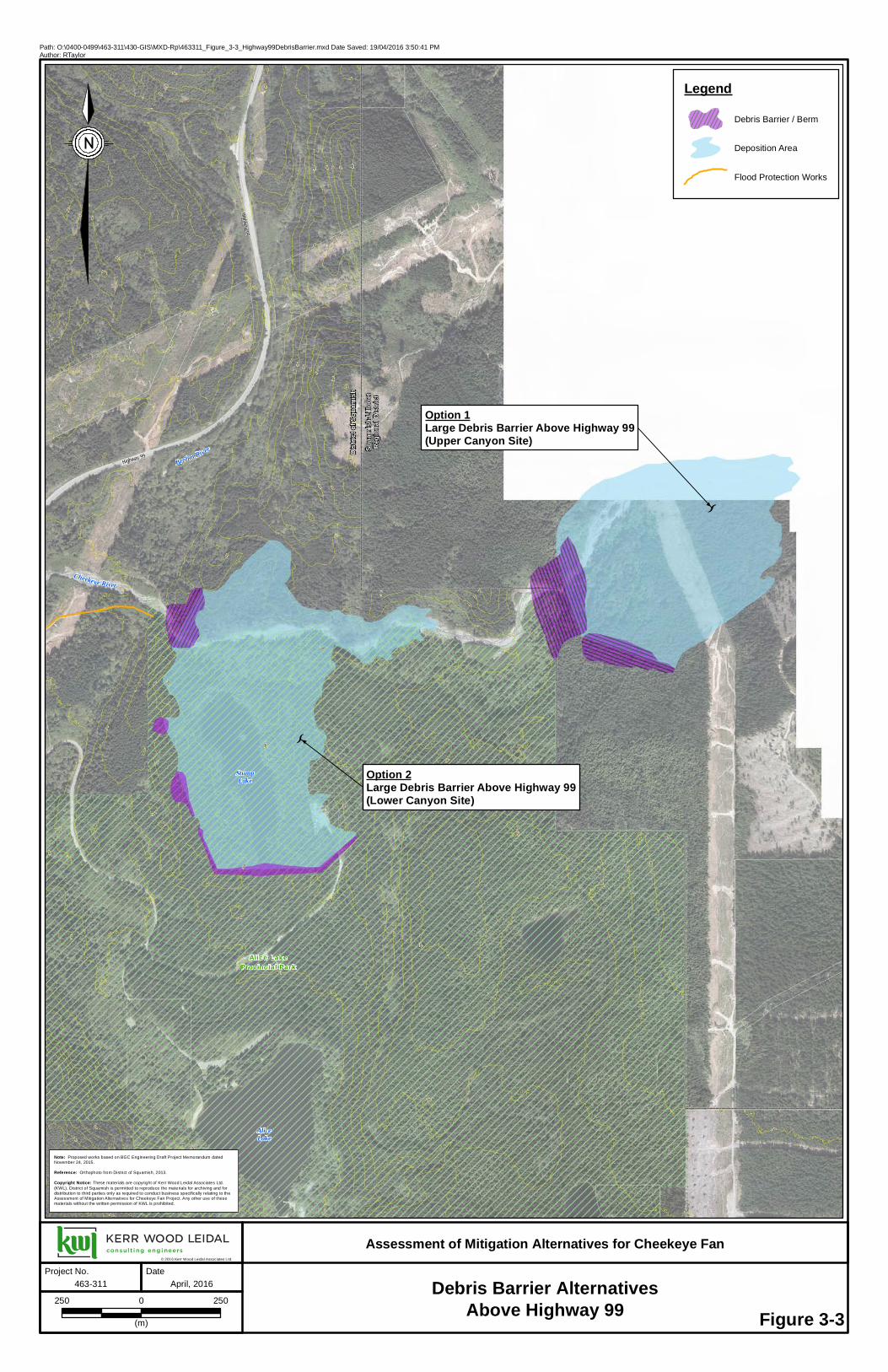
In total, 8 structural alternatives are identified plus the option of large-scale retreat. The structural alternatives include 5 debris basin/barrier alternatives, 2 berm alternatives, and 1 channelization option.
Combinations of options have not been considered at this stage. Some of the individual options have been previously evaluated and described as technically feasible by others. Other options have not been previously evaluated and technical feasibility is less certain. In the end, a combination of measures is likely to provide the most effective protection.
Section 4 provides a discussion of local issues that may be relevant to selecting an approach to mitigation. Section 5 provides a comparative evaluation of the options identified in Table 3-5.
Highway 99
StumpLake
AliceLake
Distri
ct of
Squa
mish
Squa
mish
-Lillo
oet
Regio
nal D
istric
t
Brohm River
Alice LakeProvincial Park
Highway 99
Cheekeye River
400
360
340
300280
260
240
220
200
380
320
340
320280
260240
220
340
320 300 280
260
240
340
320300280260
300
280
260
240
320300
280
320
300
280260
340320
440
420
400
300
280
240
220
240 220
220
200
200
180
300
280
360
360
320
280
420
340
300
320
280
300
280
260
260
260
260
240
240
220
220
220
200
200
200
160
140
420
320
320
260
200
200
200
Debris Barrier AlternativesAbove Highway 99
Assessment of Mitigation Alternatives for Cheekeye Fan
Path: O:\0400-0499\463-311\430-GIS\MXD-Rp\463311_Figure_3-3_Highway99DebrisBarrier.mxd Date Saved: 19/04/2016 3:50:41 PMAuthor: RTaylor
© 2016 Kerr Wood Leidal Associates Ltd.
463-311
250 2500
(m)
April, 2016
Figure 3-3
Note: Proposed works based on BGC Engineering Draft Project Memorandum datedNovember 24, 2015.
Reference: Orthophoto from District of Squamish, 2013.
Copyright Notice: These materials are copyright of Kerr Wood Leidal Associates Ltd.(KWL). District of Squamish is permitted to reproduce the materials for archiving and fordistribution to third parties only as required to conduct business specifically relating to theAssessment of Mitigation Alternatives for Cheekeye Fan Project. Any other use of thesematerials without the written permission of KWL is prohibited.
Project No. Date
LegendDebris Barrier / Berm
Deposition Area
Flood Protection Works
K
Option 1Large Debris Barrier Above Highway 99(Upper Canyon Site)
K
Option 2Large Debris Barrier Above Highway 99(Lower Canyon Site)

Squamish Valley Rd
Cheekeye River
SquamishLandfill
BC HydroSubstation
Brohm River
Dryd
en Cr
eek
Option 5
Option 3
400380360300280260
240220180160140
340320
200
200
160 120
100
80 60
240
180 140
360340
320
300
260
240
280
220
280
260
240
220
320
300 260
240
80 60
100
40
360
320
260
240
260
240
240
220
200
220
200
10080
60
40
360
340
340
320
80
60
120
100
220
200
340
100
80
420
340
340
340
320
320
320
320
300
280
280
280
280
280
260
260
240
220
220
220
200
200
200
200
160
160
160
160
120
100
100
100
80
8080
80
80
40
60
40
240
200
200
200
100
80
80
80
60
60
60
60
40
40
Assessment of Mitigation Alternatives for Cheekeye Fan
Path: O:\0400-0499\463-311\430-GIS\MXD-Rp\463311_Figure_3-4_DebrisBarrierAlternative_4_5_6.mxd Date Saved: 19/04/2016 3:52:57 PMAuthor: RTaylor
© 2016 Kerr Wood Leidal Associates Ltd.
463-311
250 2500
(m)
April, 2016
Figure 3-4
Project No. Date
LegendBerm
Deposition Area
Debris Barrier
High Ground
Fan Boundary
Flood Protection Works
Indian Reserve
Option 5Large Debris Barrier on Lower Fan(Below Dogleg)
Note: Option 4 works based on BGC Engineering Draft Project Memorandum datedNovember 24, 2015.
Reference: Orthophoto from District of Squamish, 2013.
Copyright Notice: These materials are copyright of Kerr Wood Leidal Associates Ltd.(KWL). District of Squamish is permitted to reproduce the materials for archiving and fordistribution to third parties only as required to conduct business specifically relating to theAssessment of Mitigation Alternatives for Cheekeye Fan Project. Any other use of thesematerials without the written permission of KWL is prohibited.
Debris Barrier Alternatives 4, 5 and 6
Option 3Debris Barrier Above Highway 99
K
K
Option 4Large Debris Barrier Below Highway 99(Dogleg Site)

ÏÎ
ÏÎ
Government Rd
Depot Rd
Ross
Rd
Squamish Valley Rd
Highway 99
Highway 99
Cheakamus River
Cheekeye RiverStumpLake
AliceLake
Squamish River
Brackendale
SquamishAirport
SquamishLandfill
BC HydroSubstation
Distr
ict of
Squ
amish
Squa
mish
-Lillo
oet
Regio
nal D
istric
t
Brohm Rive rHo
p Ran
ch Cr
eek
Meighan Creek
Judd Slough
Dryd
en C
reek Alice Lake
Provincial Park
CN Railway
CHEAK AM U S 1 1CHEAK AM U S 1 1
PO Q U I O SI N &PO Q U I O SI N &SKA M AIN 13SKA M AIN 13
WAIWAKU M 14WAIWAKU M 14
SEAIC HEM 1 6SEAIC HEM 1 6
SEAIC HEM 1 6SEAIC HEM 1 6
AIKW U CKS 1 5AIKW U CKS 1 5
440
420
400
380
360340320240200180160140120100
260
220
300
280
340240
220200
180160
140
8040
280260
12060
320
300
100
20
20018016012010080
220
140
60
300280
260
160
140120 100 80 60
340320280240
300260
280260
8060
240220
140
120
100806040
360340
280260260240
260240
220
200
200
180
10080
360
340 320300
260
240
60
40
80
240320
240
220
40
220
100
300
300
260
220
220
240
240
200
200 220
120
100
80
420
400
360
320
280
280
280
280
240
240
240
220
220
220
220
200
200
160
120
120
120
100
100
100
100
80
80
80
40
60
40
20
40
40
40
20
300
200
60
40
40
40
40
40
20
Berm and Channelization Alternatives
Assessment of Mitigation Alternatives for Cheekeye Fan
Path: O:\0400-0499\463-311\430-GIS\MXD-Rp\463311_Figure_3-5_BermAndChannelization.mxd Date Saved: 19/04/2016 3:54:11 PMAuthor: RTaylor
© 2016 Kerr Wood Leidal Associates Ltd.
463-311
250 2500
(m)
April, 2016
Figure 3-5
Project No. Date
LegendÏÎ Floodbox / Pump Station
Berm
Deposition Area
Fan Boundary
Flood Protection Works
Indian Reserve
Option 8Berm Above Brackendale
Option 7Mid-Fan BermK
Option 6Mid-Fan Channelization
Note: Option 6 channelization works based on BGC Engineering Draft ProjectMemorandum dated November 24, 2015.
Reference: Orthophoto from District of Squamish, 2013.
Copyright Notice: These materials are copyright of Kerr Wood Leidal Associates Ltd.(KWL). District of Squamish is permitted to reproduce the materials for archiving and fordistribution to third parties only as required to conduct business specifically relating to theAssessment of Mitigation Alternatives for Cheekeye Fan Project. Any other use of thesematerials without the written permission of KWL is prohibited.

Assessment of Mitigation Alternatives for Cheekeye Fan Final Report District of Squamish April 2016
3-14 \\libra25.burnaby.kerrwoodleidal.org\0000-0999\0400-0499\463-311\300-Report\Tables\20160413_CheekeyeFan_Table3-5.docx
Table 3-5: Primary Debris Flow Mitigation Alternatives for Cheekeye Fan Reference Description Commentary
1. Large Debris Barrier Above Highway 99 – Upper Canyon Site
Two sites have been identified where a (very) large debris barrier having up to 5.5M m3 could be constructed. These alternatives have been investigated to a conceptual level by BGC Engineering. Either site would likely involve a dam-like earthen structure (with concrete and steel components) in a canyon, allowing deposition within a natural basin upstream. Some berming on the flanks of the basin areas would be needed to prevent side outflow. Either site could also be built with a smaller volume as part of a multiple barrier approach.
With such a barrier, the debris flow hazard would be significantly mitigated upstream of Highway 99 to the benefit of all of the District’s mitigation priorities. Highway 99 would be protected in its current location and alignment. Such a barrier could adequately mitigate the debris flow hazard to all areas of the fan. As debris would be contained upstream, there would be no transfer of risk from one area to another. The sites are partly (lower canyon site) or fully (upper canyon site) within Alice Lake Provincial Park. The upper canyon site is also significantly outside of the District boundary, within SLRD. During a large debris flow, debris retained at the lower canyon site would infill Stump Lake. Some additional (complex and undefined) works would be required in the highway vicinity (perhaps berms and additional conveyance capacity under highway), and along the creek corridor (to be determined).
2. Large Debris Barrier Above Highway 99 – Lower Canyon Site
3. Debris Basin Above Highway 99
A large debris basin could be constructed immediately above Highway 99 through a combination of berming and excavation. The work would need to avoid impacting fish access to Brohm River. A small outlet structure would likely still be required. The upper limit of storage volume has not been considered. This alternative may not be able to achieve 5.5M m3 storage volume. A range of volumes could be considered as one component of a multiple barrier approach. At a small scale, this alternative could simply be a sediment basin.
This alternative would avoid Highway 99 modification or relocation. The power line crossing above Highway 99 would pass through the basin and may be an issue.
4. Large Debris Barrier Below Highway 99 – Dogleg Site
A large debris barrier could be constructed below the Highway 99 bridge. This would involve a barrier structure at the dogleg and a berm to high ground extending across Highway 99 near the Alice Lake access road. This site could also be built with a smaller volume as part of a multiple approach. This alternative was not investigated in detail for this report.
Highway 99 would have to be regraded to go over the berm, or be relocated on the upper fan with a new bridge upstream of the existing crossing. The Highway intersection with Alice Lake access road / Squamish Valley Road may also need to be modified or relocated. These roadwork issues could be significant, and would fall under provincial jurisdiction. The existing Highway 99 bridge area would remain vulnerable to closure. The power line crossing below Highway 99 would pass through the basin and may be an issue. Fish access to Brohm River would need to be preserved.
5. Large Debris Basin on Lower Fan – Below Dogleg
A debris barrier could be built below the dogleg, with berms to high ground on either side. Unless work is done in the vicinity of Highway 99 to prevent debris flow avulsion down the highway, this barrier would only be effective as a downstream component of a multiple barrier approach. This alternative was not investigated in detail for this report.
The multiple berm sections required under this alternative would be spread over a considerable distance, potentially resulting in an operational difficulty. This alternative would be aided by expansion of the District landfill to the east (the landfill would act as a berm). Fish access to Brohm River would need to be preserved.
6. Mid-Fan Channelization (to Squamish River)
Channelization of the Cheekeye River (as either realignment of the existing mainstem or, more likely, as an overflow channel) could be achieved through some combination of channel excavation and berm construction. The objective would be to deflect debris flows away from Brackendale toward Squamish River. There may be a variation to commence the channelization works at the dogleg rather than above Highway 99. This alternative was not investigated in detail for this report.
Highway 99 would have to be regraded to go over the berm, or be relocated on the upper fan with a new bridge upstream of the existing crossing. The Highway intersection with Alice Lake access road / Squamish Valley Road may also need to be modified or relocated. These roadwork issues could be significant, and would fall under provincial jurisdiction. The existing Highway 99 bridge area would remain vulnerable to closure. The works would cross a BC Hydro transmission line, Squamish Valley Road, and Government Road. Issues would have to be addressed in each case. In the absence of other measures, this alternative would not significantly protect Cheakamus I.R. No, 11 or the confluence residential development. The works would direct debris flow toward the Squamish Airport. These works would direct debris flow toward Squamish River above a major river constriction, which may lead to hydraulic complications. Transfer of risk is a significant concern of this alternative.
7. Mid-Fan Berm (to Squamish River)
This option would involve a series of large berms across the fan, commencing at high ground east of Highway 99, crossing the highway and terminating north of IR 14. Significant variations in alignment could be accommodated. A number of supplemental berms could be constructed for specific purposes, if desired. This alternative was previously investigated to a preliminary design level by KWL in 2003.
Highway 99 would have to be regraded to go over the berm. The Highway 99 bridge area would remain vulnerable to closure. The works would cross a BC Hydro transmission line and Government Road. Issues would have to be addressed in each case. In the absence of other measures, this alternative would not benefit Cheakamus I.R. No. 11 or other development at the Cheekeye River / Cheakamus River confluence. The works would direct debris flow toward the Squamish Airport and a section of railway between the airport and IR 14. These works would direct debris flow toward Squamish River above a major river constriction, which may lead to hydraulic complications. Transfer of risk is a possible concern for this alternative.
8. Berm Above Brackendale
This alternative would involve a berm around upper Brackendale. Significant variation in alignment could be accommodated. A number of supplemental berms could be constructed for specific purposes, if desired. This alternative was not been investigated in detail for this report.
On the west side of Brackendale, this alternative would need to address (to some extent) the issues noted above for Alternatives 6 and 7 at Government Road and CP Railway, as well as the hydraulic issue with Squamish River. On the east side of Brackendale, this alternative would need to address issues associated with proximity to Highway 99 and crossing Depot Road (primary access to Brackendale). It would also require integration with diking, floodplain and drainage issues on lower Dryden Creek to the pump station. Some property acquisition might be considered in order to improve the berm alignment.
9. Large-Scale Retreat Acquire sufficient lands on the fan to reduce the overall risk to ALARP. This may include isolated developments as well as a significant portion of Brackendale. Areas that are not acquired would need to be appropriately protected.
The extent and cost of this alternative would be significant but cannot be assessed in detail without further risk assessment work. Implementation could be phased over a multi-decadal timescale. Small-scale managed retreat may be combined with several of the other alternatives as part of a comprehensive mitigation plan.

4-1
DISTRICT OF SQUAMISH Assessment of Mitigation Alternatives for Cheekeye Fan
Final Report April 2016
463.311-300
Discussion of Local Issues 4.This section provides commentary on many local issues that should be considered in developing and implementing a mitigation alternative for the Cheekeye Fan. This list of issues is not considered to be comprehensive. Additional issues may be identified following further work with the District of Squamish and other parties.
4.1 Engineering Issues Some key engineering issues are identified and discussed below.
• Large Debris Barriers: The largest debris barrier constructed to date in BC has a debris storage capacity (volume) of less than 100,000 m³. It should be recognized that the large structures being contemplated for the Cheekeye Fan would be an order of magnitude larger and would be among the largest of this type in the world. As such, the technology may not be considered to be “tested and proven” for coarse debris flows such as may occur on the Cheekeye River. Despite the different characteristics, some lessons may be learned from the large lahar (fine volcanic debris flow) retention works on the North Fork Toutle River in Washington State (downstream of Mount St. Helens).
• Multiple Barrier Approach: It is generally accepted that a multiple barrier approach to mitigation will provide more effective mitigation for debris flow situations than a single-barrier approach. Reducing reliance on any single structure increases the overall system reliability and redundancy. For the Cheekeye Fan, the best technical solution may be a combination of different structural measures.
• Consideration of “Small” Debris Flows: Depending on how they are designed, large barriers may pass “small” debris flows up to perhaps the 100-year return period. This will present a residual hazard to that would require further consideration to provide appropriate protection to downstream areas (particularly along the river corridor).
• Sediment Management: Ongoing sediment transport and management issues need to be addressed for any structural mitigation option. Sediment transported by the “normal” clear-water flow regime may either be passed through the structure or retained. Retention can result in changes to the downstream channel and create challenges with regard to reserve capacity (discussed below). Sediment management may be aided through establishing a sediment basin (a site above Brohm River confluence has been proposed previously, this would be good from a fisheries perspective). Sediment management efforts downstream of Brohm River would need to address fisheries issues. Some relevant background infraction on sediment management on the Cheekeye River is provided in Appendix C in the forum of a 2014 KWL Technical Memorandum.
• Reserve Capacity: For any mitigation scheme that is sized for a specified event volume, consideration should be given to adding an appropriate reserve capacity to allow for deposition of material that has not been able to be removed on a timely basis, particularly “small” debris flows and routine sediment transport. Increasing the reserve capacity may reduce the frequency of sediment removal.
• Area Protected: Different types and locations of mitigation structures will protect different portions of the fan. For example, large debris barriers at/above Highway 99 will reduce the risk to the whole fan. In contrast, alternatives involving a mid-fan berm would reduce the risk to the Brackendale

4-2
DISTRICT OF SQUAMISH Assessment of Mitigation Alternatives for Cheekeye Fan
Final Report April 2016
463.311-300
area, but would leave the upper fan and other areas outside the berm alignment largely unprotected.
• Transfer of Risk: It is important that a mitigative approach not inappropriately transfer risk from one area to another. In this regard, debris barrier alternatives are generally considered preferable to berming alternatives (at least some portion of the volume will be stored, rather than deflected). For example, a mid-fan berm may reduce the risk to Brackendale by redirecting a debris flow toward another at-risk area.
• ALARP Principle: In order to meet the ALARP principle, not only must the computed risk be within the ALARP zone of an F-N diagram, but it needs to be established that the cost to further mitigate the risk would be grossly disproportionate to the benefit gained, or that the solution is impractical to implement. No specific guidance is available as to how “grossly disproportionate” should be defined in the context of Cheekeye Fan debris flow risk mitigation.
• Cheakamus River: Options that “funnel” debris flows down the Cheekeye River may result in massive sediment input to the Cheakamus River at the mouth of the Cheekeye River. This area is a critical hydraulic reach. Such an occurrence could obstruct the Cheakamus River, increasing upstream flood levels. It would also increase the risk of a river avulsion toward IR 11. In addition, private works such as the existing left bank dike downstream of the Cheakamus River (Fergie’s) Bridge may have the unanticipated consequence of exacerbating debris flow risks.
• Squamish River: Large debris flows on the Cheekeye Fan would convey debris flow material to Squamish River at or upstream of a critical “bottleneck” in the Squamish River (at Aikwucks I.R. No. 15). This may increase the probability of a dike breach that may impact the above-noted south Brackendale floodway area. Options that involve channelization and/or berming could further increase this risk.Land and Infrastructure Development Issues
4.2 Land and Infrastructure Development Issues Some key issues associated with land and infrastructure development are identified and discussed below.
• South Brackendale: Approximately half of Brackendale at the base of the Cheekeye Fan is also within the Squamish River secondary floodway (i.e. in the event of a dike breach). This area has been flagged for special attention in the IFHMP. It may be appropriate to integrate floodplain management and debris flow mitigation considerations for this area.
• Cheekeye River / Cheakamus River Confluence: The Cheekeye River / Cheakamus River confluence encompasses a low-lying area of the Cheakamus River floodplain at and opposite the mouth of the Cheekeye River. Development includes the Cheekeye community on Cheakamus I.R. No. 11 as well as Sunwolf Resort and other private development. The area is subject to hazards from both the Cheakamus River and the Cheekeye River, which may occur at the same time or as independent events. A private dike has been previously constructed on the left bank of the Cheakamus River downstream of the Squamish Valley Road (Fergie’s) bridge and may have created a transfer of risk. A costly protective dike proposed for the Cheekeye community may encounter similar issues, as well as challenges associated with accommodating relief flow in the event of a bridge blockage. Any reduction in the magnitude of Cheekeye River debris flow magnitude at the river confluence would reduce the hazard to this community. Any “funneling” of debris flow material down the Cheekeye River would increase the hazard to this community. The IFHMP recommends that local-scale issues at the Cheekeye River / Cheakamus River confluence

4-3
DISTRICT OF SQUAMISH Assessment of Mitigation Alternatives for Cheekeye Fan
Final Report April 2016
463.311-300
be addressed once both the IFHMP River Flood Risk Mitigation Report and this report on Cheekeye Fan debris flow mitigation options are complete.
• Isolated Developments: There are other isolated developments on the lower fan in the vicinity of the CN Railway bridge, above the Cheakamus River floodplain. These would be difficult to protect, especially if cost-effectiveness is a consideration.
• Garibaldi Estates: The finer, more mobile fraction of debris flow runout material could extend beyond the base of the Cheekeye Fan into parts of the Garibaldi Estates community on the Mamquam River fan.
• Land Use Potential: Options that protect a greater portion of the mid to upper fan may allow consideration of a greater range of future land uses and community development.
• Retreat: Various degrees of retreat could be considered to mitigate areas of particularly high risk. Large-scale retreat could be considered as an alternative to major mitigation structures. Smaller-scale managed retreat (i.e., a staged process targeting specific blocks or buildings) may be appropriate as a supplemental measure under any of the structural mitigation alternatives.. Managed retreat may be most applicable in areas where the hazard is particularly severe, and/or where the incremental cost to protect the development is greater than the cost to retreat (i.e., near the Cheekeye River / Cheakamus River confluence).
• SLRD Territory: The upper Cheekeye Fan is beyond the District of Squamish boundary, within SLRD territory. The upper canyon debris barrier would extend into this territory and would need to address any resultant issues.
• Other Interests: Some issues associated with lands held by the BC Ministry of Transportation and Infrastructure, Indian and Northern Affairs Canada, CN Rail, and BC Hydro are outside District’s jurisidcation. These stakeholders have not (yet) been directly consulted on the contents of this assessment. Interests associated with specific infrastructure owned or operated by these parties are addressed in Section 5.
4.3 Existing Infrastructure Issues Some key issues associated with existing infrastructure on the fan are identified and discussed below.
• Highway 99: The current configuration of Highway 99 near the fan apex could allow a debris flow to follow the highway corridor into the heart of Brackendale. To be effective, most structural alternatives would require at least some modification of Highway 99 to mitigate this possibility. Modifications could involve regrading the highway to incorporate a berm crossing, adding flow-through provision under the highway, or complete relocation of the highway to a higher-elevation alignment (likely with a new bridge over the river). Some of these provisions could be very costly, complex and disruptive. Road intersections with Squamish Valley Road and the Alice Lake access road may also require modification.
• Economic Impacts: It has been estimated that the economic cost of a Highway 99 closure may be in the order of $1M per day. The effects of a highway (or railway) closure would extend throughout the Sea to Sky corridor. Other local economic impacts would include infrastructure damage, general disruption, loss of employment, emergency response, and building recovery.
• Primary and Secondary Road Access: Under any alternative, it is important that access into various residential areas be preserved and reasonably protected. Squamish Valley Road (including

4-4
DISTRICT OF SQUAMISH Assessment of Mitigation Alternatives for Cheekeye Fan
Final Report April 2016
463.311-300
Fergie’s bridge) is the only access to the Squamish Valley and Paradise Valley. Brackendale is accessed via Government Road (north and south) and Depot Road.
• Dikes: Cheekeye River debris flows that reach the lower fan would back up behind the existing dyke system along Judd Slough, Squamish River, Harris Slough and Mamquam River. This may impact the dike.
• Pump Stations: Downstream pump stations and floodboxes are likely to suffer from sedimentation during and after a debris flow event. This may result in ongoing operational problems.
• Squamish Landfill: The ongoing landfill development could be integrated into some barrier and berm options to effectively provide low-cost fill. This may give rise to some long-term options.
• Squamish Airport: The airport is not intended to be a focus for mitigation, but would require consideration under certain options (berm and channelization in particular) to ensure compatibility.
• CN Railway: The railway traverses the lower fan and crosses the Cheekeye River just above the confluence. The railway bridge has been frequently impacted by floods and sedimentation events, with periodic service disruptions. The railway would benefit from reduced hazard in the bridge vicinity.
• Industrial Areas: There are some scattered industrial developments along the lower Cheekeye Fan, upland of the CN Railway. These are not intended to be a focus for mitigation, but would also require consideration under certain options (berm and channelization in particular) to ensure compatibility.
In evaluation of alternatives, it should be recognized that some alternatives have the advantage of protecting more infrastructure than other alternatives.
4.4 Environmental and Community Issues Some key environmental and community issues are identified and discussed below.
• Aquatic Habitat Impacts: Instream structures can impact fish access along a creek or river. In this region, this issue is most critical for migrating salmon. Maintaining salmon access from Cheakamus River to Brohm River via Cheekeye River is considered a critical issue for any proposed structure on Cheekeye River. Some options would involve a berm across Dryden Creek, for which it would be critical to address fisheries issues as well. Changes in the sediment transport regime can also affect aquatic habitat and productivity.
• Terrestrial Habitat Impacts: Some structural mitigation options may disrupt wildlife movement along certain corridors, such as along the Cheekeye River.
• Overall Environmental Impact: Any approach must include a broad assessment and mitigation of environmental impacts (fish, wildlife, sensitive habitats, etc.). A common guideline is “no net loss”.
• Regulatory Challenges: Some options may trigger formal environmental impact assessment processes. Virtually all options would require approvals pursuant to the Water Act and Dike Maintenance Act.
• Social and Community Impacts: There is no known work to date on the subject of social vulnerability or social risk fromo Cheekeye Fan debris flow hazards (e.g., issues associated with displacement and sheltering of vulnerable populations, loss of employment, or interruption of key community services).

4-5
DISTRICT OF SQUAMISH Assessment of Mitigation Alternatives for Cheekeye Fan
Final Report April 2016
463.311-300
• Recreation/Trail Impacts: There are many trails through the Cheekeye Fan area that are popular for hiking, wildlife viewing and mountain biking. It is important to minimize/mitigate impacts to the trail system.
• Aesthetics: While aesthetics do not usually govern the choice of a structural mitigation option, it is important to recognize that some options will have a more substantial visual impact for residents and travellers (e.g., along Highway 99) than others.
• Alice Lake Park: Options that are within the park, or could impact park land or use, would require review and approval by BC Parks.
4.5 Operational Issues Key operational issues are identified and discussed below.
• Public Safety: Debris barriers invariably include high vertical structures that result in a significant fall hazard. Careful attention to design, fencing and signage issues is needed to maintain an appropriate level of public safety (and worker safety) and reduce liability of involved parties.
• Financial Considerations: Large-scale mitigative works, such as are being considered for the Cheekeye Fan, are expensive to construct, operate, maintain, restore after an event and (eventually) decommission or replace. A key cost component will be regular removal of accumulated sediment. Operation and maintenance costs are of critical importance as they constitute the long-term costs to the community after the mitigation works are built.There needs to be an appropriate long-term funding mechanism to cover the full range of life-cycle costs.
• Operation and Maintenance Logistics: Any works constructed need to have land tenure and equipment access. A maintenance authority needs to be established (most likely the District of Squamish in this case). The maintenance authority will likely be obligated to provide regular inspection reports to a regulator such as the Ministry of Forests, Lands and Natural Resource Operations’ Dam Safety Section or the provincial Inspector of Dikes.
• Post-Event Recovery: An approach must be identified to safely access, assess, and restore the structural mitigation works after a large event. This should include consideration of whether protection will be restored by removing infilled debris, or by constructing more structures. The role, if any, of senior government disaster relief financial assistance should be considered.

5-1
DISTRICT OF SQUAMISH Assessment of Mitigation Alternatives for Cheekeye Fan
Final Report April 2016
463.311-300
Evaluation of Primary Debris Flow Mitigation Alternatives 5.This section describes the development of a matrix tool used to perform an initial qualitative evaluation of primary debris flow mitigation alternatives for Cheekeye Fan. Use of the word ‘primary’ implies that the measures evaluated would be the most significant – but not the only – element(s) in a ‘comprehensive mitigation plan’. Various supplemental measures would be required for each alternative.
For the purpose of comparison and discussion, the matrix also includes the non-structural alternative of large-scale retreat.
This section also describes the application of the matrix to evaluate the identified alternatives and identifies preferred mitigation alternatives.
5.1 Development of Evaluation Matrix The list of issues in Section 4 was refined in consultation with District staff and Council to generate preliminary evaluation criteria and corresponding weighting factors. The criteria and weighting factors are focussed on the primary objective of protecting major existing development areas.
The evaluation criteria and weighting factors are listed below.
Evaluation Criteria Weight
Economic
Capital Cost 5 Capital Cost Sharing Potential 3 Weighting Factors Operation and Maintenance Costs 5 5 extremely important Post-Event Recovery Costs 4 4 very important
Environmental
Fish Impacts 4 3 somewhat important Disturbed Area 3 2 minor importance Wildlife Corridor Impacts 1 1 negligible importance Sensitive Habitat Disturbance 3
Social – Risk
Risk Reduction 5 Unmitigated Risk Transfer 4 Land Use Potential 4 Economic Risk Reduction 3 Additional Assets Protected 2
Social – Design
Design Confidence 4 Post Event Restoration Options 4 Infrastructure Impacts 3 Regulatory Challenges 3
Social – Other Aesthetics 1 Cultural / Archeological Impacts 2 Recreation / Trail Impacts 1
A blank copy of an evaluation matrix incorporating these criteria and weighting factors is provided in Appendix A. The matrix sheet includes more detailed descriptions of the evaluation criteria and scoring system (on a scale of 1 to 3 for each criteria). The matrix has been developed under a triple bottom line concept in that it incorporates economic, environmental and social aspects.

5-2
DISTRICT OF SQUAMISH Assessment of Mitigation Alternatives for Cheekeye Fan
Final Report April 2016
463.311-300
In applying the evaluation matrix, it is important to recognize that results are integrated across all criteria to provide an overall score. The weighting factors give appropriate emphasis to the most important criteria; however, there may still be circumstances where it is appropriate to compare scores for individual criteria.
5.2 Evaluation of Primary Debris Flow Mitigation Alternatives Appendix B includes a copy of the completed evaluation matrix, with the scores shown being the average of the three independent scores (Mike Currie, Gary Buxton, David Roulston). Some effort was made to resolve scores having a significant variation from the three individual scores, particularly for the highest ranking alternatives. The matrix results are considered inexact in that some criteria have not been researched in detail (i.e., environmental impacts, archaeological impacts, etc.), and economic criteria have only been considered qualitatively.
The matrix evaluations were rounded to the nearest even number, recognizing the inexact nature of this type of analysis. Of the primary debris flow mitigation alternatives, the matrix evaluation divides the alternatives into three groups having similar scores as follows:
• highest ranking: two debris barrier sites above highway, mid-fan berm, Brackendale berm; • middle ranking: two debris basin sites below highway; and • lowest ranking: mid-fan channelization.
An evaluation matrix is an appropriate screening method to identify the most promising primary debris flow mitigation measures for Cheekeye Fan. However, it is important to note that the outcome is dependent on the selected criteria, weightings, scoring system, and the subjective opinion of those assigned to complete the scoring. Other methods of screening may also be valid, and may produce slightly different results.
Table 5-1 provides high-level commentary on the results of the evaluation matrix for each primary mitigation alternative. Further discussion of the highest-ranking alternatives is provided in Section 5.3.

Assessment of Mitigation Alternatives for Cheekeye Fan Final Report
District of Squamish April 2016
5 - 3 \\libra25.burnaby.kerrwoodleidal.org\0000-0999\0400-0499\463-311\300-Report\Tables\20160413_CheekeyeFan_Table5-1.docx
Table 5-1: Commentary on Evaluation Matrix Results
Alternative Rank (Out of 9) Discussion Summary Comment
1. Large Debris Barrier Above Highway 99 – Upper Canyon Site
3(T) The debris barrier sites above Highway 99 rate quite high. They provide the greatest level of risk reduction (in fact, protect all areas downstream), do not transfer risk, could allow for community development, provide cost-sharing opportunities, and have virtually no infrastructure impacts. The most significant drawback is cost (for construction, O&M, and post-event restoration). There may also be some regulatory challenges.
Debris barriers above Highway 99 are considered promising alternatives based on current criteria. The upper canyon site appears most promising of the two.
2. Large Debris Barrier Above Highway 99 – Lower Canyon Site
5(T)
3. Debris Basin Above Highway 99 2
While this measure ranks high, it would not easily provide sufficient protection on its own to be considered as a primary measure. To provide a debris basin of sufficient size would essentially require the incorporation of Alternative 1 or 2.
This measure may be best applied as part of a package of measures, possibly in the form of a sediment basin.
4. Large Debris Barrier Below Highway 99 – Dogleg Site
7 Debris barrier sites below Highway 99 appear less effective than the sites above Highway 99. In comparison, they have greater environmental impacts, do not protect Highway 99, and would be more visible.
Barrier options below Highway 99 are considered less favourable alternatives based on current criteria. Debris barrier sites above Highway 99 are more favourable.
5. Large Debris Basin on Lower Fan – Below Dogleg
8
6. Mid-Fan Channelization (to Squamish River)
9
This measure has many challenges, including high cost (for construction, O&M, and post-event restoration), a high level of disturbance, design confidence, regulatory challenges, infrastructure impacts, aesthetics and trail impacts. Delivery of debris directly to the Squamish River above a key river constriction would also transfer risk.
This option is considered less favourable based on current criteria.
7. Mid-Fan Berm (to Squamish River) 3(T) These two berm alternatives rank high. The mid fan berm ranks higher as it has
fewer conflicts with existing development and infrastructure, could allow for some community growth, and has some cost-sharing potential. The mid fan berm would have to address challenges with crossing Highway 99 and Dryden Creek. Neither berm scenario would protect infrastructure on the upper fan, nor protect the confluence area including IR 11. Land acquisition may be a challenge with both berm scenarios.
The mid fan berm is considered a promising alternative based on current criteria. The exact berm alignment is highly flexible. Lower berm options toward Brackendale may be considered as a variation if there is an interest in proceeding with a berm.
8. Berm Above Brackendale 5(T)
9. Large-Scale Retreat 1
Shows that large-scale retreat would be effective as mitigation. Given that the necessary degree of retreat is not known, the cost of property acquisition cannot be assessed, but would be significant. There is no apparent potential for cost-sharing. It would not allow for community growth, nor protect existing infrastructure. On the positive side, there would be minimal technical issues and significant areas could be reclaimed to their natural state for less-intensive land use (e.g., recreation and resource applications).
This alternative appears to be technically favourable but cost-sensitive. The extent of retreat should be assessed before making a final decision. Unless there is strong support and funding for large-scale retreat, this measure may be best applied on a small scale as part of a package of measures.

5-4
DISTRICT OF SQUAMISH Assessment of Mitigation Alternatives for Cheekeye Fan
Final Report April 2016
463.311-300
5.3 Comparison of Most Promising Primary Mitigation Alternatives The evaluation process highlighted two structural alternatives as the most promising primary mitigation measures: the mid fan berm and the upper canyon debris barrier. These two alternatives are compared in Table 5-2, with the advantages shown for each. As noted above, this comparison is considered inexact in that some criteria have not been researched in detail.
Table 5-2: Advantages for Mid Fan Berm and Upper Canyon Debris Barrier Criteria Mid Fan Berm Upper Canyon Debris Barrier
Economic
• anticipated lower capital cost (to be confirmed)
• anticipated lower O&M costs (to be confirmed)
• lower post-event recovery costs • may be possible to phase
implementation over time
• greater cost-sharing potential
Environmental
• less fisheries impacts • less wildlife corridor impact • less sensitive habitat disturbance • less disruption of natural river
processes
• less total disturbed area (or “footprint”)
Social - Risk
• greater overall level of risk reduction
• minimal transfer of risk • allows for community
development (land use) • significant economic risk
reduction • protects significant additional
assets
Social – Design
• traditional technology resulting in more reliable design confidence
• easier post-event restoration • less regulatory challenges
• minimal impacts for existing infrastructure
Social – Other
• less aesthetic impact • smaller footprint avoids
conflicts with cultural sites and recreational trails

5-5
DISTRICT OF SQUAMISH Assessment of Mitigation Alternatives for Cheekeye Fan
Final Report April 2016
463.311-300
Commentary on Mid-Fan Berm In summary, the mid fan berm has a significant advantage in the economic criteria, and lesser advantages in the environmental, and social-design criteria. Of the assets identified as high priority in Section 3, the mid fan berm would protect Brackendale, Waiwakum I.R. No. 14, Seaichem I.R. No. 16, Kowtain IR 17, and Garibaldi Estates.
Some limitations, challenges and/or disadvantages of the mid fan berm compared to the upper canyon debris barrier are noted as follows:
• Cheakamus I.R. No. 11 and the confluence residential area would not be protected;
• other important assets would also not be protected, including Highway 99, CN Railway, Squamish Airport, Squamish Valley Road and Squamish landfill;
• undeveloped lands north of the berm would remain unprotected, and not suitable for development;
• extending the berm alignment across Highway 99, Dryden Creek, Government Road and the CN Railway would present significant technical challenges; and
• the berm may transfer risk by redirecting debris flows that would otherwise reach Brackendale toward the airport area.
The mid-fan berm concept allows for some flexibility in alignment. The structure could be shifted south, possibly as far as the “berm above Brackendale” option.
The mid fan berm would require relatively few complementary structural measures to develop a comprehensive mitigation plan (such works would likely comprise channel works and sediment management works along the river corridor).
The mid fan berm is not compatible with the proposed new development as presently conceived. It may be compatible with a smaller or reconfigured proposed development limited to the Ross Road area.
Commentary on Upper Canyon Debris Barrier The upper canyon debris barrier has a significant advantage in the social-risk criteria, and a slight advantage in the social-other criteria. It would offer significant and equal protection for all of the assets identified as high, medium and low priority in Section 3.
Some limitations, challenges and/or disadvantages of the upper canyon debris barrier compared to the mid fan berm are noted as follows:
• challenges associated with being in SLRD territory and requiring work within Alice Lake Provincial Park would need to be addressed;
• Cheakamus I.R. No. 11 and the Cheekeye River / Cheakamus River confluence would be significantly protected against large Cheekeye River debris flows, but may remain vulnerable to smaller debris flows that pass through the debris barrier (these areas would also remain vulnerable to flooding and erosion from Cheakamus River under all mitigation scenarios);
• environmental approval requirements are not well known, and may result in a significant challenge;
• post-event restoration would primarily involve instream work to clear the debris barrier (costly, challenging and environmentally-sensitive);

5-6
DISTRICT OF SQUAMISH Assessment of Mitigation Alternatives for Cheekeye Fan
Final Report April 2016
463.311-300
• the complex and unprecedented design may be expected to add cost and time to the design, review and approval processes; and
• a debris barrier structure does not easily lend itself to phased construction over a period of years.
While this screening-level evaluation considers only a single large debris barrier above the fan, it may ultimately be preferable to construct multiple smaller structures. This is discussed further in Section 6.
The upper canyon debris barrier would require significant complementary structural measures to develop a comprehensive mitigation plan (possibly including sediment basin, berm above highway, works in highway bridge area, berms below highway, and channel works).
BMS Cheekeye One Projects has indicated that it is willing to pay the capital cost for the upper canyon debris barrier, and work with the District to establish a funding mechanism in the proposed new development area to cover operation and maintenance costs. This demonstrates that the proposed new development is also compatible with the debris barrier. If the financial arrangement suggested by BMS Cheekeye One Projects is confirmed, it may be possible to implement the upper canyon debris barrier alternative at minimal up-front cost to the District.
While the cost-sharing opportunity suggested by BMS Cheekeye One Projects could cover up-front capital costs (and potentially operation and maintenance costs), the District would presumably be responsible for any major response, post-event recovery, and/or future reconstruction costs. Because both existing and new development would remain in place in perpetuity, the District may wish to incorporate structural design life and any potential costs for decommissioning and replacement into its decision framework.
5.4 Commentary on Large-Scale Retreat Large-scale retreat does not lend itself to easy comparison with the structural mitigation options. As suggested by its high score in the evaluation matrix, large-scale retreat has many positive aspects, and is probably the most effective long-term approach to reducing risk on the Cheekeye Fan. However, the economic and social costs of large-scale retreat may be prohibitive, and full implementation would likely span several decades.
The District may wish to investigate the scope, scale, cost and implications of risk mitigation through large-scale retreat more fully before selecting an approach for the Cheekeye Fan. Recent discussions with council related to the IFHMP suggest that the District’s constrained land base will be a significant consideration in any debate that involves gradual but certain retreat from existing developed areas. The District may be forced to choose between densifying less vulnerable floodplain areas versus the Cheekeye Fan.
Small-scale managed retreat may play a targeted role in a comprehensive plan built around any of the primary mitigation measures noted above.

6-1
DISTRICT OF SQUAMISH Assessment of Mitigation Alternatives for Cheekeye Fan
Final Report April 2016
463.311-300
Future Considerations 6.This section provides some information to assist the District in moving forward.
The District is understood to have accepted the recommendation from Cheekeye Expert Panel #2 to use quantitative risk assessment based on the F-N diagram as a basis for determining tolerable risk, and the scale of mitigation measures. Ultimately, it will need to be determined whether to supplement the risk criteria with a design return period approach for the creek corridor. It also needs to be determined how to apply the qualitative component of ALARP (the cost to further mitigate the risk would be grossly disproportionate to the benefit gained, or the solution is impractical to implement). These aspects will be important in building a comprehensive mitigation plan that is based on a primary mitigation alternative.
This report does not provide a recommendation as to whether the proposed new development should be approved or not approved. However, one objective of this report is to assist decision-makers and stakeholders in making this important decision.
The proposed new development would be compatible with, and could financially support implementation of, the upper canyon debris barrier. As proposed, the new development is not compatible with the mid-fan berm or large-scale retreat. The development decision therefore becomes inseparable from the decision on risk mitigation.
Section 6.1 provides information that the District should consider when responding to the proposed new development.
Section 6.2 addresses the scenario of the proposed new development proceeding in the short term. Presumably this would incorporate a large debris barrier above the fan as noted in the previous section.
Section 6.3 addresses the scenario of the proposed new development not proceeding in the short term.
Section 6.4 identifies some other implications that the District may wish to consider.
6.1 Response to Proposed New Development As noted in Section 5, BMS Cheekeye One Projects has proposed that its new development could cover the capital cost of a large debris barrier. BMS Cheekeye One Projects has also indicated that is willing to work with the District to implement a funding mechanism to cover ongoing operation and maintenance costs. This would be a major advantage to the District in the following respects:
• there would be no significant capital costs incurred by the District for initial construction (presuming that all the components needed to develop a comprehensive mitigation plan are included);
• all existing development and infrastructure would be significantly protected without transferring risk from one area to another;
• an appropriate level of community redevelopment could be considered in and around Brackendale (subject to District planning considerations, as well as Squamish River flood constraints and evaluation as part of the final Cheekeye Fan QRA); and
• a mechanism for financing long-term operation and maintenance could be provided.
The evaluation of primary mitigation alternatives in Section 5 identified that the large debris barrier alternative was one of the most promising measures. While the mid fan berm alternative ranked slightly higher in the evaluation matrix, the modest technical advantages are offset by the cost-sharing potential.

6-2
DISTRICT OF SQUAMISH Assessment of Mitigation Alternatives for Cheekeye Fan
Final Report April 2016
463.311-300
It would be appropriate for the District to continue its work with BMS Cheekeye One Projects to further investigate and refine this alternative. Primary objectives should include confirming the preliminary findings and resolving questions raised in this report with respect to the upper canyon debris barrier, as well as seeking a more complete understanding of the long-term implications to the District.
Further investigating the large debris barrier option in conjunction with the proposed new development should be contingent on the District accepting the following principles:
• the location, concept, and scale of the proposed new development are potentially acceptable from the perspectives of land use planning and community development;
• the concept of large-scale retreat is not favoured by the District at this time;
• quantitative risk assessment is accepted by the District as the primary tool for assessing the safety of the proposed development;
• the details of a clear and defensible approach to implementing, peer reviewing, and comparing the results of the QRA against acceptable risk criteria will be established and agreed in advance with BMS Cheekeye One Projects;
• the District would be willing to accept a large debris barrier above the fan as the primary mitigation measure; and
• the District is willing to accept long-term operation and maintenance responsibility for all works to be constructed, including any unanticipated and unfunded costs for repair, cleanout or reconstruction.
The District may also wish to consider in advance whether funding of the operation and maintenance program would extend from the proposed new development to other existing development or redevelopment areas that also would benefit from the mitigation works.
Further to the above, the District must understand that, even if a fully-funded mechanism for long-term operation and maintenance is implemented, a large debris flow could occur before the fund builds to a level capable of covering the costs of restoring and rehabilitating the structural mitigation works. Once the new development is in place, the District would have little choice but to complete the works and cover any temporary funding shortfall. A plan to address this issue should be developed to ensure that the District will be able to restore the intended level of protection without incurring a disproportionate financial burden. It is not known whether there would be any possibility of emergency management funding from senior governments.
It should also be recognized that a large debris barrier may not adequately protect all existing development and infrastructure. It may prove more cost-effective to pursue managed retreat in some areas, while implementing complementary protection in others (e.g., the Cheekeye community on Cheakamus I.R. No. 11). These considerations (and others such as emergency planning) would need to be defined as part of a comprehensive mitigation plan that could then be incorporated into District policy and guidelines.

6-3
DISTRICT OF SQUAMISH Assessment of Mitigation Alternatives for Cheekeye Fan
Final Report April 2016
463.311-300
6.2 Considerations if Proposed New Development Proceeds If the proposed new development proceeds in the short term, some key steps related to debris flow mitigation are suggested below (not necessarily in order). Some of these are known to be at least partially completed at present.
Planning Considerations 1. Ensure that the approach for the Cheekeye Fan is compatible with the direction taken in the
Squamish IFHMP that is nearing completion, and is reflected in any policy updates.
2. Initiate preliminary discussions with regulators and other stakeholders identified herein to ensure that any potential concerns are identified and addressed early in the process.
3. Develop an approach to future land use that is appropriate in view of both natural hazard and community development issues. The approach must include, but may not necessarily be limited to, the proposed new development.
4. Ensure that the ultimate vision for future land use is considered when evaluating the results of an updated quantitative risk assessment against acceptable risk or ALARP mitigation criteria.
5. Develop a framework to continue to achieve tolerable levels of risk as development evolves and is rebuilt over time. This may include implementation tools such as restrictive covenants.
Risk Assessment and Design Criteria 6. Prepare a consolidated hazard assessment report. This work is essentially complete, but the
documentation should be updated to incorporate the most recent work.
7. Confirm a target risk level for the proposed new development that is acceptable to the District. Expert Panel #2 recommended an individual risk of 1:100,000, and a societal risk of ALARP. Whether such risk should be ALARP or “broadly acceptable” may require further consideration, as might the question of how to apply the ALARP principle of disproportionate costs and benefits.
8. Determine whether there should be a target level of risk (reduction) for existing development to be achieved in parallel with the proposed new development. For existing development, Expert Panel #2 recommended an individual risk of 1:10,000, and a societal risk of ALARP for the fan as a whole.
9. From the three suites of options recommended by Expert Panel #2, select the landslide hazard probability option that is most consistent with the acceptable risk criteria to be applied, and determine whether and how more extreme events will be included in the risk assessment.
10. Update previous QRA work to incorporate new data and confirm the debris storage volume that would be needed to achieve the target risk level(s).
11. Undertake peer review of the QRA work to a level appropriate in view of the degree to which the QRA work is used as a basis for major development and/or investment decisions.
12. Determine whether there should be a minimum return period for design of works within the Cheekeye River corridor, independent of the QRA. For example, specific design return periods could be selected for flood and debris flow works along the river corridor (e.g., to maintain more frequent events within a designated primary floodway, and ensuring that only more extreme events would overflow onto the fan). This approach could also help clarify the question of possible retreat from the highest hazard areas, which would become part of the primary floodway.

6-4
DISTRICT OF SQUAMISH Assessment of Mitigation Alternatives for Cheekeye Fan
Final Report April 2016
463.311-300
Approach to Debris Barrier Design 13. Refine the canyon debris barrier concept based on the following considerations:
• consider whether it would be best to proceed with multiple smaller debris barriers versus one large debris barrier;
• identify what other structural mitigation works may need to be combined with the debris barrier(s) as part of a comprehensive mitigation plan;
• coordinate with regulators and District operations to confirm an appropriate target for reserve storage;
• size the debris barrier(s) to meet the risk acceptability criteria, accounting for reserve storage; • ensure that there are no “show stoppers” (SLRD jurisdiction, park issues, environmental issues,
regulatory challenges, etc.); • develop structural, geotechnical and hydrotechnical design criteria for the barrier(s); • develop a suitable debris barrier design concept that can satisfy the impact design criteria and
accommodate overflow during an extreme event; and • compare the proposed structure with any similar structures elsewhere in the world in order to
learn from previous experience and understand the degree to which new ground is being broken.
14. Perform debris flow modelling to quantify the residual risk to development on the fan in the event that the structural mitigation works are overwhelmed.
15. Obtain and review updated cost estimates for capital construction costs, operation and maintenance costs, and event recovery costs. Confirm that these costs remain compatible with the cost-sharing proposal suggested by BMS Cheekeye One Projects.
Operation and Maintenance 16. Confirm that the District is willing to be the maintenance authority for the debris barrier(s) subject to
understanding the anticipated costs and having an acceptable long-term funding mechanism.
17. Also confirm that the District is willing to be the maintenance authority for other structural mitigation works and the sediment management plan.
18. Consider whether existing development areas (such as Brackendale) should participate in the funding mechanism for long-term operation and maintenance.
Comprehensive Mitigation Plan 19. Confirm complementary elements, in addition to the debris barrier(s) that would be needed as part
of a comprehensive mitigation plan. In addition to the debris barrier(s), this may include:
• sediment management measures, potentially including a sediment basin above Highway 99; • a training berm above Highway 99; • modifications at Highway 99 (possibly to include underflow capacity and/or highway regrading); • river works to contain design return period flood and debris flow; • channel stabilization works; • training berms at low areas on the south bank of the Cheekeye River below Highway 99;

6-5
DISTRICT OF SQUAMISH Assessment of Mitigation Alternatives for Cheekeye Fan
Final Report April 2016
463.311-300
• watershed management measures to monitor conditions in debris source areas and undertake appropriate rehabilitation work if/as needed;
• appropriate secondary measures (e.g., land use and floodproofing measures described elsewhere in this section);
• site-specific measures such as managed retreat or additional structural protection (diking) in focus areas such as the Cheekeye River / Cheakamus River confluence;
• integration of hazard-specific warning, emergency planning, and emergency response considerations into an appropriate annex to the District’s Comprehensive Emergency Management Plan (CEMP); and
• a communication strategy to achieve public and stakeholder acceptance of the existing risks and District mitigation decisions.
20. Perform studies as appropriate to confirm that the proposed mitigation strategy:
• would achieve the design and risk tolerance criteria; • would not result in any unacceptable environmental or social impacts; • is feasible and approvable in all respects; • would not transfer risk from one part of the fan to another; and • would achieve the ALARP principle (the effort to further reduce risk would be grossly
disproportionate to the level of incremental risk reduction achieved).
21. Update debris flow modelling to better understand the residual risk with the proposed mitigation works in place.
22. Consider managed retreat for areas of high residual risk after the proposed mitigation measures are in place.
Sediment Management 23. Prepare a sediment budget to estimate sediment delivery to the fan during flood events from mean
annual to (for example) the 500-year return period. This should include consideration of sediment/debris passage provisions at the debris barrier.
24. Prepare a sediment management plan that may include a sediment basin above Highway 99. Estimate the frequency, volume and cost of future sediment removal. The method of sediment removal and possible destinations for the excavated sediment should be identified. Acceptance of environmental agencies should be sought to at least ensure that they will not prevent the plan from being implemented.
25. Identify any alternatives that could support a more natural sediment management regime (e.g., managed retreat from a primary floodway corridor).
Floodproofing Measures 26. Identify floodproofing measures for the proposed new development. These may include:
• site grading and floodways to route shallow flow through the development area in the event of the protective works being overtopped;
• elevation of buildings above surrounding finished grade; and • building design features that are resistant to erosion;

6-6
DISTRICT OF SQUAMISH Assessment of Mitigation Alternatives for Cheekeye Fan
Final Report April 2016
463.311-300
27. design requirements for debris impact (e.g., loads, siting, and orientation) for any structures that remain within the potential runout zone of large debris flow associated.
28. Implement appropriate regulatory land use provisions for long-term development control in both the proposed new development area and existing development areas.
29. Work with Squamish Nation and senior governments regarding a plan for flood protection at the Cheekeye River / Cheakamus River confluence, including but not limited to the Cheekeye community on Cheakamus I.R. No. 11.
Implementation 30. Determine the order of implementation for the proposed new development and the debris flow
structural mitigation works.
31. Undertake engineering design of all proposed mitigation works included in the final comprehensive mitigation strategy. This may be done under the lead of the District, BMS Cheekeye One Projects and/or Squamish Nation. This should include peer review and environmental review and assessment as required.
32. Make appropriate arrangements for construction, operation and maintenance of proposed mitigation works (including financial considerations).
33. Develop a comprehensive operation and maintenance manual for the mitigation works.
6.3 Considerations if Proposed New Development Does Not Proceed If the proposed development does not proceed in the short term, it would be appropriate for the District to step back and re-evaluate the best way to proceed. A compatible combination of land use and protection should be developed, with a focus on protecting existing development. This should include reconsideration of the berm alternatives, and various combinations of other measures including managed retreat. The evaluation criteria may be updated for this purpose. This work should be coordinated with the Squamish Nation in an effort to integrate protective measures and maximize the protection afforded to both District and Nation lands.
6.4 Operation and Maintenance Considerations The District will almost certainly need to be the long-term maintenance authority for any structural mitigation works constructed on the Cheekeye Fan (unless some other government agency would be willing). The implications of assuming this role for the District include the following:
• formal land tenure will be needed for all structural mitigation works;
• an operation and maintenance manual will need to be prepared that documents requirements for annual inspection of the works, periodic specialist inspection of the works, periodic watershed inspection, routine maintenance work, periodic repair work, and post-event restoration;
• the requirements of the operation and maintenance manual will need to be undertaken in perpetuity;
• an appropriate funding mechanism needs to be developed that considers the unpredictability of the timing and magnitude of future debris flow events, as well as the unpredictable costs for post-event repairs and possibly the eventual costs of future reconstruction;

6-7
DISTRICT OF SQUAMISH Assessment of Mitigation Alternatives for Cheekeye Fan
Final Report April 2016
463.311-300
• arrangements may need to be made for funding major repairs and post-event restoration in times when insufficient funds are available through the established funding mechanism (the availability of senior government disaster financial assistance could be investigated);
• the sediment management plan will need to be implemented in perpetuity; and
• other forms of monitoring (i.e. environmental, hydrologic etc.) may need to be undertaken.
To support emergency operations, the District may wish to consider installation of some form of debris flow warning or monitoring system. A warning system would indicate when a debris flow is likely to occur. A monitoring system would indicate when a debris flow is or has just occurred.
Unlike floods on the local rivers, debris flows can occur without warning and do not allow enough time for an active response. Rather than a broad-scale public warning system, it may be preferable to have an internal real-time monitoring system whereby the District’s first responders could be advised of a debris flow striking the uppermost debris barrier.
The District should keep in mind that a very large debris barrier on the Cheekeye Fan would be significant on a world scale. Long term operation and maintenance activities may need to address some unexpected issues. The structure(s) may also attract a higher level of media attention. Liability concerns should be carefully evaluated for the possible outcome that the works do not perform as intended during a large debris flow.

7-1
DISTRICT OF SQUAMISH Assessment of Mitigation Alternatives for Cheekeye Fan
Final Report April 2016
463.311-300
Summary 7.This report provides the District with information to support key decisions on implementing debris flow mitigation measures on the Cheekeye Fan, and possibly approving a proposed new development on the Cheekeye Fan.
Relevant background information is identified and summarized.
A broad range of alternative approaches to risk mitigation are identified. Local issues that would be important considerations in selecting an appropriate mitigation alternative are identified and discussed. Primary debris flow mitigation alternatives are evaluated using a matrix screening tool that was developed for this project.
As a result of the evaluation of alternatives, two types of primary mitigation measures were identified as the most promising:
• a mid fan berm to prevent debris from entering developed areas; and • a large debris barrier above the fan.
A mid fan berm has a significant advantage in economic criteria, and some advantage in environmental and social-design criteria. It would protect many existing development areas, but not all existing development areas. Cheakamus I.R. No. 11 would not be protected in this alternative, nor would other assets such as Highway 99, CN Railway, Squamish Airport, Squamish landfill and Squamish Valley Road.
A large debris barrier above the fan has a significant advantage in social-risk criteria, and some advantage in other social criteria. This alternative would need to address challenges with being in SLRD territory and requiring work in Alice Lake Provincial Park. While I.R. No. 11 would be protected against large Cheekeye River debris flows, it may remain vulnerable to small debris flows, and would remain vulnerable to flooding and erosion from Cheakamus River. Environmental approval requirements are not well known, and may result in a significant challenge.
The alternative of large scale retreat (removal of development from hazard areas) was identified as having merit, and may be the most effective long-term approach to reducing risk on the Cheekeye Fan. This alternative, however, does not lend itself to easy comparison with the structural mitigation options. Furthermore, the cost and likely extent of retreat that would be necessary to achieve a satisfactory level of risk reduction is not known. The District may wish to consider the option of retreat more fully before selecting a mitigation approach for the Cheekeye Fan. Small-scale retreat may have a part in a comprehensive plan with any of the primary mitigation measures identified.
Section 6.1 provides information that the District may wish to consider in responding to the proposed new development. The fact that the proposed new development may be able to cover initial capital costs associated with a large debris barrier, and provide an opportunity to create a funding mechanism for long-term operation and maintenance would be major advantages to the District. On this basis, and since the large debris barrier alternatives were identified as promising, it is considered appropriate for the District to work with BMS Cheekeye One Projects to further investigate and refine this alternative, confirm the preliminary findings of this report with respect to this alternative, and more fully understand the long-term implications to the District.
Further investigation of the debris barrier alternative in conjunction with the proposed new development should be contingent on the District accepting a number of key principles that are identified. The District should further ensure that the proposed funding mechanism would not overly burden the District

7-2
DISTRICT OF SQUAMISH Assessment of Mitigation Alternatives for Cheekeye Fan
Final Report April 2016
463.311-300
financially in the event that a large debris flow occurs before the fund has built to a point that can cover all restoration and reconstruction costs.
Section 6.2 identifies a broad range of issues that would need to be addressed in the event that the proposed new development proceeds in the short term with a large debris barrier. Ultimately, a comprehensive mitigation plan needs to be developed that would meet the stated objectives.
Section 6.3 addresses the scenario of the proposed new development not proceeding in the short term. In short, in this scenario it is suggested that the District step back and re-evaluate the best way to proceed.
Under any alternative, it appears inevitable that the District accept long-term operation and maintenance responsibility for all works constructed. This is a significant obligation that requires much further attention in the future. Section 6.4 identifies relevant operation and maintenance considerations.
Prior to further QRA work being conducted, it will be necessary for the District to give careful consideration to the suggestion of Expert Panel #2 that one of three suites of hazard probability options be selected. This is a critical decision that may have a bearing on the scale of any mitigation works, as well as land use planning.
The District should keep in mind that a very large debris barrier on the Cheekeye Fan would be significant on a world scale. Long term operation and maintenance activities may need to address some unexpected issues. Liability concerns should be carefully evaluated for the possible outcome that the works do not perform as intended during a large debris flow.


DISTRICT OF SQUAMISH Assessment of Mitigation Alternatives for Cheekeye Fan
Final Report April 2016
463.311-300
Statement of Limitations This document has been prepared by Kerr Wood Leidal Associates Ltd. (KWL) for the exclusive use and benefit of District Of Squamish for the Assessment of Mitigation Alternatives for Cheekeye Fan. No other party is entitled to rely on any of the conclusions, data, opinions, or any other information contained in this document.
This document represents KWL’s professional judgement based on the information available at the time of its completion and as appropriate for the project scope of work. Services performed in developing the content of this document have been conducted in a manner consistent with that level and skill ordinarily exercised by members of the engineering profession currently practising under similar conditions. No warranty, express or implied, is made.
Copyright Notice These materials (text, tables, figures and drawings included herein) are copyright of Kerr Wood Leidal Associates Ltd. (KWL). District Of Squamish is permitted to reproduce the materials for archiving and for distribution to third parties only as required to conduct business specifically relating to Assessment of Mitigation Alternatives for Cheekeye Fan. Any other use of these materials without the written permission of KWL is prohibited.
Revision History Revision Date Status Revision Author
A March 31, 2016 Draft Preliminary Draft for District Review – Not for Circulation MVC
B April 12, 2016 Final Draft Incorporates District Comments MVC
C April 20, 2016 Final Incorporates Final Review Comments from District and KWL MVC

References

REFERENCES
PART 1 – GENERAL PROFESSIONAL REFERENCES 2004 BC Ministry of Water, Land and Air Protection, May 2004. Flood Hazard Area Land Use
Management Guidelines.
2010 Association of Professional Engineers and Geoscientists of BC, Revised May 2010. Guidelines for Legislated Landslide Assessments for Proposed Residential Developments in BC.
2012 Association of Professional Engineers and Geoscientists of BC, 2012. Professional Practice Guidelines – Legislated Flood Assessments in a Changing Climate in BC.
2014 Robinson, Richard, R2A Due Diligence Engineers, Victoria, May 2014. ALARP to SFAIRP: The tipping point in the paradigm shift from hazard to precaution based safety. (Engineers Australia). Accessed April 20, 2016 https://www.engineersaustralia.org.au/sites/default/files/r2a_presentation_7_may_2014_with_eng_safety_disclaimer.pdf
PART 2 – TECHNICAL REFERENCES – CHEEKEYE FAN 1952 Mathews, W.H., Mount Garibaldi, a Supraglacial Pleistocene Volcano in Southwestern
British Columbia.
1959 Jones, W.C., Cheekye River Mudflows.
1973 Berger, T.B., Reasons for Judgment for the Honourable Mr. Justice Berger on the Matter of the Land Registry Act and on Application for Approval of a Proposed Subdivision by Cleveland Holdings Ltd.
1974 Crippen Engineering, Geotechnical-hydrogeological Investigation of the Cheekye Fan (Report).
1975 Crippen Engineering, Cheekye Fan Development Design Report on Proposed Protection Works.
1981 Crippen Engineering, Cheekye Fan Development Report on Hazard Areas and Protective Works (Report).
1990 Morgan, G.C., Cheekye Fan Terrain Hazard Assessment
1991 Baumann, F.W., Garbage Dump Debris-flow Deposit and Its Relationship to the Geologic History of the Cheekye Fan (Unpublished report).
1993 BC Lands, Cheekye River Terrain Hazard & Land Use Public Information Package.
1993 Thurber Engineering and Golder Associates, The Cheekye River Terrain Hazard and Land-use Study (Final report).
1994 Klohn Leonoff, Flood Hazard Management Study, February 1994. Background Report (District of Squamish).
1994 Klohn Leonoff & Graham Farstad Associates Ltd. May1994, Flood Hazard Management Plan (District of Squamish).
1995 Sobkowicz, J., Hungr, O., and Morgan, G., Probabilistic mapping of a debris flow hazard area: Cheekye fan, British Columbia. Proceedings of 48th Canadian Geotechnical Conference, Vancouver, British Columbia.
1995 Hungr, O. and Rawlings, G., Assessment of terrain hazards for planning purposes Cheekye fan, British Columbia. Proceedings of 48th Canadian Geotechnical Conference, Vancouver, British Columbia.
1999 Friele, P.A., Ekes, C., and Hickin, E.J., Evolution of Cheekye Fan, Squamish, British Columbia: Holocene Sedimentation and Implications for Hazard Assessment.

2001 Ekes, C. and Hickin, E.J., Ground penetrating radar facies of the paraglacial Cheekye Fan, southwestern British Columbia.
2003 Clague, J.J., Friele, P.A., and Hutchinson, I., Chronology and Hazards of Large Debris Flows in the Cheekye River Basin, British Columbia, Canada.
2003 Kerr Wood Leidal , Preliminary Design Report for Cheekye Fan Deflection Berms (Report).
2003 Cascade Environmental Resource Group Ltd., March 2003. Cheekeye Debris Flow Berm - Environmental Issues (Memo to KWL).
2005 Friele, P.A., and Clague, J.J., Multifaceted Hazard Assessment of Cheekye fan, a Large Debris-Flow Fan in South-western British Columbia. In: Debris-flow Hazards and Related Phenomena, Jakob, and Hungr (eds).
2006 BGC Engineering Inc., Cheekye Fan Debris Flow Study - Debris Flow Frequency - Magnitude Analysis (Memo to KWL), December 2006.
2006 BGC Engineering Inc., Debris Flow Frequency – Magnitude Analysis (Memo to KWL), October 2006.
2007 BGC Engineering Inc., Cheekeye Fan Debris Flow Study - Debris Flow Frequency Magnitude Analysis (Draft report), April 2007.
2007 BGC Engineering Inc., Cheekye River Debris Flow Simulations, December 2007. Final report to Kerr Wood Leidal Associates.
2007 Kerr Wood Leidal , Flood and Debris Flow Mitigation Strategy for Cheekye Fan, Squamish, BC. (Draft Report), May 2007.
2007 Cheekye Fan Geotechnical Review Board., Letter to Mr. Bordian of MacDonald Development, May 2007.
2008 BGC Engineering Inc., Cheekye River Debris Flow Frequency and Magnitude, January 2008. Final report to Kerr Wood Leidal Associates.
2008 Cheekye Fan Geotechnical Review Board, Letter to Mr. Bordian of MacDonald Development, March 2008.
2008 BGC Engineering Inc., Cheekye River Debris Flow Risk Assessment, May 2008. Final report to Kerr Wood Leidal Associates.
2008 Cheekye Fan Geotechnical Review Board, Letter to Mr. Bordian of MacDonald Development, October 2008.
2010 Jakob, M. and Friele, P.A., Frequency and magnitude of debris flows on Cheekye River, British Columbia.
2011 Pathways-DM, Risk-Based Planning in the Mountain Community of Squamish, BC. In: Intergrated Risk Assessment Methods, January 2011.
2012 Jakob, M., McDougall, S., Weatherly, H., and Ripley, N., Debris-flow simulations on Cheekye River, British Columbia.
2012 Jakob, M., McDougall, S., Weatherly, H. and Ripley, N., Debris-flow simulations on Cheekye River, British Columbia, November 2012.
2013 Golder Associates Ltd., Cheekye Fan Hazard Review.
2014 Clague, J.J., Hungr, O., and VanDine, D., Expert Review Panel, Report of Cheekeye River and Fan, April 2014.
2014 BGC Engineering Inc., Cheekeye Fan Debris Flow Mitigation Design Stage 1 – Concept Development and Validation (Memo to Bethel Lands Corp.), October 2014.
2015 Liu, S., BGC Engineering Inc., 2015 Debris Flow Modelling Summary, Cheekeye Fan (DRAFT), December 2015.

2015. Clague, J.J., Hungr, O., Morgenstern, N.R., and VanDine, D., Cheekeye Expert Review Panel, Cheekeye River and Fan Landslide Risk Tolerance Criteria, June 2015.
2015 Holm, K., and Liu, S., BGC Engineering Inc., Letter to Michael Hutchinson Re: Debris Flow Exposure Assessment, Cheekeye Fan, May 2015.
PART 3 – TECHNICAL REFERENCES – GENERAL 1992, revised
1993 Cave, P., Hazard Acceptability Thresholds for Development Approvals by Local Government, British Columbia.
1994 Geologic Survey of Canada, Geology and Geologic Hazard of the Vancouver Region, Southwestern British Columbia, ed. Monger, J.W.H.
1994 Jordan, P.R., Debris flows in the Southern Coast Mountains, British Columbia. Dynamic behaviour and physical properties.
2005 Bell, R., Glade, T., & Danscheid, M., Risks in Defining Acceptable Risk Levels In: Oldrich H., Fell R., Coulture R. & Eberhardt E. (eds): International Conference on Landslide Risk Management.
2011 Pathways-DM, Risk-Based Planning in the Mountain Community of Squamish, BC. In: Intergrated Risk Assessment Methods, January 2011.
1958 Mathews, W.H., Geology of the Mount Garibaldi Map Area, Southwestern British Columbia, Canada. Part II: Geomorphology and Quaternary volcanic rocks.
1973 Berger, T.B., Reasons for Judgment for the Honourable Mr. Justice Berger on the Matter of the Land Registry Act and on Application for Approval of a Proposed Subdivision by Cleveland Holdings Ltd.
1992 Cave, P., Natural hazards, risk assessment and land use planning in British Columbia. In Geotechnique and Natural Hazards Symposium.
2002 Friele, P.A. and Clague, J.J., Readvance of glaciers in the British Columbia Coast Mountains at the end of the last glaciation.
2005 Fell, R., Ho, K.K.S., Lacasse, S., and Leroi, E., A Framework for Landslide Risk Assessment and Management. In: Landslide Risk Management, Hungr, Fell, Couture & Eberhardt (eds). Proc. Int. Conf. on Landslide Risk Management.
2005 Jakob, M., and Weatherly, H., Debris Flow Hazard and Risk Assessment, Jones Creek, Washington. In: Landslide Risk Management, Hungr, Fell, Couture & Eberhardt (eds). Proc. Int. Conf. on Landslide Risk Management.
2007 Porter, M., Jakob, M., Savigny, K.W., Fougere, S., and Morgenstern, N., Risk management for urban flow slides in North Vancouver, Canada.
2009 District of North Vancouver, Report to Council: Natural Hazards Risk Tolerance Criteria.
2009, updated 2013
BC Ministry of Transportation and Infrastructure, Subdivision Preliminary Layout Review- Natural Hazard Risk.
2012 Guthrie, R.H., Friele, P., Allstadt, K., Roberts, N., Evans, S.G., Delany, K., Roche, D., Clague, J.J., Jakob, M., and Cronmiller, D., The August 06, 2011 Mount Meager rock slide debris flow, Coast Mountains, British Columbia. in Proceeding of the 11th International and 2nd North American Symposium on Landslides and Engineered Slopes, ed. Eberhardt, E., Froese, C., Turner, A.K., and Leroueil, S.
2012 Guthrie, R.H., Friele, P., Allstadt, K., Roberts, N., Evans, S.G., Roche, D., Clague, J.J., and Jakob, M., The 5 August 2010 Mount Meager rock slide-debris flow, Coast Mountains, British Columbia: Characteristics, dynamics, and implications for hazard and risk assessment.
2013 Porter, M., and Morgenstern, N., Landslide Risk Evaluation - Canadian Technical Guidelines and Best Practices Related to Landslides: A National Initiative for Loss Reduction.

Appendix A
Blank Evaluation Matrix for Cheekeye Fan Debris Flow Mitigation Alternatives

APPENDIX A - Blank Evaluation Matrix for Cheekeye Fan Debris Flow Mitigation Alternatives April 2016
Maximum Score = 192
Max points = Max Points = Max points =
5 3 5 4 51 4 3 1 3 33 5 4 4 3 2 4 4 3 3 1 2 1 108
Option 1 Upper Canyon Debris Barrier 0 0 0 0
Option 2 Lower Canyon Debris Barrier 0 0 0 0
Option 3 Debris Basin Above Highway 0 0 0 0
Option 4 Debris Barrier Below Highway 0 0 0 0
Option 5 Debris Basin Below Dogleg 0 0 0 0
Option 6 Mid-Fan Channelization 0 0 0 0
Option 7 Mid-Fan Berm 0 0 0 0
Option 8 Berm Above Brackendale 0 0 0 0
Option 9 Large-Scale Retreat 0 0 0 0
Capital Cost 3 = low (<$10 M) 3 = low 3 = high2 = moderate ($ 10-50 M) 2 = moderate 2 = medium1 = high (> $ 50 M) 1 = high 1 = low
3 = high 3 = low 3 = negligible or no risk transfer2 = moderate 2 = moderate 2 = risk transfer requires mitigation (retreat, protect, etc)1 = low 1 = high 1 = risk transfer can't be mitigated
O&M Costs 3 = low maintenance costs (<$50,000 annually) 3 = low 3 = will allow new, desired future uses anywhere on fan2 = moderate costs ($50k to $ 100k annually) 2 = moderate 2 = will allow limited future development on fan (seasonal, recreational, heavy industrial)1 = high maintenance costs (>$100k annually) 1 = high 1 = will allow very limited land use (resource, park, community forest, open space, agriculture, infill of Brackendale)
3 = low (< $10M) costs to recover existing land/infrastructure AND structural mitigation 3 = low (building recovery, disruptions, highway shutdown)2 = moderate ($10-50M) 2 = moderate 3 = reduces all economic risk to existing/future development/infrastructure
1 = high (> $50M) 1 = high
2 = reduces some risk to existing/future development/infrastructure
1 = doesn't reduce risk to existing/future development/infrastructure (building recovery, disruptions, highway shutdown)
3 = reduces all economic risk to existing/future development/infrastructureAddt'l Assets
Protected3 = protects all other infrastructure (Highway, Hydro, CN Rail, District infrastructure)
2 = reduces some risk to existing/future development/infrastructure 2 = protects some (Highway, Hydro, CN Rail, District infrastructure)1 = doesn't reduce risk to existing/future development/infrastructure 1 = protects minimal(Highway, Hydro, CN Rail, District infrastructure)
Design Confidence 3 = very confident that design will work as anticipated
5=extremely important 2 = reasonable confidence that design will work as anticipated4=very important 1 = poor confidence that design will work as anticipated3= somewhat important2= minor importance Post-Event
3 = restoration plan requires 1/3 of large event deposition to be off-hauled
1=negligible importance 2 = restoration plan requires 2/3 of large event deposition to be off-hauled1 = event deposition to be off-hauled to restore protection
Infrastructure Impacts
3 = no or negligible impacts to existing infrastructure
2 = some impacts (moving roads, moving buried linear infrastructure, hydropower poles)1 = severe impacts (closing airport, moving BC hydro substation etc.)
3 = minimal regulatory challenges2 = moderate regulatory requirements (Water Act, Dike Maintenance Act, Riparian Area Regulation)1 = significant regulatory requirements (boundary expansion, park access/encroachment, Environmental Assessment reqmt, etc)
Aesthetics 3 = good looking OR mostly hidden from public view2 = neutral looking, some visual exposure to public1 = visually unappealling OR large visual exposure to public
3 = low2 = medium1 = high
Recreation / Trail impacts
3 = no trails impacted
2 = limited trail closures required1 = major trail closures required
Economic Risk Reduction
Post-Event Recovery Costs
Capital Cost Sharing Potential
Sensitive Habitat
Disturbance
Sensitive Habitat
DisturbanceFish Impacts
Economic Criteria
Risk Reduction
Land Use Potential
Capital Cost Sharing Potential
Capital Cost
Post-Event Recovery
Costs
Disturbed Area
Addt'l Assets
Protected
Risk
Economic
Design
Regulatory Challenges
Post Event Restoration
Options
Unmitigated Risk Transfer
Infrastructure Impacts
Cultural / Archaeological
Impacts
Regulatory Challenges
Weight
Economic Risk
Reduction
Wildlife Corridor Impacts
Wildlife Corridor Impacts
Disturbed Area
Fish Impacts
Environmental Criteria
Land Use Potential
Description
Environmental
O&M Costs
Unmitigated Risk Transfer
Economic Risk Reduction
Weight
Sub-totalSub-Total
Social Criteria (Risk, Design, Other)
RankTotal Score
Aesthetics Recreation/ Trail Impacts
Scoring
Cultural/ Archeological
Impacts
Other
Sub-Total
Social
Design Confidence
Risk Reduction

Appendix B
Completed Evaluation Matrix for Cheekeye Fan Debris Flow Mitigation Alternatives

APPENDIX B - Completed Evaluation Matrix for Cheekeye Fan Debris Flow Mitigation Alternatives April 2016
Maximum Score = 192
Max points = Max Points = Max points
=
5 3 5 4 51 4 3 1 3 33 5 4 4 3 2 4 4 3 3 1 2 1 108
Option 1 Upper Canyon Debris Barrier 1.0 3.0 1.0 1.0 23 2.2 2.0 2.0 1.7 22 2.8 3.0 3.0 3.0 3.0 2.0 1.0 3.0 1.2 2.7 2.2 2.3 87 132 3
Option 2 Lower Canyon Debris Barrier 1.0 3.0 1.0 1.0 23 2.2 2.0 2.0 1.7 22 2.8 2.8 3.0 3.0 3.0 2.0 1.0 3.0 1.2 2.0 2.2 1.7 85 130 5
Option 3 Debris Basin Above Highway 2.0 2.3 2.3 2.3 38 2.2 1.5 2.3 1.7 21 1.5 3.0 2.3 2.0 1.3 2.0 2.3 2.5 1.7 1.7 2.0 2.0 75 133 2
Option 4 Debris Barrier Below Highway 1.3 2.2 1.0 1.2 23 1.7 1.5 1.8 1.7 18 2.3 2.7 2.7 2.0 2.0 2.0 1.3 2.0 1.7 1.3 2.0 2.0 75 116 7
Option 5 Debris Basin Below Dogleg 1.3 2.2 1.0 1.2 23 1.7 1.3 1.8 1.8 18 2.3 3.0 2.3 1.7 2.0 2.0 1.3 1.5 2.0 1.7 2.0 2.0 73 114 8
Option 6 Mid-Fan Channelization 1.3 1.7 1.3 1.2 23 2.0 1.0 1.3 1.3 16 2.5 2.3 2.0 2.0 2.3 1.7 1.3 1.0 1.0 1.0 1.7 1.3 64 103 9
Option 7 Mid-Fan Berm 2.0 2.0 2.0 2.0 34 2.8 1.8 2.5 2.0 25 2.3 2.0 1.7 1.5 1.0 2.5 2.7 1.5 2.0 2.0 2.3 2.3 73 132 3
Option 8 Berm Above Brackendale 2.0 1.3 2.0 2.3 33 2.8 2.0 2.5 2.2 26 2.2 2.0 1.3 1.2 1.0 2.0 2.7 2.2 2.3 2.0 2.0 2.3 70 130 5
Option 9 Large-Scale Retreat 1.0 1.0 3.0 3.0 35 3.0 3.0 3.0 3.0 33 2.7 3.0 0.7 1.3 0.7 2.7 3.0 3.0 1.7 3.0 1.3 3.0 79 147 1
Capital Cost 3 = low (<$10 M) 3 = low 3 = high
2 = moderate ($ 10-50 M) 2 = moderate 2 = medium
1 = high (> $ 50 M) 1 = high 1 = low
3 = high 3 = low 3 = negligible or no risk transfer
2 = moderate 2 = moderate 2 = risk transfer requires mitigation (retreat, protect, etc)
1 = low 1 = high 1 = risk transfer can't be mitigated
O&M Costs 3 = low maintenance costs (<$50,000 annually) 3 = low 3 = will allow new, desired future uses anywhere on fan
2 = moderate costs ($50k to $ 100k annually) 2 = moderate 2 = will allow limited future development on fan (seasonal, recreational, heavy industrial)
1 = high maintenance costs (>$100k annually) 1 = high 1 = will allow very limited land use (resource, park, community forest, open space, agriculture, infill of Brackendale)
3 = low (< $10M) costs to recover existing land/infrastructure AND structural mitigation 3 = low (building recovery, disruptions, highway shutdown)
2 = moderate ($10-50M) 2 = moderate 3 = reduces all economic risk to existing/future development/infrastructure
1 = high (> $50M) 1 = high
2 = reduces some risk to existing/future development/infrastructure
1 = doesn't reduce risk to existing/future development/infrastructure
(building recovery, disruptions, highway shutdown)
3 = reduces all economic risk to existing/future development/infrastructure
Addt'l Assets
Protected
3 = protects all other infrastructure (Highway, Hydro, CN Rail, District infrastructure)
2 = reduces some risk to existing/future development/infrastructure 2 = protects some (Highway, Hydro, CN Rail, District infrastructure)
1 = doesn't reduce risk to existing/future development/infrastructure 1 = protects minimal(Highway, Hydro, CN Rail, District infrastructure)
Design
Confidence
3 = very confident that design will work as anticipated
5=extremely important 2 = reasonable confidence that design will work as anticipated
4=very important 1 = poor confidence that design will work as anticipated
3= somewhat important
2= minor importance Post-Event
Restoration
3 = restoration plan requires 1/3 of large event deposition to be off-hauled
1=negligible importance 2 = restoration plan requires 2/3 of large event deposition to be off-hauled
1 = event deposition to be off-hauled to restore protection
Infrastructure
Impacts
3 = no or negligible impacts to existing infrastructure
2 = some impacts (moving roads, moving buried linear infrastructure, hydropower poles)
1 = severe impacts (closing airport, moving BC hydro substation etc.)
3 = minimal regulatory challenges
2 = moderate regulatory requirements (Water Act, Dike Maintenance Act, Riparian Area Regulation)
1 = significant regulatory requirements (boundary expansion, park access/encroachment, Environmental Assessment reqmt, etc)
Aesthetics 3 = good looking OR mostly hidden from public view
2 = neutral looking, some visual exposure to public
1 = visually unappealling OR large visual exposure to public
3 = low
2 = medium
1 = high
Recreation / Trail
impacts
3 = no trails impacted
2 = limited trail closures required
1 = major trail closures required
Weight
Sub-totalSub-Total
Social Criteria (Risk, Design, Other)
RankTotal ScoreAesthetics
Recreation/
Trail Impacts
Scoring
Cultural/
Archeological
Impacts
Other
Sub-Total
Social
Design
Confidence
Risk
Reduction
Cultural /
Archaeological
Impacts
Regulatory
Challenges
Weight
Economic
Risk
Reduction
Wildlife
Corridor
Impacts
Wildlife
Corridor
Impacts
Disturbed
Area
Fish Impacts
Environmental Criteria
Land Use
Potential
Description
Environmental
O&M Costs
Unmitigated Risk
Transfer
Economic Risk
Reduction
Addt'l
Assets
Protected
Risk
Economic
Design
Regulatory
Challenges
Post Event
Restoration
Options
Unmitigated
Risk Transfer
Infrastructure
Impacts
Risk Reduction
Land Use
Potential
Capital Cost
Sharing
Potential
Capital
Cost
Post-Event
Recovery
Costs
Disturbed
Area
Economic Risk
Reduction
Post-Event
Recovery Costs
Capital Cost
Sharing
Potential
Sensitive
Habitat
Disturbance
Sensitive
Habitat
Disturbance
Fish Impacts
Economic Criteria

Appendix C
Cheekeye River Sediment Management Considerations (2014 Technical Memorandum)