assessment report - british columbia
TRANSCRIPT

ASSESSMENT REPORT
HISNIT AREA PROJECT
Spectral Analysis Study and Prospecting Of the
HISNIT CLAIM GROUP
Tenures: #553006; 5547489; 551384; 551385
EVENT # 4194450
Alberni Mining Division NTS 092F02E
92E.078 UTM Zone 10 N (NAD 83)
Lat: 49.736115º Long: -126.120105º Northing: 678750 Easting: 5511725
(Associated Minfile # 092E 020 ARIS 28386)
For Dan Price Berkshire
FMC# 102181
By Auracle Geospatial Science Inc.
325 Dorset Road Qualicum Beach B.C.
V9K 1H5 (250) 738-0459
1

Table of Contents Executive Summary………………………………….……………3 Introduction………………………………………………..………4 Location and Access………………………………...…………….4 Physiography………………………………………………………4 Mineral Tenure Status……………………..………………………5 Previous Work………………………………………………….....5 Geology……………………………………………………...…….5 Remote Sensing and Field work…………………..………………5 Results……………………………………………………………..7 Conclusion and Statement of Work ……..………………………..8 Figures
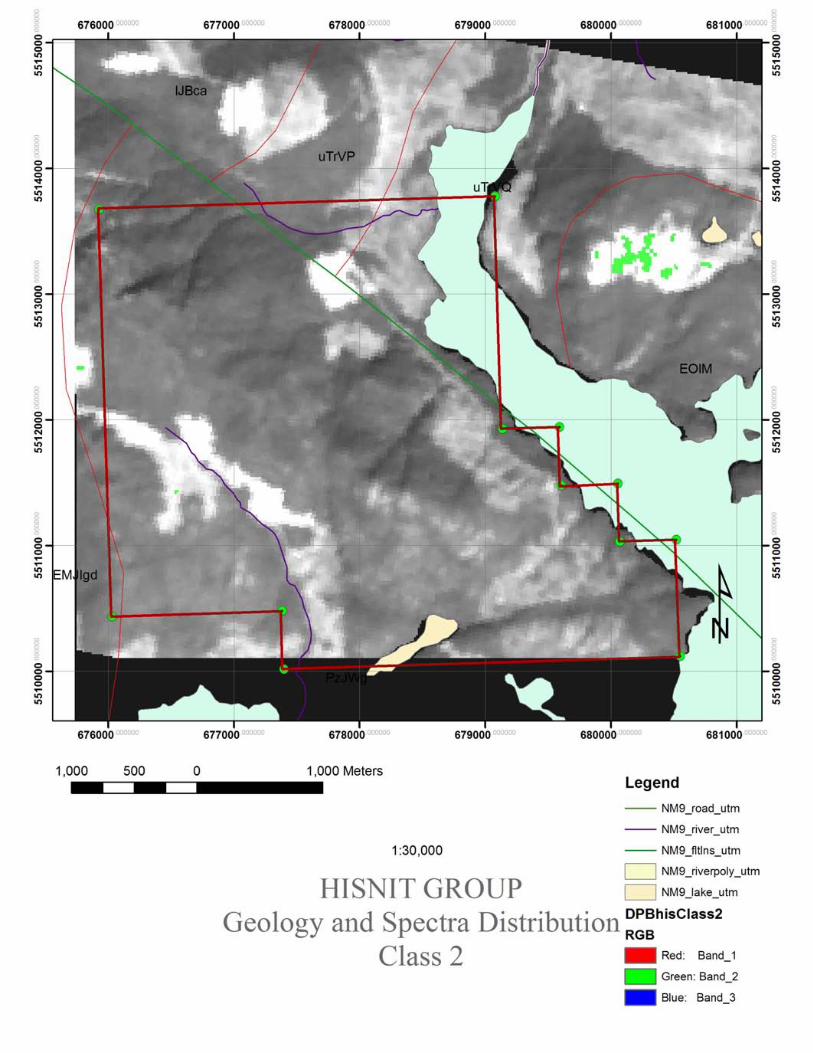
1. General Location Map……………...……………….…..….9 2. Tenure Location Map Vancouver Island…….…………....10 3. Tenure access 1:30,000 Map……….…… ………….11 4. Tenure Group Regional Geology……… ..……….12 5. Sample collection Locations 1:15,000… …………13 6. Spectra Class 2………………………………………..……14 7. Spectra Class 4…………..………………………………....15 8. Spectra Class 5……………………………………………..16 9. Spectra Class 6…………………………………..………....17 10. Spectra Class 7……………………………………………18
Appendices • I Statement of Qualification • II Tables of Costs • Geology and Geochemistry log
2

EXECUTIVE SUMMARY Auracle Geospatial Science Inc. was asked in 2007 by Dan Berkshire to carry out a Spectral Analysis program on the HISNIT mineral claims which had been staked for their base metal (Copper) potential. Geologically this area consists of West Coast Crystalline Complex undivided intrusives, Island Plutonic Suite granodioritics, and Vancouver Group Quatsino Formation: limestone; marble and calcareous rocks bounded by four mapped faults. One trending north and the other trending North-West and converging above the WEST EXTENSION tenure, with two North-west trending faults terminating at the North-West structure, and bounding the Quatsino Formation at the northern extent of the ANGELA 1 tenure. A short program of work on the ANGELA 1 was conducted by J. Houle to carry out prospector direction, sampling and geologic/topographic feature location. Further prospecting was conducted over 4 days. Remote Sensing work featuring Spectral Analysis was carried our on the tenures by the author and included the acquisition of satellite spectral data available from NASA, pre-processing the data into a workable format, orthorectifying and georeferencing to map data, atmospheric correction, noise reduction with rigorous and extensive classification of the data in search of indicators, or relationships that might lead to the discovery of metallic mineralization. This program was meant to apply recently developed technologies and methodologies together with the latest computer software available for spectral analysis as a tool for mineral exploration. This spectral analysis program was highly labour and computer intensive. Tenure files were subject to classification and analysis resulting in numerous images for examination. These Classification images were examined for correlation to known or mapped contacts and surface geology. Spatial correlation was not considered to be conclusive however there are several resulting alteration signatures and mineral end members were identified. A PIMA ground truthing program to verify the resulting data is advised to examine these relationships. Auracle Geospatial Science Inc. December 2007
3

INTRODUCTION In December and February 2006 and 2007 these tenures were acquired by Dan Berkshire. This prospective area is a target for porphyr copper type occurrences and Skarn type occurrences. Rising demand and prices for metals on the world market was added incentive for these acquisitions. In 2007 Dan Berkshire asked Auracle Geospatial Science Inc. to conduct exploration to search for alteration mineralization by remote sensing. Remote Sensing spectral analysis is a recent and still developing exploration tool. David McLelland has gained valuable experience in the use of spectral data as part of his Post Graduate Diploma, Master of Science, and industry training and certification programs. Alteration and surface mineralization mapping by remote sensing have become accepted methods in mineral exploration. This work program has provided further information and insight into the surface constitution of this mineral tenure. LOCATION AND ACCESS (See Figure 1 – General location Map) The Hisnit tenure group is located approximately 16 kilometres southeast of the Town of Tahsis on the west coast of Vancouver Island British Columbia. Access to the general area is by the Head Bay –Tahsis Forest Service Road. Hisnit Main logging road intersects the Head Bay FSR 2kilometers north of head bay and initially travels west before continuing south-east generally following the west shore of Tlupana Inlet, passes the south shore of Tlupana lake and continues south along the west shore of Hisnit Inlet. PHYSIOGRAPHY (figure 2) This prospect area is situated on the East Slope of Mount Walker and the West shore of Hisnit Inlet. The central section of this tenure group consists of high cliffs and steep rugged ground. Elevation ranges from sea level to 1153 metres. The tenure mountainsides are treed with mature second growth Fir, Balsam, Hemlock and Cedar timber. Ground cover is thick salal in the lower elevations. This area can still be snow covered in spring at higher elevations and in road passes.
4

MINERAL CLAIM STATUS This Claim is held in Good standing by Dan P. Berkshire. The HISNIT group includes 1014.755 hectares of mineral tenure. Mr. Berkshire enjoys a 100% unencumbered interest in these claims. Please refer to the cover confirmation sheet for further information.
Tenure# Name Area (ha)
553006 WEST EXTENTION 438.52
551385 ARGO 2 292.434
551384 ARGO 1 250.612
547489 ANGELA 1 313.189
PREVIOUS WORK No recorded work is attributed to the ground encompassed by this tenure; the tenures adjacent however include a 2006 ARIS report on the Century Limestone Property (28386). Across Hisnit Inlet there is a nearby Past producing Marble Quarry (Minfile 092E020). There is no record of previous work within the tenure boundaries GEOLOGY (figure3) According to provincial geological survey mapping, this area consists of West Coast Crystalline Complex undivided intrusives, Island Plutonic Suite granodioritics, and Vancouver Group Quatsino Formation: limestone; marble and calcareous rocks bounded by four mapped faults REMOTE SENSING and FIELD EXPLORATION WORK 2007 SPECTRAL ANALYSIS Spectral Analysis was conducted using ASTER L1B data granule: AST_L1B_00307232004193047_20080108171003 which was selected for suitability to multispectral image analysis for mineral classification based on the date of collection, time of day, presence of cloud over the target area, and availability of coherent Multi-band data. This granule is cloud free (0%) low aerosol image covering the HISNIT GROUP. L1B images are unprocessed data requiring georegistration, and other pre processing for this application. TRIM vector data was acquired for mapping and combined with the BC geological survey’s 9N UTM dataset. EQUIPMENT and SOFTWARE These data were processed using Clark University’s IDRISI ANDES and CARTOLINX raster GIS, ESRI and ENVI raster analysis applications. PROCESSING and ANALYSIS
5

Data was imported as raw reflectance data and visually checked for completeness and consistency before a series of pre-processing steps were taken. Pre-processing included georeferencing of the image data to create positional reference. Georeferencing consisted of resampling and rubber sheeting the data using a cubic convolution method, and reprojecting the resulting data. A region of interest (dark oceanic water) depicting a flat spectral field was used as a basis for a Flat Field Atmospheric Correction. The atmospherically corrected images were processed using a minimum noise fraction (MNF) transform to identify and reduce noise. Six MNF bands were generated and from these a level of spectral coherence was achieved, that is that data was extracted that represented the significant spectral information contained within and the insignificant data was eliminated. The MNF data was classified using a variety of statistical methods including mixture tuned matching, spectral angel comparison, and pixel unmixing to generate classification images of pixels which most likely represent the spectral end members of specific minerals. The Spectral end members were compared with those collected in 15 spectral libraries including those of the US Geological Survey, Johns Hopkins University, Jet Propulsion Laboratory, and several other industry standard libraries. FIELD WORK (see attached table of mineralization) Field work in 2007 was comprised of one day of geological exploration by geologist Jacques Houle P. Eng. and four days of prospecting by two prospectors with samples collected for further analysis. Suitability to spectral analysis and other methodologies was reported based on this work. The North Hisnit Showing consists of a 0.1 m. thick semi-massive Iron/Copper Skarn body oriented 0750/900 and exposed over 2 m. strike and 2 m. dip lengths in the west side of a logging road cut, hosted by fractured, altered mafic volcanics. Sample 201386 is a select grab of the skarn body; sample 201387 is a random grab of the adjacent mafic volcanics. The skarn sample consists of 40% magnetite, 8% pyrite and 2% chalcopyrite as blebs and disseminations, with gangue mineralogy consisting of 40% chlorite and 10% epidote. Geochemistry highlights from the sample include 0.49% copper and 48% iron. The Main Hisnit Showing consists of two parallel, semi-massive Iron/Copper Skarn bodies or veins separated by a narrow band of sheared, altered and weakly mineralized mafic volcanics and a felsic intrusive dike exposed over a combined thickness of 4.5 m. in the south side of a logging road cut. The skarn bodies or veins are each 1.75 to 2 m. thick and are oriented 0800/750 and may represent the repetition of a single zone across a recumbently folded anticline plunging at 2600 Azimuth. The three samples represent a series of continuous representative chip samples taken across the showing from east to west, with thicknesses of 2.0, 0.75 and 1.75 m. for samples 201388, 201389 and 201390 respectively. Sample 201388 consists of a highly altered, pitted and brecciated, chloritic and epidotic rock with 5% garnets and 25% metallic minerals including 10% pyrite, 7% chalcopyrite, 5% bornite and 3% sphalerite and/or magnetite. Geochemistry highlights from the sample include 2.53% copper, 370 ppm zinc, 13.8 ppm silver, 319.5 ppm cobalt, 32.5% iron, and 2.96% calcium. Sample 201389 consists of roughly equal amounts of chloritic, epidotic mafic volcanics, and vuggy felsic intrusives containing garnets, epidote, and traces of blebby chalcopyrite, bornite and sphalerite. Geochemistry highlights from the sample include 0.61% copper, 3/9 ppm silver, 8.1% iron, and 4.37% calcium. Sample 201390 consists of a pitted, brecciated, chloritic and epidotic rock with 30% bladed radiating metallic minerals including 30% sphalerite and/or magnetite, 10% pyrite, 5% chalcocite and 5% bornite and/or covellite. Geochemistry highlights from the sample include 1.46% copper, 238 ppm zinc, 423 ppm cobalt, 25.5% iron, and 2.58% calcium.
6

RESULTS The Initial Minimum Noise Fraction multiband Data produced adequate spectral coherence for subsequent analysis (See HISabundance9.jp2). This image is projected together with overlain tenure corners (blue crosses) to identify the target area to the viewer. A classification image depicting high spectral correlation or low infeasibility is projected as an overlay to the greyscale background Match filter to Malachite/Sulphides image. In this image (HisMinDist.pdf) areas of dark gray indicate a presence (or lack of infeasibility) of Malachite spectral correlation, the dark green (along the inlet’s western shoreline and at the old Minfile 092E 020 marble quarry across the inlet) depicting presence of Talc/Magnetite, Dark red the presence of Datolite/Talc, Brown the presence of Cassiterite, and Blue the presence of Goethite. The data clearly demonstrates that there are spectral signals which may be identified to produce regional exploration targets. The area north of the electrical transmission line correlates well with the strong signal of hematite in the right of way cut area. These areas would benefit by higher resolution spectral examination. Depictions of high spectral correlation or low infeasibility are projected as an overlays to the greyscale background Match filter to Malachite/Sulphides image. In this image (HisMinDist.pdf) areas of dark gray indicate a presence (or lack of infeasibility) of Malachite spectral correlation, the dark green (along the inlet’s western shoreline and at the old Minfile 092E 020 marble quarry across the inlet) depicting presence of Talc/Magnetite, Dark red the presence of Datolite/Talc, Brown the presence of Cassiterite, and Blue the presence of Goethite. The data clearly demonstrates that there are spectral signals which may be identified to produce regional exploration targets. The area north of the electrical transmission line correlates well with the strong signal of hematite in the right of way cut area. These areas would benefit by higher resolution spectral examination.
Class # Spectral Library Mineral/Rock Match 1 Null Null Null 2 USGS Mineral Goethite .582 3 USGS Mineral Goethite .620 4 USGS Mineral Cassiterite/Columbite .641 5 USGS Mineral Cassiterite/Goethite/Hematite .567 6 Null Null Null 7 JHU mineral Datolite/Talc .666 8 USGS Mineral Cassit/Malchite/Shale .643 9 USGS Mineral Pyrophillite/Shale .992
7

CONCLUSIONS This is an area of considerable potential which is supported by this work and analyses. The area, while quite rugged is amenable to further work and seems to be in a region of possible future development. This area seems to be underexplored at present. Spectral analysis has identified areas of interest that should receive more intensive ground based follow up STATEMENT OF WORK and COSTS This work was carried out by Auracle Geospatial Science Inc. for Dan P. Berkshire and fulfils the requirements of assessment work on the Tenures shown. Work is as disclosed on the following tables of costs.
8


Statement of Qualification
I, David J. McLelland, do hereby certify that: 1. I am a Principal in: Auracle Geospatial Science Inc, 325 Dorset Road Qualicum Beach, British Columbia, Canada V9K 1H5 2. I am a post graduate student of Earth and Environmental Science and have completed the postgraduate certificate in applied and theoretical GI Science at Simon Fraser University, and completed the academic component of the MSc. program requirement. 3. I have completed the B.C.I.T. B.C.Y.C.M. Mineral Exploration program, and Completed the B.C.I.T.1 B.C.Y.C.M. Advanced field School. 4. I am the Project Manager and I am responsible for the collection and management of data and execution of analysis. 5. This report was prepared on behalf of Auracle Geospatial Science who has been engaged by Dan P. berkshire to complete a work program on these properties. 6. I have no material or financial interest in the subject properties or the companies that own them. 7. This report has been prepared in accordance with generally accepted Scientific Principles and is based upon the best information available at the time of preparation. I am not aware of any material fact or material change with respect to the subject matter of the report that is not reflected in the report. Date: Dec 1 2007 Qualicum Beach, British Columbia ________________________________________ David McLelland

SW BCHISNIT Group Project2007Work BudgetProject Area: HISNIT MINERALTITLE GROUPCost Categories Type Descriptio Units Rate number Qty extendedPersonnel
Project Manager Field Verify $/Day(8hr.) $550.00 1 0 $0.00QP Field Verify $/Day(8hr.) $650.00 1 1 $650.00Field Assistants $/Day(8hr.) $350.00 1 9 $3,150.00Other $/Day(8hr.)
TravelLodging R and Board $/Day/Person $100.00 1 9 $900.00Lodging Short StayR and Board QP $/Day/Person $120.00 1 1 $120.00Meals travel $/Day/Person $30.00 0 0 $0.00Vehicle QP $/Diem $240.00 1 0.4 $96.00Vehicle $/Kilometre $0.51 580 1 $295.80Fuel Unimog 0 $0.00Fares Ferry $88.00 2 0 $0.00
Ferry Passenger $8.80 2 0 $0.00Misc Costs
MaterialsSuppliesMisc.
CommunicationsSatellite $/Week $30.00 1 0 $0.00Sat Phone $/month $275.00 1 0 $0.00Radio $/Week
Field Equipment RentalUnimog $/Day $200.00 1 0 $0.00Generator $/Week $250.00 1 0 $0.00Dryer heater $/Month $98.00 1 0 $0.00ATV $/Day $100.00 1 9 $900.00Aircraft J Ranger $/Hour
Mob & Demofuel inc $/Minute $18.89 150 0 $0.00Daily fuel inc $/Minute $378.00 4 0 $0.00L Ranger
Tech Equipment RentalField Equipment JH $/Day $60.00 1 0.7 $42.00Computer $/Day $25.00 1 0 $0.00CDGPS $/Day $30.00 1 0 $0.00Gamma Ray Spectrometer $/Week $500.00 1 0 $0.00SWIR Spectrometer $/Week $850.00 1 0 $0.00
Sampling equipment RentalSoil Probe portable $/Week $1,550.00 1 0 $0.00Tips wet cutting$each $144.19 1 0 $0.00Core Tubes 36" clr vinyl $ per set of 1 $26.75 2 0 $0.00
SampleAnalysisIntegrative analyses $/Hr. $68.50 6 0 $0.00C/Processing $/Hr. $50.00 4 0 $0.00micro prepmicroscopy $/diem $600.00 1 0.15 $90.00

Sample prepDrying onsite $/weekSample Bags $each $0.30 15 0 $0.00Assays JH total $222.54Chemical analysis Uassay $perSample $12.15 15 0 $0.00
FuelATV $/Day $10.00 2 0 $0.00Probe $/Day $20.00 1 0 $0.00Heater dryer $Day $10.00 1 0 $0.00
Data AcquisitionData selection $hr $68.50 2 1 $137.00L1B rectified 156 Units $156.00 1 1 $156.00
Mapping and ReportingSpectral analysis $hr $68.50 16 1.5 $1,644.00co-processing $hr $50.00 8 2 $800.00Geological interpretation $hr $81.25 30 0 $0.00Mapping 0 $0.00Geo report cost 0 $0.00Priniting and copying
Licences and PermitsExploration Permit $0.00Bond $0.00WCB inc $0.00Insurances Equipment $0.00
Liability 0 $0.00ATV in rental
Office and Admin$9,203.34
Total $9,203.34

2007 SamSample #
201379201380201385201386201387201388201389201390

mple DescriptionsDescriptionCopper Endoskarn/Exoskarn - brecciated, silicified, with 5% f.g. Cpy in clusters around 5% m.g. Mt, 5% Bo in clusters around quartz eyes, 40% epidote+actinolite+chlorite stockworks, 30% quartz eyes and stockworks, 15% pale pink garnets?, trace v.f. orthogonal rusty vCopper/Iron Endoskarn - weakly foliated, oxidized, brecciated, silicified, with 15% Cpy as semi-massive bands and clusters rimmed by 25% Mt in clusters and stockworks, 40% actinolite-epidote-chlorite groundmass, 5% quartz eyes, 15% v.g. pink garnets?, trace Mal Grey, massive, m.g. crystalline marble with 5% c.g. grey blebs and 5% c.g. white calcite stringers; Cream, f.g. silicified rock with 10% m.g. quartz eyes/porphyroblasts? and 10% thin, orthogonal quartz-biote-chlorite-sulphide stringers and 15% blebby sulphides containingCopper/Iron Exoskarn - foliated, f.g., with 40% chlorite, 10% epidote, 40% magnetite, 8% pyrite, 2% chalcopyrite as blebs and disseminations Mafic Volcanic - weakly foliated, altered, f.g. to m.g., chloritic, epidotic rock with 10% fuzzy epidote-chlorite stockworks - possibly altered intrusive but unlikelyCopper/Zinc Exoskarn - altered, pitted and brecciated, highly chloritic and epidotic, m.g. rock with 5% c.g. pink garnets, 25% m.g. blebby and f.g. disseminated sulphides consisting of 10% pyrite, 7% chalcopyrite, 5% bornite, 3% sphaleriteMafic volcanic containing tightly folded 5 cm. band of felsic intrusive dike - 50% dark green, f.g., weakly foliated, choritic, epidotic rock and 50% buff-ink, m.g., vuggy intrusive dike with abundant garnets, epidote and traces of v.f.g. blebby chalcopyrite, bornite and sphalerZinc/Copper Exoskarn - pitted, massive/brecciated, chloritic and epidotic, f.g. rock with 50% f.g. fractured or radiating bladed sulphides consisting of 30% sphalerite, 10% pyrite, 5% chalcoite, 5% bornite/covellite

Geochemistry Mo Cu Pb Zn Ag Ni Co Mn Fe As U Th Sr Cd Sb Bi V Ca P La Cr Mg Ba Ti Al Na K W Hg Sc Tl S Ga Se Au** Pt** Pd** Sample TotalReport # Sample # ppm ppm ppm ppm ppm ppm ppm ppm % ppm ppm ppm ppm ppm ppm ppm ppm % % ppm ppm % ppm % % % % ppm ppm ppm ppm % ppm ppm ppb ppb ppb kg kgA705844 201379 1.2 43217 7.5 17 26.7 6.5 21.5 299 3.04 14 <.5 <.5 36 0.8 0.7 0.7 57 1.21 0.038 1.8 17.6 0.17 5 0.352 0.59 0.01 0.02 0.8 <.05 3.6 <.5 2 <5 11 24 <3 8 30 3A705844 201380 64 81335 9 266 52.9 337.9 138.8 2331 27.98 7 <.5 <.5 8 1 0.6 5.4 173 0.42 0.091 7.7 6.4 1.93 <5 0.032 3.79 0.01 0.01 <.5 <.05 2.8 <.5 6.7 17 46 191 5 117 30 1.1A7001090 201385A7001090 201386 1.7 4897 7.3 143 4 37 126.6 285 48.25 <5 109.9 <0.5 56 2.3 <0.5 <0.5 1143 0.49 0.013 <0.5 7.2 0.53 5 0.055 0.85 <0.01 <0.01 3.7 0.31 1.8 <0.5 0.9 9 5 <2 <3 3A7001090 201387 <0.5 21.4 2.6 68 1.4 16.5 22.4 393 2.96 <5 <0.5 <0.5 116 <0.5 <0.5 <0.5 105 2.71 0.08 1.1 7.6 1.13 <5 0.293 2.61 0.05 0.01 <0.5 0.15 4.5 <0.5 <0.5 8 <2 <2 <3 <2A7001090 201388 0.8 25318 3.7 370 13.8 61 319.5 883 32.5 44 <0.5 <0.5 <5 6.9 1.6 <0.5 18 2.96 0.011 <0.5 0.6 0.11 27 0.007 0.33 <0.01 <0.01 2.5 0.66 0.8 0.6 5.6 10 41 52 <3 <2A7001090 201389 0.7 6116 2 86 3.9 31.6 60.6 925 8.1 12 0.8 <0.5 23 0.5 <0.5 <0.5 78 4.37 0.09 1.2 48.5 0.84 22 0.202 1.94 0.06 0.05 1.4 0.17 6 <0.5 0.6 7 3 5 <3 <2A7001090 201390 0.6 14588 2.4 238 6.6 106.1 423.2 546 25.53 6 0.9 <0.5 7 2.5 0.6 <0.5 17 2.58 0.044 1.2 1.8 0.12 7 0.032 0.56 <0.01 <0.01 0.5 0.28 1.3 <0.5 5.2 12 33 65 <3 4